enhanced tracking aerial image by applying fusion & · pdf file1mayuri m. mankar, 2prof....
TRANSCRIPT

International Research Journal of Engineering and Technology (IRJET) e-ISSN: 2395-0056
Volume: 04 Issue: 07 | July -2017 www.irjet.net p-ISSN: 2395-0072
© 2017, IRJET | Impact Factor value: 5.181 | ISO 9001:2008 Certified Journal | Page 207
Enhanced Tracking Aerial Image by Applying Fusion & Image Registration Technique
1Mayuri M. Mankar , 2Prof. N. M. Dhande,
1,2 Computer Science & Engineering , RTMNU University , A.C.E, Wardha, Maharashtra, India ,
----------------------------------------------------------------------***--------------------------------------------------------------------- Absract- An image registration method is introduced that is capable of registering images from different views of a 3-D scene in the presence of occlusion. The proposed method is capable of withstanding considerable occlusion and homogeneous areas in images. The only requirement of the method is for the ground to be locally flat and sufficient ground cover be visible in the frames being registered. With help of fusion technique we solve the problem of blur images. In previous project sometime object recognition is not possible they do not show appropriate area, path and location. So with the help of object recognition we show the appropriate location, path and area. Then it captured the motion images, static images, video and CCTV footage also. Because of occlusion sometime result not get correct or sometime problems are occurred but with the help of techniques solve the problem of occlusion. This method is applicable for the various investigation departments. For the purpose of tracking such as smuggling or any unwanted operations which are apply or performed by illegally. Various types of technique are applied for performing the tracking operation. That technique return the correct result according to object tracking. Camera is not supported this type of operation because they do not return the clear image result. So apply the drone and aircraft for capturing the long distance or multiview images. Keywords: Aerial video, homography, image registration, Fusion Technique, object recognition, multiview images, tracking. I .INTRODUCTION
To detect and track moving targets in a video captured by a moving camera, frames in the video are registered to keep the relation between the camera and the scene fixed. Registration of images from a moving camera is challenging particularly when 3-D structures, such as buildings, are present in the scene. Scene points visible in one view may be occluded from another view by the structures. A method for registering multiview images in the presence of occlusion is introduced. A homography is used to relate the images globally and approximately align them. Since corresponding points in approximately aligned images fall near each other, this step will speed up the search for landmark correspondences that are needed to register the images
locally. registration using a global homography and the final registration using a combination of global and local homographies. The global and local homographies are determined by following a coarse-to-fine strategy. The global homography is determined by reducing the resolution (size) of the images sufficiently so that local geometric differences between the images become negligible. After finding the global relation between the images, the resolution of the images is gradually increased while adding more local homographies to the process. Registration at the highest resolution is achieved by using the global homography obtained at the lowest resolution and a sequence of homographies obtained at higher resolutions to account for local geometric differences between the images from coarse to fine. To detect and to track a moving target are captured with the help of camera or video. An image registration method is introduced that is capable of registering images from different view of 3-D scene in the presence of occlusion. Aerial image registration is capturing the any object which is nothing but the targeted object with the help of aircraft and drone. Homography concept is used in an previous paper. Homography nothing but the having an same image or name but their meaning are different. It is related with the local and global homography. A hierarchical method for image registration have been developed it track corresponding land marking images from low to high resolution. It register image captured with different camera orientation by using rotationally invariant landmark features. The proposed method is particularly useful when there is need to track moving targets in urban and suburban area. The process of eliminating the outliers and finding the parameter of homography by least square using a random sample consensus (RANSAC) two widely used detector Harris corner and scale invariant feature transform. Automatic image registration is a required capability in target tracking. Various automatic image registration methods have been developed throughout the years. Specialized methods for registering high-altitude aerial images where occlusion is not significant have been proposed also. This paper describes a method for registering low-altitude aerial images where occlusion can be significant. Image registration for target tracking has been attempted before. This Method is applicable to videos where the ground level across the scene can be

International Research Journal of Engineering and Technology (IRJET) e-ISSN: 2395-0056
Volume: 04 Issue: 07 | July -2017 www.irjet.net p-ISSN: 2395-0072
modeled by a plane. In the proposed method, the ground level across the scene can change in slope and height. The only requirement is for the ground to be locally planar. A hierarchical method for registering multiview images is developed. Hierarchical methods for image registration have been developed before. These methods track corresponding landmarks in images from low to high resolution. This project solve the problem of blur images which are occurred while returning a result. With help of fusion
technique we solve the problem of blur images. In previous project sometime object recognition is not possible they do not show appropriate area, path and location. So with the help of object recognition we show the appropriate location, path and area. Then it captured the motion images, static images, video and CCTV footage also. Because of occlusion sometime result not get correct or sometime problems are occurred but with the help of techniques solve the problem of occlusion
II. LITRETURE SURVEY 1. Aerial Image Registration for Tracking.[1] In this paper author proposed Aerial is nothing but the images which are captured by top view it is a satellite image but not 100%. here used Homographic technique means having two same image or name but there meaning are different. It capture the only target motion images. 2. A novel coarse to find scheme for automatic
image registration based on SIFT and MI.[12] In this paper author proposed It consist an scheme preregistration process and fine tuning process. preregistration is implemented by SIFT(scale invariant feature transform) method and fine tuning implemented by mutual information. advantage is that they are fast and robust to noise. 3. Adaptive registration of very large images.[13] In this paper author proposed it determine the Local transformation function for registration of two image. it having high compatibility speed without sacrifing accuracy. but disadvantage is that it require the given image be in same modality. 4. Real-Time continuous image registration
enabling ultra precise 2-D motion tracking.[7] In this paper author proposed It represent the continuous image registration method(CIRM). CIRM having high computational efficiency. It continuously tracking the image. it is implemented and integrated with visual tracking. 5. Automatic satellite image registration by combination of matching and random sample consensus.[2] In this paper author proposed a new algorithm for image registration it apply random sample consensus and used for robust automated registration. RANSAC used eliminating the outliers’ and finding the parameter.
6. Evaluation of interest point detector and feature descriptors for visual tracking.[18] In this paper author proposed visual tracking it is a process of locating, identifying and determine the dynamic configuration of one or many moving object. here interest point detector and feature point detector are the first step. 7. Distinctive image features from scale-invariant key points.[21] In this paper author proposed It perform reliable matching between different views of an object. it describe the image feature that have many properties and make them suitable for matching. 8. Local invariant feature detectors. [19] In this paper author proposed Local feature is an popular tool used for image description. it define the overview of interest point detector. It used for the specific semantic interpretation. 9. Registration of region of interest for object tracking application in wide area motion imagery.[8] In this paper author proposed when dealing with wide area motion imagery, registration of the full scene can be taxing computationally. The proposed algorithm is an application utilizing two existing registration methods to stabilize a specific region of interest in an aerial image database. 10. Automatic image registration through image segmentation and SIFT.[1] In this paper author proposed The performance of this method is that it evaluate the main concept and obtain an accurate set of tie points and then apply the transformation function. here robust and efficient method for AIR is proposed which combine image segmentation and sift.
© 2017, IRJET | Impact Factor value: 5.181 | ISO 9001:2008 Certified Journal | Page 208

International Research Journal of Engineering and Technology (IRJET) e-ISSN: 2395-0056
Volume: 04 Issue: 07 | July -2017 www.irjet.net p-ISSN: 2395-0072
11. Registering aerial video image using the projective constraints.[11] In this paper it used for to separate object motion from camera motion. Corresponding background future points are used to register and align the frames. By using projective constraints determine the registration parameter . 12. A coarse-to-fine approach for remote sensing image registration based on local method.[14] In this paper author proposed the fine algorithm for multispectral remote sensing image registration. Coarse-to-fine approach consist of two main steps as a preregistration procedure and initial coarse registration. objective is that to estimate the final transformation model. 13. ARRSI- automatic registration of remote sensing
image.[3] In this paper author proposed ARRSI successfully implemented for intrasensor and intersensor images registration and rectification purpose. It capable of handling remotely sensed images geometrically disorted by various transformations. 14. Differential invariants for color image.[28] In this paper author proposed present the method for matching uncalibrated color image. It describe for use to recover the eiepolar geometry in an uncalibrated case. It return the very precise result. 15. A simple and robust feature point matching
algorithm based on restricted spatial order constraints for aerial image registration.[5]
In this paper author proposed this algorithm is called as a RSOC (Reasticated spatial order constraints). It used for remove the outliers for aerial image with monotonous backgrounds, similar patterns. Here both local and global information is considered. graph matching method is used. III. COMPATATIVE STUDY OF LITERATURE SURVEY
NAME OF PAPER
AUTHOR DESCRIPTION
Aerial image registration for tracking.
Michael E. Linger, A. Ardeshir Goshtasby April-2015
Homography technique is used. Captured only motion image.
A novel coarse to find scheme for
M.Gong, L. Jiao, D. Tian, S. Wang July-2014
Used SIFT and MI system. They are robust and easy to used.
automatic image registration based on SIFT and MI Adaptive registration of very large images
B. P. Jackson, A. A. Goshtsaby june-2014
Local transformation function is used
Real-Time continuous image registration enabling ultra precise 2-D motion tracking
P. Cheng, H. Menq May-2013
Used CIRM technique. Continuously track the object.
Automatic satellite image registration by combination of matching and random sample consensus
T. Kim, Y. Jim May-2011
RANSAC used eliminating the outliers’ and finding the parameter.
Evaluation of interest point detector and feature descriptors for visual tracking
S. Gauglitz, T. Hollerer September-2011
visual tracking it is a process of locating, identifying and determine the dynamic configuration of one or many moving object
Distinctive image features from scale-invariant key points
D. Lowe November-2004
It perform reliable matching between different views of an object.
IV.PROBLEM DEFINITION
Maximum time blur image occurred, they do not return
proper result. It cannot register image captured by different sensor or
satellite due to occlusion. It captured only motion type image Sometime object recognition is impossible.
V.OBJECTIVE
Implement Fusion technique for blur image. Implement fencing system for alternating. Implement improve object detection technique
to find target. Implement to also track video and static image.
© 2017, IRJET | Impact Factor value: 5.181 | ISO 9001:2008 Certified Journal | Page 209

International Research Journal of Engineering and Technology (IRJET) e-ISSN: 2395-0056
Volume: 04 Issue: 07 | July -2017 www.irjet.net p-ISSN: 2395-0072
VI. MODULE IMPLEMENTATION
Implementation of video frame extraction and preprocessing.
Implementation of fusion techniques. Implementation of object detection and object
tracking .
I) MODULE 1:-
II) MODULE 2:-
© 2017, IRJET | Impact Factor value: 5.181 | ISO 9001:2008 Certified Journal | Page 209

International Research Journal of Engineering and Technology (IRJET) e-ISSN: 2395-0056
Volume: 04 Issue: 07 | July -2017 www.irjet.net p-ISSN: 2395-0072
III) MODULE 3
© 2017, IRJET | Impact Factor value: 5.181 | ISO 9001:2008 Certified Journal | Page 210

International Research Journal of Engineering and Technology (IRJET) e-ISSN: 2395-0056
Volume: 04 Issue: 07 | July -2017 www.irjet.net p-ISSN: 2395-0072
IV)MODULE…4
© 2017, IRJET | Impact Factor value: 5.181 | ISO 9001:2008 Certified Journal | Page 211
International Research Journal of Engineering and Technology (IRJET) e-ISSN: 2395-0056
Volume: 04 Issue: 07 | July -2017 www.irjet.net p-ISSN: 2395-0072
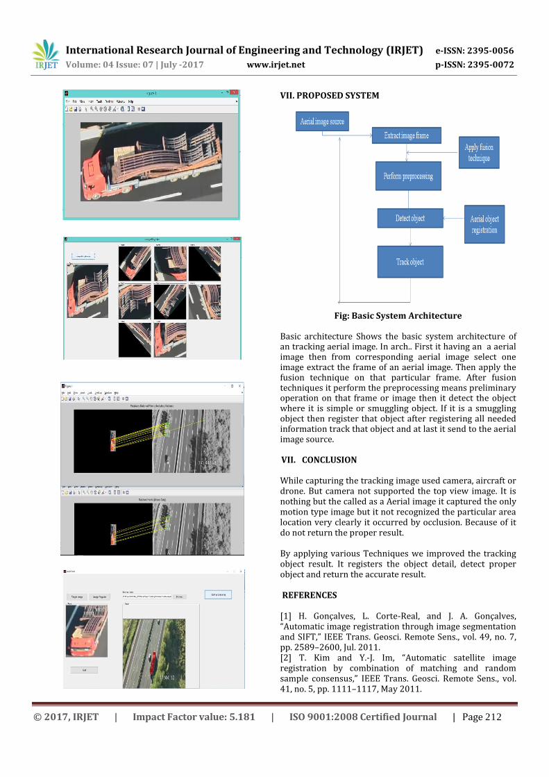
VII. PROPOSED SYSTEM
Fig: Basic System Architecture
Basic architecture Shows the basic system architecture of an tracking aerial image. In arch.. First it having an a aerial image then from corresponding aerial image select one image extract the frame of an aerial image. Then apply the fusion technique on that particular frame. After fusion techniques it perform the preprocessing means preliminary operation on that frame or image then it detect the object where it is simple or smuggling object. If it is a smuggling object then register that object after registering all needed information track that object and at last it send to the aerial image source.
VII. CONCLUSION While capturing the tracking image used camera, aircraft or drone. But camera not supported the top view image. It is nothing but the called as a Aerial image it captured the only motion type image but it not recognized the particular area location very clearly it occurred by occlusion. Because of it do not return the proper result. By applying various Techniques we improved the tracking object result. It registers the object detail, detect proper object and return the accurate result. REFERENCES [1] H. Gonçalves, L. Corte-Real, and J. A. Gonçalves, “Automatic image registration through image segmentation and SIFT,” IEEE Trans. Geosci. Remote Sens., vol. 49, no. 7, pp. 2589–2600, Jul. 2011. [2] T. Kim and Y.-J. Im, “Automatic satellite image registration by combination of matching and random sample consensus,” IEEE Trans. Geosci. Remote Sens., vol. 41, no. 5, pp. 1111–1117, May 2011.
© 2017, IRJET | Impact Factor value: 5.181 | ISO 9001:2008 Certified Journal | Page 212

International Research Journal of Engineering and Technology (IRJET) e-ISSN: 2395-0056
Volume: 04 Issue: 07 | July -2017 www.irjet.net p-ISSN: 2395-0072
[3] A. Wong and D. A. Clausi, “ARRSI: Automatic registration of remote sensing images,” IEEE Trans. Geosci. Remote Sens., vol. 45, no. 5, pp. 1483–1493, May 2007. [4] X. Fan, H. Rhody, and E. Saber, “A spatial-feature-enhanced MMI algorithm for multimodal airborne image registration,” IEEE Trans. Geosci. Remote Sens., vol. 48, no. 6, pp. 2580–2589, Jun. 2010. [5] Z. Liu, J. An, and Y. Jing, “A simple and robust feature point matching algorithm based on restricted spatial order constraints for aerial image registration,” IEEE Trans. Geosci. Remote Sens., vol. 50, no. 2, pp. 514– 527, Feb. 2012. [6] J.Ma, J. C.-W. Chan, and F. Canters, “Fully automatic subpixel image registration of multiangle CHRIS/Proba data,” IEEE Trans. Geosci. Remote Sens., vol. 48, no. 7, pp. 2829–2839, Jul. 2010. [7] P. Cheng and C.-H. Menq, “Real-time continuous image registration enabling ultraprecise 2-D motion tracking,” IEEE Trans. Image Process., vol. 22, no. 5, pp. 2081–2090, May 2013. [8] K. Jackovitz, V. Asari, E. Balster, J. Vasquez, and P. Hytla, “Registration of region of interest for object tracking applications in wide area motion imagery,” in Proc. AIPR, 2012, pp. 1–8. [9] X. Mei and F. Porikli, “Joint tracking and video registration by factorial hidden Markov models,” in Proc. IEEE Int. Conf. Acoust., Speech Signal Process., 2008, pp. 973–976. [10] I. L. Ayala, D. A. Orton, J. B. Larson, and D. F. Elliott, “Moving target tracking using symbolic registration,” IEEE Trans. Pattern Anal. Mach. Intell., vol. 4, no. 5, pp. 515–520, Sep. 1982. [11] B. P. Jackson and A. A. Goshtasby, “Registering aerial video images using the projective constraint,” IEEE Trans. Image Process., vol. 19, no. 3, pp. 795–804, Mar. 2010. [12] M. Gong, S. Zhao, L. Jiao, D. Tian, and S. Wang, “A novel coarse-tofine scheme for automatic image registration based on SIFT and mutual information,” IEEE Trans. Geosci. Remote Sens., vol. 52, no. 7, pp. 4328– 4338, Jul. 2014. [13] B. P. Jackson and A. A. Goshtasby, “Adaptive registration of very large images,” in Proc. CVPR Workshop Registration Very Large Images, Columbus, OH, Canada, Jun. 2014, pp. 345–350. [14] S. R. Lee, “A coarse-to-fine approach for remote-sensing image registration based on a local method,” Int. J. Smart Sens. Intell. Syst., vol. 3, no. 4, pp. 690–702, Dec. 2010. [15] B. Likar and F. Pernus, “A hierarchical approach to elastic registration based on mutual information,” Image Vis. Comput., vol. 19, no. 1/2, pp. 33–44, Jan. 2001. [16] A. Goshtasby, “Registration of images with geometric distortions,” IEEE Trans. Geosci. Remote Sens., vol. 26, no. 1, pp. 60–64, Jan. 1988. [17] F. L. Bookstein, “Principal warps: Thin-plate splines and the decomposition of deformations,” IEEE Trans. Pattern Anal. Mach. Intell., vol. 11, no. 6, pp. 567–585, Jun. 1989. [18] S. Gauglitz, T. Höllerer, and M. Turk, “Evaluation of interest point detectors and feature descriptors for visual
tracking,” Int. J. Comput. Vis., vol. 94, no. 3, pp. 335–360, Sep. 2011. [19] T. Tyutelaars and K. Mikolajczyk, “Local invariant feature detectors: A survey,” Found. Trends Comput. Graph. Vis., vol. 3, no. 3, pp. 177–280, Jan. 2008. [20] C. Harris and M. Stephens, “A combined corner and edge detector,” in Proc. 4th AVC, 1988, pp. 147–151. [21] D. Lowe, “Distinctive image features from scale-invariant keypoints,” Int. J. Comput. Vis., vol. 60, no. 2, pp. 91–110, Nov. 2004. [22] A. Goshtasby, Image Registration: Principles, Tools and Methods. New York, NY, USA: Springer-Verlag, 2012. [23] R. Hartley and A. Zisserman, Multiple View Geometry in Computer Vision, 2nd ed. Cambridge, U.K.: Cambridge Univ. Press, 2003, ch. 4. [24] P. Chen and D. Suter, “Rank constraints for homographies over two views: Revisiting the rank four constraint,” Int. J. Comput. Vis., vol. 81, no. 2, pp. 205–225, Feb. 2009. [25] V. Arsigny, X. Pennec, and N. Ayache, “Polyrigid and polyaffine transformations: A novel geometrical tool to deal with non-rigid deformations—Application to the registration of histologic slices,” Med. Image Anal., vol. 9, no. 6, pp. 507–523, Dec. 2005. [26] D. Shepard, “A two-dimensional interpolation function for irregularly spaced data,” in Proc. 23rd Nat. Conf. ACM, 1968, pp. 517–524. [27] E. Molina and Z. Zhu, “Persistent aerial video registration and fast multiview mosaicing,” IEEE Trans. Image Process., vol. 23, no. 5, pp. 2184– 2192, May 2014. [28] P. Montesinos, V. Gouet, and R. Deriche, “Differential invariants for color images,” in Proc. 14th Int. Conf. Pattern Recogn., 1998, vol. 1, pp. 838–840.
© 2017, IRJET | Impact Factor value: 5.181 | ISO 9001:2008 Certified Journal | Page 213