environmental assessment scoping document - u.s. fish and
TRANSCRIPT
Environmental Assessment
Scoping Document
Right-of-Way Easement Request Analysis for the
Hennepin County State Aid Highway 61/Flying Cloud Drive Reconstruction Project
September 16, 2015 Prepared by:
U.S. Fish and Wildlife Service – Midwest Region
5600 American Blvd. West, Suite 990
Bloomington, MN 55437-1458
In cooperation with:
Hennepin County – Transportation Department
1600 Prairie Drive
Medina, MN 5540-5421

Page Intentionally Left Blank
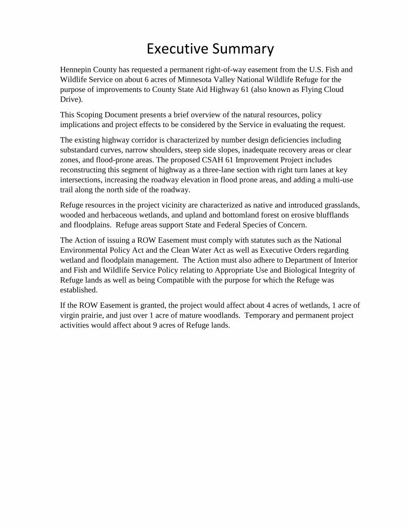
Executive Summary Hennepin County has requested a permanent right-of-way easement from the U.S. Fish and
Wildlife Service on about 6 acres of Minnesota Valley National Wildlife Refuge for the
purpose of improvements to County State Aid Highway 61 (also known as Flying Cloud
Drive).
This Scoping Document presents a brief overview of the natural resources, policy
implications and project effects to be considered by the Service in evaluating the request.
The existing highway corridor is characterized by number design deficiencies including
substandard curves, narrow shoulders, steep side slopes, inadequate recovery areas or clear
zones, and flood-prone areas. The proposed CSAH 61 Improvement Project includes
reconstructing this segment of highway as a three-lane section with right turn lanes at key
intersections, increasing the roadway elevation in flood prone areas, and adding a multi-use
trail along the north side of the roadway.
Refuge resources in the project vicinity are characterized as native and introduced grasslands,
wooded and herbaceous wetlands, and upland and bottomland forest on erosive blufflands
and floodplains. Refuge areas support State and Federal Species of Concern.
The Action of issuing a ROW Easement must comply with statutes such as the National
Environmental Policy Act and the Clean Water Act as well as Executive Orders regarding
wetland and floodplain management. The Action must also adhere to Department of Interior
and Fish and Wildlife Service Policy relating to Appropriate Use and Biological Integrity of
Refuge lands as well as being Compatible with the purpose for which the Refuge was
established.
If the ROW Easement is granted, the project would affect about 4 acres of wetlands, 1 acre of
virgin prairie, and just over 1 acre of mature woodlands. Temporary and permanent project
activities would affect about 9 acres of Refuge lands.
__________________________________________________________________________________ MNV ROW Analysis - CSAH 61/Flying Cloud Drive Reconstruction Project Page i USFWS Environmental Assessment – Minnesota Valley National Wildlife Refuge
Contents CHAPTER I – Purpose & Need for Action ................................................................................................ 3
Purpose & Need for Action................................................................................................................. 3
Background ......................................................................................................................................... 3
CHAPTER II - Alternatives ....................................................................................................................... 7
Proposed Action ................................................................................................................................. 7
No Action ............................................................................................................................................ 7
Description of the Preferred Alternative ............................................................................................ 8
CHAPTER III – Affected Environment & Environmental Consequences ................................................. 8
Background ......................................................................................................................................... 9
Refuge Property – Location & Topography .................................................................................. 10
Soils and Prime/Unique Farmland .................................................................................................... 11
Wetlands .......................................................................................................................................... 11
Floodplain ......................................................................................................................................... 12
Federal-Listed Endangered, Threatened, or Candidate, Species ................................................. 13
State Species of Concern .............................................................................................................. 13
Vegetation .................................................................................................................................... 13
Fish and Wildlife Habitat .............................................................................................................. 14
Hazardous Materials ..................................................................................................................... 15
Environmental Justice .................................................................................................................. 15
Air Quality ..................................................................................................................................... 16
Noise ............................................................................................................................................. 16
Historical and Cultural Resources ................................................................................................. 17
Cumulative Effects ........................................................................................................................ 18
Refuge Recreational Resources, Access, and Educational/Interpretive Programming ................ 20
Compatability, appropriate use and biological integrity. ................................................................. 20
List of preparers.................................................................................................................................... 20
CHAPTER IV – Coordination and Consultation ..................................................................................... 20
Public & Agency Coordination During Project Design and State Environmental Review ................ 20
Project Management Team (PMT) ............................................................................................... 20
Press Releases .............................................................................................................................. 21
Project Web Page ......................................................................................................................... 21
PUBLIC AND AGENCY INVOLVEMENT DURING THIS EA PROCESS .................................................... 21
__________________________________________________________________________________ MNV ROW Analysis - CSAH 61/Flying Cloud Drive Reconstruction Project Page ii USFWS Environmental Assessment – Minnesota Valley National Wildlife Refuge
Agency Meetings .......................................................................................................................... 21
Public Comments And Response .................................................................................................. 21
Appendix: ............................................................................................................................................ 23
USFWS Policy Compliance Overview ............................................................................................ 23
MNV ROW Analysis – CSAH 61/Flying Cloud Drive Reconstruction Project Page 3 USFWS Environmental Assessment – Minnesota Valley National Wildlife Refuge
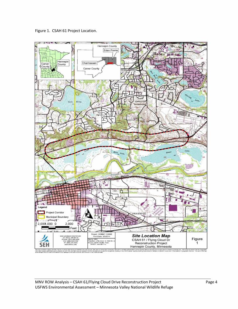
CHAPTER I – Purpose & Need for Action Purpose & Need for Action Hennepin County (County) is proposing transportation improvements to about 3.7 miles of County State Aid Highway 61 (CSAH 61 - also known as Flying Cloud Drive) from State Trunk Highway 101 on the west to Charlson Road on the east (Figure 1). The Minnesota Valley National Wildlife Refuge (Refuge) borders essentially the entire project. The County has requested the U.S. Fish and Wildlife Service (Service) grant a Right-of Way Easement (ROW) across 5.6 acres of the Refuge (Appendix B). The purpose of this Environmental Assessment (EA) is to determine if the issuance of the ROW will have a significant impact on the human environment (cite CEQ/NEPA). In addition, this EA will document that the approval of the County’s ROW request is appropriate and compatible with the Refuge purposes and Refuge system mission. (Appendix). The approval of a ROW request is subject to the National Environmental Policy Act of 1969, as amended (16 U.S.C. 668dd-668ee). The Service is therefore required to analyze this action and its potential impacts to the natural and human environment. This process also provides for public review and comment on the Service’s findings. This EA will determine if the action of granting the ROW request may result in significant impacts to the environment or function and operation of the remaining Service trust resources. If the Service determines that significant effects are not likely, the Service will issue a Finding of No Significant Impact (FONSI). If the Service determines that significant impacts may occur, an Environmental Impact Statement (EIS) will be prepared.
Background The Refuge was established in 1976 to preserve the Minnesota River Valley (Public Law 94-466). In establishing the Refuge, congress noted the following concerns: (1) the lower Minnesota River Valley is a unique environmental resource that provides wildlife habitat for a diversity of waterfowl, migratory birds, fish, and other wildlife; (2) the Valley is a source of environmental education, recreational opportunities, and interpretive programs; (3) the Valley is currently threatened with spoliation, removal from public access, and ecological downgrading; and (4) despoliation of the Valley will result in the permanent loss of unique social, educational and environmental assets. Congress also recognized that it is important for the Refuge to continue to allow “vital public services” provided those services “shall be carried out so to as minimize the disruption of the wildlife and the reduction of recreational and scenic values of the area, consistent with economic feasibility.”
MNV ROW Analysis – CSAH 61/Flying Cloud Drive Reconstruction Project Page 4 USFWS Environmental Assessment – Minnesota Valley National Wildlife Refuge
Figure 1. CSAH 61 Project Location.
MNV ROW Analysis – CSAH 61/Flying Cloud Drive Reconstruction Project Page 5 USFWS Environmental Assessment – Minnesota Valley National Wildlife Refuge
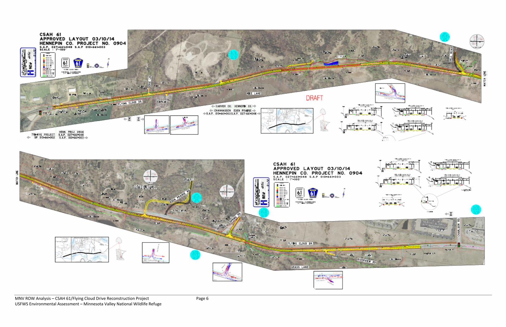
The Refuge is part of a corridor of land and water stretching nearly 70 miles along the Minnesota River, from Bloomington to Henderson, Minnesota. Comprised of more than 14,000 acres, the Refuge has multiple units and ranges from urban to rural landscapes providing a unique opportunity to enjoy wildlife related recreation. Each unit of the refuge offers a variety of attractions and seasonal activities. CSAH 61/Flying Cloud Drive is a historically important regional A-minor arterial roadway, which serves the regional transportation network. This section of roadway was a turnback from the Minnesota Department of Transportation (MnDOT) in 2009 and was previously known as State Highway 212. The existing highway corridor is characterized by number design deficiencies including substandard curves, narrow shoulders, steep side slopes, and inadequate recovery areas or clear zones. Given these deficiencies, there clearly is a need to provide safety and mobility improvements to accommodate existing and forecast traffic volume. Also, several segments of the current roadway profile fall below the 100-year flood elevation and have been subject to flood waters overtopping the roadway causing the County to close the roadway until flood waters recede. Thus another transportation management consideration is to raise the roadway profile above the 100-year flood elevation of the Minnesota River. The County’s project development process concluded that there are minimal alternatives for achieving the CSAH 61 transportation project purpose and need. The proposed CSAH 61 Improvement Project includes reconstructing this segment of highway as a three-lane section with right turn lanes at key intersections and adding a multi-use trail along the north side of the roadway. This design will allow the County to construct safety and mobility improvements to CSAH 61. The preliminary layout of the proposed transportation improvements is shown on Figure 2. This transportation improvement project has been analyzed in a State Environmental Assessment Worksheet (EAW) (Cite) (http://www.hennepin.us/residents/transportation/flying-
cloud-dr ). The state environmental review was completed by Hennepin County, in cooperation with the MnDOT, Carver County, and the cities of Eden Prairie and Shakopee. The Service reviewed the EAW and provided several written comments, which are summarized below:
The Service commented that the highway project will impact Refuge property and stated that the project lies entirely within the Congressionally authorized Refuge expansion boundary;
The Service expressed concerns with project related wetland impacts including impacts to wetlands located on Refuge property;
The Service requested additional consideration of avoidance and minimization measures be considered for impacts to remnant prairies;
MNV ROW Analysis – CSAH 61/Flying Cloud Drive Reconstruction Project Page 6 USFWS Environmental Assessment – Minnesota Valley National Wildlife Refuge
MNV ROW Analysis – CSAH 61/Flying Cloud Drive Reconstruction Project Page 7 USFWS Environmental Assessment – Minnesota Valley National Wildlife Refuge
The Service acknowledged the County’s commitment to utilizing best management practices (BMPs) for areas with highly erodible soils, but cautioned against using standard BMPs that were not effective in past project in the area;
The Service expressed concerns with potential effects on state and federal threatened and endangered species and known bald eagle nests in the vicinity of the project;
The Service also commented on the fact that because the proposed transportation improvements would require permits from the Service and other Federal agencies, the project would likely require further environmental review under the National Environmental Policy Act (NEPA).
Responses to these comments were included as part of the state Findings of Fact & Conclusions and Hennepin County’s Negative Declaration on the Need for a State EIS (Cite). Much of the information and findings from the EAW are summarized, and incorporated by reference, into this EA. Furthermore, since publication of the state EAW, Hennepin County has continued to coordinate with the Refuge and has made several refinements based on additional information that has been gathered and generated as the final design of the highway improvements have progressed. CHAPTER II - Alternatives Proposed Action The Proposed Action is to grant a ROW easement to Hennepin County to use 5.6-acres of Service fee-title lands for transportation purposes. This easement would remain in effect for a period of 50 years or so long as it is used for the purpose granted (50 CFR 29.21-3 (a)). The County will be required to pay the Service for the use and occupancy of Service lands. Payment will be based on fair market value as determined by appraisal by the Service Regional Director. Hennepin County’s temporary use of an additional 3.2 acres of Service fee-title lands also will be authorized. No Action The No Action Alternative would entail the Service denying Hennepin County’s request for a ROW Easement. The No Action alternative would not change wildlife management activities on the Refuge property, and the present conditions would generally continue. The 5.6 acres proposed for a ROW easement would remain unchanged. Such an action would most likely result from the project or project purpose being found to be not meeting the Service’s Appropriate Use (603 FW 1), Compatibility (603 FW 2), or Biological Integrity (601 FW 3) policies.
MNV ROW Analysis – CSAH 61/Flying Cloud Drive Reconstruction Project Page 8 USFWS Environmental Assessment – Minnesota Valley National Wildlife Refuge
Description of the Preferred Alternative The Preferred Alternative is the issuance of a permanent ROW easement on 5.58 acres and temporary construction easement on 3.21 acres to allow Hennepin County to implement the transportation safety and mobility features associated with the CSAH 61/Flying Cloud Drive Reconstruction Project.
CHAPTER III – Affected Environment & Environmental Consequences This chapter assesses the existing conditions and environmental impacts resulting from the Proposed Action, which involves issuing a ROW easement to reconstruct CSAH 61. For Scoping purposes this chapter presents a brief description of the affected environment, a Table of Project Effects, and a Table of Items to Be Considered in the EA. Table ___. Project Effects .
Permanently occupy 5.58 ac. of USFWS Refuge lands previously providing wildlife habitat and public recreation
Temporarily occupy 3.21 ac. of USFWS Refuge lands
Fill or remove 2.38 ac. of palustrine emergent and palustrine forested wetlands on Refuge lands
Temporarily impact 1.94 ac. of palustrine emergent and palustrine forested wetlands on Refuge lands
Purchase 20 ac. mitigation bank credits somewhere in the State
Remove 1 ac. of virgin prairie remnant on Refuge lands
Repair 1 active gully on prairie remnant
Modify but retain 1 public access point
Eliminate 3 unimproved “pull-out” overlooks
Add safety features to existing CSAH 61 (e.g., turn lanes)
Add minor capacity to CSAH 61 (e.g., improve flow with turn lanes, reduce flooding of roadway)
Add hard surfaced non-motorized trail to CSAH 61 corridor
Table ___. ROW Easement Issuance Considerations
Federal Laws and Executive Orders
Clean Water Act S404/Rivers & Harbors Act S10
National Historic Preservation Act S106
Endangered Species Act S7
Bald and Golden Eagle Act
Migratory Bird Treaty Act
EO 11988 Floodplains
EO 11990 Wetlands
EO 12898 Environmental Justice
MNV ROW Analysis – CSAH 61/Flying Cloud Drive Reconstruction Project Page 9 USFWS Environmental Assessment – Minnesota Valley National Wildlife Refuge
Table ___. ROW Easement Issuance Considerations (Cont.)
Environmental Considerations
Soils
Water Quality
Water Quantity
Air Quality
Noise
State Species of Concern
Habitats & Plant Communities of Concern
“Other Species”
Direct Effects
Indirect Effects
Cumulative Effects
Mitigation for Adverse Project Effects
Human Dimensions
Public Safety
Hunting
Fishing
Wildlife Photography
Wildlife Observation
Environmental Education
Environmental Interpretation
Refuge Specific Considerations
National Wildlife Refuge System Mission
Minnesota Valley National Wildlife Refuge Purpose
Refuge Biological Integrity
Refuge Appropriate Use Policy
Project Compatibility with Refuge Operations
Background Coordination between the Refuge and Hennepin County has been occurring throughout the project development process. Several sub-alternatives and numerous design options were considered by Hennepin County for reconstructing CSAH 61/Flying Cloud Drive (Appendix). These sub-alternatives and design options were in part proposed to avoid and minimize impacts to the Refuge property and address concerns raised by the Service. Hennepin County has completed a state level environmental review and documentation process for the proposed transportation improvements in accordance with Minnesota Statutes, section 116D.04 and 116D.045 and the adopted Minnesota Environmental Quality Board Rules, Chapter 4410.4300, subpart 22B – Highway Projects. The State EAW was completed and published for agency and public
MNV ROW Analysis – CSAH 61/Flying Cloud Drive Reconstruction Project Page 10 USFWS Environmental Assessment – Minnesota Valley National Wildlife Refuge
CSAH 61/Flying Cloud Drive
Reconstruction Project
comment on May 26, 2014. After the mandatory 30-day review and comment period, Hennepin County approved a Findings of Fact & Conclusion document and issued a Negative Declaration on the need for a State Environmental Impact Statement (EIS) in September 2014 (Hennepin County 2014) The analysis and documentation completed as part of the State EAW process is incorporated by reference in this EA document (USFWS 2014). Individuals interested in reviewing the EAW can visit the Hennepin County project web site at http://www.hennepin.us/residents/transportation/flying-cloud-dr. Where applicable, this section references material, findings, and mitigation commitments presented in the EAW.
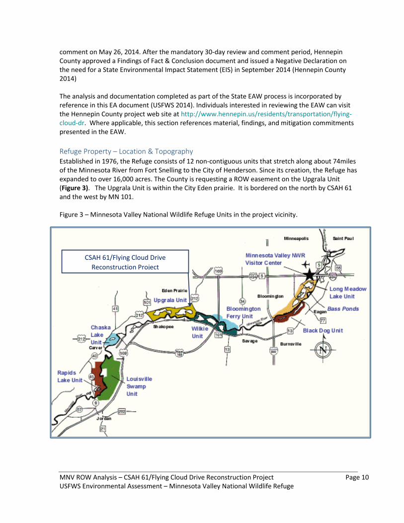
Refuge Property – Location & Topography Established in 1976, the Refuge consists of 12 non-contiguous units that stretch along about 74miles of the Minnesota River from Fort Snelling to the City of Henderson. Since its creation, the Refuge has expanded to over 16,000 acres. The County is requesting a ROW easement on the Upgrala Unit (Figure 3). The Upgrala Unit is within the City Eden prairie. It is bordered on the north by CSAH 61 and the west by MN 101. Figure 3 – Minnesota Valley National Wildlife Refuge Units in the project vicinity.

MNV ROW Analysis – CSAH 61/Flying Cloud Drive Reconstruction Project Page 11 USFWS Environmental Assessment – Minnesota Valley National Wildlife Refuge
The topography of the area is defined by the Minnesota River Valley and surrounding slopes and blufflands. The Minnesota River is at an elevation of approximately 700 feet above sea level, with the surrounding blufflands rising to over 900 feet. The dominant features found throughout the landscape of this portion of the Refuge include the river channel and floodplain that is characterized by open fields, large and small wetlands complexes, and a mix of small to medium sized forest tracts. The upland areas surrounding river and floodplain include low density urban developments
Further description of area land uses and topography can be found in EAW Item 9: Land Use and EAW Item 10: Geology, Soils and Topography/Land Forms.
Soils and Prime/Unique Farmland Soils and farmland information was gathered for the study area using the Natural Resources Conservation Service Web Soil Survey for Carver County and Hennepin County. Soils within the study area were identified in EAW Item 10: Geology, Soils and Topography/Land Forms. Upland soils in the project area are highly erosive due to high sand content and steep slopes; floodplain soils are quite sandy but generally flat.
Wetlands
The Refuge property lies within the Minnesota River valley and the area being considered for a ROW easement is characterized by numerous wetlands. The wetland delineations followed the U.S. Army Corps of Engineers guidance (Environmental Laboratory, 1987) and were typed and classified using Circular 39 (Shaw and Fredine, 1956), Cowardin et. al. (1976), Eggers and Reed (1997).
Additional data gathered on each delineated wetland included the identification of any inlet and outlet features and hydrological connectivity indicators. Topographic setting, when possible, were also determined in accordance with the settings described in the Minnesota Wetland Conservation Act (WCA). Important wetland functions and values were also recorded and land uses adjacent to and surrounding each delineated wetland were taken into consideration. A total of twenty wetlands were identified within the transportation project area, and five of those are located within or partially within the Refuge property. Table 3 summarizes the characteristics of the five delineated wetlands within the proposed ROW easement area as well as the anticipated wetland impacts. Impacts are based off of the anticipated construction limits. Additional information related to complete wetland impacts associated with the CSAH 61 Reconstruction Project can be found in the EAW under Item 11: Water Resources.
Table 3 – Delineated Wetlands – Refuge Property
Wetland ID Cowardin Circular 39 Wetland Plant Community Wetland Impact
(acres)
7 PEMC Type 3 Shallow Marsh 0.084
15 PFO1A Type 3 Floodplain Forest, Shallow Marsh 0.236
16 PFO1A Type 1FO Floodplain Forest, Shallow Marsh 0.508
17 PFO1A Type 1FO, 3 Floodplain Forest, Shallow Marsh 0.373
18 PFO1A Type 1FO Floodplain Forest 1.037
TOTAL IMPACT 2.238
MNV ROW Analysis – CSAH 61/Flying Cloud Drive Reconstruction Project Page 12 USFWS Environmental Assessment – Minnesota Valley National Wildlife Refuge
Wetland Sequencing During the preliminary design process for the CSAH 61 Reconstruction Project, design alternatives (Appendix) that would avoid and minimize wetland impacts on Refuge property were considered. Complete avoidance of wetland impacts was not feasible due to the location of the wetlands adjacent to the roadway and the steep bluffs along the north side of the corridor. Design modifications such as changes to the roadway profile, steeper side slopes, and minimized clear zones (through use of guardrail) have been incorporated into the highway design in several areas to minimize wetland impacts.
Impacts to the Refuge property and Minnesota River floodplain wetlands have been minimized by placing guardrail along the south side of the highway in several areas. The addition of this design element has reduced the amount of wetland fill for the entire project by at least 5 acres.
Wetland Permitting and Mitigation Wetlands in the project area are regulated by the Rivers and Harbors Act Section 10, Clean Water Act Section 404, Minnesota Public Waters Statute, and Minnesota Wetland Conservation Act.
Hennepin County and the Refuge have also had ongoing discussions to determine if any on-site mitigation could occur within the Refuge property. No sites have been identified to date. Because no on-site or nearby mitigation areas can be found, wetland impacts for this project will be mitigated by using wetland bank credits from a bank site at an unknown location. Replacement of lost wetlands will be in accordance with regulations and guidelines in place during the permitting stage of the project, and will occur prior to or concurrent with the impacts. It is anticipated that wetland replacement will be completed at a 2:1 ratio. Final wetland impacts and mitigation will be determined during the permitting phase.
Floodplain . Large areas of the Refuge are located within the river floodplain including portions of the 5.6 acres being considered for a ROW easement.
Similar to wetland sequencing, floodplain encroachment minimization measures have been considered and have included minor alignment shifts (away from the floodplain) and inclusion of guardrail to allow for steeper side slopes and less impact on floodplain areas.
An assessment of the pre- and post-project conditions associated with the river floodplain was conducted by Minnesota Department of Transportation in cooperation with units of local government.
The identified project improvements associated with the CSAH 61/Flying Cloud Drive Reconstruction Project and nearby transportation infrastructure improvements were incorporated into a calibrated hydrodynamic two-dimensional finite element surface water modeling system model of the Minnesota River. Model results illustrating flood extents, change in water surface elevation, velocity profiles, and changes in velocities indicate little to no change for each of the modeled events (10-year, 50-year, 100-year, and 500-year flood events). Model results showed that the proposed transportation improvements would not flood during a 100-year event because all roadway segments would be above 100-year flood elevations. As demonstrated in the detailed hydrodynamic modeling, the proposed transportation improvements would maintain the existing river levels during flood events.
MNV ROW Analysis – CSAH 61/Flying Cloud Drive Reconstruction Project Page 13 USFWS Environmental Assessment – Minnesota Valley National Wildlife Refuge
Federal-Listed Endangered, Threatened, or Candidate, Species Section 7 of Endangered Species Act of 1973, as amended (Act), requires Federal agencies to review any action that it funds, authorizes or carries out to determine whether it may affect threatened, endangered, proposed species or listed critical habitat. According to the official County Distribution of Minnesota’s Federally-Listed Threatened, Endangered, Proposed, and Candidate Species list (revised in April 2015), maintained by the Service, the project county (Hennepin) is within the distribution range of the Northern long-eared bat (Myotis septentrionalis), which has been recently added to the list of threatened species.
The Northern Long-Eared Bat (NLEB) is listed as Threatened in Hennepin and Carver County where
the project is sited. The bats spend winter hibernating in caves and mines (hibernacula) and roost
and forage in upland forests during spring and summer from approximately April 1-October 1.
Summer roosting, foraging, breeding and pup rearing habitat includes diverse native forests, with a
broad age class distribution, in proximity to water and forest openings.
We have not undertaken bat surveys for the NLEB at this project area due to the difficulty of
distinguishing NLEBs from other bat species that are not of concern. We have no other information
that indicates NLEBs are present in the project area.
Any action that requires the removal of trees during April 1- October 1 could potentially result in
some form of a take, either direct or indirect or potentially both. In order to minimize the potential
for impacts, the Service recommends that tree removal occur during the winter season, which is
approximately October 1-April 1. Hennepin County has committed to follow the recommended tree
removal schedule.
State Species of Concern Consultation with the Minnesota Department of Natural Resources began early in the project development process. The Minnesota Natural Heritage Information System database and the Minnesota Biological Survey were reviewed to determine if State rare plant or animal species, native plant communities, or other significant natural features are known to occur within an approximate one mile radius of the study area. Based on this query, rare features had previously been documented. In 2014, Hennepin County conducted a detailed botanical survey to better identify rare native plant communities in the area. The findings of the botanical survey found no rare native plant communities within the area surveyed.
Additional information on State rare plant or animal species, native plant communities, or other significant natural features can be found in EAW Item 13: Fish, wildlife, plant communities, and sensitive ecological resources (rare features) and within the FOF&C document.
Vegetation The Refuge property being requested for a ROW easement primarily lies along the Minnesota River channel and the CSAH 61 corridor and the steep river bluffs. The Refuge property is characterized by native plant communities and pristine wildlife habitats. There are numerous types of plant communities including a mix of floodplain forests, lowland hardwood forests, grasslands, remnant prairies, and wet meadows, and oak woodland-brushland. Several wetlands and intermittent streams/creeks in the area exhibit diverse emergent and submergent aquatic vegetation. Further details regarding vegetation can be found in the EAW under Item 7: cover Types and Item 13: Fish,
MNV ROW Analysis – CSAH 61/Flying Cloud Drive Reconstruction Project Page 14 USFWS Environmental Assessment – Minnesota Valley National Wildlife Refuge
wildlife, plant communities, and sensitive ecological resources (rare features). The location of plant and animal species of interest are shown in the Appendix.
A botanical (plant) survey was conducted in June 2014. The purpose of the survey was to better identify state or federally listed rare native plant communities. The botanical survey found no state or federally listed plant communities within the proposed construction limits.
Fish and Wildlife Habitat The 5.6 acres of Refuge property being requested for a ROW easement lie along the Minnesota River and the steep river bluffs. These areas of the Refuge are characterized by native plant communities and pristine wildlife habitats. According to Hennepin County’s Ecologically Significant Natural Areas database the areas include the following: Dray Prairie Sand-Gravel subtype (remnant short grass prairie); Floodplain Forest; Lowland Hardwood Forest; Mixed Emergent Marsh; Native Dominated Disturbed Upland Shrubland; Oak Woodland-Brushland; Seepage Meadow; Wet Meadow; and Willow Swamp. Furthermore, several wetlands and intermittent streams/creeks in the area exhibit diverse emergent and submergent aquatic vegetation. These plant communities and habitats support an array of wildlife species including a rich diversity of birds, mammals, fish, reptiles, and amphibians. A more detailed description of fish and wildlife habitat in the study area can be found in EAW Item 13: Fish, wildlife, plant communities, and sensitive ecological resources (rare features).
Remnant Prairies Virgin (unplowed) native prairie remnants have been identified on the Refuge area being requested for a ROW easement. Non-Refuge virgin prairie remnants are located on both sides of CSAH 61/Flying Cloud Drive. These non-Refuge remnants are in both private and public ownership (e.g., City of Eden Prairie ownership). The presence of prairie on both sides of CSAH 61 allow for no avoidance options.
Based on the preliminary design estimates, approximately 0.93 acres of remnant prairie is proposed to be impacted by the transportation improvements. The Refuge has corresponded with the County on several design modifications, which has resulted in the narrowing the construction limits through reduced clear zones (installation of guardrail, steeper side slopes, minor alignment shifts). In addition, as part of the proposed mitigation plan, Hennepin County will harvest seeds from the area and utilize the native seed mix in the re-vegetation of disturbed areas.
Bald and Golden Eagle Protection Act The bald eagle was removed from the list of threatened and endangered species on August 8, 2007. The bald eagle is still protected under the Bald and Golden Eagle Protection Act (Eagle Act) and the Migratory Bird Treaty Act. The Eagle Act makes it illegal to take (kill, wound, pursue, shoot, shoot at, poison, capture, trap, collect, molest or disturb) bald or golden eagles. Disturb is defined in the Eagle Act as "to agitate or bother a bald or golden eagle to a degree that caused, or is likely to cause, based on the best scientific information available, 1) injury to an eagle, 2) a decrease in its productivity, by substantially interfering with normal breeding, feeding, or sheltering behavior, or 3) nest abandonment, by substantially interfering with normal breeding, feeding, or sheltering behavior."
To avoid potential disturbance to eagles, a set of guidelines have been developed that recommends construction activity buffer distances. A 330’ buffer is recommended for avoiding the removal of vegetation or permanent landscape changes. A 660’ buffer is commonly used for general
MNV ROW Analysis – CSAH 61/Flying Cloud Drive Reconstruction Project Page 15 USFWS Environmental Assessment – Minnesota Valley National Wildlife Refuge
construction activities that may occur during the breeding season with the exception of load noise generating activities (pile driving, use of explosives), which has a ½-mile recommended buffer.
The Service is aware of two existing bald eagle nests in proximity to the study area. Both eagles nest locations are found outside the 330’ buffer area and therefore a take permit under 50 CFR 22.26 is not anticipated. While the action of issuing a ROW easement is not anticipated to create a disturbance in itself, the associated highway improvements have the potential for disturbing the nests. One nest is located outside the recommended 660’ buffer for general construction activities while the other is located approximately 400’-500’ from CSAH 61/Flying Cloud Drive.
Migratory Bird Treaty Act
The Migratory Bird Treaty Act (16USC 703), originally passed in 1918 protects over 800 bird species making it illegal for anyone to take, possess, import, export, transport, sell, purchase, barter, or offer for sale, purchase, or barter, any migratory bird, or the parts, nests, or eggs of such a bird except under the terms of a valid Federal Permit. The issuance of a ROW easement for the purposes of allowing Hennepin County to construct transportation improvements along CSAH 61/Flying Cloud Drive is not anticipated to substantially impact bird species in the area. Hennepin County conducted a screening of the area for nesting activity under existing structures and no nesting colonies have been identified to date.
Hazardous Materials A Phase I Environmental Site Assessment was conducted by Hennepin County in May 2013 along the CSAH 61/Flying Cloud Drive corridor. Two potentially contaminated sites were located adjacent to the Refuge, but no sites were identified within the Refuge property being requested for a ROW easement. Additional information on hazardous materials and/or contamination can be found in EAW Item 12: Contamination/Hazardous Wastes.
Environmental Justice Executive Order 12898, “Federal Actions to Address Environmental Justice in Minority Populations and Low Income Populations,” requires that environmental justice be addressed in all federal planning and programming activities. The purpose of Executive Order 12898 is to identify, address, and avoid disproportionately high and adverse human health or environmental effects of programs, policies, and activities on minority populations and low-income populations. If a project requires a federal action (approval/permit) or receives federal funding it will be considered a federal project for the purpose of compliance with this Executive Order.
Executive Order 12898 requires that the proposed actions be reviewed to determine if there are “disproportionately” high or adverse impacts on minority and low income populations.
Project Area Demographics The first step in the environmental justice determination process is to determine whether any minority and/or low-income populations are readily known to be present within the study area. For the purposes of environmental justice, a low-income population or minority population is defined as a population of people or households located in close geographic proximity meeting the racial or income criteria set forth in Executive Order 12898. Information on population characteristics of the project area was obtained from 2010 Census data at the most practical level to characterize the population in the project area. Table 5 and Table 6, in the Appendix, describe the population characteristics for the area reviewed.
MNV ROW Analysis – CSAH 61/Flying Cloud Drive Reconstruction Project Page 16 USFWS Environmental Assessment – Minnesota Valley National Wildlife Refuge
Air Quality The scope of the proposed action does not indicate that adverse air quality impacts would be expected. Additional air quality analysis was conducted as part of the state environmental review and can be found under EAW Item 16: Air.
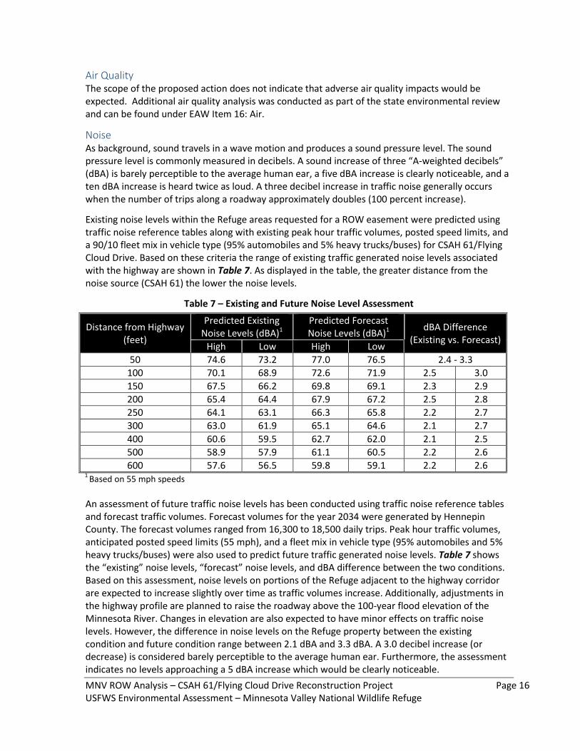
Noise As background, sound travels in a wave motion and produces a sound pressure level. The sound pressure level is commonly measured in decibels. A sound increase of three “A-weighted decibels” (dBA) is barely perceptible to the average human ear, a five dBA increase is clearly noticeable, and a ten dBA increase is heard twice as loud. A three decibel increase in traffic noise generally occurs when the number of trips along a roadway approximately doubles (100 percent increase).
Existing noise levels within the Refuge areas requested for a ROW easement were predicted using traffic noise reference tables along with existing peak hour traffic volumes, posted speed limits, and a 90/10 fleet mix in vehicle type (95% automobiles and 5% heavy trucks/buses) for CSAH 61/Flying Cloud Drive. Based on these criteria the range of existing traffic generated noise levels associated with the highway are shown in Table 7. As displayed in the table, the greater distance from the noise source (CSAH 61) the lower the noise levels.
Table 7 – Existing and Future Noise Level Assessment
Distance from Highway (feet)
Predicted Existing Noise Levels (dBA)1
Predicted Forecast Noise Levels (dBA)1
dBA Difference (Existing vs. Forecast)
High Low High Low
50 74.6 73.2 77.0 76.5 2.4 - 3.3
100 70.1 68.9 72.6 71.9 2.5 3.0
150 67.5 66.2 69.8 69.1 2.3 2.9
200 65.4 64.4 67.9 67.2 2.5 2.8
250 64.1 63.1 66.3 65.8 2.2 2.7
300 63.0 61.9 65.1 64.6 2.1 2.7
400 60.6 59.5 62.7 62.0 2.1 2.5
500 58.9 57.9 61.1 60.5 2.2 2.6
600 57.6 56.5 59.8 59.1 2.2 2.6 1
Based on 55 mph speeds
An assessment of future traffic noise levels has been conducted using traffic noise reference tables and forecast traffic volumes. Forecast volumes for the year 2034 were generated by Hennepin County. The forecast volumes ranged from 16,300 to 18,500 daily trips. Peak hour traffic volumes, anticipated posted speed limits (55 mph), and a fleet mix in vehicle type (95% automobiles and 5% heavy trucks/buses) were also used to predict future traffic generated noise levels. Table 7 shows the “existing” noise levels, “forecast” noise levels, and dBA difference between the two conditions. Based on this assessment, noise levels on portions of the Refuge adjacent to the highway corridor are expected to increase slightly over time as traffic volumes increase. Additionally, adjustments in the highway profile are planned to raise the roadway above the 100-year flood elevation of the Minnesota River. Changes in elevation are also expected to have minor effects on traffic noise levels. However, the difference in noise levels on the Refuge property between the existing condition and future condition range between 2.1 dBA and 3.3 dBA. A 3.0 decibel increase (or decrease) is considered barely perceptible to the average human ear. Furthermore, the assessment indicates no levels approaching a 5 dBA increase which would be clearly noticeable.
MNV ROW Analysis – CSAH 61/Flying Cloud Drive Reconstruction Project Page 17 USFWS Environmental Assessment – Minnesota Valley National Wildlife Refuge
Noise effects on wildlife within the Refuge is not entirely known. According to a report prepared by the Federal Highway Administration (FHWA) - “Synthesis of Noise Effects on Wildlife Populations” (September 2004), traffic noise impacts can differ greatly on the type of wildlife species affected and whether or not the noise source is new (new road/bypass) or has existed for a period of time. Historic aerial photos indicate the CSAH 61/Flying Cloud Drive alignment was built prior to 1937. The FHWA report also states that studies suggest fish are unlikely to be adversely affected by traffic noise. Reptiles and amphibians show some barrier effect due to roads, but there is no clear evidence of a noise effect alone. Burrowing toads and birds have shown adverse effects, but in other case studies have found many species of birds using roadside habitats. Large mammals may be repelled by noise, although in most cases the effect appears to be slight to moderate and small mammals do not appear to be adversely affected by traffic noise. The further away from the noise source (highway) the less likely potential impacts will affect the Refuge and wildlife in the surrounding area.
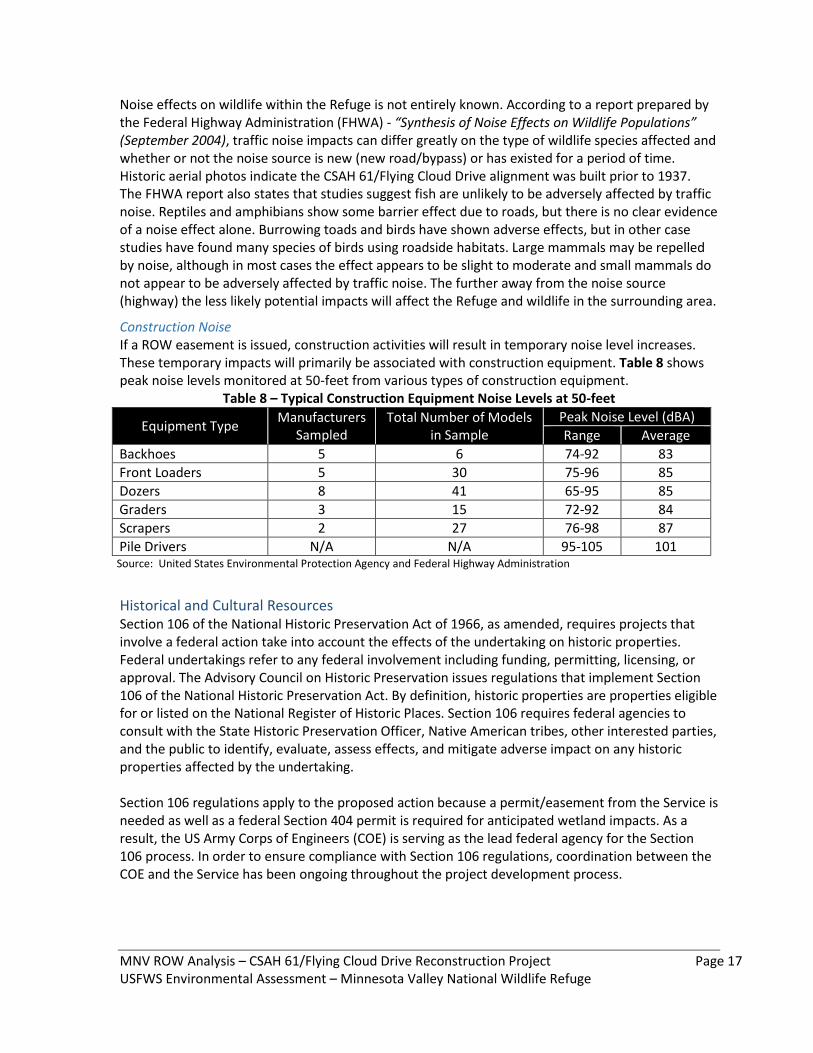
Construction Noise If a ROW easement is issued, construction activities will result in temporary noise level increases. These temporary impacts will primarily be associated with construction equipment. Table 8 shows peak noise levels monitored at 50-feet from various types of construction equipment.
Table 8 – Typical Construction Equipment Noise Levels at 50-feet
Equipment Type Manufacturers
Sampled Total Number of Models
in Sample Peak Noise Level (dBA)
Range Average
Backhoes 5 6 74-92 83
Front Loaders 5 30 75-96 85
Dozers 8 41 65-95 85
Graders 3 15 72-92 84
Scrapers 2 27 76-98 87
Pile Drivers N/A N/A 95-105 101 Source: United States Environmental Protection Agency and Federal Highway Administration
Historical and Cultural Resources Section 106 of the National Historic Preservation Act of 1966, as amended, requires projects that involve a federal action take into account the effects of the undertaking on historic properties. Federal undertakings refer to any federal involvement including funding, permitting, licensing, or approval. The Advisory Council on Historic Preservation issues regulations that implement Section 106 of the National Historic Preservation Act. By definition, historic properties are properties eligible for or listed on the National Register of Historic Places. Section 106 requires federal agencies to consult with the State Historic Preservation Officer, Native American tribes, other interested parties, and the public to identify, evaluate, assess effects, and mitigate adverse impact on any historic properties affected by the undertaking. Section 106 regulations apply to the proposed action because a permit/easement from the Service is needed as well as a federal Section 404 permit is required for anticipated wetland impacts. As a result, the US Army Corps of Engineers (COE) is serving as the lead federal agency for the Section 106 process. In order to ensure compliance with Section 106 regulations, coordination between the COE and the Service has been ongoing throughout the project development process.
MNV ROW Analysis – CSAH 61/Flying Cloud Drive Reconstruction Project Page 18 USFWS Environmental Assessment – Minnesota Valley National Wildlife Refuge
A consultation effort with Native American tribes regarding potential impacts of the project was undertaken by the COE. In addition, coordination with the State Historic Preservation Office and Minnesota Historical Society has been occurring and will continue through the final design of the highway improvements and permitting phase.
Architectural History/Standing Structures As described under EAW Item 14: Historic Properties, a Phase I architectural history survey was conducted for the study area in September 2013. The architectural history survey revealed no standing structures in the Refuge property (or entire study area) that are eligible for listing on the National Register of Historic Places.
Archaeology In the fall of 2013, a Phase I archaeological survey and Phase II archaeological testing was completed for the study area. During the Phase I archaeological survey, two previously recorded archaeological sites and thirteen new archaeological sites were identified within the study area, but none were found within the Refuge property located adjacent to CSAH 61/Flying Cloud Drive. The Section 106 process is being led by the U.S. Army Corps of Engineers (COE) because a federal Section 404 permit is required for the wetland impacts associated with the proposed highway improvements. Hennepin County is currently working with the COE to conduct additional surveys and testing because two archaeological sites (21HEO419 and 21CR156), which are located on land outside the Refuge, were recommended eligible for listing in the National Registered. If these sites cannot be avoided, a Memorandum of Agreement (MOA) will be drafted and approved by the appropriate local, state, and federal agencies. The MOA may involve Phase III data recovery and documentation, which would occur prior to construction of the proposed highway improvements.
Cumulative Effects A cumulative impact is defined in 40 C.F.R. §1508.7 as "the impact on the environment which results from the incremental impact of the action when added to other past, present, and reasonably foreseeable future actions regardless of what agency (federal or non-federal) or person undertakes such other actions. Cumulative impacts can result from individually minor but collectively significant actions taking place over a period of time." A detailed cumulative effects analysis was completed for the study area as part of Hennepin County’s EAW (see EAW Item 19: Cumulative Potential Effects). The geographic scale of the analysis varied by resource and was limited to those resources, ecosystems, and human communities directly affected by the proposed CSAH 61 project. Cumulative effects are not necessarily causally linked to the issuance of a ROW easement on 5.6 acres of Refuge property. Rather, cumulative effects are the total effect of all known actions (past, present, and future) in the vicinity of the project with impacts on the same types of resources. The cumulative effects analysis considered several past and foreseeable future actions that are: 1) either existing, actually planned for, or for which a basis of expectation has been laid; 2) are located in the surrounding area; and 3) might reasonably be expected to affect the same social, economic, and natural resources. Below is a list of actions considered in the analysis:
The Service has several expansion, preservation, and enhancement projects identified on Refuge property, but the timing of such projects is highly dependent upon available funding.
MNV ROW Analysis – CSAH 61/Flying Cloud Drive Reconstruction Project Page 19 USFWS Environmental Assessment – Minnesota Valley National Wildlife Refuge
Carver County, in cooperation with the MDOT, Hennepin County, and the cities of Shakopee and Chanhassen are currently making highway improvements to CSAH 61/Flying Cloud Drive and Highway 101. This project includes the reconstruction of Highway 101 on a four-lane bridge structure above the 100-year flood elevation of the Minnesota River and reconstruct CSAH 61/Flying Cloud Drive from the CSAH 61 and Highway 101 “Wye” intersection to just west of Bluff Creek Drive in the City of Chanhassen. Construction is anticipated to run through 2016. This project is on the west side of the Upgrala Unit. This project realigned a permanent stream (name?) and removed some hydrology contributions from Refuge lands. The removal of a roadway embankment and subsequent use of a bridge to span the floodplain will alter the timing and extent of flooding on the Upgrala Unit.
The City of Eden Prairie has identified the need to realign small segments of Dell Road and Eden Prairie Road within the cumulative effects study area. Both roadways intersect CSAH 61/Flying Cloud Drive in the project area and both currently have substandard design features such as steep grades, poor sight distance (skewed intersection), and surface water drainage issues.
Highway 101 Improvements, beginning at Carver CSAH 14/Pioneer Trail and continuing south to CSAH 61/Flying Cloud Drive. The extent of improvements (reconstruction, realignment, lane channelization, capacity expansion, etc.) has not yet been defined. The City of Chanhassen has initiated a project scoping and preliminary design effort to determine the feasibility of reconstructing this segment of Highway 101.
Carver CSAH 61/Flying Cloud Drive, beginning just west of Bluff Creek Drive to Highway 212. The extent of the transportation improvements (reconstruction, lane channelization, access management, capacity expansion, etc.) has not yet been defined. Carver County has begun the early planning stages of a corridor study that will create a vision for the future of this roadway segment.
Several future land developments in the southern portions of Chanhassen and Eden Prairie have been identified. Ongoing planning efforts continue with the Moon Valley Property (mineral extraction/gravel pit) for future high density development following reclamation of the site is required prior to development. The Eden Prairie Land Use Guide Plan Map (2030) identifies low density residential developments adjacent to the highway corridor, while the Chanhassen 2030 Land Use Plan Map indicates a mix of office/industrial, low density residential, and high density residential.
According to the Flying Cloud Regional Airport Layout Plan, several improvements are expected in the foreseeable future including taxiway reconstruction, additional private hangers, commercial establishments etc., but no new improvements are planned that would substantially alter the airport infrastructure and operations.
Habitat management partnerships? E.g., MAC, MPCA?
Eden Prairie Bluffland Ordinance Potential impacts from future projects have been discussed with local governmental units and state resources agencies. The primary impacts associated with the identified projects were determined to likely involve wetlands, storm water quality and quantity, floodplains, vegetation/wildlife, visual quality, and cultural resources. The cumulative effects analysis presented in the EAW reviewed the potential cumulative effects on each of these resources. A complete discussion on each resource is included in EAW Item 19: Cumulative Potential Effects.
MNV ROW Analysis – CSAH 61/Flying Cloud Drive Reconstruction Project Page 20 USFWS Environmental Assessment – Minnesota Valley National Wildlife Refuge
Refuge Recreational Resources, Access, and Educational/Interpretive Programming The Refuge provides an array of wildlife related recreational resources and activities. Depending on the season, these activities can include hunting, fishing, wildlife observation and photography, environmental education and interpretation. Several accessible activities are featured within the Refuge including paved nature trails and wheel chair accessible hunting blinds. Further information on the recreational opportunities available within the Refuge can be found at: http://www.fws.gov/refuge/Minnesota_Valley/ Access to the Upgrala Unit is gained from public roads and Refuge roads and trails off Hennepin CSAH 61/Flying Cloud Drive. Access points are used by the Refuge staff for management purposes and by the general public for Unit specific authorized activities. For example, an accessible hunting area is located off CSAH 61/Flying Cloud Drive within a segment of highway proposed to be reconstructed. Although this access will be modified, it will continue to provide safe access for this area. Currently, three road pull-offs and parking areas provide convenient wildlife observation locations. These will be eliminated with the proposed project. The issuance of a ROW easement for the construction of the CSAH 61/Flying Cloud Drive transportation improvements is not expected to significantly and permanently adversely affect recreational resources, reduce access, or adversely affect educational/interpretive programming on the Upgrala Unit or Refuge. To the extent practical, accommodations will be made to maintain access to the handicap accessible hunting areas during construction.
Compatibility, appropriate use and biological integrity. Based on the historical nature of the highway corridor and the specific mitigation measures that have been proposed, the Service has made a preliminary recommendation that the proposed use (ROW easement) is compatible with the Refuge recreational resources, access, and education/interpretive programming activities. Therefore, issuance of a ROW easement on 5.6 acres, which is located on the fringe of the Refuge and immediately adjacent to the existing transportation corridor, is an “appropriate use” as defined by the National Wildlife Refuge System Administration Act as amended by the Improvement and the Refuge Recreation Act.
List of preparers Gerry Shimek, Supervisory Refuge Specialist, USFWS, Minnesota Valley NWR. Bob Rogers, SEH, Inc.
CHAPTER IV – Coordination and Consultation Public & Agency Coordination During Project Design and State Environmental Review The CSAH 61/Flying Cloud Drive Reconstruction Project development process included a public and agency involvement program that was initiated at the on-set of the study, and was ongoing and active throughout the project development process. There were several elements to the involvement program, each of which is summarized below.
Project Management Team (PMT) The project development process has been guided by a PMT consisting of staff from Hennepin County, MnDOT Metro District, Caver County, City of Eden Prairie, and City of Chanhassen. The
MNV ROW Analysis – CSAH 61/Flying Cloud Drive Reconstruction Project Page 21 USFWS Environmental Assessment – Minnesota Valley National Wildlife Refuge
purpose of the PMT has been to guide the development of the alternatives, recommend project solutions, and to review and comment on the preliminary design and environmental documentation of the preferred roadway improvements. Agency coordination meetings with the Service, Minnesota Department of Natural Resources, Board of Water and Soil Resources, Soil & Water Conservation District, US Army Corps of Engineers, Riley-Purgatory Bluff Creek Watershed District, and others have occurred throughout the project development process.
Press Releases Periodic press releases were issued to local media outlets announcing upcoming open house meetings and providing updates on the project development process. Three informational meetings regarding the project were held in April, August, and December 2013. The purpose of these meetings was to provide information to the public, receive comments, and answer questions regarding the proposed project. Several individual property owner meetings have occurred with land owners throughout the study corridor. These meetings have often times occurred on-site and discussed the potential project impacts including right-of-way acquisition, access modification, and construction staging.
Project Web Page A project web page has been established at http://www.hennepin.us/residents/transportation/flying-
cloud-dr. The site provides an additional means of distributing information. The site is periodically updated to reflect project developments, planning/design changes, and to address new issues. Hennepin County will continue to make information available to the public during final design, permitting, and construction.
PUBLIC AND AGENCY INVOLVEMENT DURING THIS EA PROCESS
Agency Meetings
Public Comments And Response
REFRENCES CITED
Hennepin County. 2014. Environmental Assessment Worksheet, Hennepin County State Aid Highway 61/Flying Cloud Drive Reconstruction Project. May, 2014. Xx pp. Hennepin County. 2014. Findings of Fact and Conclusions, Hennepin County State Aid Highway 61/Flying Cloud Drive Reconstruction Project. September, 2014. Xx pp.
MNV ROW Analysis – CSAH 61/Flying Cloud Drive Reconstruction Project Page 22 USFWS Environmental Assessment – Minnesota Valley National Wildlife Refuge
USFWS. 2014. NEPA for National Wildlife Refuges: A Handbook. U.S. Fish and Wildlife Service. October, 2014. Xx pp.
Appendix:
USFWS Policy Compliance Overview
340 FW 3, Rights-of-Way and Road Closings
340 FW 3.6 A (3) A determination of compatibility or non-compatibility cannot be made in an
arbitrary manner and such a determination must be supported by facts. The facts can best be presented
in an environmental assessment (EA) or environmental impact statement (EIS). A determination of
compatibility with the purposes for which a unit of the System was established must mean
consideration only of wildlife values or project values, not of any broader social or economic concerns.
340 FW 3.10 Right-of-Way Package - Project Leader. The project leader will consider the
application and develop a package which will include the following information. Documents
referenced are available in Realty offices.
A. National Environmental Policy Act (NEPA) and National Historic Preservation Act (NHPA).
The regulations in CFR 29.21-2(a)(4) require the applicant to furnish an environmental analysis from
which the project leader may develop the environmental assessment (EA). This analysis should
include alternatives to the proposed use and information concerning historical and cultural features. If
these features are present, measures to protect them should be included in accordance with NEPA,
NHPA, and Executive Order 11593.
B. Floodplains and Wetlands. If the proposed use is located in a floodplain or wetland, include an
analysis of the potential effects, if any, of the proposed use on the floodplain or wetland. (See
Executive Orders 11988 and 11990.)
C. Coastal Zone Management. Include a statement from the applicant as to the consistency of the
proposed use with State coastal zone management programs, if appropriate.
D. Endangered Species. List any endangered species occurring on the project, if any, and a
recommendation as to whether Section 7 consultation is required.
50 CFR 29.21-2 (a) (4) All applications filed pursuant to this subpart must include a detailed
environmental analysis which shall include information concerning the impact of the proposed use of
the environment including the impact on air and water quality; scenic and esthetic features; historic,
architectural, archeological, and cultural features; wildlife, fish and marine life, etc. The analysis shall
include sufficient data so as to enable the Service to prepare an environmental assessment and/or
impact statement in accordance with section 102(2)(C) of the National Environmental Policy Act of
1969 (42 U.S.C. 4321 et seq. ) and comply with the requirements of the National Historic Preservation
Act of 1966 (16 U.S.C. 470 et seq. ), the Archeological and Historic Preservation Act of 1974 (16
U.S.C. 469 et seq. ), Executive Order 11593 “Protection and Enhancement of the Cultural
Environment” of May 13, 1971 (36 FR 8921), and “Procedures for the Protection of Historic and
Cultural Properties” (36 CFR, part 800). Concerning the National Environmental Policy Act, the
Regional Director may, at his discretion, rely on an environmental assessment or impact statement
prepared by a “lead agency.”
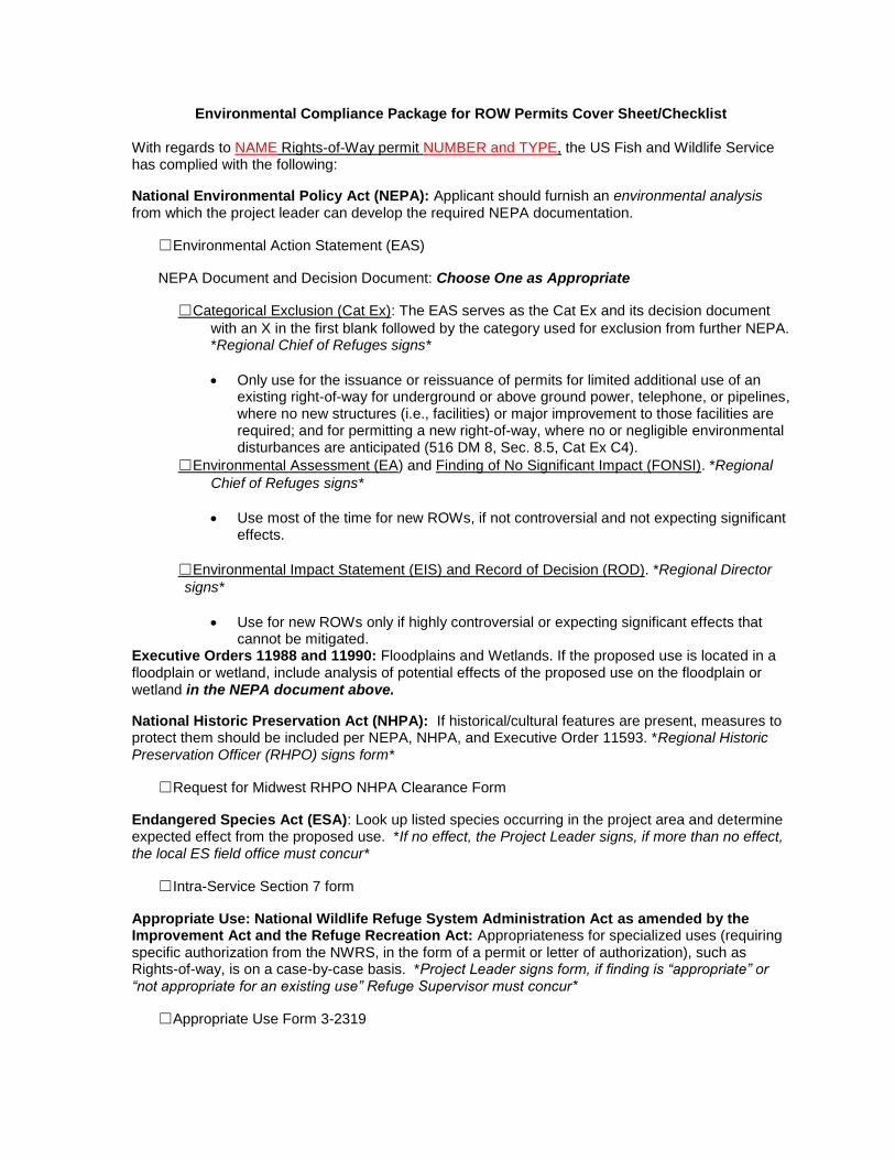
Environmental Compliance Package for ROW Permits Cover Sheet/Checklist
With regards to NAME Rights-of-Way permit NUMBER and TYPE, the US Fish and Wildlife Service has complied with the following:
National Environmental Policy Act (NEPA): Applicant should furnish an environmental analysis from which the project leader can develop the required NEPA documentation.
☐Environmental Action Statement (EAS)
NEPA Document and Decision Document: Choose One as Appropriate
☐Categorical Exclusion (Cat Ex): The EAS serves as the Cat Ex and its decision document
with an X in the first blank followed by the category used for exclusion from further NEPA. *Regional Chief of Refuges signs*
Only use for the issuance or reissuance of permits for limited additional use of an existing right-of-way for underground or above ground power, telephone, or pipelines, where no new structures (i.e., facilities) or major improvement to those facilities are required; and for permitting a new right-of-way, where no or negligible environmental disturbances are anticipated (516 DM 8, Sec. 8.5, Cat Ex C4).
☐Environmental Assessment (EA) and Finding of No Significant Impact (FONSI). *Regional
Chief of Refuges signs*
Use most of the time for new ROWs, if not controversial and not expecting significant effects.
☐Environmental Impact Statement (EIS) and Record of Decision (ROD). *Regional Director
signs*
Use for new ROWs only if highly controversial or expecting significant effects that cannot be mitigated.
Executive Orders 11988 and 11990: Floodplains and Wetlands. If the proposed use is located in a floodplain or wetland, include analysis of potential effects of the proposed use on the floodplain or wetland in the NEPA document above.
National Historic Preservation Act (NHPA): If historical/cultural features are present, measures to protect them should be included per NEPA, NHPA, and Executive Order 11593. *Regional Historic Preservation Officer (RHPO) signs form*
☐Request for Midwest RHPO NHPA Clearance Form
Endangered Species Act (ESA): Look up listed species occurring in the project area and determine expected effect from the proposed use. *If no effect, the Project Leader signs, if more than no effect, the local ES field office must concur*
☐Intra-Service Section 7 form
Appropriate Use: National Wildlife Refuge System Administration Act as amended by the Improvement Act and the Refuge Recreation Act: Appropriateness for specialized uses (requiring specific authorization from the NWRS, in the form of a permit or letter of authorization), such as Rights-of-way, is on a case-by-case basis. *Project Leader signs form, if finding is “appropriate” or “not appropriate for an existing use” Refuge Supervisor must concur*
☐Appropriate Use Form 3-2319

Compatibility: National Wildlife Refuge System Administration Act as amended by the Improvement Act: The project leader will make a recommendation whether the proposed use will be compatible, can be made compatible through specific mitigation measures, or will not be compatible and should be denied and the reasons for such denial. *Project Leader signs determination and Regional Chief of Refuges concurs*
☐Compatibility Determination (CD)
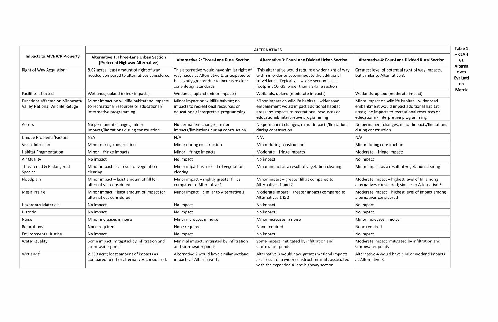
Table 1
– CSAH
61
Alterna
tives
Evaluati
on
Matrix
Impacts to MVNWR Property
ALTERNATIVES
Alternative 1: Three-Lane Urban Section (Preferred Highway Alternative)
Alternative 2: Three-Lane Rural Section Alternative 3: Four-Lane Divided Urban Section Alternative 4: Four-Lane Divided Rural Section
Right of Way Acquistion1 8.02 acres; least amount of right of way needed compared to alternatives considered
This alternative would have similar right of way needs as Alternative 1; anticipated to be slightly greater due to increased clear zone design standards.
This alternative would require a wider right of way width in order to accommodate the additional travel lanes. Typically, a 4-lane section has a footprint 10’-25’ wider than a 3-lane section
Greatest level of potential right of way impacts, but similar to Alternative 3.
Facilities affected Wetlands, upland (minor impacts) Wetlands, upland (minor impacts) Wetlands, upland (moderate impacts) Wetlands, upland (moderate impact)
Functions affected on Minnesota Valley National Wildlife Refuge
Minor impact on wildlife habitat; no impacts to recreational resources or educational/ interpretive programming
Minor impact on wildlife habitat; no impacts to recreational resources or educational/ interpretive programming
Minor impact on wildlife habitat – wider road embankment would impact additional habitat areas; no impacts to recreational resources or educational/ interpretive programming
Minor impact on wildlife habitat – wider road embankment would impact additional habitat areas; no impacts to recreational resources or educational/ interpretive programming
Access No permanent changes; minor impacts/limitations during construction
No permanent changes; minor impacts/limitations during construction
No permanent changes; minor impacts/limitations during construction
No permanent changes; minor impacts/limitations during construction
Unique Problems/Factors N/A N/A N/A N/A
Visual Intrusion Minor during construction Minor during construction Minor during construction Minor during construction
Habitat Fragmentation Minor – fringe impacts Minor – fringe impacts Moderate – fringe impacts Moderate – fringe impacts
Air Quality No impact No impact No impact No impact
Threatened & Endangered Species
Minor impact as a result of vegetation clearing
Minor impact as a result of vegetation clearing
Minor impact as a result of vegetation clearing Minor impact as a result of vegetation clearing
Floodplain Minor impact – least amount of fill for alternatives considered
Minor impact – slightly greater fill as compared to Alternative 1
Minor impact – greater fill as compared to Alternatives 1 and 2
Moderate impact – highest level of fill among alternatives considered; similar to Alternative 3
Mesic Prairie Minor impact – least amount of impact for alternatives considered
Minor impact – similar to Alternative 1 Moderate impact – greater impacts compared to Alternatives 1 & 2
Moderate impact – highest level of impact among alternatives considered
Hazardous Materials No impact No impact No impact No impact
Historic No impact No impact No impact No impact
Noise Minor increases in noise Minor increases in noise Minor increases in noise Minor increases in noise
Relocations None required None required None required None required
Environmental Justice No impact No impact No impact No impact
Water Quality Some impact: mitigated by infiltration and stormwater ponds
Minimal impact: mitigated by infiltration and stormwater ponds
Some impact: mitigated by infiltration and stormwater ponds
Moderate impact: mitigated by infiltration and stormwater ponds
Wetlands2 2.238 acre; least amount of impacts as compared to other alternatives considered.
Alternative 2 would have similar wetland impacts as Alternative 1.
Alternative 3 would have greater wetland impacts as a result of a wider construction limits associated with the expanded 4-lane highway section.
Alternative 4 would have similar wetland impacts as Alternative 3.
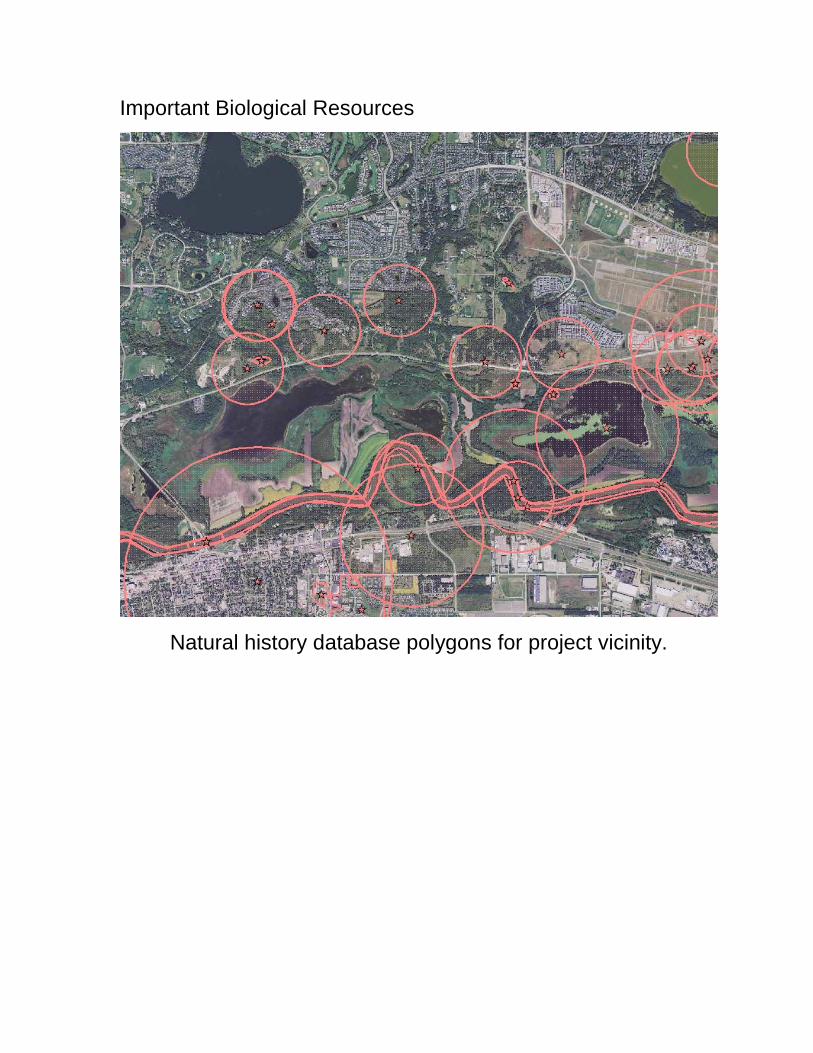
Important Biological Resources
Natural history database polygons for project vicinity.
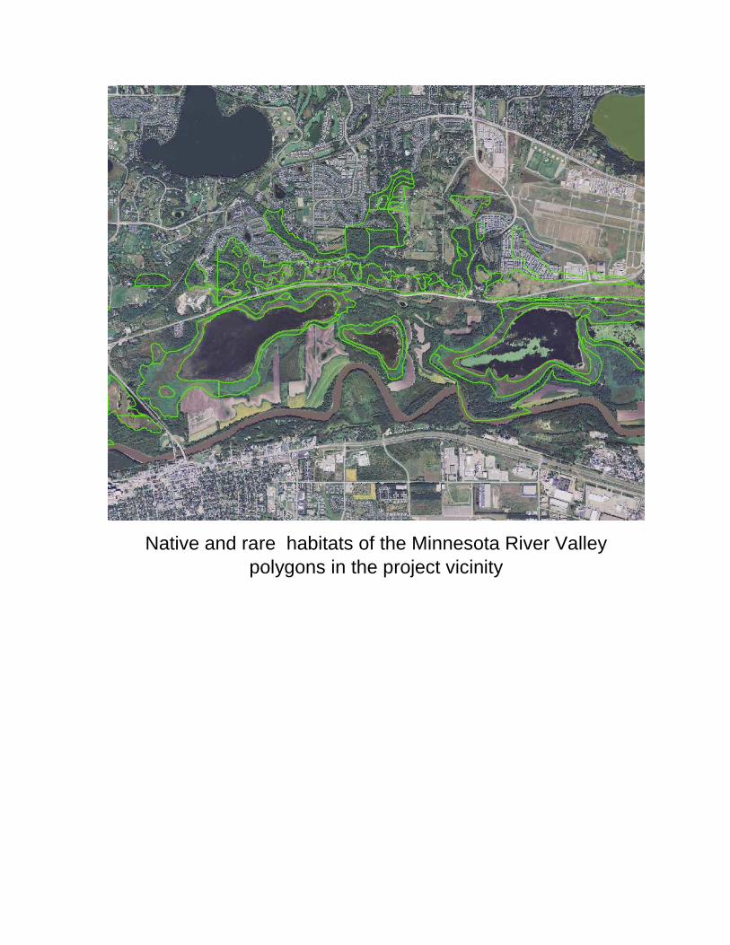
Native and rare habitats of the Minnesota River Valley
polygons in the project vicinity
Table 5 – CSASH 61 Study Area Census Data: Income and Poverty
Census Tract 260.18, Hennepin County
Census Tract 260.22, Hennepin County
Census Tract 907.02, Carver County
Hennepin County
Carver County
City of Chanhassen
City of Eden Prairie
Total Households 2,434 2,136 693 489,690 34,659 8,333 23,272
Total Families 1,775 1,930 599 280,769 25,845 6,447 16,488
Median Household income (2012 inflation adjusted dollars) $113,750 $150,156 $114,539 $64,379
$82,333
$103,462 $93,828
Median family income (2012 inflation adjusted dollars) $128,849 $155,660 $131,250 $84,836
$97,159
$121,981 $114,728
Per Capita income in 2012 (dollars) $57,564 $54,253 $51,817 $37,470
$39,632
$46,305 $48,999
Percentage of Families whose income in the past 12 months is below the poverty level 1.4 1.8 0 8 3.1
1.8 4
Percentage of People whose income in the past 12 months is below the poverty level 2.4 1.7 0 12.1 4.5
3 5.4
Poverty Data comes from Census Tract - Table DP03 - 2008-2012 American Community Survey 5-Year Estimates
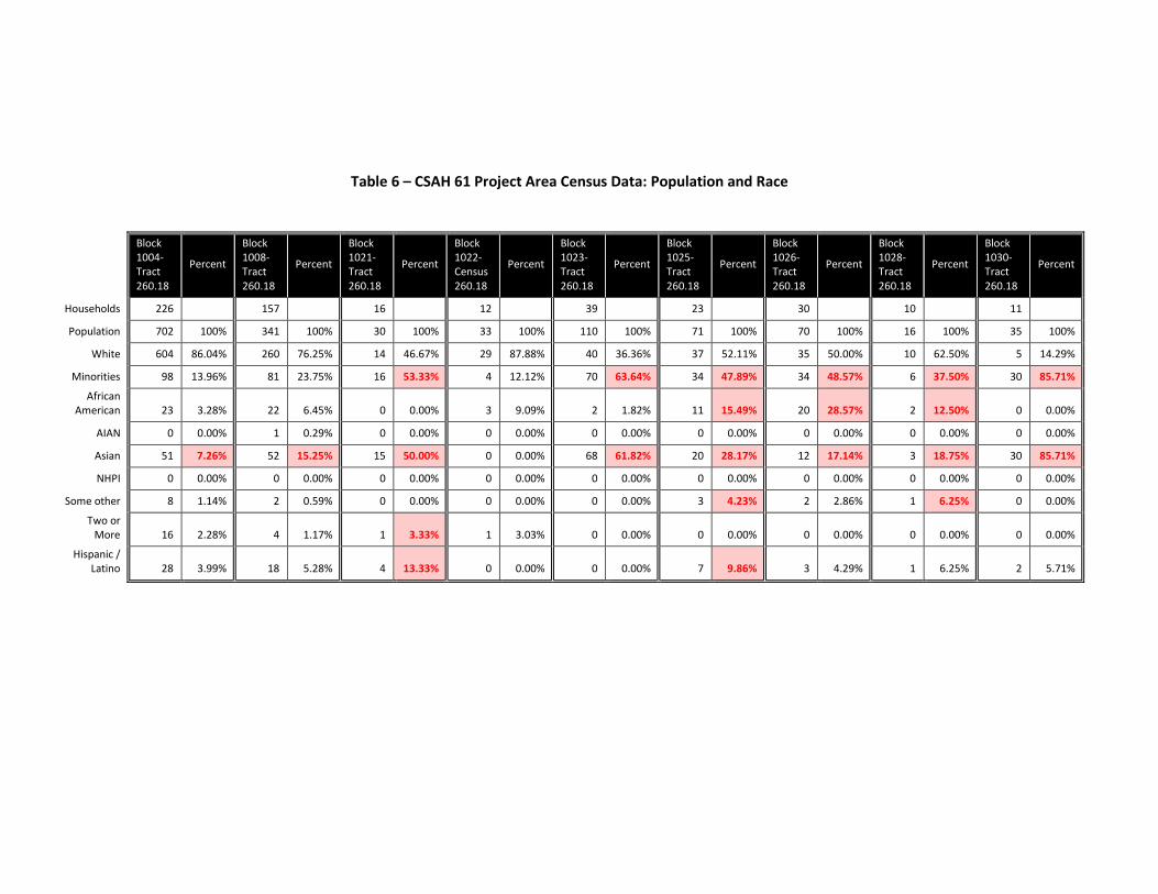
Table 6 – CSAH 61 Project Area Census Data: Population and Race
Block 1004- Tract 260.18
Percent
Block 1008- Tract 260.18
Percent
Block 1021- Tract 260.18
Percent
Block 1022-Census 260.18
Percent
Block 1023- Tract 260.18
Percent
Block 1025- Tract 260.18
Percent
Block 1026- Tract 260.18
Percent
Block 1028- Tract 260.18
Percent
Block 1030- Tract 260.18
Percent
Households 226 157 16 12 39 23 30 10 11
Population 702 100% 341 100% 30 100% 33 100% 110 100% 71 100% 70 100% 16 100% 35 100%
White 604 86.04% 260 76.25% 14 46.67% 29 87.88% 40 36.36% 37 52.11% 35 50.00% 10 62.50% 5 14.29%
Minorities 98 13.96% 81 23.75% 16 53.33% 4 12.12% 70 63.64% 34 47.89% 34 48.57% 6 37.50% 30 85.71%
African American 23 3.28% 22 6.45% 0 0.00% 3 9.09% 2 1.82% 11 15.49% 20 28.57% 2 12.50% 0 0.00%
AIAN 0 0.00% 1 0.29% 0 0.00% 0 0.00% 0 0.00% 0 0.00% 0 0.00% 0 0.00% 0 0.00%
Asian 51 7.26% 52 15.25% 15 50.00% 0 0.00% 68 61.82% 20 28.17% 12 17.14% 3 18.75% 30 85.71%
NHPI 0 0.00% 0 0.00% 0 0.00% 0 0.00% 0 0.00% 0 0.00% 0 0.00% 0 0.00% 0 0.00%
Some other 8 1.14% 2 0.59% 0 0.00% 0 0.00% 0 0.00% 3 4.23% 2 2.86% 1 6.25% 0 0.00%
Two or More 16 2.28% 4 1.17% 1 3.33% 1 3.03% 0 0.00% 0 0.00% 0 0.00% 0 0.00% 0 0.00%
Hispanic / Latino 28 3.99% 18 5.28% 4 13.33% 0 0.00% 0 0.00% 7 9.86% 3 4.29% 1 6.25% 2 5.71%