environmental consulting options tasmania - epa …epa.tas.gov.au/documents/hazell bros. group pty...
TRANSCRIPT

Environmental Consulting Options Tasmania
Mark Wapstra ABN 83 464 107 291 28 Suncrest Avenue email: [email protected] phone: (03) 62 283 220 Lenah Valley, TAS 7008 web: www.ecotas.com.au mobile: 0407 008 685
ECOtas…providing options in environmental consulting
ECOLOGICAL ASSESSMENT OF TUNBRIDGE TIER ROAD DOLERITE QUARRY, TUNBRIDGE, TASMANIA
Environmental Consulting Options Tasmania (ECOtas) for
Hazell Bros. Group Pty Ltd
15 November 2015


ECOtas…providing options in environmental consulting
Ecological Assessment of Tunbridge Tier Road Dolerite Quarry, Tunbridge, Tasmania i
CITATION
This report can be cited as: ECOtas (2015). Ecological Assessment of Tunbridge Tier Road Dolerite Quarry, Tunbridge, Tasmania. Report by Environmental Consulting Options Tasmania (ECOtas) for Hazell Bros. Group Pty Ltd, 15 November 2015.
AUTHORSHIP
Field assessment: Mark Wapstra
Report production: Mark Wapstra
Habitat and vegetation mapping: Mark Wapstra
Base data for mapping: TheList
Digital and aerial photography: Mark Wapstra, GoogleEarth, TheList
ACKNOWLEDGEMENTS
John Sherburd and Peter Bennett (Hazell Bros.) and Barry Williams (Integrated Land Management and
Planning) provided background information on the proposal.
COVER ILLUSTRATIONS
Main image: view across sheep-grazed grassland/pasture proposed for quarry expansion with existing quarry
in background. Insets (L-R): Pimelea sp. Tunbridge, Cryptandra amara, Scleranthus diander, Stackhousia subterranea – threatened flora that occur on the edges of the proposed quarry extension area.
Please note: the blank pages in this document are deliberate to facilitate double-sided printing.

ECOtas…providing options in environmental consulting
Ecological Assessment of Tunbridge Tier Road Dolerite Quarry, Tunbridge, Tasmania ii
ECOtas…providing options in environmental consulting
Ecological Assessment of Tunbridge Tier Road Dolerite Quarry, Tunbridge, Tasmania iii
CONTENTS
SUMMARY ......................................................................................................................... 1
PURPOSE, SCOPE, LIMITATIONS AND QUALIFICATIONS OF THE SURVEY .................................. 5
Purpose .................................................................................................................... 5
Scope ....................................................................................................................... 5
Limitations ................................................................................................................ 5
Qualifications ............................................................................................................. 6
Permit ...................................................................................................................... 6
PROPOSAL ........................................................................................................................ 6
THE STUDY AREA ............................................................................................................... 7
METHODS ......................................................................................................................... 8
Nomenclature ............................................................................................................ 8
Preliminary investigation ............................................................................................. 8
Field assessment ........................................................................................................ 9
Botanical survey – threatened flora .............................................................................. 9
Botanical survey – declared and environmental weeds .................................................. 10
Botanical survey – vegetation classification ................................................................. 10
Zoological survey ..................................................................................................... 15
RESULTS ........................................................................................................................ 15
Vegetation types ...................................................................................................... 15
Comments on TASVEG mapping ............................................................................ 15
Vegetation types recorded as part of the present study ............................................ 16
Plant species ........................................................................................................... 18
Priority flora species recorded from the lease area ................................................... 18
Priority flora species potentially present (database analysis) ..................................... 26
Fauna species .......................................................................................................... 26
Priority fauna species known from the study area .................................................... 26
Priority fauna species potentially present (database analysis) ................................... 26
Other ecological values ............................................................................................. 26
Weed species ...................................................................................................... 27
Rootrot pathogen, Phytophthora cinnamomi ........................................................... 27
Myrtle wilt .......................................................................................................... 27
Myrtle rust ......................................................................................................... 27
Chytrid fungus and other freshwater pathogens ...................................................... 27
Additional “Matters of National Environmental Significance” – Threatened Ecological
Communities ...................................................................................................... 28

ECOtas…providing options in environmental consulting
Ecological Assessment of Tunbridge Tier Road Dolerite Quarry, Tunbridge, Tasmania iv
Additional “Matters of National Environmental Significance” – Nationally Important
Wetlands ............................................................................................................ 28
DISCUSSION ................................................................................................................... 29
Summary of key findings ........................................................................................... 29
Legislative and policy implications .............................................................................. 31
Recommendations .................................................................................................... 34
REFERENCES ................................................................................................................... 35
APPENDIX A. Analysis of database records of threatened flora ............................................... 37
APPENDIX B. Analysis of database records of threatened fauna ............................................. 44
APPENDIX C. DPIPWE’s Natural Values Atlas report for study area ......................................... 48
APPENDIX D. Forest Practices Authority’s Biodiversity Values Atlas report for study area .......... 48
APPENDIX E. CofA’s Protected Matters report for study area.................................................. 48
OTHER ATTACHMENTS ..................................................................................................... 48
ECOtas…providing options in environmental consulting
Ecological Assessment of Tunbridge Tier Road Dolerite Quarry, Tunbridge, Tasmania 1
SUMMARY
General
Hazell Bros. Group Pty Ltd engaged Environmental Consulting Options Tasmania (ECOtas) to
undertake an assessment of the ecological values of the lease area associated with a dolerite quarry
on private land off Tunbridge Tier Road, Tunbridge, Tasmania, to ensure that the requirements of
the identified ecological values are appropriately taken into account during further project planning
and under local, State and Commonwealth government approval protocols.
Summary of key findings
Threatened flora
No plant species listed as threatened on the Commonwealth Environment Protection and
Biodiversity Conservation Act 1999 were recorded from the lease area. Two plant species
listed on the Act are known from database records but could not be located (Colobanthus
curtisiae, grassland cupflower; Leucochrysum albicans var. tricolor, grassland paperdaisy).
Both records are not located within the area proposed for quarry extension. Potential habitat
is present for additional plant species listed on the Act but targeted timed surveys have
failed to detect such species.
Ten plant species, listed as threatened on the Tasmanian Threatened Species Protection Act
1995, were detected within the lease area, but only three are located in areas that will be
disturbed by future quarry expansion activities, as follows:
Arthropodium strictum (chocolate lily): localised to south-facing slope (will not be
disturbed);
Austrostipa nodosa (knotty speargrass): extensive across pasture, rockplate grassland
and old quarry floors/faces and along access tracks (will need to be disturbed);
Austrostipa scabra subsp. falcata (sickle speargrass): as above;
Cryptandra amara (pretty pearlflower): localised to two patches on rocky outcrops at
eastern end of proposed quarry expansion area (can be practically excluded from
disturbance);
Scleranthus diander (tufted knawel): two small patches just east of existing access track
(suggested protective fencing required to minimise risk of inadvertent disturbance);
Stackhousia subterranea (grassland candles): several patches on south-facing slopes
((will not be disturbed);
Vittadinia burbidgeae (smooth new-holland-daisy): small patch just east of existing
access track (suggested protective fencing required to minimise risk of inadvertent
disturbance);
Vittadinia cuneata var. cuneata (fuzzy new-holland-daisy): one patch on rocky ridgeline
southeast of existing quarry (can be practically excluded from disturbance), one patch
on edge of older quarry area (will not be disturbed) and one patch on edge of gravel
track on existing quarry floor (will continue to be disturbed); and
Vittadinia gracilis (woolly new-holland-daisy): patches associated with rocky ridgeline
(can be practically excluded from disturbance) and an old wattle in southeast of lease
area (well away from disturbance).

ECOtas…providing options in environmental consulting
Ecological Assessment of Tunbridge Tier Road Dolerite Quarry, Tunbridge, Tasmania 2
There are database records of an additional four species listed under the Act, as follows:
Colobanthus curtisiae (grassland cupflower): record is outside proposed quarry
expansion area and species could not be located;
Hyalosperma demissum (moss sunray): database records nominally on eastern edge of
existing quarry but species could not be located;
Isoetopsis graminifolia (grass cushion): as above; and
Leucochrysum albicans var. tricolor (grassland paperdaisy): record is outside proposed
quarry expansion area and species could not be located.
One species currently unlisted but that has been approved for listing as endangered under
the TSPA was also detected, as follows:
Pimelea sp. Tunbridge (grassland riceflower): small population west of existing quarry
(suggested protective fencing required to minimise risk of inadvertent disturbance);
A permit to disturb Austrostipa nodosa and A. scabra will be required under Section 51 of
the Tasmanian Threatened Species Protection Act 1995 but this should be issued without
restrictions based on the ecology of the species. A permit to disturb a small number of
Vittadinia cuneata should also be applied for (or a variation to the existing permit obtained)
for the population detected on the existing quarry floor.
Threatened fauna
No fauna species listed as threatened on the Commonwealth Environment Protection and
Biodiversity Conservation Act 1999 or the Tasmanian Threatened Species Protection Act
1995 were detected, or are known from database records, from the lease area.
The lease area is within the predicted/known range of several species, and supports
potential habitat of these species, as follows:
Sarcophilus harrisii (Tasmanian devil): no evidence of species noted (e.g. scats,
potential den sites – no massive rock outcrops present, only occasional old logs (all
searched) and wombat/rabbit burrows (all shallow, blind and searched) – no potential
denning habitat within likely quarry expansion area (open “grassland”);
Dasyurus maculatus subsp. maculatus (spotted-tailed quoll): as above;
Tyto novaehollandiae subsp. castanops (Tasmanian masked owl): generally a low
proportion of trees with large hollows (all searched with no evidence present) – no
potential nesting habitat within likely quarry expansion area (open “grassland”);
Pseudemoia pagenstecheri (tussock skink): patches of tussock grassland present – no
potential habitat within likely quarry expansion area (open “grassland” without
significant tussock development); and
Perameles gunnii subsp. gunnii (eastern barred bandicoot): extensive areas of potential
habitat – habitat within likely quarry expansion area marginal due to rockiness and lack
of tussock development (open “grassland”).
Vegetation types
The lease area supports several TASVEG mapping units, as follows:
Eucalyptus amygdalina forest and woodland on dolerite (DAD);
Eucalyptus amygdalina inland forest and woodland on Cainozoic deposits (DAZ);
Bursaria-Acacia woodland (NBA);
Lowland grassland complex (GCL);

ECOtas…providing options in environmental consulting
Ecological Assessment of Tunbridge Tier Road Dolerite Quarry, Tunbridge, Tasmania 3
Lowland Poa labillardierei grassland (GPL);
Lowland Themeda triandra grassland (GTL);
Rockplate grassland (GRP);
Agricultural land (FAG); and
Extra-urban miscellaneous (FUM).
DAZ is classified as threatened under Schedule 3A of the Tasmanian Nature Conservation
Act 2002 but the quarry expansion will not extend into this vegetation type.
GTL and GPL, while not classified as threatened under Schedule 3A of the Tasmanian Nature
Conservation Act 2002, may equate to the EPBCA-listed Lowland Native Grasslands of
Tasmania (Critically Endangered). The site assessment indicated that these TASVEG
mapping units are not present within the area proposed for quarry expansion, which
supports mainly FAG and GRP (not threatened).
Weeds
The lease area supports localised patches of plant species classified as “declared weeds”
within the meaning of the Tasmanian Weed Management Act 1999, as follows:
Ulex europaeus (gorse): scattered patches along access track and around old quarry
(not one in current use) and in east of lease area; and
Carduus tenuifolius (winged slender thistle) and C. pycnocephalus (slender thistle):
scattered in grazed areas and in disturbed sites, usually associated with other non-
declared thistle species.
The current weed distribution does not present a significant risk to natural ecological values
such as populations of threatened flora or the condition of native vegetation. The expansion
of quarrying is unlikely to exacerbate the current weed status of the site. Stripping of topsoil
will probably concentrate weed propagules and the opportunity for weeds to colonise
disturbed ground, and these sites should be the focus of any weed control activities.
Incorporating weed management into any management plan for the site is considered
prudent.
Plant disease
No evidence of plant disease (Phytophthora cinnamomi, rootrot fungus; myrtle wilt; myrtle
rust) was detected.
No special management requirements are required in relation to these issues.
Animal disease (chytrid)
The study area is not known to support the frog chytrid pathogen.
No special management requirements are required in relation to these issues (continued
use of the water from the small dam on-site is acceptable).
Recommendations
The recommendations provided below are a summary of those provided in relation to each of the
ecological features described in the main report. The main text of the report, and supported
appendices, provide the relevant context for the recommendations.

ECOtas…providing options in environmental consulting
Ecological Assessment of Tunbridge Tier Road Dolerite Quarry, Tunbridge, Tasmania 4
Vegetation types
It is recommended that the proposed extension to the quarry exclude areas mapped as native
forest/woodland and that the rocky ridgeline be used to define the limit of works (this means that
higher priority native vegetation types are effectively wholly excluded).
Threatened flora
A permit under the Tasmanian Threatened Species Protection Act 1995 will be required for
disturbance to some species through application to the Policy Conservation & Advice Branch (PCAB,
DPIPWE).
Protection of populations of threatened flora that occur on the edge of the existing quarry and
proposed extension area is recommend (e.g. fencing of some sort), and that periodic monitoring
take place.
Threatened fauna
There is limited potential habitat present for several State- and Commonwealth-listed fauna species
but no known sites or specific habitat features (e.g. den, nests) requiring special management.
Weeds and disease
It is recommended that every effort is made to minimise the risk of introducing weeds and/or
disease to the site through application of strict machinery hygiene protocols – see guidelines in
Keeping It Clean: A Tasmanian Field Hygiene Manual to Prevent the Spread of Freshwater Pests
and Pathogens (Allan & Gartenstein 2010).
Legislation and policy
No formal referral to the relevant Commonwealth government agency under the provisions of the
Commonwealth Environment Protection and Biodiversity Conservation Act 1999 is considered
warranted.
A permit under the Tasmanian Threatened Species Protection Act 1995 will be required for
disturbance to some species through application to the Policy Conservation & Advice Branch (PCAB,
DPIPWE).

ECOtas…providing options in environmental consulting
Ecological Assessment of Tunbridge Tier Road Dolerite Quarry, Tunbridge, Tasmania 5
PURPOSE, SCOPE, LIMITATIONS AND QUALIFICATIONS OF THE SURVEY
Purpose
Hazell Bros. Group Pty Ltd engaged Environmental Consulting Options Tasmania (ECOtas) to
undertake an assessment of the ecological values of the lease area associated with a dolerite quarry
on private land off Tunbridge Tier Road, Tunbridge, Tasmania, to ensure that the requirements of
the identified ecological values are appropriately taken into account during further project planning
and under local, State and Commonwealth government approval protocols.
Scope
This report relates to:
flora and fauna species of conservation significance, including a discussion of listed
threatened species (under the Tasmanian Threatened Species Protection Act 1995 and/or
the Commonwealth Environment Protection and Biodiversity Conservation Act 1999)
potentially and actually present, and other species of conservation significance/interest;
vegetation types (forest and non-forest, native and exotic) present, including a discussion
of the distribution, condition, extent, composition and conservation significance of each
community;
plant and animal disease management issues;
weed management issues; and
a discussion of some of the policy and legislative implications of the identified ecological
values.
This report follows the government-produced Guidelines for Natural Values Surveys – Terrestrial
Development Proposals (DPIPWE 2015) in anticipation that the report (or extracts of it) may be
used as part of various approval processes that will be required for works at the site.
The assessment also complies, in a general sense, with the Tasmanian EPA’s Environmental Effects
Report requirements. The report format will also be applicable to other assessment protocols as
required the Commonwealth Department of the Environment (for any referral/approval that may
be required under the Commonwealth Environment Protection and Biodiversity Conservation Act
1999), should such referral be warranted.
Limitations
Many plant species have ephemeral or seasonal growth or flowering habits, or patchy distributions
(at varying scales), and it is possible that some species were not recorded for this reason. However,
every effort was made to sample the range of habitats present in the survey area to maximise the
opportunity of recording the majority of species present (particular those of conservation
significance). Late spring and into summer is usually regarded as the most suitable period to
undertake the majority of botanical assessments. While some species have more restricted
flowering periods, a discussion of the potential for the site to support these is presented. In this
case, a preliminary site assessment undertaken on 14 July 2015 (ECOtas 2015) indicated a very
high potential for threatened flora species to be present, and recommendations were made to
(a) remove sheep grazing to maximise the opportunity to detect threatened flora (a sheep-

ECOtas…providing options in environmental consulting
Ecological Assessment of Tunbridge Tier Road Dolerite Quarry, Tunbridge, Tasmania 6
exclusion fence was subsequently erected to prevent access to much of the area), and (b) a
schedule of targeted-timed surveys to coincide with the flowering period of several target species.
As part of timing the subsequent surveys, nearby sites with known populations of target threatened
flora were assessed to ensure site surveys coincided with the peak flowering events of many annual
species. This included Township Lagoon (mainly for Prasophyllum tunbridgense but also several
additional species), Campbell Town Golf Course (mainly for Prasophyllum incorrectum and
Caladenia anthracina but also several additional species) and Nile Road private property (for
Stackhousia subterranea). Site surveys were then coordinated to match the flowering of these
target species.
The survey was also limited to vascular species: species of mosses, lichens and liverworts were not
recorded. However, a consideration is made of threatened species (vascular and non-vascular)
likely to be present (based on habitat information and database records) and reasons presented for their apparent absence.
Surveys for threatened fauna were practically limited to an examination of “potential habitat”
(i.e. comparison of on-site habitat features to habitat descriptions for threatened fauna), and detection of tracks, scats and other signs.
Qualifications
Except where otherwise stated, the opinions and interpretations of legislation and policy expressed
in this report are made by the author and do not necessarily reflect those of the relevant agency.
The client should confirm management prescriptions with the relevant agency before acting on the
content of this report.
Permit
Any plant material was collected under DPIPWE permit TFL 13066 (in the name of Mark Wapstra).
Relevant data will be entered into DPIPWE’s Natural Values Atlas database by the author. Some plant material will be lodged at the Tasmanian Herbarium by the author.
No vertebrate or invertebrate material was collected.
PROPOSAL
The land use proposal is outlined in Tunbridge Tier Quarry – Upgrade: Notice of Intent (ILMP 2015).
The key elements of the project, as they relate to the potential impact on ecological values and the
level of assessment and reporting required, are outlined below, taken from the Notice of Intent.
The proposed layout of the Tunbridge Tier Quarry will remain similar to the existing
layout. The access road and intersection with Tunbridge Tier Road will remain in the
same locations. The existing quarry faces will be progressed in a easterly direction
once the resource from the existing footprint is exhausted.
The quarry will continue to be a campaign style operation with extracting and
crushing / screening campaigns producing stockpiles of the required products which
will be depleted to supply to projects. The increase in production will be supplied
through an increase in the scale and frequency of campaigns.
The Tunbridge Tier Quarry has the faces orientated towards the west. Stripping has
been undertaken for a width of around 15 metres behind the top of the upper face.

ECOtas…providing options in environmental consulting
Ecological Assessment of Tunbridge Tier Road Dolerite Quarry, Tunbridge, Tasmania 7
There will be ample scope to win product by advancing the upper face and
subsequently the lower face in an easterly direction.
Following on from the initial development work it will be necessary to strip
overburden from the land immediately east of the existing stripped area. This land
has dolerite bedrock outcropping over a substantial area. Overburden quantities will
be small. It will be possible to develop two faces approximately 6 metres high and
at least a 100 metres wide.
To access the deposit reserves fully it will be necessary to strip around 4 hectares
of the land mapped as agricultural land to the east and north of the existing quarry
face. The clearing will entail some loss of the native grassland that is represented
on the rocky hillock. The clearing will be staged to ensure that the minimum area
will be cleared to facilitate the required production.
The preliminary site assessment indicated that the key ecological issues that may constrain the
proposal are: (a) the classification and extent of native grassland, and (b) the distribution of
threatened flora. The quarry is currently in operation. The preliminary assessment indicated that
much of the existing quarry (including the floor, walls, access track and site office areas) were
dominated by two species of threatened flora (Austrostipa nodosa, knotty speargrass; Austrostipa
scabra subsp. falcata, sickle speargrass). As such, Hazell Bros. applied for and obtained a permit
to take under the Section 51 of the Tasmanian Threatened Species Protection Act 1995. This permit
applies to only the current quarry area and operations and not the future quarry expansion.
THE STUDY AREA
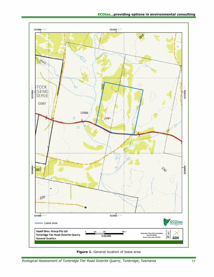
For the purposes of the assessment and report, the study area was defined as the entire lease area (Figure 1), even though only a portion of this lease area will be utilised for the quarry expansion.
The study area (Figures 1 & 2) is on private property on the north side of Tunbridge Tier Road,
west of Tunbridge, Tasmania, centred on 531872mE 5336745mN (GDA94, Tunbridge 5233
1:25,000 series Tasmap), accessed from an existing well-formed gravel road off Tunbridge Tier Road and serviced by an existing gravelled site office area.
The lease area comprises the existing quarry and sheep-grazed pastoral ground (actively sheep-
grazed until the months of the assessment) interspersed with woodland/scrub (prickly box and
wattle) dry eucalypt forest and woodland patches. The “pasture” is a mix of stock-grazed pasture
and native grassland (the classification is discussed in detail).
The far eastern edge of the lease area has a very minor drainage depression (upper reaches of a
minor tributary of the Blackman River) in pasture, well outside any area to be quarried. The western
edge of the lease area has a more distinct drainage channel/floodplain (upper reaches of a tributary
of the Blackman River), which includes a small farm dam, which is accessed by a small track from
the quarry access road to obtain water for quarry purposes. Apart from drawing water from the dam, the western drainage feature will also be unaffected by quarry activities.
Elevation varies from c. 225 m a.s.l. to c. 245 m a.s.l..
Geology (which is discussed briefly here as it can affect classification of vegetation, and potential for threatened flora, and to a lesser extent threatened fauna) is mapped as (Figure 3):
Jurassic-age “dolerite (tholeiitic) with locally developed granophyre” (geocode: Jd): most of
low hill proposed for quarrying; and
Quaternary-age “Quaternary sediments” (geocode: Qh): western part of lease area, mainly
associated with the poorly-drained ground and adjacent slopes.
ECOtas…providing options in environmental consulting
Ecological Assessment of Tunbridge Tier Road Dolerite Quarry, Tunbridge, Tasmania 8
Field assessment confirmed this broad geological mapping, with extensive areas of surface
outcropping of dolerite bedrock and extensive development of dolerite-rich regolith. Limited parts
of the eastern part of the lease area, and more extensive parts of the western parts of the lease
area, have a sandy substrate, confirming the Qh geological mapping. The patches of sandy soil in
the eastern part of the lease area are interpreted by the author as windblown surface sand with
the dominant influence on the vegetation remaining the underlying Jurassic dolerite.
Land tenure and other categorisations of the study area are as follows:
private titles (PID 6832983; Title References 131849/1 and 131849/4);
existing mining lease 1502P/M;
Northern Midlands municipality, zoned as Rural Resource under the Northern Midlands
Interim Planning Scheme 2013, and partly subject to the Priority Habitat Overlay (but not
in areas subject to the quarry extension proposal);
Northern Midlands Bioregion (according to the 5/6.1 boundaries used by most government
agencies); and
Southern Natural Resource Management (NRM) region.
The study area is bound by:
private titles on eastern, northern and western boundaries (same landowner); and
Tunbridge Tier Road on southern boundary.
METHODS
Nomenclature
All grid references in this report are in GDA94, except where otherwise stated.
Vascular species nomenclature follows de Salas & Baker (2015) for scientific names and Wapstra
et al. (2005+) for common names. Fauna species scientific and common names follow the listings
in the cited Natural Values Atlas reports (DPIPWE 2015a).
Vegetation classification follows TASVEG 3.0, as described in From Forest to Fjaeldmark:
Descriptions of Tasmania’s Vegetation (Kitchener & Harris 2013).
Preliminary investigation
Available sources of threatened flora records, vegetation mapping and other potential
environmental values were interrogated. These sources include:
Tasmanian Department of Primary Industries, Parks, Water & Environment’s Natural Values
Atlas records for threatened flora and fauna (GIS coverage maintained by the author
current as at date of report);
Tasmanian Department of Primary Industries, Parks, Water & Environment’s Natural Values
Atlas Report No. 64016 ECOtas_HazellBros_TunbridgeTier for a point (531872mE
5336745mN) indicating the approximate centre of the mining lease area, buffered by 5 km,
dated 13 July 2015 (DPIPWE 2015a) – Appendix C;
Forest Practices Authority’s Biodiversity Values Database report, specifically the species’
information for grid reference centroid 531872mE 5336745mN (nominally the centroid of
ECOtas…providing options in environmental consulting
Ecological Assessment of Tunbridge Tier Road Dolerite Quarry, Tunbridge, Tasmania 9
the Natural Values Atlas search area), buffered by 5 km, hyperlinked species’ profiles and
predicted range boundary maps, dated 13 July 2015 (FPA 2015) – Appendix D;
Commonwealth Department of the Environment’s Protected Matters Search Tool Report for
a point (-42.12219, 147.38576) indicating the approximate centre of the mining lease area
defining the subject title, buffered by 5 km, dated 13 July 2015 (CofA 2015) – Appendix E;
the TASVEG 3.0 vegetation coverage (as available through a GIS coverage);
GoogleEarth and TheList aerial imagery (Figure 2); and
other sources listed in tables and text as indicated.
Field assessment
Field assessments were undertaken on the following dates:
14 Jul. 2015 Mark Wapstra Initial site reconnaissance to ascertain “fatal flaws”
and determine a “way forward” for assessments and
reporting
3 Sep. 2015 Mark Wapstra Threatened flora surveys
29 Sep. 2015 Mark Wapstra Threatened flora surveys
30 Oct. 2015 Mark Wapstra Threatened flora surveys, vegetation type mapping
2 Nov. 2015 Mark Wapstra Final mapping of threatened flora populations
3 Nov. 2015 Mark Wapstra Re-GPSing of threatened flora sites.
Botanical survey – threatened flora
The subject title was assessed by slow-walking meandering transects designed to sample the range
of habitat types to maximise the opportunity of detecting populations of threatened flora. Where
threatened flora were detected, hand-held GPS (Garmin Oregon 650) was used to waypoint the
approximate centre and/or extent of the population (for more extensive populations). Absolute
counts of individuals were made, where practical. The term “where practical” is applied because
some plant species were impractical to count accurately due to high numbers and extent
(e.g. Austrostipa nodosa and Austrostipa scabra subsp. falcata) or growth habit (e.g. Stackhousia
subterranea is rhizomatous and counting emergent stems is not necessarily a true reflection of the
number of individuals).
Existing database records of threatened flora from within the lease area were assessed by reference
to the grid reference, precision and record notes (Figure xxx). These included the following:
Colobanthus curtisiae (grassland cupflower), A. Pyrke, 1 Jan. 1990 (this is a nominal date
only indicating a year of collection, not a day and month), 532112mE 5336483mN ± 50 m
(this is a high level of precision for a record that is dubiously dated and nominally placed
on the flats in the southeast corner of the lease area rather than a roadside verge, which
is probably the more likely site of collection from a government employee);
Hyalosperma demissum (moss sunray), L. Gilfedder, 1 Jan. 1995 (see notes above),
531912mE 5336683mN ± 100 m & (same location, precision) D. Ziegeler, 19 Oct. 1995 –
this is an annual herb, often associated with rockplate grasslands so collection from
somewhere on the rocky slope north of Tunbridge Tier Road is likely but whether it is as
accurately placed as indicated is unknown (i.e. on the edge of the existing quarry) as it
ECOtas…providing options in environmental consulting
Ecological Assessment of Tunbridge Tier Road Dolerite Quarry, Tunbridge, Tasmania 10
seems more likely that the species would be associated with the rocky outcrops of the
south-facing slope south of the quarry);
Isoetopsis graminifolia (grass cushion) – details as above;
Leucochrysum albicans var. tricolor (grassland paperdaisy), J.B. Kirkpatrick/L. Gilfedder,
1 Jan. 1994 (see notes above regarding dates in this format), 532012mE 5336583mN
± 100 m – the record is nominally placed in the grassy woodland southeast of the existing
quarry but the date of collection and the location is of low precision, indicating that the
collection could have been made in a wide area and not necessarily from the private
property;
Stackhousia subterranea (grassland candles), A.M. Buchanan, 23 Oct. 1985, 531812mE
5336583mN ± 100 m – this is nominally placed just south of the existing quarry and is
probably placed relatively precisely as the collection is actually labelled “hill on N side of
Tunbridge Tier Road, 4.3km from Midlands Highway”; and
Stackhousia subterranea (grassland candles), A.M. Buchanan, 25 Nov. 1985 & 22 Dec.
1985, 532212mE 5336483mN ± 100 m – this is nominally placed in the small patch of
forest adjacent to the drainage depression in the southeast of the lease area, which is
probably somewhat inaccurate because the records are labelled “Tunbridge Tiers Road,
3km W of the Midlands Highway” suggesting roadside verge collections.
Where populations of threatened flora were detected metal pin markers were used to permanently
mark the sites for future reference (populations of threatened Austrostipa species were not flagged
as they were extensive).
Botanical survey – declared and environmental weeds
Where “declared weeds”, within the meaning of the Tasmanian Weed Management Act 1999, or
“environmental weeds” as considered by the author, were detected, hand-held GPS (Garmin
Oregon 650) was used to waypoint the location of individuals (for single individuals or small but
discrete patches) or approximate centre and/or extent of the population (for more extensive
populations).
Botanical survey – vegetation classification
Vegetation classification follows TASVEG 3.0, as described in Kitchener & Harris (2013). Vegetation
was classified by meandering transects to identify vegetation transitions and marking with hand-
held GPS (Garmin Oregon 650) for later comparison to aerial photography or key features
(e.g. road verges, quarry edges, property boundaries, distinctive trees, drainage features, dams,
etc.).
The classification of “grassland” areas was complex due to a long history of sheep grazing. Some
areas are mapped as “agricultural land” (TASVEG code: FAG) and in the field presents as thistle-
infested sheep-grazed “grassland” in a mosaic with more native grassland dominated by species of
Austrostipa and Themeda triandra. The classification of the different types of “grassland” has
potentially significant implications for future management as some classifications have a low
priority for conservation management and others a very high priority for conservation
management.
ECOtas…providing options in environmental consulting
Ecological Assessment of Tunbridge Tier Road Dolerite Quarry, Tunbridge, Tasmania 11
Figure 1. General location of lease area

ECOtas…providing options in environmental consulting
Ecological Assessment of Tunbridge Tier Road Dolerite Quarry, Tunbridge, Tasmania 12
Figure 2. Detailed location of lease area showing aerial imagery

ECOtas…providing options in environmental consulting
Ecological Assessment of Tunbridge Tier Road Dolerite Quarry, Tunbridge, Tasmania 13
Figure 3. Geology of lease area

ECOtas…providing options in environmental consulting
Ecological Assessment of Tunbridge Tier Road Dolerite Quarry, Tunbridge, Tasmania 14
Figure 4. Existing NVA records of threatened flora from lease area and surrounds

ECOtas…providing options in environmental consulting
Ecological Assessment of Tunbridge Tier Road Dolerite Quarry, Tunbridge, Tasmania 15
Zoological survey
Surveys for threatened fauna were practically limited to an examination of “potential habitat”
(i.e. comparison of on-site habitat features to habitat descriptions for threatened fauna), and
detection of tracks, scats and other signs, except as indicated below.
Surveys for the Tasmanian devil comply with the intent of Survey Guidelines and Management
Advice for Development Proposals that may impact on the Tasmanian Devil (Sarcophilus harrisii)
(DPIPWE 2015) because the surveys for threatened flora detection and mapping, and vegetation
classification, meant that the study area was criss-crossed on numerous occasions (with the intent
of as close to 100% coverage as practical)
RESULTS
Vegetation types
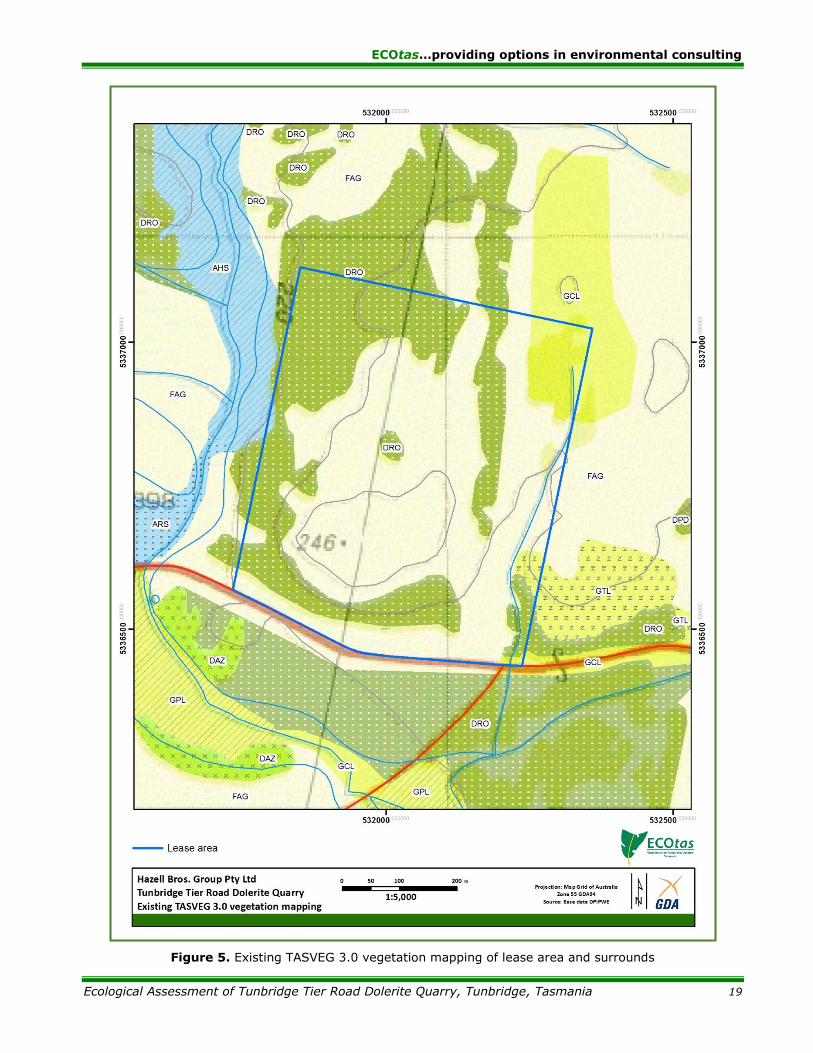
Comments on TASVEG mapping
This section, which comments on the existing TASVEG 3.0 mapping for the study area, is included
to highlight the differences between existing mapping and the more recent mapping from the
present study to ensure that any parties assessing land use proposals (via this report) do not rely
on existing mapping. Note that TASVEG mapping, which was mainly a desktop mapping exercise
based on aerial photography, is often substantially different to ground-truthed vegetation mapping,
especially at a local scale. An examination of existing vegetation mapping is usually a useful pre-
assessment exercise to gain an understanding of the range of habitat types likely to be present
and the level of previous botanical surveys.
TASVEG mapping of grassland communities is notoriously inconsistent due to several interpreters
being used and the influence of the degree of clarity of aerial imagery, especially if it does not
accurately depict the level of grazing (heavily grazed ground can appear as dry native grassland).
TASVEG 3.0 maps the lease area as (see also Figure 5):
“Eucalyptus rodwayi forest” (TASVEG code: DRO): areas shown as “green” on topographic
maps and forest/woodland on aerial imagery;
“agricultural land” (TASVEG code: FAG): cleared areas of “grassland” including the existing
quarry area;
“lowland grassland complex” (TASVEG code: GCL): small area in northeast and southeast
of lease area;
“lowland Themeda triandra grassland” (TASVEG code: GTL): small outcrop of native
vegetation in the southeast of lease area; and
“saline aquatic herbland” (TASVEG code: AHS): drainage flat in west of lease area (to be
unaffected), contiguous with “saline sedgeland/rushland” (TASVEG code: ARS) that
continues further south.
The mapping of DRO is inconsistent with geological mapping and topography and a good example
of why TASVEG mapping needs to be ground-truthed as DRO is usually associated with broad flats
with impeded drainage not well-drained rocky slopes. As intimated earlier, the classification of
“grassland” areas will be discussed in detail below but suffice to say that the mapping of the entire
area of open grassy habitat as “agricultural land” does not reflect the mosaic of pattern shown in

ECOtas…providing options in environmental consulting
Ecological Assessment of Tunbridge Tier Road Dolerite Quarry, Tunbridge, Tasmania 16
a range of ages of aerial imagery. The broad drainage flat on the western boundary of the lease
area is correctly mapped as AHS and ARS, but these vegetation types probably do not extend
properly into the lease area.
Vegetation types recorded as part of the present study
Vegetation types have been classified according to TASVEG 3.0, as described in From Forest to
Fjaeldmark: Descriptions of Tasmania’s Vegetation (Kitchener & Harris 2013). Table 1 summarises
the vegetation types identified from the lease area. Figure 6 indicates the revised mapping of the
vegetation within the study area.
The key management issue associated with the lease area is the extent of vegetation types with a
priority for conservation management, especially those within the area into which the quarry will
be extended. Most of the lease area has been extensively grazed and to a certain extent this has
affected the composition of the vegetation. In addition, while the majority of the lease area is
clearly underlain by Jurassic dolerite, some parts are overlain by (presumably) windblown sand.
Quarrying will only occur in areas clearly underlain by dolerite.
The existing vegetation mapping in relation to forest and woodland classifications is entirely
inaccurate (because no areas of Eucalyptus rodwayi-dominated forest are present: in fact no
Eucalyptus rodwayi is present). Forested areas are dominated by Eucalyptus amygdalina,
Eucalyptus pauciflora and Eucalyptus viminalis. The geological substrate affects the classification
of these areas. Areas on dolerite are classified as “Eucalyptus amygdalina forest and woodland on
dolerite” (TASVEG code: DAD), into which I have subsumed some limited areas dominated by
Eucalyptus amygdalina mapped on dolerite but with a shallow covering of sand but some dolerite
regolith still present. Areas dominated by Eucalyptus pauciflora occur mainly on sandy substrates
and best match the concept of “Eucalyptus amygdalina inland forest and woodland on Cainozoic
deposits” (TASVEG code: DAZ). DAD and DVG are not classified as threatened under Schedule 3A
of the Tasmanian Nature Conservation Act 2002 but DAZ is. No areas of forest or woodland are
anticipated to be cleared such that there are no management implications because of the
forest/woodland classification.
Small areas are locally dominated by Bursaria spinosa and can be classified as “Bursaria-Acacia
woodland” (TASVEG code: NBA), although in practice some of these patches are quite small and
essentially part of the forest and/or grassland mosaic (this is a minor problem when undertaking
vegetation mapping at a relatively small scale).
This leaves the area of open “grassland” to classify. On initial assessment, I thought that the wide
gentle swale east of the existing quarry may have reverted to being dominated by Themeda
triandra after the removal of sheep. However, several months after stock removal, this area
remains clearly dominated by species of thistle and introduced pasture grasses mixed with mainly
Austrostipa species and Themeda triandra (but clearly not dominated by the latter). On this basis,
this area has been mapped as “agricultural land” (TASVEG code: FAG) rather than a native
grassland unit (the closest match would be “lowland grassland complex” (TASVEG code: GCL),
which is not a threatened vegetation type).
Outside this more modified area of “grassland”, the rock cover increases markedly, concomitant
with an increase in dominance of Austrostipa species and Themeda triandra. The intersectional key
to grassland mapping units separates off “rockplate grassland” (TASVEG code: GRP) in the first
key couplet defined by “grassland vegetation associated with shallow soils on rockplates”. In my
opinion, the sites within the lease area clearly meet the intent of this description because of the
obvious shallow soils and shallow bedrock of dolerite with some areas covered by a loose regolith
rather than manifesting as rockplates per se. GRP is not classified as threatened under Schedule
3A of the Tasmanian Nature Conservation Act 2002 and does not technically qualify as the EPBCA-
listed Threatened Ecological Community Lowland Native Grasslands of Tasmania.

ECOtas…providing options in environmental consulting
Ecological Assessment of Tunbridge Tier Road Dolerite Quarry, Tunbridge, Tasmania 17
On slopes to the east (and some parts along the western boundary), the dominance of Themeda
triandra is clear and the rock cover is much less. In my opinion, these areas are classifiable as
“lowland Themeda triandra grassland” (TASVEG code: GTL). GTL is classified as threatened under
Schedule 3A of the Tasmanian Nature Conservation Act 2002 and may equate to the EPBCA-listed
Threatened Ecological Community Lowland Native Grasslands of Tasmania (Critically Endangered)
in some circumstances. In this case, the areas mapped as GTL are all outside the likely extent of
quarry extension and as such no special management is required.
On slopes to the south and south east of the existing quarry, some areas are dominated by Poa
labillardierei and essentially devoid of a eucalypt or tall shrub canopy, and therefore classifiable as
lowland Poa labillardierei grassland” (TASVEG code: GPL). GPL is not classified as threatened under
Schedule 3A of the Tasmanian Nature Conservation Act 2002 but may equate to the EPBCA-listed
Threatened Ecological Community Lowland Native Grasslands of Tasmania (Critically Endangered)
in some circumstances. In this case, the areas mapped as GTL are all outside the likely extent of
quarry extension and as such no special management is required.
Some areas of “grassland” that has been heavily sheep-grazed but retain a sparse cover of eucalypt
stags (less than 1% cover) is difficult to classify because of the altered species composition. I am
uncomfortable classifying these areas as GPL, GTL or GRP because they do not match the areas
described above. As such, I have chosen to classify these sites into the (somewhat catch-all) of
“lowland grassland complex” (TASVEG code: GCL).
Table 1. Vegetation mapping units present in lease area
[conservation priorities: NCA – as per Schedule 3A of the Tasmanian Nature Conservation Act 2002, using units described by Kitchener & Harris (2013), relating to TASVEG mapping units only (DPIPWE 2015b); table headings are as per modules
in Kitchener & Harris (2013); EPBCA – as per the listing of ecological communities on the Commonwealth Environment Protection and Biodiversity Conservation Act 1999, relating to communities as described under that Act, but with
equivalencies to TASVEG units; area approximate only]
TASVEG mapping unit
(Kitchener & Harris 2013)
Conservation priority
NCA
EPBCA
Comments
Dry eucalypt forest and woodland
Eucalyptus amygdalina forest and woodland on
dolerite
(DAD)
Not threatened
Not threatened See discussion above.
Eucalyptus amygdalina inland forest and
woodland on Cainozoic deposits
(DAZ)
Threatened
Not threatened See discussion above.
Non eucalypt forest and woodland
Bursaria-Acacia woodland
(NBA)
Not threatened
Not threatened See discussion above.
Native grassland vegetation
Lowland grassland complex
(GCL)
Not threatened
Not threatened See discussion above.
Lowland Poa labillardierei grassland
(GPL)
Not threatened
Potentially threatened
See discussion above.

ECOtas…providing options in environmental consulting
Ecological Assessment of Tunbridge Tier Road Dolerite Quarry, Tunbridge, Tasmania 18
TASVEG mapping unit
(Kitchener & Harris 2013)
Conservation priority
NCA
EPBCA
Comments
Lowland Themeda triandra grassland
(GTL)
Not threatened
Potentially threatened
See discussion above.
Rockplate grassland
(GRP)
Not threatened
Not threatened See discussion above.
Agricultural, urban and exotic vegetation
Agricultural land
(FAG)
Not threatened
Not threatened See discussion above.
Extra-urban miscellaneous
(FUM)
Not threatened
Not threatened
Areas of existing and old quarry are mapped as FUM, as well as the areas of existing gravel roads, parking areas and site offices.
Plant species
Priority flora species recorded from the lease area
Several species listed as threatened on the Tasmanian Threatened Species Protection Act 1995
(TSPA) and/or the Commonwealth Environment Protection and Biodiversity Conservation Act 1999
(EPBCA) were detected, or are known from database records, from the lease area. These are
discussed below (alphabetically by scientific name).
Arthropodium strictum (chocolate lily) [TSPA: rare; EPBCA: not listed]
This species was detected from a small number of sites in the grassy woodland on the south-facing
slope south of the existing quarry. The initial observations were only of vegetative (non-flowering)
material during September but surveys later in the season failed to detect flowering plants (despite
numerous other sites in the Midlands having prolific flowering).
The proposed quarry expansion does not extend to any sites supporting this species so a permit
under Section 51 of the TSPA will not be needed. The species has been accepted for removal from
the TSPA (awaiting gazettal of decision) so further special management is not considered
warranted. The sites have not been flagged.
Austrostipa nodosa (knotty speargrass) [TSPA: rare; EPBCA: not listed]
This species is locally dominant over much of the lease area, particularly prevalent on disturbed
sites such as the existing quarry floor and faces, access track and open grazed areas. It co-occurs
with Austrostipa scabra (see below) and numerous other native grassland species. It appears to
have been manifestly benefited by the disturbance from quarrying and grazing, being in lowest
abundance in forested areas and better-developed pasture.
This species has been recommended for delisting from schedules of the TSPA by the Scientific
Advisory Council and is awaiting formal gazettal of this. On this basis, and the fact that the species
clearly responds positively to disturbance, no special management is recommended in relation to
the future quarry expansion.
ECOtas…providing options in environmental consulting
Ecological Assessment of Tunbridge Tier Road Dolerite Quarry, Tunbridge, Tasmania 19
Figure 5. Existing TASVEG 3.0 vegetation mapping of lease area and surrounds

ECOtas…providing options in environmental consulting
Ecological Assessment of Tunbridge Tier Road Dolerite Quarry, Tunbridge, Tasmania 20
Figure 6. Revised vegetation mapping of lease area

ECOtas…providing options in environmental consulting
Ecological Assessment of Tunbridge Tier Road Dolerite Quarry, Tunbridge, Tasmania 21
Figure 7. Distribution of threatened flora (present study only) from lease area
ECOtas…providing options in environmental consulting
Ecological Assessment of Tunbridge Tier Road Dolerite Quarry, Tunbridge, Tasmania 22
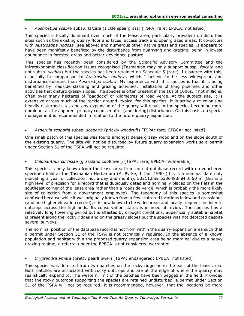
Austrostipa scabra subsp. falcata (sickle speargrass) [TSPA: rare; EPBCA: not listed]
This species is locally dominant over much of the lease area, particularly prevalent on disturbed
sites such as the existing quarry floor and faces, access track and open grazed areas. It co-occurs
with Austrostipa nodosa (see above) and numerous other native grassland species. It appears to
have been manifestly benefited by the disturbance from quarrying and grazing, being in lowest
abundance in forested areas and better-developed pasture.
This species has recently been considered by the Scientific Advisory Committee and the
infrataxonomic classification issues recognised (Tasmanian may only support subsp. falcata and
not subsp. scabra) but the species has been retained on Schedule 5 (rare). I disagree with this,
especially in comparison to Austrostipa nodosa, which I believe to be less widespread and
disturbance-tolerant than Austrostipa scabra. My experience with this species is that it is being
benefited by roadside slashing and grazing activities, installation of long pipelines and other
activities that disturb grassy slopes. The species is often present in the 10s of 1000s, if not millions,
often over many hectares of “paddock” or kilometres of road verge. At the subject site, it is
extensive across much of the rockier ground, typical for this species. It is actively re-colonising
heavily disturbed sites and any expansion of the quarry will result in the species becoming more
dominant as the apparent primary coloniser after (and during) disturbance. On this basis, no special
management is recommended in relation to the future quarry expansion.
Asperula scoparia subsp. scoparia (prickly woodruff) [TSPA: rare; EPBCA: not listed]
One small patch of this species was found amongst dense grassy woodland on the slope south of
the existing quarry. The site will not be disturbed by future quarry expansion works so a permit
under Section 51 of the TSPA will not be required.
Colobanthus curtisiae (grassland cupflower) [TSPA: rare; EPBCA: Vulnerable]
This species is only known from the lease area from an old database record with no vouchered
specimen held at the Tasmanian Herbarium (A. Pyrke, 1 Jan. 1990 (this is a nominal date only
indicating a year of collection, not a day and month), 532112mE 5336483mN ± 50 m (this is a
high level of precision for a record that is dubiously dated and nominally placed on the flats in the
southeast corner of the lease area rather than a roadside verge, which is probably the more likely
site of collection from a government employee). The taxonomy of this species is somewhat
confused because while it was originally known from a few scattered locations in lowland grasslands
(and one higher elevation record), it is now known to be widespread and locally frequent on dolerite
outcrops across the highlands. Its conservation status is in need of review. The species has a
relatively long flowering period but is affected by drought conditions. Superficially suitable habitat
is present along the rocky ridges and on the grassy slopes but the species was not detected despite
several surveys.
The nominal position of the database record is not from within the quarry expansion area such that
a permit under Section 51 of the TSPA is not technically required. In the absence of a known
population and habitat within the proposed quarry expansion area being marginal due to a heavy
grazing regime, a referral under the EPBCA is not considered warranted.
Cryptandra amara (pretty pearlflower) [TSPA: endangered; EPBCA: not listed]
This species was detected from two patches on the rocky ridgeline in the east of the lease area.
Both patches are associated with rocky outcrops and are at the edge of where the quarry may
realistically expand to. The western limit of the patches have been pegged in the field. Provided
that the rocky outcrops supporting the species are retained undisturbed, a permit under Section
51 of the TSPA will not be required. It is recommended, however, that the locations be more

ECOtas…providing options in environmental consulting
Ecological Assessment of Tunbridge Tier Road Dolerite Quarry, Tunbridge, Tasmania 23
formally protected prior to commencement of works close to the sites to minimise the risk of
inadvertent impact (e.g. topsoil/spoil being placed on top). The management of these two sites
coincides with the desire to keep the quarry activities shielded from direct view from Tunbridge
Tier Road, such that retention of the rocky ridgeline serves dual purposes. In my opinion, a buffer
of approximately 10 m from the edge of the rocky outcrop should be sufficient to appropriately
protect these sites from the risk of inadvertent disturbance and indirect impacts (e.g. dust from
adjacent quarrying works).
Hyalosperma demissum (moss sunray) [TSPA: endangered; EPBCA: not listed]
Isoetopsis graminifolia (grass cushion) [TSPA: vulnerable; EPBCA: not listed]
These species are both known only from database records, with two records for each species from
the same location (L. Gilfedder, 1 Jan. 1995 (year accurate only), 531912mE 5336683mN
± 100 m & (same location, precision) D. Ziegeler, 19 Oct. 1995). As the species were detected by
the same people on the same date from the same location, they are considered together in this
section.
These annual herbs are often associated with rockplate grasslands so collection from somewhere
on the rocky slope north of Tunbridge Tier Road is likely but whether it is as accurately placed as
indicated is unknown (i.e. on the edge of the existing quarry) as it seems more likely that the
species would be associated with the rocky outcrops of the south-facing slope south of the quarry.
Despite several surveys that coincided with the flowering period of several threatened annual herbs
at several locations in the greater Midlands (including Powranna Road Nature Reserve, Tom Gibson
Nature Reserve, “Vaucluse” private reserve, Township Lagoon, Blessington area), these, or other,
annual herbs were not detected from the lease area. Drought conditions may have contributed to
this absence, or the species may have been eliminated by the grazing activities or some other
factor. These annual herbs can flower erratically and ne absent for many years from known sites,
responding to seasonal conditions with a flourish of flowering.
In the absence of a confirmed site for these species, applying management actions to ensure their
persistence is problematic. Technically, a permit under Section 51 of the TSPA will probably be
needed because the records do fall on the edge of the existing quarry such that any expansion east
would eliminate the nominal position of the sites. In my opinion, such a permit should be granted
without conditions given the recent surveys failed to detect the species and there is no available
information on the extent/abundance of the species that may be impacted. Loss of these sites,
however, is unlikely to alter the conservation status of the species because both are being detected
with increasing frequency from many novel sites. Informal extension surveys along the rocky ridge
at the time of monitoring other threatened plant populations is recommended.
Leucochrysum albicans var. tricolor (grassland paperdaisy) [TSPA: endangered; EPBCA:
Endangered]
This species is only known from the lease area from an old database record with no vouchered
specimen held at the Tasmanian Herbarium (J.B. Kirkpatrick/L. Gilfedder, 1 Jan. 1994 (this date
format indicates the year is correct but the day and month not known), 532012mE 5336583mN
± 100 m). The record is nominally placed in the grassy woodland southeast of the existing quarry
but the date of collection and the location is of low precision, indicating that the collection could
have been made in a wide area and not necessarily from the private property in question. Given
that the present surveys were deliberately timed for when the species was in flower (confirmed by
reference to the known population at the nearby Township Lagoon) and it was not detected, it is
reasonable to assume that the proposed quarry extension will not impact on any known sites for
the species. The nominal position of the database record is not from within the quarry expansion
area such that a permit under Section 51 of the TSPA is not technically required. In the absence of

ECOtas…providing options in environmental consulting
Ecological Assessment of Tunbridge Tier Road Dolerite Quarry, Tunbridge, Tasmania 24
a known population and habitat within the proposed quarry expansion area being marginal due to
a heavy grazing regime, a referral under the EPBCA is not considered warranted.
Pimelea sp. Tunbridge (grassland riceflower) [TSPA: pending; EPBCA: not listed]
This species is not yet formally described but is listed in the Census of Vascular Plants of Tasmania
(de Salas & Baker 2015) as “Pimelea sp. Tunbridge (A.Moscal 9026) Tas Herbarium”. It is most
closely related to Pimelea curviflora and Pimelea micrantha but is restricted to a very small number
of sites along Tunbridge Tier Road, Midland Highway north and south of Tunbridge, and Lake Leake
Road. It has been considered by the Scientific Advisory Committee and a recommendation to list
the species as endangered (Schedule 5) under the TSPA accepted (awaiting formal gazettal). As
such, it is reasonable to treat this species as endangered for the purposes of management.
The detection of an additional population of this species is exciting and represents a minor range
extension. It was detected on the grassy slopes amongst Bursaria spinosa shrubland between the
access track and the existing quarry area. The continued use of the existing quarry and the
proposed extension of the quarry to the east poses no significant risk to this population. Provided
that the sites are not disturbed, no permit under Section 51 of the TSPA will be required. However,
it is recommended that the site be more formally protected as soon as practical to minimise the
risk of inadvertent disturbance (e.g. trucks turning around along access road, spoil spilling down
from existing quarry) but erection of a post and wire (or similar) fence. Ideally, the fenced area
should include the populations of Vittadinia burbidgeae and Scleranthus diander, which are located
close to the access track. Periodic monitoring of these species by Hazell Bros. staff in conjunction
with a suitably qualified ecologist is recommended, as this will supplement monitoring of the species
by Threatened Plants Tasmania (Wildcare Inc.) and DPIPWE along Tunbridge Tier Road.
Scleranthus diander (tufted knawel) [TSPA: vulnerable; EPBCA: not listed]
This species was detected from two nearby patches on the eastern side of the access track, on the
edge of Bursaria spinosa (prickly box) woodland. No change to the access track is required so this
site will remain undisturbed so a permit will not be required under Section 51 of the TSPA. It occurs
near an area that also supports Pimelea sp. Tunbridge (soon to be listed as endangered under the
TSPA) and Vittadinia burbidgeae (listed as rare under the TSPA), and therefore will be protected
from disturbance by management recommendations made for those two species. That said,
protection from disturbance is not strongly warranted (although this will be a by-product of
managing other species that do warrant protection) because the species is not deleteriously
affected by minor disturbance. The two patches have been pegged in the field.
Stackhousia subterranea (grassland candles) [TSPA: endangered; EPBCA: not listed]
This species was known from the general area prior to the present assessments (A.M. Buchanan,
23 Oct. 1985, 531812mE 5336583mN ± 100 m, “hill on N side of Tunbridge Tier Road, 4.3km from
Midlands Highway”) but with no detailed population information. The present assessment identified
several patches of different extent and abundance on the grassy slopes south and southeast of the
existing quarry. These have all been pegged out for future reference. The proposed quarry
extension will not extend beyond the rocky ridgeline (for visual management reasons) and
therefore there is a very low risk of disturbance to these patches. The main risk is from inadvertent
spillage of spoil over the slope although based on on-site discussions, this risk is considered
negligible as the working area will finish well short of the ridgeline. Formally fencing the patches is
probably not warranted, except for future reference (see comments on monitoring below). On this
basis, a permit under Section 51 of the TSPA will not be required.
It is difficult to estimate the abundance of individuals in patches of Stackhousia subterranea
because it has a rhizomatous growth habit and flowering stems are present and detectable for a

ECOtas…providing options in environmental consulting
Ecological Assessment of Tunbridge Tier Road Dolerite Quarry, Tunbridge, Tasmania 25
short period of the year only. Any abundance estimate probably (a) underestimates the number of
stems present because of short and non-flowering stems being hidden amongst dense grass and
(b) overestimates abundance because of the rhizomatous growth habit (M. Wapstra & L. Yeates
unpubl. data from Nile site). It also appears that not all patches flower every season (M. Wapstra
unpubl. data from Nile Road and Conara sites) meaning it is possible that additional patches will
be detected on this grassy slope. However, it is unlikely that any such patches will be found in
areas likely to be designated for quarrying because habitat becomes unsuitable just below the
ridgeline (too rocky and exposed).
The presence of this endangered species close to an active quarry provides an opportunity to
carefully manage the patches for their protection and closely monitor the annual variation I
abundance of flowering stems. Periodic monitoring of these species by Hazell Bros. staff in
conjunction with a suitably qualified ecologist is recommended, as this will supplement monitoring
of the species by Threatened Plants Tasmania (Wildcare Inc.) and DPIPWE along Tunbridge Tier
Road and Township Lagoon.
Vittadinia burbidgeae (smooth new-holland-daisy) [TSPA: rare; EPBCA: not listed]
This species was detected from a highly localised patch of only three plants (seedlings) about one
metre east of the access track. It has not been marked because the site has not been re-located
since it was first detected on 14 July 2015. No change to the access track is required so this site
will remain undisturbed so a permit will not be required under Section 51 of the TSPA. It occurs in
an area that also supports Pimelea sp. Tunbridge (soon to be listed as endangered under the TSPA)
and Scleranthus diander (listed as vulnerable under the TSPA), and therefore will be protected from
disturbance by management recommendations made for those two species. That said, protection
from disturbance is not warranted (although will be a by-product of managing other species that
do warrant protection) because the species responds positively to disturbance by forming extensive
patches (e.g. verge of Tunbridge Tier Road for any hundreds of metres in several patches is locally
dominated by the species).
Vittadinia cuneata var. cuneata (fuzzy new-holland-daisy) [TSPA: rare; EPBCA: not listed]
This species was detected from three sites: on the existing gravel track within the quarry itself
(about 15 plants flowering successfully despite vehicle and machinery passes and considerable
dust); small patch on rocky ridgeline southeast of existing quarry (where it occurs near Vittadinia
gracilis), and a small number of plants on the southern edge of the much older existing quarry
southwest of the main quarry. Most of these patches will not be disturbed by the proposed quarry
expansion. Technically, a permit under Section 51 of the TSPA should be obtained (or a variation
sought to the existing permit) for further disturbance to the plants on the gravel road within the
existing quarry.
Vittadinia gracilis (woolly new-holland-daisy) [TSPA: rare; EPBCA: not listed]
This species was detected from three sites, two associated with the rocky ridgeline southeast of
the existing quarry and one under an old black wattle in “rough pasture” near the southeast corner
of the lease area. None of these sites will need to be affected by the proposed quarry extension so
unless the rocky ridgeline patches are anticipated to be disturbed, a permit under Section 51 of the
TSPA will not be needed. The patches have all been pinned in the field and these pins are
recommended to form the outer limit of future quarry expansion, thus avoiding the need to disturb
these plants.
ECOtas…providing options in environmental consulting
Ecological Assessment of Tunbridge Tier Road Dolerite Quarry, Tunbridge, Tasmania 26
Priority flora species potentially present (database analysis)
Table A1 (Appendix A) provides a listing of priority flora from within the study area, and from
500 m and 5000 m of the study area (nominal buffer widths usually used to discuss the potential
of a particular study area to support various species listed in databases), with comments on
whether potential habitat is present for the species, and possible reasons why a species was not
recorded. Some species not listed on databases but considered by the author to have potential to
occur in the survey area are also discussed.
Note that the field assessment was not restricted to the species listed in Table A1 but considered
any threatened flora with the potential to be present. While the database analysis utilises a nominal
buffer of 5000 m, the author’s own experience of the vegetation and flora of the Midlands combined
with database interrogation, meant that the specific potential for numerous other species previously
recorded from the wider area were taken into account.
Fauna species
Priority fauna species known from the study area
No fauna species, listed as threatened on the Commonwealth Environment Protection and
Biodiversity Conservation Act 1999 or the Tasmanian Threatened Species Protection Act 1995, were
detected, or are known from database records, from the study area.
The study area is within the predicted/known range of several species, and supports potential
habitat of these species, as follows:
Sarcophilus harrisii (Tasmanian devil): no evidence of species noted (e.g. scats, potential
den sites – no massive rock outcrops present, only occasional old logs (all searched) and
wombat/rabbit burrows (all shallow, blind and searched) – no potential denning habitat
within likely quarry expansion area (open “grassland”);
Dasyurus maculatus subsp. maculatus (spotted-tailed quoll): as above;
Tyto novaehollandiae subsp. castanops (Tasmanian masked owl): generally a low
proportion of trees with large hollows (all searched with no evidence present) – no potential
nesting habitat within likely quarry expansion area (open “grassland”);
Pseudemoia pagenstecheri (tussock skink): patches of tussock grassland present – no
potential habitat within likely quarry expansion area (open “grassland” without significant
tussock development); and
Perameles gunnii subsp. gunnii (eastern barred bandicoot): extensive areas of potential
habitat – habitat within likely quarry expansion area marginal due to rockiness and lack of
tussock development (open “grassland”).
Priority fauna species potentially present (database analysis)
Table B1 (Appendix B) provides a listing of priority fauna from within the study area, and from
500 m and 5000 m of the study area (nominal buffer widths usually used to discuss the potential
of a particular study area to support various species listed in databases), with comments on
whether potential habitat is present for the species, and possible reasons why a species was not
recorded.
Other ecological values
ECOtas…providing options in environmental consulting
Ecological Assessment of Tunbridge Tier Road Dolerite Quarry, Tunbridge, Tasmania 27
Weed species
The lease area supports localised patches of plant species classified as “declared weeds” within the
meaning of the Tasmanian Weed Management Act 1999, as follows:
Ulex europaeus (gorse): scattered patches along access track and around old quarry (not
one in current use) and in east of lease area; and
Carduus tenuifolius (winged slender thistle) and C. pycnocephalus (slender thistle):
scattered in grazed areas and in disturbed sites, usually associated with other non-declared
thistle species.
The current weed distribution does not present a significant risk to natural ecological values such
as populations of threatened flora or the condition of native vegetation. The expansion of quarrying
is unlikely to exacerbate the current weed status of the site. Stripping of topsoil will probably
concentrate weed propagules and the opportunity for weeds to colonise disturbed ground, and
these sites should be the focus of any weed control activities. Incorporating weed management
into any management plan for the site is considered prudent.
Rootrot pathogen, Phytophthora cinnamomi
Phytophthora cinnamomi (PC) is widespread in lowland areas of Tasmania, across all land tenures.
However, disease will not develop when soils are too cold or too dry. For these reasons, PC is not
a threat to susceptible plant species that grow at altitudes higher than about 700 metres or where
annual rainfall is less than about 600 mm (e.g. Midlands and Derwent Valley). Furthermore, disease
is unlikely to develop beneath a dense canopy of vegetation because shading cools the soils to
below the optimum temperature for the pathogen. A continuous canopy of vegetation taller than
about 2 metres is sufficient to suppress disease. Hence PC is not considered a threat to susceptible
plant species growing in wet sclerophyll forests, rainforests (except disturbed rainforests on infertile
soils) and scrub e.g. teatree scrub (Rudman 2005; FPA 2009).
The study area is in part of the State not usually regarded as suitable for the pathogen.
Myrtle wilt
Myrtle wilt, caused by a wind-borne fungus (Chalara australis), occurs naturally in rainforest where
myrtle beech (Nothofagus cunninghamii) is present. The fungus enters wounds in the tree, usually
caused by damage from wood-boring insects, wind damage and forest clearing. The incidence of
myrtle wilt often increases forest clearing events such as windthrow and wildfire.
Nothofagus cunninghamii is absent from the study area.
Myrtle rust
No evidence of myrtle rust was noted.
Chytrid fungus and other freshwater pathogens
Native freshwater species and habitat are under threat from freshwater pests and pathogens
including Phytophthora cinnamomi (root rot), Batrachochytrium dendrobatidis (Chytrid frog
disease), Mucor amphibiorum (platypus Mucor disease) and the freshwater algal pest
Didymosphenia geminata (Didymo) (Allan & Gartenstein 2010). Freshwater pests and pathogens

ECOtas…providing options in environmental consulting
Ecological Assessment of Tunbridge Tier Road Dolerite Quarry, Tunbridge, Tasmania 28
are spread to new areas when contaminated water, mud, gravel, soil and plant material or infected
animals are moved between sites. Contaminated materials and animals are commonly transported
on boots, equipment, vehicles tyres and during road construction and maintenance activities. Once
a pest pathogen is present in a water system it is usually impossible to eradicate. The manual
Keeping it Clean - A Tasmanian Field Hygiene Manual to Prevent the Spread of Freshwater Pests
and Pathogens (Allan & Gartenstein 2010) provides information on how to prevent the spread of
freshwater pests and pathogens in Tasmanian waterways wetlands, swamps and boggy areas.
There are no natural drainage features within the lease area that will be affected by the proposed
quarry extension. Water is currently extracted from the small dam on the western edge of the lease
area but is used on-site such that there is no transfer of water from one catchment to another,
such that the disease-status of the dam is of no management significance.
Additional “Matters of National Environmental Significance” – Threatened Ecological Communities
The EPBCA Protected Matters Area report (CofA 2015) indicates that the Threatened Ecological
Community Lowland Native Grassland of Tasmania, listed as Critically Endangered, is likely to occur
within the report area.
Existing TASVEG 3.0 vegetation mapping does not indicate that any part of the lease area is
mapped as native grassland, with all open “grassland” areas mapped as “agricultural land” (TASVEG
code: FAG). Existing vegetation mapping is, however, only an indication of the finer-scaled
classification of “grassland” communities that may be present in an area. A preliminary assessment
of the lease area (ECOtas 2015) suggested that at least some parts of the lease area were
classifiable as one or more TASVEG 3.0 native grassland mapping units. With the exclusion of sheep
grazing for a period it was envisaged that ay areas of incipient native grassland may have reverted
quickly to a “natural” state. However, despite a relatively long period of no stock grazing, the
mosaic of “grassland” types shifted little such that classification is presented “as is”. In the absence
of further grazing, it is possible that a greater shift to native grassland will occur. However, there
is no specific reason that stock cannot be re-introduced to the presently fenced area and therefore
it is suggested that this classification needs to be accepted because the quarry life will be up to 20
years such that a management decision needs to be made in the present.
Under Lowland Native Grasslands of Tasmania — A Nationally Threatened Ecological Community.
Environment Protection and Biodiversity Conservation Act 1999 Policy Statement 3.18, the EPBCA-
listed entity is defined to include the TASVEG 3.0 native grassland mapping units “lowland Poa
labillardierei grassland” (TASVEG code: GPL) and “lowland Themeda triandra grassland” (TASVGE
code: GTL). While some areas of GPL and GTL have been mapped from within the lease area, these
vegetation type are absent from the likely quarry extension area. “Grassland” within the quarry
extension area has been mapped as a combination of “agricultural land” (TASVEG code: FAG) and
“rockplate grassland” (TASVEG code: GRP). On the basis that any areas of native grassland
communities that may comprise the EPBCA-listed entity will not be quarried or materially affected
by adjacent quarrying works, a referral under the EPBCA is not required.
Additional “Matters of National Environmental Significance” – Nationally Important Wetlands
The EPBCA Protected Matters Area report (CofA 2015) indicates that the Bells Lagoon may need to
be considered. The lease area is not within the catchment of this lagoon.

ECOtas…providing options in environmental consulting
Ecological Assessment of Tunbridge Tier Road Dolerite Quarry, Tunbridge, Tasmania 29
DISCUSSION
Summary of key findings
Threatened flora
No plant species listed as threatened on the Commonwealth Environment Protection and
Biodiversity Conservation Act 1999 were recorded from the lease area. Two plant species
listed on the Act are known from database records but could not be located (Colobanthus
curtisiae, grassland cupflower; Leucochrysum albicans var. tricolor, grassland paperdaisy).
Both records are not located within the area proposed for quarry extension. Potential habitat
is present for additional plant species listed on the Act but targeted timed surveys have
failed to detect such species.
Ten plant species, listed as threatened on the Tasmanian Threatened Species Protection Act
1995, were detected within the lease area, but only three are located in areas that will be
disturbed by future quarry expansion activities, as follows:
Arthropodium strictum (chocolate lily): localised to south-facing slope (will not be
disturbed);
Austrostipa nodosa (knotty speargrass): extensive across pasture, rockplate grassland
and old quarry floors/faces and along access tracks (will need to be disturbed);
Austrostipa scabra subsp. falcata (sickle speargrass): as above;
Cryptandra amara (pretty pearlflower): localised to two patches on rocky outcrops at
eastern end of proposed quarry expansion area (can be practically excluded from
disturbance);
Scleranthus diander (tufted knawel): two small patches just east of existing access track
(suggested protective fencing required to minimise risk of inadvertent disturbance);
Stackhousia subterranea (grassland candles): several patches on south-facing slopes
((will not be disturbed);
Vittadinia burbidgeae (smooth new-holland-daisy): small patch just east of existing
access track (suggested protective fencing required to minimise risk of inadvertent
disturbance);
Vittadinia cuneata var. cuneata (fuzzy new-holland-daisy): one patch on rocky ridgeline
southeast of existing quarry (can be practically excluded from disturbance), one patch
on edge of older quarry area (will not be disturbed) and one patch on edge of gravel
track on existing quarry floor (will continue to be disturbed); and
Vittadinia gracilis (woolly new-holland-daisy): patches associated with rocky ridgeline
(can be practically excluded from disturbance) and an old wattle in southeast of lease
area (well away from disturbance).
There are database records of an additional four species listed under the Act, as follows:
Colobanthus curtisiae (grassland cupflower): record is outside proposed quarry
expansion area and species could not be located;
Hyalosperma demissum (moss sunray): database records nominally on eastern edge of
existing quarry but species could not be located;
Isoetopsis graminifolia (grass cushion): as above; and
ECOtas…providing options in environmental consulting
Ecological Assessment of Tunbridge Tier Road Dolerite Quarry, Tunbridge, Tasmania 30
Leucochrysum albicans var. tricolor (grassland paperdaisy): record is outside proposed
quarry expansion area and species could not be located.
One species currently unlisted but that has been approved for listing as endangered under
the TSPA was also detected, as follows:
Pimelea sp. Tunbridge (grassland riceflower): small population west of existing quarry
(suggested protective fencing required to minimise risk of inadvertent disturbance);
A permit to disturb Austrostipa nodosa and A. scabra will be required under Section 51 of
the Tasmanian Threatened Species Protection Act 1995 but this should be issued without
restrictions based on the ecology of the species. A permit to disturb a small number of
Vittadinia cuneata should also be applied for (or a variation to the existing permit obtained)
for the population detected on the existing quarry floor.
Threatened fauna
No fauna species listed as threatened on the Commonwealth Environment Protection and
Biodiversity Conservation Act 1999 or the Tasmanian Threatened Species Protection Act
1995 were detected, or are known from database records, from the lease area.
The lease area is within the predicted/known range of several species, and supports
potential habitat of these species, as follows:
Sarcophilus harrisii (Tasmanian devil): no evidence of species noted (e.g. scats,
potential den sites – no massive rock outcrops present, only occasional old logs (all
searched) and wombat/rabbit burrows (all shallow, blind and searched) – no potential
denning habitat within likely quarry expansion area (open “grassland”);
Dasyurus maculatus subsp. maculatus (spotted-tailed quoll): as above;
Tyto novaehollandiae subsp. castanops (Tasmanian masked owl): generally a low
proportion of trees with large hollows (all searched with no evidence present) – no
potential nesting habitat within likely quarry expansion area (open “grassland”);
Pseudemoia pagenstecheri (tussock skink): patches of tussock grassland present – no
potential habitat within likely quarry expansion area (open “grassland” without
significant tussock development); and
Perameles gunnii subsp. gunnii (eastern barred bandicoot): extensive areas of potential
habitat – habitat within likely quarry expansion area marginal due to rockiness and lack
of tussock development (open “grassland”).
Vegetation types
The lease area supports several TASVEG mapping units, as follows:
Eucalyptus amygdalina forest and woodland on dolerite (DAD);
Eucalyptus amygdalina inland forest and woodland on Cainozoic deposits (DAZ);
Bursaria-Acacia woodland (NBA);
Lowland grassland complex (GCL);
Lowland Poa labillardierei grassland (GPL);
Lowland Themeda triandra grassland (GTL);
Rockplate grassland (GRP);
Agricultural land (FAG); and
Extra-urban miscellaneous (FUM).

ECOtas…providing options in environmental consulting
Ecological Assessment of Tunbridge Tier Road Dolerite Quarry, Tunbridge, Tasmania 31
DAZ is classified as threatened under Schedule 3A of the Tasmanian Nature Conservation
Act 2002 but the quarry expansion will not extend into this vegetation type.
GTL and GPL, while not classified as threatened under Schedule 3A of the Tasmanian Nature
Conservation Act 2002, may equate to the EPBCA-listed Lowland Native Grasslands of
Tasmania (Critically Endangered). The site assessment indicated that these TASVEG
mapping units are not present within the area proposed for quarry expansion, which
supports mainly FAG and GRP (not threatened).
Weeds
The lease area supports localised patches of plant species classified as “declared weeds”
within the meaning of the Tasmanian Weed Management Act 1999, as follows:
Ulex europaeus (gorse): scattered patches along access track and around old quarry
(not one in current use) and in east of lease area; and
Carduus tenuifolius (winged slender thistle) and C. pycnocephalus (slender thistle):
scattered in grazed areas and in disturbed sites, usually associated with other non-
declared thistle species.
The current weed distribution does not present a significant risk to natural ecological values
such as populations of threatened flora or the condition of native vegetation. The expansion
of quarrying is unlikely to exacerbate the current weed status of the site. Stripping of topsoil
will probably concentrate weed propagules and the opportunity for weeds to colonise
disturbed ground, and these sites should be the focus of any weed control activities.
Incorporating weed management into any management plan for the site is considered
prudent.
Plant disease
No evidence of plant disease (Phytophthora cinnamomi, rootrot fungus; myrtle wilt; myrtle
rust) was detected.
No special management requirements are required in relation to these issues.
Animal disease (chytrid)
The study area is not known to support the frog chytrid pathogen.
No special management requirements are required in relation to these issues (continued
use of the water from the small dam on-site is acceptable).
Legislative and policy implications
Some commentary is provided below with respect to the key threatened species, vegetation
management and other relevant legislation. Note that there may be other relevant policy
instruments in addition to those discussed.
Tasmanian Threatened Species Protection Act 1995
Three plant species listed as threatened on the Tasmanian Threatened Species Protection Act 1995
will be affected by the proposed quarry extension. Populations of other threatened plant species
can be practically excluded from disturbance.
Threatened flora on this Act are managed under Section 51, where a permit is required to knowingly
“take” (which includes kill, injure, catch, damage, destroy and collect), keep, trade in or process
any specimen of a listed species. Where threatened flora are likely to be disturbed, it is usual to

ECOtas…providing options in environmental consulting
Ecological Assessment of Tunbridge Tier Road Dolerite Quarry, Tunbridge, Tasmania 32
apply for a permit under Section 51 of the Act on the required proforma to the Policy & Conservation
Advice Branch (DPIPWE). This should only be submitted when a specific action is known such that
details can be provided of the degree of anticipated impact on the species. Note that even activities
that may benefit (or not materially impact on) a species can still require a permit. The present
document should provide sufficient details to complete the permit proforma (e.g. extent of
population, number of individuals). Austrostipa nodosa has been recommended for removal from
the TSPA so may not need to be included in a permit application. The permit will need to refer to
Austrostipa scabra, and also request advice in relation to Hyalosperma demissum and Isoetopsis
graminifolia. A variation to the current permit for the existing quarry activities may be technically
required in relation to Vittadinia cuneata. Note that it has been recommended that no special
prescriptions be applied to a permit.
Potential habitat of threatened fauna is more complex to manage under Section 51 of the Act
because unless works would result in the “taking” of a specimen, a permit under the Act is not
technically possible. However, it is usual for development proposals involving the disturbance of
potential habitat of threatened species listed on the Act to be referred to DPIPWE for advice. In the
absence of being in a position to issue a permit under Section 51 of the Act, DPIPWE’s Policy &
Conservation Advice Branch (PCAB) may make recommendations to a development proponent in
regard to managing habitat of threatened species and/or may endorse or comment on proposed
offset/mitigation strategies. It is unlikely such a referral will be warranted because the main areas
of potential habitat for any listed species will remain undisturbed.
Commonwealth Environment Protection and Biodiversity Conservation Act 1999
No flora species listed on the Commonwealth Environment Protection and Biodiversity Conservation
Act 1999 were detected from within the lease area. There is some potential habitat for flora species
listed on the Act within the lease area and older database records of such species (but not from
within areas likely to be subject to quarry expansion).
There is potential habitat for several fauna species listed on this Act, namely Dasyurus maculatus
subsp. maculatus (spotted-tailed quoll), Sarcophilus harrisii (Tasmanian devil), Tyto
novaehollandiae subsp. castanops (Tasmanian masked owl), and Perameles gunnii subsp. gunnii
(eastern barred bandicoot), although field survey failed to detect the presence (or evidence of the
presence) of these species.
Some areas of native grassland within the lease area may qualify as the EPBCA-listed Threatened
Ecological Community Lowland Native Grasslands of Tasmania but no areas of TASVEG mapping
units allocated to the EPBCA entity were mapped within areas likely to be disturbed by future quarry
expansion activities.
The Commonwealth Department of the Environment provides a Significant Impact Guidelines policy
statement (CofA 2013) to determine if referral to the department is required. In my opinion, with
respect to the above species and communities, any proposed disturbance within the lease area will
not constitute a “significant impact” because the disturbance is not such that it is likely to lead to
a long-term decrease in the size of an important population of a species (or listed ecological
community), reduce the area of occupancy of an important population (or area of listed ecological
community), fragment an existing important population into two or more populations, adversely
affect habitat critical to the survival of a species, disrupt the breeding cycle of an important
population, modify, destroy, remove or isolate or decrease the availability or quality of habitat to
the extent that the species is likely to decline, result in invasive species that are harmful to a
threatened species becoming established in the threatened species’ habitat, introduce disease that
may cause the species to decline, or interfere substantially with the recovery of the species.
No formal referral to the Commonwealth Department of the Environment under the Significant
Impact Guidelines (CofA 2013) is warranted.

ECOtas…providing options in environmental consulting
Ecological Assessment of Tunbridge Tier Road Dolerite Quarry, Tunbridge, Tasmania 33
Tasmanian Nature Conservation Act 2002
Schedule 3A of the Act lists vegetation types classified as threatened within Tasmania. The lease
area includes one such vegetation type. The intent of the listing on the Act is to prevent clearing
of these vegetation types. The administrative control on such clearing is through the Tasmanian
forest practices system or under the local planning scheme. Further details are provided under the
Forest Practices Act 1985 (see below). Note that no areas of threatened native vegetation will be
affected by the proposal.
Tasmanian Wildlife (General) Regulations 2010
While the assessment of the subject title indicated the presence of species listed on schedules of
the Regulations (i.e. “specially protected wildlife”, “protected wildlife”, “partly protected wildlife”),
no “products” (e.g. nests, dens, etc.) of these species were detected from within areas likely to be
disturbed. At this stage of planning, any disturbance within the lease area will not knowingly disturb
listed species or products of such species, such that no special actions are likely to be required in
relation to these Regulations.
Tasmanian Weed Management Act 1999
Three species classified as “declared weeds” within the meaning of the Tasmanian Weed
Management Act 1999 was detected from within the lease area.
This species are subject to a Statutory Weed Management Plans under the Weed Management Act
1999 (see information on weed section of DPIPWE’s web site). The study area falls within the
Northern Midlands municipality, which for the management of the species is classified as a “Zone
B” municipality (widespread infestations).
In relation to “Zone B” species, “containment”, within the meaning of the Weed Management Act
1999, is the most appropriate management objective for municipalities who have problematic
infestations but no plan and/or resources to undertake control actions at a level required for
eradication. The management outcome for these municipalities is ongoing prevention of the spread
of declared weeds from existing infestations to areas free or in the process of becoming free of
these weeds.
The current weed distribution does not present a significant risk to natural ecological values such
as populations of threatened flora or the condition of native vegetation. The expansion of quarrying
is unlikely to exacerbate the current weed status of the site. Stripping of topsoil will probably
concentrate weed propagules and the opportunity for weeds to colonise disturbed ground, and
these sites should be the focus of any weed control activities. Incorporating weed management
into any management plan for the site is considered prudent.
Tasmanian Forest Practices Act 1985 and associated regulations
The Act provides this definition of the concept of “clearing”:
clearing of trees means the removal of trees by–
(a) clearing, cutting, pushing or otherwise removing; or
(b) destroying the trees in any way.
The Act provides this definition of the concept of “trees”:
trees means –
ECOtas…providing options in environmental consulting
Ecological Assessment of Tunbridge Tier Road Dolerite Quarry, Tunbridge, Tasmania 34
(a) any woody plants with a height or potential height of 5 metres or more, whether or not living, dead, standing or fallen, that are–
(i) native to Tasmania; or
(ii) introduced into Tasmania and used for the processing or harvesting of timber; and
(b) tree ferns [where tree fern means a plant of the species Dicksonia antarctica].
Within the lease area, on this basis, even the removal of seedlings, saplings, logs or trunks (dead
or alive) of species of Eucalyptus, Acacia and Bursaria may constitute “clearing” of “trees” under
the Act.
The Forest Practices Regulations 2007 specify circumstances in which an FPP is not required, as
follows:
4. Circumstances in which forest practices plan, &c., not required
For the purpose of section 17(6) of the Act, the following circumstances are prescribed:
(i) the harvesting of timber or the clearing of trees on any land, or the clearance and conversion of a threatened native vegetation community on any land, in the course of mineral exploration activities, or mining activities, that are authorised under –
(ii) an exploration licence within the meaning of the Mineral Resources Development Act
1995; or
(iii) a retention licence within the meaning of the Mineral Resources Development Act 1995; or
(iv) a mining lease within the meaning of the Mineral Resources Development Act 1995.
On the basis of the above information, the proposed extraction activities will not require a Forest
Practices Plan.
Recommendations
The recommendations provided below are a summary of those provided in relation to each of the
ecological features described in the main report. The main text of the report, and supported
appendices, provide the relevant context for the recommendations.
Vegetation types
It is recommended that the proposed extension to the quarry exclude areas mapped as native
forest/woodland and that the rocky ridgeline be used to define the limit of works (this means that
higher priority native vegetation types are effectively wholly excluded).
Threatened flora
A permit under the Tasmanian Threatened Species Protection Act 1995 will be required for
disturbance to some species through application to the Policy Conservation & Advice Branch (PCAB,
DPIPWE).
Protection of populations of threatened flora that occur on the edge of the existing quarry and
proposed extension area is recommend (e.g. fencing of some sort), and that periodic monitoring
take place.

ECOtas…providing options in environmental consulting
Ecological Assessment of Tunbridge Tier Road Dolerite Quarry, Tunbridge, Tasmania 35
Threatened fauna
There is limited potential habitat present for several State- and Commonwealth-listed fauna species
but no known sites or specific habitat features (e.g. den, nests) requiring special management.
Weeds and disease
It is recommended that every effort is made to minimise the risk of introducing weeds and/or
disease to the site through application of strict machinery hygiene protocols – see guidelines in
Keeping It Clean: A Tasmanian Field Hygiene Manual to Prevent the Spread of Freshwater Pests
and Pathogens (Allan & Gartenstein 2010).
Legislation and policy
No formal referral to the relevant Commonwealth government agency under the provisions of the
Commonwealth Environment Protection and Biodiversity Conservation Act 1999 is considered
warranted.
A permit under the Tasmanian Threatened Species Protection Act 1995 will be required for
disturbance to some species through application to the Policy Conservation & Advice Branch (PCAB,
DPIPWE).
REFERENCES
Allan, K. & Gartenstein, S. (2010). Keeping It Clean: A Tasmanian Field Hygiene Manual to Prevent
the Spread of Freshwater Pests and Pathogens. NRM South, Hobart.
Bryant, S.L. & Jackson, J. (1999). Tasmania’s Threatened Fauna Handbook: What, Where and How
to Protect Tasmania’s Threatened Animals. Threatened Species Unit, Parks & Wildlife Service,
Hobart.
CofA (Commonwealth of Australia) (2015). Environment Protection and Biodiversity Conservation
Act 1999 Protected Matters Search Tool Report for a point (-42.12219, 147.38576) indicating
the approximate centre of the mining lease area defining the subject title, buffered by 5 km,
dated 13 July 2015 – Appendix E.
CofA (Commonwealth of Australia) (2013). EPBC Act Policy Statement 1.1: Significant Impact
Guidelines – Matters of National Environmental Significance. Department of the Environment.
CofA (Commonwealth of Australia) (2010). Lowland Native Grasslands of Tasmania — a nationally
threatened ecological community. Environment Protection and Biodiversity Conservation Act
1999 Policy Statement 3.18. Australian Government, Canberra.
de Salas, M.F. & Baker, M.L. (2015). A Census of the Vascular Plants of Tasmania and Index to The
Student’s Flora of Tasmania and Flora of Tasmania Online. Tasmanian Herbarium, Hobart.
DPIPWE (Department of Primary Industries, Parks, Water & Environment) (2009). Guidelines for
Natural Values Assessments, Reporting on the Impact of Proposed Activities on the Natural
Values and Providing Recommendations for Mitigating Impacts on these Values. Development
and Conservation Assessment Branch, Department of Primary Industries, Parks, Water and
Environment.
DPIPWE (Department of Primary Industries, Parks, Water & Environment) (2015a). Natural Values
Atlas Report No. 64016 ECOtas_HazellBros_TunbridgeTier for a point (531872mE 5336745mN)
indicating the approximate centre of the mining lease area, buffered by 5 km, dated 13 July
2015– Appendix C.
DPIPWE (Department of Primary Industries, Parks, Water & Environment) (2015b) Threatened
Native Vegetation Communities List as per Schedule 3A of the Tasmanian Nature Conservation
Act 2002. http://www.dpiw.tas.gov.au/inter.nsf/webpages/awah-6547zl?open

ECOtas…providing options in environmental consulting
Ecological Assessment of Tunbridge Tier Road Dolerite Quarry, Tunbridge, Tasmania 36
Duretto, M.F. (Ed.) (2009+) Flora of Tasmania Online. Tasmanian Herbarium, Tasmanian Museum
& Art Gallery: Hobart..
FPA (Forest Practices Authority) (2009). Management of Phytophthora cinnamomi in Production
Forests. Flora Technical Note No. 8. Forest Practices Authority, Hobart.
FPA (Forest Practices Authority) (2015). Biodiversity Values Database report, specifically the
species’ information for grid reference centroid 531872mE 5336745mN (nominally the centroid
of the Natural Values Atlas search area), buffered by 5 km, hyperlinked species’ profiles and
predicted range boundary maps, dated 13 July 2015 – Appendix D.
Kitchener, A. & Harris, S. (2013). From Forest to Fjaeldmark: Descriptions of Tasmania’s
Vegetation. Edition 2. Department of Primary Industries, Parks, Water & Environment,
Tasmania.
Lorimer, G.S. (2014). The ‘roadside wallaby-grass’ Rytidosperma popinense – endangered or
weed? Kanunnah 7: 54–70.
TSS (Threatened Species Section) (2003+). Notesheets and Listing Statements for various
threatened species. DPIWE, Hobart.
TSS (Threatened Species Section) (2012). Survey Time and Potential Habitat Guide for Tasmania’s
Threatened Flora. Department of Primary Industries, Parks, Water & Environment, Hobart.
Wapstra, M., Roberts, N., Wapstra, H. & Wapstra, A. (2012). Flowering Times of Tasmanian
Orchids: A Practical Guide for Field Botanists. Self-published by the authors (Third Edition, May
2012 version).
Wapstra, H., Wapstra, A., Wapstra, M. & Gilfedder, L. (2005+, updated online at
www.dpipwe.tas.gov.au). The Little Book of Common Names for Tasmanian Plants. Department
Primary Industries, Parks, Water & Environment, Hobart.

ECOtas…providing options in environmental consulting
Ecological Assessment of Tunbridge Tier Road Dolerite Quarry, Tunbridge, Tasmania 37
APPENDIX A. Analysis of database records of threatened flora
Table A1 provides a listing of priority flora from within 500 m and 5000 m of the lease area (nominal
buffer widths usually used to discuss the potential of a particular study area to support various
species listed in databases), with comments on whether potential habitat is present for the species,
and possible reasons why a species was not recorded. Some species not listed on databases but
considered by the author to have potential to occur in the lease area are also discussed.
Note that the field assessment was not restricted to the species listed in Table A1 but considered
any threatened flora with the potential to be present. While the database analysis utilises a nominal
buffer of 5000 m, the author’s own experience of the vegetation and flora of the Midlands combined
with database interrogation, meant that the specific potential for numerous other species previously
recorded from the wider area were taken into account.
Table A1. Priority flora records from within 500 m and 5000 m of boundary of lease area
Species listed below are listed as rare (r), vulnerable (v), endangered (e), or extinct (x) on the Tasmanian Threatened Species Protection Act 1995 (TSPA); vulnerable (VU), endangered (EN), critically endangered (CR) or extinct (EX) on the Commonwealth Environment Protection and Biodiversity Conservation Act 1999 (EPBCA). Information below is sourced from the DPIPWE’s Natural Values Atlas (DPIPWE 2015a) and other sources where indicated. Habitat descriptions are
taken from TSS (2003+) and TSS (2012), except where otherwise indicated.
Species
Status
TSPA
EPBCA
Observations Comments
Records within the lease area
Colobanthus curtisiae
(grassland cupflower)
r
VU
A. Pyrke, 1 Jan. 1990, 532112mE
5336483mN ± 50 m
Potential habitat (native grasslands, especially associated with bare soil in lowland areas, and rocky outcrops in higher elevation sites) present. The site is in the southeast of the lease area but well away from the proposed quarry extension area.
Several targeted surveys did not detect this species but it remains possible that it is present, most likely associated with the rocky ridgeline and grassy slopes outside the likely quarry extension area.
Hyalosperma demissum
(moss sunray)
e
-
L. Gilfedder, 1 Jan. 1995, 531912mE
5336683mN ± 100 m & (same location, precision) D. Ziegeler, 19 Oct.
1995
[3 additional records within
5,000 m]
Potential habitat (native grasslands and grassy woodlands, often associated with rock plates and patches of bare soil) present. This species was not detected despite several surveys.
Isoetopsis graminifolia
(grass cushion)
v
-
As above
[14 additional records within
5,000 m]
As above.
Leucochrysum albicans var. tricolor
(grassland paperdaisy)
e
EN
J.B. Kirkpatrick/ L. Gilfedder, 1 Jan. 1994, 532012mE
5336583mN ± 100 m
[1 additional record within 500 m;
The record is nominally placed in the southeast of the lease area but well outside any areas that would be affected by the likely quarry extension. The record is of low precision and it is doubtful if it was actually collected from within the private property (a roadside collection is more likely).

ECOtas…providing options in environmental consulting
Ecological Assessment of Tunbridge Tier Road Dolerite Quarry, Tunbridge, Tasmania 38
Species
Status
TSPA
EPBCA
Observations Comments
numerous records within 5,000 m]
Despite surveys at the peak flowering period, this species was not detected.
Stackhousia subterranea
(grassland candles)
e
-
A.M. Buchanan, 23 Oct. 1985,
531812mE
5336583mN ± 100 m (“hill on N side of Tunbridge Tier Road, 4.3km
from Midlands Highway”)
A.M. Buchanan, 25 Nov. 1985 & 22 Dec. 1985,
532212mE 5336483mN
± 100 m (“Tunbridge Tiers Road, 3km W of
the Midlands Highway”)
[12 additional records within
500 m and numerous
additional records within 5,000 m]
Species detected – see RESULTS Plant species Priority flora species detected from the lease area.
Records within 500 m of the lease area [and not considered in above sections]
Austrostipa nodosa
(knotty speargrass)
r
-
1 record
[numerous additional records within 5,000 m]
Species detected – see RESULTS Plant species Priority flora species detected from the lease area.
Austrostipa scabra
(sickle speargrass)
r
-
1 record within
500 m (subspecies not reported)
[numerous additional records within 5,000 m]
Species detected – see RESULTS Plant species Priority flora species detected from the lease area.
Carex tasmanica
(curly sedge)
-
VU
1 record
[numerous additional records within 5,000 m]
Potential habitat (usually lowland grasslands and grassy woodlands, often in poorly-drained depressions) is effectively absent (mainly too well-drained and insolated). The species was not detected from either of the drainage lines on the eastern and western parts of the lease area (both will be unaffected by the quarry expansion).
Cryptandra amara
(pretty pearlflower)
e
-
1 record
[numerous additional records within 5,000 m]
Species detected – see RESULTS Plant species
Priority flora species detected from the lease area.
Velleia paradoxa
(spur velleia)
v
-
6 records
[5 additional records within
5,000 m]
Potential habitat (grassy woodlands) present. This annually flowering herb (which was detectable at other sites along Tunbridge Tier Road at the time of the site surveys) was not detected.
Vittadinia burbidgeae
(smooth new-holland-daisy)
r
- 3 records
Species detected – see RESULTS Plant species Priority flora species detected from the lease area.

ECOtas…providing options in environmental consulting
Ecological Assessment of Tunbridge Tier Road Dolerite Quarry, Tunbridge, Tasmania 39
Species
Status
TSPA
EPBCA
Observations Comments
[numerous additional records within 5,000 m]
Records within 5000 m of the lease area [and not considered in above sections]
Amphibromus macrorhinus
(longnose swampgrass)
e
- 1 record
Potential habitat (sedgy swamps and wetlands) absent (the species was not detected from the drainage depressions or the dam).
Aphelia pumilio
(dwarf fanwort)
r
- 1 record
Potential habitat (native grasslands and grassy woodlands) present. This annually flowering herb was not detected (detectable at other sites in the Midlands at the time of the survey).
Arthropodium strictum
(chocolate lily)
r
- 3 records
Species detected – see RESULTS Plant species Priority flora species detected from the lease area.
Asperula scoparia subsp. scoparia
(prickly woodruff)
r
- 1 record
Potential habitat (open grassland, grassy forest and woodland and pasture) present. The species was not detected.
Baumea gunnii
(slender twigsedge)
r
- 1 record
Potential habitat (sedgy swamps and wetlands, rocky riparian areas) absent (the species was not detected from the drainage depressions or the dam).
Bolboschoenus caldwellii
(sea clubsedge)
r
- 4 records
Potential habitat (semi-saline coastal and inland lagoons) absent (the species was not detected from the drainage depressions or the dam).
Bolboschoenus medianus
(marsh clubsedge)
r
- 9 records As above.
Brachyscome rigidula
(cutleaf daisy)
v
- numerous records
Potential habitat (native grasslands and grassy
shrubland, usually on fertile soils) present. This species was not detected (detectable at the time of survey at Township Lagoon and on Midland Highway verge near Tunbridge Tier Road junction).
Caladenia anthracina
(blacktip spider-orchid)
e
CR 1 record
The record is of low precision but potential habitat (native grasslands and grassy woodlands with a Themeda triandra understorey) is present. The species was confirmed from Campbell Town Golf Course (a key population) and surveys of the lease area timed to coincide with this flowering event. The species was not detected. The woodland areas may be too heavily grazed for the species and the open grassy areas are perhaps too rocky and/or dominated by exotic grass species. In my opinion, it is highly unlikely the species is present within the lease area, and is even less likely
to occur in any areas proposed for quarry expansion.
Calocephalus lacteus
(milky beautyheads)
r
- several records
Potential habitat (usually near-saline poorly-drained verges of native grassland and edges of inland lagoons and large swamps) marginally present (e.g. edges of Blackman River tributary). This species was not detected (detectable at any time of the year from vegetative features).
Carex gunniana
(mountain sedge)
r
- 1 record
Potential habitat (poorly understood but includes poorly-drained grassland drainages and edges of grass/sedge-dominated swales) is probably absent. This perennial sedge was not detected.
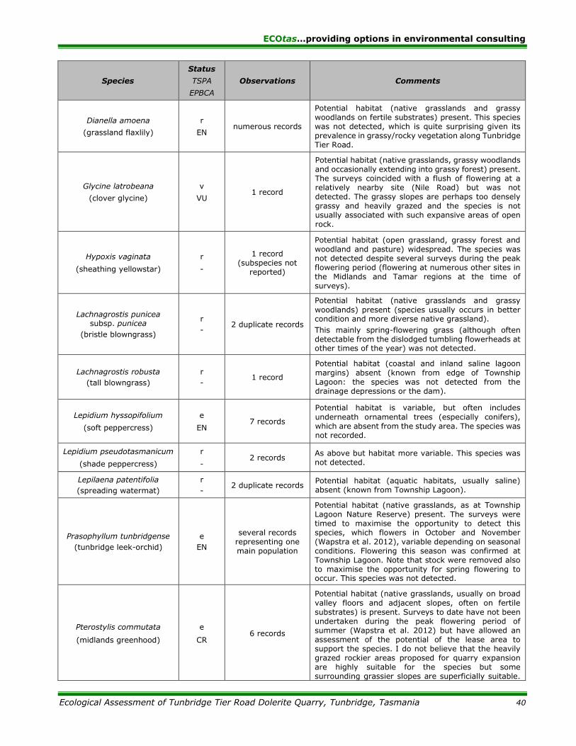
ECOtas…providing options in environmental consulting
Ecological Assessment of Tunbridge Tier Road Dolerite Quarry, Tunbridge, Tasmania 40
Species
Status
TSPA
EPBCA
Observations Comments
Dianella amoena
(grassland flaxlily)
r
EN numerous records
Potential habitat (native grasslands and grassy woodlands on fertile substrates) present. This species was not detected, which is quite surprising given its prevalence in grassy/rocky vegetation along Tunbridge Tier Road.
Glycine latrobeana
(clover glycine)
v
VU 1 record
Potential habitat (native grasslands, grassy woodlands and occasionally extending into grassy forest) present. The surveys coincided with a flush of flowering at a relatively nearby site (Nile Road) but was not detected. The grassy slopes are perhaps too densely grassy and heavily grazed and the species is not usually associated with such expansive areas of open rock.
Hypoxis vaginata
(sheathing yellowstar)
r
-
1 record (subspecies not
reported)
Potential habitat (open grassland, grassy forest and woodland and pasture) widespread. The species was not detected despite several surveys during the peak flowering period (flowering at numerous other sites in the Midlands and Tamar regions at the time of surveys).
Lachnagrostis punicea subsp. punicea
(bristle blowngrass)
r
- 2 duplicate records
Potential habitat (native grasslands and grassy
woodlands) present (species usually occurs in better condition and more diverse native grassland).
This mainly spring-flowering grass (although often detectable from the dislodged tumbling flowerheads at other times of the year) was not detected.
Lachnagrostis robusta
(tall blowngrass)
r
- 1 record
Potential habitat (coastal and inland saline lagoon
margins) absent (known from edge of Township Lagoon: the species was not detected from the drainage depressions or the dam).
Lepidium hyssopifolium
(soft peppercress)
e
EN 7 records
Potential habitat is variable, but often includes
underneath ornamental trees (especially conifers), which are absent from the study area. The species was not recorded.
Lepidium pseudotasmanicum
(shade peppercress)
r
- 2 records
As above but habitat more variable. This species was not detected.
Lepilaena patentifolia
(spreading watermat)
r
- 2 duplicate records
Potential habitat (aquatic habitats, usually saline) absent (known from Township Lagoon).
Prasophyllum tunbridgense
(tunbridge leek-orchid)
e
EN
several records representing one main population
Potential habitat (native grasslands, as at Township Lagoon Nature Reserve) present. The surveys were timed to maximise the opportunity to detect this species, which flowers in October and November (Wapstra et al. 2012), variable depending on seasonal conditions. Flowering this season was confirmed at Township Lagoon. Note that stock were removed also to maximise the opportunity for spring flowering to occur. This species was not detected.
Pterostylis commutata
(midlands greenhood)
e
CR 6 records
Potential habitat (native grasslands, usually on broad
valley floors and adjacent slopes, often on fertile substrates) is present. Surveys to date have not been undertaken during the peak flowering period of summer (Wapstra et al. 2012) but have allowed an assessment of the potential of the lease area to support the species. I do not believe that the heavily grazed rockier areas proposed for quarry expansion are highly suitable for the species but some surrounding grassier slopes are superficially suitable.

ECOtas…providing options in environmental consulting
Ecological Assessment of Tunbridge Tier Road Dolerite Quarry, Tunbridge, Tasmania 41
Species
Status
TSPA
EPBCA
Observations Comments
That said, the grazing regime and dense grass layer may have rendered the habitat unsuitable: this, combined with the highly disjunct distribution of the species, means that the likelihood of the species being present is very low. I do not believe that further surveys of the proposed quarry extension area is warranted for this species. Informal and ongoing survey of the grassy slope south of the existing quarry is suggested but should not be a formal condition of approval because the more likely habitat will not be affected by the works.
Pultenaea prostrata
(silky bushpea)
v
VU 4 records Potential habitat (native grasslands) is present. This
distinctive low shrub was not detected.
Ranunculus prasinus
(midlands buttercup)
e
EN 5 records
Potential habitat (poorly-drained swales amongst
native grassland and grassy woodlands) absent. The species is known from a population on the western side of the Midland Highway just south of Tunbridge Tier Road. This perennial herb was not detected.
Ruppia megacarpa
(largefruit seatassel)
r
- 5 records
Potential habitat (aquatic habitats, usually saline) absent (known from Township Lagoon).
Rytidosperma indutum
(tall wallabygrass)
r
- 1 record
Potential habitat (usually grassy forests and woodlands) is present. This distinctive perennial grass was not detected.
Scleranthus diander
(tufted knawel)
v
- numerous records
Species detected – see RESULTS Plant species Priority flora species detected from the lease area.
Scleranthus fasciculatus
(spreading knawel)
v
- 9 records
Potential habitat (native grasslands and grassy
forest/woodland) present on. This species was not detected (detectable at any time of the year).
Vittadinia cuneata var. cuneata
(fuzzy new-holland-daisy)
r
- numerous records
Species detected – see RESULTS Plant species Priority flora species detected from the lease area.
Vittadinia gracilis
(woolly new-holland-daisy)
r
- numerous records
Species detected – see RESULTS Plant species Priority flora species detected from the lease area.
EPBCA-listed species listed as potentially present based on Protected Matters Report (CofA 2015)
Acacia axillaris
(midlands wattle)
v
VU
Species or species’ habitat likely to
occur within area
Potential habitat (flood-prone rocky riverbeds and banks, adjacent grassy woodlands and slopes) absent. This species was not detected.
Barbarea australis
(riverbed wintercress)
e
CR
Species or species’ habitat likely to
occur within area As above.
Caladenia anthracina
(blacktip spider-orchid)
e
CR
Species or species’ habitat known to occur within area
See previous sections of table.
Carex tasmanica
(curly sedge)
-
VU
Species or species’ habitat likely to
occur within area See previous sections of table.
Colobanthus curtisiae
(grassland cupflower)
r
VU
Species or species’ habitat likely to
occur within area See previous sections of table.
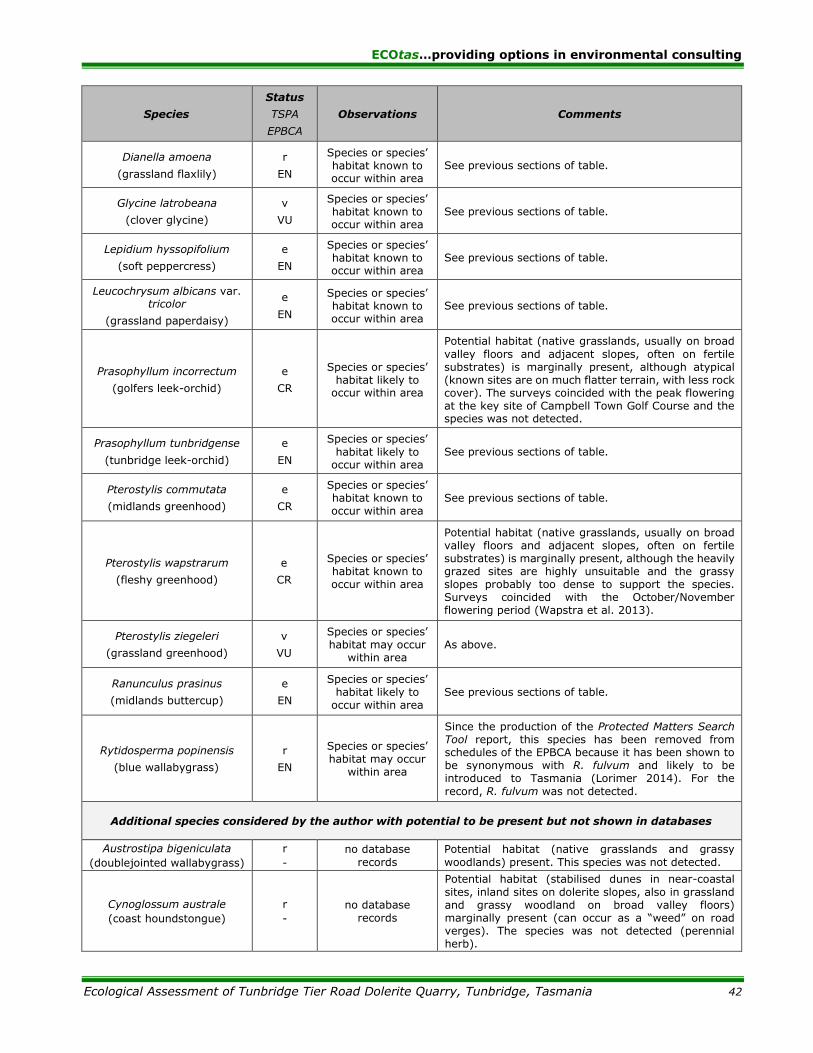
ECOtas…providing options in environmental consulting
Ecological Assessment of Tunbridge Tier Road Dolerite Quarry, Tunbridge, Tasmania 42
Species
Status
TSPA
EPBCA
Observations Comments
Dianella amoena
(grassland flaxlily)
r
EN
Species or species’ habitat known to occur within area
See previous sections of table.
Glycine latrobeana
(clover glycine)
v
VU
Species or species’ habitat known to occur within area
See previous sections of table.
Lepidium hyssopifolium
(soft peppercress)
e
EN
Species or species’ habitat known to occur within area
See previous sections of table.
Leucochrysum albicans var. tricolor
(grassland paperdaisy)
e
EN
Species or species’ habitat known to occur within area
See previous sections of table.
Prasophyllum incorrectum
(golfers leek-orchid)
e
CR
Species or species’ habitat likely to
occur within area
Potential habitat (native grasslands, usually on broad
valley floors and adjacent slopes, often on fertile substrates) is marginally present, although atypical (known sites are on much flatter terrain, with less rock cover). The surveys coincided with the peak flowering at the key site of Campbell Town Golf Course and the species was not detected.
Prasophyllum tunbridgense
(tunbridge leek-orchid)
e
EN
Species or species’
habitat likely to occur within area
See previous sections of table.
Pterostylis commutata
(midlands greenhood)
e
CR
Species or species’ habitat known to occur within area
See previous sections of table.
Pterostylis wapstrarum
(fleshy greenhood)
e
CR
Species or species’ habitat known to occur within area
Potential habitat (native grasslands, usually on broad valley floors and adjacent slopes, often on fertile substrates) is marginally present, although the heavily grazed sites are highly unsuitable and the grassy slopes probably too dense to support the species. Surveys coincided with the October/November flowering period (Wapstra et al. 2013).
Pterostylis ziegeleri
(grassland greenhood)
v
VU
Species or species’ habitat may occur
within area As above.
Ranunculus prasinus
(midlands buttercup)
e
EN
Species or species’ habitat likely to
occur within area See previous sections of table.
Rytidosperma popinensis
(blue wallabygrass)
r
EN
Species or species’ habitat may occur
within area
Since the production of the Protected Matters Search Tool report, this species has been removed from schedules of the EPBCA because it has been shown to be synonymous with R. fulvum and likely to be introduced to Tasmania (Lorimer 2014). For the
record, R. fulvum was not detected.
Additional species considered by the author with potential to be present but not shown in databases
Austrostipa bigeniculata
(doublejointed wallabygrass)
r
-
no database
records
Potential habitat (native grasslands and grassy
woodlands) present. This species was not detected.
Cynoglossum australe
(coast houndstongue)
r
-
no database
records
Potential habitat (stabilised dunes in near-coastal
sites, inland sites on dolerite slopes, also in grassland and grassy woodland on broad valley floors) marginally present (can occur as a “weed” on road verges). The species was not detected (perennial herb).
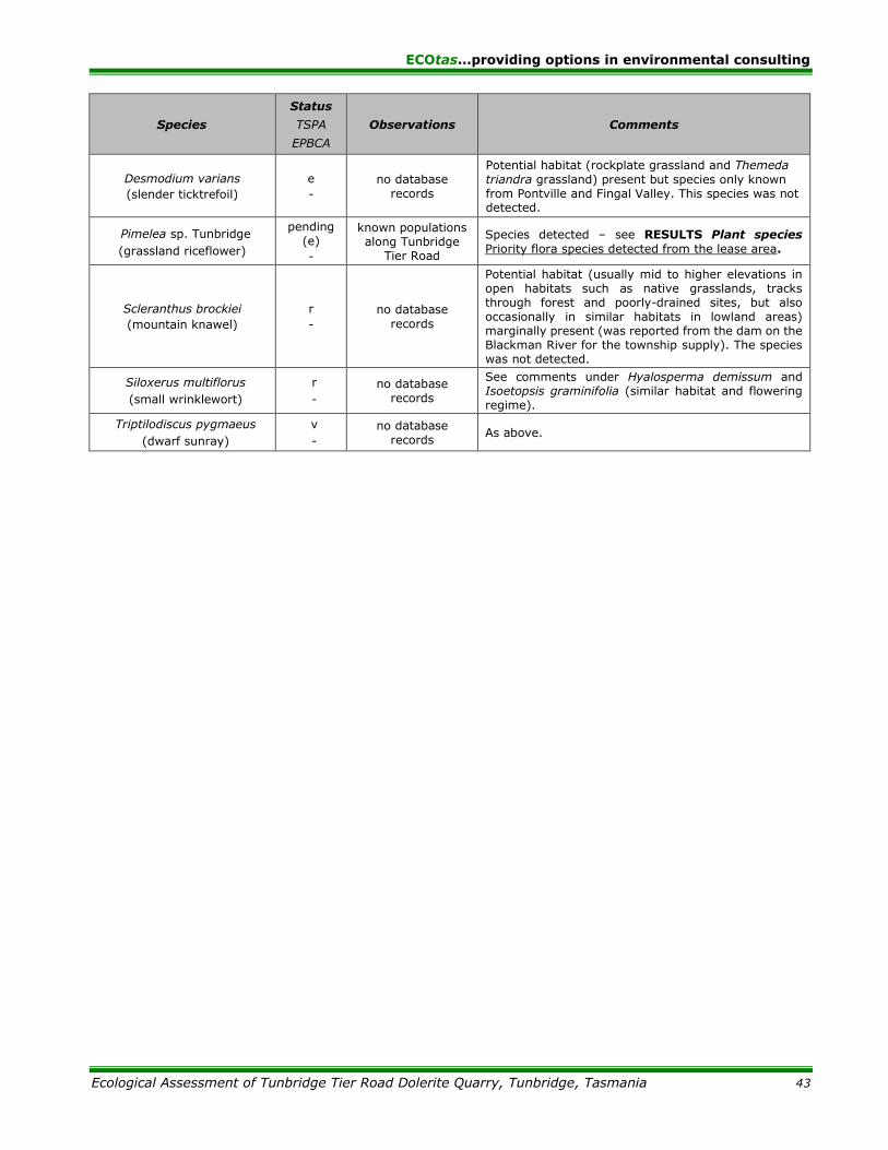
ECOtas…providing options in environmental consulting
Ecological Assessment of Tunbridge Tier Road Dolerite Quarry, Tunbridge, Tasmania 43
Species
Status
TSPA
EPBCA
Observations Comments
Desmodium varians
(slender ticktrefoil)
e
-
no database
records
Potential habitat (rockplate grassland and Themeda
triandra grassland) present but species only known from Pontville and Fingal Valley. This species was not detected.
Pimelea sp. Tunbridge
(grassland riceflower)
pending
(e)
-
known populations along Tunbridge
Tier Road
Species detected – see RESULTS Plant species
Priority flora species detected from the lease area.
Scleranthus brockiei
(mountain knawel)
r
-
no database
records
Potential habitat (usually mid to higher elevations in open habitats such as native grasslands, tracks through forest and poorly-drained sites, but also occasionally in similar habitats in lowland areas) marginally present (was reported from the dam on the Blackman River for the township supply). The species was not detected.
Siloxerus multiflorus
(small wrinklewort)
r
-
no database
records
See comments under Hyalosperma demissum and Isoetopsis graminifolia (similar habitat and flowering regime).
Triptilodiscus pygmaeus
(dwarf sunray)
v
-
no database
records As above.

ECOtas…providing options in environmental consulting
Ecological Assessment of Tunbridge Tier Road Dolerite Quarry, Tunbridge, Tasmania 44
APPENDIX B. Analysis of database records of threatened fauna
Table B1 provides a listing of priority fauna from within the lease area, and from 500 m and
5000 m of the lease area (nominal buffer widths usually used to discuss the potential of a particular
study area to support various species listed in databases), with comments on whether potential
habitat is present for the species, and possible reasons why a species was not recorded.
Table B1. Priority fauna records from within the study area, and from 500 m and 5000 m of boundary of
lease area
Species listed below are listed as rare (r), vulnerable (v), endangered (e), or extinct (x) on the Tasmanian Threatened Species Protection Act 1995 (TSPA); vulnerable (VU), endangered (EN), critically endangered (CR) or extinct (EX) on the Commonwealth Environment Protection and Biodiversity Conservation Act 1999 (EPBCA). Information below is sourced
from the DPIPWE’s Natural Values Atlas (DPIPWE 2015a), Bryant & Jackson (1999) and FPA (2015); marine, wholly pelagic and littoral species such as marine mammals, fish and offshore seabirds are excluded
Species
Status
TSPA
EPBCA
Observations Comments
Records from within the lease area
No records known from within the lease area
Records within 500 m of the lease area
No records known from within 500 m of the lease area
Records and potential habitat within 5000 m of study area
Accipiter novaehollandiae
(grey goshawk)
e
-
no database
records
Potential habitat is described as “native forest with
mature elements below 600 m altitude, particularly along watercourses” (FPA 2015), habitat elements absent from study area (species occurs in wet forests).
There are no known nests within 500 m of the lease area and no novel nests were detected during the course of the present assessment. No individuals were sighted during assessment.
Catadromus lacordairei
(green-lined ground beetle)
v
-
no database
records
Potential habitat is “open, grassy/sedgy, low altitude
grasslands and woodlands associated with wetlands and low-lying plains or flats adjacent to rivers/streams” and key habitat elements that need to be present include “sheltering sites such as patches of stones, coarse woody debris and/or cracked soils” (FPA 2015), habitat elements absent from the lease area.
Aquila audax subsp.
fleayi
(Tasmanian wedge-tailed eagle)
e
EN
no known nests
within 1000 m of the boundary of the study area
Potential breeding habitat is defined as “tall eucalypt trees
in large tracts (usually more than 10 ha) of eucalypt or mixed forest” and potential foraging habitat “includes a wide variety of forested (including areas subject to native forest silviculture) and non-forest habitats” (FPA 2015).
The species is likely to utilise the broader study area as part of a broader territory and a foraging area. There are no known nests within 500 m (or 1000 m line-of-sight), usual nominal management buffers applied in production forests. The present survey did not detect any novel nest sites from the study area.
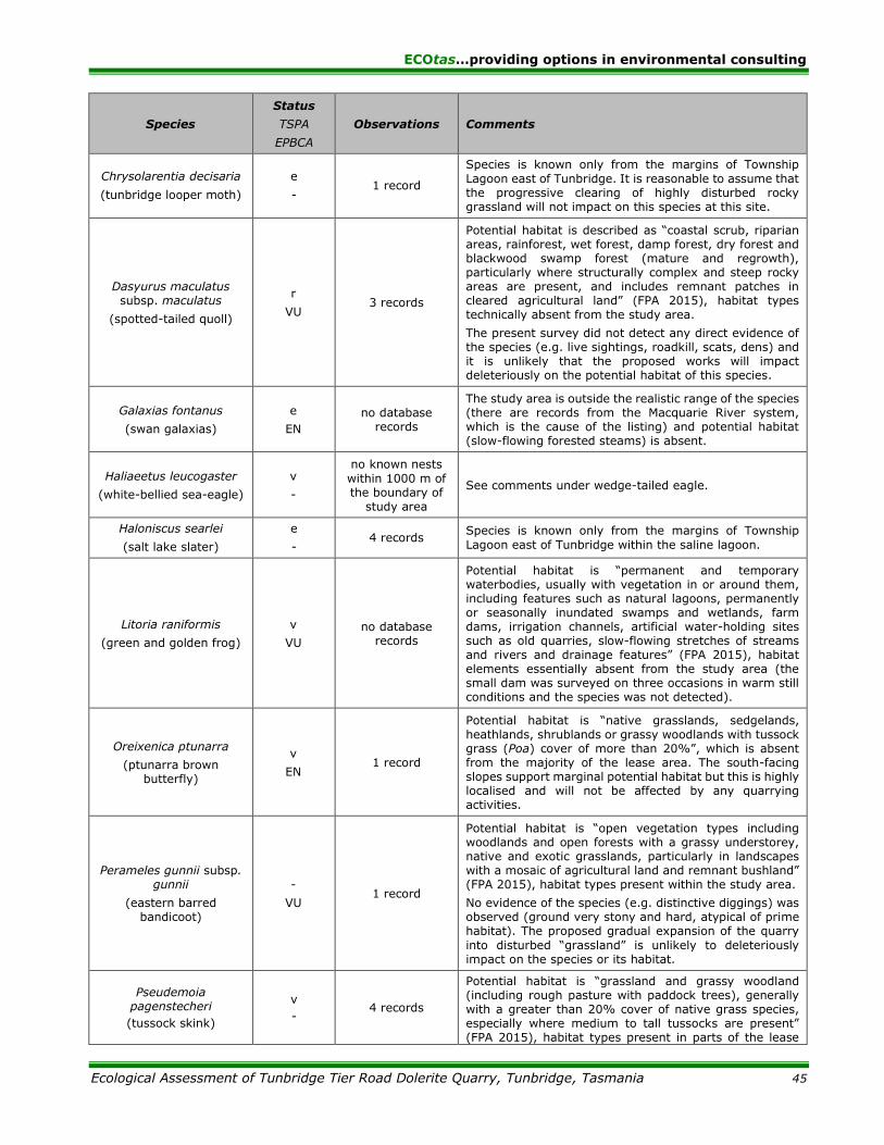
ECOtas…providing options in environmental consulting
Ecological Assessment of Tunbridge Tier Road Dolerite Quarry, Tunbridge, Tasmania 45
Species
Status
TSPA
EPBCA
Observations Comments
Chrysolarentia decisaria
(tunbridge looper moth)
e
- 1 record
Species is known only from the margins of Township
Lagoon east of Tunbridge. It is reasonable to assume that the progressive clearing of highly disturbed rocky grassland will not impact on this species at this site.
Dasyurus maculatus subsp. maculatus
(spotted-tailed quoll)
r
VU 3 records
Potential habitat is described as “coastal scrub, riparian areas, rainforest, wet forest, damp forest, dry forest and blackwood swamp forest (mature and regrowth), particularly where structurally complex and steep rocky areas are present, and includes remnant patches in cleared agricultural land” (FPA 2015), habitat types technically absent from the study area.
The present survey did not detect any direct evidence of the species (e.g. live sightings, roadkill, scats, dens) and it is unlikely that the proposed works will impact deleteriously on the potential habitat of this species.
Galaxias fontanus
(swan galaxias)
e
EN
no database records
The study area is outside the realistic range of the species (there are records from the Macquarie River system, which is the cause of the listing) and potential habitat (slow-flowing forested steams) is absent.
Haliaeetus leucogaster
(white-bellied sea-eagle)
v
-
no known nests
within 1000 m of the boundary of
study area
See comments under wedge-tailed eagle.
Haloniscus searlei
(salt lake slater)
e
- 4 records
Species is known only from the margins of Township
Lagoon east of Tunbridge within the saline lagoon.
Litoria raniformis
(green and golden frog)
v
VU
no database records
Potential habitat is “permanent and temporary waterbodies, usually with vegetation in or around them, including features such as natural lagoons, permanently or seasonally inundated swamps and wetlands, farm dams, irrigation channels, artificial water-holding sites such as old quarries, slow-flowing stretches of streams and rivers and drainage features” (FPA 2015), habitat elements essentially absent from the study area (the small dam was surveyed on three occasions in warm still conditions and the species was not detected).
Oreixenica ptunarra
(ptunarra brown butterfly)
v
EN 1 record
Potential habitat is “native grasslands, sedgelands, heathlands, shrublands or grassy woodlands with tussock grass (Poa) cover of more than 20%”, which is absent from the majority of the lease area. The south-facing slopes support marginal potential habitat but this is highly localised and will not be affected by any quarrying activities.
Perameles gunnii subsp. gunnii
(eastern barred bandicoot)
-
VU 1 record
Potential habitat is “open vegetation types including woodlands and open forests with a grassy understorey, native and exotic grasslands, particularly in landscapes with a mosaic of agricultural land and remnant bushland” (FPA 2015), habitat types present within the study area.
No evidence of the species (e.g. distinctive diggings) was observed (ground very stony and hard, atypical of prime habitat). The proposed gradual expansion of the quarry
into disturbed “grassland” is unlikely to deleteriously impact on the species or its habitat.
Pseudemoia pagenstecheri
(tussock skink)
v
- 4 records
Potential habitat is “grassland and grassy woodland (including rough pasture with paddock trees), generally with a greater than 20% cover of native grass species, especially where medium to tall tussocks are present” (FPA 2015), habitat types present in parts of the lease

ECOtas…providing options in environmental consulting
Ecological Assessment of Tunbridge Tier Road Dolerite Quarry, Tunbridge, Tasmania 46
Species
Status
TSPA
EPBCA
Observations Comments
area (e.g. grassy slopes to south of the existing quarry area). The area into which the quarry will expand is rocky and open with poor tussock development (possibly due to heavy grazing). Provided this condition remains, the tussock skink is unlikely to utilise the proposed quarry extension area and further surveys or special management prescriptions are not recommended.
Sarcophilus harrisii
(Tasmanian devil)
e
EN 11 records
Potential habitat is described as “all terrestrial native
habitats, forestry plantations and pasture” (FPA 2015), habitat types present within the study area.
The present survey did not detect any direct evidence of the species (e.g. live sightings, roadkill, scats, dens) but it is reasonable to assume that the species is present throughout the greater area.
Any proposed works are unlikely to impact deleteriously on the potential habitat of this species.
Tyto novaehollandiae subsp. castanops
(Tasmanian masked owl)
e
VU
no nest/roost
records within 5000 m
Potential habitat “is all areas with trees with large hollows
(15 cm entrance diameter). In terms of using mapping layers, potential habitat is considered to be all areas with at least 20% mature crown cover” (FPA 2015) but is more conservatively considered to be eucalypt-dominated forest below c. 600 m elevation, habitat elements marginally present within the study area. All remnant dead trees with hollows were carefully assessed and none had evidence of use (e.g. whitewash, pellets, prey, etc.) and most trees with potentially suitable hollows were infested by starlings.
The species is likely to utilise the study area for foraging
and temporary roosting only: the proposed quarry expansion will not affect this component of the potential habitat of the species.
EPBCA-listed species listed as potentially present based on Protected Matters Report (CofA 2015) [excluding marine, pelagic and littoral species]
Aquila audax subsp. fleayi
(Tasmanian wedge-tailed eagle)
e
EN
Breeding likely to occur within area
See previous sections of table.
Apus pacificus
(fork-tailed swift)
Migratory
Marine Species
Species or species’ habitat likely to occur
within area
Aerial foraging bird that rarely lands – study area
presents marginal habitat only and any works in the area would not have a deleterious impact on the species.
Ardea alba
(great egret)
Migratory Wetland/ Marine Species
Species or species’ habitat likely to occur
within area
Potential habitat (natural and artificial wetlands and swampy habitats) absent.
Ardea ibis
(cattle egret)
Migratory
Wetland/ Marine Species
Species or
species’ habitat may occur within
area
As above.
Botaurus poiciloptilus
(Australasian bittern)
-
EN
Species or
species’ habitat known to occur
within area
Potential habitat (natural and artificial wetlands and swampy habitats) absent.
Dasyurus maculatus subsp. maculatus
(spotted-tailed quoll)
r
VU
Species or species’ habitat known to occur
within area
See previous sections of table.

ECOtas…providing options in environmental consulting
Ecological Assessment of Tunbridge Tier Road Dolerite Quarry, Tunbridge, Tasmania 47
Species
Status
TSPA
EPBCA
Observations Comments
Gallinago hardwickii
(Lathams Snipe)
Migratory
Wetland Species
Species or
species’ habitat may occur within
area
Potential habitat (natural and artificial wetlands and swampy habitats) absent.
Lathamus discolor
(swift parrot)
e
EN
Species or
species’ habitat may occur within
area
Site is well outside the mapped range of the species (DPIPWE 2015; FPA 2015).
Haliaeetus leucogaster
(white-bellied sea-eagle)
v
-
Species or species’ habitat likely to occur
within area
See previous sections of table.
Hirundapus caudacutus
(white-throated needletail)
Migratory
Terrestrial Species
Species or
species’ habitat may occur within
area
Aerial foraging bird that rarely lands – study area
presents marginal habitat only and any works in the area would not have a deleterious impact on the species.
Litoria raniformis
(green and golden frog)
v
VU
Species or
species’ habitat may occur within
area
See previous sections of table.
Perameles gunnii subsp. gunnii
(eastern barred bandicoot)
-
VU
Species or
species’ habitat likely to occur
within area
See previous sections of table.
Myiagra cyanoleuca
(satin flycatcher)
Migratory Terrestrial Species
Species or
species’ habitat known to occur
within area
Potential habitat marginally present (species utilises a wide range of habitats but tends to be most frequent in dry open tall woodlands and forests and associated sheltered slopes/gullies).
The species was not detected by sight or call during the assessment, which was partially undertaken within the species’ residential period in the State. Any works in the area would not have a deleterious impact on the species because such works will be restricted to very open “grassland” habitats.
Oreixenica ptunarra
(ptunarra brown butterfly)
v
EN
Species or
species’ habitat may occur within
area
See previous sections of table.
Sarcophilus harrisii
(Tasmanian devil)
e
EN
Species or species’ habitat likely to occur
within area
See previous sections of table.
Tyto novaehollandiae subsp. castanops
(Tasmanian masked owl)
e
VU
Species or
species’ habitat known to occur
within area
See previous sections of table.
ECOtas…providing options in environmental consulting
Ecological Assessment of Tunbridge Tier Road Dolerite Quarry, Tunbridge, Tasmania 48
APPENDIX C. DPIPWE’s Natural Values Atlas report for study area
Appended as pdf file.
APPENDIX D. Forest Practices Authority’s Biodiversity Values Atlas report for study
area
Appended as pdf file.
APPENDIX E. CofA’s Protected Matters report for study area
Appended as pdf file.
OTHER ATTACHMENTS
.shp and/or .dwg file of point locations of threatened flora
.xls file of point locations of threatened flora
.shp and/or .dwg file of vegetation mapping