environmental management - kgl resources€¦ · 5.2 mine overview 5.2.1 ownership the jervois mine...
TRANSCRIPT

SECT
ION
5.1
| DRA
FT E
NVIR
ONM
ENTA
L MAN
AGEM
ENT
PLAN
ENVIRONMENTALMANAGEMENT
DRAFT ENVIRONMENTAL MANAGEMENT PLAN
SECTION5.1

5.1-i Jervois Base Metal Project
This page is intentionally left blank

Environmental Impact Statement
5.1-1 Jervois Base Metal Project
Jervois Base Metal Project VOLUME 3 Environmental Management
SECTION 5.1| Draft Environmental Management Plan
5.1 Introduction The Jervois Base Metal Project has a history of operations stemming back to 1929 with the focus in
more recent times being upon developing further geological knowledge of the resource base. Under
KGL Resources Limited (KGL) ownership operationally appropriate plans have been in place to avoid,
minimise and mitigate impacts of the mine and resource development activities upon the
environment. In addition to this consistent focus upon managing any identified potential for
environmental risks associated with the Project KGL has recently technical studies associated with the
draft Environmental Impact Statement (EIS).
An application to re-open the Jervois Base Metal Mine (Jervois Mine) has been made. An assessment
of the potential environmental risks is required under the EA Act. The scope of this assessment was
defined by the Terms of Reference for the Preparation of an Environmental Impact Statement (ToR) in
August 2017. Section 5 of the ToR requires the development of a draft Environmental Management
Plan (EM Plan) and in accordance with Northern Territory Environmental Protection Authority’s
Guideline for the preparation of an Environmental Management Plan.
This plan has been developed using the above to ensure that operations:
• Comply with legislation, including authorities issued under the Environmental Assessment Act
(EA Act) and Waste Management and Pollution Control Act; and
• Incorporate revised or improved measure to management environmental impacts.
The draft EM Plan has been prepared to support the application for approval of the proposed re-
opening of the Jervois Mine and accompanies the draft Environmental Impact Statement to include
proposed mining activities within the Project area. In effect, the draft EM Plan describes the existing
environment, the potential environmental risks, establishes environmental objectives and provides
auditable performance criteria and management plans applicable to the entire mine area.
5.1.1 Structure and Related Documents The draft EM Plan is designed to provide an environmental management framework for the mine to
operate within. It has been designed to be an operationally functional document which allows for
ease of use for regulators, contractors and employees associated with the Jervois Mine throughout
the Project lifecycle.
The draft EM Plan has been developed as an overarching document that coordinates environmental
management within the mine site. On this basis, whilst the document discusses all aspects of
environmental impact management where required it refers to single element management plans
which provide greater detail or specific actions for management activities. This includes:
• Draft Mine Rehabilitation and Closure Plan
• Draft Biodiversity and land management Plan
• Draft Erosion and Sediment Control Plan
• Draft Water Management Plan
• Draft Social Impact Management Plan
• Draft Waste Management Plan; and
• Draft Fire Management Plan.

Environmental Management
SECTION 5 | Draft Environmental Management Plan 5.1-2
As this is a re-opening of the mine, the impacts identified as similar to that of the existing mine and
are able to be managed accordingly. Recognised and proven measures have been identified will be
applied to the recommencement of operations. In combination with the additional measures outlined
in this draft EM Plan and the knowledge of current operations, potential for environmental risks of the
proposed mining operations are considered to be suitably managed. These actions are summarised
in this draft EM Plan.
It is on this basis that the draft EM Plan considers the management of the re-opening of the Jervois
Mine impacts and the existing mine in the following manner.
5.2 Mine Overview
5.2.1 Ownership The Jervois Mine is solely owned by Jinka Minerals Limited a 100% owned subsidiary of KGL Resources
Limited (KGL). Throughout this EM Plan the reference is made to KGL as the owner and operator of
this mining Project.
5.2.2 Location The Jervois Mine is located within the Northern Territory approximately 380 kilometres north-east of
Alice Springs in Central Australia, off the Plenty Highway. The nearest occupied communities are
Bonya and Harts Range (Figure 5.1-1).
Identify the environmental values and establish the background
condition (Section 4 of EM Plan)
Indentify and develop the environmental protection objectives
(Section 5 of EM Plan)
Development commitments (including management plans and strategies to acheive compliance
(Section 5 of EM Plan)
Develop key performance indicators, monitoring and reporting
requirements associated with Jervois Mine acticities (Section 5 of EM Plan)

5.1-3 Jervois Base Metal Project
Figure 5.1-1 Jervois Mine Locality

Environmental Management
SECTION 5 | Draft Environmental Management Plan 5.1-4
5.2.3 Tenements The previous mining operational areas, exploration and associated Mining Management Plan (MMP)
covers tenement areas within the boundaries of ML30180, ML30182 and ML30829, all held by Jinka
Minerals Limited. A summary of mining tenure is provided in Table 5.1-1 and an overview is provided
in Figure 5.1-2.
Table 5.1-1 Mining Tenure
Tenure No. Status Grant Date Expiry Date Holder Area (Ha)
ML 30180 Granted 28/01/2014 27/01/2024 Jinka Minerals Limited
33.21
ML 30182 Granted 26/03/2014 25/03/2030 Jinka Minerals Limited
482.8
ML 30829 Granted 18/08/2017 17/08/2032 Jinka Minerals Limited
1,438
EL 25429 Jinka Minerals Limited
Approximately 3,800

Environmental Impact Statement
5.1-5 Jervois Base Metal Project
Figure 5.1-2 Jervois Mine Tenures

Environmental Management
SECTION 5 | Draft Environmental Management Plan 5.1-6
5.2.4 Land within or adjacent The Jervois Mine is located within the 273,600 hectare (ha) Jervois Pastoral Lease owned by Jervois
Pastoral Company Pty Ltd. The 970 ha Project footprint equates to approximately 0.35% of the Jervois
Pastoral Lease. The Lucy Creek and Jervois homesteads are located approximately 24 km north and
35km south of the Project respectively.
5.2.5 The Project The reopening of the Jervois Mine will involve the extraction of existing and expanded base metal reserves within the Project area. The Project contains a significant and high-grade copper resource, as well as silver, gold, lead and zinc in several deposits. The ore would be mined by open pit and underground methods and processed to a concentrate on site. The concentrate would then be trucked via the Plenty and Stuart Highways to the current rail freight terminal in Alice Springs, and then onto Darwin and/or Adelaide by rail. An option to shorten the road haulage being investigated by KGL involves the construction of a rail siding adjacent to the Adelaide to Darwin rail line north of Alice Springs on the Ghan Railway Line where it crosses the Plenty highway. The Project footprint is estimated at 970 ha of which a significant portion has been disturbed by historic mining activities. The Project area is located within the boundaries of ML30180, ML30182 and ML30829. This EIS has been based upon KGL’s current understanding of the resource and an allowance for potential growth. Based upon this the initial operations will focus upon optimising the recovery of the currently estimated copper resource of 25.2 million tonnes (Mt). These operations are anticipated to produce approximately 87 Mt of waste rock and 20 Mt of tailings. The rate of mining is influenced by the processing plant capabilities which currently allows for Run of Mine feed of up to 1.6 Mtpa, producing 150,000 tonnes of base metal concentrate per annum (assuming a two percent copper grade). Mining operations at the Project area will be split between three operational areas:
Reward
Bellbird; and
Rockface.
Mining at Reward and Bellbird is both open cut and underground, whilst Rockface is underground only. Ore from all three mining areas will be trucked to the ROM stockpile for processing at the plant. Mine infrastructure will include pits, waste rock landforms, tailings storage facilities, topsoil stockpiles, haul roads, heavy vehicle parking areas, ROM pads and fuel storage areas. The processing plant will include associated water tanks, workshops, fuel facilities, concentrate load out facility, mobile equipment, power plant, air and water supply facilities and storage areas. Other infrastructure associated with the Project will include laydown areas, production and monitoring bores, a magazine and explosives store, an accommodation camp, administration buildings, new sediment catchment dams, access and haul roads, monitoring and supply bores, power generation and supply facilities, workshops, hardstands and laydown areas. Proposed infrastructure will be located over previously disturbed mine infrastructure areas wherever feasible. Once approved, it is anticipated that construction will commence in 2019, with mining and
commissioning occurring in approximately 2020. It is currently anticipated that there will be up to 360
people employed to facilitate the construction requirements and up to 300 for the proposed Project
operations.
Environmental Impact Statement
5.1-7 Jervois Base Metal Project
5.2.6 Phases of Development
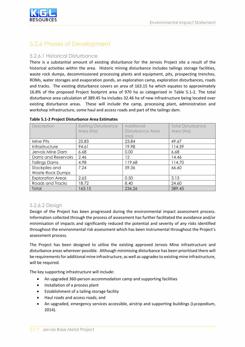
5.2.6.1 Historical Disturbance There is a substantial amount of existing disturbance for the Jervois Project site a result of the
historical activities within the area. Historic mining disturbance includes tailings storage facilities,
waste rock dumps, decommissioned processing plants and equipment, pits, prospecting trenches,
ROMs, water storages and evaporation ponds, an exploration camp, exploration disturbances, roads
and tracks. The existing disturbance covers an area of 163.15 ha which equates to approximately
16.8% of the proposed Project footprint area of 970 ha as categorised in Table 5.1-2. The total
disturbance area calculation of 389.45 ha includes 32.46 ha of new infrastructure being located over
existing disturbance areas. These will include the camp, processing plant, administration and
workshop infrastructure, some haul and access roads and part of the tailings dam.
Table 5.1-2 Project Disturbance Area Estimates
Description Existing Disturbance
Area (Ha)
Additional
Disturbance Area
(Ha)
Total Disturbance
Area (Ha)
Mine Pits 25.83 23.84 49.67
Infrastructure 94.61 19.98 114.59
Jervois Mine Dam 6.68 0.00 6.68
Dams and Reservoirs 2.46 12 14.46
Tailings Dams 4.98 119.68 114.70
Stockpiles and
Waste Rock Dumps
7.24 59.36 66.60
Exploration Areas 2.63 0.50 3.13
Roads and Tracks 18.72 8.40 24.60
Total 163.15 236.26 389.45
5.2.6.2 Design Design of the Project has been progressed during the environmental impact assessment process.
Information collected through the process of assessment has further facilitated the avoidance and/or
minimisation of impacts and significantly reduced the potential and severity of any risks identified
throughout the environmental risk assessment which has been instrumental throughout the Project’s
assessment process.
The Project has been designed to utilise the existing approved Jervois Mine infrastructure and
disturbance areas wherever possible. Although minimising disturbance has been prioritised there will
be requirements for additional mine infrastructure, as well as upgrades to existing mine infrastructure,
will be required.
The key supporting infrastructure will include:
• An upgraded 360-person accommodation camp and supporting facilities
• Installation of a process plant
• Establishment of a tailing storage facility
• Haul roads and access roads; and
• An upgraded, emergency services accessible, airstrip and supporting buildings (Lycopodium,
2014).

Environmental Management
SECTION 5 | Draft Environmental Management Plan 5.1-8
The following key surface water management infrastructure and measures required as part of the
Project will be:
• A new 180 ML process water dam to be constructed between the proposed process plant and
the reward open cut pit
• A new 10 ML underground dewatering dam adjacent to the process plant
• Sediment dams to capture and manage runoff from waste rock dumps; and
• Repairs and upgrades to the existing Jervois dam embankment and spillway to improve dam
storage and safety (WRM, 2018).
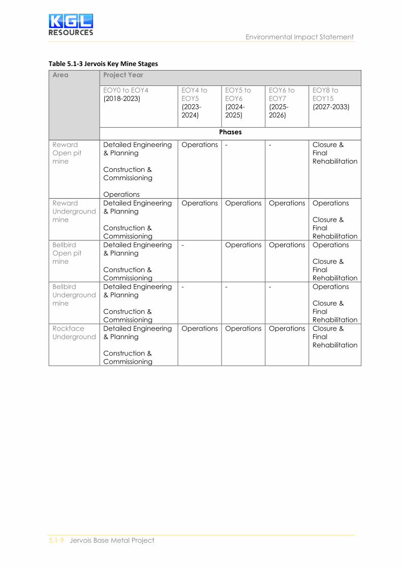
5.2.6.3 Construction Project activities will occur in accordance with the proposed mining schedule and construction
program outlined in Table 5.1-3. Construction equipment would be transported to the site at the
direction of mine operators and contractors responsible for each element of the Project’s construction.
As the site is remote it will be required to be self-sufficient in terms of services. All power will be
generated on site and water will be sourced from the existing dam and supplement by the proposed
borefield. The infrastructure to be upgraded or constructed will be prioritised during the Project’s
construction phase so as to ensure the mining schedule is adhered to.
5.2.6.4 Operation As with the historic Jervois Mine footprint, the Project will commence open pit extraction and follow
onto underground extraction in the domain progression. The process of commencing operations
within each of these domains will adhere to a consistent activity sequence as outlined below:
• Remove of vegetation (if required)
• Collection of topsoil and placement in a rehabilitation area or designated stockpile
• Removal of historic mine wastes (where required); and
• Removal of overburden.
The detailed works proposed for the recommencement of mining at Jervois are outlined below in
Table 5.1-3.
Environmental Impact Statement
5.1-9 Jervois Base Metal Project
Table 5.1-3 Jervois Key Mine Stages
Area Project Year
EOY0 to EOY4
(2018-2023)
EOY4 to
EOY5
(2023-
2024)
EOY5 to
EOY6
(2024-
2025)
EOY6 to
EOY7
(2025-
2026)
EOY8 to
EOY15
(2027-2033)
Phases
Reward
Open pit
mine
Detailed Engineering
& Planning
Construction &
Commissioning
Operations
Operations - - Closure &
Final
Rehabilitation
Reward
Underground
mine
Detailed Engineering
& Planning
Construction &
Commissioning
Operations Operations Operations Operations
Closure &
Final
Rehabilitation
Bellbird
Open pit
mine
Detailed Engineering
& Planning
Construction &
Commissioning
- Operations Operations Operations
Closure &
Final
Rehabilitation
Bellbird
Underground
mine
Detailed Engineering
& Planning
Construction &
Commissioning
- - - Operations
Closure &
Final
Rehabilitation
Rockface
Underground
Detailed Engineering
& Planning
Construction &
Commissioning
Operations Operations Operations Closure &
Final
Rehabilitation

Environmental Management
SECTION 5 | Draft Environmental Management Plan 5.1-10
5.2.6.5 Decommissioning and closure The Mining Management Act requires mine rehabilitation and closure activities to be planned and
undertaken. A mining management plan, including a plan and costing of closure activities, is required
under the Mining Management Act. The Mining Management Act also requires the operator to
provide the Minister with a security to secure the payment of costs and expenses in relation to the
Minister taking an action to complete rehabilitation of the mining site.
Post-mining land uses for the site have been identified as:
• Low-intensity grazing; and
• Infrastructure (including borefields and a downgraded airstrip).
Actions to achieve these outcomes have been devised in detail in the draft Rehabilitation,
decommission and Closure Plan. This includes a design framework to ensure that the final landforms
are sage and accessible, and that there are procedures that improve the quality and long-term viability
of revegetation. The beneficial reuse of infrastructure has been identified, with structures such as
dams proposed to be made available to Landholders if this is suitable and mutually agreed upon.
Rehabilitation and decommissioning work associated with mine is proposed to be undertaken early
and in a progressive manner.
5.3 EM Plan Framework The Jervois Base Metal Mine is to be approved under the EA Act. This draft EM Plan provides the mine
operator with a strategic framework for the environmental management of the mine, which is
reflective of any identified environmental risks, regulatory compliance and improvements to
operational and mining practices.
The draft EM Plan has been developed to reflect high level commitments, which are discussed in detail
as Environmental Objectives, supported by auditable actions and standards, and tailored to the mine’s
specific environmental risk assessment criteria. The actions and management plans have been
designed to enable to the mine to maintain or exceed its environmental compliance criteria in
consistence with operation of similar open pit and underground base metal operations.
To ensure that the Project appropriately manages the identified environmental risks in a meaningful
and measurable way throughout the Project’s lifecycle this framework has been developed with
refence to the following Australian Standards:
• Australian Standard/New Zealand Standard (AS/NZS) International organisation for
Standardisation (ISO) 14000 Series (including AS/NZS 14001 Environmental management
systems – Specification with guidance for use)
• AS/NZS ISO 31000: 2009 Risk management – Principles and guidelines
• HB 436:2013 Risk management guidelines – Companion to AS/NZS ISO 13000: 2009; and
• HB 203:2012 Managing environment-related risk.
5.3.1 Objectives Developed upon strong environmental compliance principles and in conjunction with the draft EIS,
the draft EM Plan has been developed to provide an operationally functional document designed to
capture all mitigation measures that have been identified within the environmental risk assessment
process. In addition, the primary objectives of this draft EM Plan are to document the following
criteria:

Environmental Impact Statement
5.1-11 Jervois Base Metal Project
• How the environmental risks associated with the proposed mining operations have been
assessed and good practice mitigation and management measures have been specific to
ensure the risks will be properly managed throughout the life of the Project.
• The implementation process for EIS findings and recommendations, including commitments.
• Identification of tailored and operationally functional environmental compliance measures.
5.3.2 Legal and Other Requirements Compliance with legal obligations is an integral component to a successful operational compliance.
KGL aims to ensure that appropriate mitigation measures are implemented to control environmental
risks relevant to the operation of the mine. This includes compliance with the Mining Management
Plan and all relevant environmental legal requirements.
5.4 Description of Environmental Values and Risks Guided by the ToR an assessment of the existing environment relevant to the Project has been
detailed in the EIS along with detailed technical studies regarding the potential for impacts and the
associated risk profiles. The following section provides an overview of this assessment and the
potential impacts and risks of the Project.
5.4.1 Terrestrial Flora and Vegetation This section discusses the potential impacts to terrestrial flora and vegetation as a result of the Project
with reference to the NT EPAs ToR objective of maintaining the conservation status, diversity,
ecological integrity, geographic distribution and productivity of terrestrial flora and vegetation at
species and ecosystem levels through avoidance or management of adverse impacts.
The NT EPA has Guidelines for Assessment of Impacts on Terrestrial Biodiversity (NT EPA, 2013) that
provide guidance as to the level of detail required for terrestrial flora and vegetation within the impact
assessment process. As recommended by the guideline, the EIS considered the:
• Vegetation of proposed development sites and the immediately adjacent area
• Presence and distribution of critical habitats (Territory Parks and Wildlife Conservation Act
2014 (TPWCA) or listed threatened ecological communities (TEC) (Environment Protection and
Biodiversity Conservation Act 1999 (EPBC Act))
• Threatened flora species (as listed under the TPWCA and/or EPBC Act) of proposed
development sites and immediately adjacent areas
• Local and regional conservation status of vegetation types and threatened flora present
• Potential impacts of Projects on vegetation and threatened flora in, adjacent to, and
downstream from development sites
• Conservation significance of a development’s impacts on vegetation and threatened flora at
local and regional levels; and
• Compliance with Northern Territory Land Clearing Guidelines (NT NREAS, 2010).
In order to satisfy the above listed requirements of the terrestrial flora and vegetation assessment, a
number of ecological investigations were undertaken by Low Ecological Services P/L between 1985
and 2017.
5.4.1.1 Environmental Values Based on the results of extensive surveys conducted to date, eight refined vegetation communities
have been mapped over the entire Project area, which is estimated at 3,800 ha. The vegetation
communities present in each land unit and the dominant plant species present within each of these
vegetation communities Table 5.1-5.

Environmental Management
SECTION 5 | Draft Environmental Management Plan 5.1-12
Table 5.1-4 Vegetation Communities
Vegetation
Unit
Broad vegetation
classification
Structural formation Fine vegetation description
71 Acacia with grass
understory
Sparse shrubland Acacia aneura (Mulga) tall
sparse shrubland with grassland
understory
74 Acacia with grass
understory
Sparse shrubland Acacia stowardii (now sibirica)
(Bastard Mulga), Cassia,,
Eremophila (Fuschsia) sparse
shrubland
4.1.2 Potential Impacts and Risks The construction and operation of the Jervois Mine is associated with a number of potential impacts
to the floristic values of the Jervois Mine, including:
• Vegetation clearing for pits and infrastructure
• Impacts to threatened flora
• Introduction of exotic flora
• Dust pollution
• Erosion and sedimentation
• Changes in hydrology
• Release of contaminants from tailings dams and waste rock; and
• Bushfire.
Potential Impacts to Threatened Species
Two flora species listed as near threatened under the Territory Parks and Wildlife Conservation Act
(TPWC Act), Eremophila cordatisepala and Sauropus rigens, were recorded during on-ground surveys
(Low Ecological, 2018).
There are five records of E. cordatisepala from the Project area in association with Corymbia and
Acacia sibirica woodland (3 records) and Acacia estrophiolata woodland (1 record) and all are outside
the proposed extent of disturbance for new mine infrastructure and pits. One record is within 10m of
the existing Marshall Reward Pit access road and another record is within 30m of existing Lucy Creek
Station Road (in the south of the Project area) and these specimens may be subject to indirect impacts
from dust deposition.
The S. rigens was located in Hummock grassland habitat on the western side of the Project area. There
are two records from the Project area and both are outside the proposed extent of disturbance.
However, it is noted that one record is located approximately 90m east of Jervois Dam and any future
works on the dam will need to consider management for the species.
Introduction of Exotic Species
The current assessment has recorded the presence of a variety of exotic flora, including two declared
weeds and WoNS species as follows:
• Buffel grass (Cenchrus ciliaris)
• Coral cactus (Cylindropuntia fulgida var. mamillata) – WoNS, Class A & C
• Couch grass (Cynodon dactylon)
• Spiked Malvastrum (Malvastrum americanum)
• Athel pine (Tamarix aphylla) – WoNS, Class A & B; and

Environmental Impact Statement
5.1-13 Jervois Base Metal Project
• Prickly mimosa (Vachellia farnesiana).
Exotic flora species are concentrated in areas suffering some form of disturbance, mostly clearing for
cattle grazing. Weeds threaten populations of native flora and fauna by competing with native flora
and eventually changing the habitat, which is no longer suitable for the majority of native species. The
EPBC Act lists weed invasion as a ‘key threatening process’ to biodiversity due to the impact on wildlife
and the landscape (Threatened Species Scientific Committee (TSSC), 2009).
The spread of weed species is facilitated by disturbance. During construction there would be the
potential for disturbing weeds in the Project area resulting in the movement of weeds within and
outside of the Project area. This could increase the level of infestation in the Study area and potentially
facilitate the spread of weeds to the other adjacent areas. Weed seed can be transported in the mud
on machinery or in the machinery itself.
There is a low likelihood of weeds spreading into adjoining native woodland/forest vegetation as a
result of the Project because the control of declared weeds will be implemented for the Project area.
Further, construction areas and the post-mine landforms will be progressively rehabilitated with
native vegetation (limiting opportunities for weeds to grow).
5.4.2 Terrestrial Environmental Quality The NT EPA’s objective to terrestrial environmental quality is to maintain the quality of land and soils
so that environmental values of site fauna, flora and vegetation communities are protected. To
achieve this objective the Jervois Project has given consideration to land, soil, biological and
hydrological aspects during its design and developed management plans to minimise impacts from
the Project. The preceding section focused on biological aspects, and later sections will focus on
hydrological aspects. This section focusses on erosion and sedimentation, acknowledging the
interactions between soil, vegetation and water, to maintain terrestrial environmental quality.
5.4.2.1 Environmental Values The existing environmental values fauna, flora and vegetation communities.
5.4.2.2 Potential Impacts and Risks The construction and operation activities of the Jervois Mine which will potentially impact soils and
their susceptibility to erosion in include:
• Clearing of vegetation
• Stripping of in-situ soil resources in mining disturbance areas
• Alteration of soil structure during preparation for infrastructure and hardstand areas e.g.
mine facilities area, stockpile areas, waste rock dump, roads, tailing storage facilities and
haul roads
• Increased erosion and sediment movement due to exposure of soils to wind and water
during construction of mine infrastructure
• Soil erosion resulting from the construction of diversion drains; soil migration to surface
waters
• Traffic and physical disturbance creating dust; and
• Alteration of physical and chemical soil properties (e.g. structure, fertility, permeability
and microbial activity) during soil stripping and stockpiling operations.
The related impacts will be described in the following sub sections.

Environmental Management
SECTION 5 | Draft Environmental Management Plan 5.1-14
5.4.2.2.1 Clearing Vegetation The new infrastructure will have an impact area of approximately 389.45 ha, which includes 32.46 ha
of new infrastructure being located over existing disturbance areas. The vegetation community most
affected by the Project would be vegetation community 5 – Corymbia and Acacia sibirica woodland.
The clearing of vegetation leaves exposed soil vulnerable to erosion by both water (rain and surface
flows) and wind.
Water may collect sediments during overland flow and as it passes through the proposed creek
diversions. Suspended sediments would be deposited as stream flow velocity reduces further
downstream. Sedimentation in downstream areas (where the velocities are lower) can lead to filling
of the waterway channel and encroachment of the riparian vegetation into the waterway channel
Deposited sediments can cause adverse effects on aquatic ecosystems, although these are limited in
the Jervois area due to the ephemeral nature of the watercourses.
5.4.2.2.2 Erosion The most common forms of water erosion likely to be encountered at the Jervois mine are:
• Splash erosion is the spattering of soil particles cause by the impact of raindrops on soil
• Sheet erosion is the uniform removal of soil in thin layers from sloping land
• Rill erosion is the removal of soil by water concentrated in small but well-defined channels;
and
• Gully erosion produces channels deeper and larger than rills (generally greater than 300mm
deep.
The soils across the Jervois Project area comprise well drained, light to moderately textured soils
(maximum clay content 20-30%) with low EC values and low fertility (low CEC) (Perry et al 1962). Field
analysis of the soil characteristics indicates that the risks from soil salinity and acidity are very low
(VPS 2018).
Erosion risk associated with soil disturbance within the Project area is considered moderate due to
the nature of both the surface and subsoils to slake when wet.
5.4.2.2.3 Potential Pollutant Sources Potential erosion and sediment sources as well as the potential contaminants and impacts at the
Jervois mine are presented in Table 5.1-6.
Table 5.1-5 Potential erosion and sediment sources
Disturbance
category
Potential contaminant Potential impacts
Spoil / Waste rock dumps
Available /
Unavailable / Re-
contoured
Unconsolidated material with
varying quantities of saline and
sediment pre-disposition.
Bare areas vulnerable to storm
activity,
Acid mine drainage (AMD)
Sheet and rill erosion of potentially
alkaline/ acidic/saline deposits
leading to deposition of
contaminants and sediment
volumes. Sediments causing
damage to receiving waters
through reduction in water quality
and degradation of in-stream
habitats.
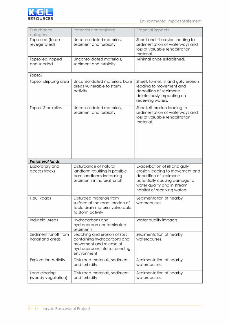
Environmental Impact Statement
5.1-15 Jervois Base Metal Project
Disturbance
category
Potential contaminant Potential impacts
Topsoiled (to be
revegetated)
Unconsolidated materials,
sediment and turbidity
Sheet and rill erosion leading to
sedimentation of waterways and
loss of valuable rehabilitation
material.
Topsoiled, ripped
and seeded
Unconsolidated materials,
sediment and turbidity
Minimal once established.
Topsoil
Topsoil stripping area Unconsolidated materials, bare
areas vulnerable to storm
activity.
Sheet, tunnel, rill and gully erosion
leading to movement and
deposition of sediments,
deleteriously impacting on
receiving waters.
Topsoil Stockpiles Unconsolidated materials,
sediment and turbidity
Sheet, rill erosion leading to
sedimentation of waterways and
loss of valuable rehabilitation
material.
Peripheral lands
Exploratory and
access tracks
Disturbance of natural
landform resulting in possible
bare landforms increasing
sediments in natural runoff
Exacerbation of rill and gully
erosion leading to movement and
deposition of sediments
potentially causing damage to
water quality and in stream
habitat of receiving waters.
Haul Roads Disturbed materials from
surface of the road, erosion of
table drain material vulnerable
to storm activity
Sedimentation of nearby
watercourses
Industrial Areas Hydrocarbons and
hydrocarbon contaminated
sediments
Water quality impacts.
Sediment runoff from
hardstand areas.
Leaching and erosion of soils
containing hydrocarbons and
movement and release of
hydrocarbons into surrounding
environment
Sedimentation of nearby
watercourses.
Exploration Activity Disturbed materials, sediment
and turbidity
Sedimentation of nearby
watercourses.
Land clearing
(woody vegetation)
Disturbed materials, sediment
and turbidity
Sedimentation of nearby
watercourses.

Environmental Management
SECTION 5 | Draft Environmental Management Plan 5.1-16
Disturbance
category
Potential contaminant Potential impacts
Drainage channels Disturbance of landform
resulting in possible bare
landforms increasing sediments
in runoff
Sheet, tunnel, rill and gully erosion
leading to movement and
deposition of sediments,
deleteriously impacting on
receiving waters.
Licenced stream
diversions / Levees
Disturbance of landform
resulting in possible bare
landforms increasing sediments
in runoff
Sheet, tunnel, rill and gully erosion
leading to movement and
deposition of sediments,
deleteriously impacting on
receiving waters.
5.4.2.2.4 Dust Deposition Dust deposition may impact on natural ecosystems adjacent to the Project area if reasonable
quantities of dust are sustained over extended periods of time. Dust deposition issues are most likely
to occur along haul roads, where there is a narrow corridor within natural areas or publicly accessible
areas immediately adjacent to activities involving heavy machinery and the transportation of ore.
Activities within the mine (i.e. open mine pits and waste piles) would also create dust, but these issues
would be created and managed within the mine disturbance area and are less likely to spill over into
adjacent natural areas.
5.4.3 Terrestrial Fauna
5.4.3.1 Environmental Values Fauna distribution and abundance is influenced by species specific responses to broad habitat types,
rather than to refined vegetation communities. For the purposes of this report, the eight refined
vegetation communities have been grouped into six broad habitat types based on geology, vegetation
structure and complexity, and characteristic species, which translate into differences in the nature
and availability of resources relevant to fauna.
The construction of the Project has the potential to impact terrestrial fauna and their supporting
habitat. This may include direct and indirect effects such as:
• Habitat loss
• Habitat fragmentation and loss of connectivity
• Habitat degradation; and
• Fauna mortality and morbidity.
The habitat type most affected by the Project would be habitat type 4 – Tall Corymbia sp. and Acacia
sp. woodland, closely followed by habitat type 2 – Low Acacia sp. shrubland. This is a reflection of the
distribution of these habitat types over the Project area (Low Ecological, 2018).
Impacts to threatened fauna
Surveys recorded two species of conservation significance; Dromaius novaehollandiae (emu) and
Rattus villosissimus (long-haired rat) within the Project area. Another four conservation significant
fauna species were indicated as ‘likely’ to occur within the Project area:
• Australian bustard (Ardeotis australis) – Near threatened (TPWC Act)
• Red-tailed black cockatoo (Calyptorhynchus banksii samueli) – Near threatened (TPWC Act)
• Grey honeyeater (Conopophila whitei) – Data deficient (TPWC Act); and

Environmental Impact Statement
5.1-17 Jervois Base Metal Project
• Australian painted snipe (Rostratula australis) – Endangered (EPBC Act), Vulnerable (TPWC
Act).
Due to the availability of suitable habitat within the site and surrounds there are anticipated to be no
significant impacts to threatened fauna.
5.4.4 Hydrological Processes This Section provides a description of the surface water and groundwater settings of the Project, the
potential impacts and water management strategies and systems proposed to manage the potential
impacts. It also draws on the specialist studies undertaken for the Water Management Plan (WMP)
(Section 5).
Relevant legislation, policy and guidelines
• Environmental Protection and Biodiversity Conservation Act 1999 (EPBC Act)
• Environmental Assessment Act (1982) (EA Act)
• Water Act; and
• Australian and New Zealand Guidelines for Fresh and Marine Water Quality.
Hydrological and groundwater assessments have been undertaken for the Project (Appendix C-5 and
C-6). The studies undertaken consisted of desktop assessments, hydrological and hydrogeological
surveys and numeric modelling.
5.4.4.1 Environmental Values The exiting environment for hydrological processes is constituted by the regional surface waters, the
local drainage network and the flood regimes of the area. These are discussed in the sections below.
5.4.4.1.1 Regional Surface Water Network The Jervois Project area is in the upper catchment of the Hay River Basin, which ultimately feeds into
Lake Eyre in the north of South Australia figure 5.1-3. The drainage lines that intersect the Project
area feed into the Marshall River to the south and Arthur Creek to the north, which in turn converge
into the Hay River, approximately 60 kilometres south-east of the Project area. Surface water in the
Project area and surrounding region is ephemeral and the creeks hold water during and after rainfall
events. Drainage lines originating in the Jervois Range, include Unca Creek. Unca Creek and its
tributaries drain to the east through the Project area and north-east towards Arthur Creek, but flood
out through the broad drainage plain to the south-east. Other watercourses in the surrounding area
include: Daylight Creek 4 km south-west, Midnight Creek 7 km south and Bonya Creek 11 km south-
west.

Environmental Management
SECTION 5 | Draft Environmental Management Plan 5.1-18
Figure 5.1-3 Hay River drainage network

Environmental Impact Statement
5.1-19 Jervois Base Metal Project
5.4.4.1.2 Local drainage network The local drainage of the Jervois Project area is incised by a number of ephemeral drainage lines that
hold water during and after rainfall events. Drainage lines in the Project area are shown in relation to
proposed infrastructure in Figure 5.1-4.
Unca Creek is the only watercourse of note in the vicinity of the Jervois Project. Unca Creek has a
catchment area of 21.8 km2 upstream of the Project area, with 17.1 km2 (78%) of this catchment being
captured by Jervois Dam. Downstream of the dam, Unca Creek runs in an easterly direction through
the northern portion of the Project area before turning southeast and crossing Lucy Creek Access Road.
A tributary of Unca Creek runs east through the southern portion of the Project area before joining
the main creek channel approximately 1.5 km east of Lucy Creek Access Road. The southern Unca
Creek tributary has a catchment area of 21.9 km2 upstream of the Unca Creek confluence (WRM, 2018).
The Unca Creek catchment upstream of Jervois Dam is steep and rocky, with poorly defined, sandy
drainage features located along valley floors. Downstream of Jervois Dam, the catchment becomes
flat and open, with wide expanses of sandy flats and spinifex grass, with scattered vegetation along
the creek and drainage feature channels. The Unca Creek channel downstream of Jervois Dam is
generally about 10 m wide and less than 1m deep, with a sandy bed that would become mobile during
flood events (WRM, 2018).

Environmental Management
SECTION 5 | Draft Environmental Management Plan 5.1-20
Figure 5.1-4 Local drainage network

5.1-21 Jervois Base Metal Project
4.4.1.3 Jervois dam Jervois Dam is an artificial water reservoir at the north-west corner of the Project area, which holds a
substantial volume of water for several years following rainfall. It was constructed for previous mining
operations in the early 1970’s and is the largest and most permanent surface water body in the Jervois
Region. Jervois Dam currently has a storage capacity of 279 ML below the existing spillway level
(367.38 mAHD), and a catchment area of approximately 17.1 km2. The dam spillway is a narrow (less
than 3 m wide) rock chute that has been cut through the ridge at the northern end of the dam wall.
The existing spillway chute is about 4 m below the crest of the existing dam wall. Faulty construction
resulted in a pervious layer in the dam wall which allows seepage which provides long term irrigation
for the area immediately east of the dam. It is planned to repair this leak to enable a larger quantity
of water to be available for the mining process.
Analysis of dam level records (refer Appendix C5) indicates that:
• Jervois Dam generally fills up rapidly between December and February and then gradually
decreases in volume during the remainder of the year via evaporation and/or seepage, but
rarely empties completely.
• During the period of record, the dam is at least 3.5% full on 90% of all days, at least 21.5% full
in 50% of all days and at least 76.4% full in 10% of all days.
The dam’s storage capacity to the spillway (274.8 ML) is exceeded on 3% of all days in the period of
record.
4.4.1.3 Flooding – existing conditions A Unified River Basin Simulator (URBS) hydrological model and a TUFLOW two-dimensional hydraulic
model were developed to simulate the flood behaviour of Unca Creek and its tributaries in the vicinity
of the Project (Appendix C-5).
The models were used to estimate peak flood levels, depths and extents in the vicinity of the Project
for the 10% and 1% AEP and the probable maximum flood (PMF) events under existing conditions
(pre-mining).

Environmental Management
SECTION 5 | Draft Environmental Management Plan 5.1-22
Figure 5.1-5 Peak flood depths and extents across the entire Project area, existing conditions, 1%
AEP (100 year ARI) event

Environmental Impact Statement
5.1-23 Jervois Base Metal Project
5.4.4.2 Potential Impacts and Risks
5.4.4.2.1 Surface Water Flood impacts of operating mine
The predicted impacts of the Project are summarised below:
• There are no predicted increases in peak flood levels and velocities along the watercourses
traversing the Project area, except in Unca Creek.
• The Jervois Dam spillway will be raised and widened under operational conditions, increasing
the peak outflow discharge from the spillway by about 10%, resulting in minor increases in
peak flood levels and velocities along Unca Creek downstream of Jervois Dam.
• Increases in peak flood levels of up to 0.1 m are predicted in Unca Creek downstream of
Jervois Dam for the 10% AEP and 1% AEP events. The average increase in flood levels along
Unca Creek is about 0.05 m for the 10% AEP event and about 0.08 m for the 1% AEP event.
These increased flood levels are not expected to have any material impact on existing land
uses downstream of the Project area.
• There are minor predicted increases in peak velocities of up to 0.2 m/s in Unca Creek
downstream of Jervois Dam for the 10% AEP and 1% AEP events. The average increase in peak
velocities along Unca Creek is about 0.07 m/s for the 10% AEP event and about 0.11 m/s for
the 1% AEP event. Given that the average peak flood velocities along Unca Creek under
existing conditions are about 0.9 m/s for the 10% AEP event and 1.3 m/s for the 1% AEP event,
the minor predicted increases in peak velocities due to the Project are not considered
significant.
• If Jervois Dam was removed (the pre-dam case), the 1% AEP peak discharge in Unca Creek
downstream of the dam sit would be approximately 58.4 m3/s. The 1% AEP peak discharge
downstream of the existing dam is 27.6 m3/s, and this will increase to 35.1 m3/s after the dam
is upgraded. Therefore, the predicted increase in flood levels and velocities following the dam
upgrade would be closer to the pre-dam flooding conditions.
Impact of final voids
A water balance model was used to assess the long-term behaviour of the final voids post mine closure.
The final void water balance model (Appendix C5) indicates that:
• All voids will typically have a small volume of surface water runoff stored in the base of the
void.
• The stored water depth in each void is predicted to typically vary between 10 m and 15 m
deep, however this may increase to as much as 30 m deep during extended wet periods.
• The water surfaces in the final voids are generally between 40 m and 100 m below surrounding
ground levels.
Final landform hydraulic modelling indicated that the final voids will be protected from flooding from
Unca Creek and its tributaries for all events up to and including the PMF.

Environmental Management
SECTION 5 | Draft Environmental Management Plan 5.1-24
Impacts on Water Quality
The Project has the potential to impact on water quality in Unca Creek and its tributaries due to
controlled and uncontrolled releases of water.
The results of the water balance model show that no uncontrolled releases are predicted from the
process water dam in any of the water balance model simulations. Therefore, the Project will not
release any mine affected water or dewatered groundwater to the environment. The water balance
model indicates that there is approximately a 10% chance of uncontrolled releases of water from the
waste rock sediment dams in the first four years of Project life.
5.4.4.2.2 Groundwater Numerical groundwater modelling was used to investigate the likely impacts of groundwater
abstraction for the mine process water supply and dewatering of mine excavations on existing users.
Drawdown at Receptors
The closest pastoral bores (RN010717) and the bores near Lucy Creek homestead, which is about 10
km from the planned mine supply borefield. The borefield for Orrtipa-Thurra Community represented
by RN018072 is located about 18 km from the planned mine site.
The results from the drawdown analysis indicate that, for the 10 years scheduled life of mine, a
maximum drawdown of 3 m can be expected at the closest pastoral bores (RN011101, RN011102 &
RN013274), while the bores at Lucy Creek Station (RN013381 and RN018943) show a drawdown of
less than 0.5 m.
No drawdown is observed at the Orrtipa-Thurra community borefield represented by RN018072.
Following closure of the mine the groundwater levels at the borefield recover to 90% of their pre-
pumping levels in less than 5 years and almost completely recover after 20000d (55 years).
Groundwater modelling (Appendix C6) forecasts that the drawdown impacts around the mine. The
0.5 m drawdown at the end of mining extends approximately 1 km beyond the mining lease to the
south of Rockface underground mine.
Life of mine inflows
Inflows to the pits and underground mines have been determined during the life of mine (Appendix
C6). Inflows into pits increase from commencement of mining and reach a peak during year 3 at about
0.2 ML/d (1.8 L/s). Inflows to the underground mines increase from commencement of mining and
reach a peak during year 7 at about 6.3 ML/d (74 L/s).
Contamination from TSF
The mine operation tailings will be stored in a tailings storage facility (TSF) to the west of Reward pit.
Some tailing liquor will seep from storage in the TSF to the groundwater table. This may result in some
increase in groundwater level and change to the chemical composition of groundwater. Random walk
particle tracking indicates that in the long-term the particles sourced from the areas beneath the TSF
will be captured by the formation of a pit-lake at Reward pit.

Environmental Impact Statement
5.1-25 Jervois Base Metal Project
Groundwater Dependant Ecosystems
There are no identified groundwater dependant ecosystems (GDE’s) within at least 40 kilometres of
the process water supply borefield and the depth to groundwater generally precludes ecosystem use.
A single waterhole is mapped to the southeast of the mine site, although generally groundwater levels
in the mine site are generally greater than 20 metres below ground level suggesting that this feature
is likely to be disconnected from the regional groundwater system. Two sites show groundwater levels
less than 5 m below ground level and are associated with Unca Creek.
5.4.5 Inland Water Environment Quality This section examines the potential impacts and risks to inland waters environmental quality and
sensitive receptors. It explores potential sources, pathways, receptors, and fate of any potentially
contaminated waters. It describes the environmental values, potential impacts and risks s to surface
and groundwater
5.4.5.1 Environmental Values The environmental values are the qualities of water resources to be protected from activities in the
catchment. Protecting environmental values aims to maintain healthy aquatic ecosystems and
waterways that are safe and suitable for community use. Environmental values reflect the ecological,
social and economic values and uses of the waterway (such as stock water, cultural uses, maintaining
biodiversity, fishing and agriculture).
The processes to identify environmental values and determine water quality objectives (WQOs) are
based on the National Water Quality Management Strategy: Implementation Guidelines (NWQMS,
1998). They are further outlined in the Australian and New Zealand Guidelines for Fresh and Marine
Water Quality (ANZECC & ARMCANZ, 2000).
There are no currently prescribed EVs for the Project Area. Therefore, based on the NWQMS (1998)
and ANZECC & ARMCANZ (2000) guidelines, the following EVs are proposed for the Project:
• aquatic ecosystems
• primary industries including stock drinking water, irrigation and general water uses
• recreation and aesthetics; and
• cultural and spiritual values.
Adopted water quality objectives
Based on the ANZECC & ARMCANZ (2000) guideline, the condition of the watercourses in the vicinity
of the Project is considered as Condition 2: slightly to moderately disturbed ecosystem. The adopted
surface water quality indicators relevant to meeting the above EVs are sourced from the ANZECC &
ARMCANZ (2000) guideline.
Table 5.1-6 shows the adopted water quality objectives (WQOs) for the receiving waters downstream
of the Project. The ANZECC & ARMCANZ (2000) WQOs for aquatic ecosystems are considered to be
the most conservative of the EVs listed above and have therefore been adopted as the surface water
WQOs for most parameters. WQOs for pH, electrical conductivity (EC), turbidity, dissolved oxygen

Environmental Management
SECTION 5 | Draft Environmental Management Plan 5.1-26
(DO), sulphate and iron were sourced from ANZECC & ARMCANZ (2000) guidelines for either livestock
drinking water or recreation.
The following is of note with regards to the adopted WQOs:
• The WQOs in 6 were obtained from the ANZECC & ARMCANZ (2000) guideline for aquatic
ecosystems based on 95% of species level of protection, except for pH, EC, turbidity, DO,
sulphate, nitrate and iron.
• The ANZECC & ARMCANZ (2000) recommended pH level for general water uses is between 6
and 8.5 for groundwater and between 6 and 9 for surface water. The recommended pH limit
of between 6 and 8.5 is adopted for the Project.
• The adopted WQO limits for EC and sulphate are based on the ANZECC & ARMCANZ (2000)
guidelines for livestock drinking water.
• In absence of more site-specific guidelines, the adopted turbidity limit is based on the ANZECC
& ARMCANZ (2000) guidelines for upland and lowland rivers in south central Australia: low
rainfall area.
• In absence of more site-specific guidelines for arid regions, the adopted DO (%) limit is based
on the ANZECC & ARMCANZ (2000) guidelines for freshwater lakes and reservoirs in south
central Australia: low rainfall area. No data is available in the guideline for upland rivers, which
would have been more representative of the Project area.
• The WQO limit for iron is based on the ANZECC & ARMCANZ (2000) guidelines for recreational
purposes.

Environmental Impact Statement
5.1-27 Jervois Base Metal Project
Table 5.1-6 Adopted surface water quality objectives (WQOs) for the Project, and comparison with
observed water quality data
Parametres Abbreviation Units Adopted
WQO value a
Group A
observed
water quality
(80%ile) i
Non-metallic indicators
pH pH pH units 6.0 - 8.5 b 7.1
Electrical
conductivity
EC μS/cm 5,970 c 4,090
Total dissolved solids TDS mg/L 4,000 c 30
Turbidity Turbidity NTU 50 d 1,160
Dissolved oxygen DO %
saturation
90 e n/a
Sulphate SO4 mg/L 1,000 f 1.3
Nitrate NO3 mg/L 0.7 0.240
Metals and metalloids (filtered, unless otherwise stated)
Aluminum Al μg/L 55 <10 (total) j
Arsenic As μg/L 24 59.2 (total) j
Cadmium Cd μg/L 0.2 54 (total) j
Copper Cu μg/L 1.4 92 (total) j
Iron Fe μg/L 300 g 232 (total) j
Lead Pb μg/L 3.4 44 (total) j
Magnesium Mg mg/L 2,000 h 0.9
Manganese Mn μg/L 1,900 661 (total) j
Mercury Hg μg/L 0.6 66.9 (total) j
Nickel Ni μg/L 11 49 (total) j
Zinc Zn μg/L 8 244 (total) j a – Obtained from Table 3.4.1 in ANZECC & ARMCANZ (2000) based on 95% species level of protection,
unless otherwise stated. b – Section 4.2.10.1 in ANZECC & ARMCANZ (2000) for general water uses. c – Table 4.3.1 in ANZECC & ARMCANZ (2000), adopted the lower limit for beef cattle and horses. d – Table 3.3.9 in ANZECC & ARMCANZ (2000) for upland & lowland rivers. e – Table 3.3.8 in ANZECC & ARMCANZ (2000) for lowland rivers and freshwater lakes and reservoirs. f – Section 4.3.3.4 in ANZECC & ARMCANZ (2000) for livestock drinking water. g – Table 5.2.3 in ANZECC & ARMCANZ (2000) for recreational purposes. h – Section 4.3.3.2 in ANZECC & ARMCANZ (2000) for livestock drinking water. i – Group A sites are representative of undisturbed areas within the mineralised zone of Project area. j – Testing on filtered samples was not undertaken.
5.4.5.2 Potential Impacts and Risks There are several risks associated with the construction and operation of the Project that could lead
to contamination of surface and groundwater. These include contamination of waterways or
groundwater caused by embankment failure or overtopping and subsequent uncontrolled release
from storage ponds, the processing site and the TSF. Inappropriate storage and handling of hazardous
substances may also result in uncontrolled release, spills or passive discharge into drainage lines.

Environmental Management
SECTION 5 | Draft Environmental Management Plan 5.1-28
Most aspects of the Project have some potential to cause water contamination, such as, but not
limited to the ore stockpiles, waste landforms including the waste rock dump (WRD), magnetite
stockpiles or TSF. Key potential sources of contaminants are listed Appendix 5.1.D, the dams that
capture runoff from these sources are also shown.
Table 5.1-7 Contamination sources and destinations of runoff
Contaminant source Contaminant
type
Destination water storage
ROM and product stockpiles Sediment, metals Process water dam
Process plant industrial area Sediment, metals,
chemicals, oil and
grease
Process water dam
Open cut mining pits Sediment, metals Process water dam
Waste rock dumps Sediment, acid Sediment dams
Potential release mechanisms for water contamination include:
• Erosion of disturbed surfaces;
• Inadequate stormwater/runoff separation;
• Leaching from WRD and long-term stockpiles;
• Seepage from the TSF;
• Inadequate treatment of waste water prior to discharge; and
• Accidental spills.
Vegetation and flora reliant on surface flows and groundwater uptake may also be impacted by
surface water and ground water contamination.
The assessments undertaken demonstrate that with appropriate water management and mitigation
measures in place, the potential impact of the Project on groundwater, surface flows and water quality
in the receiving waters downstream of the Jervois Mine will be acceptable.
5.4.6 Air Quality, Greenhouse Gases This section discusses the potential air quality impacts and greenhouse gas assessment for the mine
development with reference to the following guidelines and legislation:
• EIS Project Terms of Reference (August 2017)
• Northern Territory Waste Management and Pollution Control Act (WMPC Act) (14 October
2015)
• National Environment Protection Measure for Ambient Air Quality (NEPM Air); and
• National Greenhouse Energy and Reporting Act 2007.
The Northern Territory Government provides guidance on the assessment of air quality through the
use of Environmental Protection Objectives established in accordance with the Northern Territory
WMPC Act which refers to the use of source criteria from the NEPM. On this basis the specific air
quality objective indicators relevant for the mine are:
• Total Suspended Particulates (TSP) – Defined as the total of all particles suspended in the
air and is used as a metric of the potential for particulate matter to affect amenity.
• PM10 – A subset of TSP which refers to particles suspended in the air with an aerodynamic
diametres less than 2.5 micrometres.
• PM2.5 – This is a subset of TSP and PM10 and refers to particles suspended in the air with
an aerodynamic diametres less than 2.5 micrometres. PM2.5 is also referred to as fine
particulate matter.

Environmental Impact Statement
5.1-29 Jervois Base Metal Project
• Depositional Dust – A mechanism which allows for assessment of the amount of deposited
particulate matter that rapidly settles from the air.
5.4.6.1 Environmental Values The environmental values to be enhanced or protected within the Jervois Mine area are the qualities
of the air environment that contribute to the wellbeing of individuals and the community.
The following sections describe the environmental values identified to be impacted as a result of the
Project that are this EM PLAN. These include sensitive receptors, ambient air quality, pollutant
concentrations and greenhouse gas emissions.
Sensitive Receptors
The nearest sensitive receivers are located at large separation distances from the Project Site, ranging
from 16 to 35 km. The nearest sensitive receivers to the haul route include the Gemtree Caravan Park
(200m separation), and other homesteads and communities at distances ranging from 800m to 8.3km.
Figure 5.1-6 represents the nearest sensitive receptors in relation to the Project.
Environmental Management
SECTION 5 | Draft Environmental Management Plan 5.1-30
Figure 5.1-6 Sensitive Receptors Relevant to the Project Area

Environmental Impact Statement
5.1-31 Jervois Base Metal Project
Table 5.1-8 Sensitive receptors along Plenty Highway and Road No. 194
Code Sensitive Receptor Distance
SR5 Bonya Community 8.3 km north-west of Road No. 194/Plenty Highway
turnoff
SR6 Jervois Homestead 800 m west of Plenty Highway
SR7 Atitjere Community 1 km south of Plenty Highway
SR8 Gemtree Caravan
Park
200 m north of Plenty Highway
Source: Air Assessment - Jervois Base Metal Project (Air Noise Environment , 2018)
Existing Air Quality
The key air quality indicators for the mine were identified through selection of available monitoring
stations situated within similar environmental contexts, being that of isolated rural areas. The stations
selected were from Palmerston and Winnelie stations with the Northern Territory.
Table 5.1-9 Measured 2015 background concentrations
Pollutant Measured
Concentration
µg/m3
Averaging
Time
Monitoring
Station
Area Description
TSP 36.3 Annual Jondaryan Near to highway
and coal train
loading area
29.1 Townsville
Coast Guard
Industrial Port
PM10 24.8
20.1
Hour, 75th %ile
Annual
Palmerston,
Darwin
Boundary of General
Industry
20.9
15.7
Winnellie,
Darwin
Near suburban area
and refinery
PM2.5 10.9
7.8
24-hour,
75th %ile
Annual
Palmerston,
Darwin
Boundary of General
Industry
4.5
3.4
Winnellie,
Darwin
Near suburban area
and refinery
CO 342.8 8-hour,
75th %ile
Palmerston,
Darwin
Boundary of General
Industry
381.9 Winnellie,
Darwin
Near suburban area
and refinery
NO2 11.1
7.7
1-hour,
75th %ile
Annual
Palmerston,
Darwin
Boundary of General
Industry
7.4
5.6
Winnellie,
Darwin
Near suburban area
and refinery Source: Air Assessment - Jervois Base Metal Project (Air Noise Environment , 2018)
Existing Air Emissions Sources
The Jervois Mine is located in an area of historical mining disturbance and there are currently no
existing industrial or mining operations for a radius of 25 km or more from the site. On this basis, air
quality at the site and the nearest potentially sensitive receptors will be similar to a typical inland rural
area in Australia. Key sources that are expected to define background air quality are:
• Smoke from natural bushfires (localised, and larger regional savannah bushfires) and
controlled burns; and
Environmental Management
SECTION 5 | Draft Environmental Management Plan 5.1-32
• Dust emissions from motor vehicles using unsealed roads.
5.4.6.2 Potential Impacts and Risks In relation to air quality, the primary air pollutants for the Project relate to particulates from material
handling activities (e.g. excavation, loading, crushing), and gaseous combustion emissions from
operation of mobile and stationary equipment. Particulate matter is typically defined as Total
Suspended Particulates (TSP), PM10, PM2.5 and deposited dust. Primary combustion pollutants
include particulate matter, nitrogen oxides and carbon monoxide. Air emissions from underground
mining activity would be emitted via exhaust fans forming part of the underground mine ventilation
system.
In summary, key air emissions sources associated with the Project include:
• open pit mining activity (e.g. overburden removal, blasting, excavation)
• underground mining activity – emissions vented via exhaust ventilation system
• dump truck movements along on-site vehicle routes
• crushing activity at the processing plant; and
• power generation plant.
5.4.7 Noise This section discusses the environmental values and potential impacts that related to noise associated
with the Jervois Mine. The nature of this Project means that it will have the potential to cause noise
impacts from its planned operations, including mining activities, ore processing and handling
infrastructure and transport.
5.4.7.1 Environmental Values The mine area is defined as a remote rural environment. As such the existing acoustic environment
of the Jervois Mine and surrounds is one defined by natural noise sources (birds, insects etc)
superimposed with intermittent noise from local traffic and farming machinery. Generally, very low
noise levels are experienced throughout the year, with readings typically at or below 30 dB(A).
Average noise levels from unsurfaced vehicle routes in the area experience short term increases in
noise levels (typically 1 to 3 minutes per event, dependent upon vehicle speed) and may be auditable
at receptors located in close proximity to the road. As the initial assessment was desktop based a
conversation assumption was made that the area would adhere to typical baseline noise levels likely
to be at the 30 dB(A) reference level for remote rural areas.
5.4.7.2 Potential Impacts and Risks As the Project development consists of construction and operational phases occurring simultaneously
the discussion of potential noise impacts refers to both aspects of development combined.
The nearest receptor is the Bonya Community which is 17 km from the Jervois mine. Desktop
assessment indicates that the noise levels displayed in Table 5.1-11 are likely to occur.

Environmental Impact Statement
5.1-33 Jervois Base Metal Project
Table 5.1-10 Predicted Noise Levels
Noise Source No. SPL dB(A) Total dB(A)
Open Pit Mining
Drill Rigs 2 127 130
Excavator (Up to 810kW, 200 t) 2 114 117
Underground Mining Activity
Intake Fans 2 90 93
Exhaust Fans 4 119 125
Mobile Equipment
50-60 t Dump Trucks (Mine to Process Plant) 5 115 122
25 t Product Trucks 2 108 111
150 t Dump Trucks (Cat 785 or similar) 5 118 125
90 t Dump Truck (Cat 777 or similar) 5 115 122
200 t Excavator 1 114 114
100 t Excavator 1 108 108
Dozer 2 108 111
Grader 1 107 107
Water Cart 1 108 108
Processing Plant
Primary Crusher 1 120 120
SAG Mill 1 120 120
Pebble Crusher 1 120 120
Conveyor Drive 7 94 102
Air Compressor 1 110 110
Pump 32 110 125
Other
12 MW CNG Power Station 1 114 114
Lighting plant 10 90 100
Total Operational Sound Power Level 134 dB(A)
Predicted Noise Level at Nearest Sensitive Receiver
(16 km distance) 12 MW
7 dB(A)
Noise Criteria LAeq 30 dB(A)
In addition to the potential impacts to sensitive receptors there is the potential for impacts to fauna
species arising from the Jervois Mine. Field studies have confirmed that there are minimal mammal
species occurring within the vicinity of the mine, therefore, it is unlikely that the mine development

Environmental Management
SECTION 5 | Draft Environmental Management Plan 5.1-34
will have significant impacts upon fauna species. Available literature indicates that man-made noise
sources, such as traffic and industry, may have cause initial disruption to fauna species but that
subsequent familiarization occurs whereby the sounds are ignored as they are not of biological
significance to the species.
5.4.8 Social, Economic and Cultural Surrounds This section discusses the environmental values and potential impacts that related to the social,
economic and cultural surrounds associated with the Jervois Mine.
5.4.8.1 Environmental Values A comprehensive review of the socio-economic values occurring with the Jervois Mine footprint and
surround areas is included within Section 4.7 of the EIS Report 2018. A summary of the socio-
economic values is provided below.
As part of the EIS Report a Social Impact Assessment (SIA) was prepared after baseline research and
consultation between November 2017 and March 2018. The SIA covers construction of the mine and
supporting infrastructure, extraction and processing of the ore, and transportation of the copper
concentrate to Darwin and Adelaide. It includes initial transport of construction and workforce traffic
along the Plenty Highway and Lucy Creek Road, a workers’ accommodation village on the Project site
near the proposed mine and associated mine buildings and infrastructure.
In general, the Jervois Base Metal Project is assessed as being of a smaller scale than many other
regional resource Projects as it will have a relatively small workforce and is re-opening a mine site
where exploration and mining activity has taken place since 1929.
5.4.8.2 Potential Impacts and Risks As the Jervois Mine has a long history of activity the anticipated social impacts associated with the
Project are lower than those generally associated with a new mine development. In accordance with
the International Association for Impact Assessment (IAIA) Principles (Varclay, 2003) and Guidelines
(Vanclay, et al, 2015) potential impacts were identified and categorised as part of the EIS social impact
assessment activities.
The issues of highest concern to the community were in relation to road safety and the increased
potential for road trauma resulting from increased traffic associated with the recommencement of
operations.
The issues identified as being of moderated concern to the community, were as follows:
• The potential for impacts to water resources
• Concerns regarding reduced community of social cohesion
• The potential failure of the company to meet expectations of local Indigenous job creation
• The inability to meet local employment requirements due to lack of required skills
• Worker shortages due to mine drawing on available work ready individuals
• A possible reduction in tourism due to the increase in traffic associated with the mine
• Failure to see positive economic impacts within the region as a result of the mine; and
• The potential cumulative impacts arising from five major Projects within the Central Australia
region.
It should be noted that concerns in relation to impacts to water resources were not necessarily specific
to that of the Jervois Mine but were generally raised in the context of the recent government decision
to allow fracking associated with gas Projects to occur within the Northern Territory.

Environmental Impact Statement
5.1-35 Jervois Base Metal Project
In addition to the potential for negative impacts the SIA also identified the potential for key
opportunities associated with the Jervois Mine. These were identified as being the opportunities for
job creation and training for local Indigenous people, with recognition that this requires realistic
expectations about up-take rates, new or increased employment opportunities for local Alice Springs
residents and local procurement of goods and services (True North Strategic Communication, 2018).
5.5 Commitments to achieve compliance There are two key components to achieving and maintaining environmental compliance which are the
Environmental Management System (EMS) and the Environmental Management Plan (EM Plan).
The adoption of a management system which will guide compliance and continuous improvement of
the management tool, being the EM Plan. The Jervois Mine site-specific EMS will ensure that any
identified potential impacts to the environment are avoided, minimised or mitigated. This system will
be continuously improved to ensure that operations are cognisant of:
• Compliance requirements under relevant legislation, including the EA Act
• the audit commitments, timing and responsibilities associated with the management plan and
system
• Revised improved measures to manage environmental impacts are incorporated into
operational requirements in a timely and orderly manner
• Ensuring staff training occurs to an appropriate standard
• Ensuring that both internal and external communications are in accordance with the
company’s communication strategy; and
• Each site personnel member’s important role in ensuring environmental compliance is
adhered to and constantly improved upon (NT EPA, 2015).
The Jervois Mine EMS adheres to Australian Standards which are proved to minimise the
environmental impacts associated with mining activities. An overview of this system, relevant to the
Jervois Mine is provided in Section 5.1.
The objective of the EM Plan is to ensure that there is plan which acts as an operationally functional
management tool for all personnel involved in mining activities on the Jervois Mine site. This is
achieved through by ensuring that:
• The relationship between the EM Plan and the overall environmental management
framework is clearly defined
• The risk assessment process appropriately guides the focus of the management actions
• Each environmental aspect of issue is considered in terms of:
o Environmental objective(s)
o Performance criteria
o Management actions
o Timing and responsibility for implementation
• The implementation pathway allows for the clear integration of the management actions and
commitments identified throughout the EIS process (NT EPA, 2015).
The draft EM Plan’s component of compliance management is provided in full in Sections 5.2 and 5.3
of this document.
5.5.1 Environmental Management System The Jervois Mine Environmental Management System has been designed in accordance with the ISO
14001 – Environmental Management System framework. The EMS forms part of the Jervois Mine

Environmental Management
SECTION 5 | Draft Environmental Management Plan 5.1-36
Health and Safety Management System requires the active participation of all employees and
contractors. This draft EM Plan provides the framework utilised by KGL to actively manage their
environmental performance. This draft EM Plan establishes clear goals, control strategies and
provides mechanisms to measure environmental performance.
5.5.1.1 Operational Control of Hazards/Risks In order to ensure that the identified hazards and risks are comprehensively managed, the draft EM
Plan includes specific plans to address the following:
• Mine rehabilitation and closure
• Biodiversity management
• Weed management
• Erosion and sediment control
• Water management
• Groundwater management
• Social impact management
• Cultural heritage management
• Waste management
• Traffic management; and
• Fire management.
5.5.1.2 Roles and Responsibilities Resources for the operation have been identified by KGL and are detailed in the site organizational
chart. Specifically, the roles and responsibilities of key Project personnel in relation to the EMS are
defined in position descriptions. The overview of the responsibilities of staff specific to this EM Plan
and EMS is provided below:

Environmental Impact Statement
5.1-37 Jervois Base Metal Project
Table 5.1-11 Responsibility of staff specific to Environmental Management
Management
Principle
Plan Element General
Manager –
Jervois
Mine
Environment
and
Community
Manager
Wider
Team
Plan Creation of the Management Plan ✓
Approval of the Management Plan ✓ ✓
Approval of Management Plan
Amendments
✓ ✓
Do Implementation
and Operation
Establish Risk
Register
✓
Identify Risks ✓ ✓
Determine Risk
Profile
✓ ✓ ✓
Define Risk
Treatments
✓ ✓
Implement
Controls
✓ ✓
Check Monitor / Review Risk Treatments ✓ ✓
Act Report Risk Performance ✓ ✓
5.5.1.3 Training and Awareness All employees and contractors involved in construction, operation and rehabilitation activities at the
Jervois Mine have a responsibility to minimise adverse environmental impacts by complying with the
requirements of this Plan and the environmental assessment and approval conditions. Effective
implementation of this plan, and subsequent compliance, will be facilitated by ensuring all staff
receive appropriate training to have an awareness of their roles and responsibilities.
All employees will be required to complete the Jervois Mine induction training with site specific
induction on the environmental responsibilities of the Project, prior to commencement of work. The
induction will focus on training staff on the obligations of the environmental management systems
currently in place, this EM Plan and the relevant legislation.
Additional training will be provided to those engaged in activities where specific environmental
capabilities may be required to ensure compliance.
Training records will be maintained; detailing the attendees, content, trainer and dates of the
induction/training.
5.5.1.4 Consultation and Communication Communication is considered as being either internal or external. External communication forms the
fundamental basis of sustained community engagement which is strongly encouraged by the NT EPA.
All external communication will be undertaken in accordance with the protocols outlined in the Social
Impact Management Plan which has considered the level of environmental risk and community
interest associated with the re-opening of the Jervois Mine. Internal communication is focused upon
managing the environmental performance associated with these operations. More information
regarding the internal and external communication processes is outlined below.
Project Contacts
To facilitate effective consultation and communication a list of contacts has been established and will
be regularly updated and readily available to provide details of relevant contacts from Northern

Environmental Management
SECTION 5 | Draft Environmental Management Plan 5.1-38
Territory Government, relevant government agencies and Project stakeholders. It is the responsibility
of the Environment & Community Manger to ensure that this list is maintained.
Internal communication
KGL acknowledges that effective consultation and participation by personnel is essential for a
successful safety and health management system and the desired risk management culture to exist.
Focused upon managing and communicating regarding environmental performance and incident
related issues, by undertaking the following internal activities:
➢ Weekly Communications Meetings, with ‘Environmental Management’ as an agenda item.
➢ Monthly operation reports which include Environmental Management.
➢ Provision of ‘Tool Box’ talks focusing on environmental management awareness and other
related issue for all site staff.
➢ Daily production meetings covering works for the day and any environmental issues that
require special consideration.
➢ Site notice boards, which include displays of the Environmental Policy.
➢ Formal memos and notices issued to staff where amendments to operational procedures
and/or methods are to occur to improve environmental performance.
External communication
In accordance with the recommendations of the NT EPA early and sustained community engagement
is an established practice undertaken by KGL and its employees. The SIMP guides KGLs
representatives in their external communication is conducted with the following controls:
➢ Advertising construction/operational activities.
➢ Establishing the Complaints Management System.
➢ Incident notification for regulatory authorities.
➢ Consulting with government agencies and stakeholders.
Enquiries and complaints management
All complaints and incidents will be managed in accordance with the Jervois Mine Incident
Management and Investigation Procedure. All complaints received will be recorded in complaints
database, which will be kept as part of the mine records and in accordance with the SIMP.
The following information will be recorded and stored for each complaint:
➢ Date and time of complaint.
➢ Complainant contact details.
➢ The issue, nature and urgency of the complaint.
➢ Recommended response.
➢ Date action completed.
➢ Outcomes and response to the complaint.
➢ All complaints received will be acknowledged and every attempt will be made to resolve the
issue to satisfaction of the complainant.
➢ Where required to do so under legal obligations, the relevant governing body will be notified
of incidents in the manner prescribed.
5.5.1.5 Emergency Preparedness and Response Potential environmental emergency situations are to be managed through the Jervois Mine
Emergency Response Plan. This plan will be developed by KGL to ensure that the potential

Environmental Impact Statement
5.1-39 Jervois Base Metal Project
environmental emergency situations arising from a variety of causes, directly or indirectly related to
the Jervois Mine are addressed.
This plan will provide clear guidance on the:
➢ Emergency Procedures to be undertaken upon the unlikely event of an environmental
emergency situation occurring.
➢ Emergency contact register including the contact names and phone numbers of key Project
personnel, other relevant authorities, and off-site emergency services.
A record of dangerous goods, chemicals and fuels stored onsite will be maintained. In addition, all
Materials Safety Data Sheets will be stored at the main site office and, where appropriate, at specific
locations where those substance(s) are being used.
5.5.1.6 Monitoring and Measuring As guided by the requirements of the NT EPA guideline each environmental management sub-plan
within this framework outlines clear environmental monitoring objectives and a monitoring program
capable of meeting the identified objectives. Each environmental objective is supported by
performance indicators which have been developed as a result of the detailed technical study and
analysis undertaken as part of the EIS process conducted by KGL.
All monitoring will be undertaken in accordance with the relevant standards and data will be recorded
and stored appropriately in line with quality control standards.
5.5.1.7 Audits, Corrective Actions and Reporting Review, records and audits
This draft EM Plan will be reviewed and finalised prior to construction and operations commencing
onsite. Updates will primarily be focused upon ensuring that NT EPA and mining management plan
requirements are incorporated into this plan.
The EM Plan will be reviewed annually and to facilitate environmental compliance management
regular audits will be undertaken by KGL throughout all phases of the Jervois Mine’s development.
The Environment and Community Manager will be responsible for the development of an audit
schedule prior to the commencement of construction. The purpose of these audits will be to compare
the operational activities with the of the EM Plan commitments and performance criteria.
Environmental reporting
Internal and external reporting requirements have been identified throughout this EM Plan.
Specifically, the focus of external reporting is to meet the conditions of approval and statutory
requirements.
5.5.1.8 Continuous improvement As part of KGL’s commitment to continuous improvement of their environmental management
practices non-conformances relating the EM Plan objectives will be reported and appropriately
investigated. To ensure that these opportunities for improvement are captured Jervois Mine has
preventative, non-conformance and corrective action requirements.
These requirements are as follows:
• A register of non-conformances/corrective actions will be maintained to monitor the status of
any issues raised.
• Non-conformances to be appropriately resolved within the nominated period.
• Non-conformances raised as a result of an audit are added to the corrective action register for
management and close out.

Environmental Management
SECTION 5 | Draft Environmental Management Plan 5.1-40
Figure 5.1-7 Continuous improvement process
5.5.2 Compliance Controls As previously outlined in Section 1.1 the draft EM Plan is designed to provide an environmental
management framework that is operationally functional for the mine to operate within.
For ease of reference summary tables have been developed which refer to detailed sub-management
plans where required.

Environmental Impact Statement
5.1-41 Jervois Base Metal Project
5.5.2.1 Biodiversity Management Plan A summary of the measures of compliance for this environmental factor, this includes objectives,
performance indicators, management actions, monitoring and reporting is provided below in Table
5.1-12. Further technical information is provided in Appendix 5.1.A this EM Plan.
Table 5.1-12 Summary of Biodiversity management compliance measures
Draft Biodiversity Management Plan
Environmental
Protection Objective
To avoid clearing threatened flora species and adequately manage
indirect impacts (such as dust deposition and changes in hydrology) to
prevent fatal harm to threatened species.
Performance
Indicator/Criteria
• Performance Indicator Threatened flora
• Clearing does not result in the removal of threatened flora, as far
as possible.
• Target Criteria
• No threatened flora specimens cleared outside of approved
areas.
Management
Actions
• Ensure there is an appropriately qualified Environmental Advisor
onsite.
• Vegetation clearing/excavation to be subject to internal
permitting system.
• Where practical clearing should be undertaken when soil moisture
conditions are optimal to avoid excessive disturbance to soil and
landform.
• Management of site access to avoid creation of unnecessary
tracks.
• Prior to clearing demarcate exclusion zones to protect areas of
vegetation to be retained.
• Use of appropriate methods and machinery to suit site conditions.
• Implementation of an erosion and sediment control plan (ESCP).
• Measures undertaken to retain mature trees or habitat trees
where possible.
• Clearing debris to be collected with a stick rake, stockpiled in the
permitted area and mulched for use in rehabilitation.
• Collection of native seed from the mining lease area for use in the
rehabilitation program.
• Progressive rehabilitation in accordance with the Mine Closure
and Rehabilitation Plan (MCRP).
Monitoring The known specimens of threatened flora are to be monitored on a
quarterly basis to ascertain their status and condition. New specimens will
be recorded to add to the monitoring program.
Monitoring of the rehabilitation program is to be undertaken as outlined in
the MCRP.
Reporting Monitoring records are to be recorded in the Biodiversity Management
Report, which is produced annually and feeds into the annual Mining
Management Plan (MMP) audit.

Environmental Management
SECTION 5 | Draft Environmental Management Plan 5.1-42
5.5.2.2 Bushfire Management Plan A summary of the compliance measures for this environmental factor is provided below in Table 5.1-
13. Further detailed technical information is provided in Appendix 5.1 of this EM Plan.
Table 5.1-13 Summary of Bushfire management compliance measures
Draft Bushfire Management Plan
Environmental
Protection Objective
To minimise the potential impact in relation to fires, with a focus upon
protecting people, assets, biodiversity and cultural heritage sites from
controlled and uncontrolled fires.
Performance
Indicator/Criteria
Zero incidents of uncontrolled bushfires resulting from mining related
activities.
Management
Actions
• Fire prevention training.
• Hot works permitting system.
• Management procedures and stop work requirements.
• Procedures for reporting bushfires or incidental fires in close
proximity to the Mine
• Installation of strategic fire breaks.
• Hydrocarbon and hazardous materials management in
accordance with AS1940 – 2017 – The storage and handling of
flammable and combustible liquids which specifies the
requirements for firebreaks.
• All vehicles and works areas will be equipped with fires suppression
and firefighting equipment appropriate for the scale and nature
of works conducted in that area.
• Emergency response which nominates personnel to the ole of Fire
Warden and provides for appropriate training.
Monitoring Annual fire management procedure review.
Monitor of fire tracking and alert systems.
Reporting Annual reporting to be undertaken in accordance with the requirements
of the Jervois Mine SHMS.

Environmental Impact Statement
5.1-43 Jervois Base Metal Project
5.5.2.3 Weed Management Plan A summary of the compliance measures for this environmental factor is provided below in Table 5.1-
14
Table 5.1-14 Summary of weed management compliance measures
Draft Weed Management Plan
Environmental
Protection Objective
To manage existing infestations of exotic flora, with a view to eradication,
and avoid further spread of exotic flora species.
Performance
Indicator/Criteria
Performance Indicators
Existing infestations of exotic flora within the mining lease area are
eradicated.
Exotic flora does not spread further within the mining lease area.
Target Criteria
There are no infestations of exotic criteria within the mining lease.
No new infestations are identified and assessed as being a result of
mining activities.
Management
Actions
• Ensure there is an appropriately qualified Environmental Officer
onsite.
• Employees and contractors will be required to participate in an
environmental induction program. The program will provide
information on employee environmental responsibilities as well as
weed identification.
• Clearing of vegetation to be restricted to the minimum required to
enable the safe construction, operation and maintenance of the
Jervois Mine including infrastructure corridors.
• Conduct surveys to locate weed infestations prior to
commencement of construction.
• Implement weed management program to control weed
infestations. Methods used should represent those in the NT Weed
Management Handbook (Weed Management Branch, 2015).
• Appropriate disposal of weed material to prevent further spread.
Equipment hygiene program to minimise the risk of introduction or
spread of weeds or soil borne diseases to the Mine area.
Monitoring Annual surveys against performance indicators.
Reporting Annual survey results to be recorded in the Biodiversity Management
Report and reported within the annual MMP.

Environmental Management
SECTION 5 | Draft Environmental Management Plan 5.1-44
5.5.2.4 Air Quality and Greenhouse Gases A summary of the compliance measures for this environmental factor is provided below in Table 5.1-
15
Table 5.1-15 Summary of Air Quality and Greenhouse Gases management compliance measures
Draft Air Quality and Greenhouse Gases Plan
Environmental
Protection Objective
To ensure there is no health risk, nuisance or loss of amenity due to
particulate or airborne dust emissions from the site and to achieve
compliance with the requirements of the:
National Environmental Protections Measure for Ambient Air Quality
(NEPM Air)
Northern Territory Waste management and Pollutions Control Act (14
October 2015).
Performance
Indicator/Criteria
• The objectives of this air quality plan are being complied with if
the following criteria are achieved:
• Dust generated by vehicles on the access roads external to site
does not allow for visible tracking
• There are no visible suspended particulate releases dispersing
external to the site boundary
• Particulate concentrations do not exceed the following limits:
o Total Suspended Particulates – Annual Average: 90 µg/m3
o PM10 – 24 hour average: 50 µg/m3
o PM2.5 – 24 hour average: 25 µg/m3 o PM2.5 – annual average: 8 µg/m3; and
o Depositional dust – Daily average: 120 mg/m3/day.
Management
Actions
Dust Controls
• Unsealed internal roads traversed by vehicles associated with
Jervois Mine will be watered as required. The rate of watering is
increased during dry periods or during periods of high winds.
• Vehicular access within the site is strictly limited to authorised
vehicles and designated routes.
• Vehicle speeds will be limited onsite to minimise visible dust
generation.
• Dump truck routes will be kept as short as practicable.
• Vehicles (other than mining machinery) are not permitted on
overburden dumps except for the purposes of planning,
rehabilitation or monitoring.
• Wet dust suppression measures in the form of high pressure, low
volume water sprays are to be used for crushing plant, conveyors,
screening plant and stockpiles.
• Spoil is removed and dumped as soon as practicable after
blasting.
• Topsoil stripping and placement is avoided on days when the
wind speed is sufficient to carry dust beyond the mining lease
boundary.
• To minimise exposed material and associated dust generation
progressive rehabilitation of mined areas will occur in accordance
with the mine schedule to minimise exposed material and dust
generation.
• To assess the effectiveness of rehabilitation, conduct baseline
particulate monitoring prior to construction for a period of 6
months (including dry months) to provide a basis for comparison

Environmental Impact Statement
5.1-45 Jervois Base Metal Project
to monitoring post-rehabilitation. As a minimum, monitoring of
PM10 shall be undertaken.
• Minimise drop heights into hoppers, onto stockpiles and into haul
trucks.
• Where practicable position crushing and screening plant and
stockpiles in areas shielded by terrain, vegetation or berms to
reduce wind speeds and the risk of surface erosion.
• The Erosion and Sediment Control Plan will be finalised and
implemented prior to the commencement of development.
• All milling and ore processing are to be completed using wet
processes.
• Crushing and conveying equipment for dry material shall have
dust controls.
• Burning of cleared vegetation will be limited and shall not occur
during periods of high winds.
• Application of chemical dust suppressant to a 1km section of the
unsealed highway closets to Jervois Homestead and Atidjere
Community on a quarterly basis to minimise the risk of dust
impacts.
Machinery
• Scheduled vehicle and heavy equipment maintenance will occur
as per the Original Equipment Manufacturer (OEM) requirements
to minimise gaseous and particulate exhaust emissions.
• Shut down equipment when not required (to avoid diesel
emissions during idling).
Monitoring • Air monitoring will be undertaken where necessary to further
investigate a valid complaint, where standard mitigation
strategies have not resolved the issues that resulted in the
complaint, and at the request of the NT Government (NT EPA).
• Monitoring will be completed in accordance with the relevant
Australian Standards (relevant to the pollutant being measured).
• All monitoring will be completed by an appropriately qualified
person, and all analysis completed by a NATA accredited
laboratory.
Reporting Air quality performance will be reported in the annual mine management
plan.

Environmental Management
SECTION 5 | Draft Environmental Management Plan 5.1-46
5.5.2.5 Noise Management Plan A summary of the compliance measures for this environmental factor is provided below in Table 5.1-
16
Table 5.1-16 Summary of noise management compliance measures
Draft Noise Management Pan
Environmental
Protection Objective
To take all reasonable and practicable measure to avoid or minimise the
potential for noise nuisance and to achieve compliance with the
requirements of the: Noise Guidelines for Development Sites in the
Northern Territory (May 2014). Northern Territory Waste Management and
Pollution Control Act (14 October 2015).
Performance
Indicator/Criteria
The objectives of this air quality plan are being complied with if the
following criteria are complied with:
• There are no community complaints received
• Mining operations occur within the permitted hours of operation;
and
• Blasting operations occurring within the permitted hours for
blasting.
Management
Actions
• Complete annual noise testing of fixed and mobile plant and
equipment to confirm that source noise levels are consistent with
achieving a total mine noise exposure below 35 dB(A) at the
nearest off-site receptors, or alternative noise limits as defined in
the mine approval.
• Follow manufacturers maintenance schedules to minimise noise
emissions from mobile plant and haul vehicles.
• Ensure exhaust mufflers are effective and undamaged.
• Ensure all of-site vehicles are compliant with the ADR (Australian
Design Regulations) noise emission standards and are licensed.
• Minimise use of air brakes in residential areas.
• Restrict of-site haul vehicle movements to daylight hours where
practicable.
Monitoring • Noise monitoring will be undertaken where necessary to further
investigate a valid complaint, where standard mitigation
strategies have not resolved the issues that resulted in the
complaint, and at the request of the NT Government (NT EPA).
• Monitoring will be completed in a timely fashion in accordance
with the relevant Australian Standards (AS 1055.1 Acoustics –
Description and measurement of environmental noise –General
procedures). A written response will be provided within 28 days.
• All monitoring will be completed by an appropriately qualified
person.
Reporting The Environment Manager is to:
• Investigate any noise complaints promptly and take appropriate
actions to reduce noise nuisance.
• Maintain a register of noise complaints and implement
appropriate investigation and mitigation strategies for addressing
community concerns.
Results of audits and use of complaints management system to be
reported in the MMP.

Environmental Impact Statement
5.1-47 Jervois Base Metal Project
5.5.2.6 Waste Management Plan A summary of the compliance measures for this environmental factor is provided below in Table 5.1-
17. Further detailed technical information is available in Appendix 5.1.C
Table 5.1-17 Summary of Waste management compliance measures
Draft Waste Management Plan
Environmental
Protection Objective
Waste will be managed to avoid adverse impacts on the health of the
workforce and minimise the risk of impacts to the terrestrial environment
and water resources.
Performance
Indicator/Criteria
Zero environmental incidents associated with landfill and waste
collections areas.
Management
Actions
• Food waste not available to fauna
• Waste will not be burned
• Temporary storage and final disposal of waste types will only
occur in authorised locations.
• Landfill will be operated as a non-hazardous waste facility with all
hazardous waste removed from site by appropriately licensed
contractor.
• Presence of appropriate bins and containers for immediate waste
containment.
• Presence of appropriate signage.
• Records kept of the waste volume estimates and storage, removal
or disposal locations.
Monitoring • Annual waste management procedure review.
• Monitor waste volume estimates and their
storage/removal/disposal.
Reporting Annual reporting on any waste related incidents.

Environmental Management
SECTION 5 | Draft Environmental Management Plan 5.1-48
5.5.2.7 Traffic Management Plan A summary of the compliance measures for this environmental factor is provided below in Table 5.1-
18.
Table 5.1-18 Summary of Traffic management compliance measures
Draft Traffic Management Plan
Environmental
Protection Objective
Jervois Mine associated traffic will be managed to mitigate adverse
impacts on the safety of the workforce, risk of impacts to the broader
public and potential for environmental impacts.
Performance
Indicator/Criteria
Compliance with the specifications of this Traffic Management Plan.
Management
Actions
• Codes of behaviour when driving on public roads.
• Implement a Traffic Management Plan which includes speed limits
and road watering requirements.
• Regular community liaison to maintain open communication.
• Communication with other road users.
• Timing of road maintenance in consultation with key stakeholders.
• Working with NT government to seek approval for early sealing of
the Plenty Highway between Jervois and the Stuart Highway.
• Communication and engagement with key tourism stakeholders.
• Liaise with the Hart’s Range Police regarding further development
of the Traffic Management Plan.
• Public road safety awareness campaign, including road signage.
Monitoring • Safety incident reporting including near misses.
• Safety incident reporting specific to fauna injury or death.
• Public road network pavement condition assessment.
Reporting Annual reporting on any safety incidents or accidents.

Environmental Impact Statement
5.1-49 Jervois Base Metal Project
5.5.6.8 Water Management Plan A summary of the compliance measures for this environmental factor is provided below in Table 5.1-
19. Further technical information is provided in Appendix 5.1.D of this EM Plan.
Table 5.1-19 Summary of Water management compliance measures
Draft Water Management Plan
Environmental
Protection Objective
The adopted principles for management of water on the site are as
follows:
Existing surface water drainage patterns will be maintained where
practical to do so
Water from different sources will be managed separately by classification
of: undisturbed runoff, mine affected water, sediment laden runoff and
raw water.
Performance
Indicator/Criteria
Compliance of operations with the specifications of the Water
Management Plan.
Management
Actions
• Establishment of water monitoring program at nominated sites,
including but not limited to sedimentation dams, upstream and
downstream locations.
• Water will be selected for use based on water quality
considerations.
• Water collected on site as part of mining operations will be used
preferentially in order to reduce demand on external water
sources (excluding supplying potable water) will be sourced
preferentially.
• Water management will occur in accordance with the mine
water quality classification system as determined by the
completed impact assessment.
• Sediment dams and water management structures constructed in
accordance with the Detailed Water Management Plan.
• Annual operational review of the OPSIM water balance model
and refinement as required.
Monitoring • Monitoring of mine water classification aspects as per the detailed
Water Management Plan:
• Undisturbed runoff
• Raw water (plant Standard)
• Sediment laden water; and
• Mine affected water.
Reporting Annual Return provided to regulatory assessment agency.

Environmental Management
SECTION 5 | Draft Environmental Management Plan 5.1-50
5.5.6.9 Groundwater Management Plan A summary of the compliance measures for this environmental factor is provided below in Table 5.1-
20. Further technical information is provided in Appendix 5.1.E of this EM Plan.
Table 5.1-20 Summary of Groundwater management compliance measures
Draft Groundwater Management Plan
Environmental
Protection Objective
Groundwater will be managed to minimise the risk of impacts to the
beneficial uses of groundwater resources and groundwater dependent
environment.
Performance
Indicator/Criteria
• Groundwater drawdown impacts less than those forecast by
numerical modelling.
• Groundwater quality at baseline values.
Management
Actions
• Develop and establish monitoring network in accordance with
Groundwater Monitoring Program.
• Annual monitoring model validation.
• Establish trigger levels for groundwater drawdown.
Monitoring • Annual groundwater management procedure review.
• Monitor groundwater levels.
• Quantify, record and report monthly the volume of water
extracted from groundwater resources.
Reporting Annual reporting on any groundwater related incidents.
Environmental Impact Statement
5.1-51 Jervois Base Metal Project
5.5.6.10 Erosion and Sediment Management Plan A summary of the compliance measures for this environmental factor is provided below in Table 5.1-
21. Further detailed technical information is provided in Appendix 5.1.F of this EM Plan.
Table 5.1-21 Summary of erosion and sediment management compliance measures
Draft Erosion and Sediment Control Plan
Environmental
Protection Objective
To maintain the existing Water Environmental Quality of the surface water
areas within and downstream of the site.
Performance
Indicator/Criteria
Compliance of operations with the specifications of the Erosion and
Sediment Control Plan (ESCP).
Management
Actions
• Control measures as outlined in the detailed ESCP plan to be
adhered to, including design and location.
• Control measures for the four different drainage channels are
addressed as follows:
• Permanent watercourse drainage (diversions). Erosion control
measures for these diversions are not specifically addressed in this
Plan.
• Permanent drainage that does not require regulatory approval
but will remain in place at the end of concept mine plan and
effectively act as a watercourse.
• Temporary drainage in low gradient areas such as catch drains,
diversion channels or flow diversion banks that either collect
concentrated flow or overland flow.
• Temporary drainage down slopes such as chute drains.
Monitoring • Sediment dam monitoring to occur following significant runoff
event occurrence
• Hand-held turbidity probe to be used and in the first four years of
operations, a water quality sample will be taken and sent for lab
analysis to determine TSS levels at the time of sampling.
• Surface runoff form water rock dumps that collects in the
sediment dam would be monitored for water quality parametress.
• ESCP measures to be inspected:
i. at least daily when rain is occurring
ii. within 24 hours prior to expected rainfall; and
iii. within 18 hours of rainfall event of sufficient intensity and duration
to cause on-site runoff.
• Monthly site inspections must check:
• Surface coverage of finished surfaces (both area and percentage
cover)
• Health of recently established vegetation
• Proposed staging of future land clearing, earthworks, pre-strip
activities and site/soil stabilisation.
Reporting Annual Return provided to regulatory assessment agency.

Environmental Management
SECTION 5 | Draft Environmental Management Plan 5.1-52
5.5.6.11 Social Impact Management Plan A summary of the of the compliance measures for this environmental factor is provided below in Table
5.1-22. Further technical information is provided in Appendix 5.1.G of this EM Plan.
Table 5.1-22 Summary of social impact management compliance measures
Social Impact Management Plan
Environmental
Protection Objective
To establish social sustainability based upon ensuring a positive legacy
beyond the life of the Jervois Mine.
Performance
Indicator/Criteria
Compliance with the measures outlined within the Social Impact
Management Plan (SIMP).
Management
Actions
• As per the detailed requirement of the SIMP:
• Identify current and proposed stakeholder engagement strategies
• Regular liaison with the Hart’s Range Police
• Establish register of agreed activities and commitments
• Develop communication strategy
• Maintain and complaints register
• Develop a complaints procedure in place with the EMS.
Monitoring Annual stakeholder surveys and review of complaints register.
Reporting Annual reporting on any complaints.

Environmental Impact Statement
5.1-53 Jervois Base Metal Project
5.5.6.12 Cultural Heritage Management Plan A summary of the compliance measures for this environmental factor is provided below in Table 5.1-
23.
Table 5.1-23 Summary of cultural heritage management compliance measures
Cultural Heritage Management Plan
Environmental
Protection Objective
In accordance with the NT EPA objective heritage will be managed in a
manner that recognises, respects and maintains the cultural heritage
values of the site and surrounds.
Performance
Indicator/Criteria
No heritage incidents associated with the recommencement of activities
at the Jervois Mine.
Management
Actions
• Worker induction to include a briefing on the existence of
Aboriginal Sacred Sites and procedures for the protection of these
sites;
• Avoiding identified sites where possible and if this is not feasible, a
permit to disturb will be sought from the NT Minister for
Environment under Section 72-75 of the NT Heritage Act.
• Previously undetected Aboriginal archaeological sites -
assessment of the site, the alteration of activities to avoid the site if
possible, and if not feasible an application will be made for a
permit to salvage the site
• Retention of a GIS file recording the location of Aboriginal
Archaeological Sites protected under the NT Heritage Act
• Commissioning field surveys if works are planned outside of the
planned footprint.
• Internal company permitting system for operational disturbance.
Monitoring • Monthly inspections of signage, flagging and/or barriers
protecting exclusion zones.
• Quarterly inspections of temporary fencing protecting
archaeological artefacts and sites.
• Ad hoc monitoring where issues identified, or complaints made.
Reporting Monthly internal reporting by Jervois management team and Annual
Performance Review.

Environmental Management
SECTION 5 | Draft Environmental Management Plan 5.1-54
5.5.6.13 Mine Rehabilitation and Closure Plan A summary of the compliance measures for this environmental factor is provided below in Table 5.1-
24. Further detailed technical information is provided in Appendix 5.1.H of this EM Plan.
Table 5.1-24 Summary of mine rehabilitation management compliance measures
Draft Mine Rehabilitation and Closure Plan
Environmental
Protection Objective
Compliance
• Closure requirements of the Northern Territory government will be
met.
• All legally binding conditions and commitments relevant to
rehabilitation and closure will be met.
• Safe to Human Health and Wildlife
• Post mining landscape will be left in a condition safe and secure
for human health and animals.
• Environment
• Vegetation is resilient, self-sustaining and comparable to the
surrounding areas and pre-existing ecosystem.
• Surface and groundwater hydrological patterns/flows not
adversely affected.
• Infrastructure and Waste
• Disturbed surfaces rehabilitated to facilitate post-mining land use.
Performance
Indicator/Criteria
Landscape and vegetation assessment undertaken and reported to
show function is resilient, self-sustaining and comparable to the
surrounding areas.
Management
Actions
Development of detailed MRCP
Establishment of plan for rehabilitation trials
Revegetation studies and plans developed.
Monitoring As per draft MRCP monitoring of the following:
• Plant establishment, growth, diversity and cover
• Evidence and type of erosion
• Water quality including groundwater and surface water
• Air quality
• Landform stability including cover system performance
• Soil quality; and
• Fauna.
Reporting Annual reporting.

Environmental Impact Statement
5.1-55 Jervois Base Metal Project
5.5.6.14 Health and Safety Management Plan Management of matters specific to health and safety are incorporated within each environmental
aspect’s management plan. The overarching health and safety management plan which addresses all
matters associated with the Project will be established in accordance with will be based on AS/NZS
4801:2001 Occupational Health and Safety Management Systems and adopt the relevant NT Worksafe
Codes of Practice. The Health and Safety Management System will include:
• Policies
• Roles and responsibilities
• Management structure
• Change management
• Management plans
• Standard operating procedures
• Emergency response procedures
• Medical and First Aid
• Education and training programs
• Incident reporting
• Hazard reporting
• Investigation
• Inspections
• Record keeping; and
• Monitoring, auditing, reporting and review.