envsec initiative - unep fv deska... · web viewenvsec initiative environment and security...
TRANSCRIPT

ENVSEC Initiative
Environment and Security Initiative: Transforming Risks into Co-operation
Central AsiaFerghana – Osh – Khudjand Area
BACKGROUND PAPER

DISCLAIMER
This report was prepared for the purpose of providing background information, by: Luigi De Martino, with contributions of Viktor Novikov, Diana Rizzolio, Dominique del Pietro (UNEP). Additional comments and valuable inputs were received from Gianluca Rampolla del Tindaro (OSCE), Inkar Kadyrzhanova (UNDP), Nickolai Denisov, Otto Simonett (UNEP).
The views expressed in this paper are those of the authors and do not necessarily reflect those of the UN or the OSCE. The designations employed and the presentations do not imply the expression of any opinion on the part of the three agencies concerning the legal status of any country, territory, city or area of its authority, or delineation of its frontiers and boundaries.
2

Disclaimer.............................................................................................. ....................................2
1.1 Introduction................................................................................................................................5
1.2 About the ‘Environment and Security’ Initiative.........................................................................5
1.3 About this paper........................................................................................................................8
1.4 Understanding the links between environment and security.....................................................8
2. Regional Environment and Security Overview........................................................................11
2.1 Political and Security Factors..................................................................................................12
2.2 Economic Factors....................................................................................................................13
3. The Ferghana Triangle: Issues and Hotspots.........................................................................15
3.1 Water.......................................................................................................................................16
3.1.1 Water Issues in the Ferghana Valley: what is the relevant level?...........................................19
3.1.2 Conclusions Water Cluster......................................................................................................26
3.2 Land.........................................................................................................................................27
3.2.1 Conclusions Land Cluster.......................................................................................................31
3.3 Industrial and Nuclear Wastes................................................................................................32
3.3.1 Conclusions Industrial Wastes................................................................................................37
3.4 Cross-Cutting Issues...............................................................................................................37
3.4.1 Natural Disasters.....................................................................................................................37
3.4.2 Impact of Global Climate Change...........................................................................................39
3.4.3 Other Issues............................................................................................................................40
4. The Ferghana Valley and the Prospect for Conflicts...............................................................41
3

MAPS and BOXES
Map – ENVSEC regions of concern...........................................................................................................7
Table- Security promoting vs. Insecurity Promoting Mechanisms.............................................................8
Box - Livelihood Definition..........................................................................................................................9
Box - Mobilizing young men.....................................................................................................................11
BOX - The Ferghana Valley.....................................................................................................................12
Box - Labour Migration.............................................................................................................................15
Map - Areas of concern of the Ferghana Valley......................................................................................16
Box -The Water – Energy Nexus (World Bank, 2004).............................................................................17
Map - Water management in Central Asia (Source: UNEP/GRID)..........................................................18
Box - Water Wars.....................................................................................................................................20
Map – Water Cluster Locations................................................................................................................20
Table - Water – Logging, Raising groundwater.......................................................................................20
Box - Irrigation in Central Asia .................................................................................................................22
Table – Water Availability and Access to Water.......................................................................................23
Box - Agriculture in Uzbekistan................................................................................................................24
Table – Water Quality and Water Pollution..............................................................................................25
Box - Batken.............................................................................................................................................28
Map - Ferghana Valley Population Density Map. Source: Reliefweb, October 2003...............................28
Table: Land Cluster..................................................................................................................................29
Map- Land Issues and Problem Areas.....................................................................................................30
Box - Walnut-fruit forests..........................................................................................................................30
Box – Protected Areas..............................................................................................................................31
Map - Radioactive, chemical and biological hazards in Central Asia (UNEP/GRID)...............................33
Table – Radioactive wastes hotspots.......................................................................................................33
Table – Industrial Wastes Hotspots..........................................................................................................35
Map- Industrial Activity Problem Areas.....................................................................................................35
Map – Oil and Gas Resources in the Ferghana Area..............................................................................36
Map- Industrial Locations and Recurrence of Natural Disasters..............................................................36
Box – Natural Disasters in the Ferghana Valley.......................................................................................38
Map – Impact of Climate Change in the Central Asian Mountains...........................................................39
Box- Climate Change Scenarios for Central Asia....................................................................................40
Table – Summary Environment and Security Links.................................................................................41
Map - Ferghana valley: Environment and Security Hotspots, All Clusters..............................................44
4

1.1 Introduction
Central Asia, a region at the crossroad between Asia, Europe and the Middle East. Osh, Kokand, Ferghana and Khudjand are names that bring to mind the ancient Silk Road.
This paper focuses on the Ferghana valley, still the centre of Central Asia and presently shared between three countries – Uzbekistan, Tajikistan and Kyrgyzstan – emerged as sovereign states after the breakdown of the Soviet Union.
From the different perspectives that one could use to look at the Ferghana valley, this paper takes linking the environment and security. After presenting the “Environment and Security” Initiative, a joint undertaking of three organisations: the Organization for Security and Cooperation in Europe (OSCE), the United Nations Environment Programme (UNEP), and the United Nations Development Programme (UNDP), we will deal with the theory used for looking at the links between security and environment. In the second chapter the paper will analyse the overall political and economical framework in Central Asia, pointing out the main trends affecting the situation in the Ferghana valley. The third chapter will be dedicated to the analysis of the regional situation and to the discussion of the different clusters that compose the environment and security dimension in the Ferghana valley.
The present document will be used as an input to stimulate the discussion for activities in the Ferghana – Osh – Khudjand area during the next phase of the “Environment and Security” initiative in Central Asia. In this sense, it would be extremely interesting for the organisations at the origin of this paper to receive feedback and reaction from its readers.
1.2 About the ‘Environment and Security’ Initiative
Acknowledging the multifaceted character of environmental sources of human insecurity, three organizations with different mandates, expertise, and networks — the Organization for Security and Cooperation in Europe (OSCE), the United Nations Environment Programme (UNEP), and the United Nations Development Programme (UNDP) — joined together to form the Environment and Security Initiative (ENVSEC).
Among the array of environment-security interactions, ENVSEC seeks to identify and map those situations where environmental problems threaten to generate tensions – among communities, countries or regions, where for example:
- Water or air pollution in one community is a source of insecurity in another;
- Allocation or use of land resources creates instability between neighbouring regions;
- Environment can be (perceived as) a means of control and persuasion of one country over another (upstream – downstream relations)
At the same time, ENVSEC looks at situations where environmental cooperation may help build common understanding on other more general issues. For example, joint collection of data or management of a cross-border nature reserve will not immediately reduce insecurity per se, but may help to build trust and strengthen relations. Ultimately, it is believed that transboundary environmental cooperation can contribute to peace building1.
1 Conca, K. and Dabelko, G. Environmental Peacemaking. Woodrow Wilson Center Press, 2002.
5

By providing a framework for cooperation on local and cross-border environmental issues, ENVSEC seeks to promote mutual confidence and peace. It builds on the combined strengths and field presence of the lead organizations to perform three key functions: assessing vulnerability and monitoring environment and security linkages; building capacity and developing institutions; and developing, implementing, and advocating integration of environmental and security concerns and priorities in international and national policy-making.
Identification of environmental sources of human insecurity and of opportunities for cooperation are the foci of ENVSEC assessment work. These assessments seek to identify areas of priority for action by the partner organisations and affected communities. ENVSEC uses a regional approach because many potential sources of environmental conflict and threats to human security can only be approached from a multilateral perspective.
The pilot phase of the initiative in 2003 assessed environmental threats in Central Asia and South-Eastern Europe, two regions where environmental concerns have clear security implications. (The Southern Caucasus joined later in 2004.) The work began by identifying through consultation with national and regional stakeholders the priority environment and security issues and situations. The subsequent stage moves to the local level in the regions and countries, when specific hot spots will be evaluated and inter-agency interventions designed for the following years.
The Environment and Security Initiative is governed by a Memorandum of Understanding, signed in 2003. A Programme Management Unit located at UNEP in Geneva coordinates all operations, fund-raising and reporting of the initiative. NATO’s Public Diplomacy Division joined the Initiative as an associate in 2004. The ENVSEC Management Board, consisting of senior members of the respective organisations, approves strategic direction and fund allocation.
6

Map 1 – ENVSEC regions of concern
National Governments are strongly represented in the ENVSEC process through partnerships with all three founding organisations. Ministries of Foreign Affairs and Ministries of the Environment have given their firm endorsement to the ENVSEC approach at the 5th Environment for Europe Conference in Kyiv, at the OSCE’s Economic Forum in Prague, at the OSCE Maastricht Ministerial Council and at other international and regional fora.
Everyday links with national Governments are maintained through UNDP’s and OSCE’s networks of country missions as well as through National Focal Points appointed by the Governments and typically representing Ministries of Foreign Affairs and the Environment. During implementation of specific projects, national inter-sectoral working groups are established in host countries. ENVSEC activities are also coordinated with ongoing policy processes, including the implementation of the Environmental Strategy for Eastern Europe, Caucasus and Central Asia (EECCA) launched in Kyiv in 20032.
The academic community and civil society organisations are involved in national and regional scoping consultations, make part of country working groups and participate in specific project activities. On the international level, ENVSEC maintains links with research and policy organisations with relevant expertise.
1.3 About this paper
The present report has been prepared in order to provide background material on the links between environment and security in a specific region of post-Soviet Central Asia, the Ferghana – Osh – Khudjand area also identified as the Ferghana valley.
2 http://www.oecd.org/dataoecd/59/49/30917886.pdf
7

The paper draws from a number of different sources including:
Academic research;
Reports by international and local organisations working in Central Asia on relevant issues;
News pieces published in different media (newspapers, Internet);
Data from the UNDP Preventive Development Program (Early Warning component) and from the database of the early warning project developed by Swisspeace / FAST;
Results of the discussions conducted by a joint OSCE, UNEP, UNDP mission in Central Asia in September 2004, and feedback received from the countries on the preliminary versions of this document;
Outcomes of ENVSEC regional consultations in Ashgabad in February 03 as well as national consultations in all countries in the course of 2003 were used as well.
1.4 Understanding links between environment and security
The links between environment and security are an issue of debate in the academic community. This report is based on a specific, conflict-oriented approach to the concept of environmental security and focuses on identifying the linkages between environmental degradation and violent conflict in a given region, in this case the Ferghana triangle.
Modern conflicts are complex and multileveled. In a recent review of environmental security entitled “State of the Art Review of Environmental Security and Cooperation” (Dabelko and Alii, 2000), the authors highlight the multiple stresses the may cause insecurity and the types of resilience that promote security for individuals and groups:
Table 1. Security promoting vs. Insecurity Promoting Mechanisms
System Security-Promoting Mechanisms Insecurity-Promoting Mechanisms
Economic WealthWelfare Policies
PovertyInequity
Political LawLegitimate force
CorruptionUnlawful Use of force
Cultural Social IdentityJustice
DiscriminationInjustice
Demographic Low Birth RateUrbanization
High Birth RateRapid Population Flows
Ecological Life SupportRaw Materials
ScarcityDiseases
Source: Dabelko et al., 2000. in Maltais et al., 20033
Although still very broad in its scope, the table above underlines the necessity to look at what are the problems and issues that lower the resilience of groups and societies and make them more vulnerable to threats, including to the threat of violent conflict.
Unfortunately, the relations and the causalities between the above-mentioned factors promoting insecurity are still an issue of debate. Empirically, it has been difficult to demonstrate that either poverty or environmental factors, in and by themselves, are strong determinants of conflict. However, recent research (Ohlsson: 2000) points out
3 Maltais Aaron, Dow Kirstin, Persson Asa, Integrating Perspectives in Environmental Security, Stockholm, SEI, January 2003 available at www.sei.se
8

that it is the loss of livelihoods that is the common denominator for many of the internal conflicts of the last decades.
Ohlsson (2000) argues that “while poverty may be a near-endemic condition in certain societies, loss of livelihoods marks a rapid transition from a previous stable condition of relative welfare into a condition of poverty or destitution”. It is the rapid process of change resulting in a sudden fall into poverty that creates the potential for livelihood conflicts.
Losses of livelihoods have many causes in the contemporary world though mostly related to job scarcity, population increase, and environmental degradation of key resources such as water and arable land. Failures to meet such challenges create an opportunity for political forces to build on the grievances of the society and mobilize popular support that may under certain conditions become violent.
The losses of livelihood resulting from environmental scarcities of arable land and water form a special case of growing importance. Although roughly half the human population now at the turn of the century are living in cities, agriculture is still by far the largest single source of livelihoods and income.
The rapid negative changes associated with the losses of livelihoods by eroding the resilience of societies, i.e. their capacities to absorb shocks, increase their vulnerability to tensions and even violent conflict. On the other hand, not all tensions and conflicts become violent.
The Swiss Environment and Conflicts Project, based at the Swiss Federal Institute of Technology, Zürich and the Swiss Peace Foundation, analysed more than 40 cases of conflict, about half of which crossed the threshold of violent outcomes (Baechler, 1998, 1999) and concluded that environmentally-induced conflicts result in violence only if and when some of the following five key situations coincide:
• Inevitable environmental conditions. Group survival is dependent on degraded resources for which no substitutes are apparent and eventually the group faces an inevitable and therefore desperate environmental situation
• Scarcity of regulatory mechanisms and poor state performance. When a political system is incapable of producing certain social and political conditions, goals, such as sustainable resource use, become unattainable. The scarcity is either due to a lack of state outputs regarding resource management and livelihood security or due to a disruption of social institutions designed to regulate access to resources
• Institutionalising the environment. The environment is instrumentalised or manipulated by dominating actors to pursue specific group interests so that environmental discrimination becomes an (ideological) issue of group identity
• Opportunities to build organizations and find allies. Actors organize themselves in political settings – often behind a strong leader – and gain allies either from groups affected by similar problems, from certain (fraternizing) factions of the elite, or from foreign groups such as I(N)Gos
• Spillover from a historic conflict. Environmental discrimination occurs within the context of an existing (historic) conflict structure and, as a result, the conflict receives new impetus
Source: Baechler, 1999: 32-33 in Maltais et al., 2003
The ETHZ/Swisspeace research team also found that violent conflicts that are in part caused by environmental degradation are more likely to occur in marginal vulnerable areas, typically arid plains, mountain areas with highland - lowland interactions, and
Livelihood Definition
A livelihood comprises the capabilities, assets (stores, resources, claims, and access) and activities required for a means of living.
Source: Chambers and Conway, 1992
9

trans-national river basins (Baechler, 1999). Moreover, environmentally induced conflicts are more likely to happen at intra-state rather than inter-state level.
After looking at the conditions that make violent, environmentally-induced conflict possible, and at which regions are structurally more vulnerable to conflict, one should look at what are the patterns of causation behind violent conflict.
Research carried out in Switzerland and in Canada (a research team at Toronto University, led by Homer-Dixon, 1999, see Peace and Conflict Studies Program, 2003) highlighted the following processes:
The typical causal pathway to conflict involves dependency on natural capital and discriminatory practices, in terms of unequal access to natural resources, causing marginalization of a group, which in turn stimulates population movement (Baechler, 1998, 1999).
Environmental discrimination is the key mechanism and it is often related to a modernization and development process with uneven distributive implications (Baechler, 1998, 1999).
According to the Canadian team, environmental scarcity arises when the quality and quantity of renewable resources decreases (supply-induced scarcity), population grows (demand-induced scarcity) and/or resource access becomes more unequal (structural scarcity).
Degradation of renewable resources and population growth that cause unequal access to resources may lead to a situation of ‘resource capture’ in which elites gain control over scarce resources.
“Ecological marginalization” occurs when unequal resource access and population growth combine to drive further degradation of renewable resources. Environmental scarcity, in turn, can produce five types of social effects: constrained agricultural productivity; constrained economic productivity; migration of the affected people; greater segmentation of society, usually along existing ethnic cleavages; and disruption of institutions, especially the state. (in Marais et al., 2003: 14).
When looking at the processes behind conflict, one should identify the actors with an incentive for violence. These need to access resources that facilitate mobilization and expansion of violence. What is critical is not whether people actually have reason to commit violence, but what enables them to carry it out in particular circumstances. In
their research, Collier and Hoeffler (2001) argue that conflict may be explained either by grievance or by greed. They conclude that if we want to understand the causes of contemporary civil wars we should focus less on explanations based on grievances and look instead at the greed of those who have an interest in using violence to achieve their goals.
At the same time, societies are not powerless when confronted with conflict and have capacities to deal with it. Institutions, particularly political
Box - Mobilizing young men
“It is a common feature of livelihood conflicts that the rank and file of most atrocious militias around the world are filled by large cohorts of young men, who have been subjected to a rapid devaluation of their expectations as a result of loss of family livelihoods, and forced to accept a much more lowly situation in society than they had been led to believe they were entitled to, in their position as men.
In such situations, and if they are unable to find alternative livelihoods, in the cities, or in other sectors than agriculture, young men are extremely easy to mobilize in one or another movement, or even militia - particularly if they are promised land, livelihoods, or even just looting.
(…) The mobilization of young men, by scrupulous leaders - or warlords - who of course have agendas of their own, is regularly undertaken along ethnic lines”.
Source: Leif Ohlsson (2000a) text of the oral presentation presented at the workshop "Poverty & Environment", the UNDP/Sida conference on poverty reduction, Stockholm 20-21 November 2000, available at: http://www.edcnews.se/Reviews/Ohlsson2000.html
10

institutions, can work to defuse conflict situations or they can fuel discontent through repression, poor governance, corruption, and inefficiency. Finally, regional and global factors can increase or decrease the possibility of conflict. When a variety of these factors are in play, there will be windows of vulnerability, moments when events such as elections, or even natural disasters, can trigger the outbreak of full-scale violence
2. REGIONAL ENVIRONMENT AND SECURITY OVERVIEW The situation of the Ferghana area can be understood only within the broader context of the three countries whose regions constitute the valley, i.e. Kyrgyzstan, Uzbekistan and Tajikistan. In this chapter we will look at some of the overall trends characterizing Central Asia after the end of the Soviet Union.
2.1 Political and Security Factors
With the breakdown of the Soviet Union and the accession to independence, the creation of an identity as a national state is one of the major challenges for Central Asia. Already the Soviet Union had promoted a sense of national identity and national distinctiveness, at independence nationalism has been further developed so that the defence of perceived national interest becomes the first reflex when dealing with issues of regional relevance. As a consequence, the Central Asian states have so far given in principle preference to bilateral, case-by-case solutions. This has exacerbated competition among regional actors and diminishes the impact of regional cooperation institutions and initiatives. On the other hand, so far case-by-case mechanisms have been able to prevent interstate crises to escalating to open conflict.
Independence has also meant the necessity to determine and stabilise the complex national borders inherited from tsarist and Soviet administrations. The presence of seven enclaves located in the Ferghana valley increases the complexity of the border question. If on the one hand the states have solved the main questions linked to the border delimitation with China and Russia, on the other hand several unsolved questions related to border delimitation and demarcation processes are straining the relations between the Central Asian states.
Armed incursions from opposition groups harboured in neighbouring countries, the penetration of trans-national organised crime networks (drugs, arms, human being trafficking), the alleged success of radical Islamic organisations such as the Hizb-ut-Tahrir mostly in the areas of the Ferghana valley have contributed to strengthening the perception of insecurity of the Central Asian regimes. Hence stability and security
BOX - The Ferghana ValleyThe Ferghana Valley is an intermountain depression in Central Asia, between the mountain systems of the Tien-Shan in the north and the Gissar-Alai in the south. The Valley is approximately 300 km long and up to 170 km wide and has an area of 22,000 sq km.” The location of the Ferghana Valley makes it a separate geographic zone. If geographically this zone is a single and non-separated area, politically the Ferghana Valley presently subsumes three provinces of Kyrgyzstan – Osh and Jalal-Abad, and the recently created Batken, three provinces of Uzbekistan – Andijan, Ferghana and Namangan in the center, and the Sogd (formerly Leninabad) Province in Tajikistan, the south-western end of the Valley.When the Ferghana Valley became part of the Russian Empire in 1874, it continued to be treated as a single large administrative unit and remained territorially much the way it had under the Kokand Khanate (Ethnic divisions were not the primary means of demarcation. The 1917 revolution and the subsequent creation of the USSR led to great changes in Central Asia. Beginning in 1924, the region was divided according to new administrative borders, creating "national" republics that contained large populations of non-titular nationalities: Uzbeks in Kyrgyzstan, Tajik in Uzbekistan, and so forth. If these populations existed in large enough numbers outside their own "national" republic, they won some level of autonomy. With the collapse of the Soviet Union, these largely administrative dividing lines became international borders.
11

is on the top of the political agenda. The Central Asian states as well as their main neighbours and the USA share a similar interest in security. This interest has been reinforced by the “war on terrorism” after the US-led intervention in Afghanistan.
The states of Central Asia have used multilateral regional organisations such as the CAEU4, the CIS Security Treaty and the Shanghai Cooperation Organisation in order to strengthen their cooperation in fighting terrorism, extremism and trans-border organised crime. At the same time, the legitimate need to establish state control over the new national territory combined with the above security agenda have pushed the states of the region to pursue unilateral policies supporting an increased militarization of border areas such as the one in the Ferghana area.
Central Asian states are multicultural countries each of them with own minorities in other states (including in China as well as presence of Chinese minorities –Uighurs5- in Central Asia). Minorities’ management is not only an issue of concern within the states but also between the states. The post-independence international borders between sovereign states not only make the ordinary flows of goods and people more problematic, but the boundaries are also contributing to creating or at least reinforcing ethnic identities. Language and alphabet policies and changes not only affect the relations of minorities with the titular state, but also contribute to the fragmentation process marking present-day Central Asia.
The question of political transition and change is an issue of concern. All five Central Asian countries are still governed by Soviet – era elites, that have a common background and socialisation. This has plaid a positive role in averting crisis and overcome tensions. At the same time, highly personalised and centralised politics make inter-state relations dependent on the personal relations between the five presidents and make the question of political change a very sensitive political issue.
2.2 Economic Factors
As the rationale of the common Soviet market and economic system has disappeared, the Central Asian states have to find their own position in the global market without the support of the redistributive role of the Soviet economy. Their geographical position, landlocked between two economic “giants” such as China and Russia, makes this task difficult especially for poor countries such as Tajikistan and Kyrgyzstan. The five countries are differently endowed in terms of natural resources, Kazakhstan and Turkmenistan profiting mostly from their large energy resources (oil and gas). The control of such reserves and of their transport ways are a key factor of the interest of neighbouring states such as Russia and China as well as of global players such as the USA.
Even though there is nominal support to economic reform policies the implementation of such policies has varied in practice from one country to another, and even within each country they differ from one region to another. The same situation has occurred for issues such as land privatisation. This phenomenon has contributed to increase the fragmentation of a region formerly characterised by an important integration in a larger market, a unitary set of laws and regulations (the Soviet one) and benefiting from the redistributive function of the Soviet economy.
Central Asia is a region producing raw materials that need to be transported over long distances to reach markets as local ones are limited in size and purchasing power. The creation of national borders and customs makes trade and transport expensive and difficult. Restrictive border management policies and practices, combined with legal and illegal levies and duties have a negative impact over trade 4 The CAEU has been created in 1994 under the name of Central Asian Economic Community or CAEC by Kazakhstan, Uzbekistan and Kyrgyzstan. Tajikistan joined the organisation in 19985 The Uighur question is sensitive issue for the relations between China and Kazakhstan and Kyrgyzstan.
12

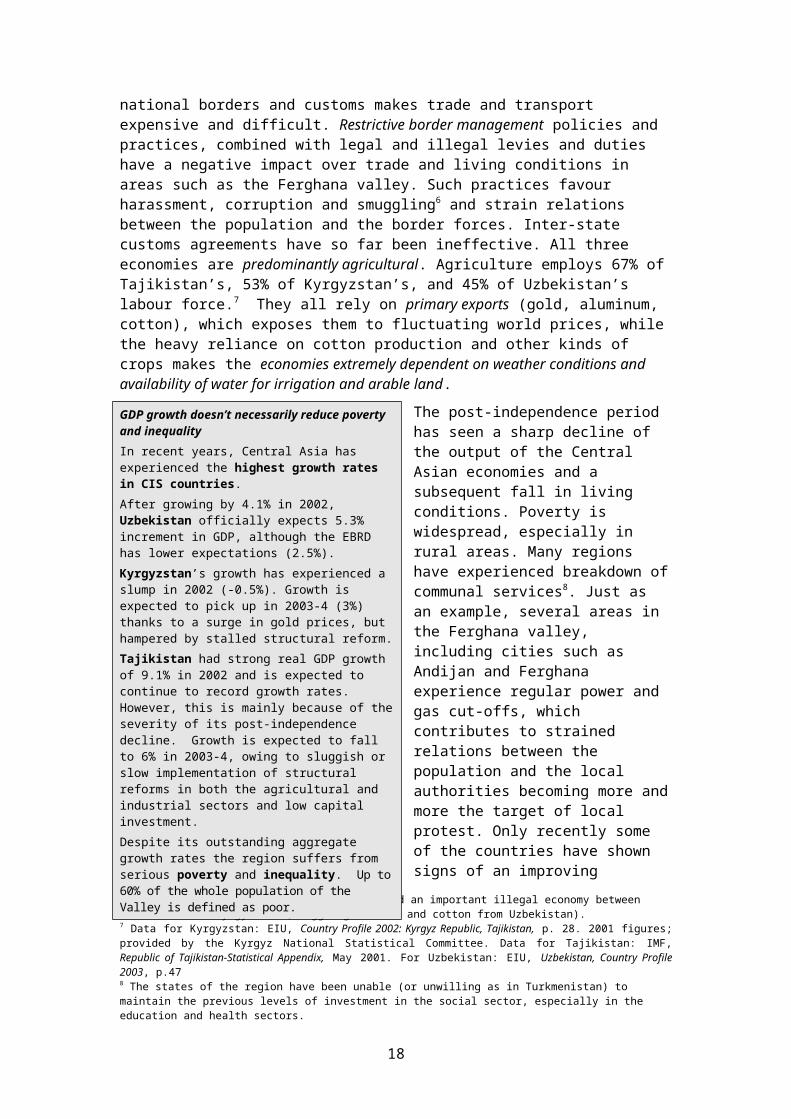
and living conditions in areas such as the Ferghana valley. Such practices favour harassment, corruption and smuggling6 and strain relations between the population and the border forces. Inter-state customs agreements have so far been ineffective. All three economies are predominantly agricultural. Agriculture employs 67% of Tajikistan’s, 53% of Kyrgyzstan’s, and 45% of Uzbekistan’s labour force.7 They all rely on primary exports (gold, aluminum, cotton), which exposes them to fluctuating world prices, while the heavy reliance on cotton production and other kinds of crops makes the economies extremely dependent on weather conditions and availability of water for irrigation and arable land.
The post-independence period has seen a sharp decline of the output of the Central Asian economies and a subsequent fall in living conditions. Poverty is widespread, especially in rural areas. Many regions have experienced breakdown of communal services8. Just as an example, several areas in the Ferghana valley, including cities such as Andijan and Ferghana experience regular power and gas cut-offs, which contributes to strained relations between the population and the local authorities becoming more and more the target of local protest. Only recently some of the countries have shown signs of an improving economic situation however high GDP growth rates have not helped reducing poverty and social inequalities.
The post-independence economic crisis has reinforced the economic disparities between urban and rural areas and between regions, thus contributing to reinforcing the horizontal inequality among population groups and regions. This process of marginalisation of a number of sub-state regions bears the risk for these to become “incubators of conflict” (ICG 2001).
Unemployment rate is high in all three countries especially among younger people and in marginalised regions. OCHA estimates that unemployment is likely to be around 10-20% for the Kyrgyz Republic, 30% in Tajikistan and 30-40% in Uzbekistan. The steadily growing lack of jobs combined with the fact that in all three countries almost half of the population is under 17 years old and will be entering the
6 For example, the border closure has fuelled an important illegal economy between Uzbekistan and Kyrgyzstan (smuggling of fuel and cotton from Uzbekistan).7 Data for Kyrgyzstan: EIU, Country Profile 2002: Kyrgyz Republic, Tajikistan, p. 28. 2001 figures; provided by the Kyrgyz National Statistical Committee. Data for Tajikistan: IMF, Republic of Tajikistan-Statistical Appendix, May 2001. For Uzbekistan: EIU, Uzbekistan, Country Profile 2003, p.478 The states of the region have been unable (or unwilling as in Turkmenistan) to maintain the previous levels of investment in the social sector, especially in the education and health sectors.
GDP growth doesn’t necessarily reduce poverty and inequality In recent years, Central Asia has experienced the highest growth rates in CIS countries. After growing by 4.1% in 2002, Uzbekistan officially expects 5.3% increment in GDP, although the EBRD has lower expectations (2.5%). Kyrgyzstan’s growth has experienced a slump in 2002 (-0.5%). Growth is expected to pick up in 2003-4 (3%) thanks to a surge in gold prices, but hampered by stalled structural reform. Tajikistan had strong real GDP growth of 9.1% in 2002 and is expected to continue to record growth rates. However, this is mainly because of the severity of its post-independence decline. Growth is expected to fall to 6% in 2003-4, owing to sluggish or slow implementation of structural reforms in both the agricultural and industrial sectors and low capital investment. Despite its outstanding aggregate growth rates the region suffers from serious poverty and inequality. Up to 60% of the whole population of the Valley is defined as poor.
13

workforce soon, driving up unemployment figures drastically9, produces a situation where social unrest becomes a possible scenario
Widespread poverty and unemployment has triggered important flows of internal migrations from marginalised rural areas to urban (especially to capitals).
A second coping mechanism has been the important labour migration to Russia of large numbers of persons (mostly men). This has been a major safety valve for the region, especially for Tajikistan, Kyrgyzstan and more recently Uzbekistan.
If we now look at the mechanisms fostering insecurity discussed in chapter 1.4 above, one can see that not surprisingly the current situation in post-independence Central Asia presents all the factors supporting insecurity.
The period after the accession to independence has seen a rapid decline of the living conditions of large segments of the population, a dramatic increase in poverty and inequality, the breakdown of communal and social services, the emigration of key minorities, the development of labour migration as survival mechanism for entire regions. At the same time this process has been accompanied by high birth rates, increased economical and/or political marginalisation of groups (ethnic minorities) and regions. Central Asian economies continue to depend on raw materials extraction and agriculture.
3. Ferghana – Osh – Khudjand: Issues and Problem Spots
The research of available sources of information, previous publications on the subject and ENVSEC consultations have so far identified three main clusters of issues as relevant for the environment and security dimensions in the Ferghana triangle: access to and quality of water resources, access to and degradation of land, and pollution from industrial facilities.
In the next pages the report will analyse these clusters and, making use of the theoretical inputs presented above, will try to identify and prioritize specific locations and issues that can be considered as “problem areas” or “hotspots” from and environment and violent conflict perspective.
9 Data as reported in OCHA (2004): Official statistics in the Kyrgyz Republic suggest an unemployment rate of 3% for 2001, while the EIU suggests figures around 7-10%, multilateral agencies even 20%. EIU, Country Profile 2002, Kyrgyz Republic, Tajikistan, p. 13. UNICEF reports an unemployment rate of 24.8% among age 15-24. UNICEF (2003), Year-end figures. At the same time, 41% of the Kyrgyzstan’s population is under 17 and will soon be entering the workforce (source: ibidem).. Unemployment in Tajikistan is officially reported at 2.3% in 2001 (source: ibid.) while ICG estimates unemployment to be over 30% (ICG (2003), Tajikistan: A Roadmap For Development, ICG Asia Report No. 51, 24 April 2003). 36.5% of persons age 15-24 are registered unemployed (UNICEF (2003), ibid.. Year-end figures). Almost half (48.9%) of the population is under 17 years of age and will be looking for jobs soon (ibid.). In Uzbekistan as little as 0.4% of the workforce is registered as unemployed, but 57.9% of age 15-24 have no job according to UNICEF. The Institute for Regional Studies in Bishkek reports that in the Uzbek part of the Ferghana Valley as many as 35% of all able-bodied people under 25 were unemployed in 1999 (FEWER (2001): Early Warning Report on the Ferghana Valley, October 2001). Here too, 44.3% of the population is younger than 17 years and will enter the labor force soon and drive unemployment figures up.
Box - Labor MigrationIn Kyrgyzstan an estimated 500’000 persons migrate annually to Russia and Kazakhstan for work (10% of total population; 25% of working population). Urban population is the most likely to emigrate and account for more than 60% of total emigrants.Thanks to the recent improved situation in the agricultural sector, Osh and Jalal-Abad cotton sector is attracting more and more unskilled daily labour from Uzbekistan despite the difficulties in crossing the borders. Uzbeks are also regularly moving to South Kazakhstan in search of employment in the agricultural sector.In Tajikistan, every year, an estimated 900’000 persons (one third of the working population) migrate to Russia and Kazakhstan for work.
Mechanisms Fostering Insecurity
PovertyInequalityCorruptionUnlawful Use of forceDiscriminationInjusticeHigh Birth RateRapid Population FlowsScarcityDiseases
14

In the analysis particular attention will be given to the sub-national level and especially to marginal vulnerable lands such as arid plains, mountain areas with highland - lowland interactions and trans-national river basins. On the topographical map below, the main areas of concern become clear. In blue the areas related to the Syr-Darya basin and in red the hilly / mountain areas that represent the physical border of the Valley. These areas are interesting for their relations with the irrigated plains of the Ferghana valley.
Map 2 - Areas of concern of the Ferghana Valley10
3.1 Water
For Central Asia, agriculture represents a mainstay of the economy and in the economic crisis of the post-independence period it has gained even greater importance. With agriculture almost entirely dependent on irrigation access to water is of strategic importance.
The Syr Darya, formed by the confluence of two major tributaries - Naryn and Kara-Darya - both originating in the Kyrgyz Republic, is one of the two major rivers serving the Aral Sea basin and is the key water resource for the whole Ferghana Valley. With a length of 2200 km it originates in the Tien Shan mountain of the Kyrgyz Republic, passes through Tajikistan, Uzbekistan and South Kazakhstan and falls into the Aral.
In principle, the mountains of Central Asia are rich in water. Taking into account that a country is considered a highly water-scarce country when annual water supplies drop below 1,000 cubic meters per person, the situation in Central Asia is very different between down- and upstream countries. In 1998 it has been evaluated that annual water supplies were of 704 cubic meters per person for Uzbekistan and 232 for Turkmenistan. The situation in this case is quite critical. On the other hand, the figures were of 4,484 for Kazakhstan, 11,171 for Tajikistan and 10,394 for Kyrgyzstan (World Resources Institute, 1998: 305). 10 Source: Reliefweb, October 2003. Areas of concern highlighted by author.
15
Trans-boundary water basin
Border regions with low-lands vs. high lands relations

The water crisis in Central Asia is so far11 not a crisis of quantity but of distribution. Although Afghanistan, Tajikistan and Kyrgyzstan are the most upstream countries in the Aral Sea basin, water withdrawals for these three countries totals 17%. The picture for downstream states (Uzbekistan, Kazakhstan and Turkmenistan) is exactly the opposite. Uzbekistan withdraws 52% of the total water, followed by Turkmenistan (20%) and Kazakhstan (10%).
Water abstraction versus flow generation in Central Asia
The chart shows that there is a clear imbalance in water consumption. While irrigation was practiced for over 2000 years in the river basin, it was only in the period of Soviet rule, water was diverted from the river on a large scale through an extensive irrigation infrastructure such as diversion dams, storage dams, canals, distributaries and pumping stations to enable the irrigated cultivation of cotton, fodder, wheat, fruits and vegetables. Box -The Water – Energy Nexus (World Bank, 200412)
By the 1960s the diversion of water for irrigation from the Syr Darya river was so extensive (around 30 BCM) that in the dry years with lower flows, the irrigation needs were greater than the total flow in the river. This necessitated the construction of the multi-year storage reservoir in the Kyrgyz Republic on the Naryn river, the main tributary of Syr Darya, for the purpose of storing water in wet years and releasing such stored water during the dry years for facilitating down stream irrigated cultivation both during normal and dry years. This reservoir was also provided with hydroelectric generating sets for producing electricity when water was being released. Four more reservoirs with limited pondage were constructed down stream in the same Naryn river to produce electricity using the waters released from Toktogul.
Under Protocol No.413 of 1984 of the Soviet government, in a normal year 75% of the annual discharge from the reservoir was to be made in summer (April-September) and discharges in winter (October-March) at 180 m3/second should not exceed the remaining 25%. Surplus electricity generated in summer was fed into the Central Asian Power System for use by Uzbek and south Kazakh regions. Since Kyrgyz region lacked any significant resources of fossil fuels, they were transferred from Uzbek and Kazakh regions to enable Kyrgyz region to meet its winter demand for electricity and heat.
Once these regions became independent states, the above arrangement came under a great strain. Fossil fuel prices rose quickly to world price levels and payments were often demanded in hard currency. Customers quickly switched from expensive fossil fuel fired heating to electric heating, increasing winter electricity demand. The Kyrgyz Republic could not afford to import fossil fuels and started to increase winter discharges of water to meet its winter power demand and reduce summer releases to
11 In the future this situation may change when looking i.a. at the local impact of global climate change.12 WORLD BANK, Water Energy Nexus, Improving Regional Cooperation in the Syr Darya Basin, Washington, January 2004
16

store water for the following winter. During 1990-2000, the summer releases declined to 45% and winter releases increased to 55% of the annual discharges.
To solve this problem of the competing (and now international) claims on the water, the Central Asian States entered into an agreement in February 1992 to maintain and adhere to the Soviet era arrangements. This, as well as other agreements13 for the release of water and exchange of electricity and fossil fuels proved ineffective and could not arrest the increasing power orientation of the Toktogul operation. The issue of compensating Kyrgyzstan for for water storage services remained open. Moreover, even when agreed summer discharges were made, supply of fossil fuels fell short of agreed quantities, forcing the Kyrgyz Republic to increase winter discharges. In wet years downstream states did not need the agreed volumes of summer discharges and this affected the export of electricity and the compensating quantities of fossil fuel transfers to the Kyrgyz Republic. The latter was thus exposed to a serious risk in terms of timing for meeting its winter demand for heat and power.
Map 3 - Water management in Central Asia
The problems related to the water – energy nexus along the Syr- Darya have already been a caused a number of incidents since independence. In 1993, in 1998, in 2001, and in 2004 Kyrgyzstan was blamed for releasing too much water from the Toktogul dam during winter and not enough during summer. Farmers in Uzbekistan and south Kazakhstan faced irrigation water shortages in summer and the frozen waterways and canals being unable to handle the larger volume of water in winter resulting in either flooding of small towns and arable lands or diverting them wastefully into a
13 Annual agreements as well as the Long Term Framework Agreement in March 1998,
17
series of depressions which formed the artificial lake called Aydarkul, with adverse environmental consequences.
Looking at the water vs. energy equation, Kazakhstan and Uzbekistan have so far been able to hammer out agreements with Kyrgyzstan and Tajikistan to swap fossil fuels for water. However the terms of trade in water for fuel swaps is problematic and crises are recurrent over the payment for water or fuel. The question of who pays for the management and maintenance of those parts of the system that benefit more than one republic has also become a major political issue.
Several inter-state bodies have been created since 1992 in order to deal with the issue of water management at regional level however, disputes over water allocations show that inter-state bodies are still not able to solve critical issues since they often lack the necessary political commitment from the highest spheres of the concerned governments (see e.g. Gely and Mueller, 2002).
For example, even though the Aral Sea Basin Program (ASBP) is administered by a council of deputy prime ministers and the International Fund for the Aral Sea (IFAS) is governed by the President of the five Central Asian countries - a solution that should assure a high level of political commitment – the issue of water management is left largely up to the states. In Central Asia, the ASBP and IFAS would provide a basis for joint approaches and actions. At the national level, different ministries should be able to integrate the actions of the inter-states bodies into national policies, strategies and programs. However, the real capacities of these ministries in fulfilling this task are often overestimated. At provincial level, the participation of local governments, the private sector, civil society organizations and institutions would be needed to translate these policies and programs into action and provide feedback. Civil society is often an important mechanism for parties directly concerned by water issues, to express their views. This aspect of participation is de facto often ignored in practical decision-making despite attempts of some inter-state bodies such as IFAS or ISDC to create public advisory bodies made of NGOs.
The World Bank is currently facilitating a high-level discussion and negotiation with the Central Asian states on the issue of the Water – Energy Nexus in the region. The signals are so far very encouraging and if the venture is successful, the water and energy concerns of the states would finally be integrated into a single regional policy and operational framework.
A basic productive resource for agriculture, water and competition for scarce water resources has been portrayed as a source of international conflict. Nations, however, and the international system have learnt to manage this threat.
Previous research (Klötzli, 1994) identified three main Central Asian regions where there are regularly incidents over water use: the Amu Darya delta, the Zeravshan valley, and the Ferghana valley. However, in the case of the Zeravshan and Ferghana valley, despite the very local character of the conflicts, the presence on now international borders and / or the implication of communities of another ethnic group, have “loaded” the conflict with ethnic and / or trans-border dimension.
3.1.1 Water Issues in the Ferghana Valley
As we have seen previously, the tensions related to the management of the water flow from the Toktogul reservoir have strained the relations between Uzbekistan, Kazakhstan and Kyrgyzstan to the point that Kyrgyz troops were deployed in summer 2000 and 2001 (drought years) in order to protect the reservoir and the water release operations. On the other hand, the constant involvement of interstate bodies, multilateral organisation, international financial organisations and key regional actors
18

is a guarantee that enough pressure and resources are dedicated to find peaceful solutions among the five Central Asian states.
In general, there is now a growing consensus that water scarcity will not create wars between nations - but there is also a growing conviction that water scarcity may work in a direction to exacerbate the basic conditions that fuel livelihood conflicts, particularly as countries go through the crucial transition period between dependence on agriculture and a modern society, based on economic growth in cities.
These findings apply also in the case of Central Asia where, as we have seen, states have been able to find pragmatic solutions to the disputes related to water. The situation is more preoccupying when looking at the sub-state level.
Map 4 - Water Cluster Locations
According to the results of the analysis carried out within the frame of the present study, the water question in the Ferghana area seems to turn around three main
Box - Water Wars
Some research into the prospect of “water wars” shows that no war over water has ever been fought, and only a handful of minor water “skirmishes” can be identified for the past century, while during this period 145 water related treaties have been signed. However, it is noted “there is ample evidence that the lack of clean freshwater has led to occasionally intense political instability and that, on a small scale, acute violence can result.”
Source: Wolf, 1998.
19

clusters of issues: water availability/ access to water; water quality; and the issue of raising groundwater / water-logging.
The next table summarizes the results concerning the question of water-logging:
Table 2. Water-Logging, Raising groundwater problems
LOCATIONS ISSUES ROOT CAUSE SECURITY ASPECT
TAJ - Spitamen district KYR - Sai-Aksu, Leilek district
flooding by waters released in KYR
agriculture and water use between KYR-TAJ
local tensions
KYR - Toktogul reservoir
flooding in UZB and KAZ, high water discharges, water allocations
energy vs. agriculture needs
flooding of lands
TAJ - Isfara and KYR - Batken border regions; Isfara Canal (TAJ)
loss of arable land raising water table due to increased water levels in Kyrgyz reservoirs, infrastructure degradation
local tensions
KYR - Kampyr-Ravat reservoir; Kara-Su and Uzgen districtsUZB Kurgan-Tepe district
loss of arable land, destruction of homes
raising water table health problems, flooding of lands
KYR - Kara-Bak village, Batken region
loss of arable land, destruction of homes
raising water table, irrigation infrastructure degradation
flooding of lands
TAJ- Kairakkum Reservoir - Arka / Kistakuz villages
migration of Tajiks towards Kyrgyz lands
raising water table local tensions and clashes
KYR - Kadamdzhai district KYR - Rishtan district
raising water levels expansion of Burgundy channel
loss of lands
TAJ-UZB Farhod Reservoir raising water levels water levels, infrastructure degradation
flooding of lands
KYR – Kara Darya, Yassy, Kurshab rivers
rise of water level in the Kyrgyz rivers
reservoir and river sedimentation
protests due to damage to agricultural lands
KYR – Osh province risk of dam failure of the Papan reservoir (built in the 19th century)
status of the infrastructure
risk of downstream flooding
KYR – Osh province water-logging from the Uzbek controlled Andijan and Papan reservoirs
raising water levels in the reservoirs
health problems, loss of lands
KYR – Uzgen district water-logging from the Uzbek controlled Uzgen reservoir (KYR)
raising water levels in the reservoir
health problems, loss of lands
KYR – Toktogul reservoir water-logging in Andijan (UZB) and Uzgen (KYR)
higher levels of water stored for hydropower production
flooding of lands; loss of arable soils, water deficit
Raising groundwater table levels is a problem in the regions around water reservoirs, especially around the Kampyr-Ravat reservoir in South Kyrgyzstan. In the Kara-Su and Uzgen districts of Kyrgyzstan, as well as the neighbouring villages of Kurgan-Tepe district across the border in Uzbekistan, estimates that 250 houses have been severely damaged and of up to 1,000 ha of arable land have been lost, reflective of the cross-border nature of the problem14. A similar situation exists around the Andijan, Uzgen and Papan reservoirs, with an additional inter-state dimension as these reservoirs are Uzbek controlled.
14 Source: IRIN available at http://www.edcnews.se/Cases/KyrgyzGroundwater.html
20

Always according to IRIN, local officials and scientists estimate that in the Osh region more than 185 settlements within the affected area were being impacted. The phenomenon resulted in the destruction of topsoil, as well as extinction of flora and agricultural crops once found in the area, decreasing health situation of the population of the affected villages.
Increasing levels of the water table around the Kairakkum lake in Tajikistan is also a source of concern. In the border areas of Arka and Kistakuz, the phenomenon is pushing Tajiks to resettle to higher Kyrgyz lands. Land acquisitions by Tajiks have been declared illegal by local Kyrgyz authorities that may want to expel the Tajiks by force.
In the same area, i.e. Arka and Kistakuz, tensions already existed between Kyrgyz and Tajiks due to the use of irrigation without proper drainage by the firsts and the subsequent water logging of Tajik agricultural lands. In Kara-Bak village of neighbouring Batken Province, some 300 ha of land are no longer usable due to water saturation15. In Spitamen district of Sogd region in Tajikistan, arable land is regularly flooded by the release of water from the rice fields located on higher grounds in Say-Aksu district in Kyrgyzstan.
Several factors are related to such situations. First of all the construction of the huge Soviet irrigation schemes instead of improving irrigation conditions and agricultural performance, led to soil erosion, rising groundwater levels and water-logging, secondary salinization, increased water use and lowered yields (Micklin, 2000: 33). A second factor is that building brigades and contractors had failed to properly forecast the implications of constructing such huge irrigation channels and artificial reservoirs. Moreover, Soviet construction brigades often neglected the necessity to install drainage facilities in the drive to maximise the area of new irrigation (Micklin, 2000: 33), and environmental impact assessments have rarely or never been carried out.
In the period since independence, lack of funds and lack of clarity concerning the responsibilities for the maintenance of the system led to the progressive degradation of the existing irrigation and drainage infrastructure. The result is further degradation of the soil and loss of top quality arable land.
Finally, in the post-independence period, under the pressure of population growth, new lands have been put into production. These newly developed lands are often in marginal regions, e.g. on the slopes of the Kyrgyz border regions (Batken, Osh, Jalal-Abad). Irrigated without proper drainage systems, often sown with water-consuming rice, these cultures contribute to exacerbating the raising groundwater levels of the
15 Source: IRIN available at http://www.edcnews.se/Cases/KyrgyzGroundwater.html
Box - Irrigation in Central Asia
In the Soviet era, extensive irrigation infrastructure has been developed along the Syr Darya (and Amu Darya) basin. The period between 1950 and 1985 saw the construction of reservoirs, irrigation canals, pumping stations and field canals, resulting in most of the water flowing in the rivers being diverted for irrigation. The irrigation infrastructure supported the cultivation of cotton, wheat, fodder, fruits, vegetables and rice in the arid steppe areas. It enabled the expansion of irrigated areas during this period by 150% in Amu Darya basin and 130% in Syr Darya basin. Large populations moved to the area to work in agricultural farms. Thus by 1999, agriculture contributed 11% of GDP in Kazakhstan, 29% in Tajikistan, 27% in Turkmenistan, 33% in Uzbekistan, and 38% in the Kyrgyz Republic. Cotton accounts for nearly 20-40% of the exports. Central Asia is the third largest producer of cotton in the world.The total agricultural area in the Syr Darya basin amounted to 3.4 million hectares, 56% of which was in Uzbekistan, and 24% in south Kazakhstan. In 2000, about 35% of the irrigated areas was under cotton cultivation, 30% under wheat, 12% under fruits and vegetables, 9% under fodder, 5% under rice and 9% under other minor crops. Cotton, fodder fruits and vegetables are the economically viable crops. Wheat areas are increasing on account of the food self-sufficiency concerns of the republics.Irrigation is inefficient. Water use is as high as 12,900 cubic meters / hectare and only 21% of this is effectively used. The remaining 79% is lost, most of it on the unlined on-farm and inter farm canals. This compares with the loss level of about 60% in developing countries.
21

lower lands. As these lands are usually in another state, Tajikistan or Uzbekistan, these issues become quickly a trans-boundary and “ethnic” problem.
The same factors are linked to the issue of water availability and access to water.Table 3. Water availability and access to water
Table – Water Availability and Access to WaterLOCATIONS ISSUES ROOT CAUSE SECURITY ASPECT
KYR - Jar-Kyshtak in Leilek districts, Batken region
water allocation disputes water allocation / access to water
local clashes
KYR – UZB Koprovadskoe and Kirki-Dong reservoirs
unresolved demarcation of UZB-KYR border
demarcation of borders interstate negotiations
UZB - Uzbek part of the Ferghana Valley
Water allocation for private farmers /Access to water
legislation / government cotton and wheat quota
local tensions
UZB - Dostyk Canal water allocations conflicting interests for water use
inter-regional disputes
KYR - Enclaves, Batken region water allocations dependency from neighbours for accessing resources
local tensions and clashes
KYR – Tortkul reservoir water allocations disputes between Batken (KYR) and Sogd (TAJ)
water allocation between KYR and TAJ
local tensions
Taj - Mastchoh District, Sogd region
water availability lack of infrastructure local tensions
KYR - Batken region water availability/lack of drinking water
lack of infrastructure local tensions
KYR - Aravan, Uzgen districts, Osh region
water availability for irrigation
infrastructure degradation
local clashes on water
KYR - Leilek, Batken, Kadamdzhai districts, Batken region
water availability for irrigation
water allocation between KYR UZB TAJ villages
local clashes on water
KYR - Nooken district, Jalal-Abad region
water availability for irrigation
water allocation between KYR UZB villages
local clashes on water
KYR- Ala Buka district, Jalal-Abad region
water availability for irrigation
water allocation between KYR villages
local clashes on water
KYR – Ak-su district, Jalal-Abad region
water availability for irrigation and drinking
water allocation, infrastructure degradation
local clashes on water
KYR - Ak-Say, Ak-Tatyr and Samarkandek villages in Batken region; Kyrgyz-Tajik border area
water availability/access to water, land allocations
water and land allocation between KYR and TAJ communities
local tensions and clashes
The border regions between Kyrgyzstan and Tajikistan and Kyrgyzstan and Uzbekistan (including the enclaves) are especially problematic areas as the irrigation infrastructure has been built when the borders were only administrative separations, with independence these have become state border.16 As border demarcation between Uzbekistan and Kyrgyzstan is not yet completed, the border concerning the Kirki Dong and Koprovadskoe reservoirs is still unresolved. Irrigation channels go now through the territory of two or even three states, so disputes over water availability become easily trans-boundary matters.
Water allocation disputes also gain easily an ethnic dimension. The countries sharing the Ferghana valley are multi-ethnic states. In Kyrgyzstan, the Uzbek population is concentrated mostly in the South, in Osh, Jalal-Abad, and in the Kara-Su, Aravan,
16 The presence of seven enclaves located in the Ferghana valley increases the complexity of the border question. Several unsolved questions related to the border delimitation and demarcation processes are straining the relations between the Central Asian states. The situation has become even more difficult with the increased militarization of the borders in the Ferghana after the 1999 and 2000 military incursions of the Islamic Movement of Uzbekistan (IMU).
22

and Susak districts, the Sogd region in Tajikistan harbours an important Uzbek minority. In such a situation, disputes over water or land may quickly mobilize communities through ethnic solidarity networks.
Aravan, Uzgen and Osh districts in Kyrgyzstan are regularly theatre of disputes over water allocations. The same happens in Batken region, specifically in Samarkandek, Ak-Say and Ak-Tatyr villages (tensions between Tajik and Kyrgyz communities) and in the Leilek, Batken and Kadamdhzai districts (tensions between Kyrgyz, Uzbek and Tajik villages).
The demarcation and enforcement of state borders and the distribution of ethnically diverse communities along these borders (and the presence of seven enclaves) are factors that rapidly load local disputes over water with an ethnic and trans-border dimension. A situation that increases the risk of escalating local disputes in more important violent clashes. Local and regional authorities have a major role to play in de-escalating tensed situations and find peaceful solutions.
Tensions over water availability or water allocations are frequent also in mono-ethnic and non-border districts such as in the Ala Buka district in Jalal-Abad (Kyrgyzstan) or in Mastchoh district, in Sogd (Tajikistan) where tensions are mostly between local communities and district and regional authorities.
The issue of water allocations has an additional dimension. The emergence of numerous small private plots after independence has significant implication for water use as it becomes very difficult to calculate water allotments to collectivities as irrigation and drainage systems were not designed to serve small-scale farms. In general it seems that water allocated for private plots is clearly inadequate, with the results that households compete for water with individuals and groups diverting water to their own plots. (O’Hara, 2002) Water allocation has also an “elite” dimension, as local elites that have access to land manage also to get a better access to water than small farmers.
The question of water quota allocations is an especially sensitive issue in Uzbekistan, where the available water is not distributed equally among the users. Not only upstream provinces allegedly taking more water than the downstream ones but also the Uzbek legislation still gives a priority access to water for the large collective farms (private farmers, who are “secondary users” depend on the collective farms for accessing water).
At the same time, in Tajikistan and Kyrgyzstan where the number of individual farmers is higher, water ministries have lost their previous counterparts, the collective farms. The multiplication of interlocutors makes the authorities’ task almost impossible. This is the reason why local water authorities favour the creation of Water Users’ Associations. Moreover, the issue of water access is exacerbated by the government’s preference to cash crops and its quota system for cotton and wheat. At the same time, government prices for such crops tend to be much lower than their open market value, impacting on the viability of independent farming.
Box - Agriculture in Uzbekistan
“In Uzbekistan, agriculture accounts for 33% of GDP, 60% of foreign exchange receipts and 45% of the employment. The government follows the objectives of stabilizing cotton export revenues, achieving wheat self-sufficiency, and keeping food prices low. In pursuit of these the government controls production, planting, procurement and pricing of the produce. Farmers get low prices. Government monopolies handle input supply and marketing. It bans exports of products like cereals and livestock and imports through state monopolies products like sugar and vegetable oils. About 20% of the farm areas have been privatized, but are still subject control of production and pricing and procurement. Prices of livestock, fruits and vegetables have been liberalized. While agricultural production has been stabilized, incentives for efficiency improvement remain low”.
(Cited from World Bank, 2004:3)
23

Therefore, the problem of water scarcity in parts of Uzbekistan can be understood only taking into consideration these local and national political and economical factors and can’t be exclusively blamed on Kyrgyzstan’s policy of releasing less water in summer months or on drought as in 1999-2001.
The question of water quality and water pollution is the third aspect related to the water cluster.
Table 4. Water quality and water pollutionTable – Water Quality and Water PollutionLOCATIONS ISSUES ROOT CAUSE SECURITY ASPECTUZB – Reservoirs along the Syr Darya
water pollution by untreated municipal waste from Osh and Kara-Suu (KYR)
breakdown of infrastructure
health problems
TAJ - Kanibadam, Sogd region
water quality salinization of drinking water (canal)
health problems
TAJ - Gantchi, Jabbor Gafurov district, Sogd
water quality canal water pollution by domestic waste in KYR
local tensions
TAJ - Kairakkum Reservoir and Syr Darya near Khudjand
water quality pollution by agriculture / mineralization of water
water quality / health
TAJ – UZB Syr Darya and Isfarinka canal
water quality pollution by agriculture health problems
UZB - Ferghana region
water quality / contamination of drinking water
chlorination system dysfunctional
health problems
Kanibadam in Sogd province in Tajikistan– a town along one of the main irrigation channels - as well as the Kairakkum lake are affected by the problem of water salinization and consequent decreasing of drinking water quality.
This problem is not new. With the expansion of the irrigation systems and the construction of large dams along the Syr Darya (and Amu Darya) during the period of 1965 to 1985, the Soviet “government devoted more attention to installing collector-drainage networks to cope with the growing problems of rising groundwater levels, water logging and secondary salinization. However, this increased return drainage flows into rivers, substantially worsening their quality” (Micklin, 2000: 34). The widespread use of mineral fertilizers and pesticides also contributed to the pollution of water resources by return flows from irrigated fields.
Soil contamination linked to irrigated agriculture (contamination by pesticides, nitrates and strontium) is an issue in the whole central part of the Ferghana valley where maximum soil salinity is observed.
The situation has not dramatically changed from the Soviet period and the problems of secondary salinization and agriculture-related pollution remain the same though they have gained a gained a trans-boundary dimension especially between Tajikistan and Uzbekistan, for both the Syr Darya and Zeravshan rivers. (UNDP, 2003).
A related problem is the issue of the pollution of drinking water resources by organic waste, a problem usually linked to the breakdown of local drinking water infrastructure as in the case of Osh city and in towns of the Uzbek Ferghana region or lacking infrastructure as in the case of Gantchi in Sogd, Tajikistan, where the water used by the downstream Tajik settlement is polluted by the waste of upstream Kyrgyz communities. These cases of pollution often results in increased health problems for the local populations (such as in the recent typhoid fever epidemic or malaria outbreak in the Batken region or the hepatitis epidemic in the Osh region) and / or increased upstream-downstream tensions among communities where ethnicity can quickly be mobilized as a dividing line.
24

3.1.2 Conclusions Water Cluster
For the Ferghana Valley, agriculture represents a mainstay of the economy and in the economic crisis of the post-independence period it has gained even greater importance. With agriculture almost entirely dependent on irrigation access to water is of strategic importance.The states of the region have inherited huge irrigation and power-generation infrastructure build during the Soviet Union and managed, at that time, centrally. With independence, the Soviet water management arrangements came under great strain. As upstream countries needed more electricity generation capacities whereas the downstream ones need the water for agriculture, the water – energy nexus along the Syr-Darya has been the source of several incidents between the Central Asian countries, some of them had the potential to escalate to military actions. On the other hand, the Central Asian states – also thanks to the constant international pressure and attention – have found pragmatic solutions that have so far averted the use of force. The situation is more worrying at the sub-state level where the Zeravshan and the Ferghana valleys have been the theatre of local conflicts which, due to the presence of now international borders and / or the presence of communities of another ethnic group, have gained an “ethnic” and / or trans-border dimension. In the Ferghana valley, three main issues are source of concern: water availability / access to water; water quality and the issue of raising groundwater levels and water-logging.Raising groundwater levels is a problem in the regions around water reservoirs (such as Kairakkum, Kampyr-Ravat and the Uzbek managed reservoirs near Osh), resulting in loss of arable land, destruction of homes, decreasing health situation and population movement towards higher grounds. Lack of or degrading drainage infrastructure contributes to exacerbate these problems along irrigation channels, especially in the border areas of the Ferghana.Water-logging downstream of large reservoirs like Toktogul is becoming a growing inter-state problem as the Uzbek authorities are building intermediate reservoirs and canals to capture and divert excess flow.The development of new more marginal lands - often on the slopes in border areas and without the construction of appropriate drainage systems thus resulting in raising water levels in the plains– has created tensions between higher –lands communities and lower-lands ones. The establishment of international borders have made the issue of accessing water and of maintaining water infrastructure an extremely complex question. Tensions and even local violent clashes along the borders of Kyrgyzstan, Uzbekistan and Tajikistan are recurrent. At the same time, tensions over access to water are frequent also in mono-ethnic and non-border communities, where disputes involve mostly local communities and district / regional authorities.The issue of water allocation is a particularly sensitive question in Uzbekistan, specifically between upstream and downstream provinces and between collective farms and private farmers. The salinization of water resources and the pollution of rivers by return flows from irrigated fields is a recurrent problem inherited with the construction of the Soviet irrigation systems. After independence, the situation has gained a trans-boundary dimension, especially between Uzbekistan and Tajikistan (Kairakkum lake).The demarcation and enforcement of state borders and the distribution of ethnic divers communities along these borders (and the presence of seven enclaves) are factors that rapidly load local disputes over water with an ethnic and trans-border dimension. A situation that increases the risk of escalating local disputes in more
25

important violent clashes. Local and regional authorities have a major role to play in de-escalating tensed situations and find peaceful solutions.
3.2 Land
Given the importance of agriculture for the whole Ferghana basin, land like water has been historically among the most important factors in terms of political and security relevance.
One of the first questions when dealing with land in the Ferghana basin is the issue of land availability. Because of geographic and historical conditions, the Central Asian capitals, the Ferghana valley, the irrigated areas of Khatlon and Sogd (South and North Tajikistan), the areas along the Zeravshan river (Samarkand and Bukhara) in Uzbekistan show very high population densities.
The Ferghana Valley is the most populous area in Central Asia, holding about 20% of Central Asia’s population. It is estimated to be home to 10.5 million people. The Ferghana territories hold 50% of Kyrgyzstan’s population, 31% of Tajikistan’s population and 27% of Uzbekistan’s inhabitants (even though the Uzbek territory is only 4.3% of the Ferghana Valley territories). In absolute terms, about 6.6m Uzbek, 2.4m Kyrgyz, and 1.5m Tajik populate the Valley.
Population density is extremely high in the Uzbek part of the valley (277 people/km2) compared to the Tajik (69) or Kyrgyz parts (18). High population densities increase the risk of depletion of natural resources and thus of competition and even conflict for their control. This situation is reinforced by the fact that all Central Asian countries (with the exception of Kazakhstan) show an important population growth. OCHA cites a population growth rate of 1.5%.17 Between 1959 and 1989 the population of the basin states has increased by 140 per cent and is expected to increase by a third again by 2020 (O’Hara, 2002).
Table 5 - Population and population density.18
Administrative Unit % of state's territory
Area, square km
% of state's population
Population, millions
Density (pop./sqkm)
Tajikistan 100 143,100 100 5.9 70.7Sogd Province 18.2 26,044 31.4 1.8 41Kyrgyzstan 100 198,500 100 4.7 23.5Osh Province 42.2 83,767 32 1.5 33Jalal-Abad Province 23.1 45,854 18.2 0.9 23Uzbekistan 100 447,400 100 23 53.4Andijan Province 0.1 4,474 8.7 2.0 504Ferghana Province 0.2 8,948 10.6 2.4 367Namangan Province 0.2 8,948 7.6 1.7 236Total Ferghana 154,557 30.9 10.4
Agrarian overpopulation and an increasingly young population put the whole region under demographic pressure. This situation is aggravated by the lack of jobs and economic opportunities in general but especially in marginalised areas.
17 UNICEF data in OCHA, 2004: 14
18 Source: http://www.ferghana.elcat.kg/1en.htm. 1999. N.B. The newly created Batken province in Kyrgyzstan is not yet represented by these figures.
26

Migration is one coping mechanism to look for better economic perspectives. Kyrgyzstan faces a process of internal migration from least developed areas, especially from rural areas and small towns where Soviet enterprises provided the viability of these towns. Interestingly, the share of rural population grew to 65.2% in 1999. This phenomenon is further contributing to a de-urbanisation process where only the main urban areas and marginalised areas show an important population growth (Batken, 1,7%, Osh: 2.1%, Bishkek: 3.7% in 1998 UNDP 2001).
Osh and Jalal-Abad regions are important centres for cotton and cotton-processing industries, hydro-electrical power production, extraction of oil and gas. Jalal-Abad is becoming an important industrial centre, whereas Osh is facing deindustrialization though remaining a key knot on the transport routes from the Ferghana, to Tajikistan and China. Thanks to the recent improved situation in the agricultural sector in Kyrgyzstan, Osh and Jalal-Abad cotton sector is attracting more and more unskilled daily labour from Uzbekistan.
Map 5 - Ferghana Valley Population Density Map. Source: Reliefweb, October 2003
The results of the next table have to be read in the light of the factors discussed above, e.g high demographic pressures in the Ferghana – especially in the Uzbek areas - lack of jobs and lack of economic perspectives – especially in marginalised areas but increasingly in irrigated areas of Uzbekistan (due to the problems linked to
Box - Batken
Batken is a region of special concern (established in 1999 after the incursions of the IMU). It is the poorest region of Kyrgyzstan (ADB estimates that more than 80% of the population lives in poverty), combining the highest ratio of unemployment and one of the highest birth rate (1.7%). It has a complex political geography with numerous border crossings. Three big enclaves are located in Batken, Sokh (Uzb.), Voruh (Taj.), Shahimardan (Uzb.). Transport of goods and persons depends on the political climate and relations at the border. Because of such characteristics, the ICG in 2001 was defining the Batken region as an “incubator of conflict”.
27

the Uzbek cotton sector). These factors trigger population movements internationally (international labour migration), internally (migration to main urban centres and capitals) and cross-border (for example Uzbek labourers on Kyrgyz fields).
At the same time, local migration (both internal and cross-border) is also targeted towards less populated rural areas in the region. The regions of Osh and Jalal-Abad as well as the hills and mountain areas around these cities are poles of local migration. The mountain slopes of the Batken province are attracting population from border areas in Tajikistan.
This situation is changing the relations between lower and higher lands. Higher lands are usually marginal areas with limited capacities to support a large population living from agriculture. Moreover, local migration towards these areas is destabilising the local situation, increasing pressure on limited resources and hence fostering tensions and conflicts for their control. In this sense, local migration towards higher grounds represents a short-term solution to the problem of lack of economic perspectives for large segments of the population in the Ferghana region.
Table 6 - Land Cluster issues
LOCATIONS ISSUES ROOT CAUSE SECURITY ASPECTKYR - Enclaves, Batken region
border and land disputes
dependency from neighbours for accessing resources
local tensions and clashes
TAJ – Border region around Isfara
border and land disputes
unclear attribution of lands local tensions and clashes
TAJ - Gantchi, Jabbor Gafurov district, Sogd region
deforestation population pressure / lack of energy
degradation of environment
KYR - Ferghana and Chatkal mountain ranges, Jalal-Abad region
deforestation, overuse of walnut forests
population pressure, migration from lowlands
local tensions
KYR- TAJ Border areas
deforestation cutting of juniper forests leads to erosion
local tensions
KYR - Kerben, Aksy district, Jalal-Abad region and Mamai village (UZB)
dispute of pasture use unclear use of border pastures
local tensions
TAJ - Border regions Tajikistan - Kyrgyzstan and Kyrgyzstan -UZB
dispute over use of KYR pastures by TAJ and UZB cattle
population pressure on limited land; pastures previously managed jointly.
local tensions
KYR - Aksy district, Jalal-Abad region
land availability population pressure on limited land
competition for land, clashes
KYR - Susak district, Jalal-Abad region
land allocations unclear attribution of lands between KYR, UZB
local tensions
KYR - Nooken, Alabuka districts, Jalal-Abad region
land availability population pressure on limited land
illegal purchase of land, clashes
TAJ - Isfara, Tajikistan, Voruch enclave (in KYR, Batken region)
land availability / deforestation
population pressure on limited land
local tensions
KYR - Kok-Tash, Batken region - Chorku Isfara (TAJ)
seizure of lands by Tajiks
unclear attribution of lands local tensions and clashes
From the table it seems clear that enclaves and border areas are zones of concern with regard to tensions related to land. The complex and problematic demarcation of
28

borders between Tajikistan and Kyrgyzstan contributes to foster lack of clarity in terms of attribution of land. The border region around Isfara in Tajikistan and the region of Susak district in Kyrgyzstan are an example of such a situation. In Isfara (more precisely in Kok-Tash – Batken region- and Chorku, near Isfara), the situation has escalated to open conflict between Kyrgyz and Tajiks. A similar situation has happened in the region of Arka and Kistakuz (see chapter on water), where Tajiks have acquired lands in Kyrgyzstan after their lands have been flooded by raising water levels. In general, Kyrgyz officials have regularly raised concern that the fact that parts of Uzbekistan and Tajikistan bordering on Kyrgyzstan are overpopulated put pressure on Kyrgyzstan, and it fears that its neighbours will seize hundreds of hectares of land, string barbed wire and lay mines.19 A reference often done in relation of the situation around the Kairakkum reservoir.
Map 6 - Land Issues and Problem Areas
Another set of issues outlined by the table above is the question of deforestation and use of pastures. One of the main areas affected by these problems is the area of Jalal-Abad where the main walnut-fruit forests are located. Sources cited by IRIN20 mention that in the region there are some 10,000 households in the area already, with that number increasing each year. “Villages located in forest territories are overpopulated. Not having any land - or means to get by - people take out of the forest everything they can," a local expert cited by IRIN explained, adding that livestock trampled down young plants in the area, while some local farmers turned forests into ploughed fields. Moreover, with winters in the area notoriously long and cold, there has been a marked rise in the number of people cutting down trees in the area for fuel.”
Forests are getting under pressure also in the border areas around Isfara, in the Voruch enclave (Tajik enclave in Batken region, Kyrgyzstan) and in Gantchi, in Sogd Tajikistan. Once more these border areas are some of the main hotspots in terms of environmentally related local tensions. And once more these tensions get an “ethnic” dimension as the disputes usually involve groups from different ethnic communities.
Pastures in the mountain areas of Kerben (Jalal-Abad region, Kyrgyzstan) are also affected by similar problems. Disputes caused by unclear regulations concerning the use of pastures in border regions or simply by competition between different groups living in these areas are frequent along the borders between Kyrgyzstan (where the majority of pastures are located), Uzbekistan and Tajikistan.
These two types of regions, e.g. forest areas (especially the walnut forests) and pastures areas, seem to have many of the characteristics necessary for environmentally - induced conflicts to result in violence: the inhabitants of those regions depend to a large extent upon the resources put under pressure by the increasing numbers of persons arriving in the region, their livelihoods are directly, negatively and rapidly affected by the consequences of local overpopulation such as lower per capita availability of productive agricultural land and further impoverishment of upland areas. In this context, environmental disputes can be easily
instrumentalised using ethnic identities as a marker and a divider, this manipulation is facilitated by the fact that the incoming population is most probably Tajik or Uzbek and it is reinforced by other identity markers such as “plain – mountain” identities. Moreover, the
19 EIU ViewsWire, Kyrgyz Republic: Riot-torn region hopes for stability, 26 May 2003
Box - Walnut-fruit forests.
These important forests -- highlighted in WWF’s Global 200 biodiversity assessment -- represent remnants of the Tertiary subtropical forests which exist only in the Central Asian region The walnut-fruit forests are found primarily on the northern slopes of the Ferghana and Chatkal ranges of the Tien Shan, and on the southern slopes of the Gissar and Darvaz ranges in the southeast. The forests are a remarkable combination of walnut (Juglans regia) - reaching 20 m in height -- and wild fruit trees such as wild apple (Malus) and prune (Prunus).
29

regulatory mechanisms are usually deficient and the state has limited capacities to protect the resources; at the same time local authorities – in this case the Kyrgyz ones are openly dominated by Kyrgyz nationals (even in the South).21
Limited land availability has another impact: because of population pressure and scarce resources all available lands are utilized for agricultural purposes also those areas rich in endemic and endangered species. Moreover, pipelines, roads, electricity lines in the areas of fragile biodiversity, intensive use of recreational resources (including hunting and alpinism), mining and processing industries are all factors contributing to the loss of biodiversity in the region.
Finally, since independence, Central Asian states have introduced a number of agricultural and land reforms aimed at improving outputs and diversify the agricultural base. If in general, the overall trend has been towards the transfer of land to the private sector, in practice the different reform programs mean also different legal regimes for accessing land and regulating the management of water at the local level in the three basin states. This situation increases the complexity of the problems at the sub-state level
3.2.1 Conclusions on Land Cluster
In the Ferghana valley, where the agricultural sector is of strategic importance, the questions linked to access to land, land availability and land quality are vital for large segments of the population.
As we have seen in the previous chapter on water, soil contamination and overall land degradation from agricultural practices increase environmental pressure especially in remote, mountainous areas, such as the Batken region (UNEP, 2003).
High demographic pressures in the Ferghana – especially in the Uzbek areas -, lack of jobs and lack of economic perspectives – especially in marginalised areas but increasingly in irrigated areas of Uzbekistan (due to the problems linked to the Uzbek cotton sector) are factors triggering population movements, internationally (international labour migration), internally (migration to main urban centres and capitals) and cross-border (for example Uzbek labourers on Kyrgyz fields). At the same time, local migration (both internal and cross-border) is also targeted towards less populated rural areas in the region. The regions of Osh and Jalal-Abad as well as the hills and mountain areas around these cities are poles of local migration. The mountain slopes of the Batken province are attracting population from border areas in Tajikistan.
The rapid influx of new population lowers the per capita availability of productive agricultural land in upland areas. Forests and pastures are resources increasingly put under severe pressure. Disputes caused by unclear regulations concerning the use of pastures in border regions or simply by competition between different groups living in these areas are frequent along the borders between Kyrgyzstan (where the majority of pastures are located), Uzbekistan and Tajikistan. Once more enclaves and border areas around Isfara are some of the main hotspots in terms of environmentally related local tensions.
20 IRIN, Kyrgyzstan: Focus on Deforestation in the South, available at http://www.irinnews.org/report.asp?ReportID=36809 21 Even though after the events in Aksy, when local police fired on demonstrators killing six persons, local authorities have usually shown restrain when dealing with situations having the potential to trigger popular protest.
Box – Protected Areas
Protected areas, established in representative and unique ecosystems, formerly proved to be very effective tools for biodiversity conservation and monitoring. Recently, however, formerly integrated protected network has become separated into fragmented patches, its effectiveness dropped significantly and political borders turn out to be constraining factors for natural habitats. Some protected areas were devastated by the armed conflicts (Romit, etc) and other failed to conserve biodiversity because of increasing ecosystems fragmentation and barriers for migration.
30

These two types of regions, e.g. forest areas (especially the walnut forests) and pastures areas, seem to have many of the characteristics necessary for environmentally - induced conflicts to result in violence. These regions should be among priorities for the ENVSEC initiative in terms of monitoring.
This situation is changing the relations between lower and higher lands. Local migration towards these areas is destabilising the local situation, increasing pressure on limited resources and hence fostering tensions and conflicts for their control. In this sense, local migration towards higher grounds represents a short-term solution to the problem of lack of economic perspectives for large segments of the population in the Ferghana region.
3.3 Industrial Activities and Waste
The Soviet model of development for Central Asia was based on one hand on the development of large-scale irrigation schemes that would allow the region to become a major cotton producer and on the other hand on the development of heavy industry (mining, oil and gas industry, chemical industry, textile). Major industrial sites have been built together with the towns and cities to accommodate technicians and workers. With independence and the end of economic rationality that unified the Soviet market, the majority of these plants had to compete on the international market without necessary experience or capital. The majority of them had to drastically reduce their operations. Moreover, many of the trained technical staff left for Russia. Over the years industrial and mining towns have lost large parts of their population.
Although not much data is available, it seems that the operations of the industries in the region were carried out with limited environmental or public health concern and resulted in the accumulation of pollutants in the local environment. The Ferghana valley has been used by the Soviet Union as one of the main source of uranium ores, some 50 deposits were explored in this region.
31

Map 7 - Radioactive, chemical and biological hazards in Central Asia
Table 7 – Radioactive wastes hotspots
LOCATIONS ISSUES ROOT CAUSE SECURITY ASPECTKYR – Mayluu Suu, Jalalbad region
radioactive spills unprotected deposit contamination of Syr Darya
KYR – Shekaftar uranium mine
toxic wastes, uranium tailings
radioactive storage facility health problems; river pollution
UZB Uygursai uranium mine
toxic wastes, uranium tailings
radioactive storage facility health problems; river pollution
UZB – Charkesar uranium mine
toxic wastes, uranium tailings
radioactive storage facility health problems; river pollution
TAJ – Gafurov town, Chkalovsk, Taboshar, Adrasman and on the Mogol-Tay slopes
uranium tailing deposits; high radiation levels
uranium mining; open radioactive storage facility
contamination of land and water
The tailing dams at Mayluu Suu (Kyrgyzstan), Shefaktar and Sumsar (Kyrgyzstan), at the Charkesar mine (in Uzbekistan), and in the complex in around Khudjand (Chkalovsk, Adrasman and Taboshar) in Sogd province of Tajikistan are sites of special concern. Many tailing dumps, as well as mud storage, were built directly on river flood-plains22. There were cases where protection dams were washed away and
22 UNEP / GRID-ARENDAL, Thirteen Environmental Stories from Central Asia, Arendal, May 2003
32

radionuclides entered the rivers and reservoirs such as the Kairakkum reservoir23. Landslides threaten to push the contents of the dumps into the rivers. In Adrasman and Chkalovsk open tailing dumps are exposed to wind and water erosion, as well as to floods and landslides.
Because of their vulnerability to natural hazards, previous history of accidents24 and their position along water courses and in the vicinity of towns and cities, these tailing dumps represent a severe risk for the human security of the whole region. At the same time, despite the clear trans-boundary nature of the risks of contamination, these dumps have not been considered as a major issue by the Central Asian states. So far the notable exception is the one of the Kyrgyz government who has been very active in raising the attention of the international community over the problems of Mayluu Suu and has been able to raise World Bank funding to carry out feasibility studies and some melioration work on site25. Only recently Tajikistan started to approach international organisations on the issue of radioactive waste deposits. Uzbekistan has so far adopted a lower profile in raising international attention to this issue. Uzbekistan has a joint commission with Kyrgyzstan that primarily deals with Mayluu Suu, and the Uzbek state of the environment report from 200126 confirms the concern over the question of nuclear waste.
23 Meeting with the Academy of Science Dushanbe, Septermber 2004.24 In the mentioned GRID-ARENDAL publication, one author reports that in 1958 the tailing dump nr 7 broke, releasing about 600’000 m3 of radioactive materials in the river. The radioactive mudflow caused widespread destruction and contamination of huge areas. Additional information can be found in the Virtual media tour, http://www.grida.no/enrin/mediatour2003/25 On the other hand, with respect to Myluu Suu a recent TACIS-financed study suggested that the cost of intervention is too high given the level of risk. Complete clean-up seems not to be possible. (meeting with TACIS in Tashkent)26 Republic of Uzbekistan, State of the Environment report, 2001, pp 106-107
33

Table 8 – Industrial Wastes Hotspots
LOCATIONS ISSUES ROOT CAUSE SECURITY ASPECTKYR - Kadamdzhai district, Chadak gold deposit
toxic wastes, soil contamination
pollution by Kadamdzhai Combinat
health problems; soil contamination
KYR – Haidarken district, Batken region
theft of mercury from industrial plant
local circumstances at Haidarken Mercury plant
security problem
KYR – Jalal-Abad region
possible toxic spills Kyrgyzneftegas JSC, Kyrgyz Petroleum C;Maili Suu Electric Bulb Plant
KYR – Haidarken district, Batken
toxic spills industrial pollution mercury mining
health problems
KYR – Jalal-Abad, Batken regions
municipal waste disposal not functioning
infrastructure degradation, lack of funding
local tensions
KYR – Kadamdzhai district, Batken
transport of toxic substances to storage
Introduction of 300$ tax by Uzb authorities
difficulties for storage wastes
KYR – Kadamdzhai district, Batken
toxic spills industrial pollution antimony processing
health problems
KYR – Kadamdzhai district, Batken,
soil and water contamination
Industrial pollution by Kadamdzhai antimony Factory
health problems; river & soil pollution
KYR – Kyzyl-Kyya (KYR), Ferghana and Kuvasai (UZB)
pollution by power plants (coal)
coal with sulphurous content
health problems
KYR – Mayluu Suu, Jalalbad region
oil exploration, drilling, production
energy needs KYR pollution
KYR – Sulukta Kysil Kya districts, Batken
toxic spills industrial pollution, coal mining
health problems
KYR – Sumsar valley, Sumsar river; Lead Treatment Plant
toxic wastes, soil contamination
metallurgical production health problems; river & soil pollution
TAJ – Isfara pollution by industrial plants
industrial pollution pollution / health problems
TAJ – Kanibadam, Sogd region
chemical wastes deposit pollution by chemical substances
pollution / health problems
UZB – Bekabad pollution by metallurgic (aluminium) and cement plants
trans-boundary industrial pollution
pollution / health problems
UZB- Almylyk Plant, Pishkent district
pollution by industrial plant
trans-boundary industrial pollution
pollution / health problems
UZB – Ferghana city pollution by industrial plants
Trans-boundary industrial pollution
pollution / health problems
UZB – Minbulak oil field
oil exploration, drilling, production
energy needs UZB pollution Syr Darya river
UZB – Ferghana and Andijan oil processing plants
Pollution by industrial plant
Trans-boundary industrial pollution
river & soil pollution
UZB – Settlements of Mugul and Kerauchi of the Piskent district, Tashkent region
pollution by Almalyk mining & smelting
industrial pollution pollution
As we can see from the table above, the region has several locations that can qualify as “hotspot” in terms of industrial activity with negative impact on the environment and public health, mostly linked to mining and metallurgic operations, but also to oil and gas extraction.
34

Map 8 - Industrial Activity Problem Areas
In Kyrgyzstan three main locations are source of concern. The plants of Kadamdzhai and Haidarken (metallurgic plant, producing antimony and mercury) or the lead plant in the Sumsar Valley in Kyrgyzstan present problems of soils contamination with heavy metals and other toxic substances. The Kadamdzhai mercury plant is perceived as a trans-boundary problem also by the Uzbek authorities.
Moreover, in its database FAST records several thefts of mercury for a total of about than 150 kg from the plants of Haidarken and Kadmdzhai. This highly poisonous metal seems to find a market in the region.
In Tajikistan the industries around Isfara, and the chemical wastes deposit of Kanibadam are the identified hotspots in the Sogd province. The Kanibadam toxic wastes deposit (for obsolete pesticides) potentially present a similar situation as the radioactive tailing dumps described before, e.g. unprotected deposit, vulnerable to natural hazards, located in the vicinity of the border, of a water-way and of a town. As
35

in the case of the nuclear tailings, the Kanibadam deposit is not perceived as a security risk by the authorities at the regional level27.
In Uzbekistan, the Bekabad metallurgic plant, the industry in Ferghana city and the Almalyk metallurgic plant in the Piskent district28 have been identified as key problem areas. In particular the Bekabad plant is perceived as a trans-boundary problem by Tajikistan. At the same time Tajikistan prefers to adopt a low profile on this plant in order not to give the Uzbek authorities the occasion to criticize Tajikistan because of the pollution caused by the Tajikistan Aluminium smelter in Turzunzade. Tajikistan and Uzbekistan have agreements on issues of pollution from the Tajik Aluminium Plant and the Uzbek Bekabad’s metallurgic and cement plants, an indicator that the two countries take seriously the connection between environmental stress and security.29
As for the oil and gas operations, contamination by oil products is present in soils near oil deposits such as in the Minbulak oil field in Uzbekistan, at the oil production plants in Andijan and Ferghana cities in Uzbekistan or at the oil refinery in Jalal-Abad. However, also in these cases, the environmental pollution is mostly not perceived as a security problem even though past accidents have created tensions between the countries of the region30.
Only in very few cases national and regional authorities perceive pollution caused by industrial activity as a major security threat. The fact that these environmentally problematic operations in many cases still represent important economic activities, which are of crucial importance for the economies of regions such as Batken, certainly contributes to the fact that countries usually keep a low profile on issues related to industrial pollution. At the same time, these questions are a recurrent problem that contributes to strain relations between neighbouring countries ( as in the case of Tursunzade vs. Bekabad- Almalyk),
Another factor to be considered is that many of the industrial plants and of the radioactive tailings deposits are exposed to natural hazards. Moreover, they are often located near rivers and / or main irrigation channels, in the vicinity of town and cities. Accidents and natural disasters would thus affect a population far more important than only the one living in the immediate vicinity of a plant or deposit.
Incidents have been reported where flooding has washed off tailing dams at the Uranium Treatment Plant in Mayluu Suu in Kyrgyzstan or the wastes storage at the Lead Treatment Plant in Sumsar.
Major disastrous events affecting the plants listed above would have dramatic consequences the livelihoods of large regions. In addition to the immediate destructions such an event could trigger the displacement of large groups of persons also affecting the livelihoods of the receiving regions.
Even though natural disasters are usually occasions for solidarity and cooperation among states, the security dimension can’t be ruled out as such an event would also trigger the displacement of large numbers of persons within the affected country and /or to a neighbouring region.
3.3.1 Conclusions Industrial Wastes
The present report has identified a number of locations that represent a risk for the Ferghana Valley from the environmental and public health perspective.
27 Whereas the Tajik authorities are aware of the risks linked to the Kanibadam deposit.28 The Almalyk plant is actually in the Tashkent region, however the pollution coming from this operation is a source of concern also in Tajikistan.29 UNEP, UNDP, OSCE, Addressing Environmental Risks in Central Asia, Bratislava, 2003, p. 1930 In 1992, Tajikistan evaluated the damage from an oil spill in Uzbekistan as 600,000 roubles. There was formal communication between the two countries. Moreover, possible pollution from oil production was mentioned as a concern by environmental authorities in Dushanbe (meetings, September 2004).
36

The radioactive tailing dams at Mayluu Suu (Kyrgyzstan), Shefaktar and Sumsar (Kyrgyzstan), at the Charkesar mine (in Uzbekistan), and the complex in around Khudjand (Chkalovsk, Adrasman and Taboshar) in Sogd province of Tajikistan are sites of special concern. Because of their vulnerability to natural hazards, previous history of accidents31 and their position along water courses and in the vicinity of towns and cities, these tailing dumps represent a severe risk for the human security of the whole region. A similar situation exists with industrial locations that that can qualify as environmental “hotspot”. Only in very few cases (Bekabad, Turzunzade, Almalyk) national and regional authorities perceive pollution caused by industrial activity as a major security threat. The fact that these environmentally problematic operations in many cases still represent important economic activities, which are of crucial importance for the economies of regions such as Batken, certainly contributes to the fact that countries usually keep a low profile on issues related to industrial pollution. At the same time, these questions are a recurrent problem that contributes to strain relations between neighbouring countries (as in the case of Tursunzade vs. Bekabad- Almalyk).
An additional problem is linked to the fact that many of the industrial plants and of the radioactive tailings deposits are exposed to natural hazards. Moreover, they are often located near rivers and / or main irrigation channels, in the vicinity of town and cities. Major disastrous events affecting the plants listed above would have dramatic consequences for the livelihoods of large regions. In addition to the immediate destructions such an event could trigger the displacement of large groups of persons also affecting the livelihoods of the receiving regions. On the other hand, the prospect of a disaster can be used as an occasion for developing cooperation among regions and states potentially affected by an accident or disaster.
3.4 Cross-Cutting Issues
3.4.1 Natural Disasters
Central Asia is a disaster prone area, exposed to a number of natural processes such as floods, droughts, avalanches, rockslides, or earthquakes. The region is also vulnerable to man-induced disasters due to industrial activities and the nuclear / chemical dumps inherited from the Soviet period.
Several factors such as population density in disaster prone areas, the general important population growth, poverty, land and water use, non-application of building codes as well as global climate change make the region vulnerable to natural as well as man-made disasters hazards.
Natural disasters have killed about 2,500 people and affected some 5.5 million (nearly 10 percent of the total population) in Central Asia over the past decade. The incidence of natural disasters involving casualties among inhabitants settled in risk areas has been on the increase over the recent years due to increased occurrence of extreme weather events and inadequate preparedness.
In the Ferghana Valley alone, between 1994 and 2004, the cumulative damage from natural disasters estimated at over 300$ US millions, with more than 500 people killed and tens of thousands affected. 32 The regions most frequently
31 In the above mentioned GRID-ARENDAL publication, one author reports that in 1958 the tailing dump nr 7 broke, releasing about 600’000 m3 of radioactive materials in the river. The radioactive mudflow caused widespread destruction and contamination of huge areas.
32 Sources: ECHO and national reports
Box – Natural Disasters in the Ferghana Valley
The most destructive natural disasters of the past 10 years include: torrential rain and an earthquake in Osh and Jalal-Abad in 1992 destroyed 51,000 hectares of agricultural lands and affected 20,000 people (direct damage US$ 31 million), heavy rainfalls in 1993 (economic losses US$ 21 million), large-scale landslides and mudflows in 1994 and 2004 in the Osh and Jalal-Abad killed over 200 people and made over 30,000 homeless, a glacial lake outburst flood in 1998 (Shohimardon) killed over 100 people and caused damage to Kyrgyzstan and Uzbekistan, widespread floods in Jalal-Abad in 1998, caused by torrential rains, damaged an estimated 1,200 houses and public buildings (direct damage US$ 240 million), in the Tajik part of the Ferghana Valley, floods and mudflows in 1999, 2002 and 2004 led to widespread damage (compiled from nat. reports and UNECE).
37

affected by natural disasters in the Ferghana Valley are the Jalal-Abad and Osh regions (Kyrgyzstan), the Sogd region (Tajikistan) and the Ferghana region (Uzbekistan). On average, approximately 80 per cent of all the disasters (mostly hydrometeorological hazards) occur between April and August.
Many disasters, such as GLOFs33, earthquakes34 and floods35 are trans-boundary in nature. They can affect security and livelihoods directly and indirectly. One of the examples is the 1998 Shohimardon flood, when a high mountain glacial lake in the Alai Mountains of Kyrgyzstan released huge volume of water sweeping away homes, bridges, roads and other infrastructure in the Ferghana Valley and severely affecting both Kyrgyz and Uzbek territories (IRCF, UNECE).
The poor, who constitute majority of the Ferghana Valley population, are largely affected by the natural disasters. Most of the rural poor are dependent on river flows for agriculture and domestic water supply, and therefore live close to the riverbanks. The floods directly affect their security status through impacts on settlements and livelihood.
As we have previously seen (ch. 3.3.) natural disasters are a threat also for sensitive industrial plants and waste deposits. If their direct security relevance in terms of conflicts is relatively limited, disasters (and the risk thereof) are an opportunity for cooperation among relevant authorities such as the Ministries of Emergency Situations of the three countries. Such interest for cooperation could be enhanced especially in the case of industrial locations or radioactive waste deposits with an important danger of trans-boundary pollution by involving local authorities, disaster response institutions and communities of the areas at risk.
3.4.2 Impact of Global Climate Change
One factor to consider while looking at the region in terms of the links between environment and security is the impact of the global climate change on Central Asia in general and on the Ferghana basin in particular. By modifying the livelihoods of people, climate change may have an important security dimension especially in conjunction with other aggravating factors.
33 There are many glaciers and glacial lakes in the high altitude areas. A recent study shows that in the mountains surrounding the Ferghana Valley there are over 100 glacial lakes featuring potential outburst risk (GLOFs), and other dangerous situations, such as landslide dam outburst floods (LDOFs). The catastrophic phenomenon happened in July 1998 in the Shohimardon valley (Kyrgyzstan-Uzbekistan transboundary territory), when a stone-mud-ice flood killed nearly 100 people and destroyed many households. In 1999, the Asht Valley of Northern Tajikistan was hit by LDOF when 19 people killed, over 1,000 houses and infrastructure destroyed or damaged
34 The mountain areas of Central Asia, including the Ferghana Valley, are seismically active. National Seismological Networks record some 3,000-5,000 local and regional events a year. Over 500 earthquakes of magnitude M>5 were recorded during the period 1900-2000 only in the Kyrgyzstan, mostly in the Ferghana Valley and its mountains. Destructive earthquakes took place in Namanghan, Andijan, Ferghana, Jalal-Abad, Isfara areas. Maximum seismic activity has been observed in the Chatkal, Alai, and Ferghana Mountains, where 8-9 M events are possible (nat. reports). Most territory of the Ferghana valley and adjacent mountains are vulnerable to earthquakes with many small and large settlements located in the epicenter zones of the potentially devastating earthquakes (Isfara, Jalal-Abad, Osh, Kara-balta, etc). Some 30 settlements are threatened by both strong earthquakes and resultant risks (mudslides, unstable grounds, etc). The earthquakes (M>7) that struck the Ferghana Valley and adjacent mountain territory from 1911 caused few thousands casualties and millions of dollars in economic loss (nat. reports).35 Mudflows and floods are sometimes considered as the most destructive natural events in the Ferghana Valley. High density of river network, steep slopes and degraded soil cover increase mudflow risk, especially in piedmont parts of the Ferghana Valley. Mudflows are formed due to interaction of hydro-meteorological and geological factors: cloudbursts, rapid snow melting, slope steepness, easily washed grounds, etc. Almost all the piedmont territory of the Ferghana Valley is vulnerable to mudflows, including radioactive waste sites. Over 1,000 river basins are estimated to hold from moderate to high mudflow risk. In spring 1998, in Tajikistan and Kyrgyzstan, torrential rains caused severe flooding with over 20,000 people affected and many infrastructure and buildings destroyed. The years 2003 and 2004 also featured flooding events in many areas, including the Syr Darya delta. Winter ice and a failure to observe regional water use agreements trigged floods along the Syr Darya River in Kyzylorda, Southern Kazakhstan in early 2004 (nat. reports).
38

Map 9 – Impacts of Climate Change in the Central Asian Mountains
In the Ferghana valley the water and agriculture sectors are likely to be most sensitive to climate change-induced impacts in Asia. Even though regional climate scenarios are still uncertain, they can provide elements for assessing the potential impacts of climate change and considering appropriate policies and measures.
The major impact of climate change in arid and semi-arid Asia is likely to be a significant shortage of water resources associated with significant increases in surface air temperature (IPCC, 2001). Growing populations and high concentration of population in fertile areas, such as the Ferghana valley, will exert increasing pressures on water availability and water quality. The agricultural sector and thus the backbone of the regional economy would be affected by negative changes of water availability.
Most climatic projections suggest in the long run (by 2050) high temperature increase in the Syr Darya Basin ranging from 2°C to 3-5°C (moderate scenario), and over 5-6°C (worst case scenario) by the end of this century (assessments by Uzbekhydromet and Tajikhydromet). This would have additional detrimental effects on the populations’ health by possibly favoring increases in vector-borne and waterborne diseases. Decreases in water availability and food production, leading to poor nutrition and increased susceptibility to diseases, would indirectly affect the health of the population.
39

Depending on scenario selected, climate change will have from minor to severe impacts on the Syr Darya basin in general, and the Ferghana Valley area in particular.
In general, water shortages and water quality problems, already issues in the Ferghana Valley, are unlikely to be improve, and will possibly be exacerbated by climate changes. Land conditions may worsen and desert areas expand. Potential decreases in food production (rice, cereals) would lead to indirect impacts on human health. Heat stress and possible spread in vector-borne and infectious diseases are likely to increase and affect vulnerable population groups, primarily the poor, elderly and children.
More worrying is the fact that globally the occurrence and intensity of extreme weather events and the impacts of natural disasters tends to amplify, affecting even more the livelihoods of the populations of
the concerned regions.
Moreover, the absence of effective policies and institutions to address the impacts of global warming would increase the vulnerability to climate change – the states of the region being unprepared to such changes – which in turn could affect the region’s susceptibility to conflicts.
3.4.3 Other Issues
As mentioned in the chapter dedicated to the water cluster, outbreaks of diseases related to water (typhoid fever, malaria and hepatitis) have been recently registered in the Kyrgyz part of the Ferghana valley. Two elements should be noted. These outbreaks are not easily constrained by state borders. Such events are the witness of the declining living conditions of the affected populations and of the degradation of their livelihoods. In this sense they can be considered as an indicator of an increased vulnerability of these regions.
A final note should be made concerning the issue of direct military action and terrorist acts directed against strategic objects such as dams (specifically Papan in the Osh region, Toktogul reservoir but also Lake Sarez in Tajikistan). Clearly a successful attack against this type of object would have disastrous consequences for the Ferghana valley and Central Asia. On the other hand, operations against large dams would need means and capacities that seem well beyond those of the insurgency groups operating in the region. More worrying is the prospect of actions against sensitive industrial sites, the recurrent thefts of quicksilver from the Haidarken mercury plant prove that security is very easy to avoid.
Box- Climate Change Scenarios for Central Asia
On the basis of the magnitude and severity of the projected climate change impacts it is possible to elaborate scenarios (2030-2060s) of regional environmental security in Central Asia.
Most unfavorable would be the “hot and dry” scenario, when extreme temperatures, severe droughts, initially increased water flow and subsequent severe water deficit, rapid expansion of deserts in lowlands and middle mountains and major decline in natural grassland productivity would lead to diminished ecosystem services, increased susceptibility to extreme events, erosion, direct impacts on economic sectors and human health. Food and agricultural production would be highly endangered. Valuable alpine ecosystems, including piedmont mountain pastures, genetic resources and many endangered species, could be lost. Heat, malnutrition and diseases may affect thousands. The massive degradation of mountain glaciers poses essential constraints on the further development of Central Asia. Inequalities, tensions and conflicts will be likely consequences of resource scarcity, environmental deterioration and migration imposed by severe climatic changes. As problems become prevalent, the regional disputes over scarce and important resources increase.
Mildly damaging would be the “warm and wet” scenario, under which temperatures grow moderately, precipitation increases evenly, and year-to-year weather variability does not reach some critical levels. Water resources continue to decline but, on a general level, water supply to the population and economy is not threatened. Alpine ecosystems may benefit from new climatic conditions and CO2 enrichment, whereas low-mountain pastures may be adversely affected. Natural disaster consequences increase affecting vulnerable communities, especially the rural poor, and some regions at levels higher than at the present climatic conditions. Food production and agriculture do not experience significant alterations, although overall decline would predominate. Existing disputes over natural resources are unlikely to be reduced under this scenario.
40

4. Outlook: The Ferghana Area and the Prospect for Conflicts
The present report is dealing with the links between environment and security in the Ferghana areas (Ferghana – Osh – Khudjand). In chapter 1.4 above we have tried to propose an approach that would help clarifying these links. The arguments used can be summarised in the following table:Table 9 – Summary Environment and Security Links
Necessary conditions Vulnerable Locations Causal Pathways Mechanisms Fostering Insecurity
Scarcity of regulatory mechanisms and poor state performance.
Marginal vulnerable areas, at intra-state level.Areas directly impacted by environment degradation (pollution, water logging)Densely populated areas where access to key resources becomes an issue of survival
- Dependency on natural capital- Unequal access to natural resources, - Consequent marginalization of a group- Population movements
Poverty
Inequality
Dependency from scarce natural resources
Arid plains, Mountain areas with highland - lowland interactions,Trans-national river basinsDensely populated areas where access to key resources becomes an issue of survival
“Ecological marginalization” (unequal resource access +population growth).
CorruptionUnlawful Use of force
Institutionalising the environment.
Environmental scarcity can produce:
DiscriminationInjustice
Opportunities to build organizations and find allies.
Constrained agricultural productivity;Constrained economic productivity;
High Birth RateRapid Population Flows
Spillover from a historic conflict
Migration of the affected people; Greater segmentation of society, usually along existing ethnic cleavages;Disruption of institutions, especially the state.
ScarcityDiseases
If we look at post-independence Central Asia through the “lenses” proposed in the table above, we can say that the exception of the civil conflict in Tajikistan, Central Asia has been in general stable. The Ferghana valley, for the last ten years predicted to be on the verge of an explosion, has not experienced major conflicts (with the exception of the IMU incursions in 1999 and 2000).
The overall stability of the region can probably be linked to an underestimation of the restraint factors. Analysis seems to have underestimated the persistence of Central Asian pre-Russian, pre-modern conservatism, especially concerning the vision of power. In the hierarchical societies of Central Asia, only a strong – and thus pervasive - state is a legitimate state. The capacities of the population to endure protracted economic crisis have been grossly underestimated. Islam is not only used by radical neo-fundamentalist organisations to create a conflict environment but is also a strong element of stability and restrain. The Central Asian ruling elites share a common background and socialisation, making easier to find ad-hoc solutions in case of crises. Elites and authorities have been so far able not only to avoid major interstate crises but also to control crisis situations at local level. Finally, social institutions such as the salience of informal social networks (« clans ») and the family have been a powerful instrument of social control and restraint factor.
41

However, thirteen years have past since independence and during this time several insecurity-fostering factors have become more important:
The fragmentation of Central Asia as a region from the political and economical point o f view;
The progressive demarcation of the state borders in the Ferghana valley and the reinforcement of the security regime at the border with the parallel introduction of more restrictive visa regimes;
Decreasing living conditions for the majority of the population in the Ferghana region, the post-independence period profiting only a fraction of the population contribute to widespread perceptions of social inequalities and injustice;
The different speeds of economic development processes between states but especially within states have strengthened horizontal inequalities at the sub-region level;
High population densities in the irrigated lowlands of Tajikistan and Uzbekistan, combined with a birth rate decrease the capacities of these regions to absorb excess labour;
Constrained economic productivity in the Ferghana areas and high levels of unemployment especially among the youth, contribute to increase the pool of people with grievances. So far migration (rural – rural, rural - urban or to other CIS countries) has been a major safety valve;
To a strongly networked society corresponds a weak state where corruption is widespread. State performances in delivering services have in general decreased since independence;
Repeated abuses by state security forces contribute developing grievances against the state structures and to radicalize oppositions;
Infrastructure degradation (especially the irrigation infrastructure of key importance for the agricultural sector), combined with resource scarcity contributes to accelerating existing political and social crises.
The increased importance of these risk factors combined with a constant erosion of certain restraint factors, seem to make Central Asia more vulnerable to conflict. If at the interstate level the prospects of conflict are low36 as restrain factors are still strong, t is at the sub-state level and in already marginalized areas that tensions are the strongest.
If we look more specifically at the role of environmental factors in influencing the region’s vulnerability to tensions and violent conflict, the results of the analysis presented by this report can be visualised in the following map (see next page):
36 Interstate violence may occur in case of unilateral military operations on the territory of a neighbouring state in response to localised conflicts over access to natural resources or in case of state breakdown and subsequent intervention by a neighbouring state to control strategic economic objects (dams such as Toktogul lake, industrial plant such as Turzunsade aluminium smelter).
42

Map 10 - Ferghana valley: Environment and Security Hotspots, All Clusters
Confronted with decreasing living conditions, degrading livelihoods, an increasing shortage of land due to high demographic pressure and with the bleak economic prospects in the Ferghana valley, large segments of the population decide to migrate in order to look for a better future. Local migration, e.g. migration within the region, is a phenomenon of key importance. Not only people are migrating to regional centres such as Osh and Jalal-Abad in South Kyrgyzstan but there is also an important migration37 from the low lands towards the hills and mountain regions surrounding the Ferghana valley. The pressure put on natural resources by the rapid inflow of population in these already marginal lands is changing the relations between low- and highlands. More importantly the competition for scarce local resources between “established” populations and “newcomers” can easily and rapidly escalate into violent conflict. Threatened by ecological marginalization, the mobilisation of the populations living in these regions would most probably happen along ethnic lines.
In the irrigated plains, enclaves and border regions are areas of concern. Not only the reinforcement of the borders (and especially of the Uzbek border) is disrupting legal trade flows and economic activities (but fostering smuggling), the new state borders load with a trans-border dimension local disputes and make the search for solutions more complex.
37 Though reliable statistical data are not available, a range of anectodical information confirm this trend.
43

The establishment of international borders has made the issue of accessing water and of maintaining water infrastructure an extremely complex question. Tensions and even local violent clashes over access to water are recurrent along the borders of Kyrgyzstan, Uzbekistan and Tajikistan. At the same time, tensions over access to water are frequent also in mono-ethnic and non-border communities, where disputes have often an elite dimension and involve mostly local communities and district / regional authorities. The issue of water allocation is a particularly sensitive question in Uzbekistan. Disputes and tensions between collective farms and private farmers will become more frequent.
Radioactive tailing dumps and several industrial locations are environmental “hotspots”. In a few cases (Bekabad, Turzunzade, Almalyk) do national and regional authorities perceive pollution as a major issue and as a security threat. The fact that these environmentally problematic operations in many cases still represent important economic activities certainly contributes to the fact that countries usually keep a low profile on issues related to industrial pollution. At the same time, these questions are a recurrent problem that contributes to strain relations between neighbouring countries (as in the case of Tursunzadeh vs. Bekabad- Almalyk).
Tailing dumps and industries are exposed to natural hazards. Moreover, they are often located near rivers and / or main irrigation channels, in the vicinity of town and cities. Major disastrous events affecting the plants listed above would have dramatic consequences the livelihoods of large regions. In addition to the immediate destructions such an event could trigger the displacement of large groups of persons also affecting the livelihoods of the receiving regions. At the same time, the prospect of a disaster can be used as an occasion for developing cooperation among regions and states potentially affected by an accident or disaster.
Climate change is likely to be a pressing and complex environmental issue for the mountain areas of Central Asia in the coming 30-50 years (especially if severe climate warming scenarios hypothesized in several studies indeed occur). A situation made more difficult by the absence of effective policies and institutions to address the impacts of global warming would increase the vulnerability to climate change – the states of the region being unprepared to such changes – which in turn could affect the region’s susceptibility to conflicts.
Finally, strategic infrastructure such as dams (specifically Papan in the Osh region, Toktogul reservoir but also Lake Sarez in Tajikistan) could be at risk of terrorist attacks. Fortunately, operations against large dams would need means and capacities that seem well beyond those of the insurgency groups operating in the region. More worrying is the prospect of actions against sensitive industrial sites, since various incidents prove that security is very easy to avoid.
4.1 The Road Ahead
One of the final conclusions of the report could be that the vulnerability to environmentally – related conflicts at sub-state levels has increased during the last thirteen years. Especially at risk are mountain / forest areas as well as enclaves and border regions. Issues pertaining to water (especially to the allocation of water) and land (availability and quality) are clearly risk-increasing factors as these resources are already scarce in the Ferghana region.
At the same time, states are not without means of action. By strengthening key institutions, developing policies favouring cooperation and a sustainable and more equal economic development, the Central Asian states would probably be able to counter many of the negative effects of the phenomena described in this report, and by doing this would decrease their vulnerability to violent conflict.
44

The Environment and Security initiative would like to support the states of the region in this policy development work. Priority areas such as water, land and industrial waste should be given specific attention therefore the initiative foresees to undertake concrete projects in identified problem areas. Moreover, the initiative plans to support the monitoring of environmentally related conflicts especially in mountain / forest areas as well as enclaves and border regions.
45

References
BAECHLER, G. (1998) Why environmental transformation causes violence: A synthesis. Environmental Change and Security Project Report, Issue 4 (Spring 1998): 24-44.
BAECHLER, G. (1999) Environmental Degradation in the South as a Cause of Armed Conflict. In: CARIUS, A. and LIETZMANN, K. eds. Environmental Change and Security: A European Perspective. Berlin: Springer. pp. 107-129.
CHAMBERS, R. and CONWAY, G. (1992) Sustainable rural livelihoods: Practical concepts for the 21st century. IDS Discussion Paper 296. Brighton: IDS.
COLLIER P. and HOEFFLER A.,( 2001) “Greed and Grievance in Civil War,” World Bank Policy Research Working Paper No. 2355 October.
DABELKO, D., LONERGAN, S., and MATTHEW, R. (2000) State of the Art Review of Environmental Security and Co-operation. Paris: OECD.
DOUGLAS G. (1996)., “An overview of the Ferghana Valley,” Perspectives on Central Asia, Volume 1, Number 1 January 1996, Published by the Eisenhower Institute's Center for Political and Strategic Studies
FEWER (2001): Early Warning Report on the Ferghana Valley, October 2001,
HOMER-DIXON, T. (1999a) Environment, Scarcity, and Violence. Princeton: Princeton University Press.
INTERNATIONAL CRISIS GROUP, (2001), Incubators of Conflict: Central Asia’s Localised Poverty and Social Unrest, Osh/ Bruxelles
IPCC - Intergovernmental Panel on Climate Change (1997). The regional impacts of climate change: an assessment of vulnerability. A Special Report of IPCC Working group II. Watson, R., M. Zinyowera and R. Moss (eds.). Cambridge: Cambridge Uni. Press.
IPCC - Intergovernmental Panel on Climate Change (2001). Climate change 2001: Impacts, adaptation and vulnerability. Contribution of working group ii to the third assessment report of the intergovernmental panel on climate change. J.J. McCarthy, O. Canziani, N. Leary, D. Doken, K. White (eds.). Cambridge: Cambridge Uni. Press.
KLÖTZI S., (1994), “The Aral Sea Syndrome’ and Regional Cooperation in Central Asia: Opportunities or an Obstacle?” in Conflict and the Environment, edited by Gledisch N.P, pp 417 –434, NATO ASI Series 2, Environment, Dordrecht/Boston/London, Kluwer Academic Publishers
KREVER V., PERELADOVA O., WILLIAMS M., JUNGIUS H., (1998), Biodiversity Conservation in Central Asia, Washington
MALTAIS A., DOW K., PERSSON A., (2003) Integrating Perspectives in Environmental Security, Stockholm, SEI, available at www.sei.se
GELY, J., and MULLER M., (2002): Regional Water Management in Central Asia., Swiss Development Cooperation, Bishkek
MIKLIN P., (2000), Managing Water in Central Asia, London, Royal Institute of International Affairs
OHLSSON L.(2000), Text of the oral presentation presented at the workshop "Poverty & Environment", the UNDP/Sida conference on poverty reduction, Stockholm 20-21 November 2000, available at: http://www.edcnews.se/Reviews/Ohlsson2000.html
OHLSSON, L. (2000a) Livelihood Conflicts: Linking Poverty and Environment as Causes of Conflict. Stockholm: Sida.PEACE AND CONFLICT STUDIES PROGRAM, University of Toronto (2003) The Project on Environment, Population, and Security. Consulted at http:/www.library.utoronto.ca/pcs/eps.htm on January 3, 2003.
UNDP (2001), National Human Development Report, Kyrgyz Republic, Bishkek,
WOLF, A.T. (1998), Conflict and cooperation along international waterways. Water Policy 1(2):251-265.
WORLD BANK (2004), Water Energy Nexus, Improving Regional Cooperation in the Syr Darya
46

Basin, Washington
47