erosional features of the davidson creek … · erosional features of the davidson creek drainage...
TRANSCRIPT

EROSIONAL FEATURES OF THE DAVIDSON CREEK DRAINAGEBASIN WITHIN OXFORD, MISSISSIPPI AND THE UNIVERSITY
OF MISSISSIPPI
ByCharles T. Swann, R.P.G.
Mississippi Mineral Resources Institute220 Old Chemistry Building
University, Mississippi
Mississippi Mineral Resources InstituteOpen - File Report 07-01S
February, 2007
On The Cover: The photographs on the cover are from the Davidson Creek drainage basin. The upperphotograph is the limestone-lined culvert beneath the railroad right-of-way adjacent to the Stone Parkpublic swimming pool. The middle photograph is taken from just north of the Oxford Square on NorthLamar Boulevard looking westward across the parking area toward the government complex. The lowerphotograph is a knickpoint on a tributary of Davidson Creek at the Phillips Road crossing. Allphotographs were taken early in 2006.
iii
Table of Contents
List of Tables . . . . . . . . . . . . . . . . . . . . . . . . . . . . . . . . . . . . . . . . . . . . . . . . . . . . . . . . . . . . . . . . . v
List of Figures . . . . . . . . . . . . . . . . . . . . . . . . . . . . . . . . . . . . . . . . . . . . . . . . . . . . . . . . . . . . . . . vi
Acknowledgments . . . . . . . . . . . . . . . . . . . . . . . . . . . . . . . . . . . . . . . . . . . . . . . . . . . . . . . . . . . . . 1
Abstract . . . . . . . . . . . . . . . . . . . . . . . . . . . . . . . . . . . . . . . . . . . . . . . . . . . . . . . . . . . . . . . . . . . . . 2
Introduction . . . . . . . . . . . . . . . . . . . . . . . . . . . . . . . . . . . . . . . . . . . . . . . . . . . . . . . . . . . . . . . . . . 3The Channel / Flood Plain System (Fluvial System) . . . . . . . . . . . . . . . . . . . . . . . . . . . . . 4
Characteristics of the Davidson Creek Drainage Basin . . . . . . . . . . . . . . . . . . . . . . . . . . . . . . . . . 8Soils . . . . . . . . . . . . . . . . . . . . . . . . . . . . . . . . . . . . . . . . . . . . . . . . . . . . . . . . . . . . . . . . . . 8Geology . . . . . . . . . . . . . . . . . . . . . . . . . . . . . . . . . . . . . . . . . . . . . . . . . . . . . . . . . . . . . . 10
Fluvial System of Davidson Creek . . . . . . . . . . . . . . . . . . . . . . . . . . . . . . . . . . . . . . . . . . . . . . . 11
Erosion Control Measures in Study Area . . . . . . . . . . . . . . . . . . . . . . . . . . . . . . . . . . . . . . . . . . 16 Discussion of Specific Problem Areas . . . . . . . . . . . . . . . . . . . . . . . . . . . . . . . . . . . . . . . . . . . . . 20
Washington Street Extended Area . . . . . . . . . . . . . . . . . . . . . . . . . . . . . . . . . . . . . . . . . . 20Phillips Road Area . . . . . . . . . . . . . . . . . . . . . . . . . . . . . . . . . . . . . . . . . . . . . . . . . . . . . . 22Other Areas of Concern . . . . . . . . . . . . . . . . . . . . . . . . . . . . . . . . . . . . . . . . . . . . . . . . . . 24
General Recommendations to Mitigate Erosion Derived From Urbanization . . . . . . . . . . . . . . 26 1) Complete drainage basin management - A unified approach . . . . . . . . . . . . . . . . . . . 27 2) Development Plans - Retention Ponds and Flow Control Measures . . . . . . . . . . . . . 28 3) Restrictions - Flood Plain and Channel Development and Alteration . . . . . . . . . . . . 28 4) Channels and Flood Plains Zoned as Green Ways . . . . . . . . . . . . . . . . . . . . . . . . . . . 28 5) Set Back Provision - Culverts . . . . . . . . . . . . . . . . . . . . . . . . . . . . . . . . . . . . . . . . . . . 29 6) Set Back Provision - Discharge Area of Engineered Ditches . . . . . . . . . . . . . . . . . . 29 7) Alignment of New Culverts . . . . . . . . . . . . . . . . . . . . . . . . . . . . . . . . . . . . . . . . . . . . 29 8) Set Back Provision - Fifty foot “no construction” set back adjacent to active
channels . . . . . . . . . . . . . . . . . . . . . . . . . . . . . . . . . . . . . . . . . . . . . . . . . . . . . . . 29 9) Minimize Paving and Maximize Natural Areas . . . . . . . . . . . . . . . . . . . . . . . . . . . . . 2910) Emphasize Construction Methodologies That Incorporate Permeable
Surfaces . . . . . . . . . . . . . . . . . . . . . . . . . . . . . . . . . . . . . . . . . . . . . . . . . . . . . . . . 2911) Erosion Retarding Ground Cover . . . . . . . . . . . . . . . . . . . . . . . . . . . . . . . . . . . . . . . 3012) Assist Existing Local Landowners . . . . . . . . . . . . . . . . . . . . . . . . . . . . . . . . . . . . . . 30
Site-Specific Recommendations . . . . . . . . . . . . . . . . . . . . . . . . . . . . . . . . . . . . . . . . . . . . . . . . . 30
iv
Recommended Mitigation for the Washington Street Extended Area . . . . . . . . . . . . . . 30Recommended Mitigation for the Phillips Road Area . . . . . . . . . . . . . . . . . . . . . . . . . . . 30Recommended Mitigation for the Other Areas of Concern . . . . . . . . . . . . . . . . . . . . . . . 31
Conclusions . . . . . . . . . . . . . . . . . . . . . . . . . . . . . . . . . . . . . . . . . . . . . . . . . . . . . . . . . . . . . . . . . 31
References Cited . . . . . . . . . . . . . . . . . . . . . . . . . . . . . . . . . . . . . . . . . . . . . . . . . . . . . . . . . . . . . 33
Appendix A . . . . . . . . . . . . . . . . . . . . . . . . . . . . . . . . . . . . . . . . . . . . . . . . . . . . . . . . . . . . . . . . . 34

v
List of Tables
Table 1 - Soil Types Within the Drainage Basin and Selected Characteristics(from Morris, 1981) . . . . . . . . . . . . . . . . . . . . . . . . . . . . . . . . . . . . . . . . . . . . . . . . . . . . . . 8
vi
List of Figures
Figure 1 - Shumm (1977) described a fluvial system as composed of the three major components illustrated above(1a). Oxford and the University are in Zone 1, so it is of particular interest in this study. The natural(geological) flood plain (1b) is formed by the stream periodically flooding and can serve as a directindication of where flooding is likely. Although the stream / flood plain system is complex, the majorcomponents are illustrated in (c). Note that the flood plain is a topographic feature that can be identified onsite. . . . . . . . . . . . . . . . . . . . . . . . . . . . . . . . . . . . . . . . . . . . . . . . . . . . . . . . . . . . . . . . . . . . . . . . . . . . . . . . . 6
Figure 2 - Davidson Creek, as indicated above, is included within the Little Tallahatchie Drainage Basin (shades ofyellow). The lighter shade of yellow is the portion of the Davidson Creek Drainage Basin that is includedin the primary study area. The green color is the Yocona River Drainage Basin. Note that both Oxford andthe University of Mississippi are located on the divide and encompass portions of both of the LittleTallahatchie and Yocona River Drainage Basins. . . . . . . . . . . . . . . . . . . . . . . . . . . . . . . . . . . . . . . . . . . . . 7
Figure 3 - This geological map of the Oxford / University area contains five units. The Eocene Meridian and
Tallahatta Formations which consist of sand and subordinate amounts of clay, the Quaternary loess depositswhich consists of silts and silty clays. There is a small area of Pleistocene(?) terrace material in thesouthwest corner of the map containing sandstone cobbles and boulders. The modern geological floodplains are composed of varied lithologies. The distribution of the loess is discontinuous and represents theerosional remnants of a landscape covered by wind-blown silts deposited between 300,000 and 12,500years ago. . . . . . . . . . . . . . . . . . . . . . . . . . . . . . . . . . . . . . . . . . . . . . . . . . . . . . . . . . . . . . . . . . . . . . . . . . . 12
Figure 4 - Extensive paving and buildings near the Oxford Square contribute to increased surface run off from
precipitation. The increased run off can trigger erosion as streams adjust to changed conditions. Thisphotograph is taken from North Lamar and is looking westward into the Davidson Creek drainage basin(photograph taken August 1, 2006). . . . . . . . . . . . . . . . . . . . . . . . . . . . . . . . . . . . . . . . . . . . . . 13
Figure 5 - The area near the Ford Center on the University of Mississippi campus has extensive paved parking areas. Note that the paver surface in the foreground allows some infiltration of precipitation into the underlyingsoils. Permeable surfaces are an improvement over impermeable asphalt and concrete surfaces as someprecipitation can infiltrate into the soil rather than run off into the local streams (photograph taken August1, 2006). . . . . . . . . . . . . . . . . . . . . . . . . . . . . . . . . . . . . . . . . . . . . . . . . . . . . . . . . . . . . . . . . . . . . . . . . . . . 14
Figure 6 - The large oak tree adjacent to the range pole is growing on the scarp marking the edge of the modern
flood plain. The new flood plain is the flat area where the range pole rests with the channel consisting ofthe sandy area to the right. Although this flood plain and channel is younger than the one approximately sixfeet above it, the sycamores in the channel suggest it has been stable for a number of years and there is littleon-going erosion. This photograph was taken between Ford Boulevard and Washington Street Extended onthe University of Mississippi campus (photograph taken March 8, 2006). . . . . . . . . . . . . . . . . . . . . . . . . 15
Figure 7 - There are a number of retention ponds, grade control structures, and underground flow control structuresin the primary study area as well as adjacent areas. Both the University and the City of Oxford are activelyincluding these measures as mandatory requirements (City of Oxford) or as standard procedure (Universityof Mississippi). . . . . . . . . . . . . . . . . . . . . . . . . . . . . . . . . . . . . . . . . . . . . . . . . . . . . . . . . . . . . . . . . . . . . . . 17
Figure 8 - This grade control structure is one of several in the Lake Patsy City Park. The purpose of these structuresare to control the downward erosion of the stream channel. These appear to have been successful infulfilling their purpose. A similar structure could also stabilize the up stream migration of a knickpoint(photograph taken June 6, 2006). . . . . . . . . . . . . . . . . . . . . . . . . . . . . . . . . . . . . . . . . . . . . . . . . . . . . . . . . 18

vii
Figure 9 - This retention pond is located north of Jackson Avenue opposite of Stockard - Martin Towers dormitories(which are on the University of Mississippi campus). By ponding surface run off it slows the velocity ofthe water moving downstream. Slowing water velocity will lower its ability to erode and thereby provide ameasure of erosion control downstream from the pond. The pond also provides protection from the erosionthat often results downstream of large culverts. This stream is a tributary of Davidson Creek and drains thecentral portion of the University campus (photograph taken June 6, 2006). . . . . . . . . . . . . . . . . . . . . . . . 18
Figure 10 - The large culverts in this photograph will serve as an underground flow control structure on theUniversity of Mississippi campus. The surface run off will flow into this set of connected culverts whichwill have an eight inch outflow. The smaller outflow will result in the run off being stored, water velocityslowed which will lead to lowered erosion potential. This structure is located on Dormitory Row on theUniversity of Mississippi campus. Johnson Commons is visible behind the equipment on the right(photograph was taken June 6, 2006). . . . . . . . . . . . . . . . . . . . . . . . . . . . . . . . . . . . . . . . . . . . . . . . . . . . . 19
Figure 11 - Two of the major areas of concern are illustrated on this map along with their sub-drainage basins. Seethe text for a full description. The Phillips Road sub-basin includes the Washington Creek Drainage Basin.Other areas of concern are also indicated on the map, but not their sub-drainage basins. The filling of theflood plains is a practice that continues to be problematic. The area near the new bridge crossing of CollegeHill Road and Davidson Creek is an on-going example of this practice. . . . . . . . . . . . . . . . . . . . . . . . . . 21
Figure 12 - The photograph above was taken from inside the large culvert beneath Washington Street Extended. Itclearly indicates that the culvert is directing water flow across the channel and into the flood plain, ratherthan parallel with the direction of channel flow. The well defined plunge pool downstream of the culvertand vegetation destroyed by erosion clearly indicate the erosion potential caused by this culvert. Thecondominiums in the background are those at 200 Washington (photograph taken March 8, 2006). . . . . 23
Figure 13 - An abrupt change in channel slope is referred to as a knickpoint. In the photograph above the knickpointis marked by a small water fall. Erosion from the water fall will cause the knickpoint to migrate upstreamwhich can cause erosion problems to infrastructure founded adjacent to the stream. This knickpoint is justnorth of Phillips Road and its upstream migration will eventually intersect the box culvert beneath PhillipsRoad (photograph taken March 29, 2006). . . . . . . . . . . . . . . . . . . . . . . . . . . . . . . . . . . . . . . . . . . . . . . . . 24
Figure 14 - This construction is located only a few feet from a stream actively eroding laterally toward theconstruction. Note that the construction site is clearly on the flood plain not only of the stream in thephotograph, but of the stream behind the construction as well. All of the vegetation that could potentiallystabilize the stream has been removed. This site has a multitude of potential problems that could beavoided by disallowing construction in areas with such obvious concerns (photograph taken March 22,2006). . . . . . . . . . . . . . . . . . . . . . . . . . . . . . . . . . . . . . . . . . . . . . . . . . . . . . . . . . . . . . . . . . . . . . . . . . . . . . 25
Figure 15 - New construction at the northwest corner of Davidson Creek and College Hill Road has filled part of theDavidson Creek flood plain limiting the area in which flood waters can flow. This practice can cause floodlevels to rise in other areas while also encouraging the stream channel to adjust to new conditions (resultingin vertical and lateral erosion). This practice should be discouraged (photograph takenJanuary 12, 2007) . . . . . . . . . . . . . . . . . . . . . . . . . . . . . . . . . . . . . . . . . . . . . . . . . . . . . . . . . . . . . . . . . . . . 26
Figure 16 - This picture of Burney Branch in eastern Oxford illustrates the results of radical stream engineering. This sort of engineered solution often results in creating new problems and seldom completely solves theintended problems. This solution to the erosion concerns is not recommended (photograph taken January12, 2007).. . . . . . . . . . . . . . . . . . . . . . . . . . . . . . . . . . . . . . . . . . . . . . . . . . . . . . . . . . . . . . . . . . . . . . . . . . 27

-1-
ACKNOWLEDGMENTS
It would be in poor form to imply a study such as this could be conducted withoutsignificant help. The people that have provided support and / or provided advice are numerous. I appreciate everyone’s help and concern. There are some who have been particularly helpfuland have gone beyond what is required - these I particularly wish to acknowledge.
I have enjoyed several lengthy discussions with Mr. Buddy Kahler formerly of theUniversity of Mississippi Physical Plant Department. He educated me on the history of erosionissues at the University and City. Mr. Ken Bray, also of the Physical Plant, pointed out theunderground flow control structures on campus and discussed their design and intended function. Mr. Ian Banner, University of Mississippi, Director of Facility Planning, has consistentlyprovided background on the direction the University is going in aspects of planning of future andon-going campus construction. His staff have provided subsurface data for the geological map. Mr. Paul Mitchell, Technical Design Specialist, for the Mississippi Mineral Resources Institute,provided the excellent artwork included in the manuscript. Mr. Doug Shields of the U.S.Department of Agriculture’s Soil Sedimentation Laboratory significantly aided in the initialphases of the project and has shown a continued interest in the results.
Mr. Tim Akers, City Planner for the City of Oxford, has always made time for me when Idropped by unannounced to ask questions. These “over the table” discussions were alwayseducational. Ms. Dee Ursic, also of the Oxford Planning and Development Department, wasalways willing to guide me to relevant city ordinances and plans as well as answer some of my“elementary” questions.
I particularly wish to thank the Stone Glen Neighborhood Association who invited me topresent my initial findings at their meeting. By so doing they became something of anexperimental audience. I appreciate their remarks, comments, and the additional informationthey provided me regarding erosion in their neighborhood. Dr. Dan Mattern, both Universityprofessor and resident of the Stone Glen Neighborhood, has consistently provided assistance atthe ground level.
Finally, I appreciate those internal reviewers that went through the manuscript, madesuggestions, pointed out needed corrections and provided interesting discussion of the mainpoints. I am, of course, responsible for all conclusions - should there be any of value.
-2-
EROSIONAL FEATURES OF THE DAVIDSON CREEK DRAINAGE BASIN WITHINOXFORD, MISSISSIPPI AND THE UNIVERSITY OF MISSISSIPPI
ByCharles T. Swann, R.P.G.
AbstractThere are several reasons the Oxford / University community should be concerned about
urbanization. Among these are that urbanization contributes to the flooding of areas previouslynot within a flood hazard zone, it contributes to accelerated rates of vertical and lateral erosion instreams, and ever increasing amounts of impermeable surfaces reduce infiltration and rechargeinto the aquifer from which current public water supply is derived. Erosion is a natural part ofstream processes, but accelerated rates of erosion in the Oxford and University area are mostlikely related to continuing urbanization. Urbanization (and a lack of practices to mitigateurbanization) is the overall problem that needs to be considered by citizens and governmentalentities. The specific areas with acute erosion problems, discussed herein, are symptomatic ofthe larger urbanization concern. This study focused on the portion of the Davidson Creekdrainage basin which lies within the bounds of Oxford and the University.
An initial investigation demonstrated that even over a span of five years there has beensignificant urban growth within the study area. Field study further verified that the amount ofimpermeable urban surfaces have increased and the trend continues. Increased surface runoff ofprecipitation resulting from these surfaces often triggers changes in local stream channels in theform of vertical or lateral erosion. Acute erosion is taking place at a stream crossing north ofWashington Street Extended due to culvert orientation which focuses waters into the oppositechannel / valley wall. Increasing amounts of water carried by this stream will result in acontinuing concern for this area. A diversion structure is needed to redirect water flow toparallel the channel direction. Another area is along the same stream and is located north ofPhillips Drive. A knickpoint has developed and is moving upstream. A grade control structureis needed here to arrest the upstream migration of the erosion prior to it reaching the box culverton Phillips Road. On-going erosion of a smaller scale is evident in several areas of the drainagebasin and site-specific remedies will be required to mitigate these smaller problem areas. Insome areas of the Davidson Creek drainage basin, past erosion is evident, but not on-goingerosion. This situation suggests that historic changes in the drainage basin have caused streamadjustment, but the stream has since stabilized.
A set of recommendations are offered herein to help mitigate the problems caused byurbanization. Perhaps the most important recommendation is that a group be established tooversee management of entire drainage basins within Oxford and the University. Erosionmitigation measures should also be systematically included in the University and Oxfordplanning and zoning. Radical channelization such as completed on Burney Branch in easternOxford, is not recommended.

-3-
IntroductionThis report presents the results of the initial phase of the investigation and is written with
the goals of identifying factors that influence accelerated erosion, suggest reasons for theirpresence, and to make recommendations to help mitigate the continuing and future problemsstream erosion will cause. Further study is being considered, but has not yet been initiated. Thereport is written with the non-scientist in mind. The hope is that a minimum of technical termswill encourage a reading of the material and discussions among concerned citizens,representatives of local governments as well as professionals. The ultimate goal is to initiategreater discussion regarding the problems resulting from stream erosion in the urbanenvironment and lay the foundation for a unified plan to mitigate stream erosion. The planshould include all concerned stakeholders including the concerned citizens, the University ofMississippi, and the City of Oxford.
This study is limited in several ways. First, the study area is limited to the DavidsonCreek drainage basin (watershed) within the confines of Oxford, Mississippi, and the campus ofthe University of Mississippi. Although the entire Oxford / University urban area is not includedin its entirety, the conclusions of the study should apply to the remainder of the urban area. Thestudy also is limited to the area’s erosion problems and excludes flooding issues, although thetwo are typically linked. This report focuses most heavily on the acute erosional problems in thestudy area and not the more general problem of urbanization changes to local drainage systems. The general problem will be detailed at a later date. This report will suggest only generalsolutions to the acute erosional problems and not present detailed engineered solutions. Theremay be multiple solutions to some problem areas and the engineering professional is bestqualified to evaluate and chose among them.
There will be reference to the fluvial system throughout this report. A fluvial system ismerely water traveling on the ground surface through a set of channels, gullies, and rills to someponding base level. A fluvial system and a surface water channel / flood plain system areconsidered equivalent terms. The fluvial system components and the factors that influence thesystem are considered in the following section.
The Oxford / University area has a history of acute erosion problems. The soils in andaround the study area are noted for their susceptibility to rapid erosion. The geological materialbeneath the soil cover is also loose and easily eroded, so the conditions are right for large-scale,rapid erosion unless carefully managed and mitigated. The City of Oxford has taken the initialsteps by passing ordinances regarding erosion, landscaping, and retention ponds. The growth(urbanization) of Oxford and the University of Mississippi can contribute markedly to erosionconcerns unless mitigation becomes an integral part of long-term planning activities by the bothOxford and the University. It is hoped that the wisdom gained from this study can be appliedequally well to the remainder of the city and the University campus.
-4-
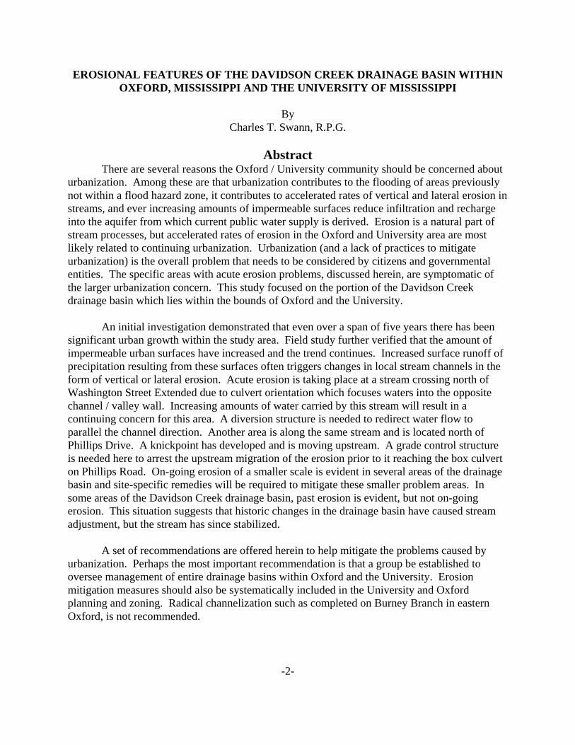
The Channel / Flood Plain System (Fluvial System)The flow of water through a natural channel may at first glance seem quite simple. But
actually, natural stream flow involves a complex set of variables acting together to determine themanner in which the stream will act. Examples of stream variables include stream gradient(slope of channel), surface and ground water flow into the channel, roughness of the channel,size and shape of the channel, soil infiltration rates and grain size, flood plain development, andamount of sediment being carried by the stream, just to name a few. These variables willdetermine if the channel will be eroding deeper or filling its channel with sediment or they maydetermine if the stream will have a relatively straight, deep, channel or perhaps a set of multiple,shallow channels. When major changes are made to one or more of these variables it maytrigger rapid change in the stream system (often referred to as crossing a critical geomorphicthreshold). Crossing a critical threshold may, for example, result in a stream eroding a deeperchannel and building a new flood plain below the existing one in order to equilibrate to the newconditions. Crossing a critical threshold may not result in a permanent change. It is not unusualthat when conditions change again, the eroding stream may respond differently by backfilling itschannel with sediment and acquiring a different set of characteristics.
Schumm (1977) divides the fluvial system into three idealized parts: Zone 1) the drainagebasin, where most of the stream’s water and sediment load is acquired; Zone 2) the transfer zone,a channel / flood plain system that moves the water from the drainage basin down the gradient;and Zone 3) the depositional zone, where the water pools and its sediment load is largelydeposited (Figure 1). The drainage basin (Zone 1) is of most interest in this project since Oxfordand the University are located within a portion of Davidson Creek’s drainage basin.
Erosion is a characteristic of the streams’s drainage basin as both water (fromprecipitation) and sediment are moved down slope into the stream’s transfer zone. Zone 1 istypically represented as a system of gullies which will merge with the transport channels of Zone2. With erosion being a normal part of activities in the drainage basin, the rate of erosionbecomes important the important factor. The built environment can typically adapt to slowerosion rates, but rapid rates typically cause problems to man-made structures and may altercurrent land use.
Drainage basins (Zone 1) are defined by the stream or a tributary, so the size can varyremarkably. Large drainage basins are composed of smaller ones corresponding to smallertributary streams. The Mississippi River drainage basin, for example, encompasses much of theNorth American continent. A smaller component of the Mississippi River drainage basin is theLittle Tallahatchie River drainage basin which includes much of northern Mississippi. TheDavidson Creek drainage basin is a component of the Little Tallahatchie drainage basin and itcan be subdivided into smaller basins corresponding to the tributaries of Davidson Creek. Thedrainage basin boundaries are referred to as a divide. Precipitation, for example, falling on oneside of the Davidson Creek divide will run into Davidson Creek on the other side of the divide itwill flow into the adjacent Burney Branch or Goose Creek, according to location. Both Oxfordand the University of Mississippi (Figure 2) are situated along the higher elevations of the LittleTallahatchie - Yocona River drainage basin divide.

-5-
Zone 2 is the channel system that transports the water and sediment load from Zone 1 tobase level (a pooling area - such as Sardis Lake, a local base level). Important changes occur atthe Zone 1 and Zone 2 interface as the system changes from erosion to the transport of the waterand sediment down stream. Unfortunately, this interface is almost impossible to define (Cookeand Doornkamp (1990)). There are a number of parameters that represent physical processes oferosion and transport. But, as stated by Cooke and Doornkamp (1990), the influence of man-made changes far exceed the influence of these natural physical processes.
Zone 3 is the area where the system has reached a pooling area where stream velocity isslowed and the sediment it transports is dropped. The area is often referred to as base level. Base level can be local, such as a pond, or on a global scale such as the world’s oceans. On theLittle Tallahatchie River, Sardis Lake is the largest local base level. The water carried byDavidson Creek will eventually flow into Sardis Lake.
Change in conditions in one zone can have consequences in the other zones, i.e. the threezones act together as a single response system. This concept has particular relevance in northernMississippi, as many changes have been made to the local fluvial systems without regard to themost probable response from entire system. Biedenharn (1983), for example, documented thechanges occurring downstream of Sardis Dam after its construction (in 1939) and concluded thatan understanding of the entire drainage basin was needed to understand the reaction of streams tosome alteration. Cooke and Doornkamp (1990) also point out that the management of a fluvialsystem must consider the entire system, not just selected portions thereof.
Figure 1 also contains an idealized cross-section of a stream illustrating the major parts ofthe stream system geomorphology. Of particular value to this study is the natural (orgeomorphic) flood plain. As illustrated in Figure 1, the flood plain is a flat area adjacent to thestream channel that carries water and sediment during flood events, and is an important part ofthe stream system that is often overlooked. The natural flood plain is formed during high waterflow events and represents sediment that was deposited by the stream during flood stage. Thisfeature is, then, a direct indication of the area a stream is likely to flood. The natural flood plainalso slows the flow of water through it and so acts to spread the peak stream flow (within thechannel) through time, thus reducing the likelihood of often catastrophic flash floods. Thechannel will also adjust through time as runoff conditions change. In this regards the naturalflood plain acts as a store of sediment used by the channel to maintain its balance of water /sediment / and channel gradient. Alteration of the natural flood plain, such as by filling, starts achain of events that leads to erosion and often increased flooding risks.

Figure 1 - Shumm (1977) described a fluvial system as composed of the three major components illustrated above (1a). Oxford and the University are in Zone 1, so it is of particular interest in this study. The natural (geological) flood plain (1b) is formed by the stream periodically flooding and can serve as a direct indication of where flooding is likely. Although the stream / flood plain system is complex, the major components are illustrated in (c). Note that the flood plain is a topographic feature that can be identified on site.
Drainage BasinDivide
Tributary
Water Level at Flood Stage
FloodPlain
FloodPlain
ValleyWall
ValleyWall
Streams
Zone 3Deposition
(a)
(b) (c)
Zone 2Transfer
Zone 1 Basin-Sediment Production
Normal Water Level
6

18
17
16 15
2221
2019
3029
28 27
Davidson
Davidson
Bu
rney
Bra
nch
Creek
Creek
OXFORD / UNIVERSITYAIRPORT
UNIVERSITY OFMISSISSIPPI
7
Figure 2 - Davidson Creek, as indicated above, is included within the Little Tallahatchie Drainage Basin (shades of yellow). The lighter shade of yellow is the portion of the Davidson Creek Drainage Basin that is included in the primary study area. The green color is the Yocona River Drainage Basin. Note that both Oxford and the University of Mississippi are located on the divide and encompass portions of both of the Little Tallahatchie and Yocona River Drainage Basins.
21 22
2928 27
Bu
rneyeye
Brarar
nch
2019
OXFORD / UNIVERSITYAIRPORT
Daviiviv ddssdsddsd oonn CCrerer ekeke
UNIVERSITY OFMISSISSIPPI
18
17
16 15
30
Daviviv dsdsd on
CrCrCerer ek
YOCONADRAINAGE BASIN
DAVIDSON CREEKDRAINAGE BASIN
LITTLE TALLAHATCHIEDRAINAGE BASIN
OXFORD
0 .5 N1 Mi.
0 1000 2000 3000 4000 Ft.
0 .5 1 Km

-8-
The natural flood plain should not be equated with the modeled flood plain elevationstypically used in flood planning. The modeled flood elevations are an interpretation of somedata set which is often beset with problems of data quality. To be statistically useful, forexample, a 100 year flood elevation would need perhaps 500 years of data for that individualstream. Seldom is such information available. Although the model will produce an elevationderived from the poor data set, the adage “garbage in - garbage out” applies. Modeled floodelevations should be used with caution and careful attention should be paid to the quality of thedata set used to produce the flood elevations. Throughout the following text, when the termflood plain is used, it will refer to the natural flood plain illustrated in Figure 1.
Characteristics of the Davidson Creek Drainage BasinSoils
An obvious factor in drainage basin analysis is the type of soils contained within thebasin. The soil survey for Lafayette County was issued in 1981 (Morris, 1981). Morris mappedSmithdale Sandy Loam as the major soil type within the drainage basin and it comprises almostten percent of the soils mapped in Lafayette county. The Smithdale Sandy Loam and the relatedSmithdale - Uderthents complex soils were both noted as being either eroded and / or gullied,attesting to potential erosional concerns. Piping, subsurface groundwater erosion formingunderground channels, was also noted as a concern for both of these soil types. The Smithdalesoils were described as being a silty mantle on the highest elevations. These silty soils areprobably derived from the thin loess ( a wind-blown deposit) that covers areas of the Oxfordtopography (loess is described in the following section). There are seven different soils mappedwithin the study area. Table 1 lists these soils and others, as well as selected soil characteristicspertinent to this investigation. These data were largely derived from Morris (1981).
Table 1 - Soil Types Within the Drainage Basin and Selected Characteristics (from Morris, 1981)
Soil and SoilMap Number
Permeability Runoff ErosionHazard
Limits forUrban Use
Piping Comments
SmithdaleSandy Loam(7F)
moderate rapid severe severe - slope severe eroded, steepslopes with gullies
Smithdale -UderthentsComplex (7)
moderate rapid severe severe - slope severe eroded, steepslopes with gullies
Ochlockonee -BrunoAssociation(40)
moderate slow slight severe -flooding
severe flood plains
Lexington SiltyLoam (3B)
moderate /moderatelyrapid
medium moderate slight notnoted
on upland ridgetops, probablyloess - derived

Table 1 - Soil Types Within the Drainage Basin and Selected Characteristics (from Morris, 1981)
Soil and SoilMap Number
Permeability Runoff ErosionHazard
Limits forUrban Use
Piping Comments
-9-
Lexington SiltyLoam (3C)
moderate /moderatelyrapid
medium moderate slight notnoted
on upland ridgetops, probablyloess - derived
Lexington SiltyLoam (3D3)
moderate /moderatelyrapid
rapid severe moderate notnoted
on upland ridgetops, probablyloess - derived
OchlockoneeSandy Loam(9)
moderate slow slight severe -flooding
severe loamy alluvium
It is important to note that all the soils listed above, with the exception of the flood plainsoils, have been listed as having a moderate to severe erosion hazard. Eroded soils with steepslopes and gullies are a characteristic of the Smithdale soils that Morris (1981) discusses inseveral locations in his text. It is important to note that the Smithdale soils are also the mostcommon one in the Davidson Creek drainage basin. It should also be noted that erosion shouldbe a concern for the city planners as well as planning efforts on the University of Mississippicampus.
The Smithdale - Bruno Association soils, Smithdale Sandy Loam and the LexingtonSandy Loam are all described as having the characteristic of rapid run off. A rapid rate of runoffimplies that a larger portion of the precipitation will move over the ground surface and into thefluvial system, rather than infiltrate into the ground to become groundwater. This characteristicis another suggestion that the fluvial system is influenced by local soils and is an importantcharacteristic to be considered in understanding the drainage basin.
Piping was noted in all the soils except the Lexington soils. Piping is characteristic ofloess-derived soils in particular. Piping occurs where the soils become saturated and flow alongan underground channel. The stimuli for piping lies with the formation of a preferred subsurfacepathway. The pathway can originate by such common things as decayed roots or animalburrows. Once flow is initiated along the pathway, it will widen to the point it will reach thesurface forming a conical depression. The conical depression serves to catch additionalprecipitation, allowing more water to travel through the underground channel, which then causesthe channel to enlarge and cause more surface depressions. The importance of loess in theDavidson Creek drainage area is not so much the engineering problems (it is too thin in mostplaces to cause substantial problems), but it seems to play a part in initiating rapid erosion in theloose sands beneath.
GeologyIn many ways the local geology sets the stage for stream behavior. The geological unit
on which the steam flows will provide a source of sediment that the stream erodes and moves

-10-
down its channels, it will determine the amount of groundwater that will contribute to surfacestream flow and is the parent material for soil development. The geology can also providepreferred pathways along which streams flow or present barriers that slow erosion and alterchannel flow patterns. Figure 3 is a geological map of the Oxford / University area and showsthe areal distribution of the geological units in the Oxford / University area.
Within the Davidson Creek drainage basin, there are three geological units at the surface. The oldest is the Eocene Tallahatta Formation, remnants of a Pleistocene loess sheet, and theyoungest unit is the flood plain deposits that are presently forming along Davidson Creek and itstributaries. Outside of the Davidson Creek drainage basin a small area of terrace materials wasalso identified (southwest corner of Figure 3). Little is known of these materials and this outlieris assumed to be of Pleistocene age. Also outside of the drainage basin, the Eocene MeridianSand was mapped along Burney Branch (southeastern corner of Figure 3).
The Tallahatta Formation is composed largely of sand with subordinate clay beds. TheTallahatta is approximately 50 million years old and overlies the older Meridian Sand. The loosesands in which the large gullies form are largely in the Tallahatta Formation. The grain sizevaries from medium to fine and are poorly consolidated. The depositional environments areconsidered near-shore marine.
The next youngest geological unit within the study area is the thin cover of loess that lieson top of the Tallahatta Formation. The loess is a wind-blown deposit that is derived from theMississippi River flood plain (the “Delta”) and river channels during a period of arid climates inthe southeastern U.S. During this period of aridity, there was sparse vegetation in theMississippi flood plain and a prevailing westerly wind blew fine-grained particles (clay and silt-size particles) eastward and deposited them as a wedge-shaped layer over the existingtopography. The loess is thickest near the edge of the Mississippi River flood plain (the thickpart of the wedge) where it can be as much as 100 feet in thickness. It thins to the east, so in theOxford / University area (the thin part of the wedge) it is usually 10 - 15 feet thick and often less. The thickest loess was identified in engineering borings beneath Stockard - Martin Dormitory onthe University campus where 23 feet were identified (silt and silty clay).
Although the exact age of the loess in Oxford is not known, it is assumed to have beendeposited between 300,000 years ago and 12,500 years ago (Saucier, 1994; Morrison, 1991;Parks, 1993). Since it covers a pre-loess topography, thickness may vary significantly fromplace to place and its geometry is similar to a blanket covering the older landscape. The data todelineate the loess on the University of Mississippi campus were derived from engineeringborings drilled for foundation design of campus structures and other areas were identified byexamination of surface exposures. Much of the original loess has been removed through erosionor by development, which accounts for its “patchy” distribution.
The map in Figure 3 also contains the modern day flood plains as a mapped unit. Theflood plains are the youngest mapped unit and consists of a mixture of sand, clay and silt

-11-
deposits. The flood plains are built or eroded with each flood event and so they are ofimportance to the study.
The geological conditions for the Davidson Creek area reveal few factors that wouldcontrol stream migration. The clay beds present in the Meridian / Tallahatta section are typicallytoo thin and discontinuous to pose any other than a temporary restraint to erosion or streammigration. Field investigations suggest that the loess cover provides a protective cap to slowerosion rates (also noted in Happ, 1968), but where the loess has been removed (either by naturalerosion or by man-made excavations), the loose sands beneath are easily and quickly eroded. Nofaults or jointing was identified in the area (Swann, Mullen and others, 1999) that could providea preferred direction for stream migration.
Fluvial System of Davidson CreekPerhaps the most detailed examination of the erosion problems in and around Oxford was
published in 1940. Deforestation and poor soil conservation practices had resulted in serious andwidespread erosion problems. Happ, Rittenhouse and Dobson (1940) documented the erosionproblems in the Toby Tubby and Hurricane Creek drainage basins (along with others). Theydocumented both erosion problems and sedimentation problems resulting from streams reachinga local base level and depositing a large amount of sediment in a restricted area. Their extensivework has remained a cornerstone for flood and erosion control work in Oxford and NorthMississippi. The setting of the Oxford area, however, has changed remarkably since 1940. Rowcrop agriculture is now virtually non-existent near Oxford and many of the former open fieldsare now wooded or have been urbanized. Large gully formation, as documented by Happ,Rittenhouse and Dobson (1940), has been halted or greatly slowed by planting a vegetative cover(kudzu is the typical cover) in the highly erosive areas. Happ (1968, p.8) states “it seemsprobable that soil erosion and valley sedimentation rates have been reduced at least 50 percentsince 1937.” Field work in the Davidson Creek drainage basin suggests that the trend Happrecognized in 1968 continues.
Geomorphic parameters are another way to describe the drainage basin. One very basicparameter is basin relief. The basin relief is simply the difference in elevation from highest pointto lowest within the basin. The significance of basin relief is that it is measure of the ability ofwater to erode and move soils. The greater the vertical distance from divide to the lowest point,the faster the water will move, the more energy the moving water will posses and so the morework it can do to modify the landscape.

12
Figure 3 - This geological map of the Oxford / University area contains five units. The Eocene Meridian and Tallahatta Formations which consist of sand and subordinate amounts of clay, the Quaternary loess deposits which consists of silts and silty clays. There is a small area of Pleistocene(?) terrace material in the southwest corner of the map containing sandstone cobbles and boulders. The modern geological flood plains are composed of varied lithologies. The distribution of the loess is discontinuous and represents the erosional remnants of a landscape covered by wind-blown silts deposited between 300,000 and 12,500 years ago.
1817
16 15
2221
20
19
3029
28 27
Davidson
Davidson
Bu
rney
Bra
nch
Creek
Creek
OXFORD / UNIVERSITYAIRPORT
UNIVERSITY OFMISSISSIPPI
OXFORD
0 .5 N1 Mi.
0 1000 2000 3000 4000 Ft.
0 .5 1 Km
Quaternary Flood plain deposits - Sand, clay, silt; associatedwith existing fluvial systems.
Age Unit Description
Pleistocene
Pleistocene
Eocene
Loess - Silt to clayey silt; rarely calcareous; mostoften preserved at higher elevations.
Riverine terraces - Sand, medium - to coarse-grained,clayey; with sub rounded, iron-cemented cobbles inpaleochannels.
Tallahatta Formation - Sand, fine - to coarse-grained,often cross-bedded; with subordinate clay beds andlaminations.
Meridian Sand - Sand, medium - to coarse-grained,occasional granules; cross-bedded.

-13-
The lowest elevations are where Davidson Creek crosses the Oxford City Limits. Thiselevation was estimated at 355 feet above sea level. The highest elevations are on a ridge justeast of the Clegg Field where elevations are estimated to be as high as 565 feet above sea level. Basin relief, therefore, is 210 feet. A relief of 210 feet is significant as the relief within the entireOxford South, 7.5 minute topographic quadrangle is 350 feet. The Davidson Creek drainagebasin relief of 210 feet is approximately 60 percent of the relief for the entire quadrangle. Muchof the quadrangle relief is accounted for by one feature, Thacker Mountain, with elevations over600 feet. Relief in the Oxford North quadrangle is 315 feet. Davidson Creek drainage basin’srelief accounts for approximately 67 percent of the relief within the Oxford North quadrangle. The important point to be made here is that there is sufficient relief and steep enough gradientsto generate significant erosion.
Urbanization also influences the manner in which a fluvial system works. The mostobvious change is in the reduction of rainfall infiltration into the soils because of impermeablesurfaces (surfaces that don’t allow rain water to “soak in”). Examples of impermeable surfacesinclude paved highways, buildings, paved driveways, paved parking lots, sidewalks and anyother surface that prevents rainfall from infiltrating into the soil. The reduction of infiltrationareas results in an increase of run off (rain water that flows over the surface and into the drainagesystem). The increased run off is carried by the existing stream system which will then adjust tothe new input of water. Part of the divide between Davidson Creek and Burney Branch isthrough the square of Oxford and northward roughly along North Lamar Boulevard. Figure 4 isa photograph looking westward from the Davidson Creek divide on North Lamar into theDavidson Creek drainage basin. Extensive paving and buildings in this block, defined by N.Lamar, Jackson St., North 9th, and Jefferson St., results in extensive runoff into Davidson Creek.
Figure 4 - Extensive paving and buildings near the Oxford Square contribute to increased surface run off fromprecipitation. The increased run off can trigger erosion as streams adjust to changed conditions. This photograph istaken from North Lamar and is looking westward into the Davidson Creek drainage basin (photograph taken August1, 2006).
-14-
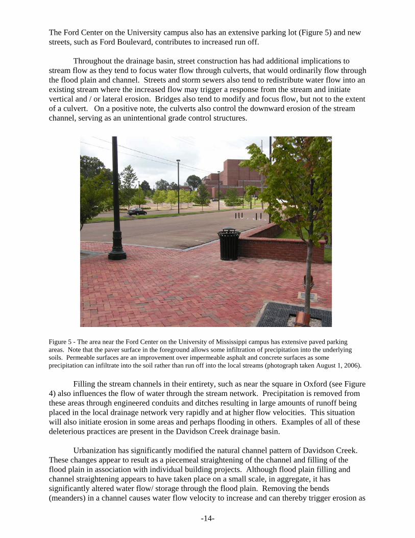
The Ford Center on the University campus also has an extensive parking lot (Figure 5) and newstreets, such as Ford Boulevard, contributes to increased run off.
Throughout the drainage basin, street construction has had additional implications tostream flow as they tend to focus water flow through culverts, that would ordinarily flow throughthe flood plain and channel. Streets and storm sewers also tend to redistribute water flow into anexisting stream where the increased flow may trigger a response from the stream and initiatevertical and / or lateral erosion. Bridges also tend to modify and focus flow, but not to the extentof a culvert. On a positive note, the culverts also control the downward erosion of the streamchannel, serving as an unintentional grade control structures.
Filling the stream channels in their entirety, such as near the square in Oxford (see Figure4) also influences the flow of water through the stream network. Precipitation is removed fromthese areas through engineered conduits and ditches resulting in large amounts of runoff beingplaced in the local drainage network very rapidly and at higher flow velocities. This situationwill also initiate erosion in some areas and perhaps flooding in others. Examples of all of thesedeleterious practices are present in the Davidson Creek drainage basin.
Urbanization has significantly modified the natural channel pattern of Davidson Creek. These changes appear to result as a piecemeal straightening of the channel and filling of theflood plain in association with individual building projects. Although flood plain filling andchannel straightening appears to have taken place on a small scale, in aggregate, it hassignificantly altered water flow/ storage through the flood plain. Removing the bends(meanders) in a channel causes water flow velocity to increase and can thereby trigger erosion as
Figure 5 - The area near the Ford Center on the University of Mississippi campus has extensive paved parkingareas. Note that the paver surface in the foreground allows some infiltration of precipitation into the underlyingsoils. Permeable surfaces are an improvement over impermeable asphalt and concrete surfaces as someprecipitation can infiltrate into the soil rather than run off into the local streams (photograph taken August 1, 2006).

-15-
the stream adjusts. Filling the flood plain forces flood waters into the channel that wouldordinarily flow through or be stored in the flood plain. This practice compounds the erosionpotential, particularly if the channel has already been straightened and makes the streamsusceptible to flash flooding.
Some of the Davidson Creek tributaries also contain evidence of historical channel /flood plain instability. The best example of past changes in stream morphology is on theUniversity campus between Washington Extended and Ford Boulevard. This stream drains theFord Center area of the campus. Remnants of the original flood plain is approximately six feetabove the present flood plain which is delineated by a pronounced scarp. Trees growing on thescarp indicate that it was formed decades ago (see Figure 6) as a result of changes in the stream’sflow regime. The present day channel and flood plain are being formed at the base of the scarpand represents present day conditions. Large trees within and adjacent to the present flood plain/ channel suggest there is little on-going erosion vertical erosion. Some lateral erosion (bankundercutting) was noted where the riprap-lined ditch on Ford Boulevard ends and enters thewooded area north of the Washington Extended crossing.
Figure 6 - The large oak tree adjacent to the range pole is growing on the scarp marking the edge of the modernflood plain. The new flood plain is the flat area where the range pole rests with the channel consisting of the sandyarea to the right. Although this flood plain and channel is younger than the one approximately six feet above it, thesycamores in the channel suggest it has been stable for a number of years and there is little on-going erosion. Thisphotograph was taken between Ford Boulevard and Washington Street Extended on the University of Mississippicampus (photograph taken March 8, 2006).

-16-
Erosion Control Measures In Study AreaErosion concerns have previously been recognized in the study area and some mitigation
measures have been and are continuing to be implemented. Grade control and storm water flowcontrol measures are in place in both Oxford and the University (Figure 7). In Oxford, a set of grade control structures are in place in Lake Patsy City Park along a ephemeral (a stream thatflows only during wet weather), channelized, tributary to Davidson Creek. These structures(Figure 8) were designed to control erosion and are presently within a manicured, grassed, park environment. There appears to be no erosion except immediately downstream of the structureswhere a small plunge pool has developed. This erosion control measure has been successful, is appropriate, and blends well with the park setting. Erosion control structures, such as these, aremore esthetically pleasing than the radical measures such as the Burney Branch Project ineastern Oxford.
In northern Oxford, a retention pond has been constructed just south of the North OxfordBaptist Church complex. This pond serves the area including the southern half of the NorthOxford Baptist Church complex, southward along Old Highway 7 (Old Highway 7 is the sub-basin divide) approximately to County Road 1014 and then eastward along the ridge and back tothe retention pond. On-going construction at North Oxford Baptist Church is included in thissmall drainage basin. Another retention pond is located on development property on Molly BarrRoad, adjacent to the Clegg Field property. This small pond has captured a substantial amountof sediment due to cleared, unprotected and exposed soils that have been exposed to rainfall for several months. This pond is built on a drainage which is in part of the Davidson Creek drainagebasin that is at higher elevations.
Retention ponds are also part of the Oxford Commons development in eastern Oxford atthe east end of Sisk Avenue. Although not within the study area (see Figure 7 for map), the Oxford Commons development has constructed retention ponds and they are functional at thetime of this writing.
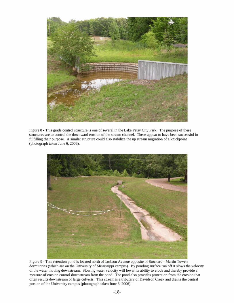
A surface water retention pond was built by the City of Oxford adjacent to JacksonAvenue and the University of Mississippi campus. This structure is located on a Davidson Creektributary that drains the center portion of the University campus. This retention pond controlsand lowers flow velocities from the campus by providing a local base level and so provides ameasure of erosion mitigation downstream of the structure (see Figure 9). The temporaryponding also mitigates potential erosion resulting from increased water flow velocity as it travelsfrom the University campus through the culvert beneath Jackson Avenue.
The University of Mississippi has also incorporated surface water flow control into on-going construction. A large surface water retention pond is located south of the Physical Plantfacilities and a smaller one is located west of the Physical Plant Administration building. Bothof these ponds control surface flow into the Goose Creek drainage basin rather than DavidsonCreek. Another pair of retention ponds are located at the former Oxford Mall (now owned inpart by the University of Mississippi). These ponds were built prior to the mall’s constructionand they remain as functional retention ponds within the Davidson Creek drainage basin.

17
Figure 7 - There are a number of retention ponds, grade control structures, and underground flow control structures in the primary study area as well as adjacent areas. Both the University and the City of Oxford are actively including these measures as mandatory requirements (City of Oxford) or as standard procedure (University of Mississippi).
18 17 16 15
2221
20
19
3029
28 27
Davidson
Davidson
Bu
rney
Bra
nch
Creek
Creek
OXFORD / UNIVERSITYAIRPORT
UNIVERSITY OFMISSISSIPPI
20
19
Daviiviv ddssdsddsd oonn CCrerer ekeke
UNIVERSITY OFMISSISSIPPI
OXFORD
DAVIDSON CREEKDRAINAGE BASIN
U U
U
0 .5 N1 Mi.
0 1000 2000 3000 4000 Ft.
0 .5 1 Km
Grade ControlStructure
Retention Pond
Underground FlowControl StructureU
-18-
Figure 8 - This grade control structure is one of several in the Lake Patsy City Park. The purpose of thesestructures are to control the downward erosion of the stream channel. These appear to have been successful infulfilling their purpose. A similar structure could also stabilize the up stream migration of a knickpoint(photograph taken June 6, 2006).
Figure 9 - This retention pond is located north of Jackson Avenue opposite of Stockard - Martin Towersdormitories (which are on the University of Mississippi campus). By ponding surface run off it slows the velocityof the water moving downstream. Slowing water velocity will lower its ability to erode and thereby provide ameasure of erosion control downstream from the pond. The pond also provides protection from the erosion thatoften results downstream of large culverts. This stream is a tributary of Davidson Creek and drains the centralportion of the University campus (photograph taken June 6, 2006).

-19-
The University has also designed and installed three underground storm water control structuresto store peak flow. Storing peak flow and releasing it at lower rates into the local drainagesystem will reduce flow velocities, flow volumes, extend the period of flow and therefore serveto mitigate potential erosion. The most recent underground flow control structure (on DormitoryRow) was under construction in the summer of 2006. It consists of a series of large, connectedculverts which act as water storage, with an outlet consisting of a much smaller (eight inch) outflow pipe. Figure 10 illustrates the run off storage pipe before being placed beneath the parkinglot on Dormitory Row. Although not designed for flow control of large areas, a series of theseflow control / storage structures should reduce the height of the peak flood flow and reducestream velocities in a tributary steam. These structures are also useful as they are constructed inthe subsurface, so some selected surface structures, such as parking lots and landscaping, can beconstructed above them.
Flow from the eastern-most structure, near the former Physical Plant building, is withinthe Burney Branch drainage basin. Of the remaining two, one is located beneath the expandedparking lot near the Phi Kappa Tau fraternity house on Fraternity Row and the other is beneaththe new parking lot adjacent to the Johnson Commons on the east end of Dormitory Row. Bothof these are within the Davidson Creek drainage basin.
Figure 10 - The large culverts in this photograph will serve as an underground flow control structure on theUniversity of Mississippi campus. The surface run off will flow into this set of connected culverts which willhave an eight inch outflow. The smaller outflow will result in the run off being stored, water velocity slowedwhich will lead to lowered erosion potential. This structure is located on Dormitory Row on the University ofMississippi campus. Johnson Commons is visible behind the equipment on the right (photograph was taken June6, 2006).
-20-
Throughout the study area there are engineered structures that act as unintentional gradecontrol structures. Most commonly they are some form of concrete culvert. Water flowingthrough these structures is limited in the ability of erode in the up stream direction by theelevation of the base of the culvert itself. In other words, since the culvert not subject to erosion,it prevents the stream channel from eroding below the culvert on the upstream side. Since theflow is not constrained on the down stream side of the culvert, erosion can, and often does, occurbelow the culvert. Culverts also modify stream flow by increasing the speed of the water anddirects the flow of water down the channel or across the channel into its flood plain. Theculverts constructed beneath the newly constructed Gertrude Ford Boulevard, for example,control the downward erosion potential of water flow from the Ford Center area of campus. Theriprap downstream of these culverts serves to mitigate the erosive effects of the culvert on streamflow by armoring the ditches opposite the culvert.
Discussion of Specific Problem AreasSeveral of the Davidson Creek tributaries contain evidence of past or present erosional
events. Most tributaries are entrenched to varying degrees suggesting they are not in equilibriumwith present conditions and are adjusting to changes in their drainage basins or have beenstraightened and the stream has been artificially contained by filling of the flood plains. There isevidence of past erosion and entrenchment, so it is necessary to separate past from on-goingerosion. There are two areas (Washington St. Extended and the Phillips Road areas) whereerosion is posing an acute problem to the built environment or may potentially cause an acuteproblem if not soon addressed. The map in Figure 11 illustrates the location of these two areasand also defines the drainage basin upstream of these two points. The Phillips Road drainagebasin includes the Washington Street Extended drainage basin, but not vice-versa.
Other areas of concern were also identified during field study. Although these areas areof less concern than the Washington Extended and Phillips Road areas, they are noted as causefor concern for potential erosion or areas that contribute to the underlying causes of erosion. These areas are also located on Figure 11, but their upstream drainage basins are not identified. Discussion of all these areas follow.
Washington Street Extended AreaPerhaps the most notable erosion is occurring just north of the University campus were a
northward flowing intermittent stream crosses beneath Washington Avenue Extended (betweenthe intersections of Washington and Stone and Washington and Molly Barr / Gertrude Ford). This Davidson Creek tributary is not named on existing maps, so for convenience, it will bereferred to here as University Branch. University Branch has its origins along the LittleTallahatchie / Yocona River divide and includes parts of the University campus and the City ofOxford. At the point of the Washington Avenue crossing, the downstream channel / flood plaintakes a slightly more northern bearing with Washington Avenue Extended passing over the bendin the course of the stream. South of the crossing, University Branch drains the eastern edge of the University campus including the Ford Center area.
The most acute erosion problem occurring along this tributary is immediately north ofwhere it crosses beneath Washington Avenue Extended. Here there is a well-defined plungepool (an area where the water from the culvert has eroded a bowl-shaped depression) has
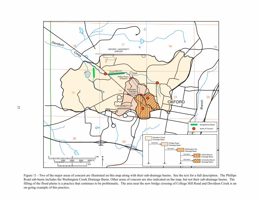
21
Figure 11 - Two of the major areas of concern are illustrated on this map along with their sub-drainage basins. See the text for a full description. The Phillips Road sub-basin includes the Washington Creek Drainage Basin. Other areas of concern are also indicated on the map, but not their sub-drainage basins. The filling of the flood plains is a practice that continues to be problematic. The area near the new bridge crossing of College Hill Road and Davidson Creek is an on-going example of this practice.
18 17 16 15
2221
2019
3029
28 27
Davidson
Davidson
Bu
rney
Bra
nch
Creek
Creek
OXFORD / UNIVERSITYAIRPORT
Daviiviv ddssdsddsd oonn CCrerer ekeke
2019
OXFORDUNIVERSITY OF
MISSISSIPPI
0 .5 N1 Mi.
0 1000 2000 3000 4000 Ft.
0 .5 1 Km
Straightened Reach
Areas of Concern
Davidson CreekDrainage Basin
Sub-basin Phillips RoadDrainage Basin
Washington Ext.Drainage Basin
Oxford BranchDrainage Basin
University BranchDrainage Basin
Sub-basin
Sub-basin
Sub-basin
Phillips RoadKnickpoint
WashingtonExtended
Culvert

-22-
developed downstream of the culvert. The channel is eroding the flood plain and perhaps someof the geological material beneath the flood plain. Condominiums (200 Washington) areimmediately east of the culvert / plunge pool and are built above a wood retaining wall that hasfilled parts of the flood plain.
Another more eastern tributary also contributes flow to the Washington AvenueExtended erosional area from portions of Martin Luther King Circle eastward to parts of North9th Street and Jackson Avenue. Both of these areas have large areas of paved parking lots,streets, and buildings which increase run-off and the amount of surface water the local streamsmust carry. This eastern tributary (an unnamed tributary that is here referred to as the OxfordBranch for convenience) was investigated to determine if on-going erosion was present, nonewere obvious except in localized areas. Just west of the railroad culvert and south of the StoneCenter is a low, brick wall across the stream that appears to have been in place a considerabletime without erosional undercutting. The upstream area (south) that extends from WashingtonExtended to the Ford Center was also investigated to determine if there was on-going erosion. Older erosional features were identified (see Figure 6), but no significant new or on-goingfeatures were identified. The presence of significant erosional features are present only north ofthe Washington Extended crossing. The cause of the erosion must then lie in or about the culvertbeneath Washington Avenue. This culvert carries water from University Branch and the OxfordBranch, with the Oxford Branch water joining the University Branch waters beneath WashingtonAvenue Extended.
Due to the culvert’s orientation relative to the stream channel’s geographic flowdirection, the flow of water is directed eastward across the channel and into the eastern channelbank. Redirecting the flow into the eastern channel bank, rather than in the same direction as thechannel flow direction, results in bank erosion and forces water to flow along the eastern edgeof the channel / flood plain rather than within the established channel. Figure 12 is a photo takenfrom within the culvert and indicates the direction the culvert focuses water flow. Thecondominiums and retaining wall in the background of Figure 12 are at 200 WashingtonExtended. Although the culvert directs water across rather than along the channel of the stream,it was constructed prior to construction of the condominiums suggesting that more care shouldbe exercised when siting structures downstream of large culverts. Several of the condominiumsare also situated on fill that was once flood plain, so the area for potential flow through the floodplain has been reduced resulting in potentially higher flood levels.
Phillips Road AreaA second area of concern is located on Phillips Road where the same intermittent stream
discussed above flows through a box culvert. Downstream of the box culvert, the stream bed hasbeen “hardened” by covering the channel (including the channel banks) with concrete. Aknickpoint has formed (Figure 13) and is now moving upstream into the concrete-lined channelarea. Knickpoints are abrupt changes in channel slope that are often marked by water falls. Asmall water fall also marks the knickpoint just north of stream crossing on Phillips Road. Thesmall waterfall is undercutting the concrete channel lining and as the undercutting continues, theconcrete fails and breaks into the channel below the waterfall exposing new soils to erosionbeneath the concrete. The water can then start eroding the soils beneath the concrete and theprocess begins again. In this manner the knickpoint / waterfall moves upstream. Theknickpoint is located only a feet down stream of the present box culvert under Phillips Road. The concern here is that the knickpoint will migrate upstream and intersect the Phillips Road boxculvert causing damage and repair cost to Oxford and inconvenience to the neighborhood. South

-23-
of the culvert, lateral erosion has caused limited-scale bank failures that have been mitigated byplacing blocks of discarded concrete in the area of bank failure. This mitigation measure isappropriate for limited-scale areas and will serve to armor the bank and slow or redirect thestream flow. Establishing a vegetative bank cover will also slow erosion.
The knickpoint at Phillips Road is indicative of downstream changes to the stream systemand is itself a means of stream adjustment to the new conditions. Often knickpoints result fromincreasing channel gradient (slope) in the stream system having the knickpoint or a larger streaminto which a smaller one drains. In this case, the intermittent stream drains into the main channelof Davidson Branch. Examination of this portion of Davidson Branch reveals that much of theoriginal course of the Davidson Branch channel has been altered by straightening. Thestraightening was apparently done as a result of development near the stream and withoutforethought as to the long-term implications. The straightening of the channel results in a higherstream gradient (it removes the bends in the stream channel) which often triggers streamadjustment (a knickpoint). This seems to be the case in the Phillips Road knickpoint. Piecemealstream straightening has increased stream gradient to the extent readjustment has occurred as aknickpoint that has migrated upstream and is presently at Phillips Road.
Figure 12 - The photograph above was taken from inside the large culvert beneath Washington Street Extended. Itclearly indicates that the culvert is directing water flow across the channel and into the flood plain, rather thanparallel with the direction of channel flow. The well defined plunge pool downstream of the culvert andvegetation destroyed by erosion clearly indicate the erosion potential caused by this culvert. The condominiumsin the background are those at 200 Washington (photograph taken March 8, 2006).

-24-
Other Areas of ConcernTwo other areas upstream from the Washington Extended culvert are potential sources of
erosion. Much of the storm drainage from the Ford Center parking lot drains into the southerntributary by way of an open pipe extending over the channel. There is no energy dispersing structure in place for reducing the impact of this uncontrolled flow. A second example is in theeastern tributary just west of the railroad culvert. A pipe from the pool at the Stone Center(apparently used to drain water from the pool) extends into this tributary and, like at the FordCenter, is causing active erosion by uncontrolled flow. No energy dispersing structure is inplace to reduce the impact of this uncontrolled flow.
The construction in the northeastern corner formed by the intersection of the railroadright-of-way and Price Street is of great concern because of multiple factors that can lead toerosion / flooding problems (Figure 14). The new construction is clearly on the flood plain notonly of the stream in the photograph, but also of the stream behind the construction. The streamadjacent to the construction is eroding toward the new construction and note that it isimmediately downstream of a culvert. In the foreground are stumps where trees have beenremoved that could have slowed erosion and contribute to stream stabilization. There is, atpresent, little or no vegetation on the channel banks to slow channel erosion and / or lateralstream migration. Also note that one of the structures and the fill material that one is built on, blocks the flow of water through the flood plain and contributes to changes in stream behavior. The stream in the photograph drains the Martin Luther King Street area eastward to the Oxford
Figure 13 - An abrupt change in channel slope is referred to as a knickpoint. In the photograph above theknickpoint is marked by a small water fall. Erosion from the water fall will cause the knickpoint to migrateupstream which can cause erosion problems to infrastructure founded adjacent to the stream. This knickpoint is justnorth of Phillips Road and its upstream migration will eventually intersect the box culvert beneath Phillips Road(photograph taken March 29, 2006).

-25-
Square and North Lamar Boulevard. This stream’s drainage basin is an area where increasedpaving and development is likely. This urbanization will increase the amount of water thisstream will carry and through time increase its potential for both lateral and vertical erosion. This area is an example of the type of situation where the city should clearly disallowconstruction of dwellings.
Another area of concern is on the main Davidson Creek channel where it crosses CollegeHill Road. Opposite of Lake Patsy Park and northwest of the new Davidson Creek bridge, newconstruction has filled portions of the Davidson Creek flood plain. This restricting of flood plainflow will likely increase flood levels as well as contribute to the destabilization of the streamchannel by triggering channel adjustment (vertical or lateral erosion or knickpoint formation). InFigure 15 the filling of the flood plain is clearly visible. Here as in other examples, portions ofthe valley wall has been excavated to form a level pad for the structure. The most commonpractice is to use most of the excavated valley wall material to then fill the flood plain andexpand the area for construction. Flood plain filling such as this should be discouraged,although it is common in Oxford.
Figure 14 - This construction is located only a few feet from a stream actively eroding laterally toward theconstruction. Note that the construction site is clearly on the flood plain not only of the stream in the photograph,but of the stream behind the construction as well. All of the vegetation that could potentially stabilize the streamhas been removed. This site has a multitude of potential problems that could be avoided by disallowingconstruction in areas with such obvious concerns (photograph taken March 22, 2006).

-26-
General Recommendations To Address Erosion Derived From Urbanization The following recommendations are suggested to address the overall problem of
urbanization. They are also offered as a beginning point for discussion and will hopefully leadto the initiation of mitigating the erosion hazard associated with on-going urbanization. Maximum benefit will be derived from implementing these recommendations in the planning /zoning process. If these measures are incorporated into development plans, then costs will beless and development design can accommodate the mitigation measures. Although it is hopedthat these recommendations will be incorporated into zoning and / or building guidance, theyshould not be considered as ideas to be used in an “as is” form - further thought to detail, andpublic involvement is appropriate.
A common response to erosion (and often flooding) problems such as these, is toradically channelize the stream. This typically involves straightening, widening, deepening thechannel and lining the new channel with riprap or concrete. The channelization of BurneyBranch in eastern Oxford is a good example of this type of mitigation (Figure 16). Thismitigation often substitutes another set of problems for any it may remedy. Radicalchannelization has low aesthetic appeal, makes adjoining property less attractive and could leadto lower resale value. The deep channel is a danger to anyone who may inadvertently fall into it. This public danger requires fencing which, in turn, requires continuing upkeep and maintenance to restrict public access. The engineered channel (particularly if concrete lined) rapidly moveswater along a smooth gradient. As the water moves along the channel it gains velocity.
Figure 15 - New construction at the northwest corner of Davidson Creek and College Hill Road has filled part ofthe Davidson Creek flood plain limiting the area in which flood waters can flow. This practice can cause floodlevels to rise in other areas while also encouraging the stream channel to adjust to new conditions (resulting invertical and lateral erosion). This practice should be discouraged (photograph taken January 12, 2007).

-27-
Downstream from the channelization the water is rapidly moved into the natural streamwhich is not adjusted for the increased flow. Erosion and / or flooding is often the result. Upstream from the channelization the increased slope can initiate erosion in tributaries whereerosion was not a pre-existing problem. Channelization is not recommended. Working with thenatural system has many values such as visual appeal for the adjoining land owners and addedappeal to the city. The recommendations offered below reflect this philosophy.
1) Complete Drainage Basin Management - A Unified ApproachThis recommendation is perhaps the most important. Alteration of channels and flood
plains are carried out by private citizens, industry, as well as government without regard to thechanges that are likely to be triggered above and below the stream alteration. A unifiedapproach is called for where the drainage basin is considered as a complete unit and managed asa complete unit. Areas where extensive paving is planned, such as the Oxford Commonsdevelopment (Sisk Avenue), for example, should immediately bring to mind the need for erosioncontrol in adjacent downstream areas. The identification of knickpoints in streams should point to potential erosion and plans should be made to either mitigate the upstream migration of theknickpoint or accommodate its migration so no structures are effected. A group of interestedstake holders (city and University) should be set up to monitor drainage basin development andrecommend to the city and University potential mitigation measures. More specifically, thegroup should :
A) characterize the extent of urbanization in individual drainage basins and identifydevelopment trends,
Figure 16 - This picture of Burney Branch in eastern Oxford illustrates the results of radical stream engineering. This sort of engineered solution often results in creating new problems and seldom completely solves theintended problems. This solution to the erosion concerns is not recommended (photograph taken January 12,2007).

-28-
B) identify areas of active and non-active erosion,
C) identify areas of acute erosion and recommend mitigation measures,
D) assist in development planning and zoning to minimize erosion, and to assist withdeveloping improved means to mitigate the overall effects of urbanization and assistlong-range planning.
The basin management team should include, in some manner, the Mississippi ForestryCommission, the U.S. Department of Agriculture, Natural Resources Conservation Service and the Soil Sedimentation Lab (also U.S. Department of Agriculture).
2) Development Plans - Retention Ponds and Flow Control Measures Flow control measures, whether retention ponds and / or other engineered measures,
should be included as standard requirements in development plans. Retention ponds are moredesirable as they allow the stored water to infiltrate into the soils and eventually into the watertable. Ponds should be constructed on all streams flowing from development containing extensive paving and other impermeable surfaces. In areas where development is already wellestablished, opportunities should be sought to incorporate these structures into the existinginfrastructure.
Oxford has passed the Stormwater Retention And Detention Ordinance (Ordinance No.2000-16) that regulates discharge of surface water from development sites and describes howretention ponds should be designed and managed. This ordinance is an excellent start to surfacewater management, although the 25-year rainfall frequency is probably an insufficient time spanto adequately characterize high rainfall events for the area. Long-term planning at the Universityshould also include the identification of suitable sites for retention ponds.
3) Restrictions - Flood Plain / Channel Development and Alteration Development within flood plains should be limited to recreational areas (soccer fields for
example), nature trails, bicycle trails, gardens, natural areas, sidewalks and other structuresunaffected by potential flood waters. Artificial fill for development should not fill or blockwater flow through flood plains or modify channel orientation. This recommendation will allowfor stream adjustment (vertical and lateral) without endangering major structures.
4) Channels and Flood Plains Zoned as Green WaysGreen ways are areas designated as natural areas where natural processes are allowed to
work without unnecessary intervention. The name is derived from the trees and vegetation that isencouraged to grow there. The channels and flood plains are well suited to the green wayconcept. In the study area, the green ways should consist of natural vegetation and large trees near the channel area that slow bank erosion and the associated flood plain to facilitate floodwater flow. Selected development is typically allowed but should be limited to very specificuses that will be only minimally effected by erosion and / or flooding. Further restrictions maybe needed within the green ways such as channel set backs. 5) Set Back Provision - Culvert
Field investigations have consistently identified erosional areas immediately downstream from a culvert due to the culvert focusing the energy of the moving water. The areasubjected to erosion is significant in large culverts such at Washington Street but less in smaller
-29-
diameter culverts. The set back should reflect these differences. No development should beallowed within the set back and the area monitored for erosion that may need mitigation.
6) Set Back Provision - Discharge Area of Engineered Ditches A similar concern arises where surface water is contained within an engineered drainage
ditch (most often concrete) or is forced to flow through significant lengths of culvert. Both theditch and culvert increase water velocity and will result in erosion in the discharge area. Withouterosion control measures, the discharge can initiate unintentional erosion in adjoining property. Provisions should be required to mitigate discharge erosion in these areas.
7) Alignment of New Culverts Since culverts increase water velocity and focuses water flow, the orientation of the
culvert can influence the erosion potential. When the culvert discharge approximates thedirection of natural channel flow, then the potential for initiation of erosion is reduced.
8) Set Back Provision - Fifty foot “no construction” set back adjacent to active channelNo structures should be allowed within 50 feet of the edge of an active channel. This set
back allows natural migration of the channel within its flood plain without damaging man-madestructures.
9) Minimize Paving and Maximize Natural AreasSidewalks, street paving, parking lot paving, driveway paving are all a major contributors
to potential erosion because it prevents infiltration precipitation and maximizes the watercontributed to stream channels and flood plains. Pave only what is necessary, particularlyparking areas. Large islands in a parking area add to the visual appeal, increases infiltration,lowers run off and if planted with trees will cool the adjoining area. Low use areas do notrequire sidewalks ten feet in width - six foot sidewalks or less are equally useful. Fit thesidewalk width to patterns of use. Sidewalks with little use should be removed completely.
The Oxford Comprehensive Land Use Plan (City of Oxford, 2004) includes a discussionof conservation development that emphasizes open space (at least 50 percent). This type ofdevelopment will accommodate “stream corridors and woodlands” (page 22). The conservationdevelopment concept seems to embrace the idea maintaining natural, open areas with a minimumof paving and impermeable surfaces and so it embraces the ideas in this recommendation as wellas recommendations three, four, and eight.
10) Emphasize Construction Methodologies That Incorporate Permeable SurfacesPermeable surfaces allow precipitation to infiltrate into the underlying soils and
eventually to the water table, recharging our source of drinking water, and reduces the amountof water that runs over the surface into local streams and drainages. Reduction of the run offwill reduce stream flow and slow erosion. Permeable surfaces include the use of pavers withsand joints rather than mortar or cement. Permeable pavement has been developed that allowswater to infiltrate through the pavement surface and into the subsurface. This technology ismuch preferred over standard asphalt or cement paving that allows virtually no infiltration ofwater through the pavement. Perhaps the most permeable material is simply gravel. Graveldriveways, in particular, can be attractive both esthetically and financially. Chert and quartzgravel is available locally and is mined in adjacent counties.
-30-
11) Erosion Retarding GroundcoverThe soils in the Oxford / University area are easily eroded so exposed soils should not be
allowed to be exposed to erosion for extended periods of time. The City of Oxford has twoordinances that are relevant to this recommendation, the Oxford Erosion Control Ordinance(Ordinance 1998-12) and the Landscape Ordinance. The erosion ordinance focuses on sedimentthat is deposited on public or adjacent private lands as a result of erosion of areas underdevelopment, describes the regulation of land clearing, filling of stream channels andexcavations, as well as permit requirements. The erosion ordinance also limits the amount oftime a permitted property can remain without a vegetation cover (9 months). In section 9 ½ -22of the Landscape Ordinance (included as Appendix B, Land Development Code - City ofOxford, Mississippi, Ordinance 2004-24, pp. 140 - 149) some of the purposes of the Ordinance isto “... protect the public from the effects of erosion, flooding, ... ensure that the local stock ofnative trees and vegetation is replenished; ...” (page 140). The regulations described in thisordinance describes buffers and set backs as it effects development, such as the number of treesrequired. Planting trees and grasses will control erosion and increase soil infiltration ofrainwater. The University should develop policy reflecting similar goals of reducing erosion bymaintaining existing tree and grass cover and maintaining similar vegetative buffers betweencertain University components.
12) Assist Existing Local LandownersBoth the University and the City of Oxford can assist homeowners in mitigation of
erosion problems. An example would be to provide suitable materials to armor banks in erosion-prone areas and / or provide information on other means to control erosion and maintain greenways. Vegetative cover for banks can also slow or stop lateral erosion.
Site-Specific RecommendationsRecommended Mitigation for the Washington Street Extended Area
1) Install diversion structure to reorient culvert flow downstream rather than into theeastern bank channel and valley wall.
2) Maintain vegetation (particularly major trees) within the channel / flood plain.
3) A retention pond is another option that could also be built north of the WashingtonExtended culvert that would serve to slow and redirect the flow of water.
4) Oxford and the University should encourage infiltration areas in the upstream portionof the drainage basin, minimize paving, and use permeable hard surfacing.
Recommended Mitigation for the Phillips Road Area1) The immediate concern here is that the knickpoint will continue its upstream migrationand will eventually intersect with the box culvert compromising the integrity of PhillipsRoad itself. It is suggested that a grade control structure be constructed here to arrest theknickpoint migration upstream. The upstream migration is typically not rapid since it isundercutting the concrete channel lining, so there is time for mitigation measures to beimplemented.
2) Establish or maintain vegetative cover on banks to slow lateral erosion with bankarmoring to slow limited problem areas (armored areas can also be vegetated with aground cover).

-31-
Recommended Mitigation For Other Areas Of Concern1) Install energy dispersing structures to reduce the energy of these uncontrolled flowsboth at the University’s Ford Center parking lot discharge and at the Stone Center pooldischarge.
2) Maintain vegetation (particularly major trees) within the channel / flood plain. Avegetative groundcover on the banks will also slow lateral erosion.
ConclusionsThe Davidson Creek drainage basin includes parts of Oxford and the University of
Mississippi. The area of study included the Davidson Creek drainage basin within the city limitsand within the University of Mississippi campus. The purpose of the investigation was toevaluate the effects of urbanization on erosion potential, identify overall as well as site-specificconcerns as regards to erosion, suggest causes for the erosion, and suggest a set ofrecommendations to mitigate the erosion problem. In the urban environment, flooding anderosion are both urbanization-caused problems or problems made worse due to urbanization. This investigation considered only the erosional aspect, acknowledging that erosion and floodingcan be and often are linked.
The initial investigation reviewed new development in a subset of the study area andconfirmed that over the last five years that new streets, houses, and parking lots have beenadded. All of these structures create impermeable surfaces that increase run off, which in turnincreases the amount of water being put into the local drainage network. After the initialinvestigation, field work and map analysis, two areas of particular concern were identified andseveral areas of lesser concern. One of the areas of particular concern is on Washington AvenueExtended, where erosion is taking place down stream of a large culvert. This erosion is due toculvert orientation. The culvert directs water across the channel and flood plain (rather than intothe channel) and erosion is taking place on the eastern valley wall. The eastern valley wall isoccupied by condominiums that were built (in part) by filling parts of the flood plain. Theimplications of this construction is that partial filling of the flood plain has reduced availablespace for flood water flow, causing the potential flood level to rise to a higher elevation. Theother concern is that the condominiums are built onto the flood plain which brings themphysically closer to the culvert discharge. Logic would dictate that the closer to the waterdischarge point the greater the potential for erosion from the culvert. A discharge diversionstructure is suggested here to turn the culvert discharge into the existing channel and to dispersethe energy of the water moving through the culvert.
The second area of concern is downstream of a culvert beneath Phillips Road. Here aknickpoint (an abrupt change in stream gradient) has developed and is migrating upstream,toward the culvert. It is suggested that this knickpoint is the result of straightening of the mainchannel of Davidson Branch which increased steam gradient. This straightening has apparentlycrossed a geomorphic threshold and Davidson Creek reacted by forming the knickpoint. Thestraightening appears to have been done “piecemeal” as the flood plain and adjacent area wasdeveloped by various entities. It is suggested that a grade control structure be installed to arrestthe upstream migration of the knickpoint. Several other areas of lesser concern were alsoidentified in the course of the field work. These areas are described and mitigation measures aresuggested.

-32-
The problems resulting from urbanization are most easily mitigated in the planning /zoning process. In hopes of beginning this process, a set of recommendations are suggested tomitigate both the broad urbanization concerns as well as the more site specific concerns. Radicalchannelization, such as took place on Burney Branch in eastern Oxford is not recommended forDavidson Creek.

-33-
References CitedBiedenharn, D.S., 1983, Channel response on the Little Tallahatchie River downstream of Sardis
Dam: River Meandering - Proceedings of the Conference Rivers ‘83, The AmericanSociety of Civil Engineers, pp. 498 - 509.
City of Oxford, 2004, Comprehensive Land Use Plan - City of Oxford, Mississippi: City ofOxford, Planning and Development, 59 p.
Cooke, R.U. and J.C. Doornkamp, 1990, Geomorphology in environmental management: OxfordUniversity Press, New York, New York, 410 p.
Happ. S.C., 1968, Valley sedimentation in North-Central Mississippi: Proceedings of theMississippi Water Resources Conference, Jackson, Mississippi, pp. 1 -8.
Happ, S.C., Gordon Rittenhouse, G.C. Dobson, 1940, Some principles of accelerated stream andvalley sedimentation: U.S. Department of Agriculture, Technical Bulletin Number 695.
Morris, W.M., Jr., 1981, Soil survey of Lafayette County, Mississippi, U.S. Department ofAgriculture, 119 pages plus maps.
Morrison, R.B., 1991, Quaternary nonglacial geology: conterminous U.S.: in The Decade ofNorth American Geology, Geological Society of America, pp. 1 - 12.
Parks, W.S., 1993, Use of geophysical well logs to determine loess thickness and correlateloesses and geosols in the Memphis, Tennessee - northern Mississippi area: MississippiGeology, v. 14, no. 3, pp. 41- 46 p.
Saucier, R.T., 1994, Geomorphology and Quaternary geologic history of the lower MississippiValley: U.S. Army Corps of Engineers, Waterways Experiment Station, v.1, 396 p.
Schumm, S. A., 1977, The fluvial system: John Wiley & Sons, New York, New York, 338 p.
Swann, C.T., C.L. Mullen, R.M. Hackett, R.K. Stewart, and C.B. Lutken, 1999, Evaluation ofearthquake effects on selected structures and utilities at the University of Mississippi - Amitigation model for universities: Mississippi Mineral Resources Institute, Open-FileReport 99-1, 274 p.

34
Appendix A - Map of Locations Identified in the Text
18 17 16 15
2221
2019
3029
28 27
Davidson
Davidson
Bu
rney
Bra
nch
Creek
Creek
OXFORD / UNIVERSITYAIRPORT
UNIVERSITY OFMISSISSIPPI
OXFORD
0 .5 N1 Mi.
0 1000 2000 3000 4000 Ft.
0 .5 1 Km
Fig. 9
Fig. 8
Fig. 6
Fig. 4
Fig. 5
Fig. 14
Fig. 12
Fig. 16
Fig. 15Fig. 13
Fig. 10

The Mississippi Mineral Resources Institute (MMRI) was established in 1972 and isheadquartered at the University of Mississippi. The Institute conducts research throughoutMississippi and its coastal waters (MMRI State-sponsored programs) and in offshore Federalwaters (MMRI’s Center for Marine Resources and Environmental Technology). This project ispart of the MMRI Environmental Program and is funded through the appropriations madeannually to the MMRI by the State of Mississippi.
