esatdor european seas and territorial development
TRANSCRIPT

ESPON 2013 1
ESaTDOR European Seas and Territorial
Development Opportunities and Risks
Applied Research 2013/1/15
Interim Report | Version 01/09/2011

ESPON 2013 2
This report presents the interim results of an
Applied Research Project conducted within the
framework of the ESPON 2013 Programme,
partly financed by the European Regional
Development Fund.
The partnership behind the ESPON Programme
consists of the EU Commission and the Member
States of the EU27, plus Iceland, Liechtenstein,
Norway and Switzerland. Each partner is
represented in the ESPON Monitoring
Committee.
This report does not necessarily reflect the
opinion of the members of the Monitoring
Committee.
Information on the ESPON Programme and
projects can be found on www.espon.eu
The web site provides the possibility to
download and examine the most recent
documents produced by finalised and ongoing
ESPON projects.
This basic report exists only in an electronic
version.
© ESPON & the University of Liverpool, 2011.
Printing, reproduction or quotation is authorised
provided the source is acknowledged and a
copy is forwarded to the ESPON Coordination
Unit in Luxembourg.
ESPON 2013 3
List of authors
Stephen Jay, Sue Kidd, Lynne McGowan and David Shaw School of Environmental Sciences, the University of Liverpool, UK (Project Lead Partners)
Holger Janßen
Leibniz Institute for Baltic Sea Research, Warnemünde, Germany Kalliopi Sapountzaki Harokopion University of Athens, Greece Louis Wassenhoven National Technical University of Athens, Greece Haris Kokkossis University of Thessaly, Greece Alison Gilbert and Ron Janssen Vrije Universiteit Amsterdam, Netherlands Torunn Kvinge and Ove Langeland Norwegian Institute for Urban and Regional Research, Oslo, Norway Ghiorghe Bătrînca, Ramona Bejan, Alina Boştină, and Costel Stança Constanta Maritime University, Romania Dania Abdul-Malak, Ana Luisa Lopes Barbosa, Andreas Littkopf and Emanuele Mancosu University of Malaga, Spain Oriol Biosca and Andreu Ulied MCRIT, Barcelona, Spain Joaquin Farinos-Dasi University of Valencia, Spain

4
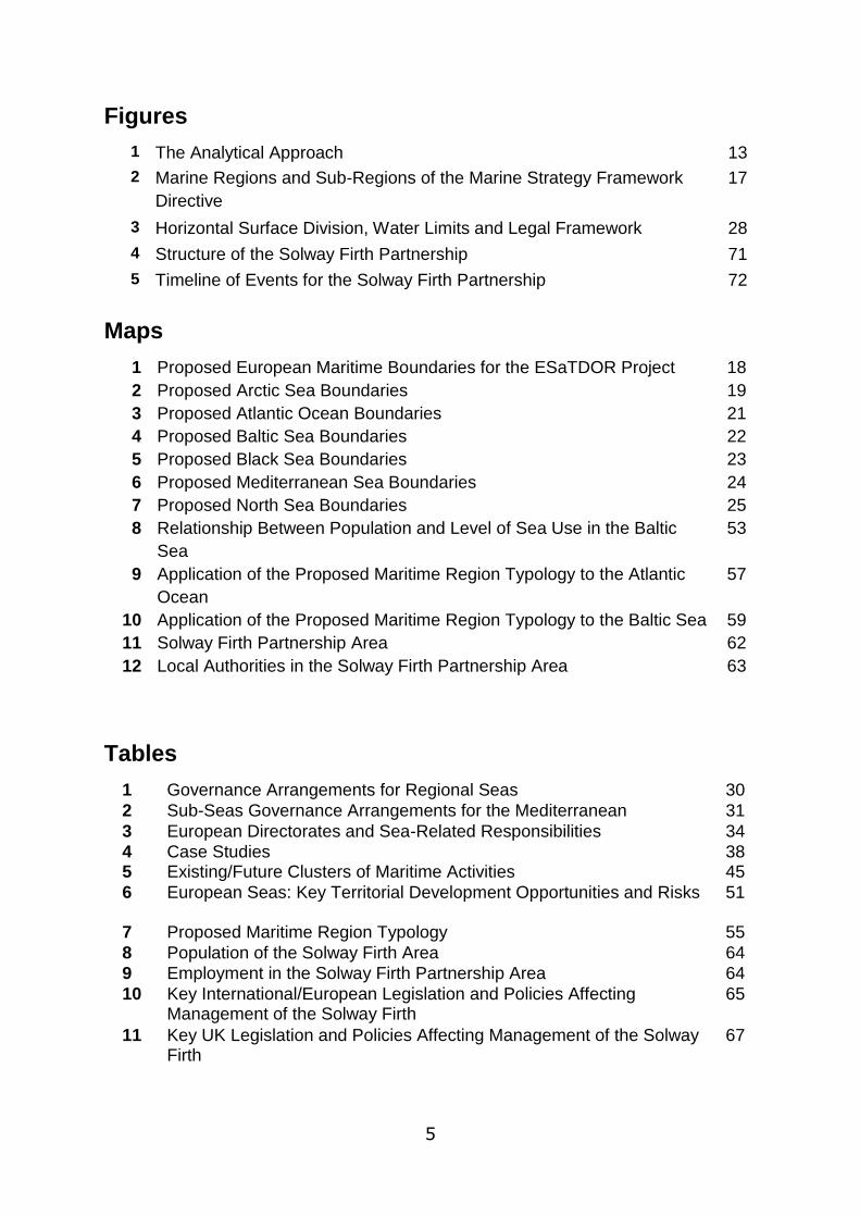
Contents Figures ....................................................................................................................... 5
Maps .......................................................................................................................... 5
Tables ........................................................................................................................ 5
Executive Summary ................................................................................................. 6
Chapter 1: Context ................................................................................................... 8
Chapter 2: Outline of Methodology ....................................................................... 12
Chapter 3: Main Results Achieved So Far ........................................................... 14
Data Protocols and Mapping Briefing Paper ......................................................... 14
Defining Maritime Boundaries ............................................................................... 16
Coastal and Marine Governance Briefing Paper .................................................. 27
Case Study Selection ........................................................................................... 37
Economic Use Briefing Paper ............................................................................... 44
Energy, Cables and Pipelines Briefing Paper ....................................................... 46
Transport and Shipping Briefing Paper ................................................................. 47
Coastal and Marine Environment Briefing Paper .................................................. 49
Key Territorial Development Opportunities and Risks .......................................... 50
Chapter 4: Developing a Maritime Region Typology ........................................... 52
Review of Existing ESPON Typologies ................................................................. 52
Applying the Typology .......................................................................................... 56
Evaluation and Possible Refinement of the Typology ........................................... 60
Chapter 5: Pilot Case Study - the Solway Firth Partnership .................................. 61
Chapter 6: Further Proceedings Towards the Draft Final Report ...................... 79
Key Challenges and Proposed Responses for Draft Final Report ........................ 79
Draft Conclusions and Policy Recommendations ................................................. 83
Looking Ahead to the Next Stages of Work .......................................................... 87
Draft contents page of final report......................................................................... 89
References .............................................................................................................. 93
5
Figures
1 The Analytical Approach 13
2 Marine Regions and Sub-Regions of the Marine Strategy Framework
Directive
17
3 Horizontal Surface Division, Water Limits and Legal Framework 28
4 Structure of the Solway Firth Partnership 71
5 Timeline of Events for the Solway Firth Partnership 72
Maps
1 Proposed European Maritime Boundaries for the ESaTDOR Project 18
2 Proposed Arctic Sea Boundaries 19
3 Proposed Atlantic Ocean Boundaries 21
4 Proposed Baltic Sea Boundaries 22
5 Proposed Black Sea Boundaries 23
6 Proposed Mediterranean Sea Boundaries 24
7 Proposed North Sea Boundaries 25
8 Relationship Between Population and Level of Sea Use in the Baltic
Sea
53
9 Application of the Proposed Maritime Region Typology to the Atlantic
Ocean
57
10 Application of the Proposed Maritime Region Typology to the Baltic Sea 59
11 Solway Firth Partnership Area 62
12 Local Authorities in the Solway Firth Partnership Area 63
Tables
1 Governance Arrangements for Regional Seas 30
2 Sub-Seas Governance Arrangements for the Mediterranean 31
3 European Directorates and Sea-Related Responsibilities 34
4 Case Studies 38 5 Existing/Future Clusters of Maritime Activities 45
6 European Seas: Key Territorial Development Opportunities and Risks 51
7 Proposed Maritime Region Typology 55
8 Population of the Solway Firth Area 64
9 Employment in the Solway Firth Partnership Area 64
10 Key International/European Legislation and Policies Affecting Management of the Solway Firth
65
11 Key UK Legislation and Policies Affecting Management of the Solway Firth
67

6
ESaTDOR Interim Report
Executive Summary The new Territorial Agenda of the European Union 2020 explicitly includes maritime considerations as part of the territorial agenda and promotes: the inclusion of sea space as an integral part of national, regional and local spatial policy; close alignment of Maritime policy with territorial agendas objectives and priorities; the integration of maritime space into relevant EU macro strategies; and developing EU maritime policy as a prominent part of Cohesion policy. These orientations are particularly relevant to this ESPON applied research project which seeks to contribute to the emerging policy debate by exploring in greater detail land sea inter-actions and the extent to which various marine based activities can contribute to economic growth and societal wellbeing, whilst at the same time ensuring that critical environmental assets are effectively managed and where necessary protected. More particularly this research seeks to:
Map the different types of sea use across Europe with the objective of creating a typology (or typologies) of different types of coastal/sea regions drawing upon existing ESPON terrestrial typologies as appropriate;
Identify various development opportunities (and constraints) for different types of sea/coastal region;
Explore best practice examples of terrestrial-marine and maritime governance to provide advice and guidance on how these critical assets can be efficiently, effectively and democratically managed; and
Make policy recommendations and identify further areas for applied policy research designed to maximize the opportunities of and minimize the human impacts on the critical marine assets of Europe.
This Interim Report provides an overview of the work that has been undertaken so far. It starts with a brief outline of the methodology that has been developed to guide the research which was the focus of WP2.1 and the Inception Report. This is followed by a summary of the key findings from the thematic briefing papers which were prepared under WP2.2. These include two technical papers related to Data Collection and Mapping and Marine and Coastal Governance (including final details of the selection and design of case studies), and four topic papers related to key aspects of the European maritime economy and environment: Economic Use; Energy, Cables and Pipelines; Transport and Shipping; Coastal and Marine Environment. From the topic based papers a summary of the data collection priorities identified and initial overview of key development and opportunities and risks for Europe‟s maritime regions are presented. The key findings section also provides some very early outputs from the European Sea Profile work that is currently being undertaken as part of WP2.3 relating to the development of a draft Maritime Region Typology. In addition, an example of one of the marine and coastal governance case studies that are being investigated under WP2.4 is presented. Finally, a number of issues are discussed related to the draft final report including some preliminary thoughts on the conclusions and recommendations that might arise from the research. Full versions of the Thematic Briefing Papers are presented in the appendices.

7
The summary of the research findings to date highlight a number of issues that the ESaTDOR project team will need to address over the coming months. Two key challenges are particularly evident. The first relates to data and mapping and the appropriate balance to be struck between an illustrative and in depth approach. The second related issue concerns the relative balance between quantitative and qualitative outputs. In conclusion it is clear that the marine environment is increasingly being recognised by many sovereign states as an important and integral part of their territorial space. The demands being placed on the marine environment are growing rapidly, and commercial exploitation of marine resources, combined with a need to protect environmental integrity means that more effective governance mechanisms (both in terms of structures and processes) are needed. Marine spatial planning is seen as an approach that can bring about integrated, both sectorally and spatially (across territories) policy responses to deal with conflict and competing uses for the marine resources. Combined with better developed integrated coastal zone management and more broadly cast national, regional and local spatial policy, a new era of European engagement with its seas is before us. However all these developments require a step change in our understanding of the marine environment and human use and impacts on the sea and the place specific inter-connections between terrestrial and marine areas. In terms of emerging conclusions and policy recommendations from the ESaTDOR project we believe that there are both generic and specific points that can be raised related to:
Coastal and Marine Data and Mapping;
Maritime and Maritime related Sectoral Policy;
Coastal and Marine Governance; and,
Sea Specific Guidance.

8
Chapter 1: Context
The Treaty of Lisbon, which came into force in 2009, added a new goal of territorial cohesion to the twin EU objectives of social and economic cohesion. This concern for territorial cohesion has been of growing importance in the light of the new challenges facing Europe including: recovery from the global economic crisis; structural reforms in the Euro zone; growing interdependencies between regions, both between EU member states and with emerging global economies; changing demographic and social contexts; environmental change (mitigating and adapting to climate change, protecting biodiversity and natural and cultural landscapes) and concern for energy security. Whilst some of these challenges are longstanding, the intensity and implications of their impacts on social, economic and territorial cohesion is promoting some re-appraisal, re-thinking and indeed re-affirmation of the EU‟s strategic priorities. Europe 2020, the EU‟s economic growth strategy advocates smart, sustainable and inclusive growth as the key direction of travel in order to achieve the European goals of social, economic and territorial cohesion. The fifth cohesion report „Investing in Europe‟s Future‟ published at the end of 2010, suggested that regional disparities are diminishing, but if the goals for Europe are to be achieved, better co-ordination and integration between regional development and European and national policies is required. Whilst to date much attention has been placed on the terrestrial (land based) environment (indeed this is the implicit focus of the Territorial Agenda of the EU), there is growing recognition and realization that the interface between the land and the sea and indeed the seas themselves and the important resources within these environments need to be more carefully considered and managed in an integrated manner. Indeed for some countries a greater proportion of the area under their sovereign jurisdiction is sea rather than land based. It was within this context that the EU‟s Integrated Maritime Policy (IMP) was established in 2007 in order to “enhance the optimal development of all-sea related activities in a sustainable manner”. This pioneering work is attempting to achieve a balance between harnessing the significant economic and social benefits that the sea can provide whilst ensuring good environmental quality within Europe‟s marine areas. To achieve this the IMP recognizes the need for greater integration between fragmented sectoral policies and frameworks for action that operate at different spatial scales, from local, regional, to national, to transnational within both EU space, but also globally. Hence there has been a growing call for an integrated approach to marine spatial planning (MSP) throughout the territories of the EU;
“Increased activity on Europe's seas leads to competition between sectoral interests, such as shipping and maritime transport, offshore energy, ports development, fisheries and aquaculture and environmental concerns. Climate change, in particular the rise of sea levels, acidification, increasing water temperatures, and frequency of extreme weather events is likely to cause a shift in economic activities in maritime areas and to alter marine ecosystems. Marine Spatial Planning (MSP) can play an important role in mitigation, by
9
promoting the efficient use of maritime space and renewable energy, and in cost-efficient adaptation to the impact of climate change in maritime areas and coastal waters. MSP is a tool for improved decision-making. It provides a framework for arbitrating between competing human activities and managing their impact on the marine environment” (CEC,2008, 2).
Whilst some progress has been made, in different country contexts (eg UK‟s Marine Act) and indeed within some regional seas (notably in the Baltic Sea), to deal with this agenda, a recent “Progress Report on the EU‟s Integrated Maritime Policy” (DG Maritime Affairs and Fisheries, 2010) has been published assessing developments since the IMP was first introduced. The report sets out key orientations for future development including:
The enhancement of integrated maritime governance and cross-cutting policy tools;
The implementation of sea basin strategies;
The definition of the boundaries of maritime sustainability;
The development of the international dimension of IMP, and
A renewed focus on sustainable economic growth, employment and innovation
While Marine Spatial Planning is being promoted by DG Mare, there is a growing recognition of the significant inter-linkages between marine and terrestrial areas and that the opportunities and risks presented by the marine environment can have an important role in delivering the wider European goals of social, economic and territorial cohesion. This has led to a recognition that maritime policy has an important and integral role to play in cohesion policy. Hence recent developments related to the EU‟s territorial agenda now make explicit reference to the marine environment as being integral to the territorial agenda of the EU. For example in the a background document to the recently revised Territorial Agenda for the EU, recommendations included: the introduction of some form of regulatory mechanism similar to spatial planning to avoid random and excessive sea space allocation to some interests; the inclusion of sea space as an integral part of national, regional and local spatial policy; close alignment of Maritime policy with territorial agendas objectives and priorities; the integration of maritime space into relevant EU macro strategies; and developing EU maritime policy as a prominent part of Cohesion policy (Drafting Team set up for the update of the Territorial State and Perspectives of the EU 2011). This has led to the new Territorial Agenda of the European Union 2020 that was agreed in Godollo, Hungary in May 2011. For the first time this EU document explicitly includes maritime considerations as part of the territorial agenda:
„Maritime activities are essential for territorial cohesion in Europe. Economic activities such as energy production and transport are increasing rapidly in European marine environments. There is a need to solve user conflicts and balance various interests by cooperation in maritime spatial planning. The Marine Strategy Framework Directive and EU Integrated Maritime Policy call for coordinated actions from Member States on maritime spatial planning.

10
Such planning should be integrated into the existing planning systems to enable harmonious and sustainable development of a land-sea continuum.‟ (Informal Ministerial Meeting of Ministers responsible for Spatial Planning and Territorial Development, 2011, para. 55).
Whilst the marine environment is now being increasing recognised as having a significant role to play in broader debates of territorial cohesion, there is also discussion concerning the nature of Cohesion policy itself and the extent to which there needs to be a paradigm shift in thinking away from a policy based on redistribution of resources to one which responds in a tailored way to the risks and potentialities of particular places. This place-based approach is being advocated as facilitating bespoke interventions for particular local economic, social and environmental circumstances and is more aligned with the principles of subsidiarity, rather than a top down interventionist perspective (Barca, 2009). Whilst the debate around the budget for future Cohesion policy and the way it will be framed is still ongoing, from the perspective of this research project, the fact that maritime considerations are being increasingly recognised as being linked to territorial cohesion and that policies need be framed in a way that relates to place specific risks and opportunities means that this research is both timely and can make a useful contribution to these ongoing debates. These orientations are particularly relevant to this ESPON applied research project which seeks to contribute to the emerging policy debate by exploring in greater detail land sea inter-actions and the extent to which various marine based activities can contribute to economic growth and societal wellbeing, whilst at the same time ensuring that critical environmental assets are effectively managed and where necessary protected. More particularly this research seeks to:
Map the different types of sea use across Europe with the objective of creating a typology (or typologies) of different types of coastal/sea regions drawing upon existing ESPON terrestrial typologies as appropriate;
Identify various development opportunities (and constraints) for different types of sea/coastal region;
Explore best practice examples of terrestrial-marine and maritime governance to provide advice and guidance on how these critical assets can be efficiently, effectively and democratically managed; and
Make policy recommendations and identify further areas for applied policy research designed to maximize the opportunities of and minimize the human impacts on the critical marine assets of Europe.
Based upon the aims and objectives outlined above and the emerging policy context for the marine environment as an important and integral part of the territorial agenda, our working hypothesis is;
That the marine environment is a critical yet undervalued component of the EU‟s, national regional and local territorial space. Its associated risks and opportunities need to be better understood and more effectively managed in an integrated manner to ensure that these significant marine assets and resources can better contribute to broader European strategic goals.

11
This Interim Report provides an overview of the work that has been undertaken so far. It starts with a brief outline of the methodology that has been developed to guide the research which was the focus of WP2.1 and the Inception Report. This is followed by a summary of the key findings from the thematic briefing papers which were prepared under WP2.2. These include two technical papers related to Data Collection and Mapping and Marine and Coastal Governance (including final details of the selection and design of case studies), and four topic papers related to key aspects of the European maritime economy and environment: Economic Use; Energy, Cables and Pipelines; Transport and Shipping; Coastal and Marine Environment. From the topic based papers a summary of the data collection priorities identified and an initial overview of key development and opportunities and risks for Europe‟s maritime regions are presented. The key findings section also provides some very early outputs from the European Sea Profile work that is currently being undertaken as part of WP2.3 relating to the development of a draft Maritime Region Typology. In addition, an example of one of the marine and coastal governance case studies that are being investigated under WP2.4 is presented. Finally, a number of issues are discussed related to the draft final report including some preliminary thoughts on the conclusions and recommendations that might arise from the research. Full versions of the Thematic Briefing Papers are presented in the appendices.
12
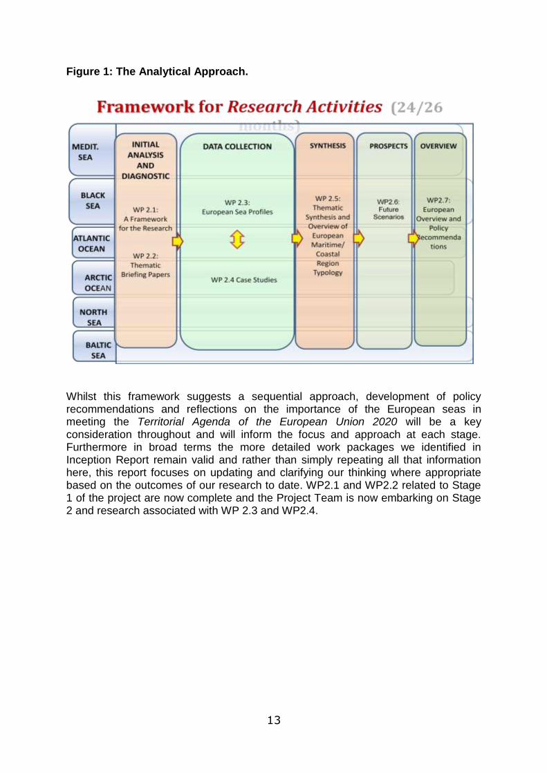
Chapter 2: Outline of Methodology This is the first time that ESPON has directed its attention in a major way to exploring the territorial development opportunities and risks associated with European seas. Our early work on the project has highlighted the value of this type of research which is perhaps long overdue. However, it has also revealed a complexity of issues related to sea boundary definition, data access and compatibility, disaggregation of data between territorial and marine space and the difficulty in developing meaningful units of analysis for European marine space. These issues were highlighted in the Inception Report and key conclusions at this point included the need to adopt an exploratory approach and examine varying experience in relation to marine mapping and governance both between the different European seas and across the different areas of thematic interest. In other words our approach to the research is iterative, incremental and experimental. The analytical approach we have adopted to the research follows a five step process (see Figure 1):
Stage 1 is an initial analysis and diagnostic phase exploring what is already known about both the European seas, but also thematic priorities around which the research is focused. This will inform the production of more detailed briefs for the next stage,
Stage 2 is a period of intense data collection, both in terms of collating existing data sets for the European seas, but also through case studies providing an evaluation of how various existing governance arrangements have been working in practice,
Stage 3 is a period of synthesis and reflection as the information is consolidated into digestible elements,
Stage 4 considers future prospects and is a period of scenario building and testing, based on an understanding of the opportunities and challenges facing the European seas, and
Stage 5 involves the development of an overview including clear policy recommendations, and suggestions for further prioritisation of research.
13
Figure 1: The Analytical Approach.
Whilst this framework suggests a sequential approach, development of policy recommendations and reflections on the importance of the European seas in meeting the Territorial Agenda of the European Union 2020 will be a key consideration throughout and will inform the focus and approach at each stage. Furthermore in broad terms the more detailed work packages we identified in Inception Report remain valid and rather than simply repeating all that information here, this report focuses on updating and clarifying our thinking where appropriate based on the outcomes of our research to date. WP2.1 and WP2.2 related to Stage 1 of the project are now complete and the Project Team is now embarking on Stage 2 and research associated with WP 2.3 and WP2.4.
14
Chapter 3: Main Results Achieved So Far
WP 2.2: Thematic Briefing Papers
The main objective of WP2.2 was to specify detailed data collection requirements for WP2.3 and WP2.4. The outputs from this work included two technical papers covering Data Collection and Mapping and Coastal and Marine Governance and four topic briefing papers covering : Economic Use; Energy, Cables and Pipelines; Transport and Shipping; and Coastal and Marine Environment. Each of the topic papers follows a standard format and includes:
An introduction outlining the scope of theme and areas of focus from an EU
policy perspective with reference to the Lisbon and Gothenburg Agendas as
appropriate
A summary overview of the global governance and policy context
A summary overview of the EU Level governance and policy context
An account of thematic data ambitions using the INSPIRE Directive as an
initial base for identification.
A review of thematic data availability focussing on key data sets and
assessing spatial coverage, data format and temporal quality (start date,
frequency, consistency etc) and policy relevance.
A discussion of key thematic development opportunities and risks
Recommended priorities for Regional Seas Data Collection
Useful References
The full papers are included in the appendices to this report and a summary of key findings from each is presented below.
Data Protocols and Mapping Briefing Paper
Data and mapping challenges The data protocols and mapping briefing paper provides an overview of the current status of maritime mapping in the EU/ESPON area and highlights some of the key challenges for data assembly and mapping that relate to the ESaTDOR project. Different initiatives related to marine mapping in EU seas exist, but a common approach to marine data collection protocols has yet to be established. Across the different European seas there is a lack of homogenous statistical information related to sea areas, and uneven coverage of particular seas – for example the North Sea is well represented through bodies such as Eurostat, the EEA and ICES, whereas for regions such as the Black Sea and Arctic which feature non-EU27 countries, data sources are more scattered.

15
Inconsistencies in the definition of sea boundaries add a further layer of complexity to mapping and data collection, as regions defined for example by Exclusive Economic Zones, Regional Sea Conventions, the Water Framework Directive, Marine Strategy Framework Directive Marine Regions and EU Integrated Maritime Policy do not necessarily correspond, being focused on either ecosystem functions or thematic interests such as transport and covering different sized geographical areas. Whilst much data is available at a NUTS 0 or national level, this may not be the appropriate scale for the purposes of the ESaTDOR project as many nations border more than one sea. Similarly, there is often a lack of disaggregation between land and sea, while for some thematic datasets there is good data related to activities on the terrestrial side, information gaps exist on the marine side. With these issues in mind, the data collection aspects of the ESaTDOR project clearly needs to consider:
- Consistency of terminology and definitions for different data sets;
- Data quality and systematic methods of recording and managing data;
- Ensuring complete and accurate data collection, addressing potential errors
and gaps,
- Defining sea boundaries to ensure no overlaps or gaps,
- Reference to relevant state of the sea/coast reports, and
- Listing additional datasets that may be useful.
Using INSPIRE as a starting point for marine data harmonisation. Data collection and sea use mapping are critical requirements for effective maritime spatial planning, and as new maritime spatial planning systems emerge within EU countries there is a need for a consistent way of understanding the maritime context and the important environmental, economic and social interactions and interconnections between marine areas and landward communities. In particular, where neighbouring states are required to cooperate on marine and coastal initiatives there is a pressing need for the harmonisation of marine spatial information. With this in mind the ESaTDOR project has looked initially to the INSPIRE Directive, which aims to establish an infrastructure for sharing spatial information within the European Community. This provide a starting point for marine data harmonisation and the guidelines set out in Annex 11 of the ESaTDOR Inception Report which are adapted from INSPIRE will be used to direct future data collection efforts including the thematic data review that is included in the topic based briefing papers discussed below.

16
Defining Maritime Boundaries
Given the variability in sea boundary definitions referred to above and as all previous ESPON projects have focused on land based elements of territorial development, a key aspect of the ESaTDOR project has been to propose preferred maritime boundaries for the Arctic Sea, Atlantic Ocean, Baltic Sea, Black Sea, Mediterranean Sea and North Sea which encompass ESPON space. These boundaries should facilitate consistent data collection and mapping for maritime regions and in turn help the development a maritime region typology which is discussed further under WP2.3 below. The definition of preferred maritime boundaries requires a pragmatic approach as many maritime activities occur in areas beyond national and territorial limits or at no fixed location. In addition, work for the ESaTDOR Inception Report showed that there is great variability in the way that sea boundaries of individual nations are defined, with some based on Exclusive Economic Zones and the limits of continental shelf which may be declared under the provisions of the UN Convention on the Laws of the Sea (UNCLOS) and others on maritime delimitation treaties, for example the agreement between the Republic of Bulgaria and the Republic of Turkey on determination of the boundary in the mouth area of the Rezovska/Mutludere River and delimitation of the maritime areas between the two in the Black Sea which was signed in 1992 and ratified in 1998. In the Inception Report it was stated that, following the first ESaTDOR team meeting, “the preferred sea boundaries for data collection were the Marine Strategy Framework Directive Marine Regions and Marine Sub Regions, and in relation to the Arctic, ESPON marine space as defined by the areas covered by the Exclusive Economic Zones of Norway and Denmark” . It was thought that this would facilitate data collection at the NUTS 0 level. However it was also noted in the Inception Report that other sea boundaries such as those defined for the EU‟s Integrated Maritime Policy or the OSPAR Convention for the North East Atlantic do not coincide with MSFD boundaries but reflect other thematic interests such as transport and ecosystem functions. This problem is particularly highlighted in relation to potential boundaries for the North Sea, Atlantic and Arctic, (see Figure 2 below) where Norwegian and Icelandic waters are beyond the boundaries of MSFD marine regions and the “Greater North Sea” extends into the western limits of the UK‟s Exclusive Economic Zone, which would normally be classed as part of the Atlantic.

17
Figure 2: Marine Regions and Sub-regions of the Marine Strategy Framework Directive
Source: Suarez de Vivero and Mateos (2007)
Furthermore, MSFD boundaries often cut through the Exclusive Economic Zones. This means data related to sea uses provided at the national level (for example fisheries) could be attributed to more than one ecosystem or regional sea boundary. This is the case for Norway for example, whose EEZ extends into OSPAR regions for the Arctic and Greater North Sea. These examples illustrate the complexity of maritime boundaries and the potential disadvantages associated with trying to apply one particular set of boundaries consistently across the entire ESPON maritime space. Therefore following further reflection by the team the proposed maritime region boundaries outlined below have been selected based on a combination of different approaches that are felt to be most appropriate to each regional sea area. In most cases, the boundaries for regional sea conventions such as OSPAR, HELCOM, the Barcelona and Black Sea Conventions have been used as this enables ESaTDOR to make best use of the information that is already collected by regional sea secretariats. In some areas, such as the Arctic, Mediterranean and Black Seas, this will also facilitate the collection of data related to neighbouring countries that are not part of ESPON space but nevertheless are integral to the function and characterisation of regional seas such as the Balkan States, Turkey, Russia, Ukraine and the countries of the Middle East and North Africa. The proposed maritime boundaries are shown in relation to each nation‟s Exclusive Economic Zones in Map 1 below. The seas surrounding European territories in the
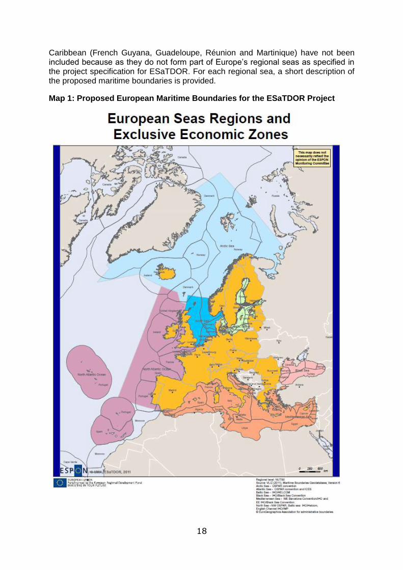
18
Caribbean (French Guyana, Guadeloupe, Réunion and Martinique) have not been included because as they do not form part of Europe‟s regional seas as specified in the project specification for ESaTDOR. For each regional sea, a short description of the proposed maritime boundaries is provided.
Map 1: Proposed European Maritime Boundaries for the ESaTDOR Project
19
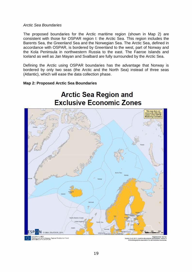
Arctic Sea Boundaries The proposed boundaries for the Arctic maritime region (shown in Map 2) are consistent with those for OSPAR region I: the Arctic Sea. This region includes the Barents Sea, the Greenland Sea and the Norwegian Sea. The Arctic Sea, defined in accordance with OSPAR, is bordered by Greenland to the west, part of Norway and the Kola Peninsula in northwestern Russia to the east. The Faeroe Islands and Iceland as well as Jan Mayan and Svalbard are fully surrounded by the Arctic Sea. Defining the Arctic using OSPAR boundaries has the advantage that Norway is bordered by only two seas (the Arctic and the North Sea) instead of three seas (Atlantic), which will ease the data collection phase. Map 2: Proposed Arctic Sea Boundaries

20
Atlantic Ocean Boundaries For the boundaries of the Atlantic Ocean (shown in Map 3), the northern extent is defined by reference to the proposed Arctic boundaries. The OSPAR boundaries are also used here to delimit the boundary between the North Sea, Arctic and Atlantic. The western edge of the Atlantic is defined by the limits of the EU‟s Integrated Maritime Policy areas for the Celtic Seas, Bay of Biscay and Atlantic Iberian Coast, following a line of longitude at 18°W. This western limit includes within it the Celtic Seas and Bay of Biscay/Iberian Coast OSPAR regions and the Exclusive Economic Zones of the UK, Ireland, France, Portugal and Spain. In this instance it was decided to use the IMP boundaries rather than extend the boundary further west to cover the entire OSPAR Wider Atlantic Region as this covers a large area which, with the exception of Portugal‟s EEZ surrounding the Azores, is beyond the jurisdiction of any European nation. The southern boundary of the Atlantic uses both the lowest extent of the OSPAR regions, which is also consistent with Integrated Maritime Policy limits. Although the Canary Islands and Madeira fall outside this zone, their EEZs (and IMP regions) have also been included as part of the Atlantic. Between the UK and mainland Europe, the eastern limits of the Atlantic are defined using the line between the English Channel and the North Sea. This coincides with the IMP boundary of the Celtic Seas and is appropriate given the Channel‟s importance as a Motorway of the Sea, providing a strategic transport route connecting North West Europe with the Atlantic Ocean.
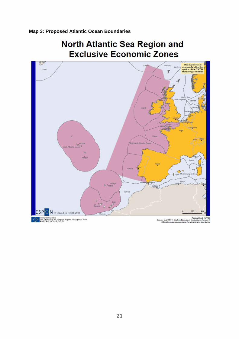
21
Map 3: Proposed Atlantic Ocean Boundaries
22
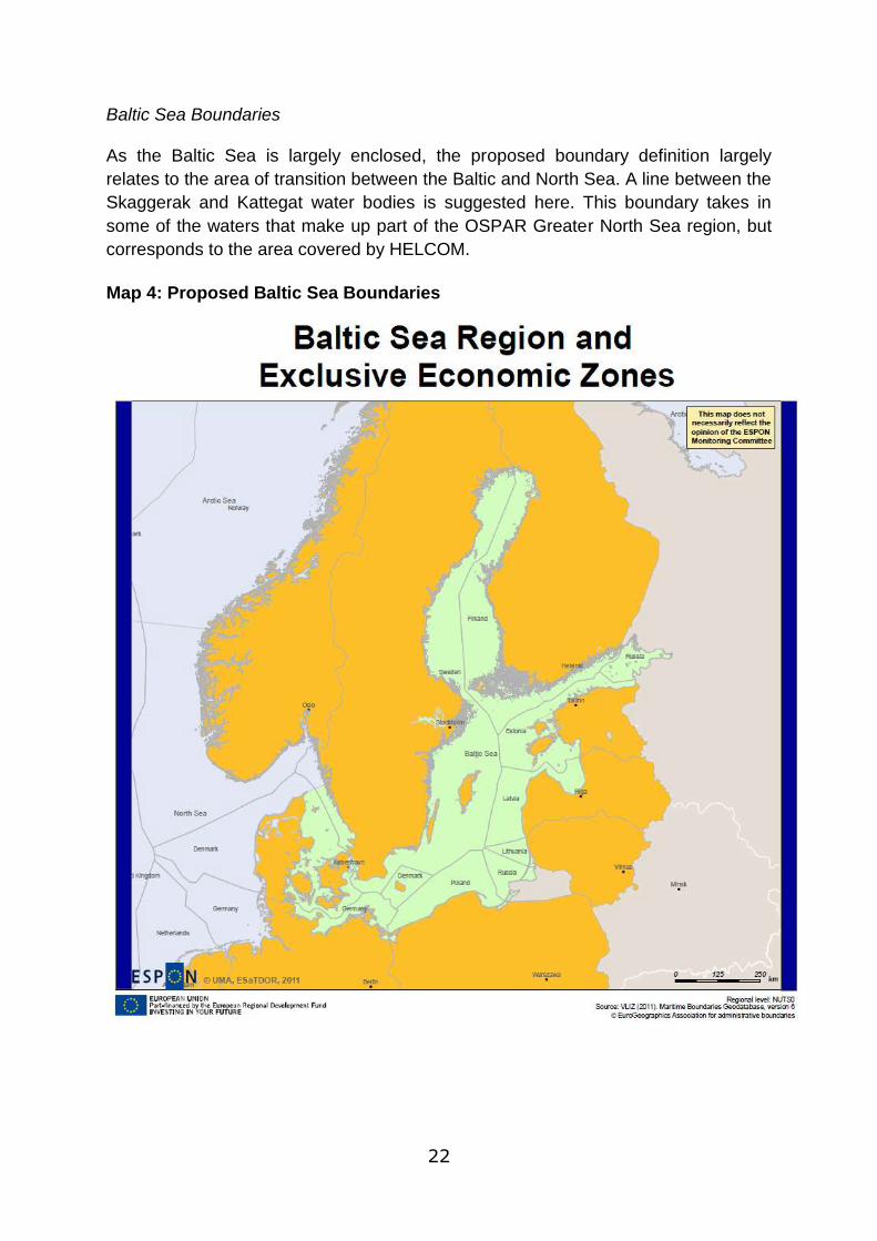
Baltic Sea Boundaries As the Baltic Sea is largely enclosed, the proposed boundary definition largely
relates to the area of transition between the Baltic and North Sea. A line between the
Skaggerak and Kattegat water bodies is suggested here. This boundary takes in
some of the waters that make up part of the OSPAR Greater North Sea region, but
corresponds to the area covered by HELCOM.
Map 4: Proposed Baltic Sea Boundaries
23
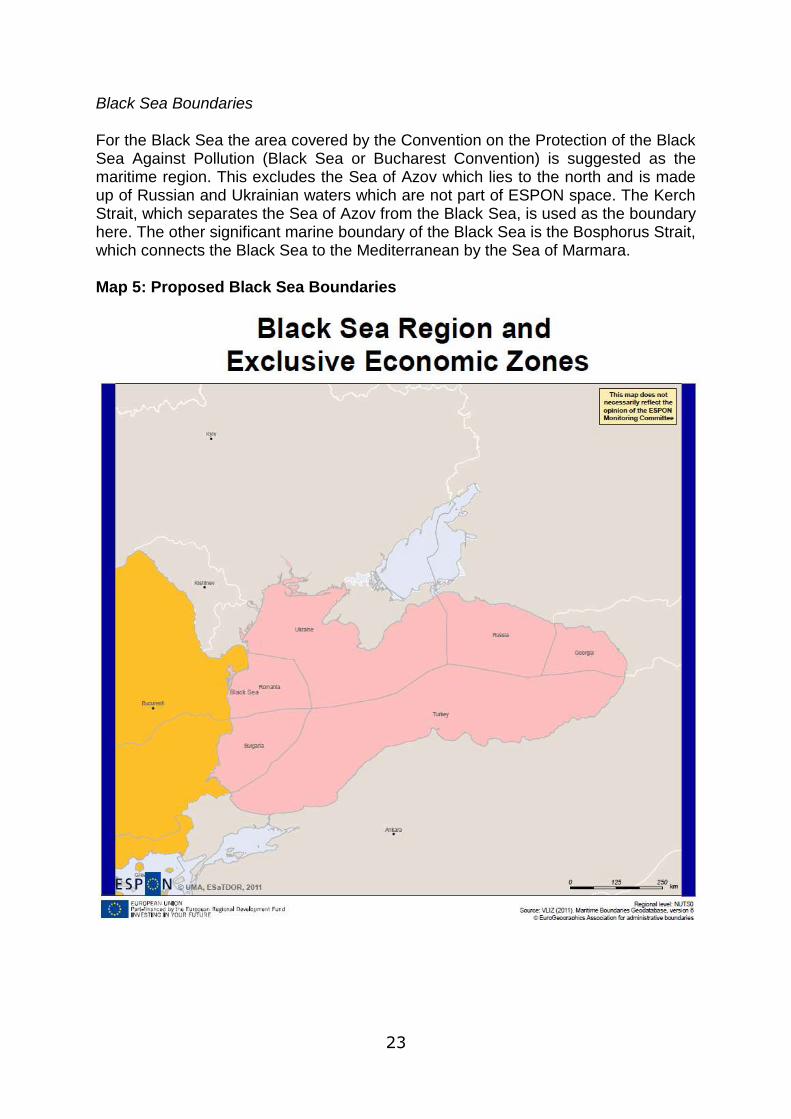
Black Sea Boundaries For the Black Sea the area covered by the Convention on the Protection of the Black Sea Against Pollution (Black Sea or Bucharest Convention) is suggested as the maritime region. This excludes the Sea of Azov which lies to the north and is made up of Russian and Ukrainian waters which are not part of ESPON space. The Kerch Strait, which separates the Sea of Azov from the Black Sea, is used as the boundary here. The other significant marine boundary of the Black Sea is the Bosphorus Strait, which connects the Black Sea to the Mediterranean by the Sea of Marmara. Map 5: Proposed Black Sea Boundaries
24
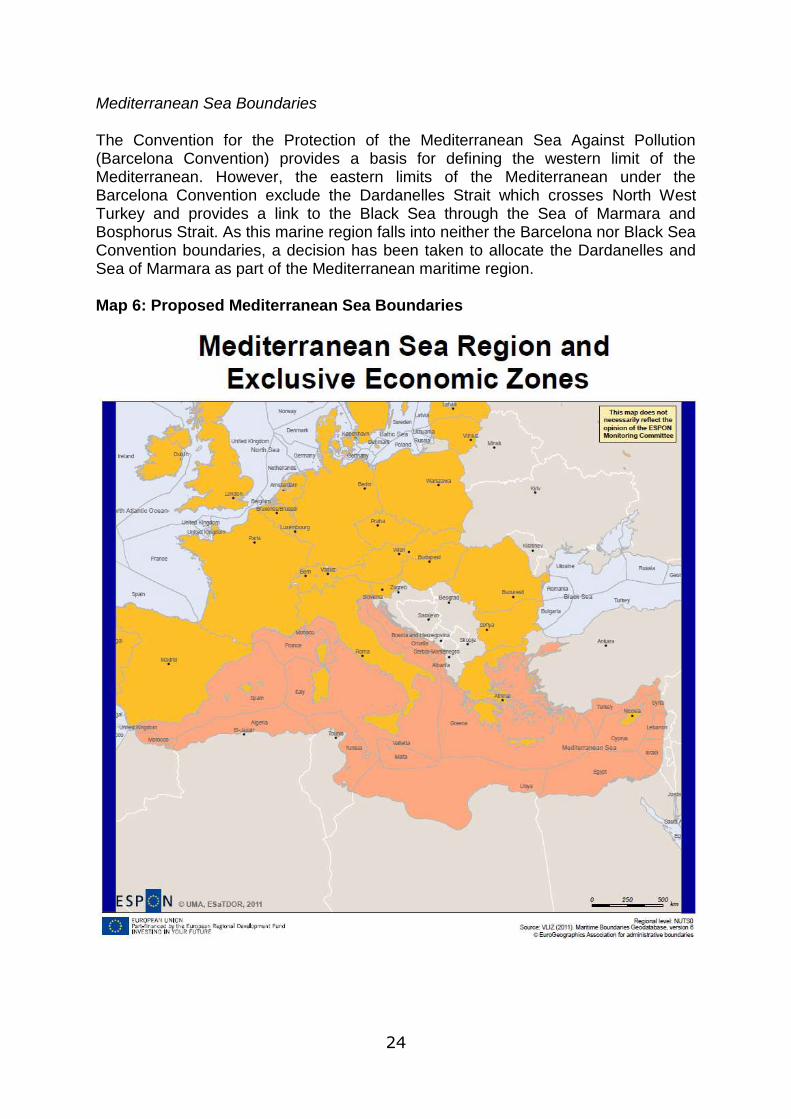
Mediterranean Sea Boundaries The Convention for the Protection of the Mediterranean Sea Against Pollution (Barcelona Convention) provides a basis for defining the western limit of the Mediterranean. However, the eastern limits of the Mediterranean under the Barcelona Convention exclude the Dardanelles Strait which crosses North West Turkey and provides a link to the Black Sea through the Sea of Marmara and Bosphorus Strait. As this marine region falls into neither the Barcelona nor Black Sea Convention boundaries, a decision has been taken to allocate the Dardanelles and Sea of Marmara as part of the Mediterranean maritime region. Map 6: Proposed Mediterranean Sea Boundaries

25
North Sea Boundaries The North Sea boundaries are to some degree determined by the boundaries of its neighbouring maritime regions. To the north and North West, the Greater North Sea OSPAR boundaries separate this maritime region from the Arctic and Atlantic. To the east, the HELCOM boundaries of the Baltic Sea provide another boundary, and in the south west the IMP boundary separating the English Channel from the North Sea completes the maritime extent of the North Sea region. Map 7: Proposed North Sea Boundaries

26
Future Use of the Proposed Maritime Boundaries
It is recognised that these proposed maritime boundaries may need to be refined based on comments made by the ESPON Coordination Unit and Sounding Board and also in light of further data collection and mapping work undertaken as part of the next stages of the ESaTDOR project. However, in order to maintain close cooperation and the compatibility of maritime boundary maps with the ESPON Database, members of the ESaTDOR team have provided these maps shown above to the Database manager. Currently the ESPON Database has not yet proposed a map template for maritime regions and the first provisional Mapkit for doing so is to be made available in December 2011. Therefore whilst the initial base maps for maritime regions presented here can be utilised to develop new mapping capabilities for ESPON maritime space, further attempts to map the current state of sea use, and associated territorial development potentials and challenges within the ESPON mapping template may not be undertaken until the exact spatial units have been agreed.
A further development of mapping capabilities that is to be explored by the ESaTDOR project relates to mapping sea uses at a finer scale within the defined maritime boundaries. Given that some maritime space is subject to more complex patterns of use, it has been recognised that the base maps developed for maritime regions will need to be divided into smaller geographical units to reflect maritime activities at particular locations within each sea. Therefore ESaTDOR will investigate the possibility of mapping sea uses based on 100 x 100Km grid squares and the potential for smaller units to be used in areas of most complex activity, for example within territorial waters. Whilst ultimately the ability to map sea uses precisely within this framework may be beyond the capabilities of the ESaTDOR team, the lessons learned from experimentally applying this approach could feed into recommendations for future data collection and mapping protocols for the ESPON Database and European maritime space.
27
Coastal and Marine Governance Briefing Paper
The Coastal and Marine Governance Briefing Paper sets out the current context for coastal and marine governance and the key challenges that Europe faces in developing a better integrated and more coherent approach to the planning and management of coastal and marine resources. In doing so the paper sets the scene for WP2.4 related to the governance case studies and together with the appended Case Study Guidance Note is intended to inform the case study research. Key issues highlighted in preparing for the case studies are outlined below. Coastal and Marine Governance Complexity There is a recognition that activities within the marine environment are growing very rapidly and that increasing intensity of use is a feature all Europe‟s seas. At present, it is usually the case that each activity is subject to regulation and planning, albeit by different agencies, each with its own specific legislative approach. It is therefore not surprising that problems of overlapping jurisdictions and potential conflict between sectors and stakeholders in national and transnational space is increasingly evident. Marine Spatial Planning (MSP) has emerged as an embryonic approach to try to resolve inter-sectoral and cross- border conflicts across marine space, while ICZM has been developed over a longer timeframe to promote more coherent planning of coastal areas and the land/sea interface. Within a European context MSP has sometimes been compared with spatial or land use planning within a terrestrial context, and whilst there may be similarities in terms of the theoretical objectives, processes and principles, there are at least four factors that make MSP much more complex:-
1. Whilst land use planning traditionally functions through one dimension (the
surface of the land), MSP must operate in three dimensions simultaneously,
on and under the sea bed; in the water column and on the surface;
2. Land use planning is traditionally concerned with permanent and fixed
structure whereas marine planning must accommodate both fixed and fluid
structures and activities;
3. Perhaps most importantly are the diversity of legal rights that are created by
and subject too, different legal and policy regimes; and
4. Finally the time dimension is also significant with patterns of environmental
conditions and associated sea use varying significantly on a daily, monthly
and seasonal basis, as well as over longer time cycles. (MARGb et al 2008).
ICZM must also address these complexities plus the added dimension of integrating landward and seaward planning and management regimes. This then creates a very complex set of overlapping governance arrangements in marine and coastal areas, which are highly place specific, reflecting very particular combinations of international, European, national, regional and local laws and practices.
28
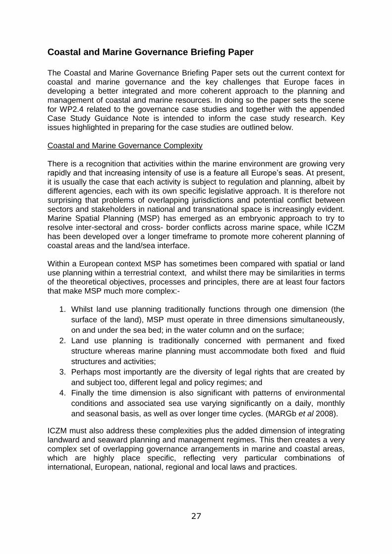
Figure 3: Horizontal Surface Division, Water Limits and Legal Framework
From an international perspective, the Law of the Sea Convention which entered into force in 1994, tries to balance the rights and interests of nation states in relation to the sustainable use of marine resources and the protection and preservation of the marine environment. It defines five areas of marine jurisdiction over which sovereign states have rights and responsibilities:-
1. Internal waters are on the landward side of the baseline of the territorial sea, over which the coastal state has full sovereignty. The baseline is important as this helps to determine the extent to which the territorial waters will extend, and is usually determined by the low water mark.
2. Territorial waters can extend up to 12 nautical miles out from the baseline, or will be determine by negotiation between nation states if the stretch of water is less than 24 nautical miles. In these areas the sovereign state authority is in practice absolute.
3. Beyond the territorial waters states can claim a further 12 mile contiguous zone.
4. Beyond the territorial waters the sovereign states can claim an Exclusive Economic Zone (EEZ) which can be up to 200 nautical miles from the baseline. Within this zone the sovereign states have the rights to explore, exploit, conserve and manage all natural resources living or non-living, and outside of the Mediterranean seas all coastal states have claimed EEZs or their equivalents.

29
5. Finally some states may be able to claim sovereign jurisdiction beyond the outer limits of the 200 nautical mile EEZ to the edge of continental shelf. This is particularly important in parts of the Arctic and Atlantic regional seas.
Nevertheless within the Mediterranean, despite not claiming EEZ status many states have claimed sectoral jurisdiction to maritime zones and as such they can practice MSP for the purposes for which such zones were created, for example France has declared an Ecological Protection Zone, but the scope of the zone does not include fisheries. Spain, Malta, Algeria, and Croatia have all claimed fishery zones of various sizes. Hence the process and procedure for delimiting maritime boundaries is far from complete and there are many areas that are still contested. Whilst from an international perspective the international law of the sea focuses on the roles and responsibilities of the sovereign states, in various parts of the European territories different nation states manage the seas in different ways. In Germany for example, coastal Lander are expected to extend their spatial (terrestrial) structure plans to their respective parts of the territorial seas, while in the UK a system of marine planning is developing which parallels, but is quite separate from terrestrial planning. However, it similarly exhibits distinct differences in the detail of its delivery in each of the devolved administrations reflecting the unique constitutional characteristics in each instance. At a European scale, governance arrangements for the exploitation and management and protection of maritime resources have also been emerging in an incremental manner and three broad areas of activity that have an impact on the seas can be identified. First there are a range, of what might be described as sectoral policies and initiatives, each with important maritime implications. Perhaps the most well known of these relates to the Common Fisheries Policy (CFP), whereby the EU has exclusive competence in the conservation, management and exploitation of living aquatic resources. Similarly, the Birds and Habitats Directives are applicable to designated areas and specific species within both a terrestrial and marine context. Second there are a range of general process directives which are applicable both to land and sea. Of particular significance here are the directives relating to the environmental appraisal of proposed plans and projects. The Council Directive of 27th June 1985 on the assessment of certain public and private projects on the environment (85/337/EEC), the so called EIA directive, requires that large scale development proposals should be subject to an environmental impact assessment procedure as part of the decision making process, to mitigate harmful environmental effects. More recently, the assessment process has been pushed up the policy hierarchy and Directive 2001/42/EC on the assessment of the effects of certain plans and programmes on the environment (the SEA Directive) requires plans to be appraised for their environmental impacts. The Waste Framework Directive (Directive 2006/12/EC) also applies to both terrestrial and marine areas and seeks for example to eliminate the dumping of waste at sea. Thirdly a number of nation states that have responsibilities and competences related to various regional seas have decided to collaborate in order to address certain

30
challenges that might adversely affect the longer term integrity of those environments, recognizing that collaborative working is the only way to address issues that are transnational in nature, at least within a marine context. Multilateral agreements have been concluded, often with a strong environmental protection and enhancement orientation. The approach adopted varies with some initiatives focusing on the regional seas as a whole, while others relate to particular areas for special protection on a permanent or temporary basis. Some of these regimes are identified in Table 1: Table 1: Governance Arrangements for the Regional Seas
Regional Sea(s) Regime and Functionality
North East Atlantic (Atlantic and North Sea
Convention for the Protection of the marine Environment for the North East Atlantic (OSPAR) Whilst focused on pollution prevention it also requires contracting parties to protect the marine environment against harmful human activities and where practicable restore marine areas that have been adversely affected
North East Atlantic (North Sea, Arctic and Baltic Seas)
North East Atlantic Fisheries Convention Seeks to maintain the rational exploitation of fishery stocks based on scientific advice
Baltic Sea Convention on the Protection of the Marine Environment of the Baltic Sea Area (Helsinki Convention) Through the parties to the convention and the governing body (HELCOM) appropriate measures need to be taken to establish a system of coastal and marine Baltic Sea Protected Areas (BSPA)
Baltic Sea VASAB has mainly been focused on spatial development on land but has in the recent years shown a clear interest in Maritime Spatial Planning. VASAB operates a joint working group on MSP in co-operation with HELCOM
Black Sea Convention on the Protection of the Black Sea Against Pollution (Bucharest Convention) The Commission on the Protection of the Black Sea Against Pollution focuses on seven strategic priorities: (a) pollution monitoring and assessment (PMA); (b) control of pollution from land based sources (LBS); (c) development of common methodologies for integrated coastal zone management (ICZM); (d) environmental safety aspects of shipping (ESAS); (e) conservation of biological diversity (CBD); (f) environmental aspects of the management of fisheries and other marine living resources (FOMLR); and (g) information and data exchange (IDE).
Mediterranean Sea
Convention for the Protection of the Marine Environment and Coastal regions of the Mediterranean (Barcelona Convention) This seeks to prevent any form of marine pollution from land based activities, exploration and exploitation of the marine bed, pollution from ships and aircrafts and seeks to create Specially Protected areas of Mediterranean Interest (SPAMI)
31
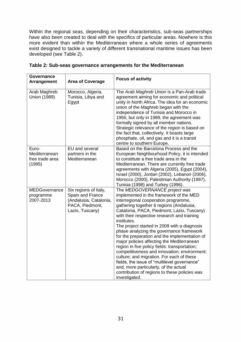
Within the regional seas, depending on their characteristics, sub-seas partnerships have also been created to deal with the specifics of particular areas. Nowhere is this more evident than within the Mediterranean where a whole series of agreements exist designed to tackle a variety of different transnational maritime issues has been developed (see Table 2). Table 2: Sub-seas governance arrangements for the Mediterranean Governance Arrangement Area of Coverage
Focus of activity
Arab Maghreb Union (1989)
Morocco, Algeria, Tunisia, Libya and Egypt
The Arab Maghreb Union is a Pan-Arab trade agreement aiming for economic and political unity in North Africa. The idea for an economic union of the Maghreb began with the independence of Tunisia and Morocco in 1956, but only in 1989, the agreement was formally signed by all member nations. Strategic relevance of the region is based on the fact that, collectively, it boasts large phosphate, oil, and gas and it is a transit centre to southern Europe.
Euro-Mediterranean free trade area (1995)
EU and several partners in the Mediterranean
Based on the Barcelona Process and the European Neighbourhood Policy, it is intended to constitute a free trade area in the Mediterranean. There are currently free trade agreements with Algeria (2005), Egypt (2004), Israel (2000), Jordan (2002), Lebanon (2006), Morocco (2000), Palestinian Authority (1997), Tunisia (1998) and Turkey (1996).
MEDGovernance programme 2007-2013
Six regions of Italy, Spain and France (Andalusia, Catalonia, PACA, Piedmont, Lazio, Tuscany)
The MEDGOVERNANCE project was implemented in the framework of the MED interregional cooperation programme, gathering together 6 regions (Andalusia, Catalonia, PACA, Piedmont, Lazio, Tuscany) with their respective research and training institutes. The project started in 2009 with a diagnosis phase analyzing the governance framework for the preparation and the implementation of major policies affecting the Mediterranean region in five policy fields: transportation; competitiveness and innovation; environment; culture; and migration. For each of these fields, the issue of “multilevel governance” and, more particularly, of the actual contribution of regions to these policies was investigated.
32
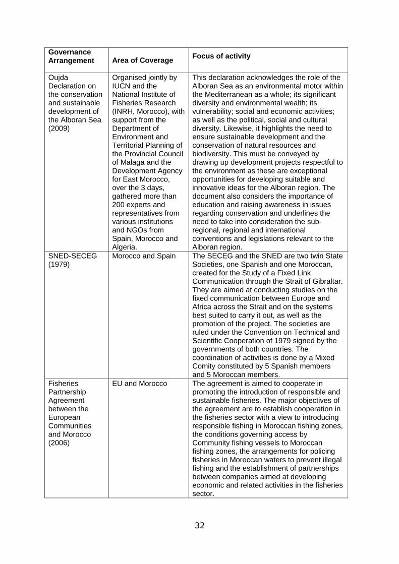
Governance Arrangement Area of Coverage
Focus of activity
Oujda Declaration on the conservation and sustainable development of the Alboran Sea (2009)
Organised jointly by IUCN and the National Institute of Fisheries Research (INRH, Morocco), with support from the Department of Environment and Territorial Planning of the Provincial Council of Malaga and the Development Agency for East Morocco, over the 3 days, gathered more than 200 experts and representatives from various institutions and NGOs from Spain, Morocco and Algeria.
This declaration acknowledges the role of the Alboran Sea as an environmental motor within the Mediterranean as a whole; its significant diversity and environmental wealth; its vulnerability; social and economic activities; as well as the political, social and cultural diversity. Likewise, it highlights the need to ensure sustainable development and the conservation of natural resources and biodiversity. This must be conveyed by drawing up development projects respectful to the environment as these are exceptional opportunities for developing suitable and innovative ideas for the Alboran region. The document also considers the importance of education and raising awareness in issues regarding conservation and underlines the need to take into consideration the sub-regional, regional and international conventions and legislations relevant to the Alboran region.
SNED-SECEG (1979)
Morocco and Spain The SECEG and the SNED are two twin State Societies, one Spanish and one Moroccan, created for the Study of a Fixed Link Communication through the Strait of Gibraltar. They are aimed at conducting studies on the fixed communication between Europe and Africa across the Strait and on the systems best suited to carry it out, as well as the promotion of the project. The societies are ruled under the Convention on Technical and Scientific Cooperation of 1979 signed by the governments of both countries. The coordination of activities is done by a Mixed Comity constituted by 5 Spanish members and 5 Moroccan members.
Fisheries Partnership Agreement between the European Communities and Morocco (2006)
EU and Morocco The agreement is aimed to cooperate in promoting the introduction of responsible and sustainable fisheries. The major objectives of the agreement are to establish cooperation in the fisheries sector with a view to introducing responsible fishing in Moroccan fishing zones, the conditions governing access by Community fishing vessels to Moroccan fishing zones, the arrangements for policing fisheries in Moroccan waters to prevent illegal fishing and the establishment of partnerships between companies aimed at developing economic and related activities in the fisheries sector.

33
Governance Arrangement Area of Coverage
Focus of activity
Adriatic Sea Partnership (2006)
6 countries in the Adriatic (Albania, Bosnia and Herzegovina, Croatia, Italy, Montenegro and Slovenia)
Originally a Slovenian initiative in cooperation with the Regional Environmental Center, the Adriatic Sea Partnership (ASP) was launched at the Mediterranean Action Plan (MAP) sub-regional conference on the Sustainable Development Strategy for the Adriatic in Portoroz, Slovenia, June 5-6, 2006. Through various international initiatives, the Adriatic countries have begun to make commitments for protection and management of the Adriatic Sea region, including a Contingency Plan for the Adriatic, a Ballast Waters Management Plan, an Integrated Coastal Zone Management Plan, and a common strategy under the EU Marine Strategy and the EC Water Framework Directive
As well as taking an area or seas based approach governance arrangements that apply to the seas have also been developed on a sectoral basis. For example, Table 3 indicates the diversity of European Directorate Generals that have various responsibilities and interests that relate to the seas. Of critical concern is the extent to which these sectoral interests can be effectively co-ordinated horizontally, and if there are conflicts between uses in particular places how are these to be resolved.
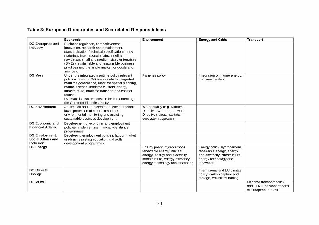
34
Table 3: European Directorates and Sea-related Responsibilities
Economic Environment Energy and Grids Transport
DG Enterprise and Industry
Business regulation, competitiveness, innovation, research and development, standardisation (technical specifications), raw materials, international affairs, satellite navigation, small and medium sized enterprises (SMEs), sustainable and responsible business practices and the single market for goods and services.
DG Mare Under the integrated maritime policy relevant policy actions for DG Mare relate to integrated maritime governance, maritime spatial planning, marine science, maritime clusters, energy infrastructure, maritime transport and coastal tourism. DG Mare is also responsible for implementing the Common Fisheries Policy
Fisheries policy Integration of marine energy, maritime clusters.
DG Environment Application and enforcement of environmental laws, protection of natural resources, environmental monitoring and assisting sustainable business development.
Water quality (e.g. Nitrates Directive, Water Framework Directive), birds, habitats, ecosystem approach
DG Economic and Financial Affairs
Development of economic and employment policies, implementing financial assistance programmes
DG Employment, Social Affairs and Inclusion
Developing employment policies, labour market analysis, assisting education and skills development programmes
DG Energy Energy policy, hydrocarbons, renewable energy, nuclear energy, energy and electricity infrastructure, energy efficiency, energy technology and innovation.
Energy policy, hydrocarbons, renewable energy, energy and electricity infrastructure, energy technology and innovation.
DG Climate Change
International and EU climate policy, carbon capture and storage, emissions trading.
DG MOVE Maritime transport policy, and TEN-T network of ports of European Interest
35
Finally, most rights to the exploitation of the seas are based with national governments, who generally speaking claim sovereignty rights over the resources within the marine environment and usually, through this issue licences to various organisations and institutions which give the right to exploit marine resources subject to compliance with European and international agreements. In terms of the various governance arrangements highlighted three key points can perhaps be raised:-
1. There is a strong and growing interest in the maritime environment and its resources (often from an environmental integrity perspective) but apart from land based pollution many of the marine governance arrangements established so far are marine focussed and there is often only limited consideration of sea/land interactions.
2. Many of the land based agendas conversely also do not think strategically about land/sea interactions and if they do the focus is mainly upon on land based environmental risks linked for example to coastal erosion, flooding and rising sea levels (with some notable exceptions such as coastal Lander in Germany).
3. The growing sectoral interests in the seas are leading to increasing competition for finite maritime space and it is not clear how conflicts for space and negative impacts for other marine objectives can be resolved.
Requirement for new perspectives and competencies In spatial planning terms, within a terrestrial land based context, the call for horizontal and vertical co-ordination, co-operation and integration across local, regional, national and transnational boundaries has been an explicit part of the policy discourse since the adoption of the European Spatial Development Perspective in 1999. It is clear that within a maritime context similar arguments can now be made for developing an integrated approach to the management of the marine environment. Equally, from both terrestrial and marine perspectives thinking and planning more strategically about the interactions between land and sea based activities now seems to be a fundamental requirement and taking such an integrated approach can be seen to be emerging as an important new direction within the European policy context. Such new practices need not only political leadership, but also the appropriate training of technicians in responsible administrative bodies. This training, in turn, is related not only to technical skills of analysis and interpretation, but also social skills related to conflict management (mediation) and a new culture of inter-administrative collaboration (negotiation). This learning process among administrative bodies and decision makers has not only to be promoted by top-down processes; but also by complementary bottom up activity with technical experts working closely with territorial and local realities. This implies a transition from traditional government procedures (which have often been dominated by sectoral siloed interests) to new governance arrangements, of which the new Maritime Policy, MSP and ICZM represent „socio-territorial innovations‟.

36
Trying to promote spatial planning ideas and principles and transposing them for coastal areas with ICZM, and, in turn to our seas, with the emerging Maritime Spatial Planning (MSP) will be an important dimension of the developing Maritime Policy for the EU. One could imagine a continuum whose point of departure is traditional spatial planning in coastal areas (inland, up to the coastal line); forward 1 nautical mile inside the sea (according to responsibilities laid down by the Water Framework Directive– 2000/60/EC) and continuing over the 12 mile territorial waters and beyond to put in practice a new Maritime Spatial Planning (MSP). In this way ICZM could work in tandem with the new MSP to consider inland development possibilities alongside „offshore‟ development opportunities and potential at the same time as recognizing and respecting environmental interrelationships and dynamics. In these areas, often trans-national and trans-regional intersections occur, and so the need for cooperation agreements to define common development strategies (territorial cooperation to territorial cohesion) becomes an unavoidable imperative. Beyond the territorial waters (further than 12 miles from the coast) comes an area where MSP may be more directly influenced by the new, broader, ambitions of a generic European Maritime Policy (CE, 2007) and international agreements. But for many of Europe‟s seas the interaction between nation states and the EU and between candidate and other countries also poses a significant challenge and the need for co-operation and collaboration to manage and protect these assets remains a priority.
Whilst an environmental approach may be the easiest way to co-ordinate all these new alternatives and instruments (i.e. through the Marine Strategy Framework Directive, the environmental arm and legal pillar of European Maritime Policy1), fundamental drivers of change relate to social or anthropogenic factors. All anthropogenic action has its impact on the environment that returns it as global processes (e.g. climate change) or more detailed ones, adapted to each locality (beach erosion, coastal regression, ecosystem destruction, river basins contamination). The origins of these processes are inland and, in the end, all of them re-emerge as impacts or new opportunities for these territories. The planning and management (or mismanagement) of coastal and maritime assets are ultimately shaped by political decisions. Aspects of Good Governance Clearly the marine environment is being increasing recognized as an important and integral component of the area of jurisdiction and potential exploitation of sovereign states. Within this environment however, the cross boundary implications of individual decisions suggest, that whilst respecting the rights of individual states to exploit their own resources, this should be undertaken in collaboration and co-operation with neighbouring states to ensure that the decisions made do not have negative spillover externalities. This calls for effective governance arrangements underpinned by a good understanding of the implications of further exploitation of marine areas on its environmental integrity. Within a terrestrial context good governance is seen as interplay between the state, market and civil society working

37
at multiple levels (vertically) and horizontally (cross-sectoral, across and between territories and between territorial and economic actors). Within land based territorial governance structures also, much has been made of the role of public participation in the process of planning to ensure that local potentialities are properly appreciated. Within a marine context much of the planning to date has been between various governmental sectors and their market actors. Civil society engagement seems less well developed. Whether models of meaningful, democratic governance can be developed for the marine environment in its totality remains to be seen. The case studies will enable a better understanding of the different emerging practices within this emerging environment for integrated spatial planning and are therefore an integral part of this exploratory research programme.
Case Study Selection
The purpose of the case studies within the ESaTDOR project is to provide a more in depth assessment of the governance experience of different maritime/coastal regions and consider the potential transferability of good practice. The primary selection criterion that has been identified is that the projects or governance arrangements must be transnational in nature, i.e. all the case studies must include the co-operation of more than one nation state. Secondly we feel that it is important that one of the case studies in each sea examines a governance arrangement that has been put in place to manage the maritime resources at a least the level of the sea itself. It is evident from our initial review that in some sea level initiatives, identified across Europe as exemplars of best practice (e.g. VASAB) the focus has been on managing the sea in a holistic way. In other cases the focus is more on the management of particular resources or issues. The third criterion for case study selection is that there should also be cases which relate to transnational arrangements at sub-sea level. These could be exploring land/ sea interactions, managing resources and protecting vulnerable ecosystems that are mobile and transcend national boundaries or looking to establish economic growth opportunities, for example through coordinated energy supply systems. In choosing the case studies no assumptions have been made as to whether these are exemplars of best practice as such assessment is felt to be premature.
38
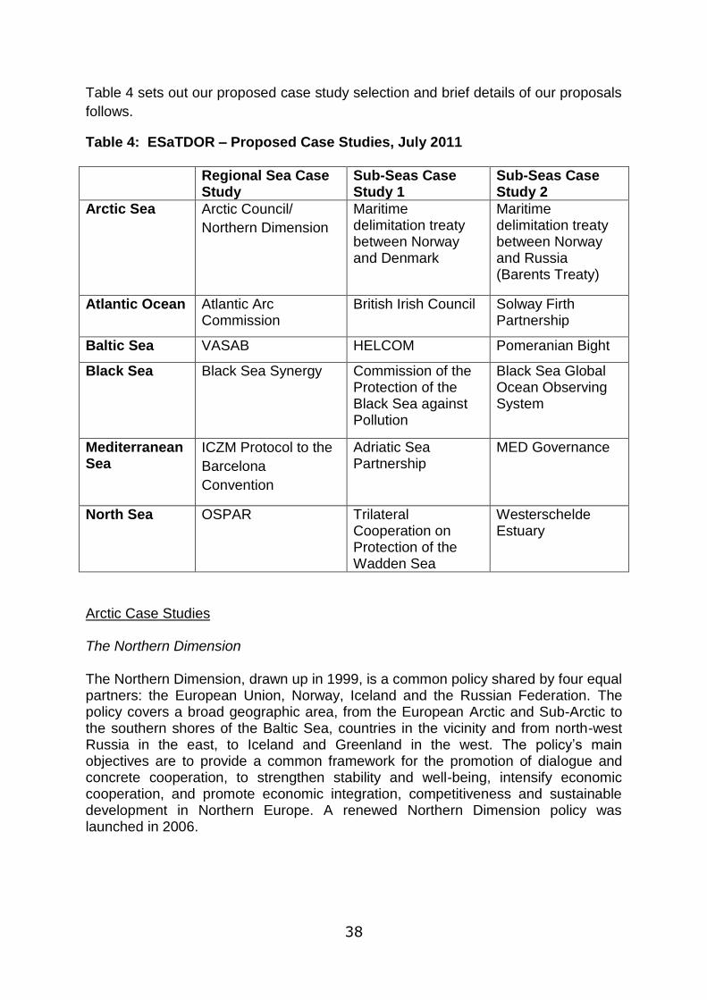
Table 4 sets out our proposed case study selection and brief details of our proposals
follows.
Table 4: ESaTDOR – Proposed Case Studies, July 2011
Regional Sea Case Study
Sub-Seas Case Study 1
Sub-Seas Case Study 2
Arctic Sea Arctic Council/
Northern Dimension
Maritime delimitation treaty between Norway and Denmark
Maritime delimitation treaty between Norway and Russia (Barents Treaty)
Atlantic Ocean Atlantic Arc Commission
British Irish Council Solway Firth Partnership
Baltic Sea VASAB HELCOM Pomeranian Bight
Black Sea Black Sea Synergy Commission of the Protection of the Black Sea against Pollution
Black Sea Global Ocean Observing System
Mediterranean Sea
ICZM Protocol to the
Barcelona
Convention
Adriatic Sea Partnership
MED Governance
North Sea OSPAR Trilateral Cooperation on Protection of the Wadden Sea
Westerschelde Estuary
Arctic Case Studies The Northern Dimension The Northern Dimension, drawn up in 1999, is a common policy shared by four equal partners: the European Union, Norway, Iceland and the Russian Federation. The policy covers a broad geographic area, from the European Arctic and Sub-Arctic to the southern shores of the Baltic Sea, countries in the vicinity and from north-west Russia in the east, to Iceland and Greenland in the west. The policy‟s main objectives are to provide a common framework for the promotion of dialogue and concrete cooperation, to strengthen stability and well-being, intensify economic cooperation, and promote economic integration, competitiveness and sustainable development in Northern Europe. A renewed Northern Dimension policy was launched in 2006.

39
Sub-Sea Case Studies: 1) Maritime delimitation treaty between Norway and Russia (Barents Sea Treaty) and 2) Maritime delimitation treaty between Norway and Denmark The Treaty between the Kingdom of Norway and the Russian Federation concerning Maritime Delimitation and Cooperation in the Barents Sea and the Arctic Ocean (Barents Sea Treaty) was signed in 2010 and marks the end of a long process of negotiation between the two countries over ownership of the seabed, subsoil and overlapping Exclusive Economic Zones. The Treaty establishes a single delimitation line for their EEZs and continental shelf in areas within 200 miles of their coasts and a delimitation line between the Norwegian and Russian continental shelf where it extends beyond 200 miles. In addition, the Treaty formalises cooperation between Norway and Russia on fisheries and the conservation of fish stocks, and sets out provisions for cooperation on the exploitation of any petroleum deposits that extend across the delimitation line.
In February 2006, the Government of the Kingdom of Denmark together with the Home Rule Government of Greenland and the Government of the Kingdom of Norway concluded an agreement on a maritime boundary between Greenland and Svalbard. The Agreement delimits the continental shelf, the Exclusive Economic Zone of Greenland and the fishery protection zone around Svalbard. The Agreement makes provisions for cooperation on the exploitation of mineral deposits found to extend across the limits of each nation‟s continental shelf, specifying the manner in which any deposit is to be most effectively exploited and how the proceeds are to be apportioned. Atlantic Case Studies The Atlantic Arc Commission The Atlantic Arc Commission is one of the six Geographical Commissions in the Conference of Peripheral Maritime Regions of Europe and seeks to integrate cooperation projects of varying scale, covering all the areas of sustainable regional development, into a coherent strategy. With post-2006 European policies in mind, the Regions have prepared an Atlantic Spatial Development Perspective (ASDP), which identifies actors, actions and policies to implement at different levels in order to support the sustainable growth of the Atlantic Arc. Priority Action Themes include transport - improving internal and external accessibility, inter-modality, developing maritime links; sustainable development, particularly ICZM; fisheries (within the constraints of the CFP) and research, innovation and improving competitiveness. Sub-Sea Case Studies: 1) the British Irish Council and 2) Solway Firth Partnership The British-Irish Council was established in 1998 as part of the Belfast or Good Friday Agreement which was signed by the British and Irish governments and political parties of Northern Ireland. The Council works to promote positive, practical relationships among the people of the islands and provide a forum for consultation and co-operation. As part of its work, the Council‟s Electricity Grid sub-group is
40
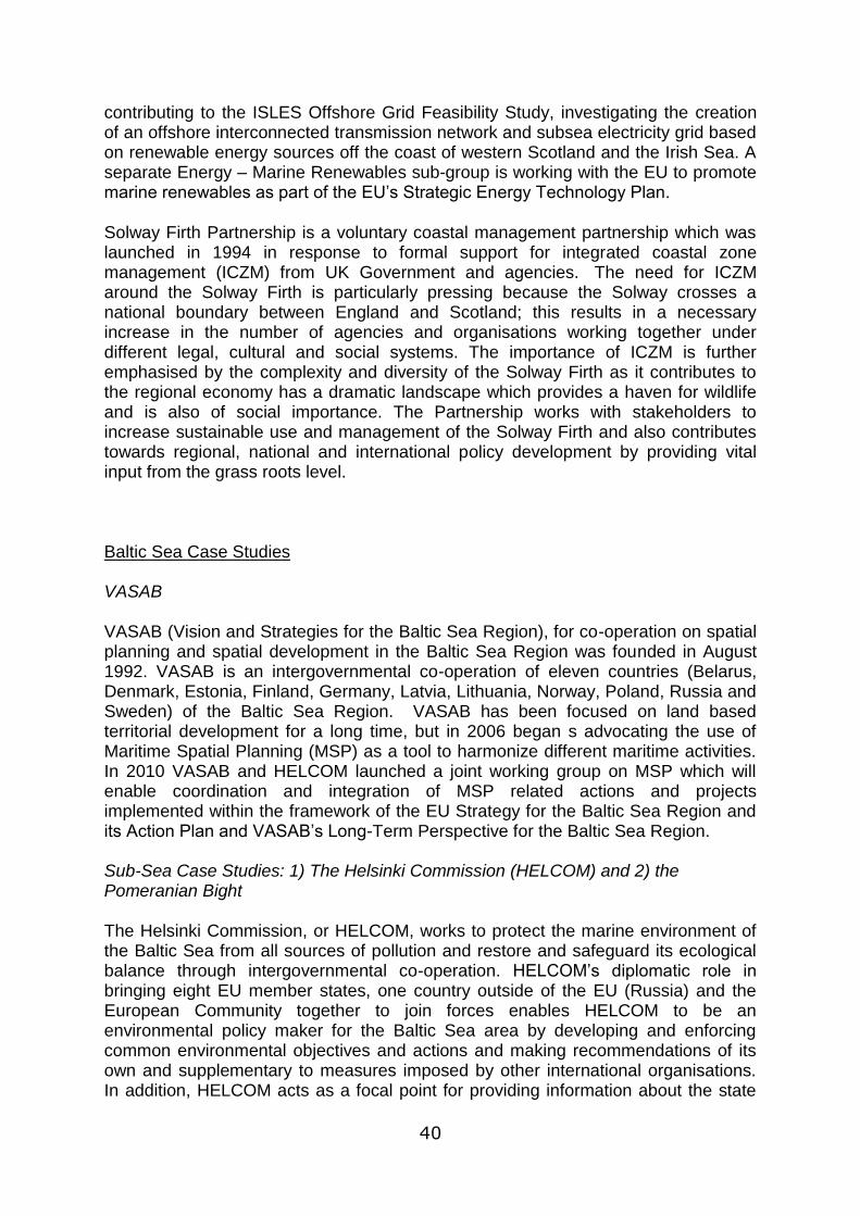
contributing to the ISLES Offshore Grid Feasibility Study, investigating the creation of an offshore interconnected transmission network and subsea electricity grid based on renewable energy sources off the coast of western Scotland and the Irish Sea. A separate Energy – Marine Renewables sub-group is working with the EU to promote marine renewables as part of the EU‟s Strategic Energy Technology Plan.
Solway Firth Partnership is a voluntary coastal management partnership which was launched in 1994 in response to formal support for integrated coastal zone management (ICZM) from UK Government and agencies. The need for ICZM around the Solway Firth is particularly pressing because the Solway crosses a national boundary between England and Scotland; this results in a necessary increase in the number of agencies and organisations working together under different legal, cultural and social systems. The importance of ICZM is further emphasised by the complexity and diversity of the Solway Firth as it contributes to the regional economy has a dramatic landscape which provides a haven for wildlife and is also of social importance. The Partnership works with stakeholders to increase sustainable use and management of the Solway Firth and also contributes towards regional, national and international policy development by providing vital input from the grass roots level.
Baltic Sea Case Studies VASAB VASAB (Vision and Strategies for the Baltic Sea Region), for co-operation on spatial planning and spatial development in the Baltic Sea Region was founded in August 1992. VASAB is an intergovernmental co-operation of eleven countries (Belarus, Denmark, Estonia, Finland, Germany, Latvia, Lithuania, Norway, Poland, Russia and Sweden) of the Baltic Sea Region. VASAB has been focused on land based territorial development for a long time, but in 2006 began s advocating the use of Maritime Spatial Planning (MSP) as a tool to harmonize different maritime activities. In 2010 VASAB and HELCOM launched a joint working group on MSP which will enable coordination and integration of MSP related actions and projects implemented within the framework of the EU Strategy for the Baltic Sea Region and its Action Plan and VASAB‟s Long-Term Perspective for the Baltic Sea Region. Sub-Sea Case Studies: 1) The Helsinki Commission (HELCOM) and 2) the Pomeranian Bight The Helsinki Commission, or HELCOM, works to protect the marine environment of the Baltic Sea from all sources of pollution and restore and safeguard its ecological balance through intergovernmental co-operation. HELCOM‟s diplomatic role in bringing eight EU member states, one country outside of the EU (Russia) and the European Community together to join forces enables HELCOM to be an environmental policy maker for the Baltic Sea area by developing and enforcing common environmental objectives and actions and making recommendations of its own and supplementary to measures imposed by other international organisations. In addition, HELCOM acts as a focal point for providing information about the state
41
of/trends in the marine environment and a coordinating body, ascertaining multilateral response in case of major maritime incidents. The Marine Spatial Planning Pilot Project Pomeranian Bight/Arkona Basin comprises shares of territorial sea as well as of the EEZ of four countries: Denmark, Sweden, Poland and Germany. This area contains a wide range of topics, problems and conflicts which have been addressed with the BaltSeaPlan project (Planning the future of the Baltic Sea) co-financed by the Baltic Sea Region Programme of the European Union. Within the on-going BaltSeaPlan project responsible planning authorities together with NGOs and research institutes have developed a common cross-border vision outside official planning procedures. Even though the outcome of this process will be non-binding it is the first well-grounded example of what a transboundary maritime spatial plan in the Baltic Sea Region covering the area of Pomeranian Bight may look like. Black Sea Case Studies Black Sea Synergy Black Sea Synergy was initiated in 2008 to encourage cooperation between the countries in the wider Black Sea Region and with the European Union. The Synergy offers a forum for tackling common problems, recognising that some issues require coordination at the regional level while encouraging political and economic reform. The Synergy will contribute to better coordination of specific environmental programmes, notably those focusing on tasks relating to water quality, and facilitate efforts to establish regional fisheries management cooperation in order to ensure sustainable use of Black Sea fishery resources. In addition, the Synergy will stimulate dialogue on Black Sea maritime policies and offers a framework to improve coordination between relevant EU and regional policies and wide-ranging programmes such as Motorways of the Sea. Sub-Sea Case Studies: 1) the Commission of the Protection of Black Sea Against Pollution and 2) Black Sea Global Ocean Observing System The Commission of the Protection of the Black Sea Against Pollution implements the provisions of the Black Sea (Bucharest) Convention and the Black Sea Strategic Action Plan, which aims to help resolve the transboundary environmental problems of the Black Sea and is a joint effort between the six Black Sea countries supported by a permanent secretariat and a number of working groups on issues such as Integrated Coastal Zone Management (ICZM), pollution monitoring, biodiversity and fisheries and other living marine resources. The main challenges dealt with by the Black Sea Commission include combating pollution from land-based sources and maritime transport, achieving sustainable management of living marine resources, and pursuing sustainable human development. The Black Sea Global Ocean Observing System is an association formed by the Black Sea riparian countries in order to foster Operational Oceanography in the region and set up links with other regional and global organizations with similar objectives. Of its many objectives, the Black Sea GOOS will provide high quality and

42
time series data for a better understanding of the Black Sea ecosystem, contributing to international planning and implementation of the GOOS, identifying regional priorities for the use of operational oceanography and co-operating with the Black Sea Environmental Programme (BSEP), the Permanent Secretariat of the Black Sea Commission (Secretariat for the Bucharest Convention) and other relevant bodies, to harmonise oceanographic activities in the region. The work of the Black Sea GOOS is guided by a Memorandum of Understanding (adopted 2001), an ad hoc Steering Committee and Executive Committee. Mediterranean Sea Case Studies ICZM Protocol to the Barcelona Convention In September 2010 the European Council adopted the decision to ratify the ICZM Protocol to the Convention for the Protection of the Marine Environment and the Coastal Region of the Mediterranean (Barcelona Convention). Having been ratified by six contracting parties, the Protocol entered into force the 24th of March 2011. The Protocol establishes a common framework for the integrated management of the Mediterranean coastal zone and calls upon Parties to work together to strengthen the coherence and effectiveness of the coastal strategies, plans and programmes established (either bilaterally or multilaterally) and to promote regional and international cooperation for the implementation of common programmes on the protection of marine habitats.
Sub-Sea Case Studies: 1) the Adriatic Sea Partnership and 2) MEDGovernance
The Adriatic Sea is a highly sensitive marine area facing serious environmental challenges, yet it is also one of Europe‟s most highly developed industrial areas - economically significant for tourism and recreation, and as a major transport hub for energy resources. The Adriatic Sea Partnership (ASP) was established in 2006 and brings together existing institutional arrangements (such as the Trilateral Commission of Croatia, Italy, Slovenia for the Protection of the Adriatic and the Mediterranean Action Plan) and provides a joint platform for new initiatives such as the development of an Adriatic Management Plan. The Partnership also provides a mechanism to ensure coordination of activities stemming from EU initiatives such as the Marine Strategy Framework Directive and the Barcelona Convention.
The MEDGovernance programme is comprised of partners such as provincial and regional authorities, cultural and research institutes from the countries of the Western Mediterranean and is funded by the Med Programme. The activities of the MEDGovernance initiative include an analysis of regional policies for environment, transport and energy, migration, mobility and other topics, which will feed into the perspectives adopted by the Conference of Peripheral Maritime Regions (CPMR) on territorial cohesion. MEDGovernance also facilitates the coordination of regional plans towards a single Mediterranean framework, and builds capacity for collaboration on Mediterranean issues by offering training to public administrators, and through a social and economic forum (meeting) to compare and disseminate the actions of governance and to elaborate common policies at EuroMediterranean and global level.

43
North Sea Case Studies The OSPAR Commission The OSPAR Commission is the forum through which the Contracting Parties to the OSPAR Convention for the protection of the marine environment in the North East Atlantic cooperate, and the North Sea forms Region II (Greater North Sea) of the OSPAR Commission‟s maritime area. The OSPAR Convention deals with prevention and elimination of pollution from land-based sources, offshore sources, pollution by dumping or incineration and assessment of the quality of the marine environment and works through Contracting Parties agreeing to abide by the decision and recommendations of the Commission. The OSPAR Permanent Secretariat manages the reporting of Contacting Parties on the implementation of OSPAR measures and the reporting of data under OSPAR monitoring programmes. OSPAR work areas include monitoring and assessment, biodiversity and ecosystems, radioactive substances, climate change, and most significantly for the North Sea, eutrophication, hazardous substances and the offshore oil and gas industry. Sub-Sea Case Studies: 1) Trilateral Cooperation on the Protection of the Wadden Sea and 2) Westerschelde Estuary The Wadden Sea lies in the south-eastern part of the North Sea and is bounded by the Netherlands, Germany and Denmark and a chain of offshore islands. Since 1978, these nations have cooperated on protection and conservation of the Wadden Sea focusing on management, monitoring and research, as well as political matters. A Joint Declaration on the Protection of the Wadden Sea was agreed in 1982, and a refreshed declaration was adopted in 2010 together with the Trilateral Wadden Sea Plan 2010 which sets out a framework for the integrated management of the Wadden Sea Area as an ecological entity, as well as its landscape and cultural heritage, within the cultural entities. It sets out a series of targets, as well as policies, measures, projects and actions to achieve these targets, to be implemented by the Wadden Sea countries. The Westerschelde Estuary begins at the port of Antwerp in Belgium and crosses the border between Belgium and the Netherlands and is significant as the only maritime route linking Antwerp to the North Sea. The need to maintain navigable waterways has led to changes in the morphology of the estuary and has had important consequences for the ecology and hydrology of the area, which provides access to ports, flood plains, recreation and fisheries grounds. The need to accommodate these interests has been addressed through several memoranda of understanding, a bilateral Long Term Vision for the Westerschelde (1999) and Development Plan (2004) which focuses on nature restoration and environmental monitoring as a means to compensate for the impacts of dredging. With no one body having overall responsibility for developing the Westerschelde, there remains great potential for conflict between competing environmental and socioeconomic demands.
44
Economic Use Briefing Paper
Key data collection ambitions The most important economic activities connected with the European Seas are the traditional maritime sectors (shipbuilding, marine equipment, maritime services, exploitation of marine aggregates, offshore supply, maritime works, navy and coastguard, inland navigation, recreational boating, seaports and shipping) together with coastal tourism and fisheries. The Policy Research Council, commissioned by the European Commission (DG MARE), calculated that in 2004/2005 total value added connected with these industries in EU27 and Norway amounted to 186 600 million euro and employed 4.78 million persons (representing 2.25 per cent of all European employment). Based on the country reports at NUTS2 levels, provided by the Policy Research Corporation, it is possible to estimate approximate employment and value added per employee in these industries for the different European seas and an initial analysis of this type is presented in the Economic Use Briefing Paper. Detailed guidelines for economic use related to marine and maritime policies in Europe are to be found in several documents including the Lisbon and Gothenburg Agendas, Europe 2020, the Territorial Agenda of the European Union 2020, The Marine Strategy Framework Directive and EU Integrated Maritime Policy (IMP). These documents are concerned with supporting sustainable economic growth for maritime activities through further exploration of the possibilities linked to marine resources, including deep-sea ocean technologies, emerging markets and industrial innovation, as well as through the cross-sectoral “cluster” approach to maritime economic activities. With these EU policy directions in mind, it is felt that the key data ambitions for the ESaTDOR project and for ESPON should be connected to mapping the importance of traditional maritime sectors, coastal and sea-related recreation and tourism and fisheries (fishing, fish processing, and aquaculture) in terms of value added and employment. However, a key aim should also be to investigate the existence and development of industrial clusters. The regional sea analysis presented in the briefing paper begins to reveal the particular strengths of each European Sea and the types of industrial clusters that may already exist or could be developed in different areas. An initial assessment of the anticipated pattern of clusters is shown in Table 5 below.
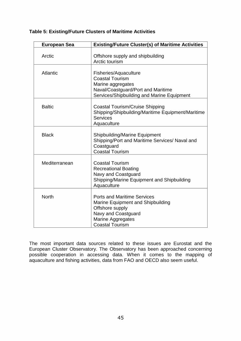
45
Table 5: Existing/Future Clusters of Maritime Activities
European Sea Existing/Future Cluster(s) of Maritime Activities
Arctic
Offshore supply and shipbuilding Arctic tourism
Atlantic
Fisheries/Aquaculture Coastal Tourism Marine aggregates Naval/Coastguard/Port and Maritime Services/Shipbuilding and Marine Equipment
Baltic
Coastal Tourism/Cruise Shipping Shipping/Shipbuilding/Maritime Equipment/Maritime Services Aquaculture
Black
Shipbuilding/Marine Equipment Shipping/Port and Maritime Services/ Naval and Coastguard Coastal Tourism
Mediterranean
Coastal Tourism Recreational Boating Navy and Coastguard Shipping/Marine Equipment and Shipbuilding Aquaculture
North
Ports and Maritime Services Marine Equipment and Shipbuilding Offshore supply Navy and Coastguard Marine Aggregates Coastal Tourism
The most important data sources related to these issues are Eurostat and the European Cluster Observatory. The Observatory has been approached concerning possible cooperation in accessing data. When it comes to the mapping of aquaculture and fishing activities, data from FAO and OECD also seem useful.
46
Energy, Cables and Pipelines Briefing Paper
Key data collection ambitions European Seas are an important source of the EU‟s conventional energy resources thanks to the significant offshore reserves of oil and gas, especially in the North Sea (and smaller reserves elsewhere, such as in the Black Sea). However, these resources are in decline and along with the decrease in conventional onshore resources, this has led to the EU becoming increasingly reliant on energy imports, especially from Russia, Norway, Libya and Algeria (though Norway‟s North Sea reserves are also set to decline) raising growing concerns about energy security. This and the EU‟s commitment to reduction of greenhouse gas emissions provide the underlying rationale of recently formulated EU energy policy. Policy is also directed to completion of the internal energy market and the development of transnational energy networks. Hence the Sustainable Development Strategy places energy at the heart of European activity, with an emphasis on market-based tools (taxes, subsidies and the CO2 emissions trading scheme) and developing energy technologies (for energy efficiency and renewable and low-carbon energy). The strategy prioritises combating climate change and the transition to clean forms of energy production. These themes are being reiterated in territorial cohesion and maritime policy, as well as energy policy. European Seas are being recognised as an important focus for the achievement of these goals. Firstly, rapid and large-scale deployment of offshore wind energy is anticipated, especially in the shallower northern seas, to be followed in the longer term by other marine renewables. Secondly, and closely associated with this, marine grid systems will be developed to enable more efficient electricity transmission across regions. Thirdly, the potential for carbon storage under the seabed (in exhausted gas and oil fields and in deep saline aquifers) is being explored. The seas will also play a continuing, and in some respects, growing role in the current patterns of energy production and distribution. It is anticipated that newly discovered offshore hydrocarbon reserves will be exploited, especially in the Arctic Ocean. Conventional resources will continue to be transported by ship, including from new points of supply, such as for liquefied natural gas. The network of gas pipelines will be expanded, with new links from the east and the south of the EU crossing marine areas. Similarly, the seabed will continue to host the growing network of telecommunications cables. In order to inform the key issues emerging from the EU energy policy the key data ambitions for the ESaTDOR project and for ESPON relate to the following issues:
The current and possible future contribution of European Seas to conventional forms of energy supply,
The potential contribution of European Seas to the expansion of renewable sources of energy,
The contribution of existing and potential marine energy networks,
47
The potential contribution of European Seas to contribute to carbon capture and long-term storage.
There are some existing data sources which can provide information to meet these data ambitions including the International Energy Agency, BP, OECD Eurostat, and European Environment Agency. However, these are not all complete, and frequently do not separate marine-related data from that for national jurisdictions as a whole. At a regional seas level useful data can be obtained from sources such as OSPAR, HELCOM and Plan Bleu, and it might also prove helpful to make connections with a number of EU funded projects including the FP7: MARINA, and ORECCA projects, the INTERREG: POWER Cluster, SUBMARINER and POWER WICO projects and ESPON RERISK project.
Transport and Shipping Briefing Paper
Key data collection ambitions According to EU Maritime Transport Strategy, 80% of world trade is currently carried by sea and around 90% of the European Union‟s trade with third countries passes through European ports. According 2011 Transport White Paper, Europe (EU/EEA) has the world‟s largest shipping fleet, representing 41.6% of world‟s (measured in GT) directly employing some 300,000 seafarers on board merchant vessels and another three million in related jobs. Importantly, maritime traffic is predicted to continue to increase in the short and mid -term. Today, there are more than 1200 ports in the coasts of the European Union but most traffic is concentrated in a few major ports, most notably in the Atlantic and Northern ranges. In 2009, only 15 ports managed more than 40 million freight tones (general cargo, containers, solid bulk and liquids), and only the 3 largest ports in the EU concentrated 37% of all maritime freight managed in EU ports, all in the North of the continent (Rotterdam with 387MTn, Antwerp with 158MTn and Hamburg with 110MTn). The increasing traffic of manufactured goods from China, Japan and other Far East countries currently runs and will most likely continue to run through Suez channel and the Mediterranean Sea. Even with an upgraded Panama Channel, the Far East – Europe route through Suez is still shorter, between 25% and 60% in distance and between 7% and 50% in travel time depending on the origin/destination ports. Most interestingly, a primary element with potential to alter current east-west flow patterns is related to climate change: with an increased global temperature the Arctic Sea route could become practicable for significant periods of the year, with shortened travel distances for Japanese and Korean ports and for some Chinese ports. This scenario, however, seems only reasonable in the long term. At present, only 25% of the Asiatic traffic enters Europe through the Mediterranean ports, while 75% of freight continues through Gibraltar up to Northern European ports with an additional two days of travel, and subsequent increase in CO2
48
emissions. With a total maritime container throughput of an estimated 90.7 million TEU in 2008, only 13 ports managed more than 1MTEU and 40% of the total traffic was concentrated in the four largest ports, all in the Northern range. An important share of container business in the Mediterranean is transhipment traffic (i.e. 95% in Algeciras and 50% in Valencia in 2009), with the Atlantic ports still being the major entrance for goods bound to the Mediterranean area. Currently the two major cornerstones of EU maritime policy are the implementation of the Motorways of the Sea and the effective reduction of environmental impacts of the maritime sector. These policy objectives feature prominently in White Paper on Transport (2011) and other EU policy documents related to marine transport. The Marco Polo programme aims to shift a substantial part of the increase in international road freight traffic to short-sea shipping, rail and inland waterways, or to a combination of modes of transport in which road journeys become as short as possible. The promotion of the Motorways of the Sea requires simplified maritime procedures for intra EU trips and to this end the action plan to establish a European maritime transport space without barriers has been developed. On the other hand, various communications by the Commission urge an effective reduction of emissions of shipping, reduction of maritime accidents and reduction of their environmental impact. The “Greening Transport” communication urged the promotion of sustainable mobility and internalized external costs of maritime transport, while reducing greenhouse gas emissions from the sector by 2009 and lower sulphur contents of maritime fuel. Reflecting EU transport policy, the key data ambitions for the ESaTDOR project and for ESPON in relation to maritime transport concern:
Freight transport
Short sea shipping:
Passenger transport:
Fishing
Pollution
There are relatively large and specialised public data sources for maritime transport including the EUROSTAT, OECD, European Sea Port Organisation (ESPO), World Bank, and ITOPF websites. Sea based data sources such as Arctic Data, Plan Bleu and Helcom also provide useful information. There are however a number of gaps and not all of above information is available. The main data gaps are related to the origin and destination of maritime flows, as well as to the available services and costs, and the types of freight being carried. Needless to say, being commercial ports privately managed, and being transport operators owned by multinational private corporations, most of this information has commercial value and is restricted. Also, data on the economic impact of the shipping activity or cruise activity on local economies is not available.
49
Coastal and Marine Environment Briefing Paper
Key data collection ambitions The above discussions highlight the great significance of European marine environment to the economic and social wellbeing of all European people and particularly to those living in coastal regions. They also reveal a sharp appreciation of the adverse impact that past development patterns have caused and the continuing environmental degradation that can be associated with increased human use of the sea unless appropriate safeguards are taken. The Lisbon and Gothenburg Agendas (now called the EU's Sustainable Development Strategy or SDS) are a commitment to renewal in the EU based on the principles of sustainable development and its three core elements: economy, society and the environment. The 2009 Review of the EU Sustainable Development Strategy (EU SDS) confirmed that sustainable development remains a fundamental objective of the European Union under the Lisbon Treaty. The SDS will continue to provide a long-term vision and constitute the overarching policy framework for all Union policies and strategies. Environmental sustainability is a major cross-cutting theme for 2007-2013. The Gothenburg European Council highlighted four priority areas – climate change, sustainable transport, public health and resource management – all of which have implications for the coastal and marine environment. Marine and coastal environmental issues are specifically addressed by a number of directives and policy documents and three perspectives can be identified as being particularly significant: Integrated Coastal Zone Management, 6th Environment Action Plan, and Integrated Maritime Policy. The Common Fishery Policy, which is currently being reviewed, falls to a large degree under the latter. Cohesion among the Water Framework Directive, Marine Strategy Framework Directive and Maritime Policy, specifically on environmental matters, is currently being addressed and one of the key delivery instruments here is seen as Maritime (or Marine) Spatial Planning. The overall environmental objective promoted by these instruments is to protect and restore the natural capital of the marine environment and in so doing safeguard the ecosystem services it provides. The Marine Strategy Framework Directive is seen as a key starting point for setting the data ambitions of the ESaTDOR Project and ESPON activity with respect to the maritime environment. In particular, Annex III of the MSFD sets out a list of marine and coastal pressures and impacts that may influence the achievement of Good Environmental Status and it is thought that these should guide data collection efforts. Interestingly, the INSPIRE Directive data categorisation meshes poorly with the fields set out in the MSFD but a suggested alignment is set out in the briefing paper. While it is recognised that all the data fields are important, three priorities for data collection are put forward. These relate to key development opportunities and risks associated with the marine environment which are discussed further below. These are:
the designation of marine protected areas
the spread of non-indigenous and alien invasive species.
Anticipated variations in the experience of sea level rise
50
Databases exist to support many of the INSPIRE categories, although the quality of the data and their geographical distribution is highly variable. The EEA provides the best access to environmental data. It is supported by the various regional seas commissions and by EUROSTAT. In general, north eastern Europe (especially North and Baltic Seas) are data-rich. The Mediterranean and Black Seas are generally data poor except for high profile issues. E.g. non-indigenous species (NIS) for the Mediterranean, eutrophication issues for the Black. Data lists are the most common form, although geo-referencing is gaining ground rapidly.
Key Territorial Development Opportunities and Risks
Contributing to the identification of data collection priorities for WP2.3 was an initial assessment of key development opportunities and risks in each topic area. The points identified in the thematic briefing papers are drawn together and summarised in Table 6 below. A common thread running through the analysis is the close interrelationship between environmental factors and territorial development opportunities and risks. Many of the opportunities identified are determined by the environmental conditions that are experienced in different localities and judgements about how these may change over time. For example, climate change opens up the possibility of quite different patterns of human activity associated with the marine environment including development of new sea routes in the Arctic, changes in distribution of fish species and patterns of fishing and aquaculture, increased demand for renewable energy and more energy efficient forms of transport favouring sea transport, and developing technologies such as carbon storage. Similarly, increasing attention to marine environmental quality which is being promoted through the MSFD and other EU policies can be anticipated to open up new potential for ecotourism and conservation related services. However, such synergies are paralleled by situations where new development could be associated with increased risk of environmental degradation with negative consequences for coastal regions. For example, the growing quantities of world trade that is likely to pass through the Mediterranean Sea and in the longer term the Arctic while offering significant scope for increased employment in a wide range of shipping related industries, also brings the prospect of increasing encroachment and damage from alien species and increased pollution associated with shipping accidents. The analysis is also helpful in indicating the great scope for increased human activity in and around Europe‟s seas over the coming years. This suggests that land/sea interrelationships are likely to strengthen over time and there is the prospect that some of the EU‟s most peripheral regions will be able to benefit in new ways from the substantial marine resources that lie adjacent to them. At the same time however, increased competition for marine space is likely to be a feature in many areas and careful marine spatial planning will be needed to ensure an appropriate balance is struck between different stakeholder interests. For example, there is a risk that traditional maritime interests such as fishing and tourism could be adversely affected by renewable energy developments.
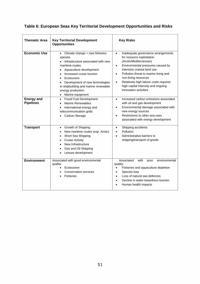
51
Table 6: European Seas Key Territorial Development Opportunities and Risks
Thematic Area
Key Territorial Development Opportunities
Key Risks
Economic Use Climate change > new fisheries
species
Infrastructure associated with new
maritime routes
Aquaculture development
Increased cruise tourism
Ecotourism
Development of new technologies
in shipbuilding and marine renewable
energy production
Marine equipment
Inadequate governance arrangements
for resource exploitation
(Arctic/Mediterranean)
Environmental pressures caused by
intensive coastal land use
Pollution threat to marine living and
non-living resources
Relatively high labour costs requires
high capital intensity and ongoing
innovation activities
Energy and Pipelines
Fossil Fuel Development
Marine Renewables
International energy and
telecommunication grids
Carbon Storage
Increased carbon emissions associated
with oil and gas development
Environmental damage associated with
new energy sources
Restrictions to other sea uses
associated with energy development
Transport Growth of Shipping
New maritime routes (esp. Arctic)
Short Sea Shipping
Cruise Activity
New Infrastructure
Gas and Oil Shipping
Leisure development
Shipping accidents
Pollution
Administrative barriers to
shipping/transport of goods
Environment Associated with good environmental quality:
Ecotourism
Conservation services
Fisheries
Associated with poor environmental quality:
Fisheries and aquaculture depletion
Species loss
Loss of natural sea defences
Decline in water-based/eco tourism
Human health impacts
52
Chapter 4: Developing a Maritime Region Typology
Initial Outputs from WP2.3 Having developed a set of base maps indicating the boundaries of proposed maritime regions, a key next task for the ESaTDOR project is to consider how these maritime regions may be characterised in terms of their territorial potentials and challenges and create a typology for maritime regions accordingly.
Review of Existing ESPON Typologies
In this initial phase of developing a maritime region typology we have considered the use of existing ESPON typologies as a starting point. Under ESPON‟s Scientific Platform, the Typology Compilation Project draws together typologies that have been developed from a terrestrial rather than a marine perspective. The Typology Compilation identified four different coastal typologies which can be used to delimit the boundaries of coastal regions. These are:
1. Based on the European Environment Agency‟s map of Population Density in the EU Coastal Zone (10Km) by NUTS3 (2001), which defines three zones: coastal strip up to 1Km, coastal hinterland up to 10 Km and non-coastal territory.
2. Based on the European Environment Agency‟s map of Population Trends 1991-2001 in the European Coastal Regions (NUTS3). This uses a simple division of NUT3 regions into those bordering coastlines and those which do not.
3. Using data from CSIL, the Centre for Industrial Studies project on the Impact of Tourism on Coastal Areas: Regional Development Aspects. Like the EEA‟s population trends map, regions are divided into those that border a coastline or do not, using NUTS2 level geography.
4. The ESPON Project “Territorial Impacts of the Common Fisheries Policy” typology of coastal regions. This contains nine different classifications for coastal areas at the NUTS3 level, based on population density and Functional Urban Areas.
In the ESaTDOR Inception Report, an initial assessment of the ability to extend these typologies to apply to maritime areas was made. Those based on population density alone were felt to be too simplistic as they did not capture the complex relationship between activities on land and at sea, whilst NUTS3 level geography was felt to be an inappropriate scale for extrapolating maritime data.
At a more general level, the use of any land-based typology as a foundation for maritime typologies has great disadvantages as the relationship between use of the sea and adjacent areas of land is uncertain and highly varied across European territory. Map 8 below shows an example from the Baltic Sea in which the number of maritime uses are plotted on a 50Km grid square system and compared with the populations of adjacent NUTS3 regions. From this exercise it can be seen that there is no clear spatial link between population values and the intensity of maritime activities in the Baltic Sea. Some of the highest values for maritime uses occur in Germany's coastal waters and EEZ where there are low population values. Similarly, for Estonian waters there is a low population but high levels of maritime use. In

53
contrast, the Stockholm area of Sweden is highly populated, but the adjacent waters show a low number of uses.
Map 8: Relationship Between Population and Level of Sea Use in the Baltic Sea

54
Map 8 also shows that the character of maritime areas varies greatly within seas, and thus it is neither possible nor desirable to apply one label to an entire sea - this risks over simplifying the activities and interrelationships between environmental conditions, the number of uses in any given maritime location and their connection to land.
From these points it is clear that a new maritime typology is required that uses a broad set of variables to characterise maritime regions. At this early phase in the data collection and mapping activities of the ESaTDOR project, the approach to developing a new typology therefore has to be based on a more qualitative assessment of the current situation in maritime regions.
The proposed draft maritime typology uses the following five categories in a continuum:
- European Core - High Density - Medium Density - Rural - Wilderness
This typology (and the terminology for proposed categories) is broadly based upon patterns of human use, and work by Smith, Maes, Stojanovic and Ballinger (2010), which relates the development of marine spatial planning initiatives in Europe and their integration with terrestrial spatial planning to the regional development goals of the European Union.
Given the argument that typologies based on population are inappropriate for maritime regions, the categories in the proposed typology aim to reflect the density of maritime uses and their significance for territorial development. Thus “European Core” represents the busiest maritime regions with the greatest strategic importance for future development. This is followed by regions of “high” and “medium” density use, “rural” regions, and “wilderness”, which generally applies to those areas of open sea which are largely unconnected with land.
In order to provide the basis for a consistent assessment of the state of European Seas, the individual characteristics that have been used to define these categories are shown in Table 7. An explanation of how the typology has been applied follows..

55
Table 7: Proposed Maritime Region Typology
Sea Type European Core High Density Medium Density Rural Wilderness
Characteristics
Level of use Most heavily used High degree of use More localised concentrations of use
Low levels of human use Very low and intermittent levels of use
Footprint High human footprint
High human footprint Intermediate human footprint Low footprint Minimal human footprint
Maritime connections
Great international connectivity
Nationally significant and some international connections
Nationally and regionally significant connections
Limited connectivity Remote areas, limited connectivity
Land-sea interactions
Global hinterland European-scale hinterland
National/regional hinterland Local/ regional hinterland with some more significant sectors/ seasonal extensions
Very small local hinterland, some extensions
Environmental risk
High environmental risk associated with human footprint
Significant environmental risk
Medium environmental risk Low environmental risk Limited environmental risk
Environmental conditions
Most heavily degraded
Significant degradation in some areas
More dispersed pattern of environmental degradation
Less environmental degradation
Very low/unknown levels of environmental degradation
Economic significance
High strategic economic importance
Significant economic importance
More dependent upon a limited number of strategic industries
Economy dominated by primary production and tourist sectors
Limited direct economic importance
ESPON 2013 56
Applying the Typology
In order to test the proposed typology, an attempt has been made to classify the Atlantic, and Baltic Seas using Table 7 to assess the character of different parts of each region. A limited number of key datasets are associated with each characteristic to provide some quantitative basis for attributing a maritime region or sub-region to a particular category.
For “level of use”, location of ports, passenger transport numbers, shipping routes, freight transport, tourism data and location of wind farms, distribution of the fishing fleet, cables and pipelines have been considered.
“Human footprint” is defined as the ecological footprint arising from human uses of the sea, therefore, where there is a high level of use, footprint is also expected to be high.
“Maritime Connections” refers to the number of links a region has with size of port, shipping routes and connections to wider Motorways of the Sea being considered.
“Land-Sea Interactions” attempts to capture the relationship between a maritime region, its adjacent coastal strip and areas further inland. For this characteristic, locations of ports and land based transport networks (TEN-Ts) have been considered.
“Environmental Risk” is defined as the risk associated with human use of the sea or natural risk such as flooding and erosion. Data relating to maritime accidents, oil spills, overfishing, coastal erosion and provide a baseline picture.
“Environmental conditions” refers to the current environmental status of marine regions. Status of fish stocks, surface temperature, location of Natura 2000 Sites and Regional Sea reports such as OSPAR‟s Quality Status Report 2010 have informed the assessment of this characteristic.
“Economic Significance” attempts to determine the economic value of maritime regions in relation to Europe‟s territorial cohesion agenda. Economic sectors such as shipping, tourism and proximity to Europe‟s core or peripheral (land-based) regions have been considered key information for assessing this characteristic.
It is anticipated that region types are assigned by reference to the different characteristics and trying to provide a general or average picture of each region, noting that, for example, a sea region that could be the busiest, most economically significant and have the greatest connectivity, but not necessarily the most environmental degradation – in combination these factors could still lead to a qualitative decision that the overall picture for this region corresponds most closely with the European Core category.
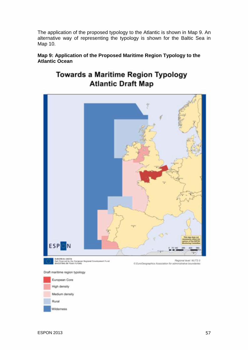
ESPON 2013 57
The application of the proposed typology to the Atlantic is shown in Map 9. An alternative way of representing the typology is shown for the Baltic Sea in Map 10.
Map 9: Application of the Proposed Maritime Region Typology to the Atlantic Ocean
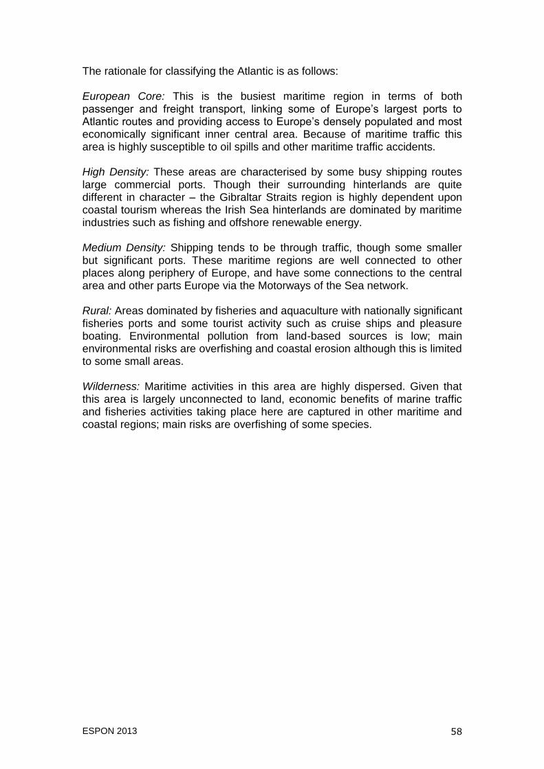
ESPON 2013 58
The rationale for classifying the Atlantic is as follows: European Core: This is the busiest maritime region in terms of both passenger and freight transport, linking some of Europe‟s largest ports to Atlantic routes and providing access to Europe‟s densely populated and most economically significant inner central area. Because of maritime traffic this area is highly susceptible to oil spills and other maritime traffic accidents. High Density: These areas are characterised by some busy shipping routes large commercial ports. Though their surrounding hinterlands are quite different in character – the Gibraltar Straits region is highly dependent upon coastal tourism whereas the Irish Sea hinterlands are dominated by maritime industries such as fishing and offshore renewable energy. Medium Density: Shipping tends to be through traffic, though some smaller but significant ports. These maritime regions are well connected to other places along periphery of Europe, and have some connections to the central area and other parts Europe via the Motorways of the Sea network. Rural: Areas dominated by fisheries and aquaculture with nationally significant fisheries ports and some tourist activity such as cruise ships and pleasure boating. Environmental pollution from land-based sources is low; main environmental risks are overfishing and coastal erosion although this is limited to some small areas. Wilderness: Maritime activities in this area are highly dispersed. Given that this area is largely unconnected to land, economic benefits of marine traffic and fisheries activities taking place here are captured in other maritime and coastal regions; main risks are overfishing of some species.

ESPON 2013 59
Map 10: Application of the Proposed Maritime Region Typology to the Baltic Sea
ESPON 2013 60
Evaluation and Possible Refinement of the Typology
The examples of applying the maritime typology to the Atlantic and Baltic Sea raise some key points. Whilst at this stage both represent a relatively simplistic approach to classifying maritime regions, the two examples show that the different categories developed within the typology from European Core to Wilderness Seas can be applied to different parts of the ESPON maritime space and are therefore suitable for use across all of Europe‟s regional seas. Although the different types of maritime region have been shown on the two maps to be delimited by straight lines or circles, these are approximations and it is recognised that the transition between different types of sea may be more gradual and a further avenue to be explored in refining the typology is looking at how these transitional areas may be represented. At this early stage in the project, collection of data and mapping within the framework of ESPON maritime boundaries is not well advanced. This presents a challenge to the ESaTDOR project as a whole and in particular the mapping of key data sets in a way that provides a more robust foundation for characterising maritime space. Earlier in this section, the example of the Baltic Sea was used to demonstrate the ambiguous relationship between population and levels of maritime activity in adjacent waters (see Map 8) and thus why maritime typologies based on measures of population were unsuitable. The use of a single indicator to represent high and low levels of sea use does however provide an exemplar for how levels of maritime activity might be best defined in the ESaTDOR maritime typology, bringing together a number of datasets or several layers of maps into one composite indicator. Similarly, other characteristics contained within the typology such as “environmental risk” and “maritime connections” could be represented in this way by producing a composite indicator from a number of datasets. In combination, these indicators would inform a more objective methodology for defining maritime regions. Considering how this ideal might be achieved, a critical decision for ESaTDOR will be the selection of key data sets that contribute to a rounded picture of the state of European sea use. In this instance, the selection of data should be informed by reference to the key thematic interests of transport, economic use, energy and the environment.
ESPON 2013 61
Chapter 5: Pilot Case Study - the Solway Firth Partnership Initial Outputs from WP2.4 Guided by the Coastal and Marine Governance Briefing Paper and the Case Study Guidance Note referred to above, an initial pilot case study has been undertaken to trial the proposed approach, provide guidance to others and elicit early feedback from the ESPON Coordination Unit and Sounding Board. This relates to the Solway Firth Partnership one of the sub-sea case studies for the Atlantic. A draft note related to the case study findings using the reporting format proposed is set out below. Introduction The Solway Firth occupies an area of coast and seas between the north west of England and south west of Scotland, facing out towards the Irish Sea. The Solway Firth Partnership, established in 1994, works in this area “to secure an environmentally sustainable future for the Solway Firth area which allows the economy to prosper while respecting the distinctive character, natural features, wildlife and habitats of the Firth” based on the principles of Integrated Coastal Zone Management. In recent years, as separate marine planning arrangements have been developed and implemented for English and Scottish waters, this has placed great emphasis on the need for a cross-border approach to planning for the Solway‟s marine and coastal areas. Whilst the Solway Firth Partnership has no statutory responsibilities for marine or terrestrial planning in the Firth, it has been closely involved in stakeholder consultations for marine planning on both sides of the border and other activities such as consultations for offshore energy, preparing management plans for European Marine Sites, promoting the Solway Firth‟s natural and cultural assets and working with local fishing communities to ensure sustainable fisheries. Location and Environment The Solway Firth is a sea bay located between the North West coast of England and south western Scotland in the United Kingdom, opening out onto the Irish Sea and in close proximity to the Isle of Man. It stretches from the Mull of Galloway in the north down to St Bees Head in Cumbria. The area covered by the Solway Firth Partnership (shown in Map 11) includes the waters of the upper Solway starting at Gretna, extending south west to St Bees Head in Cumbria and reaching Milleur Point north of Stranraer in Scotland. No inland boundary has been defined for the Partnership area, as this depends upon the extent to which individual coastal and marine activities are connected with their hinterland.
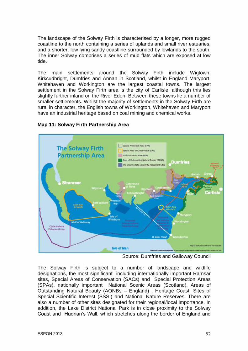
ESPON 2013 62
The landscape of the Solway Firth is characterised by a longer, more rugged coastline to the north containing a series of uplands and small river estuaries, and a shorter, low lying sandy coastline surrounded by lowlands to the south. The inner Solway comprises a series of mud flats which are exposed at low tide. The main settlements around the Solway Firth include Wigtown, Kirkcudbright, Dumfries and Annan in Scotland, whilst in England Maryport, Whitehaven and Workington are the largest coastal towns. The largest settlement in the Solway Firth area is the city of Carlisle, although this lies slightly further inland on the River Eden. Between these towns lie a number of smaller settlements. Whilst the majority of settlements in the Solway Firth are rural in character, the English towns of Workington, Whitehaven and Maryport have an industrial heritage based on coal mining and chemical works. Map 11: Solway Firth Partnership Area
Source: Dumfries and Galloway Council
The Solway Firth is subject to a number of landscape and wildlife designations, the most significant including internationally important Ramsar sites, Special Areas of Conservation (SACs) and Special Protection Areas (SPAs), nationally important National Scenic Areas (Scotland), Areas of Outstanding Natural Beauty (AONBs – England) , Heritage Coast, Sites of Special Scientific Interest (SSSI) and National Nature Reserves. There are also a number of other sites designated for their regional/local importance. In addition, the Lake District National Park is in close proximity to the Solway Coast and Hadrian‟s Wall, which stretches along the border of England and

ESPON 2013 63
Scotland from Bowness on Solway to Wallsend on the east coast of England is designated a UNESCO World Heritage Site. Within the Scottish waters of the Solway Firth, building of the 60-turbine Robin Rigg wind farm was completed in April 2010. This site can generate up to 180 Megawatts of electricity. In addition, there has been a proposal for a tidal energy scheme on the Upper Solway between Annan on the Scottish coast and Bowness on the English coast which aims to be online by 2020 (Solway Energy Gateway, 2011). Socio-Economic Conditions The area around the Solway Firth is comprised of a small number of administrative areas or local planning authorities, shown on Map 12. On the Scottish side, the coastal area adjacent to the Solway is part of Dumfries and Galloway Council – this includes the former district councils of Annandale and Eskdale, Wigtown, Stewartry, Nithsdale and several smaller parish council areas which were abolished in 1996. To the south of the Solway, three council areas border the Firth – these are Allerdale, Carlisle and Copeland. These three councils make up a part of the larger Cumbria County Council area along with the councils of Eden, South Lakeland and Barrow-in-Furness. Map 12: Local Authorities in the Solway Firth Partnership Area
Source: UKBORDERS (2009) English Administrative Districts and Scottish
Council Areas
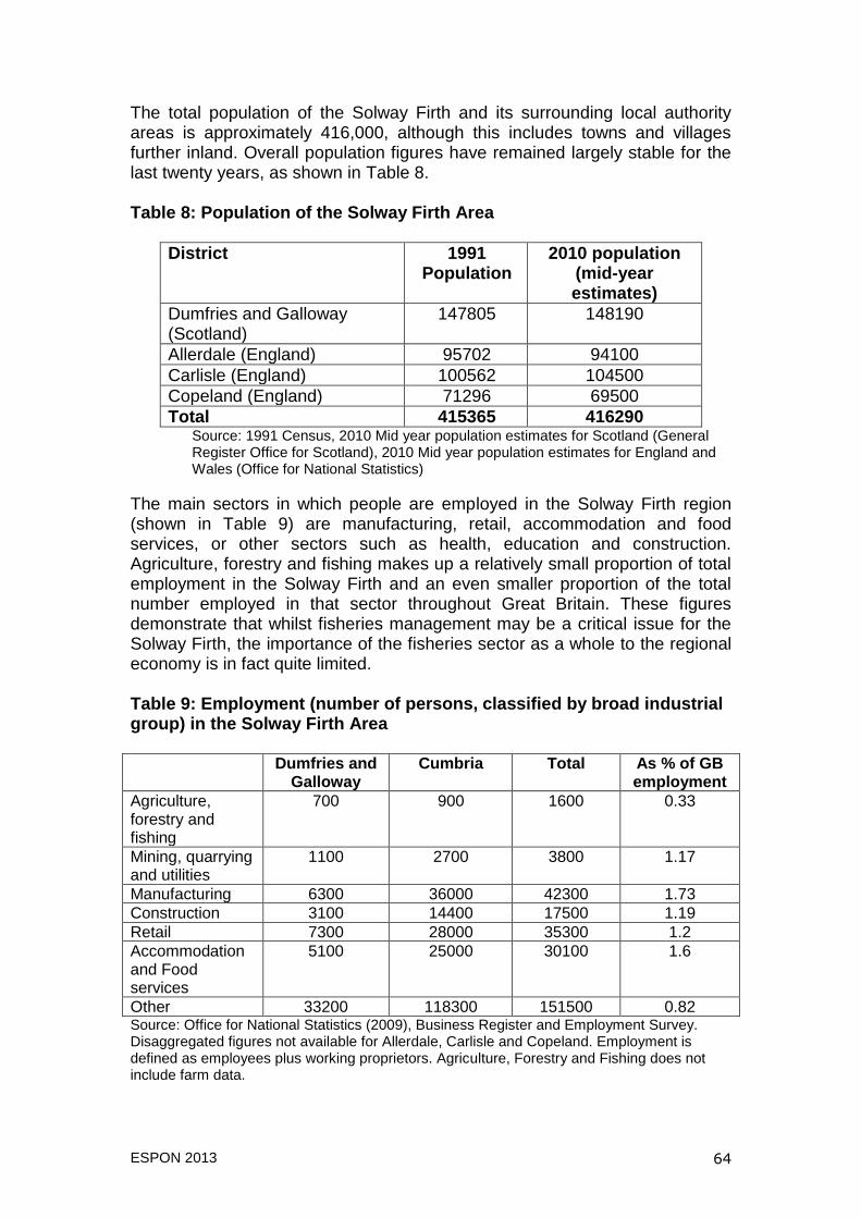
ESPON 2013 64
The total population of the Solway Firth and its surrounding local authority areas is approximately 416,000, although this includes towns and villages further inland. Overall population figures have remained largely stable for the last twenty years, as shown in Table 8. Table 8: Population of the Solway Firth Area
District 1991 Population
2010 population (mid-year estimates)
Dumfries and Galloway (Scotland)
147805 148190
Allerdale (England) 95702 94100
Carlisle (England) 100562 104500
Copeland (England) 71296 69500
Total 415365 416290 Source: 1991 Census, 2010 Mid year population estimates for Scotland (General Register Office for Scotland), 2010 Mid year population estimates for England and Wales (Office for National Statistics)
The main sectors in which people are employed in the Solway Firth region (shown in Table 9) are manufacturing, retail, accommodation and food services, or other sectors such as health, education and construction. Agriculture, forestry and fishing makes up a relatively small proportion of total employment in the Solway Firth and an even smaller proportion of the total number employed in that sector throughout Great Britain. These figures demonstrate that whilst fisheries management may be a critical issue for the Solway Firth, the importance of the fisheries sector as a whole to the regional economy is in fact quite limited. Table 9: Employment (number of persons, classified by broad industrial group) in the Solway Firth Area Dumfries and
Galloway Cumbria Total As % of GB
employment
Agriculture, forestry and fishing
700 900 1600 0.33
Mining, quarrying and utilities
1100 2700 3800 1.17
Manufacturing 6300 36000 42300 1.73
Construction 3100 14400 17500 1.19
Retail 7300 28000 35300 1.2
Accommodation and Food services
5100 25000 30100 1.6
Other 33200 118300 151500 0.82 Source: Office for National Statistics (2009), Business Register and Employment Survey. Disaggregated figures not available for Allerdale, Carlisle and Copeland. Employment is defined as employees plus working proprietors. Agriculture, Forestry and Fishing does not include farm data.

ESPON 2013 65
The Legal and Policy Framework for Management of the Solway The main legal instruments and policies guiding the management of the Solway can be divided into those that originate at European or international level and at the level of the devolved administrations for England and Scotland which are listed in more detail in Tables 10 and 11 below. Table 10: Key International/European legislation and policies affecting management of the Solway Firth Legislation/Policy name
Purpose
Convention on Wetlands of International Importance (Ramsar Convention)
The Ramsar Convention provides for “the conservation and wise use of wetlands by national action and international cooperation as a means to achieving sustainable development throughout the world” (see Scottish Natural Heritage, 2011) and requires management plans for designated Ramsar sites to be put in place. In England and Scotland Ramsar sites are protected under legislation pertaining to European Natura sites (SPAs and SACs). The Solway Firth has one Ramsar site, Upper Solway Flats and Marshes, which includes land on both the English and Scottish sides of the Solway.
Marine Strategy Framework Directive
The MSFD requires Member States to achieve good environmental status for their marine waters by 2020. The MSFD has been transposed into UK law by the Marine Strategy Regulations 2010. Currently the UK is undertaking an assessment of the state of UK Seas and will publish its Programme of Measures for achieving good environmental status by 2016.
Water Framework Directive (WFD)
The WFD requires all inland waterways and coastal waters out to 1 Nautical mile to reach good chemical and biological status by 2015. The WFD regulations are transposed into law in the UK by the Water Environment (Water Framework Directive) (England and Wales) Regulations 2003 and the Water Environment and Water Services (Scotland) Act 2003. In order to implement the WFD, the UK has been divided into River Basin Districts for which a River Basin Management Plan must be prepared. The Solway Firth is part of the Solway Tweed River Basin District, which crosses the administrative boundaries of England and Scotland and also extends from the west to east coasts of Great Britain.
EC Directive on the conservation of wild birds (79/409/EEC) (Birds Directive)
The Birds Directive covers the protection, management and control of all species of naturally occurring wild birds in the territory of Member States and requires the protection and management of habitats for endangered and migratory species in Special Protection Areas. In the Solway Firth, Upper Solway Flats and Marshes is designated as an SPA.
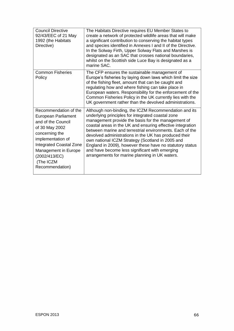
ESPON 2013 66
Council Directive 92/43/EEC of 21 May 1992 (the Habitats Directive)
The Habitats Directive requires EU Member States to create a network of protected wildlife areas that will make a significant contribution to conserving the habitat types and species identified in Annexes I and II of the Directive. In the Solway Firth, Upper Solway Flats and Marshes is designated as an SAC that crosses national boundaries, whilst on the Scottish side Luce Bay is designated as a marine SAC.
Common Fisheries Policy
The CFP ensures the sustainable management of Europe‟s fisheries by laying down laws which limit the size of the fishing fleet, amount that can be caught and regulating how and where fishing can take place in European waters. Responsibility for the enforcement of the Common Fisheries Policy in the UK currently lies with the UK government rather than the devolved administrations.
Recommendation of the
European Parliament
and of the Council
of 30 May 2002
concerning the
implementation of
Integrated Coastal Zone
Management in Europe
(2002/413/EC)
(The ICZM Recommendation)
Although non-binding, the ICZM Recommendation and its underlying principles for integrated coastal zone management provide the basis for the management of coastal areas in the UK and ensuring effective integration between marine and terrestrial environments. Each of the devolved administrations in the UK has produced their own national ICZM Strategy (Scotland in 2005 and England in 2009), however these have no statutory status and have become less significant with emerging arrangements for marine planning in UK waters.
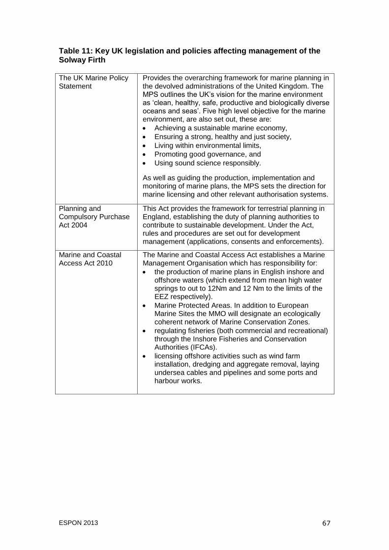
ESPON 2013 67
Table 11: Key UK legislation and policies affecting management of the Solway Firth The UK Marine Policy Statement
Provides the overarching framework for marine planning in the devolved administrations of the United Kingdom. The MPS outlines the UK‟s vision for the marine environment as „clean, healthy, safe, productive and biologically diverse oceans and seas‟. Five high level objective for the marine environment, are also set out, these are:
Achieving a sustainable marine economy,
Ensuring a strong, healthy and just society,
Living within environmental limits,
Promoting good governance, and
Using sound science responsibly.
As well as guiding the production, implementation and monitoring of marine plans, the MPS sets the direction for marine licensing and other relevant authorisation systems.
Planning and Compulsory Purchase Act 2004
This Act provides the framework for terrestrial planning in England, establishing the duty of planning authorities to contribute to sustainable development. Under the Act, rules and procedures are set out for development management (applications, consents and enforcements).
Marine and Coastal Access Act 2010
The Marine and Coastal Access Act establishes a Marine Management Organisation which has responsibility for:
the production of marine plans in English inshore and offshore waters (which extend from mean high water springs to out to 12Nm and 12 Nm to the limits of the EEZ respectively).
Marine Protected Areas. In addition to European Marine Sites the MMO will designate an ecologically coherent network of Marine Conservation Zones.
regulating fisheries (both commercial and recreational) through the Inshore Fisheries and Conservation Authorities (IFCAs).
licensing offshore activities such as wind farm installation, dredging and aggregate removal, laying undersea cables and pipelines and some ports and harbour works.

ESPON 2013 68
Planning Policy Statements and Planning Policy Guidance Notes
Planning Policy Statements set out the (English) government‟s policies relating to different aspects of terrestrial spatial planning. Of particular relevance to coastal and marine governance PPG20: the Coast, published in 1992 provided the first set of policy guidance specifically for development in coastal areas. This has now been superseded by PPS 25: Development and Flood Risk (incorporating the supplement Development and Coastal Change), which outlines the policies planning authorities should use in order to prevent inappropriate development at the coast and also to protect new (and existing) developments from physical changes to the coastline such as erosion and accretion.
The Planning etc. (Scotland) Act 2006
This Act sets the framework governing terrestrial planning in Scotland, including the requirement to produce a National Planning Policy Framework and strategic development plans, and setting out rules and procedures for development management (applications, consents and enforcements). All functions carried out under the direction of the Act must contribute to sustainable development objectives.
Scottish Planning Policy
The National Planning Policy Framework is a strategy for the long-term development of Scotland's towns, cities and countryside. Within this framework, the Scottish government affirms its commitment to marine planning, noting that their approach should “build on the work of the seven Local Coastal Partnerships [which includes the Solway Firth Partnership] and marine planning pilots to achieve more integrated outcomes for coast and sea” (Scottish Government 2010: 36).
Marine Scotland Act 2010
The Marine Scotland Act provides a framework for the sustainable management of Scotland‟s seas through:
a new statutory marine planning system, based on a National Marine Plan and individual plans for proposed Scottish Marine Regions.
a simplified licensing system for dumping at sea, offshore energy, cables and pipelines, aquaculture consenting and dredging activities,
improved measures for nature conservation, including the designation of Marine Protected Areas to protect biodiversity and historical assets of national importance.
The creation of Marine Scotland, an agency that will deliver marine planning functions on behalf of the Scottish government.
Crown Estates Act 1961
The Crown Estates Act established the organisation headed by Crown Estate commissioners to oversee the management of land and assets belonging to, but not the private property of the Sovereign. These assets include the majority of the UK‟s sea bed out to the 12 Nautical Mile limit and approximately half of the foreshore, the area between mean high and low water. Under the Energy Act
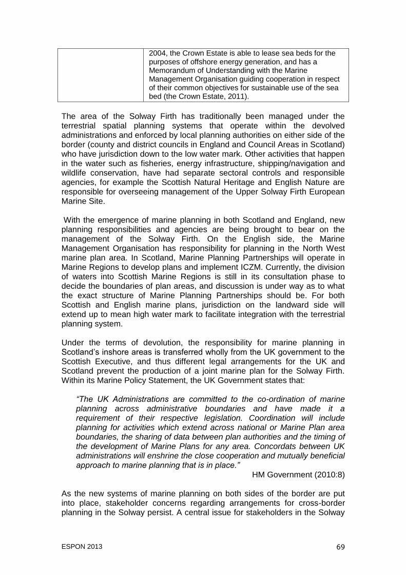
ESPON 2013 69
2004, the Crown Estate is able to lease sea beds for the purposes of offshore energy generation, and has a Memorandum of Understanding with the Marine Management Organisation guiding cooperation in respect of their common objectives for sustainable use of the sea bed (the Crown Estate, 2011).
The area of the Solway Firth has traditionally been managed under the terrestrial spatial planning systems that operate within the devolved administrations and enforced by local planning authorities on either side of the border (county and district councils in England and Council Areas in Scotland) who have jurisdiction down to the low water mark. Other activities that happen in the water such as fisheries, energy infrastructure, shipping/navigation and wildlife conservation, have had separate sectoral controls and responsible agencies, for example the Scottish Natural Heritage and English Nature are responsible for overseeing management of the Upper Solway Firth European Marine Site. With the emergence of marine planning in both Scotland and England, new planning responsibilities and agencies are being brought to bear on the management of the Solway Firth. On the English side, the Marine Management Organisation has responsibility for planning in the North West marine plan area. In Scotland, Marine Planning Partnerships will operate in Marine Regions to develop plans and implement ICZM. Currently, the division of waters into Scottish Marine Regions is still in its consultation phase to decide the boundaries of plan areas, and discussion is under way as to what the exact structure of Marine Planning Partnerships should be. For both Scottish and English marine plans, jurisdiction on the landward side will extend up to mean high water mark to facilitate integration with the terrestrial planning system. Under the terms of devolution, the responsibility for marine planning in Scotland‟s inshore areas is transferred wholly from the UK government to the Scottish Executive, and thus different legal arrangements for the UK and Scotland prevent the production of a joint marine plan for the Solway Firth. Within its Marine Policy Statement, the UK Government states that:
“The UK Administrations are committed to the co-ordination of marine planning across administrative boundaries and have made it a requirement of their respective legislation. Coordination will include planning for activities which extend across national or Marine Plan area boundaries, the sharing of data between plan authorities and the timing of the development of Marine Plans for any area. Concordats between UK administrations will enshrine the close cooperation and mutually beneficial approach to marine planning that is in place.”
HM Government (2010:8)
As the new systems of marine planning on both sides of the border are put into place, stakeholder concerns regarding arrangements for cross-border planning in the Solway persist. A central issue for stakeholders in the Solway
ESPON 2013 70
Firth therefore is trying to ensure successful integration of the separate marine planning systems for England and Scotland to ensure that they work together to deliver beneficial outcomes for the whole of the Solway. The Solway Firth Partnership Prior to the establishment of the Solway Firth Partnership, there had been only a limited number of sectorally based cross-border initiatives operating on the Firth. These included the management of the Upper Solway Flats and Marshes SPA and Site of Special Scientific Interest, and joint work between the Cumbria Sea Fisheries Committee and district Fisheries Boards. The Solway Firth Partnership was launched in 1994 as a response to formal support for Integrated Coastal Zone Management (ICZM) from the European Union, UK Government and their agencies. The Partnership was established under the auspices of Scottish Natural Heritage‟s Focus on Firths initiative, which aimed “to help resolve the problems of uncoordinated management of the firths, and to achieve a more sustainable approach to their use and development” (Scottish Natural Heritage, 1997:36) through the creation of Partnerships or Forums who would produce a management strategy in consultation with statutory and local stakeholders. The proposal to establish a Solway Firth Partnership was also supported on the English side of the Firth by the Nature Conservancy Council and English Nature, whose Campaign for a Living Coast and Estuaries Initiative programme had similar aims to the Focus on Firths programme, concentrated on the integrated management and sustainable use of England‟s estuarine waters. Key public agencies on both sides of the Solway Firth were therefore approached to set up the partnership, including local planning authorities, nature conservation bodies, fisheries groups, regional development agencies and ports and harbour owners and authorities. The initial funding for the Partnership was provided by Scottish Natural Heritage and the Nature Conservancy Council. The overarching vision of the Solway Firth Partnership is “To secure an environmentally sustainable future for the Solway Firth area which allows the economy to prosper while respecting the distinctive character, natural features, wildlife and habitats of the Firth”. To this end, a Solway Firth Strategy has been produced and a yearly business plan is drawn up, which identifies key tasks for the Partnership and the way in which they will be delivered.
Structure of the Solway Firth Partnership Following its establishment in 1994 the Solway Firth Partnership became a company limited by guarantee with charitable status in 2003. Core funding for
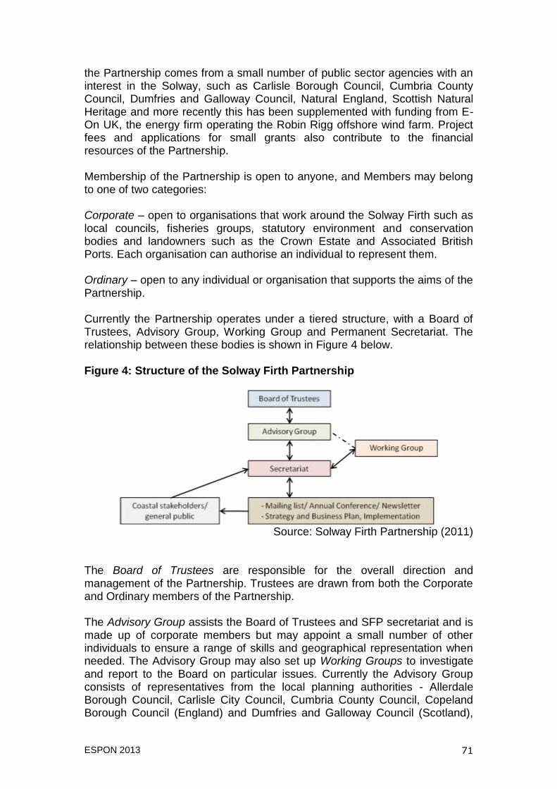
ESPON 2013 71
the Partnership comes from a small number of public sector agencies with an interest in the Solway, such as Carlisle Borough Council, Cumbria County Council, Dumfries and Galloway Council, Natural England, Scottish Natural Heritage and more recently this has been supplemented with funding from E-On UK, the energy firm operating the Robin Rigg offshore wind farm. Project fees and applications for small grants also contribute to the financial resources of the Partnership. Membership of the Partnership is open to anyone, and Members may belong to one of two categories: Corporate – open to organisations that work around the Solway Firth such as local councils, fisheries groups, statutory environment and conservation bodies and landowners such as the Crown Estate and Associated British Ports. Each organisation can authorise an individual to represent them. Ordinary – open to any individual or organisation that supports the aims of the Partnership. Currently the Partnership operates under a tiered structure, with a Board of Trustees, Advisory Group, Working Group and Permanent Secretariat. The relationship between these bodies is shown in Figure 4 below. Figure 4: Structure of the Solway Firth Partnership
Source: Solway Firth Partnership (2011)
The Board of Trustees are responsible for the overall direction and management of the Partnership. Trustees are drawn from both the Corporate and Ordinary members of the Partnership. The Advisory Group assists the Board of Trustees and SFP secretariat and is made up of corporate members but may appoint a small number of other individuals to ensure a range of skills and geographical representation when needed. The Advisory Group may also set up Working Groups to investigate and report to the Board on particular issues. Currently the Advisory Group consists of representatives from the local planning authorities - Allerdale Borough Council, Carlisle City Council, Cumbria County Council, Copeland Borough Council (England) and Dumfries and Galloway Council (Scotland),
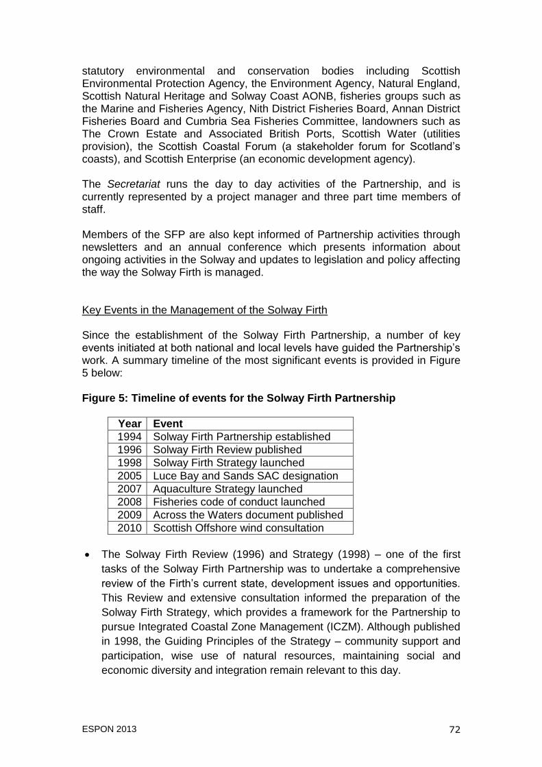
ESPON 2013 72
statutory environmental and conservation bodies including Scottish Environmental Protection Agency, the Environment Agency, Natural England, Scottish Natural Heritage and Solway Coast AONB, fisheries groups such as the Marine and Fisheries Agency, Nith District Fisheries Board, Annan District Fisheries Board and Cumbria Sea Fisheries Committee, landowners such as The Crown Estate and Associated British Ports, Scottish Water (utilities provision), the Scottish Coastal Forum (a stakeholder forum for Scotland‟s coasts), and Scottish Enterprise (an economic development agency). The Secretariat runs the day to day activities of the Partnership, and is currently represented by a project manager and three part time members of staff. Members of the SFP are also kept informed of Partnership activities through newsletters and an annual conference which presents information about ongoing activities in the Solway and updates to legislation and policy affecting the way the Solway Firth is managed. Key Events in the Management of the Solway Firth Since the establishment of the Solway Firth Partnership, a number of key events initiated at both national and local levels have guided the Partnership‟s work. A summary timeline of the most significant events is provided in Figure 5 below: Figure 5: Timeline of events for the Solway Firth Partnership
Year Event
1994 Solway Firth Partnership established
1996 Solway Firth Review published
1998 Solway Firth Strategy launched
2005 Luce Bay and Sands SAC designation
2007 Aquaculture Strategy launched
2008 Fisheries code of conduct launched
2009 Across the Waters document published
2010 Scottish Offshore wind consultation
The Solway Firth Review (1996) and Strategy (1998) – one of the first
tasks of the Solway Firth Partnership was to undertake a comprehensive
review of the Firth‟s current state, development issues and opportunities.
This Review and extensive consultation informed the preparation of the
Solway Firth Strategy, which provides a framework for the Partnership to
pursue Integrated Coastal Zone Management (ICZM). Although published
in 1998, the Guiding Principles of the Strategy – community support and
participation, wise use of natural resources, maintaining social and
economic diversity and integration remain relevant to this day.
ESPON 2013 73
Luce Bay and Sands SAC designation - Luce Bay and Sands on the
Scottish side of the Solway Firth was designated a Special Area of
Conservation under the Habitats Directive in 2005 for its dune and seabed
habitats which support migratory birds and rare newts. Solway Firth
Partnership was tasked with preparing a management scheme for the
SAC on behalf of the Scottish government and Scottish Natural Heritage
through raising awareness, consultation, liaison with stakeholders and
drafting the Management Scheme document.
In recognition of the potential conflicts between aquaculture development
in the Solway and other sectors such as tourism, conservation and
shellfish harvesting, the Partnership produced a Solway Firth Aquaculture
Strategy in 2006/7 in conjunction with the Solway Fish Aquaculture
Working Group. This identified possible sites for aquaculture development
or where such activities were not possible, potential socio-economic
benefits to local communities and management issues that may arise
from the operation of aquaculture activities (Poseidon Aquatic Resource
Management Ltd., 2006).
In 2008, conflict between static and mobile fisheries sectors in Galloway
lead to the development of a voluntary code of conduct by the Galloway
Static Gear Fishermen‟s Association, Solway Scallop Skippers and
Solway Harbourmasters supported by Solway Firth Partnership. This has
resulted in improved communications between the two sectors, with static
gear now clearly marked so that mobile fisheries can avoid damage to
lobster pots. The code is reviewed annually and has provided a model for
similar codes being adopted in the Firth of Clyde.
In anticipation of the new Marine Acts for Scotland and England and the
potential problems of having two marine planning systems operating
within the Solway Firth and other water bodies with a cross-border
dimension such as the Severn Estuary between Wales and England, the
Partnership was commissioned by Wildlife and Countryside Link and
others to produce a report entitled “Across the Waters”. This was
published in 2009 and outlined the main issues arising from current
management arrangements for the Solway Firth and the opportunities and
problems that could arise from the new systems of marine planning.
Across the Waters concluded with a series of recommendations as to how
integrated planning could be achieved for the whole of the Solway. These
included treating the Solway Firth as one single area for marine planning,
aligning timescales for marine plan reporting on both sides of the Solway,
establishing a single point of contact for marine licensing enquiries and
ESPON 2013 74
fostering links between MCZ and MPA programmes to ensure their
coherence across borders.
In May 2010, the Scottish Government launched its Draft Plan for
Offshore Wind Energy in Territorial Waters (Marine Scotland, 2010) which
identified areas in Wigtown Bay and Solway Firth for future wind energy
developments. Following public consultation on this Draft Plan, the
Partnership‟s response to Marine Scotland raised a number of concerns
on behalf of local stakeholders about shortcomings in the contents of the
plan and the consultation process, such as the lack of detailed information
given on potential locations of wind farms, inadequate consideration of the
visual impacts on National Scenic Areas and the Lake District National
Park, unknown impacts on bird and fish species in the Solway Firth and
the timing of proposals coming in advance of marine plans being drawn
up for English and Scottish waters of the Solway. The consultation
response given by the Partnership excluded representation of the Crown
Estates, who have a commercial interest in the development of offshore
energy (see Solway Firth Partnership, 2010b). Ultimately, plans for further
offshore wind development in the Solway Firth were dropped by the
Scottish government in the face of local opposition and potential impacts
on the seascape, which is central to the tourist economy of the Solway
Firth.
Outputs and Evaluation of Governance Arrangements The timeline above illustrates a variety of issues and activities that the Solway Firth Partnership has been involved with since its formation in 1994. Despite its lack of decision making powers, the Partnership has had a number of achievements in relation to the management of the Solway Firth. An extensive list of these achievements is presented in the Solway Firth Partnership Business Plan 2010-2011, (Solway Firth Partnership, 2010a) but the main successes can be distilled as those relating to communication, awareness raising and networking, conflict resolution and maintaining a Firth-wide, cross border perspective on management issues. In terms of communication, awareness raising and networking, the Partnership has brought together a wide cross-section of stakeholders with a common interest in the Solway Firth. This is evidenced by the number of statutory and non-statutory bodies and sectors represented within the Partnership‟s structure as part of the board, advisory and working groups as well as the ordinary membership and attendance at the annual conference. Facilitating consultation on local matters such as the current work on fisheries management in the Luce Bay SAC, participation in World Oceans Week and publicity materials developed by the Partnership (for example on recreational angling and the seafood industry) all contribute to raising the profile of local
ESPON 2013 75
issues and highlighting the importance of the Solway Firth‟s natural, economic and cultural resources. The open nature of membership within the Solway Firth Partnership is one of its great strengths, as this means it can provide a forum for discussion, and in the case of conflict between members or sectors the permanent secretariat can act as a neutral facilitator for resolving disputes. In the case of the consultations for Scotland‟s Offshore Wind Energy Plans, the Partnership was not a facilitator of consultation but was able to take an independent view of the procedure and point out shortcomings of the process. One stakeholder pointed out that the Partnership was “very careful not to campaign against wind farms” as part of this process, recognising that members of the Partnership may have different views on the relative benefits or negative impacts such development would have on the area. The greatest success of the Solway Firth Partnership which has been cited by stakeholders is its continuing efforts to maintain a Firth-wide approach to planning. Lobbying by the Solway Firth Partnership resulted in a concordat between the UK and Scottish Ministers responsible for overseeing marine planning which would ensure a joined up approach to marine planning for the Solway Firth. The Marine Policy Statement reaffirms this commitment to coordinated planning and information sharing across the devolved administrations. The Across the Waters report prepared by Solway Firth Partnership has also helped to raise the profile of joint marine planning in the Solway. Although none of the recommendations made in the report have been concretely followed up by Marine Scotland or the Marine Management Organisation, the fact that decision making on Marine Regions and Marine Planning Partnerships and the commencement of plan preparation for England‟s North West marine area all have yet to take place means that many of the points raised in Across the Waters remain relevant and have yet to be addressed. However, such decisions are beyond the remit of the Partnership and will be driven by the resources available to and the political interests of the devolved administrations. Of the Solway Firth Partnership‟s weaknesses as an agent of coastal and marine governance, SFP is subject to the same criticism that has been levelled at other coastal partnerships and fora throughout the UK (see McKenna et al (2008), Morris (2008), and Shipman and Stojanovic (2007)) in that the voluntary, non-statutory nature of coastal partnership activities lacks the power and legal weight to effect more fundamental change in the way coastal areas are managed. This problem has its foundations in the non-binding nature of ICZM Recommendation 2002/413/EC, which requires Member States to produce ICZM strategies but does not require that they have any legal powers, preferring instead to rely on the use of existing legal instruments. Although the Solway Firth Partnership was set up before the Recommendation was published, the Recommendation has been used to
ESPON 2013 76
highlight the ongoing need for an integrated approach to the management of marine areas and has provided further impetus for close working between agencies with responsibilities for aspects of managing the Solway on both sides of the border. Were the Solway Firth Partnership to be given more powers, for example through being reconstituted in the future as a Marine Planning Partnership, notwithstanding any future proposals for the structure of Marine Planning Partnerships which will be decided by Marine Scotland, the current membership of the Board and Advisory Groups would be unable to take on this new role. This is because many of the current representatives on the Board of Trustees and Advisory Group already have statutory responsibilities related to their own organisations which could conflict with the remit and statutory responsibilities that could be conferred upon a more powerful Solway Firth Partnership. In the current situation, the Solway Firth Partnership is sustained because of its perceived neutrality and role as a central point of contact and information for stakeholders with an interest in the Solway Firth. The work of the Partnership is seen to bring added value to the existing statutory planning systems. Like many organisations in the UK at the current time, the ability of the Solway Firth Partnership to continue its work is dependent mainly upon a decreasing amount of public sector funding. Whilst there is sufficient good will amongst its members to see the Solway Firth Partnership continue to operate, uncertain financial resources are a major challenge to further endeavours. The Role of the European Union in Management of the Solway Firth In the interviews conducted as part of this case study, the influence of the European Union policies and initiatives on coastal and marine governance was found to be relatively small. With respect to environmental issues, Directives such as the Habitats, Birds and the Water Framework Directive have been transposed into UK or English and Scottish law and thus had direct effects in terms of the management of particular sites within the Solway or as part of a larger plan area in the case of the WFD. Amongst interviewees it was felt that the key management issues in the Solway Firth are found to be drivers at a national or local levels rather than the European. For example, in relation to offshore energy, one interviewee stated that the Scottish Government‟s target of 80% of its energy consumption to come from renewable sources by 2020 is driven by a national political agenda to switch to a low carbon economy and become a world leader in renewable energy technologies. At a more basic level, one interviewee described support for ICZM and the work of the Solway Firth Partnership as being
“driven by more local considerations. It‟s about the people, the organisations that have responsibilities around the Solway Firth, the communities around the Solway Firth, actually being driven by a need and that desire to be working more closely, to look after and use the Solway Firth better”.
ESPON 2013 77
The ability of Dumfries and Galloway and Cumbria County Council to attract European Structural Funds was also noted, however much of this investment has gone towards agri-environment and rural development schemes. More recently, North and North West Cumbria has received money from the European Fisheries Fund Axis 4 Programme which aims to help small communities that are dependent on fishing, but this is being administered by a Fisheries Local Action Group rather than the Partnership. Looking forward to other European initiatives that may have implications for the management of the Solway Firth such as the Roadmap for Maritime Spatial Planning and possible follow-up actions related to the ICZM Recommendation, the necessity for future European intervention was regarded as being of low priority. In particular, it was noted that neither the Marine Scotland nor the Department for Environment, Food and Rural Affairs (DEFRA) in England had responded to the European Commission‟s Consultation on Maritime Spatial Planning and Integrated Coastal Zone Management which was held in early 2011. This again was attributed to the need for national interests to take precedence and also a desire to minimise the administrative burden that could result from any additional Directives. Furthermore, a potential mismatch between time scales for implementing marine planning at the national and local levels within England and Scotland and actions coordinated at the European level was cited as a challenge to achieving further integration of marine planning across borders and with higher levels of government. Lessons for Marine Planning The case of the Solway Firth Partnership highlights a number of critical issues for cross-border marine planning, relating to both the process of coastal and marine planning and the potential outcomes of such initiatives. The ongoing nature of work to fully embed a system of marine planning for both English and Scottish waters means that in some cases, conclusions are based on what is known about proposals for defining marine region boundaries and the possible structure of Marine Planning Partnerships, which are subject to change, and how they might affect the way integrated marine planning for the Solway could be achieved in future. One key lesson that has emerged from the development of marine planning on both sides of the Solway is the need for high level agreement on arrangements for cross border planning to be followed through at the regional and local levels. Whilst the Solway Firth has been successful in obtaining ministerial agreement on joint working, divergence in legislation, organisational structure and political interests on either sides of the Solway could create further barriers to developing a common approach for planning the Solway. A second lesson relates to the boundaries of marine plan areas. The arbitrary nature of delimiting territorial, inshore and offshore waters fails to reflect the dynamic nature of the marine environment and respect ecosystem integrity,
ESPON 2013 78
and the division of waters within the Solway Firth into separate marine plan areas could have implications for ecosystem functions that are as yet unknown. In the case of Scotland‟s offshore wind consultation, one of the criticisms made by Solway Firth Partnership of the process was that “Many of the proposals in the Draft Plan would have significant impacts on the south side of the Solway yet local communities and key stakeholders in England have not been consulted” (Solway Firth Partnership, 2010b). Whilst some environmental effects can be anticipated and mitigated for by way of strategic environmental assessment (SEA), a clearer understanding of the relationship between human uses of the sea and their impacts on the coastal and marine ecosystem as a whole should provide the baseline for planning decisions. Conclusions This case study demonstrates that whilst individual nations are beginning to understand the importance of coastal and marine environments and act accordingly to implement marine planning, there are a great number of issues still to be resolved. In the first instance, the definition of plan boundaries that prevent a holistic, ecosystem-centred approach to planning for marine areas needs to be addressed. In the case of the Solway, there is popular support for a Firth-wide approach to marine planning, but differing legislation and political interests are and may continue to be a barrier to achieving integrated planning that respects ecosystem integrity. In addition, the progress of implementation in different nations is uneven, and the preparation of marine plans along different time scales could hamper efforts towards integrated management. At this time, many uncertainties remain about how marine planning for the Solway Firth will be implemented. However the continuing work of the Solway Firth Partnership provides a valuable resource for bringing together key stakeholders and ensuring that a cross-border perspective on marine planning is maintained.

ESPON 2013 79
Chapter 6: Further Proceedings Towards the Draft Final Report
The above summary of the research findings from work undertaken so far highlights a number of issues that the ESaTDOR project team will need to address over the coming months. However, in looking ahead to the draft final report two key challenges are evident. The first relates to data and mapping and the appropriate balance to be struck between an illustrative and in depth approach. The second related issue concerns the relative balance between quantitative and qualitative outputs. Our current thinking on these matters is set out below and guidance from the ESPON Coordination Unit and Sounding Board on whether the proposed approach is appropriate would be particularly appreciated.
Key Challenges and Proposed Responses for Draft Final Report
The most critical challenge facing the team relates to our ability to collect data in a consistent manner across all the regional seas so that the results can be effectively mapped. There are a number of closely inter-related dimensions to this dilemma, which are highlighted below. At the moment we have identified the challenges and are working though in a pragmatic and iterative way methods to try and address such challenges. During the first phase of the research we were largely involved in a scoping exercise that enables the team to develop a clearer understanding of the data collection challenges we face. What this has revealed is that the challenges of combining different data from different policy regimes is going to be much more difficult than originally envisaged and our proposal is to be more selective in terms of mapping across all of the regional seas, with a view to making very clear policy recommendations regarding what information is critical for understanding the risks and opportunities for territorial cohesion based on effective management of the Europe‟s maritime environment. At this stage we are largely identifying challenges and are working towards a solution. Our approach is iterative and feedback on the interim report and continued ongoing dialogue with the ESPON Database team will hopefully provide pragmatic and realisable solutions. The critical issues from a data collection and mapping perspective include the following:-
1. Significant variations in determining regional seas boundaries between different European and other international maritime policy regimes. To overcome this dilemma we have taken a rationale and pragmatic approach to defining boundaries (see section ???). We hope that our proposals are approved by ESPON and that this can be reported to the ESPON Database team who are hoping to produce maritime base maps for the ESPON space by December 2011.
ESPON 2013 80
2. However this creates challenges in so far as the data that is available
has been collected for different spatial units.
3. Where data is available at a national level, sometimes it is very difficult
to disaggregate the data in order to differentiate what can be ascribed to the land and what can be ascribed to the seas. Furthermore in some cases where a sovereign country has interests in more than one regional sea, then allocating activities to each sea can be difficult. This for example relates to the United Kingdom and its interests in the North Sea and the Atlantic, or Spain and France, within interests in both the Mediterranean and Atlantic regional seas.
4. In some instances there is limited data availability within the public
domain, some interesting and important data for integrated marine planning may be commercially sensitive or contested and not in the public domain.
5. There is a huge variation between the regional seas in terms of the
quantity and quality of data available within the regional seas themselves. The Baltic Sea probably has the best data sets available, in part because of the relatively longer stand collaboration between the countries bordering the Baltic Sea who understand the need for evidence based collaborative action. Amongst other European seas some consistency of approach to data collection is evident, but within regional seas where there are either a number of accession countries, or none EU countries (most notably the Mediterranean, then there are serious data availability challenges.
6. There is a growing realisation that use and exploitation of maritime
resources has been and continues to expand at an ever increasing rate. For example in recent years there has been a rapidly growing licensing of parts of the sea bed as being locations whereby renewable energy schemes (mainly wind turbines) can be located. There are differences, between operational windfarms, those in development and areas of potential for which licenses are available or have been granted. This is a rapidly developing policy area and much of the information is only available in national not European space, and is then collected in a variety of different ways. There is also a challenge in the extent to which data sets are sufficiently contemporary to measure current and future patterns of use rather than reporting on historic patterns.
7. Whilst we have focused here on maritime resources, the project is
concerned not just with maritime activities but with the interface between land and sea and how these interactions can contribute to
ESPON 2013 81
social, economic and territorial cohesion. This however brings with it challenges in terms of the extent and distance to which sea based activities penetrate into the European land mass and conversely what is the landward extent of activities that has an impact on the seas. With pollution for example it is widely understood that agricultural run-off from a considerable inland catchment is having an impact on pollution levels in for example the Black Sea. Similarly the hinterland of some of the major European ports is very extensive. Energy production within the marine environment whilst having localised impact close to where it comes ashore, often has wider impact through the territory. With fishing and tourism activities are often contained along a relatively narrow coastal strip and often (depending on the scale of the territorial units used) hidden by the dominance of other none exclusively coastal activities.
This creates a who series of challenges in terms of defining the boundaries of the regional seas; in terms of aggregating and disaggregating data to describe the characteristics of regional (and sub-regional seas); in having a consistent approach in terms of how the data is geo-referenced etc. We will therefore be looking to use a small number of data sets in each thematic area, which provide as comprehensive data coverage as possible across all of the European regional seas in order to develop a limited number of illustrative thematic maps which point the way forward for future mapping projects. We will also explore the potential to draw these different data sets together to produce maps related to a composite coast/sea region typology. In addition through the European Sea Profile work package we are proposing to explore differences in approaches to data assembly and mapping and highlight areas of good practice that could be applied more widely. Based on this illustrative approach we hope to develop clear recommendations as to how the marine environment and its interface with the land can be effectively mapped in the future, and also to suggest critical data sets that should be collected on a European wide basis to facilitate efficient and effective spatial planning. In terms of developing this agenda still further we are seeking feedback on this interim report, are continuing our dialogue with the ESPON Database team, will hold a further team meeting to discuss this issue in October and are engaging in dialogue with DG Mare to seek practical ways to overcome these challenges.

ESPON 2013 82
Balance Between Quantitative and Qualitative Outputs The discussion on data and mapping above reveals the particular nature of this applied research project which is very much a first step into marine matters for ESPON. This means that it is difficult for the project to follow the well established pattern of many previous land based ESPON projects with their emphasis on consistent data assembly and mapping across ESPON space and associated data informed policy recommendations. In this project we are proposing to take an illustrative rather than comprehensive approach to data assembly and mapping and are anticipating that the balance of outputs will be more towards providing a qualitative overview assessment and associated policy recommendations and less upon quantitative matters in the form of closely focussed new data assembly. The appropriate balance to be struck in the project between qualitative and quantitative matters and a broad and a more limited focus will be a key issue for the Stage 2 work packages related to the European Sea Profiles and Marine and Coastal Governance Case Studies. Here, we are proposing that each of the regional sea teams will produce an overview of the different thematic areas as they relate to their region as a whole and different sub-regional areas drawing upon whatever data sets that can be found to support an informed discussion. The data sets uncovered through this process may be useful in informing future European data collection and mapping activity, but it is felt that the qualitative discussion that could be derived from the research could be equally important in informing future policy directions both at the EU and at the European Sea level and it is proposed that this should be developed as a key output of the work. With this in mind it is envisaged that recommendations to flow from the ESaTDOR project could be grouped under the following headings Coastal and Marine Data and Mapping, Maritime and Maritime related Sectoral Policy, Coastal and Marine Governance, and Sea Specific Guidance. Some initial thoughts related to these areas are set out below. We would however, also appreciate guidance from the ESPON Coordination Unit and Sounding Board on whether the proposed approach to Stage 2 is appropriate, or whether a more focussed approach on data assembly in selected key areas should be adopted.

ESPON 2013 83
Draft Conclusions and Policy Recommendations
It is clear that the marine environment is increasingly being recognised by many sovereign states as an important and integral part of their territorial space. As a consequence the demands being placed on the marine environment are growing rapidly, and commercial exploitation of marine resources, combined with a need to protect environmental integrity means that more effective governance mechanisms (both in terms of structures and processes) are needed. Marine spatial planning is seen as an approach that can bring about integrated, both sectorally and spatially (across territories) policy responses to deal with conflict and competing uses for the marine resources. Combined with better developed integrated coastal zone management and more broadly cast national, regional and local spatial policy, a new era of European engagement with its seas is before us. However all these developments require a step change in our understanding of the marine environment and human use and impacts on the sea and the place specific inter-connections between terrestrial and marine areas. In terms of emerging conclusions and policy recommendations we believe that there are both generic and specific points that can be raised related to Coastal and Marine Data and Mapping, Maritime and Maritime related Sectoral Policy, Coastal and Marine Governance, and Sea Specific Guidance. Some initial thoughts on possible conclusions are recommendations related to the first three areas are presented below. Suggestions of sea specific conclusions and recommendations will flow from WP2.3 which is still in its early stages. Coastal and Marine Data and Mapping CONCLUSION 1 - The growing interest in the marine environment is generating a great deal of data that is fragmented, inconsistent, incomplete and collected at a variety of spatial scales. If European marine spatial planning is to become more embedded in territorial policy making, it is important that data is collected in a more systematic and consistent manner. The INSPIRE directive already provides tentative ideas for how this might be managed and this is an important protocol that should guide future developments. Furthermore DG Mare has recognised the challenge by creating a European Marine Observation and Data Network (EMODNET) to help integrate existing but fragmented initiatives and assemble data and maintain a database to support marine spatial planning. It is hope that the ESTaDOR applied policy project can help to contribute to this agenda. RECOMMENDATION - The proposed boundaries for the European regional seas in ESPON space, as proposed in this report, are adopted as pragmatic, but permeable boundaries for mapping and planning purposes RECOMMENDATION - In developing a typology that describes the diversity of regional and sub-regional seas, a small number of critical indicators can be

ESPON 2013 84
identified in terms of measuring and monitoring change and used as the basis for future scenario building and planning. RECOMMENDATION - The ESaTDOR project has defined key thematic data ambitions and data protocols for marine areas building upon the framework provided by the INSPIRE Directive and these should be used to guide longer term data collection strategies. RECOMMENDATION - A key requirement for effective MSP and ICZM is a consistent protocol for sub-sea mapping and it is recommended that this should be based on 100 x 100Km grid squares with the scope for smaller units to be used in areas of most complex activity, for example within territorial waters. Maritime and Maritime related Sectoral Policy CONCLUSION 2 - There is a growing recognition in policy terms that the marine environment is an important and integral part of European space, which needs to be considered carefully in its own right. Equally, there growing acknowledgement that the inter-linkages between the marine and land based environments provide a critical interface of opportunities for territorial cohesion, but also threats to local social and economic wellbeing. The inter-relationships (opportunities and threats) vary considerably in different regional and sub-regional seas. It therefore follows that there is a need for integrated thinking about these inter-relationships so that opportunities can be maximised and threats minimised and that place sensitive policy responses are developed. RECOMMENDATION – That the importance of the maritime environment for land based development and land sea interrelationships is fully recognised and better understood and becomes an integral part of the European Union‟s social, economic and territorial cohesion agenda. RECOMMENDATION - That whilst some of the institutions of the EU have begun to recognise the importance of the marine environment (e.g. DG Mare, DG Environment, DG Move, DG Energy etc) some, most noticeably DG Regio still maintain a land focussed definition of the territorial agenda. The territories over which sovereign states have jurisdiction include, both land and maritime resources, and these need to be properly recognised and understood. RECOMMENDATION – Efforts should be made to promote the inclusion of sea space as an integral part of national, regional and local spatial policy. CONCLUSION 3 – Sectoral policies will continue to be important to provide detailed guidance on the increasingly intense use of Europe‟s seas and to facilitate the optimal development of all-sea related activities in a sustainable manner. Specific issues related to both development opportunities and risks for future sectoral policy are being identified through the ESaTDOR project

ESPON 2013 85
and these should be taken forward in an integrated manner as part of the EU‟s Integrated Maritime Policy Agenda. Examples of the type of recommendations that might flow from future stages of work, initially drawing on the risks and opportunities, are as follows: Economic Use RECOMMENDATION - Enhanced support for the following existing and potential maritime industry clusters should be provided: [Full list of clusters to be provided in Draft Final Report] RECOMMENDATION – Increased technical capacity and innovation related to sustainable fishing and aquaculture development should be supported. Energy, Cables and Pipelines RECOMMENDATION - Support for research and manufacturing related to the following marine renewable energy technologies and the development of the following sea based energy grids should be provided: [Full list of renewable technologies to be provided in Draft Final Report] RECOMMENDATION – Techniques and technical capacity related to the nature conservation and biodiversity enhancement potential of marine renewable technologies should be supported. Transport and Shipping RECOMMENDATION - A European ports strategy should be developed to respond to the following opportunities and challenges presented by increasing and shifting patterns of marine transport: [Full list of opportunities and challenges to be provided in Draft Final Report]. RECOMMENDATION – Support should be provided for enhanced emergency planning and response activities in the Arctic to reflect increasing levels of use. Coastal and Marine Environment RECOMMENDATION – Support should be given to assisting the development of ecotourism associated with the new European network of marine protected areas. RECOMMENDATION – Support should be given to the development of new coastal wetlands and soft sea defences as part of a coordinated response to sea level rise and climate change.

ESPON 2013 86
Coastal and Marine Governance CONCLUSION 4 - In recent years there has been a growing appreciation of the need for new governance arrangements to support integrated management of the coastal and marine areas. At a European scale various sectorally orientated processes, regimes and programmes are being developed to try and ensure more effective management and protection of maritime assets. Many such activities have had their origins in managing, protecting and enhancing the environmental integrity of the maritime ecosystems, but increasingly the commercial exploitation of maritime assets is also coming to the fore. This then leads to questions about what are the most appropriate governance arrangements to manage land sea interactions in the most effective manner in order to deliver effective horizontal integration between sectors and across national boundaries and deal with transnational externalities at a variety of different spatial scales. It is evident that a hierarchy of governance arrangements needs to be developed covering European, regional seas and sub-regional seas scales, but that these need to be carefully tailored to reflect the particular governance traditions and contextual factors pertaining in each European sea. In developing such arrangements there is a need to bring together state, market and civil society interests and for arrangements to achieve a suitable balance between formality and informality and continuity and responsiveness to change. Whilst not being prescriptive it is hoped that the governance case studies will provide some recommendations on the type of institutional frameworks that are needed and the associated skills and competences that are required. Some initial thoughts on the types of recommendations that might emerge are as follows: RECOMMENDATION – The EU should support the development of a network of transnational partnerships designed to support an integrated approach to MSP and ICZM activities at a variety of spatial scales. RECOMMENDATION - The following are put forward as important attributes and effective coastal and marine related governance arrangements:…. [To be completed in Draft final Report] RECOMMENDATION - Capacity building to support the development of coastal and marine related governance arrangements should include the following:…. [To be completed in Draft final Report]
ESPON 2013 87
Looking Ahead to the Next Stages of Work
Ongoing Work WP 2.3 European Seas profiles and WP 2.4 Case Studies Currently the research team is engaged in a period of data collection at the regional seas level. This will last until January 2012. There are three aspects to this work. First based on the work of the thematic experts the regional seas experts are developing more detailed regional seas profiles based on the identification of critical data sets that either, help to characterise the seas or, are expected to have a significant impact of their future. Secondly the regional seas experts are undertaking a number of case studies exploring the strengths and weaknesses of various governance arrangements that are transnational in nature and which are designed to effectively manage maritime resources. Thirdly we are still exploring ways and means of effectively consolidating this work in terms of mapping the key characteristics of European regional seas, exploring key inter-linkages, between land and sea environments and refining our emerging European seas typology. WP 2.5 Thematic Synthesis Reports A team meeting in January 2012 in Greece will enable us to reflect on how the main stage of data collection at the regional seas level has progressed. This work then provides the basis for producing baseline maps which will be part of the process of synthesis which will take place early next year. A series of synthesis reports will provide further elaboration of the initial draft thematic reports that have already been produced drawing upon the understanding that has been gained through the Stage 2 work packages. Critical at this stage will be an understanding of the current status of the regional seas, alongside their existing role in influencing, and being influenced by, land based activities. The synthesis work will also provide an important opportunity to reflect on trends over time and to look ahead more purposefully to anticipate future opportunities and shocks that may alter current patterns of activity. For example might the emergence of a super-highway in the sea that circumnavigates the globe change the relative fortunes of major European ports in the north in comparison with Mediterranean ports? This then might have implications for economic development and the environment as a result of increased traffic in the Mediterranean. Similarly what are the implications for global maritime trade on Europe if greater access can be provided through the Arctic Sea, which may be opened up due to climate change. In other words we will look to develop a serious of critical scenarios and begin to think about the implications for territorial cohesion, both at a European scale, but also in relation to particular regional seas or particular parts of regional seas.
ESPON 2013 88
WP 2.6 Future Scenarios We will use then use our understanding of the current patterns of sea use combined with the thematic analysis of trends and possible future opportunities and shocks to begin to develop scenarios which will drive the development of policy options to encourage what might be considered positive policy outcomes and/or to control, manage or limit negative outcomes. This foresight work will be prepared by the ESaTDOR Team, in close liaison with experts drawn from both thematic and local regional seas perspectives. We envisage holding a team meeting in Amsterdam in June 2012 to review the outcome of the thematic synthesis work and mapping developments. As part of this meeting we will invite thematic experts/stakeholders to explore whether the development trajectories for the various thematic scenarios alongside tentative policy proposals are realistic and to develop and refine our approach accordingly. This will be an important opportunity to draw upon a wider knowledge base and consider whether we have missed any significant trends/scenarios that may affect future sea use and land/sea interactions. We need to think carefully about which stakeholders we should invite to this meeting and this will be a subject of discussion at the January team meeting. We need to achieve a good balance between thematic and regional sea interests. In addition, our research has revealed that five Directorate Generals (Mare, Regio, Environment, Move and Energy) that broadly map onto our thematic uses could be invited. We also feel that representatives from the ESPON family should also be involved (ESPON Project Expert , project sounding board members, researchers from closely aligned projects (eg GEOSPECS- Geographic Specificities and Development Potentials in Europe which includes coastal zones) and selected members from the co-ordinating unit. From this basis using the DPSIR (driver pressure state impact and response) approach a series of outcomes for each of the regional seas could be developed and these will be road tested by local experts in each of the seas areas. Throughout the research we are establishing good working relationships with key stakeholders in each of the regional seas and a number of alternative mechanisms, workshops, email correspondence, informal feedback could be used depending on the characteristics of each of the seas to explore whether the scenarios and policy responses are valid. The outputs from all this activity will then feed into the final report (see below).

ESPON 2013 89
Draft contents page of final report
In terms of producing a draft final report, we have argued elsewhere that our approach to the project is experimental and iterative, and that we are meeting many challenges that have not been experienced to the same extent within a terrestrial context. Drawing upon the ESPON generic template and our Annex III of the contract we are proposing the following draft and indicative table of contents for comment.
A Executive summary (max. 10 pages)
1 Analytical part incl. key messages and findings
2 Options for policy development which will be substantive, procedural, process and technical in nature and can be applied at a variety of different scales
3 Suggestions for further analysis/research
B Report (max. 50 pages)
1 Main results
- To identify the critical indicators that can be used understand the role of the marine environment in territorial cohesion
- To identify a method and recommendations as to how this data can be effectively mapped within a context of fragmented and overlapping boundaries that are cannot be easily combined
- To describe the current use of European regional seas based on an initial sectoral analysis and integrated to show typology of sea use, combining threats and opportunities
- To identify current and potential trends for sea use and use these to build scenarios of risks and opportunities in terms of the maritime contribution to social, economic and territorial cohesion
- To recognise the transnational nature of maritime resources and the potentialities for local action to cause externalities (both positive and negative)
- To explore different models of governance designed to manage maritime resources either on a sectoral or an integrated basis
2 Options for policy development (basis for interventions related to
development opportunities for improving European competitiveness and cohesion).
Based on our analysis of the above and recognising that marine spatial planning process and procedures are developing apace, policy development will be directed towards:

ESPON 2013 90
European level policy makers having a better understanding of the role of the marine environment to land based (territorial agenda) and what intervention may enhance or threaten opportunities and risks
Regional Seas to better appreciate the risks and potentials of their maritime environment
Providing technical guidance and advice as to how maritime resources can be best measured monitored and mapped, both on a sectoral and integrated basis
Providing guidance of the effectiveness of different governance arrangements designed to manage maritime resources
3 Key analysis / diagnosis / findings and the most relevant indicators and
maps. Our approach is to be selective rather than comprehensive. The rational
for choosing key indicators and the way they have been combined qualitatively and quantitatively to produce a typology of European regional seas characteristic will be explained.
4 In case the research addresses themes being dealt with by ESPON 2013
and produces opposing results, an explanation of these differences and a presentation of proposals for further European research, case studies, etc.
5 Issues for further analytical work and research, data gaps to overcome. As marine spatial planning is emerging as a new policy area and has
only recently been recognised as being integral to the territorial cohesion agenda, the approach to date has tended to focus upon managing and protecting marine environmental integrity. So far only limited attention has been given to thinking about the potentialities and risks that the marine environment offers for land based activities, both immediately adjacent to the seas, but also further inland. As an initial and exploratory piece of work there will be much that can be said about the need for further work either as part of future ESPON programmes, as part of the research and development activities of various European DGs or wider European research initiatives, (e.g future framework programmes).

ESPON 2013 91
C Scientific report (no page limits)
Introduction The growth and development of marine spatial planning and management
as integral part of European territorial cohesion policy Project Aims and Objectives Methodology
Research Findings Data and mapping protocols and procedure for integrating land and sea
interests Key thematic opportunities and risks for exploiting and managing maritime
resources - Economic Use - Energy, Cables and Pipelines - Transport and Shipping - Coastal and Marine Environment
Governance of the European regional seas and examples of different
practice - Presentation of case studies, including policy synthesis
Current and Future Risks and Opportunities for European Regional Seas
and their potential impacts on territorial cohesion - Characterisation of current regional seas use, including a regional
and sub-seas typology - Future scenarios for European Regional seas - Suggestions of interventions to minimise risks and maximise
opportunities Policy Recommendations –Substantive, policy, process and procedural
- EU level - Transnational - National - Regional
Future research needs

ESPON 2013 92
Annexes to the Scientific report
List of indicators developed and datasets provided to the ESPON Database
List of maps and tables
List of missing data/ and or critical data that should be collected
List of abbreviations and glossary
List of references, including the use of results from projects outside the ESPON 2013 Programme
List of publications and presentations of the TPG members resulting from the implementation of the Applied Research project
Additional maps not included in the core text of the report
Bibliography
ESPON 2013 93
References
Barca, F (2009) An Agenda for a Reformed Cohesion policy: A place-based
approach to meeting European Union challenges and expectations. An independent
report prepared at the request of Danuta Hubner, Commissioner for Regional Policy
Commission of the European Communities (CEC) (2000) Directive 2000/60/EC of the European Parliament and of the Council establishing a framework for Community action in the field of water policy, Brussels: European Commission Commission of the European Communities (CEC) (2002) Recommendation of the European Parliament and of the Council 2002/413/EC on the Implementation of Integrated Coastal Zone Management, Brussels: European Commission CEC (2008) Communication from the Commission: Roadmap for Maritime Spatial
Planning: Achieving Common Principles in the EU, COM(2008) 791 final
CEC (2010a) Investing in Europe‟s Future: Fifth Report on Economic Social and Territorial Cohesion, Brussels
CEC (2010b) Europe 2020: A strategy for smart sustainable and inclusive growth. COM (2010)2020 The Crown Estate (2011) Memorandum of Understanding Between the Marine Management Organisation (MMO) and the Crown Estate Commissioners (the Crown Estate) dated 8th February 2011 http://www.thecrownestate.co.uk/mmo_mou.pdf [last accessed 29/08/2011] Department of Communities and Local Government (2010) Planning Policy Statement 25: Development and Flood Risk London: TSO Department of the Environment (1992) Planning Policy Guidance (PPG) Note 20: the Coast, London: HMSO DEFRA (2009) a Strategy for Promoting and Integrated Approach to the Management of Coastal Areas in England, London: DEFRA HM Government (2010) UK Marine Policy Statement: a draft for Consultation, London:TSO Drafting Team set up for the update of the Territorial State and Perspectives of the EU (2011) The Territorial State and Perspectives of the European Union: 2011 Update
Informal Ministerial Meeting of Ministers responsible for Spatial Planning and Territorial Development (2011) Territorial Agenda of the European Union 2020: Towards an Inclusive, smart and Sustainable Europe of Diverse Regions, agreed 19th May 2011 Godollo, Hungary Marine Scotland (2010) Draft Plan for Offshore Wind Energy in Scottish Territorial Waters, Edinburgh: the Scottish Government

ESPON 2013 94
McKenna, J., Cooper, A., and O‟Hagan, A.M. (2008) “Managing by Principle: a Critical Analysis of the European Principles of Integrated Coastal Zone Management (ICZM)” in Marine Policy, 32:941-955 Morris, R. (2008) “English Nature's Estuaries Initiative: A review of its contribution to ICZM”, in Coastal Management 51(1):25-42 Poseidon Aquatic Resource Management Ltd. (2006) Solway Firth Aquaculture Strategy http://www.consult-poseidon.com/asp/publicproject.asp?valueid=279 [last accessed 29/08/2011] Scottish Executive (2005) Seas the Opportunity: a Strategy for the Long Term Sustainability of Scotland‟s Coasts and Seas, Edinburgh: the Scottish Executive
Scottish Natural Heritage (1997) Scotland‟s Living Landscapes: Firths, Perth: SNH
Scottish Natural Heritage (2011) Ramsar Sites http://www.snh.gov.uk/protecting-scotlands-nature/protected-areas/international-designations/ramsar-sites/ [last accessed 29/08/2011]
Shipman, B. And Stojanovic, T. (2007) “Facts, Fictions and Failures of Integrated Coastal Zone Management in Europe”, in Coastal Management 35(2-3):375-398 Smith H.D., Maes, F., Stojanovic, T.A. and Ballinger, R.C. (2010) “The integration of land and marine spatial planning” in Journal of Coastal Conservation Planning and Management 14 (4) Solway Energy Gateway (2011) Solway Energy Gateway Ltd. http://www.solwayenergygateway.co.uk/solway-energy-home.asp [last accessed 29/08/2011] Solway Firth Partnership (1996) The Solway Firth Review, Dumfries: Solway Firth Partnership Solway Firth Partnership (2009) Across the Waters - Implementation of the UK Marine and Coastal Access Act and Devolved Marine Legislation: Cross Border Case Studies, London: Wildlife and Countryside LINK Solway Firth Partnership (2010a) Business Plan 2010-11, Dumfries: Solway Firth Partnership Solway Firth Partnership (2010b) Solway Firth Partnership response to the Scottish Government Draft Plan for Offshore Wind Energy in Scottish Territorial Waters and SEA Consultation, letter to Marine Scotland, dated 27th September 2010 Solway Firth Partnership (2011) Company Structure, http://www.solwayfirthpartnership.co.uk/structure.asp [last accessed 29/08/2011] Solway Firth Partnership (undated) Luce Bay and Sands SAC leaflet, Dumfries: Solway Firth Partnership The Scottish Government (2009) National Planning Policy for Scotland 2 Edinburgh: the Scottish Executive
ESPON 2013 95
The ESPON 2013 Programme is part-financed by the European Regional Development Fund, the EU Member States and the Partner States Iceland, Liechtenstein, Norway and Switzerland. It shall support policy development in relation to the aim of territorial cohesion and a harmonious development of the European territory.
ISBN