ethnobotanical survey of the thurmond ranch on the...
TRANSCRIPT

In this issue: The Burton Site, a Plains Village site in Cotton County
Winter 2003 Volume 51, Number 1
© 2003 Oklahoma Anthropological Society
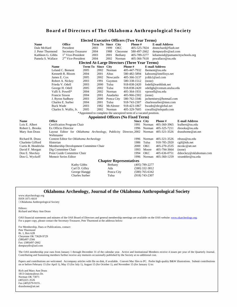
Board of Directors of The Oklahoma Anthropological Society
Elected Executive Officers (Two Year Terms) Name Office Term To Since City Phone # E-mail Address Dale McHard President 2003 1999 OKC 405-525-7824 [email protected] J. Peter Thurmond Secretary-Treasurer 2004 1988 Cheyenne 580-497-2662 [email protected] Kathleen G. Gibbs 1st Vice-President 2003 2001 Bethany 405-789-2277 [email protected] Pamela S. Wallace 2nd Vice-President 2004 2002 Norman 405-366-7618 [email protected]
Elected At-Large Directors (Three Year Terms) Name Term To Since City Phone # E-mail Address Leland C. Bement 2005 2002 Norman 405-447-7932 [email protected] Kenneth R. Bloom 2004 2001 Altus 580-482-5894 [email protected] James E. Cox 2005 2002 Newcastle 405-366-3137 [email protected] Robert A. Nickey 2003 1991 Guymon 580-338-1512 (none) Frieda V. Odell 2003 2000 Tulsa 918-838-2420 [email protected] George H. Odell 2005 2002 Tulsa 918-838-2420 [email protected] Valli S. Powell* 2004 2002 Norman 405-364-1931 [email protected] Francie Sisson 2004 2001 Anadarko 405-966-2302 (none) J. Byron Sudbury 2003 2000 Ponca City 580-762-3346 [email protected] Charles E. Surber 2004 2001 Tulsa 918-743-2307 [email protected] Buck Wade 2003 1982 McAlester 918-423-1867 [email protected] Charles S. Wallis, Jr. 2005 2002 Norman 405-329-7605 [email protected]
*Appointed to complete the unexpired term of a vacated position. Appointed Officers (No Fixed Term)
Name Office Since City Phone # E-mail Address Lois E. Albert Certification Program Chair 1991 Norman 405-360-3965 [email protected] Robert L. Brooks Ex Officio Director 1996 Norman 405-325-7211 [email protected] Mary Ann Drass Layout Editor for Oklahoma Archeology, Publicity Director,
Webmaster 2002 Norman 405-321-3526 [email protected]
Richard R. Drass Content Editor for Oklahoma Archeology 1996 Norman 405-321-3526 [email protected] Charlette Gifford Historian 1986 Tulsa 918-785-2920 [email protected] Curtis B. Hendricks Membership Development Committee Chair 2000 OKC 405-270-2535 [email protected] David F. Morgan Dig Committee Chair 1993 Moore 405-794-3664 (none) Don E. Shockey Point Guide Committee Chair 1994 OKC 405-636-0751 [email protected] Don G. Wyckoff Memoir Series Editor 1996 Norman 405-360-1259 [email protected]
Chapter Representatives Kathy Gibbs Bethany (405) 789-2277 Carl D. Gilley Ada (580) 332-3812 George Hanggi Ponca City (580) 765-6342 Charles Surber Tulsa (918) 743-2307
Oklahoma Archeology, Journal of the Oklahoma Anthropological Society www.okarcheology.org ISSN 1071-6610 Oklahoma Anthropological Society Editors: Richard and Mary Ann Drass OAS financial statements and minutes of the OAS Board of Directors and general membership meetings are available on the OAS website: www.okarcheology.org. For a paper copy, please contact the Secretary-Treasurer, Pete Thurmond at the addresss below: For Membership, Dues or Publications, contact: Pete Thurmond Rt. 1, Box 62B Cheyenne OK 73628-9729 (580)497-2566 Fax: (580)497-2662 [email protected] The OAS membership year runs from January 1 through December 31 of the calendar year. Active and Institutional Members receive 4 issues per year of the Quarterly Journal.Contributing and Sustaining members further receive any memoirs occasionally published by the Society at no additional cost. Papers and contributions are welcomed. Accompany articles with file on disk, if available. Convert Mac files to PC. Prefer high quality B&W illustrations. Submit contributionson or before February 15 (for April 1), May 15 (for July 1), August 15 (for October 1), and November 15 (for January 1) to: Rich and Mary Ann Drass 1813 Oakmeadows Dr. Norman OK 73071 (405)321-3526 Fax (405)579-9155. [email protected]
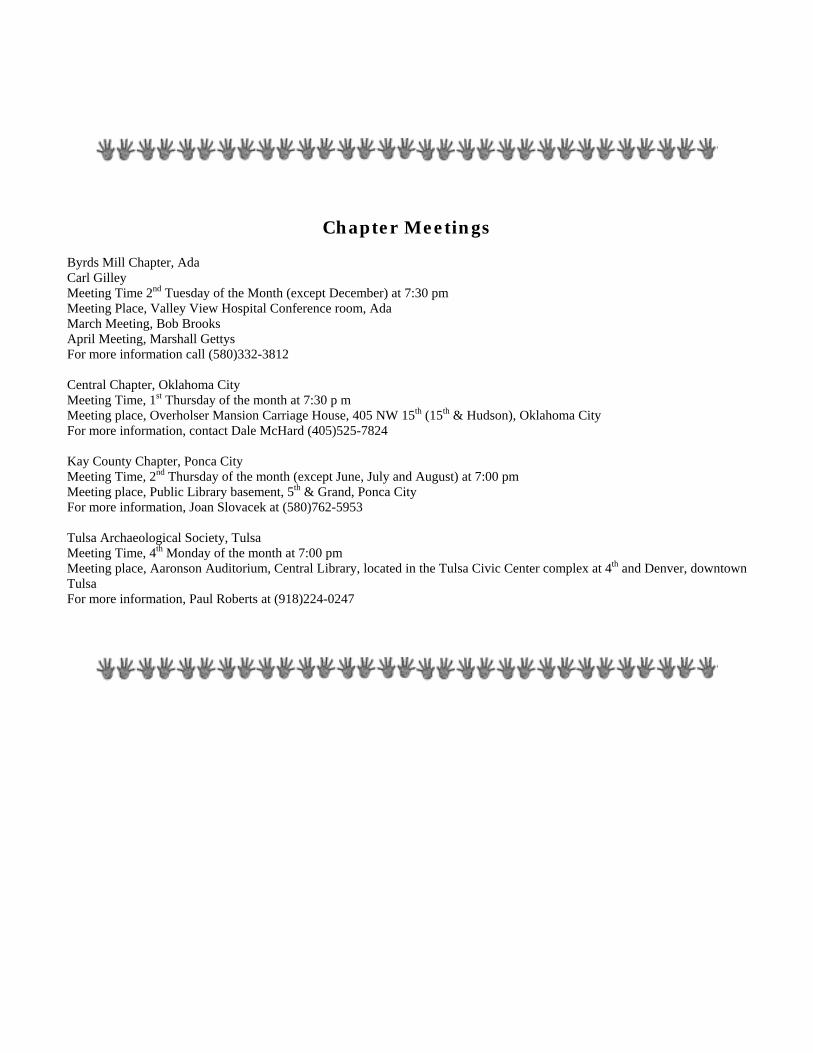
Chapter Meetings Byrds Mill Chapter, Ada Carl Gilley Meeting Time 2nd Tuesday of the Month (except December) at 7:30 pm Meeting Place, Valley View Hospital Conference room, Ada March Meeting, Bob Brooks April Meeting, Marshall Gettys For more information call (580)332-3812 Central Chapter, Oklahoma City Meeting Time, 1st Thursday of the month at 7:30 p m Meeting place, Overholser Mansion Carriage House, 405 NW 15th (15th & Hudson), Oklahoma City For more information, contact Dale McHard (405)525-7824 Kay County Chapter, Ponca City Meeting Time, 2nd Thursday of the month (except June, July and August) at 7:00 pm Meeting place, Public Library basement, 5th & Grand, Ponca City For more information, Joan Slovacek at (580)762-5953 Tulsa Archaeological Society, Tulsa Meeting Time, 4th Monday of the month at 7:00 pm Meeting place, Aaronson Auditorium, Central Library, located in the Tulsa Civic Center complex at 4th and Denver, downtown Tulsa For more information, Paul Roberts at (918)224-0247
Board of Direct Spring MeetingSpring Dig, Ma
RENEW YOUR SOFORM IN
DO YOU NEED TO RENEW? Plelabel below. Membership in
membership is paid through the eclass of membership; L = Life,Institutional. So "2002-C" wo
throu
Address Service Reque
Oklahoma Anthropological Society Rt. 1, Box 62B Cheyenne OK 73628
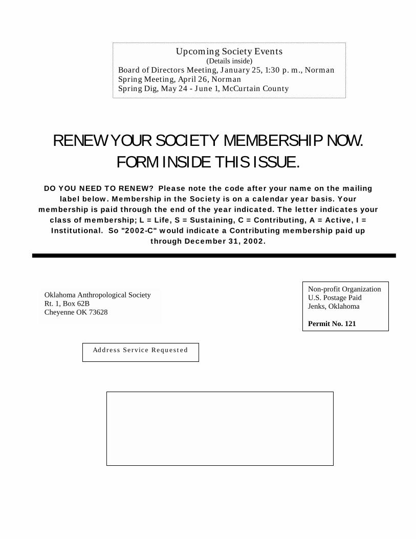
Upcoming Society Events (Details inside)
ors Meeting, January 25, 1:30 p. m., Norman, April 26, Norman y 24 - June 1, McCurtain County
CIETY MEMBERSHIP NOW. SIDE THIS ISSUE.
ase note the code after your name on the mailing the Society is on a calendar year basis. Your nd of the year indicated. The letter indicates your
S = Sustaining, C = Contributing, A = Active, I = uld indicate a Contributing membership paid up gh December 31, 2002.
sted
Non-profit Organization U.S. Postage Paid Jenks, Oklahoma Permit No. 121
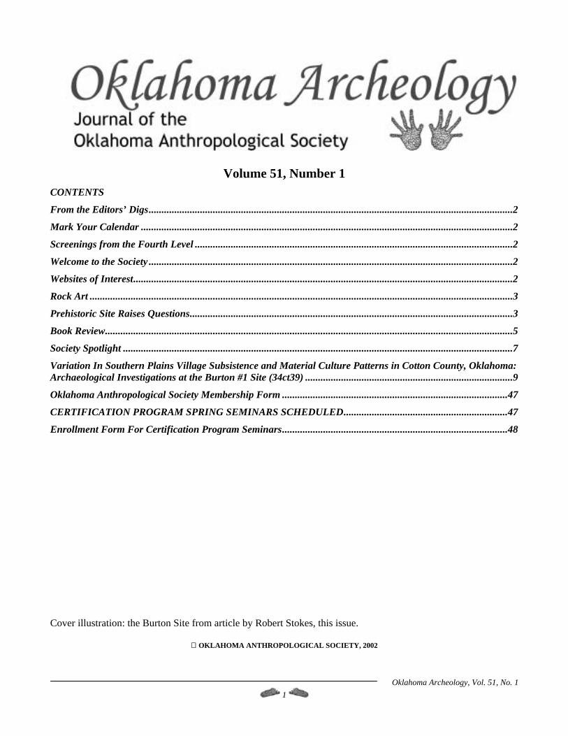
Volume 51, Number 1
CONTENTS
From the Editors’ Digs..............................................................................................................................................2 Mark Your Calendar .................................................................................................................................................2 Screenings from the Fourth Level ............................................................................................................................2 Welcome to the Society ..............................................................................................................................................2 Websites of Interest....................................................................................................................................................2 Rock Art .....................................................................................................................................................................3 Prehistoric Site Raises Questions..............................................................................................................................3 Book Review...............................................................................................................................................................5 Society Spotlight ........................................................................................................................................................7 Variation In Southern Plains Village Subsistence and Material Culture Patterns in Cotton County, Oklahoma: Archaeological Investigations at the Burton #1 Site (34ct39) .................................................................................9 Oklahoma Anthropological Society Membership Form ........................................................................................47 CERTIFICATION PROGRAM SPRING SEMINARS SCHEDULED................................................................47 Enrollment Form For Certification Program Seminars........................................................................................48 Cover illustration: the Burton Site from article by Robert Stokes, this issue.
OKLAHOMA ANTHROPOLOGICAL SOCIETY, 2002
Oklahoma Archeology, Vol. 51, No. 1 1
From the Editors’ Digs Screenings from the Fourth Level I feel that the Fall Meeting was quite a success based
on the quality and variety of the papers presented and the speakers. In my view from a strictly scientific and research standpoint, it was one of the best meetings we have had in some time. It was good to see the Sinclairs. My thanks to Richard Drass and Bob Brooks for their work in setting up the meeting with speakers, and my thanks also to the Program Committee for its work.
Greetings for the New Year! It was an interesting year for archeology in Oklahoma. We hope you got out to enjoy the meetings, the Spring Dig and the Fall Survey. The 50th anniversary celebration at the Sam Noble Museum was lots of fun and the papers at the fall meeting were outstanding. Thanks to the speakers who presented papers at our meetings this year. --- Dale McHard The Spring Dig in western Oklahoma at the Jake Bluff site gave us the exciting find of a Clovis bison kill, one of the few recorded bison kill sites for the time period. Lee Bement keeps finding those interesting sites, and it’s exciting to think of the future of Paleo research in the state. We can all feel proud that the Society continues to make a significant contribution to this important research.
Welcome to the Society New Members, 08/16/2002 through 11/15/2002
Sustaining
Darrell W. & Eva G. Dilks, Moore, OK Stephen Perkins & Kathryn Wullstein, Edmond, OK
Contributing Lauren, Peter, Joshua, Victoria, Brianna, & Samantha
Cleeland, Purcell, OK Dave Morgan and his band of surveyors have made a significant contribution, too, in completing the Lake Murray State Park survey. Their diligence has helped add more than 50 sites to the state’s register of archeological sites.
Ben & Katie Kamphaus, Norman, OK Dr. Susana Katz, Panhandle, TX
Rose Swope, Oklahoma City, OK Susanne Weinberger, Stillwater, OK
Active Paul N. Backhouse, Lubbock, TX Just a reminder that it’s time to send in your dues for 2003. We have an interesting series of articles on the Antelope Creek phase Stamper site written by Chris Lintz coming up for the next three issues of the Journal. It’s part archaeology and part detective story; Chris has done an amazing job of piecing together a fascinating story about an important site and some interesting personalities from archeology in Oklahoma in the 1930’s. You won’t want to miss it.
Bob Bearden, Hot Springs, AR Stephanie Gordon, Bethany, OK Nichole L. Hamm, Owasso, OK
Stuart E. McAllister, Cleveland, OK Donna Otto, Claude, TX
Mike Reynolds, Stonewall, OK Institutional
State University of New York at Albany
Richard Drass Mary Ann Drass
Mark Your Calendar December 1, 2002 January 2002 Board of Directors Meeting
The January Board meeting has been scheduled to meet on January 25, starting at 1:30 p. m. at the Oklahoma Archeological Survey office in Norman. Everyone is invited to attend.
Websites of Interest Websites on Spiro obsidian sourced to Mexico (thanks to Paul Roberts).
2003 OAS Spring Meeting http://www.dallasdino.org/newsletter/Jan01V10Is1.pdf The Spring Meeting is set for April 26, 2003, in the auditorium of the Sam Noble Oklahoma Museum of Natural History in Norman.
http://www.obsidianlab.com/research_spiro.html
The 2003 Spring Dig May 24 to June 1, McCurtain County.
Oklahoma Archeology, Vol. 51, No. 1 2

Rock Art Seth Hawkins
Prehistoric Site Raises Questions Trove of artifacts challenges view of
Folsom people By Nancy Lofholm Reprinted with permission from: Denver Post Western Slope Bureau Sunday, September 01, 2002 - GUNNISON - The 400-foot-high "W" on a mountainside over Gunnison is a notable symbol for Western State College. But nowadays it might also stand for the "why" of an ancient archaeological mystery. A primitive camp above the white-washed rock "W" in two years has yielded a trove of unusual stone weapon points made on that spot more than 2,500 years before the pyramids were built in Egypt and more than 5,000 years before the cliff houses were erected at Mesa Verde. The site is shaping up to be one of the premier - and most puzzling - archaeological digs in the country. So far, the 24,000 stone points, engravers, notchers, bits of weapons, bone and stone fragments and other artifacts found at the Mountaineer site indicate this
was the site of a veritable long-term ancient weapon-making operation. The find throws several long-held beliefs about a period more than 10,000 years ago into question in a number of areas: The Folsom Period people who worked and hunted here were not living where common anthropological theory says they should have been. Folsom people were thought to have been mainly plains hunters and gatherers. They also worked and hunted on W mountain much longer than anthropologists previously believed the mostly nomadic Folsom people ever stayed in one place. And they were still making Folsom points there long after archaeologists believed the Folsom Period ended. Carbon dating has found that one of the points recovered at the Mountaineer site is approximately 7,000 years old. That's about 3,000 years newer than any Folsom points found previously. The Folsom Period was believed to be from 10,200 to 10,900 years ago.
Oklahoma Archeology, Vol. 51, No. 1 3
More carbon dating on pieces of other points is expected to show some of them are as much as 11,000 years old, which would put them in the earlier Clovis Period.
The site on "W" Mountain has yielded other finds along with artifacts. Stiger can point to an ancient fire ring where careful excavation has indicated ancient hunters sat and chipped away at quartzite to create the points.
All this adds up to a buzz of new intrigue in the archaeological community. He has also found rock-lined depressions on the edge
of the mountain overlooking Gunnison that were believed to have been used as hunting blinds and possibly as storage pits for meat in winter.
"We're still scratching our heads on this one. One more time we're being told we don't really know that much. Archaeology is telling us something new. We have to discard some of our old notions and ideas," said Dr. Mark Stiger, the professor of anthropology at Western State who found the site when he was scouting a location for a new communications tower on the mountain.
The area that archaeologists refer to as "the site that just keeps on giving" will get scrutiny when the Colorado Archaeological Society meets here Sept. 28 and 29 for the group's annual meeting.
Stiger initially found numerous flakes and bits of stone points on the surface.
Meg Van Ness, an archaeologist with the Colorado Historical Society, said archaeologists hope to find out much more about the Folsom people from this site. With a little shallow digging - less than a foot in some
areas - he and a group of students have found more than 100 parts or complete specimens of Folsom points.
"It's so incredibly significant because we can say something more about their hunting and we can say something more about their lives now," she said.
These rare points are blunter shaped than other arrowheads but are cut as thin and sharp as broken glass.
Archaeologists and students from Southern Methodist University have already spent time digging alongside Stiger at the site, and some of those students are writing their theses and dissertations on the W mountain dig.
They have delicate fins on the bottom and have channels where spears or arrows were fastened. "This site is so large. There is none other that large in
that time period," said Brian Andrews, a Southern Methodist graduate student who is writing his doctoral dissertation on the oddities of the site. "And so far only about 1 percent of it has been excavated. I think this will be considered a major site."
Those channels were made by striking one well-placed blow, which is part of the reason Folsom points are considered by archaeologists to be some of the finest rock work ever done by humans.
"You can see the sequence of making these," Stiger said as he pointed to the details of Folsom points now numbered and stored in the new science building at Western State. "You can see everything but the curse words."
A few Folsom points have been found in the mountains of the Western Slope over the past 70 years, but archaeologists had theorized that those were discarded or dropped by Utes who had found them on their travels to the plains. Most Folsom points found previously in Colorado have come from ancient campsites north of Fort Collins and in the San Luis Valley
Oklahoma Archeology, Vol. 51, No. 1 4
Book Review With the close of the Civil War, many military men who held high office in the Union Army were delegated to far lesser jobs at minimal pay. Custer was one such major general reduced to the rank of captain and assigned to routine duty in Texas. With his large ego, this position was not to last long.
Custer, Black Kettle, and the Fight on the Washita By Charles J. Brill Forward by Mark L. Gardner
Reviewed by: Pamela S. Wallace, Ph.D.
(Published by University of Oklahoma Press 2001. Previously published as Conquest of the Southern Plains. Oklahoma City: Golden Saga Publishers 1938)
In September 1868, General Sheridan and Sherman (of the infamous march to Atlanta) saw that Custer was released from temporary suspension related to a previous court-martial in order to lead the Seventh Calvary against the Indians of the Plains.
How many Americans, much less Oklahomans, know the story of the Battle (Massacre) of the Washita and how it affected the final defeat of George Armstrong Custer at Little Big Horn? Some people may have heard the name Black Kettle on the television show Dr. Quinn, Medicine Woman or perhaps know of the Sand Creek Massacre in Colorado. These sources are a beginning. The story of the Washita encounter is complex with many sides offering a variety of opinions.
It was not uncommon for the military to “punish” Indians who had done some disservice or broken a perceived treaty point. It made no difference that the deed was performed by one tribal group. Another group was often punished for the offense. A portion of the blame for the Washita massacre must be attributed to such policy. Brill presents an excellent format to tell this tragic
story. He interviewed Cheyenne survivors of the massacre and other Native people living in the same area during that time; he records in the appendix the various government and military documents directly related; and he attempts to give a broader perspective of both the battle and reasons for the Plains Indian wars that erupted following the U.S. Civil War. For an entire group of Native people in Oklahoma, November 27, 1868 was a day of death and destruction, but also the mark of resilience of the Cheyenne people and their culture into the present day.
In the winter of 1868, between Black Kettle’s camp along the Washita and Ft. Cobb were camped over 6,000 Cheyenne, Arapaho, Kiowa, and Comanche people, nearly all of the non-reservation people of the Southern Plains. Custer selected Black Kettle’s camp for annihilation. That decision helped draw many Plains people together as one to finally defeat Custer. Just a month before the Washita encounter, U.S. Indian Agent Wynkoop stated in his official report that had Congress seen the injustices done to these people, there would not be sufficient money in U.S. Treasury to make appropriations.
Weaknesses in the book itself include: no index, no maps of the larger area to understand the movement of both Native people and military troops, and some terminology that is inappropriate today such as squaw and papoose. I will not go into content detail, but give the reader a few points to ponder and hopefully give reasons to read this excellent resource:
The winter of 1868 had turned harsh with several inches of snow on the ground. Knowing the military was moving towards them, Black Kettle and his advisors decided to move their camp the next day closer to neighboring villages for protection. He waited one day too long. Custer attacked at dawn.
The Washita massacre occurred just four years after the Sand Creek massacre. The attack was on the same band of Cheyenne led by Black Kettle who had negotiated with the federal government to end the strife between both peoples under the Treaty of Medicine Lodge. Black Kettle’s band was at peace, or so they believed with the “Great White Father.”
Chapter eight of Brill’s book details from the Cheyenne perspective that early snowy morning on November 27, 1868. From the first alert by a Cheyenne woman to the last dying breath of Black Kettle and his wife, the story is told in detail.
Oklahoma Archeology, Vol. 51, No. 1 5
If you want an actual experience that brings this story to life, I would encourage you to visit the Washita Battlefield which is a National Historic Site. With a map from the National Park Service in Cheyenne, you can follow the story and see the places described. If you are lucky on your trip, stop in Clinton at the Cheyenne Cultural Center, perhaps Peace Chief Lawrence Hart will be available to tell you the story of the making of the national park. He spoke before Congress once explaining that this was “sacred place” and needed to be preserved for those who had died. Congressional members did not seem to understand this concept and did not cast votes in favor of a national landmark. However, this decision was reversed in 1996. Among others, Chief Hart spoke once more of “sacred ground” and now it was understood – the Murrah Building bombing had happened two years before, “sacred ground” became for the first time a common symbol between two different cultures.
Custer believed in “equal” treatment for all Indians. At the Washita, he claimed that he killed 103 Indians. According to the Cheyenne, only 11 were warriors, the remainder would have been women, children, and elders. Other reports from military men substantiated this, noting the very large number of women and children killed with only 53 taken captive. Read the words of Magpie as he describes being wounded and his eventual escape. Read Little Beaver’s recollections of the massacre viewed through his eyes as a twelve year old boy. Read how a few women and children were saved by Kiowa and Arapaho warriors who had gotten word of the battle. Find out how an entire detachment under General Elliot was destroyed by Cheyenne warriors from other camps, with the aid of Kiowa and Arapaho. Learn why Custer did not come to Elliot’s aid and how he answered his superiors for this breach of military ethics.
There is a wonderful excursion through western Oklahoma, called the Cheyenne Trail. It goes from Ft. Reno north to Roman Nose State Park, westward to Ft. Supply then south through the Antelope hills, Cheyenne, and Clinton. Follow the brilliant blue and yellow road signs. Here, you will see the places spoken of in Brill’s account, see the wonder of western Oklahoma, and learn how such tragedy can become a learning experience for all people. The book itself is worth the effort, the trail is an exceptional addition that can only be found here in Oklahoma where those events took place nearly 135 years ago.
The tribes from the surrounding area could have destroyed Custer’s troops following the Washita. With his bravado, Custer was certainly ready to continue the fight. Only one person stood in his path and gave him advice that would allow Custer and his men to live and fight another day. The entire village of 300-400 people was burned to the ground. Eight hundred (800) ponies were rounded up and shot. Only a few ponies were needed to move prisoners or soldiers.
Daughter of Little Rock, second to Black Kettle, Monahseetah, a young female captive of Washita drew the eye of Custer. He refers to her often in his notes and she later gave birth to a child with yellow hair and fair skin named Yellow Swallow.
The following book is available for review. Let us know if you’re willing to review the book; it’s yours to keep. Editors.
Brill is not the ultimate answer to the questions of the Washita encounter or of war on the Plains. His account does provide a very different view than previously held in the 1930s when the book was originally published. Neither historian nor anthropologist, Brill used many of the tools of both disciplines to give a broader perspective and help set the stage for both academic questions and popular understanding of this tremendous clash of cultures. For the Cheyenne people, he allows their voice to be heard for the first time in a way that many can read and learn from this event in our history.
Hyslop, Stephen G. 2002 Bound for Santa Fe: The Road to New Mexico and the American Conquest, 1806-1848. University of Oklahoma Press.
Oklahoma Archeology, Vol. 51, No. 1 6
Society Spotlight
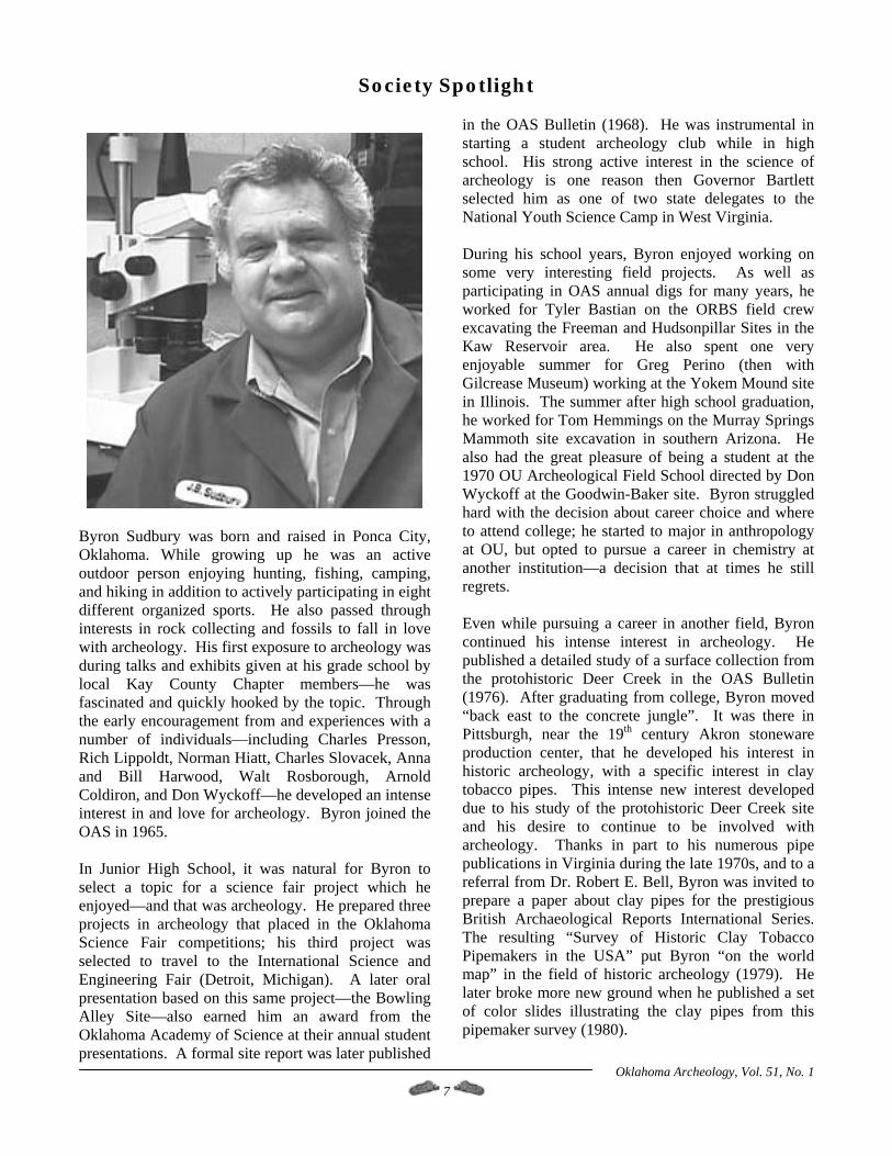
Byron Sudbury was born and raised in Ponca City, Oklahoma. While growing up he was an active outdoor person enjoying hunting, fishing, camping, and hiking in addition to actively participating in eight different organized sports. He also passed through interests in rock collecting and fossils to fall in love with archeology. His first exposure to archeology was during talks and exhibits given at his grade school by local Kay County Chapter members—he was fascinated and quickly hooked by the topic. Through the early encouragement from and experiences with a number of individuals—including Charles Presson, Rich Lippoldt, Norman Hiatt, Charles Slovacek, Anna and Bill Harwood, Walt Rosborough, Arnold Coldiron, and Don Wyckoff—he developed an intense interest in and love for archeology. Byron joined the OAS in 1965. In Junior High School, it was natural for Byron to select a topic for a science fair project which he enjoyed—and that was archeology. He prepared three projects in archeology that placed in the Oklahoma Science Fair competitions; his third project was selected to travel to the International Science and Engineering Fair (Detroit, Michigan). A later oral presentation based on this same project—the Bowling Alley Site—also earned him an award from the Oklahoma Academy of Science at their annual student presentations. A formal site report was later published
in the OAS Bulletin (1968). He was instrumental in starting a student archeology club while in high school. His strong active interest in the science of archeology is one reason then Governor Bartlett selected him as one of two state delegates to the National Youth Science Camp in West Virginia. During his school years, Byron enjoyed working on some very interesting field projects. As well as participating in OAS annual digs for many years, he worked for Tyler Bastian on the ORBS field crew excavating the Freeman and Hudsonpillar Sites in the Kaw Reservoir area. He also spent one very enjoyable summer for Greg Perino (then with Gilcrease Museum) working at the Yokem Mound site in Illinois. The summer after high school graduation, he worked for Tom Hemmings on the Murray Springs Mammoth site excavation in southern Arizona. He also had the great pleasure of being a student at the 1970 OU Archeological Field School directed by Don Wyckoff at the Goodwin-Baker site. Byron struggled hard with the decision about career choice and where to attend college; he started to major in anthropology at OU, but opted to pursue a career in chemistry at another institution—a decision that at times he still regrets. Even while pursuing a career in another field, Byron continued his intense interest in archeology. He published a detailed study of a surface collection from the protohistoric Deer Creek in the OAS Bulletin (1976). After graduating from college, Byron moved “back east to the concrete jungle”. It was there in Pittsburgh, near the 19th century Akron stoneware production center, that he developed his interest in historic archeology, with a specific interest in clay tobacco pipes. This intense new interest developed due to his study of the protohistoric Deer Creek site and his desire to continue to be involved with archeology. Thanks in part to his numerous pipe publications in Virginia during the late 1970s, and to a referral from Dr. Robert E. Bell, Byron was invited to prepare a paper about clay pipes for the prestigious British Archaeological Reports International Series. The resulting “Survey of Historic Clay Tobacco Pipemakers in the USA” put Byron “on the world map” in the field of historic archeology (1979). He later broke more new ground when he published a set of color slides illustrating the clay pipes from this pipemaker survey (1980).
Oklahoma Archeology, Vol. 51, No. 1 7
He remained active in archeology while living in Pennsylvania, and began corresponding with Bob Everett about pipes, and then about the Oklahoma Certification program (Byron started an archeology newsletter in Pennsylvania in the late 1970s, and was involved in the Pennsylvania certification program as an instructor). When Byron returned to Oklahoma in 1980, he actually became a primary author for the original OAS Certification Program. Although family responsibilities have served to somewhat limit his field and research activities during the past two decades, he has remained active in Oklahoma archeology serving on the Certification Council and as a chapter officer. He was elected to the OAS Board of Directors, and was recently appointed as chairperson of the Golden Trowel Awards Committee. Byron also publishes an occasional monograph series about clay tobacco pipes, and actively participates in field activities whenever possible. As Byron was nurtured and tutored by others to grow and develop his interest when he was young in the field, one of his major avocational career highlights was in helping introduce other major players to the discipline (locally, Barry Splawn and Mick Sullivan). Byron also very much enjoyed the various field opportunities where his children were able to work with him, the latest of which was at the Kubik site. Byron was awarded an OAS Golden Trowel award in 1998 in recognition of his 30+ years of productive service, activity, leadership, and publications. Byron is a life member of eight different state archeological societies. During a recent employment downturn, Byron returned to school at UCO and earned his Masters Degree (with Honors) in Forensic Science/Criminalistics. Byron then set up his own analytical chemistry laboratory to perform contract work. For his research project in scanning electron microscopy class at UCO he isolated and visualized phytoliths from the Waugh Folsom site (2000). Thus, Byron continues his archeological interests no matter what particular discipline he is actually pursuing. Byron remains very active in the OAS, but he is even more active in pursuing his own research interests in archeology. He continues to monitor the fluvial study that he originally published with Mick (1990), and is also actively engaged in research projects involving clay tobacco pipes, gun flints, trade beads, and is trying to help initiate a major phytolith research project. He is also developing a web site to help
disseminate information about clay pipes (claypipes.com) and intends to release data CDs incorporating color photographs of clay pipes for reference use. Although he remains committed to and involved in his major hobby, he feels that the focus and the most important accomplishment in his life is as a single parent having raised two outstanding children—John and Laura. References Cited “Ka-131, THE BOWLING ALLEY SITE: A Late Prehistoric Site in Kay County, Oklahoma,” in Bulletin of the Oklahoma Anthropological Society, Vol. XVII, pp. 87-135. “Ka-3, The Deer Creek Site. An Eighteenth Century French Contact Site in Kay County, Oklahoma,” in Bulletin of the Oklahoma Anthropological Society, Vol. XXIV, pp. 1-135. “Historic Clay Tobacco Pipemakers in the United States of America,” in The Archaeology of the Clay Tobacco Pipe, II, British Archaeological Reports International Series Vol. 60, pp. 151-341. 1980 Historic Clay Tobacco Pipes Manufactured in the U.S.A. – A Slide Collection. Looseleaf Notebook and 60 slides, privately printed. & Michael J. Sullivan. “Sudbury Lithic Experiment – A Preliminary Report,” in Newsletter of the Oklahoma Anthropological Society, 38(2), pp. 2-3. ms. “SEM Evaluation of Plant Remains in Selected Soil and Ash Samples from the Waugh Site, 34HP42: A Folsom Campsite and Buffalo Processing Station in Western Oklahoma.” (December 5, 2000).
Oklahoma Archeology, Vol. 51, No. 1 8
Variation In Southern Plains Village Subsistence and Material Culture Patterns in Cotton County, Oklahoma: Archaeological Investigations at the Burton #1 Site
(34ct39)
Robert J. Stokes
with Faunal Analysis by Kari Schmidt
INTRODUCTION
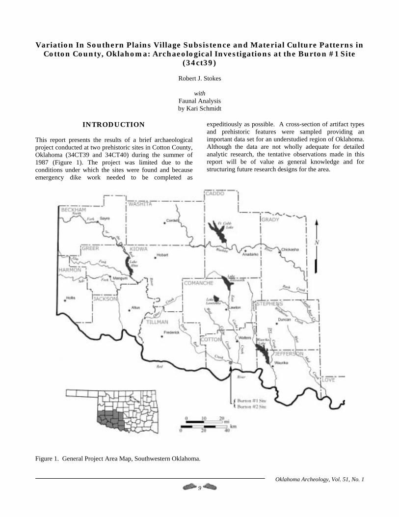
This report presents the results of a brief archaeological project conducted at two prehistoric sites in Cotton County, Oklahoma (34CT39 and 34CT40) during the summer of 1987 (Figure 1). The project was limited due to the conditions under which the sites were found and because emergency dike work needed to be completed as
expeditiously as possible. A cross-section of artifact types and prehistoric features were sampled providing an important data set for an understudied region of Oklahoma. Although the data are not wholly adequate for detailed analytic research, the tentative observations made in this report will be of value as general knowledge and for structuring future research designs for the area.
Figure 1. General Project Area Map, Southwestern Oklahoma.
Oklahoma Archeology, Vol. 51, No. 1 9
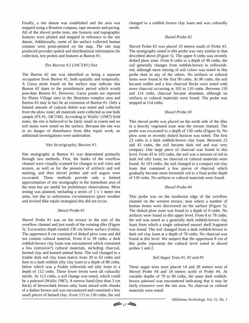
Project History and Background In June 1987, the Oklahoma Archaeological Survey was contacted by a local collector about a human burial exposed as a result of recent flooding along Deep Red Creek, Cotton County. The flooding partially destroyed an existing dike along the creek and retrenched an earlier overflow channel through a field behind the dike. Dr. Robert Brooks, State Archaeologist, visited the site to inspect the human remains and determine the extent of the disturbance to archaeological resources. Because the proposed construction project was to repair an existing dike, Brooks requested that Charles Wallis, Oklahoma Conservation Commission (OCC) Archaeologist, accompany him to the project area. The presence of unmarked human graves was confirmed in addition to an extensive surface scatter of prehistoric artifacts. The area was recorded as 34CT39, Burton #1, in the files of the Oklahoma Archeological Survey. Because the project was being funded through a federal emergency repair program, an environmental assessment report was not considered necessary. The U.S. Army Corps of Engineers office in Tulsa had already authorized this approach at the time the emergency program was approved for funding. Because the presence of unmarked human graves was confirmed within the project area, the Soil Conservation Service, OCC archaeologist and State Archaeologist agreed that a limited cultural resource salvage project was warranted and that removal of the human remains was required per state law before construction could resume. During the second visit to the site, Brooks excavated the burial noted on his first trip and salvaged a second burial exposed several meters to the south. Based on the presence of scattered human remains on the surface and in the overflow channel, a third and possible fourth burial were suspected. A local collector mentioned that at least one other burial had been exposed during earlier flooding. OCC personnel continued to periodically monitor the project and make controlled surface collections until September 1987. During the course of site survey and surface collections, five non-burial features were noted. These features were areas of dark fill exposed along the sides of the overflow channel away from the creek (Wallis 1987). It is not known what parts of the features were lost to flooding and heavy machinery disturbance. The features were flagged for excavation; however, vandals struck the site between the 14th and 20th of August 1987 and dug up four features marked by pin flags. Because the vandals left the feature fill in unscreened piles next to each pit, important data were still believed to be salvageable; however, feature size and shape were lost. All fill from Features 3 and 4 and a sample from Feature 1 were bagged for water screening. No fill was collected from Feature 2 and Feature 5 was not investigated.
Due to poor weather and time constraints, only four shovel probes were placed in the site area with three being within the location slated for borrow. Blade work was restricted to the immediate dike location and previously disturbed areas. The existing dike was repaired using fill dirt recovered off site. Shovel probe testing at the site proved to be useful for determining the site's boundary and stratigraphy. We were able to make some inferences and generalizations regarding site size, intensity of site occupation and resource utilization patterns, but not intra-site patterning with reference to habitation areas, work areas and feature distributions. These limitations to the data set constrain interpretations and conclusions. On August 14, 1987, Wallis recorded a second site located to the southwest of 34CT39. The recovery of a Garza point suggested a later occupation for this corner of the field than was suspected for the main part of Burton #1. It was decided that this area should receive a site designation and became the Burton #2 site, 34CT40. Only a small artifact surface collection was appropriated from this site.
Research Focus for Burton #1 The available data limit what can be said about these two sites. Investigations geared toward general issues of subsistence and economy are feasible. In particular, we can investigate subsistence and lithic resource use patterns of the Southern Plains Villagers who resided at Burton #1. It is generally assumed that Plains Villagers relied heavily on agriculture for subsistence (e.g., Bell 1984; Brooks 1989; Drass 1997) augmented by seasonal bison hunts (Vehik 1994), but because of the limited research conducted in southwestern Oklahoma, these patterns remain to be documented for this area.
Oklahoma Archeology, Vol. 51, No. 1 10
Initially, Burton #1 was thought to contain two cultural components, a Plains Village occupation underlain by a Plains Woodland component (Wallis 1987). The Woodland component was viewed as being buried beneath flood deposits with evidence exposed in the sides of the overflow channel. This initial determination was based on the presence of artifact types including Gary and Scallorn points and expedient (unshaped and lightly used) grinding stones and on the absence of bison remains and ceramics in the lower, buried component. Additionally, a dark band was noted in the overflow channel bank that appeared to contain charcoal and artifacts. This band is apparently thin (ca. 3 to 10 cm) where exposed in the vertical sides of the overflow channel near the creek, but is more diffuse away from the creek where the overflow channel is wider and shallower, especially along its western edge (e.g., the burial area). The dark band was observed on both walls of the channel which indicates that at least a portion of the site was bisected and impacted by flooding. Artifacts were noted on the slope of the channel and are believed to have originated from these dark bands. The suspected upper component, found in the
plow zone (terrace and field areas) and on the channel surface above the dark bands, was thought to date later based on the presence of a Fresno point, non-cordmarked pottery and bison bone. The results of radiocarbon assays on charcoal from two of the features place them into the Plains Village time period and not Plains Woodland as originally thought. It is clear now that the dark band, which we believe is a vertical exposure of a prehistoric occupation surface, plus the features and the burials are Plains Village and the bulk of the artifacts are from this same horizon. The time range generally assigned to Gary, Scallorn and Fresno projectile points tend to overlap, so it is not unreasonable to suggest that only one cultural component exists at the site. Since only one cultural component exists at the site, research was focused on resource use patterns in the Late Prehistoric period and was geographically expanded so more direct comparisons could be made with contemporary and better known Washita River and Henrietta complex sites. This approach has the benefit of expanding our comparative data set in order to investigate broader cultural patterns. As a result, patterns were detected at Burton #1 that hint at variability within the Southern Plains Village tradition in this area in some aspects of subsistence and material culture. Although similar in many ways to Washita River and Henrietta complex sites, the variations found at Burton #1 may indicate localized cultural adaptation to a somewhat harsher natural environment than found further east along the Red River corridor in Oklahoma and Texas.
Research Questions and Goals Two research goals were formulated for this study. First, because fine-grained lithic raw materials are scarce in the general site area, we assume that the majority of lithic materials found on site will be locally available coarser-grained raw materials. These materials can be obtained from ancient river terraces and from more recently deposited alluvium along Deep Red Creek, Cache Creek and the Red River. Lithic materials found on ancient river terraces in this area are called Ogallala gravels which are a mixed collection of quartzites, cherts, chalcedonies, petrified wood and other lithic materials. Ogallala gravels originated in the Rocky Mountains to the west and were deposited as stream outwash on the western plains throughout the Pleistocene era (Banks 1990; Shelley 1993; Wyckoff 1993). Because Plains Villagers are believed to be sedentary agriculturalists, few non-local (exotic) lithic raw materials should be found in the overall lithic assemblage and those present may be traded rather than directly procured materials. If this is the case, then few non-local cores should be present at the site and tools made from non-local material should show evidence for curation and use to the point of exhaustion (Bamforth 1986; Morrow and Jeffries 1989; Nelson 1991). As a consequence of the absence of
cores and the curation of tools, non-local reduction debris should be primarily secondary, tertiary, touch-up and rejuvenation debris. Conversely, locally available materials should be ubiquitous in the assemblage and all stages of reduction debris should be present, including tested and moderately-to-well used cores. Expedient tools should be made from lower-quality local materials while more formal tools should be made from higher quality local and non-local materials (Bamforth 1986). If the occupants of Burton #1 were more mobile, then few usable finished tools of high-quality and non-local materials should be found at the site, as these items would have been taken to the next camp. Consequently, only fine-grained reduction debris and exhausted or broken tools will be found (Bamforth 1986; Binford 1979). If the occupants of Burton #1 were more sedentary, then a higher percentage of usable and unusable tools mixed with both low and high-quality reduction debris should be found at the site (Morrow and Jeffries 1989; Nelson 1991). A second research goal was to examine subsistence activities at the site and then compare how they articulate with known Southern Plains Village patterns. If the occupants of Burton #1 were primarily agriculturalists who also practiced seasonal bison hunting, we would expect to see evidence for cultigens (maize primarily) and bison remains, mixed with wild plant foods and other prey items. The bison remains should be limited to more transportable segments, such as hindquarters and thighs (D. Hughes 1977; Vehik 1994), although nearby kills may skew this prediction as every effort would be made to bring back as much of the bison as possible to the village. Alternatively, if we find little evidence for agriculture, either directly in the form of burned maize cobs or kernels, or indirectly in the absence of large, basin-shaped grinding stones and digging tools, then this may suggest less sedentary behavior. A determination for either (or neither) pattern at Burton #1 would be important for characterizing some aspects of Southern Plains Village subsistence in this area.
Oklahoma Archeology, Vol. 51, No. 1 11
Issues of decreasing mobility and changing subsistence strategies through time among Southern Plains groups are problems addressed in numerous studies covering the Late Archaic, Woodland and Late Prehistoric periods (Brooks 1994a; Drass 1997; Lintz 1986; Vehik 1984, 1994). In this part of the Southern Plains, few Archaic and Plains Woodland sites have been investigated which limits what can be said about changing subsistence and settlement patterns. However, several recent culture area syntheses of Plains Village occupations in south-central Oklahoma (e.g., Brooks 1989, 1994b; Drass 1997) and north-central Texas (Brooks 1989; Martin 1994; Prikryl 1990; Prikryl and Perttula 1995) are available. These syntheses primarily focus on the Washita River and Henrietta complexes and are updated and expanded versions of earlier syntheses (e.g., Bell 1973, 1984; Krieger 1946). If the results of the analyses in this report generally support the cultural patterns outlined for either of these areas, then the cultural boundaries for either can be more confidently expanded to
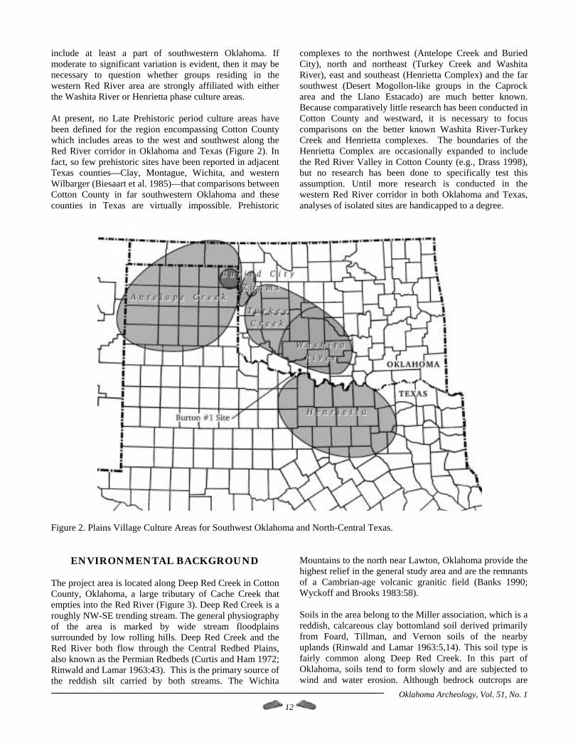
include at least a part of southwestern Oklahoma. If moderate to significant variation is evident, then it may be necessary to question whether groups residing in the western Red River area are strongly affiliated with either the Washita River or Henrietta phase culture areas. At present, no Late Prehistoric period culture areas have been defined for the region encompassing Cotton County which includes areas to the west and southwest along the Red River corridor in Oklahoma and Texas (Figure 2). In fact, so few prehistoric sites have been reported in adjacent Texas counties—Clay, Montague, Wichita, and western Wilbarger (Biesaart et al. 1985)—that comparisons between Cotton County in far southwestern Oklahoma and these counties in Texas are virtually impossible. Prehistoric
complexes to the northwest (Antelope Creek and Buried City), north and northeast (Turkey Creek and Washita River), east and southeast (Henrietta Complex) and the far southwest (Desert Mogollon-like groups in the Caprock area and the Llano Estacado) are much better known. Because comparatively little research has been conducted in Cotton County and westward, it is necessary to focus comparisons on the better known Washita River-Turkey Creek and Henrietta complexes. The boundaries of the Henrietta Complex are occasionally expanded to include the Red River Valley in Cotton County (e.g., Drass 1998), but no research has been done to specifically test this assumption. Until more research is conducted in the western Red River corridor in both Oklahoma and Texas, analyses of isolated sites are handicapped to a degree.
Figure 2. Plains Village Culture Areas for Southwest Oklahoma and North-Central Texas.
ENVIRONMENTAL BACKGROUND The project area is located along Deep Red Creek in Cotton County, Oklahoma, a large tributary of Cache Creek that empties into the Red River (Figure 3). Deep Red Creek is a roughly NW-SE trending stream. The general physiography of the area is marked by wide stream floodplains surrounded by low rolling hills. Deep Red Creek and the Red River both flow through the Central Redbed Plains, also known as the Permian Redbeds (Curtis and Ham 1972; Rinwald and Lamar 1963:43). This is the primary source of the reddish silt carried by both streams. The Wichita
Mountains to the north near Lawton, Oklahoma provide the highest relief in the general study area and are the remnants of a Cambrian-age volcanic granitic field (Banks 1990; Wyckoff and Brooks 1983:58). Soils in the area belong to the Miller association, which is a reddish, calcareous clay bottomland soil derived primarily from Foard, Tillman, and Vernon soils of the nearby uplands (Rinwald and Lamar 1963:5,14). This soil type is fairly common along Deep Red Creek. In this part of Oklahoma, soils tend to form slowly and are subjected to wind and water erosion. Although bedrock outcrops are
Oklahoma Archeology, Vol. 51, No. 1 12
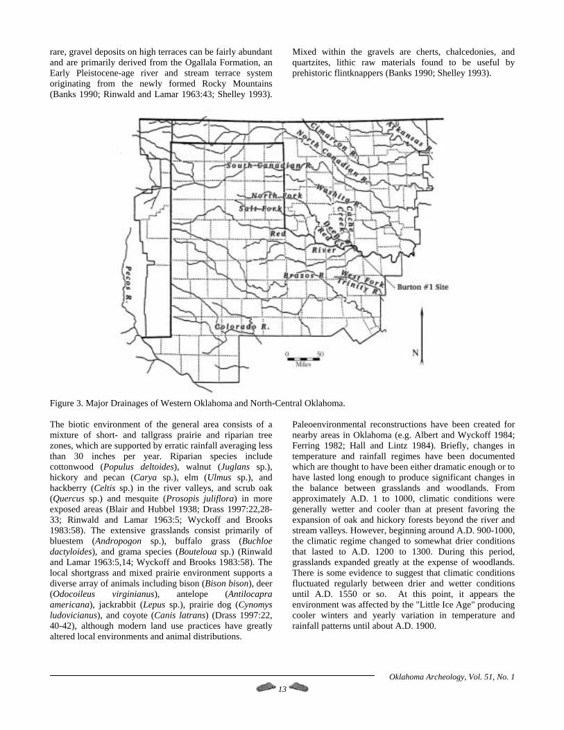
rare, gravel deposits on high terraces can be fairly abundant and are primarily derived from the Ogallala Formation, an Early Pleistocene-age river and stream terrace system originating from the newly formed Rocky Mountains (Banks 1990; Rinwald and Lamar 1963:43; Shelley 1993).
Mixed within the gravels are cherts, chalcedonies, and quartzites, lithic raw materials found to be useful by prehistoric flintknappers (Banks 1990; Shelley 1993).
Figure 3. Major Drainages of Western Oklahoma and North-Central Oklahoma. The biotic environment of the general area consists of a mixture of short- and tallgrass prairie and riparian tree zones, which are supported by erratic rainfall averaging less than 30 inches per year. Riparian species include cottonwood (Populus deltoides), walnut (Juglans sp.), hickory and pecan (Carya sp.), elm (Ulmus sp.), and hackberry (Celtis sp.) in the river valleys, and scrub oak (Quercus sp.) and mesquite (Prosopis juliflora) in more exposed areas (Blair and Hubbel 1938; Drass 1997:22,28-33; Rinwald and Lamar 1963:5; Wyckoff and Brooks 1983:58). The extensive grasslands consist primarily of bluestem (Andropogon sp.), buffalo grass (Buchloe dactyloides), and grama species (Bouteloua sp.) (Rinwald and Lamar 1963:5,14; Wyckoff and Brooks 1983:58). The local shortgrass and mixed prairie environment supports a diverse array of animals including bison (Bison bison), deer (Odocoileus virginianus), antelope (Antilocapra americana), jackrabbit (Lepus sp.), prairie dog (Cynomys ludovicianus), and coyote (Canis latrans) (Drass 1997:22, 40-42), although modern land use practices have greatly altered local environments and animal distributions.
Paleoenvironmental reconstructions have been created for nearby areas in Oklahoma (e.g. Albert and Wyckoff 1984; Ferring 1982; Hall and Lintz 1984). Briefly, changes in temperature and rainfall regimes have been documented which are thought to have been either dramatic enough or to have lasted long enough to produce significant changes in the balance between grasslands and woodlands. From approximately A.D. 1 to 1000, climatic conditions were generally wetter and cooler than at present favoring the expansion of oak and hickory forests beyond the river and stream valleys. However, beginning around A.D. 900-1000, the climatic regime changed to somewhat drier conditions that lasted to A.D. 1200 to 1300. During this period, grasslands expanded greatly at the expense of woodlands. There is some evidence to suggest that climatic conditions fluctuated regularly between drier and wetter conditions until A.D. 1550 or so. At this point, it appears the environment was affected by the "Little Ice Age" producing cooler winters and yearly variation in temperature and rainfall patterns until about A.D. 1900.
Oklahoma Archeology, Vol. 51, No. 1 13

PREVIOUS ARCHAEOLOGICAL RESEARCH IN COTTON COUNTY
The southwestern tier of counties, including Cotton County, remains one of the least studied areas in the state. Cotton County is primarily agricultural and the lack of a diversified economic base has had the effect of limiting federally mandated compliance work and research oriented survey and excavation. Additionally, only one major reservoir project in Cotton County required archaeological clearance work (Waurika Reservoir), unlike many other counties in Oklahoma. The construction of Interstate 44 through the eastern part of the county was completed without benefit of archaeological research although some survey and testing along the highway corridor was later accomplished (Anderson and Bearden 1992). As a result of the lack of federal projects, the number of sites recorded for the county is low. Many of the recorded sites date to the Historic period and many of the others are unassigned prehistoric. This situation makes any discussion of prehistoric occupations in Cotton County very difficult. Despite the limited database for Cotton County, a number of recorded sites do contain lists of artifact types and many sites have been assigned to particular temporal/cultural periods. This information is useful for outlining a sketch of cultural developments in the general area in addition to providing a comparative database for the Burton #1 site. While sites are assigned to the Late Prehistoric period, none have been broken down further into Washita River or Henrietta complex. Spivey et al. (1977:11-15) suggest that Plains Village sites should resemble Henrietta complex sites of north–central Texas based on proximity and topography. However, this assumption has not been tested to date. Site records were queried at the Oklahoma Archaeological Survey in Norman for data on both archaeological sites and research/CRM projects. The number of recorded sites is small compared to other Oklahoma counties, as are survey and testing projects. Much of the county’s cultural resource programs have been concentrated along its major streams and rivers, including the Red River to the south and its primary tributaries, Cache Creek, West Cache Creek and Deep Red Creek. Prehistoric groups were invariably drawn to important water sources and there is no reason to believe that Cotton County is an exception to this rule. To date, 111 sites have been formally recorded for Cotton County. Sixty-eight sites are listed as prehistoric, of which 75 percent (n=51) are unassigned to any age or cultural group. Of the remaining prehistoric sites, one is possibly Paleoindian, two are Archaic, nine are Plains Woodland and 11 are Plains Village (many are cross-listed as multi-component sites). No sites that are definitely protohistoric have been recorded. Included in these overall totals are the Burton #1 and #2 sites; they were recorded as Plains Woodland-Plains Village and protohistoric sites
respectively. Beyond frequency counting for each category, little more is known about these identifiable prehistoric sites. None have been extensively tested or researched except 34CT17 where two early Plains Village burials were excavated (Hofman 1977). The Burton #1 site probably provides the best data available for any prehistoric habitation site in Cotton County.
Some Generalizations on Site Type and Site Location in Cotton County
Little can be said at this point for Paleoindian and Archaic occupations except that they are either few in number or deeply buried. The distribution of Archaic sites is primarily along streams (although 34CT96 is in an upland setting) and they may be small campsites and special use sites. Local Ogallala quartzites and cherts dominate lithic assemblages, which include exhausted cores and formal tools (Yarbrough projectile points and a variety of scrapers.) Plains Woodland sites appear to be camps, and most are on terraces and floodplains along major water courses although several sites may be in the uplands above stream valleys. These latter sites, however, are identified as Woodland to protohistoric and are of little use for reconstructing prehistoric patterns without a tighter date range. No agricultural tools have been reported for any of these sites and very few contain pottery. Diagnostic projectile points include Gary, Scallorn, Ellis and Yarbrough types. Because it is difficult to discern general settlement, subsistence and material culture patterns for the Cotton County area, their relationships to other Plains Woodland traditions in the Southern Plains remain problematical. Plains Village sites are also generally located along the same river courses and in the same topographic settings as sites dating to the Plains Woodland period. None of these sites have been studied (except the Burton #1 site), so we cannot state whether they represent villages, farming hamlets, or camps; the diversity of artifact types reported is generally much greater for Late Prehistoric period sites than for Plains Woodland sites. Diagnostic projectile points for the Late Prehistoric period sites include Fresno, Washita and Harrell points, although Scallorns are also occasionally reported. In general, other artifact types remain poorly described, including pottery, groundstone, agricultural tools and ornamental items. Lithic assemblages are composed primarily of locally available materials, but Edwards, Alibates, Tecovas, Frisco and Florence cherts have been noted. Very little subsistence data are available except for the occasional mention of bison remains noted at some of the sites.
Oklahoma Archeology, Vol. 51, No. 1 14
The protohistoric period in Cotton County is poorly represented in the state records. A Garza point base found at Burton #2 (34CT40) is suggestive of a protohistoric time frame; however, few similar occurrences have been recorded. At this point, it cannot be determined if
protohistoric sites have been missed during survey (identification problems) or if the area was actually abandoned during this tumultuous time period. DATA RECOVERY METHODOLOGY FOR
BURTON #1 (34CT39) The bulk of the data collected from the Burton #1 site (34CT39) and from Burton #2 (34CT40) are from surface and erosional contexts, but numerous artifacts and other samples were gathered from shovel probes and feature fill which helps to somewhat balance the more limited information potential of just surface collections. Overall, the varied nature of data collection has helped to ensure that important information was gathered which can be used for addressing the subsistence and material culture questions outlined earlier in this report. This section will begin with a discussion of the general site setting and how it affected artifact collection, followed by a brief description of Burton #2 and the collection strategy employed there.
The Site Setting Both sites are on the southern floodplain and low terrace of Deep Red Creek near its confluence with West Cache Creek. A small ephemeral drainage traverses the northwest edge of the site where it ultimately joins Deep Red Creek north of the site. The general topography of the area is fairly level with a series of low terraces bordering the creek from its gently upward sloping floodplain. The lower site area is subject to occasional flooding, sediment deposition and scouring, as evidenced by the flooding events of 1987 and the entrenchment of the overflow channel. The formation of the overflow channel coupled with decades of agricultural disturbance and, more recently, by heavy machinery disturbance associated with attempts to rebuild the dike have had a land altering impact on portions of Burton #1. Several probes were placed in the plow zone near the overflow channel so that the natural stratigraphy of the site area could be better understood. Based on these tests coupled with field observations, we believe that the diffuse soil staining and artifact scatter in the vicinity of the burials and Features 1 and 5, and the better defined dark band nearer to the creek, represent one cultural horizon buried beneath almost a meter of flood deposits. Scouring of the soil by recent flooding, coupled with the likely removal of some site overburden for original dike construction, especially from the field on the west side of the channel (Wallis, personal communication 1998), is most likely responsible for exposing the buried cultural horizon. Subsequent use of heavy equipment to rebuild the dike and to disk the fields has chewed up the surface of the site area west of the overflow channel, directly impacting and exposing the features and burials along the shallower bank. The dark band on the east bank, which may represent a vertical exposure of the cultural horizon, has been disturbed
by flooding but apparently not extensively by plowing or dike repair activities.
Artifact Collection at the Burton #1 Site Three areas were surface collected at Burton #1: (1) the plow zone on both sides of the overflow channel, including the first and second terraces above the creek, (2) the disturbed areas in the dike repair zone and (3) the sides and base of the overflow channel (Figure 4). The collection strategy targeted all observable artifacts, in addition to bone (human and animal), mussel shell, burned rock and clay, lithic raw material samples and historic period trash. Bulk artifact collections were bagged separately according to their specific collection zone. For the plow zone and dike repair areas, 17 bulk artifact samples were collected and seven samples were collected from the overflow channel. Five features were identified and were targeted for excavation. Due to pothunting, however, only the fill was retrieved from Features 1, 3, and 4. Fill samples from these features were water screened and sorted; all artifacts, bone, shell, botanical remains, burned clay and charcoal were saved for analysis. Two burials were identified in the field and were excavated by the Oklahoma State Archaeologist in 1987. None of the burials excavated by Brooks were given field specimen (FS) numbers, although the disturbed and scattered human bone fragments in the plow zone were (e.g., FS# 9, 11, 12, 13, 29 and 31). In addition to the burials, human bone was also found scattered across the site, especially near the overflow channel. Some of these probably belong to the exposed and excavated burials. Brief descriptions and preliminary analyses of the burials are found in Wallis (1990) and Agogino (1992), but little work was done with the scattered human bone remains. All are currently in the process of repatriation through the Sam Noble Oklahoma Museum of Natural History and the Natural Resources Conservation Service. Four shovel probe tests were excavated at Burton #1 in addition to several soil augur probes. These probes were placed near the overflow channel and in the adjoining fields. Shovel probes #1 and #2 are in the plowed field east of the overflow channel, shovel probe #3 is near the dike repair area and shovel probe #4 is near the western edge of the overflow channel. Only one probe was positive for possible cultural items (burned clay) below the plow zone (approximately 30 to 40 cm below surface), although charcoal was noted within a soil color change at variable depths of approximately 78 cm to 1.1 m in all of the probes. The results of these tests will be presented in the following section.
Oklahoma Archeology, Vol. 51, No. 1 15
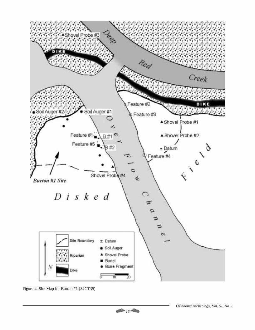
Figure 4. Site Map for Burton #1 (34CT39)
Oklahoma Archeology, Vol. 51, No. 1 16
Finally, a site datum was established and the area was mapped using a Brunton compass, tape measure and pacing. All of the shovel probe tests, site features and topographic features were plotted and mapped in reference to the site datum. Additionally, some of the surface collected human remains were point-plotted on the map. The site map produced provides spatial and distributional information for collection, test probes and features at Burton #1.
The Burton #2 (34CT40) Site The Burton #2 site was identified as being a separate occupation from Burton #1, both spatially and temporally. A Garza point found on the surface may indicate that Burton #2 dates to the protohistoric period which would post-date Burton #1. However, Garza points are reported for Plains Village sites in the Henrietta complex area and Burton #2 may in fact be an extension of Burton #1. Only a limited amount of cultural debris was noted and collected from the plow zone; all materials were collected as one bulk sample (FS #1, 34CT40). According to Wallis’ (1987) field notes, the site is believed to be fairly small in extent and no soil stains were noted on the surface. Because the site was in no danger of disturbance from dike repair work, no additional investigations were undertaken.
Site Stratigraphy, Burton #1 Site stratigraphy at Burton #1 was determined primarily through two methods. First, the banks of the overflow channel were visually scanned for changes in soil color and texture, as well as for the presence of artifacts and soil staining, and then shovel probes and soil augurs were excavated. These methods provide only a limited approximation of site stratigraphy in the immediate area of the tests but are useful for preliminary observations. More testing was planned, including a series of 1 x 1 meter test units, but due to unforeseen circumstances (poor weather and revised dike repair strategies) this did not occur.
Shovel Probe #1 Shovel Probe #1 was on the terrace to the east of the overflow channel and just south of the existing dike (Figure 5). Excavation depth totaled 130 cm below surface (cmbs). The uppermost 8 cm consisted of disked plow zone and did not contain cultural material. From 8 to 39 cmbs, a dark reddish-brown clay loam was encountered which contained a few (intrusive?) cultural materials, including charcoal, burned clay and burned animal bone. The soil changed to a friable dark red clay loam matrix from 39 to 63 cmbs and then to a dark reddish silty clay loam to a depth of 88 cmbs, below which was a friable yellowish red silty loam to a depth of 112 cmbs. These lower levels were all culturally sterile. At 112 cmbs, a soil change was noted, which could be a paleosol (Wallis 1987). A narrow band (less than 3 cm thick) of brown/dark brown ashy loam mixed with chunks of a darker brown soil was encountered and contained a few small pieces of burned clay. From 115 to 130 cmbs, the soil
changed to a reddish brown clay loam and was culturally sterile.
Shovel Probe #2 Shovel Probe #2 was placed 10 meters south of Probe #1. The stratigraphy noted in this probe was very similar to that described above (Figure 5). The upper 8 cmbs was recently disked plow zone. From 8 cmbs to a depth of 90 cmbs, the soil generally changes from reddish-brown to yellowish-red, although more mixing of soil colors was noted in this probe than in any of the others. No artifacts or cultural items were found in the first 90 cmbs. At 90 cmbs, the soil became redder and a few charcoal flecks were noted with more charcoal occurring at 103 to 110 cmbs. Between 110 and 114 cmbs, charcoal became abundant, although no artifacts or cultural materials were found. The probe was stopped at 114 cmbs.
Shovel Probe #3 This shovel probe was placed on the north side of the dike in a heavily vegetated zone near the stream channel. The probe was excavated to a depth of 130 cmbs (Figure 6). No plow zone or recently disked horizon was noted. The first 23 cmbs is a dark reddish-brown clay loam. Between 23 and 43 cmbs, the soil became dark red and was very compact. One large piece of charcoal was found in this level. From 43 to 103 cmbs, the soil was a mixture of red to dark red silty loam; no charcoal or cultural materials were found. At 103 cmbs, the soil changed to a compact red clay loam that contained a few pieces of charcoal which gradually became more brownish red to a final probe depth of 130 cmbs. No artifacts or cultural materials were found.
Shovel Probe #4 This probe was on the southwest edge of the overflow channel on the western terrace, near where a number of human bones were discovered on the surface (Figure 5). The disked plow zone was found to a depth of 8 cmbs. No artifacts were found in this upper level. From 8 to 78 cmbs, the soil was noted as a generally dark reddish-brown clay loam from which a single unburned mussel shell fragment was found. The soil changed from a dark reddish-brown to dark red clay loam at a depth of 78 cmbs. No charcoal was found at this level. We suspect that the uppermost 8 cm of this probe represents the cultural level noted in shovel probes 1 and 2.
Soil Augur Tests #1, #2 and #3 These augur tests were placed 14 and 28 meters west of Shovel Probe #4 and 18 meters north of Probe #4. At variable depths of 70 to 90 cmbs, the same dark reddish-brown paleosol was encountered indicating that it may be fairly extensive over the site area. No charcoal or cultural materials were noted.
Oklahoma Archeology, Vol. 51, No. 1 17
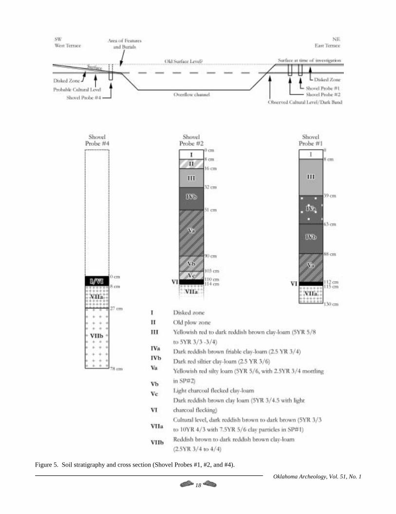
Figure 5. Soil stratigraphy and cross section (Shovel Probes #1, #2, and #4).
Oklahoma Archeology, Vol. 51, No. 1 18

. Figure 6. Soil stratigraphy, Shovel Probe #3.
Observations on Site Stratigraphy The results of the shovel and soil augur probes indicate that some cultural materials are present in the upper 40 cm or so of the site and that a buried soil horizon is present at depths of between 70 to 114 cmbs. However, the actual cultural horizon appears to be between 110 and 114 cmbs in the area east of the overflow channel. The dark band noted in the channel is most likely this deeper buried cultural horizon which is now exposed at a depth of approximately 60 to 100 cm below surface along the east wall of the overflow channel. However, it appears that the buried cultural horizon is exposed closer to the surface on the west side of channel. The results of Shovel Probe #4 indicate that much of the overburden on the west side of the overflow channel has been removed while the east terrace still retains much of its overburden. The removal of soil deposits from the west terrace has given the general site topography an uneven look and has acted to horizontally expose the prehistoric surface on this side near the channel but not on the east terrace (see Figure 5). It seems reasonable to conclude that the materials recovered from Burton #1 all belong to a single cultural horizon.
LITHIC ANALYSIS This section will consist of two parts. First, the projectile points recovered from Burton #1 will be discussed and grouped together according to their general provenience. Also, the single projectile point recovered from Burton #2 will be briefly discussed. The second part will consist of a discussion of raw materials observed at the site and their
likely source areas plus reduction stages and tool types present. This information will be used to infer raw material procurement and use patterns at Burton #1 since patterned use of local and non-local lithic raw materials for tool manufacture should reflect the mobility and/or trading patterns of the prehistoric occupants of Burton #1. The raw material types described in this section are derived primarily from Banks (1990) and from lithic samples curated at the Oklahoma Archaeological Survey in Norman
Projectile Points from Burton #1 and Burton #2 Six projectile points and three preforms were recovered from Burton #1, while only one projectile point was collected from Burton #2 (Figure 7, Table 1). Two projectile points were found in the plowed field at Burton #1 (FS 6-7 and 6-8). One is a small Gary point and the other is a reworked, partially serrated and possibly corner-notched unidentifiable point. One projectile point and one preform were found on the lower slope of the overflow channel (FS 25-16 and 25-24). The former is a Fresno point and the latter is a roughly triangular preform. Two projectile points, one unfinished point or preform and two additional preforms were found scattered along the base of the overflow channel (FS #’s 9-3, 9-4, 9-7, and 24-27). The two points are Scallorns (one of which is the midsection and base only), the unfinished point is unidentifiable and the two preforms are roughly triangular. Lastly, the projectile point found at Burton #2 is the base of a Garza point.
Oklahoma Archeology, Vol. 51, No. 1 19

Figure 7. Projectile points recovered from Burton #1 and Burton #2. a) Unidentified point (FS 24-27); b) Probably Scallorn (FS 9-3); c) Scallorn (FS 9-4); d) Gary (FS 6-8); e) Fresno (FS 25-24); f) Garza (FS 40/1-1); g) Unidentified point (FS 6-7); h) Preform (FS 25-16); i-k) Biface/point tips
Table 1. Projectile Points and Preforms Recovered from Burton #1 and Burton #2. FS # Provenience Type Raw Material Remarks Burton #1 6-7 Plow zone Preform Unidentified chert Corner notched and partially serrated 6-8 Plow zone Gary Alibates Small in size 25-16 Dark band Preform Viola? Triangular, unnotched 25-24 Dark band Fresno Viola? Triangular, unnotched 9-3 Overflow channel Scallorn Quartzite Midsection and base, corner notched 9-4 Overflow channel Scallorn Quartzite Complete point, corner notched 9-7 Overflow channel Preform Quartzite Triangular, unnotched 9-7 Overflow channel Preform Quartzite Triangular, unnotched 24-27 Overflow channel Unidentified point Arbuckle? Unfinished or heavily reworked Burton #2 1-1 Plow zone Garza Tecovas Base only, basal notched, small size
Oklahoma Archeology, Vol. 51, No. 1 20
It would seem at first glance that the site contains a mixture of point types that cover a rather broad time range. This situation (in part) initially led the site recorders to assume that Burton #1 contained two components, an earlier Plains Woodland occupation and a later Plains Village component. The Gary point, however, appears to be smaller than those reported from Plains Woodland sites and they are also often found in association with Washita River phase houses (Brooks 1987). Scallorn and Garza points are occasionally found at Henrietta Complex sites (Martin 1994). It is conceivable that the projectile point assemblage at Burton #1 was produced during the Late Prehistoric period and that the Burton #2 site is actually a contemporaneous component of Burton #1. The raw materials used to produce the projectile points at Burton #1 are typical for Plains Village sites. The majority of points and preforms are made from locally available raw materials (see Table 1). In fact, only the Gary and Garza points are made from non-local materials (Alibates and Tecovas). Quartzites and unidentifiable cherts are more common in the projectile point assemblage and are probably from the Ogallala gravels that were washed into the area from the Rocky Mountains. However, three specimens are possibly Viola and Arbuckle cherts and would not necessarily be found as locally available raw materials. Additionally, Tecovas can be found as stream gravels in the rivers that drain the Texas panhandle and southwestern Oklahoma (Drass, personal communication, 1998). Alibates can be found as river gravels to the north of Cotton County (Kraft 1997; Wyckoff 1993), although its overall suitability for tool production varies. The Gary point (because of its size) is the most likely candidate for a projectile point made from either traded or directly procured raw material that is not locally available. Unfortunately, the sample size of projectile points for Burton #1 is rather small and it is difficult to assess raw material use patterns.
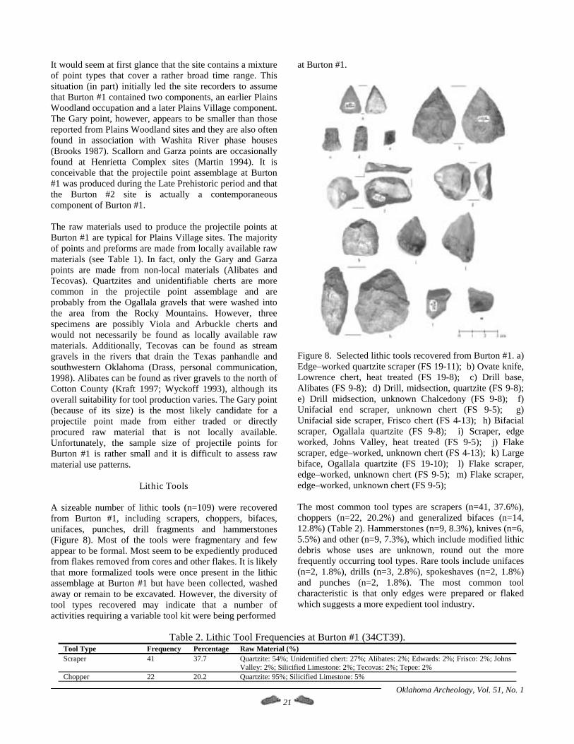
Lithic Tools A sizeable number of lithic tools (n=109) were recovered from Burton #1, including scrapers, choppers, bifaces, unifaces, punches, drill fragments and hammerstones (Figure 8). Most of the tools were fragmentary and few appear to be formal. Most seem to be expediently produced from flakes removed from cores and other flakes. It is likely that more formalized tools were once present in the lithic assemblage at Burton #1 but have been collected, washed away or remain to be excavated. However, the diversity of tool types recovered may indicate that a number of activities requiring a variable tool kit were being performed
at Burton #1.
Figure 8. Selected lithic tools recovered from Burton #1. a) Edge–worked quartzite scraper (FS 19-11); b) Ovate knife, Lowrence chert, heat treated (FS 19-8); c) Drill base, Alibates (FS 9-8); d) Drill, midsection, quartzite (FS 9-8); e) Drill midsection, unknown Chalcedony (FS 9-8); f) Unifacial end scraper, unknown chert (FS 9-5); g) Unifacial side scraper, Frisco chert (FS 4-13); h) Bifacial scraper, Ogallala quartzite (FS 9-8); i) Scraper, edge worked, Johns Valley, heat treated (FS 9-5); j) Flake scraper, edge–worked, unknown chert (FS 4-13); k) Large biface, Ogallala quartzite (FS 19-10); l) Flake scraper, edge–worked, unknown chert (FS 9-5); m) Flake scraper, edge–worked, unknown chert (FS 9-5); The most common tool types are scrapers (n=41, 37.6%), choppers (n=22, 20.2%) and generalized bifaces (n=14, 12.8%) (Table 2). Hammerstones (n=9, 8.3%), knives (n=6, 5.5%) and other (n=9, 7.3%), which include modified lithic debris whose uses are unknown, round out the more frequently occurring tool types. Rare tools include unifaces (n=2, 1.8%), drills (n=3, 2.8%), spokeshaves (n=2, 1.8%) and punches (n=2, 1.8%). The most common tool characteristic is that only edges were prepared or flaked which suggests a more expedient tool industry.
Table 2. Lithic Tool Frequencies at Burton #1 (34CT39). Tool Type Frequency Percentage Raw Material (%) Scraper 41 37.7 Quartzite: 54%; Unidentified chert: 27%; Alibates: 2%; Edwards: 2%; Frisco: 2%; Johns
Valley: 2%; Silicified Limestone: 2%; Tecovas: 2%; Tepee: 2% Chopper 22 20.2 Quartzite: 95%; Silicified Limestone: 5%
Oklahoma Archeology, Vol. 51, No. 1 21
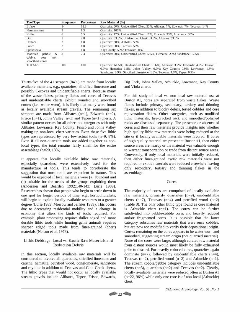
Tool Type Frequency Percentage Raw Material (%) Biface 14 12.8 Quartzite: 50%; Unidentified Chert: 22%; Alibates: 7%; Edwards: 7%; Tecovas: 14% Hammerstone 9 8.3 Quartzite: 100% Knife 6 5.5 Quartzite: 17%; Unidentified Chert: 17%; Edwards: 33%; Lowrance: 33% Drill 3 2.8 Quartzite: 33.3%; Unidentified Chert: 33.3%; Alibates: 33.3% Uniface 2 1.8 Quartzite: 50%; Alibates: 50% Punch 2 1.8 Quartzite: 50%; Tecovas: 50% Spokeshave 2 1.8 Kay County: 50%; Tecovas: 50% Modified pebble & cobble, core tool, smoothed stones
8 7.3 Quartzite: 50%; Unidentified Chert: 12.5%; Hematite: 25%; Sandstone: 12.5%
TOTALS 109 100 Quartzite: 61.5%; Unidentified Chert: 15.6%; Alibates: 3.7%; Edwards: 4.9%; Frisco: 0.9%; Hematite: 1.8%; Johns Valley: 0.9%; Kay County: 0.9%; Lowrance: 1.8%; Sandstone: 0.9%; Silicified Limestone: 1.8%; Tecovas: 4.6%; Tepee: 0.9%
Thirty-five of the 41 scrapers (84%) are made from locally available materials, e.g., quartzites, silicified limestone and possibly Tecovas and unidentifiable cherts. Because many of the waste flakes, primary flakes and cores of Tecovas and unidentifiable cherts exhibit rounded and smoothed cortex (i.e., water worn), it is likely that many were found as locally available stream gravels. The remaining six scrapers are made from Alibates (n=1), Edwards (n=2), Frisco (n=1), Johns Valley (n=1) and Tepee (n=1) cherts. A similar pattern occurs for all other tool categories with only Alibates, Lowrance, Kay County, Frisco and Johns Valley making up non-local chert varieties. Even these five lithic types are represented by very few actual tools (n=9, 8%). Even if all non-quartzite tools are added together as non-local types, the total remains fairly small for the entire assemblage (n=20, 18%). It appears that locally available lithic raw materials, especially quartzites, were extensively used for the manufacture of tools. This tends to corroborate the suggestion that most tools are expedient in nature. This would be expected if local materials were (a) abundant and (b) suitable for the needs of the groups exploiting them (Anderson and Bearden 1992:140-143; Lurie 1989). Research has shown that people who begin to settle down in one spot for longer periods of time, e.g., horticulturalists, will begin to exploit locally available resources to a greater degree (Lurie 1989; Morrow and Jeffries 1989). This occurs due to decreasing residential mobility and a change in economy that alters the kinds of tools required. For example, plant processing requires duller edged and more durable lithic tools while hunting game animals requires sharper edged tools made from finer-grained (chert) materials (Nelson et al. 1978).
Lithic Debitage: Local vs. Exotic Raw Materials and Reduction Debris
In this section, locally available raw materials will be considered to involve all quartzites, silicified limestone and caliche, hematite, petrified wood, conglomerate, sandstone and rhyolite in addition to Tecovas and Cool Creek cherts. The lithic types that would not occur as locally available stream gravels include Alibates, Tepee, Frisco, Edwards,
Big Fork, Johns Valley, Arbuckle, Lowrance, Kay County and Viola cherts. For this study of local vs. non-local raw material use at Burton #1, cores are separated from waste flakes. Waste flakes include primary, secondary, tertiary and thinning flakes, in addition to blocky debris, tested cobbles and core rejuvenation flakes. Other categories, such as modified lithic materials, fire-cracked rock and smoothed/polished rocks are discussed separately. The presence or absence of cores and their raw materials provide insights into whether high quality lithic raw materials were being reduced at the site or if locally available materials were favored. If cores of high quality material are present at Burton #1, then either source areas are nearby or the material was valuable enough to warrant transportation or trade from distant source areas. Conversely, if only local materials were initially reduced, then either finer-grained exotic raw materials were not required or exotic materials were reduced elsewhere leaving only secondary, tertiary and thinning flakes in the assemblage.
Cores The majority of cores are comprised of locally available raw materials, primarily quartzites (n=9), unidentifiable cherts (n=7), Tecovas (n=4) and petrified wood (n=2) (Table 3). The only other lithic type found as core material is Arbuckle chert (n=1). The cores can be further subdivided into pebble/cobble cores and heavily reduced and/or fragmented cores. It is possible that the latter category subsumes raw materials that were once cobbles, but are now too modified to verify their depositional origin. Cortex remaining on the cores appears to be water worn and smoothed, suggesting stream origin (not quarried material). None of the cores were large, although curated raw material from distant sources would most likely be fully exhausted prior to discard. For heavily reduced cores, quartzites again dominate (n=7), followed by unidentifiable cherts (n=4), Tecovas (n=2), petrified wood (n=2) and Arbuckle (n=1). The stream cobble/pebble category includes unidentifiable cherts (n=3), quartzites (n=2) and Tecovas (n=2). Clearly, locally available materials were reduced often at Burton #1 (n=22, 96%) while only one core is of non-local (Arbuckle) chert.
Oklahoma Archeology, Vol. 51, No. 1 22
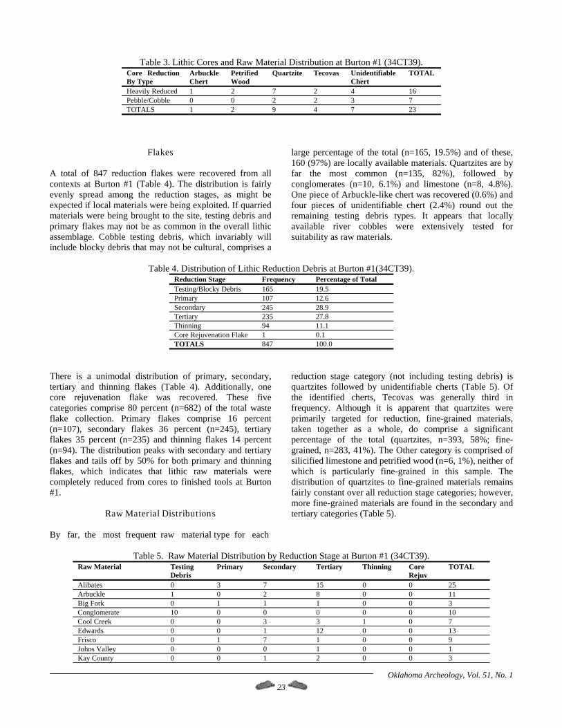
Table 3. Lithic Cores and Raw Material Distribution at Burton #1 (34CT39).
Core Reduction By Type
Arbuckle Chert
Petrified Wood
Quartzite Tecovas Unidentifiable Chert
TOTAL
Heavily Reduced 1 2 7 2 4 16 Pebble/Cobble 0 0 2 2 3 7 TOTALS 1 2 9 4 7 23
Flakes A total of 847 reduction flakes were recovered from all contexts at Burton #1 (Table 4). The distribution is fairly evenly spread among the reduction stages, as might be expected if local materials were being exploited. If quarried materials were being brought to the site, testing debris and primary flakes may not be as common in the overall lithic assemblage. Cobble testing debris, which invariably will include blocky debris that may not be cultural, comprises a
large percentage of the total (n=165, 19.5%) and of these, 160 (97%) are locally available materials. Quartzites are by far the most common (n=135, 82%), followed by conglomerates (n=10, 6.1%) and limestone (n=8, 4.8%). One piece of Arbuckle-like chert was recovered (0.6%) and four pieces of unidentifiable chert (2.4%) round out the remaining testing debris types. It appears that locally available river cobbles were extensively tested for suitability as raw materials.
Table 4. Distribution of Lithic Reduction Debris at Burton #1(34CT39).
Reduction Stage Frequency Percentage of Total Testing/Blocky Debris 165 19.5 Primary 107 12.6 Secondary 245 28.9 Tertiary 235 27.8 Thinning 94 11.1 Core Rejuvenation Flake 1 0.1 TOTALS 847 100.0
There is a unimodal distribution of primary, secondary, tertiary and thinning flakes (Table 4). Additionally, one core rejuvenation flake was recovered. These five categories comprise 80 percent (n=682) of the total waste flake collection. Primary flakes comprise 16 percent (n=107), secondary flakes 36 percent (n=245), tertiary flakes 35 percent (n=235) and thinning flakes 14 percent (n=94). The distribution peaks with secondary and tertiary flakes and tails off by 50% for both primary and thinning flakes, which indicates that lithic raw materials were completely reduced from cores to finished tools at Burton #1.
Raw Material Distributions By far, the most frequent raw material type for each
reduction stage category (not including testing debris) is quartzites followed by unidentifiable cherts (Table 5). Of the identified cherts, Tecovas was generally third in frequency. Although it is apparent that quartzites were primarily targeted for reduction, fine-grained materials, taken together as a whole, do comprise a significant percentage of the total (quartzites, n=393, 58%; fine-grained, n=283, 41%). The Other category is comprised of silicified limestone and petrified wood (n=6, 1%), neither of which is particularly fine-grained in this sample. The distribution of quartzites to fine-grained materials remains fairly constant over all reduction stage categories; however, more fine-grained materials are found in the secondary and tertiary categories (Table 5).
Table 5. Raw Material Distribution by Reduction Stage at Burton #1 (34CT39). Raw Material Testing
Debris Primary Secondary Tertiary Thinning Core
Rejuv TOTAL
Alibates 0 3 7 15 0 0 25 Arbuckle 1 0 2 8 0 0 11 Big Fork 0 1 1 1 0 0 3 Conglomerate 10 0 0 0 0 0 10 Cool Creek 0 0 3 3 1 0 7 Edwards 0 0 1 12 0 0 13 Frisco 0 1 7 1 0 0 9 Johns Valley 0 0 0 1 0 0 1 Kay County 0 0 1 2 0 0 3
Oklahoma Archeology, Vol. 51, No. 1 23
Oklahoma Archeology, Vol. 51, No. 1 24
Raw Material Testing Debris
Primary Secondary Tertiary Thinning Core Rejuv
TOTAL
Lowrance 0 0 5 11 1 0 17 Petrified Wood 0 1 2 2 0 0 5 Quartzite 135 75 139 100 79 0 528 Rhyolite 4 0 0 0 0 0 4 Silicified Limestone 8 1 0 0 0 0 9 Tecovas 3 9 22 13 8 1 56 Tepee 0 0 2 5 0 0 7 Unidentifiable Chert 4 16 53 58 5 0 136 Viola 0 0 0 3 0 0 3 TOTALS 165 107 245 235 94 1 847
As noted earlier, the majority of reduction flakes derive from local sources which include quartzite, Tecovas, Cool Creek and most likely the unidentifiable cherts (n=585, 86%). Most of the primary flakes exhibit smoothed and rounded cortex that suggests river and stream transportation which can be argued to be locally available. The variety of non-local types indicate that these raw materials were sought after as well, but remain somewhat insignificant for actual tool production at Burton #1 when compared to local materials. In sum, it appears that local raw material use at Burton #1 was a very important industry, although better quality (and perhaps more geographically distant fine-grained types) were used on occasion as well, but clearly to a much lesser degree. Non-local raw materials seem to have been obtained from all cardinal directions from the site area, except perhaps to the southwest. However, more non-local types came from sources to the east along the Red River corridor, suggesting either special resource procurement trips in this direction or trading relations with other groups living along the Red River east of the site (specifically Caddoan and Henrietta complex groups).
Fire-Cracked Rock (FCR), Unmodified Gravels, and
Modified Gravels Rock identified as modified by heat (FCR) includes primarily sandstone (n=15). The only other rock types identified as FCR are limestone (n=2) and conglomerates (n=2) (Table 6). All three raw materials are found as locally available river and stream cobbles. Three pebbles, two hematite and one sandstone, are smoothed or polished on one or more faces. Samples of unmodified stream cobbles, pebbles and gravels were acquired from the site during the course of investigations. Quartzites (n=56) were the most frequently recovered unmodified lithic raw material followed by conglomerates (n=12), sandstone (n=11), limestone (n=8), hematite (n=3) and chert (1). The small sample taken at Burton #1 indicates that cherts are not common as stream gravels in the site area, but this result is most likely due to the collection strategies employed.
Table 6. Fire Cracked Rock, Modified Gravel, and Unmodified Gravel by Raw Material Type at Burton #1 (34CT39).
Raw Material Fire Cracked Rock Modified Gravel1 Unmodified Gravel TOTALS Conglomerate 2 0 12 14 Hematite 0 2 2 4 Limestone 2 0 8 10 Quartzite 0 0 56 56 Sandstone 15 1 11 27 Unidentified Chert 0 0 1 1 TOTALS 19 3 90 112
1 These gravels appear to have been smoothed on one or more faces, function unknown.
Summation of Lithic Analysis The lithic analysis section has shown that locally available raw materials dominate the assemblage at Burton #1. This is not totally unexpected for a Plains Village site in the Southern Plains. However, Drass (1997) notes that up to 50 percent of lithic assemblages at Washita River phase sites are comprised of Frisco cherts and that Alibates often comprises a similar percentage at Turkey Creek phase sites. Henrietta complex sites tend to have high percentages of Edwards chert and quartzites. At Burton #1, quartzites were extensively used for flintknapping based on the high percentage of quartzite flake debris recovered (62% of the total or 58% when all testing debris is excluded). Tecovas is
the most abundant, fine-grained lithic material at Burton #1 representing 6% of the total (8% when all testing debris is excluded). Finer-grained materials are present in the debitage assemblage and the total percentage of 34% (41% when the testing debris is excluded) is remarkably similar to the percentages of fine-grained tools (34%) and projectile points and preforms (56%). At present, it cannot be determined whether special trips were made to distant sources of finer-grained materials or if these materials were obtained during scheduled seasonal movements. Alternatively, many lithic raw materials could have been traded in exchange for locally produced goods. I suspect that some combination of all of the above occurred

at Burton #1 with special trips occurring to nearby source areas and less-frequent stops at more distant source areas. Additionally, trading relations between Plains Villager groups appears to have been a very important component of their economies and there is no reason to assume that the occupants of Burton #1 were not part of this larger network. Finally, most of the tools at Burton #1 appear to be expediently produced and used. Even many of the projectile points have an unfinished or quickly produced quality about them, although this is hard to actually measure. This differs from the Washita River phase tool assemblage where Drass (1997) notes that formal tools are important in the tool kit. Although formalized lithic tools may not be quite as common at Turkey Creek or Henrietta complex sites as they are at Washita River phase sites, all appear to have higher occurrences of formal tools than seen at Burton #1. The occurrence of fine-grained cherts in the assemblage, however, suggests that better quality materials were important for particular tasks at Burton #1. The significance of these findings will be discussed in the conclusion section of this report.
CERAMIC ANALYSIS Only four ceramic sherds were recovered from Burton #1 (Table 7). Three are from surface contexts and the other came from Feature #4. Although this is a very small sample of sherds to work with, a few preliminary statements can be made regarding descriptive elements. None of the sherds fit comfortably into any existing typology for the general area. First, all four sherds are small (especially the sherd from Feature #4), and this makes identification difficult. Two of the surface sherds exhibit moderate weathering and/or damage from plowing, further limiting their diagnostic potential. Finally, two of the sherds appear to contain composite diagnostic elements from ceramics described for the Washita River, Henrietta and Caddoan areas. However, with only four sherds available for study, new ceramic types will not be offered in this report.
Table 7. Ceramic Analysis for Burton #1 (34CT39). FS # Provenience No. Temper Color Paste Rim or Body Surface Decoration 8-3 Surface/
Plow zone 1 Bone Brown interior, black
exterior Quartz sand grit
Body Tool punctated, rough smudging on exterior
9-37-1 Base of overflow channel
1 Bone Brown interior, black exterior
Quartz sand grit
Rim None
9-37-2 Base of overflow channel
1 Bone and chert?
Brown interior, brown-gray exterior
Quartz sand grit
Body Tool punctated
17-3 Feature #4 1 Sandstone, coarse quartz sand
Dark brown to black, interior and exterior
Quartz sand grit
Body None
Figure 9. Ceramics and impressed daub recovered from Burton #1. a) Bone tempered, decorated sherd (FS 9-37); b) Bone tempered, decorated sherd (FS 8-3); c) Bone tempered, undecorated rim sherd (FS 9-37); d) Stick impressed daub (FS 25-14); e) Stick impressed daub (FS 6-14); f–i) Grass/stick impressed daub (FS 17-13).
Oklahoma Archeology, Vol. 51, No. 1 25
The three sherds recovered from the surface of the site (plow zone and base of overflow channel) are similar in several ways. All three contain high amounts of crushed bone temper mixed with quartz sand (which may actually be part of the paste and not added tempering material; Drass 1997, personal communication). The three surface sherds all have brown interiors and gray to blackened exteriors, while the sherd from Feature #4 is a more uniform dark brown. One of the surface sherds is roughly smudged, although all three sherds exhibit signs of carbonization on their exteriors. None of the surface sherds are well-smoothed and all are pockmarked on their surfaces from loss of tempering material. One sherd (FS 9-37-1) appears to have stress fractures on its exterior surface which may have occurred during the firing process (or from post-depositional processes). The sherd from Feature #4 contains no bone tempering, but is heavily tempered with quartz sand, coarsely crushed sandstone and crushed quartz crystals. Again, a good deal of the quartz sand tempering may have originated with the clay paste. Only one sherd is a rim (FS 9-37-1), and all four appear to be from jars. The rim sherd has a rounded lip and a slight curvature to the body (see Figure 9). However, not enough of the specimen is present to precisely determine if the rim is everted, inverted or just slightly flared. I suspect that this sherd is from a wide mouth/constricted neck jar as ceramic bowls are not common in Southern Plains Village assemblages and when present generally lack rim curvature (e.g., see Brooks 1987:92-97; Drass 1997; Prikryl and Perttula 1995). This rim is similar to a rim from the “flower pot” drawing provided in Prikryl and Pertulla’s discussion of Henrietta complex ceramics (Prikryl and Perttula 1995:191, example B), but is very dissimilar to a rim design from the Dillard site (Martin 1994:166, example A). If we were to orient the rim sherd from Burton #1 to match Martin’s example, it would produce a very flared and awkward rim which resembles no known Henrietta complex ceramic jar style. Finally, two of the three surface sherds are decorated (see Figure 9). These two sherds (FS 8-3 and 9-37-2) have been decorated with tool punctations on their exterior surfaces. FS 8-3 has a series of parallel and evenly spaced elliptical punctates set above and obliquely to a series of randomized, but parallel punctates. None of the punctates are large or deep. FS 9-37-2 has a series of roughly parallel and evenly spaced elliptical punctates which are much larger and deeper than the punctates on specimen FS 8-3. Unfortunately, specimen FS 9-37-2 is moderately eroded which makes further stylistic analysis problematic. Based on the presence of this form of punctate decoration, these sherds could be either imported Caddoan wares or locally produced imitations (Drass, personal communication 1997). Perhaps a stronger case can be made for local reproductions because crushed bone tempering is not commonly reported for punctated Red River Caddoan ceramics (e.g., Brewington et al. 1995). It should be noted that a Caddoan incised sherd was reportedly found on the surface at Burton
#1 by one of the local collectors, but unfortunately this sherd is not available for study. The other two sherds appear to be plainwares or are from undecorated sections of vessels. In sum, crushed bone temper ceramic sherds are not commonly reported for Henrietta complex sites (Brooks 1989; Krieger 1946; Martin 1994; Prikryl and Perttula 1995) although Prikryl and Perttula (1995:192) have suggested that bone tempering may be more common than is currently suspected. Generally, crushed mussel shell is the most common type of temper for Henrietta complex ceramics followed by grog and quartz sand. Drass (1997) reports similar findings for Paoli and Washita River phase ceramics although crushed bone temper is occasionally found in some Washita River site assemblages. When crushed bone temper ceramics are found on Washita River sites, they tend to be Lee Plain which is a type created, in part, because of its uncommon bone temper (Brooks 1989:93; Brooks et al. 1985; Drass 1997). Bone temper is used occasionally in ceramics by other nearby cultural groups including Buried City to the northwest (Brooks 1989) and Caddoan groups from northeast Texas and the Red River area (e.g., Brewington et al. 1995). However, bone tempering is not a common practice for either of these groups. The crushed quartz sand and sandstone temper used for the single sherd from Feature #4 at Burton #1 is a more common temper type for Southern Plains Village groups (along with mussel shell). Based on temper and decoration analyses, it appears that the sherds from Burton #1 are not particularly typical for Washita River, Turkey Creek or Henrietta complex cultural groups. Only the sherd from Feature #4 can be considered a typical Southern Plains Village ceramic type. If Burton #1 is part of either the Washita River or Henrietta complexes, we would expect shell-tempering to be more prevalent, especially in light of the copious amounts of mussel shell found at the site. The two Caddoan-style sherds may be locally made imitations, if we can assume that bone temper and sandy clay pastes are local varieties in the Burton #1 site area. The rim sherd, although similar in shape and surface treatment with other Southern Plains Village assemblages, is somewhat different by virtue of its bone tempering. The absence of cordmarking at Burton #1 distinguishes the ceramics from those found at Turkey Creek phase sites. Although the very limited ceramic assemblage from Burton #1 argues against formulating new ceramic types, it does hint at local variation in ceramic technology and perhaps decoration. Obviously a much greater number of sherds will need to be studied before any conclusions can be offered.
DAUB AND BURNED CLAY
Oklahoma Archeology, Vol. 51, No. 1 26
A fair amount of daub and burned clay was found on the surface and in the features. In this report, daub will refer to the burned mud and clay used for sealing the walls of houses and other standing structures (i.e., wattle and daub

architecture, Brooks 1987:97; Drass 1997:61-65). Only those specimens that exhibit clear signs of reed, grass, stick or pole impressions were categorized as daub. On the other hand, burned clay is a catchall term for specimens which do not exhibit impressions but are believed to be the result of human activity. Burned clay can originate from a number of sources, including plastered floors and walls, clay-lined hearths and clay-lined pits (e.g., Brooks 1987:45-60; Drass 1997:65-68).
At Burton #1, burned clay far outnumbers daub in the features (Table 8). However, more daub was recovered from surface contexts compared to the features. The bulk of the specimens from the features have evidence for pronounced burning on one face, suggesting perhaps that the three features may have been clay lined and were subjected to a heat source at some point in their histories. This heat source could have resulted directly from use as a hearth or indirectly from use as a dumping receptacle for hot coals and embers.
Table 8. Daub and Burned Clay Analysis for Burton #1 (34CT39).
FS # Provenience
Daub (# and weight)
Burned Clay (# and weight)
Coloring1 Impressions
4-17 Overflow channel
1 (4.3g) — Tan to brown Small twig & circular holes
6-14 Plow zone 1 (6.0 g) — Tan to brown, red and black Intermeshed sticks, twigs, and grass
8-7 Plow zone 2 (4.3 g) — Dark brown to maroon, red and black
Single twig impression on each
9-25 Overflow channel
— 1 (1.9 g) Brown and red None
16-4-1 Feature #3 2 (3.5 g) — Brown to gray brown, red and black
One has large stick, the other grass
16-4-2 Feature #3 — 90 (40.1 g) Brown, gray-brown, red and black None 17-1-1 Feature #4 2 (0.4 g) — Yellowish-orange Parallel small twig 17-1-2 Feature #4 — 133 (51.1 g) Yellowish-orange to orange-red,
red and black None
17-13-1 Feature #4 4 (1.5 g) — Yellowish-orange, red and black 3 have parallel twig, 4th has large twigs
17-13-2 Feature #4 — 23 (20.3 g) Yellowish-orange, red and black None 21-1 Shovel
Probe #1 — 22 (4.6 g) Yellowish-orange to reddish-
orange None
25-5 Dark band, east side
— 4 (2.2 g) Orange to reddish-orange, red and black
None
25-14 Dark band, east side
1 (3.8 g) — Grayish-brown, black Large parallel twigs, cross-hatched w/small twigs
25-20 Dark band, east side
— 4 (1.1 g) Orange to reddish-orange, some white
None
25-29-1 Dark band, east side
1 (1.6 g) — Tan to yellowish-orange One deep twig
25-29-2 Dark band, east side
— 14 (15.5 g) Tan to yellowish-orange, black None
26-1 Dark band, north end
— 7 (4.5 g) Tan to orange-brown, some white None
28-6 Dark band, west side
— 5 (5.4 g) Yellowish-brown to orange-brown None
28-7-1 Dark band, west side
2 (0.5 g) — Orange-brown to brown One has single twig, other has grass
28-7-2 Dark band, west side
— 2 (0.2 g) Reddish-brown to brown None
32-1-1 Feature #1 1 (0.1 g) — Orange-red Two parallel twigs 32-1-2 Feature #1 — 12 (4.4 g) Yellowish-orange to reddish-
orange None
32-11 Feature #1 — 5 (0.8 g) Whitish-orange to reddish-orange None TOTALS 17 (26.0 g) (152.1 g)
1 “Red and Black” coloring refers to fire reddening and fire blackening/carbon staining. The higher percentage of daub compared to burned clay from the surface could suggest the presence of house structures; however, no other evidence for houses was found at the site. No large pieces of daub with unmistakable pole impressions were found, although several pieces did exhibit impressions of large sticks (see Figure 9). Several of
these pieces also exhibit grass and reed impressions interspersed between the stick impressions suggesting that they did originate from a pole and brush structure sealed with grass and mud.
GROUNDSTONE ANALYSIS
Oklahoma Archeology, Vol. 51, No. 1 27
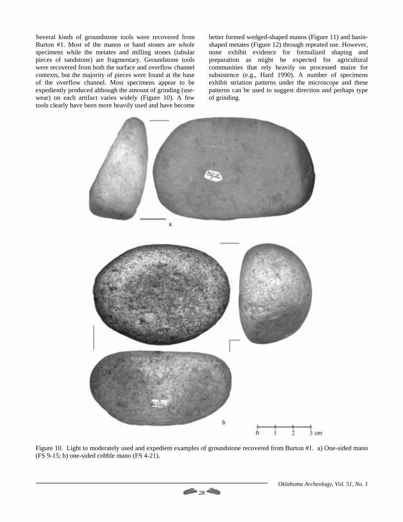
Several kinds of groundstone tools were recovered from Burton #1. Most of the manos or hand stones are whole specimens while the metates and milling stones (tabular pieces of sandstone) are fragmentary. Groundstone tools were recovered from both the surface and overflow channel contexts, but the majority of pieces were found at the base of the overflow channel. Most specimens appear to be expediently produced although the amount of grinding (use-wear) on each artifact varies widely (Figure 10). A few tools clearly have been more heavily used and have become
better formed wedged-shaped manos (Figure 11) and basin-shaped metates (Figure 12) through repeated use. However, none exhibit evidence for formalized shaping and preparation as might be expected for agricultural communities that rely heavily on processed maize for subsistence (e.g., Hard 1990). A number of specimens exhibit striation patterns under the microscope and these patterns can be used to suggest direction and perhaps type of grinding.
Figure 10. Light to moderately used and expedient examples of groundstone recovered from Burton #1. a) One-sided mano (FS 9-15; b) one-sided cobble mano (FS 4-21).
Oklahoma Archeology, Vol. 51, No. 1 28
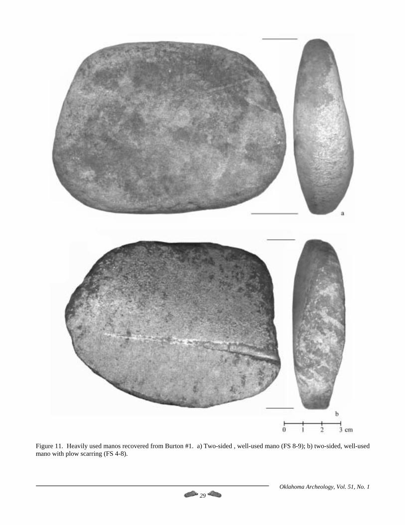
Figure 11. Heavily used manos recovered from Burton #1. a) Two-sided , well-used mano (FS 8-9); b) two-sided, well-used mano with plow scarring (FS 4-8).
Oklahoma Archeology, Vol. 51, No. 1 29
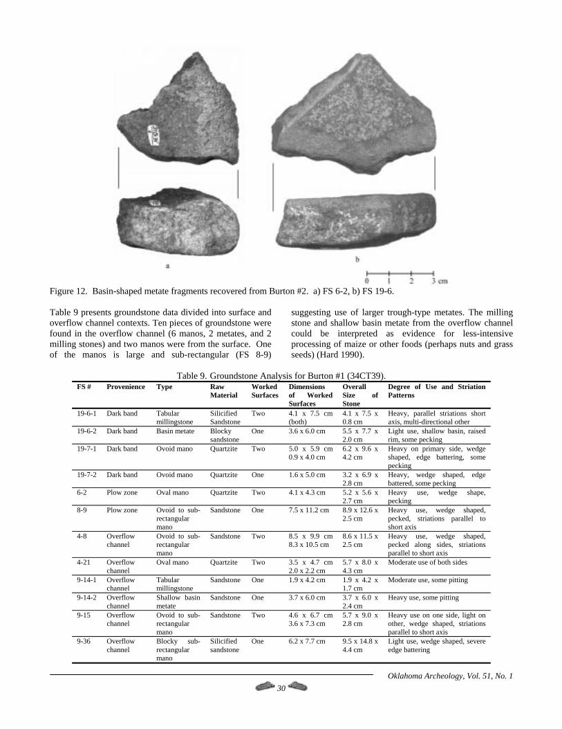
Figure 12. Basin-shaped metate fragments recovered from Burton #2. a) FS 6-2, b) FS 19-6. Table 9 presents groundstone data divided into surface and overflow channel contexts. Ten pieces of groundstone were found in the overflow channel (6 manos, 2 metates, and 2 milling stones) and two manos were from the surface. One of the manos is large and sub-rectangular (FS 8-9)
suggesting use of larger trough-type metates. The milling stone and shallow basin metate from the overflow channel could be interpreted as evidence for less-intensive processing of maize or other foods (perhaps nuts and grass seeds) (Hard 1990).
Table 9. Groundstone Analysis for Burton #1 (34CT39).
FS # Provenience Type Raw Material
Worked Surfaces
Dimensions of Worked Surfaces
Overall Size of Stone
Degree of Use and Striation Patterns
19-6-1 Dark band Tabular millingstone
Silicified Sandstone
Two 4.1 x 7.5 cm (both)
4.1 x 7.5 x 0.8 cm
Heavy, parallel striations short axis, multi-directional other
19-6-2 Dark band Basin metate Blocky sandstone
One 3.6 x 6.0 cm 5.5 x 7.7 x 2.0 cm
Light use, shallow basin, raised rim, some pecking
19-7-1 Dark band Ovoid mano Quartzite Two 5.0 x 5.9 cm 0.9 x 4.0 cm
6.2 x 9.6 x 4.2 cm
Heavy on primary side, wedge shaped, edge battering, some pecking
19-7-2 Dark band Ovoid mano Quartzite One 1.6 x 5.0 cm 3.2 x 6.9 x 2.8 cm
Heavy, wedge shaped, edge battered, some pecking
6-2 Plow zone Oval mano Quartzite Two 4.1 x 4.3 cm 5.2 x 5.6 x 2.7 cm
Heavy use, wedge shape, pecking
8-9 Plow zone Ovoid to sub-rectangular mano
Sandstone One 7.5 x 11.2 cm 8.9 x 12.6 x 2.5 cm
Heavy use, wedge shaped, pecked, striations parallel to short axis
4-8 Overflow channel
Ovoid to sub-rectangular mano
Sandstone Two 8.5 x 9.9 cm 8.3 x 10.5 cm
8.6 x 11.5 x 2.5 cm
Heavy use, wedge shaped, pecked along sides, striations parallel to short axis
4-21 Overflow channel
Oval mano Quartzite Two 3.5 x 4.7 cm 2.0 x 2.2 cm
5.7 x 8.0 x 4.3 cm
Moderate use of both sides
9-14-1 Overflow channel
Tabular millingstone
Sandstone One 1.9 x 4.2 cm 1.9 x 4.2 x 1.7 cm
Moderate use, some pitting
9-14-2 Overflow channel
Shallow basin metate
Sandstone One 3.7 x 6.0 cm 3.7 x 6.0 x 2.4 cm
Heavy use, some pitting
9-15 Overflow channel
Ovoid to sub-rectangular mano
Sandstone Two 4.6 x 6.7 cm 3.6 x 7.3 cm
5.7 x 9.0 x 2.8 cm
Heavy use on one side, light on other, wedge shaped, striations parallel to short axis
9-36 Overflow channel
Blocky sub-rectangular mano
Silicified sandstone
One 6.2 x 7.7 cm 9.5 x 14.8 x 4.4 cm
Light use, wedge shaped, severe edge battering
Oklahoma Archeology, Vol. 51, No. 1 30
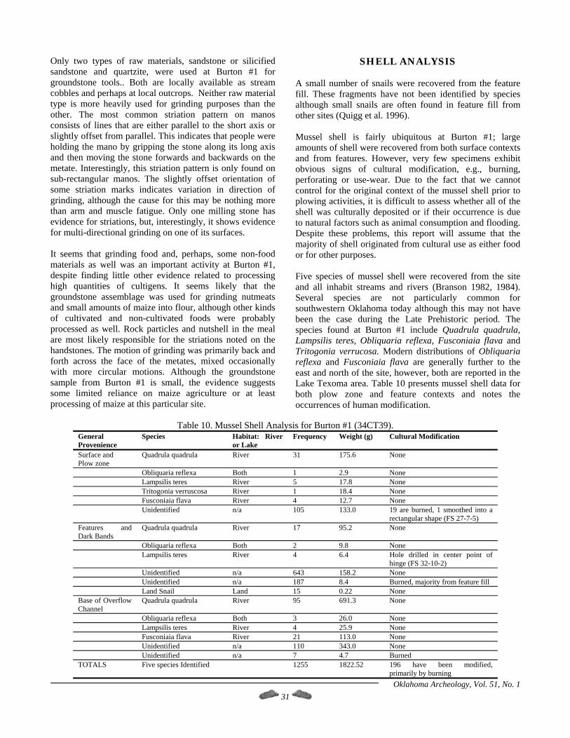
Only two types of raw materials, sandstone or silicified sandstone and quartzite, were used at Burton #1 for groundstone tools.. Both are locally available as stream cobbles and perhaps at local outcrops. Neither raw material type is more heavily used for grinding purposes than the other. The most common striation pattern on manos consists of lines that are either parallel to the short axis or slightly offset from parallel. This indicates that people were holding the mano by gripping the stone along its long axis and then moving the stone forwards and backwards on the metate. Interestingly, this striation pattern is only found on sub-rectangular manos. The slightly offset orientation of some striation marks indicates variation in direction of grinding, although the cause for this may be nothing more than arm and muscle fatigue. Only one milling stone has evidence for striations, but, interestingly, it shows evidence for multi-directional grinding on one of its surfaces. It seems that grinding food and, perhaps, some non-food materials as well was an important activity at Burton #1, despite finding little other evidence related to processing high quantities of cultigens. It seems likely that the groundstone assemblage was used for grinding nutmeats and small amounts of maize into flour, although other kinds of cultivated and non-cultivated foods were probably processed as well. Rock particles and nutshell in the meal are most likely responsible for the striations noted on the handstones. The motion of grinding was primarily back and forth across the face of the metates, mixed occasionally with more circular motions. Although the groundstone sample from Burton #1 is small, the evidence suggests some limited reliance on maize agriculture or at least processing of maize at this particular site.
SHELL ANALYSIS A small number of snails were recovered from the feature fill. These fragments have not been identified by species although small snails are often found in feature fill from other sites (Quigg et al. 1996). Mussel shell is fairly ubiquitous at Burton #1; large amounts of shell were recovered from both surface contexts and from features. However, very few specimens exhibit obvious signs of cultural modification, e.g., burning, perforating or use-wear. Due to the fact that we cannot control for the original context of the mussel shell prior to plowing activities, it is difficult to assess whether all of the shell was culturally deposited or if their occurrence is due to natural factors such as animal consumption and flooding. Despite these problems, this report will assume that the majority of shell originated from cultural use as either food or for other purposes. Five species of mussel shell were recovered from the site and all inhabit streams and rivers (Branson 1982, 1984). Several species are not particularly common for southwestern Oklahoma today although this may not have been the case during the Late Prehistoric period. The species found at Burton #1 include Quadrula quadrula, Lampsilis teres, Obliquaria reflexa, Fusconiaia flava and Tritogonia verrucosa. Modern distributions of Obliquaria reflexa and Fusconiaia flava are generally further to the east and north of the site, however, both are reported in the Lake Texoma area. Table 10 presents mussel shell data for both plow zone and feature contexts and notes the occurrences of human modification.
Table 10. Mussel Shell Analysis for Burton #1 (34CT39).
Oklahoma Archeology, Vol. 51, No. 1 31
General Provenience
Species Habitat: River or Lake
Frequency Weight (g) Cultural Modification
Surface and Plow zone
Quadrula quadrula River 31 175.6 None
Obliquaria reflexa Both 1 2.9 None Lampsilis teres River 5 17.8 None Tritogonia verruscosa River 1 18.4 None Fusconiaia flava River 4 12.7 None Unidentified n/a 105 133.0 19 are burned, 1 smoothed into a
rectangular shape (FS 27-7-5) Features and Dark Bands
Quadrula quadrula River 17 95.2 None
Obliquaria reflexa Both 2 9.8 None Lampsilis teres River 4 6.4 Hole drilled in center point of
hinge (FS 32-10-2) Unidentified n/a 643 158.2 None Unidentified n/a 187 8.4 Burned, majority from feature fill Land Snail Land 15 0.22 None Base of Overflow Channel
Quadrula quadrula River 95 691.3 None
Obliquaria reflexa Both 3 26.0 None Lampsilis teres River 4 25.9 None Fusconiaia flava River 21 113.0 None Unidentified n/a 110 343.0 None Unidentified n/a 7 4.7 Burned TOTALS Five species Identified 1255 1822.52 196 have been modified,
primarily by burning
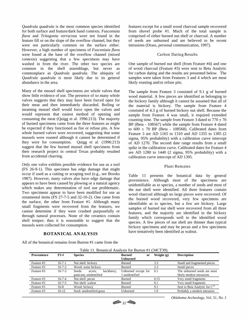
Quadrula quadrula is the most common species identified for both surface and feature/dark band contexts. Fusconiaia flava and Tritogonia verrucosa were not found in the feature fill or on the slope of the overflow channel, but they were not particularly common on the surface either. However, a high number of specimens of Fusconiaia flava were found at the base of the overflow channel (mixed contexts) suggesting that a few specimens may have washed in from the river. The other two species are common in the shell assemblage, but never as commonplace as Quadrula quadrula. The ubiquity of Quadrula quadrula is most likely due to its general abundance in the area. Many of the mussel shell specimens are whole valves that show little evidence of use. The presence of so many whole valves suggests that they may have been forced open for their meat and then immediately discarded. Boiling or steaming mussel shell would force open the valves and would represent that easiest method of opening and consuming the meat (Quigg et al. 1996:213). The majority of burned specimens came from the three features as might be expected if they functioned as fire or refuse pits. A few whole burned valves were recovered, suggesting that some mussels were roasted although it cannot be determined if they were for consumption. Quigg et al. (1996:213) suggest that the few burned mussel shell specimens from their research project in central Texas probably resulted from accidental charring. Only one valve exhibits possible evidence for use as a tool (FS 26-9-1). This specimen has edge damage that might occur if used as a cutting or scraping tool (e.g., see Brooks 1987). However, many valves also have edge damage that appears to have been caused by plowing or a natural agency which makes any determination of tool use problematic. Two specimens appear to have been modified for use as ornamental items (FS 27-7-5 and 32-10-2). One came from the surface, the other from Feature #1. Although many small fragments were recovered from the features, we cannot determine if they were crushed purposefully or through natural processes. None of the ceramics contain shell temper; thus it is reasonable to suggest that the mussels were collected for consumption.
BOTANICAL ANALYSIS All of the botanical remains from Burton #1 came from the
features except for a small wood charcoal sample recovered from shovel probe #1. Much of the total sample is comprised of either burned nut shell or charcoal. A number of seeds are unburned and are believed to be recent intrusions (Drass, personal communication, 1997).
Carbon Dating Results One sample of burned nut shell (from Feature #4) and one of wood charcoal (Feature #3) were sent to Beta Analytic for carbon dating and the results are presented below. The samples were taken from Features 3 and 4 which are most likely roasting and/or refuse pits. The sample from Feature 3 consisted of 9.1 g of burned wood material. A few pieces are identified as belonging to the hickory family although it cannot be assumed that all of the material is hickory. The sample from Feature 4 consisted of 4.3 g of burned hickory nut shell. Because the sample from Feature 4 was small, it required extended counting time. The sample from Feature 3 dated to 770 ± 70 BP (Beta - 108567) while the sample from Feature 4 dated to 600 ± 70 BP (Beta - 108568). Calibrated dates from Feature 3 are AD 1165 to 1310 and AD 1355 to 1385 (2 sigma, 95% probability) with a calibration curve intercept of AD 1270. The second date range results from a small spike in the calibration curve. Calibrated dates for Feature 4 are AD 1280 to 1440 (2 sigma, 95% probability) with a calibration curve intercept of AD 1395.
Plant Remains Table 11 presents the botanical data by general provenience. Although most of the specimens are unidentifiable as to species, a number of seeds and most of the nut shell were identified. All three features contain wood charcoal although no large pieces were recovered. Of the burned wood recovered, very few specimens are identifiable as to species, but a few are hickory. Large samples of burned nut shell were recovered from all three features, and the majority are identified in the hickory family which corresponds well to the identified wood species. A few pieces of nut shell are thinner than typical hickory specimens and may be pecan and a few specimens have tentatively been identified as walnut.
Table 11. Botanical Analysis for Burton #1 (34CT39). Provenience FS # Species Burned or
Unburned Weight (g) Description
Feature #3 16-7-1 Nut shell: hickory Burned 3.3 Small and fragmented pieces Feature #3 16-7-2 Wood: some hickory Burned 2.3 Small pieces Feature #3 16-7-3 Seeds: acorn, hackberry,
panicum, unidentified Unburned except for 1 unidentified
0.1 The unburned seeds are most likely modern intrusions
Feature #3 16-7-4 Nut shell: pecan Burned 0.15 Very small fragments Feature #3 16-7-5 Nut shell: walnut Burned 0.1 Very small fragments Feature #3 16-8 Wood: hickory Burned 9.1 Sent to Beta Analytic for C14 Feature #3 16-12 Seed: unidentified grass Unburned 1.0 Probably a modern intrusion
Oklahoma Archeology, Vol. 51, No. 1 32

Oklahoma Archeology, Vol. 51, No. 1 33
Provenience FS # Species Burned or Unburned
Weight (g) Description
Feature #4 17-10 Wood: unidentified Burned 3.0 Small pieces Feature #4 17-9 Seeds: unidentified Burned 0.1 Highly fragmented Feature #4 17-8-1 Nut shell: hickory Burned 4.4 Sent to Beta Analytic for C14 Feature #4 17-8-2 Seeds: hackberry, unidentified Unburned except for
the unidentified 0.1 Hackberry is probably
modern intrusion Shovel Probe #1 20-1 Wood: unidentified Burned 0.1 Small and fragmented pieces Dark Band 25-9 Seed: hackberry Burned 0.2 Very burned Feature #1 32-4-1 Wood: unidentified Burned 0.15 Small pieces Feature #1 32-4-2 Nut shell: hickory Burned 0.05 Very small fragments Feature #1 32-4-3 Seeds: hedgehog poppy?,
unidentified grasses Burned 0.05 Very burned, small and
fragmented Feature #1 32-8-1 Wood: some hickory Burned 2.0 Mostly unidentifiable pieces Feature #1 32-8-2 Wood: unidentifiable Burned 14.5 Mixed with soil matrix TOTALS 36.45
Burned seeds from the features include primarily hackberry seeds, although one possible hedgehog prickly poppy seed was recovered from Feature #1. Unfortunately, the remaining burned seeds are too fragmented for positive identification. A number of unburned specimens were found, although these are believed to be intrusive from modern contexts. These include hackberry or chokeberry, an acorn cap, panicum grass seeds and several which were unidentifiable because of their fragmented condition. Based on the identified plant species found at Burton #1, the local environment must have been wet enough to support groves of hickory, pecan, and hackberry trees and possibly walnut as well. This suggests that Deep Red Creek was a permanent stream prehistorically (which is also supported by the presence of mussels). Interestingly, oak trees are common in the area today, but no evidence was found for them in the prehistoric component. Based on the above, the local prehistoric environment during the latter half of the Plains Village period was similar to modern conditions although it must be remembered that modern land-use practices have greatly altered the biotic communities.
BURIALS AND SCATTERED HUMAN REMAINS
Two sets of human remains were excavated at Burton #1 by Brooks, and a number of isolated human bones were surface collected by OCC personnel (Figure 5). Both burials and all the isolated occurrences were uncovered by modern agriculture and construction activities, although a few scattered remains were found in the overflow channel. One local collector reported that he had noted a possible human burial after earlier flooding, but no direct evidence was found for it during the 1990 investigations (Wallis 1990). Both excavated burials were located on the southwest margin of the overflow channel approximately 3 to 5 meters apart. The depth of the burials was fairly shallow and at this time we have no reason to suspect they are not part of the Plains Village occupation of Burton #1. The information presented here is derived from field notes (Wallis 1987, 1990) and a very brief analytic report
(Agogino 1992).
Burial No. 1 This burial was badly disturbed by heavy machinery working the overflow channel and dike area and was also in poor condition resulting from natural decay processes (Figure 13a). Only portions of the skull and mandible were in good enough condition for analysis; the remainder of the skeleton was characterized as weathered and disintegrating (Brooks, personal communication 1998). No evidence was found for a burial pit or for the presence of grave goods because of modern disturbances. Orientation of the skeleton was difficult to determine, however, it appears that it may have been roughly east/west. Agogino (1992) suggests, based on skull and mandible, that the burial was a female, aged 36-55 years. The lack of complete long bones and other factors make age and height determinations problematic, but she may have stood between 5 feet 2 inches and 5 feet 4 inches. According to Agogino (1992:3), “Age was determined by suture closing, tooth wear, and the angle of the neck of the femur.” No determinations could be made regarding health, trauma or other pathologies.
Burial No. 2 As with Burial #1, very little skeletal material was available for study. Portions of the skull and mandible were reconstructed and used for analysis, as were portions of the long bones, including the femur head (Figure 13b). Other recovered elements include ribs, hand and foot bones, scapula and vertebrae, all of which were too badly decayed for study (Agogino 1992:2). Based on metric measurements of certain elements, Agogino postulates that the skeleton is a female and may have stood no taller than 5 feet. Because of severe tooth wear on fully erupted molars, Agogino estimates that this female was between 65 and 75 years old although Brooks suggests an upper age limit of no more than 60 years is more likely (Brooks 1998, personal communication). Finally, no evidence for either trauma or disease was found although this could mean either that there was no trauma present or that the condition of the bones was too poor for a determination (Agogino 1992:3).
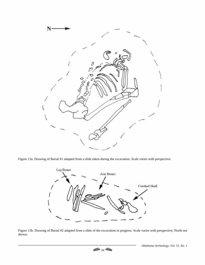
Figure 13a. Drawing of Burial #1 adapted from a slide taken during the excavation. Scale varies with perspective.
Figure 13b. Drawing of Burial #2 adapted from a slide of the excavation in progress. Scale varies with perspective; North not shown.
Oklahoma Archeology, Vol. 51, No. 1 34
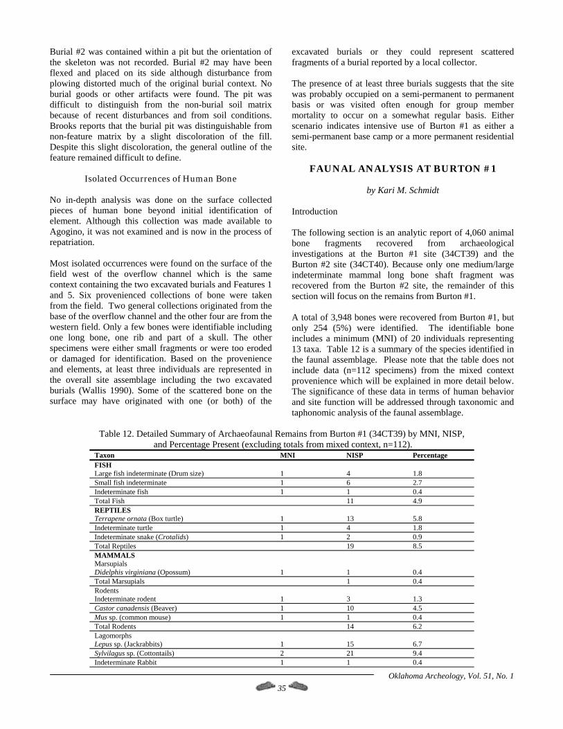
Burial #2 was contained within a pit but the orientation of the skeleton was not recorded. Burial #2 may have been flexed and placed on its side although disturbance from plowing distorted much of the original burial context. No burial goods or other artifacts were found. The pit was difficult to distinguish from the non-burial soil matrix because of recent disturbances and from soil conditions. Brooks reports that the burial pit was distinguishable from non-feature matrix by a slight discoloration of the fill. Despite this slight discoloration, the general outline of the feature remained difficult to define.
Isolated Occurrences of Human Bone No in-depth analysis was done on the surface collected pieces of human bone beyond initial identification of element. Although this collection was made available to Agogino, it was not examined and is now in the process of repatriation. Most isolated occurrences were found on the surface of the field west of the overflow channel which is the same context containing the two excavated burials and Features 1 and 5. Six provenienced collections of bone were taken from the field. Two general collections originated from the base of the overflow channel and the other four are from the western field. Only a few bones were identifiable including one long bone, one rib and part of a skull. The other specimens were either small fragments or were too eroded or damaged for identification. Based on the provenience and elements, at least three individuals are represented in the overall site assemblage including the two excavated burials (Wallis 1990). Some of the scattered bone on the surface may have originated with one (or both) of the
excavated burials or they could represent scattered fragments of a burial reported by a local collector. The presence of at least three burials suggests that the site was probably occupied on a semi-permanent to permanent basis or was visited often enough for group member mortality to occur on a somewhat regular basis. Either scenario indicates intensive use of Burton #1 as either a semi-permanent base camp or a more permanent residential site.
FAUNAL ANALYSIS AT BURTON #1
by Kari M. Schmidt Introduction The following section is an analytic report of 4,060 animal bone fragments recovered from archaeological investigations at the Burton #1 site (34CT39) and the Burton #2 site (34CT40). Because only one medium/large indeterminate mammal long bone shaft fragment was recovered from the Burton #2 site, the remainder of this section will focus on the remains from Burton #1. A total of 3,948 bones were recovered from Burton #1, but only 254 (5%) were identified. The identifiable bone includes a minimum (MNI) of 20 individuals representing 13 taxa. Table 12 is a summary of the species identified in the faunal assemblage. Please note that the table does not include data (n=112 specimens) from the mixed context provenience which will be explained in more detail below. The significance of these data in terms of human behavior and site function will be addressed through taxonomic and taphonomic analysis of the faunal assemblage.
Table 12. Detailed Summary of Archaeofaunal Remains from Burton #1 (34CT39) by MNI, NISP,
and Percentage Present (excluding totals from mixed context, n=112). Taxon MNI NISP Percentage FISH Large fish indeterminate (Drum size) 1 4 1.8 Small fish indeterminate 1 6 2.7 Indeterminate fish 1 1 0.4 Total Fish 11 4.9 REPTILES Terrapene ornata (Box turtle) 1 13 5.8 Indeterminate turtle 1 4 1.8 Indeterminate snake (Crotalids) 1 2 0.9 Total Reptiles 19 8.5 MAMMALS Marsupials Didelphis virginiana (Opossum) 1 1 0.4 Total Marsupials 1 0.4 Rodents Indeterminate rodent 1 3 1.3 Castor canadensis (Beaver) 1 10 4.5 Mus sp. (common mouse) 1 1 0.4 Total Rodents 14 6.2 Lagomorphs Lepus sp. (Jackrabbits) 1 15 6.7 Sylvilagus sp. (Cottontails) 2 21 9.4 Indeterminate Rabbit 1 1 0.4
Oklahoma Archeology, Vol. 51, No. 1 35
Taxon MNI NISP Percentage Total Lagomorphs 37 16.5 Carnivores Canis latrans (Coyote) 1 2 0.9 Total Carnivores 2 0.9 Artiodactyls Antilocapra americana (Pronghorn) 1 3 1.3 Odocoileus virginianus (White Tail deer) 1 4 1.8 Bison bison (modern Bison) 1 3 1.6 Indeterminate Artiodactyl 1 63 27.9 Total Artiodactyls 73 32.6 Small Mammal Indeterminate 2 0.9 Medium/large Mammal Indeterminate 22 9.8 Large Mammal Indeterminate 43 19.2 Total Indeterminate Mammals 67 30.0 TOTAL IDENTIFIED (5 %) 224 100.0 TOTAL UNIDENTIFIED (95 %) 3740 SITE TOTALS 20 3948
In addition to evaluating site function, faunal data can provide some evidence for reconstructing local habitats, in this case in the general vicinity of Burton #1 during the Late Prehistoric period. Based on modern and prehistoric biogeographical data (Caire et al. 1989; Dalquest and Horner 1984; Vaughn 1972), small fauna from grassland environments available to the inhabitants of Burton #1 during the Late Prehistoric period should include jackrabbits, cottontails and numerous large and small rodents (e.g., prairie dogs). Artiodactyls expected in the site area include bison, pronghorn and some deer. We would not necessarily expect to see abundant evidence for woodland-forest species such as bear, white-tail deer, woodrat, mountain lion and turkey although they certainly can be found in open and patchy woodland environments such as along streams. Carnivores such as coyotes, badgers and foxes are likely to be found in the area. Large and small fish are currently available in the Red River and also in Deep Red and Cache creeks. Amphibians (e.g., frogs, salamanders and toads), aquatic mammals (e.g., beavers and muskrats) and various reptiles (e.g., snakes, lizards, and turtles) are also generally found along creeks and rivers in western Oklahoma. Seasonally abundant waterfowl are available at different times of the year and economically useful avifauna characteristic of prairie and riparian habitats are still found in the general area. Based on currently understood Plains Village subsistence patterns for western Oklahoma (Drass 1997), we would expect the inhabitants of Burton #1 to have utilized multiple habitats in both the immediate and surrounding environmental zones. Taxonomic patterns at the site may indicate that particular groups of animals were targeted for exploitation, and the details of the analysis should aid in documenting the total range of hunting behavior found at Burton #1. Using the variables of bone fragment size, anatomical recovery rates and differential processing patterns, the human behavioral system that produced the faunal assemblage at Burton #1 can be placed into an economic and ecological perspective (Binford 1980). Adding animal bone size as a variable, even highly processed bone such as that recovered from Burton #1, can
provide a measure of overall food availability and intensity of food processing.
Methods of Analysis The bones in this assemblage were sorted by animal size and body part for each collection unit. Each fragment was counted to document differential distribution of bone fragment types and element types and to demonstrate the degree of fragmentation within different site contexts (e.g., surface versus buried). Bone condition is generally good except for a few specimens damaged by plowing and heavy machinery. Few of the bones show signs of extensive weathering and most are in stable condition (unlike, interestingly, much of the human remains). Because many of the bones are highly fragmented, especially those from buried contexts (e.g., the features), extra care was taken to examine each fragment for taxonomic detail. Many of the unidentifiable bones were grouped by size. Size classes used are: (1) small (jackrabbit, prairie dog, turtle, rodent, fish and smaller animals), (2) medium (generally carnivores, large rodents, and marsupials, e.g. coyote, dog, beaver and opossum), (3) medium/large mammal (deer and pronghorn) and (4) large mammal (bison, elk, bear and cow). Small and large categories were also used for the fish remains, but all were grouped under the small size class. Particular attributes were recorded for every bone specimen; these include lowest taxonomic identification, element and portion of element present, side, age, presence and degree of burning, natural taphonomic factors, break patterns, pathologies and number of identifiable specimens present (NISP). In addition, when the specific bone element could not be determined, the fragments were classified by basic form, such as long bone shaft, cancellous, flat bone and unidentifiable. Although it is possible that many of the large mammal indeterminate bones in this assemblage could be bison, identification was limited to "large mammal indeterminate" because it is often impossible to differentiate between cow and bison when dealing with just bone fragments. Wallis
Oklahoma Archeology, Vol. 51, No. 1 36
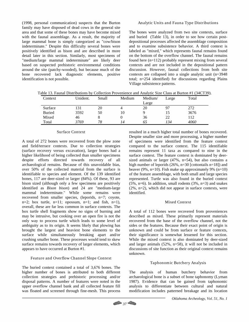
Oklahoma Archeology, Vol. 51, No. 1 37
(1998, personal communication) suspects that the Burton family may have disposed of dead cows in the general site area and that some of these bones may have become mixed with the faunal assemblage. As a result, the majority of large mammal bone is simply categorized as "cow/bison indeterminate." Despite this difficulty several bones were positively identified as bison and are described in more detail later in this section. Similarly, most specimens of "medium/large mammal indeterminate" are likely deer based on suspected prehistoric environmental conditions around the site (patchy-wooded), but because much of the bone recovered lack diagnostic elements, positive identification is not possible.
Analytic Units and Fauna Type Distributions The bones were analyzed from two site contexts, surface and buried (Table 13), in order to see how certain post-depositional processes affected the assemblage composition and to examine subsistence behavior. A third context is labeled as "mixed," which represents faunal remains found on the bottom of the overflow channel. The faunal remains found here (n=112) probably represent mixing from several contexts and are not included in the depositional pattern discussion. However, faunal collections from both site contexts are collapsed into a single analytic unit (n=3948 total; n=254 identified) for discussions regarding Plains Village subsistence patterns.
Table 13. Faunal Distributions by Collection Provenience and Analytic Size Class at Burton #1 (34CT39).
Context Unident. Small Medium Medium/ Large
Large Total
Surface 131 20 4 20 97 272 Buried 3592 50 10 9 15 3676 Mixed 46 8 0 36 22 112 Total 3769 78 14 65 134 4060
Surface Context
A total of 272 bones were recovered from the plow zone and field/terrace contexts. Due to collection strategies (surface recovery versus excavation), larger bones had a higher likelihood of being collected than smaller specimens despite efforts directed towards recovery of all archaeological remains. Because of this unavoidable bias, over 50% of the collected material from the surface is identifiable to species and element. Of the 139 identified bones, 117 are deer-sized or larger (84%). Of these, 93 are bison sized (although only a few specimens are positively identified as Bison bison) and 24 are "medium-large mammal indeterminate." While some remains were recovered from smaller species, (leporids, n=7; coyote, n=2; box turtle, n=11; opossum, n=1; and fish, n=1), overall, these are far less common in surface contexts. The box turtle shell fragments show no signs of burning and may be intrusive, but cooking over an open fire is not the only way to process turtle which leads to some level of ambiguity as to its origin. It seems likely that plowing has brought the largest and heaviest bone elements to the surface while simultaneously breaking apart and/or crushing smaller bone. These processes would tend to skew surface remains towards recovery of larger elements, which appears to have occurred at Burton #1.
Feature and Overflow Channel Slope Context The buried context contained a total of 3,676 bones. The higher number of bones is attributed to both different collection strategies and prehistoric processing and/or disposal patterns. A number of features were noted in the upper overflow channel bank and all collected feature fill was floated and screened through fine-mesh. This process
resulted in a much higher total number of bones recovered. Despite smaller size and more processing, a higher number of specimens were identified from the feature context compared to the surface context. The 115 identifiable remains represent 11 taxa as compared to nine in the surface context. The feature context is dominated by deer-sized animals or larger (47%, n=54), but also contains a high number of leporids (26%, n=30 [cottontails n=18]) and beaver (9%, n=10). Fish make up approximately 9% (n=10) of the feature assemblage, with both small and large species represented. Turtle was also found in the buried context (5%, n=6). In addition, small rodents (3%, n=3) and snakes (2%, n=2), which did not appear in surface contexts, were identified.
Mixed Context A total of 112 bones were recovered from proveniences described as mixed. These primarily represent materials recovered from the base of the overflow channel, not the sides or the features. Because their exact point of origin is unknown and could be from surface or feature contexts, their significance is somewhat lessened for this section. While the mixed context is also dominated by deer-sized and larger animals (52%, n=58), it will not be included in discussions of site function as their original context remains unknown.
Taphonomic Butchery Analysis The analysis of human butchery behavior from archaeological bone is a subset of bone taphonomy (Lyman 1987). Evidence that can be gained from taphonomic analysis to differentiate between cultural and natural modification includes patterned breakage and its location
on bone, cut-marks, evidence for burning, and evidence of bone modification in the form of worked elements (Bonnichsen 1973; Lyman 1987). Binford (1978, 1981) stresses the importance of monitoring body part patterns and occurrences at sites for economic data on butchering behavior. Certain elements may suggest a residentially oriented site function or, in other cases, a kill and/or processing site. The analysis of site function from faunal data involves identifying how game was obtained and processed at a specific locale. For larger game, many analysts have found the application of Binford’s (1978) Modified General Utility Index (MGUI) useful for interpreting patterns of body parts in well-preserved large artiodactyl assemblages. The amount of meat and marrow associated with particular bone elements in the body, with each element ranked to show its relative value in terms of potential energy, has become integral to estimating the amount of energy obtained by humans through the kinds of bone they butchered (Binford 1978). This type of study compares the differential recovery of major bones and distinguishes between the proximal and distal ends as these often have different food values. Although the artiodactyl remains at Burton #1 are highly fragmented based on the elements recovered, it seems probable that the majority of the kills may have occurred at or near the site. While long bone shafts and articular ends only slightly dominate the assemblage of artiodactyl bones (77 out of 161 or 48% of identifiable elements), the presence of an equally high number of less valued elements suggest that meat procurement was not the only use of these animals. Secondary use of animals for hides, marrow consumption, tool procurement and other artifact manufacture (rattles, containers, decoration, ornamentation, etc.) would have encouraged the transport of carcasses back to or near the village. This is, perhaps, what the faunal assemblage from Burton #1 indicates, as the artiodactyl remains appear to represent carcasses processed and consumed on site (shafts cracked for obtaining marrow) with many elements subsequently used for artifact manufacture. The presence of long bones from large mammals (both identifiable ends and shafts) and low meat value elements such as vertebrae, ribs and cranial fragments, suggests on-site or nearby processing of carcasses. Unfortunately, as mentioned earlier in this report, many of these bones could be the remains of several cows disposed in the general site area. Because so few large mammal bones could be positively identified as bison, very little useful information is available regarding procurement or processing. However, several bones identified as bison were found to contain evidence for human butchering consistent with patterns found at other prehistoric sites (Bement, personal communication, 1998). This evidence includes cut marks where muscle attaches to bone and fracture patterns indicative of twisting and breaking bone apart while still
green. It is evident that some level of bison processing was occurring at the site.
Leporid and Small Animal Body Part Patterns As leporids (jackrabbits and cottontails) are the second most abundant group of animals found at Burton #1 (n=37 elements, 15% of assemblage), they are assumed to be economically important. There are slightly more cottontails than jackrabbits (n=21 to n=15), with only one indeterminate rabbit specimen. The majority of identified bones are hind limb elements, including phalanges, metatarsals and tarsals. Because smaller mammals are easily transportable, they are often returned to habitation sites as intact carcasses. This analysis will focus on differential treatment of body parts. Elements from the entire skeleton of rabbits are present in the Burton #1 assemblage, but vertebrae and ribs, two of the most abundant elements, seem to be under-represented. This may be attributable to processing activities at the site or to recovery problems. Smaller mammals were often cooked whole in their skins over ashes and coals (Stewart 1941; Wheat 1967). This process preserves the natural juices and fats, maximizing human consumption of all available nutrients from smaller fauna. Jackrabbits in the Southwest and Great Basin were often hunted in communal drives (Schmidt 1997, 1998), resulting in high numbers of small mammals available for consumption. As documented ethnographically, when large quantities of jackrabbits are processed, rabbit skeletons that still contain some grease and meat are ground into bone meal which effectively destroys many of the smaller bone elements (e.g., vertebrae and ribs) (Downs 1966; Price 1962; Steward 1938; Stewart 1941). The missing axial elements hint at similar procurement and processing strategies at Burton #1 although the small sample size limits any conclusions and communal rabbit drives have not yet been documented for the High Plains. Other small mammals recovered at Burton #1 are possibly food remains as well, but the only direct evidence is that many specimens were found in the fill of the three features examined while several other bones show signs of burning and charring. No articulated skeletons were found which might indicate the presence of intrusive remains (Shaffer 1992). The only large rodent and marsupial species recovered at Burton #1 are beaver (ten elements were found, all likely belonging to the same individual) and opossum (n=1). The beaver remains include a portion of the maxilla and palate and the disarticulated teeth associated with this portion of the cranium. Deep Red Creek may have been to too turbulent and unpredictable for beaver dams. The presence of beaver at the site suggests that ponds were located somewhere nearby; ponds in the area would have been attractive to other aquatic creatures such as waterfowl, turtles and fish.
Oklahoma Archeology, Vol. 51, No. 1 38

Fish remains were recovered in the feature fill flotation samples (n=11 elements), with just one element recovered from the surface. The recovered elements indicate that both large and small fish are represented in the assemblage. Several otoliths from drum-sized species, and vertebrae from mostly small fish were recovered, but positive species identification was not possible. Fish procurement appears to have been part of subsistence strategies at Burton #1, but data are not sufficient for suggesting the degree of their importance in the diet or the species generally targeted for consumption. Reptile remains are few in number and represent only a few species, turtle and snake. The snake remains consist of two vertebrae, both unburned, and they appear to be from a Crotalid (non-venomous) species. The turtle remains compare favorably with the Western Box Turtle (Terrapene ornata) or a species of comparable size. Some of the turtle remains (5 of 18 identified) show no signs of burning and may be intrusive. However, turtle shells are known to be important components of ritual or ceremonial paraphernalia in many prehistoric and historic Native American societies, and the presence of unburned, but broken, turtle shell may indicate just such a function. Additionally, turtle can be processed and consumed in many ways without leaving obvious signs of cooking, so the presence of turtle in the site assemblage can be interpreted in multiple ways.
Bone Artifacts Only seven specimens show signs of tool use or manufacture (Figure 14). Four of these specimens are from deer-sized animals, two are from jackrabbit-sized animals and one is a fragment unattributable to class, size or element. Only one of these specimens, a fragment of a deer metapodial, shows obvious use as a tool. This artifact is a complete bone awl (Figure 14a). The other three specimens, one of which is illustrated (Figure 14b), are fragments of long bone shafts from deer-sized animals. These specimens show signs of polishing and shaping and are probably bone awl fragments.
The other three worked specimens are all bone fragments that have been polished and shaped and may have been modified for intended use as ornamentation. A jackrabbit-sized shaft fragment (not illustrated) shows possible use as a bone bead but may have been carnivore-ingested given the round, smooth edges. The differentiation between cultural modification and digestive modification is often difficult to make. The other two specimens have been only slightly modified by polishing and shaping. One of these is a possible bone disk (Figure 14c). The other is a modified tibia fragment from a jackrabbit (Figure 14d). The exact nature of the remaining specimen is unknown due to its small size and fragmented condition.
Discussion of Faunal Analysis
The Burton #1 faunal assemblage is dominated by larger mammals including deer and/or antelope and bison and/or
cow, making up a combined total of 67% (n=171) of the identifiable remains. Smaller mammals (e.g., leporids and beavers) appear to be of lesser importance with a combined 20% (n=51) of the identifiable assemblage, but prehistoric processing and modern recovery methods may be skewing these percentages. The remaining 13% of the assemblage (n=32) is composed of a variety of species including small mammals (e.g., rodents), fish and reptiles. Although few in number (25), the fauna representing river and pond habitats are a notable component of this assemblage and include large and small fish, beaver and turtle. Examination of identifiable body parts demonstrate that the taxonomic and taphonomic patterns observed for Burton #1 are generally similar to other Late Prehistoric period sites in the Southern Plains. However, the highly processed nature of some remains may be indicative of some level of subsistence stress or nutritional deficiency at Burton #1, a situation we might not expect if larger mammals were more abundant in the general area.
Figure 14. Bone tools and artifacts recovered from Burton #1. a) Bone awl (FS 18); b) Bone tool, polished and shaped (FS 9-2/1); c) Bone disk (FS 28-2); d) Rabbit tibia fragment (FS 7-3). The faunal remains from Burton #1 were analyzed to explore the kinds of environmental, cultural and economic data they might yield. To the extent that the small sample of
Oklahoma Archeology, Vol. 51, No. 1 39
identifiable remains allowed, this site was evaluated for behavioral clues to site function. The kinds of animals recovered may indicate a mixed grassland, riparian and wetland environment, and not a heavily forested setting. This is supported mainly by the prehistoric occupant’s emphasis on bison and other mixed grassland-woodland species, specifically pronghorn/deer and jackrabbits. The non-selective nature of bone elements present suggests that animals were hunted in the general vicinity and were then returned to the site for butchering and processing, which is indicative of a residential camp or village as opposed to a special activity or procurement site. However, more data are clearly needed to reinforce these interpretations. Intensive processing of many of the faunal remains is indicated by the high frequency of smashed bone recovered from the features, which seems to suggest that the occupants of Burton #1 were attempting to obtain as much food value as they could from smaller animals and all of their body parts. Long bone shaft fragments were cracked and smashed into thousands of highly comminuted bone fragments, possibly to procure marrow and bone grease. Steward (1938) and others note that this is often a subsistence tactic pursued when protein resources are generally scarce, especially from larger animals. This is interesting because if bison were locally abundant around Burton #1, then it seems unusual for smaller animals to be so thoroughly processed and consumed. However, as indicated by the low frequency of positively identified bison remains at Burton #1, bison in the general site area may have been moderately-to-very scarce and difficult to obtain. The Burton #1 occupants may have had to increase their diet range while hunting bison in a more opportunistic manner. The variety of faunal species consumed at the site and the level and intensity of processing associated with some of the animals seems to indicate some level of protein-related subsistence stress at Burton #1.
CONCLUSIONS This report has attempted to document some of the subsistence and economic strategies of the Late Prehistoric Plains Villagers at the Burton #1 site in southwestern Oklahoma. Because of the nature of the investigations at Burton #1, no conclusions can be offered and in its place several tentative scenarios are offered which are based on limited samples. Despite these limitations, the fact that Burton #1 remains just one of a handful of habitation sites investigated in the southwestern tier of counties in Oklahoma makes any observations from this site important for Southern Plains archaeology. The analysis of archaeological materials recovered from Burton #1 has led to a number of conflicting observations, especially regarding duration and intensity of occupation at the site. The recovery of burned daub (possible house structures?) and the presence of at least three burials indicates permanent residency while the lack of maize,
large grinding stones and large numbers of ceramics may indicate the opposite. The faunal evidence can be read to indicate some level of subsistence stress at Burton #1, which, if this is the case, casts some doubt about the ability of the local environment to support a fully sedentary village. What we have left then at Burton #1 is a great deal of circumstantial evidence and unanswered questions mixed with several preliminary and interesting cultural patterns. After synthesizing and discussing these patterns, the research area will be expanded to see if these patterns are unique to Burton #1 or if they are more broad-based across far southwestern Oklahoma. Because so little has been published on Plains Village sites in this area, and even less for adjoining Texas counties, comparative information is limited. A review of site records at the Oklahoma Archaeological Survey has augmented the available data, but only marginally; many sites recorded prior to the 1970s have little associated information. Due to the site’s geographical proximity to the central Red River Valley, the site may be related to the Henrietta complex and not necessarily with other traditions to the north and west. The lack of cordmarked ceramics and low occurrence of Alibates flint at Burton #1 argues against affiliation with the Turkey Creek phase to the northwest. Conversely, the punctated ceramics found at Burton #1 may be imported or copied from the Caddoan area along the Red River corridor to the east. The occurrence of Caddoan style pottery at Henrietta complex sites is fairly commonplace (Krieger 1946). Prikryl and Perttula (1995) report that bone temper for ceramics may be more common at Henrietta sites than is currently suspected; three of the four sherds from Burton #1 are bone tempered, including both punctated specimens. The cultural patterns found at Burton #1 are suggestive of a Plains Village tradition that has adapted to its environment by taking advantage of the variation inherent in Southern Plains grasslands. Perhaps one of the more surprising findings from this site is the limited evidence for maize cultivation. No direct evidence was found for maize in the form of botanical remains such as burned cobs or kernels from the flotation or charcoal samples, nor was indirect evidence found in the form of bison scapula hoes or well-formed, large grinding stones. Because of the site’s position on a low terrace along a permanent stream, we assumed that agriculture was an important consideration for prehistoric site location, but this may not be the case. However, some level of horticulture was probably practiced by the occupants of Burton #1 and only awaits discovery and documentation at the site.
Oklahoma Archeology, Vol. 51, No. 1 40
The apparent lack of maize from what is thought to be an agricultural Plains Village site is somewhat perplexing. This could be evidence for greater mobility and more reliance on wild foods than was previously suspected, yet the recovery of burned daub with twig and grass impressions coupled with several burials argues for a more permanent occupation. The faunal evidence sheds little light on this problem, despite our attempts at determining
probable site function in terms of hunting and butchering strategies. Much of the large mammal bone can only be categorized as either bison or cow which leaves very little bison material. Without data regarding age, sex and elements present, it is virtually impossible to determine hunting patterns or seasonality. However, ample evidence exists for exploitation of hickory nuts, which indicates a fall to winter occupation, yet nuts are easily stored and can be eaten at any point during the year. As a consequence of these problems, we cannot determine conclusively whether the site was a permanent village or a seasonal camp; the evidence can be argued for either position. The faunal evidence does show one strong pattern. The wide variety of animals consumed and the high degree of processing indicates some level of subsistence stress; it seems the occupants of Burton #1 were eating just about anything they came across and were wasting nothing. The high number of small mammals and reptiles found in the assemblage compared to larger mammals can be read as either cultural preference for smaller animals or forced reliance on them in the absence of larger animals (e.g., deer and bison) in the general area. Again, we cannot differentiate between these scenarios with the data available, but the presence of highly processed animal bone seems to be indicative of subsistence stress. If this is the case, the level and/or chronic nature of subsistence stress at Burton #1 is difficult to assess, but its presence is important for understanding some aspects of the effectiveness of subsistence strategies for Plains Villagers in this area. Because no extensive excavations were conducted at the site, we may never know if houses are present, and if they are, what kinds of structures they might be. However, the burned daub sample from the site can be used to indirectly address this issue. Most of the recovered daub was fairly small in size, perhaps an artifact of plowing disturbance and natural decay processes. However, many pieces show clear evidence of impressions, indicating that they were at one time pressed into some sort of container or structure. Because most of these impressions did not show evidence for pronounced curvature and because many pieces of daub were fairly thick, it is doubtful that they originated from basketry containers; it is more likely that they originate from some type of larger structure. Although no large pole impressed pieces of daub were found, the smaller impressions found could easily be from branches, twigs and grass interwoven amid structural posts (see Brooks 1987). It seems likely that some house structures of at least a semi-permanent nature are present at Burton #1 The lithics found at the site are composed primarily of locally available raw materials (quartzites and cherts) although more distant finer-grained cherts and agatized dolomites make up nearly a fifth of the assemblage. Exploitation of local resources would be expected for a settled or semi-settled group of people, if these resources are available, abundant and are suitable for the needs of the group. It appears that these conditions are met at Burton #1.
What is perhaps more interesting for addressing issues of residential mobility are the non-local chert types. No single fine-grained lithic type dominated the non-local assemblage, with perhaps the exception of Tecovas if it is actually a non-locally available type. In fact, Tecovas seems to fill the role of dominant fine-grained material type seen at other Plains Village sites in the region. The wide range of types present, but generally in low numbers, indicates that either the occupants of Burton #1 were engaged in a wide-spread trading network or that they moved to different areas on a regular basis and procured seasonally available finer-grained lithic raw materials. Many of the lithic types identified come from a radius of less than 100 km from Burton #1 (e.g., materials derived from the Wichita and Arbuckle Mountains). However, a number of lithic types are from more distant source areas (e.g., Edwards, Johns Valley and Alibates), suggesting that some trading was going on with groups in southeastern Oklahoma, south-central Texas and the Texas Panhandle. With the issue of residential mobility in mind, it seems that the occupants of Burton #1 (or at least some of the occupants) traveled to distant source areas on a regular or irregular basis (seasonal mobility) while also engaged in trading relationships with other groups. Finally, the human burials found at Burton #1 suggest the presence of a settled to semi-settled group of people. If the occupants of Burton #1 were highly mobile and if the site was only a short-term special activity site, then we may not expect to see burials. The fact that at least three burials were excavated or documented at the site with the possibility of more suggests the presence of at least a semi-permanent occupation. However, because the data from human remains at the site are limited and future analyses are unlikely, it will be difficult to discern any real patterns for the site with regards to diet and occupation through the analysis of human remains.
A Broader Context for the Cultural Patterns Found at Burton #1
Oklahoma Archeology, Vol. 51, No. 1 41
With these cultural patterns in mind, it seems that this area of Cotton County, specifically the Red River and its tributaries, was occupied by prehistoric Plains Village groups possibly related to the Henrietta complex more than with any other group. But some differences are apparent, specifically in the pottery, lithic raw material and tool use, subsistence and mobility patterns. Using bone for tempering material is generally not reported for Henrietta complex sites although it is more common in some Washita River assemblages. Beyond the tempering aspect, the pottery is similar to that found at Henrietta complex sites, especially in the strong Caddoan influences. Because of the uniqueness of the admittedly small ceramic sample from Burton #1, a distribution study of temper and surface treatment of sherds in the southern tier of counties in Oklahoma was undertaken in order to assess this distribution.
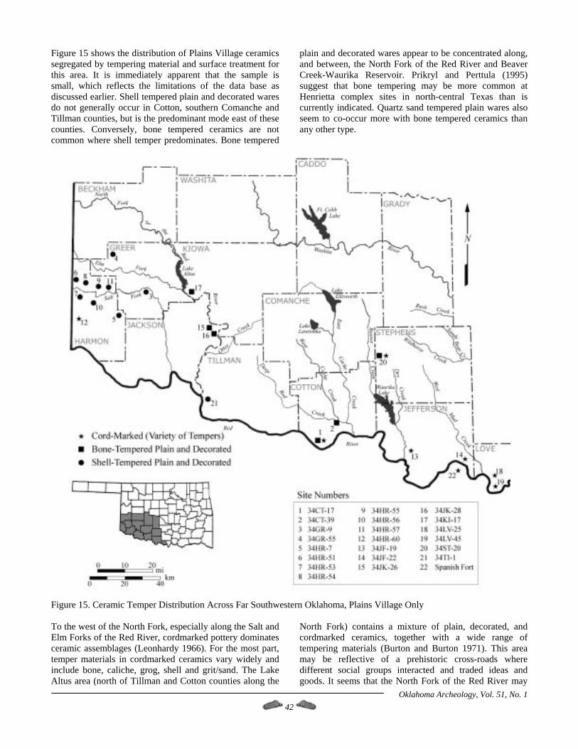
Figure 15 shows the distribution of Plains Village ceramics segregated by tempering material and surface treatment for this area. It is immediately apparent that the sample is small, which reflects the limitations of the data base as discussed earlier. Shell tempered plain and decorated wares do not generally occur in Cotton, southern Comanche and Tillman counties, but is the predominant mode east of these counties. Conversely, bone tempered ceramics are not common where shell temper predominates. Bone tempered
plain and decorated wares appear to be concentrated along, and between, the North Fork of the Red River and Beaver Creek-Waurika Reservoir. Prikryl and Perttula (1995) suggest that bone tempering may be more common at Henrietta complex sites in north-central Texas than is currently indicated. Quartz sand tempered plain wares also seem to co-occur more with bone tempered ceramics than any other type.
Figure 15. Ceramic Temper Distribution Across Far Southwestern Oklahoma, Plains Village Only To the west of the North Fork, especially along the Salt and Elm Forks of the Red River, cordmarked pottery dominates ceramic assemblages (Leonhardy 1966). For the most part, temper materials in cordmarked ceramics vary widely and include bone, caliche, grog, shell and grit/sand. The Lake Altus area (north of Tillman and Cotton counties along the
North Fork) contains a mixture of plain, decorated, and cordmarked ceramics, together with a wide range of tempering materials (Burton and Burton 1971). This area may be reflective of a prehistoric cross-roads where different social groups interacted and traded ideas and goods. It seems that the North Fork of the Red River may
Oklahoma Archeology, Vol. 51, No. 1 42
have been either an important travel corridor or a natural boundary. This interesting and intriguing distribution of ceramic temper use and decoration style across the southwestern tier of Oklahoma counties hints at two important points for this report. First, the ceramic assemblage at Burton #1 may not be anomalous for this area, and second, a more intensive study geared in this direction may prove to be exceptionally beneficial to unraveling many aspects of the Late Prehistoric period in this area. Henrietta complex groups made use of local lithic materials, which is to be expected for most Woodland and Plains Village groups, but the Burton #1 assemblage seems to have fewer fine-grained materials than eastern Henrietta groups. The occupants of Burton #1 also appear to have made more use of flake tools instead of producing more formal tools which is typical of north-central Texas Henrietta complex groups. However, based on the few analytic reports of collections and test excavations at Plains Village sites in far southwestern Oklahoma (e.g., Burton and Burton 1971 and Leonhardy 1966), it seems that local materials usually dominate lithic assemblages and that an expediently produced and used flake-tool industry is fairly common. Additionally, few formal or large pieces of groundstone are reported, with most resembling those described for Burton #1. Unfortunately, we cannot say much in regards to burial patterns, site layout, or house types with the data available from Burton #1. This situation does not improve with expanded coverage across far southwestern Oklahoma. No prehistoric houses have been excavated in this area, at least ones that have been reported. Whether this reflects an inadequate sampling of sites or a genuine absence of villages remains to be tested and further evaluated by future researchers. However, several vague references are made in published reports of large village sites in the general area, but none have been investigated or reported (Harden 1976; J. Hughes 1973). Until these sites are formally recorded and researched, the available evidence can be used to suggest that perhaps groups living in this area were more mobile than previously suspected. Lintz (1974) suggests that people in western Oklahoma and the Texas-Oklahoma panhandles were more mobile than their Washita River phase counterparts, and perhaps the same can be said for groups living along the western margins of the Southern Plains. However, the evidence at Burton #1 with regards to mobility and sedentism is somewhat ambiguous and cannot be used to test Lintz's intriguing hypothesis. To conclude, I suggest that the occupants of Burton #1 were perhaps affiliated with Henrietta complex groups along the Red River and north-central Texas more so than with Washita River or Turkey Creek groups to the north and northeast. Some cultural pattern variation is noted that is not typical for Henrietta and Washita River groups but
probably reflects local adaptations more than real cultural differences. However, in general, the observations noted for Burton #1 seem to fall within the parameters recorded for Southern Plains Village groups with the exceptions noted above. These exceptions may hint at the usefulness of developing a typology for a western Red River variation of the Henrietta complex, but obviously more work needs to be done before this suggestion becomes a reality. This suggestion could be useful to Plains archaeologists by allowing for more precision and detail when discussing the nebulous Henrietta complex in general and when investigating Plains Village sites in southwestern Oklahoma and northwestern Texas.
Acknowledgements I wish to thank Charles Wallis, Oklahoma Conservation Commission archaeologist at the time this report was written, for providing access to the artifact collection from the Burton #1 and #2 sites (34CT39 and 34CT40) and for supporting this research analysis and report. Charles' comments, criticisms, recollections and field notes pertaining to the fieldwork (Wallis 1987) and to this report were of tremendous help. The Oklahoma Conservation Commission's support in general of archaeological research in Oklahoma is always appreciated. The staff at the Oklahoma Archeological Survey in Norman have been supportive of this research and are thanked for sharing their knowledge of Oklahoma prehistory with me. I wish to thank Kari Schimdt, currently located at the University of New Mexico, for her work on the faunal analysis section, Richard Drass for his assistance with the ceramic and botanical analysis, and Marjy Duncan, Scott Brosowske and Valli Powell for their assistance in identifying various lithic raw material types. Chris Cook provided his expertise on figure formatting and report production. Charles Wallis, Robert Brooks, Richard Drass, Susan Vehik and Marjy Duncan read and commented on earlier drafts of this report. However, I remain solely responsible for any errors and inaccuracies that may be contained in this report. Finally, everyone involved with this project wishes to thank the previous landowners, Mrs. Burton and her son Kenneth, for permitting this research on their property. Note: This article represents a condensed version of a comprehensive report published as OKLAHOMA CONSERVATION COMMISSION ARCHAEOLOGICAL RESEARCH REPORT No. 18 which was released in March 1999.
References Cited Agogino, George A. 1992 An Analysis of Skeletal Remains from Cotton County and Upper Muddy Boggy Watersheds. Report to the Soil Conservation Service, State Office, Stillwater, Oklahoma.
Oklahoma Archeology, Vol. 51, No. 1 43
Oklahoma Archeology, Vol. 51, No. 1 44
Albert, Lois E., and Don G. Wyckoff 1984 Oklahoma Environments: Past and Present. In Prehistory of Oklahoma, edited by Robert E. Bell, pp. 1-43. Academic Press, Orlando, Florida. Anderson, Joseph K., and Susan E. Bearden 1992 An Archaeological Survey of Selected Areas in Cotton County Along the I-44 Corridor, for the Oklahoma Historical Society. Final Report, OHS Project No. 40-91-60042.005 and Museum of the Great Plains Report No. 91-05, Lawton, OK. Bamforth, Douglas 1986 Technological Efficiency and Tool Curation. American Antiquity 51(1):35-50. Banks, Larry D. 1990 From Mountain Peaks to Alligator Stomachs: A Review of Lithic Sources in the Trans-Mississippi South, the Southern Plains, and Adjacent Southwest. Oklahoma Anthropological Society Memoir No. 4, University of Oklahoma Printing Services, Norman, OK. Bell, Robert E. 1973 The Washita River Focus of the Southern Plains. In Variations in Anthropology: Essays in Honor of John C. McGregor, edited by D.W. Lathrap and J. Douglas, pp. 171-187. Illinois Archaeological Survey, Urbana. 1984a The Plains Villagers: The Washita River. In Prehistory of Oklahoma, edited by R.E. Bell, pp. 307-324. Academic Press, Orlando, Florida. Beta Analytic Inc. 1997 Carbon Dating Results on Features #3 and #4, 34CT39 and Descriptive Summary. Biesaart, L.A., W.R. Roberson, and L.C. Spotts 1985 Prehistoric Archeological Sites in Texas: A Statistical Overview. Office of the State Archeologist Special Report 28, Texas Historical Commission, Austin. Binford, Lewis R. 1978 Nunamiut Ethnoarchaeology. Academic Press, New York. 1979 Organization and Formation Processes: Looking at Curated Technologies. Journal of Anthropological Research 35:255-273. 1980 Willow Smoke and Dog’s Tails: Hunter-Gatherer Settlement Systems and Archaeological Site Formation. American Antiquity 45(1). Blair, F. W., and T. H. Hubbell 1938 The Biotic Districts of Oklahoma. The American Midland Naturalist 20:425-454.
Bonnichsen, R. 1973 Some Operational Aspects of Human and Animal Bone Alteration. In Mammalian Osteo-Archaeology, edited by Miles Gilbert. Missouri Archaeological Society, Columbia. Branson, Branley A. 1982 The Mussels (Unionacea: Bivalva) of Oklahoma, Part 1--Ambleminae. Proceedings of the Oklahoma Academy of Science 62:38-45. 1984 The Mussels (Unionacea: Bivalva) of Oklahoma--Part 3: Lampsilini. Proceedings of the Oklahoma Academy of Science 64:20-36. Brewington, Robbie L., John E. Dockall, and Harry J. Shafer 1995 Archaeology of 41MX5: A Late Prehistoric Caddoan Hamlet in Morris County, Texas. Reports of Investigations No. 1, Center for Environmental Archaeology, Texas A&M University, College Station. Brooks, Robert L. 1987 The Arthur Site: Settlement and Subsistence Structure at a Washita River Phase Village. Studies in Oklahoma’s Past No. 15, Oklahoma Archaeological Survey, Norman. 1989 Village Farming Societies. In From Clovis to Comanchero: Archeological Overview of the Southern Great Plains, edited by J.L. Hofman, R.L. Brooks, J.S. Hays, D.W. Owsley, R.L. Jantz, M.K. Marks, and M.H. Manhein, pp. 71-90. Arkansas Archeological Survey Research Series No. 35, Little Rock, Arkansas. 1994a Warfare on the Southern Plains. In Skeletal Biology in the Great Plains: Migration, Warfare, Health, and Subsistence, edited by D.W. Owsley and R.L. Jantz, pp. 317-323. Smithsonian Institution Press, Washington, D.C. 1994b Southern Plains Cultural Complexes. In Skeletal Biology in the Great Plains: Migration, Warfare, Health, and Subsistence, edited by D.W. Owsley and R.L. Jantz. Smithsonian Institution Press, Washington, D.C. Brooks, Robert L., Richard R. Drass, and Fern E. Swenson 1985 Prehistoric Farmers of the Washita River Valley: Settlement and Subsistence Patterns During the Plains Village Period. Archaeological Resource Survey Report No. 23, Oklahoma Archaeological Survey, Norman. Burton, Robert J., and Susan Sasse Burton 1971 An Archaeological Survey of the Lake Altus Shoreline, Greer and Kiowa Counties. Oklahoma River Basin Survey, Archaeological Survey Report No. 12, University of Oklahoma Research Institute, Norman.
Caire, W., J.D. Tyler, B.P. Glass, M.A. Mares 1989 Mammals of Oklahoma. University of Oklahoma Press, Norman. Curtis, Neville M. Jr., and William E. Ham 1972 Geomorphic Provinces of Oklahoma. In Geology and Earth Resources of Oklahoma. Oklahoma Geological Survey Educational Publication No. 1, Norman. Dalquest, W.W. and N.V. Horner 1984 Mammals of North Central Texas. Midwestern State University Press, Wichita Falls, Texas. Downs, J.F. 1966 The Two Worlds of the Washo, an Indian Tribe of California and Nevada. Holt, Rinehart and Winston Press, New York. Drass, Richard R. 1997 Culture Change on the Eastern Margins of the Southern Plains. Studies in Oklahoma's Past No. 19, Oklahoma Archaeological Survey, University of Oklahoma, Norman. 1998 The Southern Plains Villagers. In Archaeology on the Great Plains, edited by W. Raymond Wood, pp. 415-455. University of Kansas Press, Lawrence. Ferring, C. Reid 1982 The Late Holocene Prehistory of the Delaware Canyon, Oklahoma. Contributions in Archaeology 1, Institute of Applied Sciences, North Texas State University, Denton. Hall, Stephen A., and Christopher Lintz 1984 Buried Trees, Water Table Fluctuations, and 3000 Years of Changing Climate in West-Central Oklahoma. Quaternary Research 22:129-133. Hard, Robert J. 1990 Agricultural Dependence in the Mountain Mogollon. In Perspectives on Southwestern Prehistory, edited by Paul Minnis and Charles Redman, pp. 135-149. Harden, Patrick 1976 The Oklahoma Red River Basin above Denison Dam: An Archaeological Perspective. Environmental Assessments, Inc., Oklahoma City. Hofman, Jack L. 1977 Archaeological Salvage Investigations at the Henry Site, Cotton County. Oklahoma Anthropological Society Newsletter 25(2):5-9. Hughes, David T. 1977 Analysis of Certain Prehistoric Bison Kills in the Texas Panhandle and Adjacent Areas. Master's Thesis, Department of Anthropology, University of Arkansas, Fayetteville.
Hughes, Jack T. 1973 Archeological Reconnaissance in the Upper Red River Drainage of Oklahoma and Texas. Archeological Research Laboratory, West Texas State University, Canyon, Texas. Kraft, Kenneth C. 1997 The Distribution of Alibates Silicified Dolomite Clasts Along the Canadian River. Current Research in the Pleistocene 14:106-109. Krieger, Alex D. 1946 Culture Complexes and Chronology in Northern Texas, with Extension of Puebloan Datings to the Mississippi Valley. University of Texas Publication No. 4640, Austin. Leonhardy, Frank C. 1966 Test Excavations in the Mangum Reservoir Area of Southwestern Oklahoma. Contributions of the Museum of the Great Plains No. 2, Lawton, Oklahoma. Lintz, Christopher R. 1974 An Analysis of the Custer Focus and Its Relationship to the Plains Village Horizon in Oklahoma. Papers in Anthropology 15(2):1-72. 1986 Architecture and Community Variability within the Antelope Creek Phase of the Texas Panhandle. Studies in Oklahoma's Past No. 14, Oklahoma Archeological Survey, Norman. Lurie, Rochelle 1989 Lithic Technology and Mobility Strategies: the Koster Site Middle Archaic. In Time, Energy, and Stone Tools, edited by Robin Torrance, pp. 46-56. Cambridge University Press, Great Britain. Lyman, R.L. 1987 Archaeofaunas and Butchery Studies: A Taphonomic Perspective. Advances in Archaeological Method and Theory 10:249-337. Academic Press, New York. Martin, Ernest R. 1994 The Dillard Site: A Late Prehistoric Plains Village Site in Cooke County, Texas. Bulletin of the Texas Archeological Society 62: 105-200. Morrow, Carol A., and Richard W. Jeffries 1989 Trade or Embedded Procurement?: A Test Case from Southern Illinois. In Time, Energy, and Stone Tools, edited by Robin Torrance, pp. 27-33. Cambridge University Press, Great Britain. Nelson, Ben A., Margaret Rugge, and Steven A. LeBlanc
Oklahoma Archeology, Vol. 51, No. 1 45
1978 LA 12109: A Small Classic Mimbres Ruin, Mimbres Valley. In Limited Activity and Occupation Sites: A Collection of Conference Papers, edited by

Albert Ward, pp. 191-206. Center for Anthropological Studies Contribution No. 1, Albuquerque, New Mexico. Nelson, Margaret C. 1991 The Study of Technological Organization. In Archaeological Method and Theory, Vol. 3, edited by M.B. Schiffer, pp. 57-99. University of Arizona Press, Tucson. Price, J.A. 1962 Washo Economy. Nevada State Museum Anthropological Papers 6. Nevada State Museum, Carson City, Nevada. Prikryl, Daniel J. 1990 Lower Elm Fork Prehistory: A Redefinition of Cultural Concepts and Chronologies along the Trinity River, North-Central Texas. Office of the State Archeologist Report 37, Texas Historical Commission, Austin. Prikryl, Daniel J., and Timothy K. Perttula 1995 North Central Texas. In Prehistoric and Historic Aboriginal Ceramics in Texas, edited by T. Perttula, M. Miller, R. Ricklis, D. Prikryl, and C. Lintz, pp. 189-195. Bulletin of the Texas Archaeological Society 66. Quigg, J. Michael, et al. 1996 Early Archaic Use of the Concho River Terraces: Cultural Resource Investigations at 41TG307 and 41TG309, Tom Green County, San Angelo, Texas. TRC Mariah Associates, Inc., Technical Report No. 11058, Austin, Texas. Rinwald, William J., and Otho W. Lamar 1963 Soil Survey of Cotton County, Oklahoma. United States Department of Agriculture and the Oklahoma Agricultural Experimental Station Report No. 11, Washington D.C. Schmidt, Kari M. 1997 The 5 Feature Site: Evidence for a Prehistoric Rabbit Drive. Paper presented at the 55th Annual Plains Anthropological Conference, Boulder, CO. 1998 A Diachronic Examination of Faunal Remains from the San Simon Valley, Southeastern Arizona. Unpublished Master’s Thesis, Department of Anthropology, University of Oklahoma. Shaffer, Brian S. 1992 Interpretation of Gopher Remains from Southwestern Archaeological Assemblages. American Antiquity 57(4):683-691. Shelley, Phillip H. 1993 A Geoarchaeological Approach to the Analysis of Secondary Lithic Deposits. Geoarchaeology 8(1):59-72.
Spivey, Towana, C. Reid Ferring, Daniel J. Crouch, and Kathy Franklin 1977 Archaeological Investigations Along the Waurika Pipeline, Comanche, Cotton, Jefferson, and Stephens Counties, Oklahoma. Contributions of the Museum of the Great Plains No. 5, Lawton, OK. Steward, J.H. 1938 Basin-Plateau Aboriginal Sociopolitical Groups. Bureau of American Ethnology Bulletin 120. Smithsonian Institution Press, Washington, D.C. Stewart, O.C. 1941 Culture Element Distributions, XIV: Northern Paiute. University of California Anthropological Records 4(3):361-446. University of California Press, Berkeley. Vaughn, T.A. 1972 Mammalogy. W.B. Saunders Company, Philadelphia. Vehik, Susan C. 1984 The Woodland Occupations. In Prehistory of Oklahoma, edited by Robert E. Bell, pp. 175-197. Academic Press, Orlando, Florida. 1994 Cultural Continuity and Discontinuity in the Southern Prairies and Cross Timbers. In Plains Indians A.D. 500-1500: The Archaeological Past of Historic Groups, edited by K.H. Schlesier, pp. 239-263. University of Oklahoma Press, Norman. Wallis, Charles S., Jr. 1987 Field notes for data recovery at 34CT39 and 34CT40, Cotton County, Oklahoma. Curated at the Oklahoma Conservation Commission Office, Oklahoma Archaeological Survey, Norman. 1990 Inventory of Native American Human Remains Recovered as a Result of USDA SCS Projects within Oklahoma. OCC Miscellaneous Report Series No. 20, Oklahoma City. Wheat, M.M. 1967 Survival Arts of the Primitive Paiutes. University of Nevada Press, Reno. Wyckoff, Don G. 1993 Gravel Sources of Knappable Alibates Silicified Dolomite. Geoarchaeology 8(1):35-58. Wyckoff, Don G., and Robert L. Brooks (eds) 1983 Oklahoma Archaeology: A 1981 Perspective of the State's Archaeological Resources, Their Significance, Their Problems, and Some Proposed Solutions. Archaeological Resource Survey Report No. 16, Oklahoma Archaeological Survey, University of Oklahoma, Norman.
Oklahoma Archeology, Vol. 51, No. 1 46
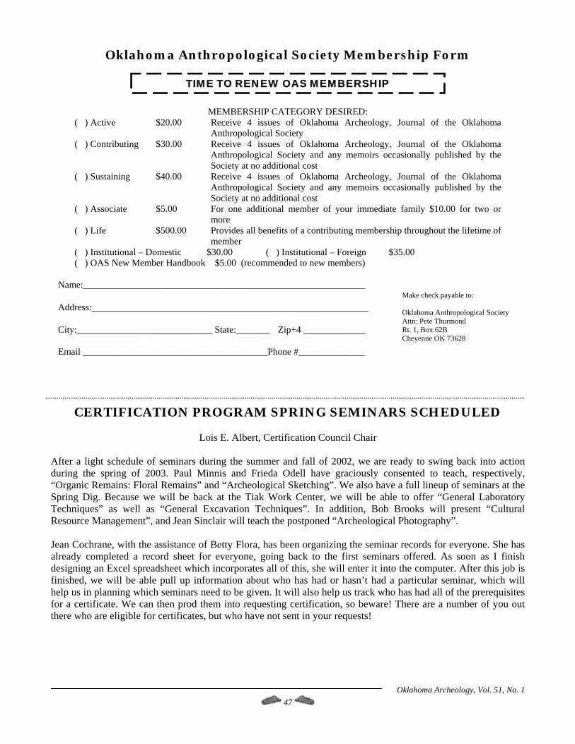
Oklahoma Anthropological Society Membership Form
( ) Active $20.00
( ) Contributing $30.00
( ) Sustaining $40.00
( ) Associate $5.00
( ) Life $500.0
( ) Institutional – Domestic( ) OAS New Member Han
Name:__________________ Address:________________ City:___________________ Email _____________________
CERTIFICATION
After a light schedule of seminduring the spring of 2003. Pa“Organic Remains: Floral RemSpring Dig. Because we will bTechniques” as well as “GenResource Management”, and Je Jean Cochrane, with the assistaalready completed a record shdesigning an Excel spreadsheetfinished, we will be able pull help us in planning which semifor a certificate. We can then pthere who are eligible for certif
TIME TO RENEW OAS MEMBERSHIP
MEMBERSHIP CATEGORY DESIRED:
Receive 4 issues of Oklahoma Archeology, Journal of the Oklahoma Anthropological Society
Receive 4 issues of Oklahoma Archeology, Journal of the Oklahoma Anthropological Society and any memoirs occasionally published by the Society at no additional cost
Receive 4 issues of Oklahoma Archeology, Journal of the Oklahoma Anthropological Society and any memoirs occasionally published by the Society at no additional cost For one additional member of your immediate family $10.00 for two or more
0 Provides all benefits of a contributing membership throughout the lifetime of member
$30.00 ( ) Institutional – Foreign $35.00 dbook $5.00 (recommended to new members)
________________________________
_________________________________
_____ State:______ Zip+4 ___________
__________________Phone #______________
Make check payable to: Oklahoma Anthropological Society Attn: Pete Thurmond Rt. 1, Box 62B Cheyenne OK 73628
PROGRAM SPRING SEMINARS SCHEDULED
Lois E. Albert, Certification Council Chair
ars during the summer and fall of 2002, we are ready to swing back into action ul Minnis and Frieda Odell have graciously consented to teach, respectively,
ains” and “Archeological Sketching”. We also have a full lineup of seminars at the e back at the Tiak Work Center, we will be able to offer “General Laboratory eral Excavation Techniques”. In addition, Bob Brooks will present “Cultural an Sinclair will teach the postponed “Archeological Photography”.
nce of Betty Flora, has been organizing the seminar records for everyone. She has eet for everyone, going back to the first seminars offered. As soon as I finish which incorporates all of this, she will enter it into the computer. After this job is up information about who has had or hasn’t had a particular seminar, which will nars need to be given. It will also help us track who has had all of the prerequisites rod them into requesting certification, so beware! There are a number of you out
icates, but who have not sent in your requests!
Oklahoma Archeology, Vol. 51, No. 1 47
Oklahoma Archeology, Vol. 51, No. 1 48
Enrollment Form For Certification Program Seminars ENROLLMENT FORM FOR CERTIFICATION PROGRAM SEMINARS _____ S9A Organic Remains: Floral (Plant) Remains. Time: Saturday, February 22, 2003, 9:00 a.m. to ca. 4:00 p.m. Place: Dale Hall Tower, Small lab. Instructor: Dr. Paul Minnis. _____ S18 Archeological Sketching. Time: Saturday, March 29, 2003, 9:00 a.m. Place: Oklahoma Archeological Survey conference room. Instructor: Frieda Odell. _____ S10 Historical Archeological Methods. Time: Saturday, April 26 or May 3, 2003. 9:00 a.m. [NOTE: TENTATIVE] Place: Oklahoma Archeological Survey Conference Room. Instructors: TBA. See next issue for more information. Please do not send money for this seminar yet. _____ S3 General Excavation Techniques. Time: Saturday, May 24, 2003, 8:30 a.m. Place: Tiak Work Center (Spring Dig). Instructor: Lois Albert. _____ S13 Cultural Resource Management. Time: Saturday, May 24, 2003, 7:30 p.m. Place: Tiak Work Center (Spring Dig). Instructor: Dr. Robert Brooks. _____ S4 General Laboratory Techniques. Time: Sunday, May 25, 2003, 8:30 a.m. Place: Tiak Work Center (Spring Dig). Instructor: Lois Albert. _____ S6 Archeological Photography. Time: Monday, May 26, 2003, 8:30 a.m. Place: Tiak Work Center (Spring Dig). Instructor: Jean Sinclair. Please include $2.00 per seminar as an enrollment fee (make checks payable to OU/Archeological Survey). In seminars with limited enrollment, preference will be given to members who are in the Certification Program. Some seminars may have an additional fee for reading or study materials; this is usually a nominal amount. Indicate: ___ I am a current OAS member. ___ I am enrolled in the Certification Program. Name: ____________________________________________________________________ Address: ____________________________________________________________________ City/State/Zip: ________________________________________________________________ Telephone: (____) _______________ (W), (____) _______________ (H) email address: Send this completed form with your payment (check/money order - make check to Oklahoma Archeological Survey) to: Lois Albert, Certification Council Chair Oklahoma Archeological Survey The University of Oklahoma 111 E. Chesapeake Norman OK 73019-5111 Telephone: (405) 325-7207; FAX (405) 325-7604 e-mail: [email protected]