euref’s reference networks epn, ueln, and ecgn – basis … · 3. austria bev - bundesamt für...
TRANSCRIPT

EUREF’s Reference NetworksEPN, UELN, and ECGN –
Basis for Tectonic Monitoring and Investigations in Europe
Johannes Ihde 1)(BKG), Carine Bruyninx (ROB), Heinz Habrich (BKG),
Ambrus Kenyeres (FÖMI), Markku Poutanen (FGI), Martina Sacher (BKG)
EUREF – ITRF and IGS Densification ICG-02 Meeting, 4 -7 September, 2007, Bangalore, India 1
1)Contact:
Federal Agency for Cartography and Geodesy (BKG)
Richard-Strauss-Allee 11
D-60598 Frankfurt on Main
WEGENER 2008, 14th General Assembly of Wegener15-18 September, 2008
Darmstadt

EUREF
• Creation in 1987 at the IUGG General Assembly in Vancouver
• Sub-commission 1.3a of IAG
• Secretary in Munich, Central Bureau of EPN in Brussels
EUREF – ITRF and IGS Densification ICG-02 Meeting, 4 -7 September, 2007, Bangalore, India 2
• Permanent committee is the Technical Working Group with 15 members (3 meetings per year)
• Links to about 130 European organizations, agencies, universities – related to positioning and navigation

Outline
(1) Mission of EUREF
(2) Definition and Realization of European Geodetic Reference Systems
(3) EUREF’s Network Infrastructure
(4) From Reprocessing and Velocity Fields to Real-Time Network Monitoring
EUREF – ITRF and IGS Densification ICG-02 Meeting, 4 -7 September, 2007, Bangalore, India 3
(4) From Reprocessing and Velocity Fields to Real-Time Network Monitoring
(5) EUREF and WEGENER – the Natural Geodetic Partners in Europe
Summary

Outline
(1) Mission of EUREF
(2) Definition and Realization of European Geodetic Reference Systems
(3) EUREF’s Network Infrastructure
(4) From Reprocessing and Velocity Fields to Real-Time Network Monitoring
EUREF – ITRF and IGS Densification ICG-02 Meeting, 4 -7 September, 2007, Bangalore, India 4
(4) From Reprocessing and Velocity Fields to Real-Time Network Monitoring
(5) EUREF and WEGENER – the Natural Geodetic Partners in Europe
Summary

• Promotion and assistance of the adoption and use of European Terrestrial Reference System (ETRS89) in Europe in alignment to ITRFxx
• The EUREF GNSS Permanent Network (EPN) is the ground based GNSS infrastructure for scientific and
(1) EUREF Mission
DDefinition, realization and maintenance of the
European Geodetic Reference Systems
EUREF – ITRF and IGS Densification ICG-02 Meeting, 4 -7 September, 2007, Bangalore, India 5
ground based GNSS infrastructure for scientific and practical applications in positioning and navigation (GGOS, IGS-RT)
• The definition and realization of the European Vertical Reference System will arrive 2007 a new stage (EVRS2007)
• Provides all its products on the “best effort” basis and free of charge to the public
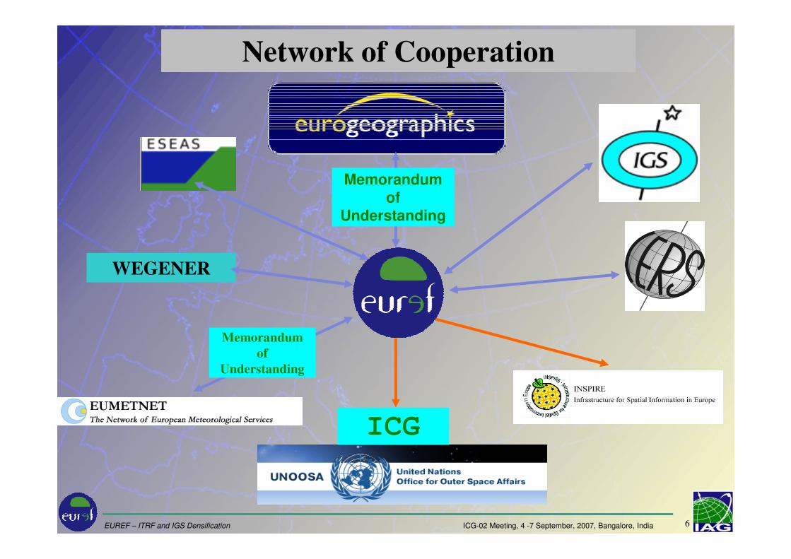
Network of Cooperation
Memorandum
of
Understanding
WEGENER
EUREF – ITRF and IGS Densification ICG-02 Meeting, 4 -7 September, 2007, Bangalore, India 6
Memorandum
of
Understanding
ICG

1. Albania Institut Studimit Tokave2. Armenia State Committee of the Real Property Cadastre3. Austria BEV - Bundesamt für Eich- und Vermessungswesen4. Belarus State Committee for Land Resources, Geodesy and Cartography5. Belgium - Nationaal Geografisch Instituut / Institut Géographique National
- Administration du Cadastre, de L'Enregistrement et des Domaines / Administratie van het Kadaster, de Registratie en de Domeinen
6. Bosnia & Herzegovina Federal Administration for Geodetic and Real Property Affairs
7. Bulgaria Ministry of Regional Development and Public Works8. Croatia Drzavna Geodetska Uprava 9. Cyprus Department of Lands and Surveys, Ministry of the Interior10. Czech Republic Cesky urad zememericky a katastralni11. Denmark Kort og Matrikelstyrelsen12. Estonia Maa-amet13. Finland - Maanmittauslaitos
- Finnish Geodetic Institute 14. France IGN – Institut Géographique National 15. Germany BKG - Bundesamt für Kartographie und Geodäsie16. Great Britain Ordnance Survey of Great Britain17. Greece - Hellenic Military Geographical Service
35. Slovakia Úrad geodézie, kartografie a katastra SR36. Slovenia Geodetska uprava republike Slovenije37. Spain - Instituto Geográfico Nacional
- Dirección General del Catastro38. Sweden Lantmäteriet39. Switzerland Bundesamt für Landestopografie40. The Netherlands Kadaster en Openbare Registers41. Turkey Harita genel komutanligi, General Command of
Mapping42. Ukraine State Service of Geodesy, Cartography and Cadastre
49 members from 42 states
NMCA’s
EUREF – ITRF and IGS Densification ICG-02 Meeting, 4 -7 September, 2007, Bangalore, India 7
17. Greece - Hellenic Military Geographical Service - Hellenic Mapping and Cadastral Organisation
18. Hungary Földügyi és Térképészeti Foosztály19. Iceland - Landmælingar Íslands
- Fasteignamat Rikisins20. Ireland Ordnance Survey of Ireland21. Italy Instituto Geografico Militare Italiano22. Kosovo Kosovo Cadastral Agency23. Latvia - LR Valsts zemes dienests
- Latvijas Geotelpiskas Informacijas Agentura24. Lithuania - National Land Service
- State Enterprise, Centre of Registers25. Luxembourg Administration du Cadastre et de la Topographie26. Malta Malta Environment and Planning Authority27. Moldova National Agency of Cadastre, Land Resources and Geodesy28. Northern Ireland Ordnance Survey of Northern Ireland29. Norway Statens kartverk30. Poland Glówny Urzad Geodezji i Kartografii31. Portugal Instituto Geografico Português32. Romania Agentia Nationala de Cadastru si Publicitate Imobiliara33. Russia Federal Service of Geodesy and Cartography of Russia34. Serbia & Montenegro
Republicki Geodetski Zavod
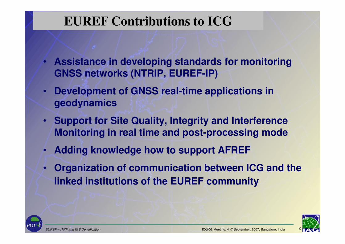
• Assistance in developing standards for monitoring GNSS networks (NTRIP, EUREF-IP)
• Development of GNSS real-time applications in geodynamics
• Support for Site Quality, Integrity and Interference
EUREF Contributions to ICG
EUREF – ITRF and IGS Densification ICG-02 Meeting, 4 -7 September, 2007, Bangalore, India 8
• Support for Site Quality, Integrity and Interference Monitoring in real time and post-processing mode
• Adding knowledge how to support AFREF
• Organization of communication between ICG and the
linked institutions of the EUREF community

GLONASS & GALILEO
Development of the GALILEO Terrestrial Reference Frame (GTRF) in alignment to ITRF 3cm
GGSP Consortium:GALILEO Geodetic Service Provider Prototype Credit: ESA
EPN is extending combined GPS/ GLONASS stations
IGS orbit
determination
CODE (AIUB, swisstopo, BKG)
EUREF – ITRF and IGS Densification ICG-02 Meeting, 4 -7 September, 2007, Bangalore, India 9
swisstopo, BKG)
ESOC
BKG

Outline
(1) Mission of EUREF
(2) Definition and Realization of European Geodetic Reference Systems
(3) EUREF’s Network Infrastructure
(4) From Reprocessing and Velocity Fields to Real-Time Network Monitoring
EUREF – ITRF and IGS Densification ICG-02 Meeting, 4 -7 September, 2007, Bangalore, India 10
(4) From Reprocessing and Velocity Fields to Real-Time Network Monitoring
(5) EUREF and WEGENER – the Natural Geodetic Partners in Europe
Summary

- ETRS89 (European Terrestrial Reference System)
• The datum is fixed to the stable part of the European Plate at the epoch 1989.0 (ITRF89)
• Realized by ETRFxx derived from ITRFxx by removing the velocity of the European plate (xx is currently 2005)
(2) Definition and Realization of
European Geodetic Reference Systems
EUREF – ITRF and IGS Densification ICG-02 Meeting, 4 -7 September, 2007, Bangalore, India 11
the velocity of the European plate (xx is currently 2005)• based on EUREF GNSS Permanent Network EPN
- EVRS (European Vertical Reference System 2007)
• Related European Vertical Datum (NAP)• Realized by the United European Levelling Network
(UELN)

8 Science-driven GNSS network serving high precision users in Geodesy, Geophysics, Timing, Navigation
8 Densification of the IGS (International GNSS Service) in Europe
8 European contribution to global geodetic networks
8 Operating under the IGS standards
– GPS & GPS+GLONASS tracking stations– Data Centres providing free access to the observation data (daily
EUREF GNSS Permanent Network - EPN
EUREF – ITRF and IGS Densification ICG-02 Meeting, 4 -7 September, 2007, Bangalore, India 12
– Data Centres providing free access to the observation data (daily & hourly RINEX)
– Analysis Centres computing station coordinates and by-products
Brest, France
Matera, ItalySajarevo,
Bosnia/HercegovinaVaasa, Finland

http://www.epncb.oma.be/
EUREF – ITRF and IGS Densification ICG-02 Meeting, 4 -7 September, 2007, Bangalore, India 13

European Commission adopted ETRS89 as the geodetic datum for geo-referenced information of the EC and promote the use of ETRS89 within member states.
Results
EUREF – ITRF and IGS Densification ICG-02 Meeting, 4 -7 September, 2007, Bangalore, India 14
Promotion of the adoption of ETRS89 by the National Mapping and Cadastral Agencies
Adoption of ETRS89 by Eurocontrol

Outline
(1) Mission of EUREF
(2) Definition and Realization of European Geodetic Reference Systems
(3) EUREF’s Network Infrastructure
(4) From Reprocessing and Velocity Fields to Real-Time Network Monitoring
EUREF – ITRF and IGS Densification ICG-02 Meeting, 4 -7 September, 2007, Bangalore, India 15
(4) From Reprocessing and Velocity Fields to Real-Time Network Monitoring
(5) EUREF and WEGENER – the Natural Geodetic Partners in Europe
Summary

GNSS Station (200)Data centre (7)Analysis centre (16)2 of them provide combined GPS/GLONASS products
EPN is the Densification of ITRF2005 and the
Realization of ETRS89
8 200 permanent GNSS stations (40 GPS/ GLONASS)
8 55 of them are IGS stations
EUREF – ITRF and IGS Densification ICG-02 Meeting, 4 -7 September, 2007, Bangalore, India 16
products
8 30 European countries are covered
8 100 contributing agencies

• 21 countries• 74 stations with
� GNSS (EPN)� absolut gravity� levelling to
EVRS
European Geodetic Network contribution to GGOS
EVRS and ECGN
European Combined Geodetic Network
EUREF – ITRF and IGS Densification ICG-02 Meeting, 4 -7 September, 2007, Bangalore, India 17
EVRS� 6 super
coducting grav.� 15 tide gauges
� 8 ECGN core� 42 ECGN� 7 candidate� 15 proposed
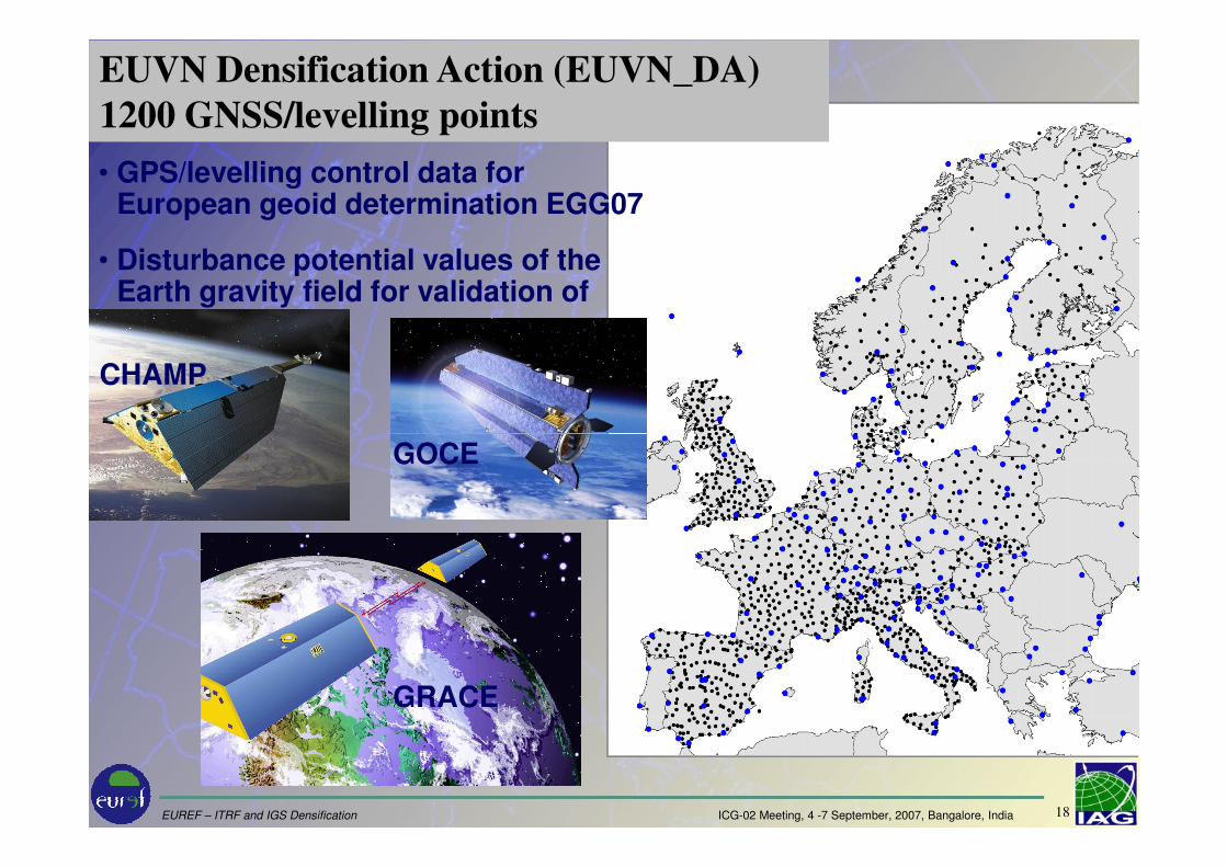
EUVN Densification Action (EUVN_DA)
1200 GNSS/levelling points
CHAMP
• GPS/levelling control data for European geoid determination EGG07
• Disturbance potential values of the Earth gravity field for validation of
EUREF – ITRF and IGS Densification ICG-02 Meeting, 4 -7 September, 2007, Bangalore, India 18
GRACE
GOCE
Outline
(1) Mission of EUREF
(2) Definition and Realization of European Geodetic Reference Systems
(3) EUREF’s Network Infrastructure
(4) From Reprocessing and Velocity Fields to Real-Time Network Monitoring
EUREF – ITRF and IGS Densification ICG-02 Meeting, 4 -7 September, 2007, Bangalore, India 19
(4) From Reprocessing and Velocity Fields to Real-Time Network Monitoring
(5) EUREF and WEGENER – the Natural Geodetic Partners in Europe
Summary

• RTCM standard for transport of real-time GNSS data and information over Internet – NTRIP technology
• Guidelines developed for
– Reference stations
– NTRIP Broadcasters
EUREF-IP Real-Time Activities (EUREF-IP)
EUREF – ITRF and IGS Densification ICG-02 Meeting, 4 -7 September, 2007, Bangalore, India 20
– NTRIP Broadcasters
– High-rate RINEX Data Centers
• EUREF-IP Pilot Project turns into routine EPN service
• EPN data streams are received at central broadcaster which provides the users with access to the streams
• The RTCM/NTRIP standard is realized in most of GNSS receivers

1. AGH University of Science and Technology - Poland (2)
2. Agricultural University of Wroclaw - Poland (1)
3. Agriculture Institute University of Milano - Italy (1)
4. Bucharest Technical University of Civil Engineering - Romania (1)
5. Budapest University of Technology and Economics - Hungary (2)
6. Bundesamt fuer Eich- und Vermessungswesen - Austria (2)
7. Czech Technical University CVUT - Czech Republic (1)
8. DIST Universita di Cagliari - Italy (1)
9. European Space Agency - Europe (1)
10. FOMI Satellite Geodetic Observatory - Hungary (1)
11. Fachhochschule Bochum - Germany (1)
12. Federal Agency for Cartography and Geodesy - Germany (17)
13. Finnish Geodetic Institute - Finland (3)
14. GOP Research Insitute of Geodesy Topography and Cartographie - Czech Republic (1)
15. Geodetic Institute University Warszawa - Poland (1)
16. Geodetic and Cartographic Institute - Slovakia (1)
17. Institut Cartografic de Catalunya - Spain (2)
18. Institut Geographique National - France (1)
19. Institute of Geodesy and Geodetic Astronomy Warsaw University of Technology - Poland (1)
20. Instituto Geografico Nacional - Spain (15)
21. Instituto Geografico Portugues - Portugal (1)
22. Instytut Geodezji i Kartografii Warszawie - Poland (1)
23. Istituto Nazionale di Ricerca Metrologica I.N.RI.M. - Italy (1)
24. KGSiN University of Warmia and Mazury - Poland (1)
1. Addis Abeba University - Ethiopia (2)
2. Agenzia Spaziale Italiana - Italy (1)
3. Agricultural University of Wroclaw - Poland (1)
4. Astronomy and Space Science Institute - Korea (2)
5. Brazilian Institute of Geography and Statistics - Brazil (1)
6. Bucharest Technical University of Civil Engineering - Romania (1)
7. Bundesamt fuer Eich- und Vermessungswesen - Austria (2)
8. Clark Fortune McDonald & Associates - New Zealand (2)
9. DIST Universita di Cagliari - Italy (1)
10. Department of Sustainability and Environment Victoria - Australia (1)
11. European Space Operations Centre - Germany (3)
12. FOMI Satellite Geodetic Observatory - Hungary (1)
13. Federal Agency for Cartography and Geodesy - Germany (20)
14. Finnish Geodetic Institute - Finland (2)
15. Florida International University Miami - U.S.A. (1)
16. GOP Research Insitute of Geodesy Topography and Cartographie - Czech Republic (1)
17. GPS Solutions Inc. - U.S.A. (1)
18. Geodetic Institute University Warszawa - Poland (1)
19. Geoinformatics Center Asian Institute of Technology - Thailand (1)
20. Geoscience Australia - Australia (23)
21. Instytut Geodezji i Kartografii Warszawie - Poland (1)
22. Istituto Nazionale di Ricerca Metrologica I.N.RI.M - Italy (1)
23. L'equipe du reseau Banian - New Caledonia (2)
24. Lantmaeteriverket - Sweden (1)
Contributors to www.euref-ip.net/home Contributors to www.igs-ip.net/home
The server www.euref-ip.net, running on Port 80 and 2101, operated by BKG
EUREF – ITRF and IGS Densification ICG-02 Meeting, 4 -7 September, 2007, Bangalore, India 21
24. KGSiN University of Warmia and Mazury - Poland (1)
25. Landesvermessung Bayern - Germany (1)
26. Landesvermessung Mecklenburg-Vorpommern - Germany (3)
27. Landesvermessung Saarland - Germany (1)
28. Landesvermessung Thueringen - Germany (1)
29. Leica Geosystems AG - Switzerland (1)
30. Leica Geosystems Sp.z.o.o - Poland (1)
31. Mairie de Cannes - France (1)
32. NERC Space Geodesy Facility - United Kingdom (1)
33. National Land Survey - Sweden (3)
34. Ordnance Survey - United Kingdom (2)
35. Politecnico di Torino - Italy (1)
36. Royal Observatory - Belgium (1)
37. SAPOS Berlin - Germany (1)
38. Satellite Observatory Lamkowko University of Warmia and Mazury - Poland (1)
39. Survey Sales and Hire - Ireland (2)
40. SwissTopo - Switzerland (1)
41. Techische Universitaet Wien - Austria (1)
42. Technical School of Rovereto - Italy (1)
43. Technical University Delft - The Netherlands (1)
44. Telespazio S.p.A. - Italy (2)
45. TopoBreda - Portugal (1)
46. Universitat die Perugia - Italy (2)
47. University Padova - Italy (2)
48. University Rome La Sapienza - Italy (1)
49. VUGTK Geodetic Observatory Pecny - Czech Republic (1)
Total: 94 Streams
24. Lantmaeteriverket - Sweden (1)
25. Mecinca Topografia GPS - Venezuela (1)
26. NASA Stennis Space Center - U.S.A. (1)
27. NERC Space Geodesy Facility - United Kingdom (1)
28. National Geographic Information Institute - Korea (1)
29. National Land Survey - Sweden (3)
30. Natural Resources - Canada (9)
31. Naval Observatory - U.S.A. (1)
32. Point Inc. - Canada (2)
33. Puget Sound Reference Network - U.S.A. (1)
34. Regional Centre for Mapping of Resources for Development - Kenya (1)
35. Royal Observatory - Belgium (1)
36. Scripps Orbit and Permanent Array Center - U.S.A. (1)
37. Solucoes em Posicionamento Global SPG - Brazil (1)
38. Standard Instrument Corporation - Taiwan (1)
39. Survey Research Institute HARAM SRI - Egypt (1)
40. Surveys and Mapping - South Africa (2)
41. SwissTopo - Switzerland (1)
42. Technical University Prague - Czech Republic (4)
43. Universidade Estadual Paulista UNESP/FCT - Brazil (4)
44. Universidade da Baira Interior UBI/CGUL/IDL - Portugal (1)
45. University New South Wales - Australia (1)
46. University Padova - Italy (2)
47. University of New Brunswick - Canada (2)
Total: 116 Streams
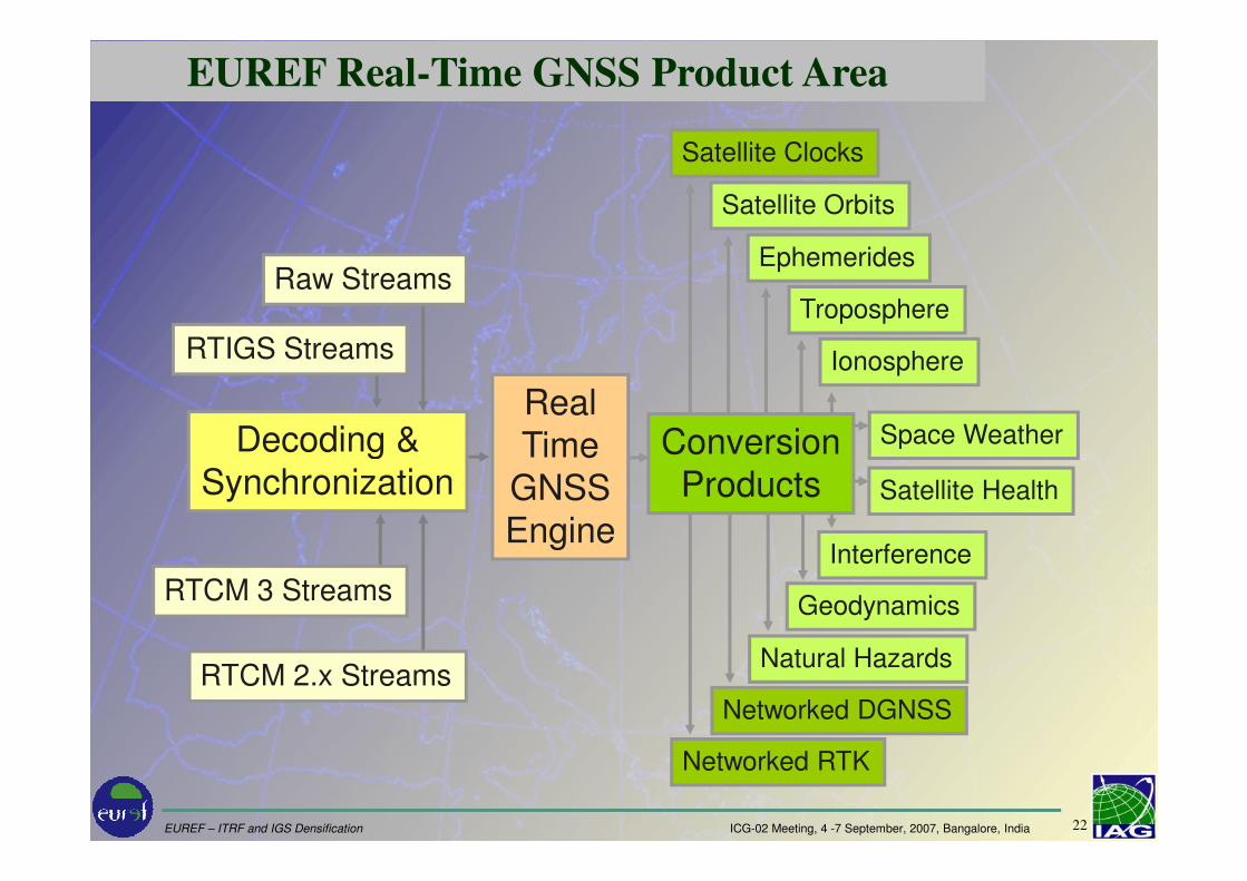
EUREF Real-Time GNSS Product Area
RealTime Space Weather
Satellite Clocks
Satellite Orbits
Troposphere
Ionosphere
Ephemerides
ConversionDecoding &
Raw Streams
RTIGS Streams
EUREF – ITRF and IGS Densification ICG-02 Meeting, 4 -7 September, 2007, Bangalore, India 22
RTCM 2.x Streams
RTCM 3 Streams
TimeGNSSEngine
Space Weather
Satellite Health
Interference
Geodynamics
Natural Hazards
Networked DGNSS
Networked RTK
ConversionProducts
Decoding &Synchronization

IGS station
Helgoland
Example: GNSS RT Application for
Geohazard MonitoringThe Love wave caused by the Sumatra-Andaman earthquake has reached Germany approx. 5530 seconds since 00:00:00 UTC, Dec 26, 2004 from the East direction after a travel time of approx. 2000 seconds.
1 Hz GPS data, Bernese Software 5.0, kinematic mode
EUREF – ITRF and IGS Densification ICG-02 Meeting, 4 -7 September, 2007, Bangalore, India 23
Correlation between 1 Hz GPS and seismometer data

Outline
(1) Mission of EUREF
(2) Definition and Realization of European Geodetic Reference Systems
(3) EUREF’s Network Infrastructure
(4) From Reprocessing and Velocity Fields to Real-Time Network Monitoring
EUREF – ITRF and IGS Densification ICG-02 Meeting, 4 -7 September, 2007, Bangalore, India 24
(4) From Reprocessing and Velocity Fields to Real-Time Network Monitoring
(5) EUREF and WEGENER – the Natural Geodetic Partners in Europe
Summary

EUREF is the key organization for the support of the geodetic GNSS ground based infra-structure in Europe
- GNSS, Height and Gravity reference frames -
• EUREF supports the IAG (IGS, GGOS, …) items in EUROPE
• EUREF takes over geodetic tasks of
Summary
EUREF – ITRF and IGS Densification ICG-02 Meeting, 4 -7 September, 2007, Bangalore, India 25
• EUREF takes over geodetic tasks of EuroGeographics – the European legal entity of 49 European NMCA’s in 42 states
• EUREF will certainly be an important partner in the implementation of INSPIRE (EC), GGOS (IAG), GEOSS (GEO)
www.euref-iag.net
www.euref.eu