evolution of the sÁzava valley in the … · the chronostratigraphical system of the vltava river...
TRANSCRIPT

55
Břetislav Balatka, Philip L. Gibbard, Jan Kalvoda GEOMORPHOLOGIA SLOVACA ET BOHEMICA 1/2010
INTRODUCTION
The aim of this paper is to determine, on the basis of the terrace system of the river and geo-morphological analysis of the relief, the main stages of the Sázava River valley evolution through the late Cenozoic. The results of geo-morphological research into the Sázava basin are therefore presented both with regard to identifying the main remains of river terraces sedimentary sequences and in correlation with the chronostratigraphical system of the Vltava River and Labe River terraces. From the point of view of geomorphological research, the Sázava River valley represents a relatively ne-glected stream in the Bohemian Labe catch-ment area.
The earliest opinions on the pre-Quaternary evolution of the Sázava basin, were presented by DANEŠ (1913) and PUFFER (1930) who differentiated five terraces in the lowest part of the Sázava course. The fundamental work on the Sázava terraces and valley and basin evolu-tion was published by NOVÁK (1932). He de-scribed river terraces with the exception of the lower course. Novák’s river-terrace localities are not always of fluvial origin, some are denu-
dational plateaux, covered by subangular cob-bles and, mainly in the middle course, with sharp-edged, quartz-dominated debris. The main river terrace localities of the middle and mainly of the lower Sázava were classified by ENGELMANN (1938). Fluvial sediments and river network evolution in the Sázava catchment were also mentioned by NOVÁK (1943) in his monograph on the geomorpho-logy of the Českomoravská vrchovina High-land.
Older literature on the Sázava terraces and valley and basin evolution before 1961 was summarised by BALATKA and SLÁDEK (1962) and NOVÁK (1932) paper was used by ZÁRUBA and RYBÁŘ (1961) for their work on huge fluvial accumulations in the Sázava middle course in the larger neighbourhood of Zruč nad Sázavou. Terraces of the lower Sáza-va between Vrabčí Brod and Zbořený Kostelec were studied by ŠTĚPANČÍKOVÁ (2003). Above the alluvial plain, she distinguished five levels and related them to the Vltava terrace system (ZÁRUBA et al. 1977). Syntheses by MALKOVSKÝ (1975, 1976 and 1979) are also important for the interpretation of the Sázava valley evolution in the Neogene. The present geomorphological research into the
EVOLUTION OF THE SÁZAVA VALLEY IN THE BOHEMIAN MASSIF
BŘETISLAV BALATKA*, PHILIP L. GIBBARD**, JAN KALVODA*
Břetislav Balatka, Philip L. Gibbard, Jan Kalvoda: Evolution of the Sázava Valley in the Bohe-mian Massif. Geomorphologia Slovaca et Bohemica 10, 2010, 1, 14 figs, 2 tabs., 41 refs. The Sázava River course and catchment were initiated, in a form similar to the present one, during younger periods of the Neogene. The main drives towards the Sázava drainage reunification were arch-like uplift of the present watershed area between the Sázava River and the Labe River during the Upper Miocene to Pliocene. During the Pliocene, the Sázava flowed to the west, in a large vale-shaped valley deepened into a tectonically and denudationally deformed Palaeogene planation surface, as well as into lower Neogene planation levels. The Quaternary cutting of the Sázava valley to an average depth of 70 – 90 m (in the lowest course up to 105 m and in the upper segment about 50 m) was induced by an epeirogenetic uplift of the Bohemian Massif. The typically developed incised meanders and bends were formed mostly in the Middle Pleistocene. Height conditions of the Sázava river terraces are shown in Tab. 1 and comparison of the Sázava system with terrace systems of the Vltava River and the Labe River as well as chronostratigraphical correlation with the North European stratigraphical classification of the Quaternary is given in Tab. 2. According to the current stratigraphical scheme of the Quaternary, the entire Sázava terraces´ system was formed mostly to the Middle and Late Pleistocene, that is to the period from the “Cromerian Complex” to the Weichselian stages. Erosional stages, before accumulation of terrace I, fall in the end of the Early Pleistocene. Older levels of fluvial sediments, occupying a still higher morphological position in the studied areas of the Bohemian Massif and up to now classified as Pliocene, have thus been stratigraphically to be shifted to the Early Pleistocene. Key words: landform evolution, fluvial sediments, Quaternary, Bohemian Massif, the Sázava River
———————– * Faculty of Science, Charles University in Prague, Albertov 6, Prague 2, 128 43, Czech Republic, e-mail:
[email protected] ** Department of Geography, University of Cambridge, Cambridge, CB2 3EN, United Kingdom, e-mail: [email protected]

56
Břetislav Balatka, Philip L. Gibbard, Jan Kalvoda GEOMORPHOLOGIA SLOVACA ET BOHEMICA 1/2010
Fig. 1 Specification of the Sázava river position in the middle B
ohemia at a part of the m
ap „Bohemia“ (Pieter van den K
eere, Am
sterdam
1620). The source region of the Sázava river is not correctly draw
n so far and the Želivka river is entirely absent. This color historical map (58 x 47
cm) is based on the Zim
merm
ann´s map of B
ohemia (1619). R
eproduction of the original map from
the Map C
ollection of the Charles U
ni-versity in Prague. C
artographical sources and historical data were provided by Petr Jánský.
57
Břetislav Balatka, Philip L. Gibbard, Jan Kalvoda GEOMORPHOLOGIA SLOVACA ET BOHEMICA 1/2010
Sázava valley evolution was initiated some ten years ago and partial or thematically related studies were published by BALATKA and KALVODA (2006), BALATKA and ŠTĚ-PANČÍKOVÁ (2006), BALATKA (2007), KALVODA (2007), BALATKA and KAL-VODA (2008 and 2010).
AN OUTLINE OF GEOLOGICAL AND MORPHOLOGICAL SETTINGS
The Sázava River rises as the Stržský potok
Brook east from Nová Huť at 757 m a. s. l. This country forms part of the Žďárské vrchy Hills in the Hornosvratecká vrchovina High-land. After its 225 km long course, the Sázava River empties into the Vltava River in Davle (Fig. 1), where the water level is at 200 m (storage level of the Vrané dam), whereas the
original level of the flowing river was at 196 m here. In the period 1931 – 1960, its average flow at its mouth was 25.5 m3 s-1. In the period 1961 – 2005, its average flow in Zruč nad Sázavou was 9.4 m3 s-1 and in Nespeky 20.8 m3 s-1. The Sázava River drains a catchment area of 4 349 km2.
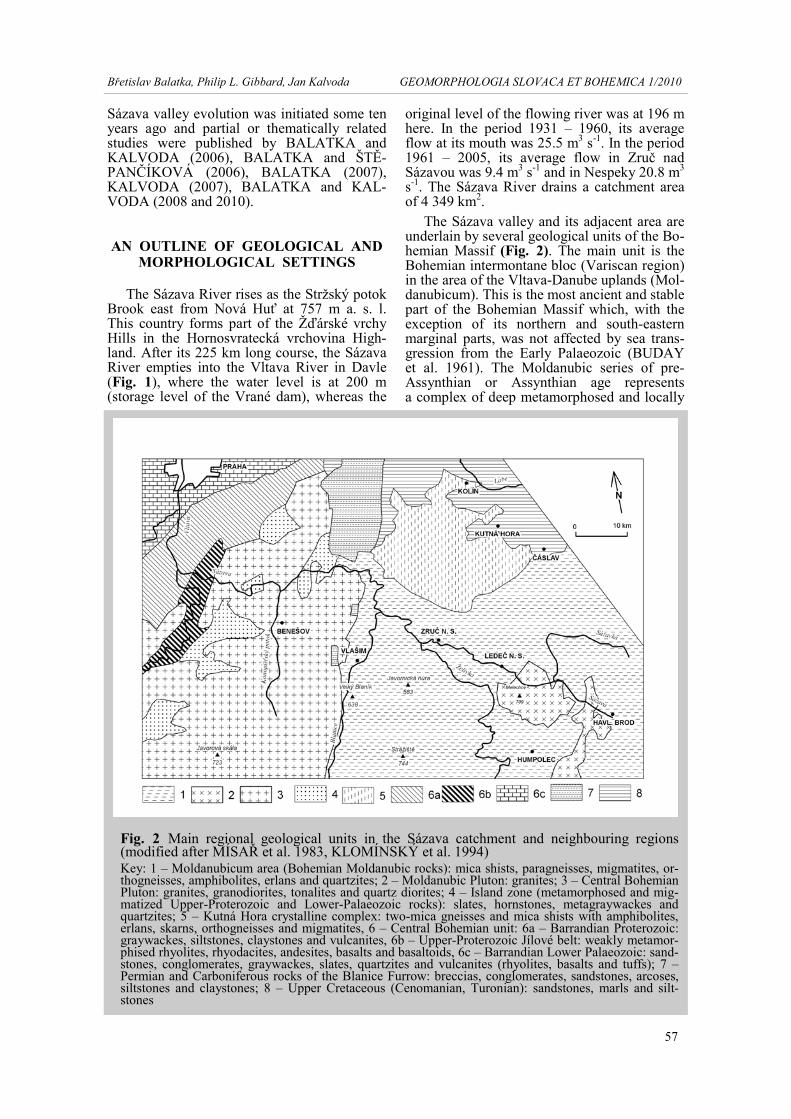
The Sázava valley and its adjacent area are underlain by several geological units of the Bo-hemian Massif (Fig. 2). The main unit is the Bohemian intermontane bloc (Variscan region) in the area of the Vltava-Danube uplands (Mol-danubicum). This is the most ancient and stable part of the Bohemian Massif which, with the exception of its northern and south-eastern marginal parts, was not affected by sea trans-gression from the Early Palaeozoic (BUDAY et al. 1961). The Moldanubic series of pre-Assynthian or Assynthian age represents a complex of deep metamorphosed and locally
Fig. 2 Main regional geological units in the Sázava catchment and neighbouring regions (modified after MÍSAŘ et al. 1983, KLOMÍNSKÝ et al. 1994) Key: 1 – Moldanubicum area (Bohemian Moldanubic rocks): mica shists, paragneisses, migmatites, or-thogneisses, amphibolites, erlans and quartzites; 2 – Moldanubic Pluton: granites; 3 – Central Bohemian Pluton: granites, granodiorites, tonalites and quartz diorites; 4 – Island zone (metamorphosed and mig-matized Upper-Proterozoic and Lower-Palaeozoic rocks): slates, hornstones, metagraywackes and quartzites; 5 – Kutná Hora crystalline complex: two-mica gneisses and mica shists with amphibolites, erlans, skarns, orthogneisses and migmatites, 6 – Central Bohemian unit: 6a – Barrandian Proterozoic: graywackes, siltstones, claystones and vulcanites, 6b – Upper-Proterozoic Jílové belt: weakly metamor-phised rhyolites, rhyodacites, andesites, basalts and basaltoids, 6c – Barrandian Lower Palaeozoic: sand-stones, conglomerates, graywackes, slates, quartzites and vulcanites (rhyolites, basalts and tuffs); 7 – Permian and Carboniferous rocks of the Blanice Furrow: breccias, conglomerates, sandstones, arcoses, siltstones and claystones; 8 – Upper Cretaceous (Cenomanian, Turonian): sandstones, marls and silt-stones

58
Břetislav Balatka, Philip L. Gibbard, Jan Kalvoda GEOMORPHOLOGIA SLOVACA ET BOHEMICA 1/2010
strongly migmatised rocks. Another structural unit of the Moldanubicum is the younger com-plex of granitoid massifs, encircled by bodies of cordieritic gneisses and Variscan migma-tites. The Moldanubic (Cadomian) folding cau-sed a significant consolidation of the area. This tectogenesis was followed by uplift and a long hiatus during which deep denudation occurred.
During the Variscan period this area was affected by strong deep magmatism which caused faults and overthrusts and frequent Va-riscan intrusions, together with cordieritic and injection aureols. In the Asturian Stage at the end of the Variscan tectogenesis the Bla-nice furrow trough was formed, similarly to a step-ped structure of other fault structures of N – S orientation. The presence of granitoid cobbles in sediments of the Český Brod Permian indi-cates intensive denudation of the thick pluton uppermost layer. During the Upper Permian, Triassic, Jurassic and Lower Cretaceous, the Moldanubic area was dry land, and the Upper Cretaceous transgression affected only the N – E margin of this area. This period of tectonic stability saw the development of planation sur-faces. A mantle of lateritic and kaolinic weath-ering products was developing up to the begin-ning of the Oligocene, under warm and in some periods wet climate conditions (MAL-KOVSKÝ 1979). Up to the end of the Palaeo-gene, streams ran through shallow, wide vale-shaped low gradient valleys.
The area of the Kutná Hora crystalline com-plex, covering northern part of the Sázava mid-
dle course, differs from the Moldanubic crys-talline complex by its weakes metamorphosis; the main rocks are orthogneisses, paragneisses and mica schists (MÜLLER et al. 2002). The most important tectonic unit in the study area – the Permian-Carboniferous Blanice Furrow – has been strongly affected by denudation, so that its initially continuous sedimentary filling has been preserved, with the exception of that of the Kostelec nad Černými lesy area, mainly in tectonically clinched blocks. The Upper Cre-taceous sea probably transgressed to the south of the present middle Sázava valley near the town of Sázava. This transgression entered from the north through a tectonic depression along the Kouřim fault, i.e. E from the uplifted territory of the Permian in the Blanice Furrow (Fig. 2).
From the upper Tertiary period onwards, there are preserved in the middle Sázava catch-ment denudation relics of Neogene sediments of limnic-fluvial origin. These sediments are classified as of Lower Miocene age (Acqui-tanian – Burdigal; MALKOVSKÝ 1975 and 1979). The geological map of the Czech Re-public 1:50 000, sheet 13 – 31 Říčany (KO-DYM et al. 1993) classifies localities near Sázava town as “relics of fluvial gravels” which are assigned to the Pliocene. Neotec-tonic movements affected the Sázava basin, especially as folds and arch uplifts, i.e. mostly as joint structures of syncline and anticline type of different amplitudes (MOSCHE-LESOVÁ 1930). Horst-type fault structures do
Fig. 3 The Sázava bouldary bed in the trough valley in the Melechov granite massif in a zone of a pronounced level gradient step

59
Břetislav Balatka, Philip L. Gibbard, Jan Kalvoda GEOMORPHOLOGIA SLOVACA ET BOHEMICA 1/2010
not occur frequently, although some are rela-tively pronounced (Velký Blaník, Malý Blaník and Melechov). The main fault structure is the pronounced N – S structure of the Kouřim fault, which continues to the south to the Bla-nice Furrow. It is a Variscan morphostructure, on which movements continued repeatedly du-ring the Upper Cretaceous as well as during the neotectonic period. The neotectonic uplift of the Černokostelecká pahorkatina Upland against the Kouřimská tabule Table has gene-rally exceeded 100 m.
The Sázava valley between the neighbour-hood of Světlá nad Sázavou and the mouth of the Vlkančický potok Brook, near Pyskočely (between river kilometres 150.0 and 50.0) is excavated into rocks of the Moldanubic crys-talline complex. Between Světlá nad Sázavou (river kilometre 143.2) and the southern neigh-bourhood of Vilémovice (river kilometre 134.8) the river crosses the Melechov massif (Fig. 3) which is an outcrop of the central Moldanubic Pluton. This markedly concentric structured massif of Variscan age is deeply rooted (15 – 17 km) and formed of four basic types of granite: Lipnice, Kouty, Melechov and Stvořidla granites (PROCHÁZKA and ML-ČOCH 1998). The river crosses all these gra-nite types, so that the asymmetrically deep, but largely open valley has a trough-like charac-
ter. From the geomorphological point of view, the main types are the Melechov and the Stvořidla granites which represent the stock of the elliptically-shaped massif. They form the large Melechov ridge (709 m) and condition the segment of an increased level gradient at Stvořidla.
Between Pyskočely and Žampach (river kilometres 50.0 – 9.8), the Sázava valley is ini-tiated into granitoids of the Central Bohemian Pluton of Variscan age. Granites, granodiorites, tonalities, diorites accompanied by abundant vein rocks (aplites, pegmatites, vein granites, porphyrs, lamprophyres, etc.) are represented there. Between Samechov and Zlenice, the val-ley cuts through bodies of Proterozoic meta-basites comprising amphibolitic slates, basalts and amphibolitic porphyrites. These bodies, together with hornstones, meta-greywackes and meta-conglomerates, form part of the metamor-phised islands representing denudational rem-nants mainly of the Upper Proterozoic. The is-land zone also includes the so-called Upper–Proterozoic Jílové belt (DUDEK in MÍSAŘ et al. 1983), traversed by the Sázava between Žampach and Pikovice (river kilometres 9.8 – 4.1). They are weakly metamorphised rhyo-lites, rhyodacites, andesites, basalts and basal-toids. In these very resistant rocks, the river has formed a closed erosional valley of an almost
Fig. 4 Part of an abandoned Sázava valley near Chabeřice filled by an up to 25 m thick accu-mulation of sediments of terrace III

60
Břetislav Balatka, Philip L. Gibbard, Jan Kalvoda GEOMORPHOLOGIA SLOVACA ET BOHEMICA 1/2010
gorge-like character. The lowest segment of the Sázava valley, downstream of Pikovice to the mouth of the Vltava (4.1 km), is based in the less resistant rocks of the Upper Proterozoic (siltstones, slates, greywackes), and that mainly of the Štěchovice and partly also of the Kra-lupy group.
The Sázava valley is characterised by re-markable morphological characters (BALAT-KA and KALVODA 2010): a) segments with a closed transverse profile follow those with enlarged to vale-like parts (Fig. 4); b) striking changes in valley directions are conditioned morphostructurally as well as by evolution; c) straight valley segments are rare, the river has a markedly undulated course with frequent in-cised bends and meanders; d) different resis-tance of rocks has not manifested in gradient conditions of the course even in the signifi-cantly erosional segments of the long middle course; e) the highest planation surfaces of etchplain and pediplain types are mostly situ-ated at 140 – 190 m above the river. Lower le-vels of denudation plateaux of mostly smaller dimensions are situated at relative heights of 90 to 130 m. They are developed at two to three height levels in a pre-Quaternary period with largely opened vale-shape valley depres-sion; f) edges of rare straight valley segments showing the extent of the mostly Middle-Pleistocene erosional down cutting are mostly situated at 60 – 90 m, in the area of the conflu-ence with the Vltava River at 105 m, and at 40 m above the river in the upper part of the course.
DISCUSSION OF CONCEPTS ON THE UPPER TERTIARY DRAINAGE OF
THE SÁZAVA CATCHMENT
Like the majority of Czech rivers, in the Upper Tertiary the Sázava catchment drained in different directions to that at present. To de-termine its course, morphostructural conditions and the localities of fluvial-lacustrine sedi-ments of Neogene age are essential. These de-posits are preserved in watershed areas, i.e. in places relatively least affected by younger ero-sion and denudation processes. The relics of probably Lower Miocene sediments (MAL-KOVSKÝ 1975 and 1979) that mainly occur in only two areas, far apart, only provide a limited basis for deciphering the Upper Tertiary evolu-tion of the river network in the Sázava catch-ment. A period of about 24 to 16 million years has elapsed since the deposition of the Upper Tertiary sediments (Fig. 5), during which dif-ferentiated neotectonic movements have brought about strong erosional-denudational
processes. They have led not only to the re-moval of the weathered cover and of part of the rock substrate, but also of part of the Neogene sediments themselves. The former Palaeogene planation surface, with a mantle of fossil weathered materials, was transformed into the younger (Neogene) relief of etchplain or pedi-ment type. In addition, younger tectonic move-ments have laid the foundation of the morpho-logical variability of landscape.
In principle, two different opinions exist on the direction of the Sázava drainage in the Neogene – the older one represented mainly by DANEŠ (1913) and NOVÁK (1930 and 1932), and a younger one represented by MAL-KOVSKÝ (1975, 1976 and 1979) or CÍLEK et al. (2004). The earlier opinion on the Tertiary drainage of the middle and lower Sázava course, advocated by DANEŠ (1913) and de-scribed in detail by NOVÁK (1930 and 1932), was based on analysis of the drainage network ground plan, on studies of geomorphological conditions and on the known occurrences of Tertiary sediments, including relict gravels. The presumed drainage to the north was based on the generally northwards inclination of the surface of the ground on the river left bank, to-gether with prevailing meridian directions of the principal left-bank Sázava tributaries, mainly of the Želivka River and the Blanice River. According to NOVÁK (1932), the indi-vidual streams of the middle Sázava catchment were orientated towards the north in the Upper Tertiary – the upper Sázava from Světlá nad Sázavou (designated as the Světelská řeka River), the Želivka River (designated as the Řeplická řeka River) and the Blanice River (designated as the Nechebská řeka River).
The course of the Tertiary upper Sázava from Světlá nad Sázavou was marked approxi-mately by the present course of the lower Sázavka River (but in the opposite direction) to Leština u Světlé and further via the nearby Sázava – Labe watershed to Nová Ves u Leš-tiny. From here it continued via the Klejnary – Doubrava watershed and Vlkaneč to the pre-sent Čáslavská kotlina Basin. The long upper course of the Sázavka in an ESE – WNW di-rection (Jiříkovský potok Brook) was the prin-cipal (right-side) affluent of this river. The pro-posed course of the so-called Světelská řeka River is to some degree supported by localities of fluvio-lacustrine gravels and sands and clays of Tertiary age (geological map 1:50 000, 13 – 43 Golčův Jeníkov). These are occur-rences SE of Bačkov (about 530 m), in the neighbourhood of Leština u Světlé (in a water-shed depression at about 470 m) and near Ko-zohlody (at about 415 m). In addition, scattered cobbles occur here near the Sázavka River (at about 512 m), NE of Leština u Světlé (above

61
Břetislav Balatka, Philip L. Gibbard, Jan Kalvoda GEOMORPHOLOGIA SLOVACA ET BOHEMICA 1/2010
the 490 m contour) and in the neighbourhood of Vlkaneč (at about 435 m).
According to NOVÁK (1932), the Tertiary Želivka was orientated in the same direction as the Řeplická řeka River across the present Želivka-Sázava watershed, near Ledeč nad Sázavou, i.e. continuing the SN valley-orien-tation between Ježov and the SW neighbour-hood of Kožlí. This river flowed along the pre-sent valley to Vlastějovice and then to Boh-daneč, Řeplice, a close-by watershed depres-sion with scattered quartz gravels at 489 m, then to the Kutnohorská plošina Plateau and via Červené Janovice to the present Čáslavská kotlina Basin and the Central Labe area.
The Neogene Blanice, like Nechebská řeka River (NOVÁK 1932), flowed from the site its present mouth to north in the direction of the younger Sázava valley towards the town of Sázava (i.e. it followed the course of the Bla-nická brázda Furrow). It then continued to a pronounced wedge-shaped promontory of a morphostructural depression with Cretaceous sediments at the Kouřim fault to the Kutno-horská plošina Plateau to the present Central Labe area. Besides is segment of the Sázava valley, a relic of the Tertiary Blanice is the pre-sent Kouřimka – Vavřinec and its left-bank tributary from near Smrk, which is 5 km NE from the Sázava near Samopše. Gravel relics of the Nechybská řeka River in the neighbour-hood of Radlice and Krymlov on the eastern
margin of the Černokostelecká pahorkatina Up-land (NOVÁK 1930), are probably broken Per-mian Carboniferous conglomerates and brec-cias. During the subsequent evolution, proba-bly during the initial process of reunification of the Sázava catchment, the Želivka and the Blanice merged possibly towards the present Sázava valley in the segment Vlastějovice – the Blanice mouth.
The possible drainage of the lower Sázava catchment towards the north might also be sup-ported by meridian orientations of larger left-bank Sázava tributaries, i.e. the Benešovský, the Konopišťský and the Janovický Brooks. It is remarkable that these streams flow opposite on the right Sázava bank: the Benešovský po-tok Brook (possibly together with the Kono-pišťský potok Brook) has the Mnichovka; the Konopišťský potok Brook has the Křivoveský potok Brook and the Janovický potok Brook the Čakovický (the Kamenický) potok Brook. These similar brooks are always connected by a Sázava valley segment of a similar direction: the Benešovský potok Brook and the Mni-chovka Brook are connected by the Sázava val-ley between Čerčany and Zlenice, the Kono-pišťský and the Křivoveský potok Brooks by the Sázava valley between Poříčí nad Sázavou and Nespeky, the Janovický and the Čakovický potok Brooks are connected by the Sázava val-ley between Týnec nad Sázavou and Zbořený Kostelec.
Fig. 5 Profile of the Miocene sediments locality Bojiště near Ledeč nad Sázavou (modified af-ter KRÁL 1971) Key: 1 – sandy-clayey loams, 2 – sands, 3 – sands with gravels, gravels with sands, 4 – clayey sands, fine-grained sands, 5 – sandy-clayey eluvium of granite
62
Břetislav Balatka, Philip L. Gibbard, Jan Kalvoda GEOMORPHOLOGIA SLOVACA ET BOHEMICA 1/2010
The right-bank tributaries of the lower Sá-zava course now arise in the watershed area between the Sázava River and the Vltava River, still in the area of the Středočeská (the Benešovská) pahorkatina Upland. The possibil-ity that northward drainage occurred in the lower Sázava course is also supported by oc-currence of Neogene sediments on the water-shed near Jesenice. Here thick sands fill old valleys (furrows) at a relative height of up to 175 m above the Sázava level. A change of drainage could have resulted from anticlined uplift of the watershed area (Fig. 1) and to a step (synclinal) fold in the zone of the present Sázava valley during the Upper Miocene to Pliocene.
On the basis of this concept, the Sázava catchment was formed during the Neogene by several partial catchments: apart from the up-permost course with presumed drainage to the Oslava River, it included the Světelská Sázava, the Želivka, the Blanice and the catchment of the lower course. Although there was a marked watershed on the rising morphostructure of the Melechov and the Žebrákovský kopec Hill be-tween the Světelská Sázava and the Želivka, the watershed between the Neogene Želivka and the Blanice was probably less morphologi-cally distinctive (Fig. 2). The higher relief of the NE promontory of the Benešovská pa-horkatina Upland, between the catchments of the Blanice and the lower course, was locally of highland character and lacked the more im-portant left-bank affluents. The merging of the catchments of individual Tertiary streams in
the Sázava catchment at its present extent oc-curred by progressive evolution of the Sázava valley (NOVÁK 1932). First, the Želivka and the Blanice should have merged, than the Světelská Sázava joined them across the barrier of a lower marginal part of Melechov. During the final stage, the former Sázava turned near the town of the same name to the west (Fig. 7) into the present direction of its lower course.
According to MALKOVSKÝ (1975 and 1979), the Sázava already flowed during the Lower Miocene (Acquitanian to Burdigal) from the neighbourhood of Ledeč nad Sázavou in its present direction to the west. From its later confluence with the Vltava, it continued to Klínec and through the Berounka catchment to the NW against the direction of the present river to the Křivoklát region. If the opinion of MALKOVSKÝ (1975 and 1979) is accepted on Neogene drainage of the substantial part of the Sázava catchment to the lake of the North Bohemian basin, it is possible to determine the absolute height position of the area of Neogene sediments as a guide to assessing of the role of younger tectonic movements. On the condition that the level of the North Bohemian lake basin was situated at an altitude of 50 m in the Lower Miocene, the altitude of the relief of Neogene sediments near Sázava town (with a recon-structed course length of about 180 km) would be about 200 m (with a mean gradient of 0.8 ‰), or 160 m (gradient of 0.6 ‰).
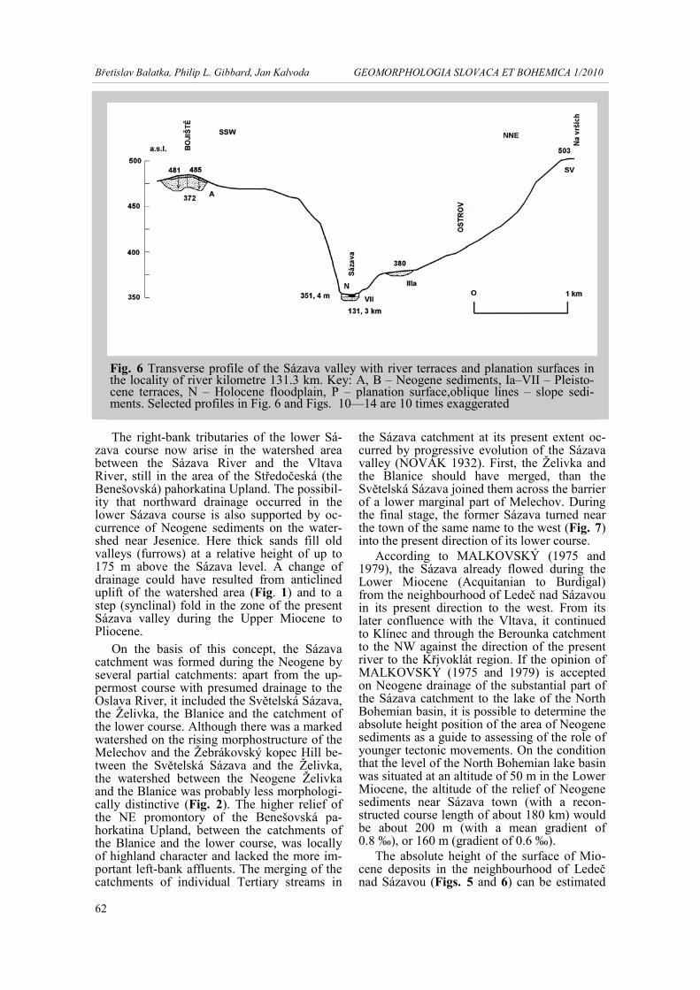
The absolute height of the surface of Mio-cene deposits in the neighbourhood of Ledeč nad Sázavou (Figs. 5 and 6) can be estimated
Fig. 6 Transverse profile of the Sázava valley with river terraces and planation surfaces in the locality of river kilometre 131.3 km. Key: A, B – Neogene sediments, Ia–VII – Pleisto-cene terraces, N – Holocene floodplain, P – planation surface,oblique lines – slope sedi-ments. Selected profiles in Fig. 6 and Figs. 10—14 are 10 times exaggerated

63
Břetislav Balatka, Philip L. Gibbard, Jan Kalvoda GEOMORPHOLOGIA SLOVACA ET BOHEMICA 1/2010
at 250 m (with a mean gradient of 0.8 ‰), or 200 m (gradient 0.6 ‰). In the case of the level of the lake in the North Bohemian basin at 100 m a. s. l., the data mentioned above would be 50 m higher. The present relative height of the surface of Miocene sediments near Sázava town reaches a maximum of 118 m (403 m a. s.l.) and near Ledeč nad Sázavou 135 m (486 m a. s. l.). The presumed elevation of sediments makes it clear that during younger periods of the Cenozoic, the areas of Neogene sediments must have been uplifted by approximately 150 – 190 m (near the town of Sázava), or by 190 – 240 m (near Ledeč nad Sázavou), and that the altitude of the North Bohemian lake basin must have been about 100 m.
Support for Malkovský´s ideas comes from relative position of sediments near Ledeč nad Sázavou and those near the Sázava town, and partially also to those at the Klínec locality. Results of research into heavy minerals and geochemical characteristics of quartz in Neo-gene fluvial sediments near Rakovník indicate that the Českomoravská vrchovina Highland could have been the source area of these sedi-ments (CÍLEK et al. 2004). Nevertheless, with the exception of the two known areas of occur-rence of possible Lower Miocene sediments (MALKOVSKÝ 1975 and 1979), no corre-sponding sediments have been found along the middle and lower Sázava valley.
The Miocene water streams flowed mostly through shallow vale-shape valleys and depo-sited the local transported material always in the nearest lake depressions entered. It is there-fore difficult to imagine that clastic sediments might, given such a negligible bed gradient, be transported from the Sázava catchment as far as to the Rakovník region. In addition, the ma-terials found in the Rakovník region might also originate from the upper Mastník course catch-ment. This catchment generally reaches to the Moldanubic paragneisses area in the so-called watershed of the Central Bohemian sill in the Votická vrchovina Highland. It is possible that the Sázava Neogene sediments (cf. KODYM et al. 1993, MÜLLER et al. 1993) are of Upper Miocene to Pliocene age. If they are Pliocene, then the localities could not be palaeo-hydrologically related to the lake in the Mo-stecká pánev Basin.
EVOLUTION OF THE SÁZAVA VALLEY IN THE LATE CENOZOIC
The long period after the sedimentation of
Lower Miocene, including the Middle and Up-per Miocene and the Pliocene, was characte-rised by an alteration of periods of tectonic sta-bility and activity. At times of tectonic stabili-ty, younger planation surfaces of mainly local
Fig. 7 The Sázava valley near the town of the same name in the place, where the river course probably turned in the upper Tertiary from the northward direction to the present westward one
64
Břetislav Balatka, Philip L. Gibbard, Jan Kalvoda GEOMORPHOLOGIA SLOVACA ET BOHEMICA 1/2010
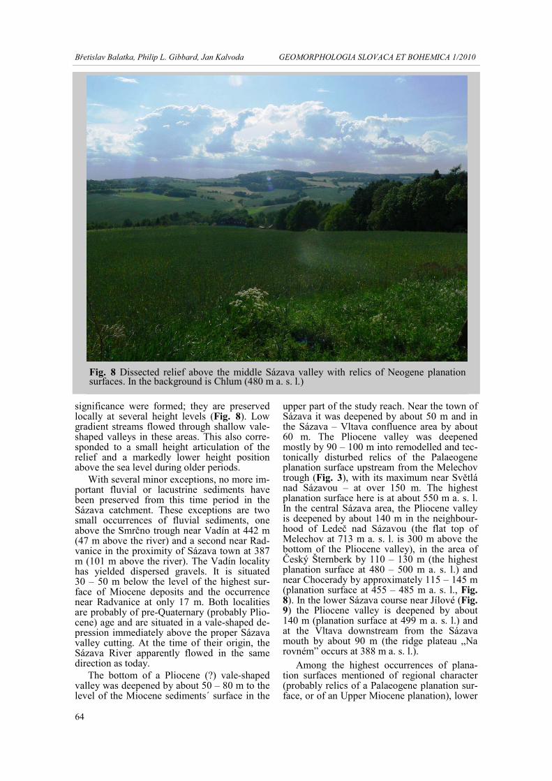
significance were formed; they are preserved locally at several height levels (Fig. 8). Low gradient streams flowed through shallow vale-shaped valleys in these areas. This also corre-sponded to a small height articulation of the relief and a markedly lower height position above the sea level during older periods.
With several minor exceptions, no more im-portant fluvial or lacustrine sediments have been preserved from this time period in the Sázava catchment. These exceptions are two small occurrences of fluvial sediments, one above the Smrčno trough near Vadín at 442 m (47 m above the river) and a second near Rad-vanice in the proximity of Sázava town at 387 m (101 m above the river). The Vadín locality has yielded dispersed gravels. It is situated 30 – 50 m below the level of the highest sur-face of Miocene deposits and the occurrence near Radvanice at only 17 m. Both localities are probably of pre-Quaternary (probably Plio-cene) age and are situated in a vale-shaped de-pression immediately above the proper Sázava valley cutting. At the time of their origin, the Sázava River apparently flowed in the same direction as today.
The bottom of a Pliocene (?) vale-shaped valley was deepened by about 50 – 80 m to the level of the Miocene sediments´ surface in the
upper part of the study reach. Near the town of Sázava it was deepened by about 50 m and in the Sázava – Vltava confluence area by about 60 m. The Pliocene valley was deepened mostly by 90 – 100 m into remodelled and tec-tonically disturbed relics of the Palaeogene planation surface upstream from the Melechov trough (Fig. 3), with its maximum near Světlá nad Sázavou – at over 150 m. The highest planation surface here is at about 550 m a. s. l. In the central Sázava area, the Pliocene valley is deepened by about 140 m in the neighbour-hood of Ledeč nad Sázavou (the flat top of Melechov at 713 m a. s. l. is 300 m above the bottom of the Pliocene valley), in the area of Český Šternberk by 110 – 130 m (the highest planation surface at 480 – 500 m a. s. l.) and near Chocerady by approximately 115 – 145 m (planation surface at 455 – 485 m a. s. l., Fig. 8). In the lower Sázava course near Jílové (Fig. 9) the Pliocene valley is deepened by about 140 m (planation surface at 499 m a. s. l.) and at the Vltava downstream from the Sázava mouth by about 90 m (the ridge plateau „Na rovném” occurs at 388 m a. s. l.).
Among the highest occurrences of plana-tion surfaces mentioned of regional character (probably relics of a Palaeogene planation sur-face, or of an Upper Miocene planation), lower
Fig. 8 Dissected relief above the middle Sázava valley with relics of Neogene planation surfaces. In the background is Chlum (480 m a. s. l.)

65
Břetislav Balatka, Philip L. Gibbard, Jan Kalvoda GEOMORPHOLOGIA SLOVACA ET BOHEMICA 1/2010
plantation surfaces (denudation plateaux) of rather local importance rising to several height levels are preserved (Figs. 6 and 10). The high-est plateaux are situated 20 – 40 m above the presumed level of the surface of Miocene sedi-ments. Other planation surfaces follow, with a slight height variation, the level of Miocene deposits and the lowest plateaux are situated on the presumed level of the surface of probably Pliocene sediments. The location and altitude of plateau surfaces (with the exception of some highest levels) are depicted by the long profile of the terraces (BALATKA and KALVODA 2010). The occurrences of plateau surfaces shown form levels, mainly in relation to Lower Miocene (?) sediments and to a Pliocene level. The lowest plateaux in the vale-shaped pre-Quaternary depression can be considered, to-gether with the localities of the nearest higher level, as typical valley pediments.
It is difficult to determine the impact of neotectonic movements on the present height position of the planation surfaces. The opinion of MOSCHELESOVÁ (1930) on the Tertiary origin of the Sázava valley in the axis of a step fold (syncline) depression is interesting. There is no doubt about the overall uplift of the re-gion in the Upper Miocene and in the Pliocene. The time classification of the younger stages of Saxon tectonics is however difficult in the Sázava catchment. This is a tectonically stable
area of the Bohemian Massif (compare MALKOVSKÝ 1975, 1976 and 1979) com-prising the Moldanubic crystalline complex and on Variscan plutons, with almost no younger covering sediments.
The origin of Neogene sediments in the Sázava catchement was probably conditioned by local tectonic depressions during the Savian Stage and also by a lower geomorphological resistance of rocks. The Middle and the greater part of the Upper Miocene period was charac-terised here by tectonic stability, which is a substantial condition for the evolution of plana-tion surfaces. The end of the Upper Miocene and the Pliocene were characterised by higher intensity of neotectonic movements leading, as in other areas of the Czech Labe catchment, to the development of the regional river network, which was already similar to that at present (Figs. 1 and 2). The river network was unified by tectonic movements and by selectively ori-entated destructive processes probably as early as at the end of the Miocene, because relics of Pliocene sediments are developed in valleys of the present streams.
The granular character of the Pliocene flu-vial sediments is also an indication of the great height variation of the relief in the Pliocene. This granularity varies locally only little from the Quaternary deposits. The evolution of the Sázava to its present course direction was thus
Fig. 9 Exit of the Sázava from the closed trough-shaped valley in metamorphosed rocks of the Jílové belt to a small valley basin with floodplain and terrace VII near Pikovice

66
Břetislav Balatka, Philip L. Gibbard, Jan Kalvoda GEOMORPHOLOGIA SLOVACA ET BOHEMICA 1/2010
established in the Pliocene, and develops since the Upper Miocene probably by processes of progressive unification of partial catchments.
A total seven of accumulation terraces and two other subsidiary levels of erosional or ero-sional-accumulational origin in the Sázava val-ley during the progressive deepening during the Quaternary were proposed (BALATKA and KALVODA 2010; Tab. 1). In the geomor-phological sense, the terraces correspond ge-netically to an alternation of erosional and ac-cumulational stages of the valley evolution which were conditioned climatically (by alter-nating glacial and interglacial periods) and tec-tonically (by the uplift of the Bohemian Mas-sif). The structure of river terraces is well do-cumented by transverse profiles through the Sázava valley and by the longitudinal profile through terraces (BALATKA and KALVODA 2010). The three highest terraces (I, II, III) have a regular surface gradient downvalley, whereas the base of terrace III ends on a gra-dient step in the Melechov massif. The gradient step, probably together with neotectonic move-ments, results in the exceptionally thick accu-mulation of terrace III sediments (up to 25 m, Fig. 4), the base of which is only about 3 – 5 m above the present level of the river and occa-sionally is at the level of the river. It means that during deep erosion, following the accu-mulation stage of terrace II, the valley was in-cised in one part of its middle course by 35 – 38 m, i.e. during most of the erosional periods of the Pleistocene. This very low position of rock substrate, recorded along a 30 km long segment, can be explained by probable relative closing of the concerned area, simultaneously
with slight uplift of the granite Melechov mas-sif (Fig. 3). This tectonic depression was ap-proximately 15 – 20 m.
Aggradations of terrace III sediments over the larger area of Zruč nad Sázavou caused an important geomorphological process (Fig. 11). After the maximum level of aggradation was reached, in several places, the bed material was retransported to nearby valleys of affluents. In such abandoned valley segments (the longest upto 3 km) the accumulation filling is pre-served at its full thickness, or it is locally re-duced to the level of the terrace IIIb surface. Periglacial conditions and the occurrence of a gradient step are indicated by coarser depos-its (gravels) only at the terrace base and by the addition of debris boulders in the otherwise sand-dominated sediments. Fine-grained de-posits recorded normal gradient conditions and probably also slight faulting of the sedimenta-tion area. Analysis of the terrace system proved the extraordinary significance of the abandoned valley segments for the reconstruction of the river terraces course in the long profile, as well as for the understanding of the valley evolution stages.
For a long segment of the middle Sázava course (80 km) downstream, the aggradation terrace III lacks important localities, which do not allow a precise reconstruction of the course and mainly of the base. Besides the highest level IIIa (with its surface at about 30 m above the present river), there was formed in the ac-cumulation of terrace III during the valley deepening a lower erosion-accumulation ter-race IIIb (with its surface 6 – 8 m lower) in the area of Zruč nad Sázavou (Tab. 1). In the fol-
Fig. 10 Transverse profile of the Sázava valley in the locality of river kilometre 123.3 Explanations are given in Fig. 6

67
Břetislav Balatka, Philip L. Gibbard, Jan Kalvoda GEOMORPHOLOGIA SLOVACA ET BOHEMICA 1/2010
lowing segment of the middle course, this ter-race occurs at isolated localities which appear to be a separate terrace level. The terraces IV and V on the middle course are aligned, in ge-neral, parallel to the present river level and only locally are there a slight divergence.
The second pronounced step in the Sázava level gradient curve is in the lowest course. It was formed by retrogressive erosion from the Vltava valley during erosional stages during the Middle and Upper Pleistocene. The begin-ning of the gradient step appears in a slighter form at first at the base of terrace III, whereas its surface still shows a quite regular form. The reach of the Sázava middle course with a re-markably normal gradient (with smaller ano-malies only downstream from the Melechov massif) is found in a higher position (by about 40 m) related to the Vltava valley bottom. The Sázava middle course reach, between both gra-dient steps, has not been more significantly
deepened since the older period of the Early Saalian glacial.
Geomorphological analysis of the Sázava valley form has revealed a different morpho-graphical character and course of valley seg-ments, conditioned by the Quaternary evolu-tion of the valley (compare Figs. 10 and 12). At the beginning of the Middle Pleistocene, i.e. in the period of the formation of terraces I and II, the valley still locally retained its Pliocene form. This had a vale transverse profile, al-though it was locally markedly narrowed. The depth of a younger pronounced valley cutting is shown by the position of the valley margin in relatively rare, straight segments of the Sázava valley. Between Havlíčkův Brod and the western neighbourhood of Světlá nad Sázavou, the valley margin occurs at a constant altitude of about 425 m (20 – 40 m above the river level), between Ledeč nad Sázavou and Zruč nad Sázavou, it is at 425 m (83 m relative
Planation Surfa-ces, Neogene sedi-ments and Qua-ternary terraces
Světlá n. Sázavou
Ledeč n. Sázavou
Zruč n. Sázavou
Mouth of the Želivka River – Kácov
Sázava – Černé Budy
Poříčí n. Sázavou – Týnec n. Sázavou
Mouth into the Vltava River – Měchenice
Planation surfa-ce, denudation plateau
108 98 61
147 131
90
150 124
94
183 110
70 – 97
144 131 119
160 128
95 – 105 185 120
Niveau A Bo-jiště 88/? 135/120
115/110 113/(110) 105/103 118-
112/105) 169/146
Klínec 144/(123)
Niveau B Rad-vanice 47/? 101/(90)
Valley edge 35 83 66 84 77 – 90 105 – 155 Střechov Terra-ce Ia 32/? (63)/? 62/54 (67)/? (66)/? IA
(105)/(91) Hvězdonice Ter-race Ib (47)/? 47/45 (54)/? (53)/? IB
(95)/? Český Šternberk Terrace II (13)/? 36/31 39/23? (37)/(22) (39)/? (41)/? II
87/73 Chabeřice Ter-race IIIa 7/? 29/24 31/4 31/3 (32)/? (35)/? IIIA
75/(67 – 72) Buda Terrace IIIb 24/4 24/3 21/11 (25)/? IIIB
68/53 Týnec Terrace IV 13/(5) 17/0 – 7 15/3 15/(11) 19/15 IV
55/43 Městečko Ter-race V 7/3 9/2 – 0 9/5 9/2 – 0 11/6 V
(33)/(25) Poříčí Terrace VI 4/-1 až – 3 4/0 až – 4 5/1 6/0 až -4 7/2 až -3 VI
21/3 Pikovice Terrace VII ?/-3 ?/-4 ?/-4 ?/-4 ?/-2 až – 3 VII
17/-5
Tab. 1 Neogene sediments and Quaternary terraces of the Sázava River in the central part of the Bohemian Massif (BALATKA and KALVODA 2010) Explanations: 115/110 – surface/base in metres above river level, (37)/(22) – approximate relative height after longitudinal profile of the terraces

68
Břetislav Balatka, Philip L. Gibbard, Jan Kalvoda GEOMORPHOLOGIA SLOVACA ET BOHEMICA 1/2010
height) and at 400 m (70 m relative height), near Český Šternberk at 375 – 390 m (75 – 90 m relative height), in the neighbourhood of Sázava town at 350 – 370 m (60 – 85 m of relative height), near Poříčí nad Sázavou at 325 – 350 m (65 – 90 m of relative height) and near Luka pod Medníkem it is at 280 m (70 m relative height, Fig. 9). The highest position of the valley margin corresponds to the depth of the valley deepening since the beginning of the Quaternary; however, lower data evidence from lower in the valley in general indicates the intensity of the Sázava valley erosion du-ring as late as the Middle Pleistocene.
In spite of its predominantly erosional cha-racter, individual segments of the Sázava val-ley includes various geomorphological diffe-rences which are conditioned by evolution du-ring different morphostructural environments. The present Sázava valley is vale-shaped in several reaches, mainly between Havlíčkův Brod and Světlá nad Sázavou, between Březina and Holšice, near Chocerady and Hvězdonice. Locally small valley basins were formed in lar-ger valley bends to meanders. They are visibly asymmetrical in their transverse profile (e.g. near Kácov, the town of Sázava, Poříčí nad Sázavou and Týnec nad Sázavou, Fig. 13). In addition, the straight reach, between Lštění and Čerčany, has the form of an asymmetrical fur-row. Narrowed erosional valley segments were deepened by the river in the Melechov trough, between the mouth of the Blanice and the Sázava town, between the mouth of the Propast Brook and Chocerady, downstream of Hvěz-donice and in the neighbourhood of Kamenný Přívoz. The most pronounced trough–shaped segment, with rock walls, was formed in the lowest Sázava course in the resistant rocks of
the Jílové belt (Fig. 9). Immediately before its confluence with the Vltava, the Sázava has a narrow trough to canyon-shape valley, the mar-gin of which is under the lowered surface of terrace III (Fig. 14).
Some Sázava valley reaches correspond in their alignements to the Tertiary directions of streams which was especially noted by NOVÁK (1932). The Sázava valley that is o-rientated SW between Havlíčkův Brod and Světlá nad Sázavou could correspond to the Tertiary course of the upper Sázava. The Sázava valley between Ledeč nad Sázavou and Vlastějovice roughly follows the assumed course of the Neogene Želivka; the segment from the confluence with the Blanice to Sázava town follows the eastern side of the course of the Blanice furrow. This is a relic of the course of the Tertiary Blanice. The straight part of the Sázava valley between Lštění and Poříčí nad Sázavou could correspond to the course of the Tertiary Benešovský (and the Konopišťský?) Brook to the present Mnichovka, but in the op-posite direction to the present courses. The Sázava valley segment between Týnec nad Sázavou and Zbořený Kostelec, connecting the localities of the confluences of the Janovický and the Kamenický Brooks with the Sázava, could correspond to its course to the Tertiary Janovický potok Brook course to the Čako-vický (the Kamenický) potok Brook.
Another important problem in the Sázava catchment is the question of the origin and de-velopment of the characteristic valley mean-ders and bends (Figs. 7 and 9). Many of these features are developed in the neighbourhood of Ledeč nad Sázavou, downstream to Sázava town, and the most perfect forms of valley me-anders are developed between the Blanice
Fig. 11 Transverse profile of the Sázava valley in the locality of river kilometre 98.6 Explanations are given in Fig. 6

69
Břetislav Balatka, Philip L. Gibbard, Jan Kalvoda GEOMORPHOLOGIA SLOVACA ET BOHEMICA 1/2010
mouth and Sázava town. The morphometric characteristics and parameters of selected Sázava meanders in the middle Sázava course were studied by PILECKÁ (1997). The basic question she addressed was why a such high number of meanders and bends (about 20) formed in the middle course of the Sázava, al-though there are only a few in the lower course (6). Equally these features are rare in the upper course mainly between Havlíčkův Brod and the neighbourhood of Světlá nad Sázavou (2). It might point to a possible causal relationship of the river valley evolution since the beginning of the Upper Tertiary. The segment upstream from the Melechov trough has a relatively an-cient character, with only a low intensity of deep and lateral erosion in the Quaternary. On the contrary, the meandering middle course downstream of the trough underwent a quite different evolution. The Sázava valley mean-ders were probably formed there as umcon-strained bends in a large and slightly inclined valley bottom during the Pliocene and the ear-liest Quaternary, i.e. before the beginning of erosional deepening of the valley which oc-
curred mainly during erosional stages from ter-race I to terrace III (Tab. 1).
The deepest valley cutting, and thus the maximum evolution of valley bends, occurred mainly in the erosional stage between the sur-face of terrace II and the base of terrace III, when the Sázava valley was deepened by nearly 40 m. This represents the significantly greatest extent of stage-by-stage deep erosion during the whole Quaternary. After the huge accumulation of sediments of terrace III, which to the greatest thickness filled in the concave parts of bends and meanders (re-deepened fur-rows), there followed in the next erosional stage a progressive removal of sediments, the formation of lower terraces and erosional slo-pes. The relatively rapid development of the valley meanders occurred (with several excep-tions) by the absence of terraces in their con-vex parts. On the contrary, in cores of the open bends, small remnants of terrace III and mainly of terraces V and VI formed (Figs. 12 and 13). They are, however, only marginal remnants of the upper parts of the original terrace accumu-lations. The maximum thickness of sediments
Fig. 12 Transverse profile of the Sázava valley in the reach between river kilometres 64.4 and 61.2 Explanations are given in Fig. 6
70
Břetislav Balatka, Philip L. Gibbard, Jan Kalvoda GEOMORPHOLOGIA SLOVACA ET BOHEMICA 1/2010
in the concave parts of meanders, i.e. at the foot of erosional slopes, were largely reduced and removed by the river during erosional pe-riods between accumulations of respective ter-races.
CORRELATION OF LATE CENOZOIC SEDIMENTS AND THE
SÁZAVA VALLEY EVOLUTION WITH THE VLTAVA AND THE LABE TERRACE STRATIGRAPHICAL
SYSTEM
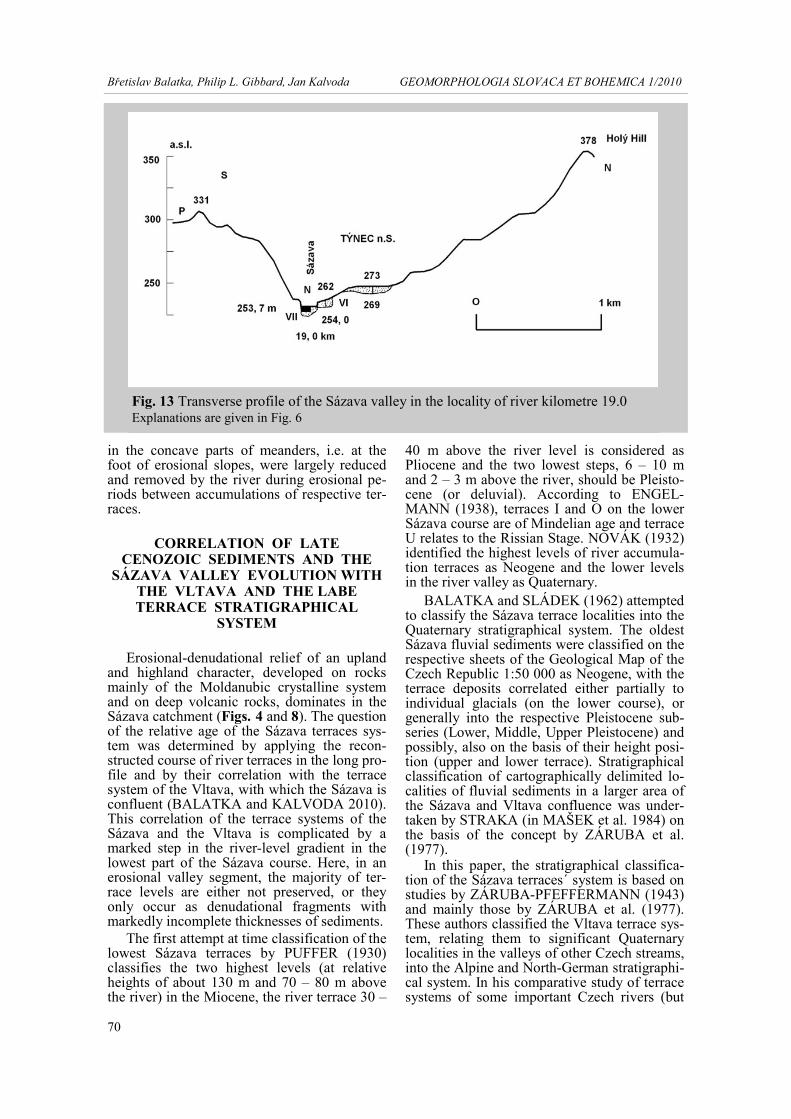
Erosional-denudational relief of an upland and highland character, developed on rocks mainly of the Moldanubic crystalline system and on deep volcanic rocks, dominates in the Sázava catchment (Figs. 4 and 8). The question of the relative age of the Sázava terraces sys-tem was determined by applying the recon-structed course of river terraces in the long pro-file and by their correlation with the terrace system of the Vltava, with which the Sázava is confluent (BALATKA and KALVODA 2010). This correlation of the terrace systems of the Sázava and the Vltava is complicated by a marked step in the river-level gradient in the lowest part of the Sázava course. Here, in an erosional valley segment, the majority of ter-race levels are either not preserved, or they only occur as denudational fragments with markedly incomplete thicknesses of sediments.
The first attempt at time classification of the lowest Sázava terraces by PUFFER (1930) classifies the two highest levels (at relative heights of about 130 m and 70 – 80 m above the river) in the Miocene, the river terrace 30 –
40 m above the river level is considered as Pliocene and the two lowest steps, 6 – 10 m and 2 – 3 m above the river, should be Pleisto-cene (or deluvial). According to ENGEL-MANN (1938), terraces I and O on the lower Sázava course are of Mindelian age and terrace U relates to the Rissian Stage. NOVÁK (1932) identified the highest levels of river accumula-tion terraces as Neogene and the lower levels in the river valley as Quaternary.
BALATKA and SLÁDEK (1962) attempted to classify the Sázava terrace localities into the Quaternary stratigraphical system. The oldest Sázava fluvial sediments were classified on the respective sheets of the Geological Map of the Czech Republic 1:50 000 as Neogene, with the terrace deposits correlated either partially to individual glacials (on the lower course), or generally into the respective Pleistocene sub-series (Lower, Middle, Upper Pleistocene) and possibly, also on the basis of their height posi-tion (upper and lower terrace). Stratigraphical classification of cartographically delimited lo-calities of fluvial sediments in a larger area of the Sázava and Vltava confluence was under-taken by STRAKA (in MAŠEK et al. 1984) on the basis of the concept by ZÁRUBA et al. (1977).
In this paper, the stratigraphical classifica-tion of the Sázava terraces´ system is based on studies by ZÁRUBA-PFEFFERMANN (1943) and mainly those by ZÁRUBA et al. (1977). These authors classified the Vltava terrace sys-tem, relating them to significant Quaternary localities in the valleys of other Czech streams, into the Alpine and North-German stratigraphi-cal system. In his comparative study of terrace systems of some important Czech rivers (but
Fig. 13 Transverse profile of the Sázava valley in the locality of river kilometre 19.0 Explanations are given in Fig. 6

71
Břetislav Balatka, Philip L. Gibbard, Jan Kalvoda GEOMORPHOLOGIA SLOVACA ET BOHEMICA 1/2010
not including the Sázava and the South Bohe-mia streams) based both on older authors and on his own research, TYRÁČEK (2001) classi-fied terrace levels and fluvial sediments gener-ally into the main glacials of the Quaternary and into the Pliocene and the Miocene. Other papers by TYRÁČEK et al. (2004) and TYRÁČEK and HAVLÍČEK (2009) attempted to correlate the Vltava-Labe terrace system with the West-European stratigraphical sche-me. The statigraphical classification of the Sázava terrace system proposed here (Tab. 2) is based on the conclusions arising from the studies presented above.
The proposed equation of the Sázava ter-races with the Vltava and Labe terrace system respects the present state and the unsolved problems of chronostratigraphical classifica-tion of fluvial and fluvial-lacustrine sediments in the catchment of these Czech streams. Strati-graphical classification of upper terraces, be-ginning with the Kralupy Terrace IIIA on the Vltava, is diametrically different when compa-ring the papers by ZÁRUBA et al. (1977) and that by TYRÁČEK et al. (2004). Discordance in the classification of river terraces or fluvial sediments is also evident when compared to their stratigraphical classification in the mono-graph by ŠIBRAVA (1972). For example, in the main terrace of the Labe system in the České středohoří Mountains, i.e. the Neštěmice Terrace (ŠIBRAVA 1972) which is equivalent to the Straškov (III) Terrace in the Říp area and
of the Vltava terrace IIIA and IIIB (ZÁRUBA et al. 1977), the older accumulation should fall into the Menapian (Günzian) Stage, whereas the younger accumulation is classified as El-sterian l. TYRÁČEK et al. (2004), the Kralupy Terrace (IIIA) equate it to the Cromerian Com-plex C, and the Vinohrady Terrace (IIIB) to the Elsterian.
The oldest terrace of the Vltava system (IA, Lysolaje) is classified by ZÁRUBA et al. (1977) as Brüggenian (Donauan), and by TYRÁČEK et al. (2004) as Cromerian A. In the ŠIBRAVA (1972) system, the correspon-ding oldest terrace, at a relative height of 100 – 150 m, including finds of Archidiskodon sp. remnants in Ústí nad Labem (Stříbrnice Ter-race), is equated to the Praetiglian Stage (Donau), whilst TYRÁČEK et al. (2004) relate it to the „Tiglian C Substage”. The Pankrác Terrace (II) on the Vltava corresponds accor-ding to ZÁRUBA et al. (1977), to the Mena-pian (Günzian l) Stage, whereas TYRÁČEK et al. (2004) relate it to Cromerian Complex C Substage. The main part of the Zdiby level, which until this paper was entirely classified as Pliocene (cf. Geological map 1:50 000, 12 – 24 Praha), is correlated by TYRÁČEK et al. (2004) to the long period including Eburonian, Waalian and Menapian (Günzian), i.e. it is a younger level than the Stříbrnice Terrace. The Kobylisy sands of the Zdiby Stage are classified into the Middle Miocene (about 15 Ma) on the basis a finding of moldavite.
Fig. 14 Transverse profile of the Sázava valley in the reach between river kilometres 0.5 and 0.0 Explanations are given in Fig. 6

72
Břetislav Balatka, Philip L. Gibbard, Jan Kalvoda GEOMORPHOLOGIA SLOVACA ET BOHEMICA 1/2010
There are also remarkable differences be-tween the correlations proposed in the papers by TYRÁČEK et al. (2004) and ZÁRUBA et al. (1977) in the dating of terrace levels. The Vltava Lysolaje Terrace IA (ZÁRUBA et al. 1977), considered up to now as the oldest Qua-ternary level, is considered by TYRÁČEK et al. (2004) as about 700 – 800 ka, whereas ZÁRUBA et al. (1977) on the basis of palaeo-magnetic evidence considered it to be 940 – 980 ka years old. The Zdiby gravels and sands are, except for the Kobylisy sands, equated in the first paper as 1.1 – 1.8 Ma, yet in the sec-ond study they are considered to be 2.05 – 2.10 Ma. The Stříbrnice Terrace was formed about 1.8 – 1.9 Ma (TYRÁČEK et al. 2004). This time correlation makes it clear that all the ter-race levels, including the Zdiby Stage (excluding the Kobylisy sands) are, following
the shift of the Tertiary / Quaternary basal boundary 2.6 million years ago (cf. GIBBARD et al. 2004 and 2010), of Quaternary age. These morphostratigraphical aspects of time correlation of river terraces in the central part of the Bohemian Massif are stressed in the pa-per by BALATKA and KALVODA (2008; Tab. 2).
The height conditions of the Sázava terraces (Tab. 1) and their classification into the chro-nostratigraphical system of Central Bohemian rivers (Tab. 2) led to the conclusion that the whole system of the Sázava river accu-mulation terraces was developing mostly du-ring the Middle and the Upper Pliocene (from the „Cromerian Complex Stage” to the Warthe Substage) and only erosional stages, before the accumulation of terrace Ia, occurred at the end of the Early Pleistocene. The origin of level B
Regional stratigraphical division (stage/substage) of the Quaternary (GIBBARD et al. 2004, 2010)
SÁZAVA BALATKA and ŠTĚPANČÍKOVÁ (2006), BALATKA (2007), KALVODA (2007)
VLTAVA ZÁRUBA et al. (1977)
Complex of VLTAVA and LABE TYRÁČEK (2001), TYRÁČEK et al. (2004), TYRÁČEK and HAVLÍČEK (2009)
Late Pleistocene Weichselian
Pikovice Terrace (VII)
Maniny Terrace (VII)
Maniny Terrace (Weichselian) Hostín 1 Terrace
Middle Pleistocene Saalian (Warthe)
Poříčí Terrace (VI)
Veltrusy Terrace (VI)
Veltrusy Terrace (Warthe)
Middle Pleistocene Saalian (Drenthe)
Městečko Terrace (V)
Dejvice Terrace (V)
Dejvice 1 and 2 Terrace (Drenthe)
Middle Pleistocene Saalian (Fuhne)
Týnec Terrace (IV)
Letná Terrace (IV)
Letná Terrace (Fuhne)
Middle Pleistocene Elsterian
Buda Terrace (IIIb)
Vinohrady Terrace (IIIB)
Vinohrady Terrace (Elsterian)
Middle Pleistocene Cromerian Complex (Glacial c)
Chabeřice Terrace (IIIa)
Kralupy Terrace (IIIA)
Kralupy Terrace (Cromerian C)
Middle Pleistocene Cromerian Complex (Glacial c)
Český Šternberk Terrace (II)
Pankrác Terrace (II)
Pankrác Terrace (Cromerian C)
Middle Pleistocene Cromerian Complex (Glacial b)
Hvězdonice Terrace (Ib)
Suchdol Terrace (IB)
Suchdol Terrace (Cromerian B)
Middle Pleistocene Cromerian Complex (Glacial a)
Střechov Terrace (Ia)
Lysolaje Terrace (IA)
Lysolaje Terrace (Cromerian A)
Early Pleistocene Bavelian (Dorst) Menapian
Rovné Terrace (Dorst) Vráž Terrace (Menapian)
Early Pleistocene Eburonian, Menapian
Niveau B Radvanice
Zdiby Stadium (Pliocene)
Zdiby Terrace (Eburonian – Menapian)
Early Pleistocene Tiglian
Stříbrníky Terrace (upper Tiglian)
Neogene (Miocene)
Niveau A Bojiště
Klínec Stadium Kobylisy Sands
Tab. 2. Chronostratigraphical correlation of the Sázava River terraces and the Vltava – Labe terrace systems in the Bohemian Massif related to the North West European stratigraphical stages of the Quaternary (modified from BALATKA and KALVODA 2008 and 2010)

73
Břetislav Balatka, Philip L. Gibbard, Jan Kalvoda GEOMORPHOLOGIA SLOVACA ET BOHEMICA 1/2010
(Radvanice), formerly classified as Pliocene (TYRÁČEK in KLOMÍNSKÝ et al. 1994, was based on the then accepted Neogene/Quaternary boundary at 1.65 Ma), then also falls into the Early Pleistocene (Menapian and Eburonian Stages).
An analysis of the dynamics of removal of sediments during the Quaternary in the central part of the Bohemian Massif was aimed at flu-vial transport and sedimentation in relation to principal changes of the rivers network charac-ter with a progressive epigenetic and antece-dent valley evolution (Figs. 7 and 9). Fluvial sediments in the valleys of the Vltava, the Be-rounka, the Sázava and the Labe are preserved as a large system of river terraces that origi-nated by interaction of climato-morphogenetic and neotectonic processes through the late Ce-nozoic. For this reason, KALVODA and BA-LATKA (2006) and BALATKA and KAL-VODA (2008) described the palaeogeographi-cal history of the central part of the Bohemian Massif. The sedimentary and morphological records of the evolution of antecedent valleys and river accumulation terraces in this area are also compared to the European stratigraphical stages of the Quaternary.
The oldest river accumulation terraces in Central Bohemia are situated above the mar-gins of valley incisions. During the oldest Pleistocene, the Vltava and its affluents freely meandered in shallow and large valleys on a planation surface of Neogene age. The rela-tive height of the oldest river terraces above the present river valley bottoms of the central part of the Bohemian Massif exceeds 100 m. This indicates the approximate extent of deep ero-sion by rivers during the Quaternary. Geomor-phological determination of values of the Vltava antecedent deepening in the late Ceno-zoic, mainly based on the position and sedi-mentary structure of river accumulation terrace relics, indicated that deep erosion of this river was the greatest during part of the Middle Pleistocene.
CONCLUSIONS
The Sázava course and catchment were ini-tiated, in a form similar to the present one, ei-ther already at the beginning of the Neogene (MALKOVSKÝ 1975, 1976 and 1979 or CÍLEK et al. 2004) or during younger periods of the Neogene. During the Sázava course and valley formation, a significant part was proba-bly played by tectonic movements of a con-tinuous character – mega-synclinal folding at the site of the present valley and mega-anticlinal uplift in watershed areas to the north
(Fig. 1). The main drives towards the Sázava drainage reunification were arch-like uplift of the present watershed area between the Sázava and the Labe during the Upper Miocene to Pliocene. During the Pliocene, the Sázava flo-wed to the west, in a large vale-shaped valley deepened into a tectonically and denuda-tionally deformed Palaeogene planation surfa-ce, as well as into lower Neogene planation levels. The present altitude of the Sázava – La-be watershed, in places of the presumed direc-tion of the „Světelská řeka“ and the „Řeplická řeka“ Rivers (almost 500 m), indicates that the relative uplift of this area could have reached roughly 70 – 100 m, related to the country along the Sázava valley.
Geomorphological analysis of the pre-Quaternary relief has demonstrated the exis-tence of a lowered Palaeogene planation sur-face of „etchplain type” in watershed positions (at relative heights of mostly 150 – 180 m) and two to three lower levels of denudational pla-teaux of Neogene age (90 – 130 m above the river, Fig. 8). These lower levels can be classi-fied mostly as pediments developed in a lar-gely pre-Quaternary vale-shaped valley depres-sion. The highest of the denudational plateaux represents relics of a planation surface of Lower to Middle Miocene age, the other two levels are probably Upper Miocene and Plio-cene.
The Quaternary cutting of the Sázava valley to an average depth of 70 – 90 m (in the upper segment about 50 m and in the lowest course up to 105 m, Fig. 14) was induced by an epeirogenetic uplift of the Bohemian Mas-sif. The typically developed incised meanders and bends were formed mostly in the Middle Pleistocene. From the Late Pleistocene to the Pliocene, free bends developed during the strong erosion which followed after the uplift of the Bohemian Massif. During the Quater-nary, deepening of the ground plan of these valley bends did not change significantly.
The Sázava terrace system is characteristic by its variable structure which is conditioned by specific hydrodynamic processes that exis-ted during the late Cenozoic evolution of the valley. The reconstruction method, consisting of construction of the long profile through the river terraces and of a series of transverse-valley profiles (BALATKA and KALVODA 2010), enabled the differentiation of seven main terraces with several subsidiary levels and two levels of Neogene fluvial to fluvio-lacustrine sediments. Whereas the surfaces of pre-Quaternary deposits are up to 135 m higher than the present river level, the relative height of the highest (I) Quaternary terrace in the mid-dle course is only about 60 m (Tab. 1).

74
Břetislav Balatka, Philip L. Gibbard, Jan Kalvoda GEOMORPHOLOGIA SLOVACA ET BOHEMICA 1/2010
The valley evolution and the terrace-system structure were significantly influenced by two segments of an increased gradient of the river level: the upper one in the granite Melechov massif (river kilometres 139.5 – 135.4, Fig. 3) with a mean gradient of 5.7 ‰ and the lower one (river kilometres 17.9 – 5.0), with a gra-dient of 3.9 ‰. These gradient steps are sepa-rated by a 117.5 km long segment with a mean gradient of 0.88 ‰. The shape of the gradient curve of the long middle course is influenced neither by the significantly increasing water content of the river nor by the different resis-tance to weathering and erosion of the various crystalline rocks of the substrate. Two gradient steps are fronts of retrogressive erosion that are progressing against the stream and this pro-gress greatly slowed, in places, with more re-sistant rocks. The upper step was formed du-ring the erosional period between terraces II and III, i.e. between the „Cromerian Complex glacial C” and the Elsterian glacial Stage, the lower step was formed during erosional stages between terraces III and IV, i.e. from the El-sterian glacial to the Weichselian glacial (Tab. 2). The present valley bottoms (floodplains), above both gradient steps, are situated in hang-ing positions by about 25 m at the upper step and about 40 m at the lower step.
The gradient steps induced a huge fluvial accumulation in lower situated segments of the Sázava course. Below the upper step in the Melechov massif an accumulation (aggra-dation) of terrace III (Chabeřice) occurred which, at an exceptionally high thickness of about 25 m, progressively levelled this step into a curve corresponding to the equilibrium profile (KREJČÍ 1939). In a shorter segment of the middle course (about 30 km), huge aggra-dations of terrace III are preserved only in fil-lings of abandoned valley segments (ZÁRUBA and RYBÁŘ 1961). Analysis of the Sázava ter-race system has confirmed the exceptional sig-nificance of abandoned valley segments (Fig. 4) for the reconstruction of the course of river terraces in the long profile, as well as for knowledge of valley evolution stages.
During the erosional stage before accumula-tion of sediments of the terrace III, the Sázava valley in its middle course was deepened al-most to the level of the present valley floor. Therefore, during the long period of part of the Middle and Early Pleistocene, in its middle course, the Sázava formed an entirely normal gradient profile. The gradient step of the lower course, which has also been developing at pre-sent, caused a terrace accumulation in the val-ley of the nearby Vltava. The present Sázava valley bottom between both gradient steps is situated, in comparison with the Vltava flood-plain, in a markedly hanging position by about
40 m. It was deepened to its present level at the time of the formation of terrace VI. The Sázava valley bottom above the Melechov trough is situated approximately only 4 – 5 m below the supposed surface of terrace III.
Height conditions of the Sázava River ter-races are shown in Tab. 1 and comparison of the Sázava system with terrace systems of Vltava and Labe as well as chronostratigraphi-cal correlation with the North European strati-graphical classification of the Quaternary is given in Tab. 2. According to the current stratigraphical scheme of the Quaternary (e.g. GIBBARD et al. 2004 and 2010), the entire Sázava terraces´ system was formed mostly to the Middle and Upper Pleistocene, that is to the period from the „Cromerian Complex” to the Weichselian stages. Erosional stages, before accumulation of terrace I, fall in the end of the Early Pleistocene. Older levels of fluvial sedi-ments, occupying a still higher morphological position in the studied areas of the Bohemian Massif and up to now classified as Pliocene, have thus been stratigraphically to be shifted to the Early Pleistocene.
ACKNOWLEDGEMENT
This paper was elaborated within the research project of the Faculty of Science, Charles Uni-versity in Prague, MSM 0021620831 „Geo-graphical systems and risk processes in the context of global changes and European inte-gration”.
REFERENCES
BALATKA, B. (2007). River terraces and the Sázava Valley evolution. In Goudie, A. S., Kalvoda, J., eds. Geomorphological Varia-tions. Nakladatelství P3K, Prague, 361 – 386.
BALATKA, B., KALVODA, J. (2006). Geo-morfologické členění reliéfu Čech. Kartografie, a. s., Praha, 79 p., 3 maps.
BALATKA, B., KALVODA, J. (2008). Evolu-tion of Quaternary river terraces related to the uplift of the central part of the Bohemian Mas-sif. Geografie – Sborník České geografické společnosti, 113, 3, 205 – 222.
BALATKA, J., KALVODA, J. (2010). Vývoj údolí Sázavy v mladším kenozoiku. Edice Geographica, Česká geografická společnost, Praha, 198 p.

75
Břetislav Balatka, Philip L. Gibbard, Jan Kalvoda GEOMORPHOLOGIA SLOVACA ET BOHEMICA 1/2010
BALATKA, B., SLÁDEK, J. (1962). Říční terasy v českých zemích. Geofond v NČSAV, Praha, 580 p.
BALATKA, B., SLÁDEK, J. (1977). Evorzní tvary v Čechách a jejich geneze. Rozpravy ČSAV, řada matematických a přírodních věd, 87, 7, Academia, Praha, 1 – 98.
BALATKA, B., ŠTĚPANČÍKOVÁ, P. (2006). Terrace system of the middle and lower Sázava River. Geomorphologia Slovaca, 6, 1, 69 – 81.
BUDAY, T., KODYM , O. ST., MAHEĽ, M., MÁŠKA, M., MATĚJKA, A., SVOBODA, J., ZOUBEK, V. (1961). Tektonický vývoj Československa. Ústřední ústav geologický v NČSAV, Praha, 254 p.
CÍLEK, V., LOŽEK, V., ŽÁK, K. (2004). Z minulosti českých řek. Vesmír, 83, 8, 447 – 453.
DANEŠ, J. V. (1913). Morfologický vývoj středních Čech. Sborník České společnosti ze-měvědné, 19, 1 – 18, 94 – 108, 168 – 176.
ENGELMANN, R. (1938). Der Elbedur-chbruch. Geomorphologische Untersuchungen im oberen Elbgebiete. Abhandlungen der Geographischen Gesellschaft in Wien, 13, 2, 1 – 139.
GIBBARD, P. L., BOREHAM, S., COHEN, K. M., MOSCARIELLO, A. (2004). Global chronostratigraphical cerrelation table for the last 2,7 million years. Quaternary Palaeoenvi-ronment Group, University of Cambridge, Cambridge, 1 – 2, 1 tab.
GIBBARD, P. L., HEAD, M. J., WALKER, M. J. C. and THE SUBCOMMISSION ON QUATERNARY STRATIGRAPHY (2010). Formal ratification of the Quaternary System/Period and the Pleistocene Series/Epoch with a base at 2.58 Ma. Journal of Quaternary Sci-ence, 25, 2, 96 – 102.
KALVODA, J. (2007). Morphostructural evo-lution of the relief in the locality of the Geody-namic Observatory at Pecný, the Ondřejovská vrchovina Highland, Czech Republic. In Goudie, A. S., Kalvoda, J., eds. Geomorpholo-gical Variations. Nakladetelství P3K, Prague, 387 – 407.
KALVODA, J., BALATKA, B. (2006). Mor-fostrukturní vývoj reliéfu české části Českého masivu. In Balatka, B., Kalvoda, J., eds.Geo-morfologické členění reliéfu Čech. Kartografie, a. s., Praha, 5 – 12.
KLOMÍNSKÝ, J., ed. et al. (1994). Geologický atlas České republiky. Stratigrafie. Český geo-logický ústav, Praha, 17 listů.
KODYM, O., DOMAS, J., HOLUB, V., MAŠEK, J. (1993). Geologická mapa ČR. List 13 – 31 Říčany. Český geologický ústav, Praha.
KRÁL, J. (1971). Zpráva o ložiskovém průz-kumu štěrkopísků Kožlí. Vojenský projektový ústav Praha, MS Geofond P 22 588, FZ 5 172, Praha.
KREJČÍ, J. (1939). Profil rovnováhy jakožto základ studia říčních teras. Spisy Odboru české společnosti zeměpisné v Brně, řada A, 5, 1 – 144.
MALKOVSKÝ, M. (1975). Paleogeography of the Miocene of the Bohemian Massif. Věstník Ústředního ústavu geologického, 50, 1, 27 – 31.
MALKOVSKÝ, M. (1976). Saxonische Tek-tonik der Böhmische Masse. Geologische Rundschau, 65, Stuttgart, 127 – 143.
MALKOVSKÝ, M. (1979). Tektogeneze plat-formního pokryvu Českého masívu. Ústřední ústav geologický v Academii, Praha, 176 p.
MAŠEK, J., ed. et al. (1984). Vysvětlivky k základní geologické mapě ČSSR 1:25 000, 12 – 423 Davle. Ústřední ústav geologický, Praha, 67 p.
MÍSAŘ, Z., DUDEK, A., HAVLENA, V., WEISS, J. (1983). Geologie ČSSR I. Český masív. Státní pedagogické nakladatelství, Pra-ha, 336 p.
MOSCHELESOVÁ, J. (1930). Vlnité prohyby o velké amplitudě v jižních Čechách. Sborník Československé společnosti zeměpisné, 36, 155 – 158.
MÜLLER, V., ed. et al. (1993). Vysvětlivky k souboru geologických a ekologických úče-lových map přírodních zdrojů v měřítku 1:50 000. List 13 – 31 Říčany. Český geologický ústav, Praha, 32 p.
MÜLLER, V., ed., JINOCHOVÁ, J., KAD-LEC, J. et al. (2002). Vysvětlivky k souboru ge-ologických a ekologických účelových map přírodních zdrojů v měřítku 1:50 000. List 13 – 33 Benešov. Česká geologická služba, Praha, 40 p.
NOVÁK, V. J. (1930). Příspěvky ku poznání vývoje dolní Sázavy. Sborník Československé společnosti zeměpisné, 36, 150 – 155.

76
Břetislav Balatka, Philip L. Gibbard, Jan Kalvoda GEOMORPHOLOGIA SLOVACA ET BOHEMICA 1/2010
NOVÁK, V. J. (1932). Vývoj úvodí a údolí řeky Sázavy. Věstník Královské České společ-nosti nauk, 11, 1 – 47.
NOVÁK, V. J. (1943). Tvářnost Českomo-ravské vysočiny. Rozpravy II. třídy České akademie, 52, 20, Praha, 1 – 101.
PILECKÁ, M. (1997). Údolní meandry, jejich geneze a morfometrické charakteristiky. Bc thesis, Přírodovědecká fakulta Univerzity Kar-lovy, Praha, 35 p.
PROCHÁZKA, J., MLČOCH, B. (1998). Komplexní geologický výzkum melechovs-kého masivu. Zprávy o geologických výzku-mech v roce 1997, Praha, 31 – 37.
PUFFER, L. (1930). Die Sazauterrassen um Pikovice – Petrov. XXXI. Jahresbericht der deutschen Staatsrealschule in Prag, 6 – 8.
ŠIBRAVA, V. (1972). Zur Stellung der Tschechoslowakei im Korrelierungssystem des Pleistozäns in Europa. Sborník geologických věd, Antropozoikum, ř. A, 8, 5 – 218.
ŠTĚPANČÍKOVÁ, P. (2003). Terasy dolní Sázavy v úseku od Vrabčího Brodu po Ka-menný Přívoz. Geografie – Sborník České geografické společnosti, 108, 3, 216 – 226.
TYRÁČEK, J. (2001). Upper Cenozoic fluvial history in the Bohemian Massif. Quaternary International, 79, 1, 37 – 53.
TYRÁČEK, J., HAVLÍČEK P. (2009). The fluvial record in the Czech Republic: A review in the context of IGCP 518. Global and Plane-tary Change, 68, 4, 311 – 325.
TYRÁČEK, J., WESTAWAY, R., BRID-GLAND, D. (2004). River terraces of the Vltava and Labe (Elbe) system, Czech Repub-lic, and their implications for the uplift history of the Bohemian Massif. Proceedings of the Geologists´ Association, 115, 101 – 124.
ZÁRUBA-PFEFFERMANN, Q. (1943). Po-délný profil vltavskými terasami mezi Kamýkem a Veltrusy. Rozpravy II. tř. České akademie, 52, 9, Praha, 1 – 39.
ZÁRUBA, Q., BUCHA, V., LOŽEK, V. (1977). Significance of the Vltava terrace sys-tem for Quaternary chronostratigraphy. Roz-pravy ČSAV, řada matematických a přírodních věd, 87, 4, Academia, Praha, 1 – 90.
ZÁRUBA, Q., RYBÁŘ, J. (1961). Doklady pleistocenní agradace údolí Sázavy. Sborník Československé společnosti zeměpisné, 66, 1, 23 – 30.