excavating the roman peasant - sas.upenn.edu · paleobotany, geophysics and ... objectives and...
TRANSCRIPT

EXCAVATING THE ROMAN PEASANT
PROJECT DESCRIPTION and 2009 PRELIMINARY RESULTS 1. INTRODUCTION Our image of the classical world is overwhelmingly shaped by elites. It is the lettered elite who penned the majority of our textual sources; it is the moneyed elite whose largess built the monuments synonymous with “classical civilization;” and it is the political elite, who were also lettered and wealthy, whose visions of society shaped ancient law and government. Not surprisingly, then, modern scholarship on the ancient world is dominated by the same issues that preoccupied ancient elites – political philosophy, the craft of literature, the monumental city, its houses and public buildings. It is easy to forget that these elites, and these concerns, represented those of only some 10% of the overall population. Even at its political zenith, the Roman Empire was an agrarian society whose economic systems, literacy and mortality levels resembled those of modern Mali. As much as 90% of Romans lived in the countryside, cultivating small plots of land and earning a tiny fraction of the lowliest elites who appear on our textual radars. The reasons for our skewed perspective are, in part, understandable. The rural non-elite play only brief, walk-on roles in the textual record, and historical studies of these non-elites are concomitantly limited. Yet the richest source of information on rural denizens is not textual, but archaeological, and this resource has gone largely untapped. Thousands of tiny rural sites have been identified through archaeological field surveys; these almost certainly represent the houses, farms and seasonal residences of rural Roman non-elites. Classical archaeologists have largely failed to tap this resource: only a handful of such sites have ever seen systematic excavation; there exists no comprehensive study of Roman peasant diet or resource management; and not one rural landscape has ever been studied from the viewpoint of its lowliest rural occupants. While the archaeology of the rural peasantry is a major topic of study in fields as diverse as medieval history, Mesoamerican studies, and modern development studies, in the Roman world, the peasantry remains a people without a material history. Excavating the Roman Peasant comprises the first systematic excavations and analysis of the lower stratum of Roman rural dwellers. Based in ancient Etruria (western Tuscany, Italy), the project aims to excavate the smallest rural sites and study their economies, resource base and micro-environments. Using the results of a modern archaeological surface survey to locate these sites and subsurface geophysics to verify their extent and preservation, we propose to fully excavate some half-dozen sites, the first of which was completed in our first, 2009 season.. We will study the spatial and material qualities of rural domestic architecture, analyze ceramic and coin finds to better understand rural exchange systems, and study animal and plant remains to understand diet and agricultural regimes. We will also produce detailed micro-surveys of the surrounding landscape, mapping resources and potential route-ways to understand how Roman peasants were influenced by, and pushed against, their environments (see Section 4: Methodologies). Finally, we seek to bridge a divide between social history and archaeology by contributing new, finer-grained information to the history of Roman non-elites. The project will draw on the combined disciplines of archaeology, history, zooarchaeology, paleobotany, geophysics and geology to produce “thick descriptions” of peasants: their diet; exploitation of local resources; socio-economies; and above all, the diversity of what it meant to be “poor” in the Roman world. Its goal is to not only remedy a major lacuna in pre-modern history through a major interdisciplinary project, but to shift the vantage point of those studies, presenting a peasant-eye’s view of issues such as agriculture, social relationships, and trade, which have previously been seen only through elite spectacles. In this respect, the study draws upon and aims to contribute to contemporary discussions on poverty and rural development in the modern

Excavating the Roman Peasant
world. It will contributes more materially to these issues by training an international group of American and Italian students, integrating members of the local village, itself a small farming community, into the project and by mounting a small local museum to Roman rural life. 2. RATIONALE AND SCHOLARLY CONTEXT The study of peasants, ancient and modern, was, until recently, largely the province of Marxist historians/anthropologists and their critics. Marx’s own writings on the Russian peasantry (Marx 1973), A. Chayanov’s formulation of an unchanging peasant economy (Chayanov 1925); E. Wolf’s contrary notion of modern rural peasantries created by modern capitalist exploitation (Wolf 1966); and T. Shanin and J. Scott’s emphasis on peasant’s informal networks of exchange or resistance (Shanin 1988; Scott 1985); all formed the backbone of a theoretical apparatus that fundamentally influenced studies of pre-modern rural communities. The foundation of the Journal of Peasant Studies in the 1970’s (now called the Journal of Agrarian Change) anchored “peasantology” around these scholarly moorings, focusing principally on the modern rural poor in Asia, Africa and the Americas, but with a major influence on the study of pre-modern societies (Bernstein and Beyers 2001).
In part inspired by this theoretical tradition, in part by Annales historical emphasis on total history (Bintliff 1991), the archaeological study of peasants has flourished in non-classics disciplines. Medieval archaeologists, particularly those working in northern Europe, initiated massive campaigns to unearth medieval villages and isolated farmhouses (Hilton and Rahtz 1966; Hurst 1979-; Pesez 1998; Zadora-Rio 1995; Heidinga 1987), map their field systems (Oosthuizen 2006), study animal economies (Waateringe and Wijingaarden-Bakker 1987; Grant 1988) and expose the agrarian heart that beat beneath feudal relationships (Chapelot and Fossier 1980; D’Archimbaud 1980). Archaeologists of the early Americas have more recently turned their attention to rural communities (Schwartz and Falconer 1994; Freter 2004), excavating villages beyond sprawling Mayan cities (Hester, Shafer and Eaton 1994) or revealing the Aztec villages which served as craft production centers (Smith 1992). Studies of pre-Colombian agricultural practices (Turner and Harrison 1983; Fedick 1996), have begun to illuminate these rural dwellers’ pressured place between urban demand and their own, often fragile ecosystems. The study of peasants in classical antiquity has not been untouched by these developments, but their influence remains limited. In Roman historical studies, early works like Max Weber’s history of Roman agriculture as the expansion of private capitalism at the expense of communal landholding (Weber 1891), and Michael Rostovtzeff’s narrative of powerful peasantries bringing the empire to its knees (Rostovtzeff 1910), saw the early injection of Marxist-based controversies into the study of Roman rural communities. Many of their ideas still resonate: landlord-tenant or owner-slave relationships have occupied the majority of historical studies on Roman rural non-elites (Giardina and Schiavone 1981; Neeve 1984; Kehoe 1997), while the energetic debate over the later Roman colonate, or tenancy system, owes its roots to Weber and Rostovtzeff’s shared impression of an increasingly embattled small farmer (Jones 1964, 795-812; c.f. Carrié 1982; Banaji 1997; Grey 2007). A major new history of early medieval economics frames the transition to the Middle Ages as the downfall of a Roman tax and landowning system, and the rise, if only briefly, of a peasant golden age (Wickham 2005). In general, however, it has been the sister-debate between neoclassical formalist versus substantivist economics, as framed by Moses Finley’s still-seminal study of the ancient economy, which has dominated economic studies in the discipline (Finley 1999 [3rd ed.]; Scheidel and Redden 2002; c.f. Scheidel, Morris and Saller 2007). Thus, many of the issues that touch on rural inhabitants – agricultural output, food supply, craft production, monetary systems and rural settlement patterns (Spurr 1986; Sallares 1991; Morley 1996; Harris 2008; Mattingly and Salmon 2000; Lo Cascio 2001, respectively) – have been directed primarily towards macro-economic questions – the volume of long-distance trade, the role of the state in formulating economic policy, and the role of land tenure and demographics. Peasants, whose socio-economies lay at the root of all these questions, have been largely left out.
2

Excavating the Roman Peasant
Where classical studies have really parted company with other disciplines’ study of peasants is the role of archaeology. Archaeological data are at the center of rural non-elites in the Middle Ages, Mesoamerica, and even colonial America. Not so Roman history. Much excellent work has been done on Roman rural landscapes: the growth of field survey in the Mediterranean, particularly in Italy, saw rural landscapes and their settlements, large and small, subject to the same level of scientific inquiry previously monopolized by cities (e.g. Potter 1979; Barker 1995; Carandini and Cambi 2002; Patterson 2004; Vaccaro 2008). In some very few cases, archaeologists have used this raft of new data to examine the lives of rural inhabitants (for Italy, e.g. Garnsey 1970). The most notable example was A. Carandini’s excavation of a so-called “slave villa,” including its posited (but now contested) slave quarters (Carandini 1985; c.f. Marzano 2007), while some work on mountain pastoralism has provided a glimpse of ancient and modern shepherding communities (e.g. Barker and Grant 1991). For the most part, however, archaeological survey data have been used to answer the same questions that preoccupied Roman historians – the changing nature of land tenure from small farm to large estate, changes in modes of production from slave to tenancy, or macro-economic changes in export markets. Classical archaeologists have either been disinterested in the rural peasantry, or assumed that their history was simply impossible to recover (c.f. Pettegrew 2001). Thus, there has been no sustained archaeological study of rural non-elites as a particular subject of inquiry. There have been virtually no excavations of rural villages, only a handful of Roman small farmsteads have ever seen systematic excavation or study (Jones 1963; Delano-Smith and Gadd 1986; Perkins and Attolini 1987; Motta 1997), and for the southern Mediterranean, only a handful of studies on Roman field systems or cropping regimes (Jones 1980). The work begun by textual historians has thus had no archaeological input.
3. OBJECTIVES AND SIGNIFICANCE The first goal of Excavating the Roman Peasant is thus partial remedy for a major lacuna in ancient Mediterranean archaeology. Our paleobotanical, zooarchaeological and micro-topographical soil reconstructions will provide the first systematic attempt to analyze Roman peasant diet and husbandry patterns. For each site we excavate, we produce micro-resource and topographic studies: mapping the location of all building materials and water sources and reconstructing soil types allows us to assess how peasants might have exploited their immediate landscapes. We will also produce movement-potential analyses, using GIS verified by field-walking, to map potential route-ways and impediments around each site. Rather than suggest that environment predetermined human action (c.f. Gaffney and Van Leusen 1995), these studies will be used to show the multiple kinds of relationships locals had with their landscapes (c.f. Llobera 1996) (see Section 4 for detailed methodologies). One of the most valuable lessons to emerge from both peasant and modern development studies has been the demolition of an essentialized “peasant.” (Bernstein and Byers 2001) It has become clear that “the peasantry” or “the poor” have more coherence as modern scholarly categories than when applied to real populations; rural non-elites exhibit enormous heterogeneity not only in wealth, but also in living spaces and social relationships. The second goal of this project is to document this heterogeneity for Roman rural inhabitants. Using the crude measurements of site size and ceramic wealth/diversity as yardsticks of “wealth/poverty,” it will excavate the full range of sites classified generally as “small,” including everything from the half-hectare 1st c. B.C. site with its own granary, kiln, and rich coin collection excavated in 2009, to the tiny 10 x 10m site with very limited surface ceramics, scheduled for excavation in 2010 (see Section 4 below for site selection methodologies). Through careful stratigraphic excavation, 14C dating, and use of micromorphology, chronological precision will further break up the “peasant” monolith, documenting, as was this case in our 2009 season, not just epochal but generational variation in living habits and economic strategies. Third, the project seeks to reorient the study of rural non-elites in new directions, taking its theoretical direction from two recent bodies of scholarly work: new research on economic
3

Excavating the Roman Peasant
anthropology that emphasizes horizontal, as well as vertical, socio-economic relationships, and new development economics that stress the sophistication of these horizontal relationships. The rural world is like a woven tapestry: horizontal “weft” relationships between peers interwoven with the vertical “warp” of relationships with superiors. Vertical warp lines are more strikingly visible, both in archaeological and textual records, and have occupied the majority of historians’ attention, yet horizontal relationships are denser and more frequent, the everyday contacts between family members, households and peers (Freter 2004; Foxhall 1990). Our project has been deliberately sited and framed to illuminate both kinds of relationships. The township of Cinigiano lies inland, away from the coast with its export-producing wine economy and large estates (Carandini and Cambi 2002) (see Section 5: Project History, below). The area seems to have had only one large elite villa, while the majority of settlements were small (<0.25ha) independent sites, possibly farms, or larger (2ha+) agglomerated sites, possibly villages (Ghisleni et al. forthcoming). While we shall excavate sites at varying distances from the main villa site, thus probing change in peasant economies along a possible dominance axis, we will be equally concerned to map ceramic distributions, resource management and dietary habits between small sites, analyzing these horizontal relationships (see Section 4: Methodologies for detailed analytic techniques). While earlier peasant studies stressed the difference between “market” economies of profit maximization, and the “informal,” reciprocal exchanges of peasants (e.g. Shanin 1988), recent economic anthropology has transformed this binary into an overlapping spectrum, stressing the importance of social ties to “pure” markets, and the centrality of profit in informal exchanges (Hirth 1998; Friedmann 1980, respectively). Likewise, development studies on the modern poor has exposed the sophistication of small-scale finance and exchange systems, demonstrating that familial/reciprocal economies are far from “primitive,” and that the economic lives of even the very poor cannot be described as “subsistence” (Collins et al. 2009). While most studies of Roman small-scale farmers still assume subsistence, extra-“market” economies (e.g. Finley 1999), some recent work on ancient agricultural practice echo the anthropology findings, suggesting that the very exigencies produced by Mediterranean agricultural boom/bust cycles pushed even small-scale peasants out of hand-to-mouth strategies towards surplus production (Halstead 1987; Sallares 1991). Our project will take these preliminary observations further, testing the hypothesis that the economic networks of peasants, as revealed by ceramic profiles, coin finds, craft specialization activities and landscape exploitation, should not be described as “subsistence,” and that even the smallest sites show an interface with market-based economies. Our last season’s results – a small Republican-period farm complete with granary for surplus storage and evidence for coin-based exchange (see Section 5: Project History, below) – already support these hypotheses. How these market interfaces are managed – through direct access to traders, exchange with peers, or control by landlords – will be interrogated by comparing distribution patterns of different sites’ ceramic, coin and zooarchaeological profiles and georeferencing the results (see Section 4: Methodologies). Finally, the project seeks to train new generations of students in innovative archaeological techniques, and to contribute to education and economy of the local village. The project is staffed by equal numbers of Italian and American-based undergraduates; each specialist has a rotating student assistant, to whom they teach the rudiments of their discipline, while the rest will have an intensive exposure to modern stratigraphic and mapping techniques. The project also includes a community archaeology component (c.f. Tully 2007). The Commune di Cinigiano has been a partner of the project since its beginnings, providing use of equipment, laboratory and storage space and assistance procuring permits. Members of the village have also worked with the team as excavators. A half-day long seminar is planned for this spring, when members of the group will present the results to the public and receive input on how the project might benefit the community. This summer, the project will initiate “Una Giornata di Archeologia,” Archaeology Day, when all villagers are invited to the site to assist with the work, ask questions and dine with the group afterwards. Finally, again in cooperation with the Commune, the project is planning a small, in-process museum: because the sites are backfilled immediately after excavation and can’t be visited by villagers (see Section 4: Methodologies), the project will display photographs, plans
4

Excavating the Roman Peasant
and exemplary finds from each season. We are also seeking local funding to employ the services of INKLINK, Italy’s innovative archaeological site artists (e.g. Fentress 2007, 367), to produce color reconstructions of each site as it might have been used by these villagers’ distant ancestors. 4. METHODOLOGIES The lacunose state of archaeological research on Roman rural communities has meant that what data exist tend to be highly limited – a single site, or a handful of anecdotes quarried from textual sources. Our project seeks to move from study based on isolated case-studies, to systematic data collection from multiple sources. In this respect, it seeks to bridge the gap between excavation, with its emphasis on the single site, and field survey, with its more superficial data from many sites (c.f. Haselgrove, Millett and Smith 1988, 2; Cunningham and Dreissen 2004). It does so by seeking to excavate multiple small sites, at speed, and at relatively low cost. Much of the project methodology is structured around this principal. 4.1. Site Selection and Excavation Methodologies: The groundwork for our project was laid by a “total” landscape survey project (combining surface and geophysical survey, aerial photography and historical map work) in the township of Cinigiano, Tuscany, begun in 2006 by one of our team members (M. Ghisleni) (see Section 5: Project History, below). She revealed a landscape rich in well-preserved, small sites which had escaped the ravages of deep ploughing so destructive in many Mediterranean agricultural regions. Among the 500 small “sites” and off-sites scatters revealed in this survey, we propose to excavate multiple sites, 6-8 in total. Recent debates over the relationship between plough-soil ceramic finds and the nature of subsurface remains have debated the reliability of field survey, particularly its ability to detect particularly small or materially poor sites (Francovich, Patterson and Barker 2000; Pettegrew 2001; Bintliff et al. 2002). The debate affects this project insofar as: a. the smallest sites detected in this or any survey cannot be proven to be the smallest/poorest actual sites, since small sites may only produce surface remains sporadically, if at all (Terrenato and Ammerman 1996); b. the smallest/poorest farms might actually be represented by dispersed, off-site scatters (Pettegrew 2001); c. the “sites” collected in survey may not represent actual subsurface remains, but manuring or other processes (Bintliff and Snodgrass 1988). The first problem is not easily overcome, except by large-scale geophysics which is impractical in this region (e.g. Campana 2008); the second and third can be tested through geophysical survey before excavation begins (see below). Sites are selected based on combined criteria of overall size (by surface area), surface material, and potential preservation. The “sites” in Ghisleni’s Cinigiano surface survey were slotted into five size categories by hectare: 2+ha, 1-2ha, 0.5-1ha, 0.25-0.5ha, and >0.25ha. Those sites in the smallest two categories will be examined for potential excavation, as well as some off-site scatters. The 2009 season focused on a relatively large (0.5ha) “site” with high-density, domestic ceramics, thought (and proven) to represent living spaces (c.f. Pettegrew 2001; Bintliff 2002); further seasons will integrate other material profiles that may indicate production/stabling/storage facilities and test the possibility that so-called “off-site” or low-density scatters represent different kinds of rural habitations. Potential preservation of sites is evaluated by the quality and quantity (e.g. erosion, shard size) of the surface remains, and geophysical survey (see below). We do not propose at this time to excavate the one villa in the study area: rather, we will rely for the present on Ghisleni’s intensive intra-site surface survey combined with geophysical and aerial photographic analysis, which provide an overview of the villa’s plan, chronologies and ceramic assemblages (Ghisleni 2009). These data will be used to study economic relationships between the non-elite sites of this project and the one villa. Our excavations follow modern standards of open-area excavation and single-context recording. In order to produce the multiple data clusters required by the project, we have integrated practices common to rescue archaeology with standards of research archaeology (c.f. Andrews, Barrett and Lewis 2000), with the result that we are able to excavate sizable areas with speed
5

Excavating the Roman Peasant
and accuracy. Where considerable topsoil covers the site (as verified by ground-truthing the geophysics results) we make controlled use of a bulldozer (donated by the township) to remove the plough-soil. We also make considerable use of augmented, or centimetric GPS – GPS mapping technology with millimeter accuracy – to map walls and other features, as well as “draw” the limits of stratigraphic contexts. Used in lieu of some hand-drawing, this mapping technology produces fast, accurate records of in-process excavation. Immediately uploaded into the project’s GIS database, it also allows the unfolding, overall picture of the excavation, its plan and vertical stratigraphy, to be available for constant analysis and interpretation (c.f. Andrews, Barrett and Lewis 2000). These maps are augmented by hand-drawings of walls, features and ceramics, as well as aerial kite photographs, which are also uploaded daily into the project’s GIS. Unlike many excavations, where finds are studied long after the season they are excavated, we integrate finds analysis into excavation practice. Finds specialists help craft excavation strategy and are on-site during the season to discuss future season’s collection strategies (See Section 6: Detailed Work Plan). By the end of each season, all finds will be processed and recorded (with the exception of lab-work for paleobotanical finds and any 14C analysis). One reason why we insist on a complete site record by season’s end are our sites’ limited availability: all sites are re-covered (backfilled) at the end of the project. This permits land to re-enter agricultural use immediately, removing the conflict of interest between landowners and archaeologists, a conflict that would doom any project that proposes multiple excavations over multiple properties. In large part due to this methodology and the positive reaction it has produced, we have had no problem obtaining excavation permits from either landowners or the Soprintendency. 4.2. Geophysics Methodology: Sites identified for potential excavation will be surveyed with magnetometry. The magnetometry survey, using two different types of instrument, will be laid out in 50 x 50m grids placed over and extending beyond the surface remains. Depending on the field conditions, the area will be surveyed with both Foerster Ferex 4.032 and an Overhauser GEM (GSM-19GW) instruments. Results are analyzed with Surfer 8. The results are georeferenced against the field survey data and checked for topographic correspondences and divergences, indicating where surface scatters coincide, or not, with subsurface remains. The absolute levels of magnetic variation will be analyzed to estimate the nature and material composition of the subsurface remains (high values may indicate presence of brick, tile, and burning activities) while the patterns of high value indicate lines of walls, collapse levels and other indications of the site’s overall plan.
6

Excavating the Roman Peasant
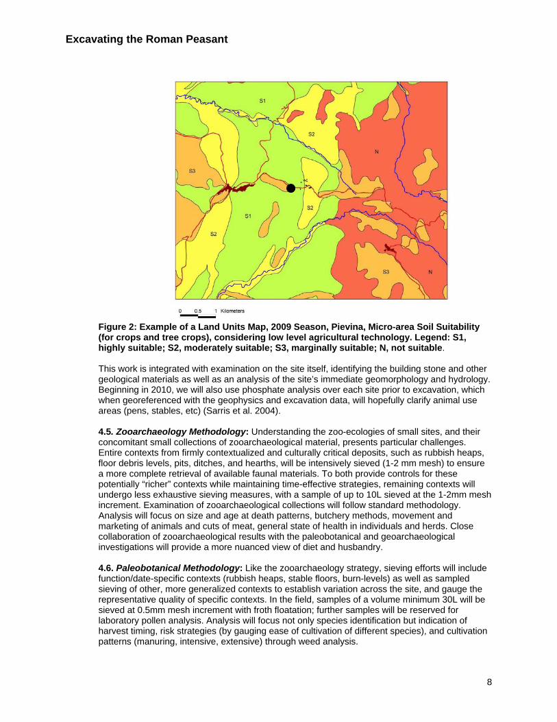
Figure 1: Results of Overhauser GEM magnetometry survey, 2009 Season, Pievina, showing correspondence with subsurface remains. 4.3. Chronologies: As one of the project goals is to further demolish the notion of an unchanging peasantry and catch a glimpse of lived experience, we will use a variety of techniques to improve chronological precision. Aside from the relatively good regional ceramic chronologies (which our team-member Vaccaro has helped to produce), and petrographic analysis of both local wares and tiles, we use AMS 14C dating to add precision to more amorphously dated periods (late antiquity, for instance), and will this year to introduce use micromorphological (microstratigraphy) analysis on floor surfaces to catch even finer-grained changes. 4.4. Geoarchaeology Methodology: Prior to excavation, a 1:25,000 Land Units Map covering a surface of about 4600 hectares, i.e. ca. 6 x 7.5 km, around each site, is prepared by combining data from stereoscopic aerial photographs with a geological map. This map represents hypothetical zones of soil qualities and underlying geologies, hydrological resources and movement potentials. Field examination during the excavation season then checks and tests these hypotheses and produces an analysis of the micro-region’s agricultural potential, geological and hydrological resources, and potential route-ways, barriers and site-lines. (See Figure 2 for an example)
7
Excavating the Roman Peasant
Figure 2: Example of a Land Units Map, 2009 Season, Pievina, Micro-area Soil Suitability (for crops and tree crops), considering low level agricultural technology. Legend: S1, highly suitable; S2, moderately suitable; S3, marginally suitable; N, not suitable. This work is integrated with examination on the site itself, identifying the building stone and other geological materials as well as an analysis of the site’s immediate geomorphology and hydrology. Beginning in 2010, we will also use phosphate analysis over each site prior to excavation, which when georeferenced with the geophysics and excavation data, will hopefully clarify animal use areas (pens, stables, etc) (Sarris et al. 2004). 4.5. Zooarchaeology Methodology: Understanding the zoo-ecologies of small sites, and their concomitant small collections of zooarchaeological material, presents particular challenges. Entire contexts from firmly contextualized and culturally critical deposits, such as rubbish heaps, floor debris levels, pits, ditches, and hearths, will be intensively sieved (1-2 mm mesh) to ensure a more complete retrieval of available faunal materials. To both provide controls for these potentially “richer” contexts while maintaining time-effective strategies, remaining contexts will undergo less exhaustive sieving measures, with a sample of up to 10L sieved at the 1-2mm mesh increment. Examination of zooarchaeological collections will follow standard methodology. Analysis will focus on size and age at death patterns, butchery methods, movement and marketing of animals and cuts of meat, general state of health in individuals and herds. Close collaboration of zooarchaeological results with the paleobotanical and geoarchaeological investigations will provide a more nuanced view of diet and husbandry. 4.6. Paleobotanical Methodology: Like the zooarchaeology strategy, sieving efforts will include function/date-specific contexts (rubbish heaps, stable floors, burn-levels) as well as sampled sieving of other, more generalized contexts to establish variation across the site, and gauge the representative quality of specific contexts. In the field, samples of a volume minimum 30L will be sieved at 0.5mm mesh increment with froth floatation; further samples will be reserved for laboratory pollen analysis. Analysis will focus not only species identification but indication of harvest timing, risk strategies (by gauging ease of cultivation of different species), and cultivation patterns (manuring, intensive, extensive) through weed analysis.
8
Excavating the Roman Peasant
4.7. GIS Analysis: For studies like ours that propose to analyze large quantities of disparate kinds of data over three-dimensional space, GIS provides the most powerful tool. All of our data – stratigraphic contexts, field drawings, finds reports, geoachaeological surveys, geophysical data – are georeferenced and collated in GIS, allowing us to readily spot patterns and adjust field practices accordingly. As an analytical tool, we use GIS to address the questions of reciprocity, economic exchange habits, and landscape manipulation which lay at the heart of our study. For example, distribution analysis of imported wares as calculated by shards per unit area, (c.f. Hirth 1998) will be used to estimate the nature of exchange systems between sites – open market, closed gift exchange, elite distribution, and the spectrum between these options. These findings will be layered with cost-distance terrain analysis along pathways identified in the geoarchaeological survey to identify possible actual exchanges/relationships between non-elites, and between non-elites and the one villa in the survey. Cost-distance will also be used to map potential route ways to optimal agricultural land and other resources, and will be layered against sight-line analysis to understand how perceptions of landscape impacted economic decision-making (c.f. Llobera 1996). 5. PROJECT HISTORY The groundwork for Excavating the Roman Peasant was laid in a field-survey project, begun in 2006 by one of the project’s collaborators (M. Ghisleni), in the commune of Cinigiano (Ghisleni et. al forthcoming). Southern Tuscany has been subject to the most numerous large-scale field surveys anywhere in the Roman Mediterranean (e.g. Potter 1979; Carandini and Cambi 2002; Terrenato and Ammerman 1996; Motta 1997; Vaccaro 2008). Originally prompted by the large-scale destruction of the Roman hinterland in the post-war years, these surveys gradually extended north up the Tuscan coast, focusing on the development of Rome’s agrarian hinterland and export-producing wine estates. Ghisleni’s survey was different; based just to the north and east of these earlier surveys, it set out to explore a “marginal” landscape, one which lay inland from the coastal export markets and set between and somewhat distant from the region’s two main terrestrial transport routes – the via Aurelia and via Cassia. What she revealed was a somewhat distinct, but hardly “marginal” landscape. Combining surface survey with selective geophysical survey (c.f. Regoli and Terrenato 1991), study of the medieval cartularies, early modern cadastral maps and aerial photography, she mapped 500 topographic units (off-site scatters and designated “sites”), most of Roman date and relatively undamaged by modern deep ploughing (Figure 3).
9

Excavating the Roman Peasant
Figure 3: Commune di Cinigiano, surface survey, “sites” and “off-site” scatters, 2nd c. B.C.-4th c. A.D. (Ghisleni et al forthcoming). Also unlike the coastal areas which experienced massive demographic upsurges in the 2nd c. B.C., followed by equally dramatic downturns in the 2nd and 5th c. A.D., the area, like other so-called “marginal” landscapes, witnessed more stability, with more consistent overall settlement numbers from the 2nd c. B.C. through to the 4th c. A.D. (c.f. Motta 1997). The types of sites she found were also somewhat different: as in most Roman landscapes, the most numerous sites were represented by small (>0.25ha) spreads of roof tile and common wares, but unlike the coastal surveys, the region seems to have had only one site classifiable as a villa (1.5-2ha site with mosaic floors, statuary and nearby agricultural quarters), while somewhat more common were large, but materially poor agglomerated sites which were interpreted as villages. Thanks to its totalizing approach to landscape, Ghisleni revealed a countryside ideal for exploring the Roman peasant: an exceptionally-well preserved landscape with real potential to integrate surface survey and geophysics, a plethora of small sites, and the possibility of focusing on their inter-site relationships, as well as those between elite and non-elite sites. The second phase of the project was initiated in June 2009 with a month-long pilot season at the site of Pievina, first discovered in Ghisleni’s survey (Figure 4). The goals of the season were four-fold: 1. to prove that the “small” tile/ceramics scatters found in the survey were, in fact, remains of small rural farms with intact stratigraphic sequences (see Section 4: Methodologies, for scholarly debate on the issue); 2. To demonstrate that such sites could be successfully excavated with open-area techniques, at speed, 3. To produce a micro-topographic study of the site’s natural resources, including soils, and sketch possible movement potentialities and 4. To convince local landowners of both the legitimacy of the project and its minimal affects on their cropping regimes, so that future collaborations and permissions might be forthcoming.
10

Excavating the Roman Peasant
Figure 4: Aerial photograph of Pievina, site of 2009 season, showing excavated remains of Roman peasant farmstead (with students for scale). All four goals were met and exceeded. The site located during surface survey suggested three distinct concentrations of ceramic, roof tile and river-stone – a possible small nucleus of houses and/or agricultural buildings. Two rounds of geophysics with different instruments (see Section 4.2) before excavation likewise revealed three, well-defined anomalies, which although they did not reveal individual walls or buildings, pointed to intact archaeological remains, including a possible kiln site. In 20-work days, a team of 20 students and four specialists excavated 90% of the surveyed area, recording some 200 distinct archaeological contexts, two major occupational periods and a rapid, if not generational, succession of alterations in the final, late antique period. The season revealed a site on the “large”/”wealthy” end of our “peasant spectrum”. The first phase, of the early 1st c. B.C., was composed of a large rectangular building (probably a house, but largely under ground-water level), a granary, and tile kiln with attendant rubbish dump (Figure 5). The living levels of this site had been largely wiped away by erosion and a major earth-movement episode sometime during or after the early 2nd c. A.D., which covered the site and erased some its buildings. In the 4th c. A.D. the site was reoccupied, reusing some of the visible walls to construct a much smaller house, attached to which was a post-built structure, perhaps a stable (Figure 6). Efforts went into more carefully channeling the down slope water which had proved so disastrous, building drains and water-shedding work-surfaces all around the site. While the ceramics could only be generally dated from the 4th through late 5th c. A.D., clear stratigraphic relationships showed at a constant, if not generational, pattern of modifications to these installations, with the progressive demolition of living space, yet concomitant accumulation of consumer goods.
11

Excavating the Roman Peasant
Figure 5: 2009 Season, Pievina. Phase 1.1: Early 1st c. B.C. farmstead
Figure 6: 2009 Season, Pievina, Phase 2.1: Mid-4th c. A.D. farmstead The pilot season was a convincing demonstration of the project’s methodological principals, and as well as support of its research hypothesis. First, it showed unequivocally that a combination of surface survey of designated small “sites” and geophysics could accurately predict the presence of intact archaeological remains. The fact that two different magnetometry instruments produced very different results reconfirmed that more than one method/instrument might be necessary. One set of results (obtained with the Overhauser GEM, (see Section 4.2 on geophysics
12
Excavating the Roman Peasant
methodologies)), however, was revealing, accurately locating even small post-holes, and showed great potential for future work (see Figure 1).
Second, the season verified the archaeological potential of such sites: the unusually good levels of preservation suggested through the surface remains and geophysics was verified through the excavation of well-preserved architecture and occupational stratigraphy, including living surfaces and household rubbish deposits rich in animal and plant remains that are so critical for our project. Finally, while the final reports on the excavated materials will not be completed until July 2010, the preliminary results and the geoarchaeological micro-survey confirmed some of our working hypothesis. The very different building techniques, structures and material profiles of the 1st c. B.C. farm versus its 4th c. A.D. successor describe in rich detail the heterogeneity of rural inhabitants, and the many and conflicting yardsticks for “wealth” and “poverty.” The Republican settlement had a large, well-built probable house, storage for surplus and small tile industry: fabric comparison of tiles from the site with those found in the field survey will show whether its distribution was domestic or micro-regional. Its 4th c. A.D. successor was much smaller, built of reused materials, had no areas for surplus storage, and saw people living in increasingly close proximity to household garbage and perhaps domestic animals. Yet the volume and wealth of the household’s domestic ceramics, and its exposure to small-value monetary exchange, was much higher. The discrepancies provide rich fodder for interrogating categories of wealth and poverty. The finds and resource survey likewise point to something more complex than mere “subsistence” economies. The unexpectedly high number of coins (some 40) point to monetized exchange mechanisms, while the small granary from the first phase suggests that surplus production was not limited to large farms. Most ceramics were of regional manufacture, while a tiny collection of imported North African and eastern materials from the late antique phase, generally thought to be absent from such small, inland sites, point to broader networks: whether these networks were all mediated through peers, elites or directly should be revealed by comparison with other sites. Building materials and water resources were also mostly local, but the topographic study helped lend specificity to what “local” might mean: most stone resources used in the Republican phase were located in “high-energy” areas, where steep terrain and likely thick vegetation would make transport more difficult and resources lay out of sight view, while grinding stones used in this first phase may have come as far away as distant Orvieto, 55km through a major mountain chain. Late antique building materials, on the other hand, were more often taken from visible, low-energy river-valleys. The publication of these results is already in-hand: because all drawings, documentation and stratigraphic analysis were completed at the end of the 30-day season, a draft of the preliminary report has already been finished. Specialists reports will be completed by July 1, and the final report will be submitted in August (in Italian) to the Notiziario della Soprintendenza per i Beni Archeologici della Toscana and (in English) to the Papers of the British School in Rome. The 2010 season will expand on these results and remedy some of its lacunas. Two smaller, less materially rich sites (a. 10x10m “site” with low concentration domestic ceramics; b. three adjacent 10x10 “site” clusters, no domestic ceramics) have been chosen for excavation, further testing the relationships between surface and subsurface remains as well as the limits/potential of geophysics. While excavation will still be confined to about 30 days, the project season will be expanded to 1.5 months, largely in order to accommodate more comprehensive sieving for paleobotanical and zooarchaeological remains and to assure all materials are studied by season’s end. The in-process interpretative apparatus will be bulked up, bringing all the team specialists on site to better shape excavation methodologies. The community archaeology project’s first public seminar, and its “Giornata di Archeologia,” will begin, as well as initial planning for the museum.
13

Excavating the Roman Peasant
6. IMPLICATIONS The implications of Excavating the Roman Peasant are far-reaching, having potential major impacts on not only Roman archaeology but also archaeological methodology and archaeology’s relationship with its many publics. The project seeks to remedy one of the great lacunae in classical archaeology and history: knowledge of the rural poor. It does so by answering the potential problems with innovative solutions – full interdisciplinarity, integrating various forms of remote sensing with excavation, uniting rescue and research archaeology, and partnering fully with local communities, including landowners and local archaeologists. In doing so, it answers positively the question which has long confronted archaeologists and historians alike – Can we really locate the poor? These solutions present a variety of new ways of doing archaeology which build upon recent developments, but break with many traditional practices. Each season is self-contained, using technology to produce a full excavation record and integrating excavation and finds analysis. We thus avoid the publication and study backlogs which have plagued Mediterranean archaeology. Costs are likewise contained by concentrating work into intensive, shorter seasons. The often contentious relationship between local landowners and archaeologists is likewise mitigated by meeting the real needs of modern agricultural communities with a different kind of archaeological “scheduling” and the return of sites to the earth after excavation. The Project also seeks to empower those most frequently left out of archaeology’s positive wake of change – local archaeologists and local communities. American excavations in the Mediterranean have long struggled against accusations of neo-colonialism and the distrust of their local colleagues, problems reflected in current debates over looting and cultural heritage. Our project integrates Italian archaeologists at every level: the students are deliberately comprised of half Americans and half Italians; the project relies upon and contributes to the doctoral dissertation of a promising young Italian archaeologist; field direction is shared by Bowes, Ghisleni and Vaccaro; lab work is performed entirely through Italian labs, while Cornell contributes its extraordinary library. This close collaboration between Amercian and Italian archaeologists have enabled the equally close, and equally essential collaboration with the local township. We have tried to balance the landowner’s desire to return their fields to cultivation (thus necessitating the backfilling of sites after excavation), with the township’s desire to develop tourism and education: the result will be the small museum, showcasing not only the results of the excavations, but also the links that bind this relatively poor, modern agricultural community with its ancestors. In a time when the young are fleeing to the cities and the agricultural heritage of these rural communities is at risk, our project provides a tangible, exciting and thoroughly modern link with the past which we hope will inspire a new generation. Finally, over the projects duration, some 90 Italian and American students will participate in Excavating the Roman Peasant, many, if not the majority, of whom will be undergraduates. Students leave the project having had an intensive exposure to archaeological methodology, modern mapping technology, GIS, and “international relations” in the form of their Italian/American peers. Students also gain skills training through close work with specialist: interested students will be partnered with a specialist as “apprentice”, assisting in their work and learning their discipline. 7. FUNDING The project acknowledges and thanks the sources of its 2009 funding: Cornell Classics Department Cornell Society for the Humanities Midas/Croesus Fund Einaudi Center for International Studies
14

Excavating the Roman Peasant
References Cited Ammerman, A. (1993), 'Review of Cherry, Davis, and Mantzourani, Landscape Archaeology as Long-
Term History', Journal of Field Archaeology, 20, 367-72. Andrews, G., Barrett, J., and Lewis, J. (2000), 'Interpretation not Record: The Practice of Archaeology',
Antiquity, 74, 525-30. Banaji, J. (1997), 'Lavoratori liberi e residenza coatta: il colonato romano in prospectiiva storica', in Elio Lo
Cascio (ed.), Terre, proprietari e contadini dell'impero romano (Rome), 253-80. Barker, G. (ed.), (1995), A Mediterranean Valley. Landscape Archaeology and Annales History in the
Biferno Valley (London/New York). Barker, G. and Grant, A. (1991), 'Ancient and modern pastoralism in central Italy: an interdisciplinary
study in the Cicolano mountains', Papers of the British School in Rome, 59, 15-88. Bernstein, H. and Byers, T. J. (2001), 'From Peasant Studies to Agrarian Change', Journal of Agrarian
Change, 1 (1), 1-56. Bintliff, J. (ed.), (1991), The Annales School and Archaeology (Leicester). Bintliff, J. and Snodgrass, A. (1988), 'Off-Site Pottery Distribution: A Regional and Interregional
Perspective', Current Anthropology, 29, 506-13. Bintliff, J. et al. (2001), 'Classical Farms, Hidden Prehistoric Landscapes and Greek Rural Survey: A
Response and an Update', Journal of Mediterranean Archaeology, 15 (2), 259-65. Campana, S. (2008), 'Geofisica estensiva continua. Verso un nuovo livello analitico per l’archeologia?' in
L. Orlando (ed.), Geofisica per l’archeologia. Possibilità e limiti (Rome). Carandini, A. (ed.), (1985), Settefinestre, una villa schiavistica nell'Etruria Romana 2 vols. (Modena). Carandini, A. and Cambi, F. (2002), Paesaggi d'Etruria. Valle dell'Albegna, Valle d'Oro, Valle del
Chiarone, Valle del Tafone. Progetto di ricerca italo-britannico seguito allo scavo di Settefinestre (Rome).
Carrié, J.-M. (1982), 'Le "colonat du Bas-Empire": un mythe historiographique?' Opus, 1, 351-70. Chapelot and Fossier (1980), Le village et la maison au Moyen Âge. Chayanov, A. V. (1966), The Theory of Peasant Economy (Homewood, IL). Collins, D., et al. (2009), Portfolios of the Poor (Princeton). Cunningham, T. and Driessen, J. (2004), 'Site by site: Combining Survey and Excavation Data to Chart
Patterns of Socio-political Change in Bronze Age Crete', in Susan E. Alcock and John F. Cherry (eds.), Side-by-Side Survey: Comparative Regional Studies in the Mediterranean (Oxford), 101-13.
Delano-Smith, C. and Gadd, D. (1986), 'Luni and the Ager Lunensis 1986: The Roman farmstead at site 9', Papers of the British School at Rome, 54, 109-18.
D'Archimbaud, G. D. (1980), Les fouilles de Rougiers (Var): contribution à l'archéologie de l'habitat rural médiéval en pays méditerranéen (Publication de l'U.R.A. no 6, Archéologie médiévale méditerranénne, Mémoires, 2; Paris).
Fedick, S. (ed.), (1996), The Managed Mosaic. Ancient Maya Agriculture and Resource Use (Salt Lake, UT).
Fentress, E. (2007), 'Around the Temple: The New Galleries of the Capitoline Museum', American Journal of Archaeology, 111, 365-69.
Finley, M. (1999), The Ancient Economy (3rd edn: Berkeley). Foxhall, L. (1990), 'The Dependant Tenant: Land Leasing and Labour in Italy and Greece', Journal of
Roman Studies, 80, 97-114. Francovich, R., Patterson, H., and Barker, G. (eds.) (2000), Extracting Meaning from Ploughsoil
Assemblages (Oxford). Freter, A. (2004), 'Multiscalar Model of Rural Households and Communities in Late Classic Copan Maya
Society', Ancient Mesoamerica, 15, 93-106. Friedmann, H. (1980), 'Household Production and the National Economy: Concepts for the Analysis of
Agrarian Formation', Journal of Peasant Studies, 7 (2), 158-84. Gaffney, V. and Van Leusen, M. (1995), 'GIS, Environment Determinism and Archeology: A Parallel Text',
in G. Lock and Z. Stancic (eds.), GIS in Archaeology: A European Perspective (London), 367-82.
15

Excavating the Roman Peasant Garnsey, P. (1979), 'Where Did Italian Peasants Live?' Proceedings of the Cambridge Philological
Society, 205, n.s. 25, 1-25. Ghisleni, M. (2009), ' Il sito di Santa Marta nel contesto delle dinamiche insediative di età romana, tardo
antica e medievale della media valle dell’Ombrone (Cinigiano-GR)', in G. Volpe and P. Favia (eds.), V Congresso Nazionale di Archeologia Medievale (Foggia), 249-47.
Ghisleni, M., et al. (forthcoming), 'Le maglie insediative della valle dell’Ombrone (GR) nel primo millennio d.C.' in G. Macchi (ed.), Geografie del Popolamento (Siena).
Giardina, A. and Schiavone, A. (eds.) (1981), Società romana e produzione schiavistica 3 vols. (Bari). Grant, A. (1988), 'Animal resources', in G. Astill and A. Grant (eds.), The Countryside of Medieval
England (Oxford), 149-87. Grey, C. (2007), 'Contextualizing Colonatus: The Origo of the Late Roman Empire', Journal of Roman
Studies, 97, 155-75. Halstead, P. (1987), 'Traditional and Ancient Rural Economy in Mediterranean Europe: Plus ça change?'
Journal of Hellenic Studies, 107, 77-87. Harris, W. V. (2008), 'The Nature of Roman Money', in W. V. Harris (ed.), Monetary Systems of the
Greeks and Romans (Oxford), 174-207. Haselgrove, C., Millett, M., and Smith, I. (eds.) (1985), Archaeology from the Ploughsoil. Studies in the
Collection and Interpretation of Field Survey Data (Sheffield). Heidinga, H. A. (1987), Medieval Settlement and Economy North of the Lower Rhine. Archaeology and
History of Kootwijk and Veluwe (The Netherlands) (Cingula, 9; Assen). Hester, T.R., Shafer, H. J., and Eaton, J. D. (eds.) (1994), Continuing Archeology at Colha, Belize
(Studies in archeology (Texas Archeological Research Laboratory), 16, Austin, TX). Hilton, R. and Rahtz, P. A. (1966), 'Upton, Gloucestershire, 1959–64', Transactions of the Bristol and
Gloucestershire Archaeological Society, 85, 70-146. Hirth, K. (1998), 'The Distributional Approach: A New Way to Identify Marketplace Exchange in the
Archaeological Record', Current Anthropology, 39 (4), 451-76. Hurst, J. (ed.), (1979-), Wharram. A Study of Settlement on the Yorkshire Wolds 11 vols. Jones, A. H. M. (1964), The Later Roman Empire (2 vols; Baltimore). Jones, G. D. B. (1963), 'Capena and the Ager Capenas: Part II', Papers of the British School at Rome, 31,
N.S. 18, 100-58. Jones, G. D. B. (1980), 'Il Tavoliere romano. L’agricoltura romana attraverso l’aerofotografia e lo scavo',
Archeologia Classica, 32, 85-100. Kehoe, D. (1997), Investment, Profit and Tenancy: The Jurists and the Roman Agrarian Economy (Ann
Arbor). King, E. and Potter, D. (1994), 'Small Sites in Prehistorical Maya Socioeconomic Organization: A
Perspective from Colha, Belize', in Glenn Schwartz and Steven Falconer (eds.), Archaeological Views from the Countryside (Washington, D.C.), 64-90.
Llobera, M. (1996), 'Exploring the Topography of Mind: GIS, Social Space and Archaeology', Antiquity, 70, 612-22.
Lo Cascio, E. (ed.), (2001), Modalità insediative e strutture agrarie nell'Italia meridionale en età Romana (Bari).
MacKinnon, M. (2004), Animal Production and Consumption in Roman Italy: Integrating the Zooarchaeological and Textual Evidence (Journal of Roman Archaeology Supplementary Series, 54; Portsmouth, RI).
Marx, K. (1973), Grundrisse der Kritik der politischen O konomie (New York). Marzano, A. (2007), Roman Villas in Central Italy. A Social and Economic History (Leiden). Mattingly, D. and Salmon, J. (eds.) (2000), Economies Beyond Agriculture in the Ancient World (London). McManamon, F. (1984), 'Discovering Sites Unseen', in M. Schiffer (ed.), Advances in Archaeological
Method and Theory (7), 223-92. Morley, N. (1996), Metropolis and Hinterland: The City of Rome and the Italian Economy, 200 B.C. - A.D.
200 (Cambridge). Motta, L. (1997), 'I paesaggi di Volterra nel Tardoantico', Archeologia Medievale, 24, 245-67. Neeve, P. W. d. (1984), Colonus: Private Farm-Tenancy in Roman Italy during the Republic and the Early
Principate (Amsterdam).
16

Excavating the Roman Peasant
17
Oosthuizen, S. (2006), Landscapes Decoded: The Origins and Development of Cambridgeshire's Medieval Fields (Hatfield).
Patterson, H. (ed.), (2004), Bridging the Tiber: Approaches to Regional Archaeology in the Middle Tiber Valley (Rome/London).
Perkins, P. and Attolini, I. (1987), 'An Etruscan Farm at Podere Tartuchino', Papers of the British School at Rome, 60, 71-134.
Pesez, J.-M. (1998), Archéologie du village et de la maison rurale au Moyen Âge (Collection d'histoire et d'archéologie médiévales, 5; Lyon: Presses Universitaires de Lyon).
Pettegrew, D. (2001), 'Chasing the Classical Farmstead: Assessing the Formation and Signature of Rural Settlement in Greek Landscape Archaeology', Journal of Mediterranean Archaeology, 14 (2), 189-209.
Potter, T. W. (1979), The Changing Landscape of South Etruria (London). Regoli, E. and Terrenato, N. (1991), 'Rilevamenti geofisici in un progetto di ricognizione archeologica: la
bassa Val di Cecina', Geofisica per l'Archeologia (Rome), 293-96. Rostovtzeff, M. (1910), Studien zur Geschichte des romischen Kolonates (Archiv fu r Papyrusforschung
und verwandte Gebiete, 1; Leipzig/Berlin). Sallares, R. (1991), Ecology of Ancient Greek World (London). Sarris, A. et al. (2004), 'Geophysical Prospection and Soil Chemistry at the Early Copper Age settlement
of Vésztó-Bikeri, Southeastern Hungary ', Journal of Archaeological Science, 31 (7), 927-39. Scheidel, W., Morris, I., and Saller, R. (eds.) (2007), The Cambridge Economic History of the Greco-
Roman World (Cambridge). Scheidel, W. and Redden, S. v. (eds.) (2002), The Ancient Economy (New York). Schwartz, G. and Falconer, S. (eds.) (1994), Archaeological Views from the Countryside (Washington,
D.C.). Scott, J. C. (1985), Weapons of the Weak. Everyday Forms of Peasant Resistance (New Haven). Shanin, T. (1988), 'Expolary Economies: A Political Economy of Margins', Journal of Historical Sociology,
1 (1), 107-15. Smith, M. E. (1992), Archaeological Research at Aztec-Period Rural Sites in Morelos, Mexico. Volume 1,
Excavations and Architecture / Investigaciones Arqueológicas en Sitios Rurales de la Epoca Azteca en Morelos, Tomo 1, Excavaciones y Arquitectura (Memoirs in Latin American Archaeology, 4; Pittsburgh).
Spurr, M. S. (1986), Arable Cultivation in Roman Italy, 200 B.C.- A.D.100 (Journal of Roman Studies Monographs, 3; London).
Stout, M. (1997), The Irish Ringfort (Dublin). Terrenato, N. and Ammerman, A. (1996), 'Visiblity and Site Recovery in the Cecina Valley Survey, Italy',
Journal of Field Archaeology, 23 (1), 91-109. Tully, G. (2007), 'Community Archaeology: General Methods and Standards of Practice', Public
Archaeology, 6 (3), 155-87. Turner, B. L. and Harrison, P. D. (eds.) (1983), Pulltrouser Swamp. Ancient Maya Habitat, Agriculture,
and Settlement in Northern Belize (Austin, TX). Vaccaro, E. (2008), 'An Overview of Rural Settlement in Four River Basins in the Province of Grosseto on
the Coast of Tuscany (200 B.C.–A.D. 600) ', Journal of Roman Archaeology, 21, 225-47. Waateringe, W. G.-v. and Wijngaarden-Bakker, L. H. v. (eds.) (1987), Farm Life in a Carolingian Village.
A Model Based on Botanical and Zoological Data from an Excavated Site (Assen). Weber, M. (1891), Römische Agrargeschichte in ihrer Bedeutung für das Staats-und Privatrecht
(Stuttgart). Wickham, C. (2005), Framing the Early Middle Ages. Europe and the Mediterranean 400-800 (Oxford). Wolf, E. (1966), Peasants (New York). Zadora-Rio, E. (1995), 'Le village des historiens et le village des archéologues', in E. Mornet (ed.),
Campagnes médiévales: L'homme et son espace. Études offertes à Robert Fossier (Paris), 145-53.