excavations of a henge monument and timber circle data ... · pdf filecircle data structure...
TRANSCRIPT

Forteviot, Perthshire 2008: Excavations of a henge monument and timber circle Data Structure and Interim Report by
Gordon Noble and Kenneth Brophy

Forteviot Henge Excavations 2008
1
Summary
This interim report will describe the provisional outcomes of our excavations, part of the SERF (Strathearn Environs and Royal Forteviot) Project, in a field immediately to the S of Forteviot village, Perth and Kinross, in August 2008. Our focus in the 2008 summer season was two elements of the Forteviot cropmark complex: a possible late Neolithic henge monument, and an adjacent pit-defined setting. Both these features are located within the large Neolithic palisaded enclosure, partially excavated in 2007 (see Brophy & Noble 2008). Trench 2 revealed information both about the henge monument, but also extensive later reuse of the site. Trench 3 was opened over the location of the possible timber-setting; this was not identified in the trench, but a large pit with burnt material and a number of other features were found, not all of which are identifiable as cropmarks. In many ways, this was a much more difficult season of excavation than Trench 1 in 2007, partly due to wetter weather conditions, but also to a large extent because of the complexity of the archaeology, especially in Trench 2, which one would not normally expect of a cropmark site. This report therefore contains results and interpretations that are provisional and a second season of excavation in and around this henge will be required in 2009 which will, we hope, answer some of the many questions raised by the 2008 season.
Introduction
One of the key aims of the SERF Project is to sample the remarkable complex of cropmarks situated to the S of Forteviot village. The 2007 excavations focused on the largest coherent cropmark site, a palisaded enclosure some 265m across. Within and around the enclosure a series of ancillary or perhaps related cropmark sites have been identified (St Joseph 1976), including possible henge monuments and timber circles. Many of these cropmarks are situated within the palisaded enclosure. Such enclosures frequently have a range of internal structures than are closely contemporary with, or built within, the enclosure (cf. Gibson 2002; Speak & Burgess 1999); such internal features were the focus of the 2008 season.
Excavations focused on the north-western part of a large ditched enclosure, located within the boundary of the palisaded enclosure. This enclosure, recognised as henge since its discovery (St Joseph 1976), was sub-circular in plan, defined by a ditch with at least one if not two clear entrance gaps, defining an enclosure at least 35m N-S by 30m E-W. An interior of c22m by 21m suggested a ditch of at least 6 or 7m width. Unusually, cropmarks also suggested that the henge was surrounded by a timber circle; its entire perimeter is not clear, but it could have had a complete diameter of something in the order of 50 - 60m. Within the northern half of the henge, a large sub-rectangular feature is also visible as a cropmark, aligned approximately NE-SW and the recent RCAHMS transcription (Figure 1) shows an additional circular feature in the south-western part of the interior of the henge. This henge complex is severely plough-damaged and only visible on the ground as a pronounced rise in the field.
Excavations in 2008 also included a speculative trench towards the centre of the palisaded enclosure, which had two main objectives. Firstly, to try to characterise a possible pitted feature known as a cropmark, and secondly, to sample the interior area of the enclosure for evidence of activity not showing as cropmarks. This pitted feature consisted of a group of possible pits or post-holes in a trapezoidal setting, a feature spread across no more than a 10m x 10m area.

Forteviot Henge Excavations 2008
2
Figure 1 Cropmark transcription ©RCAHMS. Trench locations indicated (2007-8)
Trench 2 (G Noble and K Brophy)
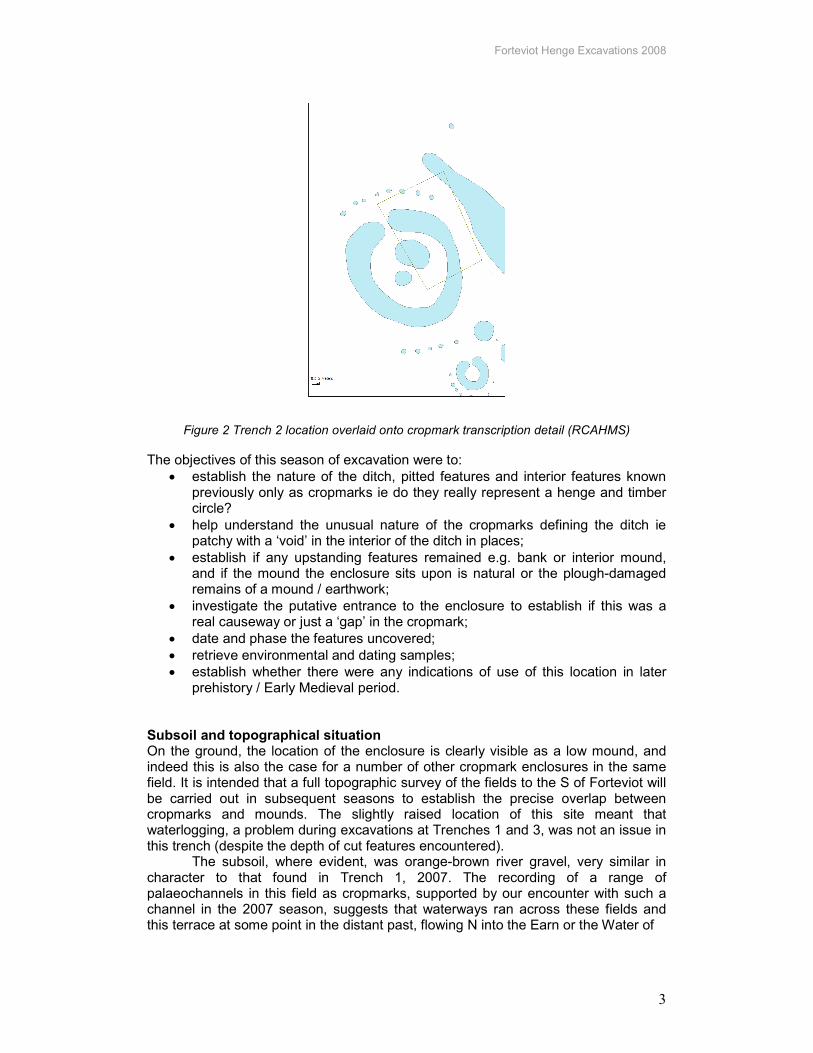
Methodology and research objectives Excavations in Trench 2 (Figure 2) were overseen by K Brophy, E Campbell, G Noble and D Wright. This trench was laid out over the north-eastern part of the henge monument encompassing the north-eastern portion of the henge interior, one of the henge entrance terminals on the northern side and most of the sub-rectangular feature in the interior. A mechanical excavator removed the topsoil over the trench under close observation, and the trench was then cleaned using hoes and subsequently carefully trowelled.
The excavation of these sites took place between 4th and 24th August, 2008. The excavation formed a central part of the University of Glasgow field school and consisted of undergraduate and postgraduate students from the University along with a smaller number of external students from Aberdeen, Chester and Sorbonne. In addition up to fifteen local volunteers were on site every day. The excavation formed part of a wider season of fieldwork and provided training for the team.
Forteviot Henge Excavations 2008
3
Figure 2 Trench 2 location overlaid onto cropmark transcription detail (RCAHMS)
The objectives of this season of excavation were to:
• establish the nature of the ditch, pitted features and interior features known previously only as cropmarks ie do they really represent a henge and timber circle?
• help understand the unusual nature of the cropmarks defining the ditch ie patchy with a ‘void’ in the interior of the ditch in places;
• establish if any upstanding features remained e.g. bank or interior mound, and if the mound the enclosure sits upon is natural or the plough-damaged remains of a mound / earthwork;
• investigate the putative entrance to the enclosure to establish if this was a real causeway or just a ‘gap’ in the cropmark;
• date and phase the features uncovered;
• retrieve environmental and dating samples;
• establish whether there were any indications of use of this location in later prehistory / Early Medieval period.
Subsoil and topographical situation On the ground, the location of the enclosure is clearly visible as a low mound, and indeed this is also the case for a number of other cropmark enclosures in the same field. It is intended that a full topographic survey of the fields to the S of Forteviot will be carried out in subsequent seasons to establish the precise overlap between cropmarks and mounds. The slightly raised location of this site meant that waterlogging, a problem during excavations at Trenches 1 and 3, was not an issue in this trench (despite the depth of cut features encountered).
The subsoil, where evident, was orange-brown river gravel, very similar in character to that found in Trench 1, 2007. The recording of a range of palaeochannels in this field as cropmarks, supported by our encounter with such a channel in the 2007 season, suggests that waterways ran across these fields and this terrace at some point in the distant past, flowing N into the Earn or the Water of

Forteviot Henge Excavations 2008
4

Forteviot Henge Excavations 2008
5
May to the W. Thankfully, these had no impact on this trench. Within the trench, natural subsoil was very difficult to identify, and indeed over 90% of the surface area of Trench 2 actually represented fills of cut features. Summary of the phasing The following phases were identified during our excavations in 2008, although these have to be regarded as provisional. Radiocarbon dates from this season have been included in the discussion where relevant; diagnostic artefacts in secure contexts were very rare.
Phase Description, main characteristics
Radiocarbon dating (see Table 2)
Secure artefact associations
I Unknown Pre-henge activity – rubble filled features
None
II Late Neolithic
Timber circle 2700-2480 calBC None
III Late Neolithic / EBA
Henge monument 2479-2130 calBC Beaker pot sherds in lower fills
IV Later prehistory / medieval
Large pit; rubble and cobble reworking of henge
Roman to late Med pottery
Table 1: Simplified phasing of activities in Trench 2
Phase I: Pre-henge activity At least two features within Trench 2 seem to pre-date the henge monument, a large spread of rubble, and a large pit filled with stones and a large megalith. This is a provisional observation and further excavation will be needed to establish the chronology and nature of these features.
Stone spread (305 / 322) A large spread of stones was identified within the SW area of the henge interior. Covering an amorphous area of about 4m by 2.5m, spread (305) consisted of rounded and angular rubble and stones. Little investigation was carried out on this feature, but it may be a large cut feature with a rubble fill, and a deposit of pinkish clay (322) was found underlying the stone spread in a very localised sondage. This feature was cut by the adjacent ‘megalith pit’ [348] on the S side (these features abut one another) and was also cut by the large scoop within the centre of the henge [316].
Figure 4 Looking northwards over the partly excavated stone filled pit [348], the monolith can be seen peeking out of the section to the left of the north pointing ranging rod. Stone spread
(305) can be seen in the upper left background.

Forteviot Henge Excavations 2008
6
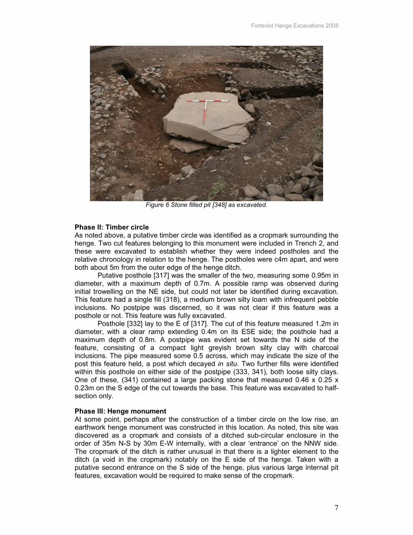
Megalith pit [348] Immediately to the south of (305), a large oval pit measuring 5.7m N-S by 3.3m, with maximum depth 0.6m was identified and excavated. This large pit consisted largely of a fill (349) of angular stones, mainly of basalt, and rounded waterworn stones / pebbles. These could all be derived locally, the basalt from a quarry at the foot of Dronachy Ridge to the S, the rounded stones from the nearby Water of May or Earn. The largest stone amongst this rubble was 1.1m in length suggesting this deposit was labour intensive. These stones had a dark brown silt matrix (323); this was heavily voided, suggesting rapid backfilling, perhaps in one event. Two silty deposits were identified at the base of this rubble deposit (364, 361), one with charcoal and possible burnt bone fragments, although these were not excavated into. The relationship between these fills and the large megalith at the base of the pit remained unclear at the end of the season.
The base of this large pit was relatively flat, and in the centre of this feature beneath the rubble deposit was a remarkable large sandstone block (359). The monolith was roughly square in shape (measuring 2.8m by 2.4 with thickness of about 0.35m) with a slightly convex upper side. The stone did not appear to be dressed, nor were any markings noted on the upper side of the monolith. The underside of the stone was not examined in this season so it is unclear what the true extent of this stone is, nor what, if anything, lies beneath it, although a flat slab was noted protruding out from beneath the S side of the stone.
Due to time constraints, the complete excavation of this enigmatic feature was left until 2009. It was noted that the henge ditch fills (eg 373) appeared to replace or displace rubble fill (349), so tentatively we concluded that this monolith was placed in this pit before the henge was constructed. However, this was by no means a final conclusion. The meaning of this remarkable discovery will be discussed in the conclusion to this report.
Figure 5 Uncovering the megalith. A slab protruding from beneath the monolith
can be seen under the bottom right hand edge of the stone
Forteviot Henge Excavations 2008
7
Figure 6 Stone filled pit [348] as excavated.
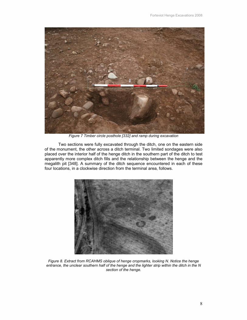
Phase II: Timber circle As noted above, a putative timber circle was identified as a cropmark surrounding the henge. Two cut features belonging to this monument were included in Trench 2, and these were excavated to establish whether they were indeed postholes and the relative chronology in relation to the henge. The postholes were c4m apart, and were both about 5m from the outer edge of the henge ditch.
Putative posthole [317] was the smaller of the two, measuring some 0.95m in diameter, with a maximum depth of 0.7m. A possible ramp was observed during initial trowelling on the NE side, but could not later be identified during excavation. This feature had a single fill (318), a medium brown silty loam with infrequent pebble inclusions. No postpipe was discerned, so it was not clear if this feature was a posthole or not. This feature was fully excavated.
Posthole [332] lay to the E of [317]. The cut of this feature measured 1.2m in diameter, with a clear ramp extending 0.4m on its ESE side; the posthole had a maximum depth of 0.8m. A postpipe was evident set towards the N side of the feature, consisting of a compact light greyish brown silty clay with charcoal inclusions. The pipe measured some 0.5 across, which may indicate the size of the post this feature held, a post which decayed in situ. Two further fills were identified within this posthole on either side of the postpipe (333, 341), both loose silty clays. One of these, (341) contained a large packing stone that measured 0.46 x 0.25 x 0.23m on the S edge of the cut towards the base. This feature was excavated to half-section only.
Phase III: Henge monument At some point, perhaps after the construction of a timber circle on the low rise, an earthwork henge monument was constructed in this location. As noted, this site was discovered as a cropmark and consists of a ditched sub-circular enclosure in the order of 35m N-S by 30m E-W internally, with a clear ‘entrance’ on the NNW side. The cropmark of the ditch is rather unusual in that there is a lighter element to the ditch (a void in the cropmark) notably on the E side of the henge. Taken with a putative second entrance on the S side of the henge, plus various large internal pit features, excavation would be required to make sense of the cropmark.
Forteviot Henge Excavations 2008
8
Figure 7 Timber circle posthole [332] and ramp during excavation
Two sections were fully excavated through the ditch, one on the eastern side of the monument, the other across a ditch terminal. Two limited sondages were also placed over the interior half of the henge ditch in the southern part of the ditch to test apparently more complex ditch fills and the relationship between the henge and the megalith pit [348]. A summary of the ditch sequence encountered in each of these four locations, in a clockwise direction from the terminal area, follows.
Figure 8. Extract from RCAHMS oblique of henge cropmarks, looking N. Notice the henge entrance, the unclear southern half of the henge and the lighter strip within the ditch in the N
section of the henge.
Forteviot Henge Excavations 2008
9
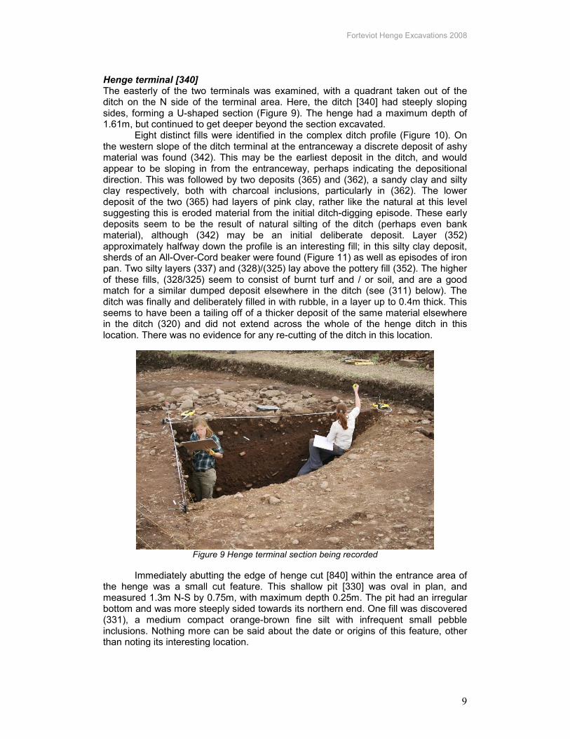
Henge terminal [340] The easterly of the two terminals was examined, with a quadrant taken out of the ditch on the N side of the terminal area. Here, the ditch [340] had steeply sloping sides, forming a U-shaped section (Figure 9). The henge had a maximum depth of 1.61m, but continued to get deeper beyond the section excavated.
Eight distinct fills were identified in the complex ditch profile (Figure 10). On the western slope of the ditch terminal at the entranceway a discrete deposit of ashy material was found (342). This may be the earliest deposit in the ditch, and would appear to be sloping in from the entranceway, perhaps indicating the depositional direction. This was followed by two deposits (365) and (362), a sandy clay and silty clay respectively, both with charcoal inclusions, particularly in (362). The lower deposit of the two (365) had layers of pink clay, rather like the natural at this level suggesting this is eroded material from the initial ditch-digging episode. These early deposits seem to be the result of natural silting of the ditch (perhaps even bank material), although (342) may be an initial deliberate deposit. Layer (352) approximately halfway down the profile is an interesting fill; in this silty clay deposit, sherds of an All-Over-Cord beaker were found (Figure 11) as well as episodes of iron pan. Two silty layers (337) and (328)/(325) lay above the pottery fill (352). The higher of these fills, (328/325) seem to consist of burnt turf and / or soil, and are a good match for a similar dumped deposit elsewhere in the ditch (see (311) below). The ditch was finally and deliberately filled in with rubble, in a layer up to 0.4m thick. This seems to have been a tailing off of a thicker deposit of the same material elsewhere in the ditch (320) and did not extend across the whole of the henge ditch in this location. There was no evidence for any re-cutting of the ditch in this location.
Figure 9 Henge terminal section being recorded
Immediately abutting the edge of henge cut [840] within the entrance area of the henge was a small cut feature. This shallow pit [330] was oval in plan, and measured 1.3m N-S by 0.75m, with maximum depth 0.25m. The pit had an irregular bottom and was more steeply sided towards its northern end. One fill was discovered (331), a medium compact orange-brown fine silt with infrequent small pebble inclusions. Nothing more can be said about the date or origins of this feature, other than noting its interesting location.

Forteviot Henge Excavations 2008
10
Figure 10 North-east facing section of the ditch terminal. Note upper rubble fill (320)
Figure 11 Beaker pottery from deposit (352) in henge ditch terminal
Eastern henge ditch [313] Excavating a section through the henge ditch on the eastern side of the monument was an arduous and problematic task, not least because the scale of the ditch and the nature of the upper rubble fill. A sondage measuring 2m across at the surface, and 1m across at the base, was cut across the ditch on the E side of the henge.
The henge ditch [313] was substantial in this location, measuring up to 11m across, and with a maximum depth of 2.8m. The ditch was noticeably steeper on the inner (western) side with a much more gradual sloping profile tailing off towards the henge exterior. The effect of the steeper inner side of the ditch was heightened by the fact that the henge interior was higher than the exterior. The ditch appeared to reach a V-shaped rather than U-shaped bottom, although at the base of the ditch excavation eventually became almost impossible.
A series of fills were identified within the henge representing a combination of natural silting, waterlogging and deliberate deposits over a potentially very long period of time. The lower fill (371) consists of a 0.75m thick deposit of wet sticky clay silt with rubble inclusions, probably a natural primary silting which could have accumulated relatively quickly. Iron panning within this layer suggests waterlogging at times. Immediately above this was a similar thick deposit of clay silt (369) with fewer stone inclusions, presumably the product of similar depositional processes.

Forteviot Henge Excavations 2008
11
Immediately above this clay silt deposit was a concentrated shallow deposit of charcoal, which may have been a dump of hearth material or related to a burning event, thrown in from the interior of the henge (which it is closer to). This was sealed by yet another deposit of clay silt (370) suggesting that aside from one depositional event, deposition continued to be gradual and natural for quite some time. Two very similar deposits (367, 368) continued the sequence above (370), with various instances of iron pan found in (367). After this long sequence, deposits started to change in character. Immediately above (367) was a compact pink silt clay layer (344) which extended across the ditch with maximum depth of 0.2m; this layer may have been trampled. This was followed by a clearly deliberate deposit of burnt material (311) which was found only on the interior (western) side of the ditch extending 2.8m into the ditch. This deposit was very distinctive, with a loamy consistency suggesting burnt turves or soil. This material was irregular and almost certainly thrown or dumped into the ditch from within the henge is ‘spade-‘ or handfuls. Some of this material may have been alight when thrown into the ditch. The irregular burnt surface formed by (311) may have been dug into before a layer of pink clay (with some rounded pebble inclusions) was deposited across the whole ditch, with maximum depth of 0.35m. The final fill (320) within the henge was perhaps the most dramatic of all, a thick deposit (up to 1m depth) of mixed rubble (basalt angled fragments, broken sandstone slabs, rounded pebbles) overlying the clay (319). Voids within this rubble suggest a rapid depositional event. The rubble does not extend across the whole ditch, and for the purposes of this report has been allocated to Phase IV (see below). Henge ditch sondage 1 [313] This sondage investigated an area of the henge where on the surface there seemed to be a more complex arrangement of different upper fills in the interior edge of the henge ditch. This was excavated to less than 1m in depth, and about 2m into the henge ditch [313]. A sequence of relatively thin sandy clays and burnt deposits were discovered, with similar elements of the main sequence outlined above, including rubble upper fill (338 = 320) overlying pink clay (339 = 319), and below this a loamy burnt deposit (345 = 311). A clay silt (350) was found beneath these familiar deposits, with no clear parallel in the main henge section. This was enough to suggest that some acts of deposition into the henge ditch may have been more localised than others.


Henge ditch sondage 2 [313] Moving further towards the S side of the henge, a narrow sondage was opened on a similar scale to sondage 1, this time to investigate the relationship between the henge ditch [313] and the large megalith pit (348) and its upper rubble fill (349). Here, the upper sequence was different, largely because the sondage did not extend far enough into the henge to cut into the rubble (320) or pink clay (319) upper ditch fills. The upper fill (372) was little more than a skim of medium brown silt loam, perhaps trampled topsoil, overlying a dark silt loam burnt layer (346 = 345 = 311). A medium brown silt deposit was beneath this (354), which in turn overlay another clearly burnt layer of dark brown silty material (347). Another brown silt clay deposit was revealed beneath this (373) which in turn overlay a thick deposit of rubble (349). This is the same as the rubble fill found in megalith pit [348]. The relationship between the henge and pit cuts was not established as time ran out, and it was resolved to return to this complex relationship in 2009. All four sections cut through the henge suggest that although there are similarities in sequence, there are also some localised differences, and these relate largely to deliberate depositional events. In each case, the henge ditch was shown to be a substantial cut feature, and it clearly took a very long time to be back-filled totally. In every case where the henge interior edge was looked at, the henge appears to have been cut or truncated by a large pit feature [316] within the henge (see phase 4, below).
The remarkable sequence of deposits within the ditch suggests lengthy periods of natural silting punctuated by occasional acts of deposition or modification. At some times the ditch almost certainly held standing water. It was unclear if there was a re-cut of the ditch here – for instance, perhaps burnt deposit (311) was partially dig out, with clay layer (319) added as a ‘foundation’ for rubble (320) to level out the ditch. On balance, though, it seems that there was not a recut. Very few artefacts were found in association with this ditch, and none in a reliable sealed context. The beaker sherds came from one vessel and it is perhaps unsurprising that the only artefacts found in the fills associated with use of the henge were found in the terminal area. For finds in the rubble upper fills, see below.
Henge exterior – bank? Orange-brown silt spreads were found on the exterior of the henge ditch extending from the lip, towards the timber circle. The cut for posthole [332] of the timber circle was initially indistinct and this may have been due to the presence of some vestige bank material here overlying the posthole.
Phase IV: Post-henge activity
Rubble fill of ditch (320) and cobbled areas (306, 321, 366) The stone and rubble upper fill of the henge ditch as discussed above (320) had an extensive presence across the trench as a whole, largely concentrated on where we had exposed the henge ditch although not extending to the inner edge of the ditch or the extremes of the terminal. On the eastern side of the henge, the rubble seems to have spilled beyond the edge of the henge ditch. This was clearly the cause of the void within the henge ditch cropmark.
This was not the last activity that took place here. In places layers containing much smaller stones overlying the coarser rubble survived suggesting the presence of cobbled areas (306, 321, 366) and a possible compact ashy surface only a few centimetres thick (329) was found in one location. This could be interpreted as an

Forteviot Henge Excavations 2008
14
outdoor surface such as one would find in a yard and is another indication that at some point the henge was radically reworked, although when we do not yet know.
The only small finds associated with this henge alteration came from rubble fill (320); these ranged from prehistoric lithics (including a microlith) to a glass droplet that may tentatively point to some kind of industrial activities in this location. However, this was not a secure context due to its place in the sequence and the voids within the fill. A possible cup-marked stone (374) was also found amidst the rubble within the henge ditch (320); the large rounded stone, measuring 0.8m by 0.5m by 0.2m, had one possible cup-mark pecked into it.
Medieval scoop [316] A large oval pit-like feature had previously been recognised as a cropmark within the northeastern quarter of the henge interior; this measures in total 10.5m NW-SE by 7.2m and about half of this was revealed within trench 2. Two sondages were cut through this feature, one at its northern edge, the other through the centre towards the baulk. Time did not allow any further investigation of what appears to be a massive scooped feature [316] with relatively steep sides, possibly a rounded bottom and a depth of at least 1.8m towards the centre. The feature is certainly more recent than the henge as it clearly cut henge ditch [313] on its eastern side and also cut the stone-filled feature (305, 322) to the S (which has no known relationship to the henge).
The profile of the scoop starts with a gentle sloping cut [316] at the edges of the feature and gradually descends, before stepping down further into the centre of the feature. There were two similar fills in the upper profile of the feature (303) and (304), (304) was restricted to the northern edge of the feature. The upper fills of the scoop were largely homogenous suggesting rapid filling for this feature. Where the step in the profile of the cut occurs the fill of the scoop changed with the stone frequency increasing dramatically with layers of stone occurring interlocked and lying on the base of the cut (326). Unfortunately only a small part of this stone fill was revealed, the stonework extending into the western baulk. The finds were intriguing with a number of roman amphorae sherds, tentatively identified as Dressel 20 type (1st-2nd Century AD), found mixed and lying above White Gritty Ware and other medieval sherds, possibly of 13th-14th Century date. Given the inclusion of the c.13th-14th Century pottery as the latest finds in the deposit, this feature is likely to date to the High Medieval period. This may the latest activity that we have a record of within the henge.
The function of this feature is uncertain, the stony fill may represent some form of sunken feature, but the upper fills suggest rapid filling above. More of this feature will be revealed in the 2009 trench.

Forteviot Henge Excavations 2008
15
Trench 3 (K Millican)
Figure 12. Trench B. RCHAMS transcription (blue) Kirsty Millican transcription (red). Trench 3
is in the top right hand corner of this image.
Methodology and research objectives Excavations in Trench 3 (Figure 12) were overseen by K Millican and E Pierce. This trench was located where cropmark transcriptions had suggested that there was a small trapezoidal setting of at least seven pits / postholes. The overall size of the setting (as a cropmark) was 10m N-S and between 2m and 6m across, widening to the S. A mechanical excavator removed the topsoil over the trench under close observation, and the trench was then cleaned using hoes and subsequently carefully trowelled. The trench measured 20m N-S by 10m and excavations took place between 4th and 24th August 2008 in tandem with work at Trench 2. The objectives of this season of excavation were to:
• establish the nature of this setting: o do the cropmarks represent pits or postholes? o what date might this setting be o how does this relate to the wider prehistoric complex it sits withing?
• investigate the nature of activities and structures within the palisaded enclosure that were not formal monuments (ie henges or enclosures)
• date and phase any additional features uncovered (ie that do not show as cropmarks);
Forteviot Henge Excavations 2008
16
• retrieve environmental and dating samples. Problems Despite careful location of the Trench using GPS and various transcriptions, the trapezoidal setting was not found within this trench. This may be because it has been ploughed away completely, or because the Trench was in slightly the wrong location, or the cropmark was over-interpreted. Nonetheless, several archaeological features were found within this Trench that may relate to the use of the palisaded enclosure.
The subsoil, as with Trench 2, was orange-brown river gravel. However, the location was not raised as with the henge and thus more vulnerable to waterlogging. This caused a great deal of difficulty in excavating features fully. Archaeological features in Trench 3 Large sub-circular pit [206] The most obvious feature in the trench was a very large sub-circular pit [206] that lay in the north-western corner of the trench, running partly under the west baulk. The extent of the feature within the trench was 2.7m (E-W) and 2.5m N-S. The feature had relatively steep sides, and was sub-circular in plan. Unfortunately, due to waterlogging, this feature could not be fully excavated beyond 0.5m depth, although a rough sequence was identified. Initially, the pit seems to have filled with a silty loam gravel (231), which may have filtered in during a period when the pit was left open. This was followed by a depositional act, in the form of a spread of carbonised organic material and charcoal (230) that was found only in the southern half of the feature, slumping at a 45º angle above the primary fill. The feature subsequently filled with silt clay deposits (235, 205), with clay becoming more dominant further up the profile, with the upper fill (205) almost wholly grey to pink clay. Although during excavation a possible re-cut was suggested [234], this was not confirmed. At some point recently, a modern field drain [223] was cut through this pit, running in a NNE=SSW direction. The nature of this feature is unknown, but the carbonised material (230) was sampled and provided one radiocarbon date of the early Neolithic (see below). Pit or posthole features [228, 208, 217] Within this trench, a number of further cut features were identified, some of which may have been postholes, although it is more likely that they were pits of some kind. To the ESE of large pit [206] was an oval cut feature [228] measuring 1.4m N-S by 0.9m with a bowl-shaped profile and a maximum depth of 0.18m. This feature had two fills (229, 221), both orange-brown silty clay, although the primary fill (221) had more small stone inclusions. This truncated feature is more likely a pit than posthole. Another oval pit was identified running into the western baulk of the trench c5m S of [206]. The feature [208] measured 1.92m N-S by at least 0.82m (with remainder of feature under baulk) with a maximum depth of 0.41m depth. The base of this pit was irregular, and it had steep sides. Two fills were recorded within this feature, the earlier of which was a thin deposit of brown silt-gravel (216), which was overlain by a light brown sandy clay upper fill (209). Two depressions in the base of this cut suggest that this could tentatively be interpreted as a double posthole, and a preponderance of stones near the base of the feature (in 216) may be remnants of post packing. A further pit [217] was found in the NE corner of the trench, partially beneath the eastern baulk of the trench, immediately to the E of pit [206]. This feature measured 1.5m N-S by at least 0.8m (before running into the baulk) and had a U-shaped profile. Two fills were identified, the lower a loose sandy gravel (224), presumably a primary fill that eroded in naturally, followed by an upper silty sand fill (218). Again, no evidence was found to suggest this was a posthole.

Forteviot Henge Excavations 2008
17
These pits revealed no small finds and contained largely sterile fills and therefore their function is difficult to ascertain. Posthole [212] A further feature was half-sectioned in this trench that may have at one time supported a post. Cut [212] was a shallow oval feature measuring 0.19m x 0.12m, steep-sided with a round bottom. The single fill was a dark brown sandy loam with large stone inclusions and charcoal staining (213). This is perhaps too large to have been a ‘stakehole’ but the stone inclusions may be remnants of the packing of a small post that was removed.
Amorphous feature / tree throws [207, 232] The trench had a number of spreads of silt, some of which resolved themselves into features (described above). However, at least one was simply a spread so silt (207), amorphous in plan, covering an area of 9m by 3m with a maximum depth towards the centre of 0.06m. No finds were recovered from this spread, and it is unclear if it was simply a silt band in the natural or was anthropomorphic in nature (no evidence for the latter). This spread was adjacent to a possible tree throw feature [232].
Modern features [222, 204] As noted, the large waterlogged pit [206] was cut in its eastern half by a field drain [222]. Faint remnants of a furrow ([204] (203)) ran across the trench ENE-WSW from the north-east corner and out the eastern baulk. This is consistent with the direction of rig and furrow identified in Trench 1 in 2007.
Forteviot Henge Excavations 2008
18
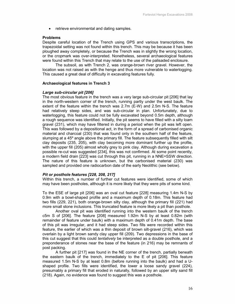
Radiocarbon dates These dates are ordered from the earliest to the latest for convenience. Henge ditch dates are highlighted in grey. Context Interpretation SUERC
number Material Uncal bp Calibrated
date range cal BC
230 Large waterlogged pit in trench 3
23236 Corylus 4945 ± 30 3780-3650 (94%)
334 Timber circle posthole
23237 Quercus 4065 ± 30 2700-2480 (84%)
333 Timber circle posthole
23246 Quercus 4005 ± 30 2580-2460 (95.4%)
362 Henge terminal lower fill (terminal)
23248 Alnus 3880 ± 30 2479-2280 (94%)
345 Burnt turf fill in henge ditch (sondage 1)
23244 Alnus 3810 ± 30 2350-2130 (93.9%)
311 Burnt turf fill in henge ditch (main section)
23238 Corylus 3790 ± 30 2310-2130 (94.1%)
370 Lower fill of ‘megalith’ pit
23243 Corylus 3725 ± 30 2210-2030 (95.4%)
363 Burnt deposit near base of henge ditch
23245 Corylus 3615 ± 30 2040-1890 (93.4%)
364 Lower fill of ‘megalith pit’
23242 Alnus 2355 ± 30 520-380 (95.4%)
Table 2 – Radiocarbon dates
Discussion
Post-excavation work will reveal much more about the dating of the features and activity outlined above, but some preliminary observations can be made at this stage.
Pre-henge features Mesolithic activity Limited evidence for Mesolithic activity in this area was found during the excavations of Trench 2, but it would be fair to say that this is only at the level of background activity. One or two possible microlith blades made of pitchstone were found in the upper fills of the henge terminal ditch (in or beneath the rubble layers), almost certainly secondary deposition. Little more can be said at this stage about the nature and intensity of a hunter-gatherer presence in this locality without a sustained campaign of fieldwalking in the locality. Arran pitchstone was commonly used throughout much of Scotland in the Mesolithic period. Waterlogged pit Although there is very little that can be said about the assorted features found within Trench 3, the earliest dated feature found during SERF was recovered from this location. The enigmatic large pit re-cut [206] was associated with carbonised material that dates to the early Neolithic (3780-3650 cal BC). This was a huge pit, over 2.5m across in plan, and at least half a metre deep. The function of this pit is unclear; the constant waterlogging suggested during excavation that this could have acted as

Forteviot Henge Excavations 2008
19
some kind of crude well, cut into clay rich natural deposits. Alternatively, it is possible that this feature was used for the sourcing of clay, perhaps for making pots or daub. The location within what subsequently became an enclosed space may be purely coincidental. Examples of pits preceding Neolithic ceremonial monuments are relatively common (cf. Balfarg, Fife (Barclay & Russell-White 1993)); there was a possible deposit of oak charcoal at Forteviot (230) but no material culture was recovered. The features in the vicinity of this pit shed no more light on this area of the palisaded enclosure or the pit, and we have no dates for any of them. Tentatively, this large pit suggests that there may have been a very long tradition of use of this location from the early centuries of the Neolithic. The surrounding pits and posthole(s) may or may not be part of the same traditions of activity. Stone-filled pits These enigmatic features have very tentatively been put into the pre-henge phase of activity, although this is based only on a possible stratigraphic relationship that was observed in henge ditch sondage 2. Here, it was suspected that the henge ditch cut the rubble fill of large pit [354], and this pit in turn seems to cut through stone spread feature / pit (305). However, it is clear that this field observation is based on a incomplete sondage through as area of the henge ditch that we do not fully understand, which in turn cuts, or is cut by, another feature we do not fully understand! Furthermore, radiocarbon dates suggest that the lower fills of the pit (ie beneath the rubble) post-date the henge construction, with one date in the early Bronze Age and another in the 1st millennium BC. Taken together, the contradictory dates and troublesome stratigraphy will not be resolved until a further season of excavations in 2009. The date and place in the sequence of these features is still unknown. The most notable element of these features is the large sandstone monolith discovered at the bottom of the even larger pit [348]. During the excavations, two main explanations for this were discussed: that it is a buried standing stone, or that it is the capstone to some kind of cist or burial chamber. The former explanation has little to support it, other than that this could have been a standing stone (although it does not look especially weathered more at one end than the other). It would not be impossible to conceive of such an act in prehistory, but with no precedent in Scotland. It also brought to mind standing stones that once formed part of the Beckhampton Avenue, Avebury, that were toppled and buried in huge pits in the Medieval period (Gillings et al 2008). Felling a standing stone would fit in with post-henge alterations of this monument (see below). Perhaps the more likely explanation is that this is part of a burial monument. The stone slab in fill (361) that extends under the stone is suggestive of a feature under the stone aligned SW-NE, and the rubble (of the same character as that found in the henge ditch) could well be cairn material. Whether this is a cist, or subterranean megalithic monument (such as Fordhouse, Angus (Peterson & Proudfoot 1997) will require further excavation to demonstrate.
The adjacent feature, stone spread / pit (305) in plan is a similar size to [348] and may well be a similar feature, something that will again repay further investigation. A complex series of silt spreads ran away from this stone spread under the western baulk of the trench, again an areas of the henge interior that will be looked at in more detail in another season. Key in 2009 is to carefully lift the megalith to see what lies beneath, to date this feature and to establish its relationship with the henge within which it sits.
Timber circle The cropmark evidence suggests that the timber circle (which surrounds the henge) had an overall diameter of c. 45m, and therefore sits at the larger end of the scale for such monuments (Millican 2007; Gibson 1998). The cropmarks do not reveal the complete circuit of this monument, which should be borne in mind. Two postholes
Forteviot Henge Excavations 2008
20
were excavated within Trench 2 in 2008, and although they were adjacent on the northern side of the circle, they were strikingly different (although we should be aware that this could well be a product of taphonomic processes). Posthole [322] was of a much more monumental character than [317] and the fills of the two features were different. [322] contained large packing stones, an obvious post-pipe and extensive charcoal deposits suggestive of post burning. [317] on the other hand contained a single homogenous fill and a cut of much smaller dimensions; here the post may have been removed. The larger posthole could have supported a large (presumably oak) post, 0.5m in diameter and up to 3m or 4m in height; the presence of a ramp simply reinforces that this hole held a big post. The radiocarbon dates associated with this feature place it within the last centuries of the Neolithic, perhaps constructed within a century or so of the huge palisaded enclosure it sits within. A notable element of the timber circle is that it sits around a henge, rather than within, which is by far the most common relationship. Typically, timber circles predate the henges that come to enclose them (Gibson 1992; Barclay 2005) and at Forteviot it seems probable that the external timber circle was the earlier of the two. This is suggested by the radiocarbon dates. If this was the case, we would expect the timber posts to have stood where the henge bank would have been constructed, either replacing the posts or subsuming them (as at the Blackshouse Burn enclosure, South Lanarkshire (Lelong and Pollard ref)). There are very few analogies for external timber circles at henge sites; in northern Britain the only real example is Milfield North, Northumbria; here a small henge was predated by a probable timber circle (Harding 1981). Interestingly, this relationship occurs again at Forteviot, with the cropmark of a’mini-henge’ just to the S of Trench 2 sitting within a pit circle. Further examination of the timber circle will take place in 2009.
The henge monument The major focus of this part of the Forteviot complex, perhaps for thousands of years, was a large circular earthwork enclosure, construction of which started around 2500BC. The henge has an internal diameter of about 22m, within a ditch that varies in width, but perhaps up to 11m, and at least 2.8m deep. The henge had one confirmed entrance gap, on the NNW side, giving the henge exactly the same orientation as the palisaded enclosure it was built within. We know from radiocarbon dates that the henge was constructed perhaps as many as 200 years after the palisaded enclosure (avenue) was built. It is unclear if the palisade would still have been visible at this time, but it seems likely based on the scale of posts that it would have been in one form or another. The henge enclosed an area already defined in previous generations by the timber circle, albeit in this case in a more definitive and long-term manner. The ditch could have provided material for a bank that could have stood 3m or higher, but anything much higher would be unstable due to the nature of the gravel soils used. Little evidence was found for an external bank, other than thin silt spreads on the N side of the ditch. However, even a conservative effort for the width of a bank suggests that the henge had an overall diameter in the region of 60m.
The henge ditch was investigated in four locations: a quadrant at the eastern terminal ditch, a section across the extent of the eastern side, and two sondages in the SE area of the henge (neither of which were bottomed or covered the full width of the ditch). The sequence at each is described above in some detail, and so only a summary of our initial interpretation of the henge ditch sequence is presented here. A simplified sequence is outlined in Table 3, below.

Forteviot Henge Excavations 2008
21
Phase Terminal Main section
Sondage 1
Sondage 2
Associations, dates
Rubble upper fill / silt loam matrix
324, 325 320 338 372? Glass droplet
Clean clay level
327? 319 339
Burnt soil / turf layer
328 311 345 346, 347 2350-2130 calBC 2310-2130 calBC
Clay silts with iron pan
337, 352 344, 367, 368
350? 373 Beaker pottery
Silts and gravels
342, 362, 365
370, 369, 371
Na na 2479-2280 calBC 2040-1890 calBC
Table 3: Simplified phasing of the henge ditch fills The henge ditch was dug towards the end of the Neolithic, perhaps around 2500BC. Initially, the ditch was left open and silt and gravel washed in; this natural process may have happened over a considerable period of time, and up to 1m of ditch fill accumulated in this way. At some point during this period, a burnt deposit (363) was thrown into the henge ditch, possibly a hearth deposit. Unfortunately, the radiocarbon date for this seems unreliable. Above these silt and gravel deposits, silty clay fills accumulated, with iron panning evident, suggesting natural filling continued, but standing water or waterlogging may have started to occur in the ditch. These deposits were associated with broken sherds of single beaker pot, which may have been thrown or placed in the ditch terminal. We can speculate, then, that for perhaps two centuries, the henge ditch was left open, gradually silting up, with occasional events of deposition. This pattern seems to have changed with a dramatic burning event in the last few centuries of the 3rd millennium BC, the early Bronze Age. A large quantity of burnt soil or turves appears to have been thrown into the henge ditch from the interior, giving an irregular layer of burnt material slumping into the interior half of the ditch. There may have been more than one burning event, with two distinct layers of this character recorded in the southern area of the henge ditch, with a silt deposit between. We have speculated that these deposits may relate to burning of the topsoil / turf within the henge on one or more than one occasion. This could have been related to a funeral pyre or some other large conflagration. This discrete deposit was subsequently sealed or covered by a clay rich layer, although its composition and extent varied across the henge. Finally, the henge ditch was filled with rubble, although when this happened is unknown. It is interesting to note that there seems to be little silting above the EBA burning activity. Either the rubble was added soon after, or the henge ditch was kept clean / stabilised / was re-cut at some point later. It is unclear which is the case here.
There is something like 80 known henge monuments in Scotland (Barclay 2005; Harding 2003) although the value of the term seems to be coming under increasing scrutiny. This is in no small part due to (a) the variation in size of monuments known as henges; and (b) dating evidence that increasingly suggests that henges in mainland Scotland north of the Clyde / Forth may be wholly or partially Bronze Age monuments (Bradley forthcoming). The dates associated with ditch fills, and the beaker sherds, all suggest that the Forteviot henge may well have spanned the crucial transitionary second half of the third millennium BC. This has recently

Forteviot Henge Excavations 2008
22
been defined as the third quarter of the third millennium BC, characterised by beakers but no bronze (Sheridan 2009). The significance of this is unclear at this stage, and this may simply be a matter of semantics. After all, those who built and used this place had different concerns. Cutting the henge ditch would have been a monumental undertaking in the Later Neolithic, cutting through deep gravel deposits with antler picks and other bone or stone tools. The ditch and putative bank would have augmented a natural rise in the field enclosing this subtle place in the landscape. The steeper internal side of the ditch simply reinforces this, and it seems likely that those within the henge would have been elevated above any external spectators (even if anyone could see into the henge). The stage-management of the experience of this monument may have been heightened by period waterlogging of the ditches. The presence of water in henge ditches has been noted elsewhere (eg Richards 1996) and would have added to the sense of the ditch as a physical and cosmological separation between the space of the henge and the outside world. It is also interesting to note that the orientation of the henge runs roughly parallel to the Water of May valley to the W. Unfortunately, too little survives of the henge interior to assess what was actually going on inside the henge during its use-life. But whatever was happening within and around this monument, it remained a powerful presence that had to be negotiated for potentially thousands of years.
Post-henge activity
Rubble fill and cobbled areas The range of fills within the henge ditch is in a sense nothing unusual, other than the upper fills, which are quite remarkable and without parallel. The range of stone found within the upper ditch fill of the henge, but also it seems in the large pit with the megalith (putative ‘cairn’ material, see above), is similar. Angular basalt fragments, some very large indeed, seem to have been quarried, probably (but not confirmed) as noted from the Dronachy Ridge quarry to the S. Rounded pebbles and boulders may have been gathered from river beds and gravels in the vicinity. Occasional sandstone slabs may have had a more distant source, perhaps the same as the buried sandstone megalith. This material has clearly been dumped, or thrown, into the henge ditch given its irregular and void-filled nature, perhaps in one event. This act seems to have involved a large amount of work (unless the stone material was already on-site, say as part of the prehistoric cairn) and it would be logical to suggest that the purpose of this act was to fill in, and level off, the henge ditch. By the time the rubble was added, the henge ditch was in the order of two-thirds full of silted material, and perhaps at times waterlogged or damp. In the same spirit, any surviving bank may have at that same time been levelled. When did this dramatic event occur? At this stage, that is impossible to tell. At present there is no definite dating to this backfilling although it must have happened after the early Bronze Age (based on dates of later henge ditch fills such as (311)). The two finds from this level, the blue glass droplet and metalworking slag, is suggestive of Iron Age or later activity, but due to plough truncation and disturbance this is not an entirely secure context. The issue of the relationship between the rubble and upper henge ditch fills has also been discussed above. What happened next is also a matter of speculation. The plough truncation of the upper levels of the rubble fill is disappointing as there may well have been better preserved use surfaces if indeed this layer represents a surface rather than the foundations for buildings and other structures. No definitive evidence for wall lines or structural components were identified, but this will repay further attention and investigation of the areas that extended out of the trench. Two hints do exist of some kind of formal use of the levelled henge. Firstly a tenacious ashy layer found only in one small spread, which seems likely to have been some kind of surface, perhaps of an outdoor yard. Secondly, a series of cobbles (surviving intermittently) overlying the

Forteviot Henge Excavations 2008
23
rubble fill, again suggesting some kind of level surface was being created in this reworking of the monument. At some point, perhaps thousands of years after the henge was initially constructed, the traces of the earthwork were eradicated, at great physical effort. This was done not merely to allow more efficient ploughing of this location (why add all the large stones?) but for the purpose of remaking the earthwork into something entirely different, somewhere with an ashy or cobbled surface. Was this done merely for convenience sake (for whatever reason) in this location, or was the henge chosen because of what it represented to those people? This seems to be at the very heart of what the SERF Project is about, and we will revisit these issues in 2009.
Large Medieval scoop feature The large scoop [316] in the interior of the henge is similarly intriguing. Although no datable material was retrieved, and the feature was not fully excavated to its full depth (due to safety concerns), the character of small finds from the upper fill (303) suggest that the back-filling of this monument took place late in the Medieval period (if not later). The artefacts – abraded sherds of Roman and Medieval pottery – suggests background material which was perhaps disturbed and found its way into the large pit during a single backfilling event. This of course does not date the digging of the pit, and the character of the lower fills (including a concentration of large stones (326)). The function of this pit is currently unknown. No evidence was retrieved during the 2008 season for a burial, or indeed anything buried, in this scoop, not does it seem likely that it was a scooped / sunken building (too deep and irregular). The possibility that this is some kind of quarry scoop has yet to be proven one way or the other. The presence of such a feature within the henge, which presumably would have been marked out at this stage as a ‘yard’ or stone-covered low mound, is probably not a coincidence. The range of ‘rubbish’ that may have been lying about when the pit was backfilled suggests that by this time the area may even have been in use for cultivation or was no longer marked out as a monument of any kind.
More extensive excavations of this enigmatic feature will be needed before much more can be said. There is no clear connection, for instance, between this feature and the alterations of the henge. Suffice it to say that at this stage this seems to be the latest evidence of human activity in this location as yet discovered.
Conclusion
What began at the start of our season as an apparently straightforward cropmark site quickly became an incredibly complex site, at times akin to digging an urban location rather than an arable cropmark site. Despite the ravages of the plough (clearly visible in the plough damage evident on many of the large stones in the upper henge ditch fill) this remarkable monument has survived better than one could have expected. Despite only limited interventions into the rubble and ditches, postholes and pits, we already have a sense of a place or locale that was in use (perhaps periodically) over a period of some 4000 years, with some evidence for human activity near by from a further millennium earlier. One of the key objectives of the SERF Project is to explore the enduring power of Forteviot – the area – and it seems that this henge may encapsulate many of these issues in microcosm. From late Neolithic ceremonial monument (timber circle and then henge) to potential re-use and re-working millennia later into something very different, we may find some of the answers to our project-wide questions at this location. Our excavations in 2009 will return to this monument to address some of the issues raised above in the discussion, from the huge buried megalith (what lies beneath, and where does it lie in the sequence) to the date and meaning of the range of post-henge traces uncovered.

Forteviot Henge Excavations 2008
24
References
• Barclay, GJ 2005 The ‘henge’ and the ‘hengiform’ in Scotland’, in V Cummings and A Pannett (eds) Set in stone, Oxbow Books, 81-94.
• Barclay, GJ & Russell-White C 1993 Excavations in the ceremonial complex of the fourth to second millennium BC at Balfarg and Balbirnie, Glenrothes, Fife, Proceedings of the Society of Antiquaries of Scotland 123, 43-110.
• Bradley, R forthcoming Henge monuments in Aberdeenshire and Caithness.
• Brophy, K & Noble, G 2008 Excavations at Forteviot palisaded enclosure, 2007. Interim Report and DSR.
• Gibson, A 1998 Stonehenge and timber circles, Tempus.
• Gibson, A (ed) 2002 Behind wooden walls: Neolithic palisaded enclosures in Europe. BAR, Oxford.
• Gillings, M, Pollard, J, Peterson, R & Wheatley, D 2008 Avebury, British Archaeology Nov / Dec 2008, 28-33.
• Harding, A 1981 Excavations in the prehistoric ritual complex near Milfield, Northumberland, Proceedings of the Prehistoric Society 47, 87-136.
• Harding, J 2003 Henge monuments of the British Isles, Tempus.
• Lelong, O & Pollard, T 1998 The excavation and survey of prehistoric enclosures at Blackshouse Burn, Lanarkshire. Proceedings of the Society of Antiquaries of Scotland 128, 12–53.
• Millican, K 2007 Turning in circles: a new assessment of the Neolithic timber circles of Scotland, Proceedings of the Society of Antiquaries of Scotland 137, 5-34.
• Peterson & Proudfoot 1997 Fordhouse barrow excavations 1994-1997, PAST 27.
• Richards, C 1996 Henges and water: towards an elemental understanding of monumentality and landscape in late Neolithic Britain, Journal of Material Culture 1, 313-36.
• Sheridan, A 2009 Towards a fuller, more nuanced narrative of Chalcolithic and EBA Britain, 2500-1500BC, Bronze Age Review 1.
• Speak, S & Burgess, C 1999 Meldon Bridge: a centre of the third millennium BC in Peebleshire. Proceedings of the Society of Antiquaries of Scotland 129, 1-118.
• St Joseph, J K S 1976 ‘Air reconnaissance: recent results, 40’, Antiquity 52 (1978), 48-50.