executive summary - tulare county general plan...
TRANSCRIPT

Tulare County General Plan 2030 Update ES-1 ESA / 207497 Final EIR September 2011
EXECUTIVE SUMMARY
Introduction
The California Environmental Quality Act (CEQA) requires that all state and local government agencies consider the environmental consequences of programs and projects over which they have discretionary authority before taking action on those projects or programs. Where there is substantial evidence that a project may have a significant effect on the environment, the agency shall prepare an environmental impact report (EIR) (CEQA Guidelines, Section 15164[a]). An EIR is an informational document that will inform public agency decision makers and the general public of the significant environmental effects of a project, identify possible ways to minimize the significant effects, and describe reasonable alternatives to the project.
CEQA requires that a draft EIR be prepared and circulated for public review. Following the close of the public review period, the lead agency prepares a final EIR, which includes the comments received during the review period (either verbatim or in summary), and responses to the significant environmental issues raised in those comments. Prior to taking action on a proposed project, the lead agency must certify the EIR and make certain findings.
This document and the Recirculated Draft Environmental Impact Report (RDEIR) that was circulated for public review on March 25, 2010 through May 27, 2010 (60-day public review period) is intended to constitute the Final Environmental Impact Report (FEIR) for Tulare County’s (County) General Plan 2030 Update (proposed project). However, certification of the FEIR rests with the Board of Supervisors; therefore additional materials may be added or modified by the County prior to the time of certification. (CEQA Guidelines §15090) The information presented in this FEIR is being provided in accordance with the requirements of the State California Environmental Quality Act (CEQA) Guidelines and includes the following chapters:
Chapter 1, “Introduction and Reader’s Guide,” discusses the purpose of this document, public review process, CEQA requirements, and use of this document.
Chapter 2, “Minor Revisions to the Recirculated Draft Environmental Impact Report,” contains minor changes and edits to the text of the RDEIR made in response to the comments. These changes correct minor errors and provide clarifications and amplifications to the information previously provided; the changes do not constitute significant new information or result in any new significant impacts.
Chapter 3, “Comments on the Recirculated Draft EIR,” includes a copy of each of the comment letters received during the review period from March 25, 2010 to May 27, 2010. The individual comment letter numbers correspond to those responses provided in Chapter 5.

Tulare County General Plan 2030 Update
Tulare County General Plan 2030 Update ES-2 ESA / 207497 Final EIR September 2011
Chapter 4, “Master Responses,” is comprised of general responses that address similar comments received regarding certain specified subject areas.
Chapter 5, “Responses to Comments on the Recirculated Draft EIR,” contains the written responses to the individual comments received during the public review period for the RDEIR along with written responses to those comments.
It should be noted that throughout the FEIR, the terms “General Plan 2030 Update,” “General Plan Update,” and “proposed project” are used interchangeably to describe the General Plan 2030 Update, an amendment to the Tulare County General Plan that will be considered by County decision makers.
Project Overview
Project Setting and County Boundaries Tulare County is located in a geographically diverse region with the peaks of the Sierra Nevada framing its eastern region, a foothill region west of the mountains, transitioning to the western portion of the County which includes the San Joaquin Valley floor, which is very fertile and extensively cultivated. The County is connected regionally via State Route 99 (SR 99), which is the primary north-south highway in the County. State highways 63 (north/south), 65 (north/south), 190 (east/west), and 198 (east/west) serve to connect the various cities, communities and regions within the County.
Tulare County consistently ranks amongst the top two leading agricultural-producing counties in the U.S., sharing this recognition with its larger neighbor to the north, Fresno County. In addition to agricultural production, the County’s economic base also includes agricultural packing and shipping operations. Small and medium sized manufacturing plants are located in the Valley part of the county and are increasing in number.
The County of Tulare is bordered by Fresno County to the north and Kern County to the south. Kings County is located on the west side of Tulare County while Inyo County borders the County to the east (see Figure ES-1). The crest of the Sierra Nevada mountain range forms the boundary with Inyo County. The northern border of Tulare County is an irregular line that passes just south of the Cities of Kingsburg and Reedley and State Highway 180. The southern border is a consistent east-west trending line, comprising the south standard parallel south of Mount Diablo, located north of the City of Delano in Kern County. The western border generally trends north-south in a straight-line north and south just east of the Cities of Corcoran and Hanford in Kings County.
Description of the Proposed Project Tulare County General Plan 2030 Update is the product of an update process that would add a variety of important new goals and policies to existing components of the County’s General Plan. In addition, some obsolete policies of the General Plan will be deleted by this update process. In many cases, those obsolete policies will be replaced by new provisions. Further, a Work Plan, consisting of implementation measures, is proposed.

395
101
5
99
1
M A D E R A
F R E S N O
K E R N S A N B E R N A R D I N O
V E N T U R A L O S A N G E L E SS A N T A B A R B A R A
I N Y OS A N
B E N I T O
M O N T E R E Y
S A N L U I S O B I S P O
S T A N I S L A U S
M E R C E D
C A L A V E R A S
T U O L U M N E
M O N O
M A R I P O S A
T U L A R E
K I N G S
0 30
Miles
TULARECOUNTY
Figure ES-1Regional Locator
SOURCE: DeLorme Street Atlas USA, 2001; and ESA, 2009Tulare County General Plan Update . 207497
Tulare County General Plan 2030 Update
Tulare County General Plan 2030 Update ES-4 ESA / 207497 Final EIR September 2011
The General Plan 2030 Update consists of a comprehensive update of Tulare County’s existing General Plan. The historic three tier structure will remain, formalized as three “Parts.” The key General Plan Update policy document includes Part I: the Goals and Policies Report and Part II: Area Plans. Part III consists of individual, existing Community, sub-area and other localized plans. The current adopted plans in Part III will not be changed as part of this update, except for that the Planning Framework (Part 1, Chapter 2) of the General Plan Update modifies the Urban Development Boundaries Dinuba (revised by this update to include the Dinuba Golf Course) and Pixley (revised by this update to include Harmon Field). Another key document is the 2010 Background Report (included as Appendix B of the RDEIR).
Part I: Goals and Policies Report
Part I (the Goals and Policies Report) of the General Plan 2030 Update document would compile, modernize, and add goals and policies that to guide future land use decisions within the County unincorporated areas. The accompanying Work Plan identifies implementation measures that will ensure the goals and policies of the General Plan Update are carried out. This section identifies how this document is organized and provides a summary of its content.
The Goals and Policies Report (Part I of the General Plan Update) sets out a hierarchy of goals, policies, and implementation measures designed to guide future development in the County. To provide a comprehensive and easy-to-use format, the Goals and Policies Report is divided into four components. Each component contains a set of related elements that have been grouped together based on the close relationship of those elements. A summary of the four components is provided below.
Each component will start with an overview of the elements contained in that component and present the guiding principles used in the preparation of these elements. The individual elements will build on these guiding principles, with each element containing a set of goals and policies that will be used to guide the future land use of the County. At the end of each element or chapter is a proposed work plan (list of implementation measures) showing how the goals and policies will be implemented. All four components and the various elements that comprise each component are summarized in Table ES-1.
Part II: Area Plans
Part II includes three “Area Plans,” one for each of the three major geographic areas of the County. They are:
Rural Valley Lands Plan
Foothill Growth Management Plan
Mountain Framework Plan
Part II also includes a new Corridor Framework Plan, which would establish policies that would guide the potential location and adoption of Corridor Plans within the County. Any such adopted Corridor Plan would be included in Part III. Part II of the General Plan provides the policy guidance required to address matters specific to defined geographic areas and corridors in the County.

Executive Summary
Tulare County General Plan 2030 Update ES-5 ESA / 207497 Final EIR September 2011
TABLE ES-1 COMPONENTS OF THE GOALS AND POLICIES REPORT, PART I
Component Chapter and Element
Chapter 1 Introduction
Component A. General Plan Framework
This component introduces the Goals and Policies Report, provides a profile of Tulare County and establishes a Planning Framework Element for the County. Contents include:
Chapter 2 Planning Framework Element
Component B. Prosperity
This component includes the elements that shape the County’s land use and economic futures. Contents include:
Chapter 3 Agriculture Element Chapter 4 Land Use Element Chapter 5 Economic Development Element Chapter 6 Housing Element [not amended or changed by this project]
Component C. Environment
This component covers topics related to natural and cultural resources and public health and safety. Contents include:
Chapter 7 Scenic Landscapes Element Chapter 8 Environmental Resources Management Element Chapter 9 Air Quality Element Chapter 10 Health and Safety Element Chapter 11 Water Resources Element Chapter 12 Animal Confinement Facilities Plan [adopted 2000; not
amended or changed by this project]
Component D. Infrastructure
This component covers the infrastructure systems necessary to ensure adequate services and capacity of desired growth. Contents include:
Chapter 13 Transportation and Circulation Chapter 14 Public Facilities and Services Chapter 15 Flood Control Master Plan [adopted 1972; not amended or
changed by this project]
Part III: Community, Sub-area and County Adopted City General Plans
Part III of the General Plan 2030 Update consists of a number of existing planning documents: Sub-Area Plans, County Adopted City General Plans, and Community Plans. Each of these plans, described in Table 1-5, applies tailored policies to specified portions of the County. These existing plans would not be revised or readopted as part of the General Plan Update with two exceptions: the Planning Framework (Part I, Chapter 2) of the General Plan Update will modify the Urban Development Boundary for the Pixley Community Plan would be modified to include the Harmon Field Airport and the Urban Development Boundary of the Dinuba County Adopted City General Plan would be modified to reflect the recently annexed Dinuba Golf Course, residential and wastewater treatment area.
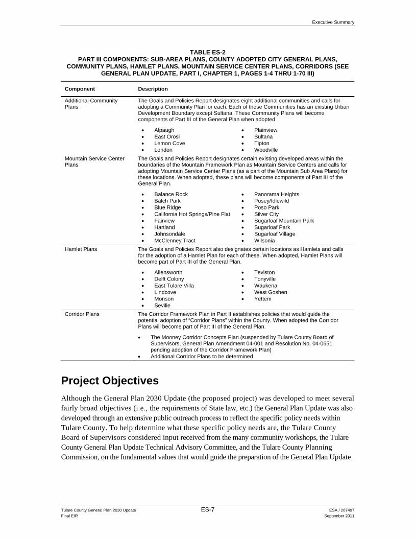
Furthermore, the General Plan 2030 Update anticipates the future adoptions of additional Sub-Area Plans, County Adopted City General Plans, and Community Plans, as well as Mountain Service Center Plans, Hamlet Plans, and Corridor Plans. These anticipated plans are discussed below. Each, when adopted, will be included in Part III. Thus, Part III includes the following plans, shown in Table ES-2.

Tulare County General Plan 2030 Update
Tulare County General Plan 2030 Update ES-6 ESA / 207497 Final EIR September 2011
TABLE ES-2 PART III COMPONENTS: SUB-AREA PLANS, COUNTY ADOPTED CITY GENERAL PLANS,
COMMUNITY PLANS, HAMLET PLANS, MOUNTAIN SERVICE CENTER PLANS, CORRIDORS (SEE GENERAL PLAN UPDATE, PART I, CHAPTER 1, PAGES 1-4 THRU 1-70 III)
Component Description
Existing Sub-area Plans Great Western Divide North Half Plan (a Sub-Area plan located within the boundaries of the Mountain Framework Plan) (adopted 1990; amended 1994
Juvenile Detention Facility-Sequoia Field Land Use and Public Buildings Elements (adopted 1995)
Kennedy Meadows Plan (a Sub-Area plan located within the boundaries of the Mountain Framework Plan) (adopted 1986; amended 1995)
Kings River Plan (a Sub-Area plan located within the boundaries of the Rural Valley Lands Plan) (adopted 1975)
Sequoia Field Land Use and Public Buildings Element (adopted 1981)
Mountain Framework Plan Sub-areas (Sub-area Plans not yet adopted)
Great Western Divide South Half Plan Posey Plan Redwood Mountain Plan South Sierra Plan Upper Balch Park Plan
County Adopted City General Plans
Eight existing County Adopted City General Plans, including two neighborhood plans, that cover the areas between the city limit lines of the eight incorporated cities in Tulare County and the County-adopted Urban Area Boundaries and Urban Development Boundaries for those cities (note that Tulare County does not have the authority to regulate land use within the city limits of those cities):
Dinuba (adopted 1964) Exeter (adopted 1976) Farmersville (adopted 1976) Lindsay (adopted 1981) Porterville (adopted 1990)
o East Porterville Neighborhood Plan (adopted 1990) Tulare (adopted 1980) Visalia (adopted 1992)
o Patterson Tract Neighborhood Plan (adopted 1992) Woodlake (adopted 1986)
Additional County Adopted City General Plans
The Goals and Policies Report calls for adopting two additional County Adopted City General Plans. Both of these areas have established Urban Development Boundaries and the Plans will become components of Part III when adopted:
Delano Kingsburg
Existing Community Plans Cutler/Orosi Community Plan (adopted 1988) Earlimart Community Plan (adopted 1988) Goshen Community Plan (adopted 1978) Ivanhoe Community Plan (adopted 1990) Pixley Community Plan (adopted 1997) Poplar/Cotton Center Community Plan (adopted 1996) Richgrove Community Plan (adopted 1987) Springville Community Plan (adopted 1985) Strathmore Community Plan (adopted 1989) Terra Bella/Ducor Community Plan (adopted 2004) Three Rivers Community Plan (adopted 1980) Traver Community Plan (adopted 1989)
Executive Summary
Tulare County General Plan 2030 Update ES-7 ESA / 207497 Final EIR September 2011
TABLE ES-2 PART III COMPONENTS: SUB-AREA PLANS, COUNTY ADOPTED CITY GENERAL PLANS,
COMMUNITY PLANS, HAMLET PLANS, MOUNTAIN SERVICE CENTER PLANS, CORRIDORS (SEE GENERAL PLAN UPDATE, PART I, CHAPTER 1, PAGES 1-4 THRU 1-70 III)
Component Description
Additional Community Plans
The Goals and Policies Report designates eight additional communities and calls for adopting a Community Plan for each. Each of these Communities has an existing Urban Development Boundary except Sultana. These Community Plans will become components of Part III of the General Plan when adopted
Alpaugh East Orosi Lemon Cove London
Plainview Sultana Tipton Woodville
Mountain Service Center Plans
The Goals and Policies Report designates certain existing developed areas within the boundaries of the Mountain Framework Plan as Mountain Service Centers and calls for adopting Mountain Service Center Plans (as a part of the Mountain Sub Area Plans) for these locations. When adopted, these plans will become components of Part III of the General Plan.
Balance Rock Balch Park Blue Ridge California Hot Springs/Pine Flat Fairview Hartland Johnsondale McClenney Tract
Panorama Heights Posey/Idlewild Poso Park Silver City Sugarloaf Mountain Park Sugarloaf Park Sugarloaf Village Wilsonia
Hamlet Plans The Goals and Policies Report also designates certain locations as Hamlets and calls for the adoption of a Hamlet Plan for each of these. When adopted, Hamlet Plans will become part of Part III of the General Plan.
Allensworth Delft Colony East Tulare Villa Lindcove Monson Seville
Teviston Tonyville Waukena West Goshen Yettem
Corridor Plans The Corridor Framework Plan in Part II establishes policies that would guide the potential adoption of “Corridor Plans” within the County. When adopted the Corridor Plans will become part of Part III of the General Plan.
The Mooney Corridor Concepts Plan (suspended by Tulare County Board of Supervisors, General Plan Amendment 04-001 and Resolution No. 04-0651 pending adoption of the Corridor Framework Plan)
Additional Corridor Plans to be determined
Project Objectives
Although the General Plan 2030 Update (the proposed project) was developed to meet several fairly broad objectives (i.e., the requirements of State law, etc.) the General Plan Update was also developed through an extensive public outreach process to reflect the specific policy needs within Tulare County. To help determine what these specific policy needs are, the Tulare County Board of Supervisors considered input received from the many community workshops, the Tulare County General Plan Update Technical Advisory Committee, and the Tulare County Planning Commission, on the fundamental values that would guide the preparation of the General Plan Update.

Tulare County General Plan 2030 Update
Tulare County General Plan 2030 Update ES-8 ESA / 207497 Final EIR September 2011
Overall, the objectives of the proposed project are to amend and update the policies of the General Plan to achieve the following:
Provide opportunities for small unincorporated communities to grow or improve quality of life and their economic viability and to provide the framework for planning new self sustaining communities;
Promote reinvestment in existing unincorporated communities in a way that enhances the quality of life and their economic viability in these locations;
Protect the County’s important agricultural resources and scenic natural lands from urban encroachment through the implementation of goals and policies of the General Plan;
Strictly limit rural residential development in important agricultural areas outside of unincorporated communities’ Urban Development Boundaries (UDBs) and cities’ County Adopted City Urban Area Boundaries (CACUABs) and County Adopted City Urban Development Boundaries (CACUDBs) (i.e., avoid rural residential sprawl);
Allow existing and outdated agricultural facilities in rural areas to be retrofitted and used for new agricultural related businesses (including value added processing facilities and uses) subject to specified criteria; and
Enhance planning coordination and cooperation with the agencies and organizations with land management responsibilities in and adjacent to Tulare County.
Build out and Population Growth Assumptions under the Proposed Project
The review of the proposed project includes an analysis of development which could occur if currently vacant land were developed according to the urban growth areas identified in the land use map (shown in Figure ES-2 and ES-3), land use designation descriptions for each planning area of the County, and the policy direction outlined in the Planning Framework Element (see Part I, Chapter 2) of the Goals and Policies Report. For purposes of this EIR analysis and for consistency with existing Tulare County Association of Governments (TCAG) and State Department of Finance projections, it is assumed that this build out would occur by 2030. However, it is possible that maximum growth or “theoretical build out” identified under the proposed project may not occur by the horizon year of 2030. To help clarify the role of the two agencies referenced for the population data used in the RDEIR, demographers from the California Department of Finance develop and provide annual estimates of current population and housing statistics for both cities and counties within California along with population projections for a variety of target years. The regional transportation and planning agency for the County, TCAG, considers these statistics for its own planning efforts. The California Department of Finance is considered a reputable source of information that is used by planning agencies and jurisdictions throughout the State of California.
Although it is not possible to give a precise breakdown between the various uses which may occur, residential uses would be expected to be part of most mixed use development. In many cases, theoretical build out may be less than the maximum allowed densities and intensities due to a number of factors, including:

0 10
Miles
Tulare County General Plan Update . 207497
Figure ES-2Land Use Diagram
SOURCE: County of Tulare, 2008; and ESA, 2009

Legend
Rural Valley Lands Plan
Regional Planning Framework,Land Use Designations& Boundaries
Various Adopted Plans
Urban Development Boundaries
Hamlet Development Boundaries
Urban Area oundaries
Urban Boundaries
Power Transmission Lines
Railroads
Airports
County Boundary
Valley Agricultural
600' Elevation
Government Lands
0 52.5Miles
0 52.5 Kilometers
B
Proposed State Highway 65 Alignment
Scale
Tulare County General Plan Update . 207497
Figure ES-3Rural Valley Lands Plan Portion of the Land Use Diagram
SOURCE: County of Tulare, 2008; and ESA, 2009

Executive Summary
Tulare County General Plan 2030 Update ES-11 ESA / 207497 Final EIR September 2011
A property owner may seek less development than is allowed under the General Plan Update;
Environmental constraints may result in lower intensity of development than allowed on some parcels;
Policies or regulations (e.g., height limits, setbacks, infrastructure constraints etc.) may lower the amount of development allowed on a particular parcel, and/or
Infrastructure constrains such as water or sewer may limit the amount of development.
An example of a community with constraints is Springville. Springville is currently under a wastewater moratorium by the California Regional Water Quality Control Board. Further constraints within the community are the slope percentage, grading, existing urban development, floodway, biological, cultural and many other issues. These constraints limit the density of urban development within the community. The analysis in the RDEIR also takes into consideration historic development patterns to project the type of development that would occur in areas with the new, mixed use designation. Existing zoning, roads, existing development, slope percentage, water and sewer capacity, and many other constraints would remain in place and would greatly reduce the maximum build-out potential. It is highly unlikely that most of the vacant land in these areas will develop to a maximum of 30 units an acre.
The review of the proposed project is based on a projected year 2030 population of 742, 970. This population estimate is based on projections provided by TCAG (TCAG, page 1, 2008) and the State Department of Finance (California Department of Finance, pages 18-19, 2007). Using these population projections as a base, the County considered several population growth scenarios that addressed the County’s incorporated and unincorporated areas ability and capacity to grow and accommodate future population. These population growth scenarios were addressed during the General Plan Alternatives Phase and are described in greater detail in the Policy Alternatives Newsletter (August 2005) located on the County’s website (http://generalplan.co.tulare.ca.us/documents.html) In reviewing these population growth scenarios and TCAG traffic modeling projections, it was determined (with County Board of Supervisor direction) that the unincorporated portions of the County could accommodate approximately 25% of future new growth. Table ES-3 identifies this expected population growth for both the incorporated and unincorporated areas of the County that would occur under the proposed project. Consequently, 75% (235,480) of the new population growth is expected, under the General Plan Update, to occur within the cities as they expand into the CACUDBs and their Spheres of Influence. The remaining new population growth, 25% (78,490) is expected to occur mainly within unincorporated communities and hamlets and foothill development corridors, urban and regional growth corridors, and mountain service centers. These future growth assumptions are consistent with several of the General Plan 2030 Update objectives specific to growth issues and the policy guidance provided in the Planning Framework Element.
Major infrastructure investments by the public and private sectors are a necessary precursor to accommodate anticipated growth within the County. As a result of the availability of public services and guided by policies included in the General Plan Update, a majority of future development is expected to occur within established Urban Development Boundaries (UDBs), Urban Area Boundaries (UABs), Hamlet Development Boundaries (HDBs), and other identified growth areas. Each of these areas are discussed above and identified in the General Plan Update Land Use Diagram.

Tulare County General Plan 2030 Update
Tulare County General Plan 2030 Update ES-12 ESA / 207497 Final EIR September 2011
TABLE ES-3POPULATION GROWTH AND DISTRIBUTION
City/County
2007 Population Estimate
2007 Population Distribution
Percent of Net New Growth
2007-2030 Net New Growth
2030 Population Estimate
2030 Population Distribution
County Adopted Cities (UDB) 284,910 66% 75.0% 235,480 520,390 70%
Unincorporated County 144,090 34% 25.0% 78,490 222,580 30%
Total 429,000 100.0% 100.0% 313,970 742,970 100.0%
SOURCE: California Department of Finance, pages 18-19, 2007; Tulare County Association of Governments, page 1, 2008.
Guidance for focusing this population growth will be provided by the various policies and implementation measures outlined in the General Plan Update, in particular those found in the Planning Framework and Land Use Elements. Several of these key policies from the Planning Framework Element are identified below:
Planning Framework Element
Section 2.1 General
PF-1.1 Maintain Urban Edges: The County shall strive to maintain distinct urban edges for all unincorporated communities within the valley region or foothill region, while creating a transition between urban uses and agriculture and open space [New Policy] [1964 General Plan; Major Issue 1-Retention of community identity, preservation of the agricultural economic base and control of urban sprawl; Policy 1] [1964 General Plan; Pg. I-6; 1964].
PF-1.2 Location of Urban Development: The County shall ensure that urban development only takes place in the following areas:
1. Within incorporated cities and CACUDBs;
2. Within the UDBs of adjacent cities in other counties, unincorporated communities, planned community areas, and HDBs of hamlets;
3. Within foothill development corridors as determined by procedures set forth in Foothill Growth Management Plan;
4. Within areas set aside for urban use in the Mountain Framework Plan and the mountain sub-area plans; and
5. Within other areas suited for non-agricultural development, as determined by the procedures set forth in the Rural Valley Lands Plan [Urban Boundaries Element, as amended].
PF-1.3 Land Uses in UDBs/HDBs: The County shall encourage those types of urban land uses that benefit from urban services to develop within UDBs and HDBs. Permanent uses which do not benefit from urban services shall be discouraged within these areas. This shall not apply to agricultural or agricultural support uses, including the cultivation of land or other uses accessory to the cultivation of land provided that such accessory uses are time-limited through Special Use Permit procedures [New Policy].
Executive Summary
Tulare County General Plan 2030 Update ES-13 ESA / 207497 Final EIR September 2011
PF-1.4 Available Infrastructure: The County shall encourage urban development to locate in existing UDBs and HDBs where infrastructure is available or may be established in conjunction with development. The County shall ensure that development does not occur unless adequate infrastructure is available, that sufficient water supplies are available or can be made available and that there are adequate provisions for long term management and maintenance of infrastructure and identified water supplies [New Policy].
PF-1.6 Appropriate Land Uses by Location: The County shall utilize the Land Use Element and adopted County Adopted City General Plans, Community Plans, Hamlet Plans, Planned Communities, Corridor Areas, or Area Plans to designate land uses and intensities that reflect and maintain the appropriate level of urbanized development in each County Adopted City General Plan, Community Plan, Hamlet Plan, Planned Community, Corridor Area, or Area Plan [New Policy].
PF-1.10 Non-Conforming Uses – General: Any previously and legally established use, building, or parcel that may not be expressly permitted by this plan in any given land use designation or the implementing zoning shall be allowed to continue in accordance with the Tulare County Zoning Ordinance and General Plan [New Policy].
Section 2.2 Communities
PF-2.6 Land Use Consistency: The County shall require all community plans to use the same land use designations as used in this Countywide General Plan (See Chapter 4, Land Use). All community plans shall also utilize a similar format and content. The content may change due to the new requirements such as Global Climate Change and Livable Community Concepts, as described on the table provided (Table 2.2-2: Community Plan Content). Changes to this format may be considered for unique and special circumstances as determined appropriate by the County. Until such time as a Community Plan is adopted for those communities without existing Community Plans, the land use designation shall be mixed use, which promotes the integration of a compatible mix of residential types and densities, commercial uses, public facilities, and services and employment opportunities [Urban Boundaries Element; Chapter IV; C. Current and Advanced Planning; Implementation Program C-1] [Urban Boundaries Element; Chapter IV; Pg; 19; 1988, Modified].
Program EIR and Final EIR Process
This FEIR is prepared as a program EIR pursuant to CEQA Guidelines Section 15168. A program EIR assesses the broad environmental impacts of a program (a series of related projects) with the understanding that a more detailed site-specific review may be required to assess future projects implemented under the program. Please refer to Chapters 1 and 2 of the RDEIR for additional discussion of the program EIR and subsequent environmental review.
The RDEIR for the General Plan 2030 Update was submitted to the State Clearinghouse (SCH# 2006041162) and released for public and agency review on March 25, 2010. This 60-day public review and comment period concluded on May 27, 2010. During the review period, forty-four

Tulare County General Plan 2030 Update
Tulare County General Plan 2030 Update ES-14 ESA / 207497 Final EIR September 2011
(44) letters were received. These letters with comments pertaining to the RDEIR are included in Volume II of this FEIR, with a summary provided in Chapter 3 of this FEIR.
This document includes comments and responses to comments on the RDEIR and, along with the RDEIR, comprises the FEIR for the proposed project. The County Board of Supervisor’s will certify the FEIR at a public hearing.
Consistent with CEQA Guidelines (§15132) this FEIR consists of:
a) The RDEIR.
b) Comments and recommendations received on the RDEIR
c) A list of persons, organizations, and public agencies commenting on the RDEIR.
d) The responses of the lead agency to significant environmental points raised in the review and consultation process.
e) Any other information added by the lead agency prior to certification of the FEIR.
Items (c) through (d) are included in this document (see chapters 3-5 of this FEIR). Item (a) and Item (b) are each bound separately. Revisions to the RDEIR including minor edits and corrections, revisions made as result of comments received and clarifications and modifications are presented in Chapter 2 of this FEIR. Consequently, this FEIR document and the RDEIR together shall comprise the FEIR.
Summary of Environmental Impacts
All of the impacts analyzed in the draft and FEIR, including those considered to be less-than-significant, are summarized in Table ES-4 and Table ES-5. The impact statements provided in the table incorporate the revised impact conclusions from the RDEIR. All proposed revisions to these policies and implementation measures are also indicated below in Tables ES-4 and ES-5. New text is indicated by underline and deletions are shown in strikethrough.
TABLE ES-4REQUIRED ADDITIONAL MITIGATING POLICIES AND IMPLEMENTATION MEASURES
3.1 Land Use and Aesthetics
PFS-1.7 Coordination with Service Providers. The County shall work with special districts, community service districts, public utility districts, mutual water companies, private water purveyors, sanitary districts, and sewer maintenance districts to provide adequate public facilities and to plan/coordinate, as appropriate, future utility corridors in an effort to minimize future land use conflicts. [New Policy – Modified Draft EIR Analysis]
LU-7.12 Historic Buildings and Areas. The County shall seek to encourage preservation of buildings and areas with special and recognized historic, architectural, or aesthetic value. New development should respect architecturally and historically significant buildings and areas. Landscaping, original roadways, sidewalks, and other public realm features of historic buildings or neighborhoods shall be restored or repaired where ever feasible. [New Policy – Modified Draft EIR Analysis]
LU-7.18 Lighting. The County shall continue to improve and maintain lighting in park and recreation facilities to prevent nuisance light and glare spillage on adjoining residential areas. [New Policy – Draft EIR Analysis].
LU-7.19 Minimize Lighting Impacts. The County shall ensure that lighting in residential areas and along County roadways shall be designed to prevent artificial lighting from reflecting into adjacent natural or open space areas. [New Policy – Draft EIR Analysis].

Executive Summary
Tulare County General Plan 2030 Update ES-15 ESA / 207497 Final EIR September 2011
TABLE ES-4REQUIRED ADDITIONAL MITIGATING POLICIES AND IMPLEMENTATION MEASURES
3.2 Traffic and Circulation
TC-2.7 Rail Facilities and Existing Development. The County will work with the California Public Utilities Commission (CPUC) to ensure that new railroad rights-of-way, yards, or stations adjacent to existing residential or commercial areas are screened or buffered to reduce noise, air, and visual impacts. Similarly, the County should coordinate with the CPUC and railroad service providers to address railroad safety issues as part of all future new development that affects local rail lines. Specific measures to be considered and incorporated into the design of future projects affecting rail lines include, but are not limited to, the installation of grade separations, warning signage, traffic signaling improvements, vehicle parking prohibitions, installation of pedestrian-specific warning devices, and the construction of pull out lanes for buses and vehicles. [New Policy – Draft EIR Analysis and Final EIR].
3.4 Energy and Global Climate Change
ERM-4.7 Reduce Energy Use in County Facilities. Continue to integrate energy efficiency and conservation into all County functions.
ERM-4.8 Energy Efficiency Standards. The County shall encourage renovations and new development to incorporate energy efficiency and conservation measures that exceed State Title 24 standards. When feasible, the County shall offer incentives for use of energy reduction measures such as expedited permit processing, reduced fees, and technical assistance.
AQ-1.7 Support Statewide Climate Change Solutions. The County shall monitor and support the efforts of Cal/EPA, CARB and the SJVAPCD, under AB 32 (Health and Safety Code §38501 et seq.), to develop a recommended list of emission reduction strategies. As appropriate, the County will evaluate each new project under the updated General Plan to determine its consistency with the emission reduction strategies. [New Policy]
AQ-1.8 Greenhouse Gas Emissions Reduction Plan/Climate Action Plan. The County will develop a Greenhouse Gas Emissions Reduction Plan (Plan) that identifies greenhouse gas emissions within the County as well as ways to reduce those emissions. The Plan will incorporate the requirements adopted by the California Air Resources Board specific to this issue. In addition, the County will work with the Tulare County Association of Governments and other applicable agencies to include the following key items in the regional planning efforts.
o Inventory all known, or reasonably discoverable, sources of greenhouse gases in the County,
o Inventory the greenhouse gas emissions in the most current year available, and those projected for year 2020, and
Set a target for the reduction of emissions attributable to the County’s discretionary land use decisions and its own internal government operations. [New Policy – Draft EIR Analysis]
AQ-1.9 Support Off-Site Measures to Reduce Greenhouse Gas Emissions. The County will support and encourage the use of off-site measures or the purchase of carbon offsets to reduce greenhouse gas emissions. [New Policy – Draft EIR Analysis]
AQ Implementation Measure #16. The County shall develop and maintain a climate action plan. The climate action plan shall include the following elements: an emissions inventory, emission reduction targets, applicable greenhouse gas control measures, and monitoring and reporting plan. [New Implementation Measure – Draft EIR Analysis]
AQ Implementation Measure #17. The County may inspect County facilities to evaluate energy use, the effectiveness of water conservation measures, production of GHGs, use of recycled and renewable products and indoor air quality to develop recommendations for performance improvement or mitigation. The County shall update the audit periodically and review progress towards implementation of its recommendations. [New Implementation Measure – Draft EIR Analysis]
3.5 Noise
HS-8.13 Noise Analysis. The County shall require a detailed noise impact analysis in areas where current or future exterior noise levels from transportation or stationary sources have the potential to exceed the adopted noise policies of the Noise Element, where there is development of new noise sensitive land uses or the development of potential noise generating land uses near existing sensitive land uses. The noise analysis shall be the responsibility of the project applicant and be prepared by a qualified acoustical engineer (i.e., a Registered Professional Engineer in the State of California, etc.). The analysis shall include recommendations and evidence to establish mitigation that will reduce noise exposure to acceptable levels (such as those referenced in Table 10-1 of the Health and Safety Element). [New Policy – Draft EIR Analysis].
HS-8.14 Sound Attenuation Features. The County shall require sound attenuation features such as walls, berming, heavy landscaping, between commercial, industrial, and residential uses to reduce noise and vibration impacts. [New Policy – Draft EIR Analysis].
HS-8.15 Noise Buffering. The County shall require noise buffering or insulation in new development along major streets, highways, and railroad tracks. [New Policy - Draft EIR Analysis].
HS-8.16 State Noise Insulation Standards. The County shall enforce the State Noise Insulation Standards (California Administrative Code, Title 24) and Chapter 35 of the Uniform Building Code. [New Policy - Draft EIR Analysis].
HS-8.17 Coordinate with Caltrans. The County shall work with Caltrans to mitigate noise impacts on sensitive receptors near State roadways, by requiring noise buffering or insulation in new construction. [New Policy - Draft EIR Analysis].
HS-8.18 Construction Noise. The County shall seek to limit the potential noise impacts of construction activities by

Tulare County General Plan 2030 Update
Tulare County General Plan 2030 Update ES-16 ESA / 207497 Final EIR September 2011
TABLE ES-4REQUIRED ADDITIONAL MITIGATING POLICIES AND IMPLEMENTATION MEASURES
limiting construction activities to the hours of 7 am to 7 pm, Monday through Saturday when construction activities are located near sensitive receptors. No construction shall occur on Sundays or national holidays without a permit from the County to minimize noise impacts associated with development near sensitive receptors. [New Policy - Draft EIR Analysis].
3.7 Geology, Soils, Seismicity, and Mineral Resources
HS-2.8 Alquist-Priolo Act Compliance. The County shall not permit any structure for human occupancy to be placed within designated Earthquake Fault Zones (pursuant to and as determined by the Alquist-Priolo Earthquake Fault Zoning Act; Public Resources Code, Chapter 7.5) unless the specific provisions of the Act and Title 14 of the California Code of Regulations have been satisfied. [New Policy – Draft EIR Analysis]
3.8 Hazardous Materials and Public Safety
HS-4.8 Hazardous Materials Studies. The County shall ensure that the proponents of new development projects address hazardous materials concerns through the preparation of Phase I or Phase II hazardous materials studies for each identified site as part of the design phase for each project. Recommendations required to satisfy federal or State cleanup standards outlined in the studies will be implemented as part of the construction phase for each project. [New Policy – Draft EIR Analysis].
3.9 Public Services, Recreation Resources and Utilities
PFS Implementation Measure #3. The County shall develop and adopt an impact fee program for new development to provide financing mechanisms to ensure the provision, operation, and on-going maintenance of appropriate public facilities and services (including, but not limited to, fire stations and equipment, police stations and equipment, ambulance or dispatch service, utility infrastructure, recreational, and library facilities). [New Implementation Program – Draft EIR Analysis]
PFS-8.6 School Funding. To the extent allowed by State law, the County may require new projects to mitigate impacts on school facilities, in addition to the use of school fees. The County will also work with school districts, developers, and the public to evaluate alternatives to funding/providing adequate school facilities. [New Policy – Draft EIR Analysis].
3.10 Agricultural Resources
AG-1.6 Conversion Easements. The County may develop an Agricultural Conservation Easement Program (ACEP) to help protect and preserve agricultural lands (including “Important Farmlands”), as defined in this Element. This program may require payment of an in-lieu fee sufficient to purchase a farmland conservation easement, farmland deed restriction, or other farmland conservation mechanism as a condition of approval for conservation conversion of important agricultural land to nonagricultural use. If available, T the ACEP may shall be used for replacement lands determined to be of statewide significance (Prime or other Important Farmlands), or sensitive and necessary for the preservation of agricultural land, including land that may be part of a community separator as part of a comprehensive program to establish community separators. The in-lieu fee or other conservation mechanism shall recognize the importance of land value and shall require equivalent mitigation. [New Policy – Modified Draft EIR Analysis]
AG-1.18 Farmland Trust and Funding Sources. The in-lieu fees collected by the County may be transferred to the Central Valley Farmland Trust or other qualifying entity, which will arrange the purchase of conservation easements. The County shall encourage the Trust or other qualifying entity to pursue a variety of funding sources (grants, donations, taxes, or other funds) to fund implementation of the ACEP. [New Policy –Draft EIR Analysis]
Agricultural Element Implementation Measure #15. The County shall consider the implementation of an Agricultural Conservation Easement Program (ACEP) to help protect and preserve agricultural lands (including “Important Farmlands”), as defined in Policy AG-1.6. [New Implementation Program – Draft EIR Analysis]
3.11 Biological Resources
ERM-1.15 Minimize Lighting Impacts. The County shall ensure that lighting associated with new development or facilities (including street lighting, recreational facilities, and parking) shall be designed to prevent artificial lighting from illuminating adjacent natural areas at a level greater than one foot candle above ambient conditions. [New Policy – Draft EIR Analysis].
ERM-1.16 Cooperate with Wildlife Agencies. The County shall cooperate with State and federal wildlife agencies to address linkages between habitat areas. [New Policy – Draft EIR Analysis]
ERM-1.17 Conservation Plan Coordination. The County shall coordinate with local, State, and federal habitat conservation planning efforts (including Section 10 Habitat Conservation Plan) to protect critical habitat areas that support endangered species and other special-status species. [New Policy – Draft EIR Analysis]
ERM-1.9 Coordination of Management on Adjacent Lands. The County shall work with other government land management agencies (such as the Bureau of Land Management, US Forest Service, National Park Service) to preserve and protect biological resources, including those within and adjacent to designated critical habitat, reserves, preserves, and other protected lands, while maintaining the ability to utilize and enjoy the natural resources in the County [Revised Policy].

Executive Summary
Tulare County General Plan 2030 Update ES-17 ESA / 207497 Final EIR September 2011
TABLE ES-4REQUIRED ADDITIONAL MITIGATING POLICIES AND IMPLEMENTATION MEASURES
3.12 Cultural Resources
ERM-6.2 Protection of Resources with Potential State or Federal Designations. The County shall protect cultural and archaeological sites with demonstrated potential for placement on the National Register of Historic Places and/or inclusion in the California State Office of Historic Preservation’s California Points of Interest and California Inventory of Historic Resources. Such sites may be of Statewide or local significance and have anthropological, cultural, military, political, architectural, economic, scientific, religious, or other values as determined by a qualified archaeological professional. [New Policy].
ERM-6.3 Alteration of Sites with Identified Cultural Resources. When planning any development or alteration of a site with identified cultural or archaeological resources, consideration should be given to ways of protecting the resources. Development can be permitted in these areas only after a site specific investigation has been conducted pursuant to CEQA to define the extent and value of resource, and mitigation measures proposed for any impacts the development may have on the resource [New Policy].
ERM-6.6 Historic Structures and Sites. The County shall support public and private efforts to preserve, rehabilitate, and continue the use of historic structures, sites, and parks. Where applicable, preservation efforts shall conform to the current Secretary of the Interior’s Standards for the Treatment of Historic Properties and Guidelines for Preserving, Rehabilitating, Restoring, and Reconstructing Historic Buildings. [Revised Draft EIR Analysis].
ERM Implementation Measure 55A Archaeological Resource Surveys. Prior to project approval (for any project involving ground disturbing or demolition of a potentially historic building), the County shall determine the need for a project applicant to have a qualified archeologist conduct the following activities: (1) conduct a record search at the Regional Archaeological Information Center and other appropriate historical repositories, (2) conduct field surveys where appropriate, and (3) prepare technical reports, where appropriate, meeting California Office of Historic Preservation Standards (Archeological Resource Management Reports). [New Policy – Draft EIR Analysis]
ERM Implementation Measure 55B Discovery of Archaeological Resources. In the event that archaeological or paleontological resources are discovered during site excavation, the County shall required that grading and construction work on the project site be suspended until the significance of the features can be determined by a qualified archaeologist or paleontologist. The County will require that a qualified archeologist / paleontologist make recommendations for measures necessary to protect any site determined to contain or constitute an historical resource, a unique archaeological resource, or a unique paleontological resource or to undertake data recovery, excavation, analysis, and curation of archaeological or paleontological materials. County staff shall consider such recommendations and implement them where they are feasible in light of project design as previously approved by the County. [New Policy – Draft EIR Analysis]
ERM Implementation Measure 55C Discovery of Human Remains. Consistent with Section 7050.5 of the California Health and Safety Code and (CEQA Guidelines) Section 15064.5, if human remains of Native American origin are discovered during project construction, it is necessary to comply with State laws relating to the disposition of Native American burials, which fall within the jurisdiction of the Native American Heritage Commission (Public Resources Code Sec. 5097). In the event of the accidental discovery or recognition of any human remains in any location other than a dedicated cemetery, the following steps should be taken:
1. There shall be no further excavation or disturbance of the site or any nearby area reasonably suspected to overlie adjacent human remains until:
a. The Tulare County Coroner/Sheriff must be contacted to determine that no investigation of the cause of death is required; and
b. If the coroner determines the remains to be Native American:
i. The coroner shall contact the Native American Heritage Commission within 24 hours.
ii. The Native American Heritage Commission shall identify the person or persons it believes to be the most likely descended from the deceased Native American.
iii. The most likely descendent may make recommendations to the landowner or the person responsible for the excavation work, for means of treating or disposing of, with appropriate dignity, the human remains and any associated grave goods as provided in Public Resources Code section 5097.98, or
2. Where the following conditions occur, the landowner or his authorized representative shall rebury the Native American human remains and associated grave goods with appropriate dignity on the property in a location not subject to further subsurface disturbance.
a. The Native American Heritage Commission is unable to identify a most likely descendent or the most likely descendent failed to make a recommendation within 24 hours after being notified by the commission.
b. The descendant fails to make a recommendation; or
c. The landowner or his authorized representative rejects the recommendation of the descendent. [New Policy – Draft EIR Analysis]

Tulare County General Plan 2030 Update
Less Than Significant = LTS Potentially Significant = PS Significant and Unavoidable = SU
Tulare County General Plan 2030 Update ES-18 ESA / 207497 Final EIR September 2011
TABLE ES-5SUMMARY OF IMPACTS AND MITIGATION MEASURES
Environmental Impact Mitigation Measures
Level of Significance
Before Mitigation
Level of Significance
After Mitigation
3.1 Land Use
Impact 3.1-1 The proposed project could divide the physical arrangement of an established community.
PFS-1.7 Coordination with Service Providers. The County shall work with special districts, community service districts, public utility districts, mutual water companies, private water purveyors, sanitary districts, and sewer maintenance districts to provide adequate public facilities and to plan/coordinate, as appropriate, future utility corridors in an effort to minimize future land use conflicts. [New Policy – Modified Draft EIR Analysis]
LTS LTS
LU-7.12 Historic Buildings and Areas. The County shall seek to encourage preservation of buildings and areas with special and recognized historic, architectural, or aesthetic value. New development should respect architecturally and historically significant buildings and areas. Landscaping, original roadways, sidewalks, and other public realm features of historic buildings or neighborhoods shall be restored or repaired where ever feasible. [New Policy – Modified Draft EIR Analysis]
Impact 3.1-2 The proposed project could conflict with other applicable adopted land use plans.
None Required (Beyond Currently Proposed General Plan Policies and Implementation Measures).
LTS LTS
Impact 3.1-3 The proposed project would substantially degrade the existing visual character or quality of scenic resources or vistas.
No additional technologically or economically feasible mitigation measures are currently available to reduce this impact to a less than significant level.
PS SU
Impact 3.1-4 The proposed project could substantially degrade the quality of scenic corridors or views from scenic roadways.
No additional technologically or economically feasible mitigation measures are currently available to reduce this impact to a less than significant level.
PS SU
Impact 3.1-5 The proposed project would create a new source of substantial light or glare which would adversely affect day or nighttime views in the County.
LU-7.18 Lighting. The County shall continue to improve and maintain lighting in park and recreation facilities to prevent nuisance light and glare spillage on adjoining residential areas. [New Policy – Draft EIR Analysis].
PS SU
LU-7.19 Minimize Lighting Impacts. The County shall ensure that lighting in residential areas and along County roadways shall be designed to prevent artificial lighting from reflecting into adjacent natural or open space areas unless required for public safety. [New Policy – Draft EIR Analysis].
3.2 Traffic and Circulation
Impact 3.2-1 The proposed project would result in a substantial increase in vehicular traffic.
No additional technologically or economically feasible mitigation measures are currently available to reduce this impact to a less than significant level.
PS SU
Impact 3.2-2 The proposed project would result in substantial changes in accessibility to County-area railroad terminals and cargo transfer points.
TC-2.7 Rail Facilities and Existing Development. The County will work with the California Public Utilities Commission (CPUC) to ensure that new railroad rights-of-way, yards, or stations adjacent to existing residential or commercial areas are screened or buffered to reduce noise, air, and visual impacts. Similarly, the County should coordinate with the CPUC and railroad service providers to address railroad safety issues as part of all future new development that affects local rail lines. Specific measures to be considered and incorporated into the design of future projects affecting rail lines include, but are not limited to, the installation of grade separations, warning signage, traffic signaling improvements, vehicle parking prohibitions, installation of pedestrian-specific warning devices, and the construction of pull out lanes for buses and vehicles. [New Policy – Draft EIR Analysis and Final EIR].
PS LTS

Executive Summary
Less Than Significant = LTS Potentially Significant = PS Significant and Unavoidable = SU
Tulare County General Plan 2030 Update ES-19 ESA / 207497 Final EIR September 2011
TABLE ES-5SUMMARY OF IMPACTS AND MITIGATION MEASURES
Environmental Impact Mitigation Measures
Level of Significance
Before Mitigation
Level of Significance
After Mitigation
Impact 3.2-3 The proposed project would result in a substantial increase in Countywide aviation usage at local facilities.
None Required (Beyond Currently Proposed General Plan Policies and Implementation Measures).
LTS LTS
Impact 3.2-4 The proposed project would result in a substantial increase in public transit usage.
None Required (Beyond Currently Proposed General Plan Policies and Implementation Measures).
LTS LTS
Impact 3.2-5 The proposed project would result in a substantial increase in bicycle and pedestrian activity.
None Required (Beyond Currently Proposed General Plan Policies and Implementation Measures).
LTS LTS
3.3 Air Quality
Impact 3.3-1 The proposed project could expose a variety of sensitive land uses to construction-related air quality emissions.
None Required (Beyond Currently Proposed General Plan Policies and Implementation Measures).
LTS LTS
Impact 3.3-2 The proposed project would result in a cumulatively considerable net increase of criteria air pollutants that result in a violation of an air quality standard.
No additional technologically or economically feasible mitigation measures are currently available to reduce this impact to a less than significant level.
PS SU
Impact 3.3-3 The proposed project could conflict with or obstruct implementation of an applicable air quality plan.
No additional technologically or economically feasible mitigation measures are currently available to reduce this impact to a less than significant level.
PS SU
Impact 3.3-4 The proposed project could expose sensitive receptors to substantial pollutant concentrations that could affect public health.
No additional technologically or economically feasible mitigation measures are currently available to reduce this impact to a less than significant level.
PS SU
Impact 3.3-5 The proposed project could create objectionable odors affecting a substantial number of people.
None Required (Beyond Currently Proposed General Plan Policies and Implementation Measures).
LTS LTS
3.4 Energy and Global Climate Change
Impact 3.4-1 The proposed project could result in the wasteful, inefficient, or unnecessary consumption of energy by residential, commercial, industrial, or public uses associated with increased demand due to anticipated population growth in the County.
None Required (Beyond Currently Proposed General Plan Policies and Implementation Measures).
LTS LTS
Impact 3.4-2 The proposed project would not could result in the wasteful, inefficient, or unnecessary consumption of energy in the construction and operation of new buildings.
ERM-4.7 Reduce Energy Use in County Facilities. Continue to integrate energy efficiency and conservation into all County functions.
LTS LTS
ERM-4.8 Energy Efficiency Standards. The County shall encourage renovations and new development to incorporate energy efficiency and conservation measures that exceed State Title 24 standards. When feasible, the County shall offer incentives for use of energy reduction measures such as expedited permit processing, reduced fees, and technical assistance.

Tulare County General Plan 2030 Update
Less Than Significant = LTS Potentially Significant = PS Significant and Unavoidable = SU
Tulare County General Plan 2030 Update ES-20 ESA / 207497 Final EIR September 2011
TABLE ES-5SUMMARY OF IMPACTS AND MITIGATION MEASURES
Environmental Impact Mitigation Measures
Level of Significance
Before Mitigation
Level of Significance
After Mitigation
Impact 3.4-3 The proposed project would potentially conflict with the State goal of reducing greenhouse gas emissions in California to 1990 levels by 2020, as set forth by the timetable established in AB 32, California Global Warming Solutions Act of 2006.
AQ-1.7 Support Statewide Climate Change Solutions. The County shall monitor and support the efforts of Cal/EPA, CARB and the SJVAPCD, under AB 32, to develop a recommended list of emission reduction strategies. As appropriate, the County will evaluate each new project under the updated General Plan to determine its consistency with the emission reduction strategies. [New Policy]
PS SU
AQ-1.8 Greenhouse Gas Emissions Reduction Plan/Climate Action Plan. The County will develop a Greenhouse Gas Emissions Reduction Plan (Plan) that identifies greenhouse gas emissions within the County as well as ways to reduce those emissions. The Plan will incorporate the requirements adopted by the California Air Resources Board specific to this issue. In addition, the County will work with the Tulare County Association of Governments and other applicable agencies to include the following key items in the regional planning efforts.
Inventory all known, or reasonably discoverable, sources of greenhouse gases in the County,
Inventory the greenhouse gas emissions in the most current year available, and those projected for year 2020, and
Set a target for the reduction of emissions attributable to the County’s discretionary land use decisions and its own internal government operations. [New Policy – Draft EIR Analysis]
AQ-1.9 Support Off-Site Measures to Reduce Greenhouse Gas Emissions. The County will support and encourage the use of off-site measures or the purchase of carbon offsets to reduce greenhouse gas emissions. [New Policy – Draft EIR Analysis]
AQ Implementation Measure #16. The County shall develop and maintain a climate action plan. The climate action plan shall include the following elements: an emissions inventory, emission reduction targets, applicable greenhouse gas control measures, and monitoring and reporting plan. [New Implementation Measure – Draft EIR Analysis]
AQ Implementation Measure #17. The County may inspect County facilities to evaluate energy use, the effectiveness of water conservation measures, production of GHGs, use of recycled and renewable products and indoor air quality to develop recommendations for performance improvement or mitigation. The County shall update the audit periodically and review progress towards implementation of its recommendations. [New Implementation Measure – Draft EIR Analysis]
3.5 Noise
Impact 3.5-1 The proposed project could expose a variety of noise-sensitive land uses to construction noise.
HS-8.18 Construction Noise. The County shall seek to limit the potential noise impacts of construction activities by limiting construction activities to the hours of 7 am to 7 pm, Monday through Saturday when construction activities are located near sensitive receptors. No construction shall occur on Sundays or national holidays without a permit from the County to minimize noise impacts associated with development near sensitive receptors. [New Policy - Draft EIR Analysis]
LTS LTS

Executive Summary
Less Than Significant = LTS Potentially Significant = PS Significant and Unavoidable = SU
Tulare County General Plan 2030 Update ES-21 ESA / 207497 Final EIR September 2011
TABLE ES-5SUMMARY OF IMPACTS AND MITIGATION MEASURES
Environmental Impact Mitigation Measures
Level of Significance
Before Mitigation
Level of Significance
After Mitigation
Impact 3.5-2 The proposed project could expose a variety of noise-sensitive land uses to traffic noise.
HS-8.13 Noise Analysis. The County shall require a detailed noise impact analysis in areas where current or future exterior noise levels from transportation or stationary sources have the potential to exceed the adopted noise policies of the Health and Safety Element, where there is development of new noise sensitive land uses or the development of potential noise generating land uses near existing sensitive land uses. The noise analysis shall be the responsibility of the project applicant and be prepared by a qualified acoustical engineer (i.e., a Registered Professional Engineer in the State of California, etc.). The analysis shall include recommendations and evidence to establish mitigation that will reduce noise exposure to acceptable levels (such as those referenced in Table 10-1 of the Health and Safety Element). [New Policy – Draft EIR Analysis].
PS SU
HS-8.14 Sound Attenuation Features. The County shall require sound attenuation features such as walls, berming, heavy landscaping, between commercial, industrial, and residential uses to reduce noise and vibration impacts. [New Policy – Draft EIR Analysis].
HS-8.15 Noise Buffering. The County shall require noise buffering or insulation in new development along major streets, highways, and railroad tracks. [New Policy - Draft EIR Analysis].
HS-8.16 State Noise Insulation Standards. The County shall enforce the State Noise Insulation Standards (California Administrative Code, Title 24) and Chapter 35 of the Uniform Building Code. [New Policy - Draft EIR Analysis].
HS-8.17 Coordinate with Caltrans. The County shall work with Caltrans to mitigate noise impacts on sensitive receptors near State roadways, by requiring noise buffering or insulation in new construction. [New Policy - Draft EIR Analysis].
HS-8.18 Construction Noise. The County shall seek to limit the potential noise impacts of construction activities on surrounding land uses by limiting construction activities to the hours of 7 am to 7pm, Monday through Saturday when construction activities are located near sensitive receptors. No construction shall occur on Sundays or national holidays without a permit from the County to minimize noise impacts associated with development near sensitive receptors. [New Policy - Draft EIR Analysis]
Impact 3.5-3 The proposed project could expose a variety of noise-sensitive land uses to railroad noise.
HS-8.13 Noise Analysis. The County shall require a detailed noise impact analysis in areas where current or future exterior noise levels from transportation or stationary sources have the potential to exceed the adopted noise policies of the Health and Safety Element, where there is development of new noise sensitive land uses or the development of potential noise generating land uses near existing sensitive land uses. The noise analysis shall be the responsibility of the project applicant and be prepared by a qualified acoustical engineer (i.e., a Registered Professional Engineer in the State of California, etc.). The analysis shall include recommendations and evidence to establish mitigation that will reduce noise exposure to acceptable levels (such as those referenced in Table 10-1 of the Health and Safety Element). [New Policy – Draft EIR Analysis].
PS SU

Tulare County General Plan 2030 Update
Less Than Significant = LTS Potentially Significant = PS Significant and Unavoidable = SU
Tulare County General Plan 2030 Update ES-22 ESA / 207497 Final EIR September 2011
TABLE ES-5SUMMARY OF IMPACTS AND MITIGATION MEASURES
Environmental Impact Mitigation Measures
Level of Significance
Before Mitigation
Level of Significance
After Mitigation
HS-8.14 Sound Attenuation Features. The County shall require sound attenuation features such as walls, berming, heavy landscaping, between commercial, industrial, and residential uses to reduce noise and vibration impacts. [New Policy – Draft EIR Analysis].
HS-8.15 Noise Buffering. The County shall require noise buffering or insulation in new development along major streets, highways, and railroad tracks. [New Policy - Draft EIR Analysis].
HS-8.16 State Noise Insulation Standards. The County shall enforce the State Noise Insulation Standards (California Administrative Code, Title 24) and Chapter 35 of the Uniform Building Code. [New Policy - Draft EIR Analysis].
HS-8.17 Coordinate with Caltrans. The County shall work with Caltrans to mitigate noise impacts on sensitive receptors near State roadways, by requiring noise buffering or insulation in new construction. [New Policy - Draft EIR Analysis].
HS-8.18 Construction Noise. The County shall seek to limit the potential noise impacts of construction activities on surrounding land uses by limiting construction activities to the hours of 7 am to 7 pm, Monday through Saturday when construction activities are located near sensitive receptors. No construction shall occur on Sundays or national holidays without a permit from the County to minimize noise impacts associated with development near sensitive receptors. [New Policy - Draft EIR Analysis]
Impact 3.5-4 The proposed project could expose a variety of noise-sensitive land uses to additional stationary noise sources.
HS-8.13 Noise Analysis. The County shall require a detailed noise impact analysis in areas where current or future exterior noise levels from transportation or stationary sources have the potential to exceed the adopted noise policies of the Health and Safety Element, where there is development of new noise sensitive land uses or the development of potential noise generating land uses near existing sensitive land uses. The noise analysis shall be the responsibility of the project applicant and be prepared by a qualified acoustical engineer (i.e., a Registered Professional Engineer in the State of California, etc.). The analysis shall include recommendations and evidence to establish mitigation that will reduce noise exposure to acceptable levels (such as those referenced in Table 10-1 of the Health and Safety Element). [New Policy – Draft EIR Analysis].
PS SU
HS-8.14 Sound Attenuation Features. The County shall require sound attenuation features such as walls, berming, heavy landscaping, between commercial, industrial, and residential uses to reduce noise and vibration impacts. [New Policy – Draft EIR Analysis].
HS-8.15 Noise Buffering. The County shall require noise buffering or insulation in new development along major streets, highways, and railroad tracks. [New Policy - Draft EIR Analysis].
HS-8.16 State Noise Insulation Standards. The County shall enforce the State Noise Insulation Standards (California Administrative Code, Title 24) and Chapter 35 of the Uniform Building Code. [New Policy - Draft EIR Analysis].

Executive Summary
Less Than Significant = LTS Potentially Significant = PS Significant and Unavoidable = SU
Tulare County General Plan 2030 Update ES-23 ESA / 207497 Final EIR September 2011
TABLE ES-5SUMMARY OF IMPACTS AND MITIGATION MEASURES
Environmental Impact Mitigation Measures
Level of Significance
Before Mitigation
Level of Significance
After Mitigation
HS-8.17 Coordinate with Caltrans. The County shall work with Caltrans to mitigate noise impacts on sensitive receptors near State roadways, by requiring noise buffering or insulation in new construction. [New Policy - Draft EIR Analysis].
HS-8.18 Construction Noise. The County shall seek to limit the potential noise impacts of construction activities on surrounding land uses by limiting construction activities to the hours of 7 am to 7 pm, Monday through Saturday when construction activities are located near sensitive receptors. No construction shall occur on Sundays or national holidays without a permit from the County to minimize noise impacts associated with development near sensitive receptors. [New Policy - Draft EIR Analysis]
Impact 3.5-5 The proposed project could expose a variety of noise-sensitive land uses to excessive groundborne vibration or groundborne noise levels.
HS-8.13 Noise Analysis. The County shall require a detailed noise impact analysis in areas where current or future exterior noise levels from transportation or stationary sources have the potential to exceed the adopted noise policies of the Health and Safety Element, where there is development of new noise sensitive land uses or the development of potential noise generating land uses near existing sensitive land uses. The noise analysis shall be the responsibility of the project applicant and be prepared by a qualified acoustical engineer (i.e., a Registered Professional Engineer in the State of California, etc.). The analysis shall include recommendations and evidence to establish mitigation that will reduce noise exposure to acceptable levels (such as those referenced in Table 10-1 of the Health and Safety Element). [New Policy – Draft EIR Analysis]. HS-8.14 Sound Attenuation Features. The County shall require sound attenuation features such as walls, berming, heavy landscaping, between commercial, industrial, and residential uses to reduce noise and vibration impacts. [New Policy – Draft EIR Analysis]. HS-8.15 Noise Buffering. The County shall require noise buffering or insulation in new development along major streets, highways, and railroad tracks. [New Policy - Draft EIR Analysis]. HS-8.16 State Noise Insulation Standards. The County shall enforce the State Noise Insulation Standards (California Administrative Code, Title 24) and Chapter 35 of the Uniform Building Code. [New Policy - Draft EIR Analysis]. HS-8.17 Coordinate with Caltrans. The County shall work with Caltrans to mitigate noise impacts on sensitive receptors near State roadways, by requiring noise buffering or insulation in new construction. [New Policy - Draft EIR Analysis]. HS-8.18 Construction Noise. The County shall seek to limit the potential noise impacts of construction activities on surrounding land uses by limiting construction activities to the hours of 7 am to 7 pm, Monday through Saturday when construction activities are located near sensitive receptors. No construction shall occur on Sundays or national holidays without a permit from the County to minimize noise impacts associated with development near sensitive receptors. [New Policy - Draft EIR Analysis]
PS SU

Tulare County General Plan 2030 Update
Less Than Significant = LTS Potentially Significant = PS Significant and Unavoidable = SU
Tulare County General Plan 2030 Update ES-24 ESA / 207497 Final EIR September 2011
TABLE ES-5SUMMARY OF IMPACTS AND MITIGATION MEASURES
Environmental Impact Mitigation Measures
Level of Significance
Before Mitigation
Level of Significance
After Mitigation
Impact 3.5-6 The proposed project would be located within an airport land use plan area or within the vicinity of a private airstrip and could expose people residing or working within the project area to excessive noise levels.
HS-8.13 Noise Analysis. The County shall require a detailed noise impact analysis in areas where current or future exterior noise levels from transportation or stationary sources have the potential to exceed the adopted noise policies of the Health and Safety Element, where there is development of new noise sensitive land uses or the development of potential noise generating land uses near existing sensitive land uses. The noise analysis shall be the responsibility of the project applicant and be prepared by a qualified acoustical engineer (i.e., a Registered Professional Engineer in the State of California, etc.). The analysis shall include recommendations and evidence to establish mitigation that will reduce noise exposure to acceptable levels (such as those referenced in Table 10-1 of the Health and Safety Element). [New Policy – Draft EIR Analysis].
PS SU
HS-8.14 Sound Attenuation Features. The County shall require sound attenuation features such as walls, berming, heavy landscaping, between commercial, industrial, and residential uses to reduce noise and vibration impacts. [New Policy – Draft EIR Analysis].
HS-8.15 Noise Buffering. The County shall require noise buffering or insulation in new development along major streets, highways, and railroad tracks. [New Policy - Draft EIR Analysis].
HS-8.16 State Noise Insulation Standards. The County shall enforce the State Noise Insulation Standards (California Administrative Code, Title 24) and Chapter 35 of the Uniform Building Code. [New Policy - Draft EIR Analysis].
HS-8.17 Coordinate with Caltrans. The County shall work with Caltrans to mitigate noise impacts on sensitive receptors near State roadways, by requiring noise buffering or insulation in new construction. [New Policy - Draft EIR Analysis].
HS-8.18 Construction Noise. The County shall seek to limit the potential noise impacts of construction activities on surrounding land uses by limiting construction activities to the hours of 7 am to 7 pm, Monday through Saturday when construction activities are located near sensitive receptors. No construction shall occur on Sundays or national holidays without a permit from the County to minimize noise impacts associated with development near sensitive receptors. [New Policy - Draft EIR Analysis]
3.6 Hydrology, Water Quality and Drainage
Impact 3.6-1 The proposed project could violate water quality standards or waste discharge requirements, or otherwise degrade water quality.
None Required (Beyond Currently Proposed General Plan Policies and Implementation Measures).
LTS LTS
Impact 3.6-2 The proposed project would result in impacts to groundwater supply, recharge, and secondary impacts to groundwater resources.
No additional technologically or economically feasible mitigation measures are currently available to reduce this impact to a less than significant level.
PS SU

Executive Summary
Less Than Significant = LTS Potentially Significant = PS Significant and Unavoidable = SU
Tulare County General Plan 2030 Update ES-25 ESA / 207497 Final EIR September 2011
TABLE ES-5SUMMARY OF IMPACTS AND MITIGATION MEASURES
Environmental Impact Mitigation Measures
Level of Significance
Before Mitigation
Level of Significance
After Mitigation
Impact 3.6-3 The proposed project could substantially alter the existing drainage pattern of the area, including through the alteration of the course of a stream or river, in a manner which would result in substantial erosion or siltation on- or off-site or substantially increase the rate or amount of surface runoff in a manner which would result in on- or off-site flooding.
None Required (Beyond Currently Proposed General Plan Policies and Implementation Measures).
LTS LTS
Impact 3.6-4 The proposed project could create or contribute runoff water which would exceed the capacity of existing stormwater drainage systems or provide substantial additional sources of polluted runoff.
None Required (Beyond Currently Proposed General Plan Policies and Implementation Measures).
LTS LTS
Impact 3.6-5 The proposed project would expose people or structures to flood hazards from development within a 100-year Flood Hazard Area or from increased rates or amounts of surface runoff from development.
No additional technologically or economically feasible mitigation measures are currently available to reduce this impact to a less than significant level.
PS SU
Impact 3.6-6 The proposed project would expose people or structures to flood hazards from failure of a levee or dam.
No additional technologically or economically feasible mitigation measures are currently available to reduce this impact to a less than significant level.
PS SU
3.7 Geology, Soils, Seismicity, and Mineral Resources
Impact 3.7-1 The proposed project could result in substantial soil erosion or the loss of topsoil.
None Required (Beyond Currently Proposed General Plan Policies and Implementation Measures).
LTS LTS
Impact 3.7-2 The proposed project could expose people to injury of structures to damage from potential rupture of a known earthquake fault, strong groundshaking, seismic-related ground failure, or landslide.
HS-2.8 Alquist-Priolo Act Compliance. The County shall not permit any structure for human occupancy to be placed within designated Earthquake Fault Zones (pursuant to and as determined by the Alquist-Priolo Earthquake Fault Zoning Act; Public Resources Code, Chapter 7.5) unless the specific provisions of the Act and Title 14 of the California Code of Regulations have been satisfied. [New Policy – Draft EIR Analysis]
PS LTS
Impact 3.7-3 The proposed project could result in potential structural damage from development on a potentially unstable geologic unit or soil.
None Required (Beyond Currently Proposed General Plan Policies and Implementation Measures).
LTS LTS
Impact 3.7-4 The proposed project could increase the potential for structural damage from development on expansive soil.
None Required (Beyond Currently Proposed General Plan Policies and Implementation Measures).
LTS LTS
Impact 3.7-5 The proposed project could result in the loss of availability of a known mineral resource or a locally important mineral resource recovery site
None Required (Beyond Currently Proposed General Plan Policies and Implementation Measures).
LTS LTS
Impact 3.7-6 The proposed project could result in land use incompatibilities with adjacent mineral extraction operations.
None Required (Beyond Currently Proposed General Plan Policies and Implementation Measures).
LTS LTS

Tulare County General Plan 2030 Update
Less Than Significant = LTS Potentially Significant = PS Significant and Unavoidable = SU
Tulare County General Plan 2030 Update ES-26 ESA / 207497 Final EIR September 2011
TABLE ES-5SUMMARY OF IMPACTS AND MITIGATION MEASURES
Environmental Impact Mitigation Measures
Level of Significance
Before Mitigation
Level of Significance
After Mitigation
Impact 3.7-7 The proposed project could result in the loss of availability of a known oil and/or gas resource that would be of value to the region and the residents of the State.
None Required (Beyond Currently Proposed General Plan Policies and Implementation Measures).
LTS LTS
Impact 3.7-8 The proposed project could result in land use incompatibilities with adjacent oil and gas operations.
None Required (Beyond Currently Proposed General Plan Policies and Implementation Measures).
LTS LTS
3.8 Hazardous Materials and Public Safety
Impact 3.8-1 The proposed project could create a significant hazard to the public or the environment from the transportation, use, or disposal of hazardous materials.
HS-4.8 Hazardous Materials Studies. The County shall ensure that the proponents of new development projects address hazardous materials concerns through the preparation of Phase I or Phase II hazardous materials studies for each identified site as part of the design phase for each project. Recommendations required to satisfy federal or State cleanup standards outlined in the studies will be implemented as part of the construction phase for each project. [New Policy – Draft EIR Analysis]
PS LTS
Impact 3.8-2 The proposed project could include uses that emit hazardous emissions or handle hazardous materials, substances, or waste within one-quarter mile of schools sites.
None Required (Beyond Currently Proposed General Plan Policies and Implementation Measures).
LTS LTS
Impact 3.8-3 Development under the proposed project could be located on a hazardous waste site.
HS-4.8 Hazardous Materials Studies. The County shall ensure that the proponents of new development projects address hazardous materials concerns through the preparation of Phase I or Phase II hazardous materials studies for each identified site as part of the design phase for each project. Recommendations required to satisfy federal or State cleanup standards outlined in the studies will be implemented as part of the construction phase for each project. [New Policy – Draft EIR Analysis]
PS LTS
Impact 3.8-4 The proposed project could impair implementation of or physically interfere with an adopted emergency response plan or emergency evacuation plan.
No additional technologically or economically feasible mitigation measures are currently available to reduce this impact to a less than significant level.
PS SU
Impact 3.8-5 The proposed project could result in development located within an airport land use plan or within the vicinity of a public or private airport and could result in a safety hazard for people residing or working in the project area.
None Required (Beyond Currently Proposed General Plan Policies and Implementation Measures).
LTS LTS
Impact 3.8-6 The proposed project could expose people or structures to a significant risk of loss, injury, or death involving wildland fires.
None Required (Beyond Currently Proposed General Plan Policies and Implementation Measures).
LTS LTS
3.9 Public Services, Recreation Resources and Utilities
Impact 3.9-1 The proposed project would require new or expanded water supplies, facilities and entitlements.
No additional technologically or economically feasible mitigation measures are currently available to reduce this impact to a less than significant level.
PS SU
Impact 3.9-2 The proposed project could result in wastewater treatment demand in excess of planned capacity that cannot be met by new or expanded facilities.
No additional technologically or economically feasible mitigation measures are currently available to reduce this impact to a less than significant level.
PS SU

Executive Summary
Less Than Significant = LTS Potentially Significant = PS Significant and Unavoidable = SU
Tulare County General Plan 2030 Update ES-27 ESA / 207497 Final EIR September 2011
TABLE ES-5SUMMARY OF IMPACTS AND MITIGATION MEASURES
Environmental Impact Mitigation Measures
Level of Significance
Before Mitigation
Level of Significance
After Mitigation
Impact 3.9-3 The proposed project would produce substantial amounts of solid waste that could exceed the permitted capacity of a landfill serving the County.
No additional technologically or economically feasible mitigation measures are currently available to reduce this impact to a less than significant level.
PS SU
Impact 3.9-4 The proposed project would comply with all federal, State, and local statutes and regulations related to solid waste.
None Required (Beyond Currently Proposed General Plan Policies and Implementation Measures).
LTS LTS
Impact 3.9-5 The proposed project would increase the need or use of fire protection services in the County.
PFS Implementation Measure #3. The County shall develop and adopt an impact fee program for new development to ensure the provision, operation, and on-going maintenance of appropriate public facilities and services (including, but not limited to, fire stations and equipment, police stations and equipment, ambulance or dispatch service, utility infrastructure, recreational, and library facilities). [New Implementation Program – Draft EIR Analysis]
PS LTS
Impact 3.9-6 The proposed project would increase the need or use of law enforcement services in the County.
PFS Implementation Measure #3. The County shall develop and adopt an impact fee program for new development to ensure the provision, operation, and on-going maintenance of appropriate public facilities and services (including, but not limited to, fire stations and equipment, police stations and equipment, ambulance or dispatch service, utility infrastructure, recreational, and library facilities). [New Implementation Program – Draft EIR Analysis]
PS LTS
Impact 3.9-7 The proposed project would increase the need or use of school services or facilities.
PFS-8.6 School Funding. To the extent allowed by State law, the County may require new projects to mitigate impacts on school facilities, in addition to the use of school fees. The County will also work with school districts, developers, and the public to evaluate alternatives to funding/providing adequate school facilities. [New Policy – Draft EIR Analysis]
PS LTS
PFS Implementation Measure #3. The County shall develop and adopt an impact fee program for new development to ensure the provision, operation, and on-going maintenance of appropriate public facilities and services (including, but not limited to, fire stations and equipment, police stations and equipment, ambulance or dispatch service, utility infrastructure, recreational, and library facilities). [New Implementation Program – Draft EIR Analysis]
Impact 3.9-8 The proposed project would increase the need or use of libraries and other community facilities.
PFS Implementation Measure #3. The County shall develop and adopt an impact fee program for new development to ensure the provision, operation, and on-going maintenance of appropriate public facilities and services (including, but not limited to, fire stations and equipment, police stations and equipment, ambulance or dispatch service, utility infrastructure, recreational, and library facilities). [New Implementation Program – Draft EIR Analysis]
PS LTS
Impact 3.9-9 The proposed project would increase the need or use of park and recreation facilities.
PFS Implementation Measure #3. The County shall develop and adopt an impact fee program for new development to ensure the provision, operation, and on-going maintenance of appropriate public facilities and services (including, but not limited to, fire stations and equipment, police stations and equipment, ambulance or dispatch service, utility infrastructure, recreational, and library facilities). [New Implementation Program – Draft EIR Analysis]
PS LTS

Tulare County General Plan 2030 Update
Less Than Significant = LTS Potentially Significant = PS Significant and Unavoidable = SU
Tulare County General Plan 2030 Update ES-28 ESA / 207497 Final EIR September 2011
TABLE ES-5SUMMARY OF IMPACTS AND MITIGATION MEASURES
Environmental Impact Mitigation Measures
Level of Significance
Before Mitigation
Level of Significance
After Mitigation
3.10 Agricultural Resources
Impact 3.10-1 The proposed project would result in the substantial conversion of important farmlands to non-agricultural uses.
AG-1.6 Conversion Easements. The County may develop an Agricultural Conservation Easement Program (ACEP) to help protect and preserve agricultural lands (including “Important Farmlands”), as defined in the Element. This program may require payment of an in-lieu fee sufficient to purchase a farmland conservation easement, farmland deed restriction, or other farmland conservation mechanism as a condition of approval for conservation conversion of important agricultural land to nonagricultural use. If available, Tthe ACEP may shall be used for replacement lands determined to be of statewide significance (Prime or other Important Farmlands), or sensitive and necessary for the preservation of agricultural land, including land that may be part of a community separator as part of a comprehensive program to establish community separators. The in-lieu fee or other conservation mechanism shall recognize the importance of land value and shall require equivalent mitigation. [New Policy – Modified Draft EIR Analysis]
PS SU
AG-1.18 Farmland Trust and Funding Sources. The in-lieu fees collected by the County may be transferred to the Central Valley Farmland Trust or other qualifying entity, which will arrange the purchase of conservation easements. The County shall encourage the Trust or other qualifying entity to pursue a variety of funding sources (grants, donations, taxes, or other funds) to fund implementation of the ACEP. [New Policy –Draft EIR Analysis]
Agricultural Element Implementation Measure #15. The County shall consider the implementation of an Agricultural Conservation Easement Program (ACEP) to help protect and preserve agricultural lands (including “Important Farmlands”), as defined in Policy AG-1.6. [New Implementation Program – Draft EIR Analysis]
Impact 3.10-2 The proposed project could conflict with the provisions of the Williamson Act contracts through early termination of active Williamson Act contracts.
None Required (Beyond Currently Proposed General Plan Policies and Implementation Measures).
LTS LTS
Impact 3.10-3 The proposed project could involve other land use conflicts between agricultural and urban uses.
AG-1.6 Conversion Easements. The County may develop an Agricultural Conservation Easement Program (ACEP) to help protect and preserve agricultural lands (including “Important Farmlands”), as defined in the Element. This program may require payment of an in-lieu fee sufficient to purchase a farmland conservation easement, farmland deed restriction, or other farmland conservation mechanism as a condition of approval for conservation conversion of important agricultural land to nonagricultural use. If available, Tthe ACEP may shall be used for replacement lands determined to be of statewide significance (Prime or other Important Farmlands), or sensitive and necessary for the preservation of agricultural land, including land that may be part of a community separator as part of a comprehensive program to establish community separators. The in-lieu fee or other conservation mechanism shall recognize the importance of land value and shall require equivalent mitigation. [New Policy – Modified Draft EIR Analysis]
PS SU

Executive Summary
Less Than Significant = LTS Potentially Significant = PS Significant and Unavoidable = SU
Tulare County General Plan 2030 Update ES-29 ESA / 207497 Final EIR September 2011
TABLE ES-5SUMMARY OF IMPACTS AND MITIGATION MEASURES
Environmental Impact Mitigation Measures
Level of Significance
Before Mitigation
Level of Significance
After Mitigation
AG-1.18 Farmland Trust and Funding Sources. The in-lieu fees collected by the County may be transferred to the Central Valley Farmland Trust or other qualifying entity, which will arrange the purchase of conservation easements. The County shall encourage the Trust or other qualifying entity to pursue a variety of funding sources (grants, donations, taxes, or other funds) to fund implementation of the ACEP. [New Policy – Draft EIR Analysis]
Agricultural Element Implementation Measure #15. The County shall consider the implementation of an Agricultural Conservation Easement Program (ACEP) to help protect and preserve agricultural lands (including “Important Farmlands”), as defined in Policy AG-1.6. [New Implementation Program – Draft EIR Analysis]
3.11 Biological Resources
Impact 3.11-1 The proposed project would have a substantial adverse effect, either directly or through habitat modifications, on a variety of special status species.
ERM-1.15 Minimize Lighting Impacts. The County shall ensure that lighting associated with new development or facilities (including street lighting, recreational facilities, and parking) shall be designed to prevent artificial lighting from illuminating adjacent natural areas at a level greater than one foot candle above ambient conditions. [New Policy – Draft EIR Analysis]
PS SU
ERM-1.9 Coordination of Management on Adjacent Lands. The County shall work with other government land management agencies (such as the Bureau of Land Management, US Forest Service, National Park Service) to preserve and protect biological resources, including those within and adjacent to designated critical habitat, reserves, preserves, and other protected lands, while maintaining the ability to utilize and enjoy the natural resources in the County. [Revised Policy]
Impact 3.11-2 The proposed project would have a substantial adverse effect on any riparian habitat or other sensitive natural communities.
ERM-1.15 Minimize Lighting Impacts. The County shall ensure that lighting associated with new development or facilities (including street lighting, recreational facilities, and parking) shall be designed to prevent artificial lighting from illuminating adjacent natural areas at a level greater than one foot candle above ambient conditions. [New Policy – Draft EIR Analysis]
PS SU
ERM-1.9 Coordination of Management on Adjacent Lands. The County shall work with other government land management agencies (such as the Bureau of Land Management, US Forest Service, National Park Service) to preserve and protect biological resources, including those within and adjacent to designated critical habitat, reserves, preserves, and other protected lands, while maintaining the ability to utilize and enjoy the natural resources in the County [Revised Policy]
Impact 3.11-3 The proposed project would have a substantial adverse effect on “federally protected” wetlands and other waters.
No additional technologically or economically feasible mitigation measures are currently available to reduce this impact to a less than significant level.
PS SU
Impact 3.11-4 The proposed project would have a substantial adverse effect on wildlife movement opportunities, migratory corridors, or native wildlife nursery sites.
ERM-1.15 Minimize Lighting Impacts. The County shall ensure that lighting associated with new development or facilities (including street lighting, recreational facilities, and parking) shall be designed to prevent artificial lighting from illuminating adjacent natural areas at a level greater than one foot candle above ambient conditions. [New Policy – Draft EIR Analysis].
PS SU

Tulare County General Plan 2030 Update
Less Than Significant = LTS Potentially Significant = PS Significant and Unavoidable = SU
Tulare County General Plan 2030 Update ES-30 ESA / 207497 Final EIR September 2011
TABLE ES-5SUMMARY OF IMPACTS AND MITIGATION MEASURES
Environmental Impact Mitigation Measures
Level of Significance
Before Mitigation
Level of Significance
After Mitigation
ERM-1.16 Cooperate with Wildlife Agencies. The County shall cooperate with State and federal wildlife agencies to address linkages between habitat areas. [New Policy – Draft EIR Analysis]
ERM-1.9 Coordination of Management on Adjacent Lands. The County shall work with other government land management agencies (such as the Bureau of Land Management, US Forest Service, National Park Service) to preserve and protect biological resources, including those within and adjacent to designated critical habitat, reserves, preserves, and other protected lands, while maintaining the ability to utilize and enjoy the natural resources in the County. [New Policy].
Impact 3.11-5 The proposed project would not conflict with any local policies or ordinances protecting biological resources, such as a tree preservation policy or ordinance.
None Required (Beyond Currently Proposed General Plan Policies and Implementation Measures).
LTS LTS
Impact 3.11-6 The proposed project could conflict with the provisions of an adopted habitat conservation plan, natural community conservation plan, or other approved local, regional, or State habitat conservation plan.
ERM-1.17 Conservation Plan Coordination. The County shall coordinate with local, State, and federal habitat conservation planning efforts (including Section 10 Habitat Conservation Plan) to protect critical habitat areas that support endangered species and other special-status species. [New Policy – Draft EIR Analysis]
LTS LTS
3.12 Cultural Resources
Impact 3.12-1 The proposed project could cause a substantial adverse change to a historic resource.
ERM-6.2 Protection of Resources with Potential State or Federal Designations. The County shall protect cultural and archaeological sites with demonstrated potential for placement on the National Register of Historic Places and/or inclusion in the California State Office of Historic Preservation’s California Points of Interest and California Inventory of Historic Resources. Such sites may be of Statewide or local significance and have anthropological, cultural, military, political, architectural, economic, scientific, religious, or other values as determined by a qualified archaeological professional. [New Policy]
PS SU
ERM-6.3 Alteration of Sites with Identified Cultural Resources. When planning any development or alteration of a site with identified cultural or archaeological resources, consideration should be given to ways of protecting the resources. Development can be permitted in these areas only after a site specific investigation has been conducted pursuant to CEQA to define the extent and value of resource, and mitigation measures proposed for any impacts the development may have on the resource. [New Policy].
ERM-6.6 Historic Structures and Sites. The County shall support public and private efforts to preserve, rehabilitate, and continue the use of historic structures, sites, and parks. Where applicable, preservation efforts shall conform to the current Secretary of the Interior’s Standards for the Treatment of Historic Properties and Guidelines for Preserving, Rehabilitating, Restoring, and Reconstructing Historic Buildings. [Revised Draft EIR Analysis]

Executive Summary
Less Than Significant = LTS Potentially Significant = PS Significant and Unavoidable = SU
Tulare County General Plan 2030 Update ES-31 ESA / 207497 Final EIR September 2011
TABLE ES-5SUMMARY OF IMPACTS AND MITIGATION MEASURES
Environmental Impact Mitigation Measures
Level of Significance
Before Mitigation
Level of Significance
After Mitigation
Impact 3.12-2 The proposed project could cause a substantial adverse change to archaeological resources, paleontological resources, and/or disturb human remains.
ERM Implementation Measure 55A Archaeological Resource Surveys. Prior to project approval (for any project involving ground disturbing or demolition of a potentially historic building), the County shall determine the need for a project applicant to have a qualified archeologist conduct the following activities: (1) conduct a record search at the Regional Archaeological Information Center and other appropriate historical repositories, (2) conduct field surveys where appropriate, and (3) prepare technical reports, where appropriate, meeting California Office of Historic Preservation Standards (Archeological Resource Management Reports). [New Policy – Draft EIR Analysis]
PS SU/LTS
ERM Implementation Measure 55B Discovery of Archaeological Resources. In the event that archaeological or paleontological resources are discovered during site excavation, the County shall required that grading and construction work on the project site be suspended until the significance of the features can be determined by a qualified archaeologist or paleontologist. The County will require that a qualified archeologist / paleontologist make recommendations for measures necessary to protect any site determined to contain or constitute an historical resource, a unique archaeological resource, or a unique paleontological resource or to undertake data recovery, excavation, analysis, and curation of archaeological or paleontological materials. County staff shall consider such recommendations and implement them where they are feasible in light of project design as previously approved by the County. [New Policy – Draft EIR Analysis]
ERM Implementation Measure 55C Discovery of Human Remains. Consistent with Section 7050.5 of the California Health and Safety Code and (CEQA Guidelines) Section 15064.5, if human remains of Native American origin are discovered during project construction, it is necessary to comply with State laws relating to the disposition of Native American burials, which fall within the jurisdiction of the Native American Heritage Commission (Public Resources Code Sec. 5097). In the event of the accidental discovery or recognition of any human remains in any location other than a dedicated cemetery, the following steps should be taken:
1. There shall be no further excavation or disturbance of the site or any nearby area reasonably suspected to overlie adjacent human remains until:
a. The Tulare County Coroner/Sheriff must be contacted to determine that no investigation of the cause of death is required; and
b. If the coroner determines the remains to be Native American:
i. The coroner shall contact the Native American Heritage Commission within 24 hours.
ii. The Native American Heritage Commission shall identify the person or persons it believes to be the most likely descended from the deceased Native American.

Tulare County General Plan 2030 Update
Less Than Significant = LTS Potentially Significant = PS Significant and Unavoidable = SU
Tulare County General Plan 2030 Update ES-32 ESA / 207497 Final EIR September 2011
TABLE ES-4 (CONTINUED)SUMMARY OF IMPACTS AND MITIGATION MEASURES
Environmental Impact Mitigation Measures
Level of Significance
Before Mitigation
Level of Significance
After Mitigation
iii. The most likely descendent may make recommendations to the landowner or the person responsible for the excavation work, for means of treating or disposing of, with appropriate dignity, the human remains and any associated grave goods as provided in Public Resources Code section 5097.98, or
2. Where the following conditions occur, the landowner or his authorized representative shall rebury the Native American human remains and associated grave goods with appropriate dignity on the property in a location not subject to further subsurface disturbance.
a. The Native American Heritage Commission is unable to identify a most likely descendent or the most likely descendent failed to make a recommendation within 24 hours after being notified by the commission.
b. The descendant fails to make a recommendation; or
c. The landowner or his authorized representative rejects the recommendation of the descendent. [New Policy – Draft EIR Analysis]
ERM-6.2 Protection of Resources with Potential State or Federal Designations. The County shall protect cultural and archaeological sites with demonstrated potential for placement on the National Register of Historic Places and/or inclusion in the California State Office of Historic Preservation’s California Points of Interest and California Inventory of Historic Resources. Such sites may be of Statewide or local significance and have anthropological, cultural, military, political, architectural, economic, scientific, religious, or other values as determined by a qualified archaeological professional. [New Policy]
ERM-6.3 Alteration of Sites with Identified Cultural Resources. When planning any development or alteration of a site with identified cultural or archaeological resources, consideration should be given to ways of protecting the resources. Development can be permitted in these areas only after a site specific investigation has been conducted pursuant to CEQA to define the extent and value of resource, and mitigation measures proposed for any impacts the development may have on the resource. [New Policy]
Less Than Significant = LTS Potentially Significant = PS Significant and Unavoidable = SU