expedition indodanau
TRANSCRIPT
Revised Edition 1997
Expedition Indodanau Technical Report
NATIONAL INVENTORY OF THE MAJOR LAKES AND RESERVOIRS IN INDONESIA General Limnology Revised Edition Copyright © 1995 Pasi Lehmusluoto and Badruddin Machbub 1997 Pasi Lehmusluoto and Badruddin Machbub (Revised edition) ISBN 951-45-7237-8 Cover photo: Pura Ulun Danu, temple dedicated to the goddess Dewi Danu of Lake Bratan, Bali By Pasi Lehmusluoto Printed and bound by Edita Oy Helsinki 1997

3
LIST OF CONTENTS PREFACE ACKNOWLEDGEMENTS ABBREVIATIONS SUMMARY 7 PART 1. THE PROJECT 9 1.1. INTRODUCTION 9 1.2. LAKES AND RESERVOIRS 10 1.3. PROJECT AREA 10 1.3.1. Geography 11 1.3.2. Climate and weather 13 1.4. EARLIER STUDIES 13 1.5. EXPEDITION INDODANAU 14 PART 2. MAJOR FINDINGS AND DISCUSSION 17 2.1. GENERAL 17 2.2. ORIGIN 17 2.3. GEOGRAPHY AND HYDROLOGY 18 2.4. PHYSICAL AND CHEMICAL ENVIRONMENTS 18 2.4.1. Thermal properties 18 2.4.2. Circulation and mixing 25 2.4.3. Temperature variations 25 2.4.4. Dissolved oxygen 26 2.4.5. Supplementary abiotic environments 28 2.5. NUTRIENTS AND EUTROPHICATION 30 2.6. CHLOROPHYLL, ALGAL BIOMASS AND PHYTOPLANKTON COMPOSITION 34 2.7. STRATIFICATION TYPES AND LAKE CLASSIFICATION 38 2.8. CONCLUSIONS 40 PART 3. SHORT DESCRIPTIONS OF INDIVIDUAL LAKES AND RESERVOIRS 43 3.1. NATURAL LAKES 43 3.2. RESERVOIRS 50 PART 4. LAKE AND RESERVOIR MANAGEMENT 54 4.1. MAJOR OBJECTIVES 54 4.2. RECOMMENDATIONS 54 PART 5. REFERENCES AND USEFUL LITERATURE 59 ANNEX
4
PREFACE The field work of the Indonesian national study program "Major Lakes and Reservoirs in Indonesia, a Limnological Study", generally called "Expedition Indodanau", was executed in 1991-1994 as a joint Indonesian-Finnish research project. In the project’s program, altogether 38 natural lakes and reservoirs were selected. They are situated in Sumatra, Java, Bali, Lombok, Flores, Sulawesi and Irian Jaya. Some of the lakes could not be visited due to logistical problems. This report deals with the results of the four field phases of the project, comprising of more than 8,000 measurements of 39 physical and chemical variables, in addition to the phytoplankton identification and enumeration. However, more data are necessary to fully understand and sustain the ecological health of these equatorial water bodies, and their interrelationship with geographic, meteorological and weather patterns as well as the effects of land-use. It has to be emphasized that the Indonesian lakes, even though they may have great volumes, are not bottomless sinks into which all manner of waste materials can be dumped, but ecological entities and they shall be treated as such. The project has given indications that the northern and southern temperate limnology is not, as such, entirely relevant to Indonesia, and cannot always be readily applied. This is especially the case with the temperature, oxygen and nutrient regimes, and possibly with the biological diversity. Without adequate information misconcepts may lead, in some occasions, to misunderstandings in decision-making. Clear study and research concepts shall be emphasized to rectify this situation. The Indonesian lakes and reservoirs are reliable sources of protein-rich food. Lake quality control shall thus be also an integrated part of the sustainable fisheries development. After a short summary of the report, in Part 1 a description of the background of the project and the project itself is given. Part 2 gives an overview on the major findings of the natural lakes and reservoirs, and discusses them, and Part 3 describes shortly the individual natural lakes and reservoirs. Part 4 deals with the objectives of the management of the natural lakes and reservoirs. Part 5 is the list of references used and other useful literature. Finally, there is one Annex. The entire team has accomplished all parts, except Part 4, which has been prepared by Pasi Lehmusluoto. This report is, basically, a descriptive one, trying to make the information available also for a wider public. The more analytical approaches are elaborated in the future publications. In the second edition, no major changes have been made. Only some newly generated data have been included in the text. In this revised and updated edition, some corrections and additions have been made.

5
ACKNOWLEDGEMENTS Following persons, institutions and companies made the mission possible by assisting in various ways in the implementation of the program; The entire project team in Indonesia; Dr. Badruddin Machbub, Ir. Nana Terangna, Drs. Sudarmadji Rusmiputro (responsible counterpart to his sudden death on 19.5.1993), Drs. Firdaus Achmad (responsible counterpart from 1.6.1993 on), Dra. Lusia Boer (deputy responsible counterpart from 1.6.1993 on), Dr. Simon S. Brahmana, Drs. Bambang Priadi, Drs. Bambang Setiadji, Mr. Oman Sayuman, Mr. Agus Margana, and the drivers Ade, Tatang and Tisna. In addition to the Indonesian project team the following persons in Indonesia and Finland shall be mentioned, Dr. Michio Hashizume of the UNESCO Regional Office for Science and Technology for Southeast Asia, Jakarta, Dr. Risto Lemmelä of the Finnish IHP-Committee for the UNESCO/International Hydrological Programme (IHP) for arranging the funds for printing of this report, LicSc. Toini Tikkanen and Prof. Pertti Eloranta, in part, for phytoplankton identification, enumeration and drafting of the contents in Chapter 2.6. dealing with phytoplankton, Mr. Ismo Malin, Mr. Jouko Saren and Mr. Pentti Orava for remarkable craftsmanship. The Indonesian Embassy, Helsinki, Finland, the Embassy of Finland, Jakarta, Indonesia, RIWRD, Bandung, Indonesia, LIPI in Jakarta and Bogor, Indonesia, Jasa Tirta Public Corporation, Malang, Indonesia, Department of International Development Cooperation (former FINNIDA), Ministry for Foreign Affairs, Helsinki, Finland, the Academy of Finland, Helsinki, Finland, the University of Helsinki, Finland and the Tallinn Technical University, Estonia. Top Solutions Oy, Finland, Hyxo Oy, Finland, AS EL-KE Sensor, Estonia, Matkantekijät Oy, Finland, OK-Matkat Oy, Finland, Malaysian Airlines System (MAS), Finland, Czechoslovak Airlines (ÈSA), Finland, Sempati Air, Indonesia, Merpati Airlines, Indonesia, Karhumetalli Oy, Finland, Hanna Instruments Asia Pacific PTE Ltd., Singapore, the following hotels in Indonesia for their hospitality during the demanding field trips: Hotel Pangeran's Beach, Padang, Hotel Pusako, Bukittinggi, Hotel Marco Polo, Bandar Lampung, Hotel Kartika Plaza, Hotel Indonesia and Hotel Sari Pan Pacific, Jakarta, Hotel Istana and Hotel Royal Dago Inn, Bandung, Makassar Gate Beach Hotel, Ujung Pandang, Hotel Wisata and Palu Golden Hotel, Palu, Hotel Kawanua City, Manado, Hotel Sindhu Beach and Hotel Bali Beach, Bali, and various guest houses, private and of the Ministry of Public Works. Numerous persons in e.g. the Provincial Offices of the Governors, Social Politics and Public Works, who helped in many ways in the formalities and logistics, especially Ir. Aisyah in Medan, Sumatra, President Director Roedjito of Jasa Tirta Public Corporation in Malang, Java, Drs. Hamza Yusuf Kali in Ujung Pandang, Sulawesi and Drs. Fauzi Bachtiar in Jayapura, Irian Jaya.

6
ABBREVIATIONS Dra. (Female) Indonesian lowest university degree in economy, chemistry, mathematics, etc. Drs. (Male) Indonesian lowest university degree in economy, chemistry, mathematics, etc. Ir. Indonesian lowest university degree in civil engineering FINNIDA The former Finnish International Development Agency IHP International Hydrological Programme LIPI Lembaga Ilmu Pengetahuan Indonesia (The Indonesian Institute of Sciences) ORP Oxydation-reduction potential RIWRD Research Institute for Water Resources Development RTR Relative thermal resistance
7
SUMMARY NATIONAL INVENTORY OF THE MAJOR LAKES AND RESERVOIRS IN INDONESIA General Limnology By Pasi Lehmusluoto1 in cooperation with Badruddin Machbub2, Nana Terangna2, Sudarmadji Rusmiputro (†)2, Firdaus Achmad2, Lusia Boer2, Simon S. Brahmana2, Bambang Priadi2, Bambang Setiadji2, Oman Sayuman2 and Agus Margana2 1 Expedition Indodanau, P.O.Box 717, FIN-00101 Helsinki, Finland; Contact by E-mail: ([email protected]) 2 Research Institute for Water Resources Development, Jl. Ir. H.Juanda 193, Bandung 40135, Indonesia The limnological information of the Indonesian lakes and reservoirs has been rather limited. There are only some studies from Java, Sumatra and Bali from 1928-1929 (Ruttner 1931), and some sporadic but by area and depth restricted studies from the 1970s, 1980s and 1990s. The present Expedition Indodanau is covering 38 major lakes and reservoirs in Sumatra, Java, Bali, Lombok, Flores, Sulawesi and Irian Jaya. The major objectives of the study are stipulated in the Joint Project Agreement. The long-range objectives are;
• To promote knowledge and environmental awareness of the problems of the major and economically important lakes and reservoirs.
The immediate objectives of the project are; • To develop and implement a pilot project for limnological study of lakes and reservoirs in
Sumatra, Java, Bali, Lombok, Sumba (later substituted for Flores), Sulawesi and Irian Jaya. • To assist in developing a workable data collecting and reporting system for all water related
data, which are produced in several Government Directorates. • To promote in-service and on-the-job training of researchers and managerial level staff, for
improving operating and decision making capabilities. • To undertake organizational review and strengthen capabilities for implementing lake and
reservoir management programs in Indonesia. The project was executed according to the Joint Project Agreement and Plan of Operation which the contracting partners had mutually agreed upon and which was outlined in the Project Proposal. The fieldwork of the project was carried out in 1991-1994. For the first time the lakes were studied by the same team using same sampling techniques and analytical methods, thus avoiding the uncalibrated situation in results comparison and evaluation. The majority of lakes in the project program were visited during the field studies. However, due to various reasons Tawar Laut, Segara Anak, Lindu and Tigawarna lakes were not visited. Some of the lakes, such as Kerinci, Gajah Munkur and Sidenreng were visited but could not be vertically sampled due to logistical hardships. From the lakes, 39 physical and chemical variables were measured either in situ, or from the collected samples at the lakes or in the laboratory in Bandung. In addition, phytoplankton was identified and enumerated from the surface samples. Altogether more than 8,000 measurements have been made. The ecological health of the large natural lakes is still quite good, and the reservoirs are not yet heavily polluted, eutrofied or contaminated. The circulation and mixing patterns of the lakes are generally irregular, and mixing tends to be incomplete. The reservoirs are oligomictic. The major threats to the natural lakes are the control dams, which do not generally affect water

8
quality, population and agriculture. However, the drainage areas are generally small and isolated from major human activities, contrary to the reservoirs. Only Singkarak, Rawa Pening, Sidenreng, Tempe, Matano and Sentani lakes may be under some notable influence from their drainage areas. Floating vegetation heavily infests Rawa Pening. Most of the shallow reservoirs are in danger to silt up due to the activities in their large watershed areas, especially Saguling, Cirata and Jatiluhur reservoirs in the Citarum river basin and Lahor, Sutami and Wlingi in the Brantas river basin. In Saguling Reservoir cage fish cultures are common. The Selorejo reservoir may be prone to extensive eutrophication. Based on the observations no really hazardous lakes could be found. The management of the lakes and reservoirs shall be based on multiple-objective and integrated planning in which non-economic objectives shall get much more weight. It is to be based on reduction of point and non-point loading, better understanding of the land-use and water interrelationship, and assimilative capacity and vulnerability of the receiving waters. It is necessary to identify and prioritize;
• Information and research needs, with pertinence also to the requirements of decision makers and other users of data,
• Monitoring of freshwaters, and • Ways to assess the quality of lakes to provide timely and appropriate information.
To fulfill this, it is more than justified to outline a strategy plan agenda, Indonesian lake basin action plan, based on the existing information and data on the lakes and reservoirs and on their respective drainage areas, which are continuously updated by national and provincial activities. This kind of activities would plausibly extend the activities of Expedition Indodanau, and assist in the sustainable development and utilization of the Indonesian inland water resources. In order to achieve all that for the prosperity of the Indonesian people, it is necessary to compile the existing information in one data base, make an inventory of the necessary background data of the lakes and their drainage areas, carry out comprehensive diel, short-term and long-term ecological studies of the lakes and reservoirs in a prioritized order, and establish a computer based lake basin atlas of Indonesia, which is the backbone for the action plan agenda.

9
PART 1. THE PROJECT 1.1. INTRODUCTION In the large island state of Indonesia there is a rather limited number of major ecologically and economically important lakes, less than one hundred. One third of them are reservoirs, most of which are situated in Java. The total number of all the lakes is estimated to be 521 (Nontji 1994, Giesen 1994), but most of them are merely ponds. The limnology of the lakes and reservoirs is largely unknown. Their research has until recently been scarce. Depth charts are almost non-existing. The lakes and reservoirs of this project and their approximate locations are shown on page 5. The study program "Major Lakes and Reservoirs in Indonesia. A Limnological Study", generally called "Expedition Indodanau", is a joint study of the Bandung based Research Institute for Water Resources Development (RIWRD) at the Agency for Research and Development of the Ministry of Public Works of Indonesia and the Department of Limnology and Environmental Protection (former Department of Limnology) at the Faculty of Agriculture and Forestry of the University of Helsinki, Finland. It has been included as a national project in the Blue Book Bappenas 1991/1992 (No. BTA-244). The local sponsoring institution, in addition to RIWRD, is the Indonesian Institute of Sciences (LIPI) with its research permit 3913/11/1992 of 14.7.1992. The project was funded by the Government of Indonesia through the Research Institute for Water Resources Development of the Ministry of Public Works, the Academy of Finland from the funds provided by the Department of International Development Cooperation (former FINNIDA) of the Ministry for Foreign Affairs through the grants 1011935-8 and 1944, the Department of Limnology and Environmental Protection of the University of Helsinki, and private funds, and the printing costs of this report, after the request of the UNESCO Regional Office for Science and Technology for Southeast Asia in Jakarta, Indonesia, by the Finnish IHP-Committee for the UNESCO/International Hydrological Programme (IHP). The objectives of the study are stipulated in the Joint Project Agreement signed from the Indonesian side by the Director General of the Agency for Research and Development, Ministry of Public Works and the Director of the Research Institute for Water Resources Development, and from the Finnish side by the Head of the Department of Limnology (at present the Department of Limnology and Environmental Protection) at the Faculty of Agriculture and Forestry of the University of Helsinki, and the Project Coordinator of the Expedition Indodanau. The long-range objectives are;
• To promote knowledge and environmental awareness of the problems of the major and economically important lakes and reservoirs.
The immediate objectives of the project are; • To develop and implement a pilot project for limnological study of lakes and reservoirs in
Sumatra, Java, Bali, Lombok, Sumba (later substituted for Flores), Sulawesi and Irian Jaya. • To assist in developing a workable data collecting and reporting system for all water related
data, which are produced in several Government Directorates. • To promote in-service and on-the-job training of researchers and managerial level staff, for
improving operating and decision making capabilities. • To undertake organizational review and strengthen capabilities for implementing lake and
reservoir management programs in Indonesia. The project was executed according to the Plan of Operation, which the contracting partners had agreed upon and which was outlined in the Project Proposal. The fieldwork of the project was carried out in 1991-1994. In this report, the project and its major findings during the four field phases in 1991-1994 are presented.

10
1.2. LAKES AND RESERVOIRS The natural resources of the lakes and reservoirs for the Indonesian national economy are manifold; e.g. water abstraction for irrigation, water supply for domestic and industrial use, for generation of hydroelectric energy, for fisheries, transport, tourism, recreation, and for conservation of biological diversity. Chapter XIV, article 33, paragraphs 2 and 3 of the 1945 Indonesian Constitution state that branches of production which are important for the State and which affect the life of most people shall be controlled by the State, and that land and water and the natural riches contained therein shall be controlled by the State and shall be made use of for the people. Later, on page 33, it is explained that only those enterprises, which do not affect the life of most people may be in the hands of individuals. The earth and waters and the natural riches contained therein are the fundamentals of the people's prosperity. Therefore, they should be controlled by the State and be made use of for the greatest possible prosperity of the people (Republic of Indonesia 1988). As already mentioned, the general limnology, long-term physical, chemical and biological trends and limnological processes of the Indonesian inland waters are, largely, fairly little known. Especially the physical processes are unique where Coriolis force is low and prevailing winds are unidirectional for extended periods of time. Chemistry is strongly affected by biological and, perhaps, geothermal processes. For the management and sustainable beneficial use of the lakes and reservoirs, more detailed recent information is necessary. As a whole, there is much to be learned about the limnology in Indonesia. The concept of sustainable development was spelled out in the 25-year development program and a directive was prepared for the sixth five-year development plan, which started in April 1993. The year 1993 was also the Year of the Environment in Indonesia. Thus, there was a good momentum for the social marketing of the environmental issues connected to the water resources. All the acts of man will affect the nature, and they have often caused problems. Usually the natural sciences are cautious of detailed studies, but the entities to which the issues belong, are often left unobserved. Conservative moderation in a humane way may be wise when dealing with nature. For example, the present rice consumption in Indonesia is about 150-190 kg/person and year, and its production may not be continuously increased. The dry season in 1992 was probably not as severe as predicted, and Indonesia did not have to import rice from abroad. Nonetheless, rice is the main component in the Indonesian diet. When all the other sources of carbohydrates are accounted for, the proportion of carbohydrates will be about 70-80 % of the diet. However, the diet should include more proteins, plants, meat and fish. If the diet would correspond to the recommendations of FAO and contain about 50 % of carbohydrates and 50 % of proteins, the rice consumption could be decreased to the national target of 138 kg rice/person and year. This would also be the prerequisite for the self-sufficiency of the rice reserves. It means, that the production, availability and use of proteins shall be increased. Thus, in addition to the more technical benefits, the lakes and reservoirs may play an important role in the production of fish proteins and in sustaining the rice self-sufficiency of the country. For this end, fisheries and aquaculture in the lakes and reservoirs may also be intensified. The lakes and reservoirs are also important in reflecting some environmental trends. Such lakes as e.g. Batur, Bratan, Maninjau, Singkarak and Toba have especially great value for recreation and tourism, as well as some of the reservoirs in Java. 1.3. PROJECT AREA The project area stretches from the northern tip of Sumatra to the northeastern corner of Irian Jaya (see Figure 1). For comparison, it is very similar to the distances between Brest in France to Sverdlovsk in Russia in Europe, or from Monrovia in Liberia to Addis Ababa in Ethiopia in Africa.

11
Figure 1. The project area shows the approximate locations of the natural lakes and reservoirs in the
program. West of Sulawesi and between Bali and Lombok lies the Wallace's line, one of the sharpest zoogeographical frontiers in the world (see Collins et al. 1991). However, this may not have much effect on the lakes and reservoirs. 1.3.1. Geography The natural lakes are situated at elevations from close to the sea level, Limboto, Lindu, Sidenreng, Tempe and Sentani lakes, to as high as 2,008 meters above sea level, Lake Segara Anak in Lombok, and their surface areas are from 0.4 km2, Tigawarna lake in Flores, to 1,130 km2, Lake Toba in Sumatra. The smallest so far visited lake is 1.9 km2, Tamblingan in Bali. The reservoirs are located at elevations from near sea level, Palasari in Bali, to moderate altitudes of 670 meters (see Table 1). The depths of the natural lakes vary from 2.5 meters, Lake Limboto, to 590 meters, Lake Matano, both in Sulawesi. The depths of the reservoirs are from 6 meters, Wlingi, to 136 meters, Gajah Munkur. They both are situated in Java. Morphometry of the lakes and reservoirs is presented in Table 1. The data has been compiled from various sources, and it has to be noted that there are pieces of information, which do contradict each other in the literature (see e.g. Ruttner 1931, Hutchinson 1957, Nontji 1990, 1994, Hehanussa 1994, Giesen 1994, Tjetjep 1994). Kaul (1987) has compiled information on tropical mountain lakes. From Indonesia, he mentions only two lakes, Bratan and Diatas, and only the altitudes are given. The most appropriate data, verified by observations during visits to the lakes and reservoirs, have been taken in Table 1. This background data shall be carefully reviewed and, when necessary, supplemented, revised and corrected.

12
Table 1. Morphometry of the natural lakes and reservoirs in Indonesia for high water level, where applicable. For locations, see Figure 1.
Lake/Reservoir Type Altitude Area Depth Volume O/C1 Catchment L/R or m (a.s.l) A', km2 A, km2 Zmax, m V, km3 DD2 Batur Caldera 1031 ND 15.9 88 ND C Bratan Caldera 1231 ND 3.8 22 ND C Buyan Caldera 1214 ND 3.9 87 ND C Diatas Tectonic 1531 ND 12.3 44 ND O Dibawah Tectonic 1462 30.0 11.2 309 ND O Kerinci Tectonic/ 710 ND 46 97 ND O volcanic Limboto Floodplain 25 ND 56 2.5 ND O Lindu Tectonic 1000 ND 32 100 ND O Maninjau Caldera 459 248.0 97.9 169 10.4 O Matano Tectonic 382 ND 164.1 590 ND O Poso Tectonic 485 ND 323.2 450 ND O Ranau Tectonic/ 540 ND 125.9 229 21.95 O volcanic Rawa Pening Semi-natural 463 282.0 25 14 0.052 O Segara Anak Crater 2008 ND 11.3 190 ND C Sentani Landslide 70 ND 93.6 42 ND O dam Sidenreng Floodplain 6 ND 200? 4 ND O Singkarak Tectonic 362 1976.0 107.8 268 16.1 O Tamblingan Caldera 1214 ND 1.9 90 ND C Tawar Laut Tectonic 1100 ND 70 80 ND O Tempe Floodplain 5 ND 350 5 ND O Tigawarna Crater 1410 ND 0.4 60 ND C Toba Volcanic/ 905 3698 1130 529 240 O tectonic Tondano Crater 600 ND 50 20 ND O Towuti Tectonic 293 ND 561.1 203 ND O Cirata 200 ND 62 125 2.16 20 Darma 670 ND 4 14 0.04 ND Gajah Munkur 140 ND 90 136 0.74 9 Jatiluhur 111 ND 83 105 2.97 32 Kedung Ombo 100 ND 46 90 0.72 25 Lahor 270 ND 2.6 30 0.037 19 Mrica 200 ND 70? 100 ND ND Palasari 66 ND 3? 45 ND ND Saguling 645 ND 53.4 99 0.93 20 Selorejo 620 ND 4 32 0.062 24 Sempor 100 ND 12? 42 0.052 29 Sutami 270 ND 15 50 0.34 26 Wlingi 163 ND 3.8 6 0.024 1.5
1 O/C = Open or confined landlocked lake; 2 DD = Draw-down amplitude of reservoirs, meters; ND = No data

13
1.3.2. Climate and weather Climate in Indonesia is generally tropical and humid. It is governed by the wet southwesterly monsoon from May to September and dry northeasterly monsoon from December to March, and the main rainy season usually falls during the transition period after the southwesterly and before the northeasterly monsoon. A rainy period occurs also in about April, after the northeasterly monsoon. Rainfall varies from 6,000 mm/year to 600 mm/year in Palu Bay in Sulawesi being the driest location in the country. The temperature variation is from 27 to 32 centigrade, although temperatures from 10 to 17 centigrades are common in the mountain areas. The general hydrological patterns are connected to the rains. However, detailed information is only available for some individual natural lakes. Water balances have been prepared e.g. for Sentani and Tondano lakes. Naturally, this information shall be available for the reservoirs. 1.4. EARLIER STUDIES The state of rivers in Indonesia has been studied for decades mainly by RIWRD, and there is a hydrological monitoring network having a good coverage maintained also by RIWRD. A good example is also the Brantas river basin monitoring network operated by the Jasa Tirta Public Corporation in Malang, Java. Lakes and reservoirs have been sampled on a sporadic basis. The studies made by the German Sunda-Expedition in 1928-1929 (see e.g. Ruttner 1931), which was a great exercise at that time, gave a good impetus for the studies of the natural lakes in Indonesia. Franz Ruttner, August Thienemann and Heinrich J. Feuerborn, all early developers of limnology, were members of the study team. Large reservoirs were not yet constructed at that time. However, time-relationships and rate-measurements were little represented (Talling 1995), and most of its contributions are on hydrobiological issues. As the result of the Sunda-Expedition, a voluminous amount of information, mainly on biology, was collected from almost all the larger natural lakes in Sumatra, Java and Bali, and also from many various kinds of small water impoundments. The latest publications based on the material of the expedition are from the fifties. There is a time gap of more than 65 years between the German Sunda-Expedition and the present nationwide Indonesian-Finnish Expedition Indodanau. After the Sunda-Expedition some of the lakes and reservoirs in Indonesia have been studied only sporadically, as already mentioned, by the Inland Fisheries Research Institute in Bogor to support fisheries (Nontji 1994), by RIWRD (mainly in 1983-1988), by many of the other government institutions and universities and in some occasions also by environmental consultants in relation to environmental impacts, and by individual researchers. Giesen (1994) states that basic inventory information is available for most of the lakes in the western part of Indonesia, and that at least half of the lakes he mentions have been studied relatively comprehensively, while the others are virtually undocumented and still poorly understood. However, the earlier physical and chemical data are of limited value, since the sampling locations cannot be accurately recalled, the samplings with no consistent patterns do not allow any closer look at the stratification, and no temporal and spatial long-term data exists for evaluation of any trends. Usually the surface waters or the very upper epilimnion (30-50 meters) have been studied. The Whitten's books on the ecology of Sumatra and Sulawesi (Whitten et al. 1987 a, b) clearly reflect the lack of information, and e.g. Green et al. (1995) the neglect of depth wise studies. In addition, except the study of the Balinese caldera lakes in 1977 by Lehmusluoto & Machbub (1989), the results of RIWRD cannot yet be publicly utilized to evaluate the possible temporal changes in some of the lakes and reservoirs. The previous data exhibit values, which cannot be calibrated against the present sampling procedures and analytical methods. Thus, Expedition Indodanau is the only research project giving, in this sense, calibrated nationwide information on the Indonesian lakes. For the biology of the Indonesian lakes, the earlier studies are giving more background data.

14
Widjaja (1980), Nontji (1994) and Giesen (1994) mad compilations of research and studies on the Indonesian lakes, and the most recent studies were reviewed at the International Conference on Tropical Limnology in Commemoration of the 65th Anniversary of the Ruttner-Thienemann Limnological Sunda-Expedition held on 4-8 August 1994 in Salatiga, Indonesia. They indicate that the studies have generally been "task oriented" rather than synoptic. They all demonstrated the immediate need of such a nationwide inventory of especially the physical and chemical properties and processes of the Indonesian natural lakes and reservoirs, as the present Expedition Indodanau, and integrated studies of lakes and their respective catchments areas. The main problems have been the meager funds, inadequate communication with other authorities and agencies (sectoral egotism as pointed out by President Soeharto 1992), inadequate communication with regional research institutions and channels for publication (Nontji 1994). 1.5. EXPEDITION INDODANAU As Nontji (1994) has stated, a detailed inventory of all Indonesian lakes has yet to be drawn up. The Expedition Indodanau, a joint study of the Research Institute for Water Resources Development (RIWRD) at the Agency for Research and Development of the Ministry of Public Works of Indonesia and the Department of Limnology and Environmental Protection at the Faculty of Agriculture and Forestry of the University of Helsinki, Finland, which was commenced in 1991 after a two-year planning period, is attempting to be an exercise to widen the knowledge and enhance the activities of regional data acquisition. In addition, the Research and Development Center for Limnology of the Indonesian Institute of Sciences (LIPI) in Bogor was interested in participating in some parts of the study. According to LIPI, the study is of great importance and fulfills the needs of "Post-Ruttner Study" (Badruddin-Lehmusluoto Study). The aim of the study is to produce basic physical and chemical information, and that on phytoplankton, on the selected lakes and reservoirs for all interested user groups, and compare the results with the limited earlier studies. A database was established for this purpose in cooperation with Mr. Robert Fortin, a Canadian data base expert assigned to the RIWRD. It is necessary to carry out both comparative (regional and lakewise), and at a later stage, integrated studies. Presently, it is also necessary to ascertain the trophic status of the lakes, provide baseline data for ongoing evaluations establish programs for continuous monitoring and plan programs for lake and reservoir management, including their watersheds. It is also necessary to be aware of the ecological rules governing the lakes and reservoirs in order to maintain their ecological health. Long-term monitoring is a prerequisite for action, sustainable development and self-sufficiency. Otherwise, there may be a risk of encountering the lake and reservoir responses beyond our experience and theoretical background, and important environmental decisions may be faced with great uncertainty. Without basic geographical and hydrological information, hydrological budgets and new inputs of nutrients (precipitation and rivers) cannot be calculated. Without vertical water column physics and chemistry thermal dynamics (seasonal and short-term vertical mixing), deep- water "ventilation" (hypolimnetic turbulence) and renewal, and nutrient balances (N, P, S and Si) for e.g. productivity drive cannot be evaluated. In this respect diel, seasonal and long-term observations are needed. An economically "unproductive" lake may be assigned to a shortsighted use, if the ecosystem is not thoroughly known. In this respect, we have to remember that e.g. also lakes are fundamentals of the people's prosperity. Therefore, they and their use should be controlled by the state (see Republic of Indonesia 1988). The first field phase was in February-March 1992 and the fourth in July-August 1993. The information in this report is based on the results obtained during the four field phases of the expedition. Altogether 38 natural lakes and reservoirs were included in the study program. They are situated in Sumatra, Java, Bali, Sulawesi, Lombok, Flores and Irian Jaya (see Figure 1). By now 36
15
(92 %) of the lakes and reservoirs have been visited, some of them three times (Table 2). Attempts to visit Lake Segara Anak in Lombok, Lake Lindu in Sulawesi and Tigawarna Lake in Flores were made, but due to logistical hardship, it was not possible. Two sites, Lake Tawar Laut in Sumatra and Tigawarna Lake in Flores were later rejected, and Sengguruh reservoir in Java was added in the program, but has not yet been visited. According to the original project plan, each of the lakes and reservoirs would have been visited twice, once in the rainy season and once in the dry season. Visits that are more frequent would have been economically unfeasible. The planned visits took some 15 months due to the long distances and logistical hardships in Indonesia. The large areas and great depths of the water bodies also cause logistical difficulties, when there are no suitable vessels available. The 39 variables, which were measured either in situ or from the sampled water in the field and in the laboratory of RIWRD in Bandung, and analytical methods used, are shown in Annex 1. The phytoplankton identification and enumeration were made in Finland. Unavailability of a specifically equipped boat caused some nuisance. The boats used varied from dug-outs and outriggers to large diesel powered vessels, and in each case, the hoisting gear and other equipment had to be separately prepared and adjusted. On the other hand, transportation of such a vessel could be just another problem. Lack of detailed bathymetric information is perhaps the most serious deficiency in the morphometric knowledge (Herdendorf 1982, Nontji 1994). The great depths of some of the lakes created also some problems in sampling and measurements in the field. The major equipment prepared especially for this expedition were the water sampler with a 500 meter long cable and the Marvet AJ90 RS temperature and oxygen analyzer having a probe with a 500 meter long electrical cable. The probe is constructed to stand water pressures up to 500 kPa. It would have been desirable to have thermistor and dissolved oxygen sensor strings in some of the lakes to monitor the mixing depth and possible circulation, and oxygen replenishment of the lakes. The limnology of the natural lakes and reservoirs, despite the overall geographical and climatological similarities, has differences in morphometry, hydrology and land-use patterns of the drainage areas. Therefore, the natural lakes and reservoirs are dealt with separately, when necessary.

16
Table 2. The present status of the Expedition Indodanau project. For locations, see Figure 1.
Code Island Field Phase Lake/Reservoir I (1992) II (1992) III (1993) IV (1993) Sumatra 1 Tawar Laut Lake (o) 2 Toba Lake x x 3 Maninjau Lake x x 4 Diatas Lake x x 5 Dibawah Lake x x 6 Singkarak Lake x x 7 Kerinci Lake (x) 8 Ranau Lake x x Java 9 Saguling Reservoir x x 10 Cirata Reservoir x x 11 Jatiluhur Reservoir x x 12 Darma Reservoir x 13 Sempor Reservoir x 14 Mrica Reservoir x 15 Rawa Pening Lake x 16 Gajah Munkur Reservoir (-) 17 Kedung Ombo Reservoir x 18 Sengguruh Reservoir (+) 19 Lahor Reservoir x 20 Sutami Reservoir x 21 Wlingi Reservoir x 22 Selorejo Reservoir x Bali 23 Tamblingan Lake x (-) 24 Buyan Lake x x 25 Bratan Lake x x x 26 Batur Lake x x x 27 Palasari Reservoir x Lombok 28 Segara Anak Lake (-) Flores 29 Tigawarna Lake (o) Irian Jaya 30 Sentani Lake x Sulawesi 31 Tondano Lake x 32 Limboto Lake x 33 Lindu Lake (+) 34 Poso Lake x 35 Sidenreng Lake x 36 Tempe Lake x 37 Matano Lake x 38 Towuti Lake x x = Visited; (x) = Visited, but vertical sampling was not possible due to lack of proper boats; (+) = To be visited later; (-) = Inaccessible due to logistical, weather or administrational problems; (o) = Under consideration
17
PART 2. MAJOR FINDINGS AND DISCUSSION 2.1. GENERAL These studies of the water resources are important to limit the harmful activities, which may reduce the availability and to deteriorate the quality and production capacity of water. The information is necessary to avoid unnecessary stress on water and water resources. In the following only the main issues are dealt with. 2.2. ORIGIN The natural lakes have usually been formed by volcanic or tectonic activity (see Table 1). Caldera lakes were formed in the depressions of the collapsed walls of volcanoes. Good examples of caldera lakes are the Batur, Bratan, Buyan and Tamblingan lakes in Bali. Crater lakes were formed in the extinct craters. Maninjau and Ranau lakes in Sumatra and Lake Segara Anak in Lombok are also typical crater lakes, and many of the small lakes in Java and Tigawarna Lake in Flores. The history of Lake Toba, situated in North Sumatra, has various stages, volcanic, tectonic and volcanic. The lake is in the collapsed "Batak tumor", which is one of the most magnificent volcanic formations in the world. The elevation of the formation is about 2,000 meters, and it is about 275 km long and 150 km wide. After the volcanic eruption some 75,000 years ago, in which about 2,000 km3 of soil material was blown off, the dome collapsed and the 90 km long and 30 km wide Lake Toba was formed in the center of the 2,269-km2 basin occupying a total area of 1,786 km2, including the Samosir "island". The water level is at an elevation of 905 meters (Bemmelen 1930, Ninkowich et al. 1978). Lake Toba is the largest volcanic caldera type lake in the world, having a water area of about 1,130 km2. The Samosir "island" was formed afterwards by tectonic activity. It is at present about 40 km long and 20 km wide, it rises about 1,630 meters above sea level, and is connected by a small neck of land, formed much later, to the western shore of Lake Toba. In this area there are so called solfataras, which actively release sulphuric vapors. Samosir is thus actually not an island. It divides the lake into the southern and northern basins, which are connected by a long strait. Lake Toba is the ninth deepest lake in the world (although in the literature other information is found), having a depth of about 529 meters (northern basin). This could not be verified since our cable and wire did reach only 500 meters, and no appropriate echo sounder was available. The southern basin has a depth of 433 meters. It is a great lake, in various meanings, but is it a Great Lake worth special attention? The tectonic Lake Singkarak in Sumatra is 268 meters deep and graben fault lake Matano in Central Sulawesi has a reported depth about 590 meters (Bemmelen 1949, see Herdendorf 1982). We can confirm that the depth is more than 500 meters. With the depth of 590 meters, it shall be the seventh deepest lake in the world. Lake Poso should, according to the present information, be the seventeenth deepest and Lake Dibawah the forty-first deepest in the world, although they are not included in the list prepared by Herdendorf (Herdendorf 1982). Similarly, Lake Towuti is not included in the list of lakes larger than 500 km2, and Lake Toba is not included in the list of lakes with great volumes, although it may have an evaluated water volume ranking approximately twenty-fifth. There are only a few shallow lakes originating because of minor tectonic movements of the earth's crust, such as Lake Sentani in Irian Jaya, which was formed by a landslide dam on the Jafuri River. Sidenreng and Tempe lakes in Sulawesi are floodplain lakes. In Sumatra, there are also a number of shallow dystrophic lakes in the peat areas, as well as in Kalimantan and Irian Jaya. In Java and Irian Jaya, there are also solution lakes in the karst areas (see also Giesen 1994). Many of the natural lakes have control dams at their outlets, e.g. Toba, Maninjau, Singkarak, Rawa Pening, Poso and Matano.

18
2.3. GEOGRAPHY AND HYDROLOGY The geography and especially hydrology of the natural lakes is not well known, except e.g. of Rawa Pening in Central Java, Tondano in North Sulawesi and Sentani in Irian Jaya. The geological formations of the reservoirs, with many fjords like bays, are more complex than the formations of the natural lakes. All the reservoirs are about 100 meters or less at the deepest. The drawdown of the reservoirs varies from 1.5 meters in Wlingi to 32 meters in Jatiluhur reservoir. Available geographic information of the lakes and reservoirs has been compiled separately in the data volume (see also Table 1). The surface areas of the lakes vary greatly. The smallest lake studied is Tamblingan in Bali, 1.9 km2 and largest Lake Toba, 1,130 km2 in Sumatra. The smallest lake in the programme is Tigawarna in Flores, 0.4 km2. Most of the natural lakes are rather deep, from 200 to 590 meters (Lake Matano in Sulawesi), but there are also lakes with depths from some tens of meters to depths of only one or two meters, Sidenreng, Tempe and Limboto, depending on the season. There is only one lake having a cryptodepression (the deepest part is below sea level), Lake Matano in Sulawesi. The cryptodepression is 208 meters, and total depth 590 meters. In addition, the relative depth (the greatest depth in percentage of the mean diameter of the basin, Zr) of the natural lakes may vary greatly. However, compared to the lakes of the temperate region the relative depth is greater. However, the relative depth of the reservoirs is usually small, corresponding to the temperate lakes. Due to the inadequate geographical information, also the drainage areas of the lakes have not been accurately defined. However, this should be a prerequisite for the hydrological water balance calculations. For the reservoirs, this information is generally available. The volumes of most of the natural lakes are unknown. For that purpose, detailed echo sounding is necessary (an appropriate echo sounder has already been designed in connection to the Expedition Indodanau). Residence times and flushing rates of the natural lakes cannot be calculated, because the information on inflow and outflow rates, water volumes, and other necessary variables are lacking. However, it may be suggested that the average residence times of most of the large and deep natural lakes are quite long, longer than the world's average water residence time of 17 years, making them rather vulnerable and sensitive for the effects of loading. 2.4. PHYSICAL AND CHEMICAL ENVIRONMENTS The ranges of the measured limnological variables of the abiotic environments of the natural lakes and reservoirs are compiled in Table 3. General conditions, marked deviations and exceptional concentrations are pinpointed in this chapter, and the results are discussed in more detail. Comparative information (Figures) and detailed information on each individual lake and reservoir (Tables and Figures) are in separate data files. In addition, all data are stored in the computer database in RIWRD. 2.4.1. Thermal properties In the natural lakes, the annual dynamic patterns of temperature may differ slightly from year to year, and annually by the northeasterly and southwesterly monsoon, and transitional periods between them. During the southwesterly monsoon from May to September, bringing rain, the clouds hinder the heat transport from the ground and the lakes. Thus, the lakes have higher temperatures at the surface and in the epilimnia during the southwesterly monsoon than during the northeasterly monsoon in December-March. In none of the lakes, deep hypolimnetic temperature rise (adiabatic or volcanic), dicothermic temperature curves, could be observed. In the following the major physical and chemical variables, and phytoplankton of the lakes, are dealt with in more detail.

19
Table 3. Ranges (minimum-maximum) of the measured variables in the epilimnia and hypolimnia of less and more than 100 meters deep major lakes, and in the epilimnia and hypolimnia of the major reservoirs in Indonesia. Value 0 means undetectable.
Variable Unit Lakes Reservoirs Epilimnion Hypolimnion Epilimnion Hypolimnion < 100 m > 100 m Transparency (Secchi) m 0.4-20.0 - - 0.5-5.0 - Chlorophyll-a (Chl-a) mg/m3 0.15-7.33 - - 0.46-6.08 - Temperature (t) °C 21.42-30.20 20.11-28.80 24.03-26.80 25.89-30.82 22.62-29.21 Dissolved oxygen (O2) mg/l 5.40-10.34 0-5.00 0-0.97 5.00-14.19 0-8.41 Carbon dioxide (CO2) mg/l 0-33.0 0-43.1 3.5-18.0 0-15.1 0-21.8 Alkalinity meq/l 0.19-3.70 0.19-3.70 1.00-2.60 1.02-3.20 1.00-3.10 pH 6.8-8.8 6.8-8.9 6.1-7.6 7.6-9.0 6.5-8.7 Conductivity (EC) µS/cm 22-1811 26-1797 198-314 97-386 131-1570 Ammonia (NH4+ NH3-N) mg/l 0-1.117 0.002-0.929 0.019-1.450 0-0.100 0-0.420 Nitrite nitrogen (NO2-N) mg/l 0-0.018 0-0.037 0-0.027 0-0.007 0-0.043 Nitrate nitrogen (NO3-N) mg/l 0-0.270 0.010-0.890 0-0.760 0-1.500 0-1.500 Organic nitrogen (Org-N) mg/l 0.020-1.042 0-0.360 0.100-0.828 0-0.620 0-1.180 Total nitrogen (Tot-N) mg/l 0.116-1.310 0.212-1.010 0.160-1.724 0.020-1.560 0.050-1.780 Phosphate phosphorus (PO4-P) mg/l 0-0.080 0-0.060 0-0.110 0-0.002 0-0.015 Total phosphorus (Tot-P) mg/l 0-0.085 0-0.080 0-0.411 0-0.006 0-0.018 N:P-ratio (Total)1 1.9-49.5 2.7-485 3.2-27.3 3.3-665 8.3-610 Chemical oxygen demand (COD) mg/l 1.8-18 5.0-17 2.2-10 4.0-10 4.0-36 Dissolved solids (DS) mg/l 16-1540 18-1530 90-166 62-178 100-485 Suspended solids (SS) mg/l 3.0-36 4.0-40 3.0-30 3.0-12 4.0-210 Turbidity (TU) NTU 0.9-22 2.0-22 1.6-18 1.5-7.9 2.0-150 Oxidation-reduction potential (ORP) mV -209 -323 -413 -147 -282 Silicate (SiO2) mg/l 3.6-68 7.7-68 8.0-40 - - Calcium (Ca) mg/l 1.9-32 1.8-35 13-33 8.1-35 9.4-36 Chloride (Cl) mg/l 1.0-225 1.5-232 1.3-8.8 4.0-26 5.4-27 Potassium (K) mg/l 0.45-22 0.50-20 0.2-2.4 1.1-3.7 1.0-4.1 Sodium (Na) mg/l 1.3-350 1.3-340 0.9-18.5 2.3-25 2.3-44 Magnesium (Mg) mg/l 0.87-61 0.85-66 2.4-21 2.2-14 2.3-14 Sulfate (SO4) mg/l 0.35-650 0.35-650 0.40-18.9 1.2-35 1.2-30 Hydrogen sulfide (H2S) mg/l 0 0-Traces2 0-1.5 0 0-Traces2 Cadmium (Cd) mg/l 0 0 0 0 0 Chromium (Cr) mg/l 0 0 0 0 0 Copper (Cu) mg/l 0 0 0 0 0 Iron (Fe) mg/l 0.08-0.82 0.10-2.50 0.18-4.59 0.10-0.90 0.15-1.30 Manganese (Mn) mg/l 0-0.14 0-0.30 0.05-0.34 0.01-0.12 0.01-0.19 Nickel (Ni) mg/l 0 0 0 0 0 Lead (Pb) mg/l 0 0 0 0 0 Zinc (Zn) mg/l 0-0.30 0-0.34 0.05-0.14 0-0.25 0-0.30
1 = N:P-ratio in the cases it could be calculated 2 = In the beginning of the study the project did not have any hydrogen sulfide measuring kit available, but hydrogen sulfide was clearly observable

20
Temperature of the natural lakes in Indonesia varies somewhat due to location, but mainly by altitude. Annual seasonality may also cause some differences. In the natural lakes, a primary thermocline can be found, which may coincide with the euphotic zone (Payne 1986), and in many of the lakes also one or more secondary thermoclines. The secondary thermoclines close to the surface are often daily microstratifications, which may break down by nocturnal cooling. In many of the lakes, the uppermost distinctive secondary thermocline was usually very sharp, as in the Bratan and Tamblingan lakes (see page 18). This stratification may often have its daily changes due to nocturnal cooling and daytime superficial warming. However, in the shallow Lake Rawa Pening, there was no epilimnion, and the thermocline began at the surface. The temperature curve resembled the light extinction curve. Unfortunately, it was not possible to make any 24-hour studies to observe the extent of nocturnal cooling. In the large and deep lakes the primary thermoclines may be at considerable depths, e.g. in Lake Toba at least at a depth of some 160 meters. Several secondary thermoclines, representing the younger history of the lake, were located above it (see page 17). During the warm southwesterly monsoon, the location of the thermocline seems to move downwards indicating some heat accumulation especially in the lakes at higher altitudes. As the data are rather limited, and no 24-hour and long-term observations were available, it is not possible to conclude further about stratification, mixing and circulation. It can only be said, that some of the lakes seem to be permanently stratified, and some may be annually stratified for longer periods. However, the oxygen concentrations in the hypolimnion indicate, that some of the lakes are receiving oxygen replenishment sometimes. One of the possible times is during the cooler hemispheric winter before the northeasterly monsoon in December-March. The general temperature patterns of the reservoirs follow the same trends as in the natural lakes. However, the draw-down and filling-up periods may cause some disturbances in the form of hydraulic stratification in the temperature regime (see Gavilan-Diaz & Matsumura-Tundisi 1995). This may be dependent on the turbine intake depth, and can be demonstrated by the very steep stratification in most of the reservoirs, and with relatively shallow epilimnia. In addition, the cooler river water entrainment in the beginning of the filling-up period may be the cause. In the reservoirs, there are annual variations in the water level caused by draw-down, and in the water flow, relatively great water flow in the main stream and high silt concentrations during the filling-up periods. Because of these, stratification may be disturbed during the draw-down and filling-up periods, and it may not develop in the similar way as in the natural lakes. The relative depth of the reservoirs is usually small and of the natural lakes great. If the stratification breaks down nightly in the reservoirs during the low-water period and north-easterly monsoon, it will be quickly reestablished in the beginning of the high-water season. During the high-water season epilimnia are also getting thicker by the action of wind. Relative thermal resistance (RTR) may be used as an indicator for the stability of lakes. The majority of the lakes were at least weakly or moderately stratified, and occasionally strongly stratified. For example, in the deep Lake Toba RTR was in September 1992 only 25.0 in the south basin, and in the north basin 31.1. In March 1992, it was 61.1. The oxygen concentrations in the northern basin in Lake Toba may indicate the possibility of circulation in contrast to the southern basin. Lake Tempe was practically not stratified (RTR 3.5). The greatest RTR was in Batur in March 1993, 126.9. In the reservoirs, stratification was generally stronger than in the natural lakes. The lowest RTR was 13.7 (Jatiluhur) and highest 156.2 (Selorejo). Density currents and seiches were not actually observed in this study, although there were some indications of their presence in some of the lakes, but especially in the large reservoirs as tilting of the thermocline. Temperature and dissolved oxygen are two of the major characteristics depicting the dynamics of the water bodies. However, in the Indonesian lakes the hypolimnetic anoxia will develop quickly

21
after a possible overturn. Within 3-5 weeks, a pronounced oxycline may develop also in oligotrophic shallow lakes and reservoirs (see Townsend 1995), and hypolimnia may become oxygen depleted. This is mainly due to temperature dependent chemical processes and not because of high organic load (see Ruttner 1940). The hypolimnetic oxygen depletion rate may thus not be used as a criterion in assessing the eutrophication status, as suggested by Cole (1983) and Rast et al. (1989), but the depth at which oxygen is totally depleted (zero oxygen depth, Zzo) may be used to follow the overall situation in the lakes (see also Ruttner 1931). The density structures of the natural lakes may vary from slightly stable to moderately stable and strongly stable, but metastable lakes (small temperature gradients and high carbon dioxide concentrations) were not found (see Kling 1988). Relatively great gradients in total dissolved solids may affect the stability in some of the lakes. In Table 4 below the ranges of temperature, dissolved oxygen and concentrations of dissolved solids in the natural lakes and reservoirs are shown for comparison. Table 4. Temperature, dissolved oxygen and dissolved solids in the major Indonesian lakes and reservoirs.
Variable Lakes Reservoirs < 100 m > 100 m
Temperature, toC Smallest vertical difference 0.15 (0.10) 0.4 0.32 Greatest vertical difference 3.88 2.3 4.35 Lowest epilimnion temperature 21.42 25 25.89 Highest epilimnion temperature 30.2 28.4 30.82 Lowest hypolimnion temperature 20.11 24.03 22.62 Highest hypolimnion temperature 28.8 26.8 29.21 Dissolved oxygen, mg/l (Saturation, %) Lowest epilimnion concentration 5.50 (72) 5.40 (72) 5.00 (62) Highest epilimnion concentration 10.34 (138) 7.40 (100) 14.19 (191) Lowest hypolimnion concentration 0 (0) 0 (0) 0 (0) Highest hypolimnion concentration 5.00 (65) 0.97 (13) 8.41 (103) Dissolved solids, mg/l Lowest epilimnion concentration 16 54 62 Highest epilimnion concentration 1540 157 178 Lowest hypolimnion concentration 18 90 100 Highest hypolimnion concentration 1530 166 485
In some of the natural lakes, the primary stratifications may be decades old and at considerable depths, which can be seen from the temperature and oxygen curves. The deep water has a certain "memory" lasting for years, which may be eroded sporadically due to temperature variations and wind. The time elapsed since the deep water has been in contact with atmosphere may be computed (see Imboden et al. 1993). Some quite recent secondary thermo- and oxyclines, and diurnal microstratifications, were observed in some of the deeper lakes, e.g. in Toba and Batur. This may be partly due to surface warming and low wind stress, causing gradual increase in deep water temperature because of several years gradual warming (Kling 1988). The "sawtooth" warming and cooling is important for deep-water oxygen replenishment (see Livingstone 1993, 1995). There may also be daily inverse and superficial variations at the very surface. Examples are shown in Figures 2 and 3.

22
Figure 2. Stratification patterns in the main basins of Lake Toba, North Sumatra. The upper figures are
in full scale, and in the lower figures the scale has been stretched to show only the upper 100 meters and the minute variations in the temperature and oxygen values. Note also the difference between the north and south basins (see also Lehmusluoto et al. 1995).
By using the vertical sampling intervals applied by Ruttner in April 1929 (Ruttner 1931), these would have been left unobserved. The resolution and precision of the temperature measurements made by a mercury thermometer (usually 0.1-0.05 centigrade) are not accurate enough to record all the minute changes in temperature. Therefore, e.g. the temperature values of Lake Toba measured in April 1929 (Ruttner 1931) and in March 1992 seem to decrease stepwise by depth in contrast to the curves measured in September 1992. In March 1992, the temperature was in the epilimnion almost the same as in April 1929, but the hypolimnetic temperature was about 0.5 centigrade higher in 1992. However, in September 1992 the upper epilimnetic temperature was about one and a half centigrade lower than in March. The temperature difference in the whole water column was in September 1992, without daily changes at the near surface, only less than one centigrade in both of the basins, when the difference in March was about two centigrade in the northern basin. The heat gain of the hypolimnion during the past 65 years may have been the result of the solar radiation or turbulent conduction and by the currents (Wetzel 1975).

23
Figure 3. Vertical stratifications in the Batur, Bratan, Buyan and Tamblingan lakes in Bali on 1-3 September 1992. Lake Tamblingan is well sheltered from winds by rather high crater rims. In March 1993 in Batur and Bratan lakes hypolimnia were almost anoxic. Buyan and Tamblingan lakes were not visited then. The annual epilimnetic temperature and oxygen differences of Ranau, Singkarak and Toba (northern basin) lakes may be explained by the annual variations in climatological and weather conditions (north-easterly and south-westerly monsoons). The northeasterly monsoon brings dry weather while the southwesterly monsoon is moisture-laden bringing rain. The clouds reflect back the solar radiation, but the cloud cover also prevents from heat transport from ground and water, thus making the epilimnetic temperature raises possible in the beginning of each year. The cooling effect of clouds is dominant in the temperate regions, but it is not clearly known what is the effect in the warmer climates. The depths at which hydrogen sulfide was first found (detectable hydrogen sulfide depth, Zhs) were also observed. It usually coincided with the zero oxygen depth. Because of the differences in size and form of the lake basins the transport of heat and oxygen into the deeper water layers, into which no light is penetrating, is more efficient in Toba and Ranau lakes than in Lake Singkarak. As mentioned, in Lake Toba there seems to have been some heat accumulation into the deeper layers since 1929. The area of lake Toba is 1,130 km2 (excluding the Samosir "island"), of Lake Ranau 125 km2 and of Lake Singkarak 107 km2. Lake Toba is thus more favorable for wind induced heat and oxygen transport, although the large Samosir "island" may reduce the effects of wind.

24
In the reservoirs, the stratification is usually rather distinct. It can be clearly seen from the steepness of the temperature and especially of the oxygen curves. For example, in the Saguling reservoir the oxygen depleted layer began during the high-water season at the depth of 5-7 meters, and during the low-water season at the depth of 4-5 meters. The stratification of Cirata and Selorejo reservoirs are shown in Figure 4 as examples. In Selorejo the effects of inflowing cooler river water can be clearly seen. The steep stratification in the reservoirs may also be partly caused by hydraulic stratification depending on the turbine intake depths (see Gavilan-Diaz & Matsumura-Tundisi 1995). In addition, inflowing waters into reservoirs prevent from destabilization (Lewis & Weibezahn 1976).
Figure 4. Vertical stratifications in Cirata and Selorejo reservoirs in Java. Note the changes in
Selorejo reservoir in the hypolimnion caused by the inflowing cooler river water. The Bongas Bay in the fertile Saguling reservoir (see Widjaja & Adiwilaga 1995) is an area, where fish cage cultures have been intensively developed. The sudden fish kills have caused great economical losses. The reasons for the fish kills are still under survey and discussion. The local and national economic value of the Saguling reservoir (maximum area 56 km2 and maximum depth 99 m) is great. The hydropower production is 700 MW/year and fish production 160 tons/year (400 nets producing each 400 kg/year). However, the Saguling basin, as well as the basins of Cirata and Jatiluhur reservoirs, and especially the Wlingi reservoir, are silting faster than expected. This is said to be due to the acts of the people living in the drainage areas, which have not been controlled by the authorities (Jakarta Post 24.12.1989). The steepness of the temperature and oxygen curves in the reservoirs is affected, as already noted, by the great annual variations in water level and water flow, and in concentrations of silt. Silt does not necessarily affect the layering of the inflowing water but the water temperature (Faithful & Griffiths 1994). Silt accumulates heat and hinders the light penetration into the deeper layers of water. Although the Saguling reservoir is large, its relative depth is small. This may suggest, that mixing of the water layers would have been more efficient than it has been. Ruttner (1940) states that oxygen deficit is dependent on temperature in the tropical lakes, as opposed to oxidizable matter in the temperate lakes, and in meromictic lakes also on the duration of stagnation.

25
2.4.2. Circulation and mixing The very shallow lakes situated at low altitudes are primarily polymictic, shallow lakes and reservoirs (< 100 in depth) are oligomictic, which means that they may seldom have a complete mixing even during the north-easterly monsoon period and hemispheric winter, and high-altitude lakes may be monomictic. During the low-water period the very shallow (water depth about 5-7 meters) reservoirs may circulate, because of wind. Lakes situated at high altitudes may circulate during the cool north-easterly monsoon period at night time, when the surface water is cooling causing convection, down to the depth of some tens of meters or even deeper, depending on the temperature differences and wind. Full circulation is unlikely, because the total and relative depths are usually relatively great. The high-altitude lakes may thus be monomictic, and polymictic to a certain depth in the suggested mixolimnion (see also page 35). It is important to be able to measure accurately vertical temperature and oxygen profiles in the entire water column with adequate intervals to see the possibility of circulation, and the depth of mixing which is vital in maintaining productivity. The depth of mixing may be the major determinant of interannual variation in primary production (see Lewis 1995). The mixing depth may be taken to be the maximum point at which an upper layer of approximately uniform nitrate concentration meets a lower layer of rapidly increasing nitrate concentrations. The mixing events may also inoculate the surface waters with viable phytoplankton (see Goldman 1988, 1990, Goldman & Jassby 1990). If a complete circulation for a reason or another would happen in some of the deep meromictic lakes in Indonesia (which is unlikely), the released amount of carbon dioxide and hydrogen sulfide, among others, could be harmful in and around the lakes. For example in Lake Singkarak, having a relative depth of about two, the accumulated carbon dioxide amounts to 60,000 tons and hydrogen sulfide to 18,000 tons. When Lake Nyos in Cameroon accidentally circulated in 1986, 1,700 people died of asphyxiation. The relative depth of Lake Nyos is 15. The reason for the circulation is still under consideration. The main cause under discussion is the unfortunate simultaneous timing of all the causes weakening stratification. It has been also shown that in the hypolimnion of Lake Nyos temperature increases towards the bottom of the lake (Kling 1987). Such a phenomenon was not observed in any of the studied lakes in Indonesia. Some of the shallow high-altitude lakes, such as Lake Bratan in Bali and Lake Diatas in Sumatra, may annually have a complete overturn. This is indicated by the oxygen curves. Lake Bratan is 20 meters and Lake Diatas 44 meters deep. There are also indications that such relatively deep and deep lakes as Batur and Toba may have complete overturns annually, possibly during the hemispheric winter in July-October. To verify these, there should be studies involving also climate and meteorological information. 2.4.3. Temperature variations Füllerborn discovered the first tropical thermocline in Lake Nyassa (Malawi) (1900). As late as in the thirties Welch (1935) presented that the tropical lakes do resemble in their temperature regimes temperate lakes, and that the hypolimnion water has in most cases temperatures close to four centigrade. Only in his third order lakes "the bottom water temperature is very similar to that of surface water, and circulation is practically continuous throughout year". However, Ruttner (1931) gave the present view already in 1931. As we can see from our observations (Table 4, page 15), the greatest observed vertical temperature difference was in a single natural lake less than 100 meters in depth 3.88 centigrade (Batur), in a lake deeper than 100 meters 2.30 centigrade (Singkarak) and in a reservoir 4.35 centigrade (Cirata). The smallest differences were 0.10 (Tempe), 0.40 (Poso) and 0.32 centigrade (Jatiluhur), respectively. Albeit the actual differences are small, the stability may be great due to the rather high temperatures. This statement made in several textbooks needs some further verification. For example

26
in Lake Toba the temperature difference between the surface and the depth of 450 meters was in September 1992 during the hemispheric winter only 0.85 centigrade, and the relative thermal resistance for the entire water column was only 25. The lowest RTRs for the entire water columns were 3.5 (Tempe) and 8.9 (Batur). In Poso Lake, the RTR was for a water column of 400 meters only 13.3 and in Lake Matano for 500 meters 34.3. The highest RTR was in Batur Lake, 126.9. In the reservoirs, the respective values were 13.7 in Jatiluhur and 156.2 in Selorejo. If we compare the RTR values of the entire water columns with a theoretical temperate lake during a summer stagnation (epilimnion temperature 18 and hypolimnion temperature 4 centigrade) the RTR for the whole water column is 170. None of the studied lakes and reservoirs did reach this value during any of the observation days in various seasons. The relationship of RTR and meromixis was not clear. Therefore, the additional chemical stability of the lakes, where it may have some importance, is yet to be evaluated. The fall in the temperatures within the regions referred to as the thermoclines fail to qualify as the originally defined thermoclines under the Birge's rule (Birge 1897), that temperature decline shall be one centigrade per meter (Welch 1935, see Talling 1995). The highest observed temperature in the epilimnion of the natural lakes was 30.20 in lakes less than 100 meters in depth (Sentani), 28.40 in lakes deeper than 100 meters (Singkarak) and in the reservoirs 30.82 centigrade (Jatiluhur). The respective lowest epilimnetic temperatures were 21.42 (Buyan), 25.00 (Toba, northern basin) and 25.89 centigrade (Palasari). The highest near bottom hypolimnetic temperature was in the lakes less than 100 meters in depth 28.80 (Sentani), in the lakes deeper than 100 meters 26.80 (Matano) and in the reservoirs 29.21 centigrade (Jatiluhur), and the lowest temperatures 20.11 (Buyan), 24.03 (Toba, northern basin) and 22.62 centigrade (Selorejo). The temperature of the water mass seems to be dependent on altitude (Ruttner 1931, Lehmusluoto 1995 a, e). The temperatures of epilimnia were at sea level about 29-30 centigrade and at the altitude of 1,500-1,600 meters about 21-22 centigrade, and the respective temperatures of the hypolimnia were about 28-29 and 20-21 centigrade. The average temperature difference between epilimnion and hypolimnion was 1.5 centigrade. As earlier noted, the natural lakes, with the exception of the few shallow lakes, which are polymictic (depths not more than 40-50 meters), are oligo- or monomictic (or atelomictic), although the vertical temperature differences are small, and many permanently chemically stratified, meromictic. Generally, RTR was in the high-altitude lakes lower in August-September than in February-March. The incomplete circulation is more obvious the deeper the lakes are and the less persistent the wind or other weather conditions are. This can be well demonstrated by the earlier mentioned relative depth, or by the ratio of maximum depth and area. It is also obvious that at the lower altitudes the nocturnal cooling of the surface layers is not effective enough to cause partial or complete mixing, as may happen at the higher altitudes during the cooler period of northeasterly monsoon. Although the stratification is annually disturbed in the reservoirs because of the great changes in the water level and flow, it obviously does not often break down. The hypolimnion may also remain anoxic. However, the stratification may be very steep due to e.g. hydraulic stratification. The deepwater abstraction may also increase the temperature reserves. 2.4.4. Dissolved oxygen Dissolved oxygen is in the Indonesian lakes one of the indicators of the effects of temperature and mixing, but not necessarily of the trophic state. It also indicates the effects of lake morphology and wind in the vertical distribution of oxygen. Unfortunately, due to the fact that the oxygen analyzers (Marvet and WTW) were at times out of order in the demanding tropical conditions no oxygen measurements could be performed in some of the lakes. However, this did not restrict the overall evaluation of the state of the lakes.

27
The primary oxyclines followed in many lakes the temperature stratification patterns. However, the oxyclines may also be located at different depths, and secondary oxyclines could also be found. Oxygen depletion is a common phenomenon in the hypolimnia of the Indonesian lakes. There are several, usually large and deep lakes, which are permanently stratified and in which hypolimnia are permanently oxygen depleted. Such lakes are for instance Ranau (depth at which anoxia begins 100 m/total depth 229 m), Singkarak (50 m/268 m), Buyan (40 m/88 m) and Tamblingan (29 m/90 m?). In only two of the natural lakes hydrogen sulfide could be observed, in Lake Singkarak the detectable hydrogen sulfide depth was 50 meters and in Lake Ranau 100 meters, and in Sentani there is a possibility for its occurrence. In the reservoirs, dissolved oxygen was depleted in the hypolimnion of the main basins, except in Darma and Wlingi reservoirs, which are rather shallow (9-14 meters deep). Only in the shallower parts, closer to the inlets, oxygen could be found in the hypolimnia in e.g. Jatiluhur, Kedung Ombo, Lahor, Mrica, Selorejo at Konto inlet and Sutami reservoirs. It has to be noted that the epilimnia were in most cases very thin and the stratification sharp. Thus, the oxygen rich water volume was usually small in the reservoirs. During the high-water season (August-November) the epilimnia may, however, be several meters deeper than during the low-water season. Deoxygenation of hypolimnion may result in a few days or weeks, and hydrogen sulfide has been formed in the hypolimnia of some of the reservoirs. The stratification patterns of the reservoirs seem to resemble much each other, a shallow epilimnion and a very sharp thermo- and oxycline. Hydrogen sulfide was present in the anoxic lower parts of the hypolimnia in Kedung Ombo, Palasari, Saguling and Sempor reservoirs. In the Indonesian lakes monitoring of the depth, where the anoxic layer begins, gives a good idea of the development of the state of the water body. Monitoring of the short-term changes in the oxygen concentrations in the hypolimnia and hypolimnetic oxygen depletion rate are not good indicators, because the annual stagnation and circulation periods may not be reliably frequent, as in the temperate regions. In Batur and Bratan lakes in Bali it can be estimated, that a complete circulation may have happened during the northeastern monsoon (probably in September), because the oxygen reserves have been replenished. However, during the warm southwesterly monsoon the oxygen reserves near the bottom were almost entirely consumed. During the German Sunda-Expedition the depth, at which 1 mg/l oxygen was present, was determined in some of the lakes (see Ruttner 1931). It is a good starting point for the monitoring. The other is the monitoring of the Secchi disc reading, if the waters are not turbid by inorganic matter. The oxygen conditions of the lakes less than 100 meters deep, deeper than 100 meters and in the reservoirs are compared in Table 4 (page 15). According to the zero oxygen depth level it could be seen, that only in Lake Singkarak the level had markedly moved upwards. The anoxic water volume of the lake had thus increased. Simultaneously, its transparency had decreased, as also in Lake Maninjau. In Lake Ranau the zero oxygen depth had moved some meters downwards. It is important that the oxygen sensor operates in this kind of situations also after having been in contact with hydrogen sulfide rich water, as does the Marvet AJ90 RS probe. The increasing and expanding mats of floating vegetation, which already cover large areas of many of the lakes and reservoirs, may also be a problem by hindering oxygen transport from air into water, and by their nocturnal use of oxygen. The vertical movements of water layers caused by heavy rains or strong winds (e.g. seiches), of which the Expedition Indodanau in some of the reservoirs observed indications, may cause especially in the fjord like bays upwelling of the anoxic and hydrogen sulfide rich waters. When the major cage cultures of fish are situated in the bays, in which water exchange is restricted and in which epilimnion is usually shallow, upwelling may cause great economic losses in the form of fish kills. The fish cages have been generally moved to the bays, because it has happened that during the rainy season harmful
28
chemicals have caused fish kills when transported into the reservoirs in the main stream of water. 2.4.5. Supplementary abiotic environments Carbon dioxide values were low, and did not generally exceed 10 mg/l in the hypolimnia. Only in Maninjau and Singkarak lakes, the concentrations were 18.0 and 14.0 mg/l. In the shallow floodplain lakes and semi-natural lakes receiving great amounts of allochthonous matter from the catchment, such as Tempe and Rawa Pening, the concentrations exceeded 30 mg/l. Clear vertical gradients were in Maninjau, Ranau, Rawa Pening and Singkarak lakes, but they were not confined to the deeper lakes. In the reservoirs, the concentrations exceeded 10 but not 20 mg/l in Kedung Ombo, Saguling, Sempor, Sutami and Wlingi, and only in Selorejo it was higher, 21.8 mg/l. Vertical gradients could be found in all the reservoirs, but releases of great amounts of carbon dioxide are unlikely. The carbon dioxide regimes seem to be rather conventional in the lakes and reservoirs, being reciprocal to the oxygen and pH values. Concentrations were usually low also in deep and meromictic lakes. The high concentrations of 30-40 mg/l in Lake Toba referred to by Hehanussa (1994), were observed by Ruttner (1931) only in the small and isolated Pangururan basin, and not in the entire lake. In the main north and south basins, the concentrations did not exceed 10 mg/l (see also Ruttner 1931). The Nyos-type catastrophe caused by "explosive" gas outburst is unlikely in the studied major natural lakes. The majority of the lakes and reservoirs were alkaline. Alkalinity values did range from 0.19 meq/l (Bratan) to 3.70 meq/l (Batur) in the natural lakes, but generally, it was some 1 meq/l. In Buyan Lake, it was about 2.40 meq/l, in Ranau 2.10 and in Singkarak about 2 meq/l. Only in Matano Lake, there was clear difference between epilimnion (1.30 meq/l) and hypolimnion (2.60 meq/l). In the reservoirs, the values were from 1.00 (Saguling) to 3.20 meq/l (Sutami). The lakes and reservoirs do thus have a rather reasonable acid neutralization capacity, which also affects the carbon dioxide regime. In the natural lakes pH of the epilimnia were at or above neutral, from 6.8 (Kerinci) to 8.8 (Batur), and in the hypolimnia of lakes less than 100 meters in depth 8.9 (Limboto) to 6.8 (Diatas), and in the lakes deeper than 100 meters from 6.1 (Maninjau) to 7.6 (Ranau). The usually high pH values affect also the carbon dioxide equilibria. In some of the reservoirs, the daytime pH was quite high. Especially in Darma, Lahor and Selorejo reservoirs, in which it was about 9 probably due to rather high daytime algal production. Electrical conductivity was usually at the range of 80-300 µS/cm in the natural lakes. However, in the two Balinese lakes, Lake Batur and Bratan, the two extremes were observed, 1,747 and 22 µS/cm, respectively. In many of the lakes, which may be permanently stratified or meromictic, such as Buyan, Maninjau, Matano, Poso, Tamblingan and Tondano there was a gradient between surface and bottom. In the reservoirs, the general conductivity was some 200 µS/cm. No great deviations were found. Distinct vertical gradients were in Darma, Kedung Ombo, Mrica and Sutami indicating either that they may not mix to the bottom or the inflowing water may be chemically denser and is layering close to the bottom. In the lakes, the concentrations of dissolved solids were usually from 90 to 130 mg/l, Batur (about 1,540 mg/l) and Bratan (about 20 mg/l) being the great exceptions. Vertical gradients were found only in Poso, Tondano and Towuti. In the reservoirs the dissolved solids concentrations were roughly 100-130 mg/l. Vertical gradients were found in Darma, Mrica and Saguling reservoirs. Concentrations of suspended solids were generally less than 10 mg/l. However, the concentrations were in Limboto 36.0-40.0 mg/l, in Poso 16.0-30.0 mg/l, Tempe about 20 mg/l, Tondano 6.0-176.0 mg/l and in Towuti 10.0-18.0 mg/l. In Matano, the concentrations were from 15.0 to 58.0 mg/l, but the lowest concentration was at the surface, the highest at the depth of 200 meters decreasing to 16.0 mg/l at the depth of 500 meters. In the reservoirs the suspended solids concentrations were generally in the epilimnia less than 10 mg/l and in the hypolimnia less than 30 mg/l. The greatest gradient was in Palasari, from 3 to 210 mg/l, because there had been no water abstraction for a long time due to shortage of water. Chemical oxygen demand was in all the other lakes less than 10 mg/l, except in Limboto in which it was 17-18 mg/l. No great vertical differences were found. In the reservoirs the chemical oxygen

29
demand was also generally less than 10 mg/l, the only exceptions being the hypolimnia of Palasari, Saguling and Selorejo. In Palasari, the value was 36.0 mg/l. The lakes were usually not turbid, the turbidity values being less than 10 NTU, with the exceptions of Limboto (22 NTU), the depths between 100-300 meters in Matano, and hypolimnia of Poso and Tempe lakes. In the reservoirs, turbidity was also generally less than 10 NTU, but in the hypolimnia of Lahor, Mrica, Palasari, Saguling, Selorejo and Sutami it exceeded 10 NTU. The greatest vertical gradient was in Palasari, from 1.6 to 210 NTU. The transparency observations of the Expedition Indodanau were in the lakes from 0.4 m in Limboto to 20.0 m in Towuti, and in the reservoirs from 0.5 m in Saguling to 5.0 m in Kedung Ombo. In addition to Lake Towuti, transparency was more than 10 meters in Toba and Matano lakes. For various correlations, see Figure 5 (page 28). The German Sunda-Expedition made also Secchi disc observations. Our observations showed, that the Secchi disc readings varied in a single water body from some tens of centimeters to about five meters (Lake Toba, Sumatra). Only in Lake Maninjau and Singkarak in Sumatra, the Secchi disc depth has markedly decreased during the past 65 years. From Lake Toba, there were no earlier values available. The oxydation-reduction potential was in the natural lakes from -300 at the bottom of Lake Ranau to 142 at the surface in Lake Buyan. Negative ORP was found in the hypolimnion of Tamblingan Lake, and negative values in the entire water columns were found in Kerinci, Limboto, Maninjau, Matano, Poso, Ranau, Sentani and Singkarak lakes, and in Buyan lake ORP were during different observation days either negative or positive. In the few reservoirs, in which ORP could be measured before the sinking of an outrigger and drowning of the instrument, it was positive in Lahor, Selorejo (except at Kwayangan inlet) and Wlingi. In Kedung Ombo, it was positive in the epilimnion and negative in the hypolimnion, as in Sutami. Because of the volcanic surroundings, the sulfate concentrations of the natural lakes could have been expected to be rather high. Sulfates are constantly introduced into the lakes through minor eruptions and from hot springs. In the natural lakes, the concentrations were usually from 1.0 to 3.0 mg/l. The highest concentrations were in Batur (650.0-670.0 mg/l) and lowest in Bratan and Poso (0.35-0.50 and 0.30-0.50 mg/l). In the reservoirs, the sulfate values varied from 1.2 (Darma) to 36.0 mg/l (Kedung Ombo). They were generally less than 10 mg/l, but in Sutami and Wlingi they were some 15.0-19.0 mg/l in the whole water column. The hydrogen sulfide concentrations of the anoxic hypolimnia in some of the lakes (Ranau, Sentani and Singkarak) may be as high as 1.5 mg/l. In the reservoirs, hydrogen sulfide was traced in the hypolimnia of Palasari, Saguling, Selorejo and Sempor. Calcium concentrations were in the lakes from 1.9 to 35 mg/l. The lowest concentrations were in Bratan and the highest concentrations in Batur and Ranau lakes. Generally, there were no gradients, except that in Matano Lake, in the epilimnion 15.0-16.0 mg/l and in the hypolimnion from 200 meters on 23.0-25.0 mg/l. In the reservoirs, the calcium concentrations were from 8.1 (Darma) to 36.0 mg/l (Kedung Ombo and Sutami), and no vertical differences were found. In the lakes, the chloride concentrations were from 1.5 to 225 mg/l. The low values were in Diatas and Bratan lakes, and the high concentrations in Lake Batur. Chloride concentrations varied in the reservoirs from 4.0 (Darma) to 27.0 mg/l (Selorejo). There were no great vertical gradients in the reservoirs. Potassium ranged from 0.45 (Bratan) to 22 mg/l (Batur), but usually it was 0.5-3.0 mg/l. There were no distinct vertical differences except in Lake Matano, in which the epilimnetic concentration was about 1.0 mg/l and hypolimnetic concentration 0.1-0.2 mg/l. In the reservoirs, the concentrations were from 1.1 (Sempor) to 4.1 mg/l (Saguling). Sodium levels did range from 1.3 (Diatas and Bratan) to 350 mg/l (Batur), but usually it was about 1.5-18.0 mg/l. In Lake Matano the epilimnetic concentrations were 3.0-3.2 mg/l and hypolimnetic concentrations 1.0-1.1 mg/l, but otherwise vertical gradients were not found. In the reservoirs, the values were from 2.3 (Sempor) to 44.0 mg/l (Cirata). Only in Cirata, there was an observable vertical gradient in February 1992, from 10.0 to 44.0 mg/l. In Saguling, the concentrations were also higher,

30
from 11.0 to 32.0 mg/l. Magnesium concentrations in the lakes were from 0.85 (Bratan) to 62 mg/l (Batur). Generally, the concentrations were from 4.0 to 10.0 mg/l. In Matano Lake, there was a clear gradient, in the epilimnion 7.3-7.5 mg/l and in the hypolimnion 18.0-21.0 mg/l. In the reservoirs, the concentrations were from 2.2 (Darma) to 13.0 (Sutami) and 14.0 mg/l (Wlingi). Iron concentrations were moderate, and did not usually increase much even in anoxic hypolimnetic conditions. In the lakes, the iron concentrations were usually less than 0.5 mg/l, but in Maninjau, Poso and Rawa Pening they were elevated even up to 2.50 mg/l. In Matano Lake, the epilimnion concentrations were from 0.12 to 0.32 mg/l, and from 200 to 500 meters 4.44-5.10 mg/l. In the reservoirs, the concentrations were also generally less than 0.5 mg/l, but in Cirata, Saguling and Sempor reservoirs the near bottom concentrations were slightly elevated, highest being 1.40 mg/l. The manganese concentrations were in the lakes from undetected to 0.14 mg/l. In Matano Lake, it was undetectable in the epilimnion, and in hypolimnion, the concentrations were from 0.22 to 0.24 mg/l in the water layer of 200-500 meters. In the reservoirs, manganese was undetectable in the epilimnia of Darma and parts of Saguling reservoir, and usually the concentrations were 0.02-0.15 mg/l. Heavy metals (cadmium, chromium, copper, nickel and lead) were not detected in the lakes and reservoirs, but zinc concentrations varied in the natural lakes from undetectable to 0.34 mg/l in Lake Batur, and in the reservoirs from undetectable to 0.25 mg/l in Saguling and 0.30 mg/l in Cirata. Results of agro-chemicals are not yet available. 2.5. NUTRIENTS AND EUTROPHICATION In the natural lakes, ammonia (NH4+NH3-N) concentrations were very variable. Usually the concentrations were lower in the epilimnion, from about 0.025 to 0.300 mg/l N, increasing towards the bottom, but e.g. in some occasions in Bratan and Diatas it was considerably higher at the surface, even 1.117 mg/l in Bratan, and undetectable in Toba. The highest hypolimnion concentration was 1.450 mg/l in Matano Lake. There was a clear gradient between 50 and 200 meters. In the reservoirs, the values were often undetectable both in the epilimnia and hypolimnia. The highest epilimnion value of 0.100 and the highest hypolimnion value of 0.420 mg/l were both found in Saguling reservoir. The nitrite concentrations were usually undetectable in the epilimnia of lakes, and in the cases it could be detected it was 0.018 mg/l N in Diatas Lake. The hypolimnia concentrations were also generally rather low, the highest being 0.037 mg/l in Buyan Lake. In Towuti Lake, it was entirely undetectable. In the reservoirs, nitrite was generally undetectable, especially in the epilimnia. The highest concentration found, 0.043 mg/l, was in the hypolimnion of Saguling reservoir. The nitrate measurements showed that the concentrations were as a whole low. The epilimnetic values were from undetectable (Toba and Poso) to 0.270 mg/l N in Diatas. Concentrations increased towards the bottom, being highest in Ranau (0.760 mg/l) and Singkarak (0.590 mg/l). In Matano Lake, it was undetectable at the surface and at the bottom, but between the depths of 20-200 meters, the concentrations varied from 0.050 to 0.330 mg/l. In Towuti nitrate was not detected in the basin visited by the Expedition Indodanau team. In Darma reservoir nitrate was not found, and at times not in the epilimnia of Cirata and Saguling reservoirs. The highest concentrations were in Sutami and Wlingi (1.200-1.500 mg/l), and in Selorejo (0.880 mg/l). In some of the reservoirs, the concentrations did increase somewhat towards the bottom. Organic nitrogen was at its lowest 0.020 mg/l N (Diatas and Maninjau) and at its highest 0.330 mg/l in Ranau lake. Exceptionally high value of 1.042 mg/l was observed in Lake Toba in March 1992. No notable vertical differences were observed, but it is noteworthy that organic nitrogen was undetectable at times in the hypolimnia of the Diatas, Dibawah and Singkarak lakes, indicating that the decomposition processes may be rapid in the epilimnia of the lakes. In the reservoirs, the organic nitrogen concentrations were generally from 0.010 to 0.400 mg/l. There were some increases near the bottom of Cirata and Saguling reservoirs, 0.760 and 1.180 mg/l, respectively. The lowest epilimnetic total nitrogen values were at the range of 0.180-0.380 mg/l N in Dibawah, Maninjau, Ranau, Sentani, Toba and Towuti lakes, and the highest 1.310 mg/l in Bratan. Generally, the values did not exceed 1 mg/l, except the exceptionally high value in Lake Toba in March 1992 because

31
of high organic nitrogen concentration. In Matano Lake, the epilimnetic concentrations were less than 0.620 mg/l, but from 300 to 500 meters they were some 1.740 mg/l. In Ranau and Singkarak lakes, a hypolimnetic increase could be observed, from 0.158 to 0.893 and 0.381 to 1.199 mg/l, respectively. In the reservoirs, generally, the total nitrogen concentrations were below 1 mg/l. In the hypolimnia of some the reservoirs the values were at times higher, in Cirata 1.220 mg/l, Lahor 1.080-1.300 mg/l, Mrica 1.100 mg/l, Palasari 1.720 mg/l, Saguling 1.780 mg/l and Selorejo 1.020 mg/l. In Sutami and Wlingi the entire water column had a concentration of 1.500-1.600 mg/l The phosphate phosphorus values were in the epilimnia of the lakes often undetectable, and the highest value was 0.080 mg/l P in Ranau lake, in which phosphorus was mostly in dissolved form (see below). Vertical differences were not notable even if the hypolimnia were anoxic; the highest hypolimnetic value was 0.256 mg/l (Ranau). Phosphate phosphorus was not found in Tamblingan, Tondano and Towuti. The phosphate phosphorus was in the reservoirs in the majority of cases undetectable. The highest concentration found was in the hypolimnion of Saguling reservoir, 0.015 mg/l. Similarly; total phosphorus values were low and often undetected (Tamblingan, Tondano and Towuti). The highest epilimnetic values were in Diatas (0.050 mg/l P), in Dibawah (0.070 mg/l), in Ranau (0.085-0.056 mg/l), and in Tempe (0.050 mg/l). No notable increases in total phosphorus concentrations were observed in the hypolimnia. The total phosphorus concentrations in the reservoirs were also very low. The highest concentration, 0.018 mg/l, was found in the hypolimnion of Saguling reservoir. As already noted in the previous chapters, the total nitrogen and nitrate nitrogen concentrations were both in the natural lakes and in the reservoirs low. This could have been expected for the natural lakes, because their drainage areas are small and most of their new inputs are from rain. But the relatively low values in the reservoirs need more clarification, because the drainage areas are large, and there are various activities (agriculture, population, fisheries, industry, etc.) loading the waters. In addition, the nitrogen circulation needs to be studied. Wetlands and rice paddies may, however, play certain roles and act as good nitrogen traps. Gradients of nitrates have been used as an indication of mixing depth (see Goldman & Jassby 1990). For phosphorus applies the same as for nitrogen, both the total phosphorus and phosphate phosphorus values were very low. This could be expected for the Indonesian lakes, because the soil is low in phosphorus. The correlations of transparency, electrical conductivity, total nitrogen, total phosphorus versus chlorophyll a, and transparency versus total nitrogen and total phosphorus in the natural lakes and reservoirs are in Figure 5.

32
Figure 5. Correlations of transparency, electrical conductivity, total nitrogen, total phosphorus versus chlorophyll a, and transparency versus total nitrogen and total phosphorus. The N:P-ratio for total nitrogen and total phosphorus in the natural lakes showed in many cases rather normal relations, although the range is from 1.9 to 485. For the reservoirs, the ratio was generally high, and the range was wide, from 3.3 to 665 (see Figure 6). The low phosphorus concentrations made the ratio high (see Bomchul 1995). The N:P-ratio for nitrate nitrogen and phosphate phosphorus was distorted. The nutrient regimes need necessarily more attention and studies. Total nitrogen and phosphorus are good guides for nutrient status evaluations (see Payne 1986).

33
Figure 6. N:P-ratio of total nitrogen and total phosphorus in epilimnia and hypolimnia of the natural lakes and of the reservoirs. Silicate levels were generally from about 10 mg/l to 40 mg/l in lakes. The lowest concentrations were in Bratan lake, 3.6 mg/l, and highest in Buyan, 68 mg/l. No vertical differences were observed. From the reservoirs, silicate measurements were not made. The nutrient regimes in the Indonesian lakes and reservoirs may differ from the temperate lakes. In the natural lakes the nutrient concentrations are usually low, and the annual productivity is mainly dependent on the new inputs by rains, rivers and drainage, rains being the major sources for nitrogen and drainage areas for phosphorus. In addition, the "ventilation" of hypolimnetic waters by turbulence and deep mixing may be a major source of nutrients. The normal sediment-water -interface may be important only in the very shallow natural lakes and in some of the reservoirs. The lakes in Indonesia are, like many other inland waters in the tropical region, quite nutrient poor (see Ruttner 1931, Anton 1994, Booth et al. 1994). Consequently, eutrophication is not a very common feature. The wetlands and rice paddies surrounding the lakes and reservoirs may have their implications in reducing the nutrient load entering the water bodies. Phosphorus accumulated in the hypolimnia during stagnation is a measure of the release of phosphorus by the sediments in anaerobic conditions (Gächter & Wüest 1993). Only when oxygen penetrates into the sediment, not that deep water is oxygenated, and can an oxic layer develop in which oxidized iron and manganese, minerals become enriched, and gives rise to phosphorus adsorption capacity (Wehrli et al. 1993). However, rapid mineralization in the Indonesian lakes prevents from the accumulation of organic nutrient loaded sediments making eutrophication less irreversible than in temperate lakes (see also Graneli 1987). The anticipated low production of the deep natural lakes, similar to the arctic lakes, may allow pronounced increases in productivity when minute quantities of nutrients are increased. It applies also to small amounts of deleterious substances, which could possibly produce equally pronounced reductions in the rates of production since the total biological matter present is so small that there is little capacity for the system to absorb such material and render it harmless. The increasing floating vegetation, such as water hyacinth (Eichhornia crassipes), water fern (Salvinia molesta) and water cabbage (Pistia stratiotes), which already cover large water areas in the lakes and reservoirs, and the submerged plant Hydrilla verticillata, may also create problems. In addition to the mechanical obstructions, the vegetation hinders oxygen transport from air into water, and the plants utilize large amounts of oxygen during nighttime. Due to the evapotranspiration, especially of the water hyacinth, water is lost 3.5 times more than through natural evaporation. It causes unnecessary loss of water. The plants are increasing rapidly. The biomass may be doubled in a week or two, and the means for their removal are scarce. Eradication would need incentives and income generating methods.

34
2.6. CHLOROPHYLL, ALGAL BIOMASS AND PHYTOPLANKTON COMPOSITION The detailed data of chlorophyll a, algal biomass and phytoplankton composition are in the separate data files, and in the data bank of RIWRD. Chlorophyll a measurements in the natural lakes showed rather low values, from 0.15 in Matano lake in Sulawesi to 7.33 mg/m3 in Bratan Lake. For Lake Kerinci a value of 17.17 mg/m3 was measured at the outlet, but this may be due to sampling error. In addition, in the reservoirs chlorophyll a measurements showed similarly low values, from 0.79 mg/m3 in Jatiluhur reservoir to 2.69 mg/m3 in the Saguling reservoir, although they were generally somewhat higher than in the lakes (see Table 3, page 13). Phytoplankton of the natural lakes and of the reservoirs was identified and enumerated from samples taken from the epilimnion water as water samples, and in some occasions with 10 micrometer net by pouring 30 liters of water through it. The cell densities were low. According to the chlorophyll a results all the lakes were oligotrophic in the temperate lake scale, but according to the phosphorus concentrations at least some of the studied lakes could be more productive, nitrogen allowing. However, the vertical distribution of phytoplankton is obviously uneven and the higher biomasses could be below the sampling depth. This is caused by the supraoptimal high solar radiation in the surface layers. The samples were investigated either by using the inverted light microscope or by interference contrast optics in light microscope but due to low densities, preservation and changes during the storage many taxa were not possible to identify to the species level. Further, the keys made for temperate lakes are not necessarily valid for the Indonesian waters. The results are shown in Figures 7 and 8, and the detailed results are in the separate data volume. Algal biomasses varied in the lakes from 0.002 mg/l in Matano and 0.016 mg/l in Towuti to 4.7 mg/l in Limboto and 4.4 mg/l in Bratan Lake. In the reservoirs, the biomasses were from 0.052 mg/l in Jatiluhur and 0.061 mg/l in Wlingi to 0.565 mg/l in Darma (see Figure 7). Contrary to the chlorophyll values the biomasses were generally smaller than in the lakes.
Figure 7. Number of algal taxa and biomass in the studied natural lakes and reservoirs in Indonesia. In some cases, also the ranges of numbers are shown as the result of enumeration of taxa from various dates.

35
Although the numbers of identified taxa of the lakes are at this stage not statistically comparable, they give an estimate of the differences in species diversity between lakes (see Lewis 1995). The phytoplankton of Lake Toba was dominated by one diatom, Denticula tenuis. It is known to prefer alkaline waters and waters with low concentrations of organic matter (oligosaprob). Besides the mentioned diatom the lake had rather diverse phytoplankton community with many species of coccal green algae (50 % of taxa), some desmids, tribophytes, other diatoms, cryptophytes, dinoflagellates and even some chrysophytes, such as Dinobryon divergens, Kephyrion sp. and obviously Uroglena sp. cells. Additionally, this last mentioned algal group was only found in Maninjau and Rawa Pening lakes and in Kedung Ombo reservoir. In September 1992 the phytoplankton was dominated by green algae, in the northern basin by Monoraphidium and Oocystis, and in the southern basin by Monoraphidium and Lagerheimia. In Lake Maninjau in early 1992 about 50 % of the observed taxa were coccal green algae representing several common genera (Oocystis, Lagerheimia, Treubaria and Scenedesmus) without any strong dominant genus, but Oocystis was strongly dominating during the hemispheric winter in August 1993. Some taxa would need more detailed investigations to ensure if they belong to green algae or to Tribophyceae. One of the poorest communities was observed in Lake Diatas. Phytoplankton was strongly dominated in March 1992 by colonies of small-celled blue-green alga, similar with Cyanodictyon imperfectum. The others were small coccal green algae, mostly Oocystis spp., and one diatom species, but all of them were represented by low densities only. However, Oocystis sp. dominated in August 1993, and the diatom Aulacoseira granulata was abundant. A relatively low number of taxa were also found from Lake Dibawah. The phytoplankton community of this lake was dominated by coccal green algae in early 1992. The most abundant taxa was species with cell size 3.5–4.5 micrometer and which mother cell wall divided into two halves and remained in the sample after autospore release like in the genus Coenochloris. The cells were not, however, in colony mucilage but free. The other taxa were less abundant but typical algae in all the lakes. In August 1993, the dominant genus was conjugatophyte Spirogyra sp., and chlorophytes Didymocystis bicellularis and Oocystis cf. solitaria were rather abundant. A high number of taxa were recorded in March 1992 from Lake Singkarak, which is downstream Lake Dibawah. However, the chlorophyll a concentration in this lake was one of the lowest from the lakes in these phytoplankton community studies. The main groups were also in this lake Chlorococcales and desmids from the group Conjugatophyceae. One of the coccal green algae species occurred as single cells but those cells were similar with Coelastrum cells with blunt appendages in three corners. In August 1993, the majoring algae were conjugatophytes (Spondylosium planum and Cosmarium punctulatum), dinophytes (Peridinium umbonatum) and chlorophytes (Tetraedron minimum). This lake was one of the few where also filamentous blue green algae were observed. Their proper taxonomical identification would need more fresh and rich samples. In Lake Kerinci the algal composition was rather diverse in August 1993. The dominant species was raphidophyte Gonyostomum semen, and other well-represented algae were dinophyte Peridinium cf. gutwinskii, conjugatophyte Spondylosium secedens, and chlorophytes Monoraphidium contortum and Crucigenia tetrapedia. In Lake Ranau, which locates in the southwestern end of Sumatra, total phosphorus concentrations were among the highest in the lakes, but the total nitrogen was relatively low. The N:P-ratio of 1.8 in the epilimnion means that the phytoplankton growth was strongly limited by nitrogen. This is, however, likely an exception among the Indonesian lakes. The most abundant taxa were in March 1992 Chodatella spp. (C.ciliata, C.citriformis) and filamentous Planktonema lauterbornii. In August 1993, the dominant algae were chlorophyte Botryococcus braunii and diatom Aulacoseira granulata. In Rawa Pening lake in Central Java the strongly dominant alga was dinophyte Peridinium

36
umbonatum, but also euglenophytes were rather well represented in August 1992. In the Bratan Lake in Bali, the highly dominant alga in September 1992 was conjugatophyte Staurastrum cf. tetracerum, 97 % of the biomass. Additionally some dinophytes were found. In Buyan lake the conjugatophytes Cosmarium bioculatum and Staurastrum chaetoceros were outstandingly represented, 74 % of the biomass. The phytoplankton composition was in Lake Batur more diverse, dominant alga being diatom Synedra acus v. angustissima. In addition, cyanophytes, dinophytes, chlorophytes and conjugatophytes were well and rather evenly represented. In Lake Tamblingan, the composition comprised rather evenly of dinophytes, chlorophytes and conjugatophytes, the dominant species being diatom Synedra acus v. angustissima. In Lake Tondano in Sulawesi, the phytoplankton composition was dominated in August 1993 by cyanophytes and diatoms, and the dominant species was the diatom Aulacoseira granulata, but chlorophytes were also well represented in the lake. The composition was strongly dominated by chlorophytes (98 % of the biomass) in the very shallow Limboto lake, the dominant species being Oocystis sp. Lake Poso was strongly dominated by diatoms (Aulacoseira sp.). In the shallow floodplain Lake Tempe, the phytoplankton composition was diverse, without any distinct dominant alga. In Lake Matano in Central Sulawesi, only seven algal species were found, lowest number in the study, chlorophyte Staurastrum furcigerum dominating, but also the dinophyte Peridinium sp. was prominent. In the downstream Lake Towuti the number of species was second lowest, only nine. The strongly dominating species was the diatom Peridinium cf. baliense. The only lake in Irian Jaya included in the study was Sentani. It was dominated by diatomophyte Aulacoseira granulata, which comprised of 47 % of the biomass. In addition, cyanophytes and chlorophytes were found. The species richness of phytoplankton in the studied reservoirs was rather similar with that in the studied lakes (see Figure 8). However, the relative contributions of different algal groups in the phytoplankton communities were more equal. Biomasses were according to densities and according to the chlorophyll a results somewhat higher than in the lakes. This was surprising when compared to the nutrient concentrations (N and P), which were very low. Filamentous blue green algae and several large dinoflagellates were also characteristic. Coccal green algae and desmids were mainly the same taxa as in the lakes.
Figure 8. Relative contribution of different algal groups to the total biomass in the phytoplankton
communities. For Lake Kerinci (7), the bargraph symbol for Chrysophycaea represents Raphidophyceae.

37
Saguling, Cirata and Jatiluhur in West Java form a chain of reservoirs, but only Cirata and Jatiluhur were sampled in March 1992, and Saguling and Jatiluhur in August 1993. In the upstream Saguling, the dominant algae were cyanophytes and cryptophytes, and the strongly dominant species was Cryptomonas sp. (48 % of biomass). In the deeper layers of Cirata Reservoir, oxygen was depleted causing increase in iron concentrations, which facilitate the abundant occurrence of iron bacterium Planktomyces bekefii. In Jatiluhur, the dominant algae were dinophytes (Peridinium spp.), conjugatophytes (Spondylosium spp. and Staurastrum spp.) and chlorophytes (Tetraedron minimum). In the Darma reservoir the algae were outstandingly dominated in August 1992 by conjugatophytes. The dominant species was Staurodesmus mucronatus, but also other species were represented. The strongly dominant species was in Sempor the conjugatophyte Cosmarium sphagnicolum. Other algae were practically non-existent. In Mrica, the dominant algae were Peridinium spp., otherwise the species composition was sparse. The Kedung Ombo reservoir was dominated by conjugatophytes, mainly by Staurastrum spp., but also Cosmarium spp. were found. In addition, dinophytes and chlorophytes were represented. Lahor, Sutami, Wlingi and Selorejo reservoirs are situated in the Brantas River system. In the upstream Lahor reservoir dinophytes did dominated in August 1992, mostly Peridinium spp., but also chlorophytes (Oocystis spp.) were strongly represented. In Sutami, the highly dominant algae were diatomophytes, and the dominant species was Aulacoseira granulata. In addition, chlorophytes were present, such as Tetraedron minimum and Oocystis spp. Wlingi was dominated by diatomophytes (Aulacoseira granulata, Synedra acus v. angustissima) and chlorophytes (Tetraedron minimum). The Selorejo reservoir was dominated by conjugatophytes Cosmarium punctulatum and Spondylosium pygmaeum, but also diatoms were found in some degree (Achnanthes sp.). The only reservoir in Bali, Palasari, was strongly dominated by dinophyte Peridiniopsis cunningtonii (87 % of the biomass). Although the biological components of an ecosystem can be characterized by simplistic descriptions (e.g. taxonomic lists, diversity indices, etc.), the species composition of many Indonesian lake communities is often poorly documented, diversity is unknown, and may well include previously undescribed species. Giving organisms the correct names, therefore, is important. The diversity of the aquatic communities in Indonesia should be carefully studied, because e.g. introduction of exotic fish species may affect the diversity in the long run. It is quite evident that the majority of the studied natural lakes and reservoirs were oligotrophic, at most mesotrophic. The fact is also indicated by the rather low chlorophyll a concentrations ranging from 0.15 in Matano to 7.33 mg/m3 in Bratan. From the Sengara Agung River at the outlet of Lake Kerinci the chlorophyll a concentration was 17.17 mg/m3. This high value may be erroneous due to sampling. The reservoirs showed, generally, to have somewhat higher concentrations of chlorophyll a, from 0.46 in Mrica to 6.08 mg/m3 in Selorejo, although the range is about the same. For correlations, see Figure 5. Results of phytoplankton communities gave some general view over the communities in these little known lakes (see Figure 8). The richness of coccal green taxa was connected to the neutral and alkaline waters with moderate conductivity. The rather low abundance of blue green algae and lack of euglenophytes indicated oligotrophy, which was expected also from very low nutrient concentrations and low chlorophyll a concentrations. In the clear lakes, the vertical distribution of the phytoplankton biomass may be rather uneven and the community structure in the surface may differ much from that in the deeper layers. The phytoplankton sampling should reach from the surface to deeper layers (e.g. from the surface to the depth of the Secchi disc transparency). For the taxonomical investigations, more rich samples should be collected using varying preservations (Lugol's solution and formaldehyde or glutaraldehyde). The sample series available for this report were from six Sumatran lakes and two Javanese reservoirs. For more comprehensive evaluation, identification and enumeration of phytoplankton of samples from other areas and islands with a wider range of water quality should be accomplished.
38
To develop useful information on the indicator value of different taxa in the Indonesian lakes a computer file should be collected with the names, illustrations (good quality drawings, digitized photos or video pictures) and similar ecological background information. With this type of file different phytoplankton workers could collect more uniform data and the evaluation of lake quality becomes much more precise. When compared with the phytoplankton results to those published by Ruttner (1952) and Green et al. (1995) there were many similarities among dominants and subdominants, but also much dissimilarity. In the Green's publication only genus names were given, which makes the view of comparison very general. It is obvious that the water quality varies greatly between and within the islands. Thus, the samples from different types of lakes/reservoirs and from different seasons should be analyzed using similar methods to develop phytoplankton studies a useful tool as part of competitive water quality monitoring. 2.7. STRATIFICATION TYPES AND LAKE CLASSIFICATION Stratification of the Indonesian lakes is a complex issue (see also page 15). Diurnal patterns of water temperature and density may be more significant than seasonal patterns (Tundisi 1984). This may, however, be not applicable only to certain e.g. monomictic lakes which may circulate only during the hemispheric winter in Indonesia, in July-September. Thus, e.g. daytime superficial warming and nocturnal cooling may play important roles, together with occasional unusual weather changes, such as cool torrential rains. The mixing depth of the epilimnion is a function of mean wind velocity and frequency, and fetch (Tilzer & Bossard 1992). The maximum depth of mixing in (meromictic) lakes is proportional to the fourth root of the surface area (Berger 1955). Thus, in the large lakes physical forcing is becoming more important, and thus the mixing depth is greater in large than in small lakes. Especially wind may accelerate mixing to greater depths. The smaller Indonesian natural lakes are, in general, strongly sheltered from winds. Ruttner (1931) has also shown, that the greater the lake area, the deeper the thermocline is located and the weaker the stability is in the water layer of 0-20 meters. He indicates that in lakes with an area of 1-2 km2 the depth of the thermocline is 4-8 meters, with an area of about 100 km2 the depth is 12-15 meters and with an area of 1,000 km2 the thermocline would be at the depth of 20-25 meters (area ratios 1:100:1000 correspond to thermocline depth ratios 1:3:6), but e.g. the effects of altitude and rim height were not considered. In Lake Toba Ruttner (1931) did observe the thermocline depth of 30 meters, which according to our measurements was in the northern basin at a depth of 65 meters and in the southern basin at 160 meters, although it was not very sharp due to small temperature differences, as also Ruttner observed. As from Table 5 (page 37) can be seen the ratios given by Ruttner are not that straight forward, since the geographic formations around the lakes, (especially the rim height), morphometry of the lakes and geology of the surrounding area may also affect the stratification patterns. However, Ruttner (1931) also stated that stability and mixing are not regular, and the age of the stability cannot be accurately defined. In some cases, the thermocline is at the very surface, and there is no epilimnion. This kind of stratification may be temporary during calm weather. There may also be diminutive stratification in very shallow lakes, caused by cool water and suspended matter. In the lakes and reservoirs receiving large inflow of cool, heavy water and large outflow there may be partial or complete absence of stratification (see Welch 1935). In addition, isolated basins in a lake may act as separate entities. The increased abstraction of hypolimnetic water will increase the temperature reserves of reservoirs. It was found that the vertical stability was usually lower in the high-altitude lakes during the hemispheric winter in August-September. Amictic lakes are improbable at sea level in the equatorial regions and below 6,000 meter elevations (Hutchinson & Löffler 1956). Oligomictic lakes are generally stable low-altitude lakes with a very slow or rare mixing. Lewis (1973) has given a new name to this pattern, atelomixis. The lakes are characterized by irregular, incomplete mixing caused by effective convection because of surface cooling, either nocturnally or by

39
cool rains. As the surface temperature decreases, water density increases sharply in these higher temperatures, and vertical convection is cooling the lower layers. Together with the daytime warming "sawtooth" stratification may form (see Järnefelt 1958, Livingstone 1995). Circulation periods tend to be unusual, irregular and short-term in duration, and mixing may be incomplete (Hutchinson & Löffler 1956). Lakes that mix deeply every year and become isothermal, but do not homogenize completely may be included in the oligomictic lakes (Lewis 1973). Monomictic lakes have one regular circulation sometime within the year (Hutchinson & Löffler 1956). Warm monomictic lakes circulate during the hemispheric winter period but are stratified during summer. Thus, the expected mixing in this kind of lakes may take place in Indonesia in July-September. Polymictic lakes have many mixing periods or continuous circulation throughout the year. Polymictic lakes are influenced by diel fluctuations in temperature, such as superficial warming and nocturnal cooling (Hutchinson & Löffler 1956). Downwelling convection currents of cool upper layers destroy the stratification, and nocturnal circulation takes place until terminated by the following day's warming (see Cole 1983). The lakes have more or less continuous mixing periods depending on the lake morphometry and climatic conditions. Typical polymictic lakes are equatorial and high-altitude lakes without severe temperature and density gradients. Large shallow lakes may represent a second type of polymictic lakes. At night and during the morning hours some stratification occurs although the shallowness of the lakes. Each afternoon when winds arise, they reduce and erode the morning stability. Another type of polymictic lakes are those in which, in addition to the diurnal variations, cooling of the superficial layer is caused by evaporation throughout 24 hours. During day light solar warming surpasses the cooling effect. In the meromictic lakes there are two distinct water masses, mixolimnion and monimolimnion. Ectogenic or endogenic processes may cause meromixis. In ectogenic meromictic lakes the density gradient may be caused by e.g. intrusion of saline waters. Endogenic meromixis may be the result of increase in salt concentrations caused by biological processes. Biologically caused meromixis may be temporary, and break down because of changed weather conditions (see e.g. Goldman & Jassby 1990). Meromixis may also be caused by continuous inflow of chemically denser river water, or by cessation of inflow. To understand the functioning of the Indonesian lakes also their stratification, mixing and circulation patterns shall be known. In this respect, according to the present information, the Indonesian lakes and reservoirs could be divided into several categories for the management purposes. This is important because some of the lakes have large volumes, which may give a feeling that they are well protected against effects of loading. Due to the high temperatures the stabilities of the Indonesian lakes and reservoirs may be, only in some occasions, at the same level as in the temperate lakes in summer time (see Järnefelt 1958). The main types are oligomictic, monomictic, polymictic and meromictic, with their sub-types (see above). In considering the possibility for deep or complete mixing it has to be taken into account that the mixing depth is dependent on many factors, such as daily, seasonal, annual, long-term and unusual climate and weather phenomena (e.g. temperature, wind). Hydrological factors may affect the general stratification, mixing and circulation patterns. In addition, such geographical factors as how exposed the lakes are to the wind (e.g. rim height) are important. In the Indonesian conditions lakes and reservoirs situated higher than 750 meters above sea level may be considered high-altitude lakes, well knowing that in other connections this altitude is low. The average temperatures were at sea level at the surface 30.0 and at the greatest depths of lakes and reservoirs 28.5 centigrade, at 750 meters 25.5 and 24.0, and at 1,500 meters 21.0 and 19.5 centigrades, respectively.

40
The lake types are primarily descriptive, and deviations from the basic classifications can be found (Ruttner 1940, Hutchinson & Löffler 1956, Löffler 1958). However, the main principles prevail, and they may be adapted to the Indonesian conditions. From the management and conservation point of view much more frequent information flow (diurnal and annual) shall be available for the better understanding of the stratification, mixing and circulation patterns of the Indonesian lakes and reservoirs, and for their classification. For this purpose some lakes shall be selected, in which e.g. continuous temperature and oxygen measurement programs could be carried out (temperature and oxygen strings). The likelihood of mixing has been defined as the ratio of maximum depth (Zmax) and area (A), instead of fetch (see also Kling 1988). The individual values are in Table 5. There are, in general, various types of stratification, mixing and circulation patterns in Indonesia affecting the oxygen conditions and utilization capacity of the lakes and reservoirs. The likelihood of mixing may be evaluated from the above Zmax:A-ratios. In the following Table 5 the lakes and reservoirs have been ranked according to this ratio. The stratification types are only tentative, and they may be defined in detail only after thorough studies. The deciding factors are depth, area, altitude and how sheltered the lakes and reservoirs are from winds. Also the geological and volcanological conditions may affect, especially the formation of meromictic conditions, and in the confined lakes there may be underground hot springs and effective seepage adding to this. In the reservoirs, deepwater outlets and the depth of turbine intakes may cause hydraulic stratification, thus affecting the overall stratification and mixing. Wind may accelerate mixing to the greater depths. In the meromictic lakes the permanently stagnant water volumes may represent small (Tamblingan) or large (Singkarak) proportions of the total volumes of lakes (see Table 7, page 54). In the meromictic lakes the thermo- and chemoclines were usually at the same depth, but they may be also at different depths. Patterns of stratification and mixing of Indonesian lakes and reservoirs are, as Table 5 shows, still largely unknown. For the definition of shallow and deep, see also Rutner (1931). In the open natural lakes and reservoirs, inflow (temperature and density) and outflow (velocity) may cause some disturbances compared to the confined landlocked lakes. Based on Table 5 the relationship between the ratio of Zmax:A and mixing type is presented in Table 6. Beadle (1981) and John (1986) have also indicated that the terminology for stratification in the tropics is not always appropriate. 2.8. CONCLUSIONS The development of limnology in Indonesia has had various periods: Prior to 1950, between 1950-1970 and after 1970. Before 1950, the only notable study was the German Sunda-Expedition in 1928-1929. Little was done in 1950-1970. Growing concern over environmental matters since the 1970s distinguished the third period of limnology in Indonesia, when it began to support fisheries and, in some occasions, to provide solutions to various environmental problems (see Nontji 1994). Various government institutions, universities and consultants carry out basic and applied work. In order to promulgate and advance the activities in Indonesia the Indonesian Society of Limnology and the National Committee of the UNESCO/International Hydrological Programme (IHP) were established in 1991. However, the development has neither been coordinated nor integrated in proportion to the needs of basic information of the natural lakes and reservoirs. Such an issue as the "hazardous lakes" did emerge in 1994 with the resolutions to further study the situation in the lakes. However, for example, the carbon dioxide concentrations referred to as alarming in Lake Toba were only from the small basin of Pangururan, not from the entire lake where the concentrations were much lower. Expedition Indodanau would have been, and still is, in the position to give information of the conditions in the lakes included in its program. As a whole, it seems that the major lakes are not hazardous.
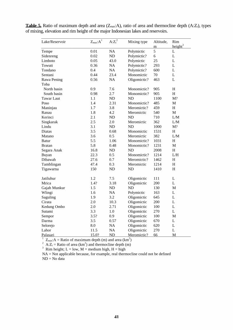
41
Table 5. Ratio of maximum depth and area (Zmax:A), ratio of area and thermocline depth (A:Zt), types of mixing, elevation and rim height of the major Indonesian lakes and reservoirs.
Lake/Reservoir Zmax:A1 A:Zt
2 Mixing type Altitude, Rim m height3 Tempe 0.01 NA Polymictic 5 L Sidenreng 0.02 ND Polymictic? 6 L Limboto 0.05 43.0 Polymictic 25 L Towuti 0.36 NA Polymictic? 293 L Tondano 0.4 NA Polymictic? 600 L Sentani 0.44 23.4 Monomictic 70 L Rawa Pening 0.56 NA Oligomictic? 463 L Toba North basin 0.9 7.6 Monomictic? 905 H South basin 0.98 2.7 Monomictic? 905 H Tawar Laut 1.1 ND ND 1100 M? Poso 1.4 2.31 Monomictic? 485 M Maninjau 1.7 3.8 Meromictic? 459 H Ranau 1.8 4.2 Meromictic 540 M Kerinci 2.1 ND ND 710 L/M Singkarak 2.5 2.0 Meromictic 362 L/M Lindu 3.1 ND ND 1000 M? Diatas 3.5 0.68 Monomictic 1531 H Matano 3.6 0.5 Meromictic 382 L/M Batur 5.5 1.06 Monomictic? 1031 H Bratan 5.8 0.48 Monomictic? 1231 M Segara Anak 16.8 ND ND 2008 H Buyan 22.3 0.5 Monomictic? 1214 L/H Dibawah 27.6 0.7 Meromictic? 1462 H Tamblingan 47.4 0.3 Meromictic 1214 H Tigawarna 150 ND ND 1410 H Jatiluhur 1.2 7.5 Oligomictic 111 L Mrica 1.4? 3.18 Oligomictic 200 L Gajah Munkur 1.5 ND ND 130 M Wlingi 1.6 NA Polymictic 163 L Saguling 1.9 3.2 Oligomictic 645 L Cirata 2.0 10.3 Oligomictic 200 L Kedung Ombo 2.0 2.71 Oligomictic 100 L Sutami 3.3 1.0 Oligomictic 270 L Sempor 3.5? 0.9 Oligomictic 100 M Darma 3.5 0.57 Oligomictic 670 L Selorejo 8.0 NA Oligomictic 620 L Lahor 11.5 NA Oligomictic 270 L Palasari 15.0? ND Meromictic? 66 M 1 Zmax:A = Ratio of maximum depth (m) and area (km2) 2 A:Zt = Ratio of area (km2) and thermocline depth (m) 3 Rim height; L = low, M = medium high, H = high NA = Not applicable because, for example, real thermocline could not be defined ND = No data
42
Table 6. An anticipated relationship between Zmax:A and mixing type in the lakes and reservoirs studied. Note that the percentages have been rounded up.
Zmax:A Polymictic Monomictic Oligomictic Meromictic Lakes (N = 18) 0-3 5 (28 %) 2 (11 %) 1 (6 %) 3 (17 %) 3-10 0 3 (17 %) 0 1 (6 %) > 10 0 1 (6 %) 0 2 (11 %) Reservoirs (N = 12) 0-3 1 (8 %) 0 5 (42 %) 0 3-10 0 0 4 (33 %9 0 > 10 0 0 1 (8 %) 1 (8 %)
There seems to be an obsessive manner to state that there are very large gaps in our knowledge on the tropical lakes and reservoirs, and that there is much to be done. Nevertheless, much is not done on a regular basis to narrow of the gap. Institutions concerned with tropical lakes, reservoirs are not many, and major research terms are infrequent. Individuals and small groups have made the greatest contributions. Unfortunately, their work has neither been coordinated nor integrated. The overall quality of lakes and reservoirs in Indonesia shall be carefully documented based on the available studies. This needs an effort to compile all the generally scattered material, including background data, in a computer based lake basin data bank of Indonesia. This may be a great task, which may be carried out by LIPI/Limnology or RIWRD, or in cooperation with both of the institutions. Presently, there are practically no former reliable data (dates, sampling locations, depths and analytical methods which can be calibrated against the present study) for the estimation of the development of the state of the water bodies during the years. Now, it is extremely difficult. Without adequate information, it is not easy to prepare a national strategy, such as the needed Indonesian lake basin management plan for the well being of the lakes and reservoirs. It is evident that the outcome of the Expedition Indodanau is not, at all, complete. It has its shortcomings in many respects, e.g. due to high mobility it was not possible to make diurnal, short-term or long-term observations. This is the general deficiency in the studies made in Indonesia. However, it gave reasonable amount of information about vertical physical and chemical characteristics, and of surface water phytoplankton, of the studied major lakes and reservoirs in the Indonesian archipelago with equal sampling and analytical methods. Therefore, the results of the Expedition Indodanau are comparable between the lakes and reservoirs, and islands. The study left many open questions, such as seasonality and predictability of stratification, mixing and circulation, oxygen and nutrient regimes, and phytoplankton and productivity, among others, in addition to the necessarily needed secondary information. Expedition Indodanau may have partly helped to fill the information gaps. If it may also prove to be an impetus, as many other studies have earlier endeavored, for the onset of continuous nationwide lake and reservoir research and monitoring activities for the sustainable utilization of the water resources, it has met its objectives and reached its goals, beyond dispute.

43
PART 3. SHORT DESCRIPTIONS OF INDIVIDUAL LAKES AND RESERVOIRS In order to give some general idea of the physical and chemical properties, of phytoplankton, when applicable, and of the state of each of the individual lakes and reservoirs, summarized results are presented below. Table 3 shows the range of variables measured. Detailed information on regional data comparison (Figures) and on each lake and reservoir are in separate data files (Tables and Figures), and the data are included in the data bank at RIWRD. As the morphology and hydrology of the natural lakes and the reservoirs are generally quite different, the summaries are presented in separate chapters. The summaries are based on the results of Expedition Indodanau, but also on the personal observations of the principal author, since he is the only one in the team who has visited all the lakes and reservoirs studied. The number after the name in brackets is the project code number. The location can be found in Figure 1. The sampling dates can be found in the data files. The general evaluation is made only for the lakes. All the conclusions shall be verified by diel, interannual and long-term observations. 3.1. NATURAL LAKES Batur Lake (26)
Lake Batur is the largest and deepest confined lake in Bali, and its basin is a caldera. It is situated next to the volcano Gunung Batur. The most recent eruption happened in 1963. There is some small-scale agriculture around the lake, and an increasing number of guest houses are being built. The lake is also used for fisheries. The volcano is a favored hiking area, and on the western shore, there is the oldest village in Bali, Trunyan. By now, there are no major man-caused threats to the lake. A survey has been made on the flood control regulation (DPU and Exsa International 1981). The lake was variously stratified during the visits (RTR 8.9, 48.0 and 126.9), and there were indications that it may have had a full circulation in July 1993 (see also Ruttner 1931, Green et al. 1994). However, Schmitz (1994) is claiming that Batur Lake is both thermo- and chemostratified, although his studies were only to the depth of 50 meters. It is the most saline of the studied lakes, having a conductivity of 1,750-1,800 µS/cm, and a dissolved solids concentration of 1,340-1,520 mg/l. It has also the highest alkalinity (3.60-3.70 meq/l) and high pH (8.8), especially in the epilimnion. There was no carbon dioxide in the lake, and iron and manganese concentrations were not elevated near the bottom. The concentrations of calcium, chloride, potassium, sodium, magnesium and sulfate were high. Nutrient concentrations of the lake were rather low, total nitrogen from 0.256 to 0.970 mg/l N and total phosphorus from undetectable to 0.028 mg/l P. Chlorophyll a concentrations were from 0.57 to 3.83 mg/m3. The phytoplankton composition was rather diverse, but the diatom Synedra acus v. angustissima was dominant in September 1992. The total biomass was 2.4 mg/l, and transparency from 3.0 to 3.2 meters. The lake is considered oligotrophic. Evaluation: Generally good, but highly saline. Bratan Lake (25)
Bratan is the shallowest confined lake in Bali, but yet very heavily under the pressure of recreational activities, motor boating and other outdoor activities, hotels and restaurants. The temple of Pura Ulun Danu (goddess of the lake) is at the lake. There are several big outboard engines for a small (3.9 km2) and shallow (22 meters) lake, the biggest being more than 200 horsepower. Attention to this fact has been drawn already some 18 years ago (Lehmusluoto 1977 a). Some small- scale agriculture is maintained around the lake. The lake was weakly stratified (RTR 19.0, 41.5 and 72.6) when visited. Schmitz (1994) claims that the lake is thermo- and chemostratified. Its water is the most dilute of the studied lakes, conductivity being 22-27 µS/cm and alkalinity from 0.18 to 0.20 meq/l. The nutrient concentrations were also relatively low, but total nitrogen showed some elevated values (0.310-1.310 mg/l N) compared to some earlier studies (Lehmusluoto & Badruddin 1989). Total phosphorus values

44
were from undetectable to 0.002 mg/l P. The chlorophyll a concentrations were from 5.59 to 7.33 mg/m3. In September 1992 the conjugatophyte Staurastrum cf. tetracerum was a strong dominant, 97 % of the total biomass, which was 4.4 mg/l. The lake shows some signs of beginning eutrophication, which has also been observed by Green et al. (1994). Transparency is 1.8 meters. Evaluation: Reasonable, but susceptible to eutrophication and pollution, e.g. engine oil. Buyan Lake (24)
Lake Buyan is a confined lake surrounded by rain forests, small-scale agriculture and quite recent vacation housing. There are some fishing activities at the lake. Its stratification was weak (RTR 2.7, 27.0 and 39.8), and it has an electrical conductivity above average, about 280 µS/cm, but close to the bottom, it elevates to about 750 µS/cm. The total nitrogen concentrations were from 0.224 to 1.060 mg/l N and total phosphorus concentrations from undetectable to 0.004 mg/l P. The carbon dioxide concentrations were from 3.3 to 6.6 mg/l. Chlorophyll a concentrations were 2.32-5.08 mg/m3, and total biomass 0.76 mg/l. The conjugatophytes Cosmarium bioculatum and Staurastrum chaetoceros were the dominant species, 74 % of the total biomass. Transparency was 2.3-3.1 meters. It is oligotrophic. Evaluation: Good, with no immediate threats. Diatas Lake (04)
Lake Diatas is one of the larger shallow natural lakes in Indonesia. It has a river outlet through the River Gunanti. Although the drainage area is used for extensive agriculture, it has seemingly not yet affected the lake. It was weakly stratified (RTR 16.3 and 27.0). The oxygen conditions are favorable. As the lake is rather shallow, 44 meters, it may circulate down to the bottom periodically. Total nitrogen values were from 0.076 to 0.927 mg/l N and total phosphorus values from undetected to 0.040 mg/l P. The highest carbon dioxide concentration in the hypolimnion was 5.30 mg/l, and iron concentration of 0.82 mg/l. The lake is oligotrophic, having chlorophyll concentrations of 1.43-1.71 mg/m3, biomass 0.05 mg/l and transparency of 5.5-6.5 meters. The dominant phytoplankton species in March 1992 was similar to Cyanodictyon imperfectum, a blue-green alga, in addition to green alga Oocystis spp., but in August 1993 Oocystis sp. dominated and the diatom Aulacoseira granulata was well represented. Evaluation: Good, but non-point loading from agricultural land shall be controlled. Dibawah Lake (05)
Lake Dibawah has a natural outlet through the River Lembong into Lake Singkarak, being thus part of one of the three lake chains in the studied islands. The drainage area, which is small, is used to some extent for agriculture. Small-scale fish farming is practiced at the outlet, and mollusc shells are collected from the shallow areas for various uses. The lake was weakly stratified (RTR 34.9) and the oxygen depletion began at the depth of about 50-60 meters, while the maximum depth is 309 meters. Thus, the major proportion of the lake volume is lacking oxygen. The pH was rather high, 7.7-8.5. As the lake is deep, it is likely that mixing occurs down to the chemocline periodically. Total nitrogen values were from 0.180 to 0.466 mg/l N and total phosphorus values from 0.015 to 0.080 mg/l P. The highest carbon dioxide concentration was 6.5 mg/l. The chlorophyll a concentration varied from 1.16 to 1.64 mg/m3, biomass was 0.18 mg/l and transparency 2.5 meters. The lake is oligotrophic. The dominant algae in March 1992 were coccal green algae, like genus Coenochloris, and in August 1993, the dominant genus was conjugatophyte Spirogyra sp., and chlorophytes Didymocystis bicellularis and Oocystis cf. solitaria were abundant. Evaluation: Good.
45
Kerinci Lake (07) Kerinci lake, which origin is uncertain, has two outlets, Segara Agung and Batang Kali rivers. The
fisheries activities are intense. It had the very average chemical chraracteristics in the epilimnia in Indonesia, but pH was rather low. The lake is governed by a large wetland area and floating vegetation. Due to logistical hardships, no observations of the stratification could be made, and no vertical sampling could be performed. The total nutrient concentrations of the outlet water were 0.380 mg/l N and 0.080 mg/l P, and chlorophyll a concentration was 17.17 mg/m3, and biomass 0.19 mg/l. The high chlorophyll concentration may be due to sampling error. The dominant species was in August 1993 raphidophyte Gonyostomum semen, and other well represented algae were dinophyte Peridinium cf. gutwinskii, conjugatophyte Spondylosium secedens and chlorophytes Monoraphidium contortum and Crucigenia tetrapedia. Evaluation: Good, but some threats may come from the large surrounding agricultural area. Limboto Lake (32)
Limboto Lake is a very shallow lake in Sulawesi flowing to the Molucca Sea through the River Limboto. It is largely covered with higher vegetation and submerged plants. It was weakly stratified. Otherwise, the water quality is reasonable, but conductivity is some 550 µS/cm. The nutrient values are, 0.545-0.566 mg/l total N and 0.011-0.028 mg/l total P. Chlorophyll a concentration was 5.24 mg/m3, biomass 4.8 mg/l and transparency 0.4 meters. Sulfate concentrations varied from 5.5 to 9.4 mg/l. The phytoplankton was dominated by chlorophytes (98 % of biomass), the dominant species being Oocystis sp. in August 1993. Hartoto (1994) has made studies of the lake in 1992-1993, but the results were not available for comparison. The lake may be considered eutrophic. Evaluation: Reasonable, but siltation and overgrowth are the problems. Lindu Lake (33) Not visited. Maninjau Lake (03)
Lake Maninjau has an outlet to the west at Muko Muko through the Antukan (Sikikis) River. The lake is the only one in Sumatra having its outlet to the west. The drainage area is used to some extent for small-scale agriculture, and it is a popular tourist place with several lakeside hotels and guesthouses. The temperature stratification of the lake was rather weak (RTR 45.3), oxygen was depleted near the bottom, and conductivity was somewhat higher in the hypolimnion (200 µS/cm) than at the surface. However, the pH is rather high at the surface. The total nitrogen concentrations were from 0.116 to 1.110 mg/l N and total phosphorus from undetected to 0.250 mg/l P. Ruttner (1931) calculated that in the deeper layers below 60 meters has accumulated 7,000 tons of NH4-N and 1,500 tons of phosphorus. These correspond approximately to concentrations of 0.875 mg/l N and 0.187 mg/l P. Chlorophyll a concentrations were from 1.30 to 2.52 mg/m3 and biomass 0.2 mg/l. It is oligotrophic, but there are some signs of beginning eutrophication. Transparency was 3.4 meters. The carbon dioxide concentration was in the deepest hypolimnion 18.0 mg/l, one of the highest in the studied deep lakes, and iron concentrations were up to 1.90 mg/l. Ruttner (1931) found during the Sunda-Expedition in 1929 about 20 mg/l CO2 near the bottom. The dominant algae in March 1992 were coccal green algae representing genera Oocystis, Lagerheimeia, Treubaria and Scenedesmus, without any strong dominant species. In August 1993 Oocystis sp. strongly dominated. Evaluation: Reasonable, but susceptible to eutrophication by population centers. Matano Lake (37) Lake Matano, the uppermost in the Matano-Mahalona-Towuti chain, is the seventh deepest lake in the world, although some information in literature may give other information. It drains through the Penten River to Lake Mahalona. It is the only lake in Indonesia with a 208 meter cryptodepression, e.g.
46
the sea level corresponds to the depth of 382 meters. The lake was weakly stratified (RTR 34.3), with anoxic hypolimnion. According to Whitten et al. (1987 b), the lake has been homotherm, but no mentioning was made of the chemical gradients. Is the lake permanently meromictic is an open question. Hartoto (1994) states that the lake was unstratified and that oxygen curve was clinograde. The results may indicate it. The water quality is good in the epilimnion, but at the depth of 150-200 meters there is a clear gradient of most of the physical and chemical variables; alkalinity increases two fold, conductivity from about 200 to about 300 µS/cm, ammonia increases 20 fold, total nitrogen 10 fold, calcium two fold, magnesium three fold, iron ten fold and manganese from undetected to 0.22 mg/l, while sodium decreases from about 3 to 1.1 mg/l. Nitrate maximum was in 50 meters, ORP minimum (-177) in 150 meters and suspended solids and turbidity maxima in 200 meters. The total nitrogen concentrations were from 0.150 to 1.740 mg/l N and total phosphorus was undetected in the entire water column of 500 meters. Chlorophyll a concentration was only 0.15 mg/m3. The highest carbon dioxide concentration of 5.3 mg/l was found at the depth of 500 meters, as were also iron and manganese concentrations, 4.59 and 0.22 mg/l, respectively. The phytoplankton biomass was only 0.002 mg/l, and only seven algal species were found, chlorophyte Staurastrum furcigerum dominating but also dinophyte Peridinium sp. was prominent. The lake is clearly oligotrophic, and its transparency was 15.5 meters. Nevertheless, the wastewaters of the small towns and the effluents of the nickel industry shall be taken care of. It would have been interesting to compare the physical and chemical results of 1992-1993 by Hartoto (1994), but they were not available. The rain forest surrounding the nickel industrial plants seemed to be without major disturbances, by the bare eye.
Evaluation: Good, but the nearby nickel mine and processing plants are discharging effluents into the lake. Due to its long residence time, they may have cumulative effects in the future.
Poso Lake (34)
Poso Lake is situated in Central Sulawesi close to Sulawesi "Highway". It drains through the Poso River to the Molucca Sea. There are also reasonable tourist facilities. Poso Lake with its over 400 meter depth was weakly stratified (RTR 13.3). The lower hypolimnion was anoxic, but the carbon dioxide concentrations did not exceed 5.3 mg/l. Otherwise the lake was like an "average" Indonesian lake, and the total nitrogen concentrations were from 0.240 to 1.090 mg/l N and total phosphorus concentrations from undetectable to 0.040 mg/l P. The chlorophyll a concentration was 0.28 mg/m3 and biomass 0.03 mg/l. The lake seems to be oligotrophic, and transparency was of 4.8 meters. It has a good stock of silver and yellow eels and two endemic fish species, Adrianichtys kruyti and Xenopoecilus poptae species, and the dominant algal species were Coccomyxa confluens and Kirchneriella contorta (Hehanussa 1994), but in July 1993 the diatom, Aulacoseira sp. dominated. There are also some observations of 1992-1993 made by Hartoto (1994), but unfortunately, they were not available. Evaluation: Good, with no actual threats. Ranau Lake (08)
Lake Ranau has an inlet of Warkuk River at Kota Batu and an outlet at Surabaja through the Komering River to the Bangka Strait. The drainage area is used for agriculture. Lake Ranau is in the Indonesian conditions a high-altitude lake, and surrounded by rain forests and agricultural fields. There is also a spa at the lakeshore. It has been observed that the western end is four centigrades warmer than the eastern end because of the influence of hot springs (Forbes 1885), but this kind of observations were not made in this study. It was weakly stratified (RTR 57.7 and 64.7), and it had an anoxic hypolimnion. Oxygen concentration was zero at about the depth of 70-100 meters. At the same depth hydrogen sulfide could already be detected, and the highest concentration near the bottom was 1.5 mg/l. The maximum depth is 229 meters. The nutrient concentrations were; total nitrogen from 0.158 to 0.893 mg/l N and total phosphorus from 0.055 to 0.411 mg/l P. Chlorophyll a concentrations varied from 1.21 to 1.28 mg/m3. The highest carbon dioxide concentration in the deeper hypolimnion was 12.0 mg/l and sulfate concentration 20.2 mg/l. The lake is oligotrophic, having a biomass of 0.03 mg/l and

47
transparency of 8.8 meters. The most abundant taxa were in March 1992 Chodatella spp. and Planktonema lauterbornii, and in August 1993 chlorophyte Botryococcus braunii and diatom Aulacoseira granulata. Evaluation: Good, with no immediate threats. A dam is planned to its outlet.
Rawa Pening Lake (15)
Rawa Pening Lake is a semi-natural lake, with a man-made dam at its outlet to the Tuntang River. Large areas of rice paddies and small towns surround it. The lake is heavily used for fisheries and other water related economic activities (bottom mud and molluscs). When visited it was stratified (RTR 71.2), but without epilimnion. The nutrient concentrations were; total nitrogen from 0.510 to 0.520 mg/l N and total phosphorus was undetected. Chlorophyll a concentration was 1.65 mg/m3, and biomass 2.6 mg/l. The strongly dominant alga was dinophyte Peridinium umbonatum, but also euglenophytes were rather well represented in August 1992. It is largely infested and overgrown with e.g. Eichhornia crassipes, but the eradication activities did not seem to be extensive, although a mechanical harvester is at the lake. The nearby Satya Wacana Christian University in Salatiga actively studies the lake. Evaluation: The lake needs an immediate management plan. Segara Anak Lake (28) Not visited. Sentani Lake (30)
The Sentani Lake is the only one in Irian Jaya included in the program. It drains through the Jafuri River to the Pacific Ocean. There is available a background study for the Sentani Hydro Scheme conducted by a Canadian company. However, this did not give much information on the limnology of the lake. The lake was stratified (RTR 51.5), with an anoxic hypolimnion. Traces of hydrogen sulfide could be detected in the hypolimnion, and carbon dioxide concentrations were from 2.2 to 3.0 mg/l. Total nitrogen varied from 0.234 to 0.899 mg/l N and total phosphorus from 0.013 to 0.040 mg/l P. Chlorophyll a concentration was 2.39 mg/m3, biomass 0.24 mg/l and transparency 2.6 meters. The dominant algal species was diatomophyte Aulacoseira granulata, which comprised of 47 % of the biomass. In addition, cyanophytes and chlorophytes were found. The lake showed some signs of eutrophication. Evaluation: Reasonable, but prone to eutrophication. Sidenreng Lake (35) Visited, but not sampled due to strong wind. Singkarak Lake (06)
Lake Singkarak has a natural flushing system (inlet from Dibawah lake via River Sumani/outlet through Umbilin river), and it acts as a sediment sink. The lake was stratified (RTR 55.2 and 78.8). The hypolimnion is likely to be permanently or semipermanently stagnant, meromictic, from the depth of 45-50 meters on. Therefore, roughly two thirds of the lake's water volume of about 15.6 km3 is oxygen depleted. The maximum depth is 268 meters. During the last few decades, the oxygen-depleted layer has moved closer to the surface, being now at about the depth of 50 meters (see Ruttner 1931). From that depth down to the bottom, there is also hydrogen sulfide present in the lake. In the oxygen depleted layer there is storage of about 60,000 tons of carbon dioxide (highest concentration 14.0 mg/l) and 18,000 tons of hydrogen sulfide (highest concentration 0.4 mg/l). To oxidize the 18,000 tons of hydrogen sulfide some 36,000 tons of oxygen would be needed, but there is instantaneously only 70 tons available in the epilimnion. The highest iron and manganese concentrations were 0.82 and 0.36 mg/l, respectively. It seems likely that the lake has not yet developed eutrophic. The suggested additional abstraction through the natural outlet of the River Umbilin would be several m3/s for

48
hydroelectric generation and for irrigation (Alpine Consultants, Switzerland). However, the effects of the abstraction shall be carefully evaluated, if in unfavorable proportion to the present recharge. It may affect the whole lake by reducing the volume of the epilimnion, and the vulnerability for mixing may become evidently more possible. In addition, the wetlands around the lake may be in danger, if the water level may be lowered. Withdrawal of hypolimnion water would be more beneficial from the environmental point of view and for irrigation purposes because of its higher nutrient concentrations (see Ruttner 1931). However, the smell of hydrogen sulfide may cause some local nuisance. Tundisi (1984) has suggested the nutrient rich hypolimnia of reservoirs to be used for irrigation, too. The total nutrient concentrations were; total nitrogen from 0.176 to 1.199 mg/l N and total phosphorus from 0.016 to 0.166 mg/l P. The chlorophyll a concentrations varied from 0.88 to 1.97 mg/m3, and biomass was 0.1 mg/l. The lake can still be considered as oligo-mesotrophic, with transparency of 2.1-3.2 meters. The main phytoplankton groups were Chlorococcales and desmids from the group of Conjugatophyceae in March 1992. In August 1993, the majoring algae were conjugatophytes (Spondylosium planum and Cosmarium punctulatum), dinophytes (Peridinium umbonatum) and chlorophytes (Tetraedron minimum). Evaluation: Susceptible to eutrophication. The effects of the additional water abstraction shall be
closely studied. The possibility of a complete overturn shall also be evaluated. Tamblingan Lake (23)
Tamblingan is the smallest of the confined Balinese lakes. It is well sheltered from winds in the caldera, but its stratification was not especially strong (RTR 55.2). The lake has an anoxic hypolimnion, but is it meromictic has to verified. The total nitrogen concentrations were from 0.690 to 0.780 mg/l N and total phosphorus concentrations from undetected to 0.002 mg/l P. The carbon dioxide concentrations were from 4.4 to 7.7. The lake was seemingly oligotrophic, although the daytime oxygen concentrations showed some oversaturation. The chlorophyll a concentration was 3.77 mg/m3, biomass 0.5 mg/l and transparency 2.7 meters. In the phytoplankton dinophytes, chlorophytes and conjugatophytes were rather evenly represented, but the dominant species was diatom Synedra acus v. angustissima. Evaluation: Good, with no threats. Tawar Laut Lake (01) Not visited. Tempe Lake (36)
Tempe is one of the floodplain lakes in Indonesia (and the only lake of which the principal author has ever taken samples from a terrace of a house), the lowest in the Sidenreng-Tempe chain of lakes. During the rainy season, its area is about 300 km2, but it shrinks to mere 10 km2 during the dry season, during which time its dry shore area is used for agriculture. Its economic value is great both because of agriculture and fishery. It cannot be considered, even during the high-water season, as a real lake, since the through-flow water velocity is quite high. Its maximum depth was during the visit 5.3 meters, and the stratification was naturally weak (RTR 3.5). Transparency was 0.6 meters. Lake Tempe is a fertile and productive water body, with total nitrogen values from 0.720 to 1.010 mg/l N and total phosphorus concentrations from 0.050 to 0.060 mg/l P, in which high allochthonous organic matter concentrations support a large and uniform fishery. The chlorophyll a concentration was 2.94 mg/m3, and biomass 0.04 mg/l. The phytoplankton composition was diverse, without any distinct dominant alga. The fish yield is 650 kg/ha/year. The carbon dioxide concentration amounted to 33.0-38.0 mg/l. Recent studies in 1992-1993 have been made by Hartoto (1994), but the results were not available. From the limnological point of view the lake is much affected by the allochthonous transport of organic matter and nutrients, and thus by the drainage area. However, it is important for its fisheries and for migrating birds. Evaluation: Due to the surrounding agricultural land the lake may be prone to further
49
eutrophication and siltation, noted already by James Brooke in 1840 (see Whitten et al. 1987 b). However, the flushing rate of the lake is high. It has been infested by Eichhornia crassipes. Plans affecting the fisheries and migrating birds shall be reviewed.
Tigawarna Lake (29) Not visited. Toba Lake (02)
The maximum depth of the southern basin is 433 meters and in the northern basin 529 meters. Lake Toba has an outlet through the River Asahan at Porsea to the Strait of Malacca. The northern basin may circulate down to the bottom periodically (RTR 31.1 and 61.1), but the southern basin is likely to be more stagnant throughout the year as there is a more clear thermocline and a distinct oxycline at the depth of 100-150 meters although its RTR was only 25.0, or it is caused by pollution. Thomas (1995) observed that the southern basin of the lake was stratified from 140 meters to 50 meters. Roughly, two thirds of the southern basin is oxygen depleted. The total volume of the lake is estimated to be some 240 km3 (principal author's evaluation). During the last few decades the oxygen depleted volume in the southern basin has slightly increased, and the depth at which oxygen gets depleted, has moved towards the surface. It seems likely that the changes have been slight. The lake is still ecologically very sound, but extremely vulnerable. Therefore, e.g. the dam and forest estate projects shall be carefully restudied. The present water level fluctuations of 1.5 meters have some effects on the whole ecosystem of the lake. The vulnerability of the lake may be enhanced. It is necessary to make a full inventory of the drainage area, and review the development plans accordingly. In addition, an inventory of the loading effects of e.g. the townships of Parapat, Porsea, Balige and Muara shall be made. The total nitrogen concentrations were from 0.100 to 1.186 mg/l N and total phosphorus concentrations from undetected to 0.061 mg/l P. According to Thomas (1995) ammonium and phosphate phosphorus were undetectable in the southern basin. The chlorophyll a concentrations were 1.21-1.93 mg/m3, and biomass from 0.023 to 0.036 mg/l. The carbon dioxide concentrations did not exceed 7.8 mg/l in the voluminous north and south basins. According to Ruttner, (1931) the concentrations may be 30-40 mg/l in the small and confined Panggururan basin. Lake Toba is an oligotrophic lake, transparency being 13.5-15.0 meters. In March 1992, the dominant alga was diatom Denticula tenuis, which favors alkaline waters and waters with low organic matter concentrations. Besides the diatom the lake had a rather diverse phytoplankton community with many species of coccal green algae, some desmids, tribophytes, other diatoms, cryptophytes, dinoflagellates and even some chrysophytes. In September 1992 was dominated by green algae, in the northern basin by Monoraphidium and Oocystis, and in the southern basin by Monoraphidium and Lagerheimia. Ratulanggi (1995) stressed the necessity of the comparable long-term data is stressed, because of its paucity. An integrated Toba conservancy shall immediately be prepared. ILEC & UNEP (1994 a) included the lake in their data book, as one of the two lakes from Indonesia. Evaluation: Very good, but vulnerable and sensitive to small additions in nitrogen and phosphorus
loading.

50
Tondano Lake (31) Tondano Lake is a very shallow Indonesian lake with no distinctive features. It is silting up by
some 20 cm/year (Anonymous 1979). It is draining through the River Tondano to the Molucca Sea. Its stratification was weak (RTR 19.1). The total nitrogen values varied from 0.365 to 0.624 mg/l N, and total phosphorus values were undetectable. Chlorophyll a concentration was 1.47 mg/m3, and biomass 0.82 mg/l. The phytoplankton was in August 1993 dominated by cyanophytes and diatoms, and the major species was the diatom Aulacoseira granulata. The lake was mesotrophic with a transparency of 2.5 meters, which is affected also by other than phytoplankton turbidity. Hartoto (1995) studied also his lake in 1992-1993. Evaluation: Reasonably good, but high siltation rate. Towuti Lake (38)
Towuti Lake is one of the magnificent lakes in Indonesia, last in the chain of Matano-Mahalona-Towuti. Its maximum depth is some 200 meters, but we found only 82 meters in the northwestern basin because the location of the greatest depth is not well documented. It flows through the Larona and Malili rivers to the Bone Bay. It was weakly stratified (RTR 39.8). Whitten et al. (1987 b), indicated that the lake was homotherm. The water quality is good and the lake is oligotrophic. Total nitrogen concentrations were from 0.360 to 0.610 mg/l N and total phosphorus concentrations were undetectable. Chlorophyll a concentration was 0.19 mg/m3, biomass 0.016 mg/l and transparency was 20 meters. The phytoplankton consisted of only nine species, and the strongly dominating one was Peridinium cf. baliense. See also Hartoto's studies of 1992-1993 (Hartoto 1995). Evaluation: Very good. 3.2. RESERVOIRS Cirata Reservoir (10)
Cirata reservoir is the second in the Saguling-Cirata-Jatiluhur chain of reservoirs in the Citarum river basin. The stratification was sharp, RTR being 56.5 and 152.1 during the two visits. The oxycline is as sharp as the thermocline. Anoxic conditions began at the depth of nine meters. No "exceptional" concentrations of chemical variables were observed. The total nitrogen concentrations were from 0.050 to 1.220 mg/l N and those of total phosphorus from undetected to 0.010 mg/l P. Chlorophyll a concentrations were from 1.98 to 2.15 mg/m3. Zinc concentrations were from 0.03 to 0.30 mg/l. The reservoir may be considered mesotrophic. Its transparency was 1.2 meters, but it is also affected by inorganic turbidity. The abundant species were e.g. diatomophyte Synedra acus v. angustissima and chlorophyte Oocystis sp., and iron bacterium Planktomyces bekefii occurred in the deeper layers. Darma Reservoir (12)
Darma is a small and shallow reservoir. It was weakly stratified (RTR 41.5). Conductivity and dissolved solids increase with depth, from 97 to 770 µS/cm and from 62 to 485 mg/l, respectively. The reservoir can be considered mesotrophic, having total nitrogen values from 0.380 to 0.420 mg/l N and total phosphorus level of 0.002 mg/l P. Chlorophyll a concentration was 2.14 mg/m3, biomass 0.57 mg/l and transparency 1.5 meters. The algal population consisted outstandingly of conjugatophytes, mainly of Staurodesmus mucronatus. Gajah Munkur Reservoir (16) Visited, but not sampled.
51
Jatiluhur Reservoir (11) Jatiluhur is the third sink in the Saguling-Cirata-Jatiluhur chain of reservoirs. The main basin was stratified (RTR 31.2 and 103.2), and anoxic conditions began during the low-water season at the depth of 11 meters and during the high-water season at the depth of about 20 meters. No "exceptional" concentrations of measured variables were found. The total nitrogen concentrations varied from 0.020 to 0.680 mg/l N and total phosphorus concentrations from 0.002 to 0.006 mg/l P. The reservoir is not turbid like the upper two in the chain, although in the seventies it had inorganic turbidity. The reservoir is rather oligotrophic than mesotrophic with chlorophyll a concentrations from 2.25 to 0.79 mg/m3 and biomasses from 0.024 to 0.052 mg/l. Transparency was from 2.6 to 3.8 meters, depending on the season. The major algae were dinophytes (Peridinium spp.), conjugatophytes (Spondylosium spp. and Staurastrum spp.) and chlorophytes (Tetraedron minimum). Kedung Ombo Reservoir (17)
Reservoir Kedung Ombo was stratified (RTR 69.5 and 79.9). The anoxic conditions began at the depth of 30 meters, and hydrogen sulfide was traced at the same depth. No "unusual" concentrations of variables were observed. The total nitrogen concentrations were from 0.380 to 0.800 mg/l N and total phosphorus concentrations from undetectable to 0.012 mg/l P. Calcium values were from 35.0 to 37.0 mg/l. Chlorophyll a concentration was 0.77 mg/m3 and biomass 0.2 mg/l. The reservoir was dominated by conjugatophytes, mainly by Staurastrum spp., but also Cosmarium spp. were found. It is oligotrophic, and its transparency was 5 meters. Lahor Reservoir (19)
Lahor is one of the upstream reservoirs in the Brantas river basin system, located within the agricultural and industrial areas. However, this cannot clearly be seen in the water quality of the reservoir. It was stratified (RTR 96.4) and anoxia began at the depth of 10 meters. Only the nitrogen values, total nitrogen from 0.930 to 1.300 mg/l N was somewhat elevated. Total phosphorus concentrations were from undetectable to 0.009 mg/l P. The reservoir is probably mesotrophic, with signs of eutrophication, since there is oversaturation of oxygen during daytime and transparency is 1.5 meters. Chlorophyll a concentration was 2.38 mg/m3 and biomass 0.26 mg/l. Dinophytes dominated in the reservoir in August 1992, mostly Peridinium spp., but also chlorophytes (e.g. Oocystis spp.) were well represented. The reservoir may be prone to heavier eutrophication and pollution, if e.g. accidental spills may occur. The vulnerability to phosphorus increases shall be investigated. Mrica Reservoir (14)
Mrica reservoir was stratified (RTR 79.9), and anoxic conditions began at the depth of 50 meters. The measured variables did not show any "exceptional" values. Total nitrogen was from 0.560 to 1.100 mg/l N and total phosphorus from 0.002 to 0.004 mg/l P. Chlorophyll a concentrations were from 0.46 to 2.52 mg/m3, and biomass 0.45 mg/l. The dominant algae were Peridium spp. in the otherwise sparse plankton. It can probably be considered mesotrophic, having transparencies of 1.9-3.6 meters. Palasari Reservoir (27)
Palasari is a small reservoir in Bali. It was used for small-scale fisheries. When visited its water level was far below the utility level, and there was neither mentionable inflow to the basin nor discharge from it. The reservoir has also the highest maximum depth:area-ratio (about 15) of all the reservoirs, which, as a whole, is 1-3. Hypolimnetic waters were anoxic, and some hydrogen sulfide was observed at the depth of 20 meters. The total nitrogen concentrations were rather high, from 0.810 to 1.720 mg/l N and total phosphorus concentrations from undetected to 0.012 mg/l P. It may be considered mesotrophic, but to be prone to eutrophication if the water level tends to be as low as it was with no flushing. The chlorophyll a value was 2.81 mg/m3, biomass 4.2 mg/l and transparency 0.8 meters. The reservoir was strongly dominated by dinophyte Peridiniopsis cunnigtonii, 87 % of the biomass.

52
Saguling Reservoir (09)
Saguling is the first reservoir in the Saguling-Cirata-Jatiluhur chain of reservoirs. In the reservoir, there are very sharp thermoclines and oxyclines at the depth of about 5-10 meters, depending on the season (RTR 75.5 and 96.7). In both observation days, oxygen was depleted in the hypolimnia, in March from the depth of seven meters and in August from the depth of ten meters, and hydrogen sulfide was present from the depth of 5-10 meters on. The total nitrogen concentrations were from 0.160 to 0.720 mg/l N and total phosphorus from 0.002 to 0.014 mg/l P. Iron concentrations were rather high at each studied location, from 0.22 to 1.39 mg/l, but in the manganese concentrations no elevation was observed. Zinc concentrations varied from undetectable to 0.25 mg/l. The reservoir is showing some signs of eutrophication, especially in the shallow Bongas Bay, where oxygen was depleted in March already at the depth of eight meters and in August at the depth of five meters, partly due to organic matter and fish feed (see also Widjaja & Adiwilaga 1995). The nutrient concentrations were higher at the inlet at Maroko than in the main basin. The chlorophyll a concentrations were from 0.82 to 4.99 mg/m3, and biomasses from 0.096 to 0.212 mg/l. The dominant algae were cyanophytes and cryptophytes, and the strongly dominant species was Cryptomonas sp., 48 % of the biomass. In March 1992 the area was densely covered with Eichhornia crassipes vegetation, but in August only a few floating plants could be seen. The loading by fish feed shall be considered as one of the reasons for the situation in the Bongas Bay. There are occasional fish kills, generally in the beginning of the filling-up periods, the reasons of which are not yet known. It may be the result of overturn, upwelling, nocturnal depletion of oxygen at the surface, river water intrusion, toxic materials or excess production of methane. The reservoir is turbid and the nutrient concentrations seem, in general, not to be alarming, although some signs of eutrophication could be observed. Transparency was 0.5-0.6 meters. ILEC & UNEP (1994 b) have included Saguling in their data book, together with Lake Toba from Indonesia. Selorejo Reservoir (22)
Selorejo is at the confluence of two rivers, Konto and Kwayangan Rivers, thus having a relatively large catchment area. The inflowing waters tend to layer on the bottom near the Konto inlet, thus improving the oxygen conditions in the hypolimnion in the eastern part of the reservoir. The reservoir was quite strongly stratified (RTR 111.8, 132.9 and 156.2). At the Kwayangan inlet the stagnant deep water was anoxic, and some hydrogen sulfide could be detected from the depth of 10 meters onwards. Concentrations of chloride and calcium were somewhat elevated, from 16.0 to 27 mg/l and from 24.0 to 27.0 mg/l, respectively. The total nitrogen concentrations were from 0.250 to 1.020 mg/l N and total phosphorus concentrations from undetectable to 0.009 mg/l P. However, the reservoir could be considered relatively eutrophic, because of the high oversaturation of oxygen in daytime, close to 200 %. Transparency was 0.8 meters. Also the chlorophyll a concentration was one of the highest in the reservoirs, 6.08 mg/m3, but biomass was only 0.18 mg/l. Phytoplankton was dominated by conjugatophyte Cosmarium punctulatum and Spondylosium pygmaeum, but also diatoms were found in some degree (Achnantes sp.). Sempor Reservoir (13)
Sempor reservoir is quite an "ordinary" mid-size reservoir with no "exceptional" characteristics. RTR was 42.3. The Sempor Reservoir was clearly stagnant having a distinct oxycline at the depth of 12-14 meters. The maximum depth of the basin was 29 meters in August 1992. Oxygen was depleted at the depth of 14 meters and hydrogen sulfide was found at the depth of 20 meters. At the surface pH was 8.5 and in the hypolimnion 7.3. Nitrate concentrations were in the whole water column about 0.060-0.080 mg/l N, but no phosphate was found. Total nitrogen ranged from 0.420 to 0.600 mg/l N and total phosphorus from 0.002 to 0.003 mg/l P. Chlorophyll a concentration was 3.78 mg/m3, biomass 0.35 mg/l and transparency 1.9 meters. The strongly dominant species was conjugatophyte Cosmarium spagnicolum, and other algae were practically non-existent. The reservoir showed some signs of

53
eutrophication. Sengguruh Reservoir (18) Not visited. Sutami Reservoir (20)
Sutami reservoir is one of the upper reservoirs in the Brantas river basin system. It was quite strongly stratified (RTR 77.0 and 130.5), and oxygen was depleted at the depth of 20 meters. The nitrate nitrogen concentrations were high, and total nitrogen values from 1.330 to 1.650 mg/l N. Total phosphorus values were from 0.002 to 0.015 mg/l P. Daytime oxygen concentrations showed oversaturation, but no other remarkable signs of eutrophication were observed. Chlorophyll a concentration was 1.18 mg/m3, biomass 0.27 mg/l and transparency was 1.5-1.9 meters. The highly dominant algae were diatomophytes, and the dominant species Aulacoseira granulata. In addition, chlorophytes were present, such as Tetraedron minimum and Oocystis spp. Wlingi Reservoir (21)
Wlingi is the downstream reservoir in the Brantas river basin system. It is, after heavy siltation, a slow motion part of the river, which may also be indicated by the rather weak stratification (RTR 7.0 and 48.5). Nitrate concentrations were high, from 1.340 to 1.560 mg/l N. Total phosphorus concentrations were undetectable, but magnesium concentrations were highest among the reservoirs, about 14.0 mg/l. No remarkable signs of eutrophication could be observed. Chlorophyll a value was 1.47 mg/m3, biomass 0.06 mg/l and transparency varied from 1.3 to 1.4 meters. This may be partly due to the inorganic turbidity. The dominant algae were diatomophytes (Aulacoseira granulata, Synedra acus v. angustissima) and chlorophytes (Tetraedrom minimum).

54
PART 4. LAKE AND RESERVOIR MANAGEMENT 4.1. MAJOR OBJECTIVES One of the major objectives in the beneficial use and management of the natural lakes and reservoirs in Indonesia will be the maintaining of the production capacity of the relatively thin epilimnetic water layers in those lakes which do not have a complete mixing and in meromictic lakes, because fish production in the inland waters will be of increasing importance as food source. The productive trophogenic layers shall not be disturbed by increased loading through the activities either in the drainage area or in the water area, and thus consequently contributing e.g. to the level of eutrophication, or by increasing the oxygen consumption rates, which in turn may decrease the value of the vital epilimnion. In the water areas, such harmful activities are e.g. the extensive cage cultivation of fish. The main threats from the drainage area are silt transport, nutrients, harmful industrial effluents and agro-chemicals. The data showed that no real threats of carbon dioxide accumulation were evident in any of the lakes. The activities in the water areas can be more easily controlled than the activities in the drainage areas, because the population pressure is on the land areas. However, it is likely that in some water areas the fish cultivation has gone beyond the planned figures. When only 1 % of the water surface was originally planned in Indonesia to be allowed for the fish cultures, there are some restricted areas where this figure has been exceeded. In addition to that, the increasing floating vegetation has taken its share of the water surface. These cannot be affecting the water quality and thus also fisheries. The population pressure is high in Indonesia. For the livelihood of people, all the available food sources will be needed. It is hoped that the results of the Expedition Indodanau will, in its part, help in resolving the present state of the major lakes and reservoirs, in evaluating the future development of their state, in sustaining their productivity and in formulating the monitoring programs and action plans also at regional and local levels. The state of the Indonesian lakes is varying. In many lakes, hypolimnetic oxygen depletion is common, and in some hydrogen sulfide is present. The extent of deoxygenation cannot be described by area, as e.g. in the temperate region, but by volume. In fact, the depth at which the oxygen concentration is zero describes the changes rather well in the natural lakes, but also a certain level of area dependent equilibria may be reached, as may have happened in Lake Singkarak. The deoxygenated water volume is more than 60 % of the total lake volume in several lakes. The main long-term environmental threats, especially to the natural lakes, but also to the reservoirs, are population increase, forestry, agriculture, and all the other activities, which are directly related to the use of the natural resources. In lake quality studies, a distinction between holistic and reductionistic approaches is evident. Work should not only be reductionistic in the sense of seeking to understanding phenomena by detailed study of smaller and smaller components, but also synthetic and holistic in the sense of seeking to understand large components as functional wholes (Odum 1977). This means good cooperation between various disciplines and organizations in order to achieve the major objectives and targets for the sustainable utilization of the lakes and reservoirs. Industrial, and other types of pollution, are less serious in the long run, because the majority of the harmful effluent wastes can be recycled, purified or treated, contrary to the direct interference with the nature. This needs only more devotion and attention to the lake and reservoir resources, and political will. 4.2. RECOMMENDATIONS Physical processes of the Indonesian equatorial lakes are largely unknown (weak Coriolis force and prevailing winds), and chemistry is strongly affected by biological and perhaps geothermal processes. Whether there exist geothermal inflows into the lakes shall be verified lake by lake. The density structure is governed by small temperature gradients and relatively important gradients in total dissolved solids. The importance of biogenically driven stratification maintained by salinity gradient has

55
also to be emphasized, as well as the deep thermal gradients, which may be adiabatic and stable. Geothermal heating may exceed the adiabatic gradient. There may also be hot springs flowing into the lakes (see Goldman 1988). Water balance is dominated by seepage, rainfall and evaporation. As the turbidity increases, the depth of light penetration is reduced, resulting in greater surface warming and an increased evaporation rate, causing a net loss of heat. Continuous transparency measurements may give an easy means to follow the algal increase in the otherwise clear lakes. The nutrient profiles and budgets demonstrate also distinct differences perhaps reflecting different rates of methanogenesis or fluvial influx. The variations in the mixing depth caused by weather, and depth of seasonal mixing, may have impacts on the nutrient flux into the epilimnion. Incomplete vertical mixing of lakes is highly dependent on the relative depth (or area) and how exposed they are to wind. Indonesian limnology requires more information on the physical and chemical phenomena of the lakes and reservoirs, to better understand and document the processes (see Melack 1995, Carranza 1995). The productive layer may extend to four or five times the Secchi depth in the highly transparent lakes. The phytoplankton assemblage is supported by nutrient recycling through zooplankton and fish excretion, and unpredictable deep mixing, which may also transport viable biomass from below to the euphotic zone. Although the annual runoff and precipitation is important in the steady accumulation of nutrients (e.g. nitrates and phosphates) in the lakes, it is the internal loading from deep mixing that may account for most interannual variability in production (Lewis 1995). Nitrogen loading is also derived from fallout from the atmosphere, and phosphorus in the streamflow. Careful depth profiles of major physical and chemical variables are a necessity. The residence time of the hypolimnetic waters shall also be investigated by modern methods as they may represent pools of nutrients for the productivity drive, as is also the atmospheric deposition of nitrate. Wetlands are an important buffer between the land and lakes, and they may prove to be important mitigation means for intercepting nutrients before they reach the lakes. Healthy plant cover surrounding the lakes on the watersheds, which recycles nutrients, is one of the effective ways of reducing nutrient flow from the watershed areas to the lakes. Whether the food web structures are more "bottom up" or "top down" controlled shall be demonstrated. The biological processes may have significantly greater importance than physical processes controlling the nutrient cycling. It is important to concentrate on various issues, such as climate and weather, physical and chemical limnology, geochemistry and biological processes along with the real field and laboratory studies, data banks and logistical activities. Without proper information, management of the natural lakes and reservoirs is fraught with uncertainties and dangers. For example, the vulnerable lakes may respond to additional nitrogen or phosphorus increases of as little as 1 µg/l. In Indonesia, the main constraint is simply the lack of background information and daily, short-term and long-term temporal and spatial data. It is, therefore, suggested that serious efforts shall be made to collect and evaluate all the scattered information (reports, publications and even manuscripts) and data in Indonesia, and include them in one data bank, such as the one in RIWRD. The management has to be based on multiple-objective planning in which non-economic objectives shall be given considerably more weight, and benefit-cost analyses shall be important tools. It is to be based on reduction of e.g. silt transport, runoff loading, waste generation (water-carriage sewerage systems shall not be supported), reduction of wastes after generation and increased or better understanding of assimilative capacity and vulnerability of receiving waters. Standards should be chosen to suit the present dominant uses of water, potable water supply, irrigation and fishing, and reflect the level of economic development of drainage basin. The concept of polluter pays is a prerequisite (ECAFE 1974).
56
As, after the baseline inventories, data beginning to accumulate, it is important to keep an open mind and allow the actual results to answer the questions set forth. This, however, requires the most objective interpretation of data and not to "miss the forest for the trees" (Goldman 1988). The importance of long-term data collection cannot be overemphasized. Records shall be kept to eliminate the possibility of uncalibrated changes in sampling procedures and analytical methods. This fact has greatly affected the value of the earlier scattered data. It is necessary to further environmental sustainability of freshwater ecosystems. The near-term objective shall be to promote interdisciplinary and institutional cooperation to improve the understanding of the freshwaters in the context of environmental change. Expedition Indodanau shall necessarily need continuation to widen the fundamental ecological understanding for the management of the natural lakes and reservoirs in Indonesia, and that the lake and reservoir management would not any more be an unpredictable challenge. In preserving the ecological balance of the lakes, it is essential to understand the structure, function, and coupling of terrestrial and aquatic ecosystems. The Freshwater Imperative (see Wetzel 1995) under preparation in the United States has similar aims in four major sectors: science, information management, decision makers' needs and education. It is necessary to identify and prioritize;
• Information and research needs with scientific significance, sociopolitical relevance and pertinence to the requirements of decision makers,
• Promote freshwater monitoring to enable improved detection, assessment and prediction of environmental effects and freshwater quality, and
• Recommend ways by which researchers can assess the quality of lakes, classify the lakes and reservoirs and provide their findings in a timely and appropriate form to enable responsible decision making in the areas of water policies, management and conservation.
To fulfill this strategy a broad cooperative institutional support is needed, but it would provide a new paradigm for linking science, management and policies to social needs (see e.g. Boon 1995). In the following Table 7, which has been produced for "administrational" purposes, a combination of ecological factors and evaluations has been put together to give some advice in considering the lake and reservoir management in detail, and timing of activities. Especially attention shall be given to the likelihood of mixing (LM), relation of oxic and anoxic water masses (TC), presence of hydrogen sulfide (Zhs), trophic status (TS), and to the potentiality of a lake being hazardous (PH). As a plausible continuation to the Expedition Indodanau preparation of a strategy, research and action plan agenda, Indonesian Lake Basin Action Plan, to direct the freshwater research and utilization in Indonesia, may be outlined based on the Lake Basin Atlas of Indonesia to be compiled from the existing information and data, and which is continuously updated. The decision makers' needs at various levels should also be carefully reviewed for the appropriate research and data acquisition programs.

57
Table 7. Various variables and combinations of variables describing the physical and chemical environments and trophic status of the major Indonesian lakes and reservoirs.
Lake/Reservoir EC1 LM2 TC3 Zhs4 NS5 pH6 SD7 TS8 PH9 U10
µS/cm Zzo Zmax N P max min Zmax Batur 1780 5.5 15/50/88 NA M L 8.8 3 O 0 3 Bratan 25 5.8 8/NA/22 NA H L 8 1.8 O+ 2.2 1 Buyan 280/750 22.3 31/39/57 NA M L 7.8 2.3 O 5.5 3 Diatas 90 3.5 18/NA/44 NA M L 7.5 5.5 O 5.3 2 Dibawah 90 27.6 17/50/309 NA L M 8.5 1.5 O 6.5 3 Kerinci 77 2.1 ND ND M M 6.8 1.5 M? 4.4 1 Limboto 550 0.05 1.3/NA/2.5 NA H M 8.8 0.4 E? 0 2 Lindu ND 3.1 ND ND ND ND ND ND ND ND (3) Maninjau 120/200 1.7 26/100/169 NA M L 8.4 9.6 O? 18 1 Matano 200/305 3.6 130/ND/590 NA M L 8.5 15.5 O 5.3 1 Poso 135/300 1.4 140/ND/450 NA M L 8 7.5 O 3.5 3 Ranau 200 1.8 30/70/229 70/229 L H 8.5 8.8 O 12 2 Rawa Pening 260/500 0.56 NA/5/14 NA H L 7.5 0.7 M+ 43.1 2 Segara Anak ND 16.8 ND ND ND ND ND ND ND ND (3) Sentani 250 0.44 4/30/42 40/42 L L 8.3 2.6 M+ 2.2 1 Sidenreng ND 0.02 ND ND ND ND ND ND ND ND (2) Singkarak 160 2.5 50/50/268 50/268 M L 8.7 2.1 M? 14 1 Tamblingan 165/250 47.4 6/17/32 30/32 H L 8.7 2.7 O 4.4 3 Tawar Laut ND 1.1 ND ND ND ND ND ND ND ND (?) Tempe 220 0.01 NA/NA/5 NA H M 7.4 0.6 E(A) 38 2 Tigawarna ND 150 ND ND ND ND ND ND ND ND (?) Toba North basin 180 0.9 65/NA/529 NA L L 8.2 15 O 6.2 1 South basin 195 0.98 160/NA/433 NA L L 8.2 13.5 O 6.7 1 Tondano 250/730 0.4 NA/NA/20 NA M L 8.3 2.5 M? 0 3 Towuti 175/400 0.36 NA/NA/203 NA M L 8.2 20 O 2.6 3 Cirata 200 2 6/6/125 NA L L 8.7 1.5 M 6.6 2 Darma 95/770 3.5 7/NA/14 NA M L 9 1.5 M 7.8 3 Gajah Munkur ND 1.5 ND ND ND ND ND ND ND ND (?) Jatiluhur 190 1.2 11/11/105 NA M L 8.4 2.6 O? 8.3 2 Kedung Ombo 310/720 2 17/30/90 30/90 M L 8.2 5 O 14 3 Lahor 220 11.5 NA/9/30 NA H L 8.9 1.5 M 7.3 1 Mrica 230/580 1.4? 22/50/100 NA H L 8.8 3.6 M 7.8 2 Palasari 270 15.0? ND/20/45 20/45 H L ND 0.8 M 6.6 1 Saguling 200 1.9 9/10/99 10/99 M L 8.7 0.5 M+ 9.5 1 Selorejo 260 8 NA/NA/32 NA L L 9 0.8 E 16.6 1 Sempor 180/270 3.5? 14/14/42 14/42 M L 8.5 1.9 M 14 2 Sutami 380 3.3 15/20/50 20/50 H L 8.7 1.9 M 19.2 1 Wlingi 360 1.6 NA/NA/6 NA H L 7.9 1.3 O? 15.1 2 1 EC = Electrical conductivity (µS/cm) depicts the mineral salt concentrations, and in the cases of two values the first is for epilimnion and the second for hypolimnion 2 LM = Likelihood of complete mixing defined as the ratio of Zmax, m:A, km2 (mean diameter data were not available to calculate the relative depths)
3 TC = Maximum observed depth of thermocline, Zt (m); Zzo = Zero oxygen depth indicating the depth at which anoxia began (m); Zmax = Maximum depth (m)
58
4 Zhs = Detectable hydrogen sulfide depth (m) indicating the depth at which hyhdrogen sulfide was first detected; Zmax = Maximum depth (m) 5 NS = Nutrient status of epilimnion (tentative boundary values) N = Total nitrogen; L = 0-0.250 mg/l N, M = 0.250-0.500 mg/l N, H = > 0.500 mg/l N P = Total phosphorus; L = 0-0.025 mg/l P, M = 0.025-0.050 mg/l P, H = > 0.050 mg/l P 6 pH = Maximum pH of epilimnion 7 SD = Minimum transparency (m) 8 TS = Trophic status, subjective evaluation based on several factors, including chlorophyll a values O = oligotrophic, M = mesotrophic, E = eutrophic, E(A) = eutrophic, with considerable allochthonous input 9 PH = Concentration of accumulated carbon dioxide (mg/l) in hypolimnion as an indication of potential hazard 10 U = Urgency of detailed study and lake basin action plan 1 = immediate, 2 = within 1-3 years if no remarkable changes in the land-use and activities in the
catchment area, 3 = within 3-5 years if no remarkable changes in the land-use and activities in the catchment area
NA = Not applicable ND = No data

59
PART 5. REFERENCES AND USEFUL LITERATURE Amarasinghe, U.S., 1994. An integrated approach for the conservation and management of a Sri Lanka
reservoir and its watershed area. In: F.Göltenboth (Ed.). Abstracts. International Conference on Tropical Limnology in Commemoration of the 65th Anniversary of the Ruttner-Thienemann Limnological Sunda-Expedition, 4.-8. July 1994, Satya Wacana Christian University, Salatiga, Central Java, Indonesia: 38.
Anonymous, 1979. Ekologi Danau Tondano. Laporan Akhir. Laboratorium Biologi Wilayah, Universitas Indonesia, Jakarta: 1-78.
Anonymous, 1982. Ecological aspects of development in the humid tropics. National Academy Press, Washington, D.C.: 1-175.
Anonymous, 1983. Analisa kualitas air, sediment transport, dan biota akuatik Danau Ranau dan Sungai O.K.U., Sumatera Selatan. Kerjasama Pusat Penelitian Universitas Sriwijaya dengan Direktorat Jenderal Pengairan, Departemen Pekerjaan Umum, Palembang: 1-69.
Anonymous, 1985. Studi reconnaissance perencanaan pengembangan sumber air wilayah Danau Diatas dan Danau Dibawah. Kapubaten Solok, Propinsi Sumatera Barat, Padang: 1-122.
Anonymous, 1991. Large lake ecosystems and sustainable development. A plan for understanding and managing the large lake exosystems of the world. Results of a UNESCO-sponsored international workshop under the auspices of the Man and the Biosphere and the International Hydrological Programme. Limnological Institute, Constance, Germany, 21-26 October, 1991: 1-14.
Anton, A., 1994. Long-term phytoplankton changes in a tropical reservoir. Mitt. Internat. Verein. Limnol. 24: 243-249.
Anton, A. & F.M.Yusoff, 1995. The effect of mixing depths on phtyplankton of tropical lakes. Abstracts. XXVI Congress of International Association of Theoretical and Applied Limnology, July 23-29, 1995, Sao Paulo, Brazil: 172.
Antoniu, R., 1968. Water quality protection plans in river basins. Fourth International Conference on Water Pollution Research, Prague, 2-6 September 1968, Uncorrected Proof: 1-6.
Badruddin Machbub, 1986. Limnologi dan pencemaran. Prosiding Ekspose Limnologi dan Pencemaran, Bogor 28-29 Oktober 1986. Pusat Penelitian dan Pengembangan Limnologi-LIPI: 61-79.
Badruddin Machbub, Nana Terangna, Firdaus Achmad, Lusia Boer, Simon S.Brahmana, Sudarmadji Rusmiputro & P.Lehmusluoto, 1992. Major lakes and reservoirs in Indonesia. A report of the first field phase. Expedition Indodanau Report Series, Report No. 2/1992: 1-9.
Baxter, R.M., M.V.Prosser, J.F.Talling & R.B.Wood, 1965. Stratification in tropical African lakes at moderate altitudes, 1500-2000 m. Limnol. Oceanogr. 100: 510-520.
Bayly, I.A.E & W.D.Williams, 1973. Inland waters and their ecology. Longman Australia Pty. Ltd., Hawthorn: 1-314.
Beadle, L.C., 1974. The inland waters of tropical Africa. An introduction to tropical limnology. Longman Group Ltd, London: 1-365.
Bemmelen, R.W., van, 1930. The origin of Lake Toba (North Sumatra). Proc. 4th Pacific Sci. Congr.: Java 1929, 2 A (Physical Papers): 115-124.
Bemmelen, R.W., van, 1939. The volcano-tectonic origin of Lake Toba (North Sumatra). De ingenieur in Nederlandsch-Indie. IV. Mijnbou en Geologie. De Mijningenieur 6: 126-140.
Bemmelen, R.W., van, 1949. The geology of Indonesia. Vol. I A. General geology of Indonesia and adjacent archipelagoes. The East Indies, inclusive of the British part of Borneo, the Malay Peninsula, the Philippine Islands, Eastern New Guinea, Christmas Island, and the Andaman- and Nicobar Islands. Government Printing Office, The Hague: 1-737.
Berger, F., 1955. Die Dichte natürlichen Wässer und die Konzentrations-Stabilität in Seen. Arch. f.
60
Hydrobiol. Suppl. 22: 287-290. Birge, E.A., 1897. Plankton studies on Lake Mendota: II. The Crustacea from the plankton from July,
1894 to December, 1896. Trans. Wisconsin Acad. Sci. Arts Lett. 11: 274-448. Biswas, S.P., 1995. Global Water scarcity: Issued and implications with special reference to India.
Abstracts. XXVI Congress of International Association of Theoretical and Applied Limnology, July 23-29, 1995, Sao Paulo, Brazil: 4.
Bomchul, K., 1995. Trophic state of reservoirs in Korea. Abstracts. XXVI Congress of International Association of Theoretical and Applied Limnology, July 23-29, 1995, Sao Paulo, Brazil: 2.
Boer, L., 1995. Some (major) chemical features of Diatas, Singkarak and Ranau lakes in Sumatra, Indonesia. In: K.H.Timotius & F.Göltenboth (Eds.). Tropical Limnology. Volume II. Tropical Lakes and Reservoirs. Satya Wacana Christian University, Salatiga, Indonesia: 43-50.
Boland, K.T. & D.J.Griffiths, 1995. Water column stability as a major determinant of shifts in phytoplankton dominance-evidence from two tropical lakes in Northern Australia. In: K.H.Timotius & F.Göltenboth (Eds.). Tropical Limnology. Volume II. Tropical Lakes and Reservoirs. Satya Wacana Christian University, Salatiga, Central Java, Indonesia: 113-122.
Boon, P.J., 1995 a. Freshwater quality: Defining the indefiniable? SILNEWS 16: 12. Boon, P.J., 1995 b. The conservation of freshwaters: Temperate experience in a tropical context.
In: K.H.Timotius & F.Göltenboth (Eds.). Tropical Limnology. Volume I. Present Status and Challenges. Satya Wacana Christian University, Salatiga, Indonesia: 149-159.
Booth, W.E., S.C.Choy & K.A.Salim, 1994. Ecology of a tropical man-made lake in Brunei Darussalam with proposals for its development and management. Mitt. Internat. Verein. Limnol. 24: 273-278.
Brutuisworo, E., 1988. Environmental management of the Saguling Dam. In: S.E.Jörgensen & R.A.Vollenweider (Eds.). Guidelines of Lake Management. Vol. 1. Principles of Lake Management, International Lake Environment Committee, Otsu: 171-189.
Carlander, K.D., 1980. Water hyacinth and overfishing problems on an Indonesian Lake. Proc. Iowa Acad. Sci. 87: 20-22.
Carranza, J., 1995. Aspects on tropical limnology. Abstracts. XXVI Congress of International Association of Theoretical and Applied Limnology, July 23-29, 1995, Sao Paulo, Brazil: 130.
Cole, G.A., 1983. Textbook on limnology. Third edition. The C.V.Mosby Company, St. Louis-Toronto-London: 1-401.
Collins, N.M., J.A.Sayer & T.C.Whitmore, (Eds.), 1991. The conservation atlas of tropical forests. Asia and the Pacific. 19. Indonesia. British Petroleum, Macmillan, the World Conservation Union and World Conservation Monitoring Centre: 141-165.
Costa-Pierce, B.A., G.W.Atmadja, P.Efendi & S.Zainal, 1988. Integrated aquaculture systems in the Saguling Reservoir, West Java, Indonesia. In: S.S.De Silva (Ed.). Reservoir Fishery Management and Development in Asia. International Development Centre, Ottawa: 224-233.
Costa-Pierce, B.A. & O.Soemarwoto, 1990. Reservoir fisheries and aquaculture development for resettlement in Indonesia. Perusahan Listrik Negara, Institute of Ecology Padjajaran University, International Centre for Living Aquatic Resources Management: 1-378.
Danielsen, F. & W.J.M.Verheugt, 1990. Integrating conservation and land-use planning. Coastal region of South Sumatra. PHPA/AWB-Indonesia, Bogor, Indonesia: 1-210.
Direktorat Perlindungan dan Pengawetan Alam, 1977. Laporan survai penjajagan areal kelompok hutan Danau Matano-Danau Towuti di Propinsi Sulawesi Selatan. PPA, Bogor, Indonesia: 1-42.
Direktorat Perlindungan dan Pengawetan Alam, 1981. Survai detail areal Cadangan Suaga Margasatwa Danau Tempe dan sekitarnya termasuk didalamnya Danau Lapongpakka, 12,297 ha. Bogor, Indonesia: 1-40.
DPU & Exsa International, 1981. Ringkasan survey pendahuluan pengaturan pengamanan banjir Danau Batur. Draft Final Report Juni 1981, Departemen Pekerjaan Umum.

61
Dugdeon, D., 1994. The need for multi-scale approaches to the conservation and management of tropical inland waters. Mitt. Internat. Verein. Limnol. 24: 11-16.
Dugdeon, D. & P.K.S.Lam, 1994. Inland waters of tropical Asia and Australia: Conservation and management. Mitt. Internat. Verein. Limnol. 24: 1-3.
Dugdeon, D., A.H.Arthington, W.Y.B.Chang, J.Davies, C.L.Humphrey, R.G.Pearson & P.K.S.Lam, 1994. Conservation and management of tropical Asian and Australian inland waters: Problems, solutions and prospects. Mitt. Internat. Verein. Limnol. 24: 369-386.
Economic Commission for Asia and Far East (ECAFE), 1974. Report. S.Iwai (Ed.). Regional Conference on Water Resources Development, 10th Session, 18 September, 1972. Water Research 8: 127-129
Eyanuer, H.F., N.Sembiring, M.Mandju, S.J.Damanik & J.Anwar, 1981. Kommunitas, lingkungan perairan dan kehidupan biologi Danau Toba di Sumatra Utara. Lingkungan dan Pembangunan 1: 89-121.
Faithfull, J.W. & D.J.Griffiths, 1994. Turbidity and its role in the limnology of a Northern Australian reservoir. In: F.Göltenboth (Ed.). Abstracts. International Conference on Tropical Limnology in Commemoration of the 65th Anniversary of the Ruttner-Thienemann Limnological Sunda-Expedition, 4.-8. July 1994, Satya Wacana Christian University, Salatiga, Central Java, Indonesia: 101.
Fernando, C.H., 1990. Reservoirs and lakes of the Southeast Asia (Oriental Region). In: F.B.Taub (Ed.). Lakes and Reservoirs. Elsevier, Amsterdam: 411-446.
Fillip, J., 1992. Limnologist's dream. Comstock's. The Sacramento Executive Monthly, January 1992: 24-27 & 50.
Findenegg, I., 1937. Holomiktische und meromiktische Seen. Internat. Rev. der Ges. Hydrobiol. 35: 586-610.
Forbes, H.O., 1885. A naturalist's wandering in the Eastern Archipelago. A narrative of travel and exploration from 1878 to 1883. Sampson Low. London.
Füllerborn, F., 1900. Über Untersuchungen in Nyassa-See und in den Seen in nördlichen Nyassa-Land. Verh. Ges. Erdk. Berl. 28: 332-338.
Gavilan-Diaz, R.A. & T.Matsumura-Tundisi, 1995. The significance of hydraulic stratification on the distribution of zooplankton at the Barra Bonita reservoir (Sau Paulo, Brazil). Abstracts. XXVI Congress of International Association of Theoretical and Applied Limnology, July 23-29, 1995, Sao Paulo, Brazil: 396.
Gerlach, L.W.C., 1881. Travels to the lake region of the Kapoeas in Borneo's western regency. Bijdragen tot de Land-, Taal- en Volkekunde van Nederlandsch-Indie 5: 285-322.
Giesen, W., 1991 a. Draft report on Lake Kerinci and the wetlands of Kerinci Seblat N.P., Sumatra. Project to Improve Wetland Management and conservation in Indonesia. Part I. Sumatra. PHPA/Asian Wetland Bureau Sumatra Wetland Project Interim Publication 6: 1-84.
Giesen, W., 1991 b. Draft report on the lakes of West Sumatra. Project to Improve Wetland Management and Conservation in Indonesia. Part I. Sumatra. PHPA/Asian Wetland Bureau Sumatra Wetland Project Interim Publication 16: 1-46.
Giesen, W., 1994. Indonesia's major freshwater lakes: A review of current knowledge, development processes and threats. Mitt. Internat. Verein. Limnol. 24: 115-128.
Goldman, C.R., 1989. Lake Tahoe. Preserving a fragile ecosystem. Environment 31: 7-31. Goldman, C.R., 1990. Summary of Crater Lake studies and comparison with the early stages of
eutrophication of Lake Tahoe. In: E.T.Drake, G.L.Larson, J.Dymond & R.Collier (Eds.). Crater Lake. An Ecosystem Study. Sixty-Ninth Annual Meeting of the Pacific Division/American Association for the Advancement of Science, Oregon State University, Corvallis, Oregon, June 18-22, 1988: 213-221.
Goldman, C.R. & A.Jassby, 1990. Spring mixing depth as a determinant of annual primary production
62
in lakes. In: M.M.Tilzer & C.Serruya (Eds.). Large Lakes. Ecological Structure and Function. Springer Verlag: 125-132.
Gopal, B., 1994. Tropical limnology versus limnology in the tropics. In: F.Göltenboth (Ed.). Abstracts. International Conference on Tropical Limnology in Commemoration of the 65th Anniversary of the Ruttner-Thienemann Limnological Sunda-Expedition, 4.-8. July 1994, Satya Wacana Christian University, Salatiga, Central Java, Indonesia: 113.
Graneli, W., 1987. Restoration and management of lakes in tropical and subtropical areas- Swedish perspective. Arch. Hydrobiol. Beih., Ergebn. Limnol. 28: 563-571.
Green, J., 1978. Ecological studies on Indonesian Lakes: the montane lakes of Bali. J.Zool., Lond. 186: 15-38.
Green, J., S.A.Corbet, E.Watts & Oey Biaw Lan, 1976. Ecological studies on Indonesian lakes: overturn and restratification of Ranu Lamongan. J.Zool., Lond. 180: 315-354.
Green, J., S.A.Corbet, W.Watts & Oey Biaw Lan, 1995. Comparative studies on Indonesian lakes. In: K.H.Timotius & F.Göltenboth (Eds.). Tropical Limnology. Volume II. Tropical Lakes and Reservoirs. Satya Wacana Christian University, Salatiga, Indonesia: 5-21.
Gächter, R. & A. Wüest, 1993. Effects of artificial aeration on trophic status and hypolimnetic oxygen concentration in lakes. EAWAG-News 34: 25-30.
Haffner, G.D., 1992. Research and environmental policy. J. Great Lakes Res. 18: 521. Hamilton, D.P. & S.G.Schladow, 1994. Modelling the sources of oxygen in an Australian reservoir.
Verh. Internat. Verein. Limnol. 25: 1282-1285. Hartono, B., 1988. Review on water pollution studies in Indonesia. Bulletin Penelitian Kesehatan 16: 1-
14. Hartoto, D.I. & Awalina, 1994. LIPI-limnological study on lakes 1987-1993: Notes on nutrient profile
of Lake Matano-Towuti. In: F.Göltenboth (Ed.). Abstracts. International Conference on Tropical Limnology in Commemoration of the 65th Anniversary of the Ruttner-Thienemann Limnological Sunda-Expedition, 4.-8. July 1994, Satya Wacana Christian University, Salatiga, Central Java, Indonesia: 10.
Hehanussa, P., 1990. Geohydrology of the Toba Tephra, North Sumatera, Indonesia. International Conference on Lake Toba, Jakarta: 1-24.
Hehanussa, P., 1994. Preliminary compilation of "hazardous deep lakes" in Indonesia. Workshop on Investigation of Crater Lakes in Indonesia, 17-18 July 1994, Bandung, Indonesia, Volcanological Survey of Indonesia: 1-13.
Herdendorf, C.E., 1982. Large lakes of the world. J. Great Lakes Res. 8: 379-412. Hutchinson, G.E., 1957. A treatise on limnology. Vol. I. Geography, physics and chemistry. Wiley &
Sons Inc., New York: 1-540. Hutchinson, G.E. &. H.Löffler, 1956. The thermal classification of lakes. Proc. Natl. Acad.Sci., USA
42: 84-86. Indonesian Institute of Sciences, 1992. Survei Danau Sentani. LIPI/Limnology: 1-85. International Lake Environment Committee (ILEC) & United Nations Environment Programme
(UNEP), 1993 a. Danau Toba (Lake Toba). In: International Lake Environment Committee & United Nations Environment Programme (Eds.). Compact-Size Edition of Data Book of World Lake Environments. A Survey of the State of World lakes. 1. Asia and Oceania. Kusatsu, ASI-10: 105-112.
International Lake Environment Committee (ILEC) & United Nations Environment Programme (UNEP), 1993 b. Lake Saguling. In: International Lake Environment Committee & United Nations Environment Programme (Eds.). Compact-Size Edition of Data Book of World Lake Environments. A Survey of the State of World Lakes. 1. Asia and Oceania. Kusatsu, ASI-39: 361-369.
Imboden, D.M., L.Sigg & R.P.Schwartzenbach, 1993. The distribution of substances in lakes:

63
Interactions between physical and chemical processes. EAWAG-News 34: 7-11. Jakarta Post, 1981. Anti-pollution drive gets little support. 9 August 1991. Jakarta Post, 1989. 24 December 1994. Japan International Cooperation Agency (JICA), 1980. Master plan for the Central South Sulawesi
water resources development project. Main report. JICA, Tokyo: 1-261. John, D.M., (Ed.), 1986. The inland waters of tropical West Africa. Arch. Hydrobiol. Beih., Ergebn.
Limnol. 23: 1-244. Järnefelt, H., 1958. Vesiemme luonnontalous. Porvoo: 1-325. (In Finnish). Jörgensen, S.E. & R.A.Vollenveider (Eds.), 1989. Guidelines of lakes management. Volume 1.
Principles of Lake Management. International Lake Environment Committee (ILEC) and United Nations Environment Programme (UNEP): 1-195.
Kartamihardja, E.S., 1987. Potensi produksi dan pengelolaan perikanan di Danau Toba, Sumatra Utara. Bulletin Penilitian Perikanan Darat 6: 65-77.
Kaul, V., 1987. Tropical montane lakes. Arch. Hydrobiol. Beih., Ergebn. Limnol. 28: 531-636. KLH, 1990. Prokasih, Program Kali Persih. Kantor Menteri Negara Kependudukan dan Lingkungan
Hidup: 1-30. Kling, G.W., 1987. Seasonal mixing and catastrophic degassing in tropical lakes, Cameroon, West
Africa. Science 237: 1022-1024. Kling,G.W., 1988. Comparative transparency, depth of mixing and stability of stratification in lakes of
Cameroon, West Africa. Limnol. Oceanogr. 33: 27-40. Kling, G.W., M.A.Clarck, H.R.Compton, J.D.Devine, W.C.Evans, A.M.Humphrey, E.J.Koeningsberg,
J.P.Lockwood, M.L.Tuttle & G.N.Green, 1987. The 1986 Lake Nyos gas disaster in Cameroon, West Africa. Science 236: 169-175.
Kottelat, M. & A.J.Whitten, 1994. Freshwater fish biodiversity in western Indonesia: State of the art, threats and needs. In: F.Göltenboth (Ed.). Abstracts. International Conference on Tropical Limnology in Commemoration of the 65th Anniversary of the Ruttner-Thienemann Limnological Sunda-Expedition, 4.-8. July 1994, Satya Wacana Christian University, Salatiga, Central Java, Indonesia: 41.
Krakatau Steel P.T. & SEAMEO-BIOTROP, 1986. Laporan akhir penelitian usaha pelestarian sumber air Rawa Danau Kapubaten Serang. South-East Asian Regional Center for Tropical Biology, Bogor, Indonesia, BIOTROP/TAAgP/86/611: 1-157.
Krismono, A. & A.Hardjamulia, 1986 a. Distribusi vertikal oksigen terlarut, suhu air dan kandungan bahan organik di Waduk Jatiluhur, Jawa Barat. Bull. Penelitian Perikanan Darat 5: 83-89.
Krismono, A. & A.Hardjamulia, 1986 b. Limnologi: kondisi fisika dan kimiawi air di Waduk Jatiluhur, Jawa Barat, dalam tahun 1983. Bull. Penelitian Perikanan Darat 5: 100-110.
Lagrega, M.D., P.Moffa, J.McDonnel & P.Sze, 1971. Information processing in water resources research. 5th International Conference on Water Pollution Research, July-August 1970: III-30/1-III-30/14.
Lawrence I., 1989. Establishing nutrient targets. ACT Planning Authority, Algal Management Strategy, Background Paper 3: 42-49.
Lehmusluoto, P., 1977 a. The use of Lake Bratan as a basin for irrigation. Lembaga Penyelidikan Masalah Air (Institute of Hydraulic Engineering), Bandung, Indonesia, Technical Note: 1-2. (Mimeographed).
Lehmusluoto, P., 1977 b. Introduction to phytoplankton primary productivity in waters. United Nations Development Programme, OTC/SF Project: INS-70/527, Technical Note: 1-34. (Mimeographed).
Lehmusluoto, P., 1992 a. Indonesian järvet - tutkimuksen uusi yhteistyömuoto. Expedition Indodanau Report Series. Report No. 1/1992: 1-14. (In Finnish).
Lehmusluoto, P., 1992 b. Intensified study of Saguling resevoir. A proposal. Expedition Indodanau: 1-
64
6 + 2 Figures. (Mimeographed). Lehmusluoto, P., 1992 c. Lake Toba. Unique by a thousand miles. A study proposal with a notion to
establish a limnological field station at the lake. Expedition Indodanau: 1-5 + 3 Figures. (Mimeographed).
Lehmusluoto, P., 1992 d. The reservoirs in the Brantas River basin. A study proposal. Expedition Indodanau: 1-3 + 5 Figures and 1 Table. (Mimeographed).
Lehmusluoto, P., 1992 e. Indonesian järvet - tutkimuksen uusi yhteistyömuoto. Vesitalous 6/1992: 31-34. (In Finnish).
Lehmusluoto, P., 1993 a. Experiences of Marvet AJ90 RS temperature and oxygen analyzer in studying large and deep equatorial lakes in Indonesia. Expedition Indodanau Report Series, Report No. 1/1993: 1-7. (Mimeographed).
Lehmusluoto, P., 1993 b. Determination of dissolved oxygen (DO) and immediate oxygen demand (IOD) by the syringe method. Expedition Indodanau Report Series, Report No. 2/1993: 1-3. (Mimeographed).
Lehmusluoto, P., 1993 c. Indonesian lake research project. A short presentation of the Expedition Indodanau. Expedition Indodanau: 1-5.
Lehmusluoto, P., 1994 a. Raportti TTT-yhteistyöhannkeesta "Expedition Indodanau" ja suomalainen pk-yhteistyö (Indonesia): 1-5 + Liitteet. (In Finnish).
Lehmusluoto, P., 1994 b. Research project of the major Indonesian lakes and reservoirs. A limnological study. Progress report with main results and suggested further action. Expedition Indodanau: 1-9.
Lehmusluoto, P., 1995 a. Research porject of the major Indonesian lakes and reservoirs. A limnological study in 1991-1994. Progress report with main results and suggested further action. Expedition Indodanau: 1-7 + 2 Figures.
Lehmusluoto, P., 1995 b. Lakes of Indonesia. The unique diversity of tropical lakes. Expedition Indodanau: 1-6. (Mimeographed).
Lehmusluoto, P., 1995 c. Indonesian järvet. Ainutlaatuinen troopisten järvien kirjo. Expedition Indodanau: 1-6. (Mimeographed in Finnish).
Lehmusluoto, P., 1995 d. Troopisten alueiden limnologian nykytila ja tulevaisuus. Vesitalous 5/1995: 39-40. (In Finnish).
Lehmusluoto, P., 1995 e. Equatorial lakes in Indonesia. Abstracts. XXVI Congress of International Association of Theoretical and Applied Limnology, July 23-29, 1995, Sao Paulo, Brazil: 150.
Lehmusluoto, P. & Badruddin Machbub, 1989. Three tropical crater lakes in Bali (Indonesia): A re-examination of some lakes visited by the German Sunda-Expedition in 1929. Arch. Hydrobiol. 114: 537-553.
Lehmusluoto, P., Simon S.Brahmana, Firdaus Achmad & Lusia Boer, 1993. Limnology of the Indonesian lakes and reservoirs, with special reference to the Saguling, Cirata and Jatiluhur reservoirs in the Citarum River basin. Summary paper. Water Quality Management for the Optimization of the System Management of the Citarum River Basin, Final Project Conference, 9-14 August 1993, RIWRD, Bandung, Indonesia/FiW, Aachen, Germany: 1-8 + 28 Figures.
Lehmusluoto, P., Badruddin Machbub, Nana Terangna, Firdaus Achmad, Lusia Boer, Bambang Setiadji, Simon S.Brahmana & Bambang Priadi, 1994. Major lakes and reservoirs in Indonesia. A limnological study. An interim report. Expedition Indodanau Report Series, Report No. 1/1994: 1-49.
Lehmusluoto, P. in cooperation with Badruddin Machbub, Nana Terangna, Firdaus Achmad, Lusia Boer, Bambang Setiadji, Simon S.Brahmana & Bambang Priadi, 1994 a. Major lakes and reservoirs in Indonesia: An overview. Expedition Indodanau: 1-2.
Lehmusluoto, P. in cooperation with Badruddin Machbub, Nana Terangna, Firdaus Achmad, Lusia Boer, Bambang Setiadji, Simon S.Brahmana & Bambang Priadi, 1994 b. Major lakes in
65
Indonesia: An overview of their present state. In commemoration to late Drs. Sudarmadji Rusmiputro, Counterpart in Charge. In: F.Göltenboth (Ed.). Abstracts. International Conference on Tropical Limnology in Commeration of the 65th Anniversary of the Ruttner-Thienemann Limnological Sunda Expedition, 4.-8. July 1994, Salatiga, Central Java, Indonesia: 4a-4b.
Lehmusluoto, P., Badruddin Machbub, Nana Terangna, Firdaus Achmad, Lusia Boer, Bambang Setiadji, Simon S.Brahmana & Bambang Priadi, 1995. Major lakes and reservoirs in Indonesia, an overview. In: K.H.Timotius & F.Göltenboth (Eds.). Tropical Limnology. Volume I. Present Status and Challenges. Satya Wacana Christian University, Salatiga, Indonesia: 11-28.
Lewis, W.M., 1973. The thermal regime of Lake Lanao (Philippines) and its theoretical implications for tropical lakes. Limnol. Oceanogr. 18: 200-217.
Lewis, W.M., 1995. Tropical lakes: How latitude makes a difference. In: K.H.Timotius & F.Göltenboth (Eds.). Tropical Limnology. Volume I. Present Status and Challenges. Satya Wacana Christian University, Salatiga, Indonesia: 29-44.
Lewis, W.M. & F.H.Weibezahn, 1976. Chemistry, energy flow, and community structure in some Venezuelan freshwaters. Arch. Hydrobiol. Suppl. 50: 145-207.
Lim, R.P., A.B.Viner, L.H.S.Lim & J.I.Furtado (Eds.), 1987. Sustainable clean water. Arch. Hydrobiol. Beih., Ergebn. Limnol. 28: 1-571.
Livingstone, D.M., 1993. Temporal structure in the deep-water temperature of four Swiss lakes: A short-term climatic change indicator? Verh. Internat. Verein. Limnol. 25: 75-81.
Livingstone, D.M., 1995. An example of the simultaneous occurence of climate-driven "sawtooth" deep-water warming/cooling episodes in several swiss lakes. Abstracts. XXVI Congress of International Association of Theoretical and Applied Limnology, July 23-29, 1995, Sao Paulo, Brazil: 129.
Loebis, Y. & W.Putuhena, 1990. Ulasan mengenai menurunnya muka air Danau Toba. Jurnal Penelitian dan Pengembangan Pengairan 5: 27-33.
Lukman & H.Fauzi, 1991. Laporan prasurvai Danau Sentani, Irian Jaya, dan Wilayah Sekitarnya. Pusat Penelitian dan Pengembangan Limnologi-LIPI: 1-64.
Löffler, H., 1958. Die Klimatypen des holomiktischen Sees und ihre Bedeutung für geographische fragen. Sitzber. Oesterr. Akad. d. Wiss., math. naturw. Kl. I. 167.
Manan, S., A.W.Taufik & E.Djuharsa, 1986. Limnologi dan kehutanan. Prosiding Ekspose Limnologi dan Pembangunan, Bogor 28-29 Oktober 1986, Pusat Penelitian dan Pengangunan Limnologi-LIPI: 61-79.
Melack, J.M., 1995. Development of tropical limnology. Plenary Lecture. Abstracts. XXVI Congress of International Association of Theoretical and Applied Limnology, July 23-29, 1995, Sao Paulo, Brazil: 2.
Mizuno, T., 1980. Some limnological aspects of Southeast Asian inland waters and growth rates of freshwater shrimp and Chironomus in the black water swamps of West Malaysia. In: S.Mori & I.Ikusima (Eds.). Proceedings of the First Workshop for the Promotion of Limnology in the Developing Countries, Societas Internationalis Limnologiae, Kyoto: 13-23.
Moss, B., 1980. Ecology of freshwaters. Blackwell Scientific Publication: 1-313. Naiman, R., H.Decamps & F.Fournier (Eds), 1989. Role of land/inland water ecotones in landscape
management and restoration. Proposals for collaborative research. UNESCO, Paris, MAB Digest 4: 1-93.
Nana Terangna, Firdaus Achmad & P.O.Lehmusluoto, 1994 a. Water quality of the reservoirs in Indonesia and their potential beneficial water uses. Expedition Indodanau: 1.
Nana Terangna, Firdaus Achmad & P.O.Lehmusluoto, 1994 b. Water quality of the reservoirs in Indonesia and their potential for beneficial water uses. In: F.Göltenboth (Ed.). Abstracts. International Conference on Tropical Limnology in Commeration of the 65th Anniversary of the Ruttner-Thienemann Limnological Sunda Expedition. 4.-8. July 1994. Salatiga. Central Java. Indonesia: 75.

66
Nana Terangna, Firdaus Achmad and P.O.Lehmusluoto, 1995. Water quality of the reservoirs in Indonesia and their potential for beneficial water use. In: K.H.Timotius and F.Göltenboth (Eds.). Tropical Limnology. Vol.II. Tropical Lakes and Reservoirs. Satya Wacana Christian University, Salatiga, Indonesia: 265-275.
Ninkowich, D., N.J.Shackleton, A.A.Abdel-Monem, J.D.Obradewich & G.Izett, 1978. K-Ar age of the later Pleistocene eruption of Toba, North Sumatra. Nature (London) 276: 574-577.
Nontji, A., 1990. Review on the limnology of Lake Toba. International Conference on Lake Toba, Indonesian Institute of Sciences-LIPI, Jakarta, 15-16 May 1990: 1-24. (Mimeographed).
Nontji, A., 1994. The status of limnology in Indonesia. Mitt. Internat. Verein. Limnol. 24: 95- 13. Ochumba, P.B.O., 1985. Limnological studies of the Nyanza Gulf of Lake Victoria. Annual Report
1984-85. Kenya Marine & Fisheries Research Institute, Mombasa: 12-13. Ochumba, P.B.O. & D.I.Kibaara, 1988. An instance of thermal instability in Lake Simbi, Kenya.
Hydrobiol. 158: 247-252. Ochumba, P.B.O. & D.I.Kibaara, 1989. Observations of blue-green algal blooms in the open water of
Lake Victoria, Kenya. Afr. J. Ecol. 27: 1-13. Odum, E.P., 1977. The emergence of ecology as a new integrative dicipline. Science 195: 1289-1293. Pangesti, D. & Isnugroho, 1989. Pengamatan erosi pada DPS Wonogiri serta pengaruhnya terhadap
sedimentasi waduk. Jurnal Penelitian dan Pengembangan Pengairan 15: 106-111. Pardede, R., 1982. Terbentuknya Danau Kerinci purba, kaitannya dengan Formasi Pengasih di Sumatra.
Prosiding PIT XI Ikatan Ahli Geologi Indonesia, Jakarta 8-9 Desember 1982: 1-14. Payne, A.I., 1986. The ecology of tropical lakes and rivers. John Wiley & Sons: 1-301. Pearl, H.W., R.C.Richards, R.L.Leonard & C.R.Goldman, 1975. Seasonal nitrate cycling as evidence of
complete vertical mixing in Lake Tahoe, California-Nevada. Limnol. Oceanogr. 20: 1-9. Pusat Penelitian dan Pengembangan Pengairan (PPPP), Departemen Pekerjaan Umum (PU), 1989-
1994. Badan Penelitian dan Pengembangan Pekerjaan Umum. Various inter-office memoranda and reports in Bahasa Indonesia.
Pusat Penelitian dan Pengembangan Pengairan (PPPP), Departemen Pekerjaan Umum (PU), 1986. Penelitian kualitas air dan hidrobiologi danau-danau di Sumatera Barat. PPPP, PU, Bandung, Indonesia:1-32.
Pusat Penelitian dan Pengembangan Pengairan (PPPP), Departemen Pekerjaan Umum (PU), 1992. Penelitian limnologi danau dan waduk di Jawa Barat dan Sumatera. March 1992.
(Manuscript). Pusat Penelitian dan Pengembangan Pengairan (PPPP), Departemen Pekerjaan Umum (PU), 1993 a.
Penelitian limnologi danau dan waduk di Pulau Bali. March 1993. (Manuscript). Pusat Penelitian dan Pengembangan Pengairan (PPPP), Departemen Pekerjaan Umum (PU), 1993 b.
Penelitian limnologi danau dan waduk di Jawa Tengah dan Jawa Timur. March 1993. (Manuscript).
Rast, W., M.Holland & S.O.Ryding, 1989. Eutrophication management framework for the policy-maker. UNESCO, Paris, MAB Digest 1: 1-83.
Ratulanggi, P.O.A., 1995. Some limnological aspects of Lake Toba (North Sumatra, Indonesia) and the need of long-term investigations. In: K.H.Timotius & F.Göltenboth (Eds.). Tropical Limnology. Volume II. Tropical Lakes and Reservoirs. Satya Wacana Christian University, Salatiga, Indonesia: 59-71.
Republic of Indonesia, Department of Information, 1988. The 1945 Constitution of the Republic of Indonesia: 1-34.
Rondo, M., 1990. Status of the inland water quality in North Sulawesi. Symposium on the Inland

67
Aquatic Environmental Stress Monitoring, BIOTROP, Bogor, 25-27 July, 1990: 1-46. Ruttner, F., 1931. Hydrographische und hydrochemische Beobachtungen auf Java, Sumatra und Bali.
Arch. f. Hydrobiol. Suppl. 8: 197-454. Ruttner, F., 1932. Merenonderzoek in Nederlandsch Indie. Eenige resultaten der Duitsche
Limnologische Soenda Expeditie. De Tropische Natuur 21: 1-14. Ruttner, F., 1940. Fundamentals of Limnology. Reprint of the third edition, 1964. University of
Toronto Press: 1-295. Ruttner, F., 1952. Planktonstudien der deutschen limnologischen Sunda-Expedition. Arch. f. Hydrobiol.
Suppl. 21: 1-274. Ruttner, F. 1962. Grundriss der Limnologie. Hydrobiologie des Süsswassers. 3. Auflage. Walter de
Gruyter & Co., Berlin: 1-332. Ryding, S.O. & W.Rast (Eds.), 1989. The control of eutrophication of lakes and reservoirs. UNESCO,
Paris and Parthenon Publishing, Carnforth, Man and the Biosphere Series 1: 1-187. Sarnita, A., 1974. Beberapa aspek limnologi tentang Danau Towuti, Danau Matana dan Danau
Mahalona (Sulawesi Selatan). Lembaga Penelitian Perikanan Darat, Bogor, Indonesia 27: 1-21. Sarnita, A., 1986. Perairan umum di Indonesia sebagai salah satu sumberdaya alam. Prosiding Seminar
Perikanan Umum, Jakarta, 1 September 1986, Pusat Penelitian dan Pengembangan Perikanan: 17-31.
Sinkari, J., (Toim.), 1993. Järvitutkimusta kanooteilla. Yliopisto 5/1993. 22-24. (In Finnish). Schmitz, W., 1994. A 2nd German limnological expedition to the Sunda lakes in 1986. In: F.Göltenboth
(Ed.). Abstracts. International Conference on Tropical Limnology in Commemoration of the 65th Anniversary of the Ruttner-Thienemann Limnological Sunda-Expedition, 4.-8. July 1994, Satya Wacana Christian University, Salatiga, Central Java, Indonesia: 6.
Scientific Programme Committee, Stockholm Water Symposium, 1992. The Stockholm Water Symposium 1992. A holistic approach to water quality management. Finding life-styles and measures for minimizing harmful fluxes from land to water. Water Front 4: 2-4.
Soerjani, M. & L.Widyanto, 1977. Pertumbuhan massal tumbuhan air dan pengaruhnya terhadap kuantitas dan kualitas air. Ekologi dan Pembangunan 5: 121-142.
Soeroto, B., 1989. Beberapa masalah di Danau Tondano dan usaha penanggulangannya. Jurnal Fakultas Perikanan Unsrat 1: 45-52.
Soetardjo & M.Machfudz, 1974. Survey sidat di Danau Poso, Sulawesi Tengah. Lembaga Penelitian Perikanan Darat, Bogor, Laporan 5: 1-20.
Sporrer, P., 1994. Changes in the ecological situation of Lake Pakis (East Java) within the previous 65 years. In: F.Göltenboth (Ed.). Abstracts. International Conference on Tropical Limnology in Commemoration of the 65th Anniversary of the Ruttner-Thienemann Limnological Sunda-Expedition, 4.-8. July 1994, Satya Wacana Christian University, Salatiga, Central Java, Indonesia: 95.
Stauffer, R.E. & G.F.Lee, 1974. The role of thermocline migration in regulating algal blooms. In: Middlebrooks, E.J., D.H.Falkenborg & T.E.Maloney (Eds.). Modeling the Eutrophication Process. Ann Arbor Science Publishers Inc.: 73-82.
Stehn, C.E., 1939. De nieuwe dieptekaart van het Tobameer (Noord-Sumatra-van Drost & Bekking). De Ingenieur in Nederlandsch-Indie. IV. Mijnbouw en geologie, De Mijningenieur 6: 121-126.
Sukarwo, P., 1990. Analisis vegetasi gulma air di Danau Sentani Jayapuran Irian Jaya. Fakultas Pertanian, Universitas Cendrawasih, Manokwari: 1-67.
Talling, J., 1995. Tropical limnology and the Sunda expedition. In: K.H.Timotius & F.Göltenboth (Eds.). Tropical Limnology. Volume I. Present Status and Challenges. Satya Wacana Christian University, Salatiga, Indonesia: 3-10.
Thienemann, A., 1931. Tropische Seen und Seetypenlehre. Arch. Hydrobiol. Suppl. 9: 205-231.
68
Thomas, R., 1995. Limnological and biological investigation in the southern part of Lake Toba on Sumatra, Indonesia. In: K.H.Timotius & F.Göltenboth (Eds.). Tropical Limnology. Volume II. Tropical Lakes and Reservoirs. Satya Wacana Christian University, Salatiga, Indonesia: 73-86.
Tilzer, M. & P.Bossard (Eds.), 1992. Commentary. In: Large lakes and their sustainable development. J. Great Lakes Res. 18: 508-517.
Tjetjep, W.S., 1994. Mitigation program of crater lakes in Indonesia. Workshop on Investigation of Crater Lakes in Indonesia. 17-18 July 1994, Bandung, Indonesia. Volcanological Survey of Indonesia: 1-22.
Townsend, S.A., 1994. The occurence of natural fish kills, and their causes, in the Darvin-Katherine-Jabiru region of northern Australia. Mitt. Internat. Verein. Limnol. 24: 197-205.
Townsend, S.A, 1995. Metalimnetic and hypolimnetic deoxygenation in an Australian tropical reservoir of low trophic status. In: K.H.Timotius & F.Göltenboth (Eds.). Tropical Limnology. Volume II. Tropical Lakes and Reservoirs. Satya Wacana Christian University, Salatiga, Indonesia: 255-264.
Tricon Jaya P.T., 1980. Laporan pendahuluan, study perencanaan perbaikan keadaan Danau Kerinci, Propinsi Jambi. Departemen Pekerjaan Umum, Dirjen Pengairan, Jakarta: 1-45.
Tundisi, J., 1984. Tropical limnology. Verh. Internat. Verein. Limnol. 22: 60-64. Tundisi, J., 1994. Tropical lakes and reservoirs in developing countries. In: Strategies for Lake
Ecosystems beyond 2000. Proceedings of the 5th International Conference on the Conservation and Management of Lakes, 17-21 May, 1993, Stresa, Italy: 1-14.
Tundisi, J.G., 1995. Limnology, water management and environmental planning: The case studies of Billings and Barra Bonita reservoirs, Sao Paulo State. Abstracts. XXVI Congress of International Association of Theoretical and Applied Limnology, July 23-29, 1995, Sao Paulo, Brazil: 95.
United Nations Conference on Environment and Development, 1992. Earth summit in Rio. Freshwater chapter in Agenda 21 amended. IRC Newsletter 209: 1-2.
Universitas Andalas, 1984. Penelitian air dan biota akuatik Danau Singkarak, Danau Maninjau, Danau Diatas dan Dibawah. Propinsi Sumatera Barat, Pusat Studi Lingkungan Hidup (PSLH), Universitas Andalas, Padang: 1-121.
Universitas Cendrawasih (UNCEN), 1984. Environental impact analysis of Sentani Lake Hydroelectric Power Project, Irian Jaya. Environmental Study Centre, Cendrawasih University, Jayjapura: 1-47.
Universitas Indonesia & Departemen Pekerjaan Umum, 1978. Laporan Akhir Survai Ekologi Danau Singkarak dan Maninjau, tahun 1977-1978. Universitas Indonesia & Departemen Pekerjaan Umum: 1-23.
Universitas Indonesia & Departemen Pekerjaan Umum, 1979 a. Laporan Akhir Survai Ekologi Danau Toba tahun 1978-1979. Universitas Indonesia & Departemen Pekerjaan Umum: 1- 42.
Universitas Indonesia & Departemen Pekerjaan Umum, 1979 b. Laporan pendahuluan survai ekologi Danau Kerinci. Universitas Indonesia & Departemen Pekerjaan Umum: 1-36.
Vaas, K.F., 1951. Notes on the water hyacinth in Indonesia and its eradication by spraying with 2,4-D. Contributions of the General Agricultural Research Station (Bogor, Indonesia) 120: 1-55.
Veen, R., van der, 1937. De Segara Anak in het Rindjani-gebergte. De Tropische Natuur 26: 195-201. Verstappen, V.T., 1961. Some "volcano-tectonic" depressions of Sumatra, their origin and mode of
development. Koninklijke Nederlandsche Akademie van Wetenschappen, Proceedings Series B Physical Science 64: 428-443.
Vincent, W.F., 1978. Survival of aphotic phytoplankton in Lake Tahoe throughout prolonged stratification. Verh. Internat. Verein. Limnol 20: 401-406
Viner, A.B., 1985. Thermal stability and phytoplankton distribution. Hyrobiol. 125: 47-69. Wehrli, B., A.Ventling & R.Müller, 1993. Biogeochemical processes at the sediment surface.

69
EAWAG-News 34:17-21. Welch, P.S., 1935. Limnology. McGraw-Hill Book Company, Inc., New York and London: 1-471. Wetzel, R.G., 1975. Limnology. Saunders, Philadelphia: 1-743. Wetzel, R.G., 1995. The freshwater imperative. SILNEWS 16: 6. Whitten, A., S.J.Damanik, J.Anwar & N.Hisyam, 1987 a. The ecology of Sumatra. Gajah Mada
University Press, Yogya: 1-537. Whitten, A., Muslim Mustafa & G.S.Henderson, 1987 b. The ecology of Sulawesi. Gajah Mada
University Press, Yogya: 1-777. Widjaja, F., 1980. A review of activities and research on limnology in Indonesia. In: S.Mori & I.Ikusima
(Eds.). Proceedings of the First Workshop on the Promotion of Limnology in the Developing Countries, Societas Internationalis Limnologiae, Kyoto: 75-80.
Widjaja, F. & E.M.Adiwilaga, 1995. Trophic status evaluation of the main reservoirs in Citarum watershed, West Java. In: K.H.Timotius & F.Göltenboth (Eds.). Tropical Limnology. Volume II. Tropical Lakes and Reservoirs. Satya Wacana Christian University, Salatiga, Indonesia: 287-292.
Williams, W.D., 1994. Constraints to the conservation and management of tropical inland waters. Mitt. Internat. Verein. Limnol. 24: 357-363.
Workshop on Investigation of Crater Lakes in Indonesia, 1994. 17.-18. July 1994, Bandung, Indonesia. Volcanological Survey of Indonesia: 1-4.
Worthington, E.B. & L.C.Beadle, 1932. Thermoclines in tropical lakes. Nature, Lond. 129: 55-56. Yaramaya P.T., 1983. Studi perimbangan tata air Danau Kerinci, Laporan utama. Dirjen Pengairan,
Departemen Pekerjaan Umum, Jakarta: 1-75. Yusoff, F.M. & H.A.Sharr, 1987. Physico-chemical limnology of Zoo Negara Lake, Malaysia. Arch.
Hydrobiol. Beih., Ergebn. Limnol. 28: 435-446. Yusoff, F.M. & M.A.Lock, 1995. Thermal stratification and its role in controlling eutrophication in
tropical reservoirs, Malaysia. In: K.H.Timotius & F.Göltenboth (Eds.). Tropical Limnology. Volume II. Tropical Lakes and Reservoirs. Satya Wacana Christian University, Salatiga, Indonesia: 277-285.
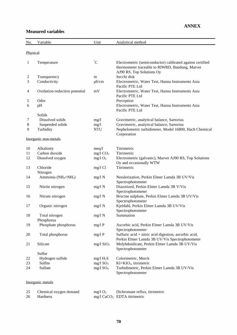
70
ANNEX Measured variables
No. Variable Unit Analytical method
Physical 1 Temperature °C Electrometric (semiconductor) calibrated against certified thermometer traceable to RIWRD, Bandung, Marvet AJ90 RS, Top Solutions Oy 2 Transparency m Secchi disk 3 Conductivity µS/cm Electrometric, Water Test, Hanna Instruments Asia Pacific PTE Ltd 4 Oxidation-reduction potential mV Electrometric, Water Test, Hanna Instruments Asia Pacific PTE Ltd 5 Odor Perception 6 pH Electrometric, Water Test, Hanna Instruments Asia Pacific PTE Ltd Solids 7 Dissolved solids mg/l Gravimetric, analytical balance, Sartorius 8 Suspended solids mg/l Gravimetric, analytical balance, Sartorius 9 Turbidity NTU Nephelometric turbidimeter, Model 16800, Hach Chemical
Corporation Inorganic non-metals 10 Alkalinity meq/l Titrimetric 11 Carbon dioxide mg/l CO2 Titrimetric 12 Dissolved oxygen mg/l O2 Electrometric (galvanic), Marvet AJ90 RS, Top Solutions Oy and occasionally WTW 13 Chloride mg/l Cl Titrimetric Nitrogen 14 Ammonia (NH4+NH3) mg/l N Nesslerization, Perkin Elmer Lamda 3B UV/Vis
Spectrophotometer 15 Nitrite nitrogen mg/l N Diazotized, Perkin Elmer Lamda 3B V/Vis
Spectrophotometer 16 Nitrate nitrogen mg/l N Brucine sulphate, Perkin Elmer Lamda 3B UV/Vis Spectrophotometer 17 Organic nitrogen mg/l N Kjeldahl, Perkin Elmer Lamda 3B UV/Vis Spectrophotometer 18 Total nitrogen mg/l N Summation Phosphorus 19 Phosphate phosphorus mg/l P Ascorbic acid, Perkin Elmer Lamda 3B UV/Vis Spectrophotometer 20 Total phosphorus mg/l P Sulfuric acid + nitric acid digestion, ascorbic acid, Perkin Elmer Lamda 3B UV/Vis Spectrophotometer 21 Silicate mg/l SiO2 Molybdosilicate, Perkin Elmer Lamda 3B UV/Vis Spectrophotometer Sulfur 22 Hydrogen sulfide mg/l H2S Colorimetric, Merck 23 Sulfite mg/l SO3 KI+KIO3, titrimetric 24 Sulfate mg/l SO4 Turbidimetric, Perkin Elmer Lamda 3B UV/Vis Spectrophotometer Inorganic metals 25 Chemical oxygen demand mg/l O2 Dichromate reflux, titrimetric 26 Hardness mg/l CaCO3 EDTA titrimetric

71
No. Variable Unit Analytical method
27 Cadmium mg/l Cd Shimadzu 630 AA, Shimadzu Corporation 28 Calcium mg/l Ca EDTA titrimetric 29 Chromium mg/l Cr Shimadzu 630 AA, Shimadzu Corporation 30 Copper mg/l Cu Shimadzu 630 AA, Shimadzu Corporation 31 Iron mg/l Fe Shimadzu 630 AA, Shimadzu Corporation 32 Lead mg/l Pb Shimadzu 630 AA, Shimadzu Corporation 33 Magnesium mg/l Mg EDTA titrimetric 34 Manganese mg/l Mn Shimadzu 630 AA, Shimadzu Corporation 35. Nickel mg/l Ni Shimadzu 630 AA, Shimadzu Corporation 36 Potassium mg/l K Shimadzu 630 AA, Shimadzu Corporation 37 Sodium mg/l Na Shimadzu 630 AA, Shimadzu Corporation 38 Zinc mg/l Zn Shimadzu 630 AA, Shimadzu Corporation Biological 39 Chlorophyll a mg/m3 Spectrofotometric (trichromatic), Perkin Elmer Lamda 3B UV/Vis Spectrophotometer
40 Phytoplankton 1/l Microscopic counting mg/l Microscopic identification and calculation

72
9 7 8 9 5 1 4 5 7 2 3 7 1
I SBN 9 51 - 4 5 - 72 37 - 8