explaining northern michigan snow - national … •if this is the case, the result is a longer...
TRANSCRIPT

Explaining Northern Michigan Snow(A “Big Picture” Viewpoint)
2010 Winter Talk Series

Background
• If you’ve attended our Winter Talk series
in the past, there’s a good chance
you’ve seen us discuss the science of
lake effect snow
• Lake effect snow is the single most
important factor as to why some parts
of Northern Michigan get so much more
snow than others

So: why does this map look like this?

Not to give away the answers, but…
• Prevailing wind direction during cold air
outbreaks
• “Fetch” and “effective fetch” lengths
• Elevation
• Proximity to a “warm” lake
• Ice cover

Prevailing Winds
• Lake effect snow will tend to develop over
the Great Lakes, as long as the air is cold
enough, and the water is warm enough
• Where the snow goes from there, depends
on where the wind is blowing
• Thus, the “prevailing wind” – our most
common wind direction – during periods of
cold weather is crucial

Prevailing Winds
• Wind Rose for Pellston,
MI (Nov-Feb)
• Dominance of
Northwesterly direction
– Particularly when cold air
is arriving!
NW
W
N
E
SSW SE
NE

Prevailing Winds & Fetches
• A “fetch” is the distance over which air is
moving over water, for a given wind direction
– Generally speaking, the longer the fetch, the more
snow the lake will be capable of generating
• Given that a northwest wind is our prevailing
winter wind, what kind of fetch does that
produce?

Prevailing Winds & Fetches
• The longest fetch,
and heaviest snow,
do NOT match up.
30
70
70
80
70
• So is there something we are we not accounting
for?
Fetches & Effective Fetches
• Yes - there’s another lake up there!
• An airmass will retain “lake effect
characteristics” on a short trip over land, IF
there is little terrain (hills/mountains) to
cross
• If this is the case, the result is a longer
“effective fetch” due to the air crossing
multiple lakes

Fetches & Effective Fetches
• As it turns out, the east half of the U.P. is
narrow, and does not have many hills
• The west half is “thicker” and much hillier,
and eliminates a Lake Superior contribution
to an effective fetch

Fetches & Effective Fetches
• Bingo!
• The longest
effective fetch,
and heaviest
snow, match up
nicely.
• In BOTH
Peninsulas!

• But why is
the heaviest
snow inland?
• It’s lake
effect;
shouldn’t it
be near the
lake?

Cold air
Warm water
Frictional
Convergence
and Upslope
Heat and Moisture
Recall How Lake Effect Forms
Precipitation

Elevation
• Elevation plays 2 key
roles
• Forced Ascent
• Colder Temperatures
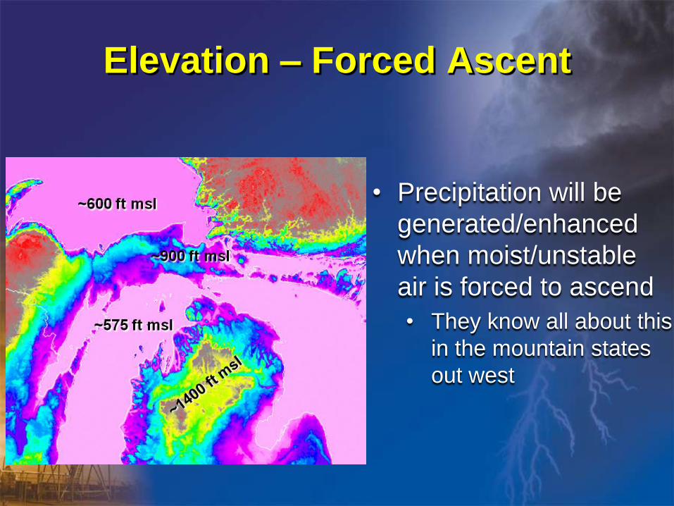
Elevation – Forced Ascent
• Precipitation will be
generated/enhanced
when moist/unstable
air is forced to ascend
• They know all about this
in the mountain states
out west

Elevation – Colder Temperatures
• Top of hills usually
colder
• May make the
difference between
rain and snow

Elevation• Conversely, precipitation will diminish/end as
air is forced to move downhill
• So snow showers will weaken as they move
toward NE Lower Michigan and Lake Huron

Elevation & “Warm” Lakes
• Most common early
in the snow season,
when coastal areas
will be warmed by
the warm lake
• It’s common to see
rain in Charlevoix,
and snow in GaylordDec 1 2009

• Same rules apply
to Eastern Upper
• But Superior is
colder, and
doesn’t hinder
coastal snow as
much as Lake
Michigan
Elevation & “Warm” Lakes

• What about St
Ignace?
• Surrounded
by water, but
doesn’t get
much snow
• The prevailing
wind is the
biggest
reason…
Elevation & “Warm” Lakes

Ice Cover
• Ice cover is another
reason
• The Straits region
freezes over quickly
in a typical winter
• Ice-covered water
does NOT generate
significant lake
effect snowJan 19 2009

The Home Stretch…
• Okay, we now have a handle on lake
effect snow and its distribution
• But, what about snow that doesn’t
originate from the lakes?

L
Typical Midlatitude Cyclone
SNOW MIX

Typical Cyclone Tracks

Midlatitude Cyclone Snow
• Numerous storm tracks pass east or even
well east of the region
• If we look at a county that sees relatively
little lake effect (e.g. Arenac), we probably
can assume a typical “synoptic snowfall”
• ~40 inches per year

In Summary
• Our snow comes from two sources
– Lake Effect
– Mid latitude cyclones
• Lake Effect depends on numerous microscale
factors
– Fetch/effective fetch, elevation, lake temperature, ice
cover, distance to shore, etc.

Any Questions???