expoliting indian military capacity in … indian...intelligence(elint) and navigation and targeting...
TRANSCRIPT
EXPOLITING INDIAN MILITARY CAPACITY
IN OUTER SPACE

EXPOLITING INDIAN MILITARY CAPACITY IN OUTER SPACE
By
Gp Capt GD Sharma, VSM (Retd)
Centre for Joint Warfare Studies (CENJOWS) New Delhi
Printed byXtreme Office Aids Pvt. Ltd.Basement Bhanot Building (Below Syndicate Bank) Nangal Raya Commercial Complex, N.D-110046Ph.: 9311156526E-mail: [email protected]: www.xtremeonline.in
Copyright (C) 2016, Centre for Joint Warfare Studies (CENJOWS), New DelhiISBN : 978-93-84492-19-9Price in India : ` 150 /-
All rights reserved
No part of this book may be reproduced, stored in a retrieval system, transmitted or utilised in any form or by any means, electronic, mechanical, photocopying, recording or otherwise, without the prior permission of the copyright owner. Application for such permission should be addressed to the publisher.
The views expressed in the book are of the author and not necessarily those of the Centre for Joint Warfare Studies/publishers.
Printed in India
1
There is an increasing dependence of military on outer space assets in all versions of wars/conflicts (nuclear,
conventional, and sub-conventional). This reliance is bornout of successful experience of using space assets by U.S. in 1991 Gulf war and thereafter in all subsequent conflicts. It has firmed up a belief in militaries world over that future military skirmishes cannot be fought without use of space assets. The space assets act as a facilitator as well as a force multiplier for the fighting forces. Now besides, U.S. many countries are using their space assets for the military. Among them Russia and China are already major space powers with considerable offensive and defensive space exploitation ability. Some developed nations of the European Union (England and France) too have considerable military space capability which is articulated in their space doctrines.1
In our neighbourhood,Pakistan lacks credible space ability but, China has made great strides in both civil and military exploitation of the space. Satellites have expanded its C4ISR capabilities, as well as ability to achieve space dominance with host of capabilities particularly in Electronic Intelligence(ELINT) and Navigation and Targeting with its
Expoliting Indian Military Capacity In Outer Space
1United Kingdom has articulated its aerospace doctrine in British Air and Space power doctrine AP3000 accessed at http://www.raf.mod.uk/rafcms/medi-afiles/9E435312_5056_A318_A88F14CF6F4FC6CE.pdf
2
navigation satellites (BeiDou) which from a regional coverage is expanding to provide global coverage with launch of more satellites. Apart from this, its successful foray in the Lunar missions (Change1&2), space stations (Tiangong 1&2) and conduct of five manned missions, showcase Chinese capability in the outer space.2 When international Space Station(ISS) retires in 2024, China alone will have its space station. The objective of the Chinese space station is not clear but, it could have long-term military implications. Some analysts estimate that People Liberation Army (PLA) wants to dominate the space high ground from LEO to the moon. In that effort, PLA’s future space lab could play a major role. It will be equipped with space cameras and dispensing payloads, and could be dedicated to space surveillance or combat missions.3 China has also demonstrated ASAT capability both at LEO and is also known to have tested missile launch to 30000 Km in the space which hints that China may even be able to target satellites of its adversary at MEO as well as in GSO. Assisted with credible submarine force, anti-ship and ASAT capability, Chinese are effectively pursuing their anti-access and anti-denial strategy. It has developed variety of capabilities to limit or prevent the use of space-based assets by adversaries during a crisis or conflict, including the development of directed-energy weapons and satellite jammers. Chinese anti-denial and anti-access capability is dependent on its space assets. To bolster its ELINT capability it has launched a constellation of 3 satellites in to 1100 Km, 63.4 degrees inclination orbit. This would enable continuous surveillance of high value targets to PLA.4 This capability has provided reliability in use of anti-ship ballistic system by Chinese against the adversary’s carrier task force. Contrary to the
2http://www.chinadailyasia.com/chinajourneytospace/2016-10/07/con-tent_15513209.html3http://www.strategycenter.net/research/pubID.247/pub_detail.asp4Space, war and security – A strategy for India by S Chandrasekhar – national institute of advanced studies
3
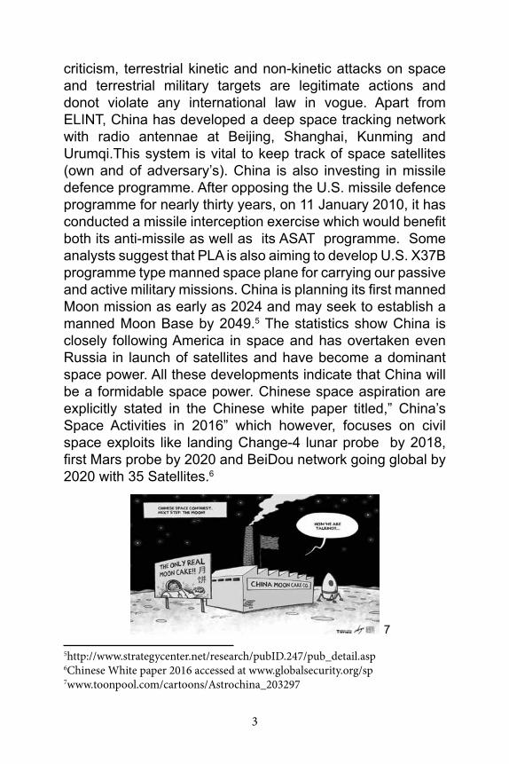
criticism, terrestrial kinetic and non-kinetic attacks on space and terrestrial military targets are legitimate actions and donot violate any international law in vogue. Apart from ELINT, China has developed a deep space tracking network with radio antennae at Beijing, Shanghai, Kunming and Urumqi.This system is vital to keep track of space satellites (own and of adversary’s). China is also investing in missile defence programme. After opposing the U.S. missile defence programme for nearly thirty years, on 11 January 2010, it has conducted a missile interception exercise which would benefit both its anti-missile as well as its ASAT programme. Some analysts suggest that PLA is also aiming to develop U.S. X37B programme type manned space plane for carrying our passive and active military missions. China is planning its first manned Moon mission as early as 2024 and may seek to establish a manned Moon Base by 2049.5 The statistics show China is closely following America in space and has overtaken even Russia in launch of satellites and have become a dominant space power. All these developments indicate that China will be a formidable space power. Chinese space aspiration are explicitly stated in the Chinese white paper titled,” China’s Space Activities in 2016” which however, focuses on civil space exploits like landing Change-4 lunar probe by 2018, first Mars probe by 2020 and BeiDou network going global by 2020 with 35 Satellites.6
5http://www.strategycenter.net/research/pubID.247/pub_detail.asp6Chinese White paper 2016 accessed at www.globalsecurity.org/sp7www.toonpool.com/cartoons/Astrochina_203297
7
4
In comparison to China, India too has made great strides in the civil space and in deep space research. The Chandrayaan-1 moon mission launch in 2008, Mars orbital mission launch in end of 2013, Reusable Launch vehicle technology Demonstrator (RLV-TD) all point at tremendous progress made by ISRO in space technology which matches the best in the world but, its progress in the military space is minimal.8
India’s journey towards military space has been stunted not because from lack in capability but, lack of thrust in specific area of Military. There has been limited use of space by the military with dual use of civil satellites on time sharing basis. Despite the demand from the military, no dedicated military satellite were launched for long. The major changes in India’s space programme ensued after china’s aggressive military space developments like ASAT test in 2007and growing ties with Pakistan.
India made a beginning in August 2013 by launching a dedicated military satellite GS at-7 for the Navy with a promise to launch similar satellites for the other two services in due course of time. Hence, while India does not lack in technical capability, it is shying away in use of space purely for military.
Implications of China’s Space Prowess to India. China’s has an overwhelming numerical and qualitative advantage in conventional and strategic arena. It has long term aim to take over Taiwan. In this endeavor, it foresees U.S. intervention. To counter that it has generally focused on developing anti access and area denial weapons such as DF-21D, to deter the seaward approach of the American Naval Armada, ballistic missile defences and kinetic energy weapons (ASAT) to target American C4ISR satellites which could support their operations in the area. Launch of an Independent
8http://www.isro.gov.in/about-isro/isros-timeline-1960s-to-today#98
5
Navigation satellites system (BaiDou) and constellation of ELINT satellites is indicating its effort to consolidate in this arena. Even though India may not be seriously considered in China’s defence calculations but, by implications Chinese weapons cover mainland India and Indian Ocean region. With China focusing more on space enabled military operations, it is essential that India too makes serious moves to enhance the military capability with existing space assets as well as launch satellites for the dedicated military use. However, before this done, it is incumbent to lay down priority areas for development of military space architecture.
In that, C4ISR, Space Surveillance Awareness (SSA), ELINT, Communication and data relay, navigation, real-time weather over the area of operation, geodesy and finally ASAT capability are most desired for the modern military to deter as well as bolster its capacity to fight the adversary. However, there remains a dilemma as which areas to be given priority in development over the others. This is also dependent on our ability to launch the space assets to take up these functions.
Areas Needing Attention in Order of Priority.
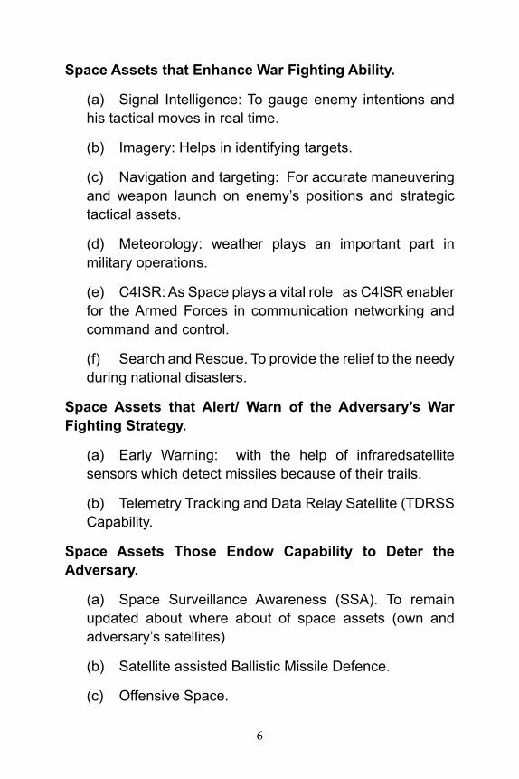
(a) Space assets that enhance war fighting ability of the armed forces.
(b) Space assets that give alert/ warning ability over the adversary’s war fighting strategy.
(c) Space Offensive capability that endow capability to deter the adversary.
Above prioritization of space assets will ensure that first, we boost up our fighting ability while following the current war fighting practices. Then follow this up with development of areas which provide the force multiplication effect and finally develop capacity to deter the adversary to carry out kinetic/ cyber strike on our space assets.
6
Space Assets that Enhance War Fighting Ability.
(a) Signal Intelligence: To gauge enemy intentions and his tactical moves in real time.
(b) Imagery: Helps in identifying targets.
(c) Navigation and targeting: For accurate maneuvering and weapon launch on enemy’s positions and strategic tactical assets.
(d) Meteorology: weather plays an important part in military operations.
(e) C4ISR: As Space plays a vital role as C4ISR enabler for the Armed Forces in communication networking and command and control.
(f) Search and Rescue. To provide the relief to the needy during national disasters.
Space Assets that Alert/ Warn of the Adversary’s War Fighting Strategy.
(a) Early Warning: with the help of infraredsatellite sensors which detect missiles because of their trails.
(b) Telemetry Tracking and Data Relay Satellite (TDRSS Capability.
Space Assets Those Endow Capability to Deter the Adversary.
(a) Space Surveillance Awareness (SSA). To remain updated about where about of space assets (own and adversary’s satellites)
(b) Satellite assisted Ballistic Missile Defence.
(c) Offensive Space.
7
SPACE ASSETS THAT ENHANCE WAR FIGHTING ABILITY
Signal Intelligence (SIGINT): It encompasses both the Electronic Intelligence (ELINT) and Communication Intelligence (COMMINT). ELINT will warn of enemy’s AD radar ORBAT and use of enemy electronic devices including devices used by guided missiles, guided missile launchers, fighter aircraft, long range and short-range navigational aids, anti-aircraft and aircraft fire control radar, blind bombing devices etc. This information is vital to know to the enemy’s Order of Battle (ORBAT) in the real time. Developed nations including our northern neighbor has launched cluster of satellites to keep its adversaries under observation.
Current Capability. U.S. and former Soviet Union (Russia) for more than 40 years had the proven space based SIGNIT capability. U.S. launched its first experimental ELINT satellite in 1960. As per some Chinese analysts, U.S. is currently operating nine to 11 ELINT satellites. The former Soviet Union also launched over 200 satellites between 1967- 1991. Russia presently is known to maintain at least two ELINT satellites after fall of Soviet Union albeit at a scaled down level despite massive setbacks. China too has begun deploying a robust network of ELINT and imagery satellites in order to locate and track large warships, mobile air defense systems, and other critical defense systems. As per a U.S. study, China has developed two ELINT gathering constellations, one comprises two and other three orbital satellites in low earth orbit.9 It is reported to have launched a constellation of three satellites in 2010. This has enabled People Liberation Army (PLA) to keep in surveillance high value targets such as aircraft carriers in pursuance of its anti-access and anti-denial policy.
9https://www.project2049.net/documents/china_electronic_intelligence_elint_satellite_developments_easton_stokes.pdf
8
Indian Capability. Our capability in electronic intelligence is woefully low and gets reflected time and again in our failure to detect border intrusions by regular forces and the terror groups sponsored by our neighbouring country. The implication is that we may remain oblivious of some intelligence which then is correlated with other sources for confirmation. This capability needs to the bolstered up by launching our own cluster of satellites to keep watch on our adversaries as well respond to threat with credible intelligence.
Implications of Chinese ELINT Programme. In our neighbourhood, in comparison to Pakistan, Chinese capability alone has holds serious implications not only for India but for the entire Asia-Pacific region, U.S. and other regional players naval and air operations, air defense systems, communications security, counter space requirements, and nuclear deterrence. It however, could become useful source of information to Pakistan as well. A robust space-based ELINT capability would also enable Chinese strategists and war planners to monitor adversary’s naval and air operations as well as peace time exercises, providing highly useful intelligence for war planning.10 The implications in specific areas are explained below:-
(a) Naval and Air Operations: The space based ELINT capability will enable the Chinese to accurately track the adversary’s Naval and air operations as well as peacetime exercises which will provide useful intelligence for war planning. It will give ability to accurately track and target carrier strike groups in near real-time from lower earth orbit as part of China’s Anti-shipping Ballistic Missile (ASBM) system.
(b) Air Defence System. A robust ELINT capability allows locating and monitoring adversary’s Air defence system and thus cataloging information on Electronic
10Ibid
9
Order of Battle. This helps in planning accurate strikes to destroy the adversary’s air defence capability when needed. Without assured an Air defence system it is difficult to win in any war.
(c) Communications Security. A robust SIGNIT satellite in the Geosynchronous Earth orbit (GEO) will enable the Chinese to monitor global communication providing vital information on the military and strategic decisions. Compromising of communication can have serious implications on military operations and strategic matters.
(d) Counter Space Requirements. It enables developing capability in counter space operations. For example,United States knowing that the Chinese ELINT capability is the corner stone on China’s anti-access and anti-denial strategy may have developed counter space ability to offset Chinese anti-access and anti-denial ability. It is most likely to be non- kinetic in the realm of cyber warfare due to universal concern on space debris.
(e) Nuclear Deterrence. The SIGINT and ELINT has the potential to provide the world wide missile launch surveillance and early warning capability which naturally would strengthen the nuclear deterrence and missile defence posture.
Our Requirement. According to a study carried out by National Institute of Advanced Studies,India would need to launch a cluster of at least 3 ELINT satellites for obtaining continuous coverage of our air space just as China has done by launching a constellation of Yaogon series of military satellites. This is a key requirement for a limited regional ISR.11 Using three satellites we can get the advantage of high precision, broad coverage area and long endurance.
11Space , War and Security- A Strategy for India Dec 2015
10
Imagery
Satellite imagery has several civil as well as military applications. During the early nineties, U.S. and Soviet Union were the only countries with any meaniful satellite imagery capability. Several countries are now capable of high quality satellite imagery in terms of resolution, spectral coverage, revisit time, and data-delivery time. Data from these systems has significant military utility for Bomb Damage Assessment(BDA), current intelligence, detection, targeting, and surveillance. Further, rapid revisit, rapid data delivery, and day/night, all-weather capabilities boost the military capability than mere improved resolution. ISRO in a recent a news brief confirmed that India’s Cartosat series of satellites have played a crucial role in localizing the terrorists targets(launch–pads) for Indian Military surgical strike after the Uri mayhem in which 19 Indian soldiers were burnt alive by the terrorists pushed across by Pakistani regular army.12 As per a study China has nine imaging satellites and another five satellites with SAR capabilities in LEO, mostly to meet the need of the military.13
Indian Capability. India has in place a complement of remote sensing satellites equipped with both electro-optical and Synthetic aperture radars. Till date, ISRO has launched twenty remote sensing satellites. Of these, 11 are still in service and provide earth observation data with a resolution up to 1m, which is at par with the world standard but, cartosat series observation are susceptible to weather and night limitation which has been overcome with launch of like Risat-2 and Risat 1 which are capable of all-weather earth observation with on board X band radar/ synthetic aperture radar. Risat- 2 was launched following the Mumbai attack whereas, Risat-1 was launched later in 2012 has a synthetic aperture radar and all weather and all conditions detection capability. The
12TOI news :30 Sep 1613www.planet4589.org/space/papers/china2014:pdf
11
synthetic aperture radar provides a resolution of 3m-50m which while meeting the operational need is well below the world standard.14
The key features like good spatial and spectral resolution are vital in the military. As on now, our space assets essentially cater for the civilian needs but, data is also available on demand to the military on dual use basis.Currently, a family of satellites comprising Resourcesat 1 & 2 and recently launched 2A, Cartosat 1, 2, 2A, and 2B, Oceansat-2 and Risat-1, all indigenous satellites bestow adequate capability to meet most of our needs. But despite these, India does not get uninterrupted observation of the interested area which is possible only if India launches constellation of satellites for observation which is an emerging trend.
Abroad, even private sector has moved in and provides data on lease basis. For example, Planet laboratories, a San Francisco based start-up company has launched more than 100 small satellites which weigh around 5 kg each and are launched as a constellation in the earth orbit of various inclinations for round the clock observation of the area of interest. Built on the low cost off the shelf components and launched in large number, these promise to be extremely useful for the ISR needs of the military.15 An experimental effort with smaller constellation of small satellites in the realm of 100 to 150 kg class could be thought in future to strengthen ISR capabilities of our military.
Space Based Navigation System
GPS devices have become an integral part of the Command, Control, Communications, and Intelligence, Surveillance and Reconnaissance or C4ISR structure, considered a vital key
14Hindu . 25 Apr 2012 accessed at http://www.thehindu.com/sci-tech/technolo-gy/article3350204.ece15Space, War and security – A Strategy for India. A NIAS publication ,P51
12
to the successful battle field strategy. Apart for navigation of the manned platforms, the navigation system is vital for operation of unmanned platforms for beyond the line of sight operations. Indian Armed forces have been using foreign navigation systems till now. They have been mainly dependent on the American GPS for navigation and targeting data but, this data will either be not available or could be erratic and not good enough for use by the armed forces at the crucial junctures. Especially as position, velocity and timing accuracy are very important for the military for successful operations.16
To meet our civil and military GPS needs, we have followed two kinds of approaches. In the first approach, indigenous GPS Augmentation system, GAGAN has been operationalized recently for the civil aviation users and enables navigation and precision landing of aircraft in India. The system uses the precisely positioned network of ground stations to eliminate some of the systematic errors in the reception of GPS signals. These error corrections are continuously transmitted to the users with in the region via geostationary satellites which then correct the GPS based positions.
To eliminate dependence on the foreign navigation systems,we recently operationalized own Indian Regional Satellite Navigation System (IRNSS) which will be used by both civil and military. It consists of a constellation of seven satellites (four in geosynchronous orbit and three geostationary). It will provide service to civil and encrypted data to the military users. Presently,it covers an area of 1500 km beyond our boundaries which could be extended after more satellites are added to the constellation. The accuracy of the system is below the foreign systems (30M). In
16During the kargil war, Indian military was denied access American GPS. A need for an indigenous satellite navigation system was felt earlier, but the Kargil experience made the nation realize its inevitability.
13
comparison, High quality GPS Sps receivers attain better than 2.168 meter horizontal accuracy as to of the time.17 Whereas; Chinese BeiDou has positioning accuracy of 10 meters and will eventually have 35 satellites for a global coverage. Thus, coverage and accuracy are still the issues with our GPS. As our area of interest increases; we need to enhance the capacity of our GPS in both respects. Nevertheless, IRNSS would serve as an invaluable component of the network centric warfare and a “force multiplier” for the Indian defence forces especially during the wartime to counter the possibility of international navigation satellite service operators denying access to the Indian armed forces.
C4ISR
Seamless glitch free communication network and real time situational awareness are vital in military operations. Availability of Space based communication, GPS, robust ISR and tracking and data relay space satellites enable C4ISR environment. These requirements are necessary for growing in field and unmanned platforms. Even in U.S. prior to 9/11, the focus was on military-based satellite resources to cover operations. After 9/11, with conflicts in Iraq and Afghanistan, the ground, air and sea units depend upon mobile, data-intensive applications, such as streaming video for Intelligence, Surveillance and Reconnaissance (ISR). As it is not possible to have uninterrupted coverage with the military satellites alone, the services are increasingly relying on the civil/ commercial satellites for their data/ video requirements.
17WHY AN INDUSTRY PARTNERSHIP IS CRITICAL TO THE GOVERN-MENT’S. A paper presented in 32 space symposium on April 12, 2016. Accessed at https://www.spacesymposium.org/sites/default/files/tt_pa-pers/Cowen-Hirsch,%20Rebecca,%20WHY%20AN%20INDUSTRY%20PARTNERSHIP%20IS%20CRITICAL%20TO%20THE%20GOVERN-MENT%E2%80%99S%20FUTURE%20IN%20SATELLITE%20COMMUNICA-TIONS%20.pdf
14
The services do not mind as long as results are in the form of maximum capability, flexibility and resiliency.18
Presently, Indian armed forces use transponders on lease from the civil communication satellites on time sharing basis for communication. This approach should continue as it is cost effective and gives some extent of protection from the enemy hostile action, who will not target the civil satellites to avoid adverse reaction from the international community, yet these could be susceptible to cyber-attacks. The defence requirement is for seamless connectivity, wide coverage, assured access i.e. be available on demand, should have protection from information warfare and flexibility to match dynamic operational environment.19 Therefore, each service should also have its own dedicated satellite for specialized functions. DRDO has planned to build and launch a series of defence spacecraft systems with surveillance, imaging and navigation capabilities that would help keep an eye on hostile developments including the movement of terrorists and militants in the neighbourhood of the country.20
In year 2013, a dedicated defence satellite GSAT-7 was satellite was launched. This is expected to have enhanced our vigilance across the oceanic waters around India which can be used by terrorists, smugglers, drug runners and sea pirates to threaten Indian security. Armyand IAF, each have their own requirements.ISRO has plans for launching independent satellites but, their time frame has not been made public. With the satellites in orbit, Indian defence forces would be in a position to get a holistic picture of the movement of troops and
18The US Defense business board in its report has recommended to the Secre-tary of defense to leverage the opportunities from the commercial communi-cation satellites,. Accessed at http://dbb.defense.gov/Portals/35/Documents/Reports/2013/FY13-02%20Taking%20Advantage%20of%20Opportunities%20for%20Commercial%20Satellite%20Communications%20Services.pdf19http://www.strategic-affairs.com/details.php?task=other_story&&id=63820http://isro.gov.in/applications/satellite-aided-search-and-rescue
15
such other things including the existence of terrorist camps in the immediate neighbourhood.
India’s ability in satellite communication is adequate. Similarly, India’s capability in surveillance and reconnaissance part of the ISR are close to the world standard except that thermal (infrared) part of the spectrum are poor and need to be strengthened for use by our BMD system after it is operationalized. We also have serious gaps in ELINT and TDRSS capability. The weakness in the ELINT have been already been explained above. As regards to TDRSS,this is considered vital for C4ISR connectivity beyond our shores, and has been dealt separately.
Search and Rescue.
India’s effort towards Satellite aided search and rescue is adequate. ISRO has launched series of INSAT multipurpose satellites to provide telecommunication,broadcasting,meteorology and search and rescue services which are availed by both civil and military. The satellites incorporate transponder(s) for receiving distress alert signals for search and rescue missions in the South Asian and Indian Ocean Region. Besides, ISRO is also a member of the International Satellite System for search and Rescue (COSPAT-SARSAT)programme which is a joint effort of the United States, Canada, France and former Soviet Union. Under this programme, India has established two Local User Terminals (LUTs), one at Lucknow and the other at Bengaluru. The Indian Mission Control Centre (INMCC) is located at ISRO Telemetry, Tracking and Command Network (ISTRAC), Bengaluru that picks up and relays alert signals originating from the distress beacons of maritime, aviation and land users.
Indian LUTs provide coverage to a large part of the Indian Ocean region rendering distress alert services to Bangladesh, Bhutan, Maldives, Nepal, Seychelles, Sri Lanka
16
and Tanzania. The operations of INMCC/LUT are funded by the participating agencies, namely, Coast Guard, Airports Authority of India (AAI), and Directorate General of Shipping and Services. Indian satellites which cover the search and rescue services are INSAT-3A which was launched in 2003 thereafter; INSAT3-D was launched in 2013 to maintain continuity in SAR services. The other satellites which provide these services are GSAT-7, GSAT10 and Kalpana .
The distress alert messages concerning the Indian service area, detected at INMCC, are passed on to Maritime Rescue Coordination Centers (MRCCs) of Indian Coast Guard (Mumbai, Chennai, Port Blair), and Rescue Coordination Centers (RCCs) of AAI (Mumbai, Kolkata, Delhi, Chennai). The search and rescue activities are carried out by Coast Guard, Navy and Air Force. The Indian LUTs and MCC provide round the clock service and maintain the data base of all 406 MHz registered beacons carried on board Indian ships and aircraft.21
Meteorology
Weather plays an important part in the military operations. All major space faring nations have launched weather satellites. India had followed a multipurpose satellite approach (INSAT Series) to cater for different services including the weather. The services are at par with the world standards. INSAT system is also providing meteorological services through Very High Resolution Radiometer and Charged Coupled Device (CCD) cameras on some of its spacecraft. Cyclone monitoring through meteorological imaging and issue of warnings on impending cyclones through disaster warning receivers have been operationalized. For this, 350 receivers have been installed along the east and west coasts of India.22 At the time of crisis these receivers are swiched on via a satellite and broadcast siren and local language warnings.
21http://www.archive.india.gov.in/sectors/science/index.php?id=1622http://space.au.af.mil/au-18-2009/au-18_chap17.pdf
17
SPACE ASSETS THAT ALERT/ WARN OF THE ADVERSARY’S WAR FIGHTING STRATEGY.
Early Warning.
As brought out earlier our weakness in early warning stems from non-availability of space based ELINT constellation necessary for real-time intelligence of the adversary. At the same time, we also do not have the ability to intercept the enemy missiles launched at us. The early warning of the missile launches is essential to intercept the missile threat before these hit our soil. United States and Russia and some European nations like France possess missile launch detection system to warn of launch of adversary’s launch of missiles. U.S. uses Space Based Infrared System (SBIRS) to protect United States and Canada . This system replaced U.S. earlier system based on Defense Satellite Programme(DSP). Missile warning system is controlled by U.S. Strategic Command in support of North American Air Defence (NORAD) to protect continental United States and Canada from ballistic missile attack.23
Former Soviet Union followed a similar trajectory, though lagging the United States in the development of space based systems. Russia too has space missile launch facility which is likely to be impaired and being assisted by ground based radars in detecting incoming nuclear missiles24, 25
China is known to use four Long Phased Array Radars (LPAR) sites at Huian, Korla, Longgangzhen and Shuangyashan that provide coverage of most of Russia, Central Asia, India and Taiwan/Southeast Asia. They can be used to support either anti-satellite attacks or a ballistic-missile
23https://www.thespacereport.org/resources/infrastructure/missile-detection-sat-ellites/other-countries-missile-detection-defense24https://themoscowtimes.com/articles/russian-nuclear-missile-detection-capa-bility-limited-by-satellite-launch-delays-4378025http://www.rediff.com/news/slide-show/slide-show-1-defence-news-why-chi-na-does-not-fear-indias-missiles/20140715.htm#5
18
early-warning function.26 However, despite having the technical know how (displayed with targeting of a weather satellite in 2007), there is no firm evidence of China having deployed a space-based ballistic missile early warning capability.27 But, the fact that China is developing ballistic missile defence of its own it is expected to have its missile detection capability. It is also reported that taking in to account the American deployment of terminal High altitude Area Defence missile system in South Korea, China and Russia are likely establish a joint missile warning system to neutralize what they see as national security threats stemming from the radar coverage of the United States’ Terminal High Altitude Area Defense (THAAD) missile system to be deployed to South Korea in 2017.28
Among western countries France has launched two micro satellites (SPIRALE in HEO) in 2009 which serve as demonstrator for missile warning capabilities. On the other hand, United Kingdom could be relying on the United States for early warning on missile launch.
Despite our recessed nuclear status and following the second strike strategy, India must not allow its citizens to suffer the horror of nuclear attack, therefore, must have the ability to neutralize the ballistic missile threat which is possible only with its own credible space missile warning system. Besides, the system is needed to warn of the repeat missile attack by the adversary armed with a conventional or a strategic war head.
Telemetry Tracking and Data Relay Satellites Capability. (TDRSS).
It is well known that India’s strategic area of interest lies from
26http://www.globalsecurity.org/space/world/china/warning.htm27http://www.chinatopix.com/articles/99396/20160827/china-russia-consid-er-joint-missile-warning-system-counter-thaad.htm28Space, War & Security - A Strategy for India
19
Gulf of Oman in the west, Indian Ocean region and extends to Malacca Strait in the East. With increase in India’s stature and economic interests in Indo- pacific region including in the South China Sea, it is incumbent to extend our communication range to safeguard our interests. The geographic increase in Indian area of interest demands that all information from space and ground assets is received and relayed to the centralized command and control nodes. A network of ground stations cannot possibly carry out this function adequately. Two or three tracking and data relay satellites in orbit can collate the coverage of our ISR assets form wide areas. United States, Russia, China and Japan have such satellites in orbit. United States, being the leader in space technology has nine such satellites, Russia three, Japan one and our northern neighbor china has three TDRSS satellites which cover their area of interest. Three Chinese satellites are meant to exercise command and control on the manned space programme and constellation of ISR satellites.29 The TDRSS concept employs geostationary satellites to provide relay links for Telemetry, Tracking and Command (TT&C) between multiple low earth-orbiting user satellites and a centrally located ground station. A third generation TDRSS satellite comprises multiple, single access and omnidirectional antennas to receive and transmit information and space to ground links.30
India does not have TDRSS satellites. As per the assessment of the National Institute of Advanced Studies (NIAS), India needs at least three such satellites with at least two of them operational at any given time. Indian capability to collate inputs from large areas enhances its command and control capability that would give operational efficiency. The satellites are expected to be in region of 3000Kg to 4000 kg wt. India does not have a launch vehicle which can insert this mass at
29https://www.nasa.gov/content/tracking-and-data-relay-satellite-tdrs-third-gen-eration-capabilities/30Space , War & Security – A Strategy for India
20
the geostationary level till GSLV MK3 becomes operational.31
SPACE ASSETS THOSE ENDOW CAPABILITY TO DETER THE ADVERSARY
Space Surveillance Awareness (SSA)
We have adequate capability to monitor and track the active Indian satellites and space launches that emit radio signals but, our capabilities in tracking the inactive satellites and space launches is extremely limited. If we are to protect our satellites from the enemy action as well as from the risk posed by exponential increase of dead satellites and space debris,we would need our own SSA and like now not remain dependent on warning information from United States. We need to track the adversary’s satellites and missiles as well as space debris which may damage our space assets. This ability apart for from deterrent value will ensure that our space assets are safeguarded from being accidentally hit by space debris and may require giving suitable manoeuvres to own satellite in the flight path of the debris whenever required.
Missile Defence System
Indian need for missile defence has been the subject of discussion in the strategic circles with arguments both in against and favour. India being surrounded by nuclear neighbours, China, with an inventory of more than 250 nuclear weapons and hundreds of missiles, and Pakistan, with more than 100 nuclear weapons and a rapidly growing arsenal controlled by the army, the emanating threats justify the creation of a BMD capability by India especially, as one of our neighbour routinely threatens strike with nuclear weapons. Further, China is developing new technologies to implement its anti-Access and
31India and Ballastic Missile defence : Furthering a Defensive deterrent ; Balra-jNagalhttp://carnegieendowment.org/2016/06/30/india-and-ballistic-missile-de-fense-furthering-defensive-deterrent-pub-63966
21
anti-Denial strategy for the Western pacific. These technologies also impact targets on the Indian mainland and Indian Ocean region so robust BMD is an operational necessity.32 BMD will deter the adversary from nuclear misadventure while creating space for a limited war.
In early eighties, when US President announced Strategic Defense Initiative (SDI) there was all round criticism including by India. But, India conceded to realism after frequent nuclear rattling by Pakistan. The changed view also helped us in concluding nuclear deal with United States. DRDO claims it have developed indigenous capability to intercept incoming Ballistic missiles 2000km away and this capability would be enhanced to meet missiles with a range of 5000km which with land based detection system does not appear credible. The system is yet to be operatized meanwhile media reports suggest that India is purchasing few batteries of formidable S-400 from Russia for deployment in Delhi and Mumbai. One of the requirements for a successful interception is that the incoming missiles are detected as far away as possible. The credible capability is possible only if satellites are used to detect the missiles. Satellites equipped with infrared sensors can do this effectively. So far only Russia and United States have demonstrated this capability. India does not have missile surveillance capability. Hence, BMD assisted with space detection should be high on our priority list. India’s BMD system, once deployed, should include sensors, space-based surveillance, monitoring and detection systems, ground- and space-based tracking systems, intelligence assessment centers, command and control centers, and interceptor units. The particular deployment option which India chooses will determine the size and scope of the system. BMD will provide strategic stability as it reduces the incentive for a nuclear first strike because BMD will protect political leadership and
32Ibid
22
guarantee a second-strike capability.33
Offensive Space Capability
Though America and former Soviet Union had credible offensive space capability, India took notice of offensive space with the Chinese ASAT test in 2007 in which it targeted its own weather satellite in low earth orbit. Thereafter, there has been a demand from the domestic strategic community to carry out an ASAT test, lest we willy-nilly land in a state similar to after promulgation of Nuclear Nonproliferation Treaty(NPT) which bars non-nuclear states from testing and possessing nuclear weapons.34
There are many ways space satellites could be destroyed besides the Kinetic mode as the Chinese did in 2007. A spacecraft could simply approach a satellite and spray paint over its optics, or manually snap off its communications antennas, or destabilize its orbit. Lasers can be used to temporarily disable or permanently damage a satellite’s components, particularly its delicate sensors, and radio or microwaves can jam or hijack transmissions to or from ground controllers.35 United States which has been an undisputed leader in the space technology is now being challenged by Russia and China. Outer Space Treaty 1967 bans location of weapons in the outer space but not the ground based weapons that can target the satellites. India therefore, would
33India despite having the capability did not test a nuclear weapon after the Chinese nuclear test in 1964. Subsequently, NPT 1970 recognized only five states with nuclear weapons (Current permanent members of the Security Council) as nuclear weapon state. India despite testing the nuclear weapon in 1998 is not recognized as a nuclear weapon state and faces attendant disadvantages.34“War in space may be closer than ever” an article in Scientific American . Accessed from https://www.scientificamerican.com/article/war-in-space-may-be-closer-than-ever/35Ibid
23
need to develop offensive space capability itself so that the fear of mutual threat to the adversary’s satellites would deter it from taking offensive actions.
Apart from ASAT capability we have options to develop soft kill technique including hacking of the controls, dazzling lasers, jamming microwaves, so that we react robustly to any threat whenever an imminent threat is perceived .36
offensive space control and active defense are the options for a space power while the former makes clear reference to weapons. The Active defense measures refer to offensive counter measures that could be taken against an attacker. But no offense / defence action is possible unless we have space surveillance system that looks out at the heavens and tracks everything.
It is in public knowledge that DRDO is developing indigenous Ballistic Missile Defence capability. According to DRDO by tweaking ballistic missile defense technology it can even target the satellites. At the same time we should give attention to less intrusive soft kill techniques to counter the space offensive by our adversary.
CONCLUSION
Space domain has a major stake in ensuring national security. Ignoring this domain would impinge on the nation’s capability to meet the external threats adequately. India despite making great strides in civil space domain is yet to exploit this domain for use of the military to squarely meet the emerging threats from our neighborhood. In our quest to build our capacity in the military space, we need to prioritize our requirements and develop these systematically. The areas that need specific
36Excerpts from the interview of Dr. VK Saraswat in India Today .Accessed at http://indiatoday.intoday.in/story/agni-v-drdo-chief-dr-vijay-kumar-saraswat-interview/1/186248.html
24
attention are space operations that enable C4ISR functions of the armed forces, early warning with uninterrupted observation of the area of interest and to warn of ballistic missile launches by our adversaries, space surveillance awareness to keep an eye on own and adversary’s space assets ,Telemetry Tracking and Data Relay Satellite (TDRSS) capability to extend our ability to operate beyond our shores and finally offensive space capability with a focus on soft kills techniques.
Indigenously designed Ballistic Missile Defence System by DRDO is at an advanced stage of development. As per the former DG of DRDO, Dr. Saraswat, it can be tweaked to carry out anti-satellite role if needed. The integral Long Range Tracking Radar with enhanced tracking range of 1400 km could be used to track and shoot the satellites.37 The ballistic Missile defence together with offensive capability to deal with hostile satellites would ensure protection and provide strategic stability in the region.