fairfax county park authority · cindy walsh, director, resource management division (rmd) ... the...
TRANSCRIPT

Fairfax County Park Authority
Approved July 26, 2000
Revision Approved
January 24, 2018
Turner Farm Park Master Plan Revision – Approved 2018
ACKNOWLEDGEMENTS
FAIRFAX COUNTY PARK AUTHORITY BOARD William G. Bouie, Chairman, Hunter Mill District Vacant, Vice Chairman, At-Large Member Linwood Gorham, Treasurer, Mount Vernon District Michael W. Thompson, Jr., Secretary, Springfield District Walter Alcorn, At-Large Member Dr. Cynthia Jacobs Carter, Lee District Maggie F. Godbold, Sully District Timothy B. Hackman, Dranesville District Ronald Kendall, Mason District Faisal Khan, At-Large Member Ken Quincy, Providence District Kiel Stone, Braddock District
SENIOR STAFF Kirk W. Kincannon, Executive Director Aimee Long Vosper, Deputy Director / Chief of Business Development Sara Baldwin, Deputy Director / Chief Operating Officer David Bowden, Director, Planning & Development Division (P&D) Todd Brown, Director, Park Operations Division (POD) Barbara Nugent, Director, Park Services Division (PSD) Cindy Walsh, Director, Resource Management Division (RMD) Judith Pedersen, Public Information Officer
PROJECT TEAM Andy Galusha, Project Manager, Park Planning Branch (PPB), P&D Andrea Dorlester, Manager, PPB, P&D Gayle Hooper, Senior Landscape Architect, PPB, P&D Adam Wynn, Landscape Architect, PPB, P&D Juan Du, Park Planner, PPB, P&D Michelle Meadows, Senior Right-of-Way Agent, Real Estate Service Branch, P&D Andy Miller, Manager, Project Management Branch (PMB), P&D Diana Imlay, Engineer, PMB, P&D Tom McFarland, Engineer, PMB, P&D Kristen Sinclair, Ecologist, Natural Resources Management Branch (NRM), RMD Liz Crowell, Manager, Archaeology & Collections Branch (ACB), RMD David Buchta, Manager, Historic Preservation Branch, RMD Denice Dressel, Project Manager, Resident Curator Program (RCP), RMD Margaret Puglisi, Assistant Project Manager, RCP, RMD Yvonne Johnson, Manager, Frying Pan Farm Park, RMD Wayne Brissey, Manager, Area 6, POD Chris Goldbecker, Lakefront Parks Manager, PSD

Turner Farm Park Master Plan Revision – Approved 2018 i
TABLE OF CONTENTS
I. INTRODUCTION .......................................................................................................... 5
A. PURPOSE & PLAN DESCRIPTION ................................................................... 5
B. PLANNING PROCESS & PUBLIC INVOLVEMENT ........................................... 6
II. PARK BACKGROUND ............................................................................................... 7
A. LOCATION & GENERAL DESCRIPTION .......................................................... 7 B. CONTEXT .......................................................................................................... 7
C. ADMINISTRATIVE HISTORY .......................................................................... 10 D. PARK CLASSIFICATION ................................................................................ 12
E. PARK & RECREATION NEEDS ...................................................................... 13
III. EXISTING CONDITIONS ......................................................................................... 16
A. NATURAL RESOURCES ................................................................................ 16 1. Geology ....................................................................................................... 16
2. Soils ............................................................................................................. 16 3. Topography .................................................................................................. 20
4. Hydrology ..................................................................................................... 20 5. Natural Communities - Plants & Animals ..................................................... 23
B. CULTURAL RESOURCES .............................................................................. 28 1. Native American Prehistory (Prior to circa 1650 AD) ................................... 28 2. Historic (circa AD 1650 – Present) ............................................................... 29
C. EXISTING HISTORIC STRUCTURES ............................................................ 32 1. Turner Farm House...................................................................................... 32
2. Garage with Apartment ................................................................................ 33 3. Tractor Shed/Crib Barn ................................................................................ 33
4. Milk House ................................................................................................... 34 5. Turner Farm Dairy Barn ............................................................................... 34
6. Observatory Towers..................................................................................... 35 D. EXISTING INFRASTRUCTURE ...................................................................... 35
1. Utilities ......................................................................................................... 35 2. Vehicular Access ......................................................................................... 35
3. Pedestrian Access & Trails .......................................................................... 37 E. EXISTING USES & OPERATIONS.................................................................. 37
IV. PARK ASPIRATIONS ............................................................................................. 38
A. PARK PURPOSE ............................................................................................ 38
B. VISITOR EXPERIENCE .................................................................................. 38 C. MANAGEMENT OBJECTIVES ........................................................................ 39
V. GENERAL MANAGMENT PLAN ............................................................................. 40
A. ENTRANCE ZONE ........................................................................................... 42
1. Vehicular Access & Circulation .................................................................... 42 2. Pedestrian Access & Circulation .................................................................. 42
B. RESOURCE PROTECTION ZONES ................................................................ 43 C. FAMILY ACTIVITY ZONE ................................................................................. 43

Turner Farm Park Master Plan Revision – Approved 2018 ii
1. Picnic Areas/Shelters ................................................................................... 44 2. Playground ................................................................................................... 44
3. Fire Pit ......................................................................................................... 44 D. ASTRONOMY ZONE........................................................................................ 45
1. Astronomy Garden ....................................................................................... 45 2. Elevation Benchmarks ................................................................................. 46
3. Remote Accessed Telescope Observatory .................................................. 47 4. Roll Top Observatory ................................................................................... 47
5. Radio Telemetry Tower ................................................................................ 47 E. EQUESTRIAN ZONE........................................................................................ 47
1. Outdoor Riding Arena .................................................................................. 47 2. Round Pen ................................................................................................... 48
3. Dressage Arena ........................................................................................... 48 4. Cross Country Equestrian Course ............................................................... 48
5. Perimeter Fence & Buffer ............................................................................ 49 6. Parking ......................................................................................................... 49
F. RESIDENT CURATOR PROGRAM & ZONE ................................................... 50 G. SITE FURNISHINGS ........................................................................................ 51
H. STORMWATER MANAGEMENT ..................................................................... 52 I. VEGETATIVE RESTORATION .......................................................................... 52
J. INTERPRETIVE FEATURES ............................................................................ 52
VI. DESIGN CONCERNS .............................................................................................. 53
A. UNIVERSAL ACCESSIBILITY .......................................................................... 53 B. PEDESTRIAN IMPROVEMENTS ..................................................................... 53
C. SOILS & SLOPES ............................................................................................ 54 D. CULTURAL & NATURAL RESOURCE PROTECTION .................................... 54
E. VEHICULAR ACCESS & CIRCULATION ......................................................... 54 F. UTILITIES ......................................................................................................... 54
G. LIGHTING ........................................................................................................ 55 H. PHASING ......................................................................................................... 55
I. FISCAL SUSTAINABILITY ................................................................................. 55 J. MANAGEMENT PLANS, USE AGREEMENTS, & PERMITS ........................... 55
K. EQUESTRIAN & RESIDENT CURATOR USE IN THE RPA ............................ 55

Turner Farm Park Master Plan Revision – Approved 2018 iii
LIST OF FIGURES Figure 1: 2015 Aerial Photo of Park and Surrounding Area ............................................ 8
Figure 2: Parks & Public Facilities in the Vicinity of Turner Farm Park ............................ 9 Figure 3: Parcel Map with Acquisition Dates ................................................................. 10
Figure 4: Features Approved with the 2000 Conceptual Development Plan ................. 11 Figure 5: Existing Facilities ........................................................................................... 12
Figure 6: Soils Map ....................................................................................................... 18 Figure 7: Elevation and Steep Slopes Map ................................................................... 21
Figure 8: Turner Farm Park’s Hydrology, Floodplain, and Resource Protection Area ... 22 Figure 9: 1937 Aerial Photo of the Turner Farm Property ............................................. 24
Figure 10: 1953 Aerial Photo of the Turner Farm Property ........................................... 25 Figure 11: 1997 Aerial Photo of the Turner Farm Property ........................................... 26
Figure 12: 2015 Aerial Photo of Turner Farm Park ....................................................... 27 Figure 13: Nike Missile Control Center W-83 ................................................................ 32
Figure 14: Turner Farm House ...................................................................................... 33 Figure 15: Turner Farm Garage with Apartment ........................................................... 33
Figure 16: Turner Farm Tractor Shed/Crib Barn ........................................................... 34 Figure 17: Turner Farm Milk House............................................................................... 34 Figure 18: Turner Farm Dairy Barn ............................................................................... 34
Figure 19: Observatory Towers ..................................................................................... 35 Figure 20: Entrances, Major Utilities, & Easements ...................................................... 36
Figure 21: Turner Farm Park General Management Plan ............................................. 41 Figure 22: Picnic Shelter ............................................................................................... 44
Figure 23: Playground ................................................................................................... 44 Figure 24: Sculptural Sundial ........................................................................................ 45
Figure 25: Human Sundial (precedent image) ............................................................... 45 Figure 26: Small Henge (precedent image) ................................................................... 45
Figure 27: Elevation Benchmark ................................................................................... 46 Figure 28: Remote Accessed Telescope Observatory .................................................. 47
Figure 29: Roll Top Observatory ................................................................................... 47 Figure 30: Radio Observatory ....................................................................................... 47
Figure 31: Turner Farm Riding Arena............................................................................ 47 Figure 32: Turner Farm Round Pen .............................................................................. 48
Figure 33: Dressage Arena ........................................................................................... 48 Figure 34: Cross County Course (precedent image) ..................................................... 48
Figure 35: Log Obstacle (precedent image) .................................................................. 48 Figure 36: Plank Fence ................................................................................................. 49
Figure 37: Turner Farm House ...................................................................................... 50 Figure 38: Turner Garage .............................................................................................. 50
Figure 39: Turner Farm Milk House, Dairy Barn, & Tractor Shed .................................. 51 Figure 40: Turner Farm Dairy Barn ............................................................................... 51
Figure 41: Park Bench ................................................................................................... 51 Figure 42: Interpretive Sign ........................................................................................... 52

Turner Farm Park Master Plan Revision – Approved 2018 iv
LIST OF TABLES Table 1: Existing Parks & Recreation Facilities within 3 Miles of Turner Farm Park (2017) ............................................................................................................................ 14 Table 2: Upper Potomac Planning District 2040 Facility Needs Analysis ...................... 14
Table 3: Master Plan Revision Summary ...................................................................... 46
Turner Farm Park Master Plan Revision – Approved 2018 5
I. INTRODUCTION
Fairfax County is a thriving community that is home to more than one million residents and the base for over two hundred million square feet of commercial, industrial and retail space. The county’s residents and work force all uniquely benefit from the more than 23,000 acres of parkland and the myriad of recreational opportunities provided throughout the county. In 1950, the Fairfax County Park Authority was established with the charge of developing and maintaining the viability of this expansive system of parkland and facilities. Through the provision of quality facilities and services as well as the protection of the county’s cultural and natural resources, the Park Authority seeks to improve the quality of life for the county’s residents today and well into the future. To achieve its long-range objectives, the Park Authority has established a consistent and equitable process for the planning of park property and facilities. A key part of this process includes development of park master plans, specific to each park and intended to establish a long-range vision towards future park uses and site development.
A. PURPOSE & PLAN DESCRIPTION The purpose of a park master plan is to create a long-range vision for a park by determining the best uses, facilities, and resource management for a specific site. During the planning process, the park is evaluated in the context of the surrounding community and as one park of many within the Fairfax County park system. The approved master plan then serves as a long-term decision-making guide to be consulted before the initiation of any detailed planning efforts, design/construction projects, resource management activities, or programming. The park master plan provides guidance for uses and facilities considered

Turner Farm Park Master Plan Revision – Approved 2018 6
appropriate within a given park as well as the general locations for those uses. Prior to implementation, these features will require additional analysis related to funding, space programming, design, and engineering. By intent, master plans are general in nature, which allows flexibility to respond to changes in the needs of park users as well as advancements in management practices while respecting the park’s overall purpose and character. Park master plans may periodically be updated to reflect changes that occur over time within the park and the surrounding community. The primary purpose of this revision to the Turner Farm Park Master Plan is to incorporate three parcels of land acquired subsequent to the 2000 master plan approval as well as to address implementation of the Resident Curator Program. The Resident Curator Program is a program administered by the Board of Supervisors, created to help care for historic structures on publicly-owned land throughout the county, such as the Turner Farm House. Additionally, this master plan revision reflects knowledge gained through 17 years of park operations, continued research on resources in the park, as well as changes in community usage patterns and preferences. This plan also capitalizes on opportunities to enhance management of the site’s natural and cultural resources while emphasizing efficiency in delivery of park services and programs appropriate to this park. The revised master plan will help Turner Farm Park continue to meet the needs and interests of county residents today while ensuring protection of the park’s important resources for the benefit of future generations.
B. PLANNING PROCESS & PUBLIC INVOLVEMENT The Park Authority initiated the public process of updating the Turner Farm Park Master Plan on June 27, 2017, with a public information meeting attended by approximately 63 community members. Public input centered on retaining the park’s pastoral character, equestrian, and astronomical facilities. Suggestions were made to enhance management of the park’s environmental features, address safety and circulation concerns, expand trail connectivity, improve site access and maintenance, increase programing, and address financial sustainability concerns. Many spoke to the value provided by the park to the community. Consideration of all public input along with an evaluation of existing site conditions, planned management of natural and cultural resources, site management needs, and evaluation of broader park network needs were integrated to form the basis of the draft master plan. This draft was published for review and presented at a public comment meeting on October 30, 2017, attended by approximately 36 community members, followed by a public comment period which ended on November 29, 2017. The plan was revised based upon this public input, and approved by the Park Authority Board on January 24, 2018.

Turner Farm Park Master Plan Revision – Approved 2018 7
II. PARK BACKGROUND
A. LOCATION & GENERAL DESCRIPTION Turner Farm Park is located in the Dranesville Supervisory District at 925 Springvale Road in Great Falls. The park provides opportunities for outdoor recreation and enjoyment of nature across its 56 acres. Contained within the park are a former National Defense Mapping Agency remote access telescope observatory, radio telemetry tower, a roll-top observatory, equestrian facilities, the Turner Farm House, barn, outbuildings, playground, picnic area, parking lot, trails, stream, and several stands of mature trees. Based on the Park Classification System established in the Fairfax County Comprehensive Policy Plan, Turner Farm Park is considered a Countywide Park, providing unique opportunities for county residents to understand the county’s agrarian past and Cold War history, to observe the night sky, and enjoy equestrian facilities. Park visitors access the park via a vehicular entrance from Springvale Road.
B. CONTEXT Turner Farm Park is surrounded primarily by single family residential neighborhoods, most of which were constructed in the 1980s, with a church located directly across Georgetown Pike to the north (Figure 1). The park is located in the Hickory Community Planning Sector (UP3) of the Upper Potomac Planning District as described in the Fairfax County Comprehensive Plan. Surrounding land uses are planned, zoned, and developed with residential uses developed at densities ranging from one to five units per acre. Turner Farm Park is zoned to the R-1 Residential District that allows for residential use at one dwelling unit per acre as well as for public facilities such as parks and schools. Within three miles of Turner Farm Park, there are six schools, 20 county parks, a segment of the Potomac Heritage National Scenic Trail (PHNST), Great Falls National Park, Upper Potomac Regional Park, Seneca Regional Park, The Nature

Turner Farm Park Master Plan Revision – Approved 2018 8
Conservancy’s Fraser Preserve, two private golf courses, the Town of Herndon’s Runnymeade Park, and 20 Reston Association parks. Other public facilities within three miles include one library and two fire stations (Figure 2).
Figure 1: 2015 Aerial Photo of Park and Surrounding Area

Turner Farm Park Master Plan Revision – Approved 2018 9
Figure 2: Parks & Public Facilities in the Vicinity of Turner Farm Park
Turner Farm Park Master Plan Revision – Approved 2018 10
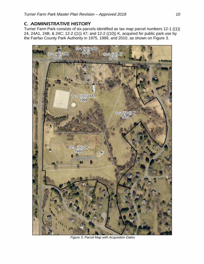
C. ADMINISTRATIVE HISTORY Turner Farm Park consists of six parcels identified as tax map parcel numbers 12-1 ((1)) 24, 24A1, 24B, & 24C; 12-2 ((1)) 47; and 12-2 ((10)) K, acquired for public park use by the Fairfax County Park Authority in 1975, 1999, and 2010, as shown on Figure 3.
Figure 3: Parcel Map with Acquisition Dates
Turner Farm Park Master Plan Revision – Approved 2018 11
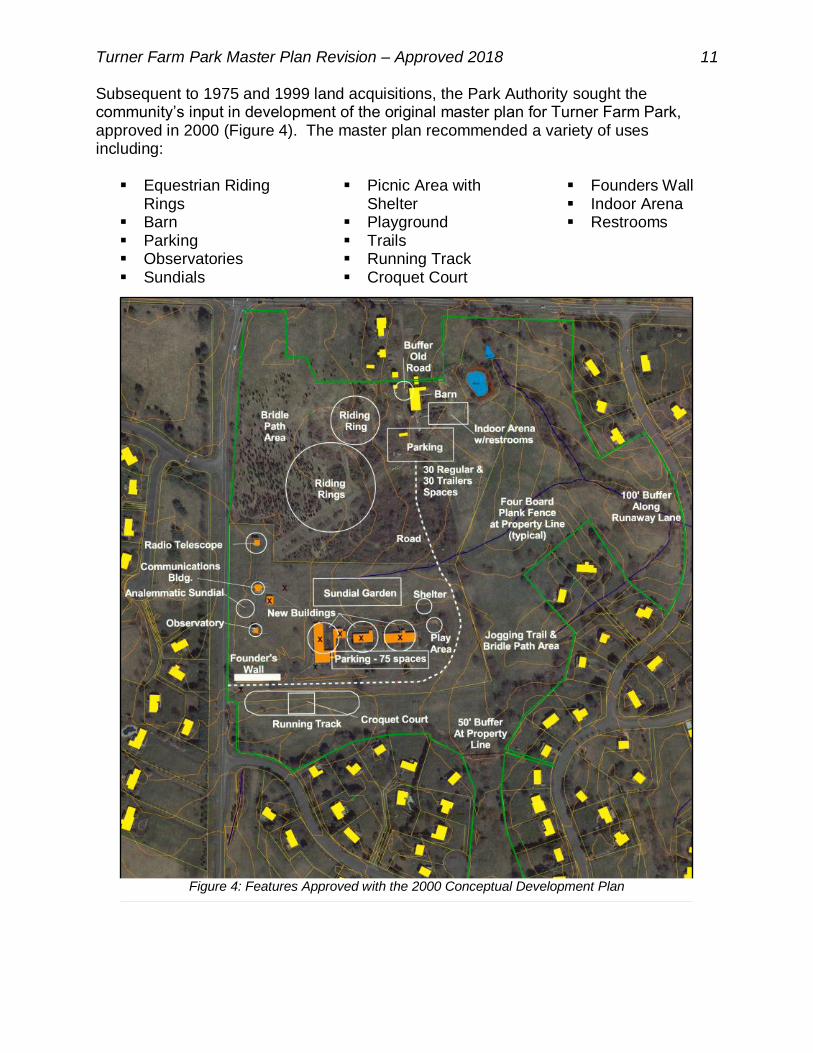
Subsequent to 1975 and 1999 land acquisitions, the Park Authority sought the community’s input in development of the original master plan for Turner Farm Park, approved in 2000 (Figure 4). The master plan recommended a variety of uses including:
Equestrian Riding Rings
Barn Parking Observatories Sundials
Picnic Area with Shelter
Playground Trails Running Track Croquet Court
Founders Wall Indoor Arena Restrooms
Figure 4: Features Approved with the 2000 Conceptual Development Plan

Turner Farm Park Master Plan Revision – Approved 2018 12
Development within the park has progressed based upon the 2000 master plan, although not all planned features have been implemented to date. Existing facilities include a portion of the planned trail system, equestrian riding areas, parking lot, two observatories, sundial garden, picnic area with shelter, playground, and barn. Additional features that exist within the park are the Turner Farm House, milk shed, and related outbuildings, associated with the 2010 land acquisition (Figure 5).
D. PARK CLASSIFICATION The Fairfax County Comprehensive Plan establishes a framework intended to guide long-term planning for the county with respect to both the built and natural
Figure 5: Existing Facilities

Turner Farm Park Master Plan Revision – Approved 2018 13
environments. As a component of the Comprehensive Plan, the Policy Plan addresses goals and objectives for various planning elements, including parks and recreation. This includes the Park Classification System which is intended to guide the planning of open space and facilities that is applied to all county-owned parks. Within the Park Classification System, Turner Farm Park is classified as a Countywide Park. Countywide Parks generally offer facilities that are unique within the county’s park network and, therefore, are expected to serve residents from across the county as well as locally. They may also contain areas designated for natural and/or cultural resource protection and/or interpretation. A variety of park facilities are appropriate in Countywide Parks. Due to the draw to a broader variety of county residents, parking must be provided. Other amenities that support all day activities, such as lighting and restrooms as well as gathering places for large programmed events with spectators may also be appropriate.
E. PARK & RECREATION NEEDS The need for park and recreation facilities in Fairfax County is determined through long-range planning efforts involving a variety of stakeholders. The Park Authority conducts a Needs Assessment every ten years to establish a benchmark for the acquisition of parkland and facility construction. As part of the Needs Assessment process, the Park Authority tracks the inventory of existing facilities, examines industry trends, surveys county resident recreation demand, and compares itself with peer jurisdictions to determine park facility needs. In addition, the Comprehensive Plan establishes countywide, population-based, service level standards for parkland and park facilities. Within three miles of Turner Farm Park are 20 County parks, 16 of which provide recreational facilities, such as trails, playgrounds, picnic areas, and athletic fields (Table 1). Some parks offer distinctive features such as the Historic Colvin Run Mill, Great Falls Grange, Riverbend’s Visitor Center and river access, and Lake Fairfax Park. Table 2 reflects projected local park facility needs in the Upper Potomac Planning District in which Turner Farm Park is located. Evaluation of park and recreation facility service levels is done according to the Planning District geography established in the Countywide Comprehensive Plan. As shown in Table 2, the Upper Potomac Planning District, which covers part of the Dranesville Supervisory District including the Great Falls area, has a deficit of public playgrounds and athletic facilities (fields and courts). Most parks in the district have few opportunities available to address these needs. School facilities and private facilities in homeowners’ association (HOA) common areas supplement the public inventory for trails, playgrounds, fields, and courts.

Turner Farm Park Master Plan Revision – Approved 2018 14
Table 2: Upper Potomac Planning District 2040 Facility Needs Analysis
194,137 2016 population – Upper Potomac Planning District
249,265 2040 projected population
Facility
Service Level Standard (per the Fairfax County Comprehensive Plan)
2016 Existing Facilities
2040 Needed Facilities
2040 Projected (Deficit)/ Surplus
Rectangle Fields 1 per 2,700 people 83.5 92.3 (8.8)
Adult Baseball Fields 1 per 24,000 people 10.0 10.4 (0.4)
Adult Softball Fields 65 1 per 22,000 people 4.5 11.3 (6.8)
Youth Baseball Fields 60 1 per 7,200 people 38.0 34.6 3.4
Youth Softball Fields 60 1 per 8,800 people 33.0 28.3 4.7
Basketball Courts 1 per 2,100 people 33.0 118.7 (85.7)
Playgrounds 1 per 2,800 people 82.0 89.0 (7.0)
Neighborhood Dog Parks 1 per 86,000 people 2.0 2.9 (0.9)
Neighborhood Skate Parks 1 per 106,000 people 1.0 2.4 (1.4)
PARK NAME
TRA
ILSA
MPH
ITHEA
TRE
CA
MPG
RO
UN
DS
CA
RO
USEL
OPEN
PLAY A
REA
PICN
IC TA
BLES
SCH
OO
L AG
E PLAYG
RO
UN
DTO
T LOT
REC
TAN
GLE FIELD
SG
RA
SSED 90FT
GR
ASSED
60FTSO
FTBA
LL DIA
MO
ND
TENN
IS CO
UR
TSB
ASKETB
ALL C
OU
RTS
HA
LF BA
SKETBA
LL CO
UR
TSEQ
UESTR
IAN
CEN
TERS
GA
RD
EN PLO
TSH
ISTOR
IC FEA
TUR
EN
ATU
RE C
ENTER
DO
G PA
RK
SKATE PA
RK
WA
TER PA
RKS
BO
AT R
ENTA
LSB
OA
T LAU
NC
HFISH
ING
PIERFITN
ESS CO
UR
SE
BARON CAMERON Y Y 1 9 1 1 Y
COLVIN RUN MILL Y Y
COLVIN RUN STREAM VALLEY Y Y Y
DIFFICULT RUN STREAM VALLEY Y Y Y
DRANESVILLE TAVERN Y
GRAND HAMPTONS 1
GREAT FALLS GRANGE Y Y Y 1 1 1 Y
GREAT FALLS NIKE Y Y Y 3 1 3 1 2 1 2 Y
HICKORY RUN SCHOOL SITE
HOLLY KNOLL Y
LAKE FAIRFAX Y Y Y Y Y Y 1 6 2 Y Y Y Y
LEXINGTON ESTATES
LOCKMEADE Y 1
RESTON NORTH Y 1 1 2
RIVERBEND Y Y Y Y Y Y Y Y Y
SHAKER WOODS
STUART ROAD Y 1 1 1 1 Y
SUGARLAND RUN STREAM VALLEY Y Y 2 2 Y
TURNER FARM Y Y 1 Y Y
WINDEMERE
WOLFTRAP STREAM VALLEY Y
Table 1: Existing Parks & Recreation Facilities within 3 Miles of Turner Farm Park (2017)
Turner Farm Park Master Plan Revision – Approved 2018 15
The Great Parks, Great Communities Comprehensive Park System Land Use Plan adopted by the Park Authority Board on June 22, 2011 includes several specific recommendations for improvements in the Upper Potomac Planning District. Recommendations relating to Turner Farm Park include the following:
“Explore trail opportunities along major utility easements in the district such as the Great Falls gas line that extends from Great Falls Nike through Turner Farm to Upper Potomac and Riverbend Parks;
Amend Turner Farm Master Plan to plan uses and facilities in added acreage; and
Continue and strengthen the Invasive Management Area (IMA) program that is currently established at parks in the district including Turner Farm Park.”
Turner Farm Park Master Plan Revision – Approved 2018 16
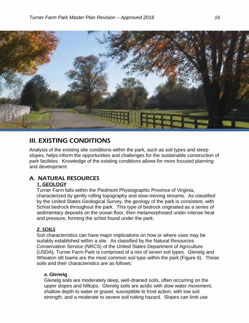
III. EXISTING CONDITIONS
Analysis of the existing site conditions within the park, such as soil types and steep slopes, helps inform the opportunities and challenges for the sustainable construction of park facilities. Knowledge of the existing conditions allows for more focused planning and development.
A. NATURAL RESOURCES 1. GEOLOGY
Turner Farm falls within the Piedmont Physiographic Province of Virginia, characterized by gently rolling topography and slow-moving streams. As classified by the United States Geological Survey, the geology of the park is consistent, with Schist bedrock throughout the park. This type of bedrock originated as a series of sedimentary deposits on the ocean floor, then metamorphosed under intense heat and pressure, forming the schist found under the park.
2. SOILS
Soil characteristics can have major implications on how or where uses may be suitably established within a site. As classified by the Natural Resources Conservation Service (NRCS) of the United States Department of Agriculture (USDA), Turner Farm Park is comprised of a mix of seven soil types. Glenelg and Wheaton silt loams are the most common soil type within the park (Figure 6). These soils and their characteristics are as follows:
a. Glenelg
Glenelg soils are moderately deep, well-drained soils, often occurring on the upper slopes and hilltops. Glenelg soils are acidic with slow water movement, shallow depth to water or gravel, susceptible to frost action, with low soil strength, and a moderate to severe soil rutting hazard. Slopes can limit use
Turner Farm Park Master Plan Revision – Approved 2018 17
potential since they have unstable excavation walls with tendencies for cut banks to cave, with potential for water erosion. Potential erosion hazard is moderate under, while severe over, seven percent slopes. Due to these attributes, suitability for different uses on Glenelg soils is slope dependent. Thus, they have limited usability for excavated ponds, and are somewhat limited in suitability for local roads, streets, moderate excavations, landscaping, and playgrounds. At slopes under seven percent, they are moderately suited for natural surface (low volume) roads, but are well suited for structures such as buildings, shallow excavations, campsites, trails, and picnic areas. Between seven and 15 percent slopes, Glenelg soils are well suited for minor excavations and moderately suited for natural surface (low volume) roads. However, they have a limited potential for building structures, local roads, streets, shallow excavations, landscaping, campsites, or picnic areas and limited suitability for excavated ponds, trails, and playgrounds. Above 15 percent slopes, Glenelg soils are limited in their ability to support any structures or other development. b. Hatboro
The Hatboro series consists of deep, poorly drained soils, occurring on nearly level flood plains with a slope range from zero to three percent. Surface runoff is high with periodic stream overflow, usually occurring during the winter and spring months. Hatboro soils are acid, often wet, with a shallow depth to saturated zone, have slow water movement, frequent flooding, and are susceptible to frost action. They are low strength, cut banks cave, and have a severe soil rutting hazard. These characteristics give Hatboro soils very limited usability for building structures, local roads, streets, shallow excavations, landscaping, natural surface roads, campsites, trails, picnic areas, playgrounds, and septic tank absorption fields. Suitability for minor excavations and excavated ponds is somewhat limited.
c. Meadowville
Soils of the Meadowville series are deep and moderately well to well drained. Permeability is moderate to moderately rapid with slow to moderate runoff. Meadowville soils are on undulating to rolling uplands, occurring around the heads of drainage ways, in saddles, depressions, on concave or slightly convex slopes. Meadowville soils are an acidic, low strength soil, with a shallow depth to saturated zone, seepage with bottom layer, and shrink-swell potential. They are affected by frost action, with unstable excavation walls and caving cut banks. Due to these attributes, Meadowville soils have limited suitability for excavations, septic tank absorption fields, or excavated ponds. They have somewhat limited suitability for building structures, local roads, or streets. These soils have a slight potential for erosion from natural surface trails, roads, or staging areas, with a severe rutting hazard, making them only moderately suitable for these uses. Uses are unlimited for landscaping, campsites, trails, picnic areas, and playgrounds.

Turner Farm Park Master Plan Revision – Approved 2018 18
Figure 6: Soils Map

Turner Farm Park Master Plan Revision – Approved 2018 19
d. Sumerduck
Soils of the Sumerduck series are deep, ranging from moderately well to poorly drained, with moderately slow permeability, and negligible to medium runoff potential. Sumerduck soils are often found in drainage ways with slopes of zero to eight percent that are subject to frequent, extremely brief, flash floods, with little deposition. They are acidic, low strength soils with a moderately high shrink-swell potential, potentially hydric with a shallow depth to high water, seepage, are affected by frost action, with moderately unstable excavation walls, and caving cut banks. Due to these attributes, Sumerduck soils have limited suitability for local roads or streets. They have somewhat limited suitability for building structures, shallow excavations, campsites, picnic areas, playgrounds, embankments, or excavated ponds. These soils have a moderate potential for erosion with a severe rutting hazard, from natural surface trails, roads, or staging areas, making them moderately suitable for these uses. They are suitable for lawns, landscaping, fairways, and paved paths. f. Wheaton
The Wheaton series consists of deep, well drained soils with moderate permeability, and medium to rapid runoff. They are low strength soils, with slow water movement/perc rate, shallow depth to water, are susceptible to frost action, and are a severe soil rutting hazard. Slope can limit use since they have unstable excavation walls, with tendencies for cut banks to cave. Potential erosion hazard is moderate under, but severe over, seven percent slope. Due to these attributes, suitability for uses on Wheaton soils is slope dependent. With less than a seven percent slope, these soils have a moderate erosion potential, but are well suited for structures such as dwellings and small commercial buildings, minor excavations, or trails and are moderately suited for natural surface (low volume) roads and trails. They are somewhat limited in suitability for moderate excavations, campsites, picnic areas, and playgrounds, while limited usability for local roads, streets, landscaping, excavated ponds, and septic tank absorption fields. Between seven and 15 percent slopes, Wheaton soils are well suited for trails or minor excavations, but somewhat limited for building structures, shallow excavations, campsites, and picnic areas. However, they have a severe erosion hazard that makes them only moderately suitable for natural surface (low volume) roads, but limited in suitability for local roads, streets, landscaping, excavated ponds, and playgrounds. Above 15 percent slopes, Wheaton soils are a severe erosion hazard with limited to no suitability at all for any structures or other development. g. Hydric Soils
Hydric Soils are those soils that are sufficiently wet in the upper part to develop anaerobic conditions during the growing season. They are poorly drained, with slow permeability and low runoff. These soils usually occur on nearly level or gently sloping plains and low areas, with a shallow depth to saturated zone. They usually exhibit a wetness, high shrink-swell potential, low bearing strength, and slope instability, resulting in landslides. Due to these attributes, they have limited suitability for local roads, streets, building structures, shallow excavations,

Turner Farm Park Master Plan Revision – Approved 2018 20
embankments, or playgrounds. This is an overlay area, where the main soil type is referenced as well.
3. TOPOGRAPHY
The topography of Turner Farm Park is gently rolling, with less than 58 feet of grade change across the park, ranging from 382 feet in elevation near the observatory to 324 feet in elevation along the wetland on the eastern edge of the park. Slopes average less than seven percent across the site. Only a few instances of steep slopes are present; most are a result of excavation to build landscape features within the park. The developed portions of the park, having been graded, form gently sloping sites for park facilities. This includes the riding rings, playground, picnic area, and parking areas. To the north, west, and south of the riding rings is a small ditch and ridge formed by grading of this landform to direct runoff toward the stormwater facility to the east of the riding area. Most of the park’s topography slopes eastward toward the small stream running through the eastern side of the park (Figure 7). 4. HYDROLOGY
Turner Farm Park lies within the Captain Hickory Run subwatershed at the northern reach of the Difficult Run watershed, which drains to the Potomac River, and ultimately to the Chesapeake Bay. As described in the Difficult Run Watershed Management Plan adopted by the Board of Supervisors in 2007, the majority of assessed tributaries in Captain Hickory Run are characterized as having an unstable channels that are actively widening in response to changes in stream flow. The substrate in the subwatershed is a combination of gravel and sand. Sixty-three percent of the stream length is moderately unstable, indicating that there is high erosion potential during high flow events. The type and density of land use in a subwatershed can affect the downstream water quality and stream condition. While each land use type introduces issues to the natural stream system, more intense land use types, such as high-density residential, commercial and industrial uses, can have high levels of impervious surface and contribute runoff and pollutants to the stream system. Less intense uses, such as open space and estate residential development, generally contain less impervious area, have more natural vegetation, and, therefore, have less impact on stream quality. Approximately 69 percent of the Captain Hickory Run subwatershed is characterized by estate and low-density residential development. Another 19 percent is preserved for open space or parks, including Turner Farm.

Turner Farm Park Master Plan Revision – Approved 2018 21
Figure 7: Elevation and Steep Slopes Map

Turner Farm Park Master Plan Revision – Approved 2018 22
Turner Farm Park is a valuable natural resource within Fairfax County as it contains a small segment of Captain Hickory Run (Figure 8). This perennial stream begins adjacent to the old farm pond, near the historic Turner Farm House, and flows southeast, leaving the park and flowing under Runaway Lane to the east. In wetter times of the year, it is fed by the farm pond and a culvert under Georgetown Pike. Captain Hickory Run is buffered by its associated Chesapeake Bay Preservation Ordinance designated Resource Protection Areas (RPAs), in which development and clearing activities should be limited. RPAs are designated corridors of environmentally sensitive land alongside the shorelines of streams, rivers, or other water bodies that drain into the Potomac River and eventually into the Chesapeake Bay. In a vegetated or forested condition, RPAs protect water quality, filter pollutants from stormwater runoff, reduce the volume of stormwater runoff, prevent erosion, and perform other important biological and ecological functions. Mandated by the State of Virginia Chesapeake Bay Preservation Act, protection of Fairfax County’s RPAs began in 1993 with the enactment of the Fairfax County Chesapeake Bay Preservation Ordinance, which regulates the kinds of development that can occur in these important, environmentally sensitive areas. Prior to the enactment of the Chesapeake Bay Preservation Ordinance, however, all vegetation around the stream was removed for agricultural purposes. In some areas, the stream buffer has not been allowed to fully regenerate. The Difficult Run Watershed Management Plan recommends the implementation of Low Impact Development (LID) techniques to benefit stormwater management; for example, the construction of bioretention areas in parking lot landscape islands and increased tree canopy cover.
Figure 8: Turner Farm Park’s Hydrology, Floodplain, and Resource Protection Area
Turner Farm Park Master Plan Revision – Approved 2018 23
Within the park, stream degradation is evident as a result of runoff from within the park as well as neighboring impervious surfaces such as roofs, driveways, roadways, and parking lots. These conditions contribute to “flashy” stormwater flows that incise stream channels. Due to Turner Farm Park’s location near a headwater within the Difficult Run Watershed, the park has been identified by Fairfax County Stormwater Planning in the Department of Public Works and Environmental Services (DPWES) as an important open space for protecting water quality. The only watershed management project identified in the Difficult Run Watershed Management Plan targeted for Turner Farm Park is the replacement of the culvert which conveys the stream under Georgetown Pike along the northern border of the park.
5. NATURAL COMMUNITIES - PLANTS & ANIMALS
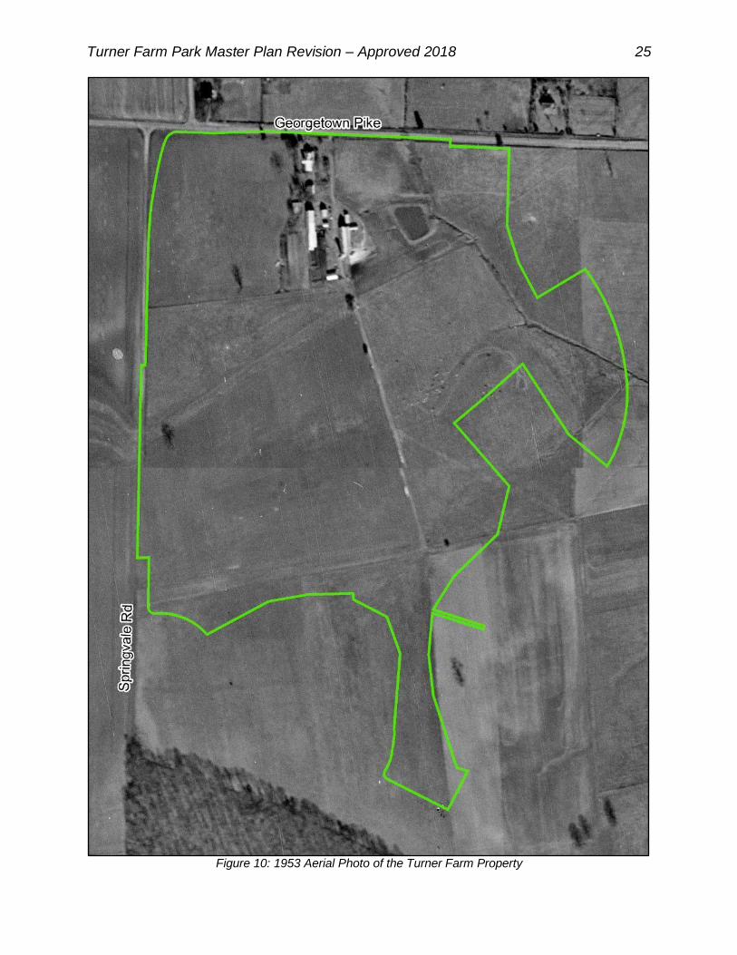
Natural communities are ecological groupings of co-existing, interacting species, integral to the physical environment and associated processes. Through much of the county’s early history, agriculture was a key pursuit, leading to the clearing of many acres for farmland. The land area of Turner Farm Park was cleared in the 1800s for growing crops and remained completely cleared for agriculture and government uses into the 1980s, as illustrated in the following series of maps spanning from 1937 to 2015 (Figures 9-12). Agriculture related uses in the form of equestrian riding still exist within the park. As a former agricultural site, Turner Farm Park contains no extant hardwood stands, remaining fully cleared for farm use into the 1980s. Between the late 1990s and early 2000s, successional vegetation was introduced into several areas of Turner Farm Park. The park’s vegetation was formally documented in 2000 by a Forest Stand Delineation and Natural Resources Inventory. A forest stand of less than five acres exists in the central area of the park, consisting of predominantly successional species that thrived in the dry and sunny conditions left after farming. In 1997, much of this stand consisted of young trees that had recently sprung up after the secessions of agricultural and government activities on the site. Additionally, there is a thin band of trees growing along Captain Hickory Run and the park boundaries. By 2015, the central stand had grown to a thick mass of established forest, while trees have now filled in much of the steam’s RPA in some areas and providing vegetative screening along some of the property lines (Figure 12). Species documented on the property include: eastern red cedar, red maple, black cherry, tree-of-heaven, staghorn and smooth sumac, sassafras, red mulberry, autumn and Russian Olive, and persimmon.
An Invasive Management Area (IMA) site was active at Turner Farm Park between 2007 and 2011, with volunteers working to remove non-native invasive vines from hedgerows in the central portion of the property. This IMA site has been inactive since 2012, however, as the program’s standards have shifted to focus efforts on high-quality forested areas, maximizing the benefit of the program’s resources. Three, semi-wooded areas within Turner Farm Park were evaluated in 2016. Park Authority staff found that these areas were moderately impacted by non-native invasive plant species.

Turner Farm Park Master Plan Revision – Approved 2018 24
Figure 9: 1937 Aerial Photo of the Turner Farm Property
Turner Farm Park Master Plan Revision – Approved 2018 25
Figure 10: 1953 Aerial Photo of the Turner Farm Property

Turner Farm Park Master Plan Revision – Approved 2018 26
Figure 11: 1997 Aerial Photo of the Turner Farm Property

Turner Farm Park Master Plan Revision – Approved 2018 27
Figure 12: 2015 Aerial Photo of Turner Farm Park

Turner Farm Park Master Plan Revision – Approved 2018 28
Due to the prior agricultural use of Turner Farm Park, both the quality and amount of habitat available for wildlife is highly marginalized. There are some limited areas of trees, wetlands, and native warm season grasses; however, the majority of the park continues to be managed for recreational use. The Park Authority has not conducted a formal wildlife inventory for the park and does not maintain a list of known species. It is likely that common species of birds, mammals, reptiles, amphibians, and insects utilize the park. Species present would likely include those that prefer open, disturbed habitats as well as generalist species, all of which would be typical species of suburban woodlots, including migratory songbirds, reptiles, amphibians, and small mammals. Several species typically found in suburban woodlots have been observed, including squirrels, fox, snakes, rabbits, hawks, and geese, all of which are typical of the region and tolerant of park use by visitors. No deer management has been conducted at Turner Farm Park and white-tailed deer are present in the park. Two initiatives were completed by the Park Authority to reconcile the use of the park as an equestrian area with its potential natural resource value, including: The Turner Farm Equestrian Use Areas Natural Resource Management Plan
(2005)
Designation as a “Certified Wildlife Habitat” with the National Wildlife Federation (2006)
No rare, threatened, or endangered species of flora or fauna have been documented at Turner Farm Park. There is limited suitable habitat for wildlife, in general, and prior surveys have not identified any species of significance.
B. CULTURAL RESOURCES Identification, protection, and interpretation of cultural resources is a key component in the Park Authority’s mission statement and supported by several Park Authority policies. To achieve these goals, consideration of cultural resources is a necessary component in development of a park master plan. During the master plan process, the project team reviewed the available information and investigated the park, to determine what, if any, remnants from the past remain. However, no formal archaeological surveys have taken place at Turner Farm. There exists a moderate potential for Native American sites as well as Civil War sites, in addition to the more current known uses of the property. Development of the park will take into account this potential, and phased archaeology will take place prior to development in accordance with park policy. Little prehistoric heritage evidence was found on site; however, Turner Farm Park fits within the cultural history of Fairfax County. A summary of the periods of human habitation reflected in the area of Turner Farm Park is provided below.
1. NATIVE AMERICAN PREHISTORY (PRIOR TO CIRCA 1650 AD)
Native American settlement in Fairfax County, including the area of Turner Farm Park, is comprised of three general periods, reflecting changes in the materials used by Native Americans that indicate shifts in how prehistoric peoples satisfied

Turner Farm Park Master Plan Revision – Approved 2018 29
subsistence needs and organized social structures. These time periods are as follows:
Paleo-Indian period – The initial occupation of Fairfax County by Native
Americans is classified at the Paleo-Indian period from approximately 16,000 B.P. to circa 10,000 B.P. It was characterized by a cold, moist climate that resulted in flourishing grasses and evergreen vegetation. Native American life was characterized by small nomadic bands displaying a heavy emphasis on hunting and supplemented by general foraging. Typical evidence of human habitation from this time would include stone fluted points, scrapers, flake tools, wedges, and hammer stones.
Archaic period – While life was still characterized by nomadic hunting bands,
environmental changes ensuing from a progressively warming climate resulted in increased reliance on and diversification in gathering during the Archaic period from circa 10,000 B.P. to 1000 B.P. This period is characterized by advancements discernible in the archaeological record by the appearance of atlatl stones, axes, pestles & mortars, progressing to soapstone vessels, shell ornaments, bone needles, fish hooks, and copper artifacts. Increased appearances of grinding and nutting stones reflects the greater emphasis on gathered items to meet dietary needs.
Woodland period – The advent of floral domestication, horticulture, and later agriculture, mark the shift to the Woodland period circa 1000 B.P. to A.D. 1650. During the Early to Middle Woodland periods, characterized by a climate shift from hot and dry to a cooler, moist climate, Native Americans intensified hunting and gathering activities while beginning experimentation with cultigens. The first clay pottery typically appears during this time, reflecting increasingly sedentary settlement patterns. Changes in the design of stone projectile points reflect the introduction of bow and arrow technology. Reliance on cultigens (in particular corn, beans, and squash) marks the shift into the Late Woodland, along with a shift to the current local climate. The adoption of agriculture resulted in an intense population increase, allowing for the formation of villages with complex social and political organization. When European colonists arrived in the seventeenth century, Native American cultures had formed tribes, each possibly occupying several villages. Tribal alliances and intertribal rivalries, often reflecting distinct cultural differences such as language and belief systems, had also developed.
2. HISTORIC (CIRCA AD 1650 – PRESENT)
European, specifically English, settlement in Northern Virginia was extremely sparse throughout most of the seventeenth century. During this period, the area that would become Fairfax County was frontier land. Colonization increased during the late seventeenth and early eighteenth century when the European population of Northern Virginia dramatically increased and the Virginia colony developed a tobacco-based economy. Due to its economic value, colonists favored tobacco cultivation over manufacturing enterprises, often becoming reliant on importation rather than production of basic household goods. The extremely labor-intensive tobacco crop

Turner Farm Park Master Plan Revision – Approved 2018 30
resulted in the widespread use of European indentured servants and slaves during the late-seventeenth and early eighteenth centuries. The County of Fairfax was officially formed in 1742, out of the northern portion of Prince William County, which itself had been carved out of Stafford County, all of which made up the larger Northern Neck Proprietary, which was granted to Thomas, 6th Lord Fairfax of Cameron by King Charles I. Thomas Fairfax conveyed a large tract of land to Bryan Fairfax in 1765, including what would become Turner Farm Park. Although tobacco cultivation and dependence on slave labor remained central components of the regional economy, tobacco’s importance had somewhat diminished by the time of the American Revolution. Beginning in the mid-eighteenth century, farmers increasingly diversified crops, in particular with the additions of wheat and corn, rather than relying on a tobacco-based monoculture. The area underwent an economic decline until the early nineteenth century, when farmers from New England moved south and introduced new agricultural practices which revitalized Fairfax County’s farms. Georgetown Pike, constructed between 1813 and 1837, greatly improved transportation and commerce in the area, providing a main thoroughfare from the port at Alexandria westward to Leesburg Pike. This construction, coupled with new farming techniques that increased production, fostered a period of growth and prosperity in the region between 1840 and 1860. As a result, more farms sprang up in the area. Georgetown Pike has served as the main road running past what became Turner Farm Park for almost 200 years as shown in Figure 9, an aerial photograph from 1937. Soon after the completion of Georgetown Pike, Orlando Fairfax, grandson of Bryan Fairfax, sold a land tract to Josiah Loomis in 1842. Josiah passed on 150 acres of land to his son Joshua Loomis in 1843, containing what would become Turner Farm Park. Road construction continued to improve transportation, connecting farms, mills, and ports during the 1850s, followed by the railroad, which became the preferred method for transporting grain and flour from the Shenandoah Valley to the market cities. Tax records indicate that in 1851 a house owned by Joshua Loomis existed in the general vicinity of the Turner Farm House. While retaining ownership of the family cemetery, the location of which has not been verified, Loomis sold the house with 150 acres that encompassed the current Turner Farm Park to William Seaton in 1856. During the Civil War, Fairfax County was of immense strategic interest due to its location along the Potomac River and several points of elevation that provided an overlook of Washington D.C. It was also positioned as the last line of defense between the Union capital city and the rebel Confederate territories. As a result, thousands of Union soldiers were stationed in Fairfax County and the area witnessed intense war-related activity, including the area near Turner Farm. Georgetown Pike was a major thoroughfare which supported large movements of troops. When the Civil War erupted in Virginia, the area around Turner Farm was within reach of foraging parties sent out along roadways from both Union and

Turner Farm Park Master Plan Revision – Approved 2018 31
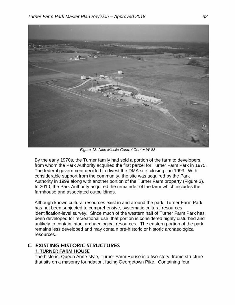
Confederate armies. As a result, local livestock and harvests were depleted to feed the military raiding parties. Skirmishes broke out when raiding parties from opposite sides encountered each other. In 1861, the Battle of Dranesville took place approximately one mile to the west of what is now Turner Farm Park. General Ord’s troops that were headquartered at the eastern end of Georgetown Pike would have passed the Turner Farm site on their way to or from the battle. When the war ended, northern Virginia’s economy and farms were in ruin, with crop production in 1870 only half of what it had been in 1860. These conditions may have contributed to Seaton selling the property in 1865 to William H. Clagett, who, in turn, sold the land to John Turner in 1869. Turner farmed the land and in 1878 resided in a house very close to the current Turner Farmhouse. During the same time, Fairfax County rebuilt itself, emerging as a major dairy production region by the twentieth century with the area looking much the way it did in the 1937 photo shown in Figure 9. The land passed through the Turner Family, with Luke Turner constructing the current Queen Ann style farmhouse and removing its predecessor in 1905. In 1920, the farm passed to Mark Turner who continued the family business, considered to be a model dairy farm. Mark Turner was also active in state and local affairs, including serving as master of the Great Falls Grange as well as serving on the executive board for the Virginia State Grange and on the Fairfax County Board of Supervisors. During this time, the onset of the Second World War and subsequent Cold War dramatically altered the character of Fairfax County. The massive increase in the size of the federal government during this period resulted in an influx of employees and their families into the region, leading to the development of suburban neighborhoods to meet the housing demand along with the associated transportation infrastructure. In 1955, these events directly affected Turner Farm when the Federal Government took 11.7 acres of the farm to build the Nike Missile Control Center W-83 as one of the first of 13 sites where surface to air missiles were installed (Figures 11 & 13). The intended purpose was to defend Washington D.C. from the threat of Soviet attack during the Cold War. It was only a few years, however, before the Soviets and the U.S. switched to using Intercontinental Ballistic Missiles (ICBM), making Nike Missile sites like the one at Turner Farm obsolete. In 1961, the U.S. Army Map Service, later known as the Defense Mapping Agency (DMA), took over management of the Nike Missile Control Center. There the U.S. Army Map Service built on the guidance system for the Nike Missiles, developing it into the Global Positioning System (GPS) now used in civilian cars and cell phones. Eventually, DMA would change its name to the National Geospatial-Intelligence Agency (NGA).
Turner Farm Park Master Plan Revision – Approved 2018 32
Figure 13: Nike Missile Control Center W-83
By the early 1970s, the Turner family had sold a portion of the farm to developers, from whom the Park Authority acquired the first parcel for Turner Farm Park in 1975. The federal government decided to divest the DMA site, closing it in 1993. With considerable support from the community, the site was acquired by the Park Authority in 1999 along with another portion of the Turner Farm property (Figure 3). In 2010, the Park Authority acquired the remainder of the farm which includes the farmhouse and associated outbuildings. Although known cultural resources exist in and around the park, Turner Farm Park has not been subjected to comprehensive, systematic cultural resources identification-level survey. Since much of the western half of Turner Farm Park has been developed for recreational use, that portion is considered highly disturbed and unlikely to contain intact archaeological resources. The eastern portion of the park remains less developed and may contain pre-historic or historic archaeological resources.
C. EXISTING HISTORIC STRUCTURES 1. TURNER FARM HOUSE
The historic, Queen Anne-style, Turner Farm House is a two-story, frame structure that sits on a masonry foundation, facing Georgetown Pike. Containing four

Turner Farm Park Master Plan Revision – Approved 2018 33
bedrooms and four bathrooms, it is characterized by a rear gabled wing with a taller, wider front facing gable that splits into two, small gables of unequal size. The tall, center gable has a half-timber pattern, while the smaller front gables retain decorative shingling. The house contains a large, central, corbelled cap chimney. Most windows are two-over-two, double-hung sash windows, taller on the first floor than on the second. Second level windows with the smaller gables on the north elevation are one-over-one. The easternmost window has a decorative, balcony-like protrusion, with a circular detail that is an original feature of the house. On the west side of the house is a two-story, side-gabled wing, with one-over-one windows. Delicately turned wood posts with decorative floral brackets and Queen Anne-style spindle work wraps around a low gable at the front entrance and three sides of the house’s porch.
2. GARAGE WITH APARTMENT
Directly south of the Turner Farm House, is a two-car garage with an apartment on the second floor. The original portion of this structure was built between 1937 and 1953, and expanded around 1998. The first floor is of masonry construction while the level above is wood framed with multiple windows.
3. TRACTOR SHED/CRIB BARN
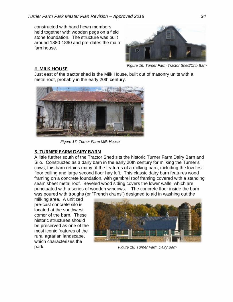
Southeast of the farm house is a 19th century crib barn once used for storage of corn. Variously described as a crib barn or run-in equipment barn, this structure features a gabled, two-story, peaked center section roof, with a loft, and low, sloped, lean-to additions on either side of the central bay added on much later. It is
Figure 14: Turner Farm House
Figure 15: Turner Farm Garage with Apartment
Turner Farm Park Master Plan Revision – Approved 2018 34
constructed with hand hewn members held together with wooden pegs on a field stone foundation. The structure was built around 1880-1890 and pre-dates the main farmhouse.
4. MILK HOUSE
Just east of the tractor shed is the Milk House, built out of masonry units with a metal roof, probably in the early 20th century.
5. TURNER FARM DAIRY BARN
A little further south of the Tractor Shed sits the historic Turner Farm Dairy Barn and Silo. Constructed as a dairy barn in the early 20th century for milking the Turner’s cows, this barn retains many of the features of a milking barn, including the low first floor ceiling and large second floor hay loft. This classic dairy barn features wood framing on a concrete foundation, with gambrel roof framing covered with a standing seam sheet metal roof. Beveled wood siding covers the lower walls, which are punctuated with a series of wooden windows. The concrete floor inside the barn was poured with troughs (or "French drains") designed to aid in washing out the milking area. A unitized pre-cast concrete silo is located at the southwest comer of the barn. These historic structures should be preserved as one of the most iconic features of the rural agrarian landscape, which characterizes the park.
Figure 18: Turner Farm Dairy Barn
Figure 16: Turner Farm Tractor Shed/Crib Barn
Figure 17: Turner Farm Milk House

Turner Farm Park Master Plan Revision – Approved 2018 35
6. OBSERVATORY TOWERS
Another iconic structure in the park is the main observatory structure located near the southern entrance from Springvale Road. It was built in the 1960s by the United States Government and has been adaptively re-used to house a large, electrically
operated telescope that is set within a steel panel, rotating dome with a retractable opening. Just north of the main observatory tower is the radio telescope structure built during the 1960s. Earlier versions of both structures were part of the Nike Missile Control Site and later retrofitted by DMA to suit their mission.
D. EXISTING INFRASTRUCTURE 1. UTILITIES
A variety of utilities currently serve Turner Farm Park or are available in close proximity. Electrical service extends from both Georgetown Pike and Springvale Road to provide power to the park’s electrical systems. Water is available from both roads as well, with a stub entering the park along the southern entrance from Springvale Road that is contained in an easement, although currently not providing service to any park facility. Natural gas is available and connected to the Turner Farm House from Georgetown Pike. No municipal sewer connections exist in this part of the county, so drain fields must be used to serve park toilets. Two old septic fields exist on the site, one related to the Turner Farm House and the other which served the former DMA facility, although neither is currently functional. The new roll top observatory is served by a new septic field. A small stormwater management facility exists just south of the barn, designed to treat runoff from the riding ring. A 50’ wide utility easement associated with the Transcontinental Gas Pipe Line (Transco) runs diagonally from the southwest to the northeast corner of the park, transporting natural gas from the Gulf Coast of Texas to the New York City area. Additional easements for storm drainage and floodplain management are recorded on the property (Figure 20). 2. VEHICULAR ACCESS
The vehicular entrance from Springvale Road provides access to the main parking lot, located between the observatories, sundials, playground, and picnic area. Closer to the intersection with Georgetown Pike, an old farm road provides unpaved access to the equestrian riding area. An entrance, located on Georgetown Pike, provides access to the resident curator area, including Turner Farm House and related buildings (Figure 20).
Figure 19: Observatory Towers

Turner Farm Park Master Plan Revision – Approved 2018 36
Figure 20: Entrances, Major Utilities, & Easements

Turner Farm Park Master Plan Revision – Approved 2018 37
3. PEDESTRIAN ACCESS & TRAILS
Turner Farm Park contains a few segments of paved trail running between the parking lot and equestrian area, observatories, playground, picnic shelter, and sundial garden, as well as a mowed equestrian cross country riding path/obstacle course. While a paved sidewalk exists on the opposite side of Springvale Road, no official trail entrances to the park exist.
E. EXISTING USES & OPERATIONS Since its opening as a public park, Turner Farm Park has grown in popularity to serve a diverse Fairfax County population. Visitors can attend astronomy and equestrian programs and events, ride their horse, exercise, picnic, enjoy the outdoors, and take part in events such as fireworks on the Fourth of July. The park’s unique assets are its astronomy facilities, equestrian amenities, and historic structures. The park’s open space, picnic area, playground, and trails are popular features for adjacent neighbors as well as the broader community. Natural areas in the park provide buffers between use areas and park neighbors as well as ecological enhancement. The park’s increased popularity presents challenges to current operations as well as a need for added facilities. Park use on peak visitation days and for special events can result in traffic backups with parking overflowing into the surrounding neighborhood as well as bottlenecks within the park. Astronomy and equestrian riding groups are the primary users of Turner Farm Park who, along with staff, have indicated that the existing parking and circulation within the park do not adequately address the needs of park users, with conflicts between vehicular, pedestrian, and equestrian traffic occurring regularly. Turner Farm Park is managed with maintenance provided by Park Operations Area 6 staff that maintains parks within a wide district. Typical regular maintenance includes activities such as mowing, removing leaves, emptying trash, painting, snow removal, facility maintenance, and other similar tasks. Periodic maintenance tasks include facility and equipment inspections; facility preparation; plumbing repairs, cleanup; limbing up of trees; tree removal; and repairing pavement as needed. Area 6 staff also responds to any park operation or maintenance issues brought to their attention.

Turner Farm Park Master Plan Revision – Approved 2018 38
IV. PARK ASPIRATIONS
A. PARK PURPOSE Park purpose statements provide a framework for planning and decision-making. As described in the Fairfax County Comprehensive Plan, Policy Plan, Parks and Recreation section, the purpose of Countywide Parks, such as Turner Farm Park, is to serve larger geographic areas or the whole county with unique facilities, while protecting sensitive environmental and cultural resources within the park. Specifically, Turner Farm Park’s purpose is to preserve and protect the site’s cultural and natural resources while providing a variety of recreational and educational activities related to the unique features of the park for all age groups.
B. VISITOR EXPERIENCE Turner Farm Park offers a visitor experience similar to that of other Countywide Parks, through a combination of educational opportunities, events, recreational facilities, trails, and open space. For individual and group visitors, Turner Farm Park provides a diverse variety of recreational facilities with opportunities to interact with other users. Both scheduled and casual enjoyment of the park’s facilities and open space is part of the visitor experience. Park users may enjoy astronomy or equestrian riding facilities, historic features, interpretive features and programs, the forest, wildlife, playground, picnic area, and trails in a park experience that typically lasts for up to a half day. The visitor experience should be supported through complementary facilities and supporting features, including sufficient, need-specific parking and restroom facilities. New and updated infrastructure, amenities, uses, and facilities should be consistent with the park’s growing popularity as well as community needs as these items contribute to a positive visitor experience in the park.
Turner Farm Park Master Plan Revision – Approved 2018 39
C. MANAGEMENT OBJECTIVES In order to achieve the park’s purpose, the following objectives, consistent with the Park Authority’s mission statement, will guide actions and strategies for dealing with management issues: Turner Farm Park will be managed to provide an open space for public enjoyment
and outdoor recreation.
Park users should have universal access to park facilities when access is possible and feasible. This includes accessible facilities and connections between different areas of the park.
Protection and appreciation of natural and cultural resources are integral to the Turner Farm Park experience. Every effort should be made to balance the stewardship of these resources with active recreation needs.

Turner Farm Park Master Plan Revision – Approved 2018 40
V. GENERAL MANAGMENT PLAN
The General Management Plan (GMP) is based on the research, site analysis, and data presented in this document. Using this information, the site is organized into management zones that provide a framework for site management and decision making (Figure 21). These zones identify the primary purpose of each area, provides recommendations for future park uses and facilities deemed to be appropriate to this park based on the research, site analysis, and data presented in this document. The GMP contains descriptions of both existing and proposed plan elements and is accompanied by a graphic that shows the general locations of the existing and planned elements. These two elements of the master plan – written and graphic - should be used together to understand the full extent of the recommendations. Development of the GMP is based on an assessment of area-wide needs and stakeholder preferences in balance with the existing site conditions and operational requirements. The scope of the master plan process does not include detailed site engineering; therefore, it should be understood that the GMP is conceptual in nature. Although reasonable engineering practices have contributed to the basis of the design, final facility location for the recommended elements will be determined through more detailed site analysis and engineering design that will be conducted when funding becomes available for the further development of this garden. Final design will be influenced by site conditions such as topography, natural resources, tree preservation efforts, and stormwater and drainage concerns as well as the requirement to adhere to all pertinent state and county codes and permitting requirements.

Turner Farm Park Master Plan Revision – Approved 2018 41
Figure 21: Turner Farm Park General Management Plan

Turner Farm Park Master Plan Revision – Approved 2018 42
A. ENTRANCE ZONE Entrance Zones define the areas where visitors form their first impression of the park. Visual elements should be designed in keeping with the park’s character and include elements that support visitor orientation, such as park identification, information kiosks, and directional, regulatory, and event signage. Other amenities such as landscaping, benches, and trash cans are appropriate in Entrance Zones as well as parking, pedestrian, and security lighting. Within the Main Entrance Zone, the existing parking lot is to remain but may be improved and expanded to meet growing park demand. Adequate parking should be provided for equestrian uses, preferably in the northern entrance zone off Springvale Road.
1. VEHICULAR ACCESS & CIRCULATION
Park Authority staff and park users have noted that the park’s existing parking and interior circulation do not adequately address the needs of park users. Conflicts between vehicular, pedestrian, and equestrian traffic occur frequently. The park’s increasing popularity presents challenges to current operations and creates a need for additional as well as well-considered facilities. Park use on peak visitation days and for special events can result in traffic backups, with parking overflowing into the surrounding neighborhood as well as constricted circulation within the park. To address these conditions, parking and circulation improvements are needed. Vehicular access to the park will continue to be provided at the existing entrances from Springvale Road, and the Georgetown Pike access will be reserved for the Resident Curator Program at the Turner Farm House. The primary entrance to the park will remain at the southern entrance from Springvale Road. To enhance access to the Equestrian Zone, the opportunity to shift the northern vehicular access point closer to Wynkoop Drive has been included to allow for improved access to the Equestrian Zone, aiding the maneuvering requirements of horse trailers and facilitating traffic flow during large events. In any event, there shall only be two vehicular entrances to the park along Springvale Road. Traffic control features such as signage, gates, and bollards can be used to control park traffic. All vehicular access points should be designed to safely accommodate pedestrian access to the park as well. 2. PEDESTRIAN ACCESS & CIRCULATION
Many people enjoy strolling the grounds of Turner Farm Park for a variety of reasons including exercise, dog walking, socializing, nature observation, running, and biking. The planned trail network throughout Turner Farm Park is designed to minimize potential conflicts between equestrian and pedestrian users. The network includes existing trails linked to new trails and entrances. Trail access is provided at the vehicular entrances and additional pedestrian entrances as shown on the GMP. The provision of visitor orientation is important at these points, including informational kiosks, benches, trash cans, and park identification, regulations, and wayfinding signage. All routes in Turner Farm Park should be located and designed to provide the greatest degree of accessibility while respecting natural and cultural resources. The loop trail should be of sufficient distance to provide interest to the user and

Turner Farm Park Master Plan Revision – Approved 2018 43
separation from the cross country equestrian riding obstacle trail, to avoid conflicts between the two different user groups.
These locations align with the Countywide Trail Plan Map which recommends a trail along both Georgetown Pike and Springvale Road. The actual location of the trails along Springvale Road and Georgetown Pike is subject to future determination by Fairfax County and VDOT. The Park Authority has the option to build trails for park use on the Turner Farm property regardless of the final location of the Countywide Trail (Figure 21).
B. RESOURCE PROTECTION ZONES Two separate areas within the park are designated as Resource Protection Zones (RPZs), to protect natural habitats, geological features, hydrological features, and/or cultural resources they contain. These RPZs contain forest communities as well as the stream and farm pond within the park. While the farm pond is a historic feature created to serve the farm, it has now become a part of the site’s hydrology as well. Such features support multiple species that co-exist and rely on these natural features. The wetlands provide numerous benefits to the watershed including storage of water, recharge of ground water, and water purification. They also provide water and habitat not only for wetland dependent species, but upland mammals as well. Protecting the integrity of these forested blocks is critical to the health of Captain Hickory Run. Therefore, these areas should be preserved and restored as much as possible to a natural state with minimal disturbance. Revegetation should include only native trees and shrubs, accompanied by invasive plant management as necessary. Pedestrian and equestrian trails with related facilities such as bridges, signage, interpretation features, or benches are appropriate within the RPZs in the general locations depicted on the GMP. The potential for historic discoveries in these areas is moderate, so appropriate subsurface archaeological investigation should be conducted prior to any ground disturbing activities within these zones to minimize potential impacts to important archeological sites. Limited off trail activity will be permitted for resource management activities along with programs scheduled and supervised by Park Authority naturalists that are compatible with resource management goals.
C. FAMILY ACTIVITY ZONE The Family Activity Zone is an area focused on more traditional park uses, such as picnics, play, and group gatherings. This zone should be convenient to parking, trail access, and other supporting facilities, and include features as noted below.

Turner Farm Park Master Plan Revision – Approved 2018 44
1. PICNIC AREAS/SHELTERS
A picnic area with shelters should be provided as a central gathering place for family- and group-oriented activities. Proximity to the parking area will aid accessibility and ease of use. The shelter should be of sufficient size for inclusion in the rental program with at least ten tables that would support group activities such as outdoor classroom programming, family gatherings, and group events. Grills should be provided, where appropriate. Picnic shelters should provide both electric and water access, so that restrooms can be provided within the
structure. Lighting would make the facility more desirable for rentals. A storage space should also be considered within the shelter for cleaning equipment. The open field sorrounding the picnic area shall be retained for use to provide an overfolow and buffer are between the picnic area and informal supporting uses, such as, but not limited to equestrian or astronomy classes. 2. PLAYGROUND
A playground should be maintained as a feature that is complementary with the picnic area and nearby Open Play Zone, enhancing opportunities for family-oriented activities. This location provides easy access for families with children using the picnic area at the same time. Playground features should be appropriate to a wide range of ages. The space could accommodate climbing features appropriate for a range of ages; however, this plan also envisions the opportunity to consider a broader range of play facilities that might build on the park’s focus on astronomy or the equestrian arts. Options to simply shape the landform to create interesting play environments for children may be considered as well. Play features that allow for social interaction, role playing and cognitive achievement, should be included. Playground features may be determined with community input when funding becomes available. At least one point of access must be provided from the primary hardscape trail for accessibility purposes. Landscape design should consider the benefits of providing shade to this portion of the site. 3. FIRE PIT
A fire pit should be maintained to complement the picnic area as well as the Astronomy Zone, enhancing opportunities for family-oriented activities. The fire pit can be used during picnics, or as a warming area on cold nights of star gazing.
Figure 22: Picnic Shelter (precedent image)
Figure 23: Playground (precedent image)

Turner Farm Park Master Plan Revision – Approved 2018 45
D. ASTRONOMY ZONE Based on the property’s ties to the Cold War Era and the Nike Missile Project, Turner Farm Park offers a unique opportunity to interpret our connection with space and the night sky. Residual structures within the park and the relative lack of intruding light glare allow for programming and interpretation not available at other Park Authority sites. The Astronomy Zone, therefore, provides unique facilities for scientific education about outer space.
1. ASTRONOMY GARDEN
The Astronomy Garden, located north of the observatory and main parking area, is a popular spot for small educational and social gatherings. The garden nicely complements the park’s past and current relationship with celestial exploration. The garden area currently contains a small sundial collection. It is recommended that elements within the garden be expanded to display additional artistic and scientific astronomical instruments to engage the public as well as to serve as an event space to accommodate larger groups. The expansion of the garden should include
additional seating areas, vegetation, and
interpretive signage. An expanded focus on sundials would provide an excellent education about time, displaying both the rotation and revolution of the Earth and Earth's orientation, explaining the seasons. Astronomical observation was of particular importance to agrarian societies, establishing an interpretive link between the prior astronomical usage of the site to the farming history of the site. The astronomy garden should be
incorporated into a large astronomical calendar and observatory. This interpretation device might be built as a henge, or stone circle, of moderately sized stones or columns to educate park visitors about astronomical movements throughout the year.
Figure 26: Small Henge (precedent image)
Figure 24: Sculptural Sundial
(precedent image)
Figure 25: Human Sundial (precedent image)

Turner Farm Park Master Plan Revision – Approved 2018 46
Stones or columns would be placed to line up with the locations on the horizon of the rising and setting sun at the times of the solstices, equinoxes, lunar events, and of important stars throughout the year. A scale model of the solar system could also be included with interpretive markers indicating the relative positions of the sun to planets.
2. ELEVATION BENCHMARKS
Three or four elevation benchmarks established in 1956, accurate to within a millimeter and marking the center of the Earth, still exist on the site. These benchmarks are utilized for an ongoing study by several U.S. Government agencies and should be preserved, both for their use and for interpretation.
Figure 27: Elevation Benchmark
2018 Master Plan Revision Summary
Existing Facilities Retained
(3) Observatories Astronomy Garden (w/Sundial) Historic Benchmarks Riding Arena Round Pen Dressage Area Cross Country Equestrian Course Perimeter Fences Main Parking Lot Buffer Area Picnic Area Playground Fire Pit Turner Farm House Turner Dairy Barn Turner Milk Shed Turner Garage/Apartment Turner Tractor Shed/Crib Barn Farm Pond Vehicular Access & Parking Proposed Elements Retained
Equestrian Trailer Parking Proposed Elements Added Improving Visitor Accessibility & Circulation Resident Curator Zone Resource Protection Zone Site Furnishings Stormwater Management Vegetation Restoration Interpretive Features 2000 Master Planned Elements Removed Croquet Court (not built) Running Track (not built) Jogging Trail (not built) Founder’s Wall (not built – replaced by memorial brick walk (existing))
Table 3: Master Plan Revision Summary

Turner Farm Park Master Plan Revision – Approved 2018 47
3. REMOTE ACCESSED TELESCOPE OBSERVATORY
This historic observatory structure, built in the 1960s by the United States Government, has been adaptively re-used to house a large Newtonian reflecting telescope that will be electrically driven and operated, with the capability of producing conventional and digital photography.
4. ROLL TOP OBSERVATORY
The Park Authority constructed a new roll top observatory building between the parking lot and the observatory tower. This structure provides space for orientation prior to telescope viewing sessions; displays of astronomical equipment; astronomy programs, and an administration/ information section. This new building may be expanded as necessary and feasible to provide additional programing space.
5. RADIO TELEMETRY TOWER
The existing radio telemetry tower built in the 1960s is located north of the observatory and should be re-used or replaced with a modern structure to house a new radio telescope.
E. EQUESTRIAN ZONE As one of the Park Authority sites that offers equestrian facilities, there is significant demand to provide a range of riding options at Turner Farm Park. The Equestrian Zone defines and area where these activities are appropriate while maintaining a level of separation from other park uses for the safety of the rider, horse, and general park patron. The following types of equestrian facilities would be appropriate for inclusion within the Equestrian Zone.
1. OUTDOOR RIDING ARENA
The existing Outdoor Riding Arena is a 200 foot by 300 foot rectangular facility supporting horse and rider training, therapeutic riding, as well as events in the traditional equestrian disciplines such as dressage, jumping, polo, and animal care demonstrations. A variety of jumps, used by riders to exercise and train their horses, may be provided for use within the arena. These can be assembled from pressure-treated lumber components that can be configured in
Figure 28: Remote Accessed Telescope Observatory
Figure 29: Roll Top Observatory
Figure 30: Radio Observatory
Figure 31: Turner Farm Riding Arena

Turner Farm Park Master Plan Revision – Approved 2018 48
various ways and include adjustable standards (in pairs), 5 or 6 feet high with hangers for 10- to 12-foot long wooden jumping rails. Movable brush boxes filled with natural or artificial foliage and low walls, adaptable to provide a variety of courses, may be provided for hunter/jumper riders within the arena. 2. ROUND PEN
A Round Pen, or Lunging Ring, for therapeutic riding, as well as the secure exercising and training of both horses and riders, is included near the Outdoor Riding Arena. This facility supports training in the traditional equestrian disciplines of all types.
3. DRESSAGE ARENA
A Dressage Arena may be provided near the Outdoor Riding Arena to support horse and rider training in that discipline as well as therapeutic riding. Designed and positioned in harmony with existing environmental features, the dressage arena should be defined by a wooden border, laid end-to-end on level ground forming a rectangle of official dimensions, currently 65.61 X 196.85 feet. The surfacing should be the same as used in the Riding Arena and Round Pen. 4. CROSS COUNTRY EQUESTRIAN COURSE
Cross-country riding and jumping are part of the classic equestrian disciplines. To support this activity and therapeutic riding, a cross country equestrian course should be woven into the historic agrarian landscape in harmony with existing environmental and cultural features. This facility not only provides an equestrian riding and training venue, it also enhances and preserves the pastoral landscape experience for other park users by providing a glimpse of historic agrarian activities. Designed to challenge horse and rider over rugged, natural terrain and obstacles, cross-country riding has roots in hunting and wars, but has long been a competitive event. Today's cross country courses employ natural land features as well as jumps, such as logs, split rail
Figure 32: Turner Farm Round Pen
Figure 33: Dressage Arena (precedent image)
Figure 34: Cross County Course (precedent image)
Figure 35: Log Obstacle (precedent image)

Turner Farm Park Master Plan Revision – Approved 2018 49
fencing, earth banks, gullies, and water hazards that complement their settings. The existing grass fields are well suited for sections of cross-country riding, particularly where natural clumps of trees enhance the view and interest of the course. Sections of the Cross Country Equestrian Course may also accommodate therapeutic riding, horse driving and a bridle trail. Used for leisurely pleasure riding and driving, the main trail should parallel the park’s perimeter to the extent possible, with secondary trails traversing a wide area of the park, recapturing what was a common scene in Fairfax County well into the 20th century. This course should consist of the same stone dust surface used on the riding arena and other equestrian facilities. 5. PERIMETER FENCE & BUFFER
A traditional three-or-four plank fence, commonplace to Virginia's farms and estates even today, is proposed to define the Equestrian Zone, to contain horses that might break loose, and to reduce possible intrusion by motorized vehicles, such as motorcycles or all-terrain vehicles which are prohibited in the park. The proposed fence would protect horses and riders from the area's busy traffic, as well as prevent encroachment from neighboring residential yards. The fence can be placed near the property line with gates placed at appropriate intervals and designed to enable non-vehicular access into the park by neighboring residents. Fencing materials can be allowed to weather to a light gray color, or they can be stained dark brown, black, gray, or white, similar to others in the community. The fence will generally be established with a 50-foot wide buffer between the property line and any park facilities. The buffer along Runaway Lane should be increased to 100 feet to protect steep slopes and the stream. Existing stands of trees along the park borders are intended to remain as part of this buffer to provide screening between neighboring homes and the park uses. Existing vegetation may be supplemented with a mix of canopy and understory trees, with shrub layers, along with invasive plant management to provide sustainable buffering and screening. 6. PARKING
Additional parking is needed to support the equestrian uses and alleviate traffic conflicts. Parking is appropriate in select locations within the Equestrian Zone, especially to service large trailers. Ultimate design should accommodate the wide turning radii necessary for such vehicles and pull-through parking to serve up to 30 trailers. In addition, overflow parking areas to accommodate visitors during peak use periods may be established in the open grassed areas. Access areas should facilitate safe
Figure 36: Plank Fence (precedent image)

Turner Farm Park Master Plan Revision – Approved 2018 50
pedestrian circulation since they also serve pedestrians and as drop off points. Horses should access various portions of the park within the Equestrian Zone or the shared Pedestrian/Equestrian trails only.
F. RESIDENT CURATOR PROGRAM & ZONE The Resident Curator Program (RCP) was established in Fairfax County to enable an individual, a group of individuals, or an organization to serve as the caretaker (or "curator") of a property. This program is intended to reduce the public costs associated with the care and preservation of historic properties by enabling groups or individuals to assume this responsibility. In addition to caring for the day-to-day management of the property, the curators are financially responsible for the rehabilitation and continued maintenance of the property. Properties that are included in the RCP are deemed historically significant to Fairfax County and meet established criteria of eligibility for curatorship. Chosen through a pre-defined application process, administered by the Board of Supervisors (BOS), the selected curator enters into a lease agreement, which includes the agreed-upon work plan, outlining the rehabilitation of the historic resource. The
work associated with the rehabilitation process is funded by the curator, who in turn has the privilege of occupying the building and using the associated grounds as determined by the lease. Depending on specific guidelines or regulations applicable to the establishment or management of the program, as well as the historic significance, integrity, and function of each property, the Resident Curator Program agreements can be established to accept proposals for a variety of functions. In addition to residential curators, non-profit organizations and businesses can serve as curators. The Resident Curator Zone includes the Turner Farm House, Garage/Apartment, Tractor Shed/Crib Barn, Milk House, and grounds.
Figure 37: Turner Farm House
Figure 38: Turner Garage

Turner Farm Park Master Plan Revision – Approved 2018 51
The historic dairy barn may be included in the Resident Curator Program along with the Turner Farm House, established under a separate curatorship agreement, or adaptively re-used by the Park Authority. For instance, the interior space could be used as a classroom, for storage, or stalls for equestrian uses, or other park related programs. For any use, repairs and upgrades to the siding, trim, electrical system, or the addition of restrooms, it will be necessary to meet current public use codes for occupancy approval. An internal access driveway should be developed to the barn from the Equestrian Zone, permitting access separate from the primary Resident Curator Zone, so that residents will not be disturbed by traffic to the barn.
G. SITE FURNISHINGS
To support park users, visitor amenities such as restrooms, picnic facilities, pavilions, trails, trailheads, benches, trashcans, as well as interpretive, regulatory, and directional signage are suitable outdoor uses that should be provided in appropriate locations throughout the park. To preserve the natural and pastoral setting as well as prevent impacts to important resources, the number of signs should be kept to a minimum and collocated when possible. Adequate and conveniently placed water sources should be provided at the barn and riding rings for both people and horses. Lockable,
Figure 39: Turner Farm Milk House, Dairy Barn, & Tractor Shed
Figure 40: Turner Farm Dairy Barn
Figure 41: Park Bench (precedent image)

Turner Farm Park Master Plan Revision – Approved 2018 52
frost-free water hydrants will be required, as all of the park features are exposed to the elements.
H. STORMWATER MANAGEMENT Construction of stormwater management facilities will be necessary to address water quality and quantity detention associated with the addition of park facilities. To the extent feasible, Low Impact Development (LID) methods should be used for stormwater management in the park, potentially in the form of pervious pavers, innovative roof systems, rain gardens, and/or bio-retention areas. The Resource Protection Areas along Captain Hickory Run should be revegetated with native trees and shrubs, as this will improve water quality for the stream due to slowing and filtering of runoff.
I. VEGETATIVE RESTORATION The existing landscape and vegetation is impacted by activities such as disposal of yard waste and competition from non-native invasive plant species. Natural resource management practices should be adaptive and realistic while focusing on restoring the disturbed landscape. Standard countywide practices that may be necessary at Turner Farm Park include non-native invasive plant control, potential deer herd culling, and restoration planting. Encroachments such as the disposal of yard waste and other debris should be eliminated. The Chesapeake Bay Resource Protection Areas along Captain Hickory Run should be revegetated with native trees and shrubs, which will improve water quality for the stream by filtering and slowing runoff. The Difficult Run Watershed Management Plan adopted by the Board of Supervisors recommends planting more trees to increase canopy cover within the open areas of the park, stating, “… stormwater improvements should be incorporated into site improvement plans”. This tree planting effort has multiple benefits including addressing community environmental concerns, providing shade, filtering air pollution, reducing mowed areas, supporting wildlife, reducing water runoff, and providing visual interest. All trees to be planted should be of locally common native species.
J. INTERPRETIVE FEATURES Interpretative features may be placed at appropriate locations within the park describing important park features. Interpretation should include the long history of the Turner Farm and Mark Turner’s community service as well as the site’s service to the Federal government culminating with its historic significance as the birth place of modern Global Positioning System (GPS) Technology. Other possible topics for interpretation include the remaining farm- and government-related structures, astronomy and equestrian facilities, the Loomis family cemetery, Georgetown Pike’s contribution in the context of historic transportation routes, natural resources, and other cultural elements that may come to light.
Figure 42: Interpretive Sign (precedent image)

Turner Farm Park Master Plan Revision – Approved 2018 53
VI. DESIGN CONCERNS
Implementation of the master plan will require that detailed design plans be prepared and submitted for approval by applicable governing agencies prior to development. These plans will be reviewed for compliance with all county, state, and federal codes and requirements in effect at that time. These reviews ensure that the proposed facilities meet all pertinent standards for traffic, parking, size, safety, stormwater management, environmental protection, and zoning compliance. Plans are created during the design phase after funding has been appropriated. This ensures that these plans meet the latest development standards, and responsibly manage the costs associated with creating engineered designs. When site design, plan submittal, and development occur, the following concerns should be considered:
A. UNIVERSAL ACCESSIBILITY Park elements and facilities should comply with the Americans with Disabilities Act (ADA) wherever possible and feasible. This includes facilities and connections between different areas of the park, as per standards in effect at the time of construction.
B. PEDESTRIAN IMPROVEMENTS Provide safe pedestrian walkways adjacent to the entrance roads and parking areas. Incorporate pervious paving, where feasible. Natural surface trails are recommended but can be upgraded to a compacted stone dust. Trail access is provided at the vehicular entrances and the pedestrian entrances as shown on the GMP. Visitor orientation is important to provide at these points, including informational kiosks, benches, trash cans, and park identification, regulation, and way finding signage. All services and routes in Turner Farm Park should be fully accessible, as feasible.

Turner Farm Park Master Plan Revision – Approved 2018 54
C. SOILS & SLOPES Existing soils have various construction limitations, including: steep slopes, low strength, shrink swell potential, tendencies to cave, shallow bedrock, frequent high water tables, susceptibility to frost action, and rutting. These attributes can be detrimental to locating buildings, playgrounds, or other structures that require footings, buried utilities, and stormwater facilities. A geotech study may be needed to determine the necessary geotechnical engineering and facility designs including the ultimate suitable locations.
D. CULTURAL & NATURAL RESOURCE PROTECTION Turner Farm Park has a variety of site constraints, such as major utility lines and problem soils, as well as important natural and cultural resources. To ensure that important park resources are not disturbed, facilities are intentionally located in areas of the park that have previously been developed or disturbed. Distributing uses within these areas allows for improved programming, circulation, and distribution through the site. This results in greater protection and fewer disturbances in the Resource Protection Zones (RPZs). Protecting natural and cultural resources should be a primary consideration in any development. In many cases, resources are not specifically marked to help ensure their protection. Additionally, local records indicate that a family cemetery dating to pre-1856 exists in the vicinity of the Turner Farm House, though its exact location has been lost. For these reasons, park planning, resource management, and utility staff should be consulted before any ground disturbing activities occur within the park to ensure no impacts to resources or utilities will occur.
E. VEHICULAR ACCESS & CIRCULATION Neighborhood concerns about park generated traffic were expressed during the master plan process. Planned entrance and circulation improvements are intended to reduce neighborhood impacts and allow for future growth in park visitation. As new facilities are designed and built, coordination with county and state transportation officials should occur. As with any other public or private development, the Park Authority will meet all applicable county, state, and federal codes and requirements in effect at the time of development. These reviews ensure that the proposed facilities address potential impacts and meet all applicable standards for traffic, parking, safety, stormwater management, environmental protection, and zoning with review by the respective agencies.
F. UTILITIES Aging utility lines may not provide sufficient service to the park. These conditions should be considered during the design of new facilities. Rerouting or providing underground utilities should be considered. Careful coordination should be planned for utility work. Work in utility easement areas on parkland should be conducted by permit and monitored.

Turner Farm Park Master Plan Revision – Approved 2018 55
G. LIGHTING The astronomy facilities are located at Turner Farm in part due to the dark skies with limited light pollution that this location provides. These conditions should be considered during the design of new facilities, and every effort made to ensure that light pollution does not impact the astronomy facilities. Any new lighting provided should be retrofitted to prevent intruding light glare. All lighting in and near the astronomy zone should be controllable from within the observatories so it can be turned off during astronomy programs.
H. PHASING Major park development is generally planned and funded through the Capital Improvement Program that is budgeted over a five-year period. New facilities shown in the master plan are likely to be constructed in phases as funding becomes available. To facilitate any of the conceived uses, adequate park infrastructure, parking, stormwater management, and ADA access (within reason for a park setting), will be required preceding the implementation of these plan elements. A prioritized phasing plan should be created to guide future funding and development.
I. FISCAL SUSTAINABILITY Economic realities require that public park funding be supplemented by revenue generated by park offerings, sponsorships, donations, and volunteerism. Fiscal sustainability within the park system and at Turner Farm Park is an essential component for the master plan implementation. The demand for facilities at Turner Farm Park continues to grow and should be viewed as an opportunity to support the park within the framework of the Park Authority’s mission. The master plan revision envisions enhanced and expanded facilities necessary to support programming growth, update obsolete facilities, as well as protect resources that define Turner Farm Park. The park fiscal sustainability model should be used in conjunction with this master plan revision to strategically chart the park’s future. Enhanced fiscal sustainability will allow Turner Farm Park to address critical maintenance, operational, and stewardship needs by providing latitude in decisions as well as funding options. Together these plans will serve both the public and the Park Authority by providing a greater opportunity for fiscal sustainability while managing the inevitable needs for capitalized repairs and replacements. Opportunities to expand the picnic shelters, programs, and flexible spaces can boost park revenues to support park operations. Implementing the Resident Curator Program can help alleviate maintenance spending, while providing around the clock eyes on the park for security purposes.
J. MANAGEMENT PLANS, USE AGREEMENTS, & PERMITS A Natural Resource Management Plan should be created for the park to deal with the management of open natural areas. Additionally, a management plan should be created for dealing with astronomy and equestrian activities at the park. Use agreements should be created for all the appropriate user groups with specialized facilities within the park.
K. EQUESTRIAN & RESIDENT CURATOR USE IN THE RPA The General Management Plan shows the Equestrian and Resident Curator Use Zones overlapping a portion of the Chesapeake Bay Resource Protection Area within the park.

Turner Farm Park Master Plan Revision – Approved 2018 56
Pasture land is recognized as a source of non-point pollution and may contribute to erosion problems. Therefore, a conservation plan shall be prepared for both use areas in consultation with the Northern Virginia Soil and Water Conservation Division (NVSWCD). Each conservation plan shall include a specific plan of action and maintenance utilizing best management practices in accordance with Fairfax County Code and the Chesapeake Bay Preservation Ordinance. Both the Resident Curator Tenant and equestrian user groups shall agree to follow, maintain, and adhere to the conservation plans as conditions of their leases.