farm reservoir design guide - suffolk coast and · pdf filefarm reservoir design guide a guide...
TRANSCRIPT

Farm ReservoirDesign GuideA guide to good planning and design offarm reservoirs in the Suffolk Coast andHeaths Area of Outstanding Natural Beauty

IntroductionThe Suffolk Coast and Heaths Area of Outstanding NaturalBeauty (AONB) has been designated for its special, nationallyimportant landscape qualities. Any development within the Area,including farm reservoirs, should respect its distinctivecharacter and ought to contribute towards maintaining orenhancing that character. This guide describes what can bedone to conserve and enhance the AONB. Most of the guidancein this publication is voluntary but we hope that farmers andreservoir designers will follow it when they can.
The AONB is in one of the driest, most water-stressed parts of the UK and waterconservation is high up the list of priorities for planners as well as farmers usingirrigation. In such areas winter storage reservoirs are one of the best solutions forfarmers. In the AONB, we would like to make sure that reservoir developments aredesigned to safeguard the special character of the landscape, maintaining andenhancing wildlife as well as enabling the production of high-value cash crops.
Careful thought about the siting, shape, design and landscaping of storage reservoirswill be of benefit in the planning process. Schemes that do not adequately understandand minimise their impact on landscape and wildlife and seek to enhance these, can bedelayed by objections and revisions.
This booklet explains how to mitigate the impact of a proposed farm reservoir on locallandscape and wildlife. It also summarises the steps of the planning process. It isdesigned for use in the Suffolk Coast and Heaths AONB, but it may also be relevant toother parts of the UK.
2
Suffolk Coast andHeaths AONB nationally
protected landscape. © Mike Page.
Farm Reservoirs
The Suffolk Coast and Heaths Area ofOutstanding Natural Beauty (AONB) A distinctive area …
The Suffolk Coast and Heath AONB contains well defined landscape types such as Coastline and Coastal Valleys, River and Stream Valleys, Estuaries and the ‘Sandlings’ Plateau.Development proposals should reflect and enhance the character of these landscapes andthe local distinctiveness of the area.
The Suffolk Coast and Heaths is also important for its wildlife, with many internationallyand nationally important habitats, including heathlands, reedbeds, grazing marshes andsaline lagoons that are home to protected species. Farm reservoirs may impact on wildlifeby altering habitat and drawing on vital water resources.
Not least, the AONB hosts a thriving local economy and many businesses ground their successin the high environmental quality of the area. Development proposals that are well thoughtout and sympathetic are better for business and can benefit the protected landscape.
As an aid to conserving and enhancing localcharacter, the Suffolk Coast and Heaths Unithas published a set of ‘Landscape CharacterGuidelines’. This is a useful reference foranyone owning or managing land in theAONB (see page 18 for further details).
Information on the wildlife of the AONB canbe found in the Suffolk Coast and HeathsNatural Area Profile, published by NaturalEngland (see page 18 for further details).
3
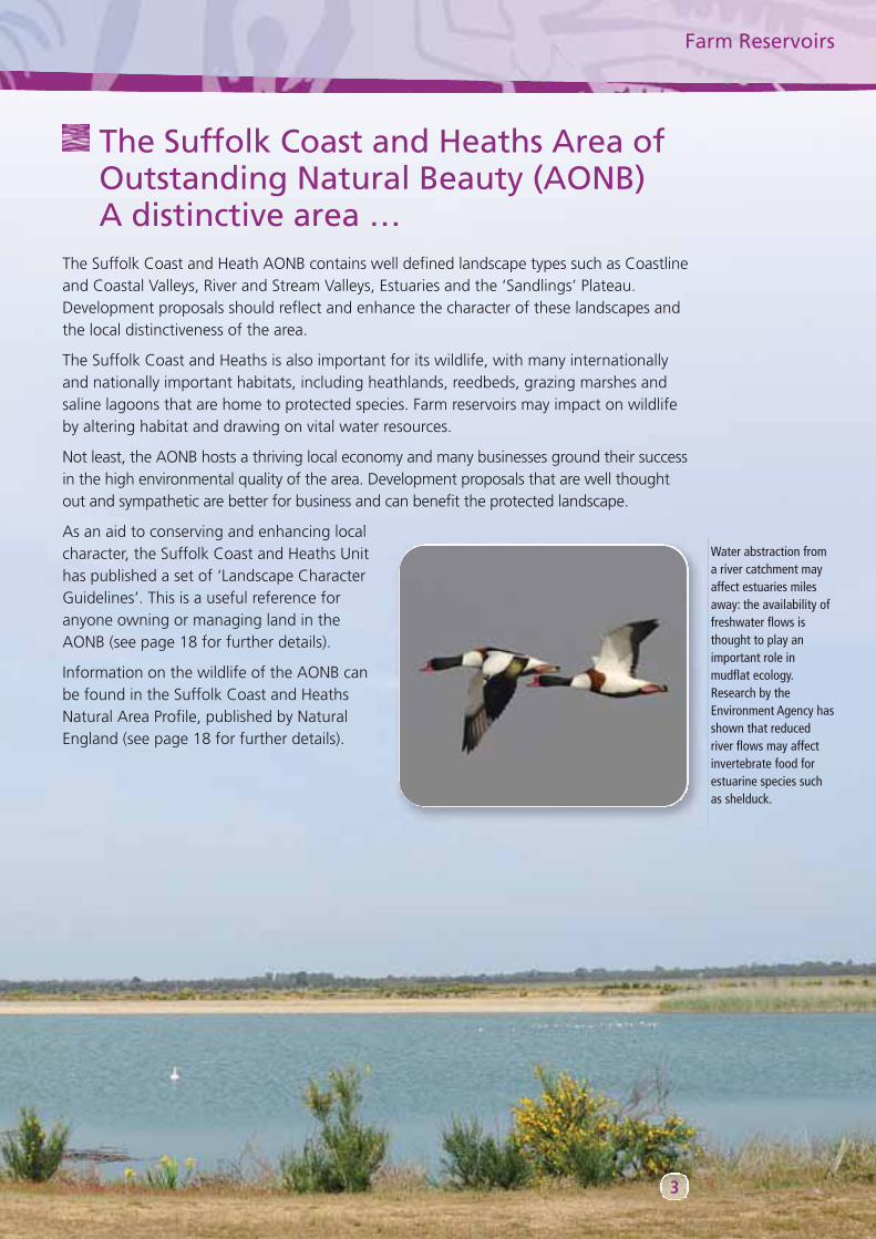
Water abstraction froma river catchment mayaffect estuaries milesaway: the availability offreshwater flows isthought to play animportant role inmudflat ecology.Research by theEnvironment Agency hasshown that reducedriver flows may affectinvertebrate food forestuarine species suchas shelduck.
4
WaveneyDistrict
Suffolk Coastal District
Babergh District
Tendring District
IpswichBorough
AONB
Additional Project Area
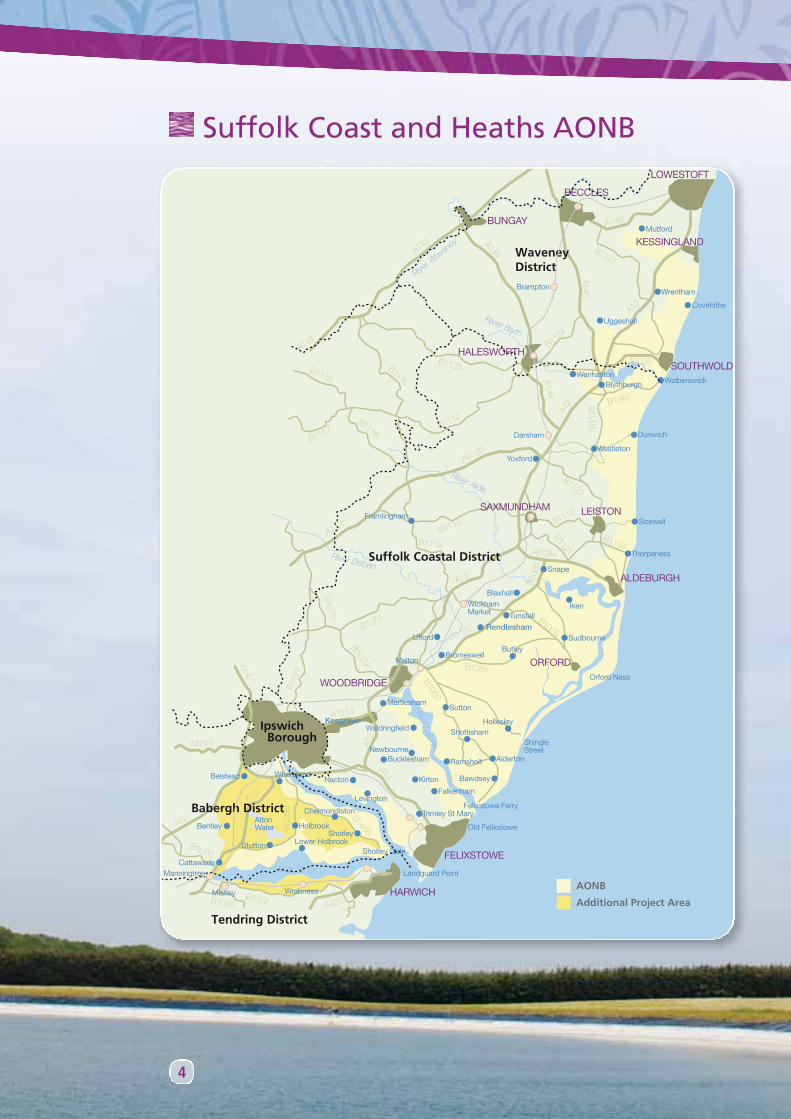
Suffolk Coast and Heaths AONB
Design principles for farm reservoirsFarm reservoirs are a potentially intrusive addition to the landscape, but with suitabledesign, can enhance it and provide wildlife value as well as supply water for irrigation.Wildlife and landscape friendly features can be incorporated into reservoir design for alittle extra cost, will gain ‘additionality’ in the planning process and may help to placateobjectors amongst statutory consultees.
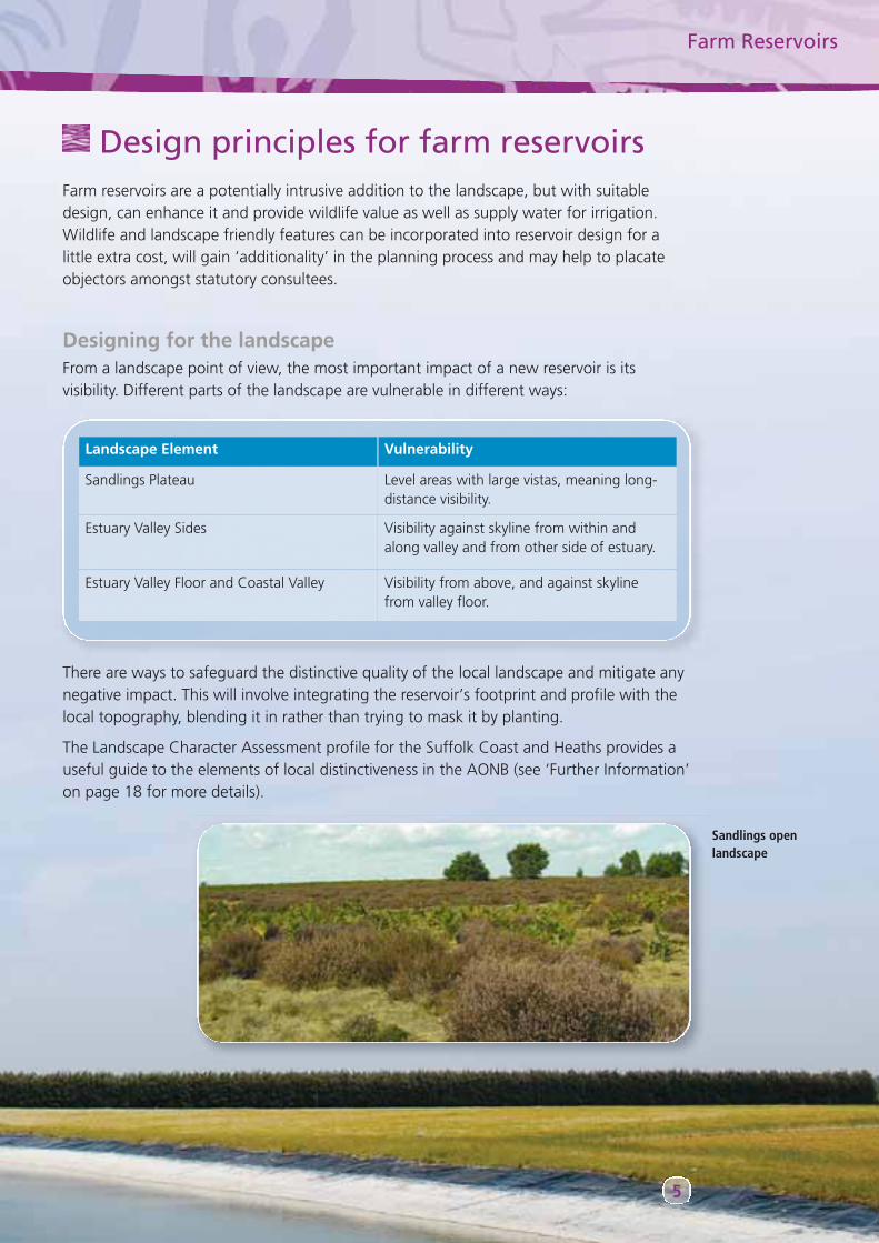
Designing for the landscapeFrom a landscape point of view, the most important impact of a new reservoir is itsvisibility. Different parts of the landscape are vulnerable in different ways:
Farm Reservoirs
5
Landscape Element Vulnerability
Sandlings Plateau Level areas with large vistas, meaning long-distance visibility.
Estuary Valley Sides Visibility against skyline from within andalong valley and from other side of estuary.
Estuary Valley Floor and Coastal Valley Visibility from above, and against skylinefrom valley floor.
There are ways to safeguard the distinctive quality of the local landscape and mitigate anynegative impact. This will involve integrating the reservoir’s footprint and profile with thelocal topography, blending it in rather than trying to mask it by planting.
The Landscape Character Assessment profile for the Suffolk Coast and Heaths provides auseful guide to the elements of local distinctiveness in the AONB (see ‘Further Information’on page 18 for more details).
Sandlings openlandscape
6
SitingIn the case of reservoirs that do not use a butyl or similar sheet liner, the availability of clayis likely to determine the general location of the reservoir. However, the specific locationshould be chosen to make the best use of pre-existing features, such as changes inlandform and existing hedges, woods and trees. Field patterns and associated features canbe very ancient and you should avoid disrupting them.
The key principles are:
• Avoid breaking the skyline: always site a reservoir away from the crest of a slope.
• Make use of landforms to help set the reservoir in its locality.
• Naturally, water bodies are more likely to be found in the lower parts of the landscapeand a reservoir may sit more comfortably here.
Take care when siting a reservoir on a floodplain. Reservoirs with large, raised banks mayincrease the risk of flooding downstream because their footprint deprives the floodplain ofvaluable storage capacity. Reservoirs which do not hold water above ground level andwhich have their excavated spoil removed from the floodplain have a neutral effect onfloodwater storage, and so are more acceptable for planners. The Environment Agencymay require a Flood Risk Assessment to ensure that the development does not increaseflood risk.
Take care to avoid Public Footpaths and other Public Rights of Way when siting a reservoir.Having to re-route Public Rights of Way will cause additional delays in the planning process.
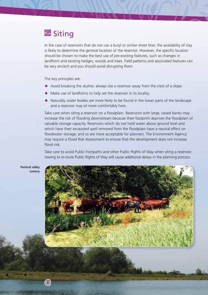
Pastoral valleyscenery

Shape and profilesFrom a water-holding point of view, a circularreservoir shape is most economical because it has alow bank / water volume ratio. A rectangular shapeis worst, but cheapest to construct. From alandscape impact point of view, an irregular outlineis best. It is rare to find straight lines in nature!
Even if the internal shape of the reservoir isrectangular, the embankment can be irregular.The boundary outline can be modified as well asthe angle of the slope and the profile of the crest.Gentle slopes, with angles no greater than 1 in 4,are less intrusive and also permit easy access forvegetation management. A hummocky surfacemay also re-create the natural curves of thelandform and help the reservoir look less intrusive.
Farm Reservoirs
7
An irregular outline reservoir
If your project includes a ditch, consider a‘beaded ditch’ as this will have greater wildlifevalue. Use low clay bunds, logs or raise the bedof the ditch with gravel to create the ‘beads’.

8
FencingIf fencing is required to keep people and animals out ofyour reservoir, carefully consider where fencing can belocated. If fencing is located off the crest there will be farless impact on the landscape. A fence sited half way upthe embankment is more difficult for deer to jump. Asuitable fence might be two metres high, with chickenwire at the bottom (dug into the ground and turnedoutwards to impede rabbits) and sheep netting above.
In locations where a high embankment is inappropriate, the reservoir needs to be over-deepened. The excess spoil can be used to contour the site, reducing slope angles, chamferingedges and creating wildlife features such as nesting banks and raised planting areas.
In cases where there is insufficient material for the embankment, your borrow pits may belandscaped for wildlife, to create ditches, ponds, boggy areas or south facing slopes thatwill greatly benefit invertebrates.
A curved orirregularly shapedmargin can soften
the shape of alined reservoir.
An embankment mayharmonise with
existing treelines.
Good fencing isessential to
reservoir safety
Designing for wildlifeThe wildlife of the Suffolk Coast and Heaths is dependent on a mosaic of habitats, manyof them developed through farming activity over hundreds, even thousands, of years. TheSandlings heaths, for example, have existed since at least the Iron Age, over 2,000 yearsago. Farm reservoirs are just one more form of human development that alters existinghabitat, but may also provide important new opportunities for plants and animals.
The main principles to follow are:
• Seek to link habitats together to allow wildlife to migrate through the area.
• Build on the typical habitats and species already found in the locality.
• Plan for the ongoing maintenance of the site as a wildlife habitat (a management planfor wildlife may be requested as part of gaining planning permission).
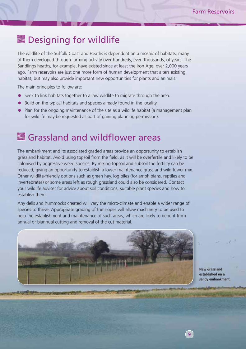
Grassland and wildflower areasThe embankment and its associated graded areas provide an opportunity to establishgrassland habitat. Avoid using topsoil from the field, as it will be overfertile and likely to becolonised by aggressive weed species. By mixing topsoil and subsoil the fertility can bereduced, giving an opportunity to establish a lower maintenance grass and wildflower mix.Other wildlife-friendly options such as green hay, log piles (for amphibians, reptiles andinvertebrates) or some areas left as rough grassland could also be considered. Contactyour wildlife adviser for advice about soil conditions, suitable plant species and how toestablish them.
Any dells and hummocks created will vary the micro-climate and enable a wider range ofspecies to thrive. Appropriate grading of the slopes will allow machinery to be used tohelp the establishment and maintenance of such areas, which are likely to benefit fromannual or biannual cutting and removal of the cut material.
Farm Reservoirs
9
New grasslandestablished on asandy embankment.
10
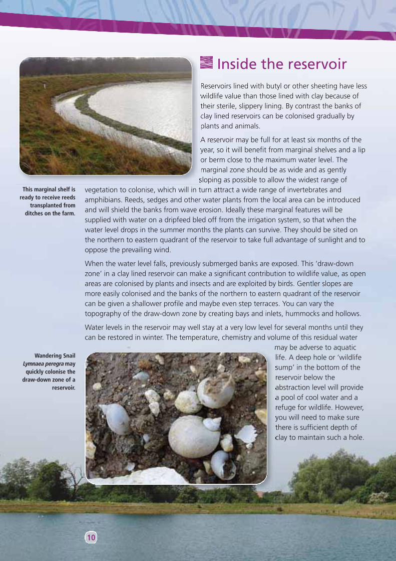
Inside the reservoirReservoirs lined with butyl or other sheeting have lesswildlife value than those lined with clay because oftheir sterile, slippery lining. By contrast the banks ofclay lined reservoirs can be colonised gradually byplants and animals.
A reservoir may be full for at least six months of theyear, so it will benefit from marginal shelves and a lipor berm close to the maximum water level. Themarginal zone should be as wide and as gentlysloping as possible to allow the widest range of
vegetation to colonise, which will in turn attract a wide range of invertebrates andamphibians. Reeds, sedges and other water plants from the local area can be introducedand will shield the banks from wave erosion. Ideally these marginal features will besupplied with water on a dripfeed bled off from the irrigation system, so that when thewater level drops in the summer months the plants can survive. They should be sited onthe northern to eastern quadrant of the reservoir to take full advantage of sunlight and tooppose the prevailing wind.
When the water level falls, previously submerged banks are exposed. This ‘draw-downzone’ in a clay lined reservoir can make a significant contribution to wildlife value, as openareas are colonised by plants and insects and are exploited by birds. Gentler slopes aremore easily colonised and the banks of the northern to eastern quadrant of the reservoircan be given a shallower profile and maybe even step terraces. You can vary thetopography of the draw-down zone by creating bays and inlets, hummocks and hollows.
Water levels in the reservoir may well stay at a very low level for several months until theycan be restored in winter. The temperature, chemistry and volume of this residual water
may be adverse to aquaticlife. A deep hole or ‘wildlifesump’ in the bottom of thereservoir below theabstraction level will providea pool of cool water and arefuge for wildlife. However,you will need to make surethere is sufficient depth ofclay to maintain such a hole.
This marginal shelf isready to receive reeds
transplanted fromditches on the farm.
Wandering SnailLymnaea peregra mayquickly colonise the
draw-down zone of areservoir.
Farm Reservoirs
11
IslandsCreating islands is one possibility for breaking up the blank expanse of water in a farmreservoir. Earth islands may not be a good idea because they reduce the water volume, canlook unsightly, are subject to wave erosion and become less accessible when water levels drop.Anchored floating islands perhaps based on wooden rafts can be more attractive and usefulfor wildlife. Islands may encourage nesting birds, depending on the type of surface. Terns maybe attracted to open areas with shingle; wild ducks will prefer areas of shrub or sedge.
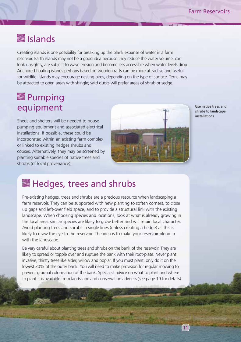
PumpingequipmentSheds and shelters will be needed to housepumping equipment and associated electricalinstallations. If possible, these could beincorporated within an existing farm complexor linked to existing hedges,shrubs andcopses. Alternatively, they may be screened byplanting suitable species of native trees andshrubs (of local provenance).
Use native trees andshrubs to landscapeinstallations.
Hedges, trees and shrubsPre-existing hedges, trees and shrubs are a precious resource when landscaping afarm reservoir. They can be supported with new planting to soften corners, to closeup gaps and left-over field space, and to provide a structural link with the existinglandscape. When choosing species and locations, look at what is already growing inthe local area: similar species are likely to grow better and will retain local character.Avoid planting trees and shrubs in single lines (unless creating a hedge) as this islikely to draw the eye to the reservoir. The idea is to make your reservoir blend inwith the landscape.
Be very careful about planting trees and shrubs on the bank of the reservoir. They arelikely to spread or topple over and rupture the bank with their root-plate. Never plantinvasive, thirsty trees like alder, willow and poplar. If you must plant, only do it on thelowest 30% of the outer bank. You will need to make provision for regular mowing toprevent gradual colonisation of the bank. Specialist advice on what to plant and where to plant it is available from landscape and conservation advisers (see page 19 for details).
12
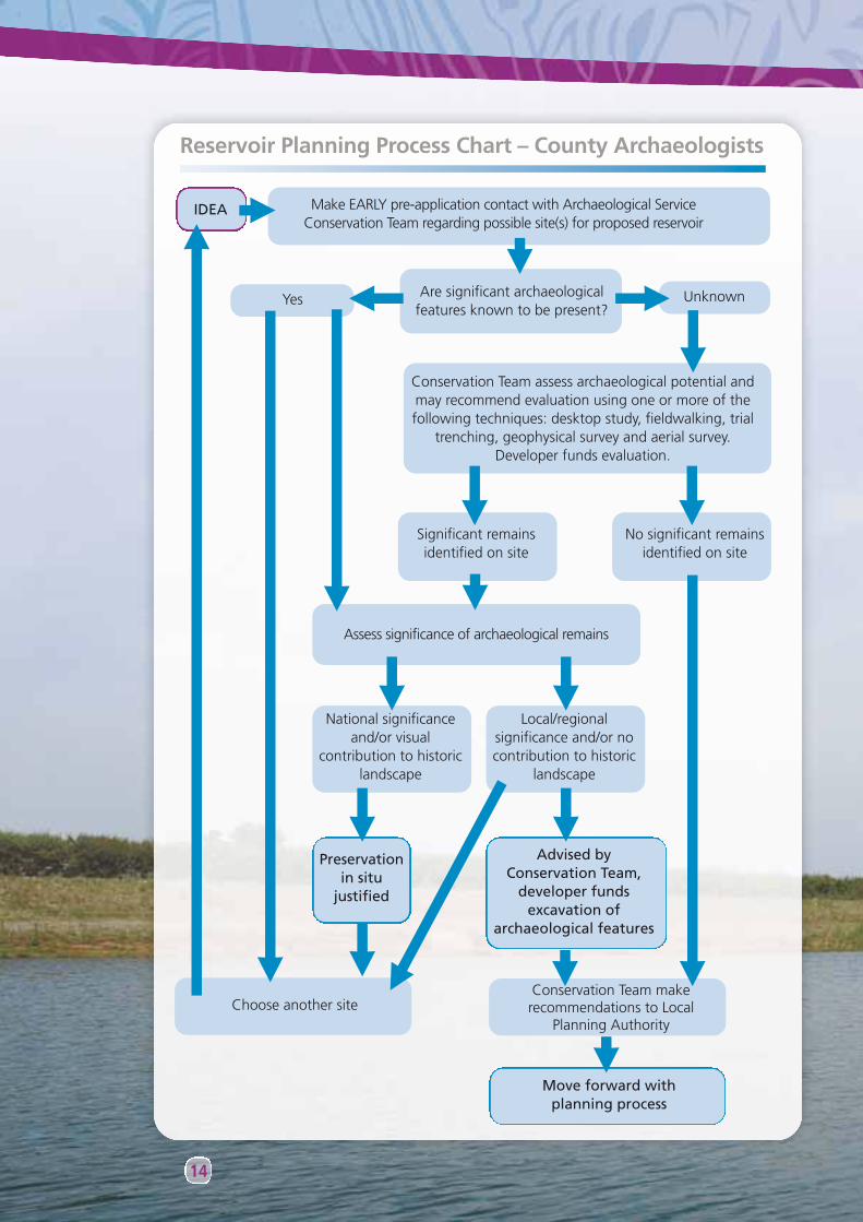
ArchaeologyWhen considering a potential site for a reservoir, it is important to seek early informationand advice about the archaeological interest in the area. Specific evidence about thelocation may be limited but that may not mean the site is not significant. As a first stepthere will be a need to assess the archaeological potential of the site, through a variety oftechniques, such as desktop study or trial trenching. If significant archaeological remainsare identified, you may have to find another site for the proposed reservoir, or undertakeexcavation that may add significantly to the cost of your project. (See page 19 for detailsof who to contact.)
Associated featuresAs part of your overall project, you may wish to consider positive management of associatedlandscape features such as ditches, hedges and ponds. Restoration or enhancement of thesefeatures for landscape and wildlife value can be undertaken as part of a package mitigatingthe impact of your proposals and help ensure that planning permission is granted. Site-specificadvice is likely to be available (see page 19 for details).
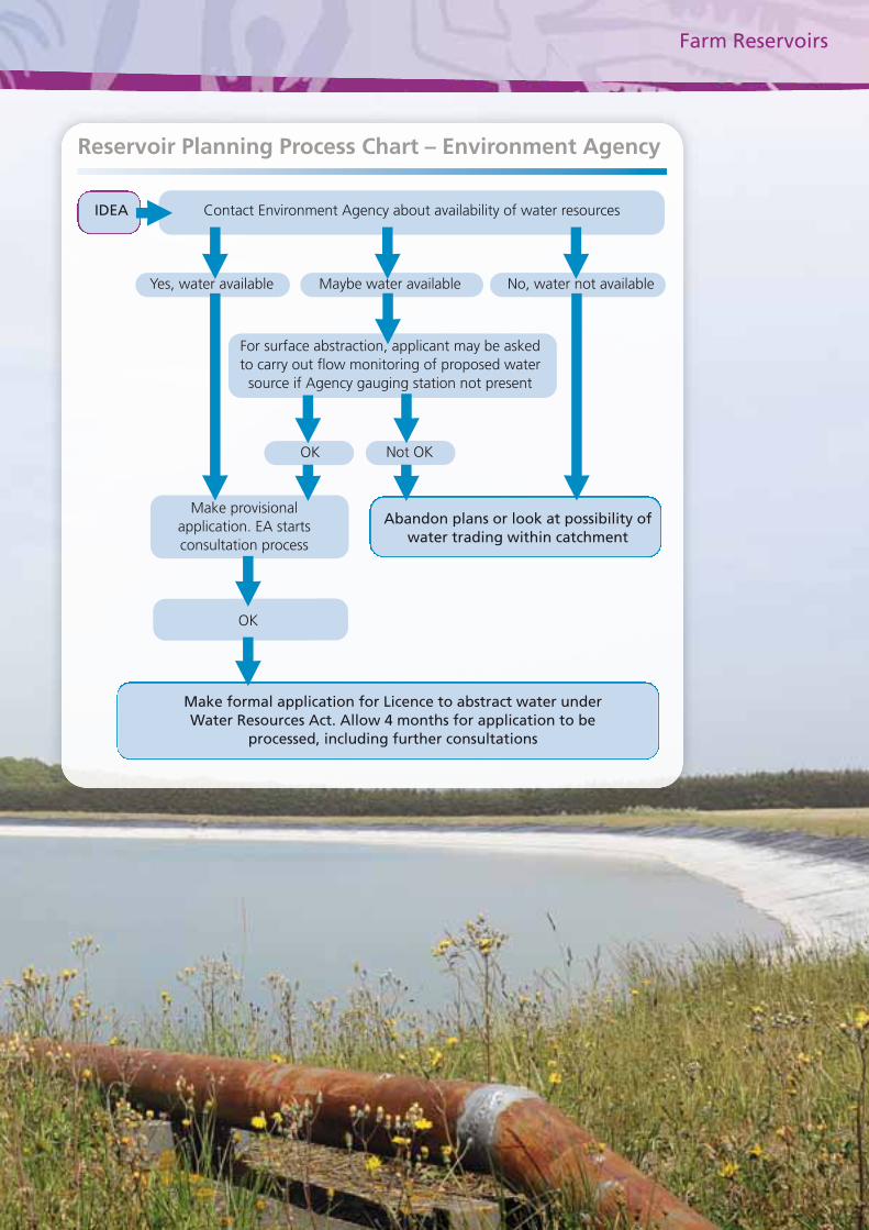
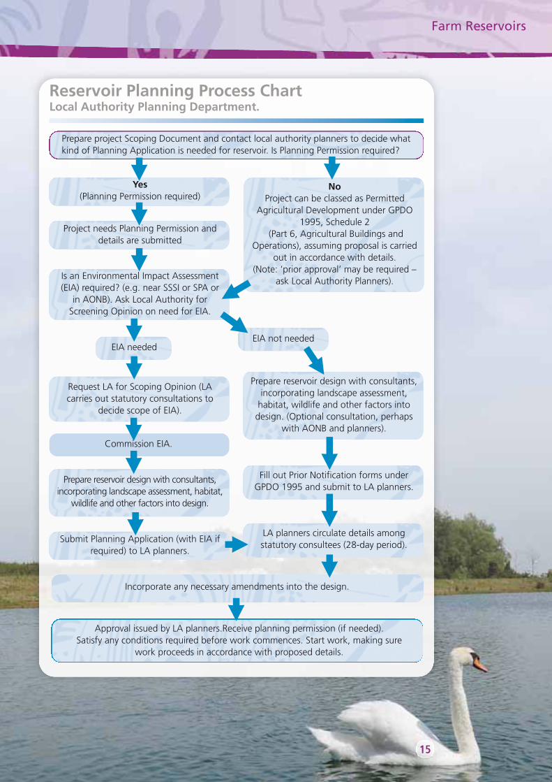
Planning your farm reservoirThe following flow diagrams show the necessary steps in obtaining the main permissions tobuild a reservoir. The first step is checking with the Environment Agency that water resourcesare available for your project. In addition you may wish to seek guidance on specific topicssuch as landscape or archaeology from the relevant advisers (see page 19 for details)
Farm Reservoirs
Reservoir Planning Process Chart – Environment Agency
IDEA
OK
OK
Make formal application for Licence to abstract water underWater Resources Act. Allow 4 months for application to be
processed, including further consultations
Not OK
Abandon plans or look at possibility ofwater trading within catchment
Make provisional application. EA startsconsultation process
Contact Environment Agency about availability of water resources
Yes, water available Maybe water available
For surface abstraction, applicant may be askedto carry out flow monitoring of proposed water
source if Agency gauging station not present
No, water not available
14
Reservoir Planning Process Chart – County Archaeologists
IDEA
UnknownYes
Significant remainsidentified on site
Conservation Team makerecommendations to Local
Planning Authority
Move forward withplanning process
Choose another site
Local/regionalsignificance and/or nocontribution to historic
landscape
National significanceand/or visual
contribution to historiclandscape
No significant remainsidentified on site
Assess significance of archaeological remains
Conservation Team assess archaeological potential andmay recommend evaluation using one or more of thefollowing techniques: desktop study, fieldwalking, trial
trenching, geophysical survey and aerial survey.Developer funds evaluation.
Make EARLY pre-application contact with Archaeological ServiceConservation Team regarding possible site(s) for proposed reservoir
Are significant archaeologicalfeatures known to be present?
Advised byConservation Team,
developer fundsexcavation of
archaeological features
Preservationin situ
justified
Farm Reservoirs
15
Reservoir Planning Process ChartLocal Authority Planning Department.
Prepare project Scoping Document and contact local authority planners to decide whatkind of Planning Application is needed for reservoir. Is Planning Permission required?
Yes(Planning Permission required)
NoProject can be classed as Permitted
Agricultural Development under GPDO1995, Schedule 2
(Part 6, Agricultural Buildings andOperations), assuming proposal is carried
out in accordance with details. (Note: ‘prior approval’ may be required –
ask Local Authority Planners).
Prepare reservoir design with consultants,incorporating landscape assessment,
habitat, wildlife and other factors intodesign. (Optional consultation, perhaps
with AONB and planners).
Approval issued by LA planners.Receive planning permission (if needed). Satisfy any conditions required before work commences. Start work, making sure
work proceeds in accordance with proposed details.
Fill out Prior Notification forms underGPDO 1995 and submit to LA planners.
LA planners circulate details amongstatutory consultees (28-day period).
Incorporate any necessary amendments into the design.
Project needs Planning Permission anddetails are submitted
Submit Planning Application (with EIA ifrequired) to LA planners.
Is an Environmental Impact Assessment(EIA) required? (e.g. near SSSI or SPA or
in AONB). Ask Local Authority forScreening Opinion on need for EIA.
Request LA for Scoping Opinion (LAcarries out statutory consultations to
decide scope of EIA).
Prepare reservoir design with consultants,incorporating landscape assessment, habitat,
wildlife and other factors into design.
EIA needed
Commission EIA.
EIA not needed
16
Legislation affecting farm reservoirsA range of legislation is relevant to land owners wishing to construct farm reservoirs. Thefollowing is a summary, but is not intended as a comprehensive statement. You shouldfind the text of the legislation on Government websites.
The Reservoirs Act 1975The Act ensures the public safety of reservoirs that hold at least 25,000 cubic metres of water above natural ground level.
Affects: The design and engineering of farm reservoirs.Administered by: The Environment Agency and requires annual inspection.
The Water Resources Act 1991The Water Act 2003This legislation provides a management framework for water resources, includingabstraction licenses, impounding of water and drought orders and the placement ofstructures such as weirs and sluices.
Flood Defence Consent: Under the terms of The Water Resources Act 1991 and theAnglian Region Land Drainage and Sea Defence Byelaws, the prior written consent of theEnvironment Agency is required for any proposed works or structures, in, under, over orwithin 9 metres of the top of the bank of any designated ‘main river’.
Affects: The ability of farmers to abstract and impound water resources. Administered by: The Environment Agency.
The Flood and Water Management Act 2010This legislation aims to provide better, more comprehensive management of flood riskfor people, homes and businesses. Defines large raised reservoirs as ‘structures capableof holding 10,000 cubic meters of water above the natural level of any part of thesurrounding land’. Such structures need to be registered with the Environment Agency.Consideration will need to be given to the impact on people downstream in the eventof a reservoir failing and a flood plan may be required. The implications of anyemergency draw-down on the flood risk in receiving watercourses will needconsideration.
Affects: The ability of farmers to abstract and impound water resources.Administered by: The Environment Agency.
The Land Drainage Act 1991This legislation provides a consenting mechanism for works affecting the flow of ordinarywatercourses (drains, ditches and minor watercourses). This may include sluices, weirs,dams, culverts or diversions.
Affects: The ability of farmers to set up flow control works to feed reservoirs orto divert/culvert drains, ditches and minor watercourses.
Administered by: The Internal Drainage Board and/or the Environment Agency.

Farm Reservoirs
17
The Countryside and Rights of Way Act 2000Building on earlier legislation, the Act has enhanced protection for Areas of Outstanding Natural Beauty in England and Wales, including the Suffolk Coast and Heaths.
Affects: The impact of farm reservoirs on sensitive landscapes and biodiversity in the AONB.
Administered by: Natural England.
The Wildlife and Countryside Act 1981The Act is the primary legislation which protects animals, plants and certain habitats in theUK. It includes provision for designating Sites of Special Scientific Interest.
Affects: The impact of farm reservoirs on protected species and habitats.Administered by: Natural England.
The Town and Country Planning Act 1990The Town and Country Planning (General Permitted Development) Order 1995The Town and Country Planning (Environmental Impact Assessment) Regulations 1999This legislation controls the planning of farm reservoirs under the planning control system andthe system of General Permitted Agricultural Development rights.
Affects: The planning and statutory consultation process involved inconstructing farm reservoirs.
• Most reservoirs will need planning permission. • Reservoirs in or impacting on environmentally sensitive sites will
require Environmental Impact Assessments (under EU Directive85/337 Environmental Impact Assessment). Sensitive sites includeSSSIs, SPAs, SACs, County Wildlife Sites.
• A heritage asset assessment will be needed in line with PlanningPolicy Statement 5. This may involve desktop studies and fieldevaluation, followed by appropriate mitigation, which could involvepreservation of the remains or further archaeological investigation.
• The site of a planned reservoir may be affected by a TreePreservation Order.
Administered by: The local planning authority and statutory consultees, includingNatural England and the County Archaeological Service.

18
Further informationPublications and online resources• Countryside Commission (1993): The Suffolk Coast and Heaths Landscape CCP406. A short introduction
to the special qualities of the AONB and the perceived forces for change.
See: www.snh.org.uk/wwo/sharinggoodpractice/CCI/cci/eastofengland/082.htm.
• English Nature (1997): Suffolk Coast and Heaths Natural Area Profile NA49. This book explains the wildlifeof the Area and the priorities for its conservation.
See: www.naturalareas.naturalengland.org.uk/Science/natural/NA_Details.asp?NA_ID=49&S=&R=8
• Environment Agency (2007): Living on the Edge. A Guide to the Rights and Responsibilities of RiversideOccupation. A booklet for people who own land or property alongside a river or other watercourse.
Downloadable from http://publications.environment-agency.gov.uk/pdf/GEHO0407BMFL-e-e.pdf
• Environment Agency (2008): The East Suffolk Catchment Abstraction Management Strategy. A booksummarising and explaining water resource availability for the local catchment, including the AONB.Includes a CD of technical information.
Can be obtained by emailing [email protected] or downloadable fromhttp://www.environment-agency.gov.uk/cy/ymchwil/cynllunio/33550.aspx
• Natural England (undated): Suffolk Coast and Heaths Joint Character Area Profile JCA82. A short guide tothe landscape, settlement and land use of the Area.
See: www.naturalengland.org.uk/Images/jca82_tcm6-5413.pdf
• Stour and Orwell Estuaries Management Group. Online resources related to managing development andits impact on estuarine wildlife. See: www.suffolkcoastandheaths.org/text.asp?PageId=93.
• Suffolk Coast and Heaths Management Plan (2008). Sets out public policy for managing the AONB.
See: www.suffolkcoastandheaths.org/downloads.asp?PageId=161.
• Suffolk Coast and Heaths AONB website, with news, information and contacts.
See: www.suffolkcoastandheaths.org.uk/.
• Suffolk Coast and Heaths Unit (2001): Landscape Character Guidelines for the Suffolk Coast and HeathsArea of Outstanding Natural Beauty. Includes Guidance Cards showing ideal priorities for conserving andenhancing the character of different facets of the landscape in the AONB.
See: http://www.suffolkcoastandheaths.org/uploads/SCH%20Landscape%20guidelines.pdf
• Suffolk Landscape Character Assessment: online maps of Suffolk’s landscape typology, including the AONB.
See: www.suffolklandscape.org.uk.
• Suffolk Wildlife Trust ‘Water for Wildlife’ project, includes information on species and farm advisory visits.
See: http://85.158.158.143/ca/gi/water%20for%20wildlife.htm
• ‘The Pond Book’ by P. Williams and others (Ponds Conservation Trust; 1999; ISBN 0-953797-10-4). Aguide to the principles of managing and creating ponds, particularly in the countryside.
See: www.pondconservation.org.uk/advice/Buythepondbook/
• ‘Sandlands: The Suffolk Coast and Heaths’ by Tom Williamson (Windgather Press; 2005; ISBN 1-905119-02-X). An in-depth explanation of how the distinctive landscape of the Suffolk Sandlings has evolved overthe centuries.
• ‘Thinking About an Irrigation Reservoir?’ A guide to planning, designing, constructing and commissioninga water storage reservoir (Environment Agency and Cranfield University).
See: www.ukia.org/eabooklets/EA%20Reservoir%20booklet_final.pdf
Farm Reservoirs
Organisations• Environment Agency: 08708 506506 / www.environment-agency.gov.uk
• Local Authority Planning Departments
• Babergh District Council : 01473 825858 / www.babergh.gov.uk • Suffolk Coastal District Council: 01394 444423 or 403 or 428 / www.suffolkcoastal.gov.uk • Waveney District Council: 01502 523024 (Lowestoft and northern parishes);
01502 523020 (other parishes) / www.waveney.gov.uk
• Natural England: 01284 762218 / www.natural-england.org.uk
• Suffolk Archaeological Service: 08456 066067www.suffolk.gov.uk/Environment/Archaeology
• Suffolk Coast and Heaths Unit: 01394 384948 / www.suffolkcoastandheaths.org
• Suffolk FWAG: 01473 652800 / www.fwag.org.uk/contact
• Suffolk Wildlife Trust: 01473 890089 / www.suffolkwildlife.co.uk
AcknowledgementsMany people have generously given their time, advice and comments towards makingthis booklet. We gratefully acknowledge receipt of assistance from the following:
Will Akast, James Carr, Graham Robertson, Naomi Steele - Environment Agency
The late Peter Berry - Babergh District Council
Anne Westover, Steve Milligan, Martin Price - Suffolk Coastal District Council
Sir Michael Bunbury - Naunton Hall Estate
Graham Hall - Prime Irrigation Ltd.
Andrew Hawes - Stephen Hawes Associates
Michael Hyde-Parker - Natural England
Sarah Poppy - Suffolk Archaeological Unit
Messrs GH and JG Paul - Kirton Lodge Farm
Tim Schofield - Suffolk FWAG
Peter Youngs - East Suffolk Water Abstractors’ Group
Tim Holt-Wilson
The opinions and design guidelines in this booklet are purely the responsibility of the Suffolk Coast and Heaths Unit. If you wish to suggest any improvements or corrections please contact us at the address overleaf.
19
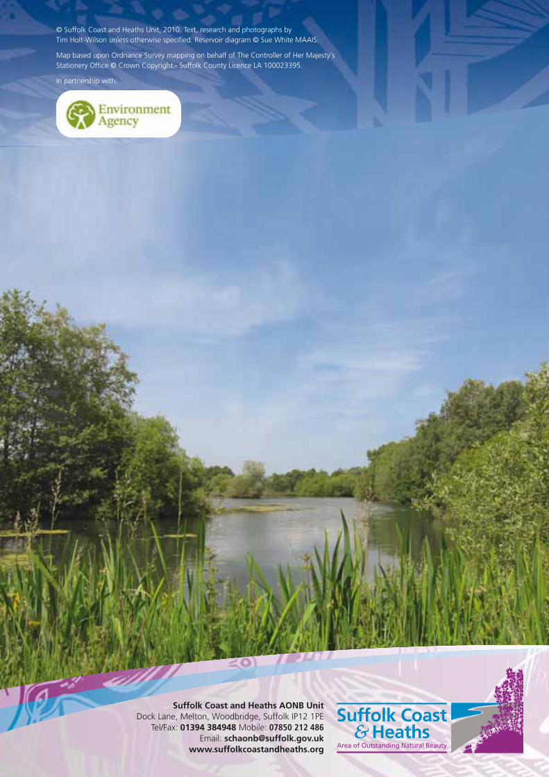
© Suffolk Coast and Heaths Unit, 2010. Text, research and photographs by Tim Holt-Wilson unless otherwise specified. Reservoir diagram © Sue White MAAIS.
Map based upon Ordnance Survey mapping on behalf of The Controller of Her Majesty’sStationery Office © Crown Copyright - Suffolk County Licence LA 100023395.
In partnership with:
Suffolk Coast and Heaths AONB UnitDock Lane, Melton, Woodbridge, Suffolk IP12 1PE
Tel/Fax: 01394 384948 Mobile: 07850 212 486Email: [email protected]
www.suffolkcoastandheaths.org