federal university of lavras, minas gerais, brazil · it is located in the southern minas gerais...
TRANSCRIPT
CALIBRATION AND VALIDATION OF SWAT
HYDROLOGICAL MODEL FOR SAPUCAÍ RIVER
BASIN, BRAZIL
INTRODUCTION
CONCLUSIONS
MATERIAL AND METHODS
Authors: Matheus Fonseca Durães; Carlos Rogério de Mello and Nilton Curi
Federal University of Lavras, Minas Gerais, Brazil – [email protected]
GOALS
RESULTS AND DISCUSSION
ACKNOWLEDGMENTS: UFLA and CNPq
SPONSORED by CNPq
Simulating the hydrologic pattern of river basins is one of the most
important tools for natural resources management as it allows forecasting
the impacts of land use changes on the hydrology of a given basin (Durães
et al., 2011).
SWAT was developed by the USDA Agricultural Research Service (ARS),
and is a physically-based, continuous time model that is designed to assess
the effect of management and climate change on water, sediment, and
agricultural chemicals over long periods of time (Arnold and Fohrer, 2005;
Jha et al., 2007, Gassman et al., 2007). This model has been applied in
Brazil for different purposes and regions
The objective of this study was to perform SWAT calibration and validation
procedures in a monthly time step, and then simulating monthly calibrated
parameters behavior on a daily time step, aiming to obtain results associated
to its suitability in this basin.
The study area refers to the Sapucaí river basin (SRB), the most important
tributary of the Grande River. It is located in the southern Minas Gerais state,
Southeastern Brazil, between the coordinates of -22,554ºS and -22,885°S
latitude and -45,701°W and -45,735°W longitude, with an area
of 8,882km ². Its outlet is located in the reservoir of the Furnas Hydropower
Plant, whose power generation capacity is about of 1,216MW.
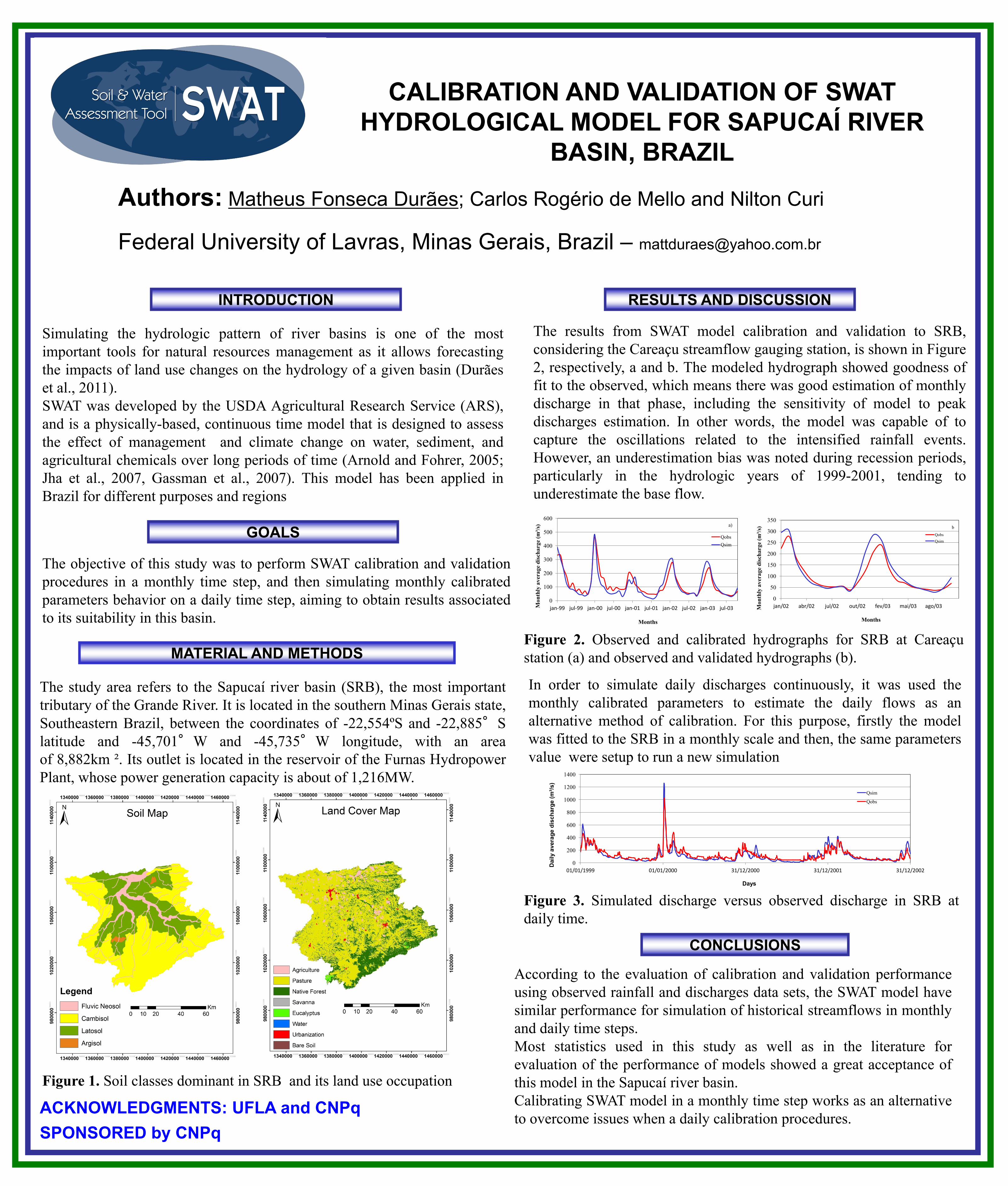
The results from SWAT model calibration and validation to SRB,
considering the Careaçu streamflow gauging station, is shown in Figure
2, respectively, a and b. The modeled hydrograph showed goodness of
fit to the observed, which means there was good estimation of monthly
discharge in that phase, including the sensitivity of model to peak
discharges estimation. In other words, the model was capable of to
capture the oscillations related to the intensified rainfall events.
However, an underestimation bias was noted during recession periods,
particularly in the hydrologic years of 1999-2001, tending to
underestimate the base flow.
According to the evaluation of calibration and validation performance
using observed rainfall and discharges data sets, the SWAT model have
similar performance for simulation of historical streamflows in monthly
and daily time steps.
Most statistics used in this study as well as in the literature for
evaluation of the performance of models showed a great acceptance of
this model in the Sapucaí river basin.
Calibrating SWAT model in a monthly time step works as an alternative
to overcome issues when a daily calibration procedures.
0
100
200
300
400
500
600
jan-99 jul-99 jan-00 jul-00 jan-01 jul-01 jan-02 jul-02 jan-03 jul-03 Mo
nth
ly a
ver
ag
e d
isch
arg
e (m
³/s)
Months
Qobs
Qsim
a)
0
50
100
150
200
250
300
350
jan/02 abr/02 jul/02 out/02 fev/03 mai/03 ago/03 Mo
nth
ly a
ver
ag
e d
isch
arg
e (m
³/s)
Months
Qobs
Qsim
b
In order to simulate daily discharges continuously, it was used the
monthly calibrated parameters to estimate the daily flows as an
alternative method of calibration. For this purpose, firstly the model
was fitted to the SRB in a monthly scale and then, the same parameters
value were setup to run a new simulation
Figure 1. Soil classes dominant in SRB and its land use occupation
Figure 2. Observed and calibrated hydrographs for SRB at Careaçu
station (a) and observed and validated hydrographs (b).
0
200
400
600
800
1000
1200
1400
01/01/1999 01/01/2000 31/12/2000 31/12/2001 31/12/2002
Da
ily a
ve
rag
e d
isc
ha
rge
(m
³/s
)
Days
Qsim
Qobs
Figure 3. Simulated discharge versus observed discharge in SRB at
daily time.