fedor petrovich litke and his expeditions to novaya … · via sunda strait and the cape of good...
TRANSCRIPT

1
The Journal of the Hakluyt Society December 2017
Fedor Petrovich Litke and his Expeditions to Novaya Zemlya
1821-24
by William Barr
Abstract
Having distinguished himself as senior midshipman on board Vasiliy Mikhailovich Golovnin’sKamchatka during the latter’s round-the-world cruise in 1817-19, in 1821 at the age of only 23,Leytenent Fedor Petrovich Litke was selected by the Russian Navy Department to lead anexpedition to survey the coasts of Novaya Zemlya, and also the mainland coast from the WhiteSea west to the Russian-Norwegian border. While Litke was entirely successful in executingthis latter part of his orders, he was less successful in surveying Novaya Zemlya. In the brigNovaya Zemlya, over four consecutive seasons (1821-4), he succeeded despite his best effortsin surveying only parts of the west coast of the double-island due to persistently late-survivingsea ice. He was unable to penetrate north of Mys Nassau and thus was unable to reach MysZhelaniya the northern tip of Novaya Zemlya, and while he was able to send boats throughMatochkin Shar to survey that strait, he was unable to reach any part of the east coast. Thecontrast with the present situation, whereby the route north of Novaya Zemlya in ice-freewaters is commonly used by vessels proceeding from the Barents Sea to the Kara Sea, is aninteresting commentary on changing sea-ice conditions.
Early career
Fedor Petrovich Litke’s family was German in origin. His grandfather, Johann Philipp Lütke(Ivan Filippovich Litke), a Lutheran pastor, moved from Germany to St Petersburg in 1735 totake up the position of co-rector of the Academy of Science’s gimnaziya (high school)1. Hissecond son Petr Ivanovich pursued a military career, but in June 1795 he was appointedCouncilor of Customs in St Petersburg. In the interim, on 15 December 1784 he had marriedAnna Ivanovna Engel. The latter gave birth to Fedor Petrovich on 17 September 1797,2 butunfortunately died from complications associated with his birth. Being left with five youngchildren, ranging in age from twelve years to a few hours, Petr Ivanovich arranged for hismother-in-law, Elizaveta Kasperovna Engel, then living in Kiev, to move to St Petersburg tolook after his children. Then, a year after Anna’s death Petr Ivanovich married seventeen-year-old Yekaterina Andreyevna Pal’m whom Orlov has described as Fedor Petrovich’s ‘evil, cruelstepmother’.3
In 1804, at the age of seven, Fedor Petrovich was sent to a boarding school run by EfimKhristoforovich Meyer, who was a firm believer in corporal punishment. Alekseev hasdescribed Fedor Petrovich at this stage as ‘badly developed physically, fearful, shy andunresourceful’.4 But then on 8 March 1808 Petr Ivanovich died, and two months later FedorPetrovich’s grandmother Elizaveta Kasperovna also died. The family got together and decidedthat the children should be distributed among various of the family members. Fedr Petrovichwas taken out of boarding school and sent to live with his uncle, Fedor Ivanovich Engel. The
1 Alekseev, Fedor Petrovich Like, p.1; Orlov, ‘Fedor Petrovich Litke’, p. 7.2 This and all other dates are according to the Julian calendar. To derive the Gregorian date add 11 days.3 Orlov, ‘Fedor Petrovich Litke’, p. 7.4 Alekseev, Fedor Petrovich Litke, p. 5
2
latter ignored young Fedor Petrovich almost completely, but on the other hand he was givenfree access to his uncle’s extensive library. He read voraciously, if in rather a disorganizedfashion. This somewhat irregular education was further enhanced by listening to thedistinguished guests who attended Fedor Ivanovich Engel’s dinner parties on Mondayevenings.
But then on 29 June 1810 Fedor Petrovich’s sister, Natalya, married naval officerKapitan-leytenant Ivan Savvich Sul’menev and he moved with them to Kronshtadt where IvanSavvich was stationed. A very close relationship developed between Fedor Petrovich and hisuncle. He enjoyed the trip out to Kronshtadt immensely and spent many hours exploring thenaval base. He also listened avidly to conversations between his uncle and naval friends, aboutthe sea, ships and naval battles.
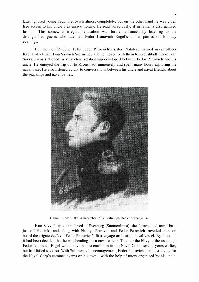
Figure 1. Fedor Litke, 4 December 1823. Portrait painted at Arkhangel’sk.
Ivan Savvich was transferred to Sveaborg (Suomenlinna), the fortress and naval basejust off Helsinki, and, along with Natalya Petrovna and Fedor Petrovich travelled there onboard the frigate Pollux – Fedor Petrovich’s first voyage on board a naval vessel. By this timeit had been decided that he was heading for a naval career. To enter the Navy at the usual ageFedor Ivanovich Engel would have had to enrol him in the Naval Corps several years earlier,but had failed to do so. With Sul’menev’s encouragement, Fedor Petrovich started studying forthe Naval Corp’s entrance exams on his own – with the help of tutors organized by his uncle.
3
His exam was an oral one, the examiners being officers who knew his uncle. He passed theexam and on 23 April 1813 he joined the Navy as a naval cadet (gardemarin).5 Almostimmediately he found himself on active service; on 9 May he was on board the galiot Aglaya,one of 21 gunboats under the command of Sul’menev, who flew his broad pennant on boardthat vessel when he led his little flotilla first to Riga and then to Danzig (Gdansk), held by theFrench.6 Initially the gunboats were stationed in the Putziger Vik (Zatoka Pukka) but then on21 and 23 August and 4 September they attacked the batteries at the mouth of the Wista(Vistula) River while Russian and Prussian troops attacked the city. Fedor Petrovich was incharge of a launch carrying Sul’menev’s orders, under fire, to each of the gunboats engaged inthe attack. For his performance he was awarded the Order of Sv. Anna, Fourth Class. Then, on23 September he was promoted Mishman (Midshipman), still only 15 years old.7
After spending the winter in Königsberg (Kaliningrad) and St Petersburg, in mid-June1814 Litke returned to Sveaborg on board Aglaya. He spent most of the winter of 1814-15 in StPetersburg, staying with the Sul’menevs, then was back in Sveaborg for the following winter.On Sul’menev’s recommendation Fedor Petrovich’s next appointment was to the frigateKamchatka, which was to undertake a round-the-world cruise under the command of VasiliyMikhailovich Golovnin. Litke was the senior midshipman on board, the others being FerdinandPetrovich Vrangel’ and Fedor Fedorovich Matyushkin, both of whom became lifelong friendsof Litke, and who, by coincidence would later be engaged in surveying the coasts of the EastSiberian Sea at the same time that Litke was mounting expeditions to Novaya Zemlya.
Kamchatka put to sea from Kronshtadt on 26 August 1817.8 After calling atCopenhagen, Portsmouth (from where Litke visited London for a few days) and Rio de Janeiro,and having taken about a month to round Cape Horn due to its notorious westerly gales, thefrigate reached Callao on 7 February 1818. From there Litke visited Lima. Putting to sea againon 27 February Kamchatka headed north and west, reaching Petropavlovsk-na-Kamchatke on 3May. Sailing again on 19 June the frigate next called at Kodiak en route to Novo-Arkhangel’sk(now Sitka); along the way Litke and his fellow officers surveyed the Komandorskiye Ostrova,Attu and others of the Aleutian Islands. The frigate reached Novo-Arkhangel’sk, the capital ofRussian America on 28 July. Although he probably did not learn of it until Kamchatka returnedto Kronstadt, on 26 July 1818 Litke had been promoted to Leytenant.
Sailing from Novo-Arkhangel’sk again, after a brief stop at Fort Ross the frigatecontinued south to Monterey. Putting to sea again on 18 September, after another brief stop atFort Ross Kamchatka headed southwest, bound for the Sandwich Islands (Hawaii). There, herfirst stop was at Hawaii (the Big Island) where Litke went ashore at Kealakekua Bay whereCaptain James Cook had been murdered only 40 years earlier. The next stop was Honolulu onOahu, from where the frigate sailed again on 30 October. After calling at Guam Kamchatkanext headed for Manila in the Philippines, arriving on 13 December. Her stay here was quitelong – until 17 January 1820, the time being used for repairs, caulking and painting inpreparation for the long voyage home. Via Sunda Strait and the Cape of Good Hope, with nointermediate stops the frigate reached St Helena on 20 March. Since Napoleon Bonaparte wasstill a prisoner there, security was tight and only Golovnin and one of the cadets was allowedashore. The visit was brief, with the frigate putting to sea again on 22 March. After a short stop
5 Orlov, ‘Fedor Petrovich Litke’, p. 8.6 Alekseev, Fedor Petrovich Litke, p. 12.7 ibid, p. 14.8 ibid, p. 21.

4
at Ascension and a longer one at Faial in the Azores, the frigate called at Portsmouth andreturned to Kronshtadt on 5 September 1819.9
Soon afterwards Litke submitted a request to be transferred to the naval detachmentbased at Arkhangel’sk. This request was approved and he travelled north to that city in thespring of 1820. There he was posted Fourth Leytenant on board the ship Tri Svyatiteliya,Kapitan Rudnev. On 20 July, along with the frigates Patrikii and Merkurius, Litke’s ship setsail for Kronstadt. After a brief stop at Helsingør, Denmark, they reached Kronshtadt on 5September. 10
Following a less-than-successful attempt in 1820 the Navy Department was planning todispatch another expedition to survey the coasts of Novaya Zemlya in 1821. Golovnin, whohad been greatly impressed by Litke’s performance during the round-the-world cruise on boardKamchatka, submitted his name to the Minister for the Navy as a suitable candidate tocommand the planned expedition. His recommendation was accepted.
Earlier expeditions to Novaya Zemlya
When one considers that almost the entire mainland arctic coast of Russia had been mapped inconsiderable detail during the Great Northern Expedition of 1833–43,11 it appears strange, atfirst sight, that the relatively accessible coasts of Novaya Zemlya still remained largelyunsurveyed as late as 1819. While there had been numerous visits by hunters and trappers fromPomor’ye [the White Sea area] earlier than this, the first maps of the islands had to wait untilthe late 16th century and the voyages of Dutch seafarers such as Willem Barents in 1594 andespecially in 1896–7,12 which resulted in Gerard de Veer’s remarkable map of the entire westcoast. Hunters and trappers from Pomor’ye continued to visit the islands, men such as SavvaLoshkin who in 1760–62 circumnavigated the entire island,13 or Jakov Chirakin who in 1766discovered and sailed through Matochkin Shar and back, and roughly mapped that strait.14
On the basis of Chirakin’s report and map in 1768 the Admiratly dispatched PoruchikFedor Rozmyslov in a koch. He sailed through Matochkin Shar and he and his men wintered intwo groups at the eastern end of the strait before returning. Rozmyslov produced a moredetailed map of the strait.15 Then in 1807 a mineral prospecting expedition under ShturmanGrigoriy Pospelov and mining expert Ludlov examined parts of the west coast of the southisland, especially the area around the western entrance to Matochkin Shar.16 Pospelov produceda somewhat rough map of the west coast, especially of the section from Kostin Shar toMatochkin Shar.17
Finally in 1819 the Navy Department dispatched an expedition under Leytenant AndreiPetrovich Lazarev in a brig named Novaya Zemlya to produce an accurate map of the wholeisland.18 Starting from Arkhangel’sk on 10 June he initially found the entire west coast ofNovaya Zemlya solidly icebound; he then ran west to Ostrov Kolguyev before returning to
9 ibid, p. 37.10 ibid, p. 46.11 Belov, Arkticheskoye moreplavaniye, pp. 264-340.12 De Veer, A true description.13 Pasetskiy, Pervootkryvateli Novoy Zemli, pp. 40-42.14 Belov, Arkticheskoye moreplavaniye, p. 382.15 ibid, p. 389.16 ibid, p.467; Litke, Chetyrekhkratnoye puteshestviye, p. 82.17 Belov, Arkticheskoye moreplavaniye, p. 468.18 ibid, p. 469; Litke, Chetyrekhkratnoye puteshestviye, p. 86.

5
Novaya Zemlya. He sighted the coast of the south island on 19 July and took bearings on twoconspicuous headlands. Heading north in search of Matochkin Shar he ran into close ice at 73°15′N. His ship was damaged in the ice and scurvy broke out among his crew. Cutting his losseson 9 August Lazarev headed back south.
In light of Lazarev’s less-than-successful attempt, the Naval Ministry decided todispatch another expedition, led by Litke, in 1821.
Litke’s first expedition 1821
He received his orders on 21 April.19 They specified:
The goal of the orders which I am giving you is not a detailed survey of NovayaZemlya, but simply an initial overview of its coasts and identification of the size of thisisland by determining the geographical locations of its main capes and the length of thestrait known as Matochkin Shar, unless the latter is blocked by ice or other obstacles.20
In St Petersburg the State Admiralty Department provided him with charts, books andinstruments – two chronometers, three sextants, a marine barometer and three thermometers.He set off from the city just before the winter sledge route became impassable and reachedArkhangel’sk in early April. The city lies on the Severnaya Dvina, at the head of its delta, some
19 Alekseev, Fedor Petrovich Litke, p. 20.20 Litke, Chetyrekhkratnoye puteshestviye, p. 93.

6
35 km from the White Sea. The ice on the Dvina did not start to break up until 30 April andtherefore Litke had plenty of time to make his preparations.
The vessel which had been earmarked for the expedition was lying at nearbyLapominskaya Gavan’. This, his first command at the age of only 23, was a new brig – i.e. avessel with two masts, square-rigged on both masts – named Novaya Zemlya. Built by mastershipwright Andrey Mikhailovich Kurochkin, it was 24.4 m long with a beam of 7.6 m and adepth of hold of 2.7 m. It was very solidly built and fastened with copper. The brig’s totalcomplement was 43; the officers included First Officer Leytenant Mikhail AndranovichLavrov, Midshipman Nikolai Alekseyevich Chizhov and Litke’s younger brother MishmanAleksandr Petrovich. Other members of the ship’s complement were surgeon IsaakTikhomirov, two navigators and 33 seamen, including three gunners, a caulker, a sailmaker acarpenter and a smith.

7
Novaya Zemlya was towed from Lapominskaya to Arkhangel’sk on 13 May and finalfitting-out proceeded there. The brig finally got away from Arkhangel’sk on 14 July bounddownriver to the sea. Passing the Novodvinskaya Fortress Litke saluted it with seven guns,receiving the same number in reply. The vessel crossed the bar at the river-mouth on the 15th,and after handing his last mail to the pilot as he returned to the pilot station Litke set anorthwesterly course across the White Sea. Although slowed by calms by the morning of the17th Novaya Zemlya was passing the cape of Zimniye Gory (near the present village ofZimnegorskiy), which marks the northern cape of Dvinskaya Guba and the southern entranceto the gorlo (literally ‘the throat’), i.e. the narrow entrance to the White Sea. From here,however, Litke had to contend with a northeasterly wind which meant tacking to and fro acrossthe gorlo, at first in fog and then in clear conditions, resulting in interesting mirages such asvessels appearing upside-down. By 5 pm on the 17th the brig was off Ostrov Sosnovets, just offthe western shore and by 8 pm on the 18th, just off Ostrov Morzhovets, just northeast of thenorth end of the gorlo. The northern end of the gorlo is strewn with shoals, many unmarked atthat time. The maps which Litke possessed showed one shoal with a depth of (2 fathoms – 3.66m), 19 miles east of Mys Orlovskiy on the west shore and another (1½ fathoms – 2.7 m) 20miles west of Konushin Nos on the east shore. He was confident of being able to threadbetween them, but in the early hours of the 19th it fell calm and the brig drifted gently aground,in a depth of only 3.05 m forward. A kedge anchor was led out aft, in hopes of warping off butunfortunately the tide was dropping fast. A fresh northeasterly wind had now risen and the brigstarted to roll over on its port side. Litke tried to prop it up using spare yards and masts butthey all snapped in succession and the vessel heeled over quite alarmingly. But then, quiteincomprehensibly the brig suddenly swung upright again. Low water came at about 8 am –presenting quite a remarkable scene. Novaya Zemlya was sitting high and dry on a sand-barmeasuring about 1 km by 500 m, with no land in sight in any direction. With nothing that couldbe done for the moment Litke gave the crew permission to enjoy this unique situation, ‘Aroundthe brig men strolled in various attitudes, some examining the exposed hull; others (officers)were making astronomical observations or were strolling unconcernedly around the sandyexpanse, collecting souvenirs of shells or pebbles – altogether it comprised an unusualpicture’.21
This situation must have been extremely embarrassing and worrying for Litke – at thestart of his first voyage with his first independent command. But worse was to come. Thenortheast wind was strengthening again, raising large waves; meanwhile the tide was risingsteadily and soon the waves were breaking against the ship. In the meantime Litke had led outa second kedge anchor astern. With the impact of the waves the brig started pounding. At 11.45by which time the depth aft was 3.73 m although the bows were still aground, by hauling in onboth kedge anchors the crew managed to refloat their vessel.22 Since the sea was by now toorough to send a boat to recover the kedge anchors, and since he was reluctant to take his vesselback close to the shoal, Litke decided to abandon the kedge anchors, although this meant thathe was left with only one, and a small one at that.
By 2 am on the 20th the brig was under way, heading west. It was approaching the coastby 8.30, but in thick fog; the fog had lifted by 10 o’clock, however, and Litke was able to takebearings on the coast near the mouth of the Ponoy River. By evening he had beat north to MysOrlovskiy, on which a lighthouse was under construction. Continuing north, by 9 pm on the
21 ibid, p. 118.22 ibid, p. 119.

8
21st the brig was off Mys Gorodetskiy, from which Litke took his departure, heading northacross the Barents Sea.
In fog, rain, drizzle and headwinds, progress across the Barents Sea was slow and farfrom comfortable. Moreover on the 26th it was discovered that out of four barrels of potatoesthe contents of three were rotten and had to be discarded. When the fog cleared on the 30 th
Litke was able to shoot the sun at noon; the brig’s position was 70°52′N; 46°43′E. At 4 am onthe 31st the air temperature suddenly dropped to +1.5°C and a whole fleet of ice floes wassighted; shortly afterwards a continuous belt of ice was visible extending from NW to NE.Then the fog closed in again.
Litke swung south, aiming to try to reach the coast of Novaya Zemlya as far south aspossible. He continued to work his way south, skirting the ice edge and probing it repeatedly totry to reach land. His noon latitude on 5 August was 70°56′N but, frustratingly, on the 10 th itwas 71°8′N, i.e. a current had carried the brig back north by 12 minutes, i.e. 12 nautical miles(22.2 km) despite sailing steadily south. Finally, at 7 pm on the 10th land was sighted from thecrosstrees and then from the deck, bearing NEbN. From his map Litke guessed that it was thecoast of Ostrov Mezhdusharskiy, but he was unable to spot the entrance to Kostin Shar.Repeated attempts to close with the land were blocked by ice, however. By noon on the 14th
land was still in sight to the NE and ENE, but Litke was unable to identify it, and unable to getcloser because of ice. Concluding that the coast of Novaya Zemlya from about 70° to 72°N wascompletely inaccessible due to offlying ice:
For these reasons I decided not to linger any longer off the south coast but to hasten tothe coasts lying further north, although it seemed contrary to probability and the naturalorder of things, that they would be freer of ice than the former.23
During the 14th several herds of walrus were seen resting on floes, with 10-15 animals in eachherd. Several shots were fired at one herd, but after two shots they paid no further attention,although presumably at least one animal had been hit. On the 15th a bear was seen swimmingamong the ice near the ship, over 32 km from land. Litke remarked ‘Having fallen asleep onthe ice these animals are sometimes carried out a great distance from shore’.24 He wasevidently unaware that the sea ice is the natural habitat of this species, as is indicated by itsLatin name, Ursus maritimus.
Litke’s observed latitude at noon on the 18th was 71°53′N, and on the 22nd 72°24′N, i.e.off the prominent cape of Mys Britvin, according to Rozmyslov’s map.25 Soon after noon onthe 22nd land was sighted, running SSW to NNE, and at its northern tip a conspicuous mountainwith a domed, snow-covered summit, later name Gora Pervousmotrennaya (First-observed). Infact this mountain lies some 40 km almost due northeast of Mys Britvin, which would suggestthat Rozmyslov’s reported latitude was significantly too far south. Remarkably, the sea at thispoint appeared to be completely free of ice. Baffled as to his exact location Litke consulted oneof his men, Smirennikov, who had twice been to Matochkin Shar previously, by karbas. He,however, could not recognize the coast in sight, but felt that they had overshot the entrance toMatochkin Shar; in fact it still lay about 50 km to the northeast.
23 ibid, p. 129.24 ibid.25 ibid, p. 131.

9
After lying hove-to overnight, on the 23rd the brig continued northwards, althoughstrong offshore winds prevented Litke from hugging the coast as closely as he would havepreferred. He was watching for any significant break in the coastal mountains, suggesting astrait running east. Two apparent openings turned out to be only inlets, however.26 Finally, at6.30 pm on the 24th at a dead-reckoning latitude of 74°10′N, Litke decided that he must haveovershot Matochkin Shar and turned back south. The true latitude of the entrance to the strait is73°19′N. At noon next day his observed latitude was 74°23′N, i.e. over a full degree of latitude(60 nautical miles – 111 km) north of the entrance to the strait. On this basis he deduced that hehad turned back at 74°45′N, and not 74°10′N, and that the farthest land he was able to see musthave lain north of the 75th parallel, i.e. north of Poluostrov Admiral’teystva.
26 ibid, p. 133.
10
Heading south Litke hugged the coast, only a few kilometers off, in ice-free water but
…Just as before we did not see a single feature which we might identify as the mouthof Matochkin Shar. We did not see a single major inlet or any break in the chain ofmountains which might indicate a large strait, nor a single one of the small islands lyingoff its mouth.27
His observed noon latitude on the 26th was 73°17′N, so he had in fact just missed theentrance to the strait. Smirennikov was no help, in that he still maintained that they were northof Matochkin Shar. The only way to resolve the impasse would have been to investigate everyinlet by boat which, given the lateness of the season was impractical. Litke therefore decided toabandon his search for Matochkin Shar and to focus on surveying the coast further south.
By late on the 26th the brig was back abeam of Gora Pervousmotrennaya, and on themorning of the 27th a sudden shoaling to less than 20 meters forced Litke to head out to sea forhalf an hour to avoid the dangerous reefs off Mys Britvin. He then continued south, fairly closeinshore, across Zaliv Mollera towards Severnyy Gusinniy Nos. In the late afternoon of the 27 th
the sight of a large hut, with a probable bath-house beside it, tempted Litke to close to within 3km of the shore to get a better look. Although the lead was being cast constantly, the depthsuddenly decreased to 5 m without warning and the brig struck heavily, twice, but fortunatelyreceived no damage.
As Novaya Zemlya continued south along the outer coast of Gusinaya Zemlya, snowstarted to fall, and then drifting floes began to appear out of the fog. When the fog cleared justbefore noon it revealed that the brig had strayed into a trap, a continuous wall of close iceextended from NW to SE, butting against the coast to the south. For two days Litke had to beatback north for some 50 km before he could round the northern end of this ice field; the snowcontinued with the temperature as low as -1.5°C at times. Aware that the Dvina Riversometimes froze up by the end of October, and that it might take a month to reach its mouth,Litke was now forced to abandon any further plans for exploring the southern coasts of NovayaZemlya, and to start for home.
Next day, 31 August, with snow falling, he set a course for Mys Gorodetskiy on thewest shore of the entrance to the White Sea. But at 3 am on 1 September, to his great surprise acoast which could only be that of Kanin Nos, was spotted ahead, although he had expected thathis course would take him about 65 km west of that headland. Adjusting his course to avoid thecape he headed for and soon sighted Mys Obornyy, to the northwest of Mys Gorodetskiy, at 4pm. Swinging south, next morning he sighted the lighthouse on Mys Orlovskiy. NovayaZemlya was then becalmed for the whole of the 2nd, but then experienced five days ofheadwinds, forcing Litke to tack repeatedly as he headed south and southeast towardsArkhangel’sk.
He reached the Nikol’skiy beacon at the mouth of the Dvina on the morning of the 8th,hoping to find a pilot to take him across the bar; there was a hut for the pilots at the beacon.There was no response from the beacon however and Litke was forced to wait for theremainder of the 8th and the morning of the 9th, firing guns repeatedly and burning lights atnight; the situation was becoming increasingly urgent since storm clouds were building to thenorthwest, i.e. threatening to catch the brig on a lee shore. The pilots lived on OstrovMudyuzhskiy, within sight of the brig, but there was no response from there either. A pilotfinally arrived at noon on the 9th. The reason for the delay was that the 8th was a major holiday,
27 ibid, p. 134.

11
the feast of the Nativity of the Virgin Mary, and also the first day of the sale of sea fish inArkhangel’sk. The pilots felt that they had a right to enjoy a holiday too.
Litke’s troubles were not over yet, however. The pilot, probably still drunk, managed torun the brig aground on the bar. Spotting this from Ostrov Mudyuzhskiy, all the pilots cameout by boat and tendered plenty of advice. Fortunately, however the tide was rising andNovaya Zemlya was soon refloated. After crossing the bar Litke anchored for the night offOstrov Mudyuzhskiy, but next morning found that the brig was again aground. It was not untilthe early hours of 11 September that it managed to get under way for the run up the river,finally reaching Arkhangel’sk safely at 11 am that morning.
Novaya Zemlya was unloaded, then moved to Lapominskaya Gavan’ for the winter.Litke settled down in Arkhangel’sk to put his journal in order and to draft a map of his voyage.Although undoubtedly disappointed that he had been unable to fulfil a major objective, namelya survey of Matochkin Shar, he could console himself with the fact that that he had mapped anextensive section of the west coast of Novaya Zemlya and had established for future referencethat the southern part of that coast might remain blocked by ice until quite late in the year whensections further north were already ice-free.
In late November he received instructions from the Naval Minister to return to StPetersburg with all his documents, and he arrived in the capital in early December.
Second expedition 1822
Soon after his return he was informed that he was to renew his surveys of Novaya Zemlya inthe following year (1822) but that, since he had confirmed that the coasts of Novaya Zemlyawere not free of ice until quite late in the season, he would start by surveying the Lapland coastfrom Mys Svyatoy Nos west to Kol’skiy Zaliv, with a special emphasis on the details ofanchorages. While mariners, both Russian and foreign had been sailing this coast for centuries,remarkably there were still no accurate, detailed charts of it. Litke was directed to survey alluseful anchorages from boats, with an emphasis on soundings, sea-bed materials, currents andtides and to make views of entrances to anchorages, capes and other conspicuous features. Hewas to proceed to Novaya Zemlya at the end of July and, ice-conditions permitting, was tohead to its northern tip and determine its coordinates. Returning to Matochkin Shar he was todetermine the coordinates of its entrance and to send two oared boats through the strait to theKara Sea; there one was to survey northwards and the other southwards as far as timepermitted. He was admonished not to winter on Novaya Zemlya,28 but in case this could not beavoided, he would be provided with a disassembled house and/or canvas housing to cover theupper decks of his ship, and bricks for a stove. On his way back to Arkhangel’sk, in view of hisown doubts as to the position of Kanin Nos as shown on earlier maps, he was to check thedistance between Kanin Nos and Svyatoy Nos.
Despite his best efforts, due to delays about obtaining instruments Litke was unable toget away from St Petersburg until 21 March 1822. By then, due to an unusually early spring,there was no snow left on the southern part of the road to Arkhangel’sk, and since hisbarometers, chronometers etc. would not have survived the journey by post-coach, he had tobuy his own carriage. Two post-stations past Vytegra (near Onezhskoye Ozero) he caught upwith the retreating snow on the highway and was able to mount his carriage on runners and toproceed comfortably from there, although swollen rivers, or rivers still covered with thin ice,posed serious problems. He finally reached Arkhangel’sk on 31 March. On his arrival he
28 ibid, p. 143.

12
discovered that one of his chronometers was broken. The damage could not be repaired inArkhangel’sk, but fortunately he still had two other chronometers.
Litke had again been allocated the brig Novaya Zemlya for his voyage. Since the ice onthe Dvina went out at the unusually early date of 11 April, he was able to bring the brig fromLapominskaya Gavan’ to make final preparations on the 26th. Thereafter there was some delayin making arrangements to careen the brig to check on damage to the hull caused by thegroundings during the previous season. It was found that about 2 m of the keel was completelybroken off. This was quickly repaired and the work of loading the ship could begin on 15 May.By 10 June Novaya Zemlya was ready to put to sea. The brig’s total complement this year was48; once again it included Leytenant Mikhail Lavrov and Litke’s younger brother MishmanAleksandr Petrovich. Medical officer this year was Nikita Smirnov. There were 28 seamen onboard, including a carpenter, sailmaker, blacksmith, caulker, steward and gunner.
Delayed by foul weather and northerly winds for a week the brig finally headeddownriver on 17 June. Even then, however, she was delayed for a further four days off OstrovBrevennik. Litke set his men to try fishing, both on the river and on a nearby lake, but withlittle success. Novaya Zemlya finally resumed her progress downriver at 10 am on the 21st, andcrossed the bar at 5 pm, heading northwest under full sail.
Next morning a wind from the ENE soon strengthened to gale force and Litke beganthe slow process of navigating the gorlo by tacking from side to side mainly under reefedtopsails. Finally, on the 24th a fair southwesterly wind started to blow, permitting rapid progressnorthwards. By 8 am on the 25th the brig was passing Ostrov Sosnovets and by 6 pm the high,sheer cliffs of Mys Orlovskiy. By about noon on the 27 th Novaya Zemlya was off SvyatoyNos.29
In order to check the distance from Svyatoy Nos to Kanin Nos, following hisinstructions, Litke had hoped to take care of the matter immediately, but the wind now swunginto the northeast, making the crossing to Kanin Nos difficult, if not impossible. Instead heswung into Svyatoynosskiy Zaliv, just beyond Svyatoy Nos, with the intention of making athorough survey of the Iokangskiye Ostrova, on the southwest side of that embayment. Helanded first on Ostrov Sal’nyy, finding the south side of the island very pleasant, with a fineexpanse of grass, plus wild onions of which his men harvested a supply, plus cloudberries andstrawberries in flower. For his astronomical observations he selected a spot on the shores of theIokanga River where he found an abundance of dwarf birch and juniper, reindeer tracks, andclouds of mosquitoes.
Next morning there was a minor panic when Litke discovered that he had forgotten towind his chronometers. This meant that until he could reach a location where the longitude wasknown he could not use the chronometers to establish his longitude. Nonetheless, along withLavrov and Sofronov Litke completed a survey of all four Iokangskiye Ostrova, and of theexcellent anchorage which lies in their lee. One evening they were visited by a group of Samiwho accompanied a priest, Father Ioann; based at Kola he was making his regular circuitaround the whole of Kol’skiy Poluostrov to Kandalaksha, from where he would return to Kolavia lakes and rivers.
Litke also visited a Sami camp about two miles up the Iokanga, to which they hadmoved out from their winter camp inland in May, to spend the summer catching salmon in theriver or in Ozero Iokanga a short distance upstream. They would trade most of their catch to
29 ibid, p. 147.

13
pomory who came from various places around the White Sea. The camp consisted of 11conical houses made of brushwood covered with turf.
On the morning of 2 July Litke weighed anchor intending once again to run over toKanin Nos to check its location but a flat calm, followed by a totally foul wind from EbS,forced him to change his plan and he headed back to the Kola coast. But then a violent squallhit out of the northwest, giving way to a steady strong wind from that direction, when he waswithin half a mile of the coast; he changed his plan again, resuming his easterly course, andheading out from Svyatoy Nos at 8 pm But at 7 am on the 3 rd he ran into dense, wet fog.Undaunted he continued, and soon after noon sighted the snow-covered coast of Kanin Nos.The distance covered, as revealed by his log placed the cape at 68°28′15″N; 43°21′48″E.30 Infact its coordinates are 68°39′19″N; 43°17′15″E.
When there was no sign of the weather clearing, in order to confirm these coordinates,Litke headed back across to the Kola coast. By the early hours of the 6 th land appeared, whichhe took to be Ostrov Nokuyev. He soon realized his mistake, however; it was the rockypeninsula of Mys Chernyy Nos, joined to the mainland by a low isthmus, just southeast ofOstrov Nokuyev.
The Sami had told him that there wsa a good harbour on the east side of OstrovNokuyev; this is Zaliv Vostochnyy Nokuyevskiy, leading beyond into Guba Ivanovskaya. Itappeared to Litke to be quite open to the sea and he cautiously sent one of his navigationofficers to reconnoitre it by boat. On receiving a flag signal he followed him in with the brig.He surveyed and sounded the anchorage, and determined that the northern tip of the island layat 68°26′35″N; 38°35′E. In reality its coordinates are 68°23′N; 38°27′25″E. Then, swinginground the island Litke quickly surveyed Zaliv Zapadnyy Nokuyevskiy and, just beyond it,Guba Varzinskaya where, in the winter of 1553–4 Sir Hugh Willoughby and the entirecomplements of his two ships, Bona Esperanza and Bona Confidentia died during anunanticipated wintering.31 A rustic wooden monument on the shores of the Varzina River nowcommemorates this event.
On the morning of the 8th, with a light easterly breeze Litke continued westwards, to theSem’ Ostrova. By 6 pm Novaya Zemlya was lying at anchor between the westernmost of theseislands, Ostrov Kharlov, and the mouth of the Kharlovka River. But with the combination ofthe flood tide from the northwest and a strong wind from the ENE, the brig started movingnorth, dragging the anchor; with only 27 m of cable out the anchor was soon hanging free asthe ship moved into deeper water and started drifting even faster. Sail was set in an attempt togain control of the brig, but in shallower water again the anchor started dragging again, andlittle progress was made towards safety, despite the crew’s best efforts to weigh anchor. Whenthe brig was within a cable-length of Ostrov Kharlov and Litke was about to order the cablecut, the crew finally succeeded in weighing anchor and Novaya Zemlya ran south to a moresecure anchorage.
After lunch next day Litke and some of his officers went ashore at the mouth of theKharlovka to select a site for observations. There they found another Sami encampment ofseveral huts. Here the Sami spent the summer fishing for cod, halibut and haddock. They spentthe winter about 150 km up the Kharlovka. They guaranteed to provide Novaya Zemlya with asupply of fresh fish.
30 ibid, p. 153.31 Hakluyt, The principall navigations, vol. 1, pp. 263-95.

14
The next two days were spent in making observations to determine the exact position,and in surveying the Sem’ Ostrova, the anchorage, and the mouth of the Kharlovka, and on the12th the crew watered ship. On the 14th Litke weighed anchor, and taking advantage of theoutflowing ebb tide, started tacking out to the northwest through the pass between OstrovKharlov and the mainland. But the waves were against him and he was forced to run southeastand emerged into the open sea between the easternmost of the Sem’ Ostrova, namely OtrovKubshin and Ostrov Vishnyak. But then a strong northwesterly wind started blowing, raisingheavy sea and despite tacking endlessly Novaya Zemlya was driven southeast. By the morningof the 16th she was still only abeam of the western tip of Ostrov Kharlov. A calm then lasted for12 hours but then, with a strong southeasterly wind the brig made steady progress west. It soonpassed Mys Chegodayev and by 9 am was passing the small open bay of Zolotaya Guba(Golden Bay), so named because of its red sandstone rocks. Soon afterwards it passed GubaShubina, its entrance screened by several small islands; this was the site of a Russian fishingcamp, where 10 boats could be seen lying on the beach. Two miles beyond Guba Rynda camein sight; the Rynda River debouches into its head, supporting a significant salmon fisheryoperated by the Russian Kochnev. A ship could be seen in the bay and a substantial building onshore. As Novaya Zemlya passed, a boat with several fishermen came off. It too was bundwestwards, to Guba Porchnikha, just beyond Ostrov Bol’shoy Oleniy where their own ship waslying; for a glass of wine they readily agreed to pilot the brig into that harbour.
Next day (the 17th) a heavy overcast prevented any chance of making astronomicalobservations; instead Litke took the opportunity of measuring a baseline on Ostrov Bol’shoyOleniy. Also that day he and some of his men engaged in a light-hearted hunt. By chance theyraised a hare and, unarmed, they tried to catch it by hand without success. On the following daya heavy fog prevented any survey work although Litke did manage to get a noon sun-shot in abreak in the fog. The 19th, however, was a superb day and Litke and his officers were able tocomplete their survey of Guba Porchnikha, Litke taking bearings from a small, rocky island inthe middle of the bay. At a Sami fishing camp on the north side of the bay Litke hoped to buyat least one reindeer to give his crew some fresh meat. They were reluctant to sell him any, butfinally let him have one for 30 rubles. They grazed their reindeer over the summer on OstrovBol’shoy Oleniy, but these were driving reindeer with which they had travelled from theirwinter camp inland, and their reluctance to sell any was simply because they naturally prizedthem particularly highly.
Litke had hoped to get under way again on the morning of the 20 th but a foulnorthwesterly headwind started blowing and he was unable to make any real progress beforehaving to heave-to. Then the fog descended again and it was not until the 22nd that the brig gotunder way. Shortly before 1 pm it passed Mys Teriberskiy and soon after high Ostrov Kil’dinhove into sight. The brig passed its eastern tip at 5 pm and soon afterwards dropped anchor inthe strait between the island and the mainland.32
Next morning Litke measured a baseline on the island and over the next three dayscompleted a thorough survey of the strait, He learned from the local Sami that the Kolamerchant Popov owned several hundred reindeer on the island. He allowed the Sami to makeuse of them, on condition that they deliver the hides of any animals they killed to him, alongwith a pud (16.38 kg) of lake fish (caught inland in winter) for each animal they killed.
Litke weighed anchor on the morning of the 26th, heading west through the strait with avery light easterly breeze; by noon he was just abeam of the spectacular, cliffed western end of
32 Litke, Chetyrekhkratnoye puteshestviye, p. 168.
15
Ostrov Bol’shoy Oleniy. By 3.30 pm the brig was off the entrance to Kol’skiy Zaliv and swungsouth into it. Having obtained directions from a passing boat by 7 pm Litke was able to dropanchor in Yekaterinskaya Gavan’. Next morning (the 27th) he spent a long time searching thesteep, rocky coasts for a suitable place to lay out a baseline and finally found a suitable locationat the north end of Yekaterinskiy Ostrov. While he took bearings from the baseline throughoutthe remainder of the day and throughout the 28th and 29th, Sofronov surveyed the shoreline ofthe harbour. In the meantime Litke, who was hoping to renew his provisions at the city ofKola, was hoping in vain for a local boat to visit the brig, so that he could send a list of hisneeds south to Kola. He was reluctant to take the brig all the way south up the inlet to Kola,when time was so precious and it might become windbound there. Ultimately, on the morningof the 30th, leaving Novaya Zemlya in the care of Lavrov, he along with Prokof’yev andSmirnov, set off up the inlet in one of the ship’s boats. Passing Ostrov Sal’nyy and the sites ofthe present cities of Severomorsk and Murmansk, and after taking a rest of a few hours at MysVelikokamenniy, at midnight they stopped for the night at a fisherman’s hut 7 km north ofKola.
They reached the city, at the confluence of the Kola and Tuloma rivers at 10.30 nextmorning (31st).33 Litke visited the mayor, Golubev and the ispravnik, Postnikov.Unfortunately, in terms of fresh provisions the city could provide only mutton andcloudberries. It was too early for the vegetables for which Litke had been hoping. Fish andcloudberries were the city’s main products, the latter being picked by the women during quiteextensive trips by boat, even as far as the Aynovskiye Ostrova on the west side of PoluostrovRybachiy. Litke had hoped to start back to the brig that same evening but their host insisted ona suitable celebration, which resulted in all Litke’s crew getting drunk – to the extent that hehad to postpone their departure, probably still with sore heads, until next morning, August 1st.Even then a combination of fog and hangovers led to a slow start, with even the helmsmandozing at the tiller. The boat ran aground several times and had to be warped off. Litketherefore decided to put ashore for a while to let his men recover somewhat and to sleep on thegrass. But when the fog cleared, the sun came out and when a boatload of Kola girls, returninghome from picking cloudberries, also put ashore, the men soon came to life, singing anddancing with their unexpected partners. Litke and his party got under way again at 2 pm andhad reached the brig at Yekaterinskaya Gavan’ by 10 pm.
Next morning (2 August) the brig weighed anchor but had barely reached the mouth ofthe harbour when it encountered a northeasterly headwind and was forced to return to its sameanchorage. A positive result of the delay was that it was visited by the ispravnik, Postnikov, onhis way west to try to settle a dispute between the local Sami and the inhabitants of Finnmark;Norwegians had allegedly been trespassing on Sami land.
With a change of wind Novaya Zemlya was able to put to sea again at 5 pm and by 7pm had emerged from Kol’skiy Zaliv, heading NE by E under full sail. Due to the variousdelays thus far Litke felt he must abandon his original intention of continuing his surveyfurther west for 3 to 4 days, including an investigation of Ostrov Vitsen, as per his instructionsparticularly since he personally did not believe that it existed.
33 ibid, p. 172.

16
For four days the brig sailed northeast across the Barents Sea without incident but onthe evening of 6 August she ran into thick, wet fog. Soon after noon on the 7 th the wind diedbut a south wind sprang up soon after midnight. The lead gave a depth of 55 metres, indicatingthat the coast of Novaya Zemlya must be near, but with visibility reduced to zero, Litkeprudently hove-to. Soon after 5 am the fog cleared and the coast of Novaya Zemlya emerged –the easily identifiable summit of Gora Pervousmotrennaya and to the south of it GubaBezymyannaya, both positively identified by Smirennikov, again on board as local pilot. Thebrig swung north, and just beyond Gora Pervousmotrennaya Smirennikov also recognizedGuba Gribovaya. Just to make sure, since he had had no observations for several days, and thisinlet bore some resemblance to the entrance to Matochkin Shar, Litke sent Lavrov in shore tocheck that it was not the strait itself.
Litke’s noon observation on the 8th gave a latitude of 73°6′N, alerting him to the factthat the entrance to Matochkin Shar must be close. Around 4 pm the small, white OstrovPan’kov, barely more than an isolated rock, came into view; Smirennikov, who had spent ayear on it delightedly recognized his old home. Litke now discovered that not only

17
Rozmyslov’s determination of the latitude for the entrance to Matochkin Shar (73°40′N) butalso his own determination from the previous year was incorrect; he now established itslatitude to be 73°20′.34 Shortly thereafter low Ostrov Mityushev and Mys Serebryanka hoveinto view to the north, i.e. they were definitely off the mouth of the elusive strait. But at thiscritical moment the wind died, and then rose out of the east. Even worse, the fog rolled in, thebarometer was dropping and, afraid of being caught in a storm Litke decided to postponefurther investigation of the strait and, instead, to explore the coast further north.
Ghosting along with a light breeze, by 5 am on the 9th the brig was passing Mys SukhoyNos. Then the wind started to strengthen, fortunately offshore, and by 8 am having passed abay which Litke named Guba Sofronova after his navigation officer, the brig was abeam ofMys Lavrova. Next, having crossed Zaliv Mel’kiy, Litke named its northern cape Mys Litkeafter his brother Mishman Litke. By 11 am they were off the mouth of Krestovaya Guba. Litkenamed the small island some distance up that inlet Ostrov Vrangelya after his friend andfellow-officer Ferdinand Petrovich Vrangel, then engaged in surveying the shores of the EastSiberian Sea, and the northern cape of the bay Mys Prokof’yev after his second navigationofficer.
In the afternoon, with a strong offshore wind the brig made excellent speed northwardspast the mouths of the two bays of Guba Yuzhnaya Sel’meneva and Guba SevernayaSel’meneva, named in honour of a distinguished naval captain of that name, and, beyond themGuba Mashigin, By 6 pm Novaya Zemlya had reached the most northerly point which it hadattained the previous year. Ahead lay what appeared to be a long, low island, which Barentshad named Admiralty Island. In fact it is a peninsula, now Poluostrov Admiral’teystva. As thebrig approached it the depth suddenly decreased to 18 and then 13 metres and Litke swungwest-southwest out of danger.
This is almost certainly where the British frigate Speedwell, captain John Wood, whileattempting a transit of the Northeast Passage accompanied by the pink Prosperous, captainWilliam Flawes, was wrecked in June 1676.35 With the exception of two of his men Wood andall his men got ashore safely and were rescued by Prosperous soon afterwards. This event iscommemorated in the name of the cape, Mys Spidvel, at the southern end of the peninsula.
Litke continued to follow the coast northeastwards, still in open water. A noon sun-shoton the 10th gave a latitude of 75°49′N, at which point the brig was abeam of Ostrov Vilyam(Barents’s Wilhelm Island) and shortly afterwards abeam of long, narrow Ostrov Berkha.Beyond it, at 6 pm Litke spotted four islands, on the most northwesterly of which were twocrosses. These were the Ostrova Krestovyye lying off Zaliv Sedova (in an embayment ofwhich, Bukhta Foki, Georgiy Sedov would winter on board Sv. Foka in 1912–13). Beyondthem Like spotted what he thought was an extensive peninsula, Poluostrov Pankrat’yeva(although the western part is in fact an island, now Ostrov Pankrat’yeva). Throughout the daythe brig was passing large numbers of relatively small ice floes and bergs, one of the latterbeing 12 m high and 180 m in circumference.
By 7 am on the 11th Novaya Zemlya was passing two long islands lying quite closeinshore (although they appeared to Litke as three islands) and just beyond them a sheer-sided,snow-covered cape beyond which the coast swung southeast. Litke assumed that the islandswere the Oranskiye Ostrova and the cape Mys Zhelaniya, the northern tip of Novaya Zemlya,
34 ibid, p. 181.35 ibid, pp. 64-5; Barrow, A chronological history, pp. 261-70.

18
and before the end of the day he would be in the Kara Sea. In fact the islands were the OstrovaBarentsa and the cape Mys Nassau. Soon, however ice floes again began to appear and to makematters worse thick fog rolled in. Around noon, through the fog the noise of jostling ice floescould be heard to east, north and west and Litke cautiously hove-to. He spent the rest of the daytacking in fog, tacking each time the noise of the ice became menacingly loud or the depthsdecreased dangerously. When the fog lifted at 3 am on the 13th Litke could see the edge of thesolid pack ice extending continually from northwest to southeast, to where it butted against thecoast. His dream of rounding Mys Zhelaniya into the Kara Sea was shattered. He had no optionbut to return south.
Fog and a period of calms, followed by foul winds, meant that he made only slowprogress until noon on the 15th, but thereafter progress improved. Soon after noon on the 16 th
the brig was rounding Sukhoy Nos and heading for Ostrov Mityushev. As he approached itLitke spotted the elusive entrance to Matochkin Shar, but by 6 pm fog had obscured it again.By dawn on the 17th the fog had cleared and the brig ran into the mouth of the strait. By 7 am itwas abeam of Mys Stolbovoy, the southern entrance cape, and soon afterwards passing MysMatochkiniy, and dropped anchor off Baran’iy Mys.36
Along with Sofronov, Smirennikov, Prokof’ev and his brother Aleksandr Petrovich,Litke went ashore at Staroverskoye, an abandoned settlement at the mouth of the MatochkaRechka, despite some difficulties due to the heavy surf. They investigated a semi-collapsed hutand an extensive range of tubs, spades, reindeer antlers and beluga nets which lay scatteredaround. Near the shore lay five overturned boats, left here by trappers/sealers in anticipation ofusing them again in a future season. A party of hunters also went ashore but had no luck.
On the following day (18th) the sun showed itself briefly through the clouds, allowingLitke to get some sun-shots. He determined his latitude to be 73°17′N; in fact it was73°14′24″N. Some of the officers crossed to the north shore to hunt, but with no better luck.While ashore they erected a cross to mark their visit.
Litke now contemplated his further plans. Despite his instructions to send two oaredboats through Matochkin Shar with orders toexplore the Kara Sea coast north and south fromthe eastern entrance of the strait, he decided not to pursue this course. Given the late date theboats would not have enough time to survey any significant stretches of the Kara Sea coastbefore they would have to turn back. Litke therefore decided that the remainder of the seasoncould be better utilized in surveying the south coast of Novaya Zemlya and Ostrov Vaygach.37
After making notes on sailing directions for entering the strait and on potential anchorages,Litke was all ready to set off southwards, but a flat calm and dense fog held him captive fortwo days.
Finally, on the morning of the 21st a light east wind allowed the brig to get under way,but was soon again becalmed and surrounded by fog again. The fog cleared around 4 pm andthe crew began the laborious process of warping ahead, but this was interrupted when a walrussurfaced just ahead of the bows. It was shot then, after some difficulty, harpooned. It wasevidently a young animal but even so it weighed over 20 pud (327.6 kg) and it yielded about100 kg of blubber.
Even after reaching the open sea Novaya Zemlya was bedeviled by persistent calms. Itwas not until midnight on the 23rd/24th that a southeasterly wind sprang up and allowed it to
36 Litke, Chetyrekhkratnoye puteshestviye, p. 186.37 ibid.

19
make progress southwards. Initially, however, it forced it to proceed further offshore, and ithad to tack repeatedly in order to stay relatively close to the coast. On the following night(24th/25th) the sky was completely clear and for the first time, as daylight faded the moon andstars were visible. Venus too was visible as soon as it rose and was initially mistaken for alight. Remarkably, too, quite a vivid display of the aurora was visible.
By that night the brig was abeam of Severnyy Gusiniy Mys. Litke named the wide baynorth of it, as far as Mys Britvin, Zaliv Mollera, after the Naval Minister. Progress south alongthe coast of Gusinaya Zemlya was slowed by a strong north-flowing current. Litke’s noonobservation on the 26th placed him at 71°47′N, 24 km north of his dead-reckoning position. Itwas not until 6 pm on 27 August that the brig reached Yuzhniy Gusiniy Mys at 71°25′N. Butthen Litke’s hopes of surveying the south coast of Novaya Zemlya were dashed; a strong galefrom the southeast (the direction in which he had hoped to proceed) began blowing and he wasforced to lie hove-to, close-reefed, for three days. Reluctantly he was obliged to start for home.
Even then, however, progress across the Barents Sea was slow. It was not until 3September that Kanin Nos hove into sight. The sky was solidly overcast and hence Litke wasunable to check the longitude of the headland by observation. As the brig passed MysOrlovskiy on the Kola coast on the morning of the 4th a severe northeasterly gale sprang up;taking advantage of it, especially when it swung to the north and northwest, Novaya Zemlyamade excellent time southwards and by 5 pm, by dead-reckoning it had almost reached the barof the Severnaya Dvina. Afraid of tackling the bar under the stormy conditions prevailing(under which he could not expect any pilots to come off) Litke prudently decided to anchor towait for calmer conditions. Having weighed anchor at daybreak on the 6th he ran up the riverand reached Arkhangel’sk at noon.38 The brig was later moved to Lapominskaya Gavan’ for thewinter again, while Litke travelled south to St Petersburg.
His superiors at the Admiralty were greatly impressed by what he had achieved. He waspromoted to Kapitan-leytenant, while Leytenant Lavrov was accorded the Order of Sv.Vladmir, 4th degree and Mishman Litke the Order of Sv. Anna, 3rd degree.
Third expedition, 1823
There were still a number of unanswered questions, however, and Litke was again dispatchednorth in the spring of 1823, to attempt to answer them. The orders he received on 2 Aprildirected him to check the following points.
1. To again check the difference in longitude between Mys Svyatoy Nos and MysKandenois [Kanin Nos], and also to establish the latitude and longitude of OstrovKolguyev.
2. To complete the survey of the Lapland coast as far as the Russian-Norwegian border,not completed last year, according to the plan you have presented.
3. To certify in the most precise fashion whether Mys Zhelaniya, as seen by you, andidentified as such on the map of Novaya Zemlya compiled by you, is indeed MysZhelaniya, or whether it is one and the same as Mys Oranskiy; and whether MysZhelaniya does not lie further northeast, as indicated on the old Dutch maps.
4. To learn whether Shturman Rozmyslov determined the length of Matochkin Sharcorrectly, as shown on his map, of which you have a copy.
38 ibid, p. 191.

20
5. To examine Yugorskiy Shar and Vaygachskiy Proliv [Karskiye Vorota] and tosurvey Ostrov Vaygach; if time and circumstances permit, having rounded MysZhelaniya or having passed through Matochkin Shar or Yugorskiy Shar into the KaraSea, to survey the east coast of Novaya Zemlya.39
Even without the second part of item 5, this represented an extremely ambitious programme!
If he had encountered problems on the trip from St Petersburg to Arkhangel’sk in 1822Litke’s patience was tried even more in 1823. Despite his best efforts he was unable to startnorth before 11 March, travelling by sleigh on the ice of the Neva River. But on finding shortlyafter starting that the river ice had already broken up, he was forced to return to St Petersburgthat same day. Starting off again by carriage on the 13th, he soon found the post-roadimpassable due to mud. Transferring to a small cavalcade of horse-drawn sleighs he and hiscompanions, travelling on the ice of the Mariinskiy Canal system and that of LadozhskoyeOzero, the River Svir’ and Onezhskoye Ozero, finally reached Vytegra where the wintersledging road was still in good condition. Throughout the trip he did his best to protect hischronometers and navigation instruments against shocks or impacts. He and his companionsfinally reached Arkhangel’sk on 23 March.40
While waiting for the ice on the Severnaya Dvina to break up, Litke busied himselfwith preparations for his impending voyage. Among other tasks he hired two men with priorknowledge of the Murman coast and/or Novaya Zemlya. These were Pavel Otkupshchikovfrom Mezen’ and Matvey Gerasimov from Kola.
The river ice started to go out on 27 April, but did not clear completely for anotherweek. On 6 May Litke sent Lavrov and a crew to Lapominskaya Gavan’ where Novaya Zemlyahad spent the winter. They brought the brig to Arkhangel’sk two days later and by 31 May thevessel was ready for sea. The officers were the same as in 1822, apart from LeytenantZavalishin and Shturman Yefremov, who took the places of Sofronov and Prokof’yev whowere ill. A slight change in the expedition’s equipment was the replacement of the relativelyheavy boats of the previous year with lighter boats built of larch which would be moreconvenient for the extensive inshore surveys which were planned both for the Murman coastand for Matochkin Shar.
Novaya Zemlya was completely ready for sea by 5 June but was delayed by strongnortherly and northwesterly winds for about a week. It finally started to get under way on the11th. But even as the anchor was being weighed the brig was caught by a violent squall and wasdriven ashore stern-first. Recovering from this Novaya Zemlya headed down the Dvina, but asshe was passing Ostrov Brevennik, caught by a sudden change of wind it ran aground again,but since the shore was steep-to, although the bowsprit was touching the shore, the bulk of thehull was still afloat and the brig was easily refloated – but this was not a good omen for thestart of the voyage. Getting under way again the brig crossed the bar in the early hours of the12th and headed northwest-by-north.
Light winds and calms slowed the brig’s progress north but by the morning of the 13thit was passing Ostrov Sosnovets and soon after 9 pm Mys Orlovskiy was in sight. By 6 pm onthe 14th it was rounding Svyatoy Nos and soon thereafter dropped anchor in last year’sanchorage at the Iokangskiye Ostrova. Litke’s objective here was twofold: to determine thelongitude from Arkhangel’sk to form the basis of the remainder of his survey of the Murmam
39 ibid, p. 196.40 ibid, p. 199.
21
coast and to check some features of the previous year’s survey of the Iokangskie Ostrova. Astrong southeast wind prevented these projects being started on the 15 th, but on the 16th Lavrovand Litke achieved their goals.
Since he knew from the previous year’s voyage that there were no safe harbours forboats meriting surveys anywhere between the Iokangskiye Ostrova and Ostrov Bol’shoyOleniy, Litke planned to sail along this section of coast without stopping. Although a northwind prevented him from getting under way on the 18th he did succeed in doing so on the 19th.By 6 pm he was passing the Sem’ Ostrova and had reached Ostrov Bol’shoy Oleniy by 10 pmand dropped anchor there. Next day, with a strong southeasterly wind the brig persistentlydragged her anchor and in dealing with this Litke lost another day of clear weather. On the 20th,in calm weather he dispatched Leytenant Zavalishin in a cutter to survey the coast all the waywest to the Vorono River. Windy, wet weather prevailed for the next four days; then on the 25th
a local boat, eastward bound, delivered one of Zavalishin’s men who was sick. Zavalashin hadbeen weather-bound at Zelentsakh.
A solar eclipse was scheduled to occur on the 26 th and, hoping to be able to correct hislongitudes, all of which till now had been based on lunar distances, Litke went ashore with hisinstruments – but to no avail; the sun was obscured by cloud throughout the time of the eclipse.Towards the evening of the 27th Zavalishin returned and provided Litke with a detailed surveyof bays, capes and islands along with sailing directions to several secure anchorages, all theway west to the mouth of the Vorono River.
On the evening of the 28th the brig set sail and at 8 pm emerged through the westernnarrows between Ostrov Bol’shoy Oleniy and the mainland, but soon encountered fog. Litkehaving been alerted by the sound of breakers, the brig narrowly escaped running aground onone of the Gavrilovskiye Ostrova; Litke’s reaction was to head north for some distance ‘sincein that direction we had a clear route to the North Pole itself’.41 By 2.30 pm on the 29th the brigwas off Teriberskiy Mys when the fog rolled in; it did not clear until the morning of 1 July,allowing Litke to safely round the cape into Teriberskaya Guba. At 2.30 he dropped anchor inKorabel’naya Guba ‘in a depth of 9 fathoms – bottom silt with sand.’42
But fog rolled in again on the evening of the 2nd, resulting in enforced idleness for twodays. Over the following three days of superb weather, however, Lavrov surveyed the coastwest to Ostrov Kil’din; Shturman Yefremov from Mys Teriberskiy east to the GavrilovskiyeOstrova; Leytenant Zavalishin outer Teriberskaya Guba; and Litke Korabel’naya Guba. Afterthis intense effort Litke gave the crew a rest-day, and provided them with a bath-house riggedfrom sails on shore, and allowed them to wash their underwear. During the week spent inTeriberskaya Guba Litke was able to observe the operations of the large fishing settlement atthe mouth of the Teriberka River, operated by pomory from the White Sea who came annuallyin barque-rigged lad’i – vessels of up to 70–80 tons; from them, operating in shnyaki (oaredboats 6 to 12 m long) they fished out at sea with baited lines for cod, haddock and halibut.
Novaya Zemlya got under way again on the morning of the 9th, westward bound;running along the high, sheer north coast of Ostrov Kil’din it was passing the western tip of theisland by midnight. Although he had surveyed Yekaterinskaya Gavan’ the previous year andhad taken a boat south to Kola and back, Litke had not surveyed Kol’skiy Zaliv. Arguing,however, that this could easily be achieved at any time by a boat from Kola, he now headed
41 ibid, p. 205.42 ibid.

22
straight west across the mouth of Kol’skiy Zaliv without stopping. By the night of the 10 th/11th
the brig was anchored in the sheltered anchorage of Ozerko (now Bol’shoe Ozerko) at theextreme head of Motovskiy Zaliv, the major inlet south of Rybachiy Poluostrov. LeytenantZavalishin was dispatched to survey Motovskiy Zaliv while Litke and the others concentratedon the immediate surroundings. On the basis of various raised marine features Litke deducedthat Rybachiy Poluostrov had relatively recently been an island; this is most probably the resultof glacio-isostic rebound. He was greatly intrigued by the phenomenon of the regularoccurrence of fin whales (Balaena physalus) beaching themselves in smaller or larger numbersat the head of this inlet; they were then harvested by the local Sami. There was ample evidenceof this in the form of bones or rotting carcasses.
Leytenant Zavalishin returned on the night of the 15th/16th having completed a verythorough survey of Motovskiy Zaliv. Litke then weighed anchored and headed east downMotovskiy Zaliv, but the brig was soon enveloped in fog and hampered by an east wind, whichmeant endless tacking in order to make any progress. That evening, around 9 pm, there was asudden alarm. The lookout on the fo’c’slehead suddenly warned of breakers ahead; the helmwas immediately put hard over just as the cause of the ‘breakers’ was identified – the back of alarge fin whale!43
Swinging around the east and north coasts of Rybachiy Poluostrov Litke plotted thepositions of various features such as Mys Lavyshev (the northeastern tip of the peninsula), MysKekurskiy (its northernmost point), Mys Nemetskiy (its northwestern tip), the Kiy Ostrova,Varangskiy Zaliv and the Ayonskiye Ostrova – so renowned for their cloudberries. As the brigpassed the latter islands, people could be seen picking the berries.
Litke’s instructions were to continue his survey west to the Russian-Norwegian bordernear the head of Varangskiy Zaliv. There was a strong east wind blowing, however, and had hefulfilled his instructions to the letter, heading back east would have meant at best endlesstacking in heavy seas to escape from this narrow inlet and at worst an extremely dangeroussituation. He therefore contented himself with penetrating no further west than Vadsø, then rannortheast along the southeast coast of the Varanger Halvøya to Vardø; a clear sky allowed himto fix the latter’s position accurately, revealing its longitude to be 31°5′35″E from Greenwich.44
The town’s actual position is 71°32′N; 31°6′E. This completed his survey of the Lapland coastand he took his departure from here for Novaya Zemlya at 5 pm on 19 June.
The crossing was bedeviled by calms and ENEerly headwinds, but despite this, aroundnoon on the 27th Litke’s planned landfall of Severnyy Gusiniy Mys appeared dead ahead. Thiswas a source of total amazement for the two local pilots, Otkupshchikov and Gerasimov. Rightat the cape Litke was able to get a good noon sun-shot, which revealed a longitude differing byonly 1 minute from that of the previous year. From there he steered straight across ZalivMollera to Mys Britvin. Knowing from experience how shoal the waters off that cape are hesteered to pass it four miles off, but even at that distance from it the depths suddenly decreasedto 18 m and as a precaution he gave the cape an even wider berth.
Litke intended to survey Matochkin Shar and he therefore headed straight for theentrance to that strait. By 3 am on the 28th the brig was off Dolgiy Mys but was becalmed in thelee of that cape. Litke had recourse to towing with the boats ahead and by midnight the brigwas off Mys Stolbovoy just off the mouth of Matochkin Shar. By noon, however, a strong east
43 ibid, p. 221.44 ibid, p. 224.

23
wind forced Litke to start tacking. Despite his best efforts, however, a strong current out of thestrait, combined with the easterly gale, carried the brig further out to sea. Rather than wastingtime in further fruitless tacking he decide to head north and to pursue another of his objectives,namely reaching and identifying Mys Zhelaniya.45
Setting a direct course for Poluostrov Admiral’teystva, Litke was within sight of thatpeninsula by the morning of the 29th but then the wind died and the brig was becalmed for anentire day. In the evening a northeasterly wind arose, forcing it to run off to the northwest untilthe land was barely visible. On the morning of the 30 th, however the wind swung more into thenorth and Litke was able to head back towards land, aiming for Ostrov Vilyalm. At noon on the30th, however, the observed latitude was 76°41′30″N, which was some 83 km north of Litke’sdead-reckoning position, the result of assistance from a strong north-flowing current. By 10 pmthe Krestovyye Ostrova were in sight to the SEbE.
By the early hours of the 31st, however, Litke was groping his way northeastwards indense fog. A clearing around 5 am revealed the coast only 8 km to leeward and he wiselyswung away. Then at noon, still in fog, a change in the colour of the water and a sounding ofonly 64 m made him swing away from the coast once again.
To this point, at a latitude of 76°30′N, no ice had been encountered but at 8 am on 1August the brig passed several icebergs and that evening a drop in the air temperature and amarked calming of the sea despite a fairly strong wind were signs that there must be ice fairlyclose to windward in the fog. Shortly before midnight the edge of the pack was sighted,extending from NNW to SSE – almost exactly the same location where Litke had encounteredit in 1822. When the weather cleared, to the south Litke spotted, at a great distance, the capewhich he had mistaken for Mys Zhelaniya the previous year and was forced to admit that it wasMys Nassau and that the islands which he had taken to be the Oranskiye Ostrova were in factthe Ostrova Barentsa.
Recognising, reluctantly, that the ice eliminated any chance of reaching Mys Zhelaniya,Litke started back southwards, initially in clear weather with light winds. Over the next fewdays calms alternated with near gale-force winds. Thus on the morning of 5 August NovayaZemlya was running south in a strong gale at a speed of 8 knots. Soon after noon Mys Lavrovwas sighted and by 4 pm the brig was rounding Sukhoy Nos. It entered the mouth ofMatochkin Shar at 6 pm on 6 August and at 9 pm dropped anchor in the lee of Baran’iy Mys,where it had anchored in 1822.46
Next day Leytenant Lavrov set off in the cutter to survey Matochkin Shar; hisinstructions were to focus on the north shore since Rozmyslov had hugged the south shore. Onreaching the eastern entrance he was to assess the ice conditions in the Kara Sea. MeanwhileYefremov was ordered to make a detailed survey of the western entrance of the strait whileLitke made careful observations to determine the exact location of a site on shore and studiedthe geology. He found that the bedrock was shale with large quartz veins. His observationsrevealed the location of the site to be 73°19′33″N; 54°20′06″E; compass variation 10°30′E; anddip of the needle 78°46′. His tidal observations revealed that the tidal period was 10 hours 1minute and the tidal range at spring tide (full moon) 60 cm.47
45 ibid, p. 225.46 ibid, p. 230.47 ibid, p. 233

24
The crew, meanwhile, were kept busy tightening the rigging and filling the waterbarrels. Attempts were made at fishing with nets but without success. Hunters were also sentout but they had little luck, bagging only two swans and winging a jaeger and a snowy owl. Onthe night of the 9th/10th three reindeer were spotted on the south shore and Litke sent a party ofhunters after them. They were unsuccessful, however, returning with just a few ducks. On the11th some walrus swam past, heading west; a party set off after them by boat in hopes that theymight haul out somewhere near, but they too were unsuccessful, returning with just a few moreducks.
Lavrov returned on the 11th, having reached the eastern end of the strait; his crew hadhad to row all the way, having encountered headwinds in both directions. On the way eastprogress had been further hampered by a very strong west-flowing current which had almostbrought the boat to a complete halt in the narrows near the middle of the strait. Lavrov hadencountered some ice near the east end of the strait but had managed to fight his way throughto Mys Vykhodniy, the northern cape at the eastern entrance. As far as he could see the KaraSea was still completely ice-covered, the ice abutting on the coast both to the north and south.In light of this Litke abandoned any idea of taking Novaya Zemlya through the strait with aview to surveying the Kara Sea coast.
Lavrov had encountered herds of walrus in the eastern part of the strait and had killed abear, whose skin he brought with him. He had seen a number of dilapidated huts on the shoresof the strait and one, at Mys Drovyaniy (near the southeastern cape at the east end) whichappeared to be almost habitable. There were large amounts of driftwood scattered along theshores and he and his men had enjoyed cheerful fires every night. By Lavrov’s measurementthe length of Matochkin Shar, from Mys Baran’iy to Mys Vykhodniy, was 47 Italian miles, i.e.85.5 km, just 5.5 km longer than Rozmyslov’s measurement.48
Aiming to head south to survey the south coasts of Novaya Zemlya Litke weighedanchor at 4 am on 12 August and headed out to sea. Almost immediately he ran into gale-forcewesterlies and heavy rain; afraid of being driven onto a lee shore he clawed his way westwardsand northwestwards. By the early hours of the 13th the brig was somewhere off Sukhoy Nos,i.e. well to the north of its starting point. By the morning of the 14th the wind had swung intothe east; taking advantage of this Litke started running south and by 8 am on the 15th waswithin sight of Severnyy Gusiniy Mys and by noon the brig was off the middle of GusinayaZemlya. Anticipating foul weather on the basis of a rapid drop in the barometer Litke then heldfurther offshore. He approached the coast again next morning and by the evening of the 16 th
Yuzhniy Gsiniy Mys was in sight, but then another gale on the 17 th drove the brig some 40 kmoffshore again. It then worked its way back eastwards again and soon after noon on the 18 th thelow, dark, smooth rocks of the Ostrova Podrezov in the mouth of Kostin Shar were sighted.
From there Novaya Zemlya continued to run south along the west coast of OstrovMezhdusharskiy. At the south end of this island lies what must once have been a separate islet,now joined to Ostrov Mezhdusharskiy by double spits enclosing a lagoon, Laguna ObmannyyShar [Fraudulent Strait Lagoon]. The name refers to the numerous ships which have beenwrecked here. Mistaking this for the southern entrance to Kostin Shar, and unable to see thelow spits until the last minute, many ships have piled up here. Spotting the danger, however,Litke rounded Kostin Nos, the southern tip of this southern ‘island’, and at 9 pm droppedanchor 6.5 km southwest of Mys Krestovyy, the low southeastern tip, identifiable by a largenumber of crosses.
48 ibid, p. 231.

25
Next day, 19 August, with a steady northwesterly wind the brig made an impressive runalong the south coast of Novaya Zemlya. It passed in turn Bukhta Strogonova, named after agroup of settlers from Novgorod who sought refuge here at or before the time of Barents’s visitin 1594, Guba Shirochikha, the extensive Guba Chernaya where the Paykacheviye, a group ofOld Believers had settled, and died, in the mid-seventeenth century, and Guba Sakhanina, andby 7.30 pm was 8 km southwest of Mys Kusoy Nos, the northeastern cape of Karskiye Vorota.Beyond this to the east lay the Kara Sea.
Litke now had a decision to make. As far as he could see the Kara Sea was free of iceand this might be his only chance to explore the east coast of Novaya Zemlya.49 On the otherhand the lack of ice might simply be due to the sustained westerly winds which had beenblowing, and a change of wind might easily blow the ice back again, trapping the brig againstthe coast, if he were to take a chance and head north along the east coast. Moreover the seasonwas quite advanced and his instructions still directed him to survey Ostrov Vaygach, KaninNos and Ostrov Kolgueyv. As fate would have it, however, the decision would be taken out ofhis hands.
Somewhat concerned by a change in the colour of the water to a turgid green, despitethe pilots’ assurances that there were no shoals in the area, Litke gave orders that the lead becast every 15 minutes, and had started to relax when the depth had increased to 27 m. But justthen the brig ran hard aground. The lead revealed depths of only 5.5 and even 4.6 m. Oneimpact followed another as the vessel drove across a series or reefs; the rudder was knocked offits pintles, fragments of the keel floated to the surface and the hull started to leak. Litke hadjust given orders to cut down the masts when the pounding ceased – a wave had carried thebrig back into deeper water.50
Soundings revealed that Novaya Zemlya had struck the summit of a submarine peak orpinnacle lying 12 km south of Kusoy Nos. Litke named it Banka Prokof’yeva after hisnavigation officer – a name which it still retains on the charts. The immediate concern was toachieve a functioning rudder again. Within 90 minutes the crew had jury-rigged tackleswhereby the rudder could be turned and the immediate danger had passed, although the hullwas still leaking making 12–15 cm per hour, but this the pumps could handle. Clearly,however, with a seriously weakened vessel any attempt at surveying the east coast of NovayaZemlya was now completely out of the question. Litke therefore wisely decided to head backwest towards Kanin Nos.
Throughout the 20th and 21st the brig was tacking into a westerly wind, and on theevening of the 21st some part of the coast of Novaya Zemlya, identified as Mys Kabaniy Nos,was briefly visible just before nightfall. On the morning of the 22nd the wind swung into theeast and, in superb weather the brig began to run more rapidly westward; its noon position was70°15′40″N; 54°38′E.
Despite the weakened condition of his vessel Litke was still determined to fulfil hisorders to the extent of at least partially surveying Ostrov Kolguyev. Its low western coast,extending from southeast to northwest was sighted around 11 am on the 23rd. The brig swungaround its north coast, lined by sheer cliffs and Litke was able to take bearings on a number ofconspicuous points, especially its northwestern point whose position he determined to be69°29′30″N; 48°55′E. He continued his survey southwards along the west coast but wisely
49 ibid, p. 24050 ibid.

26
stayed clear of the dangerously shoal south coast which ends in the dangerous spits of theYuzhnyye Ploshkiye Koshki, which shelter Guba Remenko, the only safe anchorage on theisland.
Around noon on the 24th Litke sighted the north coast of Kaninskiy Poluostrov and by 7pm Novaya Zemlya had reached the tip of the peninsula. On the basis of his chronometerreadings Litke was able to fix its longitude at 43°16′40″E, just 1′40″ different from the mean ofhis readings from previous years. Its actual longitude is 43°17′16″.
Litke’s problems were not over yet, however. Soon after the brig had rounded KaninNos the barometer fell sharply and a southerly gale arose. At 3.30 am on the 25 th a powerfulwave struck the weakened rudder and it was left hanging solely by the jury-rigged rudderchains. Another wave swept the brig’s decks and badly injured a crew member who waswashed into the scuppers.
Despite the brig’s violent movements the rudder was hoisted on deck – with greatdifficulty – and it was discovered that every one of the pintles had been snapped off. Thesolution was to set up a forge on deck where the smith was able to forge new pintles. By 6 pmthe new pintles were attached and the rudder rehung. Litke was particularly impressed by hismen’s performance; although offered a half-hour break for dinner they opted for just a glass ofwine and a biscuit each before going back to work. Lavrov too had made a particularly goodimpression; he had directly supervised this extremely difficult and critical operation.
When the wind swung into the northwest on the morning of the 26 th Litke was able totake advantage of it to run south through the gorlo, although the brig was not answering itshelm particularly well. In part because the rudder was now hanging somewhat higher thanpreviously, and in part due to the loss of much of the keel, it kept yawing quite badly untilsome 200 pud (3.25 tons) of cargo had been moved from bow to stern, which improved thesituation.
The wind soon dropped, however and thereafter progress slowed. By 5 pm NovayaZemlya was passing Mys Gorodetskiy, and next day Mys Orlovskiy, but it was not until theevening of 30 August that the brig crossed the bar into the Severnaya Dvina, where it droppedanchor for the night off Ostrov Lebedin. Next morning it ran up the river to Arkhangel’sk.51
On 14 September Novaya Zemlya was moved to Solombala where it was careened.Litke was really shocked at the damage which was revealed, and amazed that his ship hadsurvived. The forefoot was splintered, with the splinters sticking out like a fan. The after partof the keel was missing completely and the sternpost shattered, while in some places sectionsof the hull planking were missing so that the frames were visible. Litke was amazed that hisvessel had not been leaking more.
As usual he stayed in Arkhangel’sk, putting his journal in order and working on hismaps until the winter road was established, and then set off home to St Petersburg.
Fourth expedition 1824
Particularly in view of his report of having glimpsed an ice-free Kara Sea, just before NovayaZemlya ran aground, the Admiralty decided to make one further attempt to complete the surveyof the east coast of the islands, and again entrusted this task to Litke. As a guide, he wasinstructed to continue his survey from Mys Nassau to Mys Zhelaniya and from there, if
51 ibid, p. 246.
27
conditions permitted, to survey the entire east coast of Novaya Zemlya. Failing that, he wasagain to send oared boats through Matochkin Shar; they were then to survey the east coastnorth and south from there. Alternatively he was to take the brig through Karskiye Vorota andstart his survey of the east coast from there. If he encountered no ice in the Kara Sea he wasalso instructed to survey the mainland coast from Yugorskiy Shar to Obskaya Guba.
Presumably if he found the coasts of Novaya Zemlya totally blocked by ice, he wasdirected to head north across the Barents Sea midway between Novaya Zemlya and Svalbard,to see how far he could penetrate in that direction. He was also asked to instruct and superviseNavigation officer Ivan Nikiforovich Ivanov who was to survey and sound the mouth of thePechora and survey the coast east from there and to instruct and supervise another officer (stillunidentified but it would in fact be Leytenant P. A. Demidov) in carrying out a survey andsoundings in the White Sea and in surveying the shoals in the gorlo. In light of the differencein his determinations of the longitude of Kanin Nos from those established earlier, he wasdirected to check the longitudes of several points on the west side of the gorlo in order toestablish its width precisely. And finally he was to determine the longitude of Mys Mikulkin,the southeastern tip of Poluostrov Kaninskiy, in order to establish, by comparison with that ofKanin Nos, the area of the peninsula; and he was even to pinpoint the southern tip of OstrovKolguyev, to determine the width of the strait between it and the mainland.52
While these instructions were identified as only a guide for the season’s operations,they still strike one as being extremely ambitious for one officer, until one realizes that theywere written by Litke himself, at the request of the Admiralty.53 In other words he had givenhimself the widest possible freedom of action, as might be dictated by ice conditions.
Accompanied by his brother Aleksandr Petrovich and seaman Pavel Krupenikov, Litkeset off from St Petersburg by sleigh on 15 March 1824 and, to his relief found the sledgingroute still in quite good conditions. He was anticipating a rapid, accident-free trip toArkhangel’sk when disaster struck. On the night of 19/20 March a severe blizzard began andthe ‘road’ was totally obscured by snow. The horses, hitched in tandem, blundered off thepacked road down a steep embankment and the covered sleigh overturned. Litke, his brother,Krupenikov and the driver were all trapped in the snow under the sleigh. Only the youngpostilion was thrown clear, but he just ran around howling. Litke found himself unable to moveand almost suffocated in the snow. The driver finally managed to scramble out and hauledLitke and his brother out and between them they managed to right the overturned sleigh. Whenthey final located Krupenikov he was unconscious and despite their best efforts, rubbing him infront of a fire which they lit, he never regained consciousness. There was no sign of injury, soit had to be assumed that he had suffocated in the snow. The horses had escaped injury andthey were able to get the sleigh back on the packed road and to start at a walk towards thenearest station, Chernoslobodskaya. A naval surgeon whom they found there, accompanying aparty of sailors to Arkhangel’sk, was unable to revive the unconscious man. To make mattersworse for Litke, despite his protests the local priest insisted that he and his brother must remainthere until the local ispravnik could be summoned in order to carry out a postmortem.Fortunately, however, another official happened to arrive and, siding with Litke, ordered thathe be provided with fresh horses and be allowed to proceed, saving him a further delay ofseveral days. He and his brother reached Arkhangel’sk without further incident on 25 March.54
52 ibid, p. 250.53 Alekseev, Fedor Petrovich Litke, p. 69.54 Litke, Chetyrekhkratnoye puteshestviye, p. 251.

28
Litke’s first priority was to make the arrangements for the detachment which was tohead for the Pechora under Leytenant Ivanov. The latter arrived in Arkhangel’sk on the 29th
and he and his crew set off overland to Pustozersk, on the lower Pechora, a short distanceupstream from the site of present city of Naryan-Mar, on 2 April. Litke’s next concern was toget both his own vessel (Novaya Zemlya once again) and the brig Ketti (Katie) which was tocarry out the White Sea surveys, ready for sea. The commander of the latter vessel, LeytenantDemidov, did not reach Arkhangel’sk until the end of May, by which time, under Litke’ssupervision, his brig was ready for sea. Meanwhile, with the same officers and almost the samecrew as in 1823, Litke had also been preparing his own vessel for sea.
Both vessels were ready to sail by 14 June but persistent northwesterly winds delayedtheir departure until the 17th when the wind veered through north to northeast. Both brigsheaded downriver on the morning of the 18th, and although delayed for a few hours by anorthwest wind off Ostrov Mud’yuzhskiy, they were able to cross the bar and head out to sea at8 pm Katie, being a slower sailer, was soon left astern.
Litke wanted to check the longitude of the Zimniye Gory (just inland of the presentsettlement of Zinmnegorsk on the eastern shore of the White Sea) but, perversely, the windnow swung into the east and strengthened to a gale, enveloping everything in wet fog.Resignedly forced to tack, Litke pushed on, until the evening of the 20 th, when the main topsailyard snapped in the middle. To repair the damage he ran into the lee of Mys Keretskiy, justsouth of the Zimniye Gory, where he dropped anchor. While the yard was being replaced Litkewas able to determine his longitude: 39°48′15″E.
The brig got under way with a gentle easterly on the morning of the 22nd, but the windsoon backed to the northeast. Strong northeasterlies, guided by the alignment of the coasts,were (and are) notorious in the gorlo, and this was no exception. Novaya Zemlya tacked forfive days, trying to make some northward progress, but to little avail; by the evening of the 26 th
the brig was off Chapoma, a village on the north shore where the coast begins to swing westtowards Kandalakshaya Guba. It was not until the 28th that Litke was able to make somenorthward progress by tacking; in the morning the brig was off Pulongskiy Mys and by noonon the 29th off Ostrov Sosnovets. By the morning of the 30th Novaya Zemlya was off MysVoronov on the south shore and at noon Litke was able to get a clear sun-shot to determine itslongitude.
He next planned to head straight north to Konyushin Nos from Ostrov Morzhovets(now Ostrov Bol’shoe Chaich’ye) but when a break in the fog revealed the island on a totallydifferent bearing from what he expected, he decided that tacking in fog in these shoal-strewnwaters was very dangerous and he decided instead to head over to the north shore. By themorning of 1 July the brig was off Mys Orlovskiy. It rounded Svyatoy Nos at 4 am on the 2nd
and at 7 dropped anchor at its previous anchorage near the Iokangskie Ostrova. Litke’s purposein coming here was simply to check his chronometers against the established longitude of thislocation. He had completed this task by 5 July. During their visit to the Iokangskie Ostrova onthe evening of the 4th Litke and his men experienced the phenomenon, rather unusual for thelatitude, of a severe thunderstorm with torrential rain and a hailstorm with large hailstones.55
Litke took the opportunity to fill his water barrels with fresh water while the menenjoyed bathing in a canvas bath-house erected on shore; Litke also stocked up with freshsalmon and reindeer meat purchased from the Sami. When the brig weighed anchor on the
55 ibid, p. 254.

29
morning of the 6th, it was to make the surprising discovery that one fluke of the iron anchor wascracked and badly bent, presumably from having been caught between rocks as the brig swung.
Heading across to Kanin Nos, at noon on the 7th Litke had the unusual experience ofhaving both the Terskiy coast and the Kanin coast in sight at the same time although thedistance between them is at least 80 miles (128 km). Following instructions, along withZavashinin, Yefremov and Kharlov he made repeated observations; they all agreed that thelongitude was 43°16′30″E from Greenwich. This was 7′20″ west from the previouslydetermined longitude, a difference which Litke explained as being due to the fact that theearlier observations had been made at sea, just off the cape, rather than on shore.
From there Litke headed south, still aiming to establish the position of Konyushin Nos.Fog delayed him for a day but on the 10th he was able to establish the longitude of the mouth ofthe Torna River (44°17′E) and of the Kiya River (44°13′E). But the clouds then rolled in andheavy rain began; resigned to this situation Litke decided to forego persisting in trying toobtain the longitude of Konyushin Nos, especially since its longitude was almost identical tothat of the mouth of the Kiya.
He therefore started back north at 5 am on the 11 th; taking his departure from KaninNos he headed straight north, in part to fulfil the item in his instructions about investigating iceconditions midway between Svalbard and Novaya Zemlya, and in part to avoid any ice off thesouthwest coast of Novaya Zemlya such as he had encountered in the past. At noon on the 12 th,at 69°N; 40°55′E to his amazement he encountered six ships. The captain of one of them,Captain Christers, of the brig Diana of London, came aboard Novaya Zemlya. It emerged thatthese vessels were bound for Arkhangel’sk but had been blown off course by southerly andeasterly winds. Christers revealed that he thought he was 3° west from his actual position.
On the 19th Novaya Zemlya was surrounded by dense freezing fog; the rigging becameiced up and the men had to pound the ice from the sails in order to handle them. Litke wasexpecting to encounter ice at any moment, but when the weather cleared on the morning of the20th there was still no ice in sight. The noon position was 74°55′N; 46°29′E. But at 7 o’clocknext morning the edge of the pack ice was in sight stretching from NW through N and E to SE.Litke now began to fight his way east, taking advantage of every lead and polynya, to try toreach the coast of Novaya Zemlya. Once he had emerged from the ice he was still hampered byfog; the coast was sighted briefly through the fog, about 40 km away around 2 pm on the 24 th.A day later the fog cleared enough to allow Litke to identify Mys Spidvel at the southern tip ofPoluostrov Admiral’teystva; this meant that he was south of his dead-reckoning position by 32km. The brig now headed north along the coast but at 10 pm on the 25th the edge of the packappeared again at about 75°30′N, extending from SSW to NE, where it abutted on the coast.The contrast with the situation in 1822 and 1823 could scarcely have been greater since hereLitke had then encountered completely ice-free water. Clearly there was not the slightest hopeof reaching Mys Nassau, and certainly not of continuing beyond it to Mys Zhelaniya.
Accepting the inevitable Litke now pursued the goal of investigating ice conditionsmidway between Novaya Zemlya and Svalbard, i.e. along the longitude of 43°E.56 Until theevening of the 30th he tried to fight his way west and north but was repeatedly repulsed byimpenetrable ice. He was finally faced with close ice, the floes rising some 2 metres out of thewater, but with hummocks up to 20 m high, i.e. probably multi-year ice. This was at 76°5′N;42°15′E, and by Litke’s estimate some 80 km closer to Svalbard than to Novaya Zemlya. There
56 ibid, p. 257.

30
was clearly no chance of penetrating further north and Litke now abandoned any furtherattempt.
He now set a course for Kostin Shar, aiming to check his chronometers at a knownlocation before swinging south to Ostrov Vaygach. But first he had to make a change in hisrigging which had the unintentional result that he had to abandon one of his scientificprogrammes. He had to replace the main cross-trees which had broken because the topsailshrouds were too taut. The crosstrees had been fastened with copper, but the replacement wasfastened with iron which meant that he could not continue his observations of the variation ofthe compass. As he headed east he soon again encountered impenetrable ice and had to swingsouth. For a week or more, hampered by frequent fogs he made repeated attempts to push eastto the coast of Novaya Zemlya but was foiled by ice each time. It was not until 10 August thathe encountered open water; by this time, however, he had abandoned any thought of furthersurveys of the south coast of Novaya Zemlya and headed straight for Ostrov Vaygach.
His first sighting of it, on the morning of the 13 August, was its northwest coast,protected by a screen of small islands. He then worked his way north to the island’snorthwestern tip at Voronov Nos. He determined the latitude of this conspicuous cape, 75–90m high and crowned by a cairn or cross, to be 70°23′N (in fact 70°20′11″N). At this point theKara Sea to the northward appeared to be totally free of ice. Lured by this promise Litke nowheaded west-northwest, threading his way through the labyrinth of reefs and islands such asOstrov Chirachiy and Ostrov Oleniy ‘on which terrific breakers were crashing’.57 But he hadmade barely 1.5 km when the ice edge loomed ahead, stretching unbroken from west to east.Since the wind had been steady from the west and southwest for the previous two weeks, it wasclear that further north the east coast of Novaya Zemlya must still be solidly ice-bound,eliminating any chance of exploring it. Ever hopeful, however, he decided to stay in the area,tacking to and fro across Karskiye Vorota in case conditions improved.
At noon on the 14th about 12 miles west of Voronov Nos two karbasy were spotted,heading northwest from Ostrov Vaygach. On board these vessels, each about 9 m long and 2.2m wide with a single square sail, were a dozen people, 11 Nentsi and two Russians, most ofwhom came aboard Novaya Zemlya for a couple of hours. They were heading for NovayaZemlya to hunt. One of the Nentsi, Grigoriy Afanas’ev, who had been as far as Arkhangel’sk,was quite informative. He was even aware that Ivanov had visited Ostrov Vaygach,presumably having completed his surveys east from the Pechora. The anchor ropes of bothvessels were in very poor condition and Litke gave them each some rope to replace them; theyoffered some walrus tusks in return but Litke refused them, stressing that the ropes were a gift.
On the evening of the 17th when Novaya Zemlya was tacking in the vicinity of OstrovBritvin and later near the Ostrova Sakhaninskie the wind swung into the east and strengthenedto a gale. Litke and his men were very relieved that they had not ventured north along the eastcoast of Novaya Zemlya, since this wind would almost certainly have trapped them betweenthe ice and the shore. A clear sky at noon on the 19th allowed Litke to establish the coordinatesof Ostrov Bol’shoy Sakhanin as being 70°29′3″N; 53°30′E. Its actual position is 70°29′13.6″N;55°20′28.7″E.
In view of the easterly wind Litke now abandoned all hope of penetrating into the KaraSea, and at 4 pm he set a course west to Ostrov Kolguyev. Light, variable winds slowed thebrig’s progress and it did not come within sight of the island until the evening of 23 August.
57 ibid, p. 261.

31
But thereafter for a week Litke found himself battling either strong winds or fog in a fruitlessattempt to close with the south coast of the island, which he had been instructed to survey. Thefact that he was well aware that this south coast was guarded by dangerous shoals made this avery stressful period. Concerned, as always, for the safety of his ship and his men, he finallyabandoned this fruitless endeavor on 30 August and started for home.
On the morning of the 31st he sighted Kanin Nos and was able to check hischronometers. Swinging west with gentle winds, by noon on 2 September he was still 32 kmoff Mys Gorodetskiy. At that point he observed a particularly colorful example of a parhelion,whose features and color he described in great detail; the phenomenon persisted for over anhour. Headwinds and an opposing current slowed southward progress; by noon next day thebrig was about 16 km northeast of Mys Gorodetskiy having made only 16 km in 24 hours.During the afternoon, however, Litke experienced a very unusual air-flow phenomenon; upabove a steady west wind was filling the royals, the topgallants and even the upper parts of thetopsails, while lower down an east wind was pressing the foresail and mainsail against theshrouds.
On the 4th and 5th Novaya Zemlya was battling head winds and fog off Mys Orlovskiy,but at 4 pm on the 5th a southwest wind drove away the fog to reveal that it was about 30 kmmiles off that cape, i.e. right among the Orlovskiye Koshki, the shoals where the brig had runaground in 1821. Sounding very frequently, Litke headed northwest and managed to find andfollow a deeper channel and congratulated himself on never being in depths of less than 5.5 m.He managed to escape from this dangerous situation and by 8 pm was 10 km off MysOrlovskiy, and swung south.
For the next four days the brig was fighting a southwesterly headwind until it passedMys Keretskiy. It reached the bar of the Dvina on the morning of 10 September but despite thewind being only moderate there was no sign of any pilot coming off. Litke was finally forcedto send a boat to Ostrov Mudyuzhskiy to fetch a pilot. To Litke’s frustration, in the meantimethe wind had died and he had to wait until the following morning to cross the bar. A positiveaspect, however was that this gave him the opportunity to fix the position of the sand-spit ofNikol’skaya Kosa, some distance north of Ostrov Mudyuzh’skiy – at 64°59′40″N; 40°15′08″E(in fact 65°1′46.2″N; 40°10′10.6″E) – this being the northern tip of the complex of spits, barsand alluvial islands which form the Dvina delta. Heading up the river Novaya Zemlya droppedanchor at Solombala att dusk.58 As usual Litke spent some time in Arkhangel’sk compiling hisreport and refining his maps. As a result it was early December before he returned south to StPetersburg.
Later life
Immediately after his return, for a couple of years Litke was kept busy writing his account ofhis expedition to Novaya Zemlya. He must have been intensely disappointed that despite hisbest efforts he had been unable to reach Mys Zhelaniya, or to survey the east coast of NovayaZemlya. But that failure was not held against him by the naval authorities. In 1826 he wasappointed to command the corvette Senyavin, to undertake a round-the-world cruise, alongwith Mikhail Nikolayevich Stanyukovich in Moller; their main focus being to survey the coastsof northwestern North America and northeastern Asia.59 The two ships sailed from StPetersburg on 20 August 1826, reaching the North Pacific by way of Cape Horn, and thereafter
58 ibid, p. 266.59 Litke, A voyage around the world; Alekseev, Fedor Petrovich Litke, pp. 87-128.
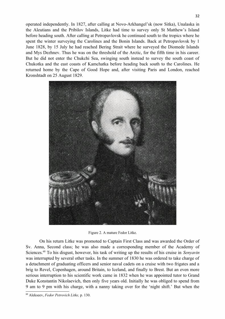
32
operated independently. In 1827, after calling at Novo-Arkhangel’sk (now Sitka), Unalaska inthe Aleutians and the Pribilov Islands, Litke had time to survey only St Matthew’s Islandbefore heading south. After calling at Petropavlovsk he continued south to the tropics where hespent the winter surveying the Carolines and the Bonin Islands. Back at Petropavlovsk by 1June 1828, by 15 July he had reached Bering Strait where he surveyed the Diomede Islandsand Mys Dezhnev. Thus he was on the threshold of the Arctic, for the fifth time in his career.But he did not enter the Chukchi Sea, swinging south instead to survey the south coast ofChukotka and the east coasts of Kamchatka before heading back south to the Carolines. Hereturned home by the Cape of Good Hope and, after visiting Paris and London, reachedKronshtadt on 25 August 1829.
Figure 2. A mature Fedor Litke.
On his return Litke was promoted to Captain First Class and was awarded the Order ofSv. Anna, Second class; he was also made a corresponding member of the Academy ofSciences.60 To his disgust, however, his task of writing up the results of his cruise in Senyavinwas interrupted by several other tasks. In the summer of 1830 he was ordered to take charge ofa detachment of graduating officers and senior naval cadets on a cruise with two frigates and abrig to Revel, Copenhagen, around Britain, to Iceland, and finally to Brest. But an even moreserious interruption to his scientific work came in 1832 when he was appointed tutor to GrandDuke Konstantin Nikolaevich, then only five years old. Initially he was obliged to spend from9 am to 9 pm with his charge, with a nanny taking over for the ‘night shift.’ But when the
60 Alekseev, Fedor Petrovich Litke, p. 130.

33
Grand Duke reached the age of seven Litke was obliged to be responsible for the night shift aswell, sleeping in the same room as his charge. He expressed his disgust at the situation inletters to his close friend Ferdinand Vrangel.61 However he did find time to marry an Englishlady, Julia Brown (Julia Vasil’yevna), the governess to Grand Duchess AleksandraNikolayevna, on 17 December 1835. Their first son, Konstantin Petr Fedorovich was born on25 August 1837, and a second son Nikolay on 14 August 1839. His wife’s health was poor,however, and she died on 8 September 1843 after giving birth to a still-born baby daughter. 62
His duties as tutor had become less onerous when Kapitan-leytenant Aleksandr Ozerov tookover the ‘night watch’ early in 1839. Litke was promoted Vice-Admiral on 6 December 1843.
Figure 3. Litke in old age.
In the summer of 1844 he took the Grand Duke on a cruise from Arkhangel’sk toKronshtadt via Copenhagen on board the ship Ingermanland. Along with Wrangel and K. M.Ber, Litke was instrumental in establishing the Russian Geographical Society, with the tsar’sapproval, on 15 August 1845.63 Then on 27 November 1846 he was appointed chairman of theNaval Scientific Committee and founded the journal Morskoy Sbornik (Naval Collection), thefirst issue of which was published on 15 March 1848. As of 24 November 1847 he becameguardian to Grand Duke Konstantin, and with the latter’s marriage to Princesse Alexandra ofSaxe-Alternburg on 30 August 1848, his responsibilities in that direction were substantially
61 ibid, p. 151.62 ibid, p. 155.63 ibid, p. 162.

34
reduced although they did not officially end until Konstantin’s 25th birthday in the fall of 1852.Meanwhile, in the spring of 1847 Litke had purchased the estate of Avandus in Estonia,adjacent to Wrangel’s estate, Ruil’, and in the summer of 1849 was appointed Commander-in-chief of the Revel Naval Port.64
On 16 February 1850 Litke who had been secretary and vice-chairman of the RussianGeographical Society was out-voted as vice-chairman (by one vote) by N. M. Murav’yev, toLitke’s great disappointment. Then in early February he was appointed commander-in-chiefand military governor of Revel, and moved to that city. In light of this, he was very muchinvolved in Russian preparations when, on 16 March 1854 Britain joined France and Turkey indeclaring war on Russia. This intimate involvement continued when he was appointedcommander-in-chief and military governor at Kronshtadt.65 He was thus in charge when theBritish Royal Navy’s squadron entered the Baltic and mounted attacks on Sveaborg and otherports.
Figure 4. Litke in old age.
Thereafter significant appointments and awards followed. Litke was promoted admiralon 27 March 1855 and was made a member of the Government Council on 23 October 1855.Two months later, on 28 December 1855 he was made an honorary member of the Academy ofSciences. In 1863 he was awarded the Order of Vladimir, First Class with large cross and on 24February 1864 there came the appointment of which he was probably most proud, that ofpresident of the Academy of Sciences. And on 28 October 1866 he was made a Count.Thereafter he started to take life a little more easily, spending more time at his estate, Avandus
64 ibid, p. 177.65 ibid, p. 195.

35
and in travelling. By 1880 he was having serious problems with his eyesight. He died on 8August 1882.66
Later exploration of Novaya Zemlya
In light of Litke’s failure, despite his repeated attempts to reach Mys Zhelaniya or to explorethe east coast of Novaya Zemlya, it is appropriate to examine when that coast was finallysurveyed. The Norwegian Eduard Johannessen, in Nordland is credited with the secondcircumnavigation of Novaya Zemlya (after Loshkin’s) in 1870, but he swung well east into theKara Sea and saw little of the coast and certainly did not survey any part of it.67 A year laterElling Carlsen in Sollid also circumnavigated the islands, but stayed much closer to the coast.He famously discovered relics of Barents’s wintering at Ledyanaya Gavan’.68 Then, in 1879 onan expedition devoted mainly to sport-hunting Sir Henry Gore-Booth, on board Isbjørnen, ranthrough Matochkin Shar, and although encountering heavy ice in the Kara Sea did manage tocoast southwards for about 100 km, hunting and surveying, before returning to MatochkinShar.69
It would be almost another 30 years before any other part of the east coast wassurveyed. This was in 1908 by an off-shoot of Charles Bénard’s expedition on board JacquesCartier. Two members of that expedition, V. A. Rusanov and Dr Candiotti, travelled by boatthrough Matochkin Shar then north to Neznayemiy Zaliv, from where they crossed the northisland to Krestovaya Guba, then returned.70 Two years later Rusanov led his own expedition.On board Dmitriy Solunskiy he circumnavigated the north island in a clockwise direction,despite heavy ice in the Kara Sea, surveying and mapping the east coast in some detail for thefirst time.71 Then in 1911, in a small cutter, Polyarnaya, he circumnavigated the south island,in a counter-clockwise direction, completing the first survey of the east coast of that island.72
Thus, it was not until about 90 years after Litke’s final effort that the icebound eastcoasts of Novaya Zemlya were fully explored and surveyed in some detail. Had he been able tosee into the future, one feels that on seeing how many others were foiled by the ice of the KaraSea his understandable disappointment at not having been able to complete the task himselfwould have been justifiably assuaged.
References
Alekseev, A. I., Fedor Petrovich Litke, Fairbanks, University of Alaska Press, 1996.
Barr, W., ‘Charles Bénard’s first expedition to Novaya Zemlya, 1908’, Polar Record, 23(146), 1987, pp. 511–29.
Barrow, J., A chronological history of voyages into the Arctic regions; undertaken chiefly for the purpose of discovering a North-east, North-west or polar passage between the Atlantic andPacific, London, John Murray, 1818.
66 ibid, p. 216.67 Heuglin, ‘E. H. Johannesens Umfahrung’.68 Jonge and Van Campen, Nova Zembla (1596-1597).69 Markham, A polar reconnaissance.70 Barr, ‘Charles Bénard’s first expedition’; Bénard, Dans l’océan glacial; Tsvetkova, ‘Zhizn’ i podvig’.71 Rusanov, ‘Na “Dmitrii Solunskom”’.72 Rusanov, ‘Na “Polyarnoy”’.

36
Belov, M. I., Arkticheskoye moreplavaniye s drevneyshikh vremen do serediny XIX veka, Istoriya otkrytiya i osvoyeniya Severnogo morskogo puti, I, Moscow, Izdatel’stvo “Morskoy transport”, 1956.
Bénard, C., Dans l’océan glacial et en Nouvelle-Zemble (avril-septembre 1908), Paris, Albin Michel, 1909.
De Veer, G., A true description of three voyages by the North-east towards Cathay and China undertaken by the Dutch in the years 1594, 1595 and 1596, London, Hakluyt Society, 1853.
Hakluyt, R., ed., The principall voiages and discoveries of the English nation, London, 1589. Facsimile reprint, Hakluyt Society, Extra series 39, 1965, 2 vols.
Heuglin, T. von, 1871. ‘Kapitän E. H. Johannesens Umfahrung von Nowaja Semla in Sommer 1870 und Norwegischer Finwalfang östlich von Nordkap’, Petermanns Geographische Mittheilungen, 17, 1871, pp. 35–6.
Jonge, J. K. J. and S. R. Van Campen, Nova Zembla (1596-1597). The Barents relics: recovered in the summer of 1876 by Charles W. Gardiner, Esqu, and presented to the Dutch government, London, Trübner & Co., 1877.
Litke, F. P., Chetyrekhkratnoye puteshestviye v Servernyy Ledovityy Okean na voennom brige “Novaya Zemlya” v 1821-1824 godakh, Moscow, OGIZ Gosudarstvennoye Izdatel’stvo Geograficheskoy Literatury, 1948.
—, A voyage around the world 1826-1829. Vol. I. To Russian America and Siberia, Kingston ON, Limestone Press, 1987.
Markham, A. H., A polar reconnaissance; being the voyage of the Isbjørn to Novaya Zemlya in1881, London, Kegan Paul, 1881.
Orlov, B., ‘Fedor Petrovich Litke: ego zhisn’ i deyatel’nost’ (1797-1882)’ in B. Orlov, ed., Chetyrekhkratnoye puteshestviye v Severnyy Ledovityy Okean na voennom brige “Novaya Zemlya” v 1821-1824 godakh, Moscow, OGIZ Gosudarstvennoye Izdatel’stvo Geograficheskoy Literatury, 1948, pp. 6–25.
Rusanov, V. A., ‘Na “Dmitrii Solunskom” vokrug Novoy Zemli. Obzor deyatel’nosti Novozemel’skoy ekspeditsii 1910 goda’, in A. Tsvetkova, ed., Vladimir Rusanov. Stat’i. lektsii, pis’ma, Moscow/Leningrad, Izdatel’stvo Glavsevmorputi, 1945a, pp.134–59.
—, ‘Na “Polyarnoy” vokrug yuzhnogo ostrova Novoy Zemli’, in A. Tsvetkova, ed., Vladimir Rusanov. Stat’i. lektsii, pis’ma, Moscow/Leningrad, Izdatel’stvo Glavsevmorputi, 1945b, pp. 162–95.
Tsvetkova, A., ‘Zhizn’ i podvig V. A. Rusanova’, in A. Tsvetkova, ed., Vladimir Rusanov. Stat’i, lektsii, pis’ma, Moscow/Leningrad, Izdatel’stvo Glavsevmorputi, 1945, pp. 5–59.
Acknowledgment
I wish to thank Mr Robin Poitras of the Department of Geography, University of Calgary forhis superb cartographic contribution.