fema region x jefferson and clallam counties, washington...lands total approximately 2.8 square...
TRANSCRIPT

Discovery Report FEMA Region X
Jefferson and Clallam Counties, Washington
Prepared by

TABLE OF CONTENTS
I. Discovery and Risk Map 3
II. County Descriptions 3
III. Project Description and Methodology 6
IV. Risk MAP Needs 12
i. Current Studies and Plans 12
ii. Hazard Events 14
iii. Mitigation Projects and Other Relevant Data 22
V. Compliance 32
VI. Communications 32
VII. Close 33
VIII. Appendix – Discovery Files 38

JEFFERSON AND CLALLAM COUNTIES DISCOVERY REPORT – JULY 2013 3 3
I. Discovery and Risk Map The FEMA Risk Mapping, Assessment, and Planning, or Risk MAP program helps communities identify, assess, and reduce natural hazard risks. Through Risk MAP, FEMA provides information to enhance local mitigation plans, improve community outreach, and increase local resilience to hazards.
During Discovery, FEMA
gathers information about local hazards and hazard risks;
reviews mitigation plans to understand local mitigation capabilities, hazard risk assessments, and current or futures mitigation activities;
supports communities within the watershed or county to develop a vision for its future;
collects information from communities about their hazard history, development plans, daily operations, and hazard management activities; and
uses all information gathered to determine which areas of the watershed require mapping, risk assessment, or mitigation planning assistance through a Risk MAP project.
II. Community Descriptions
Clallam County Clallam County is located on the Olympic Peninsula, an area situated on the northwestern portion of Washington State. The county has a total landmass of 1,739 square miles. It is bordered by the Pacific Ocean on the west, the Strait of Juan de Fuca on the north, and Jefferson County on its eastern and southern borders. As of 2010, the county had a population of 71,404 people. Approximately one quarter of Clallam County’s residents live in Port Angeles, the county’s most populous city and the county seat. The most prominent industries in the county are educational services, health care, or social assistance. Approximately twenty percent of the total work labor force in Clallam County work in these industries. The majority of the county’s population resides within cities or near cities along the coast. Much of Clallam County’s interior is home to a portion of Olympic National Park. Most jurisdictions in Clallam County participate in the National Flood Insurance Program (NFIP). All participating jurisdictions have regular participation status in the NFIP.
Jefferson County Jefferson County is also located on the Olympic Peninsula. The county has a total landmass of 1,814 square miles. The county is bordered by the Pacific Ocean on its west, Clallam County on its north, the Salish Sea on its east, and Greys Harbor and Mason Counties on its southern border. As of 2010, the county had a population of 29, 872. Approximately one third of county residents live in Port Townsend. Port Townsend is the only incorporated community in Jefferson County. Like Clallam County, the most prominent industries in the county are educational services, health care, or social assistance. Approximately twenty percent of the work force in Jefferson County work in these industries. Traveling east and west in Jefferson County is hindered by the mountainous terrain of Olympic National Park. In order to most efficiently travel from Western Jefferson County to Eastern Jefferson County and vice versa, one needs to take US Route 101 through Clallam County.

JEFFERSON AND CLALLAM COUNTIES DISCOVERY REPORT – JULY 2013 4 4
All jurisdictions in Jefferson County participate in the NFIP. Jefferson County’s Unincorporated Areas and Port Townsend have regular participation status in the NFIP.
Hoh Tribe The Hoh Tribe is located in Western Jefferson County. The Hoh Reservation is bordered by the Pacific Ocean to its west and the Hoh River to its north. Tribal lands are also surrounded by Olympic National Park. Many tribal members make their living through fishing. The Hoh Reservation is currently participating in the NFIP under emergency participation status.
Jamestown S’Klallam Tribe The Jamestown S’Klallam Tribe is located in Eastern Clallam County. Most of the tribe’s land is located near U.S. Route 101, and their commercial and administrative centers are located adjacent to Sequim Bay. Many of the tribal members live in Clallam County near the Jamestown Cemetery. The Jamestown S’Klallam Tribe is currently not participating in FEMA’s NFIP.
Lower Elwha Klallam Tribe The Lower Elwha Klallam Tribe is located in Clallam County and is located approximately 3 miles west of Port Angeles. The Salish Sea touches the Reservation’s northern boundary. Reservation lands total approximately 2.8 square miles, and the tribe currently has close to 1,000 members. The Lower Elwha Klallam Tribe currently is participating in FEMA’s NFIP.
Makah Tribe The Makah Tribe is located in the northwestern Corner of Clallam County. The Makah Reservation is bordered by both the Salish Sea and the Pacific Ocean. The main highway leading to the Makah Reservation is State Route 112. Fishing, forestry, and tourism are major economic industries of the Makah people. The Makah Tribe is currently not participating in the NFIP.
Quileute Tribe The Quileute Tribe is located in Southwestern Clallam County. The Pacific Ocean is located on its western boundary, and the reservation is surrounded by Olympic National Park. Tourism is a significant part of the tribe’s economy. Washington State Route 110 provides easy access to and from the Quileute Reservation. The Quileute Tribe is currently participating in the NFIP under emergency participation status.
JEFFERSON AND CLALLAM COUNTIES DISCOVERY REPORT – JULY 2013 5 5
Table 1a. Community Participation List
Community (CID)
County Watersheds NFIP Status CRS
Class
Discovery Process
Participation
Clallam County (530021)
Clallam
Hoh-Quilayute Dungeness-Elwha Crescent-Hoko
Participating Participating
Forks, City of (530022)
Clallam Hoh-Quilayute
Participating Participating
Jamestown S’Klallam Tribe (No Data)
Dungeness-Elwha
Not Participating
Participating
Lower Elwha Klallam Tribe (530316)
Dungeness-Elwha Crescent-Hoko
Participating 8 Participating
Makah Tribe (No Data)
Hoh-Quilayute Crescent-Hoko
Not Participating
Participating
Port Angeles, City of (530023)
Clallam
Dungeness-Elwha
Participating Participating
Quileute Indian Tribe (530335)
Hoh-Quilayute
Participating Not Participating
Sequim, City of (530301)
Clallam
Dungeness-Elwha
Participating Participating
Hoh Indian Tribe (530329)
Hoh-Quilayute
Participating Participating
Jefferson County (530069)
Jefferson
Hoh-Quilayute Queets-Quinault Lower Chehalis Skokomish Hood Canal Puget Sound Dungeness-Elwha
Participating Participating
Port Townsend, City of (530070)
Jefferson Puget Sound Dungeness-Elwha
Participating Participating

JEFFERSON AND CLALLAM COUNTIES DISCOVERY REPORT – JULY 2013 6 6
Table 1b. Watershed Locations by Counties and Tribes
County or Tribe
Watershed Names & Huc Number
All or Partially Included
Clallam County Hoh-Quilayute - 17100101 Hood Canal - 17110018 Dungeness-Elwha - 17110020 Crescent-Hoko - 17110021
All watersheds are partially included in the county
Jefferson County Hoh-Quilayute - 17100101 Queets-Quinault - 17100102 Lower Chehalis - 17100104 Skokomish - 17110017 Hood Canal - 17110018 Puget Sound - 17110019 Dungeness-Elwha -17110020
All watersheds are partially included in the county
Hoh Tribe Hoh-Quilayute - 17100101 The tribe is fully included in the watershed
Jamestown S’Klallam Tribe
Dungeness-Elwha - 17110020
The tribe is fully included in the watershed
Lower Elwha Klallam Tribe
Crescent-Hoko – 17110021 Dungeness-Elwha -17110020
The tribe is partially include in both watersheds
Makah Tribe Hoh-Quilayute - 17100101 Crescent-Hoko - 17110021
The tribe is partially include in both watersheds
Quileute Tribe Hoh-Quilayute - 17100101
The tribe is fully included in the watershed

JEFFERSON AND CLALLAM COUNTIES DISCOVERY REPORT – JULY 2013 7
Figure 1. Community Reference Map (Full Size Map in Appendix D)

JEFFERSON AND CLALLAM COUNTIES DISCOVERY REPORT – JULY 2013 8
III. Project Description and Methodology Discovery is the process of data collection, including information exchange between all governmental levels of stakeholders, spatial data presentation, and cooperative discussion with stakeholders to better understand the area, decide whether a flood risk project is appropriate, and if so, to collaborate on the project planning in detail. The Discovery process and requirements are defined in Appendix I – Discovery (June 2012), and Operating Guidance No. 04-11, Risk MAP Meetings Guidance (July 2011). In addition, there are several tools that were used to support the efforts. Region X initiated this Discovery effort in the fall of 2012, with data collection, community interviews, a meeting with stakeholders in the watershed, and development of recommendations based on an analysis of data and information gathered throughout the process. Collected data sources are shown in Table 2. Figure 2. Data Sources for Region X Discovery (project-specific data sources in Appendix)
City of Forks
City of Port Angeles
City of Port Townsend
Clallam County
ESRI
Federal Emergency Management Agency (FEMA)
FEMA - Community Information
System
FEMA - Community Needs Management Strategy (CNMS)
FEMA Regional Office
Jefferson County
Lower Elwha Klallam Tribe
Makah Tribe
Puget Sound LiDAR Consortium
Strategic Alliance for Risk
Reduction (STARR)
United States Army Corp of Engineers - National Dams
Database
United States Army Corp of Engineers - National Levee
Database
United States Census - TIGER
United States Census Bureau
United States Department of
Agriculture
United States Geologic Survey
University of Washington
Washington Department of Ecology
Washington Department of Health
Washington Department of Natural Resources
Washington Department of
Transportation
The Region X Discovery data collection entailed a massive collection of tabular and spatial data for all communities from Federal and State sources, as well as information collected through interviews with each community. Data was used primarily in two ways – tabular data was documented on a Community Fact Sheet, and spatial data was included in the Discovery Geodatabase, and is displayed on the Discovery maps, where appropriate. Full-sized Discovery maps are included in the appendix. The second phase of the Region X Discovery effort involved a review of the collected data with community officials through a phone interview, and a request for additional information. Prior to the interview, community officials received information about the Discovery process, and a Fact Sheet and Interview Reference Map for their community. Communities were asked to identify “Areas of Concern” (AOC) based on their local knowledge and analysis of the data shown on the
JEFFERSON AND CLALLAM COUNTIES DISCOVERY REPORT – JULY 2013 9 9
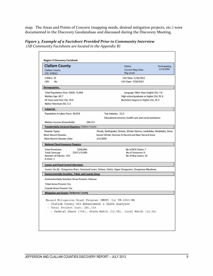
map. The Areas and Points of Concern (mapping needs, desired mitigation projects, etc.) were documented in the Discovery Geodatabase and discussed during the Discovery Meeting. Figure 3. Example of a Factsheet Provided Prior to Community Interview (All Community Factsheets are located in the Appendix B)
JEFFERSON AND CLALLAM COUNTIES DISCOVERY REPORT – JULY 2013 10
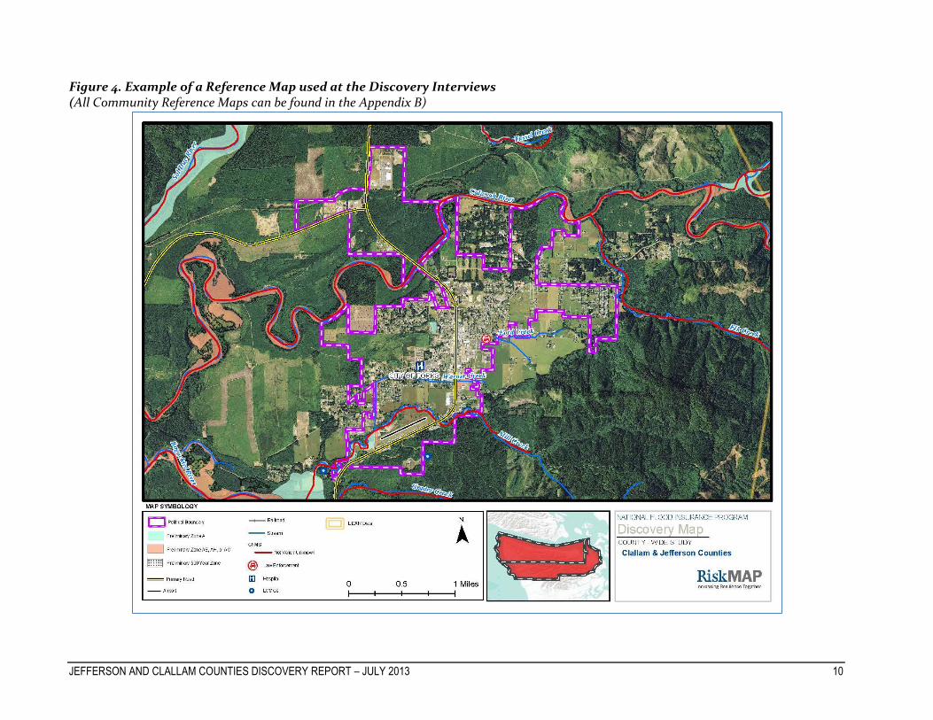
Figure 4. Example of a Reference Map used at the Discovery Interviews (All Community Reference Maps can be found in the Appendix B)

JEFFERSON AND CLALLAM COUNTIES DISCOVERY REPORT – JULY 2013 11
The third step in the Discovery effort was to hold community-specific Discovery Meetings to facilitate discussion and data analysis of study needs, mitigation project needs, desired compliance support, and local flood risk awareness efforts. During these Discovery Meetings, FEMA and STARR, FEMA’s contractor, collaborated with each of the communities that are participating in this effort. The purpose of these meetings was to meet the community officials involved in the Discovery effort, continue the discussions that were started during the community interview, and collect additional community data that will aid in the Discovery effort. The fourth phase of the Discovery effort involves an analysis of the data and information collected during the interviews and subsequent community visits and also may include recommendations as to the future relationship and activities between FEMA and the communities. The Final Discovery Map indicates desired study areas and mitigation project locations, and the Discovery Report documents the results of data collection and conversation. If a Risk MAP project is to be initiated in this watershed, Discovery will be concluded with the finalization of a project scope and signed Partnership Agreements, which indicate that all affected stakeholders agree to the terms of a funded project, including communication and data responsibilities. The basis for deciding if a Risk MAP project will be initiated depends upon FEMA Regional priority, funding and/or available resources.

JEFFERSON AND CLALLAM COUNTIES DISCOVERY REPORT – JULY 2013 12
Figure 5. Image of Clallam County Final Discovery Map
(Final Discovery Map is also located in Appendix D)

JEFFERSON AND CLALLAM COUNTIES DISCOVERY REPORT – JULY 2013 13 13
Figure 6. Image of Jefferson County Final Discovery Map
(Final Discovery Map is also located in Appendix D)

JEFFERSON AND CLALLAM COUNTIES DISCOVERY REPORT – JULY 2013 14
IV. Risk MAP Needs The results of the data collection and interviews were thoroughly discussed at the Discovery Meetings. The following sections include issues and conditions that exist in Jefferson and Clallam Counties that can be considered Risk MAP needs, to be addressed with Risk MAP projects. Details and background on all issues can be found in the interview notes, meeting notes, Hazard Mitigation Plans (HMPs), and other files included in the appendix.
i. Current Studies and Plans
Hazard Mitigation The Disaster Mitigation Act of 2000 (P.L. 106-300; 42 USC 5131 ff.) and the Federal Emergency Management Agency’s subsequent Interim Final Rule, 44 CFR Part 201, requires all states and communities to develop natural hazard mitigation plans in order to be eligible for federal Pre-Disaster Mitigation Grant funds and/or post-disaster Hazard Mitigation Grant Program funds. Hazard mitigation plans attained through Discovery are identified in the table below:
Table 2a. FEMA Approved Mitigation Plans for Clallam and Jefferson Counties and Tribal Areas
Community County Plan Name Date
Approved Expiration
Date Notes
Clallam County; City of Forks; City of Port Angeles; City of Sequim
Clallam Clallam County Hazard Mitigation Plan
January 2011 January 2016
• Mitigation Plan Approved by FEMA for: Clallam County, Forks, Port Angels, & Sequim
Jamestown S’Klallam Tribe
Jamestown S’Klallam Tribal Multi-Hazard Mitigation Plan
January 2011 January 2016 •
Lower Elwha Klallam Tribe
Lower Elwha Klallam Tribe Hazard Mitigation Plan
October 2012
October 2017 •
Makah Nation Makah Tribe Hazard Mitigation Plan
September 2012
September 2017
•
Jefferson County, City of Port Townsend
Jefferson Jefferson County and Port Townsend Natural Hazards Mitigation Plan
June 2010 June 2015
• Mitigation Plan Approved by FEMA for: Port Townsend, Fire District 1, Fire District 3, & Fire District 4
Hoh Tribe Hoh Tribal Hazard Mitigation Plan
January 2012
January 2017 •

JEFFERSON AND CLALLAM COUNTIES DISCOVERY REPORT – JULY 2013 15 15
Table 2b. Other Hazard Mitigation Plans for Clallam and Jefferson Counties and Tribal Areas
Community County Plan Name Date Adopted Notes
Clallam County
Clallam Clallam County Community Wildfire Protection Plan
December 2009
Makah and Quileute Tribes
Project Safe Haven: Tsunami Vertical Evacuation on the Washington Coast
N/A
Floodplain Studies Production of county-wide Flood Insurance Rate Maps (FIRMs) and a Flood Insurance Study (FIS) for Clallam County began during Map Modernization; however, complications arose due to issues concerning a levee policy within the county, and production of these materials was put on hold. Updated flood maps will be issued once the levee policy is finalized, which will replace the current effective maps. The current status for effective flood maps within Clallam County can be found in the table below. In late 2012, Clallam County received funding to update current GIS data and perform HAZUS analyses. This data should help the county with making more effective hazard mitigation decisions and identifying specific hazard mitigation needs in the county. Table 3. Effective FIRM dates for communities in Clallam County
Community (CID)
Effective FIRM
Study Type
Clallam County (530021)
02/23/2001 Riverine and Coastal Study
Forks, City of (530022) 12/16/1988 Riverine Study
Jamestown S’Klallam Unmapped Not Applicable
Lower Elwha Klallam Tribe (530316)
02/23/2001 Coastal and Riverine Study
Makah Tribe (Unmapped)
Unmapped – Data developed for future preliminary maps
Limited detail
Port Angeles, City of (530023)
09/28/1990 Riverine and Coastal Study
Quileute Indian Tribe (530335)
Unmapped Not Applicable
Sequim, City of (530301)
ALL ZONE C AND X - NO PUBLISHED FIRM
Not Applicable

JEFFERSON AND CLALLAM COUNTIES DISCOVERY REPORT – JULY 2013 16 16
Effective FIRMs and FISs within Jefferson County are over thirty years old. Jefferson County’s study went effective on March 15, 1982 and Port Townsend’s study went effective on July 19, 1982. The Hoh Tribe has not been mapped. FEMA’s Coordinated Needs Management Strategy (CNMS) database was created in 2011 for Region X to coordinate the management of future floodplain mapping needs. This database tracks and identifies the status and needs of existing floodplain studies based on change indicators that may have occurred since the date of the analysis to help prioritize future floodplain study needs. Currently validation for streams in Jefferson and Clallam Counties are unknown. CNMS data can be viewed on the FINAL Discovery Maps.
ii. Hazard Events
Wildfires Wildfire risk within communities depends on land use and development. Some communities don’t have significantly forested areas and therefore report their wildfire threat as minimal. Others state that wildfires are a great concern to them and much property and infrastructure are vulnerable to this natural hazard. The table below is a compilation of wildfire data attained from local governments and state and federal agencies.
Table 4. Clallam County and Jefferson County Wildfire Risk
Community County Notes
Clallam County
Clallam
• The eastern portion of the county is vulnerable to wildfires. Too much development with insufficient infrastructure. Many high value homes in this area. • See Clallam County Community Wildfire Protection Plan.
City of Forks Clallam
• Significant wildfires caused by a dry spell occurred in 1951 that impacted the northwestern portion of the city. • The northern portion of Forks was identified as susceptible to wildfires. See AOC layer on Final Discovery Map. • Identified as having low vulnerability to urban/wild land fire in HMP
Jamestown S’Klallam Tribe
• Wildfires identified as a high risk in recent planning exercises. • Forest land is adjacent to a mix of public and private ownership properties. Could be some risk here • History of wildfires in area. May be more prevalent than know. • The tribe expressed interest in assistance in better understanding and mitigating this hazard. • The majority of properties in the tribe’s HMP are identified as being moderately (medium) vulnerable to wild land fires.

JEFFERSON AND CLALLAM COUNTIES DISCOVERY REPORT – JULY 2013 17 17
Community County Notes
Lower Elwha Klallam Tribe
• Angeles bluffs have the highest risk for wildfires. • This hazard can be derived from fireworks. • The tribe has an insufficient water volume to battle large
fires. • Some residential areas in the reservation have been
identified as been prone to wildfires. See AOC on the Final Discovery Map.
• The occurrence of a severe wildfire in the reservation is identified as being extremely low according to the tribe’s HMP.
Makah Tribe
• Minimal threat of catastrophic Fires. • Wildfires pose no real structural risk but could pose an
economic threat to the tribe. • A wildfire did occur in 1995.
City of Port Angeles
Clallam
• The southern and western sides along state forest lands are vulnerable to wildfires. • Forested area south of Port Angeles is identified as being prone to wildfires. See AOC on Final Discovery Map. • Identified as having medium vulnerability to urban/wild land fire in HMP.
City of Sequim
Clallam
• Identified by the city as a low risk; however, county identified the area as being prone to wildfires. • Identified as having high vulnerability to urban/wild land fire in HMP.
Hoh Tribe
• Low risk of wildfires in the area but wildfires are severe when they occur. • Tribe has new fire department and plenty of water in the event of a wildfire. • Tribe can evacuate citizens to a river if needed.
Jefferson County
Jefferson
• Wildfires in the national forest occur every couple of years. • Wildfires have the potential to be widespread due the county being heavily forested • Wildfires pose a higher risk on private lands that border resource lands and areas adjacent to population centers. • A wildfire occurred just west of Port Townsend in 2011. See AOC on Final Discovery Map. • The County is classified as being at high risk for urban interface wildfire in the HMP.
City of Port Townsend
Jefferson
• Wildfires are not a great concern in the city. • Homeless population presents a great risk for fires starting in wooded areas. • Port Townsend is classified as being at high risk for urban interface wildfire in the HMP.
Earthquakes Clallam and Jefferson Counties have experienced historic earthquakes and have several fault lines. A common concern for almost every community is that many of their critical buildings are not retrofitted to withstand the impact of an earthquake. Information on fault lines, earthquake events, and specific details on earthquake awareness was collected from each community and is shown in the table below. A much larger area of earthquake risk is created by the Cascadia subduction zone which extends from Vancouver Island to Northern California. If rupture occurs, the Cascadia subduction zone can produce very large earthquakes (9.0 or greater).

JEFFERSON AND CLALLAM COUNTIES DISCOVERY REPORT – JULY 2013 18 18
Table 5. Clallam County and Jefferson County Earthquake Risk
Community County Notes
Clallam County
Clallam
• Trenched Lake Creek fault has recently been determined to be active. • Most Powerful modern earthquake to hit the area was in 1909. Caused damage to many areas within the county. • Many significant buildings need retrofitting in the county. They include hospitals and public buildings. Grant proposals have been submitted to retrofit many of these buildings.
City of Forks Clallam
• Schools, the center core of the city building, and some portions of the hospital are retrofitted. • Roads and airports are critical in maintaining in case of an earthquake - city would be isolated if these were to fail. • Identified as having low vulnerability to an EQ in HMP.
Jamestown S’Klallam Tribe
• Planning offices built in 1940s and 1950s and would be impacted. • Liquefaction is the biggest concern. • Many homes built decades ago are not built to EQ standards. Many of these homes are located on the ancestral homeland of the tribe, which is located in Clallam County and not within the reservation boundaries. See AOC layer on Final Discovery Map. • Main buildings on reservation are built to EQ standards. Smaller structures are not. • All properties are classified as being moderately (medium) or highly vulnerable to an EQ. See Jamestown HMP. •
Lower Elwha Klallam Tribe
• Lots of buildings are not up to EQ standards. The tribal center and “Head Start” building are especially vulnerable and a concern to the tribe. • See “Areas of Concern” on Final Discovery Map for critical structures identified by the community that are vulnerable to an EQ. • The tribe is identified as being extremely vulnerable to an EQ in its HMP.
Makah Tribe
• Forestry building has been retrofitted but older buildings have not been retrofitted. Newly constructed buildings should comply with EQ standards. • Not many EQ mitigation efforts to date have been conducted by the Makah Tribe.
City of Sequim
Clallam
• Identified as being a very high risk. Many critical buildings could be impacted. • An earthquake could change the trajectory of the Dungeness River
to within the city limits. • Identified as having low vulnerability to earthquakes in HMP.
Hoh Tribe
• The Hoh would be isolated from outside help if an earthquake would damage the bridge on Hwy 101. See AOC on Final Discovery Map. • Hwy 101 is also susceptible to liquefaction in the area.

JEFFERSON AND CLALLAM COUNTIES DISCOVERY REPORT – JULY 2013 19 19
Community County Notes
City of Port Angeles
Clallam
• Downtown area developed before EQ standards. • Not much currently has been done to retrofit buildings in case of an EQ. • Many buildings in the downtown area have been built on top of fill or near fill. • Hospital in Port Angeles is at Risk in the event of a moderate earthquake. • Fire station should meet EQ standards. • Damage of Ennis Creek Bridges on Hwy 101 as a result of an EQ could isolate the city from outside help. • Along the main bluff are residential buildings perched 150’ above the toe of the bluff that are a concern during an EQ. • Bonneville Power Authority (BPA) building is very vulnerable during an EQ. Is a source of primary electric transmission. • Pier infrastructure would be vulnerable to an EQ. • See AOC layer on Final Discovery Map for the location EQ vulnerable areas and structures. • Identified as having low vulnerability to earthquakes in HMP.
Jefferson County
Jefferson
• County courthouse would be susceptible during an EQ. • County would be cut-off if the Hood Canal Bridge were to be
damaged in an earthquake. See AOC layer on the Final Discovery Map. • County could be cut off from the hospital at Port Townsend if Hwy
101 were to be damaged by an EQ, especially at the location where the Hwy is close to Discovery Bay. • The county is identified in its HMP as being at high risk of an EQ
and being highly vulnerable to an EQ.
City of Port Townsend
Jefferson
• Nisqually EQ occurred in 2001 – foundational cracks in non-city builds occurred as a result.
• Mitigation actions – Seismic retrofit sidewalks (suspended sidewalks); Seismic retrofits have also been done to City owned facilities located outside the city limits; City Hall, Fire Station, Cotton Building, Carnegie Library, City Lake Water Outlet received upgraded seismic protection from earthquakes.
• A 5 million gallon reservoir could be impacted by an earthquake. See AOC layer on Final Discovery Map.
• Extensive fill in downtown district increases risk to overlying buildings.
• Earthquake induced bluff failures would impact residential areas (generally at bluff tops) and major roadways.
• Earthquakes in Jefferson County could cause damage to city water source infrastructure.

JEFFERSON AND CLALLAM COUNTIES DISCOVERY REPORT – JULY 2013 20 20
Figure 7. Earthquake Attained Data
Landslides Landslides can include a wide range of ground movements and can occur in Clallam and Jefferson Counties. Many communities expressed concern about the potential damage that landslides could have on residential communities and roads. The table below summarizes the specific concerns that communities in Jefferson County and Clallam County and the locations of where landslides could occur and have occurred. Table 6. Clallam County and Jefferson County Landslide Risk
Community County Notes
Clallam County
Clallam
• Rt. 112 is prone to landslides. Described as “sliding off the hill”.
County also describe the highway as “the longest continuously moving highway in the US”. • See AOC on Final Discovery Map for identified areas prone to
landslides.

JEFFERSON AND CLALLAM COUNTIES DISCOVERY REPORT – JULY 2013 21 21
Community County Notes
City of Forks Clallam
• Hwy 101 has had a landslide cut off the city. • Large landslide prone area along the Quillayute River. • See AOC on Final Discovery Map for identified areas prone to
landslides. • Town is a plateau surrounded by incised riverbeds. • Identified as having high vulnerability to landslides/erosion in
HMP.
Jamestown S’Klallam Tribe
• Significant landslide and erosion hazard areas have been identified just south of Hwy 101. Are Subject to county regulations – tribe relies on critical area codes to reduce risks. Area is also identified on the AOC layer. • Landslides obstructing road access is a great concern to the county
– would impact businesses in the area. • Tribe does have access to a hospital if one direction of the Hwy 101
is impacted - Hospital access includes Olympic Medical Center (Port Angeles) & Jefferson Healthcare (Port Townsend). • Majority of tribal properties are classified as being moderately
(medium) or highly vulnerable to landslides or erosion. See Jamestown HMP.
Lower Elwha Klallam Tribe
• Industrial pipeline in the area was broken by landslides in 1990s. • Lower Elwha roads vulnerable to landslides. See AOC layer on
Final Discovery Map. • Biggest landslide concern is residents removing ground to access
nice views from their properties. • Development land near edge of reservation could be at risk of
landslides – See “Area of Concern” layer on Final Discovery Map. • See AOC layer on Final Discovery Map for addition landslide prone
areas.
Makah Tribe
• Rt. 112 vulnerable to landslides. Private road agreement in place to serve as alternative emergency routes in case of blockage; however, tribe may not be able to get to alternative roads if needed.
City of Port Angeles
Clallam
• Landslides all along the marine bluff into the city. • Landslide occurred roughly 25 years ago where Ediz Hook meets
the mainland – resulted in one death. • Landslide at Peabody creek ravine 2 years ago. • Landslides often occur along Olympic Discovery Trail. • City has ordinances in effect that enforce setbacks, disturbance
limits, and vegetative management requirements. • The city is very concerned with landslides occurring on the marine
bluff. • Trails are more affected by landslides than roads. • Closed landfill cell containing garbage adjacent to bluff is
disappearing, cell could collapse into strait. • City identified as having high vulnerability to landslides/erosion in
HMP.

JEFFERSON AND CLALLAM COUNTIES DISCOVERY REPORT – JULY 2013 22 22
Community County Notes
City of Sequim
Clallam
• Bluff area along Sequim Bay, Johnson Creek, and Bell Creek are prone to landslides. See AOC layer on Final Discovery Map. Residential areas in the area. Some should be far away enough to prevent damages for now. • Setbacks are required by regulations for abating damages to
property by landslides. • Identified as having medium vulnerability to landslides/erosion in
HMP.
Hoh Tribe
• Bluffs along the Hoh River are eroding and subject to landslides. The tribe doesn’t believe much is at risk from these landslides. • Hoh Highlands and Hwy 101 can be blocked by landslides and
hinder aid from getting the reservation if needed.
Jefferson County
Jefferson
• Hwy 101 is critical to protect from landslides. Landslides have historically occurred along Hood Canal. • Landslide risk all along Mt. Walker. Frequent accidents in this
area. • Frequent landslides occur on Hwy 101 where the Hwy is adjacent to
the Pacific Ocean and eastern county coast line. See AOC layer on Final Discovery Map. • The county is identified as being at high risk and high vulnerability
to landslides according to its HMP.
City of Port Townsend
Jefferson
• Significant bluffs (20’-100’ high) along the waterfront. • Concrete barriers have been installed to intercept fall. They are
cleaned out and emptied for the next landslide. • There is a record of continual landslides in the area. Continual
clean up of spills on the roads and trails along the shore. • Some residential areas have been identified as being prone to
landslides. See AOC layer on Final Discovery Map. • Concrete barriers have been installed at the base of bluffs along
SR-20 to intercept fall. • Landslides in Jefferson County could cause damage to the city’s
source water infrastructure.
Flooding A plethora of issues were addressed that concerned flooding. They included inaccuracies of floodplain representation on effective FIRMs, areas were flooding could damage public and private property, and mitigation projects undertaken to limit flooding. Table 7 identifies flooding concerns as they pertain to each individual community. There have been a total of 103 flood insurance claims made in Clallam County and 42 flood insurance claims made in Jefferson County since 1978. A total of 20 repetitive losses have been identified in both counties, 6 in Jefferson County and 14 in Clallam County. There have been some Letters of Map Change (LOMC) issued across these counties with many near the Bogachiel River and Sequim Bay. Locations of LOMCs in each county can be found on the Final Discovery Maps.

JEFFERSON AND CLALLAM COUNTIES DISCOVERY REPORT – JULY 2013 23 23
Table 7. Clallam County and Jefferson County Flood Risk
Community County Notes
Clallam County
Clallam
• High tide and Pysht River can block access to route 112. • See AOC Layer on Final Discovery Map. • Kincaid Island is a concern to the county. Big erosion hazard area
and tiny channel change can put the area into the river. Currently not mapped in floodplain or floodway. • Residents below Bell View area nervous of being downstream of
flood control ponds, breech risk. • Flooding of the Bogocheil River can isolate the western portion the
county from Jefferson County. • The county recommended that the Dungeness river be restudied. • Several areas have been identified as being prone in the county.
See AOC layer on Final Discovery Map.
City of Forks Clallam
• The city disagrees with a flood hazard area on the preliminary
SFHA on the Discovery Map. See “Area of Concern” layer on Final Discovery Map. • Flooding near schools beside a Baptist church is caused by flooding
from culverts. See AOC layer on Final Discovery Map. • Culverts have been repaired in the city and city claims they
eliminated flood risk. • The city wants to take a gravel pit that is shown in a floodplain and
use it for stormwater management. • City identified as having high vulnerability to flooding in HMP.
Jamestown S’Klallam Tribe
• Jimmy Come Lately Creek flow direction has changed (area was restored). One side of the creek no longer floods. • A project has been initiated as a result of flooding on Hwy 101. • Dean Creek has a new flow direction and has been restored. • Increased flows from stream to shoreline are causing additional
erosion and stormwater flooding. • Majority of tribal properties are classified as being highly
vulnerable to flooding. See Jamestown HMP.
Lower Elwha Klallam Tribe
• Tribe claims that the east side of the levee in reservation should be zone X. Certification of the levee is in question. • Tidal flooding has been increasing in frequency and magnitude.
USACE has expanded storage facilities in an effort to offset. • Charles road can get inundated with flooding. • According to Tribe’s HMP, all homes and tribal facilities in the
lower valley are potentially vulnerable to flooding. • Lower Elwha River identified as being a flooding concern. See
AOC layer on Final Discovery Map.
Makah Tribe • Suez River is subject to flooding. • Biggest flooding event was a culvert blockage a few years ago.
JEFFERSON AND CLALLAM COUNTIES DISCOVERY REPORT – JULY 2013 24 24
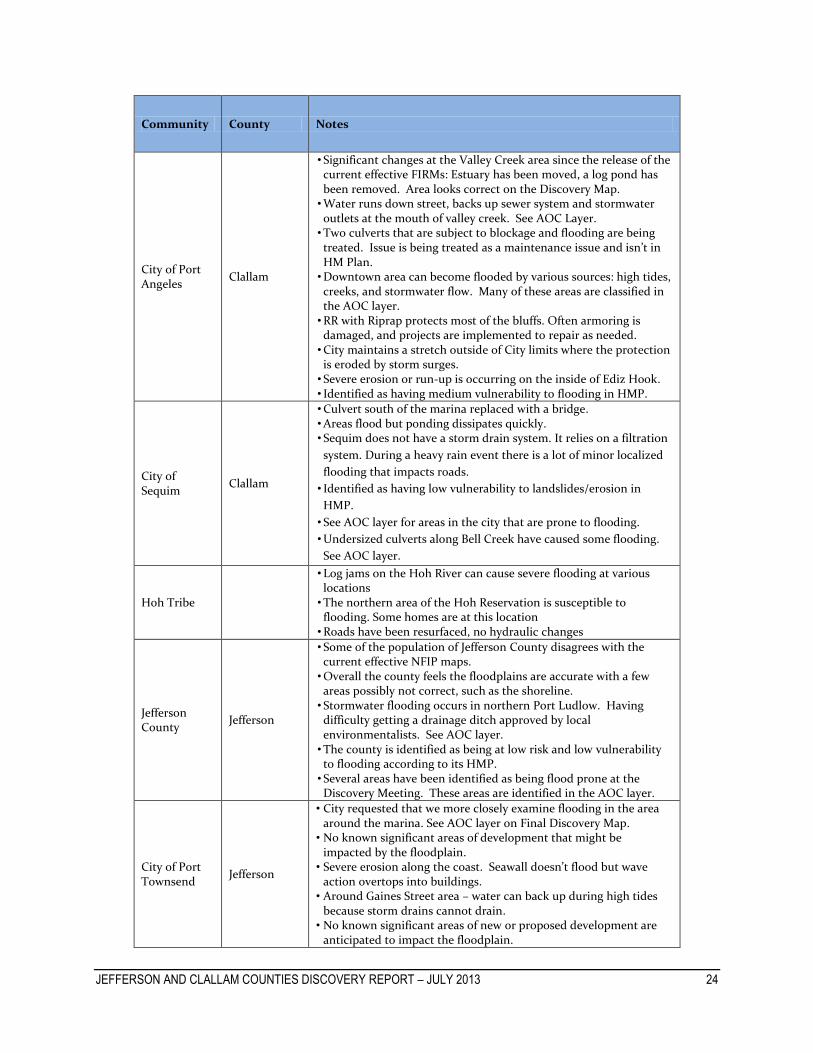
Community County Notes
City of Port Angeles
Clallam
• Significant changes at the Valley Creek area since the release of the current effective FIRMs: Estuary has been moved, a log pond has been removed. Area looks correct on the Discovery Map. • Water runs down street, backs up sewer system and stormwater
outlets at the mouth of valley creek. See AOC Layer. • Two culverts that are subject to blockage and flooding are being
treated. Issue is being treated as a maintenance issue and isn’t in HM Plan. • Downtown area can become flooded by various sources: high tides,
creeks, and stormwater flow. Many of these areas are classified in the AOC layer. • RR with Riprap protects most of the bluffs. Often armoring is
damaged, and projects are implemented to repair as needed. • City maintains a stretch outside of City limits where the protection
is eroded by storm surges. • Severe erosion or run-up is occurring on the inside of Ediz Hook. • Identified as having medium vulnerability to flooding in HMP.
City of Sequim
Clallam
• Culvert south of the marina replaced with a bridge. • Areas flood but ponding dissipates quickly. • Sequim does not have a storm drain system. It relies on a filtration
system. During a heavy rain event there is a lot of minor localized
flooding that impacts roads.
• Identified as having low vulnerability to landslides/erosion in
HMP.
• See AOC layer for areas in the city that are prone to flooding.
• Undersized culverts along Bell Creek have caused some flooding.
See AOC layer.
Hoh Tribe
• Log jams on the Hoh River can cause severe flooding at various locations • The northern area of the Hoh Reservation is susceptible to
flooding. Some homes are at this location • Roads have been resurfaced, no hydraulic changes
Jefferson County
Jefferson
• Some of the population of Jefferson County disagrees with the current effective NFIP maps. • Overall the county feels the floodplains are accurate with a few
areas possibly not correct, such as the shoreline. • Stormwater flooding occurs in northern Port Ludlow. Having
difficulty getting a drainage ditch approved by local environmentalists. See AOC layer. • The county is identified as being at low risk and low vulnerability
to flooding according to its HMP. • Several areas have been identified as being flood prone at the
Discovery Meeting. These areas are identified in the AOC layer.
City of Port Townsend
Jefferson
• City requested that we more closely examine flooding in the area around the marina. See AOC layer on Final Discovery Map.
• No known significant areas of development that might be impacted by the floodplain.
• Severe erosion along the coast. Seawall doesn’t flood but wave action overtops into buildings.
• Around Gaines Street area – water can back up during high tides because storm drains cannot drain.
• No known significant areas of new or proposed development are anticipated to impact the floodplain.

JEFFERSON AND CLALLAM COUNTIES DISCOVERY REPORT – JULY 2013 25 25
Figure 8. Floodplain Data for Jefferson and Clallam Counties and Tribal Areas
iii. Mitigation Projects and Other Relevant Data
Mitigation Projects There were several potential, desired, and in progress mitigation projects that were identified throughout the Discovery process. Most of these projects were identified through researching Hazard Mitigation Plans or speaking to community offices. Several of these projects are identified in figure 9 below. More information of mitigation projects can be found in the appendix of this report. Figure 9. Listing of Various Projects in Clallam and Jefferson Counties *
Clallam County Seismic retrofits of newer portion of Clallam County Courthouse Provide Fire Wise training outreach throughout the County Set back of the Army Corps Dike located on the Dungeness River
City of Sequim Expand upon the current storm drain system Construct a new reservoir

JEFFERSON AND CLALLAM COUNTIES DISCOVERY REPORT – JULY 2013 26 26
Figure 9. Continued
City of Port Angeles Project water main on Elwha River against landslides Reinforcement of the Peabody Heights Reservoir Earthen Dam Tumwater Street Bridge Approach Improvement
City of Forks Culvert replacement project on Russell Road Installation of a stormwater detention pond on Palmer Road
City of Port Townsend Installation of seismic retrofit City Lake Reservoir’s water transmission lines Installation of seismic sidewalks
Jamestown S’Klallam Floodplain Restoration on the Lower Dungeness River Nonstructural Retrofits of critical facilities Coordination with Clallam County concerning the NFIP program
Makah Tribe Development of a vertical evacuation strategy in the event of a tsunami
Lower Elwha Klallam Expansion of the Lower Elwha’s Levee Remove of the Lower Elwha Dam
*No mapping data was provided for these items. Areas of Concern As determined through correspondence with local community officials, the areas of concern list is displayed below by community. Some communities did identify areas outside of their jurisdiction that were a concern to them. The concerns are labeled with ID numbers corresponding to the specific concern’s location on the Final Discovery Map. Areas of concern were identified during both the Discovery Interviews and Discovery Meetings. AOCs identified at the Discovery Meeting will have “(Meeting)” at the end of their description. Much of these areas were identified at a scale much larger than the scale of the Final Discovery Map, many AOCs were identified at a scale of less than 1:1,000. Therefore, some areas on the Final Discovery Map are difficult to individually identify. It is recommended that one examine the “Areas of Concern” feature class in ArcMap. This feature class is located in the Discovery Geodatabase and the Appendix D folder. Viewing the AOC feature class in ArcMap will allow one to examine each AOC at a scale that is easily discernible. Table 8. Complete list of identified Areas of Concern Hazard Issue or Description of Area ID
AOCs identified by Clallam County
Tsunami
Properties on Ediz Hook are at risk. These include: the coast guard base, native bird reservation, fuel dumps, paper Plant, other major businesses
1
Environmental Area
Wildlife refuge
2

JEFFERSON AND CLALLAM COUNTIES DISCOVERY REPORT – JULY 2013 27 27
Hazard Issue or Description of Area ID
Critical Infrastructure Main access road to Quileute tribe and a Coast Guard Base, susceptible to many hazards
3
Flooding Rivers End area - susceptible to flooding 4
Flooding Core Dike Reach area 5
Flooding Three Crabs Area 6
Critical Structure County identified the whole tribal area as critical structure 7
Erosion Area subject to erosion 8
Earthquake Active fault line found in area - potential of significant earthquake. Could damage the identified bridge
9
Wildfire East part of county prone to wild fire; too much development with not enough infrastructure
10
Wildfire Sequim and Ben Hill area prone to wildfires 11
Severe Storms Area of Joyce is prone to severe storms 12
Severe Storms Lower Elwha is prone to severe storms 13
Severe Storms Neah Bay is prone to sever storms 14
Flooding County recommends that the Dungeness River be restudied 15
Flooding Flooding has been an issue in this area 16
Flooding Flooding has been an issue in this area (Kinkade Island Reach) 17
Flooding Rt. 112 will flood and obstruct access to Western Clallam county 18
Critical Structure Lighthouse 19
Critical Structure Diamond Pont - .5 Acre lots that are 50 ft from the water (Meeting) 148
Erosion Highly Erosive Area (Meeting) 151
Landslide Identified area for landslides (Meeting) 153
Critical Infrastructure specified infrastructure not provided on map (Meeting) 154
Critical Structure subdivision (Meeting) 156
Erosion Bank erosion (Meeting) 171
Environmental Area Community park (Meeting) 174
Critical Structure Resort (Meeting) 175
Critical Structure Camping site (Meeting) 176
Landslide Area prone to landslides (Meeting) 177
Flooding Low banks and school sewer system identified (Meeting) 178

JEFFERSON AND CLALLAM COUNTIES DISCOVERY REPORT – JULY 2013 28 28
Hazard Issue or Description of Area ID
Flooding Low banks (Meeting) 179
Flooding Low banks (Meeting) 180
AOC identified by Forks
Critical Structure Forks Municipal Airport 20
Critical Structure Quillayute Airport - run by the city of Forks 21
Critical Structure Location of water tank 22
Landslide Area prone to landslide 23
Landslide Rt. 101 entering into the city is prone to landslides 24
Wildfire Area susceptible to wildfires 25
Critical Structure Bridge leading into the City - one of seven bridges leading into Forks 26
Critical Structure Location of school system 27
Critical Structure Forks Community Center 28
Critical Structure Location of water tank 29
Critical Structure Location of water tank 30
Critical Structure Well location 31
Critical Structure Water Treatment Plant 32
Critical Structure Low to moderate income housing 33
Critical Structure Well location 34
Critical Structure Well location 35
Flooding City questions the accuracy of the SFHA 36
Flooding Culvert backs up and floods area 37
Landslide
Area for potential landslide 38
AOC identified by Hoh Tribe
Flooding Area identified by the tribe as flood prone 39
Severe Storms Log jams from storms can dam the river and flood the reservation 40
Landslide Area prone to landslides 41
Critical Structure Location of offices, gymnasium, and residential buildings 42

JEFFERSON AND CLALLAM COUNTIES DISCOVERY REPORT – JULY 2013 29 29
Hazard Issue or Description of Area ID
Tsunami Evacuation area in case of tsunami & future emergency services center
43
Earthquake Tribe would be cut off from outside resources if bridge were to collapse
44
Landslide Area prone to landsides that could hinder access on Rt. 101 45
Environmental Area Fish hatchery located in this area (Meeting) 193
AOC identified by Jamestown S’Klallam Tribe
Erosion Area prone to erosion 60
Critical Structure Water treatment and storage facility 46
Critical Structure Water supply 49
Erosion Stream erosion identified in this area 50
Critical Structure Jamestown Administrative Campus 52
Critical Structure Casino 47
Critical Structure Child daycare facility & Wastewater treatment plant 51
Environmental Area Shellfish harvest operation and Salmon Nursery 53
Critical Infrastructure Pipes that transport waste water 54
Critical Structure 105,000 water gallon storage tank 55
Critical Infrastructure Fiber optic and power lines 56
Earthquake Residential area and ancestral homeland of Tribe 57
Tsunami Residential area and ancestral homeland of Tribe 58
Landslide Area south of Route 101 is prone to landslides 59
Critical Structure Wastewater Treatment Plant 61
Critical Structure Septic tanks 62
Critical Infrastructure Plans for implementing a large on-sight sewer system 63
Flooding Restoration underway - new channel on left; old channel on right (Meeting)
169
Flooding Stream restoration - flooding limited (Meeting) 170
Critical Structure Longhouse Market and Gas Station 48
AOC identified by Jefferson County
Critical Infrastructure Jefferson County would be cut off from adjacent county if bridge were to fail
64

JEFFERSON AND CLALLAM COUNTIES DISCOVERY REPORT – JULY 2013 30 30
Hazard Issue or Description of Area ID
Critical Infrastructure access to the island would be cut off if bridge were to fail 65
Landslide Route 101 along the bay is at risk of landslides 66
Earthquake Hood Canal Bridge is prone to damage in an earthquake; Critical access point into Jefferson County
67
Critical Infrastructure US Rt. 101 & WA Rt. 20 are at risk in an earthquake, tsunami, or flood 68
Tsunami Residential area at risk in an event of a Tsunami 69
Tsunami Ferry at risk in a Tsunami 70
Severe Storms Island bridge at risk in the event of severe storm 71
Landslide Rt. 101 along the coast at risk for landslides 72
Flooding Flooding is an issue in this area - attempts were made to install a drainage ditch but efforts blocked by local environmentalists
73
Critical Infrastructure Access to the island would be cut off if bridge were to fail 74
Critical Infrastructure Cellphone towers in this area (Meeting) 181
Environmental Area Area with very soft soils - low population (Meeting) 183
Critical Infrastructure Cell tower location (Meeting) 184
Landslide Area prone to landslides (Meeting) 185
Flooding Homes in this area prone to coastal flooding (Meeting) 186
Earthquake School in Port Townsend potentially prone to liquefaction (Meeting) 187
Wildfire Wildfire occurred in 2011 (Meeting) 189
Landslide Landslide prone area (Meeting) 190
Critical Structure Redevelopment occurring in this area Meeting) 191
Critical Structure Several hazards identified as occurring in this area (Meeting) 192
Critical Structure Some properties in the area (Meeting) 194
Environmental Area Fish hatchery in this area (Meeting) 195
Flooding Elderly low income housing prone to flooding in this area (Meeting) 197
Flooding Olympic Canal Tracks - prone to flooding (Meeting) 198
Landslide Olympic Canal Tracks - prone to landslides (Meeting) 199
Landslide Area prone to landslides (Meeting) 200
Critical Structure Development - Triton Cove (Meeting) 201
Critical Structure Road is vulnerable to landslides and flooding (Meeting) 202
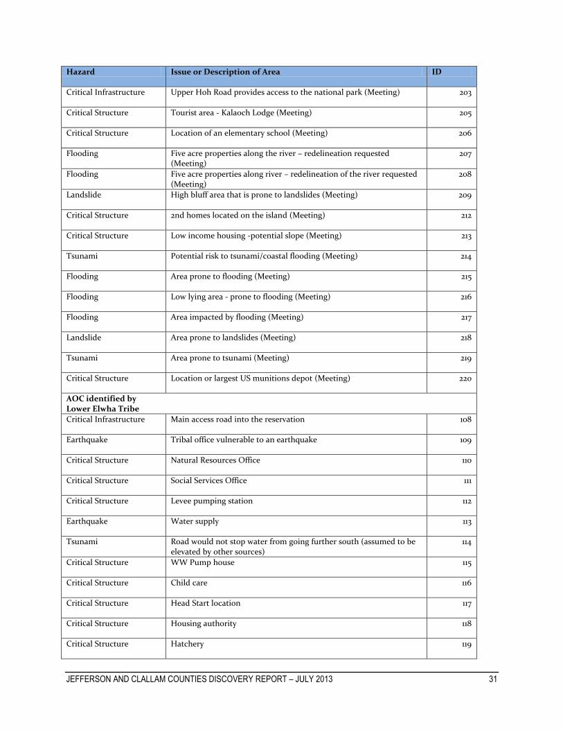
JEFFERSON AND CLALLAM COUNTIES DISCOVERY REPORT – JULY 2013 31 31
Hazard Issue or Description of Area ID
Critical Infrastructure Upper Hoh Road provides access to the national park (Meeting) 203
Critical Structure Tourist area - Kalaoch Lodge (Meeting) 205
Critical Structure Location of an elementary school (Meeting) 206
Flooding Five acre properties along the river – redelineation requested (Meeting)
207
Flooding Five acre properties along river – redelineation of the river requested (Meeting)
208
Landslide High bluff area that is prone to landslides (Meeting) 209
Critical Structure 2nd homes located on the island (Meeting) 212
Critical Structure Low income housing -potential slope (Meeting) 213
Tsunami Potential risk to tsunami/coastal flooding (Meeting) 214
Flooding Area prone to flooding (Meeting) 215
Flooding Low lying area - prone to flooding (Meeting) 216
Flooding Area impacted by flooding (Meeting) 217
Landslide Area prone to landslides (Meeting) 218
Tsunami Area prone to tsunami (Meeting) 219
Critical Structure Location or largest US munitions depot (Meeting) 220
AOC identified by Lower Elwha Tribe
Critical Infrastructure Main access road into the reservation 108
Earthquake Tribal office vulnerable to an earthquake 109
Critical Structure Natural Resources Office 110
Critical Structure Social Services Office 111
Critical Structure Levee pumping station 112
Earthquake Water supply 113
Tsunami Road would not stop water from going further south (assumed to be elevated by other sources)
114
Critical Structure WW Pump house 115
Critical Structure Child care 116
Critical Structure Head Start location 117
Critical Structure Housing authority 118
Critical Structure Hatchery 119

JEFFERSON AND CLALLAM COUNTIES DISCOVERY REPORT – JULY 2013 32 32
Hazard Issue or Description of Area ID
Wildfire Residential area at risk of wildfire 120
Wildfire Residential area at risk of wildfire 121
Critical Structure Pump house 122
Critical Structure Pump house 123
Landslide Area prone to landslides 124
Landslide Lower Elwha Road is prone to landslides 125
Landslide Bluff area is prone to landslides 126
Landslide Area prone to landslides - Massive Wasting Zone 127
Erosion Erosion occurring near the road and the beach 128
Environmental Area Critical habitat for Salmon 129
Critical Infrastructure Levee identified as a critical structure (Meeting) 162
Wildfire Area identified as prone to wildfires (Meeting) 163
Critical Infrastructure Road identified as critical infrastructure (Meeting) 164
Critical Infrastructure Levee for City of Port Angeles water supply (Meeting) 165
Flooding Elwha River identified as a flooding concern (Meeting) 168
AOC identified by Makah Tribe
Environmental Area Location of National Fish Hatchery 75
Critical Structure Location of Camp ground - Tourist area in tribe 76
Critical Structure Location of tribal center & residential housing 77
Critical Structure Location of business area 78
Critical Structure Location of sewer treatment plant, rock pit, solid waste transfer facility
79
Critical Structure Residential area location 80
Tsunami Coastal area vulnerable to tsunami 81
Tsunami Coastal area vulnerable to tsunami 82
Landslide Portion of Washington Rt. 112 vulnerable to landslides 83
Critical Infrastructure Tsunami emergency route; logging route (Meeting) 84
AOC identified by Port Angeles
Flooding Much of downtown area is prone to flooding 130

JEFFERSON AND CLALLAM COUNTIES DISCOVERY REPORT – JULY 2013 33 33
Hazard Issue or Description of Area ID
Earthquake Much of downtown area is built on fill - subject to earthquake damage
131
Critical Structure Nippon Paper Mill 132
Critical Structure Coast Guard Base 134
Earthquake Hospital would be impacted if an earthquake were to occur 135
Earthquake large substation in the city that is vulnerable to an earthquake 136
Earthquake Major bridge leading into the city 137
Tsunami Area at risk of tsunami 138
Tsunami Downtown area at risk in the event of a tsunami 139
Landslide Bluff area vulnerable to landslides 141
Flooding caused by sewer system overflow and back up of stormwater management outlets
142
Flooding Culverts get backed up in large storm events and causes the area to flood
143
Flooding Area with flooding issues from creek that is caused by significant storms
144
Erosion Inside of hook is vulnerable to erosion 145
Flooding Seawall / bulkheads being overtopped 146
Critical Structure Harden wall that protects the hook 147
Wildfire Area prone to wildfire (Meeting) 157
Environmental Area Estuary (Meeting) 160
AOC identified by Port Townsend
Environmental Area Soils do not drain well. Zoning changed to low density residential 85
Landslide Risk of landslides occurring in this developed area 86
Earthquake Location of water reservoir. A critical at-risk structure in an event of an earthquake
87
Earthquake Portions of Port Townsend’s downtown district built on fill 222
Erosion Current issues of erosion identified 88
Landslide Risk of landslides occurring in this developed area 89
Landslide Trail system and structures in this bluff area are at risk of landslides 90
Landslide Landslides pose a risk to city source water transmission lines from Quilcene to the city limits of Port Townsend
221
Flooding Wave action overtops onto buildings 91
Tsunami Historic downtown area identified as being at risk during a tsunami 92

JEFFERSON AND CLALLAM COUNTIES DISCOVERY REPORT – JULY 2013 34 34
Hazard Issue or Description of Area ID
Flooding Area recommended by city to more closely examine flooding - area does flood
93
Flooding Water backs-ups during high tide due to storm drains not properly draining water
94
AOC identified by Sequim
Earthquake If an earthquake occurs, the river could change its course to within the city
95
Landslide Residential homes adjacent to this area at risk of landslides 96
Flooding Shopping center has had issues in the past with flooding 97
Flooding Shopping center has had issues in the past with flooding 98
Landslide Landslides are a concern along the coast and along Johnson Creek 99
Flooding Flooding has occurred in the location of major city park 100
Flooding Bell Hill - populated area that has a concern with flooding 101
Tsunami At risk area in an event of a tsunami 102
Critical Infrastructure Location of water reclaimed system 103
Flooding Undersized culverts along creek have caused flooding in area 104
Landslide Area at risk of Landslides occurring 105
Tsunami Populated area at risk during a Tsunami 106
Flooding If an earthquake occurs, the river could change its course to within the city limits
107
Erosion Identified area for Erosion (Meeting) 149
Critical Infrastructure Culverts to new bridge identified (Meeting) 150
Rather than identifying all of their AOCs during Discovery Meetings and Interviews, some communities opted to additionally provide us GIS data that already has information pertaining to areas of concern. Some of the data that was provided is spatially complex and contains extensive amounts of data. The Figure below provides a listing of GIS data that communities provided to help identify AOCs. GIS data that communities provided for this report can be found in Appendix D under “Additional Resources”. Figure 10. Areas of Concern as Identified by Community Attained GIS data
City of Forks
FEMA 2011 Critical Facilities, Fish Hatcheries 2011, FCC Broadcast Facilities 2010, Liquefaction Susceptible Areas, NEHRP Seismic Site Class, Infrastructure Data (includes bridges, power lines, roads, pipelines, etc…), Erosion & Landslide Hazards, Wetlands

JEFFERSON AND CLALLAM COUNTIES DISCOVERY REPORT – JULY 2013 35 35
Figure 10. Continued
City of Port Angeles Sewer Networks, Power Lines, Gravity Mains, Bridges, Roads, Waterlines, Natural Gas Pipeline Networks, City Parks & Trails, Critical Facilities, Waste Water Structures, Wetlands, Wetland Hydric Soils, Geologic Hazards, Geology Hazards, Stormwater Management Structures
Clallam County Critical Aquifer Recharge Areas, Channel Migration Zones, Clean Water & Fires Districts, Landslide & Erosion Hazards, Seismic Hazard Soils, Tsunami Inundation Areas, Wetlands
City of Port Townsend Wetlands, Wildlife Corridor, Landuse Data
Jamestown S’Klallam Tribe Critical Facilities
Jefferson County Liquefaction Prone Areas, Landuse Data, Landslide & Erosion Prone Areas, Seismic Soils, Wetlands
Lower Elwaha Klallam Tribe Roads, Wildlife Habitat, Erosion Prone Areas, Historical Sites, Landslide Prone Areas, Seismic Soils, Wetlands, Wildlife Corridor, Dikes, Critical Facilities, Power Lines, Sewer System Network, Water Lines
Makah Tribe Critical Facilities
LiDAR Data LiDAR data was acquired from the Puget Sound LiDAR Consortium. Through the Puget Sound LiDAR Consortium website (http://pugetsoundlidar.org/), one can download LiDAR data that covers much of the study area. LiDAR data is very useful in producing accurate, high-quality regulatory and non-regulatory NFIP projects. The map and table below provides some details about the LiDAR data one can attain from the website. For further information, please visit the Puget Sound Consortium website.
Table 9. Attained LiDAR data From the Puget Sound LiDAR Consortium Color Code Name Date Completed Resolution
Lower Puget Sound Projects 2000-2005 6 feet
Clallam County Project 2001-2002 6 feet
Olympic Peninsula Projects 2005 6 feet
Quinault River Basin LiDAR Project 2011 3 feet
Hoh River Watershed LiDAR Project *Addition LiDAR coverage expected I in the Future
2012 3 feet
Jefferson-Clallam LiDAR Project 2012 3 feet
In addition to the LiDAR data mentioned above, the Jamestown S’Klallam tribe informed FEMA and STARR that it possesses LiDAR data of the lower 12 miles of the Dungeness River, which was completed in 2008. It also has LiDAR data of the Grey Wolf and Upper Dungeness Watersheds. This dataset was completed in 2011. Both datasets have a resolution of 1 meter. One can view boundary feature class shapefiles of these datasets in Appendix D under the “Additional Resources” and “Community Attained GIS Data” folders.

JEFFERSON AND CLALLAM COUNTIES DISCOVERY REPORT – JULY 2013 36 36
Figure 11. Location of LiDAR data in Clallam and Jefferson Counties
V. Compliance Data collected from CIS indicated that none of the communities in Jefferson and Clallam Counties had any variances to their floodplain management ordinances, so it may be assumed that the communities are regulating to at least the minimum criteria required by the NFIP.
VI. Communications During Discovery Interviews and Discovery Meetings, communities indicated that they were interested in learning more about Risk MAP’s communications support, and were open to a future meeting with FEMA to learn about how they can improve their flood risk communications program. Varying forms of communication strategies are currently in use throughout the counties for the purpose of reaching out to citizens in cases of emergency. These forms of communication include but are not limited to:
Reverse 911 (Port Angeles & Clallam County)
Social Media (Sequim & Jefferson County)

JEFFERSON AND CLALLAM COUNTIES DISCOVERY REPORT – JULY 2013 37 37
Town Newsletters & Daily Newspapers (Jefferson County, Port Townsend & Sequim)
Nixel – web based text messaging alert system (Jamestown S’Klallam & Port Townsend)
Local Television and Radio (Jefferson County, Port Townsend & Port Angeles)
Siren Systems (Lower Elwha, Port Townsend & Makah)
Open House Meeting – educational outreach (Clallam County)
All compiled information on communication forms that communities use can be found in the Meeting Minutes in Appendix B of this report. To help communities improve their abilities in effectively communicating risks to the public, FEMA has offered to assist communities with this process through a variety of means such as providing HAZUS training and other information relating to HAZUS and providing outreach materials and regional newsletters on current FEMA activities. Some communities have also expressed interest in being involved in future FEMA activities. For example, the city of Port Angeles would like to be involved in any future LiDAR projects that FEMA may undertake in the future.
VII. Close Local officials in the communities were very interested in the Risk MAP Discovery process and are open to learning more about how they can begin to develop resilience to all hazard events. Natural hazards cannot be avoided fully. Through Discovery and the Risk MAP process, communities can begin to develop resilience by increasing the desire to promote action to reduce the impacts of hazards and facilitate recovery. They identified several areas for FIRM updates and areas in which they could use additional FEMA support. It is recommended that FEMA review and evaluate the guidance document outlining Mitigation Planning Technical Support with communities, once finalized. The local officials in Clallam and Jefferson Counties would benefit from the implementation of future Risk MAP projects.

JEFFERSON AND CLALLAM COUNTIES DISCOVERY REPORT – JULY 2013 38
VIII. Appendix – Discovery Files Communications (Appendix A) – Appendix A contains information and materials that were conducted prior to the Discovery Interviews.
Contacts o Stakeholders o Notification Dates (For Discovery Interviews)
Notifications/Invitations o A National Notification o B Regional Notification o C State Legislator Notification o D Congressional Notification o E Community Notification o F Floodplain Administrator Interview Request o Meeting Notes Distribution o Meeting Reminder
Community Interviews (Appendix B) – Appendix B contains data and materials used during the Discovery Interviews. Interview notes reference what was discussed during each interview. Appendix B also contains data on mitigation activities that are planned or occurring locally within the Counties and Tribes.
Fact Sheet
Interview Reference Maps
Interview Notes
Locally-Provided Documents Discovery Meeting (Appendix C) – Appendix C contains data, materials, and a record of what was discussed at each Discovery Meeting.
Agenda
Presentation
Sign-In Sheet
Discovery Meeting Map
Meeting Notes
Draft Project Charter Report (Appendix D) – Appendix D contains data that was used in the Discovery Report. It also contains GIS data attained from communities and Effective NFIP information for each county.
Discovery Report
Project Area Map – Maps used in the Discovery Report
Final Discovery Maps
Additional Resources – Primarily GIS and NFIP Data
Geodatabase
Database Updates