final mitigation plan - pages stream and wetland mitigation plan fra-270-19.84 (pid 77319) north...
TRANSCRIPT

FINAL STREAM AND WETLAND MITIGATION PLAN FRA-270-19.84 (PID 77319) North Central Outerbelt Improvements
January 2010
Prepared by: Ohio Department of Transportation Office of Environmental Services 1980 W. Broad St. Columbus, OH 43223
TABLE OF CONTENTS 1.0 Introduction ......................................................................................................................... 1 2.0 Overall Mitigation Goals and Objectives ........................................................................... 2
2.1 Summarize of Mitigation Objectives .......................................................................... 2 2.2 Summarize of Functions Lost and Gained ................................................................ 2 2.3 Summarize of Aquatic Resource Type and Functions ............................................... 3
3.0 Information on Impact Sites .............................................................................................. 4 3.1 Location of Impact Sites ........................................................................................... 4 3.2 Wetland and Stream Delineations ............................................................................. 5 3.3 Wetland and Stream Habitat Assessments ............................................................... 5 3.4 Impacts and Mitigation Requirements ....................................................................... 5
4.0 Baseline Information of Proposed Mitigation Site ........................................................... 7 4.1 Off-site Stream Preservation for Mitigation Credit .................................................... .7 4.2 Off-site Wetland Mitigation ........................................................................................ 8
5.0 Mitigation Site Selection & Justification ........................................................................... 9 5.1 Existing Conditions ................................................................................................... 9 5.2 Future Sustainability ................................................................................................. 9
6.0 Mitigation Work Plan ........................................................................................................ 10 6.1 Off-site stream preservation site ............................................................................. 10 6.2 Off-site wetland mitigation ....................................................................................... 10
7.0 Performance Standards ................................................................................................... 10 7.1 Off-site stream preservation site ............................................................................. 10 7.2 Off-site wetland mitigation ....................................................................................... 10
8.0 Site Protection and Maintenance .................................................................................... 11 8.1 Responsible Parties ................................................................................................ 11 8.2 Legal Protection ...................................................................................................... 11 8.3 Maintenance Plan and Schedule ............................................................................ 11
9.0 Monitoring Plan ................................................................................................................ 11 9.1 Off-site stream preservation site ............................................................................. 11 9.2 Off-site wetland mitigation ....................................................................................... 13
10.0 Adaptive Management Plan ........................................................................................... 13 10.1 Off-site stream preservation site ........................................................................... 13 10.2 Off-site wetland mitigation...................................................................................... 13
11.0 Financial Assurances .................................................................................................... 13 12.0 Literature Cited ............................................................................................................... 14 Appendix A: Aerial Photographs of the impacted stream and wetland resources Appendix B: QHEI Forms for the Olentangy River in the vicinity of the Panhandle Dam Appendix C: Photographs of the Panhandle Dam Mitigation Area Appendix D: Ohio EPA Olentangy River in the vicinity of the Panhandle Dam Appendix E: Little Scioto River Mitigation Bank balance Sheet. Appendix F: Section 404 Nationwide Permit and Section 401 Individual WQC for Phase B2.

1
1.0 INTRODUCTION The proposed project involves modifying a portion of Interstate 270, including the interchanges with State Route 315 and United States Route 23 within the cities of Worthington and Columbus in Franklin County, Ohio (Figure 1). The project will improve safety and reduce congestion by improving geometrics and reducing weave areas associated with the above interchanges. These modifications include the following:
• I-270 at SR 315 – reconfiguring the interchange to eliminate the weaves at the cloverleaf ramps by “braiding” the ramps (elevating one ramp over the other to eliminate lane changes).
• I-270 at US 23 – reconfiguring the full cloverleaf interchange to a partial (2 loop) cloverleaf design. Two of the cloverleaf ramps will be replaced with diamond ramps with “T” intersections at US 23 to eliminate weaving movements on I-270.
• US 23 North of I-270 – eliminating several at-grade intersections along US 23 by utilizing an open-air grade separated roadway located below the normal grade (trenched roadway). This allows through northbound traffic to flow through this area without stopping at traffic lights.
• York Temple Drive – eliminates the direct access from York Temple Drive to US 23 and relocates and extends this roadway to intersect with Campus View Blvd. The access to this roadway is only 650 feet from the interchange. This new configuration will allow full access at a signalized intersection.
This project will be constructed in seven construction phases as summarized in Figure 2. The project will occur in the Olentangy River sub-basin of the Scioto River Watershed, and is expected to impact six surface streams and one wetland. Streams impacted will include the Olentangy River, seven unnamed direct tributaries to the Olentangy River,
Figure 1: FRA-270-19.84 general location map.
Figure 2: FRA-27-19.84 Construction Phasing Summary.

2
and three unnamed indirect tributaries to the Olentangy River for a total of 4,588 linear feet of impact to tributaries, and additional piers and workpads in the Olentangy River (to widen bridges and add ramps to the IR 270/SR 315 interchange). Wetlands impacts will occur to one Category 1 wetland for a total of 0.012 acre of impact. These impacts will be mitigated by the removal of the Panhandle Dam on the Olentangy River in Delaware County and by purchasing 0.018 acre of credit from the Little Scioto wetland mitigation bank. 2.0 OVERALL MITIGATION GOALS AND OBJECTIVES 2.1 Summary of Mitigation Objectives The goal of the mitigation is to provide compensatory functional replacement of wetland and stream habitats lost through the construction of the FRA-270-19.84 (PID 77319) project. The objectives of the mitigation projects are to compensate for impacts to 4,367 linear feet of stream (and additional pier/workpad impacts to the Olentangy River) through the removal of the Panhandle Road Dam. ODOT has estimated that the removal of the Panhandle Dam will result in at least 4,224 linear feet (0.8 mile) of mitigation. The first construction phase (Phase B2) will impact 409 linear feet of stream and will be mitigated under the existing stream mitigation rules using the Panhandle Dam mitigation. Impacts for the additional phases are very preliminary, and will be reduced during future design. These phases may be potentially permitted under new stream mitigation rules that may reduce the amount of mitigation needed. If the Panhandle Road Dam site does not offer enough stream mitigation for the entire project, other opportunities will be sought during the permitting process for the additional construction phases. In addition, the unavoidable impacts to 0.012 acre of wetlands will be compensated for off-site at a 1.5:1 ratio (0.018 acre) at the Wetlands Resource Center Little Scioto Wetland Mitigation Bank in Marion County, Ohio. Compensatory mitigation for stream and wetland impacts for each phase will be conducted in accordance with the U.S. Army Corps of Engineers (USACE) and Ohio Environmental Protection Agency (OEPA) requirements. 2.2 Summary of Functions Lost and Gained The project will occur within the Olentangy River sub-basin (Hydrologic Unit Code [HUC] 05060001120) of the Scioto River Watershed (HUC 05090202). The project is expected to impact eight surface streams and three wetlands. The project is not expected to result in any substantial adverse impacts to the overall quality and value of surface waters (streams and wetlands) in the project area, and it is not expected to result in a lowering of the existing aquatic life use for any of the features based on the following conclusions:
• Most of the impacted streams and wetlands are disturbed features in urban/suburban area with limited aquatic value. The Olentangy River has good water quality, but will only be impacted by placement of additional piers for new and widened structures. Impacted streams are predominantly small headwater features with no official OEPA aquatic life use designations, exhibiting provisional WWH (streams over 1 square mile drainage), and Class I, II, and III PHWH

3
conditions. One stream that scored as a Class III stream on the HHEI, scored out as a Class I stream on the HMFEI. The remaining Class III stream will only be impacted by a minor culvert lengthening (8 linear feet). Wetlands impacted by the project are very small Category 1 features (limited value). As a result, only a minor lowering of water quality is expected for these features from loss of habitat and assimilative capacity (in terms of sediment retention, water retention, and nutrient retention and reduction) by structure/fill placement for the proposed project. The majority of the Provisional WWH habitat impacts will be to Stream 9. This stream enters the project area near the eastern project terminus from the north. It crosses under IR 270 and runs parallel to IR 270 westward. This stream then flows through the IR 270/US23 interchange and runs parallel to IR 270 until its junction with the Olentangy River (just east of the SR 315 ramps). Near the Olentangy, it has been previously channelized for the original construction of the freeway and the construction of a golf course. Most of the impact to this stream will occur in the channelized section near the golf course, within the IR 270/US 23 interchange and at the culvert where the stream enters the project area east of US 23. All of these areas have been previously impacted. Stream 8 accounts for the rest of the Provisional WWH habitat impacts. This stream enters the project area from the west near the northern end of the SR 315/IR 270 interchange. The portion of this stream that will be impacted has no riparian corridor, and was previously impacted by the construction of SR 315.
• Impacts to the physical structure of streams by the Preferred Alternative are expected to be localized. In other words, physical stream modifications will be limited to the footprint of the proposed impact area of the Preferred Alternative, with no adverse effects to stream function (including flow pattern, velocity and sediment carrying capabilities), drainage area or aquatic community expected up stream or downstream of impact zones.
The proposed mitigation is intended to offset these project impacts through the removal of the Panhandle Road Dam on the Olentangy River in Delaware County, and by purchasing credit at a wetland mitigation bank in the Scioto River basin.
• Stream preservation includes the removal of the Panhandle Road Dam. ODOT has estimated that the removal of the Panhandle Dam will result in at least 4,224 linear feet (0.8 mile) of mitigation.
• The Category 1 wetland impacts will be compensated for at a 1.5:1 ratio (0.018 acre) at the Wetlands Resource Center Little Scioto Wetland Mitigation Bank in Marion County, Ohio.
2.3 Summary of Type and Functions of Aquatic Resources Being Impacted Streams Streams impacted will include the Olentangy River, seven unnamed direct tributaries to the Olentangy River, and three unnamed indirect tributaries to the Olentangy River for a
4
total of 4,367 linear feet of impact to tributaries, and additional piers and workpads in the Olentangy River (to widen bridges and add ramps to the IR 270/SR 315 interchange). Total impacts by the proposed project for stream features are as follows: • 851 linear feet of impact to Class I Primary Headwater Habitat • 522 linear feet of impact to Class II Primary Headwater Habitat • 8 linear feet of impact to Class III Primary Headwater Habitat • 2,986 linear feet of impact to Provisional Warmwater Habitat • Impacts associated with the widening and addition of piers to the Olentangy River
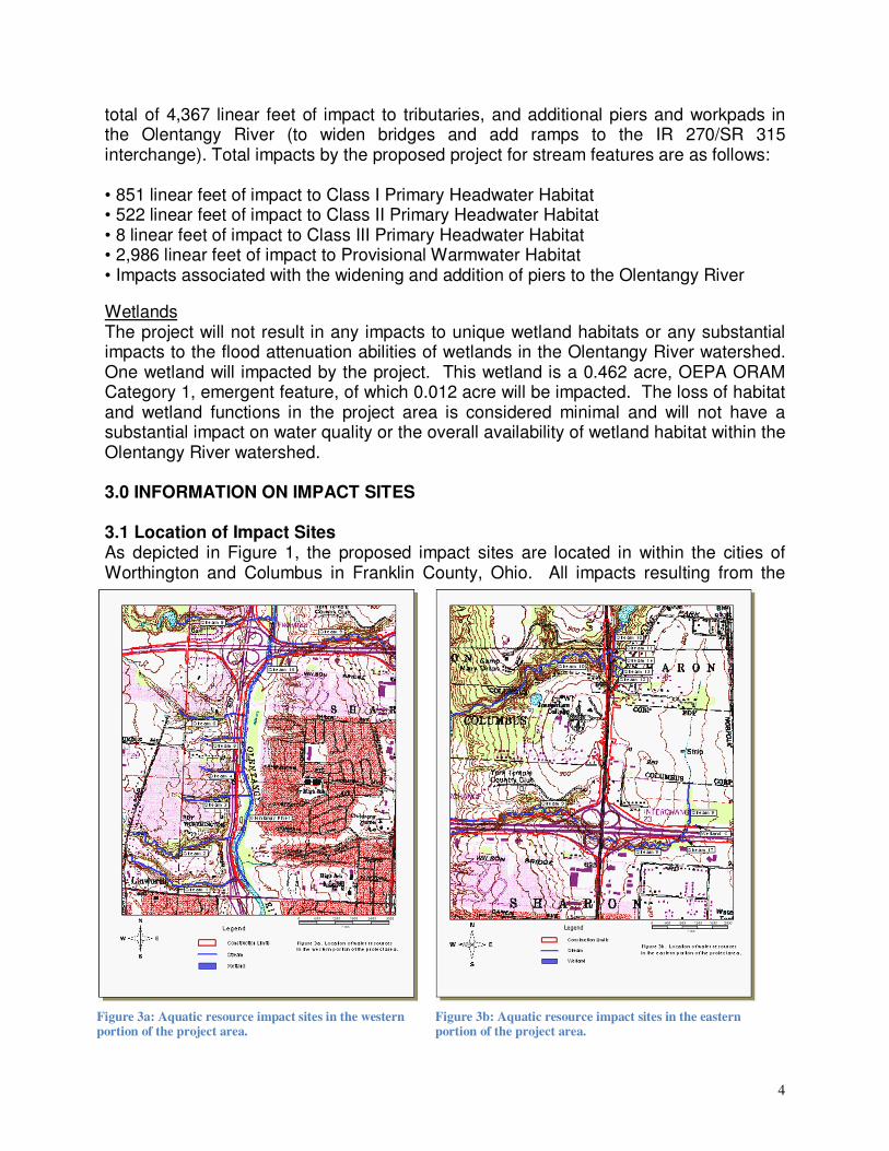
Wetlands The project will not result in any impacts to unique wetland habitats or any substantial impacts to the flood attenuation abilities of wetlands in the Olentangy River watershed. One wetland will impacted by the project. This wetland is a 0.462 acre, OEPA ORAM Category 1, emergent feature, of which 0.012 acre will be impacted. The loss of habitat and wetland functions in the project area is considered minimal and will not have a substantial impact on water quality or the overall availability of wetland habitat within the Olentangy River watershed. 3.0 INFORMATION ON IMPACT SITES 3.1 Location of Impact Sites As depicted in Figure 1, the proposed impact sites are located in within the cities of Worthington and Columbus in Franklin County, Ohio. All impacts resulting from the
Figure 3a: Aquatic resource impact sites in the western portion of the project area.
Figure 3b: Aquatic resource impact sites in the eastern portion of the project area.
5
project will occur within the Olentangy River sub-basin (Hydrologic Unit Code [HUC] 05060001120) of the Scioto River Watershed (HUC 05090202). Figures 3a and 3b indicate where the proposed impacts occur within the project area. Detailed mapping and photographs of the impacted resources can be found in the Preliminary Waterway Impact Report for FRA-270-19.84 (PID 77319), Franklin County, Ohio, dated 18 November 2008. 3.2 Wetland and Stream Delineations Wetland and stream delineations were performed as part of the project ecological survey. All wetland delineations were conducted in accordance with the 1987 Corps of Engineers Delineation Manual (Environmental Laboratory 1987), and wetland functional assessments following the OEPA’s Rapid Assessment Method (ORAM) version 5.0 (OEPA, 2001). Classification of the wetlands identified followed Cowardin et al. (1979). Stream assessments for the project were conducted using OEPA’s Qualitative Habitat Evaluation Index (QHEI) for stream greater then 1mi² drainage area, and the methods described in OEPA’s Field Evaluation Manual for Ohio’s Primary Headwater Habitat Streams (OEPA, 2002) for streams with less than 1mi² drainage area. Copies of the project area wetland delineation forms, OEPA ORAM v. 5.0 forms, QHEI forms, and Headwater Habitat Evaluation Index (HHEI) forms can be found in the Preliminary Waterway Impact Report for FRA-270-19.84 (PID 77319), Franklin County, Ohio, dated 18 November 2008. Please see the FRA-270-24.14 (PID 81737) permit application for plan sheets depicting the locations of aquatic resource impacts for Phase B2. Detailed design on other phases will be provided in subsequent permit applications. 3.3 Wetland and Stream Habitat Assessments Project area wetlands and streams were assessed using the OEPA ORAM v. 5.0, QHEI, and HHEI forms respectively. A more detailed summary of these assessments can be found in the Preliminary Waterway Impact Report for FRA-270-19.84 (PID 77319), Franklin County, Ohio, dated 18 November 2008. Specific information on the wetlands and streams to be impacted by the project has been summarized in section 3.4 Impacts and Mitigation Needed. 3.4 Impacts and Mitigation Requirements Stream Impacts Streams impacted will include the Olentangy River, three unnamed direct tributaries to the Olentangy River, and three unnamed indirect tributaries to the Olentangy River for a total of 4,367 linear feet of impact to tributaries, and additional piers and work-pads in the Olentangy River (to widen bridges and add ramps to the IR 270/SR 315 interchange). • 851 linear feet of impact to Class I Primary Headwater Habitat • 522 linear feet of impact to Class II Primary Headwater Habitat • 8 linear feet of impact to Class III Primary Headwater Habitat • 2,986 linear feet of impact to Provisional Warmwater Habitat • Impacts associated with the widening and addition of piers to the Olentangy River

6
Most of the impacted streams and wetlands are disturbed features in urban/suburban area with limited aquatic value. The Olentangy River has good water quality, but will only be impacted by placement of additional piers for new and widened structures. Impacted streams are predominantly small headwater features with no official OEPA aquatic life use designations, exhibiting provisional WWH (streams over 1 square mile drainage), and Class I, II, and III PHWH conditions. One stream that scored as a Class III stream on the HHEI, scored out as a Class I stream on the HMFEI. Wetlands impacted by the project are very small Category 1 features (limited value). As a result, only a minor lowering of water quality is expected for these features from loss of habitat and assimilative capacity (in terms of sediment retention, water retention, and nutrient retention and reduction) by structure/fill placement for the proposed project. Table A summarizes the stream impacts associated with the project. Table A. Streams Affected by the Proposed Project. Stream Name and/or Identifier
Length within Right-of-Way (l.f.)
OEPA Prov. ALU or Class
Receiving Waters Approximate Impacts (l.f.)
Fisher Run, Stream 8 663 Prov. WWH Olentangy River 318
Stream 9 4,000 Prov. WWH Olentangy River 2,668
Stream 11 174 Class III Stream 10 8
Stream 13 40 Class II Stream 12 210
Stream 15 966 Class I ( HMFEI) Olentangy River 851
Stream 17 312 Class II Stream 9 312
Olentangy River WWH Scioto River Bridge widening and/or additions, l.f. impact not known
Wetland Impacts The project will not result in any impacts to unique wetland habitats or any substantial impacts to the flood attenuation abilities of wetlands in the Olentangy River watershed. One wetland will impacted by the project. This wetland is a 0.462 acre, OEPA ORAM Category 1, emergent feature, of which 0.012 acre will be impacted. The loss of habitat and wetland functions in the project area is considered minimal and will not have a substantial impact on water quality or the overall availability of wetland habitat within the Olentangy River watershed. Table B summarizes the stream impacts associated with the project. Table B. Wetlands Affected by the Proposed Project. Wetland Identifier Total Size ORAM Category Receiving Waters Approximate
Impacts (a.c.)
Wetland C 0.462 Category I Stream 9 0.012
Mitigation Requirements Stream mitigation is currently determined on a project-by-project basis through the waterway permit process. General mitigation requirements consist of: a) on-site mitigation at a 1:1 ratio (with on-site defined as within the same effected 8 Digit USGS watershed and within 1 mile of the project), and b) off-site mitigation at a minimum ratio of 1.5:1.
7
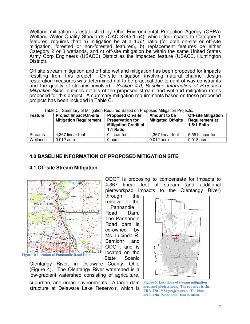
Wetland mitigation is established by Ohio Environmental Protection Agency (OEPA) Wetland Water Quality Standards (OAC 3745-1-54), which, for impacts to Category 1 features, requires that: a) mitigation be at a 1.5:1 ratio (for both on-site or off-site mitigation, forested or non-forested features), b) replacement features be either Category 2 or 3 wetlands, and c) off-site mitigation be within the same United States Army Corp Engineers (USACE) District as the impacted feature (USACE, Huntington District). Off-site stream mitigation and off-site wetland mitigation has been proposed for impacts resulting from this project. On-site mitigation involving natural channel design restoration measures was determined not to be practical due to right-of-way constraints and the quality of streams involved. Section 4.0, Baseline Information of Proposed Mitigation Sites, outlines details of the proposed stream and wetland mitigation ratios proposed for this project. A summary mitigation requirements based on these proposed projects has been included in Table C.
Table C. Summary of Mitigation Required Based on Proposed Mitigation Projects. Feature Project Impact/On-site
Mitigation Requirement Proposed On-site Preservation for Mitigation Credit at 1:1 Ratio
Amount to be Mitigated Off-site
Off-site Mitigation Requirement at 1.5:1 Ratio
Streams 4,367 linear feet 0 linear feet 4,367 linear feet 6,551 linear feet
Wetlands 0.012 acre 0 acre 0.012 acre 0.018 acre
4.0 BASELINE INFORMATION OF PROPOSED MITIGATION SITE 4.1 Off-site Stream Mitigation
ODOT is proposing to compensate for impacts to 4,367 linear feet of stream (and additional pier/workpad impacts to the Olentangy River) through the removal of the
Panhandle Road Dam. The Panhandle Road dam is co-owned by Ms. Lucinda R. Bernlohr and ODOT, and is located on the State Scenic
Olentangy River, in Delaware County, Ohio (Figure 4). The Olentangy River watershed is a low-gradient watershed consisting of agriculture,
suburban, and urban environments. A large dam structure at Delaware Lake Reservoir, which is
Figure 4: Location of Panhandle Road Dam
Figure 5: Locations of stream mitigation
area and project area. The red area is the
FRA-270-19.84 project area. The blue area is the Panhandle Dam location.

8
managed by the USACE, controls the river flow through this section of the Olentangy River. The Olentangy River discharges into the Scioto River near downtown Columbus, Ohio. The Panhandle Road Dam is located along the Designated State Scenic section of the Olentangy River in the City of Delaware, Delaware County, Ohio (Latitude: 40018’20.16” and Longitude: 8303’28.8”). This site is approximately 14.7 miles from the project area (Figure 5). The Olentangy River has been assigned an official aquatic life use designation of Warmwater Habitat from the Ohio EPA. Although it is in full attainment at the Ohio EPA sample sites upstream and downstream of the dam, it does not meet WWH criteria within the dam pool. (Ohio EPA data on this reach of the Olentangy River can be found in Appendix F). In addition, a habitat assessment of the Olentangy River conducted by ODOT within the dam pool and downstream of the dam pool (Appendix D) confirmed that the habitat within the dam pool did not meet WWH through the QHEI score.
Summary of Off-site Stream Mitigation The stream mitigation area (primary) extends from approximately 400 linear feet downstream of the dam to the first riffle upstream of the dam, and is located at coordinates 40018’20.16” N, 8303’28.8” W to 40o19’55.35” N, 83o04’10.02” W. The mitigation area totals 4,224 linear feet in length. Secondary mitigation credits (17,338 lf) may be dispensed incrementally after receipt, review, and approval of the 1, 3, and 5th-year monitoring reports, respectively, based on increased IBI, ICI, MiWB, and QHEI scores of selected sites outside of the primary mitigation area. This is optional, and ODOT may or may not perform the extra survey work to receive these credits. 4.2 Off-site Wetland Mitigation
The Category 1 wetland impacts will be compensated for at a 1.5:1 ratio (0.018 acre) by subtracting 0.018 acre of credit from ODOT’s balance at the Wetlands Resource Center Little Scioto Wetland Mitigation Bank in Marion County, Ohio. A balance sheet is included in Appendix E.
Pool looking upstream from dam. First riffle upstream from the dam. First riffle downstream of the dam

9
5.0 MITIGATION SITE SELECTION AND JUSTIFICATION 5.1 Existing Conditions Off-site Dam Removal Mitigation This mitigation area was selected based on agency comments received during the ecological coordination associated with this project. ODNR-Division of Natural Areas and Preserves Scenic River Program and Ohio EPA were especially interested in the removal of this dam. Also, since ODOT is a joint owner of the dam structure, the structure is very close to a US route, and the dam does not carry utilities, the structure was a logical choice for removal. Restoring free-flowing conditions to this segment of river will be beneficial to fish, macroinvertebrates, and freshwater mussels by the formation of new habitats between the dam and the first riffle, the re-colonization of suitable habitats upstream of the dam, and to allow genetic flow between upstream and downstream populations of aquatic wildlife. Off-site wetland mitigation at the Little Scioto Mitigation Bank. Due to the minor amount of wetland impact expected for this project (0.012 acre) and the quality of the wetlands being impacted (all OEPA Category 1 features) ODOT proposes that the impacts to wetlands resulting from this project be mitigated through off-site mitigation at the Wetlands Resource Center Little Scioto Wetland Mitigation Bank in Marion County, Ohio. Wetland mitigation is established by Ohio EPA Wetland Water Quality Standards (OAC 3745-1-54), which for impacts to Category 1 wetlands, requires that:
• mitigation be at a 1.5:1 ratio (for both on-site or off-site mitigation, forested or non-forested features),
• replacement features be either Category 2 or 3 wetlands, and • off-site mitigation be within the same United States Army Corp Engineers
(USACE) District as the impacted feature (USACE, Louisville District).
Subtracting 0.018 acre of credit off of the credit balance that ODOT has at the Little Scioto Mitigation Bank as mitigation for the proposed project will comply with all regulatory requirements, and will result in replacement of the impacted wetlands with higher quality wetlands within the USACE District. 5.2 Future Sustainability Off-site dam removal mitigation area The purpose of the dam removal is to restore free-flowing conditions to a Ohio Scenic segment of the Olentangy River. Restoring free-flowing conditions to this segment of river will be beneficial to fish, macroinvertebrates, and freshwater mussels by the formation of new habitats between the dam and the first riffle, the re-colonization of suitable habitats upstream of the dam, and to allow genetic flow between upstream and downstream populations of aquatic wildlife. No restrictive covenant has been placed on the mitigation area, as this area is already under state ownership and easement. Off-site wetland mitigation at the Little Scioto Wetland Mitigation Bank As with all public wetland mitigation banks, the Little Scioto wetland mitigation bank is preserved in perpetuity by way of a restrictive covenant.
10
6.0 MITIGATION WORK PLANS 6.1 Off-site Dam Removal Stream Mitigation The Panhandle Dam is scheduled for removal during the 2010 warm season (late spring to early fall). A small access road will be constructed between US 23 and the Olentangy River next to the dam to allow equipment to access the dam. The river-right abutment and the entire dam structure will be removed. The river-left abutment will remain in place to avoid impacts to private property. After the water levels have stabilized (1-2 days after the dam removal), a mussel survey will be conducted to relocate any stranded mussels. This survey would be done by a professional malacologist, assisted by ODOT and ODNR staff, and will encompass the area between the dam and the first riffle upstream of the dam. 6.2 Off-site wetland mitigation at the at the Little Scioto Mitigation Bank The Category 1 wetland impacts will be compensated for at a 1.5:1 ratio (0.018 acre) by subtracting 0.018 acre of credit from ODOT’s balance at the Wetlands Resource Center Little Scioto Wetland Mitigation Bank in Marion County, Ohio. No construction or monitoring work will be conducted by ODOT for this mitigation. 7.0 PERFORMANCE STANDARDS 7.1 Off-site Dam Removal Stream Mitigation The following performance standards apply to the Panhandle Dam removal project:
• Within 5 years after removal of the dam, the Olentangy River primary mitigation area (4,224 linear feet) shall be stable and intact, and achieve, at a minimum, warm water habitat status (full attainment) based on the QHEI, IBI, ICI, and MIwb assessments (at this time, this area is in non-attainment in the dam pool).
• Within 5 years after removal of the dam, the Olentangy River secondary mitigation area (17,388 linear feet) shall achieve, at a minimum, warm water habitat status (full attainment) based on QHEI, IBI, ICI, and MIwb assessments, or in areas that are already in attainment, show a measurable improvement in scores from the above-listed assessments as compared with data collected prior to the dam removal. This survey work to gain the secondary credit is optional, and ODOT will make a determination whether to do the additional survey work for this credit at a later date.
7.2 Off-site wetland mitigation at the at the Little Scioto Mitigation Bank The Category 1 wetland impacts will be compensated for at a 1.5:1 ratio (0.018 acre) by subtracting 0.018 acre of credit from ODOT’s balance at the Wetlands Resource Center Little Scioto Wetland Mitigation Bank in Marion County, Ohio. The performance of this wetland is the responsibility of the bank’s owner/operator.

11
8.0 SITE PROTECTION AND MAINTENANCE 8.1 Responsible Parties ODOT is responsible for the removal of the dam. The area where the dam is located is owned by ODOT, and under easement held by the State of Ohio, with jurisdiction assigned the ODNR-Division of Wildlife (the original easement was held by the Ohio Conservation Council before the creation of ODNR). No other protective instruments will be placed on this site. For Information on Responsible Parties Contact:
ODOT, Office of Environmental Services Waterway Permit Unit 1980 W. Broad St.
Columbus, OH 43223 (614) 466-7100
8.2 Legal Protection The river-right bank near the dam is owned by ODOT with an easement held by ODNR. The dam itself is half owned by ODOT and a private owner, but the entire structure is under the ODNR easement. The river-left bank near the dam is under private ownership. No restrictive covenant will be placed on the dam removal area, as this area is already under state ownership and easement. 8.3 Maintenance Plan and Schedule On-site dam removal stream mitigation Native vegetation will be planted in the areas denuded by the removal of the dam. ODOT will monitor invasive species along the primary mitigation area with photographs, but no invasive species removal or maintenance is required at this site. Most of the land along the primary mitigation area is under private ownership, which would not allow for vegetation management. No in-stream maintenance is required because the river channel is not being changed, and no structures will remain in the stream after the dam is removed. Off-site wetland mitigation at the Little Scioto Wetland Mitigation Bank Maintenance of this site is the responsibility of the bank’s owner/operator. 9.0 MONITORING PLAN 9.1 Off-site dam removal stream mitigation Pre-Dam Removal Assessment: ODOT will conduct a pre-dam (baseline) removal assessment. The assessment shall include biological, chemical, and physical measurements conducted in the stream mitigation area, which include representative sample locations within the impoundment and reaches upstream and downstream of the impoundment. The assessments shall include QHEI, ICI, IBI, Mlwb, erosion inspection, invasive plant species encroachment, mussel survey, and habitat diversity.

12
Post-Dam Removal Assessment: ODOT will implement assessments of the entire mitigation area, including sample points within the former impoundment and representative reaches downstream and upstream of the former impoundment. Reports containing the data listed in the appropriate subsections shall be submitted to Ohio EPA for years 1, 3, and 5 following removal of the Panhandle Road Dam. The first annual report is due to Ohio EPA by December 31 of the first full year following removal of the dam. All subsequent reports shall be submitted by December 31st of each of the subsequent monitoring years. ODOT will include any additional information that it believes relevant for Ohio EPA's consideration. The reports will include the following information:
• Habitat and Biota Assessments: The assessments shall include QHEI, ICI, IBI, Mlwb.
• Post-Dam Removal Mussel Survey: A mussel survey shall be conducted within the former impounded area and reaches upstream and downstream of the impounded area, during monitoring Year 5. During monitoring year 3, a specific survey shall be conducted for the Purple Wartyback in the second and third riffle complexes downstream of the Panhandle Road Dam (RM 27.7 - RM 27.35). The assessment shall include the location where species are found (coordinates), condition of the mussel (live, fresh dead, shell, etc.), habitat characteristics (riffle, pool, etc.), description of substrate (sand, cobbles, pebbles, etc.), stream flow rate in vicinity of riffle complex, etc.
• Mitigation Area Photographs: At a minimum, the first, third, and fifth year annual report shall contain representative photographs of the stream mitigation area, including each bank and riparian buffer of the pooled area of the Olentangy River, upstream of the former dam, and sections of the river downstream of the dam.
• Erosion Inspection: ODOT will visually inspect the floodplain and channel banks in the project area for signs of erosion and instability.
• Vegetation Monitoring: The location and name of each plant community type within the buffer mitigation area and buffer area shall be marked on a scaled drawing or scaled aerial photograph (base map) and named. The dominant plant species shall be visually determined in each vegetation layer of each community type, and the scientific names of these species shall be included in the report. Dominant species are those species which have the greatest relative basal area (woody overstory), greatest height (woody overstory), greatest percentage of aerial coverage (herbaceous understory), and lor greatest number of stems (woody vines). The vegetation monitoring requirements only apply to areas that ODOT has legal access to inspect.
• Invasive Plant Species Monitoring: ODOT will inspect the newly exposed areas to assess the exotic colonization of vegetation. This information will be presented in the monitoring report along with representative photo-documentation. The information shall be compared with the pre-dam invasive plant species survey.
• Water Chemistry Monitoring: Basic water quality parameters (pH, Specific Conductivity, Total Dissolved Solids, Dissolved Oxygen, and Temperature) will be measured in select stream locations, upstream and downstream of the former dam, using calibrated field meters during the monitoring visits.

13
• Physical Measurements: A plan view, longitudinal profile, and at least one cross-section through the former pooled area and representative sample area downstream of the former dam is required for the mitigation area in monitoring report years 1 and 5 only.
9.2 Off-site wetland mitigation at the Little Scioto Wetland Mitigation Bank Monitoring of this site is the responsibility of the bank’s owner/operator. 10.0 ADAPTIVE MANAGEMENT PLAN 10.1 Off-site dam removal stream mitigation If performance of the mitigation site does not fulfill anticipated expectations, ODOT will work with the Ohio EPA and the USACE to develop a contingency plan. 10.2 Off-site wetland mitigation at the Little Scioto Wetland Mitigation Bank The purchase of 0.18 acre of wetland mitigation credits at this approved MBRT bank has fulfilled ODOT’s obligations for providing wetland mitigation. The operation, maintenance, and monitoring of the bank is the responsibility of the bank’s owner/operator. 11.0 FINANCIAL ASSURANCES Funding for this project will come from State and Federal funds earmarked for ODOT transportation projects.
14
12.0 LITERATURE CITED Cowardin, L. M., V. Carter, F.C. Golet, and E. T. LaRoe. 1979. Classification of Wetlands and Deepwater Habitats of the United States. U.S. Fish and Wildlife Service. Biological Services Program Rept. FWS/OBS-79/31. 103 p. Environmental Laboratory. 1987. Corps of Engineers Wetlands Delineation Manual. Technical Report Y-87-1, US Ar my Engineer Waterways Experiment Station, Vicksburq, Miss. OEPA 2005. Biological and Water Quality Study of the Olentangy River, Whetstone Creek and Select Tributaries 2003-2004. Crawford, Delaware, Franklin, Marion, and Morrow Counties, Ohio. OEPA, Unpublished. IBI, ICI, MIwb, and QHEI data for selected sites near present and past low-head dam locations. OEPA. 2001. Ohio Rapid Assessment Method for Wetlands v. 5.0, User’s Manual and Scoring Forms. Ohio EPA Technical Report WET/2001-1. Ohio EPA, Division of Surface Water. Columbus, Ohio. OEPA 2002. Field Evaluation Manual for Ohio’s Primary Headwater Habitat Streams (v 1.0). Ohio EPA, Division of Surface Water. Columbus, Ohio. URS Corporation, Ohio. 18 November 2008. Preliminary Waterway Impact Report FRA-270-19.84 (PID 77319) Franklin County, Ohio.

Appendix A: Photographs of the Impacted Stream and Wetland Resources
Appendix B: QHEI forms for the Olentangy River upstream and downstream of the Panhandle Road
Dam

Appendix C: Photographs of the Panhandle Road Dam Mitigation Area

Appendix D: Ohio EPA Data on the Olentangy River near the Panhandle Road Dam Mitigation Area

Appendix E: Balance Sheet for Little Scioto Wetland Mitigation Bank

Appendix F: Section 404 Nationwide Permit and Section 401 Individual WQC for Phase B2.