final preliminary engineering...
TRANSCRIPT
FINAL PRELIMINARY ENGINEERING REPORT
GANDY BOULEVARD (SR 694) PD&E STUDY FROM WEST OF US 19 TO EAST OF 4th STREET
PINELLAS COUNTY
Work Program Item Segment No: 256931 1 Federal Aid Project No: F-295-1(1) (Old)
This project evaluated improvement alternatives for Gandy Boulevard (SR 694) from west of US 19 to east of 4th Street
Pinellas County, Florida.
Prepared for:
Florida Department of Transportation District Seven
11201 North McKinley Drive Tampa, Florida 33612-6456
August 2002

FINAL PRELIMINARY ENGINEERING REPORT
GANDY BOULEVARD (SR 694) PD&E STUDY FROM WEST OF US 19 TO EAST OF 4th STREET
PINELLAS COUNTY
Work Program Item Segment No: 256931 1 Federal Aid Project No: F-295-1(1) (Old)
This project evaluated improvement alternatives for Gandy Boulevard (SR 694) from west of US 19 to east of 4th Street
Pinellas County, Florida.
August 2002
PBS&J 5300 West Cypress Street, Suite 300 Tampa, Florida 33607
Steve Gordillo, P.E., Project Engineer
(Prepared By) (Name and Title of Engineer)
Gabor Farkasfalvy, Project Manager
50586
(P.E. Number)
(Name and Title of Responsible FDOT
Officer)
TABLE OF CONTENTS
Section Title Page
i F:\COMMON\PDE\PROJECTS\GANDY\REPORTS\PER_Final\Final PER.doc
TABLE OF CONTENTS i LIST OF TABLES vii LIST OF FIGURES viii 1 COMMITMENTS AND RECOMMENDATIONS 1-1
1.1 Commitments 1-1 1.2 Recommendations 1-2
1.2.1 Proposed Typical Sections 1-4 1.2.1.1 Segment A 1-4 1.2.1.2 Segment B 1-5 1.2.1.3 Segment C 1-6 1.2.1.4 Segment D 1-8
1.2.2 Recommended Alternative 1-10 1.2.2.1 Segment A 1-10 1.2.2.2 Segment B 1-10 1.2.2.3 Segment C 1-11 1.2.2.4 Segment D 1-12
1.3 References 1-14 2 INTRODUCTION 2-1
2.1 Purpose 2-1 2.2 Project Description 2-3 2.3 References 2-4
3 NEED FOR IMPROVEMENT 3-1
3.1 Deficiencies 3-1 3.1.1 Existing Deficiencies 3-1
3.2 Safety 3-2 3.3 Consistency with Transportation Plan 3-4 3.4 Social and Economic Demands 3-4 3.5 References 3-6
4 EXISTING CONDITIONS 4-1
4.1 Existing Roadway Characteristics 4-1 4.1.1 Functional Classification 4-2 4.1.2 Typical Section 4-2
4.1.2.1 Segment A 4-2 4.1.2.2 Segment B 4-5 4.1.2.3 Segment C 4-8 4.1.2.4 Segment D 4-8 4.1.2.5 Existing Cross Road Typical Sections 4-12

TABLE OF CONTENTS (Cont.)
Section Title Page
ii F:\COMMON\PDE\PROJECTS\GANDY\REPORTS\PER_Final\Final PER.doc
4.1.2.6 US 19 4-12 4.1.2.7 Grand Avenue 4-12 4.1.2.8 I-275 4-15 4.1.2.9 9th Street 4-15 4.1.2.10 Roosevelt Boulevard 4-15 4.1.2.11 4th Street 4-21
4.1.3 Pedestrian and Bicycle Facilities 4-21 4.1.4 Right-of-Way (ROW) 4-21 4.1.5 Horizontal Alignment 4-23 4.1.6 Vertical Alignment 4-23 4.1.7 Drainage 4-23 4.1.8 Geotechnical Data 4-23 4.1.9 Accident Data 4-23 4.1.10 Intersections and Signalization 4-27 4.1.11 Railroad Crossings 4-27 4.1.12 Transit 4-27 4.1.13 Lighting 4-28 4.1.14 Utilities 4-28 4.1.15 Pavement Conditions 4-29
4.2 Existing Bridges 4-29 4.2.1 Type of Structure 4-30 4.2.2 Current Conditions and Year of Construction 4-31 4.2.3 Channel Data 4-32 4.2.4 Bridge Openings 4-32 4.2.5 Ship Impact Data 4-32
4.3 Environmental Characteristics 4-33 4.3.1 Land Use Data 4-33 4.3.2 Cultural Features and Community Service 4-36
4.3.2.1 Cultural Resources Assessment Survey 4-36 4.3.2.2 Cultural Features and Community Service 4-38 4.3.2.3 Section 4(f) Properties 4-38
4.3.3 Natural and Biological Features 4-38 4.3.3.1 Wetlands 4-38 4.3.3.2 Threatened and Endangered Species 4-38
4.3.4 Potential Hazardous Materials and Petroleum Products Contaminated Sites 4-39
4.4 References 4-40 5 TYPICAL SECTION DESIGN CRITERIA 5-1
5.1 Functional Classification 5-1 5.2 Design Speed 5-1 5.3 Lane Widths 5-4 5.4 Bike Lanes 5-4
TABLE OF CONTENTS (Cont.)
Section Title Page
iii F:\COMMON\PDE\PROJECTS\GANDY\REPORTS\PER_Final\Final PER.doc
5.5 Median Widths 5-5 5.6 Shoulder Widths 5-5 5.7 Sidewalk Widths 5-5 5.8 Border Widths 5-6 5.9 Bridge Separation Distance 5-6 5.10 References 5-7
6 TRAFFIC 6-1
6.1 Existing Traffic Volumes 6-1 6.1.1 Traffic Counts 6-1 6.1.2 Traffic Characteristics 6-4
6.2 Roadway Characteristics 6-4 6.3 Existing Access Management 6-9
6.3.1 Access Standards 6-12 6.3.2 Access Near Interchange Areas 6-13 6.3.3 Access Management Under Existing (No-Build) Conditions6-14
6.3.3.1 Access Management along Gandy Boulevard (SR 694) 6-14
6.3.3.2 US 19/Gandy Boulevard (SR 694) Interchange Access Management 6-16
6.3.3.3 Improvements by Others 6-17 6.3.3.4 I-275/Gandy Boulevard (SR 694) Interchange Access
Management 6-18 6.4 Existing Traffic Conditions 6-18
6.4.1 Existing Signalized Intersections Level of Service Analysis 6-19
6.4.2 Existing Arterial Level of Service Analysis 6-19 6.4.3 Existing Ramp Junctions Level of Service Analysis 6-20
6.5 Multimodal Transportation System Considerations 6-21 6.5.1 Transit 6-21 6.5.2 Pinellas Mobility Major Investment Study 6-22 6.5.3 Rail 6-23 6.5.4 Aviation 6-23
6.6 Traffic Analysis Assumptions 6-23 6.7 Traffic Volume Projections 6-23
6.7.1 Design Year Annual Average Daily Traffic Volume Projections 6-24
6.7.1.1 No-Build Alternative 6-24 6.7.1.2 Build Alternatives 6-24
6.7.2 2025 Design Hour Turning Movement Volumes 6-29 6.7.2.1 No-Build Alternative 6-29 6.7.2.2 Build Alternatives 6-29

TABLE OF CONTENTS (Cont.)
Section Title Page
iv F:\COMMON\PDE\PROJECTS\GANDY\REPORTS\PER_Final\Final PER.doc
6.8 Level Of Service 6-34
6.8.1 No-Build Alternative 6-34 6.8.1.1 Design Year (2025) Signalized Intersection LOS
Analysis (No-Build Alternative) 6-43 6.8.1.2 Design Year (2025) Arterial LOS Analysis (No-Build
Alternative) 6-43 6.8.1.3 Design Year (2025) Ramp Junctions LOS Analysis
(No-Build Alternative) 6-44 6.8.2 Build Alternative 6-45
6.8.2.1 Design Year (2025) Signalized Intersection LOS Analysis (Build Alternative) 6-45
6.8.2.2 Design Year (2025) Arterial LOS Analysis (Build Alternative) 6-46
6.8.2.3 Level of Service Improvement Recommendations (Build Alternative) 6-48
6.8.3 Revised Build Alternative 6-48 6.8.3.1 Design Year (2025) Signalized Intersection LOS
Analysis (Revised Build Alternative) 6-51 6.8.3.2 Design Year (2025) Arterial LOS Analysis (Build
Alternative) 6-51 6.8.3.3 Level of Service Improvement Recommendations
(Revised Build Alternative) 6-52 6.9 Access Management Under Build Alternatives 6-55
6.9.1 Build Alternative 6-55 6.9.1.1 US 19/Gandy Boulevard (SR 694) Interchange 6-55 6.9.1.2 Modified I-275 Interchange 6-55 6.9.1.3 New 9th Street Interchange 6-56 6.9.1.4 New Roosevelt Boulevard/4th Street
Interchange 6-56 6.9.2 Revised Build Alternative 6-57
6.10 Queue Lengths 6-57 6.10.1 Build Alternative 6-57 6.10.2 Revised Build Alternative 6-60
6.11 References 6-62 7 CORRIDOR ANALYSIS 7-1
7.1 Evaluation Of Alternate Corridors 7-1 7.1.1 Improvement of Parallel Roadways 7-1 7.1.2 Enhancement of Transit Service 7-2 7.1.3 Improvement of the Existing Corridor 7-3
7.2 Corridor Selection 7-3 7.3 References 7-4

TABLE OF CONTENTS (Cont.)
Section Title Page
v F:\COMMON\PDE\PROJECTS\GANDY\REPORTS\PER_Final\Final PER.doc
8 ALTERNATIVES ANALYSIS 8-1
8.1 No-Build Alternative 8-1 8.2 Transportation System Management Alternative 8-2 8.3 Alternatives Development 8-3
8.3.1 Project Background 8-3 8.3.2 Project Segmentation 8-10 8.3.3 Proposed Typical Sections 8-11 8.3.4 Segment A 8-11 8.3.5 Segment B 8-12 8.3.6 Segment C 8-15 8.3.7 Segment D 8-23
8.4 Recommended alternative 8-25 8.4.1 Segment A - Recommended Alternative 8-27 8.4.2 Segment B - Recommended Alternative 8-27 8.4.3 Segment C - Recommended Alternative 8-32 8.4.4 Segment D – Recommended Alternative 8-39
8.5 Matrix 8-51 8.6 Design Changes to the Recommended Build Alternative 8-52
8.6.1 Segment C - Recommended Alternative 8-52 8.7 References 8-55
9 PRELIMINARY DESIGN ANALYSIS 9-1
9.1 Design Traffic Volumes 9-1 9.2 Typical Sections 9-1
9.2.1 Recommended Alternative 9-1 9.3 Intersection Concepts And Signal Analysis 9-2 9.4 Alignment And Right-Of-Way Needs 9-3 9.5 Relocations 9-3 9.6 Right-Of-Way Costs 9-3 9.7 Construction Cost 9-3 9.8 Preliminary Engineering And Construction Engineering Costs 9-3 9.9 Recycling Of Salvageable Materials 9-4 9.10 User Benefits 9-4 9.11 Pedestrian And Bicycle Facilities 9-4 9.12 Safety 9-5 9.13 Economic And Community Development 9-5 9.14 Environmental Effects 9-5
9.14.1 Land Use Data 9-5 9.14.1.1 Community Facilities and Established Land
Uses 9-5 9.14.2 Community Cohesion 9-6 9.14.3 Cultural Features 9-6
TABLE OF CONTENTS (Cont.)
Section Title Page
vi F:\COMMON\PDE\PROJECTS\GANDY\REPORTS\PER_Final\Final PER.doc
9.14.4 Wetland Impact and Mitigation 9-7 9.14.5 Threatened and Endangered Species 9-7 9.14.6 Potential Hazardous Materials and Petroleum Products
Contaminated Sites 9-7 9.14.7 Noise Impacts 9-7 9.14.8 Air Quality Impacts 9-7 9.14.9 Water Quality Impacts 9-8 9.14.10 Aquatic Preserves 9-8 9.14.11 Section 4(f) Lands 9-8 9.14.12 Outstanding Florida Waters 9-9 9.14.13 Floodplains 9-9
9.15 Utility Impacts 9-9 9.16 Traffic Control Plan 9-9 9.17 Results Of Public Involvement Program 9-10
9.17.1 Advance Notification 9-11 9.17.2 Elected Official/Agency Kickoff Meeting 9-11 9.17.3 Newsletters / Presentations / Small Group Meetings 9-11 9.17.4 Public Hearing 9-12
9.18 Value Engineering 9-14 9.19 Drainage 9-14 9.20 Structures 9-14 9.21 Access Management Under Recommended Alignment 9-14 9.22 Regional Transit Locations 9-17 9.23 Aesthetics And Landscaping 9-17 9.24 References 9-18
APPENDICES
Appendix A Alternative Design Concepts & Contamination Sites Appendix B Geopak Output Appendix C Correspondence

LIST OF TABLES
Table Number Title Page
vii F:\COMMON\PDE\PROJECTS\GANDY\REPORTS\PER_Final\Final PER.doc
1-1 Evaluation Matrix -Recommended Alternative 1-13 3-1 Pinellas County Socio-Economic Information 3-5 4-1 Crash Summary for Intersections 4-25 4-2 Crash Summary for Segments 4-26 4-3 Pavement Condition Rating 4-29 4-4 Existing Bridges 4-30 4-5 Bridge Rating Summary 4-32 5-1 Typical Section Design Criteria 5-2 6-1 Traffic Characteristics 6-4 6-2 Access Class 3 Standards 6-12 6-3 Standards for Controlled Access FIHS Facilities 6-13 6-4 Existing Median Openings along Gandy Boulevard (SR 694) 6-16 6-5 Existing Median Opening/Connection Spacing at US 19/Gandy Boulevard (SR 694) Interchange 6-17 6-6 Existing Median Opening/Connection Spacing at I-275/Gandy Boulevard (SR 694) Interchange 6-18 6-7 Existing (2000) Signalized Intersections LOS 6-19 6-8 Existing (2000) Arterial Segment LOS 6-20 6-9 Existing (2000) Ramp Junctions LOS 6-21 6-10 Design Year (2025) Signalized Intersections LOS No-Build Alternative 6-43 6-11 Design Year (2025) Arterial LOS No-Build Alternative 6-44 6-12 Design Year (2025) Ramp Junctions LOS No-Build Alternative 6-45 6-13 Design Year (2025) Signalized Intersections LOS Build Alternative 6-46 6-14 Design Year (2025) Arterial LOS Build Alternative 6-47 6-15 Design Year (2025) Signalized Intersections LOS Revised Build Alternative 6-51 6-16 Design Year (2025) Arterial LOS Revised Build Alternative 6-52 6-17 Review of Median/Connection Opening Spacing at New 9th Street Interchange 6-56 6-18 Review of Median/Connection Opening Spacing at New Roosevelt Boulevard/4th Street Interchange 6-57 6-19 Design Year (2025) Queue Lengths Build Alternative – AM Peak Hour 6-58 6-20 Design Year (2025) Queue Lengths Build Alternative – PM Peak Hour 6-59 6-21 Design Year (2025) Queue Lengths Revised Build Alternative – AM Peak Hour 6-61 6-22 Design Year (2025) Queue Lengths Revised Build Alternative – PM Peak Hour 6-61 8-1 Evaluation Matrix -Recommended Alternative 8-51 9-1 Median Openings 9-16 9-2 Median Openings 9-17

LIST OF FIGURES
Figure Number Title Page
viii F:\COMMON\PDE\PROJECTS\GANDY\REPORTS\PER_Final\Final PER.doc
2-1 Project Location Map 2-2
4-1 Existing Roadway Typical Section 4-3 4-2 Existing Bridge Typical Section 4-4 4-3 Existing Roadway Typical Section 4-6 4-4 Existing Roadway Typical Section 4-7 4-5 Existing Roadway Typical Section 4-9 4-6 Existing Roadway Typical Section 4-10 4-7 Existing Roadway Typical Section 4-11 4-8 Existing Roadway Typical Section 4-13 4-9 Existing Roadway Typical Sections 4-14 4-10 Existing Roadway Typical Section 4-16 4-11 Existing Bridge Typical Section 4-17 4-12 Existing Bridge Typical Section 4-18 4-13 Existing Roadway Typical Section 4-19 4-14 Existing Roadway Typical Section 4-20 4-15 Existing Roadway Typical Section 4-22 4-16 Existing Land Use 4-34 4-17 Future Land Use 4-37 6-1A Existing (2000) Annual Average Daily Traffic Volumes 6-2 6-1B Existing (2000) Annual Average Daily Traffic Volumes 6-3 6-2A Existing (2000) AM Peak Hour Volumes 6-5 6-2B Existing (2000) AM Peak Hour Volumes 6-6 6-3A Existing (2000) PM Peak Hour Volumes 6-7 6-3B Existing (2000) PM Peak Hour Volumes 6-8 6-4A Existing Lane Configuration for Study Corridor 6-10 6-4B Existing Lane Configuration for Study Corridor 6-11 6-5 Access Management Existing Conditions 6-15 6-6A Design Year (2025) Annual Average Daily Traffic
Volumes (No-Build Alternative) 6-25 6-6B Design Year (2025) Annual Average Daily Traffic
Volumes (No-Build Alternative) 6-26 6-7A Design Year (2025) Annual Average Daily Traffic
Volumes (Build Alternative) 6-27 6-7B Design Year (2025) Annual Average Daily Traffic
Volumes (Build Alternative) 6-28 6-8A Design Year (2025) AM Peak Hour Volumes (No-Build Alternative)
Plate A – Western Segment 6-30 6-8B Design Year (2025) AM Peak Hour Volumes (No-Build Alternative)
Plate B – Eastern Segment 6-31 6-9A Design Year (2025) PM Peak Hour Volumes (No-Build Alternative)
Plate A – Western Segment 6-32

LIST OF FIGURES (Cont’d.)
Figure Follows Number Title Page
ix F:\COMMON\PDE\PROJECTS\GANDY\REPORTS\PER_Final\Final PER.doc
6-9B Design Year (2025) PM Peak Hour Volumes (No-Build Alternative)
Plate B – Eastern Segment 6-33 6-10A Design Year (2025) AM Peak Hour Volumes (Build Alternative)
Plate A – Western Segment 6-35 6-10B Design Year (2025) AM Peak Hour Volumes (Build Alternative)
Plate B – Eastern Segment 6-36 6-11A Design Year (2025) PM Peak Hour Volumes (Build Alternative)
Plate A – Western Segment 6-37 6-11B Design Year (2025) PM Peak Hour Volumes (Build Alternative)
Plate B – Eastern Segment 6-38 6-12A Design Year (2025) AM Peak Hour Volumes (Revised Build
Alternative) Plate A – Western Segment 6-39 6-12B Design Year (2025) AM Peak Hour Volumes (Revised Build
Alternative) Plate B – Eastern Segment 6-40 6-13A Design Year (2025) PM Peak Hour Volumes (Revised Build
Alternative) Plate A – Western Segment 6-41 6-13B Design Year (2025) PM Peak Hour Volumes (Revised Build
Alternative) Plate B – Eastern Segment 6-42 6-14A Design Year (2025) Lane Configuration (Build Alternative)
Plate A – Western Segment 6-49 6-14B Design Year (2025) Lane Configuration (Build Alternative)
Plate B – Eastern Segment 6-50 6-15A Design Year (2025) Lane Configuration (Revised Build Alternative)
Plate A – Western Segment 6-53 6-15B Design Year (2025) Lane Configuration (Revised Build Alternative)
Plate B – Eastern Segment 6-54 8-1 Proposed Roadway Typical Section 1 8-3 8-2 Proposed Roadway Typical Section 2 8-4 8-3 Proposed Bridge Typical Section 3 8-16 8-4 Proposed Roadway Typical Section 4 8-18 8-5 Proposed Roadway Typical Section 5 8-19 8-6 Proposed Bridge Typical Section 6 8-21 8-7 Proposed Bridge Typical Section 7 8-22 8-8 Proposed Bridge Typical Section 8 8-24 8-9 Traffic Flow Diagram 8-28
8-10 Traffic Flow Diagram 8-29 8-11 Traffic Flow Diagram 8-30 8-12 Traffic Flow Diagram 8-31 8-13 Traffic Flow Diagram 8-33 8-14 Traffic Flow Diagram 8-34 8-15 Traffic Flow Diagram 8-35 8-16 Traffic Flow Diagram 8-36 8-17 Traffic Flow Diagram 8-37 8-18 Traffic Flow Diagram 8-38

LIST OF FIGURES (Cont’d.)
Figure Follows Number Title Page
x F:\COMMON\PDE\PROJECTS\GANDY\REPORTS\PER_Final\Final PER.doc
8-19 Traffic Flow Diagram 8-40 8-20 Traffic Flow Diagram 8-41 8-21 Traffic Flow Diagram 8-42 8-22 Traffic Flow Diagram 8-43 8-23 Traffic Flow Diagram 8-44 8-24 Traffic Flow Diagram 8-45 8-25 Traffic Flow Diagram 8-46 8-26 Traffic Flow Diagram 8-47 8-27 Traffic Flow Diagram 8-49 8-28 Traffic Flow Diagram 8-50 8-29 Traffic Flow Diagram 8-54

1-1 F:\COMMON\PDE\PROJECTS\GANDY\REPORTS\PER_Final\Final PER.doc
SECTION 1
COMMITMENTS AND RECOMMENDATIONS
1.1 COMMITMENTS
To minimize the impacts of this project on local residents and business owners, and optimize
the effectiveness of the improvements, the following commitments were made during the
PD&E Study process:
1. Based on the noise evaluation performed to date, the FDOT is committed to further
consideration of noise barriers during the final design process. During final design,
noise barriers will be evaluated at the Gateway Mobile Home Park, Lauren Manor
condominium complex, the designated recreational vehicle (RV) hookups in Robert’s
Mobile Home/RV Resort, and Pelican Sound Apartments. The traffic noise barrier
evaluation for these locations will be refined using specific horizontal alignment and
vertical elevation data along with other factors that are developed during final design.
During final design, a commitment to construct feasible and reasonable noise
abatement will be contingent upon the following conditions:
• Detailed noise analysis during the final design process supports the need for
abatement;
• Detailed noise barrier analysis indicates that the cost of the barriers will not
exceed the cost reasonableness criteria;
• Community input regarding desires, types, heights and locations of barriers
is received by the FDOT and supports the construction of noise barriers;
• Preferences regarding compatibility with adjacent land uses, particularly as
expressed by officials having jurisdiction over such lands, has been
addressed;

1-2 F:\COMMON\PDE\PROJECTS\GANDY\REPORTS\PER_Final\Final PER.doc
• Safety and engineering aspects related to roadway users and adjacent
property owners have been reviewed and any conflicts or issues resolved;
and
• Any other mitigating circumstances revealed during final design have been
analyzed and resolved.
2. The FDOT is committed to provide connectivity from sidewalks and bike lanes to
any proposed trail within or adjacent to the study area.
3. The FDOT is committed that a Level II Contamination Assessment be conducted
during the design and/or construction phases for the four sites that received a
contamination risk rating of Medium. One site is located in Segment A on Park
Boulevard and three sites are located in Segment D on 4th Street.
4. The FDOT is committed that further investigation be conducted during the design
phase to determine if Riverine (fresh water) floodplain compensation is required at
Tinney Creek and Sawgrass Lake Tributary. If compensation is required, mitigation
of encroachment into the 100-year floodplain will be compensated through the
construction of floodplain compensation ponds. These ponds will be addressed in
the design phase.
1.2 RECOMMENDATIONS
The Florida Department of Transportation (FDOT) has conducted a Project Development
and Environment (PD&E) Study to evaluate improvement alternatives along Gandy
Boulevard (SR 694) from west of US 19 to east of 4th Street in the cities of Pinellas Park and
St. Petersburg in Pinellas County, Florida. The project location map in Figure 2-1 illustrates
the location and limits of the study.
This report documented the need for the project and presented the procedures used to
develop and evaluate various improvement alternatives as they relate to the transportation
facility. Engineering data and information about the environmental characteristics of the

1-3 F:\COMMON\PDE\PROJECTS\GANDY\REPORTS\PER_Final\Final PER.doc
area, which are essential to the alignment and analytical decision-making process, has been
collected as part of the 1996 Gandy Major Investment Study1 (MIS) and was updated as
necessary. Once sufficient data was available, alignment criteria was used to refine the
alternatives. The comparison of alternatives was based on a variety of parameters using a
matrix format outlined in the MIS1 Screen Two Evaluation Report and other factors
identified during this study effort. The MIS1 identified the alternative that would have the
least impact while providing the necessary improvements and was refined in the PD&E
Study phase along with the No-Build option.
Through the PD&E Study process, the FDOT evaluated the improvement alternatives along
the Gandy Boulevard (SR 694) Corridor. The Gandy Boulevard (SR 694) Corridor is
primarily an east/west facility, which in its entirety, extends from a western terminus at Gulf
Boulevard in Pinellas County to an eastern terminus at Bayshore Boulevard in Hillsborough
County. The Gandy Boulevard (SR 694) Corridor is functionally classified as an east/west
principal urban arterial highway and is part of the Florida Intrastate Highway System (FIHS).
The facility also serves as a major hurricane evacuation route for residents in Pinellas
County. The PD&E Study limits encompass the portion of Gandy Boulevard (SR 694) from
west of the US 19/Gandy Boulevard (SR 694) interchange to east of 4th Street and include
proposed interchanges at: 4th Street and Gandy Boulevard (SR 694); 9th Street and Gandy
Boulevard (SR 694); and interchange improvements at I-275. The total length of the study is
approximately 3.9 miles. This project has been evaluated in the MIS1, which was initiated in
1996.
For this PD&E Study, the project was divided into segments based on the existing land use,
interchange locations, and projected traffic volumes for the design year. Because the portion
of Gandy Boulevard (SR 694) from west of US 19 to east of 4th Street contains similar land
use characteristics and projected traffic volumes, this project was divided into four segments
based on the new interchanges that are proposed in the corridor. The segments of the project
are identified as follows:
• Segment A: West of US 19 to west of Grand Avenue
• Segment B: West of Grand Avenue to west of I-275
1-4 F:\COMMON\PDE\PROJECTS\GANDY\REPORTS\PER_Final\Final PER.doc
• Segment C: West of I-275 to west of 9th Street
• Segment D: West of 9th Street to east of 4th Street
1.2.1 Proposed Typical Sections
This section of the report describes and presents graphically the proposed typical sections,
lane configuration, and alignment developed in this PD&E Study. This study evaluated
engineering and environmental issues associated with an urban arterial alternative along the
Gandy Boulevard (SR 694) Corridor from west of the US 19/Gandy Boulevard (SR 694)
interchange to east of 4th Street.
1.2.1.1 Segment A
The limits of Segment A are along Gandy Boulevard (SR 694) from west of US 19 to west of
Grand Avenue. The existing typical sections (Figures 4-1 through 4-4) are a divided six-lane
roadway with open drainage ditches on both sides of the roadway. The existing ROW width
varies between 102 feet (ft.) and 380 ft. The existing land use in this section is a mix of
commercial and residential uses.
As indicated in the Design Traffic Memorandum2, an interchange modification is not needed
by the design year 2025 for the US 19 interchange. This interchange is located within this
project segment and will remain in its existing configuration. The associated proposed
typical section will be discussed in this section.
Roadway Typical Section
Proposed Roadway Typical Section 1 (Figure 8-1) has been evaluated for Segment A along
Gandy Boulevard (SR 694). This proposed typical section is a six-lane divided urban section
with a 26 ft. median including a median barrier wall and 12 ft. shoulders. The median
widens just west of Grand Avenue to allow for a dropped inside left turn lane from
eastbound Gandy Boulevard (SR 694) to Grand Avenue. This typical section contains three
12 ft. travel lanes in each direction. The typical section also includes off-ramps with two

1-5 F:\COMMON\PDE\PROJECTS\GANDY\REPORTS\PER_Final\Final PER.doc
12 ft. travel lanes in each direction as a one-way loop, 5 ft. sidewalks and a 4 ft. bicycle lane
along the outside of the off-ramp. The inside shoulder on the off-ramps is 8 ft. paved. The
proposed design speed for the mainline for this typical section is 60 mph and requires a
minimum right-of-way (ROW) width of 222 ft. The proposed design speed for the off-ramps
is 50 miles per hour (mph).
Bridge Typical Section
No new structures are proposed for Segment A.
1.2.1.2 Segment B
The limits of Segment B are along Gandy Boulevard (SR 694) from west of Grand Avenue
to west of I-275. The existing typical section (Figure 4-4) is a divided six-lane roadway with
open drainage ditches and frontage roads on both sides of the roadway. The existing ROW
width varies between 160 ft. and 380 ft. The existing land use in this section is a mix of
commercial and residential uses.
As indicated in the Design Traffic Memorandum2, an overpass is needed by the design year
2025 for the Grand Avenue intersection.
Roadway Typical Section
Proposed Roadway Typical Section 2 (Figure 8-2) has been evaluated for Segment B along
Gandy Boulevard (SR 694). This proposed typical section is a six-lane divided section with
a median width varying from 26 ft. (with median barrier) up to 40 ft. (with grassed drainage
swales). This typical section contains three 12 ft. travel lanes in each direction. The typical
section also includes two-lane two-way frontage roads with two 12 ft. travel lanes in each
direction, a 5 ft. sidewalk and a 4 ft. bicycle lane along the outside of the roadway. Finally,
the typical section contains two-lane one-way off-ramps. The off-ramps contain two 12 ft.
travel lanes and 10 ft. inside and outside shoulders. From the end of Segment B (west of
I-275) to the east of I-275, the proposed six-lane divided rural section continues under I-275

1-6 F:\COMMON\PDE\PROJECTS\GANDY\REPORTS\PER_Final\Final PER.doc
while the frontage roads and off-ramps terminate at I-275. The proposed design speed for
this typical section is 60 mph along the mainline and 50 mph for the off-ramps and frontage
roads. This section requires a minimum ROW width between 314 ft. and 328 ft.
Bridge Typical Section
Proposed Bridge Typical Section 3 (Figure 8-3) has been evaluated for Segment B along
Gandy Boulevard (SR 694) over Grand Avenue. This typical section is a six-lane divided
urban bridge section with a 40 ft. median. The required median width of 40 ft. is used to
accommodate two 12 ft. median shoulders and open median space that is needed through the
overpass area. Since the roadway median width approaching the bridge is also 40 ft., a
transition area is not required for the median width between the roadway and bridge sections.
This typical section contains three 12 ft. travel lanes in each direction. The proposed design
speed for this typical section is 60 mph.
1.2.1.3 Segment C
The limits of Segment C are along Gandy Boulevard (SR 694) from west of I-275 to west of
9th Street. The existing typical sections (Figures 4-5 through 4-6) are a divided four-lane
roadway with open drainage ditches on both sides of the roadway. This segment also
contains two-way two-lane frontage roads on the north and south side of Gandy Boulevard
(SR 694). The existing ROW width varies between 420 ft. and 550 ft. The existing land use
in this section is a mix of commercial and residential uses.
As indicated in the Design Traffic Memorandum2, an interchange modification is needed by
the design year 2025 for the I-275 interchange in order to make the interchange fully
accessible. The modification includes removing the signalized at-grade intersection between
the northbound I-275 off-ramp and Gandy Boulevard (SR 694). The northbound
I-275 to westbound Gandy Boulevard (SR 694) movement would be accomplished via a
flyover connecting the existing northbound I-275 off-ramp with the existing southbound
I-275 off-ramp to westbound Gandy Boulevard (SR 694). These modifications to the

1-7 F:\COMMON\PDE\PROJECTS\GANDY\REPORTS\PER_Final\Final PER.doc
I-275/Gandy Boulevard (SR 694) interchange do not require an Interchange Modification
Report (IMR) since the access points on I-275 do not change.
Two additional movements were evaluated. The first movement included a new ramp from
westbound Gandy Boulevard (SR 694) to northbound I-275. The second movement included
a new ramp connecting southbound I-275 to eastbound Gandy Boulevard (SR 694). These
additional movements require redesigning the entire interchange due to existing ramp
conflicts and ROW impacts. This would require an IMR. The Design Traffic
Memorandum2 recommends not adding these two new additional movements for two
reasons. First, the traffic volumes for those movements do not warrant the additional ramps.
Second, the movements created by adding westbound Gandy Boulevard (SR 694) to
northbound I-275 and southbound I-275 to eastbound Gandy Boulevard (SR 694) are
accomplished at the I-275/Roosevelt interchange. As a result, the FDOT decided not to
include the additional ramps to make the interchange fully accessible.
Finally, as indicated in the Design Traffic Memorandum2, an overpass is needed by the
design year 2025 for the relocated 16th Street intersection. The associated proposed typical
sections are discussed in this section.
Roadway Typical Sections
Proposed Roadway Typical Section 4 (Figure 8-4) between I-275 and 16th Street and
Proposed Roadway Typical Section 5 (Figure 8-5) between 16th Street and 9th Street were
evaluated for Segment C along Gandy Boulevard (SR 694). Proposed Roadway Typical
Section 4 contains three 12 ft. travel lanes in each direction, as well as frontage roads with
two 12 ft. travel lanes in each direction, 5 ft. sidewalks and a 4 ft. bicycle lane along both
sides of the roadway. The existing two-way frontage roads were revised to include the bike
lane, sidewalks, curb and gutter, shoulders, and standard lane widths. From the beginning of
Segment C (west of I-275) to the east of I-275, the six-lane divided rural section continues
under I-275 while the frontage roads terminate at I-275.

1-8 F:\COMMON\PDE\PROJECTS\GANDY\REPORTS\PER_Final\Final PER.doc
Proposed Roadway Typical Section 5 contains two 12 ft. travel lanes in each direction as
well as frontage roads with two 12 ft. travel lanes in one direction as a one-way loop, 5 ft.
sidewalks and a 4 ft. bicycle lane along the outside of the roadway. The proposed design
speed for this typical section is 60 mph for mainline and 50 mph for frontage roads and
requires a ROW width of up to 236 ft.
Bridge Typical Sections
The east/west overpass for Gandy Boulevard (SR 694) over 16th Street requires a six-lane
bridge typical section along Gandy Boulevard (SR 694). Proposed Bridge Typical Section 6
(Figure 8-6) has been evaluated for Segment C along Gandy Boulevard (SR 694) over
16th Street. This typical section is a six-lane divided urban bridge section with a 40 ft.
median. The required median width of 40 ft. is used to accommodate two 12 ft. median
shoulders and open median space that is needed through the overpass area. A transition area
is not required for the median width between the roadway and bridge sections because full
width shoulders will be utilized for both the roadway and bridge typical sections. This
typical section contains three 12 ft. travel lanes in each direction.
Proposed Bridge Typical Section 7 (Figure 8-7) has been evaluated for the single-lane
flyover from I-275 northbound to Gandy Boulevard (SR 694) westbound. This typical
section contains a single 15 ft. lane with 6 ft. inside and outside shoulders; however, the
minimum values may change if on a horizontal curve. The proposed design speed for these
typical sections is 60 mph.
1.2.1.4 Segment D
The limits of Segment D are along Gandy Boulevard (SR 694) from west of 9th Street to east
of 4th Street. The existing typical section (Figure 4-7) is a divided four-lane roadway with
open drainage ditches on both sides of the roadway. The existing ROW width varies
between 220 ft. to 520 ft. The existing land use in this section is a mix of commercial and
residential use.

1-9 F:\COMMON\PDE\PROJECTS\GANDY\REPORTS\PER_Final\Final PER.doc
As indicated in the Design Traffic Memorandum2, interchanges are needed by the design
year 2025 for the intersections of Gandy Boulevard (SR 694)/9th Street, Gandy Boulevard
(SR 694)/Roosevelt Boulevard, and Gandy Boulevard (SR 694)/4th Street. These
interchanges are located within this project segment and were evaluated for east/west
overpasses. The associated proposed typical sections are discussed in this section.
Roadway Typical Section
Proposed Roadway Typical Section 5 (Figure 8-5), previously discussed in Segment C, has
also been evaluated for Segment D along Gandy Boulevard (SR 694). This proposed typical
section is a four-lane divided section with drainage swales within a median which varies
from 40 ft. to 64 ft. This typical section contains two 12 ft. travel lanes in each direction.
The typical section also includes frontage roads with two 12 ft. travel lanes in each direction
as a one-way loop, 5 ft. sidewalks and a 4 ft. bicycle lane along both sides of the roadway.
The proposed design speed for this typical section is 60 mph and requires a ROW width
which varies from 222 ft. to 236 ft.
Bridge Typical Section
The east/west overpasses will require a four-lane bridge typical section along Gandy
Boulevard (SR 694). Proposed Bridge Typical Section 8 (Figure 8-8) has been evaluated for
Segment D along Gandy Boulevard (SR 694) over 9th Street, Roosevelt Boulevard, and
4th Street. This typical section is a four-lane divided urban bridge section with a 64 ft.
median and barriers. The required median width of 64 ft. is used to accommodate median
shoulders and allow the addition of one lane in each direction beyond the PD&E Study’s
design year. A transition area is not required for the median width between the roadway and
bridge sections. This typical section contains two 12 ft. travel lanes in each direction. The
proposed design speed for this typical section is 60 mph. A north/south overpass has not
been analyzed for this section.

1-10 F:\COMMON\PDE\PROJECTS\GANDY\REPORTS\PER_Final\Final PER.doc
1.2.2 Recommended Alternative
1.2.2.1 Segment A
The PD&E Recommended Alternative provides a six-lane divided controlled access facility
with two-lane one-way off-ramps along the corridor between US 19 and Grand Avenue.
Access between the off-ramps and the expressway is provided by an on-ramp for eastbound
Gandy Boulevard (SR 694) and an on-ramp for westbound Gandy Boulevard (SR 694)
(Figure 8-9). Traffic traveling eastbound on Gandy Boulevard (SR 694) will access Grand
Avenue via an inside drop-ramp (Figure 8-10).
1.2.2.2 Segment B
The PD&E Recommended Alternative provides a six-lane divided controlled access facility
with two-lane one-way off-ramps and two-lane two-way frontage roads along the corridor
between Grand Avenue and I-275. Access between the frontage roads and Gandy Boulevard
(SR 694) is not provided. Traffic traveling westbound on Gandy Boulevard (SR 694) will
access Grand Avenue and US 19 via an off-ramp prior to Grand Avenue (Figure 8-11).
Traffic on Grand Avenue will access Gandy Boulevard (SR 694) westbound via the one-way
off-ramp to the on-ramp west of Grand Avenue (Figure 8-12). Traffic on Grand Avenue will
access Gandy Boulevard (SR 694) eastbound via the one-way off-ramp to US 19; make a
u-turn at US 19 and head east on the one-way off-ramp to the Gandy Boulevard (SR 694)
eastbound on-ramp (Figure 8-13). Traffic on Grand Avenue will access I-275 northbound
and southbound via a two-lane one-way off-ramp (Figure 8-14). Traffic on northbound and
southbound I-275 will access US 19 and Grand Avenue via a two-lane one-way off-ramp
(Figure 8-15). Traffic traveling eastbound on Gandy Boulevard (SR 694) will access
northbound and southbound I-275 via an off-ramp prior to the I-275 interchange
(Figure 8-16).
1-11 F:\COMMON\PDE\PROJECTS\GANDY\REPORTS\PER_Final\Final PER.doc
1.2.2.3 Segment C
Following the Public Hearing, the PD&E Recommended Alternative for Segment C was
modified. The design changes included an on-ramp from 16th Street to westbound Gandy
Boulevard (SR 694). Additional changes were made at the 9th Street interchange to improve
LOS. The lane configuration at the interchange is as follows:
• Three southbound through lanes and a single left turn lane, (to provide an
additional southbound through lane).
• Two northbound through lanes and dual left turn lanes, (additional left-turn lane).
The PD&E Recommended Alternative provides a six-lane divided controlled access facility
with two-lane two-way frontage roads along the corridor between I-275 and 16th Street on
the north and south side of Gandy Boulevard (SR 694), two-lane one-way frontage roads
between 16th Street and 9th Street on the north side of Gandy Boulevard (SR 694), and two-
lane two-way frontage roads between 16th Street and 9th Street on the south side of Gandy
Boulevard (SR 694). Local access between the frontage roads and Gandy Boulevard
(SR 694) is provided between 16th Street and 9th Street via an off-ramp from eastbound
Gandy Boulevard (SR 694) and an on-ramp to westbound Gandy Boulevard (SR 694) from
16th Street (Figure 8-17). Traffic traveling eastbound on Gandy Boulevard (SR 694) will
access 16th Street via an off-ramp prior to 9th Street and make a u-turn at 9th Street onto a
two-lane one-way frontage road to 16th Street (Figure 8-18). Traffic traveling westbound on
Gandy Boulevard (SR 694) will access 16th Street via an off-ramp prior to 4th Street onto a
two-lane one-way frontage road. Traffic will cross 4th Street, Roosevelt Boulevard, and 9th
Street before reaching 16th Street (Figure 8-19). Traffic traveling on 16th Street will access
Gandy Boulevard (SR 694) eastbound by traveling on the eastbound two-lane two-way
frontage road, which becomes 94th Avenue, turn left (north) on 9th Street. Traffic will then
turn right onto the eastbound two-lane one-way frontage road, through 4th Street, to the on-
ramp (Figure 8-20). Traffic on 16th Street will access Gandy Boulevard (SR 694) westbound
by traveling north or south on 16th Street to the on-ramp (Figure 8-29). Traffic on
southbound I-275 will access US 19 and Grand Avenue via an off-ramp to a two-lane one-

1-12 F:\COMMON\PDE\PROJECTS\GANDY\REPORTS\PER_Final\Final PER.doc
way westbound collector road (Figure 8-22). Traffic on northbound I-275 will access US 19
and Grand Avenue via a new fly-over to a two-lane one-way westbound collector road
(Figure 8-23). Traffic on southbound I-275 will access westbound Gandy Boulevard
(SR 694) via an on-ramp (Figure 8-24). Traffic on northbound I-275 will access eastbound
Gandy Boulevard (SR 694) via an on-ramp (Figure 8-25).
1.2.2.4 Segment D
The PD&E Recommended Alternative provides a four-lane divided controlled access facility
with two-lane one-way frontage roads along the corridor between 9th Street and east of
4th Street. Access between the frontage roads and Gandy Boulevard (SR 694) is provided via
an on-ramp to eastbound Gandy Boulevard (SR 694) east of 4th Street and an off-ramp from
westbound Gandy Boulevard (SR 694) east of 4th Street (Figure 8-26). Traffic traveling
westbound on Gandy Boulevard (SR 694) will access 4th Street and 9th Street via an off-ramp
prior to 4th Street onto a two-lane one-way frontage road to 4th Street or 9th Street (Figure
8-27). Traffic traveling eastbound on Gandy Boulevard (SR 694) will access 9th Street and
4th Street via an off-ramp prior to 9th Street onto a two-lane one-way frontage road to 9th or
4th Street (Figure 8-28).
The estimated cost of the Recommended Alternative roadway and pond improvements are
summarized in Table 1-1 below:

1-13 F:\COMMON\PDE\PROJECTS\GANDY\REPORTS\PER_Final\Final PER.doc
Table 1-1 Evaluation Matrix -Recommended Alternative
SEGMENTS
EVALUATION FACTORS * A B C D TOTAL
BUSINESS AND RESIDENTIAL RELOCATIONS
Number of businesses estimated to be relocated 2 0 1 1 4 Number of residences estimated to be relocated 7 0 0 1 8
COMMUNITY FACILITY INVOLVEMENT
Community Facilities 0 0 0 0 0
NOISE SENSITIVE SITES
Number of noise sensitive sites affected 47 0 0 21 68
CULTURAL/HISTORIC RESOURCES AND PUBLIC PARKS INVOLVEMENT
Number of historic sites/structures within or adjacent to ROW 0 0 0 0 0
Number of public parks within ROW 0 0 0 0 0
NATURAL ENVIRONMENT INVOLVEMENT
Estimated total wetland involvement area in acres 1.12 2.29 0.42 5.97 9.80
FLOODPLAIN AND FLOODWAY ENCROACHMENT
Area of base floodplain and floodway encroachment in acres 0 0 0 0 0 POTENTIAL PETROLEUM POLLUTANT AND HAZARDOUS MATERIAL CONTAMINATED SITES (within or adjacent to ROW) Number of potential petroleum pollutant contaminated sites 1 0 0 3 4 Number of potential hazardous material contaminated sites 0 0 0 0 0
ESTIMATED PROJECT COSTS (Present value in million $)
Design cost $2.17 $3.04 $3.12 $4.24 $12.57 ROW acquisition cost $13.20 $1.75 $9.38 $6.86 $31.19 Construction cost $14.43 $20.24 $20.77 $28.27 $83.71 Construction engineering and inspection cost $2.17 $3.04 $3.12 $4.24 $12.57
TOTAL COST $31.97 $28.07 $36.39 $43.61 $140.04
* Includes preferred ponds

1-14 F:\COMMON\PDE\PROJECTS\GANDY\REPORTS\PER_Final\Final PER.doc
1.3 REFERENCES
1. Major Investment Study; Florida Department of Transportation; 2001.
2. Design Traffic Memorandum; Gannett Fleming, Inc.; May 2002.

2-1 F:\COMMON\PDE\PROJECTS\GANDY\REPORTS\PER_FINAL\FINAL PER.DOC
SECTION 2
INTRODUCTION
The Florida Department of Transportation (FDOT) has conducted a Project Development
and Environment (PD&E) Study to evaluate improvement alternatives along Gandy
Boulevard (SR 694) from west of US 19 to east of 4th Street in the cities of Pinellas Park and
St. Petersburg in Pinellas County, Florida. The project location map in Figure 2-1 illustrates
the location and limits of the study.
2.1 PURPOSE
The objective of the PD&E Study was to provide documented environmental and
engineering analyses, which would help the FDOT and the Federal Highway Administration
(FHWA) reach a decision on the type, conceptual design, and location of the necessary
improvements along the Gandy Boulevard (SR 694) Corridor to accommodate future
transportation needs in a safe and efficient manner.
This report documented the need for the project and presented the procedures used to
develop and evaluate various improvement alternatives as they relate to the transportation
facility. Engineering data and information about the environmental characteristics of the
area, which are essential to the alignment and analytical decision-making process, has been
collected as part of the 1996 Gandy Major Investment Study1 (MIS) and was updated as
necessary. Once sufficient data was available, alignment criteria was used to refine the
alternatives. The comparison of alternatives was based on a variety of parameters using a
matrix format outlined in the MIS1 Screen Two Evaluation Report and other factors
identified during this study effort. The MIS1 identified the alternative that would have the
least impact while providing the necessary improvements and was refined in the PD&E
Study phase along with the No-Build option.

2-2 F:\COMMON\PDE\PROJECTS\GANDY\REPORTS\PER_FINAL\FINAL PER.DOC

2-3 F:\COMMON\PDE\PROJECTS\GANDY\REPORTS\PER_FINAL\FINAL PER.DOC
2.2 PROJECT DESCRIPTION
Through the PD&E Study process, the FDOT evaluated improvement alternatives along the
Gandy Boulevard (SR 694) Corridor. The Gandy Boulevard (SR 694) Corridor is primarily
an east/west facility, which in its entirety, extends from a western terminus at Gulf
Boulevard in Pinellas County to an eastern terminus at Bayshore Boulevard in Hillsborough
County. The Gandy Boulevard (SR 694) Corridor is functionally classified as an east/west
principal urban arterial highway and is part of the Florida Intrastate Highway System (FIHS).
The facility also serves as a major hurricane evacuation route for residents in Pinellas
County. The PD&E Study limits encompass the portion of Gandy Boulevard (SR 694) from
west of the US 19/Gandy Boulevard (SR 694) interchange to east of 4th Street and include
proposed interchanges at: 4th Street and Gandy Boulevard (SR 694); 9th Street and Gandy
Boulevard (SR 694); and interchange improvements at I-275. The total length of the study is
approximately 3.9 miles. This project has been evaluated in the MIS1, which was initiated in
1996.
For PD&E Studies, projects are divided into segments based on the existing land use,
interchange locations, and projected traffic volumes for the design year. Because the portion
of Gandy Boulevard (SR 694) from west of US 19 to east of 4th Street contained similar land
use characteristics and projected traffic volumes, this project was divided into four segments
based on the new interchanges that are proposed in the corridor. The segments of the project
are identified as follows:
• Segment A: West of US 19 to west of Grand Avenue
• Segment B: West of Grand Avenue to west of I-275
• Segment C: West of I-275 to west of 9th Street
• Segment D: West of 9th Street to east of 4th Street
2-4 F:\COMMON\PDE\PROJECTS\GANDY\REPORTS\PER_FINAL\FINAL PER.DOC
2.3 REFERENCES
1. Major Investment Study; Florida Department of Transportation; 2001.
3-1 F:\COMMON\PDE\PROJECTS\GANDY\REPORTS\PER_FINAL\FINAL PER.DOC
SECTION 3
NEED FOR IMPROVEMENT
The need for improvement along the Gandy Boulevard (SR 694) Corridor was established
based on the evaluation of the following:
• Current quality of traffic operations in the study area;
• The expected future quality of traffic operations along Gandy Boulevard
(SR 694) under the No-Build Alternative;
• Traffic safety statistics for the period between 1994 and 1998; and
• The projected future socio-economic growth in the region of the project.
3.1 DEFICIENCIES
Capacity analyses were conducted to identify the intersections that presently or would in the
future operate at a deficient Level-of-Service (LOS) if no improvements were constructed.
The LOS standard specified by FDOT for future traffic conditions at intersections along
Gandy Boulevard (SR 694) is LOS D. This effort was documented in the Design Traffic
Memorandum1 prepared for this PD&E Study.
3.1.1 Existing Deficiencies
The results of the capacity analysis of the existing (2000) traffic conditions performed for
Gandy Boulevard (SR 694) reveals that eight of the nine signalized intersections are
operating below the acceptable standard of LOS D during the AM and/or PM peak hours.
The signalized intersections within the study area operating below the acceptable standard
are:

3-2 F:\COMMON\PDE\PROJECTS\GANDY\REPORTS\PER_FINAL\FINAL PER.DOC
• Gandy Boulevard (SR 694) at US 19, LOS F during AM and PM peak hours;
• Gandy Boulevard (SR 694) at Grand Avenue (28th Street), LOS F during PM
peak hour;
• Gandy Boulevard (SR 694) at I-275 northbound off-ramp, LOS F during AM and
PM peak hours;
• Gandy Boulevard (SR 694) at Frontage Road, LOS F during AM and PM peak
hours;
• Eastbound Gandy Boulevard (SR 694) at 9th Street, LOS E during PM peak hour;
• Westbound Gandy Boulevard (SR 694) at 9th Street, LOS F during AM peak
hour and LOS E during PM peak hour;
• Gandy Boulevard (SR 694) at 4th Street, LOS F during AM and PM peak hours;
and
• Roosevelt Boulevard at 9th Street, LOS F during AM peak hour and LOS E
during the PM peak hour.
3.2 SAFETY
To evaluate the safety of traffic operations in the study area, crash records for the five-year
period between 1994 and 1998 were obtained for the following intersections and roadway
segments located within the area. Crash data was only available for a few locations.
Intersections
• Gandy Boulevard (SR 694) at US 19
• Gandy Boulevard (SR 694) at I-275
• Gandy Boulevard (SR 694) at 4th Street
• Roosevelt Boulevard at 9th Street

3-3 F:\COMMON\PDE\PROJECTS\GANDY\REPORTS\PER_FINAL\FINAL PER.DOC
Roadway Segments
• Gandy Boulevard (SR 694) from 40th Street to 34th Street
• Gandy Boulevard (SR 694) from 34th Street to I-275
• Gandy Boulevard (SR 694) from I-275 to 4th Street
• Roosevelt Boulevard from 9th Street to Gandy Boulevard (SR 694)
The crash records indicated that 819 crashes occurred during the five-year period between
1994 and 1998. Of the total number of crashes, 491 occurred at intersections and 328
occurred on roadway segments. In addition, during the five-year period there were 12
fatalities and 890 injuries. The majority of the total crashes occurred during daylight on dry
roadway conditions and were due to disregarding other traffic and were classified as rear-end
type crashes.
A review of the safety ratios for intersections and segments revealed that four intersections
and one segment have safety ratios greater than 1.0. A safety ratio greater than one indicates
that a segment or intersection is experiencing an abnormal amount of crashes compared to
the statewide average of an intersection or roadway with similar characteristics. The
intersections and segments experiencing safety ratios greater than one are:
Intersections
• Gandy Boulevard (SR 694) at US 19 (during years 1994 thru 1996)
• Gandy Boulevard (SR 694) at I-275 (during years 1995 thru 1998)
• Gandy Boulevard (SR 694) at 4th Street (during years 1994 thru 1998)
• Roosevelt Boulevard at 9th Street (during years 1994, 1995 and 1998)
Roadway Segments
• Gandy Boulevard (SR 694) from I-275 to 4th Street (during year 1997)

3-4 F:\COMMON\PDE\PROJECTS\GANDY\REPORTS\PER_FINAL\FINAL PER.DOC
The anticipated growth for this area of Pinellas County will increase the traffic demand along
the roadway. As the traffic volumes continue to increase on this roadway facility, the
number of crashes can be expected to increase. Improvements considered as part of this
PD&E included widening Gandy Boulevard (SR 694) to six-lanes and reconstructing it as a
grade separated roadway. There were also proposed frontage roads and off-ramps that would
service the properties adjacent to the roadway corridor. In addition, the proposed flyover
serving the I-275 northbound to Gandy Boulevard (SR 694) westbound traffic would
eliminate the signalized intersection that currently serves this traffic movement. These
improvements would remove conflicting traffic movements from the roadway, therefore,
greatly enhancing the corridor’s safety and reducing potential for crashes.
3.3 CONSISTENCY WITH TRANSPORTATION PLAN
The Pinellas County Comprehensive Plan, Transportation Element2 and the Pinellas County
Metropolitan Planning Organizations (MPO) Adopted 2020 Long Range Transportation
Plan3 (LRTP) designate Gandy Boulevard (SR 694) as a principal arterial. Both the
Transportation Element2 and the LRTP3 display Gandy Boulevard (SR 694) from US 19 to
Grand Avenue as a future four-lane divided roadway, from Grand Avenue to 9th Street as a
six-lane divided roadway, and from 9th Street to 4th Street as a four-lane controlled access
roadway. The alternatives under consideration for the Gandy Boulevard (SR 694) Corridor
were not consistent with these plans. The Pinellas County MPO recently updated 2020
LRTP3 to Pinellas County MPO Adopted 2025 Long Range Transportation Plan4. The plan
was adopted on December 12, 2001, but still shows Gandy Boulevard (SR 694) as a four-
lane roadway in some areas.
3.4 SOCIAL AND ECONOMIC DEMANDS
Pinellas County, with 280 square miles (sq mi) is the second smallest county in the State. Its
small land area and large population have made Pinellas County the most densely populated
county in Florida. Presently, Pinellas County has more than 3,200 persons per sq mi.
According to the 2000 Census of Population, Housing and Employment, the County’s
population was 921,482, which represents a 8.19% increase over the 1990 population of

3-5 F:\COMMON\PDE\PROJECTS\GANDY\REPORTS\PER_FINAL\FINAL PER.DOC
851,659, while the State of Florida as a whole grew 23% over the same period. Projected
permanent population for 2025, based on the 2000 Florida Statistical Abstract5, is 1,036,000
which represents a 12.4% increase over 2000. Population growth has been fueled by
tourism acquainting future residents with the area, an active second home market, and
retirement plans. The nature of this growth has resulted in Pinellas County having a high
percentage of retirement-age persons. Approximately 22.5% of the population is 65 years of
age or older. The purchase price for homes in Pinellas County is among the highest in the
State and an emerging issue is the availability of adequate and affordable housing for low
and moderate-income populations. This and other socio-economic information is presented
in Table 3-1.
Table 3-1 Pinellas County Socio-Economic Information
Statistic Value
Population – 1990 851,659
Population – 2000 921,482
Projected population – 2025 1,036,000
% increase in population – 1990-2000 8.19 %
% increase in population – 2000-2025 12.4%
Median age 43.0
% 65 and older 22.5%
Persons per household 2.2
Average house purchase price (1998) $106,079 (5th highest among FL counties)
Per capita income (1998) $30,633
Source: 2000 Florida Statistical Abstract5 U.S. Census Bureau, Census 20006

3-6 F:\COMMON\PDE\PROJECTS\GANDY\REPORTS\PER_FINAL\FINAL PER.DOC
3.5 REFERENCES
1. Design Traffic Memorandum; Gannett Fleming, Inc.; May 2002.
2. Pinellas County Comprehensive Plan, Transportation Element; Pinellas County
Planning Department; Clearwater, Florida; Adopted February 17, 1998, Last
Amended 1999.
3. Pinellas County MPO Adopted 2020 Long Range Transportation Plan; Pinellas
County MPO; Pinellas County, Florida; December 1998, Revised May 28, 1999.
4. Pinellas County MPO Adopted 2025 Long Range Transportation Plan; Pinellas
County MPO; Pinellas County, Florida; December 2001.
5. 2000 Florida Statistical Abstract: Bureau of Economic and Business Research;
University of Florida College of Business Administration; Gainesville, Florida, 2000.
6. US Census Bureau, Census 2000.

4-1 F:\COMMON\PDE\PROJECTS\GANDY\REPORTS\PER_Final\Final PER.doc
SECTION 4
EXISTING CONDITIONS
4.1 EXISTING ROADWAY CHARACTERISTICS
Gandy Boulevard (SR 694) is developed with mixed commercial, industrial, and residential
land use along both sides of the roadway for the length of the project. Vacant land currently
exists along the north side of Gandy Boulevard (SR 694) between Gateway Center and
9th Street; however, developments are planned for most of this area of the project. Several
large commercial developments are scattered along the project corridor. The existing posted
speed limits along the Gandy Boulevard (SR 694) Corridor vary between 40 miles per hour
(mph) and 50 mph throughout the project limits. Aerials are provided in Appendix A for
reference.
This section examines the existing roadway typical sections relevant during the analysis of
the proposed alternatives for this PD&E Study along Gandy Boulevard (SR 694) and in the
vicinity of the interchanges. These existing roadway and bridge typical sections describe or
define the following facilities located within the project limits:
• Roadway sections along Gandy Boulevard (SR 694) between west of US 19 and
east of 4th Street;
• Roadway sections for the cross roads where new interchange alternatives will be
evaluated (US 19, Grand Avenue, 9th Street, Roosevelt Boulevard, and 4th Street);
• The I-275 roadway; and
• The existing ramps and bridges associated with the interchanges at 9th Street and
I-275.

4-2 F:\COMMON\PDE\PROJECTS\GANDY\REPORTS\PER_FINAL\FINAL PER.DOC
4.1.1 Functional Classification
Gandy Boulevard (SR 694) is functionally classified as a principal urban arterial from west
of US 19 to east of 4th Street.
4.1.2 Typical Section
Gandy Boulevard (SR 694) throughout the project limits from west of US 19 to east of
4th Street displays many various types of typical sections. Since some project segments had a
unique existing typical section, they were used to define the existing Gandy Boulevard
(SR 694) within the project limits. It should be noted that pavement has been added to the
roadway since the original construction to create right turn lanes along areas throughout the
project. Right turn lanes were added along eastbound and westbound Gandy Boulevard
(SR 694) at Grand Avenue and 16th Street.
The City of St. Petersburg is currently in design to widen Gandy Boulevard (SR 694) from
four-lanes to six-lanes. The design calls for an addition of one lane in each direction within
the existing median from 28th Street to 9th Street.
4.1.2.1 Segment A
The existing roadway typical section along Gandy Boulevard (SR 694) from west of US 19
to east of US 19 varies. As shown in Figure 4-1, west of US 19, Gandy Boulevard (SR 694)
is a divided six-lane roadway with curb and gutter on both sides of the roadway. This
section contains three 12 foot (ft.) travel lanes in each direction and a raised median varying
in width between 16 ft. and 18 ft. This section has 6 ft. sidewalks along the ROW. The
existing ROW width varies between 102 ft. and 142 ft.
As shown in Figure 4-2, the Gandy Boulevard (SR 694) bridge section over US 19 consists
of two 12 ft. travel lanes in each direction with a 7 ft. inside shoulder and a 7 ft. outside
shoulder.

4-3

4-4
4-5 F:\COMMON\PDE\PROJECTS\GANDY\REPORTS\PER_Final\Final PER.doc
As shown in Figure 4-3, the east and west approaches to US 19 along Gandy Boulevard
(SR 694) consisted of two 12 ft. travel lanes in each direction with inside paved shoulders
and a concrete barrier wall in the median and outside paved shoulders with shoulder gutter
and guardrail. The exit/entrance ramps are 15 ft. wide with curb and gutter. The existing
ROW width varies between 142 ft. and 340 ft.
As shown in Figure 4-4, the existing typical section along Gandy Boulevard (SR 694) from
east of US 19 to I-275 is a divided four-lane roadway with auxiliary lanes and open drainage
ditches on both sides of the roadway. Segment A does not contain the two-way two-lane
frontage roads on the north and south side of Gandy Boulevard (SR 694) between US 19
(SR 55) and Grand Avenue as depicted in the typical section and necessitated analyzing
different proposed typical sections during this PD&E Study. For simplicity, one typical
section (Figure 4-4) is shown for Segment A and Segment B. This section contains two
12 ft. travel lanes in each direction, one varying width auxiliary lane in each direction, and a
depressed median varying in width from 24 ft. to 60 ft. The outside travel lanes in each
direction serve as auxiliary lanes between US 19 on the west side and I-275 on the east side.
The outside eastbound auxiliary lane was added at US 19 and dropped at I-275. The outside
westbound auxiliary lane was added at I-275 and dropped at US 19. The existing ROW
width varies between 160 ft. to 380 ft.
The existing land use in this section is generally a mix between residential and commercial.
The Average Annual Daily Traffic (AADT) for these segments ranges from 51,300 vehicles
per day (vpd) to 53,200 vpd. The existing posted speed in this segment varies between 45
mph and 50 mph.
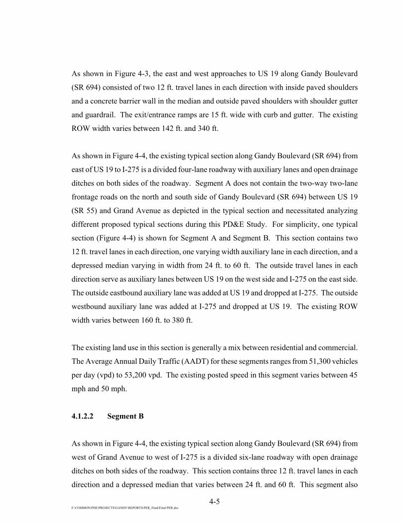
4.1.2.2 Segment B
As shown in Figure 4-4, the existing typical section along Gandy Boulevard (SR 694) from
west of Grand Avenue to west of I-275 is a divided six-lane roadway with open drainage
ditches on both sides of the roadway. This section contains three 12 ft. travel lanes in each
direction and a depressed median that varies between 24 ft. and 60 ft. This segment also

4-6

4-7

4-8 F:\COMMON\PDE\PROJECTS\GANDY\REPORTS\PER_Final\Final PER.doc
contains sections of two-way two-lane frontage roads on the north and south side of Gandy
Boulevard (SR 694) between Grand Avenue and west of I-275. The existing ROW width
varies between 160 ft. and 380 ft.
The existing land use in this section is generally a mix between residential and commercial.
The AADT for this segment ranges from 53,200 vpd to 60,300 vpd. The existing posted
speed in this segment is 50 mph.
4.1.2.3 Segment C
As shown in Figure 4-5, the existing typical section along Gandy Boulevard (SR 694) at
I-275 is a divided four-lane roadway. This segment also contains sections of two-way two-
lane frontage roads on the north and south side of Gandy Boulevard (SR 694) between east
of I-275 and 9th Street as shown in Figure 4-6. This existing section has open drainage
ditches on both sides of the roadway. Gandy Boulevard (SR 694) contains two 12 ft. travel
lanes in each direction with a depressed median varying in width between 60 ft. and 92 ft.
This section of Gandy Boulevard (SR 694) also contains a 10’ paved outside shoulder, and
drainage swales in the median. The existing ROW width varies between 420 ft. and 550 ft.
The existing land use in this section is generally a mix between residential and commercial.
In addition, The City of St. Petersburg is currently designing improvements to portions
of the existing four-lane section by widening within the existing median, adding one lane in
each direction from 28th Street to 9th Street. The AADT for this segment ranges from 47,200
vpd to 60,300 vpd. The existing posted speed in this segment is 50 mph.
4.1.2.4 Segment D
As shown in Figure 4-7, the existing typical section along Gandy Boulevard (SR 694) from
9th Street to east of 4th Street is a divided four-lane roadway. This existing section has open
drainage ditches on both sides of the roadway. Gandy Boulevard (SR 694) contains two
12 ft. travel lanes in each direction with a depressed median that varies in width between

4-9

4-10

4-11

4-12 F:\COMMON\PDE\PROJECTS\GANDY\REPORTS\PER_Final\Final PER.doc
36 ft. and 275 ft. This section of Gandy Boulevard (SR 694) also contains swales in the
median. The existing ROW width varies between 220 ft. and 520 ft.
The existing land use in this section is generally a mix between residential and commercial.
The AADT for this segment ranges from 25,400 vpd to 34,100 vpd. The existing posted
speed in this segment is 50 mph.
4.1.2.5 Existing Cross Road Typical Sections
The Design Traffic Memorandum1 projected that the existing interchange at US 19 remains
sufficient for design year 2020 traffic.
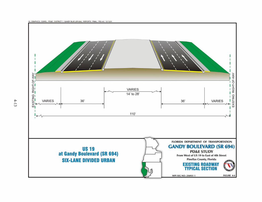
4.1.2.6 US 19
As shown in Figure 4-8, the existing typical section along US 19 both north and south of
Gandy Boulevard (SR 694) is a divided six-lane urban roadway with curb and gutter on both
sides of the roadway. This section contains three 12 ft. travel lanes in each direction. This
section of US 19 currently traverses under a four-lane bridge for Gandy Boulevard (SR 694).
Access to eastbound and westbound Gandy Boulevard (SR 694) is via signalized on-ramps
and off-ramps. The existing ROW width is typically 110 ft. The existing land use for this
section is a mix between residential and commercial.
4.1.2.7 Grand Avenue
As shown in Figure 4-9, the existing typical section along Grand Avenue north of Gandy
Boulevard (SR 694) is a divided four-lane urban roadway. This section contains two 12 ft.
travel lanes in each direction with a depressed median. The existing ROW width is
approximately 100 ft. The existing land use for this section on the north side of Gandy
Boulevard (SR 694) is commercial. The existing typical section along Grand Avenue south
of Gandy Boulevard (SR 694) is an undivided two-lane roadway with 10 ft. of unpaved
shoulders on both sides of the roadway. This section contains one 12 ft. travel lane in each
direction. The existing ROW width is typically 100 ft. The existing land use in this section
4-13

4-14

4-15 F:\COMMON\PDE\PROJECTS\GANDY\REPORTS\PER_Final\Final PER.doc
on the south side of Gandy Boulevard (SR 694) is generally a mix between residential and
commercial.
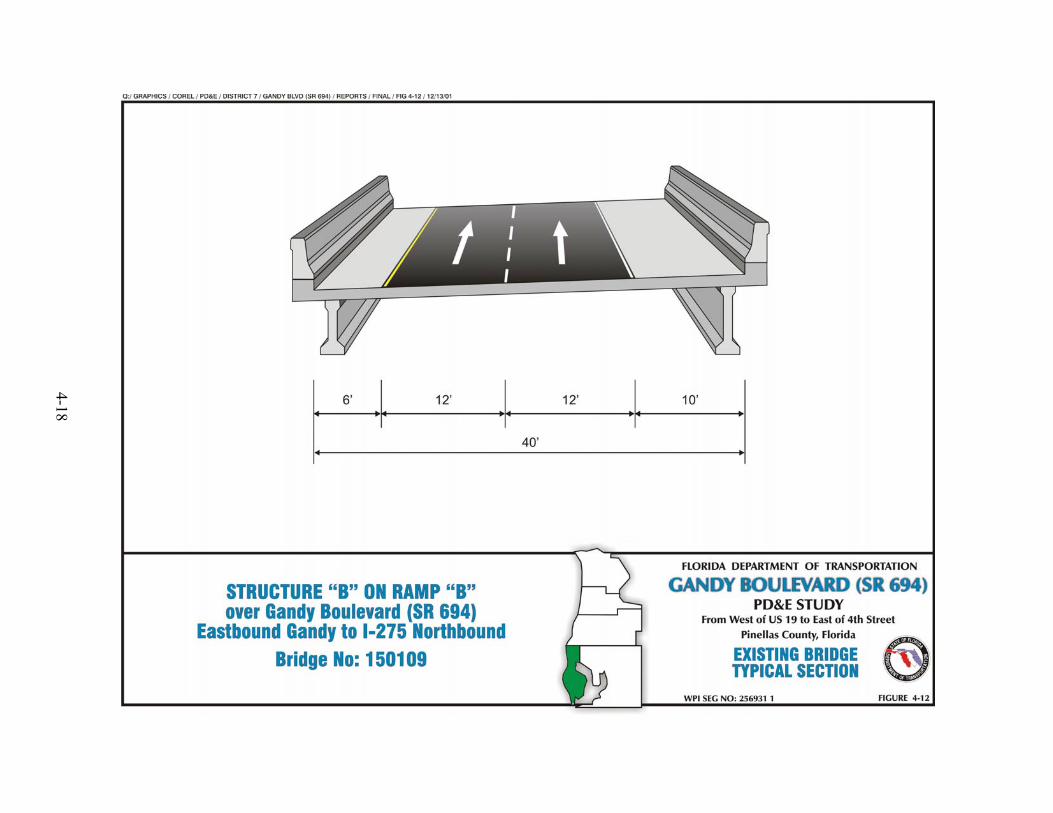
4.1.2.8 I-275
The existing typical section along I-275 north and south of Gandy Boulevard (SR 694) and
over Gandy Boulevard (SR 694) is a six-lane divided rural roadway, a divided bridge
section, and a ramp flyover as shown in Figures 4-10, 4-11, and 4-12 respectively. The
roadway section contains three 12 ft. travel lanes in each direction and a 64 ft. depressed
median. This section has 12 ft. inside and outside shoulders with 10 ft. paved and drainage
swales in the median. As shown in Figure 4-11, the southbound bridge section contains
three 12 ft. travel lanes with a 10 ft. inside shoulder and a 10 ft. outside shoulder. The
northbound bridge section contains four 12 ft. travel lanes with a 10 ft. inside shoulder and a
6 ft. outside shoulder. The interchange currently does not provide access from I-275 south
to Gandy Boulevard (SR 694) east and Gandy Boulevard (SR 694) west to I-275 north. As
shown in Figure 4-12, the existing flyover Ramp B over Gandy Boulevard (SR 694) consists
of two 12 ft. travel lanes with a 6 ft. inside shoulder and a 10 ft. outside shoulder. The
existing ROW width along I-275 varies between 340 ft. and 375 ft. The existing land use for
this section is generally a mix between residential and commercial.
4.1.2.9 9th Street
The existing typical section along 9th Street consists of a four-lane divided rural roadway as
shown in Figure 4-13. This section contains two 12 ft. travel lanes in each direction and a
depressed median varying in width between 18 ft. and 40 ft. The existing ROW width varies
between 200 ft. and 290 ft. The existing land use in this section is generally a mix between
residential and commercial.
4.1.2.10 Roosevelt Boulevard
The existing typical section along Roosevelt Boulevard between Gandy Boulevard (SR 694)
and 9th Street consists of a four-lane divided rural roadway section as shown in Figure 4-14.

4-16

4-17
4-18

4-19

4-20

4-21 F:\COMMON\PDE\PROJECTS\GANDY\REPORTS\PER_Final\Final PER.doc
This section contains two 12 ft. travel lanes in each direction and a depressed median varying
in width between 40 ft. and 64 ft. This section has an 8 ft. inside shoulder and a 12 ft.
outside shoulder with 10 ft. of the outside shoulder paved. The existing ROW width varies
between 200 ft. and 225 ft. The existing land use in this section is generally a mix between
residential and commercial.
4.1.2.11 4th Street
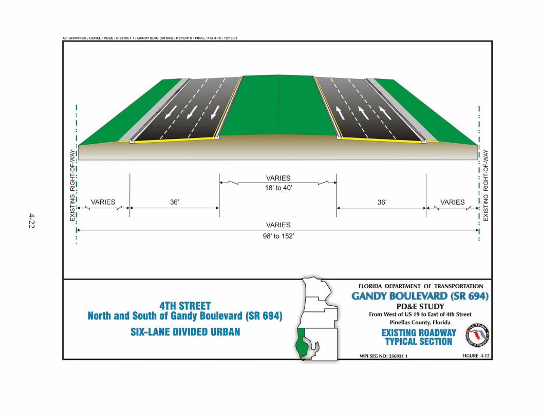
The existing typical section along 4th Street consists of a six-lane divided urban roadway as
shown in Figure 4-15. This section contains three 12 ft. travel lanes in each direction and a
depressed median varying in width between 18 ft. and 40 ft. This section has curb and gutter
with sections of sidewalk. The existing ROW width varies between 98 ft. and 152 ft. The
existing land use in this section is generally a mix between residential and commercial.
4.1.3 Pedestrian and Bicycle Facilities
The existing pedestrian facilities along the Gandy Boulevard (SR 694) Corridor were limited
to the intersection of US 19. There are currently no designated bicycle facilities along the
Gandy Boulevard (SR 694) Corridor. From east of US 19 to 9th Street, there are 10 ft. paved
outside shoulders on both sides of Gandy Boulevard (SR 694) that accommodate bicyclists.
From 9th Street to east of 4th Street, there are 5 ft. paved outside shoulders on both sides of
Gandy Boulevard (SR 694) which also accommodate bicyclists. Florida Power Trail, a
multi-use trail is currently planned in the vicinity of Gandy Boulevard (SR 694).
4.1.4 Right-of-Way (ROW)
The existing ROW for Gandy Boulevard (SR 694) from west of US 19 to east of 4th Street
ranges from a minimum of 102 ft. to a maximum of 550 ft.
4-22

4-23 F:\COMMON\PDE\PROJECTS\GANDY\REPORTS\PER_Final\Final PER.doc
4.1.5 Horizontal Alignment
The existing horizontal alignment was obtained from survey data. Gandy Boulevard
(SR 694) contains five horizontal curves within the project limits. A GEOPAK printout of
the horizontal geometry depicting the alignment characteristics of each curve is located in
Appendix B.
4.1.6 Vertical Alignment
The existing vertical alignment was obtained from Southwest Florida Water Management
District (SWFWMD) contour maps. The elevations along the roadway centerline range from
a low point of 5.0 ft. above sea level at the east end to a high point of 12.5 ft. above sea level
near the west end. The profile grade primarily consists of tangent sections with sag and crest
vertical curves.
4.1.7 Drainage
A Final Pond Siting Report2 (PSR) and a Final Location Hydraulic Report3 (LHR) were
prepared as part of this PD&E Study. The findings of the Final PSR2 and Final LHR3 have
been incorporated by reference into this Report.
4.1.8 Geotechnical Data
A Preliminary Geotechnical Report4 was prepared as part of this PD&E Study. The findings
of the report have bben incorporated by reference into this Report.
4.1.9 Accident Data
Department crash data was available for four intersections and four roadway segments in the
project area. To evaluate the safety of traffic operations in the study area, crash records for
the five-year period between 1994 and 1998 were reviewed. The crash records indicated that

4-24 F:\COMMON\PDE\PROJECTS\GANDY\REPORTS\PER_FINAL\FINAL PER.DOC
819 crashes occurred during the five-year period. Included in the total were 491 crashes at
intersections and 328 along the segments. The five-year totals for intersections are shown in
Table 4-1. In addition, 12 fatalities and 890 injuries occurred during the five-year period.
More information on accident data can be found in the Design Traffic Memorandum1.
Based on the five years of crash data, an average safety ratio was calculated for each
intersection and segment displayed in Tables 4-1 and 4-2. The safety ratio calculations were
based on the methodology outlined in the Highway Safety Improvement Program Guideline,
Topic No. 500-000-100-C5, prepared by the FDOT. Safety ratios above 1.0 indicate that the
specific segment or intersection experiences vehicle collisions above statewide average for
similar facilities and, therefore, traffic safety at these locations need to be improved.
All four of the intersections and one of the roadway segments experienced a safety ratio
greater than one.
Intersections with Safety Ratios Greater than 1.0
• Gandy Boulevard (SR 694) at US 19 (during years 1994 thru 1996)
• Gandy Boulevard (SR 694) at I-275 (during years 1995 thru 1998)
• Gandy Boulevard (SR 694) at 4th Street (during years 1994 thru 1998)
• Roosevelt Boulevard at 9th Street (during years 1994, 1995 and 1998)
Roadway Segment with Safety Ratio Greater than 1.0
• Gandy Boulevard (SR 694) from I-275 to 4th Street (during year 1997)
A majority (60%) of the crashes occurred at the intersections. A review of the information
provided in Table 4-1 reveals that the majority of the crashes occurred during dry roadway
conditions, and during the daylight off-peak hours. Approximately 42% of the crashes were
classified as rear-end type crashes. The second major type of crash was classified as angle
(17%). The majority of crashes were caused by disregarding other traffic (54%).
4-25 F:\COMMON\PDE\PROJECTS\GANDY\REPORTS\PER_Final\Final PER.doc
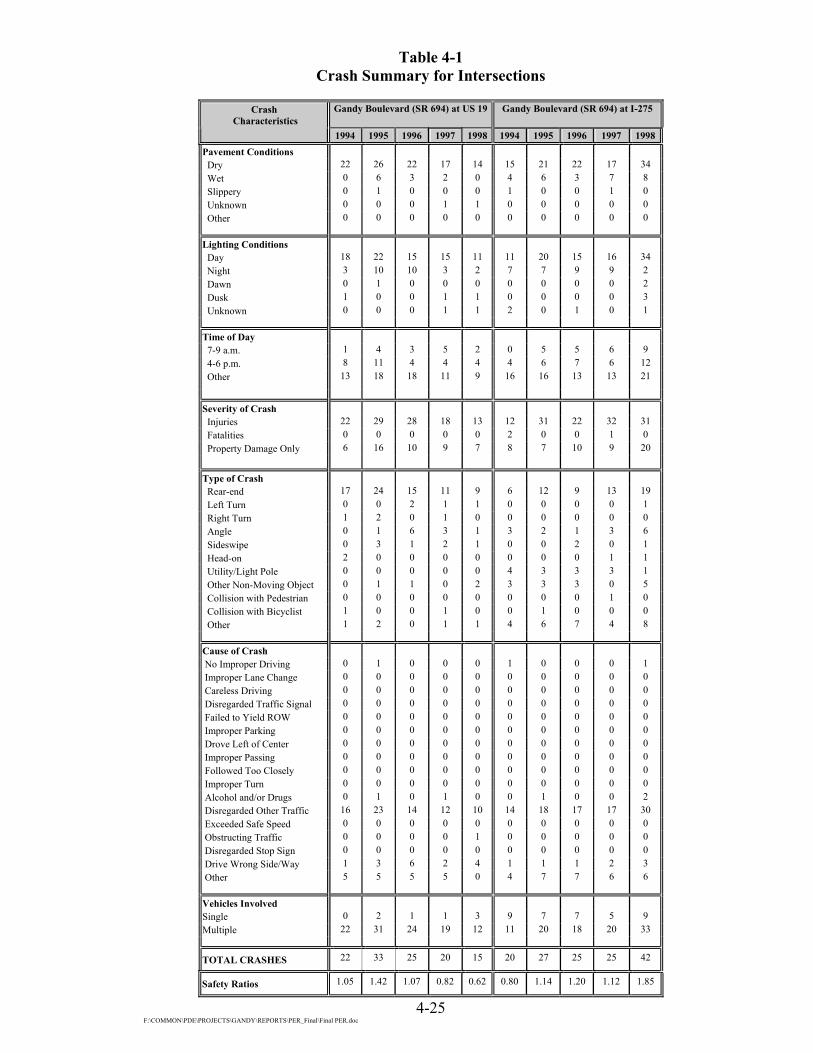
Table 4-1 Crash Summary for Intersections
Gandy Boulevard (SR 694) at US 19
Gandy Boulevard (SR 694) at I-275
Crash
Characteristics 1994
1995
1996
1997
1998
1994
1995
1996
1997
1998
Pavement Conditions
Dry 22 26 22 17 14 15 21 22 17 34 Wet 0 6 3 2 0 4 6 3 7 8 Slippery 0 1 0 0 0 1 0 0 1 0 Unknown 0 0 0 1 1 0 0 0 0 0 Other 0 0 0 0 0 0 0 0 0 0
Lighting Conditions Day 18 22 15 15 11 11 20 15 16 34 Night 3 10 10 3 2 7 7 9 9 2 Dawn 0 1 0 0 0 0 0 0 0 2 Dusk 1 0 0 1 1 0 0 0 0 3 Unknown 0 0 0 1 1 2 0 1 0 1
Time of Day 7-9 a.m. 1 4 3 5 2 0 5 5 6 9 4-6 p.m. 8 11 4 4 4 4 6 7 6 12 Other 13 18 18 11 9 16 16 13 13 21
Severity of Crash Injuries 22 29 28 18 13 12 31 22 32 31 Fatalities 0 0 0 0 0 2 0 0 1 0 Property Damage Only 6 16 10 9 7 8 7 10 9 20 Type of Crash Rear-end 17 24 15 11 9 6 12 9 13 19 Left Turn 0 0 2 1 1 0 0 0 0 1 Right Turn 1 2 0 1 0 0 0 0 0 0 Angle 0 1 6 3 1 3 2 1 3 6 Sideswipe 0 3 1 2 1 0 0 2 0 1 Head-on 2 0 0 0 0 0 0 0 1 1 Utility/Light Pole 0 0 0 0 0 4 3 3 3 1 Other Non-Moving Object 0 1 1 0 2 3 3 3 0 5 Collision with Pedestrian 0 0 0 0 0 0 0 0 1 0 Collision with Bicyclist 1 0 0 1 0 0 1 0 0 0 Other 1 2 0 1 1 4 6 7 4 8
Cause of Crash No Improper Driving 0 1 0 0 0 1 0 0 0 1 Improper Lane Change 0 0 0 0 0 0 0 0 0 0 Careless Driving 0 0 0 0 0 0 0 0 0 0 Disregarded Traffic Signal 0 0 0 0 0 0 0 0 0 0 Failed to Yield ROW 0 0 0 0 0 0 0 0 0 0 Improper Parking 0 0 0 0 0 0 0 0 0 0 Drove Left of Center 0 0 0 0 0 0 0 0 0 0 Improper Passing 0 0 0 0 0 0 0 0 0 0 Followed Too Closely 0 0 0 0 0 0 0 0 0 0 Improper Turn 0 0 0 0 0 0 0 0 0 0 Alcohol and/or Drugs 0 1 0 1 0 0 1 0 0 2 Disregarded Other Traffic 16 23 14 12 10 14 18 17 17 30 Exceeded Safe Speed 0 0 0 0 0 0 0 0 0 0 Obstructing Traffic 0 0 0 0 1 0 0 0 0 0 Disregarded Stop Sign 0 0 0 0 0 0 0 0 0 0 Drive Wrong Side/Way 1 3 6 2 4 1 1 1 2 3 Other 5 5 5 5 0 4 7 7 6 6
Vehicles Involved Single 0 2 1 1 3 9 7 7 5 9 Multiple 22 31 24 19 12 11 20 18 20 33
TOTAL CRASHES 22 33 25 20 15 20 27 25 25 42
Safety Ratios 1.05 1.42 1.07 0.82 0.62 0.80 1.14 1.20 1.12 1.85

F:\COMMON\PDE\PROJECTS\GANDY\REPORTS\PER_Final\Final PER.doc 4-26
Table 4-2 Crash Summary for Segments
Crash Characteristics
Gandy Boulevard (SR 694) at 9th Street
Gandy Boulevard (SR 694) at 4th Street
TOTAL
1994
1995
1996
1997
1998
1994
1995
1996
1997
1998
1994
1995
1996
1997
1998
1994-98
Pavement Conditions Dry 25 34 23 28 32 17 13 9 10 12 79 94 76 72 92 413 Wet 4 5 4 7 3 3 3 0 0 1 11 23 10 16 12 72 Slippery 0 0 0 0 0 1 0 0 0 0 2 1 0 1 0 4 Unknown 1 1 0 0 0 0 0 0 0 0 1 1 0 1 1 4 Other 0 0 1 0 0 0 0 0 0 0 0 0 1 0 0 1
Lighting Conditions Day 13 24 17 22 19 9 4 2 7 7 51 70 49 60 71 301 Night 12 13 9 11 15 9 11 7 3 6 31 41 35 26 25 158 Dawn 1 0 0 0 0 0 0 0 0 0 1 1 0 0 2 4 Dusk 2 2 2 0 1 1 1 0 0 0 4 3 2 1 5 15 Unknown 2 1 0 2 0 2 0 0 0 0 6 1 1 3 2 13
Time of Day 7-9 a.m. 2 4 3 6 3 2 0 1 3 1 5 13 12 20 15 65 4-6 p.m. 4 10 8 6 6 2 6 0 3 6 18 33 19 19 28 117 Other 24 26 17 23 26 17 10 8 4 6 70 70 56 51 62 309
Severity of Crash Injuries 41 49 29 41 51 14 13 9 7 15 89 122 88 98 110 507 Fatalities 0 0 0 1 3 0 0 0 0 0 2 0 0 2 3 7 Property Damage Only 6 12 8 8 8 2 8 3 3 4 22 43 31 29 39 164 Type of Crash Rear-end 5 13 6 9 13 4 9 4 6 4 32 58 34 39 45 208 Left Turn 11 11 10 12 5 8 4 4 2 6 19 15 16 15 13 78 Right Turn 0 1 0 0 0 0 0 0 0 1 1 3 0 1 1 6 Angle 9 8 8 11 13 6 0 0 1 0 18 11 15 18 20 82 Sideswipe 0 0 3 2 0 2 1 0 0 0 2 4 6 4 2 18 Head-on 1 2 0 0 0 1 0 0 1 0 4 2 0 2 1 9 Utility/Light Pole 0 1 0 0 0 0 0 0 0 0 4 4 3 3 1 15 Other Non-Moving Object 0 1 0 1 0 0 0 0 0 2 3 5 4 1 9 22 Collision with Pedestrian 1 1 0 0 0 0 1 0 0 0 1 2 0 1 0 4 Collision with Bicyclist 0 0 0 0 0 0 0 0 0 0 1 1 0 1 0 3 Other 3 2 1 0 4 0 1 1 0 0 8 11 9 5 13 46
Cause of Crash No Improper Driving 1 0 0 0 0 0 0 1 0 0 2 1 1 0 1 5 Improper Lane Change 0 0 0 0 0 0 0 0 0 0 2 0 0 0 0 2 Careless Driving 0 0 0 0 0 5 9 3 6 7 5 9 3 6 7 30 Disregarded Traffic Signal 0 0 0 0 0 0 1 1 0 1 0 1 1 0 1 3 Failed to Yield ROW 0 0 0 0 0 13 1 3 1 2 13 1 3 1 2 20 Improper Parking 0 0 0 0 0 0 0 1 0 0 0 0 1 0 0 1 Drove Left of Center 0 0 0 0 0 0 0 0 0 0 0 0 0 0 0 0 Improper Passing 0 0 0 0 0 0 0 0 0 0 0 0 0 0 0 0 Followed Too Closely 0 0 0 0 0 0 1 0 1 0 0 1 0 1 0 2 Improper Turn 0 0 0 0 0 0 1 0 0 2 0 1 0 0 2 3 Alcohol and/or Drugs 3 2 0 2 0 0 0 0 0 0 3 4 0 3 2 12 Disregarded Other Traffic 14 24 20 22 15 0 0 0 0 0 44 65 51 51 55 266 Exceeded Safe Speed 0 0 0 0 0 0 0 0 0 0 0 0 0 0 0 0 Obstructing Traffic 0 0 0 0 0 0 0 0 0 0 0 0 0 0 1 1 Disregarded Stop Sign 0 0 0 0 0 0 0 0 0 0 0 0 0 0 0 0 Drive Wrong Side/Way 7 11 5 9 12 0 0 0 0 0 9 15 12 13 19 68 Other 5 3 3 2 8 1 3 0 2 1 15 18 15 15 15 78
Vehicles Involved Single 2 3 0 0 2 0 2 0 0 1 11 14 8 6 15 54 Multiple 28 37 28 35 33 21 14 9 10 12 82 102 79 84 90 437
TOTAL CRASHES 30 40 28 35 35 21 16 9 10 13 93 116 87 90 105 491
Safety Ratios 2.12 2.40 1.67 1.87 1.68 2.25 1.48 0.84 0.86 1.13 Not Applicable

F:\COMMON\PDE\PROJECTS\GANDY\REPORTS\PER_Final\Final PER.doc 4-27
4.1.10 Intersections and Signalization
There are nine signalized intersections along the project corridor, which are listed below:
• US 19
• Grand Avenue
• I-275 Northbound off-ramp
• 16th Street (Frontage Road)
• Eastbound Gandy Boulevard (SR 694) at 9th Street
• Westbound Gandy Boulevard (SR 694) at 9th Street
• Gandy Boulevard (SR 694) at Roosevelt Boulevard
• 4th Street
• Roosevelt Boulevard at 9th Street
The existing lane geometry of each signalized intersection along the project corridor is
illustrated schematically in the Design Traffic Memorandum1.
4.1.11 Railroad Crossings
There is no railroad that crosses Gandy Boulevard (SR 694) within the project limits.
4.1.12 Transit
The Pinellas Suncoast Transit Authority (PSTA) provides public transit service in the
Gandy Boulevard (SR 694) Corridor. Route 74 serves the majority of the study corridor by
traveling east/west via Park Boulevard and Gandy Boulevard (SR 694). Major stops along
the route include the Indian Rocks Shopping Center, the Seminole Mall, Park 66 Shopping
Center, the Pinellas Parkside Mall, and the Gateway Mall. Headways on Route 74 typically
are 30 minutes in the peak periods and 60 minutes in the off-peak periods of the day. Hours
of operation are from 5:15 a.m. to 8:45 p.m. Monday through Friday. Limited weekend
service is also provided.

4-28 F:\COMMON\PDE\PROJECTS\GANDY\REPORTS\PER_FINAL\FINAL PER.DOC
Other PSTA routes provide connections along the Gandy Boulevard (SR 694) Corridor.
The Pinellas Parkside Mall on the east end of the corridor is served by PSTA Routes 11, 19,
52, 74, 75, and 444, which provide connections to Pinellas Park and north St. Petersburg.
Route 96 provides peak period, weekday commuter service along I-275. Route 59 and 99
provide additional north-south service along 9th Street. Route 4 provides service along
4th Street to northeast St. Petersburg and Route 100X provides commuter service to Tampa
from the Gateway Mall via Gandy Boulevard (SR 694) east of 4th Street.
4.1.13 Lighting
Highway lighting is currently provided within the project limits along both sides of Gandy
Boulevard (SR 694) from West of US 19 to East of 4th Street. The approximate spacing of
the existing street light poles is 200 ft.
4.1.14 Utilities
In order to evaluate potential surface and subsurface utility conflicts associated with the
proposed project, information was obtained pertaining to the type, location and ownership
of the existing utilities with the project area. Each utility owner was contacted via letter
requesting they identify the type and location of any existing or proposed utilities within the
project corridor. The following utility organizations with potential facilities within the
study corridor did respond to requests for existing and proposed facility information.
• Intermedia Communications of Florida, Inc;
• Florida Power Corporation; and
• AT&T (P.E.A., Inc.).
The following utility organizations with potential facilities within the study corridor did
not respond to requests for existing and proposed facility information:

4-29 F:\COMMON\PDE\PROJECTS\GANDY\REPORTS\PER_FINAL\FINAL PER.DOC
• Verizon Florida, Inc.;
• Paragon/Time Warner Cable;
• Pinellas County Highway Engineering;
• KMC Telecom III, Inc.;
• Florida Power Corporation – BA Pipeline;
• Florida Gas Transportation;
• City of St. Petersburg; and
• City Pinellas Park.
4.1.15 Pavement Conditions
A flexible pavement condition survey is typically conducted by FDOT for certain sections of
roadway. The pavement program provides ratings based on cracking, rideability, and
rutting conditions. A scale of one to ten is used in rating the pavement condition of a
roadway, with a rating of six or less considered deficient. Ratings for Gandy Boulevard
(SR 694) are provided in Table 4-3.
Table 4-3 Pavement Condition Rating
Location Milepost Cracking Rating Ride Rating Rutting
Rating
Gandy Boulevard (SR 694), R-2 0.000 – 3.351 10.0 8.3 10.0
4.2 EXISTING BRIDGES
The Gandy Boulevard (SR 694) Corridor includes six existing bridges between US 19 and
4th Street. These bridges are shown in Table 4-4.

4-30 F:\COMMON\PDE\PROJECTS\GANDY\REPORTS\PER_FINAL\FINAL PER.DOC
Table 4-4 Existing Bridges
Bridge Name Bridge Number Mile Post
SR 55 (US 19) 150125 0.000 Sawgrass Creek 150217 0.692 I-275 southbound over Gandy Boulevard (SR 694) 150100 1.547
I-275 northbound over Gandy Boulevard (SR 694) 150101 1.570
Gandy Boulevard (SR 694) Eastbound off-ramp over I-275 150099 1.547
Gandy Boulevard (SR 694) Eastbound off-ramp over Gandy Boulevard (SR 694) 150109 1.689
4.2.1 Type of Structure
Gandy Boulevard (SR 694) over US 19
This four-span grade separation carries Gandy Boulevard (SR 694) over US 19. The
superstructure consists of an 81.08 ft. wide deck and Type III American Association of
State Highway and Transportation Officials (AASHTO) beams. The substructure consists
of concrete endbents and bents founded on piles.
Gandy Boulevard (SR 694) over Sawgrass Creek
This concrete box culvert structure consists of three 8 ft. by 8 ft. cells with an overall width
of 26 ft. The roadway carries Gandy Boulevard (SR 694) over Sawgrass Creek and consists
of six lanes and a depressed median.
I-275 southbound over Gandy Boulevard (SR 694)
This four-span grade separation carries I-275 southbound over Gandy Boulevard (SR 694).
The superstructure consists of three lanes separated by a concrete barrier wall atop a Type III

4-31 F:\COMMON\PDE\PROJECTS\GANDY\REPORTS\PER_FINAL\FINAL PER.DOC
AASHTO girder with an overall width of 56 ft. The substructure consists of concrete
endbents founded on concrete piles.
I-275 northbound over Gandy Boulevard (SR 694)
This four-span grade separation carries I-275 northbound over Gandy Boulevard (SR 694).
The superstructure consists of four lanes separated by a concrete barrier wall atop Type III
AASHTO girder with an overall width of 60 ft. The substructure consists of concrete
endbents founded on concrete piles.
Gandy Boulevard (SR 694) eastbound off-ramp over Gandy Boulevard (SR 694)
This four-span grade separation carries eastbound Gandy Boulevard (SR 694) ramp traffic
over I-275. The superstructure consists of a 40 ft. wide deck atop Type III AASHTO beams.
The substructure consists of concrete endbents and bents founded on concrete piles.
Gandy Boulevard (SR 694) eastbound off-ramp over Gandy Boulevard (SR 694)
This four-span grade separation carries eastbound Gandy Boulevard (SR 694) ramp traffic
over Gandy Boulevard (SR 694). The superstructure consists of a 40 ft. wide deck atop
Type III AASHTO beams. The substructure consists of concrete endbents and bents
founded on concrete piles.
4.2.2 Current Conditions and Year of Construction
The following bridges were evaluated using a sufficiency rating which is indicative of bridge
sufficiency to remain in service. The result of this method is a percentage in which 100%
would represent an entirely sufficient bridge and zero would represent an entirely insufficient
or deficient bridge. The bridge rating summary is found in Table 4-5.

4-32 F:\COMMON\PDE\PROJECTS\GANDY\REPORTS\PER_FINAL\FINAL PER.DOC
Table 4-5 Bridge Rating Summary
Bridge Name Bridge Number Sufficiency Rating
SR 55 (US 19) 150125 90.0 Sawgrass Creek 150217 70.0 I-275 southbound over Gandy Boulevard (SR 694) 150100 94.1
I-275 northbound over Gandy Boulevard (SR 694) 150101 95.1
Gandy Boulevard (SR 694) Eastbound off-ramp over I-275 150099 94.9
Gandy Boulevard (SR 694) Eastbound off-ramp over Gandy Boulevard (SR 694) 150109 96.2
4.2.3 Channel Data
There are no bridges along the Gandy Boulevard (SR 694) Corridor which are over
navigable or non-navigable waterways within the project limits.
4.2.4 Bridge Openings
There are no bridges along the Gandy Boulevard (SR 694) Corridor which are over
navigable or non-navigable waterways within the project limits.
4.2.5 Ship Impact Data
There are no bridges along the Gandy Boulevard (SR 694) Corridor which are over
navigable or non-navigable waterways within the project limits.

4-33 F:\COMMON\PDE\PROJECTS\GANDY\REPORTS\PER_FINAL\FINAL PER.DOC
4.3 ENVIRONMENTAL CHARACTERISTICS
4.3.1 Land Use Data
Generally, the existing land uses adjacent to the Gandy Boulevard (SR 694) Corridor
consisted of commercial, residential, and industrial uses in an urban setting. An overview of
existing land use is shown in Figure 4-16.
The project corridor was divided into four segments to effectively assess and compare
project impacts. The existing land uses are described in the following paragraphs by study
segment.
Segment A
Segment A, located west of US 19 to west of Grand Avenue, is heavily developed with little
vacant land and features mixed land uses including residential, commercial, and public/semi-
public. There are several residential facilities (mobile home parks or condominium units)
and single-family residences in this area, some of which use Gandy Boulevard for primary
access. Commercial uses include retail stores including the Parkside Mall and Home Depot,
ANCO Anderson Nail Company, restaurants, automotive service establishments, storage
facilities, a bike shop, an animal shelter, and a hotel. Public/semi-public uses include the
Florida Highway Patrol (FHP) office located on the east side of US 19, north of Gandy
Boulevard (SR 694).
Segment B
The existing land uses within Segment B, west of Grand Avenue to west of I-275, are mostly
commercial and light industrial uses with limited residential development. Commercial uses
include Johnson Sails, Inc., a storage facility, a printing facility, an automotive
establishment, and telephone service facilities. Light industrial uses include Taco Metals,
Inc., Coca Cola, Lindab Sign, and R.V. Money, Inc. Sawgrass Lake Park is a 390-acre

4-34

4-35 F:\COMMON\PDE\PROJECTS\GANDY\REPORTS\PER_Final\Final PER.doc
recreational and environmental educational park that lies to the south. The only part of the
park adjoining the Gandy Boulevard (SR 694) Corridor is a service entrance in the vicinity
of 28th Street.
Segment C
The existing land uses within Segment C, located west of I-275 to west of 9th Street, are
commercial, light industrial, residential, public/semi-public, and public service/non-profit.
Land uses in the I-275/Gandy Boulevard interchange area consist of the Florida Power
Corporation northeast substation, an elementary school, a mobile home park, apartments,
single-family residences, and the Royal Palm Cemetery and Funeral Chapel. The northwest
quadrant of the interchange area is currently vacant, wooded land. Commercial uses within
this segment include the R’Club, corporate centers, a self storage facility, K-Mart, a bank,
and a computer store. Light industrial uses include The Murray Company, Jabil Circuit
(3 Line Manufacturing), and a power substation. Residential uses include multi-family
residential facilities (i.e., apartments) as well as single-family residential developments.
Public/semi-public uses include the U.S. Post Office. Public service/non-profit uses include
Florida Blood Services and American Heart Association. The First Baptist Church of St.
Petersburg is also located in this study segment.
Segment D
The existing land uses within Segment D, located west of 9th Street to east of 4th Street, are
mostly commercial and residential. Commercial uses are comprised of the Koger Executive
Center office buildings, banks, restaurants, automotive service stations, insurance companies,
retail shops, storage facilities, commercial centers (that house Primex Technologies, Paychex
Business Solutions, MIDA Groups, Sunbelt Marketing Development Company, and
Celotex), insurance offices, a shopping center, and a car wash. Residential uses include
several multi-family facilities (condominium units, apartments, and mobile home parks).
Bon Secours – Maria Manor, a retirement/nursing facility, is also located in this study
segment. A Florida Power & Light power transmission line crosses the Gandy Boulevard
(SR 694) Corridor at 9th Street.

4-36 F:\COMMON\PDE\PROJECTS\GANDY\REPORTS\PER_FINAL\FINAL PER.DOC
Land uses in the vicinity of 4th Street and 9th Street consist of Koger Executive Center office
buildings, Holy Cross Episcopal Church, automotive service stations, a GTE facility,
restaurants, a bank, and shopping centers (which include Publix, Walgreens, etc.) as well as
several multi-family residential developments.
Future Land Use
Local government comprehensive plans are developed to provide guidance in planning for
the future. The adopted future land uses for the project corridor are shown in Figure 4-17.
Any planned or proposed large-scale development projects must be consistent with the
designated future land use for the property. If the proposed project is not consistent, then the
applicant would be required to obtain a land use plan amendment. The Development of
Regional Impact (DRI) process is governed by Chapter 380.06 of the Florida Statutes (FS)
and Rules 9J-2.001 through 9J-2.0256 of the Florida Administrative Code (FAC). By
definition, a DRI is a development which, because of its character, magnitude, or location
would have a substantial effect upon the health, safety, or welfare of citizens of more than
one county. There are two large-scale planned development projects in the vicinity of the
Gandy Boulevard/I-275 interchange (Gateway Areawide and Gateway Centre DRIs) both of
these projects are undergoing the DRI process.
4.3.2 Cultural Features and Community Service
4.3.2.1 Cultural Resources Assessment Survey
A Final Cultural Resources Assessment Report6 (CRAS) was prepared as part of this PD&E
Study. The findings of the Final CRAS6 are incorporated by reference into this Report.

4-37

4-38 F:\COMMON\PDE\PROJECTS\GANDY\REPORTS\PER_Final\Final PER.doc
4.3.2.2 Cultural Features and Community Service
Community services located along the project corridor include the Royal Palm Cemetery and
Funeral Chapel, the First Baptist Church of St. Petersburg, a US Post Office, and a cemetery.
It is anticipated that there will be minor access changes to the First Baptist Church in order to
improve safety conditions and improve traffic circulation. There will be no other disruption
to community services. There are no schools, hospitals or other government facilities
located adjacent to the project.
4.3.2.3 Section 4(f) Properties
In accordance with Section 4(f) of the DOT Act of 1966 (Title 49, U.S.C., Section 1653 (f),
amended and recodified in Title 49, U.S.C., Section 303, in 1983), the project was examined
for possible Section 4(f) properties. No Section 4(f) resources are involved with the
proposed project.
4.3.3 Natural and Biological Features
4.3.3.1 Wetlands
A Final Wetland Evaluation Report7 (WER) was prepared as part of this PD&E Study. The
findings of the Final WER7 are incorporated by reference into this Report.
4.3.3.2 Threatened and Endangered Species
A Final Endangered Species Evaluation Report8 (ESER) was prepared as part of this PD&E
Study. The findings of the Final ESER8 are incorporated by reference into this Report.
4-39 F:\COMMON\PDE\PROJECTS\GANDY\REPORTS\PER_FINAL\FINAL PER.DOC
4.3.4 Potential Hazardous Materials and Petroleum Products Contaminated Sites
A Final Contamination Screening Evaluation Report9 (CSER) was prepared as part of this
PD&E Study. The findings of the Final CSER9 are incorporated by reference into this
Report. Potential Contamination Sites are shown in Appendix A.

4-40 F:\COMMON\PDE\PROJECTS\GANDY\REPORTS\PER_FINAL\FINAL PER.DOC
4.4 REFERENCES
1. Design Traffic Memorandum; Gannett Fleming, Inc.; August 2002.
2. Final Pond Siting Report (PSR); PBQD; August 2002.
3. Final Location Hydraulic Report (LHR); PBQD; August 2002.
4. Geotechnical Report; Williams Earth Sciences, Inc.; September 2001.
5. Highway Safety Improvement Program Guidelines; Topic No. 500-000-100-C;
FDOT; December 1991.
6. Final Cultural Resources Assessment Report; ACI; August 2002.
7. Final Wetland Evaluation Report; PBQD; August 2002.
8. Final Endangered Species Evaluation Report; PBQD; August 2002.
9. Final Contamination Screening Evaluation Report; PBQD; August 2002.

5-1 F:\COMMON\PDE\PROJECTS\GANDY\REPORTS\PER_Final\Final PER.doc
SECTION 5
TYPICAL SECTION DESIGN CRITERIA
In order for the proposed roadway improvements to fulfill their objective of accommodating
motorized vehicles, and where appropriate, pedestrians and bicyclists in a safe and efficient
manner, the proposed typical sections must adhere to specific design standards. The FDOT’s
Plans Preparation Manual (PPM)1, AASHTO – A Policy on Geometric Design of Highway
Streets2, and the District Seven Straight Line Diagram (SLD) were used as the reference for
development of proposed typical section design criteria for this project. Table 5-1 presents
the pertinent criteria used for this effort and their respective values or designations. A
discussion of each criterion follows below.
5.1 FUNCTIONAL CLASSIFICATION
The functional classification of a roadway affects elements of design such as design speed,
LOS requirements, and local access accommodations. According to the FDOT SLD, Gandy
Boulevard (SR 694), SR 55 (US 19), SR 93 (I-275), and SR 687 (4th Street) are classified as
urban principal arterials and SR 686 (Roosevelt Boulevard) is classified as an urban minor
arterial. According to the Pinellas County Comprehensive Plan3, 9th Street is classified as a
minor arterial. Gandy Boulevard (SR 694) is included in the FIHS as a controlled access
facility.
5.2 DESIGN SPEED
The design speed affects design elements such as horizontal and vertical alignments, super
elevation, and typical section dimensions (clear zone, median width, etc.). The assumed
design speed should be logical with respect to factors such as topography, adjacent land use,
and the functional classification of the highway. As indicated in AASHTO-A Policy on
Geometric Design of Highways and Streets2, the design speed control applies to a lesser
degree on arterial streets than on other type of facilities such as rural highways since

5-2 F:\COMMON\PDE\PROJECTS\GANDY\REPORTS\PER_Final\Final PER.doc
Table 5-1 Typical Section Design Criteria
Criteria Value/Designation Documentation
Functional Classification: Gandy Boulevard (SR 694) Frontage Road SR 55 (US 19) SR 93 (I-275) 9th Street SR 686 (Roosevelt Boulevard) SR 687 (4th Street)
Urban Principal Arterial Collector Urban Principal Arterial Urban Principal Arterial-Interstate Minor Arterial Urban Minor Arterial Urban Principal Arterial
FDOT Straight Line Diagram Pinellas County Comprehensive Plan3
FDOT Straight Line Diagram FDOT Straight Line Diagram Pinellas County Comprehensive Plan3
FDOT Straight Line Diagram FDOT Straight Line Diagram
Design Speed: Gandy Boulevard (SR 694) Frontage Road SR 55 (US 19) SR 93 (I-275) 9th Street SR 686 (Roosevelt Boulevard) SR 687 (4th Street) Ramps Collector Roads
60 mph 50 mph 50 mph 70 mph 50 mph 50 mph 50 mph 50 mph 50 mph
FDOT PPM Section 1.9 Tables 1.9.1 & 1.9.2
Lane Width: (Gandy) Mainline Travel Lane Frontage Road Single Lane Ramp Two Lane Ramp Bicycle Lane
12.0 ft. 12.0 ft. 15.0 ft. 24.0 ft. 4.0 ft.
FDOT PPM1
Table 2.1.1, 2.1.2, & 2.1.3
Median Width: (Gandy) Roadway (rural) Roadway with Median Barrier Raised Median
40.0 ft. 26.0 ft. (Minimum) 22.0 ft.
FDOT PPM1 Table 2.2.1
Roadway Shoulder Width: (Gandy) Roadway Outside Median or Left Frontage Road Outside Median or Left Ramp (Single Lane) Inside Outside Ramp (Two Lane) Inside Outside
12.0 ft. total with 5.0 ft. paved 12.0 ft. total with 0.0 ft. paved 12.0 ft. total with 5.0 ft. paved 8.0 ft. total with 0.0 ft. paved 6.0 ft. total with 2.0 ft. paved 6.0 ft. total with 5.0 ft. paved 6.0 ft. total with 2.0 ft. paved 10.0 ft. total with 5.0 ft. paved
FDOT PPM1 Table 2.3.2 (Based on high volume roadway) FDOT PPM1 Table 2.3.4 FDOT PPM1 Table 2.3.2 FDOT PPM1 Table 2.3.2

Table 5-1 (Cont’d.) Typical Section Design Criteria
5-3 F:\COMMON\PDE\PROJECTS\GANDY\REPORTS\PER_Final\Final PER.doc
Criteria Value/Designation Documentation
Sidewalk Width: (Gandy) Standard Adjacent to Curb/Gutter
5.0 ft. 6.0 ft.
FDOT PPM1 Section 8.3.1
Border Width: (Gandy) Travel Lane at Curb Bike Lane or Auxiliary Lane at Curb Flush Shoulder Freeways and Interchange Ramps
14.0 ft. 12.0 ft. 40.0 ft. (Design Speed > 45 mph) 33.0 ft. (Design Speed < 45 mph) 94.0 ft. *
FDOT PPM1 Table 2.5.2 Table 2.5.1 Table 2.5.1 Table 2.5.1
* Measured from the edge of the outside travel lane.
the top speeds for several hours a day on arterial streets are limited or regulated to that
which the recurring peak volumes can be handled. Speeds along these types of roadways are
governed by the presence of other vehicles traveling in groups both in and across the through
lanes. The speeds are also governed by traffic devices rather than by the physical
characteristics of the street. During periods of low to moderate traffic volumes, speeds are
governed by such factors as speed limits, intersectional frictions, and mid-block frictions
such as a high density of driveways.
Within the project limits, the Gandy Boulevard (SR 694) Corridor is generally a rural and
residential area with a small percentage of commercial and office uses. The area is highly
developed with major generators including the Roberts Mobile Home/RV Center, Lauren
Manor Condos, Gateway Center, First Baptist Church of St. Petersburg, Gateway Mobile
Park, and a large number of apartments and condominiums. There is a substantial amount of
vacant land available for future development. Redevelopment is anticipated in areas of strip
malls with an intensification of uses anticipated. The Pinellas County Comprehensive Plan3
designates Gandy Boulevard (SR 694) as a hurricane evacuation route.
As indicated in the Design Traffic Memorandum4, a six-lane facility at a minimum is needed
along Gandy Boulevard (SR 694) to achieve a LOS C based on the design year (2025) traffic
analysis. Although Gandy Boulevard (SR 694) may be reconstructed to a six-lane facility
5-4 F:\COMMON\PDE\PROJECTS\GANDY\REPORTS\PER_Final\Final PER.doc
throughout the project limits as recommended, it is anticipated that the increasing traffic
volumes and the expected future redevelopment will serve to further urbanize this
environment which will influence the operating speed of Gandy Boulevard (SR 694). The
existing posted speed limit on Gandy Boulevard (SR 694) ranges between 45 and 50 mph
throughout the project limits. Field observations indicated that the posted speed appeared to
be on the high end of the operating speed during much of the day. This was due primarily to
the high traffic volume combined with the existing urban conditions and frequent traffic
control devices. It is based on these factors that a proposed design speed of 60 mph was
selected for this project along Gandy Boulevard (SR 694). This design speed conforms to
the FDOT PPM1 for an urban arterial FIHS highway. A design speed of 50 mph was
selected for this project along the cross roads where proposed new interchanges will be
located. This design speed selection was based on the same justification as for the Gandy
Boulevard (SR 694) Corridor and conforms to the FDOT PPM1 for an urban arterial type
highway. A design speed of 50 mph was selected for proposed frontage roads. A design
speed of 50 mph was selected for proposed ramps.
5.3 LANE WIDTHS
According to the FDOT PPM1, Table 2.1.1, travel lanes widths for an urban arterial facility
should be 12 ft.
For interchange ramps, FDOT PPM1 Table 2.1.3 states that the standard width of a one-lane
ramp should be 15 ft. and the standard width for a two-lane ramp should be 24 ft.
5.4 BIKE LANES
As indicated in the FDOT PPM1, Section 8.4, a bike lane is an important element for
consideration in the highway design process. A bike lane can be designated or undesignated.
In the FDOT PPM1, Table 2.1.2 lists the minimum width of a bike lane for an urban arterial
to be 4 ft.

5-5 F:\COMMON\PDE\PROJECTS\GANDY\REPORTS\PER_Final\Final PER.doc
5.5 MEDIAN WIDTHS
According to the FDOT PPM1, Table 2.2.1, the desirable raised median width for an arterial
facility is 22 ft. This median width also applies to the cross roads where interchanges will be
needed by the design year 2025 at 9th Street, Roosevelt Boulevard, and 4th Street and where
overpasses are needed at Grand Avenue and 16th Street. Also, according to the FDOT PPM1,
Table 2.2.1, the desirable depressed median width for an arterial is 40 ft.
5.6 SHOULDER WIDTHS
According to the FDOT PPM1, Table 2.3.2, the minimum shoulder width for a divided six-
lane arterial facility varies between 8 ft. to 12 ft. depending on the projected design year
traffic volumes. The Design Traffic Memorandum4 indicated that the design year 2025
traffic projections along the Gandy Boulevard (SR 694) and Roosevelt Boulevard corridors
vary between normal and high volume highway criteria as listed on page 2-22 of the FDOT
PPM1. Therefore, the high volume shoulder width of 12 ft. was selected.
According to the FDOT PPM1, Table 2.3.2, the minimum shoulder width for a single-lane
interchange ramp is 6 ft., of which 2 ft. should be paved on the inside and 5 ft. should be
paved on the outside. The minimum outside shoulder width for a two-lane interchange ramp
is 10 ft. width 5 ft. paved, and the minimum left shoulder width should be 6 ft., of which
2 ft. should be paved.
5.7 SIDEWALK WIDTHS
As indicated in the FDOT PPM1, Section 8.3.1, the minimum width of a sidewalk shall be
5 ft. when separated from the curb by at least a 2 ft. buffer strip and a minimum width of 6 ft.
if constructed adjacent to the curb.

5-6 F:\COMMON\PDE\PROJECTS\GANDY\REPORTS\PER_Final\Final PER.doc
5.8 BORDER WIDTHS
The minimum border widths for highways with curb and gutter are listed in the FDOT PPM1,
Table 2.5.2. The minimum border width for an arterial with a design speed of 45 mph or
greater is 14 ft. when the travel lanes are located at the curb. When a bike lane or other
auxiliary lane is located at the curb, the border width may be reduced to 12 ft. As shown in
FDOT PPM Table 2.5.1, the minimum border width for highways with a design speed of
45 mph or less and a flush shoulder is 33 ft. The standard border width for freeways
(including interchange ramps) is 94 ft. measured from the edge of the outside travel lane.
5.9 BRIDGE SEPARATION DISTANCE
Section 2.2.3 of the PPM1 recommends a minimum separation of 20 ft. between the decks of
adjacent bridges. For bridges which are not adjacent to roadway sections utilizing retaining
walls, the shoulder width may be 10 feet.

5-7 F:\COMMON\PDE\PROJECTS\GANDY\REPORTS\PER_Final\Final PER.doc
5.10 REFERENCES
1. Plans Preparation Manual (English); Florida Department of Transportation;
Tallahassee, Florida; January 2000.
2. AASHTO-A Policy on Geometric Design of Highways and Streets; American
Association of State Highway and Transportation Officials; 2001.
3. Pinellas County Comprehensive Plan; Pinellas County Board of County
Commissioners; Adopted August 8, 1989, Amended October 1991.
4. Design Traffic Memorandum; Gannett Fleming, Inc.; May 2002.

6-1 F:\COMMON\PDE\PROJECTS\GANDY\REPORTS\PER_Final\Final PER.doc
SECTION 6
TRAFFIC
The existing traffic conditions, as well as the projected future (design year 2025) conditions
in the study area, were addressed in the Design Traffic Memorandum1 prepared for the
Gandy Boulevard (SR 694) PD&E Study. The traffic projections for the design year (2025)
were evaluated for three improvement scenarios: 1) No-Build, 2) At-grade Arterial, and 3)
Build improving the continuity of through travel lanes, along Gandy Boulevard (SR 694)
from US 19 to 4th Street, to a six-lane controlled access roadway with frontage roads and
slip-ramps. The following sections present a summary of the findings from this report.
6.1 EXISTING TRAFFIC VOLUMES
6.1.1 Traffic Counts
Traffic counts were collected during the month of March 2000; additional counts were also
collected over a period from September to December 2000. These counts included 3-day
approach and 7-day machine counts on Gandy Boulevard (SR 694). In addition, peak period
turning movement counts were collected at the major intersections located along the study
corridor. The raw count data can be found in Appendix A of the Design Traffic
Memorandum1.
The daily traffic counts were multiplied by an axle adjustment factor and a weekly seasonal
adjustment factor to determine the AADT volumes. The axle adjustment factor was 0.97 for
all counts, except for those counts collected at I-275 where a factor of 0.96 was applied. The
seasonal adjustment factor varied since it was dependent on the week the traffic count was
conducted. The 1999 FDOT's Volume Factor Report for Pinellas County (see Appendix B
of the Design Traffic Memorandum1) contains a list of factors for each week of the year.
Therefore, this Volume Factor Report was used to determine the appropriate factor to
seasonally adjust the raw traffic count data. As indicated in Figures 6-1 (a and b), the

6-2

6-3

6-4 F:\COMMON\PDE\PROJECTS\GANDY\REPORTS\PER_Final\Final PER.doc
existing AADT volumes for the Gandy Boulevard (SR 694) Corridor ranged between 25,400
vpd to 60,300 vpd.
The existing peak hour turning movement volumes were also seasonally adjusted by using
the factors contained in the 1999 FDOT's Volume Factor Report for Pinellas County. The
existing AM and PM peak hour turning movement volumes at major intersections within the
study corridor are illustrated on Figures 6-2 (a and b) and Figures 6-3 (a and b).
6.1.2 Traffic Characteristics
The factors displayed in Table 6-1 describe the peak hour traffic flow characteristics along
the Gandy Boulevard (SR 694). The assumptions used to determine the factor for this study
are documented in the Design Traffic Memorandum1. These characteristics were used for
both the existing and future traffic analyses.
Table 6-1 Traffic Characteristics
Travel Characteristics Arterial Interstate
Design Hour (K30) Factor 10.02% 9.22% Directional (D) Factor 57.39% 52.21% Peak Hour Factor (PHF) 0.95 0.95 24-Hour Truck (T24)Factor 7.00% 7.00% Design Hour Truck (DHT) Factor 3.5% 3.5%
6.2 ROADWAY CHARACTERISTICS
Existing Gandy Boulevard (SR 694) from US 19 to the western I-275 ramps is two lanes plus
one auxiliary lane in each direction. The auxiliary lanes become part of the on/off-ramps for
the interchange. Two through lanes in each direction continue under the interstate until just
west of the 4th Street intersection. Three lanes in each direction travel through the 4th Street
intersection. These lanes taper to two in each direction near the St. Petersburg Kennel Club.
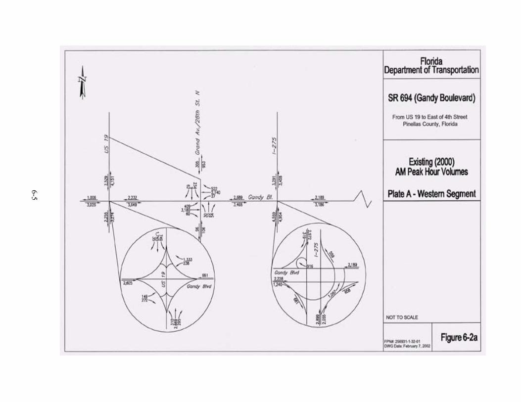
6-5

6-6

6-7

6-8
6-9 F:\COMMON\PDE\PROJECTS\GANDY\REPORTS\PER_Final\Final PER.doc
There are nine signalized intersections evaluated as part of this study. These intersections
include:
• Gandy Boulevard (SR 694) at US 19
• Gandy Boulevard (SR 694) at Grand Avenue (28th Street)
• Gandy Boulevard (SR 694) at I-275 northbound off-ramp
• Gandy Boulevard (SR 694) at Frontage Road
• Eastbound Gandy Boulevard (SR 694) at 9th Street
• Westbound Gandy Boulevard (SR 694) at 9th Street
• Gandy Boulevard (SR 694) at 4th Street
• Gandy Boulevard (SR 694) at Roosevelt Boulevard
• Roosevelt Boulevard at 9th Street N
There are two existing interchanges located within the study corridor. The locations of the
interchanges along Gandy Boulevard (SR 694) are listed below:
• US 19 (signalized single point urban interchange)
• I-275 (free-flowing for all ramps except Gandy Boulevard (SR 694) at I-275
northbound off-ramp)
The existing intersection lane geometry is displayed in Figures 6-4 (a and b).
6.3 EXISTING ACCESS MANAGEMENT
This section addresses the issues concerning access management standards along Gandy
Boulevard (SR 694) from west of US 19 to east of 4th Street.
The FDOT has developed access management regulations to help achieve safer and more
efficient traffic flow on the state highway system. The major documents on access
management regulations are:

6-10

6-11

6-12 F:\COMMON\PDE\PROJECTS\GANDY\REPORTS\PER_Final\Final PER.doc
• Florida Statute 335.18 - The Access Management Act (adopted 1988 and revised
1992),
• Administrative Rule 14-96 (regulating the access permitting process), and
• Administrative Rule 14-97 (the access management classification system and
standards).
Administrative Rule 14-97 categorizes the state highways into seven access management
classes, each class with its own standards. The most stringent standards apply to Access
Class 1 which covers limited access freeways. Access Classes 2 through 7 covers controlled
access highways and are organized from the most restrictive (Class 2) to the least restrictive
(Class 7).
6.3.1 Access Standards
Gandy Boulevard (SR 694) has an adopted Access Class 3 classification and is also a
controlled access FIHS facility. Table 6-2 describes the access spacing standards for an
Access Class 3 roadway.
The question arises as to whether access management standards more stringent than Access
Class 3 standards should be adopted for Gandy Boulevard (SR 694) in light of its FIHS
classification. Table 6-3 summarizes the standards for controlled access FIHS facilities.
Table 6-2 Access Class 3 Standards
Facility Design Features (Median Treatment) Restrictive
Minimum Connection Spacing - With posted speed over 45 mph - With posted speed at or less than 45 mph
660 ft. 440 ft.
Minimum Directional Median Opening Spacing 1,320 ft.
Minimum Full Median Opening Spacing 2,640 ft.
Minimum Signal Spacing 2,640 ft.

6-13 F:\COMMON\PDE\PROJECTS\GANDY\REPORTS\PER_Final\Final PER.doc
Table 6-3 Standards for Controlled Access FIHS Facilities
Access Management Standards The access management standards for controlled access segments of the FIHS shall be those contained in Access Class 2 or 3 as defined in Department Rule Chapter 14-97 F.A.C. and the FDOT's Plans Preparation Manual.
Other Access Management Classifications
Other access management standards may be assigned to a segment of the FIHS through a corridor access management plan developed as part of the Action Plan for the segment. The plan should define the highest standards attainable where Class 2 or 3 would not be feasible. In certain cases, a lower standard may lead to removal of the segment from the FIHS.
Design of Medians and Median Openings
The minimum median width standards for the FIHS should be those in the Department’s latest Plans Preparation Manuals (Topic Nos. 625-000-005 and 625-000-101). Safe accommodation of left turns and U-turns to ensure minimum interference with through traffic on controlled access facilities shall be provided through greater than minimum median width to accommodate these movements or through other strategies. Other strategies may include the use of such techniques as flared approaches, jug-handle designs, or roundabouts when properly justified. Refer to the FDOT's Median Handbook and the Florida Roundabout Guide for additional details.
Deviation from Median Opening Standards
Deviation from median opening standards shall follow theDepartment’s Median Opening Decision Process (Topic No. 625-010-020) which requires more analysis and justification when considering deviations from these standards on the FIHS.
Design Speed Standards The design speed for controlled access facilities shall be at least 65 mph in rural areas and at least 50 mph in urban and urbanized areas.
Table 6-3 implies that the current Access Class 3 classification for Gandy Boulevard
(SR 694) is stringent enough to suffice for Gandy Boulevard’s (SR 694) classification as a
controlled access FIHS facility.
6.3.2 Access Near Interchange Areas
Administrative Rule 14-97 addresses the importance of regulating access near interchange
ramp intersections with at-grade arterial roadways. This rule indicates that on a controlled
access facility, any area within 1,320 ft. of the interchange quadrant exit ramp or up to the
first intersection with an arterial road, whichever is less, shall be regulated. The purpose of
regulating this access within these specific parameters is to protect the safety and operational

6-14 F:\COMMON\PDE\PROJECTS\GANDY\REPORTS\PER_Final\Final PER.doc
efficiency of the limited access facility and the interchange area. The 1,320 ft. distance is
measured from the end of the taper of the exit ramp farthest from the interchange. The
following restrictions apply to interchange areas:
• Distance between the end of the exit ramp to the nearest connection will be at
least (440 ft.) if the posted speed limit is 45 mph or less. However, if a property
within this area is landlocked, then one permitted connection closer than this
distance will be considered;
• Distance between the end of the exit ramp to the nearest connection will be at
least 660 ft. if the posted speed limit is greater than 45 mph. However, if a
property within this area is landlocked, then one permitted connection closer than
this distance will be considered; and
• Minimum distance to the first median opening will be at least 1,320 ft. as
measured from the end of the taper of the egress ramp.
6.3.3 Access Management Under Existing (No-Build) Conditions
In order to study Gandy Boulevard’s (SR 694) access management under No-Build
conditions, it suffices to examine access management issues along Gandy Boulevard
(SR 694) within the project limits and also at the interchanges with US 19 and I-275. Figure
6-5 presents the existing layout of Gandy Boulevard (SR 694) from US 19 to 4th Street. Also
included on the figure are full median openings, signalized intersections, and posted speed
limits.
6.3.3.1 Access Management along Gandy Boulevard (SR 694)
There are several median openings located along Gandy Boulevard (SR 694) within the
project limits. These median openings and their relative spacing are summarized in Table
6-4.

6-15

6-16 F:\COMMON\PDE\PROJECTS\GANDY\REPORTS\PER_Final\Final PER.doc
Five of the seven segments listed in Table 6-4 are deficient relative to Access Class 3 median
opening spacing requirements. Of these five deficient segments, two have measured spacing
within 11 percent of the minimum required spacing.
Table 6-4 Existing Median Openings along Gandy Boulevard (SR 694)
Distance
Description Measured Required
Meets Access Management
Standards
From Sunset Palms full median opening (FMO) to Grand Avenue signalized FMO 1,440 ft. 2,640 ft. No
From Grand Avenue signalized FMO to I-275 northbound off-ramp (signalized) 5,920 ft. 2,640 ft. Yes
From I-275 northbound off-ramp (signalized) to signalized FMO at Power Substation 1,630 ft. 2,640 ft. No
From signalized FMO at Power Substation to signalized FMO at 9th Street 3,740 ft. 2,640 ft. Yes
From signalized FMO at 9th Street to signalized FMO at Roosevelt Boulevard 2,360 ft. 2,640 ft. No
From signalized FMO at Roosevelt Boulevard to signalized FMO at 4th Street 560 ft. 2,640 ft. No
From signalized FMO at 4th Street to FMO at Pelican Sound 2,350 ft. 2,640 ft. No
* All distances are measured from west to east
6.3.3.2 US 19/Gandy Boulevard (SR 694) Interchange Access Management
In accordance with the adopted FDOT Access Management Classification system, US 19 is
Access Class 5 south of Gandy Boulevard (SR 694) and Access Class 3 north of Gandy
Boulevard (SR 694). The speed limit on US 19 south of Gandy Boulevard (SR 694) is 45
mph. North of Gandy Boulevard (SR 694), the speed limit on US 19 remains at 45 mph until
approximately 650 ft. north of Gandy Boulevard (SR 694) (approximately at 76th
Avenue/76th Terrace) where the posted speed changes to 55 mph. The posted speed limits
and the standards in Section 6.3.1 were evaluated to develop the minimum spacing
requirements in Table 6-5.

6-17 F:\COMMON\PDE\PROJECTS\GANDY\REPORTS\PER_Final\Final PER.doc
Table 6-5 Existing Median Opening/Connection Spacing at US 19/Gandy Boulevard
(SR 694) Interchange
Distance Access Description
Measured Required
Meets Interchange Access Management
Standards
Median Opening Spacing From westbound off-ramp to first median opening north of Gandy Boulevard (SR 694) 380 ft. 1,320 ft. No
From eastbound off-ramp to first median opening south of Gandy Boulevard (SR 694) 710 ft. 1,320 ft. No
Connection Spacing From westbound off-ramp to first connection north of Gandy Boulevard (SR 694) and on the east side of US 19 380 ft. 440 ft. No
From eastbound off-ramp to first connection south of Gandy Boulevard (SR 694) and on the west side of US 19 710 ft. 440 ft. Yes
6.3.3.3 Improvements by Others
The following improvements within the US 19/Gandy Boulevard (SR 694) Interchange area
were documented in US 19 Access Management Study from 54th Avenue South to State
Route 602 dated June 2001 by DKS Associates for FDOT:
• US 19 at 76th Avenue/76th Terrace – Close the median opening. Provide a striped
median opening designed for emergency vehicles (only) at the FHP driveway.
• At the US 19/78th Avenue intersection – Construct a bi-directional median
opening, extending the lengths of the left turn lanes as far as practical. Restripe
the eastbound approach to eliminate the left turn lane.
These improvements on US 19 will increase the spacing between the westbound off-ramp to
the first median opening north of Gandy Boulevard (SR 694) from 380 ft. to 1,200 ft.

6-18 F:\COMMON\PDE\PROJECTS\GANDY\REPORTS\PER_Final\Final PER.doc
6.3.3.4 I-275/Gandy Boulevard (SR 694) Interchange Access Management
The posted speed limit on Gandy Boulevard (SR 694) is 50 mph within the vicinity of the
I-275 interchange. The posted speed limit and the standards in Section 6.3.1 were combined
to develop the minimum spacing requirements in Table 6-6.
Table 6-6 Existing Median Opening/Connection Spacing at I-275/Gandy Boulevard (SR 694)
Interchange
Access Description Distance
Measured Required
Meets Interchange Access Management
Standards
Median Opening Spacing From northbound off-ramp to first median opening east of I-275 (signalized access to Power Substation) 940 ft. 1,320 ft. No
From southbound off-ramp to first median opening west of I-275 at Grand Avenue 2,780 ft. 1,320 ft. Yes
Connection Spacing From northbound off-ramp to first connection east of I-275 and on the south side of Gandy Boulevard 940 ft. 660 ft. Yes
From southbound off-ramp to first connection west of I-275 and on the north side of Gandy Boulevard (SR 694) 2,780 ft. 660 ft. Yes
The proximity of the median opening at the Power Substation access road and Gandy
Boulevard (SR 694) intersection represents a deficiency in the existing access management
plan for the I-275/Gandy Boulevard (SR 694) interchange.
6.4 EXISTING TRAFFIC CONDITIONS
The Highway Capacity Software (HCS), Version 3.2 was used to evaluate the quality of
traffic flow currently experienced in the study area. The HCS is based on analysis
procedures defined in the 1994 Highway Capacity Manual, Special Report 2093 (HCM).
The morning and evening peak hour LOS were determined for the nine signalized

6-19 F:\COMMON\PDE\PROJECTS\GANDY\REPORTS\PER_Final\Final PER.doc
intersections. The LOS standard specified by FDOT for Gandy Boulevard (SR 694) is LOS
C. The following sections summarize the results of the existing capacity analyses.
6.4.1 Existing Signalized Intersections Level of Service Analysis
The LOS analysis for existing (2000) conditions, shown in Table 6-7, shows that six of the
nine signalized intersections are currently operating below the acceptable standard of
LOS D during the AM peak hour. During the PM peak hour eight of the nine signalized
intersections are currently operating below LOS D.
Table 6-7 Existing (2000) Signalized Intersections LOS
Existing (2000) Peak Hour Signalized Intersection
AM PM Gandy Boulevard (SR 694) at US 19 F F Gandy Boulevard (SR 694) at Grand Avenue (28th Street) D F Gandy Boulevard (SR 694) at I-275 northbound off-ramp F F Gandy Boulevard (SR 694) at Frontage Road F F Eastbound Gandy Boulevard (SR 694) at 9th Street D E Westbound Gandy Boulevard (SR 694) at 9th Street F E Gandy Boulevard (SR 694) at Roosevelt Boulevard C D Gandy Boulevard (SR 694) at 4th Street F F Roosevelt Boulevard at 9th Street F E
6.4.2 Existing Arterial Level of Service Analysis
After the analysis of signalized intersection was completed, the results were used to
determine the LOS for roadway segments within the study corridor. Each arterial segment
along Gandy Boulevard (SR 694) was examined in both directions, as the LOS for a segment
can vary depending on the direction analyzed. As noted in Table 6-8, four of five segments
and the overall arterial in the westbound direction are operating below the LOS D standard
during the AM peak hour. All five westbound segments and the overall arterial are operating

6-20 F:\COMMON\PDE\PROJECTS\GANDY\REPORTS\PER_Final\Final PER.doc
below LOS D during the PM peak hour. In the eastbound direction, two of the six segments
plus the overall arterial are operating below the LOS D standard during the AM peak hour.
Two of the eastbound segments are operating below LOS D during the PM peak hour.
Overall, the eastbound arterial is operating at LOS D during the PM peak hour.
Table 6-8 Existing (2000) Arterial Segment LOS
Existing (2000) Peak Hour Arterial Segment
AM PM Westbound Gandy Boulevard (SR 694) 4th Street to Roosevelt Boulevard F F Roosevelt Boulevard to 9th Street E F 9th Street to Frontage Road F F Frontage Road to I-275 F F I-275 to Grand Avenue (28th Street) B F Overall E F Eastbound Gandy Boulevard (SR 694) US 19 to Grand Avenue (28th Street) D D Grand Avenue to I-275 F D I-275 to Frontage Road B B Frontage Road to 9th Street D E 9th Street to Roosevelt Boulevard C C Roosevelt Boulevard to 4th Street F F Overall E D
6.4.3 Existing Ramp Junctions Level of Service Analysis
Evaluation of the interchange ramp junctions at US 19 and I-275 were also analyzed as part
of this study. The 12 ramp junctions identified within the study corridor are listed in Table
6-9. The existing LOS analysis reveals that one of the 12 is operating below the acceptable
LOS D standard during the AM peak hour. During the PM peak hour four of the 12 ramp
junctions are operating below the LOS standard.

6-21 F:\COMMON\PDE\PROJECTS\GANDY\REPORTS\PER_Final\Final PER.doc
Table 6-9 Existing (2000) Ramp Junctions LOS
Existing (2000)
Peak Hour Ramp Junction Type AM PM
Eastbound Gandy Boulevard (SR 694) to I-275 Diverge C B Eastbound Gandy Boulevard (SR 694) to Northbound I-275 Merge B B Eastbound Gandy Boulevard (SR 694) to Southbound I-275 Merge C C Northbound I-275 to Gandy Boulevard (SR 694) Diverge F F Southbound I-275 to Westbound Gandy Boulevard (SR 694) Diverge B B Southbound I-275 to Westbound Gandy Boulevard (SR 694) Merge C D Westbound Gandy Boulevard (SR 694) to Southbound I-275 Diverge D E Westbound Gandy Boulevard (SR 694) to Southbound I-275 Merge D E Eastbound Gandy Boulevard (SR 694) to US 19 Diverge C B US 19 to Eastbound Gandy Boulevard (SR 694) Merge D B US 19 to Westbound Gandy Boulevard (SR 694) Merge A B Westbound Gandy Boulevard (SR 694) to US 19 Diverge C E
6.5 MULTIMODAL TRANSPORTATION SYSTEM CONSIDERATIONS
6.5.1 Transit
The PSTA provides public transit service in the Gandy Boulevard (SR 694) Corridor. Route
74 serves the majority of the study corridor by traveling east/west via Park Boulevard and
Gandy Boulevard (SR 694). Major stops along the route include the Indian Rocks Shopping
Center, Seminole Mall, Park 66 Shopping Center, Pinellas Parkside Mall, and Gateway Mall.
Headways on Route 74 typically are 30 minutes in the peak periods and 60 minutes in the
off-peak periods of the day. Hours of operation are from 5:15 a.m. to 8:45 p.m. Monday
through Friday. Limited weekend service is also provided.
Other PSTA routes provide connections along the Gandy Boulevard (SR 694) Corridor.
The Pinellas Parkside Mall on the east end of the corridor is served by PSTA Routes 11, 19,
52, 74, 75, and 444. These routes provide connections to Pinellas Park and north St.
Petersburg. Route 96 provides peak period, weekday commuter service along I-275. Route
59 and 99 provide additional north-south service along 9th Street. Route 4 provides service

6-22 F:\COMMON\PDE\PROJECTS\GANDY\REPORTS\PER_Final\Final PER.doc
along 4th Street to northeast St. Petersburg and Route 100X provides commuter service to
Tampa from the Gateway Mall via Gandy Boulevard (SR 694) east of 4th Street.
To plan for future transit service, PSTA continues to monitor and evaluate all routes to
provide more efficient and effective service. As indicated in the Pinellas County
Comprehensive Plan, Transportation Element4, routes that fall below 75% of the system
averages for passenger productivity and farebox recovery ratios, are monitored for two
consecutive quarters. PSTA will then prepare recommendations on improving service such
as route realignments or scheduling modifications. PSTA monitors routes for at least six
months before adjustments, such as headway improvement or the consolidation of existing
fixed routes, are implemented.
The Pinellas County MPO 2020 Long Range Transportation Plan5 lists cost feasible transit
enhancements proposed for the years 2004 through 2010. Review of the Plan revealed that
transit service enhancements are only proposed for Routes 52 and 59, by the year 2005. The
proposed enhancements are described below:
• The Route 74 proposed transit enhancements for the interim years 2004-2010
include the reduction of the headways from 30 minutes to 15 minutes during the
peak period. There are currently six buses servicing this route. During the off-
peak period, the headways are proposed to be reduced from the 60 minutes to 30
minutes.
6.5.2 Pinellas Mobility Major Investment Study
In 1997, the Pinellas County MPO initiated the Pinellas Mobility Major Investment Study6
(MIS). The purpose of this study is to identify transportation and policy solutions to manage
problems anticipated with future traffic congestion. As part of this study, multimodal
transportation strategies were evaluated to determine their effects on land use patterns, local
transportation policies, development regulations and environmental impacts. The
multimodal strategies evaluated include: high occupancy vehicle (HOV) lanes,
transportation system management (TSM), intelligent transportation systems (ITS),
6-23 F:\COMMON\PDE\PROJECTS\GANDY\REPORTS\PER_Final\Final PER.doc
transportation demand management (TDM), transit, rail, and bicycle/pedestrian facilities.
The MPO approved the Locally Recommended Alternative (LPA) Report in October 2000.
The LPA identifies Gandy Boulevard (SR 694) from US 19 to 4th Street as part of potential
express bus route system. The Locally Recommended Alternatives will be evaluated as part
of the next phase of the study, currently being initiated by the MPO.
6.5.3 Rail
There is no existing railroad that crosses Gandy Boulevard (SR 694) within the project
limits.
6.5.4 Aviation
The St. Petersburg-Clearwater International Airport is located four miles northwest of the
northern end of the study corridor in Pinellas County. This airport will not be affected by the
proposed improvements of the study corridor.
6.6 TRAFFIC ANALYSIS ASSUMPTIONS
The design year (2025) traffic volumes were estimated using the Tampa Bay Regional
Planning Model (TBRPM) Version 3.2. In addition, the traffic factors displayed in Table 6-1
were used to develop design year traffic volumes.
6.7 TRAFFIC VOLUME PROJECTIONS
The design year (2025) traffic volumes were estimated using the TBRPM Version 3.2. To
refine the TBRPM model projections, a comparison of the validation results with observed
volumes was undertaken. Where the 1995 model volumes were not within 10 percent of
observed counts, the ratio of 1995 count /1995 volumes was applied to 2020 projections to
correct for over/under assignment. After applying the model output conversion factor, the
2020 AADT volume was then inflated by one percent per year to account for traffic in the

6-24 F:\COMMON\PDE\PROJECTS\GANDY\REPORTS\PER_Final\Final PER.doc
year 2025. Projected volumes were then compared with year 2000 volumes to affirm that
growth/decline in traffic was consistent with expectation for the area.
6.7.1 Design Year Annual Average Daily Traffic Volume Projections
For the design year (2025), traffic projections were developed for the No-Build Alternative
and the Build Alternatives. The assumptions used to develop these alternatives in the model
are described below.
6.7.1.1 No-Build Alternative
To establish a baseline against which to compare various alternative improvement scenarios
for the Gandy Boulevard (SR 694) Corridor, the LRTP improvements for Gandy Boulevard
(SR 694) in the study area, along with the improvements on Roosevelt Boulevard (east of
I-275) were removed from the 2020 (20A) network and volumes were reassigned. Figures
6-6 (a and b) display the projected 2025 AADT volumes developed by using the TBRPM.
As shown in Figures 6-6 (a and b), the projected No-Build design year AADT volumes along
the study corridor are expected to range between 32,500 vpd to 85,700 vpd. A comparison
of the 2025 AADT volumes to the existing (2000) AADT volumes reveals the daily traffic is
expected to increase between 28 and 42 percent by the design year 2025.
6.7.1.2 Build Alternatives
Build Alternative
The Build Alternative consists of a six-lane divided controlled access roadway with frontage
roads and slip-ramps. The same amount of traffic is expected to flow through the corridor
(32,500 vpd to 85,700 vpd) as the No-Build Alternative. However, the Build Alternative
allows the traffic to be distributed between the mainline, frontage roads, and ramps. The
projected Build design year AADT volumes are shown in Figures 6-7 (a and b).

6-25

6-26

6-27

6-28

6-29 F:\COMMON\PDE\PROJECTS\GANDY\REPORTS\PER_Final\Final PER.doc
Revised Build Alternative
The Build Alternative was revised based on the results of the Public Hearing held on March
14, 2002. The revised Build Alternative reflects the addition of a slip-ramp from 16th Street
to westbound Gandy Boulevard (SR 694). The same amount of traffic is expected to flow
through the corridor as the Build Alternative. The only difference is the redistribution of
traffic due to the addition of the slip-ramp.
6.7.2 2025 Design Hour Turning Movement Volumes
6.7.2.1 No-Build Alternative
The K30 and D factors reported in Table 6-1 were used to develop preliminary year 2025 AM
and PM peak hour approach volumes for all intersections. Where there are no access points
between intersections, approach/departure volumes from one intersection were reconciled
(smoothed) with the next intersection. Because the observed traffic volumes on Gandy
Boulevard (SR 694) were the highest near I-275, this was the control point against which
other intersection approach volumes were calculated. The projected 2025 design hour
turning movement volumes for AM peak hour are displayed in Figures 6-8 (a and b). Figure
6-9 (a and b) displays the 2025 PM peak hour volumes.
6.7.2.2 Build Alternatives
Build Alternative
The Build Alternative, which consists of a six-lane divided controlled access roadway with
frontage roads and slip-ramps, results in redistribution of traffic along the study corridor.
Once again, where there are no access points between intersections, approach/departure
volumes from one intersection were reconciled (smoothed) with the next intersection. Also,
for the build conditions, the observed traffic volumes on Gandy Boulevard (SR 694) were
the highest near I-275; this was the control point against which other intersection approach

6-30

6-31

6-32

6-33

6-34 F:\COMMON\PDE\PROJECTS\GANDY\REPORTS\PER_Final\Final PER.doc
volumes were calculated. The projected Build Alternative 2025 design hour turning
movement volumes for AM peak hour are displayed in Figures 6-10 (a and b). Figure 6-11
(a and b) displays the 2025 PM peak hour volumes.
Revised Build Alternative
A revised Build Alternative with design changes was developed based on the results of the
Public Hearing held on March 14, 2002. The revised Build Alternative reflects the addition
of a slip-ramp from 16th Street to westbound Gandy Boulevard (SR 694). The slip-ramp
allows traffic from the 16th Street area to travel westbound on Gandy Boulevard (SR 694)
without using the circuitous route via the south frontage road and 9th Street. The same
methodology used to develop design hour volumes for the Build Alternative was used
for the revised Build Alternative. The 2025 AM and PM design hour turning movement
volumes are displayed in Figures 6-12 (a and b) and Figures 6-13 (a and b), respectively.
6.8 LEVEL OF SERVICE
The 2025 design hour turning movement volumes discussed previously, were used as input
to the LOS analyses. The LOS analyses were performed for the No-Build and Build
Alternatives for AM and PM peak conditions. As mentioned in Section 6.4 of this report, the
LOS standard specified by FDOT for the Gandy Boulevard (SR 694) Corridor is LOS D. The
following subsections summarize the results of the design year (2025) LOS analyses
conducted for signalized intersections, ramp junctions and roadway segments.
6.8.1 No-Build Alternative
The analysis for the No-Build Alternative includes evaluating the impact of the 2025 design
hour traffic volumes on the existing lane geometry. The existing nine signalized
intersections were evaluated using the same software (HCS Version 3.2) as was used to
evaluate existing operational conditions described in Section 6.4.

6-35

6-36

6-37
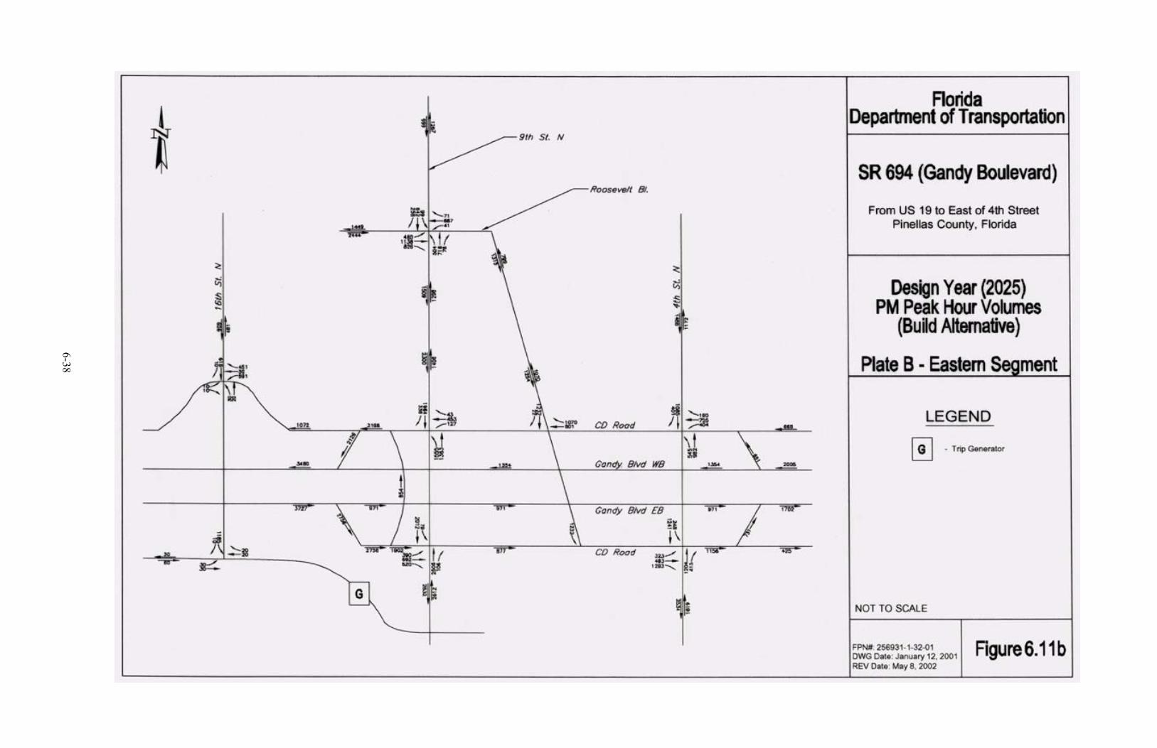
6-38

6-39

6-40
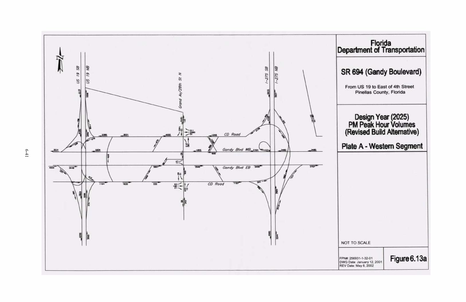
6-41

6-42

6-43 F:\COMMON\PDE\PROJECTS\GANDY\REPORTS\PER_Final\Final PER.doc
6.8.1.1 Design Year (2025) Signalized Intersection LOS Analysis (No-Build
Alternative)
A capacity analysis was conducted for the nine intersections using the 2025 No-Build traffic
volumes. The results of the analyses reveals that eight of the nine signalized intersections
are expected to operate below the acceptable LOS D conditions during the AM peak hour.
During the 2025 PM peak hour, all nine signalized intersections are expected to operate
below LOS D. The result of the No-Build signalized intersections operation analyses are
summarized in Table 6-10.
Table 6-10 Design Year (2025) Signalized Intersections LOS
No-Build Alternative
No-Build (2025) Peak Hour Signalized Intersection
AM PM Gandy Boulevard (SR 694) at US 19 F F Gandy Boulevard (SR 694) at Grand Avenue (28th Street) F F Gandy Boulevard (SR 694) at I-275 northbound off-ramp F F Gandy Boulevard (SR 694) at Frontage Road F F Eastbound Gandy Boulevard (SR 694) at 9th Street F F Westbound Gandy Boulevard (SR 694) at 9th Street F F Gandy Boulevard (SR 694) at Roosevelt Boulevard D F Gandy Boulevard (SR 694) at 4th Street F F Roosevelt Boulevard at 9th Street F F
6.8.1.2 Design Year (2025) Arterial LOS Analysis (No-Build Alternative)
After the analysis of signalized intersection was completed, the results were used to
determine the LOS for roadway segments assuming the 2025 No-Build Alternative. Each
arterial segment along Gandy Boulevard (SR 694) was examined in both directions, as the
LOS for a segment can vary depending on the direction analyzed. As noted in Table 6-11,
four of the five segments and overall in the westbound direction are expected to operate
below the LOS D standard during the AM peak hour. All five westbound segments and

6-44 F:\COMMON\PDE\PROJECTS\GANDY\REPORTS\PER_Final\Final PER.doc
overall are projected to operate below LOS D during the PM peak hour. In the eastbound
direction, five of the six segments plus overall are expected to operate below the LOS D
standard during the AM peak hour. During the PM peak hour, five of the six eastbound
segments plus overall are operating below LOS D standard.
Table 6-11 Design Year (2025) Arterial LOS
No-Build Alternative
No-Build (2025) Peak Hour Arterial Segment AM PM
Westbound Gandy Boulevard (SR 694) 4th Street to Roosevelt Boulevard F F Roosevelt Boulevard to 9th Street F F 9th Street to Frontage Road F F Frontage Road to I-275 F F I-275 to Grand Avenue (28th Street) D F Overall F F Eastbound Gandy Boulevard (SR 694) US 19 to Grand Avenue (28th Street) F F Grand Avenue to I-275 F F I-275 to Frontage Road F E Frontage Road to 9th Street F F 9th Street to Roosevelt Boulevard C D Roosevelt Boulevard to 4th Street F F Overall F F
6.8.1.3 Design Year (2025) Ramp Junctions LOS Analysis (No-Build Alternative)
Evaluation of the interchange ramp junctions at US 19 and I-275 were also conducted for
design year (2025) No-Build Alternative. The 12 ramp junctions identified within the study
corridor are listed in Table 6-12. The LOS analyses for the No-Build Alternative reveals that
nine of the 12 ramp junctions are expected to operate below the acceptable LOS D standard
during the AM peak hour. During the PM peak hour five of the 12 ramp junctions are
expected to operate below the LOS D standard.

6-45 F:\COMMON\PDE\PROJECTS\GANDY\REPORTS\PER_Final\Final PER.doc
Table 6-12 Design Year (2025) Ramp Junctions LOS
No-Build Alternative
No-Build (2025) Peak HourRamp Junction Type
AM PM Eastbound Gandy Boulevard (SR 694) to I-275 Diverge F D Eastbound Gandy Boulevard (SR 694) to northbound I-275 Merge F A Eastbound Gandy Boulevard (SR 694) to southbound I-275 Merge F F Northbound I-275 to Gandy Boulevard (SR 694) Diverge F F Southbound I-275 to westbound Gandy Boulevard (SR 694) Diverge F F Southbound I-275 to westbound Gandy Boulevard (SR 694) Merge D C Westbound Gandy Boulevard (SR 694) to southbound I-275 Diverge F D Westbound Gandy Boulevard (SR 694) to southbound I-275 Merge F F Eastbound Gandy Boulevard (SR 694) to US 19 Diverge C C US 19 to eastbound Gandy Boulevard (SR 694) Merge F C US 19 to westbound Gandy Boulevard (SR 694) Merge B C Westbound Gandy Boulevard (SR 694) to US 19 Diverge F F
6.8.2 Build Alternative
The evaluation of the future traffic operations with the Build Alternative was conducted
with CORSIM. CORSIM provides measures of effectiveness that are comparable to HCS.
The software was used for the Build Alternative, since it evaluates the operation of the
proposed roadway system as a whole. HCS only evaluates isolated elements of the roadway
system (i.e., intersections, arterial segments). The animated simulation of future traffic
conditions can assist in visually identifying congested areas and also can stimulate discussion
to determine options to improve the operation of the area.
6.8.2.1 Design Year (2025) Signalized Intersection LOS Analysis (Build Alternative)
The Build Alternative consists of a six-lane divided controlled access roadway with frontage
roads and slip ramps. Thirteen signalized intersection are included in the Build Alternative.
These signalized intersections are listed in Table 6-13.

6-46 F:\COMMON\PDE\PROJECTS\GANDY\REPORTS\PER_Final\Final PER.doc
A summary of the operational analyses conducted for the signalized intersections is shown in
Table 6-13. Two of the 13 signalized intersections are expected to operate below the LOS D
standard during both 2025 AM peak hour. The intersections are Gandy Boulevard (SR 694)
at 9th Street and Roosevelt Boulevard at 9th Street. In addition, Gandy Boulevard (SR 694) at
US 19 and the westbound Frontage Road at Grand Avenue (28th Street) are expected to
operate below the LOS standard only during the PM peak hour.
Table 6-13 Design Year (2025) Signalized Intersections LOS
Build Alternative
Build (2025) Peak Hour Signalized Intersection AM PM
Gandy Boulevard (SR 694) at US 19 D E Westbound Gandy Boulevard (SR 694) slip ramp at Grand Avenue (28th Street) B A Eastbound frontage road at Grand Avenue (28th Street) B A Westbound frontage road at Grand Avenue (28th Street) C E Eastbound frontage road at 16th Street B B Westbound frontage road at 16th Street F F Eastbound frontage road at 9th Street C* D* Westbound frontage road at 9th Street D* D* Eastbound frontage road at Roosevelt Boulevard B B Westbound frontage road at Roosevelt Boulevard B B Eastbound frontage road at 4th Street B B Westbound frontage road at 4th Street B B Roosevelt Boulevard at 9th Street F F
Note: *Further review revealed that CORSIM was under estimating the operation of the intersections. Therefore, HCS was used to evaluate these intersections. Based on the HCS analyses, the intersections are expected to operate at LOS F during the AM and PM peak hours.
6.8.2.2 Design Year (2025) Arterial LOS Analysis (Build Alternative)
The LOS results from the operational analysis are summarized in Table 6-14. During the
design year (2025), Gandy Boulevard (SR 694) is expected to operate at or above the
acceptable LOS D conditions. Table 6-14 also reveals that a few frontage road arterial
segments are expected to operate below the LOS D standard in AM or PM peak hours.

6-47 F:\COMMON\PDE\PROJECTS\GANDY\REPORTS\PER_Final\Final PER.doc
Table 6-14 Design Year (2025) Arterial LOS
Build Alternative
Build (2025) Peak Hour Arterial Segment
AM PM North Frontage Road 4th Street to Roosevelt Boulevard D D Roosevelt Boulevard to 9th Street A A 9th Street to U-turn F C U-turn to Gandy Boulevard (SR 694) westbound on-ramp F F Gandy Boulevard (SR 694) westbound on-ramp to 16th Street F F 16th Street E D I-275 southbound off-ramp to Gandy Boulevard (SR 694) westbound on-ramp
B B
Gandy Boulevard (SR 694) westbound on-ramp to Gandy Boulevard (SR 694) westbound off-ramp
B C
Gandy Boulevard (SR 694) westbound off-ramp to Grand Avenue (28th Street)
E F
Grand Avenue (28th Street) to Gandy Boulevard (SR 694) westbound on-ramp
B B
Gandy Boulevard (SR 694) westbound on-ramp to U-turn C E U-turn to US 19 F F Westbound Gandy Boulevard (SR 694) Westbound off-ramp (east of 4th Street) to westbound on-ramp (west of U-turn)
A A
Westbound on-ramp (west of U-turn) to I-275 southbound on-ramp A A I-275 southbound on-ramp to westbound off-ramp (west of I-275) C B Westbound off-ramp (west of I-275) to westbound on-ramp (east of Grand Avenue [28th Street])
A A
Westbound on-ramp (east of Grand Avenue [28th Street]) to westbound on-ramp (west of Grand Avenue [28th Street])
A A
Westbound on-ramp to US 19 A A South Frontage Road US 19 to eastbound Gandy Boulevard (SR 694) on-ramp D D Eastbound Gandy Boulevard (SR 694) on-ramp to Grand Avenue (28th Street)
A A
Grand Avenue to Gandy Boulevard (SR 694) off-ramp A A Gandy Boulevard (SR 694) off-ramp to I-275 B B Gandy Boulevard (SR 694) off-ramp to U-turn D B U-turn to 9th Street E C 9th Street Roosevelt Boulevard A A Roosevelt Boulevard to 4th Street F F

Table 6-14 (Cont’d.) Design Year (2025) Arterial LOS
Build Alternative
6-48 F:\COMMON\PDE\PROJECTS\GANDY\REPORTS\PER_Final\Final PER.doc
Build (2025) Peak Hour Arterial Segment
AM PM Eastbound Gandy Boulevard (SR 694) US 19 to on-ramp (east of US 19) A A On-ramp [east of US 19] to off-ramp (west of Grand Avenue [28th Street])
A A
Off-ramp ramp (west of Grand Avenue [28th Street] to off-ramp [west of I-275])
A A
Off-ramp (west of I-275) to I-275 northbound off-ramp A A I-275 northbound off-ramp to off-ramp (west of U-turn) D C Off-ramp (west of U-turn) to on-ramp (east of 4th Street) A A
6.8.2.3 Level of Service Improvement Recommendations (Build Alternative)
The following improvements are recommended to improve the operation of Gandy
Boulevard (SR 694) in the design year (2025):
• Six-lane divided controlled access roadway
• Slip-ramps
The recommended lane geometry for Gandy Boulevard (SR 694) and the interchanges is
reflected in Figures 6-14 (a and b).
6.8.3 Revised Build Alternative
As noted in Section 6.7.2.2, a public hearing was held in March 2002. Based on the
comments received from the hearing a design change was incorporated into the Build
Alternative. The design change was the addition of a slip-ramp from 16th Street to
westbound Gandy Boulevard (SR 694). The slip-ramp allows traffic from the 16th Street
area to travel westbound on Gandy Boulevard (SR 694) without using the circuitous route
via the south frontage road and 9th Street. CORSIM was used to evaluate the future traffic

6-49

6-50
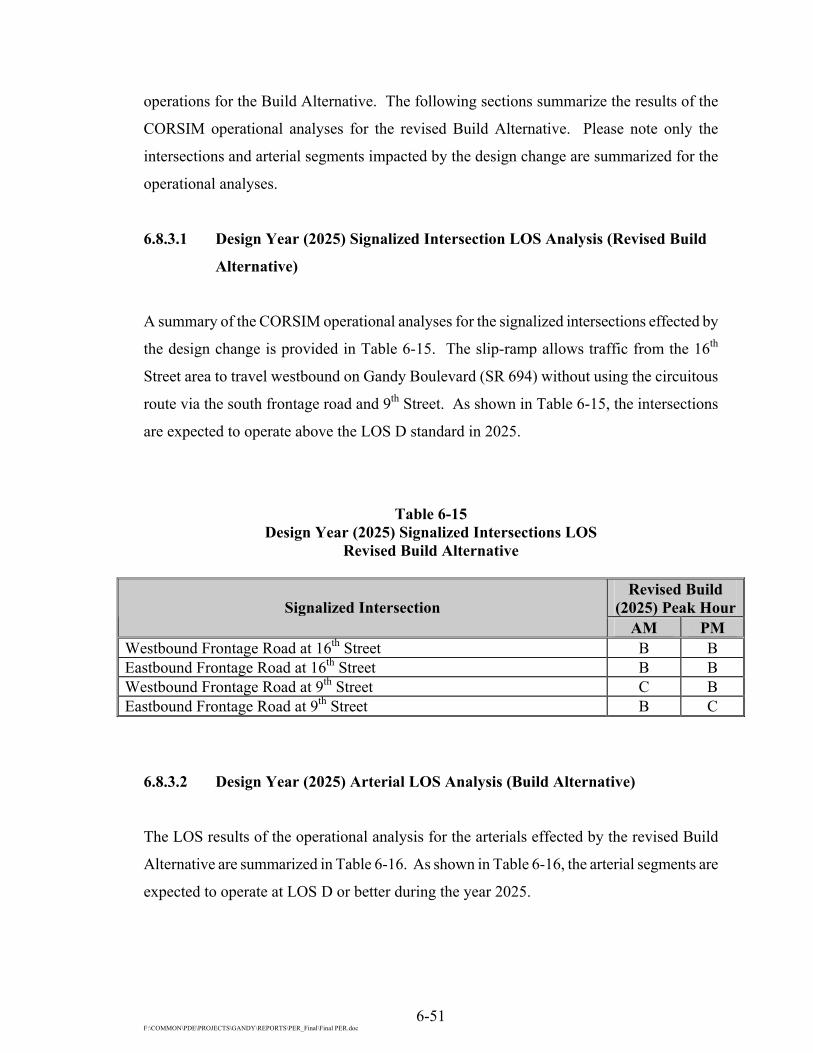
6-51 F:\COMMON\PDE\PROJECTS\GANDY\REPORTS\PER_Final\Final PER.doc
operations for the Build Alternative. The following sections summarize the results of the
CORSIM operational analyses for the revised Build Alternative. Please note only the
intersections and arterial segments impacted by the design change are summarized for the
operational analyses.
6.8.3.1 Design Year (2025) Signalized Intersection LOS Analysis (Revised Build
Alternative)
A summary of the CORSIM operational analyses for the signalized intersections effected by
the design change is provided in Table 6-15. The slip-ramp allows traffic from the 16th
Street area to travel westbound on Gandy Boulevard (SR 694) without using the circuitous
route via the south frontage road and 9th Street. As shown in Table 6-15, the intersections
are expected to operate above the LOS D standard in 2025.
Table 6-15 Design Year (2025) Signalized Intersections LOS
Revised Build Alternative
Revised Build (2025) Peak HourSignalized Intersection
AM PM Westbound Frontage Road at 16th Street B B Eastbound Frontage Road at 16th Street B B Westbound Frontage Road at 9th Street C B Eastbound Frontage Road at 9th Street B C
6.8.3.2 Design Year (2025) Arterial LOS Analysis (Build Alternative)
The LOS results of the operational analysis for the arterials effected by the revised Build
Alternative are summarized in Table 6-16. As shown in Table 6-16, the arterial segments are
expected to operate at LOS D or better during the year 2025.

6-52 F:\COMMON\PDE\PROJECTS\GANDY\REPORTS\PER_Final\Final PER.doc
Table 6-16 Design Year (2025) Arterial LOS
Revised Build Alternative
Revised Build (2025) Peak
Hour Arterial Segment
AM PM North Frontage Road 9th Street to U-turn D C U-turn to westbound Gandy Boulevard (SR 694) on-ramp D D Westbound Gandy Boulevard (SR 694) on-ramp to 16th Street D D Westbound Gandy Boulevard (SR 694) Westbound on-ramp west of 16th Street to I-275 southbound on-ramp C C South Frontage Road 16th Street to 9th Street D C
6.8.3.3 Level of Service Improvement Recommendations (Revised Build
Alternative)
The following recommended improvements are the same as the Build Alternative with one
exception, the addition of an on-ramp from 16th Street to westbound Gandy Boulevard
(SR 694):
• Six-lane divided controlled access roadway
• Ramps (with additional ramp from 16th Street to Gandy Boulevard)
The recommended lane geometry and interchanges for the Gandy Boulevard (SR 694) are
reflected in Figures 6-15 (a and b) and the alternative design concepts are located in
Appendix A.

6-53

6-54

6-55 F:\COMMON\PDE\PROJECTS\GANDY\REPORTS\PER_Final\Final PER.doc
6.9 ACCESS MANAGEMENT UNDER BUILD ALTERNATIVES
6.9.1 Build Alternative
In order to meet access management criteria as shown in Tables 6-2 and 6-3, an Access
Management Plan was developed for the proposed improvements. Under the Build
Alternative, the mainline of Gandy Boulevard (SR 694) has no at-grade intersections within
the project limits. Consequently, access management concerns are localized at the following
interchanges with Gandy Boulevard (SR 694):
• US 19 Interchange (existing),
• Modified I-275 Interchange,
• New 9th Street Interchange, and
• New Roosevelt Boulevard/4th Street Interchange.
6.9.1.1 US 19/Gandy Boulevard (SR 694) Interchange
The revised Build Alternative for Gandy Boulevard (SR 694) does not modify the geometry
at the US 19/Gandy Boulevard (SR 694) interchange. Therefore the deficiencies listed in
section 3.1.1 and Table 6-7 will still exist.
6.9.1.2 Modified I-275 Interchange
With the proposed raised vertical profile of Gandy Boulevard (SR 694), no median openings
or connections will be within the influence area of the interchange. Consequently, no access
conflicts are anticipated within the interchange area.

6-56 F:\COMMON\PDE\PROJECTS\GANDY\REPORTS\PER_Final\Final PER.doc
6.9.1.3 New 9th Street Interchange
The speed limit on 9th Street both north and south of Gandy Boulevard (SR 694) is 45 mph.
The posted speed limit and the standards in section 6.3 were combined to develop the
minimum spacing requirements in Table 6-17.
Table 6-17 Review of Median/Connection Opening Spacing at
New 9th Street Interchange
Distance Access Description
Measured Required
Meets Interchange Access Management
Standards
Median Opening Spacing From eastbound off-ramp to first median opening south of Gandy Boulevard (SR 694) 310 ft. 1,320 ft. No
From westbound frontage road to first median opening north of Gandy Boulevard (SR 694) 580 ft. 1,320 ft. No
Connection Spacing From eastbound off-ramp to first connection south of Gandy Boulevard (SR 694) and on the west side of 9th Street
310 ft. 440 ft. No
From westbound frontage road to first connection north of Gandy Boulevard (SR 694) and on the east side of 9th Street
220 ft. 440 ft. No
6.9.1.4 New Roosevelt Boulevard/4th Street Interchange
The speed limit on 4th Street south of Gandy Boulevard (SR 694) is 40 mph. North of Gandy
Boulevard (SR 694), the speed limit on 4th Street remains at 40 mph until approximately the
first driveway connection on the east side of the roadway. North of this driveway connection
the posted speed limit is 50 mph. The posted speed limits and the standards in section 6.3
were combined to develop the minimum spacing requirements in Table 6-18.
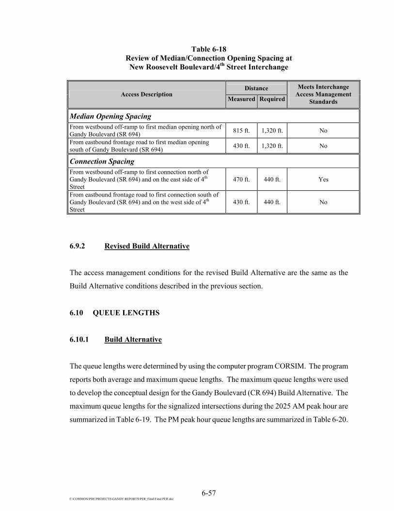
6-57 F:\COMMON\PDE\PROJECTS\GANDY\REPORTS\PER_Final\Final PER.doc
Table 6-18 Review of Median/Connection Opening Spacing at New Roosevelt Boulevard/4th Street Interchange
Distance
Access Description Measured Required
Meets Interchange Access Management
Standards
Median Opening Spacing From westbound off-ramp to first median opening north of Gandy Boulevard (SR 694) 815 ft. 1,320 ft. No
From eastbound frontage road to first median opening south of Gandy Boulevard (SR 694) 430 ft. 1,320 ft. No
Connection Spacing From westbound off-ramp to first connection north of Gandy Boulevard (SR 694) and on the east side of 4th Street
470 ft. 440 ft. Yes
From eastbound frontage road to first connection south of Gandy Boulevard (SR 694) and on the west side of 4th Street
430 ft. 440 ft. No
6.9.2 Revised Build Alternative
The access management conditions for the revised Build Alternative are the same as the
Build Alternative conditions described in the previous section.
6.10 QUEUE LENGTHS
6.10.1 Build Alternative
The queue lengths were determined by using the computer program CORSIM. The program
reports both average and maximum queue lengths. The maximum queue lengths were used
to develop the conceptual design for the Gandy Boulevard (CR 694) Build Alternative. The
maximum queue lengths for the signalized intersections during the 2025 AM peak hour are
summarized in Table 6-19. The PM peak hour queue lengths are summarized in Table 6-20.
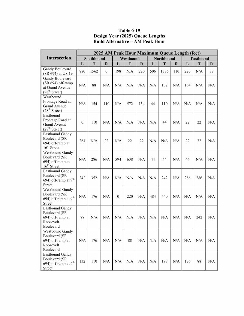
Table 6-19 Design Year (2025) Queue Lengths Build Alternative – AM Peak Hour
2025 AM Peak Hour Maximum Queue Length (feet)
Southbound Westbound Northbound Eastbound Intersection L T R L T R L T R L T R
Gandy Boulevard (SR 694) at US 19 880 1562 0 198 N/A 220 506 1386 110 220 N/A 88
Gandy Boulevard (SR 694) off-ramp at Grand Avenue (28th Street)
N/A 88 N/A N/A N/A N/A N/A 132 N/A 154 N/A N/A
Westbound Frontage Road at Grand Avenue (28th Street)
N/A 154 110 N/A 572 154 44 110 N/A N/A N/A N/A
Eastbound Frontage Road at Grand Avenue (28th Street)
0 110 N/A N/A N/A N/A N/A 44 N/A 22 22 N/A
Eastbound Gandy Boulevard (SR 694) off-ramp at 16th Street
264 N/A 22 N/A 22 22 N/A N/A N/A 22 22 N/A
Westbound Gandy Boulevard (SR 694) off-ramp at 16th Street
N/A 286 N/A 594 638 N/A 44 44 N/A 44 N/A N/A
Eastbound Gandy Boulevard (SR 694) off-ramp at 9th Street
242 352 N/A N/A N/A N/A N/A 242 N/A 286 286 N/A
Westbound Gandy Boulevard (SR 694) off-ramp at 9th Street
N/A 176 N/A 0 220 N/A 484 440 N/A N/A N/A N/A
Eastbound Gandy Boulevard (SR 694) off-ramp at Roosevelt Boulevard
88 N/A N/A N/A N/A N/A N/A N/A N/A N/A 242 N/A
Westbound Gandy Boulevard (SR 694) off-ramp at Roosevelt Boulevard
N/A 176 N/A N/A 88 N/A N/A N/A N/A N/A N/A N/A
Eastbound Gandy Boulevard (SR 694) off-ramp at 4th Street
132 110 N/A N/A N/A N/A N/A 198 N/A 176 88 N/A

Table 6-19 (Cont.) Design Year (2025) Queue Lengths Build Alternative – AM Peak Hour
6-59 F:\COMMON\PDE\PROJECTS\GANDY\REPORTS\PER_Final\Final PER.doc
2025 AM Peak Hour Maximum Queue Length (feet) Southbound Westbound Northbound Eastbound Intersection
L T R L T R L T R L T R Westbound Gandy Boulevard (SR 694) off-ramp at 4th Street
N/A 110 198 176 176 66 220 132 N/A N/A N/A N/A
Roosevelt Boulevard at 9th Street
88 286 1144 88 1540 88 484 594 396 374 1320 1276
Table 6-20 Design Year (2025) Queue Lengths Build Alternative – PM Peak Hour
2025 PM Peak Hour Maximum Queue Length (feet)
Southbound Westbound Northbound Eastbound Intersection L T R L T R L T R L T R
Gandy Boulevard (SR 694) at US 19 902 164 22 198 N/A 110 506 1364 0 220 N/A 88
Gandy Boulevard (SR 694) off-ramp at Grand Avenue (28th Street)
N/A 110 N/A N/A N/A N/A N/A 66 N/A 44 N/A N/A
Westbound Frontage Road at Grand Avenue (28th Street)
N/A 770 264 N/A 726 66 44 110 N/A N/A N/A N/A
Eastbound Frontage Road at Grand Avenue (28th Street)
0 132 N/A N/A N/A N/A N/A 44 N/A 22 22 N/A
Eastbound Gandy Boulevard (SR 694) off-ramp at 16th Street
286 N/A 22 N/A 22 22 N/A N/A N/A 22 22 N/A
Westbound Gandy Boulevard (SR 694) off-ramp at 16th Street
N/A 946 N/A 22 462 N/A 44 22 N/A 22 N/A N/A
Eastbound Gandy Boulevard (SR 694) off-ramp at 9th Street
242 418 N/A N/A N/A N/A N/A 242 N/A 264 286 N/A
Westbound Gandy Boulevard (SR 694) off-ramp at 9th Street
N/A 176 N/A 0 220 N/A 484 440 N/A N/A N/A N/A
Eastbound Gandy Boulevard (SR 694) off-ramp at Roosevelt Boulevard
110 N/A N/A N/A N/A N/A N/A N/A N/A N/A 286 N/A

Table 6-20 (Cont’d.) Design Year (2025) Queue Lengths Build Alternative – PM Peak Hour
6-60 F:\COMMON\PDE\PROJECTS\GANDY\REPORTS\PER_Final\Final PER.doc
2025 PM Peak Hour Maximum Queue Length (feet) Southbound Westbound Northbound Eastbound Intersection
L T R L T R L T R L T R Westbound Gandy Boulevard (SR 694) off-ramp at Roosevelt Boulevard
N/A 176 N/A N/A 132 N/A N/A N/A N/A N/A N/A N/A
Eastbound Gandy Boulevard (SR 694) off-ramp at 4th Street
132 88 N/A N/A N/A N/A N/A 110 N/A 198 154 N/A
Westbound Gandy Boulevard (SR 694) off-ramp at 4th Street
N/A 132 176 176 176 88 176 88 N/A N/A N/A N/A
Roosevelt Boulevard at 9th Street 110 264 132 132 924 66 198 308 286 594 1320 1254
6.10.2 Revised Build Alternative
As noted earlier CORSIM was used to reevaluate the operation analyses for the revised Build
Alternative. The CORSIM output was compared for both Build Alternatives. The
comparison revealed that the queue lengths provided in the previous section were the same
for the revised Build Alternative except for the intersection listed in the following tables. The
maximum queue lengths for the signalized intersections during the 2025 AM peak hour are
summarized in Table 6-21. The PM peak hour queue lengths are summarized in Table 6-22.
These maximum queue lengths were incorporated into the conceptual design for the Gandy
Boulevard (SR 694) revised Build Alternative.

Table 6-21 Design Year (2025) Queue Lengths
Revised Build Alternative – AM Peak Hour
2025 AM Peak Hour Maximum Queue Length (feet) Southbound Westbound Northbound Eastbound Intersection
L T R L T R L T R L T R Eastbound Gandy Boulevard (SR 694) off-ramp at 16th Street
154 N/A 22 N/A 264 0 N/A N/A N/A 22 22 N/A
Westbound Gandy Boulevard (SR 694) off-ramp at 16th Street
N/A 110 N/A 154 132 N/A 88 66 N/A 22 N/A N/A
Eastbound Gandy Boulevard (SR 694) off-ramp at 9th Street
66 88 N/A N/A N/A N/A N/A 242 N/A 198 176 N/A
Westbound Gandy Boulevard (SR 694) off-ramp at 9th Street
N/A 176 N/A 44 132 N/A 308 264 N/A N/A N/A N/A
Table 6-22 Design Year (2025) Queue Lengths
Revised Build Alternative – PM Peak Hour
2025 PM Peak Hour Maximum Queue Length (feet) Southbound Westbound Northbound Eastbound Intersection
L T R L T R L T R L T R Eastbound Gandy Boulevard (SR 694) off-ramp at 16th Street
198 N/A 22 N/A 220 0 N/A N/A N/A 22 22 N/A
Westbound Gandy Boulevard (SR 694) off-ramp at 16th Street
N/A 308 N/A 286 66 N/A 132 44 N/A 22 N/A N/A
Eastbound Gandy Boulevard (SR 694) off-ramp at 9th Street
242 418 N/A N/A N/A N/A N/A 242 N/A 264 286 N/A
Westbound Gandy Boulevard (SR 694) off-ramp at 9th Street
N/A 198 N/A 88 198 N/A 352 198 N/A N/A N/A N/A

6-62 F:\COMMON\PDE\PROJECTS\GANDY\REPORTS\PER_Final\Final PER.doc
6.11 REFERENCES
1. Design Traffic Memorandum; Gannett Fleming, Inc.; May 2002.
2 US 19 Access Management Study from 54th Avenue South to State Route 60; DKS
Associates: Tampa, Florida; June 2001.
3. 1994 Highway Capacity Manual (HCM), Special Report 209; Transportation
Research Board; Washington, D.C.; 1994, Updated 1998.
4. Pinellas County Comprehensive Plan, Transportation Element; Pinellas County
Planning Department; Clearwater, Florida; Adopted February 17, 1998, Last
Amended 1999.
5. Pinellas County MPO 2020 Long Range Transportation Plan; Pinellas County MPO;
Pinellas County, Florida; December 1998, Revised May 28, 1999.
6. Major Investment Study; Florida Department of Transportation; 2001.

7-1 F:\COMMON\PDE\PROJECTS\GANDY\REPORTS\PER_Final\Final PER.doc
SECTION 7
CORRIDOR ANALYSIS
7.1 EVALUATION OF ALTERNATE CORRIDORS
In an effort to identify potential alternate corridors that could serve the future travel demand
of the Gandy Boulevard (SR 694) Corridor, the following options were considered:
• Improvement to another east-to-west roadway within the region;
• Enhancement of transit service within the existing Gandy Boulevard (SR 694)
Road Corridor; and
• Roadway improvement of the existing Gandy Boulevard (SR 694) Corridor.
7.1.1 Improvement of Parallel Roadways
The Gandy Boulevard (SR 694) Corridor is highly developed, primarily with office, light
industrial, and residential land uses adjacent to the existing ROW. A review of the existing
roadway network in the immediate vicinity of Gandy Boulevard (SR 694) revealed the
presence of an east-west arterial roadway located approximately 2.0 mi north and south of
Gandy Boulevard (SR 694). The arterial roadway to the north is 102nd Avenue/Bryan Dairy
Road/118th Avenue (CR 296). Currently, the CR 296 Extension is being built as a six-lane
partially controlled access roadway and will connect with I-275 at the I-275/Roosevelt
Boulevard interchange. The roadway to the south of Gandy Boulevard (SR 694) connecting
to I-275 is 54th Avenue. Fifty-fourth Avenue is planned to be improved to a six-lane divided
roadway from I-275 to US 19. West of US 19 to 49th Street, 54th Avenue is planned to be
improved to a four-lane divided facility to connect with the existing four-lane divided from
49th Street to 66th Street (SR 693).

7-2 F:\COMMON\PDE\PROJECTS\GANDY\REPORTS\PER_Final\Final PER.doc
Improvement to any of the parallel existing roadways, in lieu of improving Gandy Boulevard
(SR 694), would not address the projected traffic demand along Gandy Boulevard (SR 694)
and is, therefore, not considered viable.
7.1.2 Enhancement of Transit Service
PSTA provides existing transit service along the Gandy Boulevard (SR 694) Corridor.
There is one route (Route 74) that provides regular transit service along the study corridor.
A brief description of the route is provided in Section 4.1.12.
To plan for future transit service, PSTA continues to monitor and evaluate all routes in an
effort to provide more efficient and effective service. As indicated in the Pinellas County
Comprehensive Plan, Transportation Element1, routes that fall below 75% of the system
averages for passenger productivity and farebox recovery ratios, are monitored for two
consecutive quarters. PSTA then prepares recommendations on improving service such as
route realignments or scheduling modifications. PSTA monitors routes for at least six
months before adjustments, such as headway improvement or the consolidation of existing
fixed routes, are implemented.
The existing transit service was adopted for the 2015 Cost Feasible Plan; therefore, service
levels will remain at current 1995 levels with no identified major service improvements
other than bus and capital equipment replacements and enhancements. However, since the
Pinellas County Comprehensive Plan, Transportation Element1 and MPO policies provide
for continued review of the transit operations to determine if changes to route structures can
be made to enhance the existing operations, PSTA has already expanded its operations
beyond the system included in the 2015 plan. Therefore, it appears that existing transit
service along the Gandy Boulevard (SR 694) Corridor will not be changed significantly in
the next 15 years. In addition, since transit passengers account for a minimal amount of
person trips in the Gandy Boulevard (SR 694) Corridor, transit service enhancement alone
would not be considered a viable alternative to roadway improvements.

7-3 F:\COMMON\PDE\PROJECTS\GANDY\REPORTS\PER_Final\Final PER.doc
7.1.3 Improvement of the Existing Corridor
The existing facility consists of a four-lane divided roadway. Much of the existing ROW
along Gandy Boulevard (SR 694) is sufficient to accommodate a six-lane divided highway
facility without purchasing additional ROW, with the exception of the proposed interchange
locations, retention ponds, right turn lanes, and corner clips. The need for improvements
along this corridor is also consistent with the Pinellas County Comprehensive Plan,
Transportation Element1 and complies with applicable design standards. Therefore, roadway
improvements to the existing corridor are a viable corridor alternative.
7.2 CORRIDOR SELECTION
In summary, the foregoing evaluation of feasible alternative corridors focused on
improvement of parallel roadways and enhancement of transit service, as compared with
improvement of the existing corridor.
In conclusion, the existing corridor is the recommended corridor for further consideration,
and a more detailed development and evaluation of alternative corridors, such as with an
impacts evaluation matrix, appear to be unnecessary. Therefore, the most feasible corridor
alternative for this PD&E Study is roadway improvements within the existing Gandy
Boulevard (SR 694) Corridor.

7-4 F:\COMMON\PDE\PROJECTS\GANDY\REPORTS\PER_Final\Final PER.doc
7.3 REFERENCES
1. Pinellas County Comprehensive Plan, Transportation Element; Pinellas County
Planning Department; Clearwater, FL; Adopted February 17, 1998, Last Amended
1999.

8-1 F:\COMMON\PDE\PROJECTS\GANDY\REPORTS\PER_Final\Final PER.doc
SECTION 8
ALTERNATIVES ANALYSIS
To develop an improved interstate facility for Gandy Boulevard (SR 694) that is in the best
overall public interest, engineering, environmental, and economic factors must be taken into
consideration. The improved facility should be designed to safely and efficiently
accommodate the projected design year vehicular traffic. The alignment should be placed so
as to optimize the possibilities for construction staging and traffic control. All of these
criteria have a direct bearing on the selection of the preferred design concept.
Included in the following sections are descriptions of the alternate improvement concepts
developed for this project and the evaluation methods used to compare the alternatives.
These descriptions are preceded by a presentation of the advantages and disadvantages of
the No-Build Alternative.
8.1 NO-BUILD ALTERNATIVE
The No-Build Alternative consists of canceling the project or postponing improvements of
Gandy Boulevard (SR 694) beyond the design year 2020. Certain advantages associated
with the implementation of the No-Build Alternative, include:
• No new construction or ROW costs,
• No disruption to the existing land uses due to construction activities,
• No disruption to traffic due to construction activities, and
• No ROW acquisitions or relocations.

8-2 F:\COMMON\PDE\PROJECTS\GANDY\REPORTS\PER_Final\Final PER.doc
The disadvantages of the No-Build Alternative include:
• Minimizing or preventing the increase of economic viability and community
values,
• Unacceptable LOS on the existing facility,
• Increased traffic congestion causing increased road user cost due to travel delay,
• Deterioration of air quality caused by traffic congestions and delays,
• Deterioration of the existing safety deficiencies due to the increase in traffic,
• Deterioration in the emergency service response time, and
• Increased roadway maintenance costs.
Postponement of the project will increase the overall project cost due to the current
escalation of construction and ROW costs.
8.2 TRANSPORTATION SYSTEM MANAGEMENT ALTERNATIVE
The Transportation System Management (TSM) alternative, which consists of low cost
capital improvements that maximize the efficiency of the present system, was also
considered for this project.
TSM activities currently in place within the Greater Tampa Bay Area, which may reduce
single occupancy vehicular trips and improve operational efficiency within the project
corridor, include the following:
• Active “Transportation Management Organizations” within Pinellas County,
which provide car-pooling, van sharing, mass transit incentives, and flextime
support services to businesses and the general public.
• Frequent bus service within the corridor, which is in compliance with the
“Americans with Disabilities Act.” Additionally, the transit system has
implemented various improvements and/or incentives to increase ridership. Such
measures include express service, bicycle carrying racks for the buses, a bus
shelter program, bus turnouts, and reduced fares for students and the elderly.

8-3 F:\COMMON\PDE\PROJECTS\GANDY\REPORTS\PER_Final\Final PER.doc
However, in order to accommodate future travel demand along the Gandy Boulevard
(SR 694) Corridor, TSM activities alone were not considered a viable alternative to roadway
improvements.
8.3 ALTERNATIVES DEVELOPMENT
8.3.1 Project Background
In June 1988, the FDOT initiated a PD&E Study for improving Gandy Boulevard (SR 694)
from US 19 to 4th Street in Pinellas County. A Draft Environmental Assessment (EA) for the
PD&E Study was submitted to the FHWA in August 1995. The Draft EA was not approved,
since the FHWA requested that a Gandy Corridor Major Investment Study1 (MIS) be
completed prior to the approval of any environmental documents. A byproduct of the
Intermodal Surface Transportation Efficiency Act (ISTEA) of 1991, major investment
studies were required for large-scale transportation projects of regional impact.
In August 1990, the FDOT initiated a separate PD&E Study evaluating Gandy Boulevard
(SR 694) from 4th Street in Pinellas County east to Dale Mabry Highway in Hillsborough
County, including the western terminus of the Lee Roy Selmon Expressway. A Final EA
was submitted to the FHWA for the eastern PD&E Study in May 1993 and was approved in
October 1993. After a Public Hearing was held in December 1993, the Draft Finding of No
Significant Impact (FONSI) was prepared. However, the FONSI was not submitted to
FHWA because the MIS1 had not been completed.
To comply with the ISTEA requirements, FDOT initiated the MIS1 in July 1996. The MIS1
was one of three major investment studies that interrelate in the immediate region. The
Hillsborough County MPO, jointly with the Hillsborough Area Regional Transit Authority
(HARTline), initiated a mobility MIS1 in mid-1996 examining issues related to mobility in
and through Hillsborough County, including connections to Polk, Pasco, and Pinellas
Counties. The MIS1 was concluded in April 1998 and the results have been incorporated in
the Hillsborough County 2020 Long Range Transportation Plan (LRTP). A 30-mile rail

8-4 F:\COMMON\PDE\PROJECTS\GANDY\REPORTS\PER_Final\Final PER.doc
corridor extending from the University of South Florida (USF) to Port Tampa, with
extensions out to the Westshore business district, Tampa International Airport/Hillsborough
Community College (TIA/HCC) and St. Joseph’s Hospital has been advanced for further
study.
Similarly, the Pinellas County MPO initiated a mobility MIS1 to extend to US 19 in mid-
1997. Recognizing that the individual MIS1 cannot address regional transportation issues
independently, the study sponsors developed and signed a Memorandum of Understanding
(MOU) to coordinate regional improvements with a potential connection via the Gandy
Corridor. Multi-modal strategies for inclusion in the MIS1 were to be provided by both the
Hillsborough and Pinellas studies.
A recommended strategy from the Pinellas MIS1 was initially due in 1998 but the
recommendations have been delayed until some future date. Therefore, to continue progress
with the Gandy Boulevard (SR 694) Corridor, the concepts evaluated in the MIS1 study were
further developed to accommodate the potential future inclusion of rail transit, should the
Pinellas MIS1 select the Gandy Boulevard (SR694) Corridor as a transit connection to
Hillsborough County. However, since the Gandy MIS1 selection of the two reasonable and
feasible strategies, the Pinellas MIS1 concluded recently that the Gandy Boulevard (SR694)
Corridor is not the preferred transit corridor. Therefore, transit was not evaluated for the
Gandy Boulevard (SR 694) Corridor.
As mentioned previously, prior to conducting the MIS1, a PD&E Study for the Gandy
Boulevard (SR 694) Corridor in Pinellas County was initiated. The study’s project limits
were from west of US 19 in the City of Pinellas Park to a point just east of 4th Street.
Discontinued “Western” PD&E Study
In June 1988, the FDOT initiated the PD&E Study for improving Gandy Boulevard
(SR 694) from US 19 to 4th Street in Pinellas County (western EA). The traffic study for the
project considered three alternative configurations of expressway lanes, collector/distributor
(C/D) roads, and ramps within the corridor. The preliminary concepts labeled “A”, “B”, and

8-5 F:\COMMON\PDE\PROJECTS\GANDY\REPORTS\PER_Final\Final PER.doc
“C” were refined during the study process to develop concepts “D”, “E”, and “F”. Concepts
“D”, “E”, and “F” were presented at the Alternatives Public Workshop on November 16,
1993. The concepts are described below.
Concept “D”
This concept provides C/D and/or frontage roads along the corridor except between I-275
and 9th Street. Access between the C/D roads and the expressway lanes is greater than in
Concept “E” which in turn balances projected traffic volumes. Ramps at the I-275
interchange are provided for both the expressway lanes and the C/D roads of Gandy
Boulevard (SR 694), a full diamond interchange is provided at 9th Street, and braided ramps
are provided between the expressway lanes and frontage roads in the vicinity of the Gateway
Centre entrance. Access to Roosevelt Boulevard is enhanced by providing a diamond
interchange at 9th Street. Unlike Concept “F”, a direct connection is not provided for the
Roosevelt Boulevard frontage roads and 4th Street, which relieves congestion at the 4th Street
intersection but reduces access to properties that are in the area.
Concept “E”
This concept provides C/D roads between US 19 and I-275 (and I-275 eastbound to 9th
Street) and limits access to the expressway lanes, thus favoring the expressway through
movements from US 19 and Roosevelt Boulevard to the Gandy Bridge. In most portions of
the project, the projected traffic is greater on the C/D roads than on the expressway lanes.
There is no direct interchange between I-275 and the expressway lanes; however, ramps are
provided for all movements between I-275 and the C/D roads. Roosevelt Boulevard
connects directly to the expressway lanes by flyovers, and contains frontage roads and a
diamond interchange at 9th Street. There is no connection between Roosevelt Boulevard and
4th Street. Ramps are provided from the C/D roads to the expressway lanes of Gandy
Boulevard (SR 694) to the east of US 19, and east of 9th Street.

8-6 F:\COMMON\PDE\PROJECTS\GANDY\REPORTS\PER_Final\Final PER.doc
Concept “F”
This concept provides C/D and/or frontage roads along the corridor except between I-275
and 9th Street. Access between the C/D roads and the expressway lanes is greater than in
Concept “E” which in turn balances projected traffic volumes. Ramps at the I-275
interchange are provided for both the expressway lanes and the C/D roads of Gandy
Boulevard (SR 694), a full diamond interchange is provided at 9th Street, and braided ramps
are provided between the expressway lanes and frontage roads in the vicinity of the Gateway
Centre entrance. Access to Roosevelt Boulevard is enhanced by providing a diamond
interchange at 9th Street, and providing frontage roads that connect with 4th Street and Gandy
Boulevard (SR 694). The direct connection of the Roosevelt Boulevard frontage roads to
4th Street differs from Concept “D”, which improves access to properties in the area but
requires two additional traffic signals.
These concepts meet the 2010 Long Range Plan requirements by providing a six-lane
expressway, or a four-lane expressway with C/D roads and/or frontage roads, throughout
the corridor. It should be noted that the three concepts create different volumes of projected
year 2010 traffic, and are projected to operate at different LOS along portions of the corridor.
Following the Alternatives Public Workshop on November 16, 1993, the public’s comments
were reviewed and a Recommended Alternative was selected by FDOT. The Recommended
Alternative selected was Alternative “F” with modifications described as follows:
• The northbound dual left turn lane at the Gandy Boulevard (SR 694)/4th Street
intersection was increased to three lanes to better accommodate traffic
(immediately after this left turn the traffic will split between Gandy Boulevard
[SR 694] westbound and Roosevelt Boulevard northbound);
• The FDOT’s Value Engineering Study (January 12, 1994) modified the proposed
Gateway interchange to remove the braided ramps. The on ramps and off-ramps
between the expressway and C/D roads crossed in a braided fashion west of the
Gateway interchange area. By applying realignment, these ramps were combined
with the interchange ramps so that the additional crossing movements were not

8-7 F:\COMMON\PDE\PROJECTS\GANDY\REPORTS\PER_Final\Final PER.doc
required (thus eliminating the need for long structures immediately outside
of the interchange);
• The expressway alignment was slightly shifted to the north in a portion of the
project to avoid a business impact (Taco Metals, east of the proposed Gateway
interchange); and
• Adding an additional access point along the expressway (between the I-275 and
9th Street interchanges) was considered to provide direct access to a large
proposed commercial development (Metropoint). However, due to the effect
this access point would have on the nearby interchange movements, this
consideration was omitted from the Recommended Alternative.
1996 Major Investment Study (MIS)
A MIS1 was undertaken in 1996 by the FDOT to study ways to enhance mobility in the
Gandy Corridor between the Dale Mabry Highway intersection in Hillsborough County and
US 19 in Pinellas County.
The MIS1 combined two separate PD&E studies along Gandy Boulevard (SR 694) in
Hillsborough and Pinellas Counties that were underway in the early 1990s. The MIS1
documented the results of the transportation study over a five-year period from 1996 to 2001.
As a result of the extensive public involvement and coordination associated with the MIS1,
Pinellas County selected a single strategy. The methodology for selecting the preferred
strategy is described below.

8-8 F:\COMMON\PDE\PROJECTS\GANDY\REPORTS\PER_Final\Final PER.doc
Gandy Corridor MIS1 Evaluation
A Draft Evaluation Report2, documenting the development of the alternative concepts, was
prepared as part of the documentation required to complete the MIS1. The limits of the MIS1
were from the intersection of Dale Mabry Highway in Hillsborough County to just west of
the US 19 interchange in Pinellas County. The study limits were divided into four corridor
segments that consisted of the following:
• Lee Roy Selmon Expressway to Gandy Bridge (Hillsborough County);
• Gandy Bridge;
• Gandy Bridge to 4th Street (Pinellas County); and
• 4th Street to US 19 (Pinellas County).
The Draft Evaluation Report2 described the pre-screening process; defined the Screen One
and Screen Two measures of effectiveness criteria, analysis, and results; identified the
conceptual alternatives technically reasonable for advancement to the development phase;
and outlined the public involvement that assisted in shaping the results.
The evaluation criteria for the two-screen process were developed so that each alternative
concept could be compared against the others in terms of potential impacts and/or
performance. At the initiation of the study, a Problem Statement was developed by the MIS1
Oversight Group (representative stakeholders) and then modified by the public. The three-
part Problem Statement was identified as follows:
MIS1 Problem Statement
• The existing transportation facilities (including roads, transit, bicycle, and
pedestrian) in the Gandy Corridor are insufficient to meet the public’s travel
needs. The problem is intensified by the lack of transportation choices for those
who travel through or within the corridor.

8-9 F:\COMMON\PDE\PROJECTS\GANDY\REPORTS\PER_Final\Final PER.doc
• The Gandy Corridor does not currently provide effective or efficient alternatives
to I-275 across Tampa Bay, linking South Pinellas County with Hillsborough
County, especially the Tampa Central Business District.
• There are unmet needs for improved emergency evacuation, especially for the
South Pinellas County area.
Based upon the Problem Statement, the following four study goals were established:
• Maintain or improve the quality of life;
• Provide a transportation solution that minimizes adverse effects to the
environment;
• Provide effective and efficient mobility for the forecasted travel demand; and
• Provide a cost-effective transportation investment strategy.
A total of 50 conceptual alternatives, divided among the four corridor segments, were
initially developed as part of the MIS1. From the above goals, the following four principal
measures of effectiveness (MOE) were established for the pre-screening, Screen One and
Screen Two evaluations:
• Community MOE – Evaluates the potential effects of alternative concepts on
community issues such as cohesion, access, relocations, noise, and visual
elements.
• Environment MOE – Evaluates the potential effects on wetlands, floodplains, air,
and stormwater runoff.
• Mobility MOE – Evaluates the potential effects on operational efficiency,
regional congestion, pedestrians and bicyclists, intermodal connections, systems
management, and trips diverted from I-275.
• Economy MOE – Evaluates the cost-effectiveness of the alternative concepts.
During the pre-screening process, the Oversight Group (representative stakeholders) reduced
the set of 50 conceptual alternatives to 22. Due to the many-segmented concepts, modeling
was not performed as a method of evaluation for the pre-screening, rather each concept was

8-10 F:\COMMON\PDE\PROJECTS\GANDY\REPORTS\PER_Final\Final PER.doc
qualitatively measured against the MOE criteria. Screen Two included modeling as well as
more extensive quantitative assessments where appropriate.
The Screen One evaluation resulted in the reduction of the 22 conceptual alternatives to
seven Build Alternatives, plus a No-Build Alternative. These conceptual alternatives were
linked to form four individual, more comprehensive “strategies.” Based on community
input, a variation on one of the typical sections was developed for a total of five strategies to
be evaluated during Screen Two and presented to the community. Each of the alternative
concepts from Hillsborough County was coupled with the alternative concepts from Pinellas
County. The No-Build Alternative was included as a separate strategy. In each Build
strategy the Pinellas County alternative remained the same. The modified Alternative F was
used for each strategy analyzed in Screen Two.
Preferred Strategy for Pinellas County
Utilizing the information developed in the PD&E studies and the MIS1, a preferred strategy
was previously selected. The strategy includes a four-lane freeway with frontage roads and
an overpass at Gateway Center Parkway, between I-275 and 9th Street, and the Dog Track; a
full interchange at I-275; half diamond interchanges at 4th Street, 9th Street, and Roosevelt
Boulevard; a half diamond interchange at San Martin Boulevard and 3,000 ft. from the west
end of the bridge; and an overpass at the west end of the causeway area.
This preferred strategy was advanced to the current PD&E phase along with the No-Build
option. This is now referred to as the Recommended Alternative.
8.3.2 Project Segmentation
For PD&E Studies, projects are divided into segments based on the existing land use,
interchange locations, and projected traffic volumes for the design year. Because the portion
of Gandy Boulevard (SR 694) from west of US 19 to east of 4th Street contained similar land
use characteristics and projected traffic volumes, this project was divided into four segments
8-11 F:\COMMON\PDE\PROJECTS\GANDY\REPORTS\PER_Final\Final PER.doc
based on the new interchanges that were proposed in the corridor. The segments of the
project are identified as follows:
Segment A: West of US 19 to west of Grand Avenue
Segment B: West of Grand Avenue to west of I-275
Segment C: West of I-275 to west of 9th Street
Segment D: West of 9th Street to east of 4th Street
8.3.3 Proposed Typical Sections
This section of the report describes and presents graphically the proposed typical sections,
lane configuration, and alignment developed for the Recommended Alternative in this PD&E
Study. This study evaluated engineering and environmental issues associated with an urban
arterial alternative along the Gandy Boulevard (SR 694) Corridor from west of the
US 19/Gandy Boulevard (SR 694) interchange to east of 4th Street.
8.3.4 Segment A
The limits of Segment A are along Gandy Boulevard (SR 694) from west of US 19 to west of
Grand Avenue. The existing typical sections (Figures 4-1 through 4-4) are a divided six-lane
roadway with open drainage ditches on both sides of the roadway. The existing ROW width
varies between 102 ft. and 380 ft. The existing land use in this section is a mix of
commercial and residential uses.
As indicated in the Design Traffic Memorandum3, an interchange modification is not needed
by the design year 2025 for the US 19 interchange. This interchange is located within this
project segment and will remain as its existing configuration. The associated proposed
typical section is discussed in this section.

8-12 F:\COMMON\PDE\PROJECTS\GANDY\REPORTS\PER_Final\Final PER.doc
Roadway Typical Section
Proposed Roadway Typical Section 1 (Figure 8-1) was evaluated for Segment A along
Gandy Boulevard (SR 694). This proposed typical section is a six-lane divided urban section
with a 26 ft. median including a median barrier wall and 12 ft. shoulders. The median
widens just west of Grand Avenue to allow for a dropped inside left turn lane from
eastbound Gandy Boulevard (SR 694) to Grand Avenue. This typical section contains three
12 ft. travel lanes in each direction. The typical section also includes off-ramps with two
12 ft. travel lanes in each direction as a one-way loop, 5 ft. sidewalks and a 4 ft. bicycle lane
along the outside of the off-ramp. The inside shoulder on the off-ramps will be 8 ft. paved.
The proposed design speed for the mainline for this typical section is 60 mph and requires a
minimum ROW width of 222 ft. The proposed design speed for the off-ramps is 50 mph.
Bridge Typical Section
No structures were proposed for Segment A.
8.3.5 Segment B
The limits of Segment B are along Gandy Boulevard (SR 694) from west of Grand Avenue
to west of I-275. The existing typical section (Figure 4-4) is a divided six-lane roadway with
open drainage ditches and frontage roads on both sides of the roadway. The existing ROW
width varies between 160 ft. and 380 ft. The existing land use in this section is a mix of
commercial and residential uses.
As indicated in the Design Traffic Memorandum3, an overpass is needed by the design year
2025 for the Grand Avenue intersection.
Roadway Typical Section
Proposed Roadway Typical Section 2 (Figure 8-2) was evaluated for Segment B along
Gandy Boulevard (SR 694). This proposed typical section is a six-lane divided section with

8-13

8-14

8-15 F:\COMMON\PDE\PROJECTS\GANDY\REPORTS\PER_Final\Final PER.doc
a median width varying from 26 ft. (with median barrier) up to 40 ft. (with grassed drainage
swales). This typical section contains three 12 ft. travel lanes in each direction. The typical
section also includes two-lane two-way frontage roads with two 12 ft. travel lanes in each
direction, a 5 ft. sidewalk and a 4 ft. bicycle lane along the outside of the roadway. Finally,
the typical section contains two-lane one-way off-ramps. The off-ramps contain two 12 ft.
travel lanes and 10 ft. inside and outside shoulders. From the end of Segment B (west of
I-275) to the east of I-275, the proposed six-lane divided rural section continues under I-275
while the frontage roads and off-ramps terminate at I-275. The proposed design speed for
this typical section is 60 mph along the mainline and 50 mph for the off-ramps and frontage
roads. This section requires a minimum ROW width between 314 ft. and 328 ft.
Bridge Typical Section
Proposed Bridge Typical Section 3 (Figure 8-3) was evaluated for Segment B along Gandy
Boulevard (SR 694) over Grand Avenue. This typical section is a six-lane divided urban
bridge section with a 40 ft. median. The required median width of 40 ft. is used to
accommodate two 12 ft. median shoulders and open median space that is needed through the
overpass area. Since the roadway median width approaching the bridge is also 40 ft., a
transition area is not required for the median width between the roadway and bridge sections.
This typical section contains three 12 ft. travel lanes in each direction. The proposed design
speed for this typical section is 60 mph.
8.3.6 Segment C
The limits of Segment C are along Gandy Boulevard (SR 694) from west of I-275 to west of
9th Street. The existing typical sections (Figures 4-5 through 4-6) are a divided four-lane
roadway with open drainage ditches on both sides of the roadway. This segment also
contains two-way two-lane frontage roads on the north and south side of Gandy Boulevard
(SR 694). The existing ROW width varies between 420 ft. and 550 ft. The existing land use
in this section is a mix of commercial and residential uses.
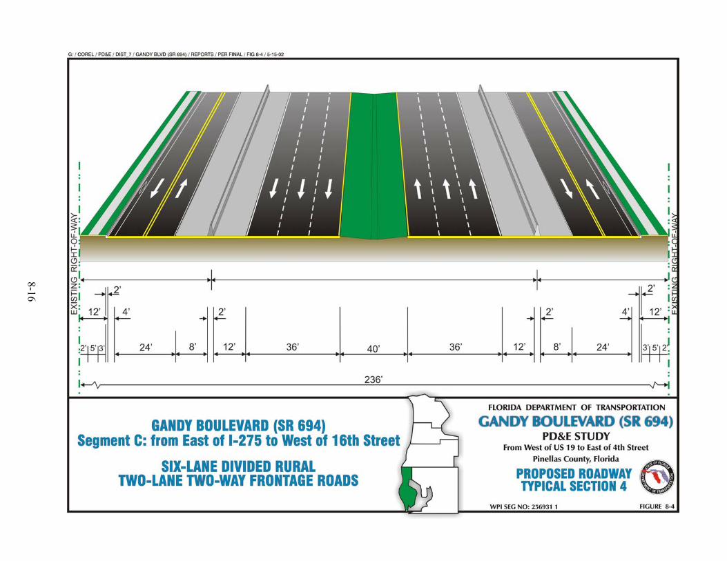
8-16

8-17 F:\COMMON\PDE\PROJECTS\GANDY\REPORTS\PER_Final\Final PER.doc
As indicated in the Design Traffic Memorandum3, an interchange modification is needed by
the design year 2025 for the I-275 interchange in order to make the interchange fully
accessible. The modification includes removing the signalized at-grade intersection between
the northbound I-275 off-ramp and Gandy Boulevard (SR 694). The northbound I-275 to
westbound Gandy Boulevard (SR 694) movement would be accomplished via a flyover
connecting the existing northbound I-275 off-ramp with the existing southbound I-275
off-ramp to westbound Gandy Boulevard (SR 694). These modifications to the I-275/Gandy
Boulevard (SR 694) interchange do not require an Interchange Modification Report (IMR)
since the access points on I-275 do not change.
Two additional movements were evaluated. The first movement included a new ramp from
westbound Gandy Boulevard (SR 694) to northbound I-275. The second movement included
a new ramp connecting southbound I-275 to eastbound Gandy Boulevard (SR 694). These
additional movements would require redesigning the entire interchange due to existing ramp
conflicts and ROW impacts. This would require an IMR. The Design Traffic
Memorandum3 recommended not adding these two new additional movements for two
reasons. First, the traffic volumes for those movements do not warrant the additional ramps.
Second, the movements created by adding westbound Gandy Boulevard (SR 694) to
northbound I-275 and southbound I-275 to eastbound Gandy are accomplished at the
I-275/Roosevelt interchange. As a result, the FDOT decided not to include the additional
ramps to make the interchange fully accessible.
Finally, as indicated in the Design Traffic Memorandum3, an overpass is needed by the
design year 2025 for the relocated 16th Street intersection. The associated proposed typical
sections are discussed in this section.
Roadway Typical Sections
Proposed Roadway Typical Section 4 (Figure 8-4) between I-275 and 16th Street and
Proposed Roadway Typical Section 5 (Figure 8-5) between 16th Street and 9th Street were
evaluated for Segment C along Gandy Boulevard (SR 694). Proposed Roadway Typical
Section 4 contains three 12 ft. travel lanes in each direction, as well as frontage roads with
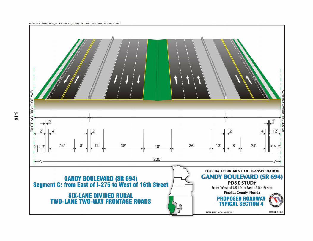
8-18

8-19

8-20 F:\COMMON\PDE\PROJECTS\GANDY\REPORTS\PER_Final\Final PER.doc
two 12 ft. travel lanes in each direction, 5 ft. sidewalks and a 4 ft. bicycle lane along both
sides of the roadway. The existing two-way frontage roads were revised to include the bike
lane, sidewalks, curb and gutter, shoulders, and standard lane widths. From the beginning of
Segment C (west of I-275) to the east of I-275, the six-lane divided rural section continues
under I-275 while the frontage roads terminate at I-275.
Proposed Roadway Typical Section 5 contains two 12 ft. travel lanes in each direction as
well as frontage roads with two 12 ft. travel lanes in one direction as a one-way loop, 5 ft.
sidewalks and a 4 ft. bicycle lane along the outside of the roadway. The proposed design
speed for this typical section is 60 mph for mainline and 50 mph for frontage roads and
requires a ROW width of up to 236 ft.
Bridge Typical Sections
The east/west overpass for Gandy Boulevard (SR 694) over 16th Street will require the
evaluation of a six-lane bridge typical section along Gandy Boulevard (SR 694). Proposed
Bridge Typical Section 6 (Figure 8-6) were evaluated for Segment C along Gandy Boulevard
(SR 694) over 16th Street. This typical section is a six-lane divided urban bridge section with
a 40 ft. median. The required median width of 40 ft. is used to accommodate two 12 ft.
median shoulders and open median space that are needed through the overpass area. A
transition area is not required for the median width between the roadway and bridge sections
because full width shoulders are utilized for both the roadway and bridge typical sections.
This typical section contains three 12 ft. travel lanes in each direction.
Proposed Bridge Typical Section 7 (Figure 8-7) has been evaluated for the single-lane
flyover from I-275 northbound to Gandy Boulevard (SR 694) westbound. This typical
section contains a single 15 ft. lane with 6 ft. inside and outside shoulders; however, the
minimum values may change if on a horizontal curve. The proposed design speed for these
typical sections is 60 mph.
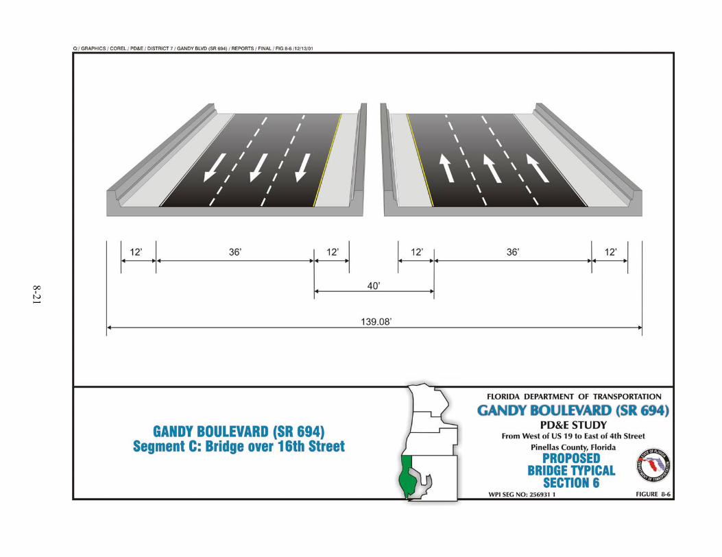
8-21

8-22

8-23 F:\COMMON\PDE\PROJECTS\GANDY\REPORTS\PER_Final\Final PER.doc
8.3.7 Segment D
The limits of Segment D are along Gandy Boulevard (SR 694) from west of 9th Street to east
of 4th Street. The existing typical section (Figure 4-7) is a divided four-lane roadway with
open drainage ditches on both sides of the roadway. The existing ROW width varies
between 220 ft. to 520 ft. The existing land use in this section is a mix of commercial and
residential use.
As indicated in the Design Traffic Memorandum3, interchanges are needed by the design
year 2025 for the intersections of Gandy Boulevard (SR 694)/9th Street, Gandy Boulevard
(SR 694)/Roosevelt Boulevard, and Gandy Boulevard (SR 694)/4th Street. These
interchanges are located within this project segment and have been evaluated for east/west
overpasses. The associated proposed typical sections are discussed in this section.
Roadway Typical Section
Proposed Roadway Typical Section 5 (Figure 8-5), previously discussed in Segment C, was
also be evaluated for Segment D along Gandy Boulevard (SR 694). This proposed typical
section is a four-lane divided section with drainage swales within a median which varies
from 40 ft. to 64 ft. This typical section contains two 12 ft. travel lanes in each direction.
The typical section also includes frontage roads with two 12 ft. travel lanes in each direction
as a one-way loop, 5 ft. sidewalks and a 4 ft. bicycle lane along both sides of the roadway.
The proposed design speed for this typical section is 60 mph and requires a ROW width
which varies from 222 ft. to 236 ft.
Bridge Typical Section
The east/west overpasses require a four-lane bridge typical section along Gandy Boulevard
(SR 694). Proposed Bridge Typical Section 8 (Figure 8-8) was evaluated for Segment D
along Gandy Boulevard (SR 694) over 9th Street, Roosevelt Boulevard, and 4th Street. This
typical section is a four-lane divided urban bridge section with a 64 ft. median and barriers.
The required median width of 64 ft. accommodates median shoulders and allows the addition
8-23

8-24

8-25 F:\COMMON\PDE\PROJECTS\GANDY\REPORTS\PER_Final\Final PER.doc
of one lane in each direction beyond the PD&E Study’s design year. A transition area is not
required for the median width between the roadway and bridge sections. This typical section
contains two 12 ft. travel lanes in each direction. The proposed design speed for this typical
section is 60 mph. A north/south overpass was not analyzed for this section.
8.4 RECOMMENDED ALTERNATIVE
The Design Traffic Memorandum3 found unacceptable levels of service in the corridor under
existing conditions for both the AM and PM peak hours. Of the nine intersections studied,
only one currently operates at the LOS standard of D or better in both the AM and PM peak
hour. Arterial analysis of the corridor revealed that the overall segment of Gandy Boulevard
(SR 694) from US 19 to 4th Street currently meets or exceeds the acceptable LOS D only in
the PM eastbound direction with exceptions in two segments (LOS E & F). Close signal
spacing near 4th Street, combined with significant traffic volumes, currently results in long
delays and a large number of traffic accidents. Furthermore, the increase of the land
use development in the area and therefore the increase in traffic volumes along the corridor
continue, especially in the Gateway area. For these reasons, the City of St. Petersburg, local
residents/businesses, and FDOT have identified Gandy Boulevard (SR 694) as a regionally
significant corridor in need of improvement.
Three possible alternatives for improving this corridor were examined for the design year
(2025). These include a No-Build Alternative, a Build – At Grade Alternative, and a Build -
Grade Separation Alternative. Analysis of the No-Build Alternative revealed that every
signalized intersection in the corridor except for one will operate at LOS F in 2025. Most of
the ramp merge and diverge areas will also fail. Arterial analysis of this alternative
indicated that the corridor will operate at LOS F in both the eastbound and westbound
directions in both the AM and PM peak hour under this alternative.
The two Build Alternatives yielded improvements in the LOS for the corridor. Under the
Build – At Grade Alternative, most of the ramp merge and diverge areas operate at a
satisfactory LOS in 2025. The signalized intersections analysis indicated some improvement
in LOS under this alternative, but six of the study intersections still fail to meet the LOS D

8-26 F:\COMMON\PDE\PROJECTS\GANDY\REPORTS\PER_Final\Final PER.doc
standard for the AM peak hour, the PM peak hour, or both peak hours. Arterial analyses
revealed an improvement with the corridor as a whole meeting the LOS D standard in both
the eastbound and westbound directions in the AM peak hour, but failing in the PM peak
hour.
The most significant improvement in LOS was produced by the Build – Grade Separation
Alternative. Under this alternative, the majority of ramp merge and diverge areas operate at
or better than the LOS D standard in 2025. The results of the Highway Capacity Software
(HCS) analysis for signalized intersections indicated that all intersections except for one
meet the LOS D standard in both the AM and PM peak hour in design year 2025. Analysis
of the roadway segments revealed that three of the five roadway segments analyzed meet or
exceed the LOS D in both the AM and PM peak hour.
Interim analysis was also performed in order to determine how long the at grade
improvements would be effective at each intersection. This analysis revealed that at grade
improvements would be effective throughout the entire study period for four of the
intersections. This analysis was not performed for the intersection of Gandy Boulevard
(SR 694) and US 19 as any improvements to this intersection would be grade separated.
This portion of Pinellas County remains at the core of the long-term economic development
potential of the county. To support and enhance economic development in the area, the key
intersections in the corridor need improvements to relieve the congestion. Analysis of three
alternatives for the future of this corridor revealed that the Build - Grade Separation
Alternative would be most effective at addressing this issue.
The Design Traffic Memorandum3 projects that overpasses are needed at the intersections of
Grand Avenue and 16th Street. Also, the Design Traffic Memorandum3 projects that a split
diamond interchange is needed by the design year 2025 for the intersections of 4th Street and
9th Street, while Roosevelt Boulevard remains as an at-grade intersection. Finally, the
Design Traffic Memorandum3 projects that a flyover is needed for the northbound I-275 to
westbound Gandy Boulevard (SR 694) movement. Since each project segment was unique
8-27 F:\COMMON\PDE\PROJECTS\GANDY\REPORTS\PER_Final\Final PER.doc
and required the analysis of different typical sections, the project segments were used to
define the proposed typical sections for the Gandy Boulevard (SR 694) Corridor analysis.
8.4.1 Segment A - Recommended Alternative
The PD&E Recommended Alternative provides a six-lane divided controlled access facility
with two-lane one-way off-ramps along the corridor between US 19 and Grand Avenue.
Access between the off-ramps and the expressway is provided by an on-ramp for eastbound
Gandy Boulevard (SR 694) and an on-ramp for westbound Gandy Boulevard (SR 694)
(Figure 8-9). Traffic traveling eastbound on Gandy Boulevard (SR 694) will access Grand
Avenue via an inside drop-ramp (Figure 8-10).
The Recommended Alternative developed in the MIS1 included a four-lane freeway with
frontage roads and a four-lane overpass with ramps at US 19. The PD&E Recommended
Alternative in this section includes a six-lane freeway with off-ramps and a four-lane
overpass with ramps at US 19. The MIS1 and the PD&E both included a four-lane overpass
with ramps at US 19; however, the PD&E Recommended Alternative includes a six-lane
section for the rest of Segment A compared to a four-lane section proposed in the MIS1.
A CORSIM analysis was run and confirmed that the six-lane section would accommodate
the traffic at an acceptable LOS for design year 2025 conditions.
8.4.2 Segment B - Recommended Alternative
The PD&E Recommended Alternative provides a six-lane divided controlled access facility
with two-lane one-way off-ramps and two-lane two-way frontage roads along the corridor
between Grand Avenue and I-275. Access between the frontage roads and Gandy Boulevard
(SR 694) is not provided. Traffic traveling westbound on Gandy Boulevard (SR 694) will
access Grand Avenue and US 19 via an off-ramp prior to Grand Avenue (Figure 8-11).
Traffic on Grand Avenue will access Gandy Boulevard (SR 694) westbound via the one-way
off-ramp to the on-ramp west of Grand Avenue (Figure 8-12). Traffic on Grand Avenue will
access Gandy Boulevard (SR 694) eastbound via the one-way off-ramp to US 19, make a
u-turn at US 19 and head east on the one-way off-ramp to the Gandy Boulevard (SR 694)

8-28

8-29

8-30

8-31

8-32 F:\COMMON\PDE\PROJECTS\GANDY\REPORTS\PER_Final\Final PER.doc
eastbound on-ramp (Figure 8-13). Traffic on Grand Avenue will access I-275 northbound
and southbound via a two-lane one-way off-ramp (Figure 8-14). Traffic on northbound and
southbound I-275 will access US 19 and Grand Avenue via a two-lane one-way off-ramp
(Figure 8-15). Traffic traveling eastbound on Gandy Boulevard (SR 694) will access
northbound and southbound I-275 via an off-ramp prior to the I-275 interchange (Figure
8-16).
The Recommended Alternative developed in the MIS1 included a four-lane freeway with
frontage roads and a four-lane overpass at Grand Avenue. The PD&E Recommended
Alternative in this segment includes a six-lane freeway with frontage roads, off-ramps and a
six-lane overpass at Grand Avenue. The MIS1 and the PD&E both included an overpass at
Grand Avenue and frontage roads; however, the PD&E Recommended Alternative includes
a six-lane section for all of Segment B, plus off-ramps, and access to both Gandy Boulevard
(SR 694) and I-275 compared to a four-lane section without off-ramps proposed in the MIS1.
A CORSIM analysis was run and confirmed that the six-lane section with selective direct
access and indirect access to both Gandy Boulevard (SR 694) and I-275 would accommodate
the traffic at an acceptable LOS for design year 2025 conditions.
8.4.3 Segment C - Recommended Alternative
The PD&E Recommended Alternative provides a six-lane divided controlled access facility
with two-lane two-way frontage roads along the corridor between I-275 and 16th Street on
the north and south side of Gandy Boulevard (SR 694), two-lane one-way frontage roads on
the north side between 16th Street and 9th Street, and two-lane two-way frontage roads on the
south side between 16th Street and 9th Street. Access between the frontage roads and Gandy
Boulevard (SR 694) is not provided between I-275 and 16th Street. Access between the
frontage roads and Gandy Boulevard (SR 694) is provided between 16th Street and 9th Street
via an on-ramp for westbound Gandy Boulevard (SR 694) (Figure 8-17). Traffic traveling
eastbound on Gandy Boulevard (SR 694) will access 16th Street via an off-ramp prior to 9th
Street and make a u-turn at 9th Street onto a two-lane one-way frontage road to 16th Street
(Figure 8-18). Traffic traveling westbound on Gandy Boulevard (SR 694) will access 16th
Street via an off-ramp prior to 4th Street onto a two-lane one-way frontage road to 16th Street

8-33

8-34

8-35

8-36
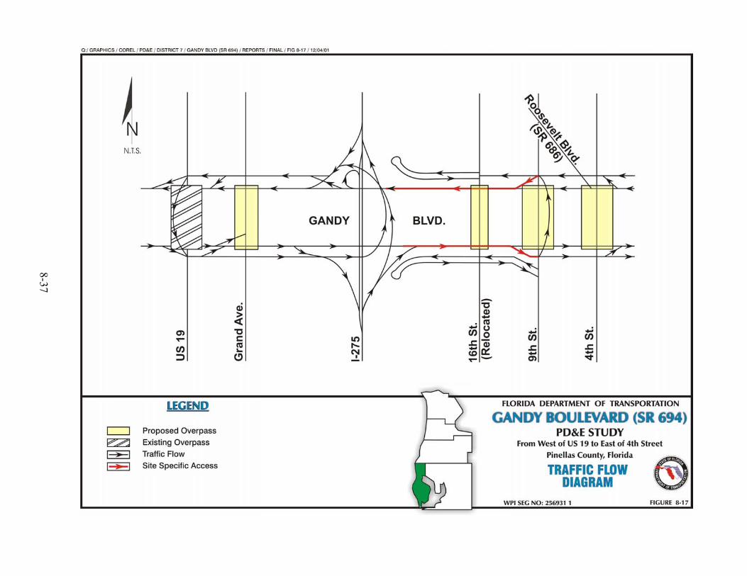
8-37

8-38

8-39 F:\COMMON\PDE\PROJECTS\GANDY\REPORTS\PER_Final\Final PER.doc
(Figure 8-19). Traffic traveling on 16th Street will access Gandy Boulevard (SR 694)
eastbound by traveling on the eastbound two-lane two-way frontage road to 9th Street, then
up to the eastbound two-lane one-way frontage road through 4th Street to the on-ramp (Figure
8-20). Traffic on 16th Street will access Gandy Boulevard (SR 694) westbound by traveling
eastbound on the two-lane two-way frontage road to 9th Street, then north on 9th Street to the
westbound two-lane one-way frontage road to the on-ramp (Figure 8-21). Traffic on
southbound I-275 will access US 19 and Grand Avenue via an off-ramp to a two-lane one-
way westbound collector road (Figure 8-22). Traffic on northbound I-275 will access US 19
and Grand Avenue via a new fly-over to a two-lane one-way westbound collector road
(Figure 8-23). Traffic on southbound I-275 will access westbound Gandy Boulevard
(SR 694) via an on-ramp (Figure 8-24). Traffic on northbound I-275 will access eastbound
Gandy Boulevard (SR 694) via an on-ramp (Figure 8-25).
The Recommended Alternative developed in the MIS1 included a four-lane freeway with
frontage roads and a four-lane overpass at 16th Street. The PD&E Recommended Alternative
in this segment includes a six-lane freeway with frontage roads and a six-lane overpass at
16th Street. The MIS1 and the PD&E both included an overpass at 16th Street and frontage
roads; however, the PD&E Recommended Alternative includes a six-lane section for all of
Segment C, and two-way frontage roads compared to a four-lane section with one-way
frontage roads proposed in the MIS1. A CORSIM analysis was run and confirmed that the
six-lane section with selective direct and indirect access to both Gandy Boulevard (SR 694)
and 16th Street would accommodate the traffic at an acceptable LOS for design year 2025
conditions.
8.4.4 Segment D – Recommended Alternative
The PD&E Recommended Alternative provides a four-lane divided controlled access facility
with two-lane one-way frontage roads along the corridor between 9th Street and east of 4th
Street. Access between the frontage roads and Gandy Boulevard (SR 694) is provided via an
on-ramp to eastbound Gandy Boulevard (SR 694) east of 4th Street and an off-ramp from
westbound Gandy Boulevard (SR 694) east of 4th Street (Figure 8-26). Traffic traveling
westbound on Gandy Boulevard (SR 694) will access 4th Street and 9th Street via an off-ramp

8-40

8-41
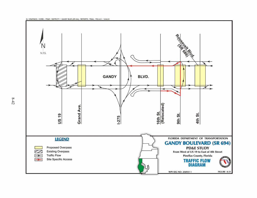
8-42

8-43

8-44

8-45

8-46

8-47

8-48 F:\COMMON\PDE\PROJECTS\GANDY\REPORTS\PER_Final\Final PER.doc
prior to 4th Street onto a two-lane one-way frontage road to 4th Street or 9th Street (Figure
8-27). Traffic traveling eastbound on Gandy Boulevard (SR 694) will access 9th Street and
4th Street via an off-ramp prior to 9th Street onto a two-lane one-way frontage road to 9th or
4th Street (Figure 8-28).
The Recommended Alternative developed in the MIS1 included a four-lane freeway with
one-way frontage roads and four-lane overpasses at 9th Street and 4th Street with ramps. The
PD&E Recommended Alternative in this segment includes a four-lane freeway with one-way
frontage roads and four-lane overpasses at 9th Street and 4th Street with ramps. The MIS1 and
the PD&E both included a four-lane roadway and four-lane overpasses at 9th Street and 4th
Street and one-way frontage roads with ramps. A CORSIM analysis was run and confirmed
that the four-lane section with selective direct access and indirect access to Gandy Boulevard
(SR 694), 9th Street, and 4th Street would accommodate the traffic at an acceptable LOS for
design year 2025 conditions.

8-49

8-50

8-51 F:\COMMON\PDE\PROJECTS\GANDY\REPORTS\PER_Final\Final PER.doc
8.5 MATRIX
Table 8-1 Evaluation Matrix -Recommended Alternative
SEGMENTS
EVALUATION FACTORS * A B C D TOTAL
BUSINESS AND RESIDENTIAL RELOCATIONS
Number of businesses estimated to be relocated 2 0 1 1 4 Number of residences estimated to be relocated 7 0 0 1 8
COMMUNITY FACILITY INVOLVEMENT
Community Facilities 0 0 0 0 0
NOISE SENSITIVE SITES
Number of noise sensitive sites affected 47 0 0 21 68
CULTURAL/HISTORIC RESOURCES AND PUBLIC PARKS INVOLVEMENT
Number of historic sites/structures within or adjacent to ROW 0 0 0 0 0 Number of public parks within ROW 0 0 0 0 0
NATURAL ENVIRONMENT INVOLVEMENT
Estimated total wetland involvement area in acres 1.12 2.29 0.42 5.97 9.80
FLOODPLAIN AND FLOODWAY ENCROACHMENT
Area of base floodplain and floodway encroachment in acres 0 0 0 0 0 POTENTIAL PETROLEUM POLLUTANT AND HAZARDOUS MATERIAL CONTAMINATED SITES (within or adjacent to ROW) Number of potential petroleum pollutant contaminated sites 1 0 0 3 4 Number of potential hazardous material contaminated sites 0 0 0 0 0
ESTIMATED PROJECT COSTS (Present value in million $)
Design cost $2.17 $3.04 $3.12 $4.24 $12.57 ROW acquisition cost $13.20 $1.75 $9.38 $6.86 $31.19 Construction cost $14.43 $20.24 $20.77 $28.27 $83.71 Construction engineering and inspection cost $2.17 $3.04 $3.12 $4.24 $12.57
TOTAL COST $31.97 $28.07 $36.39 $43.61 $140.04
* Includes Preferred Ponds

8-52 F:\COMMON\PDE\PROJECTS\GANDY\REPORTS\PER_Final\Final PER.doc
8.6 DESIGN CHANGES TO THE RECOMMENDED BUILD ALTERNATIVE
8.6.1 Segment C - Recommended Alternative
Following the Public Hearing, the PD&E Recommended Alternative for Segment C was
revised. The design changes include an on-ramp from 16th Street to westbound Gandy
Boulevard
(SR 694). Additional changes were made at the 9th Street interchange. The lane
configuration at the interchange is as follows:
• Three southbound through lanes and a single left turn lane, (to provide an
additional southbound through lane).
• Two northbound through lanes and dual left turn lanes, (additional left turn
lanes).
The PD&E Recommended Alternative provides a six-lane divided controlled access facility
with two-lane two-way frontage roads along the corridor between I-275 and 16th Street on
the north and south side of Gandy Boulevard (SR 694), two-lane one-way frontage roads
between 16th Street and 9th Street on the north side of Gandy Boulevard (SR 694), and two-
lane two-way frontage roads between 16th Street and 9th Street on the south side of Gandy
Boulevard (SR 694). Local access between the frontage roads and Gandy Boulevard
(SR 694) will be provided between 16th Street and 9th Street via an off-ramp from eastbound
Gandy Boulevard (SR 694) and an on-ramp to westbound Gandy Boulevard (SR 694) from
16th Street (Figure 8-17). Traffic traveling eastbound on Gandy Boulevard (SR 694) will
access 16th Street via an off-ramp prior to 9th Street and make a u-turn at 9th Street onto a
two-lane one-way frontage road to 16th Street (Figure 8-18). Traffic traveling westbound on
Gandy Boulevard (SR 694) will access 16th Street via an off-ramp prior to 4th Street onto a
two-lane one-way frontage road. Traffic will cross 4th Street, Roosevelt Boulevard, and
9th Street before reaching 16th Street (Figure 8-19). Traffic traveling on 16th Street will
access Gandy Boulevard (SR 694) eastbound by traveling on the eastbound two-lane two-
way frontage road to 94th Avenue, turn left (north) on 9th Street. Traffic will then turn right
8-53 F:\COMMON\PDE\PROJECTS\GANDY\REPORTS\PER_Final\Final PER.doc
onto the eastbound two-lane one-way frontage road, through 4th Street, to the on-ramp
(Figure 8-20). Traffic on 16th Street will access Gandy Boulevard (SR 694) westbound by
traveling north or south on 16th Street to the on-ramp (Figure 8-29). Traffic on southbound
I-275 will access US 19 and Grand Avenue via an off-ramp to a two-lane one-way
westbound collector road (Figure 8-22). Traffic on northbound I-275 will access US 19 and
Grand Avenue via a new fly-over to a two-lane one-way westbound collector road (Figure
8-23). Traffic on southbound I-275 will access westbound Gandy Boulevard (SR 694)
via an on-ramp (Figure 8-24). Traffic on northbound I-275 will access eastbound Gandy
Boulevard (SR 694) via an on-ramp (Figure 8-25).
The Recommended Alternative developed in the MIS1 included a four-lane freeway with
frontage roads and a four-lane overpass at 16th Street. The PD&E Recommended Alternative
in this segment includes a six-lane freeway with frontage roads and a six-lane overpass at
16th Street. The MIS1 and the PD&E both included an overpass at 16th Street and frontage
roads; however, the PD&E Recommended Alternative includes a six-lane section for all of
Segment C, and two-way frontage roads compared to a four-lane section with one-way
frontage roads proposed in the MIS1. A CORSIM analysis was run and confirmed that the
six-lane section with selective direct and indirect access to both Gandy Boulevard (SR 694)
and 16th Street would accommodate the traffic at an acceptable LOS for design year 2025
conditions. Additionally, CORSIM analysis was run and confirmed that 9th Street will
accommodate the traffic at an acceptable LOS for design year 2025.

8-54

8-55 F:\COMMON\PDE\PROJECTS\GANDY\REPORTS\PER_Final\Final PER.doc
8.7 REFERENCES
1. Major Investment Study; Florida Department of Transportation; 2001.
2. Draft Evaluation Report; Florida Department of Transportation; 1998.
3. Design Traffic Memorandum; Gannett Fleming, Inc.; May 2002.

9-1 F:\COMMON\PDE\PROJECTS\GANDY\REPORTS\PER_Final\Final PER.doc
SECTION 9
PRELIMINARY DESIGN ANALYSIS
After selecting a Recommended Alternative, the next step in the study process was to
define/refine the design parameters associated with that choice, including intersection design,
drainage design, and maintenance of traffic during construction. The defining of these
parameters allows for a more comprehensive and accurate evaluation of project impacts and
costs.
9.1 DESIGN TRAFFIC VOLUMES
The average annual daily and directional design hour traffic volumes, AADT and DDHV
respectively, were discussed previously in Section 6 of this report. Based on the DDHV and
after consideration of the existing turning movements and the impacts of future
developments on traffic flow, design hour traffic volumes were developed for the signalized
and major unsignalized intersections along the project. Figures 6-9 (a and b) through 6-12 (a
and b) depict the design hour volumes.
9.2 TYPICAL SECTIONS
9.2.1 Recommended Alternative
Segment A
The limits of Segment A are along Gandy Boulevard (SR 694) from west of US 19 to west of
Grand Avenue. The Proposed Roadway Typical Section 1 for Segment A was previously
discussed in Section 8.3.4 and shown in Figure 8-1.

9-2 F:\COMMON\PDE\PROJECTS\GANDY\REPORTS\PER_Final\Final PER.doc
Segment B
The limits of Segment B are along Gandy Boulevard (SR 694) from west of Grand Avenue
to west of I-275. The Proposed Roadway Typical Section 2 and Proposed Bridge Typical
Section 3 for Segment B were previously discussed in Section 8.3.5 and shown in Figure 8-2
and Figure 8-3.
Segment C
The limits of Segment C are along Gandy Boulevard (SR 694) from west of I-275 to west of
9th Street. The Proposed Roadway Typical Section 4, Proposed Roadway Typical Section 5,
Proposed Bridge Typical Section 6, and Proposed Bridge Typical Section 7 for Segment C
were previously discussed in Section 8.3.6 and shown in Figures 8-4 through 8-7.
Segment D
The limits of Segment D are along Gandy Boulevard (SR 694) from west of 9th Street to east
of 4th Street. The Proposed Roadway Typical Section 5 and Proposed Bridge Typical Section
8 for Segment D were previously discussed in Section 8.3.7 and shown in Figure 8-5 and
Figure 8-8.
9.3 INTERSECTION CONCEPTS AND SIGNAL ANALYSIS
The Design Traffic Memorandum1 illustrates the recommended intersection lane geometry.
The Design Traffic Memorandum1 also provides detailed information about the operation of
each signalized intersection during the design hour and the expected average vehicle-queue
lengths. As shown in Table 6.14, during the design year 2025, with the recommended lane
geometry, all signalized intersections in the study area are expected to provide overall LOS
D or better, with the exception of 66th Street, which will operate at LOS E.

9-3 F:\COMMON\PDE\PROJECTS\GANDY\REPORTS\PER_Final\Final PER.doc
9.4 ALIGNMENT AND RIGHT-OF-WAY NEEDS
Appendix A includes aerial photography illustrating the Recommended Alternative for the
project and the anticipated roadway ROW needs. As shown, the proposed roadway
improvements are primarily accommodated within the existing ROW width.
9.5 RELOCATIONS
There is a possibility of four business and eight residential relocations.
9.6 RIGHT-OF-WAY COSTS
The estimated ROW acquisition costs by segment for the Recommended Alternative were
presented earlier in Table 8-1. These costs included ROW acquisitions for improving the
roadway facility along Gandy Boulevard (SR 694) from west of US 19 to east of 4th Street,
and ROW for ponds. As shown in Table 8-1, the total estimated ROW acquisition cost is
$31.19 million. The ROW costs were determined using 2000 dollars.
9.7 CONSTRUCTION COST
Table 8-1 includes the estimated construction costs by project segment for the
Recommended Alternative. These costs were calculated with the use of the FDOT’s Long
Range Estimates (LRE) computer program method. As shown, the estimated total
construction cost for the roadway and bridge construction is $83.71 million, and were
generated using 2000 dollars.
9.8 PRELIMINARY ENGINEERING AND CONSTRUCTION
ENGINEERING COSTS
The cost of engineering (final design) and the cost of Construction, Engineering and
Inspection (CEI) were estimated as 15% each of the estimated $83.71 million construction

9-4 F:\COMMON\PDE\PROJECTS\GANDY\REPORTS\PER_Final\Final PER.doc
cost. Therefore, these efforts are expected to cost approximately $12.57 million each for a
total of $25.14 million.
9.9 RECYCLING OF SALVAGEABLE MATERIALS
During construction of the project, recycling of re-usable materials will occur to the greatest
extent possible. Where possible, removal and recycling of the existing pavement for use in
the new pavement will be considered. This helps to reduce the volume of the materials that
need to be hauled and disposed of away from the project and reduces the cost of purchasing
materials suitable for pavement construction. Other materials such as signs, drainage
concrete pipes, etc., will also be salvaged and re-used for regular maintenance operations if
they are deemed to be in good condition.
9.10 USER BENEFITS
The public will realize numerous benefits after the Recommended Alternative is constructed.
Savings in travel time, reduced vehicle operating costs, reduced traffic accident-related
costs, and reduced emergency response times are the main benefits. Access to schools and
community facilities, as well as the numerous commercial establishments and residences,
will be enhanced. The creation of a motorist-friendly facility will contribute to the economic
growth of the area adjacent to the project.
9.11 PEDESTRIAN AND BICYCLE FACILITIES
As noted in section 8.3, the proposed typical section in segments A, B, C, and D will provide
5 ft. wide sidewalks and 4 ft. wide bicycle lanes (or a paved shoulder serving as an
undesignated bicycle lane along the frontage roads). Other facilities such as crosswalks and
public sidewalk curb ramps at intersections will be designed to meet the Americans with
Disabilities Act (ADA). The Florida Power Trail, a multi-lane trail, is currently planned in
the vicinity of Gandy Boulevard (SR 694).

9-5 F:\COMMON\PDE\PROJECTS\GANDY\REPORTS\PER_Final\Final PER.doc
9.12 SAFETY
The proposed improvements will upgrade this portion of Gandy Boulevard (SR 694) to a
safer and more efficient transportation facility. The increased roadway capacity is expected
to result in less congestion and therefore, reduces the probability for accidents. The design
and alignment of the roadway will meet applicable safety standards. Adherence to design
speed as it applies to establishing and setting minimum values on critical roadway design
features will be closely followed. Roadway design elements including curvature, sight
distance, width and clearance will meet the applicable minimum roadway design standards.
Access control techniques to promote safe and efficient traffic circulation will also be used.
9.13 ECONOMIC AND COMMUNITY DEVELOPMENT
As previously presented in Section 3, the Pinellas County Comprehensive Plan2 and the
Pinellas County MPO 2020 Long Range Transportation Plan3, as well as the Cities of Largo
and Pinellas Park comprehensive plans call for improvements along Gandy Boulevard
(SR 694). These plans were developed after thorough evaluation of the future population and
development growth in the region of the project. The proposed Gandy Boulevard (SR 694)
improvements, developed through the process previously described in Section 8, respond to
and fully accommodate the projected year 2025 traffic demand to the maximum extent
feasible.
9.14 ENVIRONMENTAL EFFECTS
9.14.1 Land Use Data
9.14.1.1 Community Facilities and Established Land Uses
Community facilities provide a focal point for adjacent neighborhoods and communities, as
well as serving the needs of surrounding areas. For the purpose of this study, community
facilities included churches and other religious institutions, parks and recreation areas, other

9-6 F:\COMMON\PDE\PROJECTS\GANDY\REPORTS\PER_Final\Final PER.doc
neighborhood gathering places, fire stations, police stations, public and private schools,
medical and emergency treatment facilities, cemeteries, and public buildings and facilities.
Community services located along the project corridor include the Royal Palm Cemetery and
Funeral Chapel, the First Baptist Church of St. Petersburg, a U.S. Post Office and a
cemetery. It is anticipated that there will be minor access changes to the First Baptist Church
in order to improve safety conditions and traffic circulation. Information for mapping the
community facilities in the project vicinity was derived from on-site observation and
conversations with county staff. No other disruption to community services is expected.
The existing land uses adjacent to the Gandy Boulevard (SR 694) Corridor are a mix of
residential, commercial, office, and light industrial/warehouses. The proposed project is
consistent with future land use plans. Future land uses are expected to follow the established
trends.
9.14.2 Community Cohesion
The project involves expansion of an existing four-lane facility with limited expected ROW
acquisition. No splitting or isolation of neighborhoods or any particular ethnic group will
occur. The project is not anticipated to harm elderly persons, handicapped individuals, non-
drivers and transit dependent individuals, or minorities. It is anticipated that the project
improvements will not impact community cohesiveness.
Therefore, the proposed improvements are being developed to comply with Executive
Order 12898, Environmental Justice, issued on February 11, 1994. The proposed
improvements are considered to have no effect on community cohesiveness.
9.14.3 Cultural Features
A Final Cultural Resources Assessment Report4 (CRAS) was prepared as part of this PD&E
Study. The findings of the Final CRAS4 are incorporated by reference into this Report.

9-7 F:\COMMON\PDE\PROJECTS\GANDY\REPORTS\PER_Final\Final PER.doc
9.14.4 Wetland Impact and Mitigation
A Final Wetland Evaluation Report5 (WER) was prepared as part of this PD&E Study. The
findings of the Final WER5 are incorporated by reference into this Report.
9.14.5 Threatened and Endangered Species
A Final Endangered Species Evaluation Report6 (ESER) was prepared as part of this PD&E
Study. The findings of the Final ESER6 are incorporated by reference into this Report.
9.14.6 Potential Hazardous Materials and Petroleum Products Contaminated
Sites
A Final Contamination Screening Evaluation Report7 (CSER) was prepared as part of this
PD&E Study. The findings of the Final CSER7 are incorporated by reference into this
Report.
9.14.7 Noise Impacts
A Final Noise Report8 was prepared as part of this PD&E Study. The findings of the Final
Noise Report8 are incorporated by reference into this Report.
9.14.8 Air Quality Impacts
A Final Air Quality Report9 was prepared as part of this PD&E Study. The findings of the
Air Quality Report9 are incorporated by reference into this Report.

9-8 F:\COMMON\PDE\PROJECTS\GANDY\REPORTS\PER_Final\Final PER.doc
9.14.9 Water Quality Impacts
No adverse impacts to water quality are anticipated. The proposed stormwater facility
design will include, at a minimum, the water quality requirements for water quality impacts
as required by the SWFWMD in Chapter 373, F.S., and Rules 40E-1, 40E-4, and 40E-40
F.A.C. Therefore, no further mitigation for water quality impacts will be needed. A water
Quality Impact Evaluation (WQIE) was completed for this project.
The impacts of the proposed project on the surface water quality will essentially be limited to
the effects of erosion during construction. These impacts are considered temporary and will
be minimized by strict adherence to Section 104 of the FDOT Standard Specifications for
Road and Bridge Construction10.
9.14.10 Aquatic Preserves
All of Pinellas County is designated as a State Aquatic Preserve and as such is designated as
Outstanding Florida Waters (OFW). The project’s Stormwater Management Facilities
(SMF) sites have been evaluated assuming the facilities discharge directly to OFW and
treatment of one inch of runoff for facilities not discharging directly to OFW.
9.14.11 Section 4(f) Lands
In accordance with Section 4(f) of the DOT Act of 1966 (Title 49, U.S.C., Section 1653 (f),
amended and recodified in Title 49, U.S.C., Section 303, in 1983), the project was examined
for possible Section 4(f) properties. It was determined that this project does not involve, nor
will affect, any Section 4(f) properties.

9-9 F:\COMMON\PDE\PROJECTS\GANDY\REPORTS\PER_Final\Final PER.doc
9.14.12 Outstanding Florida Waters
See Section 9.14.10.
9.14.13 Floodplains
A Final Location Hydraulic Report11 (LHR) was prepared as part of this PD&E Study. The
findings of the Final LHR11 are incorporated by reference into this Report.
9.15 UTILITY IMPACTS
Several utility distribution lines are located within the existing Gandy Boulevard (SR 694)
ROW, including Florida Power Corporation, City of St. Petersburg, City of Pinellas Park,
AT&T, Pinellas County, Verizon, Paragon/Time Warner Cable, KMC Telecom III, Inc.,
Florida Gas, and Intermedia Communications of Florida, Inc. A gas transmission line owned
by Florida Power Corporation crosses Gandy Boulevard at 9th Street. In addition, there is a
power substation located at the northeast quadrant of the Gandy Boulevard interchange with
I-275. Depending on their location and depth, implementation of the recommended
improvements for the project may require adjustment of some of these facilities. A set of
plans identifying the recommended Recommended Alternative was sent by FDOT to the
utility companies to provide utility relocation costs. These costs are not included in the total
estimated project costs presented in Section 9.7, since they will be incurred by the utility
owners.
9.16 TRAFFIC CONTROL PLAN
Gandy Boulevard (SR 694) provides access to numerous residences and businesses along
this corridor. Due to its importance, Gandy Boulevard (SR 694) should remain functional
throughout the duration of the construction activities. The existing number of travel lanes
9-10 F:\COMMON\PDE\PROJECTS\GANDY\REPORTS\PER_Final\Final PER.doc
should be maintained to the maximum extent possible. Lane closures, if necessary should
occur during off-peak hours.
The following conceptual construction sequence will help maintain traffic operations along
Gandy Boulevard (SR 694):
• Relocate existing utilities within the ROW.
• Construct stormwater ponds (if ponds are proposed in these areas).
• Construct ditches and sidewalks while maintaining two-way traffic on the
existing or temporary pavement.
• Construct either the ultimate eastbound or westbound lanes (sidewalks, curb and
gutter, travel lanes) while maintaining existing two-way traffic on a combination
of the existing pavement and newly constructed or temporary pavement.
• Temporarily operate two-way traffic on the completed ultimate eastbound or
westbound lanes, while constructing the remaining ultimate travel lanes.
• Shift eastbound and westbound traffic to their respective, completed roadways.
9.17 RESULTS OF PUBLIC INVOLVEMENT PROGRAM
An updated Public Involvement Program was approved for this PD&E Study on August 22,
2000. The purpose of the program was to outline the various mechanisms and opportunities
the Department was using to inform and solicit responses from interested parties, including
local residents, public officials and agencies, and business owners. The program, which
included an Advance Notification (AN) Package; presentations to the Pinellas County
Metropolitan Planning Organization’s Citizens Advisory Committee (CAC); and Technical
Coordination Committee (TCC); the Glen Lakes Estates Homeowner’s Association; and a
Public Hearing, are summarized in the Final Comments and Coordination Report12. A brief
summary of the Public Involvement Program follows.

9-11 F:\COMMON\PDE\PROJECTS\GANDY\REPORTS\PER_Final\Final PER.doc
9.17.1 Advance Notification
An AN Package was prepared in accordance with Part 1, Chapter 2 of the FDOT PD&E
Manual13 and was transmitted to the Florida State Clearinghouse in the Governor’s Office of
Planning and Budgeting on March 30, 2000. While several agencies responded with no
comments, the following had comments: Tampa Bay Regional Planning Council (TBRPC),
Southwest Florida Water Management District (SWFWMD), Florida Department of
Community Affairs (DCA), Florida Department of State Historic Preservation Office
(SHPO), and the Florida Department of Environmental Protection (DEP). Generally, the comments indicated either no anticipated impacts, consistency with applicable
requirements, a request that standard protective measures be used, or a request for further
coordination during the project’s final engineering design phase. The full comments and
corresponding responses are included in the Final Comments and Coordination Report12.
9.17.2 Elected Official/Agency Kickoff Meeting
An Elected Official/Agency Kick-off Meeting was held on February 15, 2000, from 10:00
a.m. to 12:00 noon at the St. Petersburg City Council Chambers, 175 Fifth Street North,
St. Petersburg, Florida. The purpose of the meeting was to introduce the project to local
officials and staff and to obtain information regarding local issues and concerns. Information
presented at the meeting included graphics depicting the project location map, existing
typical section, and proposed project schedule. A brief project handout also included this
information, discussed the proposed improvements, and provided a comment sheet that could
be submitted at the meeting or by mail. A copy of the meeting materials may be found in
Appendix B of the Final Comments and Coordination Report12.
9.17.3 Newsletters / Presentations / Small Group Meetings
The FDOT issued two newsletters to elected officials, agencies, and property owners within
300 ft. of the centerline of proposed alternative throughout the course of the project.

9-12 F:\COMMON\PDE\PROJECTS\GANDY\REPORTS\PER_Final\Final PER.doc
The first was mailed in April 2001 and was introductory in nature. It acquainted the public
with the PD&E process, the project history, project description, and upcoming activities.
The second was issued in January 2002 and announced the upcoming Public Hearing,
explained the Recommended Alternative, discussed various environmental considerations,
and gave a schedule of upcoming activities.
The FDOT also gave a presentation to the Glen Lakes Estates Homeowner’s Association on
December 11, 2000. After a brief presentation on the project’s status, upcoming milestones,
and future public involvement opportunities, the FDOT answered questions regarding the
project and the PD&E process. A project Fact Sheet was distributed to attendees.
Finally, a presentation was given to the Pinellas County MPO’s CAC on February 28, 2002.
This presentation updated members on the project and gave them an overview of what would
be presented at the upcoming Public Hearing.
Follow-up presentations to present information on the Public Hearing were given to the
Pinellas MPO Technical Coordinating Committee (TCC) on May 22, 2002, to the Pinellas
MPO CAC on May 23, 2002, and to the Pinellas MPO Board on June 12, 2002.
9.17.4 Public Hearing
A Public Hearing was held on March 14, 2002, from 4:30 p.m. to 7:30 p.m. at the First
Baptist Church of St. Petersburg, Heritage Hall, 1900 Gandy Boulevard, St. Petersburg,
Florida. Elected officials, and various agency representatives were notified of the meeting
by first class mail at least 25 to 30 days prior. Per Florida Statute and the FDOT’s PD&E
Manual13, property owners within 300 ft. of any of the alternatives under study were notified
of the meeting by first class mail at least 21 days prior. The meeting was advertised in the
Florida Administrative Weekly on February 15, 2002, and in the St. Petersburg Times, South
Edition on February 21 and March 7, 2002.

9-13 F:\COMMON\PDE\PROJECTS\GANDY\REPORTS\PER_Final\Final PER.doc
The meeting consisted of an informal session and a formal session. The informal session
began at 4:30 p.m. and lasted until 6:00 p.m. During that time, the public could view a
continuously looped project video, view the conceptual plans and project documents on
display, speak to the court reporter in a one-on-one setting, or ask questions from FDOT
representatives. Project handouts and a copy of the Evaluation Matrix were available to all
attendees. At 6:00 p.m., the FDOT gave a formal presentation regarding the project and its
associated environmental effects. An opportunity to provide formal public comment
followed the presentation. The court reporter transcribed the entire formal portion.
Following the formal portion of the Hearing, the informal portion resumed until 7:30 p.m.
Conceptual alignments and project reports were available for public review prior to and after
the Hearing beginning February 21, 2002 through March 25, 2002 at the FDOT District
Seven Headquarters and at the North Branch Library, Reference Desk, 861 70th Avenue
North, St. Petersburg, Florida. Information brochures/handouts were offered to attendees at
the Public Hearing. A copy of these materials, as well as all notification materials may be
found in Appendix C of the Final Comments and Coordination Report12.
Approximately 104 people attended the Public Hearing. One person gave a statement to the
court reporter during the informal portion of the Hearing, and two spoke during the formal
portion. A total of six written comments were received either at the Public Hearing or in the
mail. Four of the comments requested that FDOT provide westbound access for Gandy
Boulevard from 16th Street, one requested a copy of the conceptual plans, and another
requested direct access for eastbound Gandy Boulevard from the Royal Palm Mobile Home
Park. As stated previously, based upon this public comment, and additional engineering
analysis, the FDOT will provide westbound access for Gandy Boulevard from 16th Street.
A copy of the Official Public Hearing Transcript may be found in Appendix D of the Final
Comments and Coordination Report12.

9-14 F:\COMMON\PDE\PROJECTS\GANDY\REPORTS\PER_Final\Final PER.doc
9.18 VALUE ENGINEERING
The Gandy Boulevard (SR 694) improvement alternative was reviewed by a Value
Engineering (VE) review team formed by FDOT staff. The review was performed from
October 29, 2001 to November 2, 2001. A Value Engineering Study14 has been prepared as
part of this PD&E Study. The findings of the Value Engineering Study14 are incorporated by
reference into this Report. Refer to Appendix C for the recommendation and course of
action.
9.19 DRAINAGE
A LHR11 has been prepared as part of this PD&E Study. The findings of the LHR11 are
incorporated by reference into this Report.
9.20 STRUCTURES
The Gandy Boulevard (SR 694) Corridor includes 10 proposed bridges between west of
US 19 to east of 4th Street.
9.21 ACCESS MANAGEMENT UNDER RECOMMENDED ALIGNMENT
In order to meet access management criteria as shown in Tables 6-2 and 6-3, an Access
Management Plan was developed for the proposed improvements. Under the recommended
alignment scenario, the mainline of Gandy Boulevard (SR 694) has no at-grade intersections
within the project limits. Consequently, access management concerns are localized at the
following interchanges with Gandy Boulevard (SR 694):
9-15 F:\COMMON\PDE\PROJECTS\GANDY\REPORTS\PER_Final\Final PER.doc
• US 19 Interchange (existing)
• Modified I-275 Interchange
• New 9th Street Interchange
• New Roosevelt Boulevard/4th Street Interchange
US 19/Gandy Boulevard (SR 694) Interchange
The new alignment for Gandy Boulevard (SR 694) does not modify the geometry at the
US 19/Gandy Boulevard (SR 694) interchange. Therefore the deficiencies listed in section
3.1.1 and Table 6-7 will still exist.
Modified I-275 Interchange
With the removal of the signalized intersection with the northbound I-275 off-ramp, no
median openings or connections will be within the influence area of the interchange.
Consequently, no access conflicts are anticipated within the interchange area.
New 9th Street Interchange
The speed limit on 9th Street both north and south of Gandy Boulevard (SR 694) is 45 mph.
The posted speed limit and the standards in section 6.3 were considered in the development
of the minimum spacing requirements in Table 9-1.

9-16 F:\COMMON\PDE\PROJECTS\GANDY\REPORTS\PER_Final\Final PER.doc
Table 9-1 Median Openings
Review of Median/Connection Opening Spacing at New 9th Street Interchange
Distance Access Description
Measured Required
Meets Interchange Access Management
Standards
Median Opening Spacing From eastbound off-ramp to first median opening south of Gandy Boulevard (SR 694)
310 ft. 1,320 ft. No
From westbound frontage road to first median opening north of Gandy Boulevard (SR 694)
580 ft. 1,320 ft. No
Connection Spacing From eastbound off-ramp to first connection south of Gandy Boulevard (SR 694) and on the west side of 9th Street
310 ft. 440 ft. No
From westbound frontage road to first connection north of Gandy Boulevard (SR 694) and on the east side of 9th Street
220 ft.
440 ft. No
New Roosevelt Boulevard/4th Street Interchange
The speed limit on 4th Street south of Gandy Boulevard (SR 694) is 40 mph. North of Gandy
Boulevard (SR 694), the speed limit on 4th Street remains at 40 mph until approximately the
first driveway connection on the east side of the roadway. North of this driveway connection
the posted speed limit is 50 mph. The posted speed limits and the standards in section 6.3
were considered in the development of the minimum spacing requirements in Table 9-2.

9-17 F:\COMMON\PDE\PROJECTS\GANDY\REPORTS\PER_Final\Final PER.doc
Table 9-2 Median Openings
Review of Median/Connection Opening Spacing at New Roosevelt Boulevard/4th Street Interchange
Distance Access Description
Measured Required
Meets Interchange Access Management
Standards
Median Opening Spacing From westbound off-ramp to first median opening north of Gandy Boulevard (SR 694)
815 ft. 1,320 ft. No
From eastbound frontage road to first median opening south of Gandy Boulevard (SR 694)
430 ft. 1,320 ft. No
Connection Spacing From westbound off-ramp to first connection north of Gandy Boulevard (SR 694) and on the east side of 4th Street
470 ft.
440 ft. Yes
From eastbound frontage road to first connection south of Gandy Boulevard (SR 694) and on the west side of 4th Street
430 ft.
440 ft. No
9.22 REGIONAL TRANSIT LOCATIONS
Provided in Section 4.1.12.
9.23 AESTHETICS AND LANDSCAPING
The placement and maintenance of any landscaping shall comply with the required clear
zone and sight distance at intersections. No other provisions or commitments were made
regarding special aesthetic features.

9-18 F:\COMMON\PDE\PROJECTS\GANDY\REPORTS\PER_Final\Final PER.doc
9.24 REFERENCES
1. Design Traffic Memorandum; Gannett Fleming, Inc.; May 2001.
2. Pinellas County Comprehensive Plan, Transportation Element; Pinellas County
Planning Department; Clearwater, Florida; Adopted February 17, 1998, Last
Amended April 21, 1999.
3. Pinellas County MPO 2020 Long Range Transportation Plan; Pinellas County MPO;
Pinellas County, Florida; December 1998, Revised May 28, 1999.
4. Final Cultural Resources Assessment Report; ACI; May 2002.
5. Final Wetland Evaluation Report; PBQD; May 2002.
5. Final Endangered Species Evaluation Report; PBQD; May 2002.
7. Final Contamination Screening Evaluation Report; PBQD; May 2002.
8. Final Draft Noise Report; PBS&J; May 2002.
9. Final Air Quality Report; PBS&J; May 2002.
10. FDOT Standard Specifications for Road and Bridge Construction; 2000.
11. Final Location Hydraulic Report; PBQD; May 2002.
12. Draft Comments and Coordination Report; PBS&J; May 2002.
13. FDOT Project Development and Environment Guidelines; 1998.
14. Value Engineering Study; FDOT; December 2001.

APPENDICES APPENDIX A Alternative Design Concepts &
Contamination Sites APPENDIX B Geopak Output
APPENDIX C Correspondence

APPENDIX A
Alternative Design Concepts & Contamination Sites

APPENDIX B
Geopak Output


APPENDIX C
Corresponden
Memorandum Date: January 15, 2002 To: Gabor Farkasfalvy From: John Cerreta, P.E. Subject: Comments to the Value Engineering Report
Work Program Item Segment No.: 256931 1 S.R. 694 (Gandy Boulevard) PD&E Study from U.S. 19 to East of 4th
Street Pinellas County
Comment: 1. Braided ramp to US 19 / Grand Avenue. The Value Engineering Team recommends that the Value Engineering Alternative be implemented. This alternative would eliminate the braided ramp by providing additional slip ramps.
If this recommendation can be implemented, there is a possible savings of $2,780,269.
Response: Removing the braided ramp and providing additional slip ramps is not
a viable option. Geometric analysis prohibits consecutive slip ramps between US 19
and Grand Avenue. Due to the close proximity of the interchanges/overpasses, the
acceleration and deceleration lengths needed for the slip ramps cannot be provided
according to the criteria in the FDOT Plans Preparation Manual PPM and AASHTO.
Without including these additional ramps, full access will not be provided; therefore,
the braided ramp will remain.
Comment: 2. Reduce number of westbound lanes. The Value Engineering Team
recommends that the Value Engineering Alternative be implemented.

This alternative would reduce the number of westbound lanes west of I-275 from three to two lanes.
If this recommendation can be implemented, there is a possible savings of $175,460.
Response: The number of westbound lanes provided in the preferred alternative
west of I-275 was dictated by the traffic analysis performed by Gannet Flemming
Inc. Therefore, the lane configuration will remain with three westbound lanes
through Grand Avenue.
Comment: 3. Retain existing pavement. The Value Engineering Team
recommends that the Value Engineering Alternative be implemented. This alternative would retain the existing pavement from the I-275 Interchange to the grade change to the proposed Frontage Road Interchange (16th Street).
If this recommendation can be implemented, there is a possible
savings of $1,049,237. Response: As long as the existing pavement and subgrade is suitable, it is
anticipated that a majority of the pavement along the existing frontage roads will be retained with improvements according to the typical section. The frontage roads will be widened and converted to a closed drainage system. However, since an overpass at 16th Street is proposed the proposed profile grade will separate from the existing grade just east of I-275 resulting in complete reconstruction of the Gandy mainline pavement. Similarly, due to several grade differences along the project, most of the existing mainline pavement cannot be salvaged.
Comment: 4. Reduce eastbound lanes / widen 9th Street exit ramp. The Value
Engineering Team recommends that the Value Engineering Alternative be implemented. This alternative would reduce the number of eastbound lanes from three to two and widen the exit ramps to 9th Street from one to two lanes.
If this recommendation can be implemented, there is a possible savings of $13,320.
Response: The preferred alternative depicts reducing the number of
eastbound lanes from three to two just prior to 9th Street. The preferred alternative was revised to include a two-lane off ramp in the eastbound direction at 9th Street. The traffic analysis

supports the two-lane off-ramp. The preferred alternative was revised to drop the third eastbound lane by creating the second lane on the off-ramp.
Comment: 5. Roosevelt / 4th Street Bridge. The Value Engineering Team
recommends that the Value Engineering Alternative be implemented. This alternative would reduce the length of the bridge spanning Roosevelt Boulevard and 4th Street.
If this recommendation can be implemented, there is a possible
savings of $1,877,172. Response: The reduction in bridge length would require a relocation of a
potential pond site. Relocation of the pond site was found to be less feasible due to very high right-of-way acquisition cost.
Comment: 6. Grand Avenue. The Value Engineering Team recommends that
the Value Engineering Alternative be implemented. This alternative would retain Grand Avenue in its current location.
If this recommendation can be implemented, there is a possible
savings of $763,678. Response: During the old PD&E, the MIS, and the new PD&E, research
found that a DRI presents Grand Avenue relocated. The preferred alternative is consistent with the approved DRI, and previous studies.
dg cc: File 100694.xx (5T)

