final report, savai'i volcanic hazards project, samoa
TRANSCRIPT

FINAL REPORT Savai’i, Volcanic Hazards project
Samoa, October 2000
Dr Shane J. Cronin1, Mr Paul W. Taylor2, Mr Faatoia Malele3
SOPACTechnical Report 343
1Massey University, Palmerston North, New Zealand 2Australian Volcanological Investigations, Sydney, Australia
3Apia Observatory, MAFF, Apia, Samoa

[SOPAC Technical Report 343 – SPDRP : 2]
NOTE
This report is one of a collection carried forward from the transfer of the UN Department of Humanitarian Affairs (UNDHA), South Pacific Disaster Reduction Programme (SPDRP) into the Disaster Mangement Unit of the South Pacific Applied Geoscience Commission (SOPAC). For ease of reference and retrieval this report is logged into the SOPAC publication system as SOPAC Technical Report 343.
UNDP is acknowledged as the major funding agency for the publication of the results borne out of the SPDRP project; and the British, Australia and New Zealand governments are acknowledged for their continuing support of disaster reduction/management activities in the Pacific region that have been transferred into the Disaster Management Unit of SOPAC.

[SOPAC Technical Report 343 – SPDRP : 3]
TABLE OF CONTENTS
BACKGROUND AND INTRODUCTION ......................................................................... 4 Objectives................................................................................................................. 4 Key Personnel .......................................................................................................... 4 Itinerary..................................................................................................................... 4 Tasks ........................................................................................................................ 5 Administrative Support.............................................................................................. 5 REPORT AND DISCUSSION ......................................................................................... 5 Official Opening ........................................................................................................ 5 OBJECTIVE 1 ................................................................................................................. 6 Field training activities .............................................................................................. 6 Classroom-based training activities .......................................................................... 9 OBJECTIVE 2 ............................................................................................................... 14 Age/Frequency of volcanism on Savai’i ................................................................. 14 Nature and magnitude of past volcanism................................................................ 15 OBJECTIVE 3 ............................................................................................................... 15 OBJECTIVE 4 ............................................................................................................... 17 WORKSHOP RECOMMENDATIONS........................................................................... 18 REFERENCES CITED.................................................................................................. 18 ANNEX 1 List of participants ............................................................................................ 19 2 Planned follow-up activities .............................................................................. 20 3 Final project budget.......................................................................................... 22 4 Dating and volcanic processes......................................................................... 23

[SOPAC Technical Report 343 – SPDRP : 4]
Background and Introduction Savai'i is the largest island of the Samoan archipelago and home to around 50 000 people. It is also the youngest volcanic centre of Samoa with two eruptions recorded early this century as well as others in the recent prehistory. The eruption of 1905-1911 resulted in destruction of five villages and permanent burial of agricultural land and coral reef systems over almost 200 square kilometres. Savai'i was identified as one of the key locations within the Southwest Pacific region requiring immediate study of its volcanic hazards (Howorth and Elaise, 1997). A reconnaissance study of the volcanic geology of Savai'i with a preliminary hazard assessment was carried out in 1998 (Taylor and Talia, 1999). During a national-level workshop held in Apia during September 1999 it was recommended that a scientific study be undertaken to further the preliminary scientific work and to prepare an operational support plan to manage volcanic risk within the country. It was also recommended that further development of in-country skills should be undertaken to enable the assessment and management of volcanic hazards within Samoa. This project aimed to follow-up previous work by developing a skills-base in volcanic geology and volcanic risk assessment within the staff of the Apia Observatory (Ministry of Agriculture, Forestry and Fisheries). In combination with field-based training activities, further scientific data was to be gathered, particularly concerning the ages and frequencies of past eruptions.
Objectives 1. To carry out training for technical and emergency management staff in volcanic geology,
volcanic risk assessment, management and monitoring. 2. To carry out a geologic study targeted to elucidating the past frequency of volcanic eruptions,
details on the types of activity and to enable the preliminary volcanic hazard map to be updated.
3. To draft requirements for a volcanic Operational Support Plan for Savai'i as an annex to the Samoan National Disaster Management Plan
4. To draft requirements for awareness programs, strategies and materials.
Key Personnel Mr Paul Taylor: Australian Volcanological Investigations, Australia Dr Shane Cronin: Massey University, New Zealand Mr Faatoia Malele: Assistant Director, Apia Observatory, Samoa Mr Afioga Tafilimatialupe V I Tauafiafi: Samoan National Disaster Management Office, Prime Minister’s Department, Samoa
Itinerary 1. Technical preparation, enrolment, logistical arrangements and planning
– Suva and Apia, October 7-12, and 23-24 2. Field work training
– Savai’i, October 13-22 3. Class-room workshop
– Apia, October 25-27 4. Follow-up activities planning and commencement
– Apia, October 28-31

[SOPAC Technical Report 343 – SPDRP : 5]
Tasks
1. Field work and field training This task aims to collect data on the age, frequency and nature of past volcanism on Savai’i. Materials will be collected for radiocarbon dating, in order to provide quantitative ages of past eruptions and to predict probabilities of future events. During the course of this work, accompanying staff from the Apia Observatory will be trained in field-work techniques and in the recognition of volcanic rocks and deposits. A further field trip was carried out on the last afternoon of the classroom-based workshop to familiarise participants with the older volcanic rocks exposed on Upolu.
2. Workshop A three-day workshop aims to teach technical (Apia Observatory) and education (local college and University staff) participants aspects of volcanic risk management, including:
– Volcanism and volcanic products – Savai’i volcanic geology – Volcanic hazard, vulnerability and risk – Monitoring volcanic activity – Volcano warning systems and volcanic disaster management – Operational support planning – Volcanic hazard awareness and education
Administrative Support Administrative support throughout the project is to be provided by the staff of the Apia Observatory, and the National Disaster Management Office.
Report and Discussion There were two main activities carried out during this project, a field workshop and a classroom workshop. This report will describe activities undertaken during each of these activities, but under the headings of each of the four main objectives.
Official opening The official opening for this project was held at the beginning of the classroom workshop. Following an opening prayer from Rev Pealua Leaana (Mulunuu Parish), the assembled participants (see Annex 1) were addressed by Mr Afioga Tafilimatialupe V I Tauafiafi (Samoan National Disaster Management Officer) of the Prime Minister’s Department. The Minister for Agriculture, Forest, Fishery and Meteorology, Hon. Mafasolia Papu Vaai delivered a keynote address (Figure 1) to open the workshop. In this address the Minister pointed out the need to be well prepared and forewarned in order to effectively manage the impacts of volcanism on Savai’i. He recognised that this project was a follow-up activity from the national-level workshop held last year and hoped that continual follow-up work be carried out to continue strengthening the capacity of the Apia Observatory and also to sensitise government officers at a high level to volcanic risk potential on Savai’i.

[SOPAC Technical Report 343 – SPDRP : 6]
Figure 1. Hon Mafasolia Papu Vaai, the Minister for Agriculture, Forest, Fishery and Meteorology opening the classroom-based portion of the activity with a keynote address. The last presentation of the opening session was a brief introduction to the workshop objectives and program by Dr Shane Cronin. Following this, a question and discussion session focused on the current lack of volcanic and earthquake monitoring equipment and expertise within the Apia Observatory. Responding to a question from the Minister, the Assistant Director of the Observatory Mr Faatoia Malele highlighted that only one operating seismograph was located in the country and that they had to rely on overseas countries for information on local earthquakes. Mr Malele also noted that both equipment and training were required in order for the Observatory to provide early warning of volcanic eruptions.
Objective 1: To carry out training for technical and emergency management staff in volcanic geology, volcanic risk assessment, management and monitoring. Part of this objective was met by conducting a field-workshop, combining both elements of training and collection of new field data. This was followed-up within the classroom-based workshop activity in Apia, where the field-party participants were required to recall what they had learned and observed to the additional participants in the classroom.
Field Training activities Six staff from the Apia Observatory participated in this 10-day excursion to Savaii (Annex 1). To facilitate greater efficiency in field-work coverage on most days we split the participants into two groups, one led by Dr Cronin and the other by Mr Taylor. The participants were rotated between these groups to ensure that they all benefited from a range of field work and trainer experiences. Training activities carried out were a combination of “on-the-job” training, where the participants were involved in active data collection, as well as traditional teaching field-visits. This former activities included:
– Sediment, peat and soil coring and description (Figure 2) – Outcrop description of various types of volcanic deposits – Geochemical rock sampling – Mapping of cones and lava flows

[SOPAC Technical Report 343 – SPDRP : 7]
For the teaching field visits sites were visited that exhibited the three main types of past volcanic activity within the best exposed deposits. These included: – The Matavanu (1905-1911) lava flow field. This un-vegetated lava field displays many
typical lava flow features, including various pahoehoe surface textures, pressure ridges, tumulus, hornitos, lava blisters, inflation features, lava tubes. Since lava flows are likely to be the most common type of activity on Savai’i, four hours were spent demonstrating and explaining its features (Figure 3).
– Scoria and spatter cones in the Falealupo and Salelologa areas. Many cones in these areas have been partially quarried for roading and construction materials. Hence there are many good locations where the internal deposits of scoria and spatter cones are exposed. At these localities the features of low-level explosive volcanism were demonstrated and described to the participants (Figure 4). This included descriptions of tephra fall, scoria formation, spatter formation, spatter-flows and cone development.
– Tuff cones and hydrovolcanic deposits in the Tafua area. This is one of the few locations where deposits of the most violent activity possible on Savai’i are exposed. In this location, participants were introduced to tephra fall and pyroclastic surge deposits, as well as littoral explosive deposits associated with the flow of lava into the sea.
– In addition to visits to these areas, further smaller stops were made to examine, describe and demonstrate deposits of aa lavas, lava flows of differing ages and weathering states, fluvial and marine deposits, as well as the differing types of volcanic landforms.
Figure 2. Dr Cronin demonstrating swamp/peat coring with the asstance of Apia Observatory technical and scientific staff.
Figure 3. Dr Cronin explaining features on the Matavanu Lava flow field (1905-1911 eruption.

[SOPAC Technical Report 343 – SPDRP : 8]
Figure 4. Seuseu Crater, a quarried cone where the field workshop participants were shown features and deposits of tephra or ash eruptions. In addition to the Savai’i field work, the final afternoon of the classroom workshop, was spent on a short field trip to complement the earlier field training. The major aim of this field session was to observe features characteristic of the older volcanic units (the Fagaloa Volcanics) cropping out on Uplou. Under the supervision of Dr Cronin and Mr Taylor, workshop participants visited the Piula lava tube to discuss the processes involved in its formation (Figure 5), as well as the quarry at Le Mafa pass and the Papasee’a Sliding Rocks to observe dykes that have intruded the pre-existing basaltic flows.
Figure 5. Workshop participants at the Piula Lava Tube, Upolu, during the afternoon field trip on the last day of the classroom-based workshop.

[SOPAC Technical Report 343 – SPDRP : 9]
Classroom-based training activities Aspects of the training required in Objective 1 were met by a variety of teaching methods within a three-day workshop held in Apia. In addition to 14 technical participants from the Apia Observatory, there were three participants from the education arena, from local colleges and the National University of Samoa (Figure 6). A summary of the subject areas covered and teaching methods follows. 1. An introduction to volcanoes and volcanism
– Illustrated lecture by Mr Taylor outlined the reasons for volcanism and the locations around the world where volcanoes occur. Mr Taylor described how the volcanism at Savai’i was related to both a “hot-spot” (a fixed place in the earths mantle where heat wells upward) and to the northern termination of the Tonga-Kermadec subduction system. Mr Taylor also outlined the landforms and features present on Savai’i, including the overall shield-form of the island, plus the presence of scoria cones, tuff cones and lava flows.
2. Volcanic processes and hazards
– IAVCEI/UNESCO Video – Understanding volcanic Hazards – Mr Taylor – Illustrated lecture – Dr Cronin. This presentation focused on the elements of the previous
video and discussion that are directly relevant to Savai’i. Pictures of the main volcanic processes on Savai’i were introduced, along with a brief indication of some of their potential effects on the environment, humans and human constructions.
– Workgroup exercise – Dr Cronin. In this exercise participants were split into three groups and asked to outline features of the three main types of volcanic processes that are likely to occur on Savai’i (lava flows, volcanic ash or tephra falls and hydrovolcanic eruptions). Within each of the groups were participants from the field workshop, who were to use the information they gained from the field study to assist the group in its deliberations. They were to describe the sub-processes involved, their hazardous impacts on the environment, and the nature of the deposits left behind. Each group prepared a large-format chart of their findings (Figure 7) and one of the group presented their findings to the other workshop participants in plenary (Figure 8).
3. Hazard assessment, general hazards
– Workgroup exercise – Dr Cronin. Following a discussion on the definition of the terms hazard and disaster the participants (in three groups) were tasked with outlining all the natural and man-induced hazards that faced Samoa. They were to identify the area affected by each of the hazards, an idea of their relative frequency, plus their potential impact on life. From this the groups were to identify the greatest hazards facing the nation. The results of the groups varied in comprehensiveness (Figure 9), however, during their presentations, all concluded that the greatest hazards Samoa faced were from cyclones, floods and landslides, the effects of all being exacerbated by deforestation from human activities. One group did not even list volcanic hazards, while the others ranked it as a relatively low-level hazard.
4. Geology, volcanic history and volcanic hazards of Savai’i.
– Illustrated lecture by Mr Taylor. This lecture outlined what is currently known about the geological history and volcanism of Savai’i, based on past and ongoing geological investigations. Mr Taylor presented information contained within Taylor and Talia (1999), and explained the preliminary hazard map produced within that report. Mr Taylor also outlined the impacts of the historical eruptions on Savai’i, especially the 1905-1911 event. In addition, Mr Taylor outlined the areas in which more geological information is needed to further understanding of the hazards posed by Savai’i.

[SOPAC Technical Report 343 – SPDRP : 10]
5. Assessing volcanic risk – IAVCEI/UNESCO video, Reducing Volcanic Risk – Mr Taylor – Workgroup exercise – Dr Cronin. After explaining the terms vulnerability and risk the
participants were split into two groups to develop different aspects of a general vulnerability and risk assessment for volcanism on Savai’i. One group was to target the physical elements vulnerable to volcanic impacts, whilst the other was to describe the vulnerability of socio-economic elements and aspects. This exercise generated much discussion between the groups during their respective presentations. The physical-elements group (Figure 10) had used a combination of hazard information from the hazard map with the locations of major infrastructure to identify particular facilities/resources at particular risk (notably resources in the Asau area). The socio-economic group explored the many follow-on impacts possible from volcanic eruptions including impacts on families and villages deprived of income and/or their own land (Figure 11).
Figure 6. Workshop participants for the classroom-based portion of the activity.
Figure 7. Workgroup charts demonstrating features of the main types of volcanic hazard processes possible on Savaii.

[SOPAC Technical Report 343 – SPDRP : 11]
Figure 8. Workshop participants presenting the results of their working group deliberations to plenary.
Figure 9. Working group results for the exercise on the general hazards facing Samoa.

[SOPAC Technical Report 343 – SPDRP : 12]
Figure 10. Results of the workgroup analysing physical vulnerability and risk.
Figure 11. Results of the workgroup analysing socio-economic vulnerability and risk on Savai’i. 6. Volcanic risk management – Monitoring systems and awareness programs
– Types of volcano monitoring systems – Illustrated Lecture – Dr Cronin – Monitoring workgroup exercise – Dr Cronin. One group of participants (those more
geotechnically oriented) were tasked with outlining the most appropriate volcano monitoring system for Savai’i (Figure 12). In addition they were to determine the resources required to set-up and maintain the system, as well as the other spin-off benefits that it may have for the nation. Discussions following the presentation of this group’s findings highlighted that it is more than just a one-off investment into equipment that is required for an effective monitoring system. There must also be long-term funding support for equipment maintenance, a large commitment to training local staff to operate and interpret results from the system, and an organisational structure that enables the effective and timely release of warnings and information. The outputs from these deliberations were drafted in the form of Recommendations 1 and 2, where the Samoan government is encouraged to apply for long-term bilateral assistance for monitoring activities (including both set-up and maintenance), as well as increasing the in-country skills capacity to run and use the results from a monitoring program.

[SOPAC Technical Report 343 – SPDRP : 13]
– Awareness workgroup exercise – Dr Cronin. A second group of participants (particularly those in the education arena) were tasked with outlining the key elements of a successful volcanic hazard awareness program for Savai’i. They were to list the types of information that should be delivered, tools used to deliver the message, target audience and organisations that could be used to reach the target audience (Figure 13). During subsequent discussions it was concluded that since there is no current sign of activity it would be better to disseminate primarily geologic information on the past history and hazards on Savai’i, rather than detailed information on how to avoid death and damage during eruptions. It was felt that the latter category of information would create undue alarm in the population. Further outputs of this part of the activity are discussed under the heading for Objective 4.
7. Volcanic emergency management – Operational support planning
– Disaster management structure in Samoa – Lecture - Mr Tauafiafi (SNDMO). In this lecture Mr Tauafiafi outlined the Samoan National Disaster Management Plan and Emergency Procedures (1997) noting the organisation structure and levels of alert and responsibility. Mr Tauafiafi noted that the plan was designed primarily for cyclone hazards and requires an appendix specifically detailing actions required and organisation structures to manage volcanic emergencies.
– Building blocks for volcanic operational support plans – Illustrated lecture – Dr Cronin. In this lecture Dr Cronin emphasised the differences and similarities between volcanic eruptions and cyclone emergencies. Management of both hazards requires effective warning systems to be in place. Once a warning system is established (based on volcanic monitoring) emergency management operations are keyed to the various levels of alert. In addition, Dr Cronin introduced a derivative of the New Zealand volcano alert level system.
– Workgroup exercise – Dr Cronin and Mr Taylor. Two workgroups were tasked with acting out the role of a disaster management committee in charge of Savai’i. Each of the groups were given an individual eruption scenario with differing warning periods, areas affected and timing. At each time when information was provided about the state of the activity the group were to decide upon the level of alert, based on the alert level system within the Samoan National Disaster Management Plan. At each point the group were also tasked with identifying the main tasks required and the groups/organisations or individuals responsible for carrying out these tasks. Outcomes of this exercise are discussed under the heading of Objective 3.
Figure 12. Monitoring system workgroup results.

[SOPAC Technical Report 343 – SPDRP : 14]
Figure 13: Awareness and education workgroup results.
Objective 2: To carry out a geologic study targeted to elucidating the past frequency of volcanic eruptions, details on the types of activity and to enable the preliminary volcanic hazard map to be updated. Parts of this activity are still underway, although the field activities are now complete. The fieldwork required to meet this objective was combined with the field-workshop and training activities on Savai’i. Two main themes of field activities were undertaken: 1. Age/frequency of volcanism on Savai’i. 2. Nature and magnitude of past volcanism.
1. Age/Frequency of volcanism on Savai’i To meet this part of the objective, cores of organic sediments were collected from swamp depressions all over the island. Due to the limited time available many potential coring sites could not be visited in the forested highlands of the island. Two main areas were targeted for this part of the study, coastal and lowland swamps and upland crater swamps. Over 15 lowland and coastal swamps were visited and cored. Almost all of these are recent and shallow depressions formed on top of poorly vesicular lava and behind coastal barriers of sand. In many cases villages are constructed on the sand barriers, with swamps located behind them. This meant that many sites suffered some degree of human disturbance. Despite this, several sites revealed good sediment records of up to 1.5 m in thickness. Some of the sites also contained volcanic ash deposits. Continuing work will focus on locating the source vents of the ash deposits found and radiocarbon dating the organic sediments that enclose the ash deposits. In this way a partial picture will be built up of volcanic activity affecting the coastal areas over the last 1-2000 years. Ten upland crater swamps were visited and cored during the fieldwork period. Of these three sites contained long term records of organic sedimentation, with one site having 7 m of sediment preserved (probably a 10 000 year record). Ash deposits from these sites will be analysed to determine sources and their enclosing sediments dated using radiocarbon dating. These results will be used toward developing a longer-term view of the eruptive frequency on Savai’i, which in turn will allow us to estimate the probability of future events on the island.
[SOPAC Technical Report 343 – SPDRP : 15]
In addition to the above dating studies we are carrying out relative age estimations across the island. This involves analysis of information collected in the field on the weathering and soil development in different areas of the island. In addition, we intend to carry out an analysis of the shape parameters of volcanic cones on the island as well as the degree of dissection of lava flows. This relative age information will be calibrated by radiocarbon dates where possible to enable a re-mapping of the island as well as a better estimate of the past frequency of eruptions. To follow-up and complete this part of the objective, further laboratory analysis and radiocarbon dating studies are required. We expect to provide an Annex to this final report on these results in three months time.
2. Nature and magnitude of past volcanism To meet this part of the objective we carried out field geological studies in areas that are representative of the main eruption types on Savai’i. For lava eruptions the parameters and magnitude of events are relatively well known from historical records of the 1905-1911 Matavanu eruption. We have supplemented this data by collecting further information on flow processes from the preserved deposits. For tephra or volcanic ash eruptions the nature and magnitude parameters of the events are not well known. From the data collected in the coring study, plus visits to exposures of volcanic cones we have collected enough data to provide an insight of magmatic explosive processes on Savai’i. In general these eruptions are very weakly explosive, but some events have generated widespread ash deposits. Further laboratory analysis of samples from ash deposits will help us to further elucidate the magnitude and nature of the past ash eruptions and in turn provide us with new data for determining risk potential for these types of eruptions. The most explosive style of eruptions on Savai’i are generated by the interaction of magma with water, either as groundwater or as surface water in lakes, lagoons etc. We carried out a detailed field study in the Tafua area to characterise (through interpretation of the deposits) the nature and magnitude of a typical magma-water (hydrovolcanic) eruption on Savai’i. With further laboratory study and analysis we will be able to provide new information on the hazard potential of these types of events. The results of these ongoing laboratory studies will be added as an Annex to this report within the next three months. Outputs from both parts of this objective are contained as part of Recommendation 3, where further studies are required to update the available geologic information for both Savai’i and Upolu. These results are also part of the follow-on activities identified for this project (Annex 2).
Objective 3. To draft requirements for a volcanic Operational Support Plan for Savai'i as an annex to the Samoan National Disaster Management Plan During the classroom-based workshop a presentation from Mr Tauafiafi (SNDMO) highlighted the absence of specific organisational plans for volcanic emergency management in the National Disaster Management Plan and Emergency Procedures for Samoa. Mr Tauafiafi suggested that an appendix be added to the Plan, containing a plan required for volcanic hazard management. The volcanic operational support plan must follow the same procedures and management structure as the overall national plan but would contain elements specific to volcanic emergency management. Dr Cronin discussed some of the elements required in a volcanic operational support plan that were different to plans for other types of hazards. These differences stem from the unusual features of volcanic activity, including:

[SOPAC Technical Report 343 – SPDRP : 16]
– A variable period of warning possible – from days to years – A potentially long period of destructive activity – up to 5-10 years – Variable levels of activity, along with rapidly changing and complex types of activity – Permanent damage consequences requiring permanent resettlement.
Since the group assembled in the workshop was from a technical or education background it was agreed that they were not the correct group to develop a volcanic operation support plan to be incorporated into the National Plan. However, inputs and ideas from this group could be used toward preparing the volcanic operational support plan. To this end, as well as providing useful training and awareness, an exercise on volcanic emergency management was carried out. Dr Cronin and Mr Taylor each briefed two separate groups on differing eruption scenarios in alternate parts of the island. Information was provided in a piecemeal fashion to simulate its availability during a developing volcanic emergency. Using the national disaster management plan as a guide, the groups were to decide upon the level of alert, the actions required and the responsible agencies at each time information was provided (Figure 13). The results of this group exercise can provide some of the elements needed within a volcanic operational support plan.
Figure 14: Results of the two working groups for a scenario eruption exercise, demonstrating some of the tasks required during the management of a volcanic emergency. During presentation of each group’s results in plenary, there were a number of discussions between the two groups about the different stages when direct action is required, including warnings, evacuation plans etc. In addition the facilitators encouraged discussions on aspects of

[SOPAC Technical Report 343 – SPDRP : 17]
the emergency plans that were missing including, organisation of evacuee refuge centres, inventories and planning of evacuations, chain-of-command structures etc. The exercise highlighted some of the difficulties associated with volcanic disaster management and emphasised that it all depends on accurate and timely warnings and forecasts of activity. For this an appropriate monitoring and warning system must be in place before any event or at least in the very early stages of its commencement. To follow up on this aspect the workshop drafted Recommendation 5, in which a follow-up workshop is convened for high-level government officers, including those on the National Disaster Council. Part of this workshop would be aimed at sensitising these officials to the potential volcanic risk on Savai’i. In addition, this would be an appropriate group to prepare a volcanic operational support plan supplement to the National Disaster Management Plan.
Objective 4: To draft requirements for awareness programs, strategies and materials. There were two parts to meeting this objective. Firstly the previously described (under Objective 1) workgroup exercise outlined some ideas on an awareness program needed in the long term (see Figure 11), including information that should be delivered, tools to deliver the message, target audience and partner organisations to deliver information. This resource is the starting point for developing an awareness program for Savai’i. Secondly, during discussions of awareness programs the workshop group felt that since Savai’i is within a period of dormancy, and that there is no sign of any impending activity, then it would be premature and inappropriate to provide too much detailed information on volcanic emergency procedures etc. It was felt that too much information, delivered too strongly would be counter-productive and tend to scare people into a much higher state of readiness that was necessary. Instead the workshop participants considered that a low-key science-based awareness program should be carried out. Specifically, preparation and distribution of a small leaflet (in Samoan) describing what is currently known about Savai’i volcano, including a simple hazard map of the island. Further intensive education and awareness should be planned if there is any signs of renewed activity. To proceed with this second point, the major part of the follow-on activities of this project (Annex 2) is focused on preparing the appropriate awareness materials for distribution. In addition the workshop participants drafted Recommendation 4 to follow-up on the initial education effort in future.

[SOPAC Technical Report 343 – SPDRP : 18]
Workshop Recommendations 1. That the Samoan Government (Ministry of Agriculture, Forestry and Fisheries, MAFF) pursue
long-term bilateral assistance to establish and maintain a seismic/volcanic monitoring system for the nation. (possible countries with a technical capacity include Japan, U.S., New Zealand, Australia, France, Germany).
2. That the Samoan Government (Public Service Commission) prioritise training and overseas
study opportunities for Apia Observatory staff in the areas of volcanic hazard assessment and seismic monitoring.
3. That the Samoan Government (MAFF) support and encourage continuing geologic
investigations on Savai’i and Upolu to update the 1959 geologic maps. 4. That the Apia Observatory and Samoan National Disaster Management Office (SNDMO)
coordinate a large-scale, science-based, multimedia education and awareness program for volcanic hazards on Savai’i, in cooperation with other government agencies and NGOs (eg. Red Cross, Disaster Support Organisation).
5. That the disaster management unit of SOPAC with the Apia Observatory and the SNDMO,
convene a follow-up workshop to sensitise senior government officials to the issues of Savai’i volcanic risk and operational support planning.
References Cited Howorth, R., Elaise, A., 1997: Workshop on Volcanic Hazards and Emergency Management in
the South Pacific. SOPAC Miscellaneous Report 245.
Kear, D., Wood., B.L., 1959: The Geology and Hydrology of Western Samoa. New Zealand Geological Survey Bulletin 63.
Taylor, P.W., Talia, L. 1999: Volcanic hazards assessment of Savai’i, Samoa. SOPAC Technical Report 295. 26pp + Map.

[SOPAC Technical Report 343 – SPDRP : 19]
Annex 1: List of Participants
1. Field work training Name Position Organisation Lameko Talia Senior Scientific Officer/Chief Geologist Apia Observatory Iosefatu Eti Scientific Officer – Hydrology “ Malaefatu Leavasa Technician – Hydrology “ Sitivi Kamu-Wright Technical Trainee – Hydrology “ Peni Levai Technical Trainee “ Johnny Ah Kau Technical Trainee – Geophysics “
2. Workshop Name Position Organisation Anna Jacob Head of Social Science Department Samoa College, Vaivase Niusila Faamanatu Geography Teacher Samoa College, Vaivase Susana Matalavea Geography Lecturer National University of Samoa Faatoia Malele Assistant Director Apia Observatory Sitivi ? Assistant Director “ Lameko Talia Senior Scientific Officer/Chief Geologist “ Johnny Ah Kau Technical Trainee – Geophysics “ Iosefatu Eti Scientific Officer – Hydrology “ Malaefatu Leavasa Technician – Hydrology “ Sitivi Kamu-Wright Technical Trainee – Hydrology “ Peni Levai Technical Trainee “ Sagato Tuiafiso Senior Scientific Officer – Meteorology “ Ta’ala Tue’lagi Senior Scientific Officer – Meteorology “ Nikolao Tualevao Scientific Officer – Climate “ Samuelu Taape Technician “ Taeu Taeu Technical Officer – Meteorology “ Eteuai Misieli Technical Officer – Meteorology “

[SOPAC Technical Report 343 – SPDRP : 20]
Annex 2: Planned follow-up activities The October 2000 technical workshop on the volcanic hazards of Savai’i was designed to train and familiarise geo-scientific staff (of the Apia Observatory) and senior-level geography teachers with principles of volcanology, hazard-, vulnerability- and risk-assessment and volcanic risk mitigation. The workshop consisted of a 10-day field activity for 6 technical and scientific officers from the Apia Observatory, and a 3-day classroom portion with additional technical staff and senior geography teachers. The follow-on activities as provided for in the activity budget are designed to begin work on two of the five main recommendations arising from the workshop discussions. These are: 3. That the Observatory and the Samoan Government (MAFF) support and encourage
continuing geologic investigations on Savai’i and Upolu to update the 1959 geologic maps.
4. That the Observatory and NDMO coordinate a large-scale, science-based multimedia education and awareness program for volcanic hazards on Savai’i, in cooperation with other government agencies and NGOs.
Part of the first recommendation is partly addressed by the purchase of modern aerial photograph imagery, maps and composite aerial photographs. This data resource will be used in conjunction with the information collected by the resource people and workshop group during the field portion of the activity. The preparation, printing and distribution of an awareness pamphlet detailing the basic scientific information about the volcanic hazards of Savaii will address part of the second recommendation. The workshop group felt that at this stage, the best information provided would be of a scientific and background nature. To this end a simple awareness pamphlet will be produced containing a hazard map along with text (in Samoan) explaining the map and the general geologic background of the island.
Budget of activities Purchase of materials to assist geologic mapping $SAT 1250 $US 400 Geological mapping and interpretation Provided in-kind – Dr Shane Cronin and Mr Paul Taylor in conjunction with Observatory staff Awareness pamphlet Preparation of revised hazard map and text Provided in-kind
– Dr Shane Cronin and Mr Paul Taylor in conjunction with Observatory staff Translation into Samoan language Provided in-kind

[SOPAC Technical Report 343 – SPDRP : 21]
Lameko Talia and other staff of the Observatory Layout and printing costs $SAT 2500 $US 800
Distribution Provided in-kind – Apia Observatory, Samoa College and National University of Samoa Disbursement of funds $SAT 1250 ($US 400) to Dr Shane Cronin (Massey University, New Zealand) for the purchase of geological mapping support materials (receipts to accompany this form). $SAT 2500 ($US 800) to Mr Faatoia Malele (Assistant Director, Apia Observatory, Samoa) for the Layout and Printing costs of the pamphlet (receipt to accompany this form).

[SOPAC Technical Report 343 – SPDRP : 22]
Annex 3: Final Project Budget ($US)
Field-training Expenses SPDRP Samoa
Govt Cost Share with Others
Vehicle hire and fuel 1100 Radiocarbon dates: 15 dates @ $265 3975 Sundry expenses (materials, custom fees, etc) 500 Airfare – Paul T 900 Airfare – Shane C 900 DSA – Paul T: 10 days @ $62 620 DSA – Shane C: 10 days @ $62 620 Consultancy – Paul T 2000 Consultancy – Shane C 2000 Partial accommodation for 6 participants from the Apia Observatory
500
Living expenses for 6 participants from the Apia Observatory
940
Totals ($US) 9955 2100 2000
Training Workshop and Preparation SPDRP Samoa
Govt Cost Share with Others
DSA – Paul T: 15 days @ $94 1410 DSA – Shane C: 15 days @ $94 1410 Consultancy – Paul T: 4 days @ $150 600 Consultancy – Shane C 1000 Printing of Notes and purchase of materials 300 Workshop costs 1500 Post-workshop follow-up A) Awareness Materials B) Geologic Mapping
800 400
Totals ($US) 6420 1000 Printing of maps and reports 1325 Grand Totals 17 700 2100 3000

[SOPAC Technical Report 343 – SPDRP : 23]
Annex 4: Dating and volcanic process studies Shane Cronin1, Paul Taylor2, Thomas Platz1
1Institute of Natural Resources, Massey University, Private Bag 11 222, Palmerston North, NZ 2Australian Volcanological Investigations, PO Box 291, Pymble, Australia
4.1 Dating Study 4.1.1 Introduction
Little absolute dating of volcanic deposits has been carried out on Savai’i, following the initial mapping of the island into five formations (Table 1) by Kear and Wood (1959) and Kear (1967). The oldest rocks exposed on the island (Fagaloa Volcanics) are considered to be up to 2.5 million years old (Keating, 1985; 1987). However, McDougall (1986) determined from K/Ar dating that there were no units older than 400 000 years on the island, with dates for Mulifanua Volcanics between 0.2 and <0.1 million years old and Salani Volcanics between 0.1-0.2 million years (McDougall, pers comm. 1998). Table 1: Mapping units used for Savaii, Kear and Wood (1959)
Formation Inferred age
Aopo Volcanics Historical (1760 AD estimated, 1902 AD, 1905-1911 AD) Puapua Volcanics Middle-late Holocene (<5000 years old) Mulifanua Volcanics Late Pleistocene (200 000 to 10 000 years old) Salani Volcanics Middle-late Pleistocene (1 million to <100 000 years old) Fagaloa Volcanics Pliocene to early Pleistocene (3-1 million years old) Our aims in this study were to clarify the ages of volcanism of the Puapua Volcanics, and Mulifanua Volcanics in order to provide a better estimate the frequency of eruptions on Savaii. Our aerial photographic interpretation of volcanic morphology along with observations of weathering and soil development suggest that many eruption units mapped as Mulifanua Volcanics as were erupted in the Late Holocene along with the Puapua Volcanics (i.e. <5000 years old). 4.1.2 Work carried out
In order to carry out radiocarbon dating of volcanic units, cores of organic sediments were collected from swamp depressions in many parts of the island. Due to the limited time available many potential coring sites could not be visited in the forested highlands. Two main areas were targeted for this part of the study, coastal and lowland swamps and upland crater swamps. Over 15 lowland and coastal swamps were visited and cored. Almost all of these are recent and shallow depressions formed on top of poorly vesicular lava and behind coastal barriers of sand. In many cases villages are constructed on the sand barriers, with swamps located behind them. This meant that many sites suffered some degree of human disturbance. Despite this, several sites revealed good sediment records of up to 1.5 m in thickness. Some of the sites also contained volcanic ash deposits. Continuing will focus on locating the source vents of the ash deposits found. Ten upland crater swamps were visited and cored during the fieldwork period. Of these, three sites contained long term records of organic sedimentation, with one site having 7 m of sediment preserved. Radiocarbon dates obtained by the study can not only be applied to the direct sampling location but they can also be used to calibrate relative dating methods such as the shape parameters of volcanic cones and the degree of dissection of lava flows. This information can be used to redefine mapping formations on the island.

[SOPAC Technical Report 343 – SPDRP : 24]
4.1.3 Results and discussion
Radiocarbon dates that can be related to volcanic activity on Savai’i (including those collected in this study) are compiled in Table 2. The new samples collected during this study increase our confidence in previously dated samples and point toward a high Holocene frequency of eruptions on Savai’i. These results are encouraging and should be followed up with future coring and dating studies on Savai’i, particularly within swamps and craters of the central highlands. Of greatest significance to note are the ages of 2300 and 3500 years BP for at least two of the major eruptive episodes mapped as Mulifanua volcanics in the Maugaloa area of Savaii. This corroborates with the youthful morphology and weak weathering of these rocks, which in other places are characteristic of a Late Holocene (<5000 years) age (eg. Taveuni Island Fiji, Cronin and Neall, 2000; Cronin et al., in press). The implications of these results are that it appears many units mapped as Mulifanua volcanics overlap in age with those of Puapua volcanics. Hence a rigorous programme of re-mapping Savai’i should proceed in order to better understand the volcanic hazard potential of the island. The dates and information collected in this study provides new information to begin this re-mapping process. Interpretation of the data in the light of lava and cone morphology can proceed as the first steps of the process. Later steps may involve collection and analysis of satellite data, particularly radar data that allow production of digital terrain models and highlight landscape and structural geological features. Table 2: Radiocarbon dates relating to volcanism collected on Savai’i. Code Age
(years B.P.) Calibrated age* Location Significance
Source
Wk8982 230 ± 70 1550-1820 AD S13o 44.98’
W172o 18.60’ Maximum age of a possible volcanic ash layer in the Lalofasa area, minimum age of lava flows in this area (Puapua volcanics).
This study
Wk8981 340 ± 210 1410-1810 AD S13o 42.98’ W172o 29.67’
Minimum age of Mt Le’ele cone/crater (Puapua volcanics)
This study
Wk8983 610 ± 60 1300-1395 AD S13o 47.32’ W172o 14.59’
Minimum age of Tafua Savai’i tuff deposits that overlie Puapua lavas
This study
NZ375 715 ± 50 1250-1360 AD S13o 40’ W172o 24’
Minimum age of Puapua lavas in the Gataivai area
Grant-Taylor and Rafter (1962); Kear pers comm. 1999
NZ374 760 ± 50 1210-1275 AD S13o 40’ W172o 24’
Minimum age of Puapua lavas in the Gataivai area
“
Wk8979 980 ± 140 890-1180 AD S13o 27.66’ W172o 26.31’
Minimum age of Puapua lava flows in the Sasina area.
This study
NZ376 1850 ± 80 70-260 AD S13o 35’ W172o 14’
Maximum age of Puapua lavas in the Puapua area
Grant-Taylor and Rafter (1962)
Wk8977 2310 ± 180 800-150 BC S13o 33.21’ W172o 24.67’
Maximum age of ash producing-eruption in the Maugaloa area (Mulifanua volcanics)
This study
Wk8980 2920 ± 90 1280-1010 BC S13o 30.83’ W172o 47.44’
Minimum age of Puapua lavas in the Falealupo area
This study
Wk8978 3610 ± 110 2150-1830 BC S13o 33.21’ W172o 24.67’
Minimum age of Maugaloa tephra cone and lava flows (Mulifanua volcanics)
This study
4.2 Nature and magnitude of past volcanism 4.2.1 Introduction Previous studies of past volcanism on Savai’i have concentrated on the least hazardous processes on the volcano – lava flows. Our studies concentrated on identifying and characterising more violent processes on the volcano. Volcanic ash falls are process that accompanied many eruptions on Savai’i, but deposition records do not allow detailed studies of

[SOPAC Technical Report 343 – SPDRP : 25]
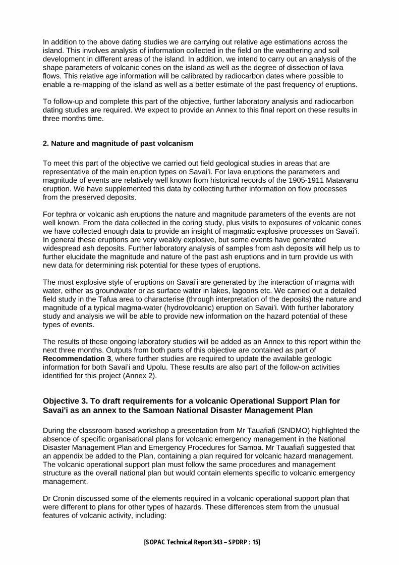
these. By contrast, deposits of the most violent processes found on Savai’i, phreatomagmatic volcanism are well exposed in the Tafua-Savai’i area. Phreatomagmatic processes involve the explosive interaction of hot rising magma and water. Water is most likely to be as groundwater within saturated sediments that magma encounters as it rises. The rapid chilling of hot (up to 1100 oC) magma by water causes a chain-reaction series of explosions – resulting in a blasting of rock debris and chilled magma radially from a vent. These blasts are extremely violent and destroy almost everything in their paths. Normally however, they are confined to within a few kilometres of the vent area. Through detailed studies of the Tafua-Savai’i deposits during this study we determined characteristics of the eruptions in the area which provide a model for the more violent types of events that we could expect on Savai’i. It is likely that phreatomagmatic explosions will proceed most new eruptions on the island, but it is only in highland swamp areas and near-shore or off-shore locations where sustained phreatomagmatic activity is likely to occur. 4.2.2 Tafua-Savai'i Tafua-Savai'i, situated on the Tafua-Savai'i peninsula, SE-Savaii, Samoa, consists of two coalesced structures (Figure 1), a scoria cone and a tuff ring. The complex is up to 170 m in height with an entire diameter of 1.6 km NW-SE and 0.9 km NE-SW. The angles of the slopes vary between 20-27o. The northwestern scoria cone has an entire diameter of c. 600 m with an elliptical 75-m deep internal crater of 200 m (N-S) by 100 m (E-W). The crater walls are almost vertical and exposures show shower-bedded scoria fall deposits, with most being block sized (>64 mm diameter). A lava flow of up to 200-m wide extends from the NE-sector of the scoria cone base and extends c. 2.3 km northwards before turning to extend 1.8 km in SW direction, covering c. 2.8 km2. The horseshoe-shaped tuff ring at the southeastern part of Tafua-Savai'i complex, is c. 600 m in diameter and open to the east. The bottom of the crater is of similar altitude to the surrounding area. Huge loose blocks of tuff, including abundant highly vesicular blocks up to 10 cm are observable around the rim. A layered tuff exposed on top of the rim dips outwards with an estimated angle of 30o. Thin sill-like basaltic flows are described by Kear and Wood (1959) inside the crater, although our investigations found only a few highly vesicular scoria blocks.
[SOPAC Technical Report 343 – SPDRP : 26]
Figure 1: Tafua-Savai’i peninsula and complex. The complex sits on top of Puapua aged lava flows as mapped by Kear and Wood (1959). 4.2.3 Description of main exposures 4.2.3.1 Outcrop 1 – most complete sequence
Cross-sections through the Tafua-Savai’i pyroclastic deposits are best found along the coastline, east and west of the main beach. Exposure 1 is a road cut close to the beach, 100 m from the shore, about 60 m in length and up to 3.5 m in height. The exposure shows four well-defined units (Figure 2). The partially exposed basal unit (A) is a massive, ungraded, sandy matrix-supported poorly sorted diamicton, containing both vesicular (scoria) and dense (lava) angular clasts of up to 10 cm in diameter (clasts 10% by volume). The largest clasts, are mostly dense pyroxene-basalts. Parts of the unit are clast-supported pebbly zones. The nearly horizontal contact to the unit above (B) is sharp but not always recognisable.
Tuff Deposits

[SOPAC Technical Report 343 – SPDRP : 27]
Figure 2: Diagram of Outcrop 1 with the four units described in the text, side view shows a closer detail of unit B. Unit B is a silty sand matrix-supported diamicton with clasts up to 9-cm in diameter, and ranges between 10 to 75 cm thick. Planar and low-angle cross-bedding is well developed (especially near the top of the unit), with distinctive lenses consisting of clast-supported lapilli. These lenses up to 1 m long and up to 20-cm thick and are surrounded silty and sandy matrix areas. Occasionally, lamination and planar bedding is present as single clast layers (of sands 2-3 mm in diameter) intercalated with mm-scale silty layers. Surface weathering causes the fine-grained layers recede. The layering may represent individual graded depositional units or separate transport and depositional episodes. At the southern end of the exposure two massive horizontal and sub-horizontal beds (16-19 cm thick) lie within the centre of unit B. Both beds are silt-sand matrix supported with up to 5% lapilli-sized clasts. The contact to unit C is diffuse and not always recognisable. Unit C at the northern end of the exposure is clast rich (75 % by vol., fine-medium lapilli), clast supported in places and matrix-supported (silt-sand matrix) in others, with rounded to angular, poorly vesiculated or dense clasts. Its thickness ranges between 38 to <5 cm with an irregular sharp and eroded upper contact. Laterally the unit grades into being matrix-supported, with less lapilli-sized clasts. The uppermost unit (D) is a massive, greyish brown poorly sorted, matrix-supported (fine sand), bed with 5% by volume dense, fine lapilli to fine block clasts (dmax 9 cm). It ranges between 0.5 m to 1.2 m thick. The long axes of the largest clasts are orientated parallel to layering. Small clasts are mostly rounded, the larger ones are angular. Above a sharp and planar upper contact is a partly preserved soft greyish brown firm silty sand layer, up to 5 cm thick. 4.2.3.2 Distal and supplementary exposures of tuff
Outcrop 2 is at the western limit of the beach, 50 m from the shoreline, and located on top of a Puapua-aged lava flow. Five depositional units are distinguishable and all are strongly consolidated or cemented. The 60-cm thick basal unit (A) lies directly on top of the lava flow and is a sandy matrix-supported, diamicton with patchy areas containing up to 90% by volume lapilli clasts (Dmax 4 cm), but <25% by volume in the bulk of the unit. In some locations normal grading is noted. Above a sharp contact is a 3-5 cm massive silty sand (unit B) with no outsize clasts. The 65-cm thick unit C can divided into a lower and upper unit. The lower half is has a fine sandy matrix with rare lapilli clasts (modally c. 7 mm, Dmax 4 cm). This grades upward to a coarse sandy matrix diamicton (with similar clast proportion) with lateral variations of fine sandy zones. Impact wet-sediment deformation structures are noted within this unit. Above a sharp contact is a 15 cm thick (unit D) fine sandy matrix diamicton with rare clasts up to 2 cm and rare zones of coarse sandy matrix. The uppermost unit (E) is incompletely preserved with up to 15 cm with a silt-fine sandy base grading into a coarse sandy top. A few tens of metres west of exposure 2 the tuff laps onto and is bounded by a lava flow.

[SOPAC Technical Report 343 – SPDRP : 28]
East of the main Tafua-tai beach in situ tuff deposits are located above sea level at low tide, with surface pitting from marine erosion. About 100 m east of the beach the lava cliffs start and tuff deposits 20-70 cm cap the lava flows. On the smooth upper surface, shrinkage cracks are noted in places. At outcrop 5 the 70 cm tuff is yellow-brown to pale brown, consisting of mm-cm-scale laminated and wavy bedded silty and sandy layers, often slightly coarser grained at the base (Figure 3). The coarsest clasts rarely exceed 0.5 cm diameter. At the bottom of the exposure a U-shaped channel (28 cm deep, 1.10 m wide), that may be orientated E-W, is filled by massive sillty sand with few lapilli clasts.
Figure 3: Photograph of tuff deposits (pale) overlying lava flows at outcrop 5. Further east, outcrop 6 comprises a lower 10 cm of yellow-brownish silty to fine sandy tuff, with thin (mm-cm scale) silty layers that are slightly wavy, without any outsize clasts. Above a sharp contact is a 20 cm thick coarse sandy reddish brown massive deposit which grades upward to a black coarse sand to pebble/lapilli grade matrix diamicton with common block-sized dense and vesicular lava clasts often exceeding 40 cm in diameter. In addition to these areas Tafua-tai village has many exposures of tuff deposits as small (100 m long, 3 m wide and 0.5 m high) seaward-dipping ridges. Rare large block lava clasts are found within these units (Dmax 1.3 m). 4.2.4 Littoral deposits associated with the underlying Puapua lava flows 300 m west of Tafua-tai beach at outcrop 3 is a 4 m long and 55 cm high lens of pyroclastic deposits interbedded between two lava flows. The lower 20 cm is comprises 30% by volume black angular and vesicular basalt clasts (coarse ash to lapilli, Dmax = 4 cm) supported in a massive fine sandy brownish matrix. Above this lies a 10-cm thick lava flow with sharp contacts, variable vesicularity and pale grey weathering on its surface. The 25-cm unit above contains c. 30 % by volume coarse ash and lapilli distributed in a fine sandy brownish matrix, some of the clasts are partly welded together. A 3 to 4 cm silt to fine sandy clast-poor or devoid zone is noted in areas.
[SOPAC Technical Report 343 – SPDRP : 29]
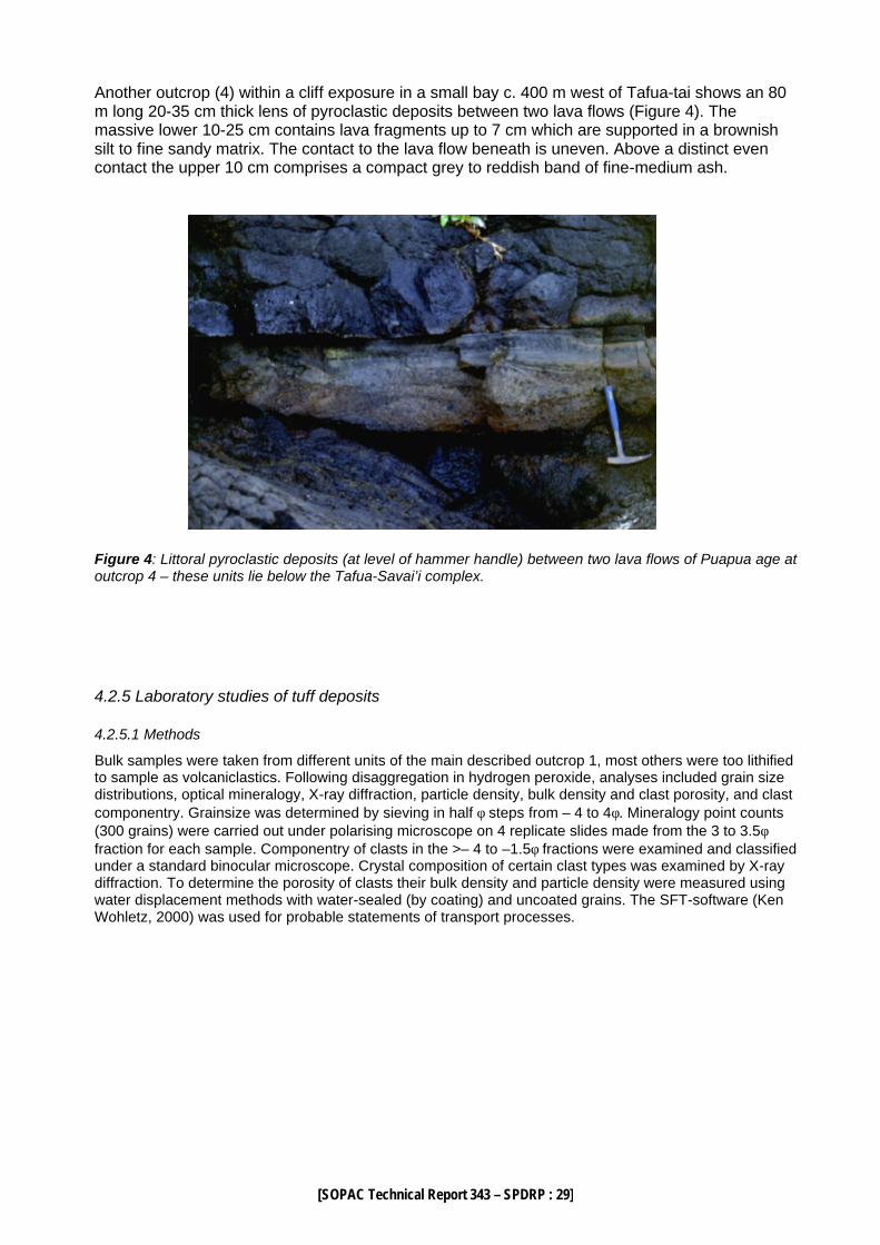
Another outcrop (4) within a cliff exposure in a small bay c. 400 m west of Tafua-tai shows an 80 m long 20-35 cm thick lens of pyroclastic deposits between two lava flows (Figure 4). The massive lower 10-25 cm contains lava fragments up to 7 cm which are supported in a brownish silt to fine sandy matrix. The contact to the lava flow beneath is uneven. Above a distinct even contact the upper 10 cm comprises a compact grey to reddish band of fine-medium ash.
Figure 4: Littoral pyroclastic deposits (at level of hammer handle) between two lava flows of Puapua age at outcrop 4 – these units lie below the Tafua-Savai’i complex. 4.2.5 Laboratory studies of tuff deposits 4.2.5.1 Methods
Bulk samples were taken from different units of the main described outcrop 1, most others were too lithified to sample as volcaniclastics. Following disaggregation in hydrogen peroxide, analyses included grain size distributions, optical mineralogy, X-ray diffraction, particle density, bulk density and clast porosity, and clast componentry. Grainsize was determined by sieving in half φ steps from – 4 to 4φ. Mineralogy point counts (300 grains) were carried out under polarising microscope on 4 replicate slides made from the 3 to 3.5φ fraction for each sample. Componentry of clasts in the >– 4 to –1.5φ fractions were examined and classified under a standard binocular microscope. Crystal composition of certain clast types was examined by X-ray diffraction. To determine the porosity of clasts their bulk density and particle density were measured using water displacement methods with water-sealed (by coating) and uncoated grains. The SFT-software (Ken Wohletz, 2000) was used for probable statements of transport processes.

[SOPAC Technical Report 343 – SPDRP : 30]
Figure 5: Grainsize distribution of units within outcrop 1, unit D (top), C (middle), B (base). The many modes within the distribution are modelled by individual sub-population curves representing different transport and depositional mechanisms including ballistic fall (coarsest end), through traction and saltation (middle peaks) and suspension (finest peak). 4.2.5.2 Gransize distributions
The grain size distributions of unit B, C and D of outcrop 1 (Figure 5) are all very poorly sorted and with a polymodal graphic distribution. The Median diameters (Mdφ) range from –0.65 to 0.5φ. The Standard Deviation (σφ) lies within the range of 2.975 to 1.8φ. Each sample consists of at least 5 sub-populations that roughly correspond between the units, particularly at –3.2φ and 1.75φ and sometimes –4.25φ, with subordinate peaks at 2.75φ and 3.7φ. However the volumetric proportions within each of these sub-populations varies considerably between units. These peaks are representative of differing mechanisms of clast transport and deposition within the flows that deposited the units, and the relative proportions within each sub-population reflects the importance of the various processes within each deposition interval.

[SOPAC Technical Report 343 – SPDRP : 31]
4.2.5.3 Mineralogy of deposits
Microscopic studies of these samples showed a crystal composition of basaltic glass (87-93%), olivine (3.6-6.3%), clinopyroxene (minor) and some plagioclase, with clay minerals (possibly palagonite) and iron oxides making up to c. 9% of many samples. The basaltic glass varies in colour from pale brown to dark brown and three types of glass morphology could be distinguished – platy, vesicular and tube-like. Most glass shards are platy and subangular with sharp edges. Less common vesicular angular to subangular glass shards contain elliptical depressions or holes, and rare tube-like shards contain strongly elongated thin vesicles. In all glass shards single microlites and clusters are present in addition to melt inclusions. Often olivine crystals are surrounded completely or partly by glass. The glass shards units C and D are not as fresh as those are within B. 4.2.5.4 Clast componentry and morphology Six different clast lithologies and morphologies are found:
Type 1: glossy dark brown clasts with small ash-filled vesicles; moderately to highly vesicular containing small crystals and common glass stripes; juvenile or primary scoria
Type 2: grey-brown clasts, moderately vesicular; containing crystals of plagioclase and olivine; accessory or recycled scoria
Type 3: glossy black clasts, poor to moderately vesicular; containing crystals of plagioclase and olivine; juvenile lava clasts
Type 4: red brown clasts, highly vesicular; containing crystals (oxidised); juvenile scoria Type 5: grey clasts, dense, very poorly vesicular, containing plagioclase and olivine [some
depressions on surface from vesicles or weathered crystals]; older lava or country rock
Type 6: red clasts, dense, very poorly vesicular, containing eu- to subhedral plagioclase crystals or laths, huge pyroxenes and olivine; older lava or country rock
Clast bulk density measurements for the Type 1 primary clasts are typically 1.4-1.49 kg/m3, while the type 1 primary lava clasts are between 1.72-1.97 kg/m3. The distribution of primary (Types 1, 3, 4) and secondary clasts (Types 2?, 5, 6) throughout the different units can be used as an indicator of eruption conditions. It appears that during eruption of unit B (mid-early eruption stages) the ejecta are dominated by primary materials, but during deposition of units C and D more secondary ejecta were involved. This indicates either vent widening or vent migration during the eruption causing the entertainment of more country rock material into the explosions. In addition, the content of type-3 clasts decreases from the early to late units. The dense-rock type-3 clasts indicate the chilling effects of water on the magma, fracturing rock clasts during eruption. Later more scoriaceous materials (type-1 and 4) indicate a decreasing importance in the role of water in the eruption (drying or exclusion of reserves in the immediate eruption vicinity). A further type of clast noted in unit A of outcrop 1 consists of light-grey dense core coated by a black moderately vesicular rim. These clasts from the earliest of the eruption units probably represent secondary or country rock material that has been coated by primary material. 4.2.6 Eruption and hazard interpretation Tafua-Savai’i peninsula consists of Puapua volcanics erupted in the late Holocene. Past estimates of their age were loosely between 3000 B.C. and 1500 A.D. based on that Taufa-Savai’i was probably erupted after the late Holocene high sea level stand and at some time before recorded history (Kear & Wood 1959). Given that the name Tafua is a cognate of Tavua or Tofua – all words from the southwest Pacific that denote “place of fire or burning” (Geraghty, 1996), it appears that people were probably present to witness and record the eruption in name. Hence this also implies an eruption time at some stage after settlement of the group, ie. well after c. 950 BC (Anderson and Clark, 1999). Our new radiocarbon date from this area provides an age for coral fragments thrown onto and cemented above tuff deposits of Tafua-Savai’i. Considering the coral fragments appear to have been transported fresh from growth position to the deposition site the date from them (1300-1395 AD) provides a minimum age for the eruption. Hence we can now more firmly confine the eruption age between 950 BC and 1395 AD.

[SOPAC Technical Report 343 – SPDRP : 32]
The Tafua-Savai’i complex with its combination of tuff ring, scoria cone and lava flow encompasses all styles of volcanism on Savai’i, from explosive phreatomagmatic, explosive magmatic and effusive. These interrelated deposits indicate that the role of water was highly important in the eruption, and that the vent migrated during the episode. The probable development for at least part of the Tafua-Savai'i volcanic complex can be postulated from the outcrop 1 sequence. The initial phase of the eruption started with violent phreatomagmatic eruptions that rapidly built up a tuff ring composed of country rock (mined as the vent developed) and primary ejecta. The magma, a mixture of liquid, solid and volatiles, interacted with external water producing at least weak phreatomagmatic explosions, which led to decompression caused by wall rock and/or roof collapse. Deposits of the earliest initial phase are not exposed, however, units A and B of the exposure 1 at least part of this phase. These units contain appreciable quantities of secondary or country rock fragments, consistent with excavation of the eruption vent. In addition the dense-rock primary clast content (as discussed above) shows the strong role of water in quenching and fragmentation processes in the eruption. The presence of cross-stratification and development of clast enriched lenses indicate a very high velocity flow regime was involved in the transport and deposition of unit B deposits. This is probably from a dilute pyroclastic density current and the beds are consistent with planar surge bedforms (Wohletz and Sheridan,1979; Figure 6). The very poorly sorted, clast enriched unit C contains appreciable (up to 80% by volume) secondary or country rock clasts and dense primary clasts. This probably represents in increase in “mining” of the eruption either from, vent wall collapse, vent widening, increasing access of external water (Houghton 1993) or possibly lateral migration of the vent due to shift in magma supply. Along with this change there was also a change the eruption column dynamics to produce pyroclastic surges capable of transporting a higher concentration of clasts. The irregular and partly eroded upper surface of unit C indicate a period of non-deposition and possibly a halt in eruption. This may represent a possible collapse of the eruption column and erosion of parts of unit C by rainfall at the time. The break may have been caused by blockage of the vent due to vent-wall collapse which is consistent with the following unit D containing 99% secondary or country rock fragments. Unit D also some coated pyroclasts, which are probably recycled juvenile clasts fragmented in an earlier eruption phase and fallen or collapsed back into the vent. The sedimentary features and grainsize distributions indicate unit D is a planar surge deposit (Wohletz and Sheridan, 1979; Figure 6). The relatively large clasts (>-4 φ) were probably ballistics that were entrained into the surges depositing unit D. The supplementary outcrop 2 sequence contains five thinner units probably represents a marginal or distal facies of the tuff deposits, in this case restricted laterally by a lava flow. Two impact structures caused by clasts of 20 cm and 6 cm in diameter (estimated angle of impact is about 45º) within unit C of outcrop 2 confirm a ballistic transport in a presumed surge deposit (similar to unit D in outcrop 1). Lateral variations in grain size described in outcrop 2 possibly indicate a perpendicular cross-section through clast enriched lenses as described in outcrop 1. Outcrop 5 and 6, the most distal outcrops contain laminated and wavy bedded layers, which represent a series of single pyroclastic surges. Syn-depositional erosion occurred producing a channel structure that was filled by following surges. This also appears to indicate a period of pause during the eruption and/or heavy rain that may have accompanied it. In outcrop 6 the upper unit, with a large proportion of coarse clasts (too coarse for pyroclastic surge deposition at this distance) and appears to represent a lahar deposit. The tuff ring is marked by a small landslide scar on its SW-rim. A landslide from this part of the ring in a southerly direction probably generated the lahar deposit. Heavy rainfalls probably trigged this post-eruptive or late-stage event. In addition, the small seaward-dipping ridges in Tafua-tai village may have been caused by small, slow moving mass flows in the saturated tuff cone deposits (ridges representing the flow margins).

[SOPAC Technical Report 343 – SPDRP : 33]
Tuff rings are generated by phreatomagmatic eruptions with a low water/magma ratio (Wohletz and Sheridan, 1983) and caused by dry/wet Taalian eruption styles (Vespermann and Schmincke, 2000). The horseshoe-shaped tuff ring might be the result of a preferred SW wind direction during the eruption, however it may also represent a location where the sea gained access to the vent in a late stage of cone construction (eg. Sohn, 1996 noted this in Korean tuff rings). It is likely however that the main water source during much of this eruption was that with groundwater.
Figure 6: plot of the grainsize parameters of units B, C and D of outcrop 1 on to a classification diagram of pyroclastic surge deposits of Wohletz and Sheridan (1979). The three samples plot in the field of planar bedforms. There are no easily accessible exposures of the scoria cone deposits. However, the presence of the cone 600 m NW of the tuff ring and on top of tuff deposits shows both a transition from phreatomagmatic to Strombolian volcanism (drying of the eruption) but also migration of the vent. Shifting of the vent location was probably the main reason for the restriction in water supply, enabling the magma to rise to a shallower level and magmatic gases to take over control of eruption processes. As the Strombolian portion of the eruption progressed at least in its early to mid stages, effusion of a lava flow to the NE of the crater caused the horseshoe-shaped outer cone. The last stage of this eruption was Strombolian and produced the deep Siualii crater within the main outer scoria cone rim. No distal fallout deposits of the Strombolian eruption column are exposed, which is probably due to being washed and eroded from the impermeable underlying tuff and lava. The Tafua-Savai’i eruption probably occurred over a period of weeks to months. The processes that occurred and areas affected can be used to model the range of possible hazards for most future Savai’i eruptions. The phreatomagmatic events were probably the most hazardous to humans in the area. The pyroclastic surges were rapidly moving (often >100 m/s in historic eruptions) and would have swept away most structures or people in their paths. The impacts of these processes were probably felt up to 2 km from the vent of Tafua-Savai’i. It is also important to note from a volcanic hazard perspective the volcaniclastic deposits of outcrops 3 and 4, which are littoral deposits generated by Puapua lava flows which interacted with sea water. Although not related to the Tafua-Savai’i complex, these deposits indicate significant explosive activity relating to effusive or lava-producing eruptions.
Unit D
Unit C
Unit B

[SOPAC Technical Report 343 – SPDRP : 34]
4.3 References cited Anderson, A., Clark, G., 1999: The age of Lapita settlement in Fiji. Archaeology in Oceania 34: 31-39.
Cronin, S.J., Neall, V.E., 2000: Impacts of volcanism on pre-European inhabitants of Taveuni, Fiji. Bulletin of Volcanology 62: 199-213.
Cronin, S.J., Bebbington, M., Lai, C-D, in press: A probabilistic assessment of eruption recurrence on Taveuni volcano. Bulletin of Volcanology.
Geraghty, P.,1996: Places of Fire. Past, present and future 11, Fiji Post, Suva, 25 Feb.
Grant-Taylor, T.L., Rafter, T.A., 1962: New Zealand Radiocarbon Age Measurements - 5. New Zealand Journal of Geology and Geophysics: 331-359.
Kear, D., Wood, B.L., 1959: The geology and hydrology of Western Samoa. New Zealand Geological Survey Bulletin 63.
Kear, D., 1967: A Summary of the Geology of Western Samoa. New Zealand Journal of Geology and Geophysics: 1200-1201.
Keating, B.H., 1985: Paleomagnetic Studies of the Samoa Islands: Results from the Islands of Tutuila and Savaii. In Brocher, T. (Ed), Geological Investigations of the Melanesian Borderland, Circum-Pacific Council for Energy and Mineral Resources - Earth Science Series 3: 187-199.
Keating, B.H., 1987: Summary of the Radiometric Ages from the Pacific. Intergovernmental Oceanographic Commission, Technical Series Report, No.32.
McDougall, I.,1986: Samoan Island Chain - A Hot Spot Trace. International Volcanological Congress, Auckland, Hamilton, Rotorua, New Zealand, Abstracts volume, 333.
Sohn, Y.K., 1996: Hydrovolcanic processes forming basaltic tuff rings and cones on Chejn Island, Korea. Geological Society of America Bulletin 108: 1199-1211.
Wohletz, K.H., Sheridan, M.F., 1979: A model of pyroclastic surges, in Chapin, and Elston (eds): 177-194.
Wohletz, K.H., Sheridan, M.F. 1983: Hydrovolcanic explosions II. Evolution of basaltic tuff rings and tuff cones. American Journal of Science 283: 385-413.
Vespermann, D., Schmincke, H-U. 2000: Scoria cones and tuff rings, in Sigurdsson, H. (ed) Encyclopedia of Volcanoes, Academic Press, San Diego: 683-694.