final survey report - data.kansasgis.org
TRANSCRIPT

Final Survey Report
Kansas LiDAR Add-ons
AOI 2
15115
2223 Drake Ave SW
Suite 200
Huntsville, AL 35805
(256) 971-9991 – office
(256) 971-1154 – fax
2015

Kansas Department of Agriculture, Kansas LiDAR
Final Survey Report, 14135
2015
Table of Contents Narrative .........................................................................................................................2 Section 1:
1.1 Introduction ...................................................................................................................... 2
1.2 Applicable Standards ......................................................................................................... 2
Ground Control Geodetic Network Survey ........................................................................2 Section 2:
2.1 Ground Control Points....................................................................................................... 2
2.2 Ground Control Station Collection .................................................................................... 3
2.3 Ground Control Data Processing and Analysis .................................................................. 3
2.3.1 Network Processing ............................................................................................... 3
2.4 Overall Network Final Coordinates ................................................................................... 3
2.4.1 AOI 2 Final Coordinates ......................................................................................... 3
Ground Cover Classification Survey ..................................................................................4 Section 3:
3.1 Ground Cover Classification Check Point Collection ......................................................... 4
3.2 Check Point Data Processing and Analysis ........................................................................ 5
3.2.1 AOI 2 Ground Cover Classification Check Points ................................................... 5

Kansas Department of Agriculture LiDAR Add-ons AOI 2
Final Survey Report, 15115
2015
Page 2
Narrative Section 1:
1.1 Introduction
A survey was performed to support the acquisition of Light Detection and Ranging (LiDAR) data for the Kansas
Department of Agriculture Kansas add-ons areas of interest (AOI). This report concerns the methods used for the ground
control survey in AOI 2.
1.2 Applicable Standards
This Geodetic Control Survey was conducted so as to support Light Detection and Ranging (LiDAR) data in accordance
with the National Digital Elevation Program (NDEP) and the American Society for Photogrammetry and Remote Sensing
(ASPRS) guidelines.
Ground Control Geodetic Network Survey Section 2:
2.1 Ground Control Points
A GPS control network was performed for the purposes of establishing a three-dimensional coordinates on each of the
base station locations. The control network included a combination of a National Geodetic Survey (NGS) Control
Monuments (GROVE and M 370) and points set by Atlantic. A graphical representation of all the ground control points is
provided in figure 1:
Figure 1: AOI 2 Ground Control Geodetic Network Points
Kansas Department of Agriculture LiDAR Add-ons AOI 2
Final Survey Report, 15115
2015
Page 3
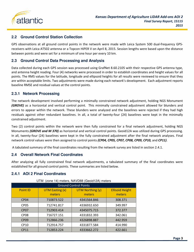
2.2 Ground Control Station Collection
GPS observations at all ground control points in the network were made with Leica System 500 dual-frequency GPS-
receivers with Leica AT502 antenna or a Topcon HiPER V on April 8, 2015. Session lengths were based upon the distance
between points and were set for a minimum of one hour per every 10 km.
2.3 Ground Control Data Processing and Analysis
Data collected during each GPS session was processed using GrafNet 8.60.2105 with their respective GPS antenna type,
and antenna height reading. Four (4) networks were processed in order to establish coordinates and height values for all
points. The RMS values for the latitude, longitude and ellipsoid heights for all results were reviewed to ensure that they
are within acceptable limits. Two adjustments were made during each network’s development. Each adjustment reports
baseline RMSE and residual values at the control points.
2.3.1 Network Processing
The network development involved performing a minimally constrained network adjustment, holding NGS Monument
(GROVE) as a horizontal and vertical control point. This minimally constrained adjustment allowed for blunders and
errors to appear within the network. These blunders were analyzed and the baselines were rejected if they had high
residuals against other redundant baselines. In all, a total of twenty-four (24) baselines were kept in the minimally
constrained adjustment.
Two (2) control points within the network were then fully constrained for a final network adjustment, holding NGS
Monuments (GROVE and M 370) as horizontal and vertical control points. Geoid12A was utilized during GPS processing.
In all, twenty-four (24) baselines were kept in the fully constrained adjustment after the final network analyses. Final
network control values were then assigned to control points (CP04, CP05, CP07, CP08, CP09, CP10, and CP11).
A tabulated summary of the final coordinates resulting from the network survey are listed in section 2.4.1.
2.4 Overall Network Final Coordinates
After analyzing all fully constrained final network adjustments, a tabulated summary of the final coordinates were
established for all ground control points. These summaries are listed below.
2.4.1 AOI 2 Final Coordinates
UTM (zone 14) meters, NAVD88 (Geoid12A) meters
Ground Control Points
Point ID UTM Easting (x)
meters
UTM Northing (y)
meters
Ellisoid Height
meters
CP04 710873.522 4341564.846 308.371
CP05 712741.817 4336932.650 349.997
CP07 712903.414 4345075.715 372.377
CP08 716727.151 4331832.393 342.061
CP09 712866.236 4326898.887 442.959
CP10 712914.757 4331877.584 414.990
CP11 712853.224 4333662.272 422.661

Kansas Department of Agriculture LiDAR Add-ons AOI 2
Final Survey Report, 15115
2015
Page 4
Ground Cover Classification Survey Section 3:
3.1 Ground Cover Classification Check Point Collection
GPS observations were conducted at each ground control point in order to conduct a Real Time Kinematic (RTK) survey.
The purpose of this survey was to collect ground test points for use during the processing of the LiDAR data to ensure
that the highest possible accuracy was achieved. GPS observations at each Real Time Kinematic (RTK) ground control
point were made with a Leica SR530 dual-frequency GPS-receivers w/ Leica AT502 antenna. The GPS units were
configured to log data at 1 Hz, and at 10 degrees mask. RTK test points collected to represent differing types of ground
cover. All observations were conducted between March 2015 and April 2015.
The purpose of this survey was to collect ground check points for use during the processing of the LiDAR data to ensure
that the highest possible accuracy was achieved.
A graphical representation of all the Ground Cover Classification Check Points is provided in figure 2.
Figure 2: AOI 2 Ground Cover Classification Check Points
Kansas Department of Agriculture LiDAR Add-ons AOI 2
Final Survey Report, 15115
2015
Page 5
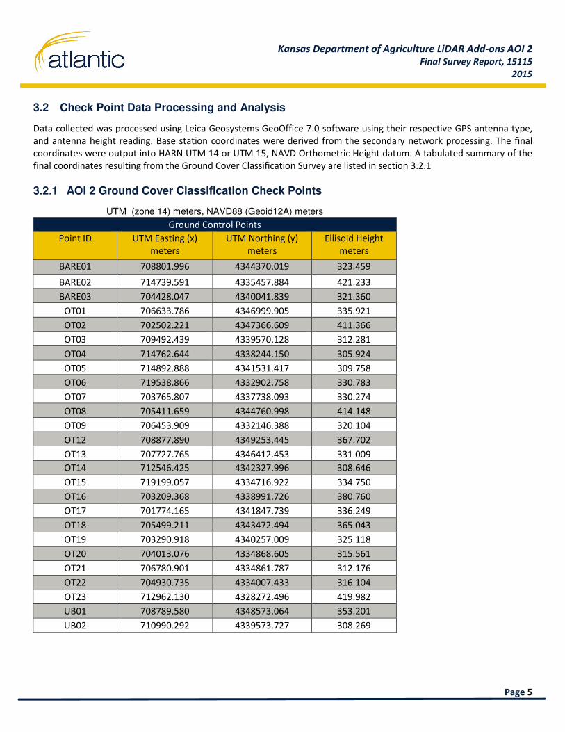
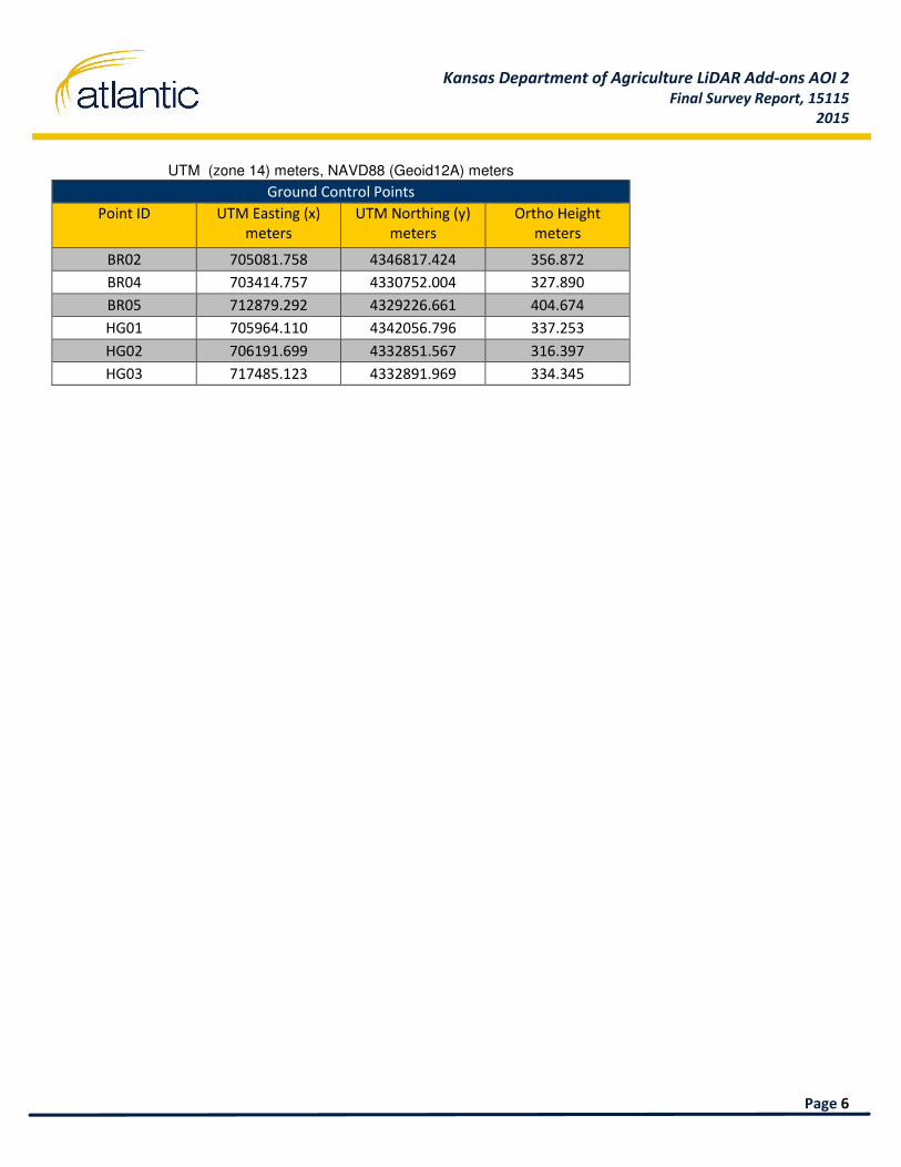
3.2 Check Point Data Processing and Analysis
Data collected was processed using Leica Geosystems GeoOffice 7.0 software using their respective GPS antenna type,
and antenna height reading. Base station coordinates were derived from the secondary network processing. The final
coordinates were output into HARN UTM 14 or UTM 15, NAVD Orthometric Height datum. A tabulated summary of the
final coordinates resulting from the Ground Cover Classification Survey are listed in section 3.2.1
3.2.1 AOI 2 Ground Cover Classification Check Points
UTM (zone 14) meters, NAVD88 (Geoid12A) meters
Ground Control Points
Point ID UTM Easting (x)
meters
UTM Northing (y)
meters
Ellisoid Height
meters
BARE01 708801.996 4344370.019 323.459
BARE02 714739.591 4335457.884 421.233
BARE03 704428.047 4340041.839 321.360
OT01 706633.786 4346999.905 335.921
OT02 702502.221 4347366.609 411.366
OT03 709492.439 4339570.128 312.281
OT04 714762.644 4338244.150 305.924
OT05 714892.888 4341531.417 309.758
OT06 719538.866 4332902.758 330.783
OT07 703765.807 4337738.093 330.274
OT08 705411.659 4344760.998 414.148
OT09 706453.909 4332146.388 320.104
OT12 708877.890 4349253.445 367.702
OT13 707727.765 4346412.453 331.009
OT14 712546.425 4342327.996 308.646
OT15 719199.057 4334716.922 334.750
OT16 703209.368 4338991.726 380.760
OT17 701774.165 4341847.739 336.249
OT18 705499.211 4343472.494 365.043
OT19 703290.918 4340257.009 325.118
OT20 704013.076 4334868.605 315.561
OT21 706780.901 4334861.787 312.176
OT22 704930.735 4334007.433 316.104
OT23 712962.130 4328272.496 419.982
UB01 708789.580 4348573.064 353.201
UB02 710990.292 4339573.727 308.269
Kansas Department of Agriculture LiDAR Add-ons AOI 2
Final Survey Report, 15115
2015
Page 6
UTM (zone 14) meters, NAVD88 (Geoid12A) meters
Ground Control Points
Point ID UTM Easting (x)
meters
UTM Northing (y)
meters
Ortho Height
meters
BR02 705081.758 4346817.424 356.872
BR04 703414.757 4330752.004 327.890
BR05 712879.292 4329226.661 404.674
HG01 705964.110 4342056.796 337.253
HG02 706191.699 4332851.567 316.397
HG03 717485.123 4332891.969 334.345

Survey Report: Kansas Department of Agriculture LiDAR Add-Ons, 2015 i
1
2
3
4
5
6
7
10
Appendix A: Field Notes
12
13
14
15
16
17
18
19
20
21
22
1
2


Survey Report: Kansas Department of Agriculture LiDAR Add-Ons, 2015 ii
3
4
5
6
7
8
9
10
Appendix B: Data Sheets
12
13
14
15
16
17
18
19
20
21
22
1
2
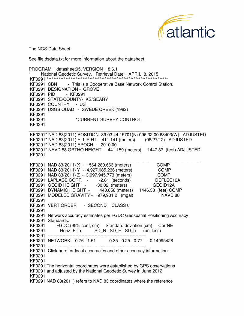
The NGS Data Sheet See file dsdata.txt for more information about the datasheet. PROGRAM = datasheet95, VERSION = 8.6.1 1 National Geodetic Survey, Retrieval Date = APRIL 8, 2015 KF0291 *********************************************************************** KF0291 CBN - This is a Cooperative Base Network Control Station. KF0291 DESIGNATION - GROVE KF0291 PID - KF0291 KF0291 STATE/COUNTY- KS/GEARY KF0291 COUNTRY - US KF0291 USGS QUAD - SWEDE CREEK (1982) KF0291 KF0291 *CURRENT SURVEY CONTROL KF0291 ______________________________________________________________________ KF0291* NAD 83(2011) POSITION- 39 03 44.15701(N) 096 32 00.63403(W) ADJUSTED KF0291* NAD 83(2011) ELLIP HT- 411.141 (meters) (06/27/12) ADJUSTED KF0291* NAD 83(2011) EPOCH - 2010.00 KF0291* NAVD 88 ORTHO HEIGHT - 441.159 (meters) 1447.37 (feet) ADJUSTED KF0291 ______________________________________________________________________ KF0291 NAD 83(2011) X - -564,289.663 (meters) COMP KF0291 NAD 83(2011) Y - -4,927,085.236 (meters) COMP KF0291 NAD 83(2011) Z - 3,997,945.773 (meters) COMP KF0291 LAPLACE CORR - -2.81 (seconds) DEFLEC12A KF0291 GEOID HEIGHT - -30.02 (meters) GEOID12A KF0291 DYNAMIC HEIGHT - 440.858 (meters) 1446.38 (feet) COMP KF0291 MODELED GRAVITY - 979,931.2 (mgal) NAVD 88 KF0291 KF0291 VERT ORDER - SECOND CLASS 0 KF0291 KF0291 Network accuracy estimates per FGDC Geospatial Positioning Accuracy KF0291 Standards: KF0291 FGDC (95% conf, cm) Standard deviation (cm) CorrNE KF0291 Horiz Ellip SD_N SD_E SD_h (unitless) KF0291 ------------------------------------------------------------------- KF0291 NETWORK 0.76 1.51 0.35 0.25 0.77 -0.14995428 KF0291 ------------------------------------------------------------------- KF0291 Click here for local accuracies and other accuracy information. KF0291 KF0291 KF0291.The horizontal coordinates were established by GPS observations KF0291.and adjusted by the National Geodetic Survey in June 2012. KF0291 KF0291.NAD 83(2011) refers to NAD 83 coordinates where the reference

KF0291.frame has been affixed to the stable North American tectonic plate. See KF0291.NA2011 for more information. KF0291 KF0291.The horizontal coordinates are valid at the epoch date displayed above KF0291.which is a decimal equivalence of Year/Month/Day. KF0291 KF0291.The orthometric height was determined by differential leveling and KF0291.adjusted by the NATIONAL GEODETIC SURVEY KF0291.in June 1991. KF0291 KF0291.The X, Y, and Z were computed from the position and the ellipsoidal ht. KF0291 KF0291.The Laplace correction was computed from DEFLEC12A derived deflections. KF0291 KF0291.The ellipsoidal height was determined by GPS observations KF0291.and is referenced to NAD 83. KF0291 KF0291.The dynamic height is computed by dividing the NAVD 88 KF0291.geopotential number by the normal gravity value computed on the KF0291.Geodetic Reference System of 1980 (GRS 80) ellipsoid at 45 KF0291.degrees latitude (g = 980.6199 gals.). KF0291 KF0291.The modeled gravity was interpolated from observed gravity values. KF0291 KF0291. The following values were computed from the NAD 83(2011) position. KF0291 KF0291; North East Units Scale Factor Converg. KF0291;SPC KS N - 81,947.065 526,915.043 MT 0.99996223 +0 55 40.3 KF0291;SPC KS N - 268,854.66 1,728,720.44 sFT 0.99996223 +0 55 40.3 KF0291;UTM 14 - 4,326,581.888 713,404.132 MT 1.00016080 +1 33 17.6 KF0291 KF0291! - Elev Factor x Scale Factor = Combined Factor KF0291!SPC KS N - 0.99993550 x 0.99996223 = 0.99989773 KF0291!UTM 14 - 0.99993550 x 1.00016080 = 1.00009629 KF0291 KF0291: Primary Azimuth Mark Grid Az KF0291:SPC KS N - X 342 274 56 21.6 KF0291:UTM 14 - X 342 274 18 44.3 KF0291 KF0291|---------------------------------------------------------------------| KF0291| PID Reference Object Distance Geod. Az | KF0291| dddmmss.s | KF0291| KF1032 WAMEGO MUN TANK APPROX.24.6 KM 0494048.8 | KF0291| KF0292 GROVE RM 1 13.653 METERS 09436 | KF0291| KF1038 MANHATTAN M W PIPE MICROWAVE APPROX. 5.2 KM 1351244.4 | KF0291| KF0290 GROVE RM 2 13.121 METERS 26751 | KF0291| KF0280 X 342 2755201.9 | KF0291|---------------------------------------------------------------------|

KF0291 KF0291 SUPERSEDED SURVEY CONTROL KF0291 KF0291 NAD 83(2007)- 39 03 44.15719(N) 096 32 00.63473(W) AD(2002.00) 0 KF0291 ELLIP H (02/10/07) 411.147 (m) GP(2002.00) KF0291 ELLIP H (08/16/04) 411.158 (m) GP( ) 4 2 KF0291 NAD 83(1997)- 39 03 44.15699(N) 096 32 00.63456(W) AD( ) B KF0291 ELLIP H (12/22/97) 411.172 (m) GP( ) 4 1 KF0291 NAD 83(1986)- 39 03 44.16286(N) 096 32 00.63182(W) AD( ) 2 KF0291 NAD 27 - 39 03 44.17376(N) 096 31 59.62125(W) AD( ) 2 KF0291 NAVD 88 (12/22/97) 441.16 (m) 1447.4 (f) LEVELING 3 KF0291 NGVD 29 (??/??/92) 441.022 (m) 1446.92 (f) ADJ UNCH 2 0 KF0291 NGVD 29 (07/19/86) 441.02 (m) 1446.9 (f) LEVELING 3 KF0291 KF0291.Superseded values are not recommended for survey control. KF0291 KF0291.NGS no longer adjusts projects to the NAD 27 or NGVD 29 datums. KF0291.See file dsdata.txt to determine how the superseded data were derived. KF0291 KF0291_U.S. NATIONAL GRID SPATIAL ADDRESS: 14SQJ1340426581(NAD 83) KF0291 KF0291_MARKER: DE = TRAVERSE STATION DISK KF0291_SETTING: 7 = SET IN TOP OF CONCRETE MONUMENT KF0291_SP_SET: SET IN TOP OF CONCRETE MONUMENT KF0291_STAMPING: GROVE 1970 KF0291_MARK LOGO: CGS KF0291_MAGNETIC: N = NO MAGNETIC MATERIAL KF0291_STABILITY: C = MAY HOLD, BUT OF TYPE COMMONLY SUBJECT TO KF0291+STABILITY: SURFACE MOTION KF0291_SATELLITE: THE SITE LOCATION WAS REPORTED AS SUITABLE FOR KF0291+SATELLITE: SATELLITE OBSERVATIONS - September 19, 2012 KF0291 KF0291 HISTORY - Date Condition Report By KF0291 HISTORY - 1970 MONUMENTED NGS KF0291 HISTORY - 1970 GOOD NGS KF0291 HISTORY - 19970306 GOOD NGS KF0291 HISTORY - 20080115 GOOD KF0291 HISTORY - 20100504 GOOD KSDT KF0291 HISTORY - 20120919 GOOD KSDT KF0291 KF0291 STATION DESCRIPTION KF0291 KF0291'DESCRIBED BY NATIONAL GEODETIC SURVEY 1970 (CAA) KF0291'THE STATION IS LOCATED ABOUT 16 MILES EAST-NORTHEAST OF KF0291'JUNCTION CITY 8 MILES SOUTH-SOUTHEAST OF MANHATTAN, ON A KF0291'SMALL HILL ON THE SOUTH RIGHT-OF-WAY OF INTERSTATE HIGHWAY KF0291'70, IN THE SW 1/4 SECTION 28, T11S, R8E. KF0291'

KF0291'TO REACH THE STATION FROM THE INTERCHANGE OF INTERSTATE KF0291'HIGHWAY 70 AND STATE HIGHWAY 177 WHICH IS ABOUT 8 MILES KF0291'SOUTH-SOUTHEAST OF MANHATTAN, (BM X 342 (AZIMUTH MARK) IS KF0291'LOCATED AT THIS POINT), GO EAST ON INTERSTATE 70 FOR 0.25 KF0291'MILE TO THE STATION ON THE RIGHT. KF0291' KF0291'STATION MARKS ARE TRAVERSE DISKS STAMPED GROVE 1970. THE KF0291'SURFACE DISK IS SET IN THE TOP OF A 12-INCH CYLINDRICAL KF0291'CONCRETE MONUMENT WHICH IS FLUSH WITH THE GROUND SURFACE. KF0291'IT IS 64 FEET SOUTH OF THE EDGE OF A CUTBANK, 4.3 FEET NORTH KF0291'OF A BARBED WIRE FENCE AND 4.2 FEET NORTH OF A METAL WITNESS KF0291'POST. THE UNDERGROUND MARK IS SET IN THE TOP OF AN IRREGULAR KF0291'MASS OF CONCRETE WHICH IS 34 INCHES BELOW THE GROUND SURFACE. KF0291' KF0291'REFERENCE MARK 1, A STANDARD DISK STAMPED GROVE NO 1 1970, KF0291'IS SET IN AN IRREGULAR MASS OF CONCRETE WHICH SUPPORTS A KF0291'METAL FENCE POST. IT IS 44.3 FEET EAST OF THE WITNESS POST KF0291'AND 0.3 FOOT NORTH OF THE BARBED WIRE FENCE. KF0291' KF0291'REFERENCE MARK 2, A STANDARD DISK STAMPED GROVE NO 2 1970, KF0291'IS SET IN THE TOP OF A 12-INCH CYLINDRICAL CONCRETE MONUMENT KF0291'WHICH PROJECTS 2 INCHES ABOVE THE GROUND SURFACE. IT IS KF0291'43.5 FEET WEST OF THE WITNESS POST AND 2.4 FEET NORTH OF KF0291'THE BARBED WIRE FENCE. KF0291' KF0291'BM X 342 (AZIMUTH MARK), IS A STANDARD BENCH MARK DISK STAMPED KF0291'X 342 1970. IT IS CEMENTED IN A DRILL HOLE IN THE NORTHEAST KF0291'WING-WALL OF THE EASTBOUND OVERPASS AT THE JUNCTION OF INTERSTATE KF0291'70 AND STATE HIGHWAY 177. IT IS 19.5 FEET NORTH OF THE KF0291'CENTER LINE OF THE EASTBOUND LANES OF INTERSTATE 70, 2.8 KF0291'FEET SOUTHWEST OF THE SOUTH END OF AN IRON GUARD RAIL AND KF0291'0.8 FOOT NORTH OF THE CONCRETE GUARD RAIL. KF0291' KF0291'HEIGHT OF LIGHT ABOVE STATION MARK 2.85 METERS. KF0291 KF0291 STATION RECOVERY (1970) KF0291 KF0291'RECOVERY NOTE BY NATIONAL GEODETIC SURVEY 1970 KF0291'13.2 MI W FROM ALMA. KF0291'ABOUT 13.2 MILES WEST ALONG INTERSTATE HIGHWAY 70 FROM THE KF0291'HIGHWAY OVERPASS OVER STATE HIGHWAY 99 AT ALMA, OR ABOUT 17.15 KF0291'MILES EAST ALONG INTERSTATE HIGHWAY 70 FROM THE HIGHWAY OVERPASS KF0291'FOR THE UNION PACIFIC RAILROAD AT JUNCTION CITY, 0.25 MILE EAST KF0291'OF THE HIGHWAY OVERPASS FOR STATE HIGHWAY 177, ON THE TOP OF A KF0291'25-FOOT HIGH SHALEY ROCK CUT ON THE SOUTH SIDE OF THE HIGHWAY, KF0291'117 FEET SOUTH (SLOPE MEASUREMENT) OF THE CENTER LINE OF THE
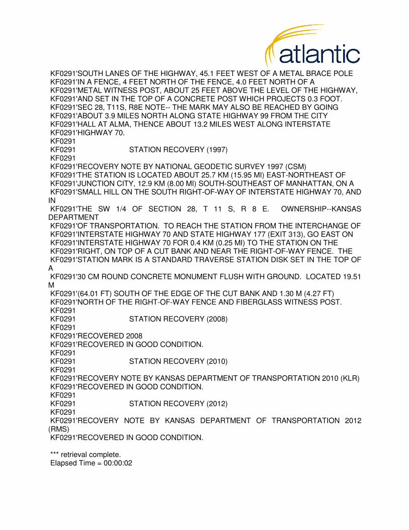
KF0291'SOUTH LANES OF THE HIGHWAY, 45.1 FEET WEST OF A METAL BRACE POLE KF0291'IN A FENCE, 4 FEET NORTH OF THE FENCE, 4.0 FEET NORTH OF A KF0291'METAL WITNESS POST, ABOUT 25 FEET ABOVE THE LEVEL OF THE HIGHWAY, KF0291'AND SET IN THE TOP OF A CONCRETE POST WHICH PROJECTS 0.3 FOOT. KF0291'SEC 28, T11S, R8E NOTE-- THE MARK MAY ALSO BE REACHED BY GOING KF0291'ABOUT 3.9 MILES NORTH ALONG STATE HIGHWAY 99 FROM THE CITY KF0291'HALL AT ALMA, THENCE ABOUT 13.2 MILES WEST ALONG INTERSTATE KF0291'HIGHWAY 70. KF0291 KF0291 STATION RECOVERY (1997) KF0291 KF0291'RECOVERY NOTE BY NATIONAL GEODETIC SURVEY 1997 (CSM) KF0291'THE STATION IS LOCATED ABOUT 25.7 KM (15.95 MI) EAST-NORTHEAST OF KF0291'JUNCTION CITY, 12.9 KM (8.00 MI) SOUTH-SOUTHEAST OF MANHATTAN, ON A KF0291'SMALL HILL ON THE SOUTH RIGHT-OF-WAY OF INTERSTATE HIGHWAY 70, AND IN KF0291'THE SW 1/4 OF SECTION 28, T 11 S, R 8 E. OWNERSHIP--KANSAS DEPARTMENT KF0291'OF TRANSPORTATION. TO REACH THE STATION FROM THE INTERCHANGE OF KF0291'INTERSTATE HIGHWAY 70 AND STATE HIGHWAY 177 (EXIT 313), GO EAST ON KF0291'INTERSTATE HIGHWAY 70 FOR 0.4 KM (0.25 MI) TO THE STATION ON THE KF0291'RIGHT, ON TOP OF A CUT BANK AND NEAR THE RIGHT-OF-WAY FENCE. THE KF0291'STATION MARK IS A STANDARD TRAVERSE STATION DISK SET IN THE TOP OF A KF0291'30 CM ROUND CONCRETE MONUMENT FLUSH WITH GROUND. LOCATED 19.51 M KF0291'(64.01 FT) SOUTH OF THE EDGE OF THE CUT BANK AND 1.30 M (4.27 FT) KF0291'NORTH OF THE RIGHT-OF-WAY FENCE AND FIBERGLASS WITNESS POST. KF0291 KF0291 STATION RECOVERY (2008) KF0291 KF0291'RECOVERED 2008 KF0291'RECOVERED IN GOOD CONDITION. KF0291 KF0291 STATION RECOVERY (2010) KF0291 KF0291'RECOVERY NOTE BY KANSAS DEPARTMENT OF TRANSPORTATION 2010 (KLR) KF0291'RECOVERED IN GOOD CONDITION. KF0291 KF0291 STATION RECOVERY (2012) KF0291 KF0291'RECOVERY NOTE BY KANSAS DEPARTMENT OF TRANSPORTATION 2012 (RMS) KF0291'RECOVERED IN GOOD CONDITION. *** retrieval complete. Elapsed Time = 00:00:02

The NGS Data Sheet See file dsdata.txt for more information about the datasheet. PROGRAM = datasheet95, VERSION = 8.6.1 1 National Geodetic Survey, Retrieval Date = APRIL 8, 2015 KF0765 *********************************************************************** KF0765 DESIGNATION - M 370 KF0765 PID - KF0765 KF0765 STATE/COUNTY- KS/RILEY KF0765 COUNTRY - US KF0765 USGS QUAD - KEATS (1992) KF0765 KF0765 *CURRENT SURVEY CONTROL KF0765 ______________________________________________________________________ KF0765* NAD 83(2011) POSITION- 39 07 52.98806(N) 096 40 21.91477(W) NO CHECK KF0765* NAD 83(2011) ELLIP HT- 287.522 (meters) (06/27/12) NO CHECK KF0765* NAD 83(2011) EPOCH - 2010.00 KF0765* NAVD 88 ORTHO HEIGHT - 317.399 (meters) 1041.33 (feet) ADJUSTED KF0765 ______________________________________________________________________ KF0765 NAD 83(2011) X - -575,688.689 (meters) COMP KF0765 NAD 83(2011) Y - -4,920,797.382 (meters) COMP KF0765 NAD 83(2011) Z - 4,003,823.392 (meters) COMP KF0765 LAPLACE CORR - -3.21 (seconds) DEFLEC12A KF0765 GEOID HEIGHT - -29.87 (meters) GEOID12A KF0765 DYNAMIC HEIGHT - 317.186 (meters) 1040.63 (feet) COMP KF0765 MODELED GRAVITY - 979,947.4 (mgal) NAVD 88 KF0765 KF0765 VERT ORDER - FIRST CLASS II KF0765 KF0765 Network accuracy estimates per FGDC Geospatial Positioning Accuracy KF0765 Standards: KF0765 FGDC (95% conf, cm) Standard deviation (cm) CorrNE KF0765 Horiz Ellip SD_N SD_E SD_h (unitless) KF0765 ------------------------------------------------------------------- KF0765 NETWORK 1.20 2.04 0.56 0.38 1.04 -0.11001991 KF0765 ------------------------------------------------------------------- KF0765 Click here for local accuracies and other accuracy information. KF0765 KF0765 KF0765.The horizontal coordinates were established by GPS observations KF0765.and adjusted by the National Geodetic Survey in June 2012. KF0765 KF0765.NAD 83(2011) refers to NAD 83 coordinates where the reference KF0765.frame has been affixed to the stable North American tectonic plate. See KF0765.NA2011 for more information.

KF0765 KF0765.The horizontal coordinates are valid at the epoch date displayed above KF0765.which is a decimal equivalence of Year/Month/Day. KF0765 KF0765.No horizontal observational check was made to the station. KF0765. KF0765.The orthometric height was determined by differential leveling and KF0765.adjusted by the NATIONAL GEODETIC SURVEY KF0765.in June 1991. KF0765 KF0765.The X, Y, and Z were computed from the position and the ellipsoidal ht. KF0765 KF0765.The Laplace correction was computed from DEFLEC12A derived deflections. KF0765 KF0765.The ellipsoidal height was determined by GPS observations KF0765.and is referenced to NAD 83. KF0765 KF0765.The dynamic height is computed by dividing the NAVD 88 KF0765.geopotential number by the normal gravity value computed on the KF0765.Geodetic Reference System of 1980 (GRS 80) ellipsoid at 45 KF0765.degrees latitude (g = 980.6199 gals.). KF0765 KF0765.The modeled gravity was interpolated from observed gravity values. KF0765 KF0765. The following values were computed from the NAD 83(2011) position. KF0765 KF0765; North East Units Scale Factor Converg. KF0765;SPC KS N - 89,433.536 514,752.790 MT 0.99995901 +0 50 23.2 KF0765;SPC KS N - 293,416.53 1,688,818.11 sFT 0.99995901 +0 50 23.2 KF0765;UTM 14 - 4,333,935.793 701,158.456 MT 1.00009827 +1 28 09.2 KF0765 KF0765! - Elev Factor x Scale Factor = Combined Factor KF0765!SPC KS N - 0.99995489 x 0.99995901 = 0.99991390 KF0765!UTM 14 - 0.99995489 x 1.00009827 = 1.00005316 KF0765 KF0765 SUPERSEDED SURVEY CONTROL KF0765 KF0765 NAD 83(2007)- 39 07 52.98814(N) 096 40 21.91549(W) AD(2002.00) 0 KF0765 ELLIP H (02/10/07) 287.533 (m) GP(2002.00) KF0765 ELLIP H (07/29/04) 287.539 (m) GP( ) 4 2 KF0765 NAD 83(1997)- 39 07 52.98796(N) 096 40 21.91554(W) AD( ) 1 KF0765 ELLIP H (03/07/02) 287.534 (m) GP( ) 4 2 KF0765 NAVD 88 (03/07/02) 317.40 (m) 1041.3 (f) LEVELING 3 KF0765 KF0765.Superseded values are not recommended for survey control. KF0765 KF0765.NGS no longer adjusts projects to the NAD 27 or NGVD 29 datums. KF0765.See file dsdata.txt to determine how the superseded data were derived.

KF0765 KF0765_U.S. NATIONAL GRID SPATIAL ADDRESS: 14SQJ0115833935(NAD 83) KF0765 KF0765_MARKER: I = METAL ROD KF0765_SETTING: 49 = STAINLESS STEEL ROD W/O SLEEVE (10 FT.+) KF0765_SP_SET: STAINLESS STEEL ROD KF0765_STAMPING: M 370 1986 KF0765_MARK LOGO: NGS KF0765_PROJECTION: FLUSH KF0765_MAGNETIC: I = MARKER IS A STEEL ROD KF0765_STABILITY: B = PROBABLY HOLD POSITION/ELEVATION WELL KF0765_SATELLITE: THE SITE LOCATION WAS REPORTED AS SUITABLE FOR KF0765+SATELLITE: SATELLITE OBSERVATIONS - December 17, 2007 KF0765_ROD/PIPE-DEPTH: 14.0 meters KF0765 KF0765 HISTORY - Date Condition Report By KF0765 HISTORY - 1986 MONUMENTED NGS KF0765 HISTORY - 20010427 GOOD MSAM KF0765 HISTORY - 20071217 GOOD INDIV KF0765 KF0765 STATION DESCRIPTION KF0765 KF0765'DESCRIBED BY NATIONAL GEODETIC SURVEY 1986 KF0765'12.0 KM (7.45 MI) WEST FROM MANHATTAN. KF0765'12.0 KM (7.45 MI) WESTERLY ALONG THE UNION PACIFIC RAILROAD FROM THE KF0765'STATION IN MANHATTAN, 13.2 M (43.3 FT) SOUTHEAST OF THE NEAR RAIL, 8.0 KF0765'M (26.2 FT) NORTH OF THE CENTER OF COUNTY ROAD 5700 WEST, AND 2.0 M KF0765'(6.6 FT) NORTHEAST OF A FENCE CORNER. NOTE--ACCESS TO DATUM POINT IS KF0765'HAD THROUGH A 5-INCH LOGO CAP. KF0765'THE MARK IS 0.3 METERS NW FROM A WITNESS POST AND FENCE KF0765'THE MARK IS ABOVE LEVEL WITH THE ROAD. KF0765 KF0765 STATION RECOVERY (2001) KF0765 KF0765'RECOVERY NOTE BY MOUNTAIN SURVEYING AND MAPPING INC 2001 (KCH) KF0765'RECOVERED BY MOUNTAIN SURVEYING AND MAPPING, INC. 2001 (WWS) KF0765' KF0765'THE STATION IS LOCATED ABOUT 10.46 KM (6.5 MI) SOUTHWEST OF KF0765'MANHATTAN, KANSAS, 3.7 KM (2.3 MI) NORTH OF OGDEN, KANSAS. IT IS IN KF0765'THE KF0765'NORTHEAST CORNER OF THE INTERSECTION OF COUNTY ROAD KF0765'2400 (WILDCAT CREEK ROAD), AND THE RAILROAD PARALLEL TO STATE KF0765'HIGHWAY 18. KF0765' KF0765'TO REACH THE STATION FROM THE INTERCHANGE OF STATE HIGHWAY 113 KF0765'(SETH CHILD RD) AND STATE HIGHWAY 18 (FT RILEY BOULEVARD) IN KF0765'MANHATTAN, KANSAS, GO 7.7 KM (4.8 MI), SOUTHWEST ON STATE ROAD 18 TO
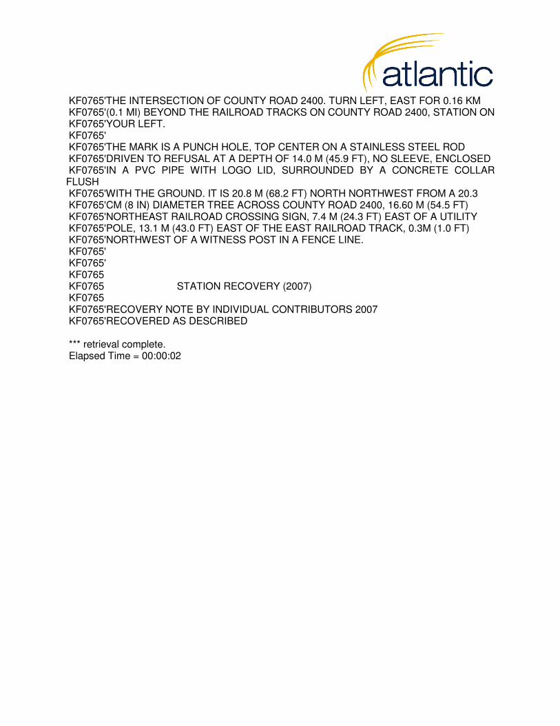
KF0765'THE INTERSECTION OF COUNTY ROAD 2400. TURN LEFT, EAST FOR 0.16 KM KF0765'(0.1 MI) BEYOND THE RAILROAD TRACKS ON COUNTY ROAD 2400, STATION ON KF0765'YOUR LEFT. KF0765' KF0765'THE MARK IS A PUNCH HOLE, TOP CENTER ON A STAINLESS STEEL ROD KF0765'DRIVEN TO REFUSAL AT A DEPTH OF 14.0 M (45.9 FT), NO SLEEVE, ENCLOSED KF0765'IN A PVC PIPE WITH LOGO LID, SURROUNDED BY A CONCRETE COLLAR FLUSH KF0765'WITH THE GROUND. IT IS 20.8 M (68.2 FT) NORTH NORTHWEST FROM A 20.3 KF0765'CM (8 IN) DIAMETER TREE ACROSS COUNTY ROAD 2400, 16.60 M (54.5 FT) KF0765'NORTHEAST RAILROAD CROSSING SIGN, 7.4 M (24.3 FT) EAST OF A UTILITY KF0765'POLE, 13.1 M (43.0 FT) EAST OF THE EAST RAILROAD TRACK, 0.3M (1.0 FT) KF0765'NORTHWEST OF A WITNESS POST IN A FENCE LINE. KF0765' KF0765' KF0765 KF0765 STATION RECOVERY (2007) KF0765 KF0765'RECOVERY NOTE BY INDIVIDUAL CONTRIBUTORS 2007 KF0765'RECOVERED AS DESCRIBED *** retrieval complete. Elapsed Time = 00:00:02

Survey Report: Kansas Department of Agriculture LiDAR Add-Ons, 2015 iii
3
4
5
6
7
8
9
10
Appendix C: Final Constraint
12
13
14
15
16
17
18
19
20
21
22
1
2

************************************************** * NETWORK - WEIGHTED GPS NETWORK ADJUSTMENT * * * * (c) Copyright NovAtel Inc., (2014) * * * * Version: 8.50.4320 * * * * FILE: C:\Users\ben.kimbrough\Documents\Projects\2015\15115 Manhattan Area\307_Control_Network\2015APRIL08\Data Processing\2015APRIL08.net ************************************************** DATE(m/d/y): Wed. 4/15/15 TIME: 21:39:28 *************************************************************** DATUM: 'WGS84' SCALE_FACTOR: 1.0000 CONFIDENCE LEVEL: 39.40 % (Scale factor is 1.0009) **************************************************************** INPUT CONTROL/CHECK POINTS **************************************************************** STA_ID TYPE -- LATITUDE -- -- LONGITUDE -- ELLHGT - HZ-SD V-SD GROVE GCP-3D 39 03 44.15701 -96 32 00.63403 411.141 0.00010 0.00010 M370 GCP-3D 39 07 52.98806 -96 40 21.91477 287.522 0.00010 0.00010 **************************************************************** INPUT VECTORS **************************************************************** SESSION NAME VECTOR(m) ------ Covariance (m) [unscaled] ------ DX/DY/DZ standard deviations in brackets CP02 to CPO1 (1) -4949.4247 4.4837e-008 (0.0002) 4659.9015 4.2816e-008 1.5492e-007 (0.0004) 5090.1125 -8.7239e-009 -7.0223e-008 1.1913e-007 (0.0003) CP03 to CP02 (1) -4710.4849 4.2001e-008 (0.0002) 5217.1037 4.0423e-008 1.5289e-007 (0.0004) 5660.3322 -1.1246e-008 -7.2138e-008 1.1971e-007 (0.0003)

CP03 to CP06 (1) -13079.5963 6.5000e-008 (0.0003) 6564.8642 5.3178e-008 2.2528e-007 (0.0005) 6237.8653 4.1107e-009 -7.7510e-008 1.4889e-007 (0.0004) CP03 to CP15 (1) -13345.1834 3.4635e-008 (0.0002) 732.2751 3.1170e-008 1.3298e-007 (0.0004) -1004.7836 -5.6317e-009 -6.3319e-008 1.0358e-007 (0.0003) CP03 to CP19 (1) -5139.8500 1.7351e-008 (0.0001) -2241.5330 8.9893e-009 7.1121e-008 (0.0003) -3342.5383 -3.3594e-009 -3.4141e-008 5.5593e-008 (0.0002) CP03 to CPO1 (1) -9659.9013 5.2438e-008 (0.0002) 9877.0227 3.3706e-008 1.4353e-007 (0.0004) 10750.4381 4.1802e-010 -6.6654e-008 1.6860e-007 (0.0004) CP06 to CP02 (1) 8369.1098 4.7904e-008 (0.0002) -1347.7695 4.2190e-008 1.6965e-007 (0.0004) -577.5321 -6.5185e-009 -8.1425e-008 1.3999e-007 (0.0004) CP06 to CP15 (1) -265.5850 1.9932e-008 (0.0001) -5832.5918 1.1109e-008 8.9001e-008 (0.0003) -7242.6582 -4.1037e-009 -4.2349e-008 7.2536e-008 (0.0003) CP06 to CP19 (1) 7939.7483 6.1744e-008 (0.0002) -8806.3998 5.2638e-008 2.9876e-007 (0.0005) -9580.4015 -1.6261e-008 -1.2628e-007 1.8188e-007 (0.0004) CP06 to CPO1 (1) 3419.6944 4.8849e-008 (0.0002) 3312.1561 2.4086e-008 1.3006e-007 (0.0004) 4512.5796 2.2418e-009 -3.3068e-008 1.3079e-007 (0.0004) CP15 to CP02 (1) 8634.6965 6.9192e-008 (0.0003) 4484.8262 5.9522e-008 2.5807e-007 (0.0005) 6665.1223 -1.3318e-009 -1.3394e-007 2.4039e-007 (0.0005) CP15 to CP19 (1) 8205.3307 2.0814e-008 (0.0001) -2973.8147 1.1523e-008 8.9961e-008 (0.0003) -2337.7473 -4.4222e-009 -4.5311e-008 7.9269e-008 (0.0003) CP15 to CPO1 (1) 3685.2768 4.3379e-008 (0.0002) 9144.7370 1.9173e-008 1.7480e-007 (0.0004) 11755.2377 9.0864e-009 -1.0485e-007 2.1470e-007 (0.0005) CP19 to CP02 (1) 429.3651 4.9852e-008 (0.0002) 7458.6327 4.5278e-008 1.7793e-007 (0.0004) 9002.8811 -9.4106e-009 -8.4574e-008 1.4305e-007 (0.0004)
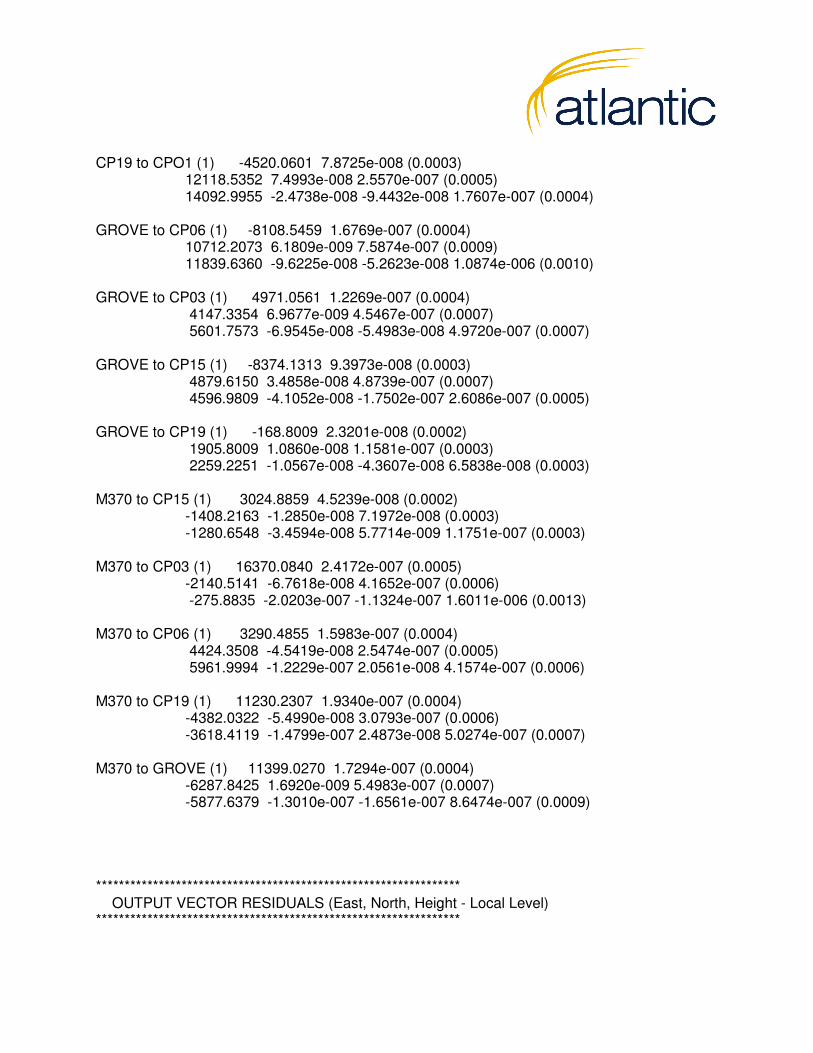
CP19 to CPO1 (1) -4520.0601 7.8725e-008 (0.0003) 12118.5352 7.4993e-008 2.5570e-007 (0.0005) 14092.9955 -2.4738e-008 -9.4432e-008 1.7607e-007 (0.0004) GROVE to CP06 (1) -8108.5459 1.6769e-007 (0.0004) 10712.2073 6.1809e-009 7.5874e-007 (0.0009) 11839.6360 -9.6225e-008 -5.2623e-008 1.0874e-006 (0.0010) GROVE to CP03 (1) 4971.0561 1.2269e-007 (0.0004) 4147.3354 6.9677e-009 4.5467e-007 (0.0007) 5601.7573 -6.9545e-008 -5.4983e-008 4.9720e-007 (0.0007) GROVE to CP15 (1) -8374.1313 9.3973e-008 (0.0003) 4879.6150 3.4858e-008 4.8739e-007 (0.0007) 4596.9809 -4.1052e-008 -1.7502e-007 2.6086e-007 (0.0005) GROVE to CP19 (1) -168.8009 2.3201e-008 (0.0002) 1905.8009 1.0860e-008 1.1581e-007 (0.0003) 2259.2251 -1.0567e-008 -4.3607e-008 6.5838e-008 (0.0003) M370 to CP15 (1) 3024.8859 4.5239e-008 (0.0002) -1408.2163 -1.2850e-008 7.1972e-008 (0.0003) -1280.6548 -3.4594e-008 5.7714e-009 1.1751e-007 (0.0003) M370 to CP03 (1) 16370.0840 2.4172e-007 (0.0005) -2140.5141 -6.7618e-008 4.1652e-007 (0.0006) -275.8835 -2.0203e-007 -1.1324e-007 1.6011e-006 (0.0013) M370 to CP06 (1) 3290.4855 1.5983e-007 (0.0004) 4424.3508 -4.5419e-008 2.5474e-007 (0.0005) 5961.9994 -1.2229e-007 2.0561e-008 4.1574e-007 (0.0006) M370 to CP19 (1) 11230.2307 1.9340e-007 (0.0004) -4382.0322 -5.4990e-008 3.0793e-007 (0.0006) -3618.4119 -1.4799e-007 2.4873e-008 5.0274e-007 (0.0007) M370 to GROVE (1) 11399.0270 1.7294e-007 (0.0004) -6287.8425 1.6920e-009 5.4983e-007 (0.0007) -5877.6379 -1.3010e-007 -1.6561e-007 8.6474e-007 (0.0009) **************************************************************** OUTPUT VECTOR RESIDUALS (East, North, Height - Local Level) ****************************************************************

SESSION NAME -- RE -- -- RN -- -- RH -- - PPM - DIST - STD - (m) (m) (m) (km) (m) CP02 to CPO1 (1) 0.0030 0.0053 -0.0088 $ 1.259 8.5 0.0006 CP03 to CP02 (1) 0.0004 0.0026 0.0010 $ 0.310 9.0 0.0006 CP03 to CP06 (1) -0.0008 0.0032 -0.0013 $ 0.225 15.9 0.0007 CP03 to CP15 (1) 0.0007 -0.0023 -0.0093 $ 0.713 13.4 0.0005 CP03 to CP19 (1) -0.0000 -0.0006 -0.0010 $ 0.183 6.5 0.0004 CP03 to CPO1 (1) -0.0028 0.0015 0.0107 $ 0.635 17.5 0.0006 CP06 to CP02 (1) 0.0018 0.0043 -0.0054 $ 0.843 8.5 0.0006 CP06 to CP15 (1) -0.0009 0.0032 -0.0040 $ 0.562 9.3 0.0004 CP06 to CP19 (1) -0.0014 -0.0041 -0.0029 $ 0.342 15.2 0.0007 CP06 to CPO1 (1) -0.0016 -0.0055 0.0057 $ 1.233 6.6 0.0006 CP15 to CP02 (1) 0.0014 0.0015 0.0042 $ 0.393 11.8 0.0008 CP15 to CP19 (1) 0.0013 0.0002 -0.0018 $ 0.240 9.0 0.0004 CP15 to CPO1 (1) 0.0006 -0.0016 0.0012 $ 0.136 15.3 0.0007 CP19 to CP02 (1) -0.0000 -0.0024 -0.0078 $ 0.695 11.7 0.0006 CP19 to CPO1 (1) 0.0036 0.0009 -0.0170 $ 0.909 19.1 0.0007 GROVE to CP06 (1) -0.0010 -0.0048 -0.0097 $ 0.604 17.9 0.0014 GROVE to CP03 (1) -0.0066 0.0068 -0.0054 $ 1.275 8.6 0.0010 GROVE to CP15 (1) -0.0015 -0.0036 -0.0161 $ 1.549 10.7 0.0009 GROVE to CP19 (1) 0.0001 0.0028 -0.0120 $ 4.165 3.0 0.0005 M370 to CP15 (1) 0.0082 -0.0055 0.0082 $ 3.590 3.6 0.0005 M370 to CP03 (1) -0.0097 0.0195 0.0090 $ 1.428 16.5 0.0015 M370 to CP06 (1) -0.0083 0.0088 -0.0029 $ 1.534 8.1 0.0009 M370 to CP19 (1) -0.0047 0.0020 0.0130 $ 1.113 12.6 0.0010 M370 to GROVE (1) -0.0014 0.0061 0.0179 $ 1.328 14.3 0.0013 -------------------------------- RMS 0.0038 0.0056 0.0089 $ - This session is flagged as a 3-sigma outlier **************************************************************** CONTROL POINT RESIDUALS (ADJUSTMENT MADE) **************************************************************** STA. NAME -- RE -- -- RN -- -- RH -- (m) (m) (m) GROVE -0.0008 -0.0000 -0.0016 M370 0.0009 0.0000 0.0016 -------------------------------- RMS 0.0009 0.0000 0.0016 **************************************************************** OUTPUT STATION COORDINATES (LAT/LONG/HT)
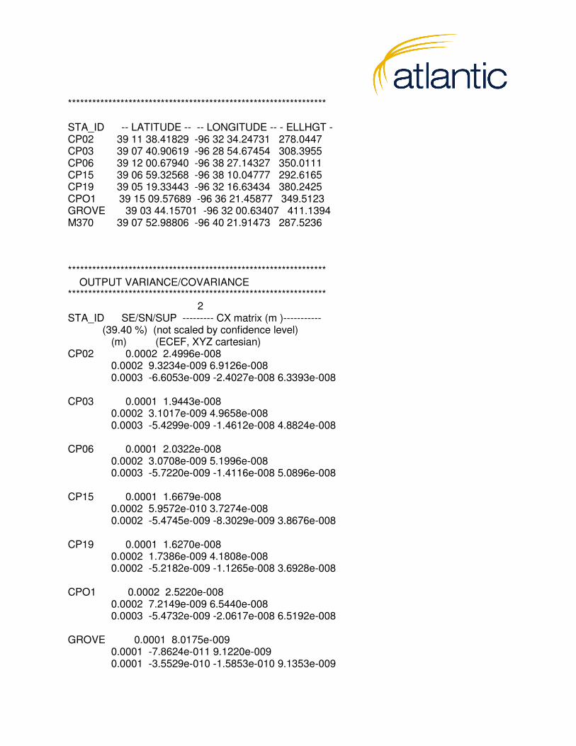
**************************************************************** STA_ID -- LATITUDE -- -- LONGITUDE -- - ELLHGT - CP02 39 11 38.41829 -96 32 34.24731 278.0447 CP03 39 07 40.90619 -96 28 54.67454 308.3955 CP06 39 12 00.67940 -96 38 27.14327 350.0111 CP15 39 06 59.32568 -96 38 10.04777 292.6165 CP19 39 05 19.33443 -96 32 16.63434 380.2425 CPO1 39 15 09.57689 -96 36 21.45877 349.5123 GROVE 39 03 44.15701 -96 32 00.63407 411.1394 M370 39 07 52.98806 -96 40 21.91473 287.5236 **************************************************************** OUTPUT VARIANCE/COVARIANCE **************************************************************** 2 STA_ID SE/SN/SUP --------- CX matrix (m )----------- (39.40 %) (not scaled by confidence level) (m) (ECEF, XYZ cartesian) CP02 0.0002 2.4996e-008 0.0002 9.3234e-009 6.9126e-008 0.0003 -6.6053e-009 -2.4027e-008 6.3393e-008 CP03 0.0001 1.9443e-008 0.0002 3.1017e-009 4.9658e-008 0.0003 -5.4299e-009 -1.4612e-008 4.8824e-008 CP06 0.0001 2.0322e-008 0.0002 3.0708e-009 5.1996e-008 0.0003 -5.7220e-009 -1.4116e-008 5.0896e-008 CP15 0.0001 1.6679e-008 0.0002 5.9572e-010 3.7274e-008 0.0002 -5.4745e-009 -8.3029e-009 3.8676e-008 CP19 0.0001 1.6270e-008 0.0002 1.7386e-009 4.1808e-008 0.0002 -5.2182e-009 -1.1265e-008 3.6928e-008 CPO1 0.0002 2.5220e-008 0.0002 7.2149e-009 6.5440e-008 0.0003 -5.4732e-009 -2.0617e-008 6.5192e-008 GROVE 0.0001 8.0175e-009 0.0001 -7.8624e-011 9.1220e-009 0.0001 -3.5529e-010 -1.5853e-010 9.1353e-009
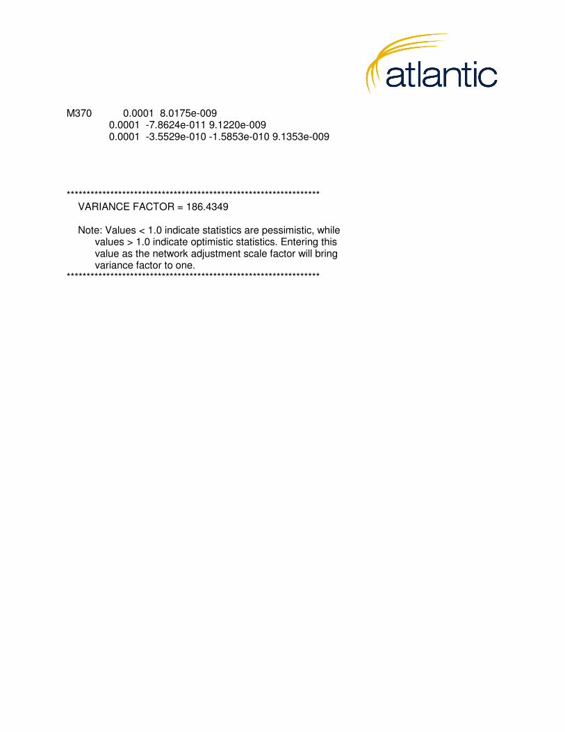
M370 0.0001 8.0175e-009 0.0001 -7.8624e-011 9.1220e-009 0.0001 -3.5529e-010 -1.5853e-010 9.1353e-009 **************************************************************** VARIANCE FACTOR = 186.4349 Note: Values < 1.0 indicate statistics are pessimistic, while values > 1.0 indicate optimistic statistics. Entering this value as the network adjustment scale factor will bring variance factor to one. ****************************************************************

Survey Report: Kansas Department of Agriculture LiDAR Add-Ons, 2015 iv
3
4
5
6
7
8
9
10
Appendix D: Real Time Kinematic Survey Results
12
13
14
15
16
17
18
19
20
21
22
1
20

PointID Easting Northing Elevation Description BARE01 708801.996 4344370.019 323.459 Bare Earth BARE02 714739.591 4335457.884 421.233 Bare Earth BARE03 704428.047 4340041.839 321.360 Bare Earth OT01 706633.786 4346999.905 335.921 Open Terrain OT02 702502.221 4347366.609 411.366 Open Terrain OT03 709492.439 4339570.128 312.281 Open Terrain OT04 714762.644 4338244.150 305.924 Open Terrain OT05 714892.888 4341531.417 309.758 Open Terrain OT06 719538.866 4332902.758 330.783 Open Terrain OT07 703765.807 4337738.093 330.274 Open Terrain OT08 705411.659 4344760.998 414.148 Open Terrain OT09 706453.909 4332146.388 320.104 Open Terrain OT12 708877.890 4349253.445 367.702 Open Terrain OT13 707727.765 4346412.453 331.009 Open Terrain OT14 712546.425 4342327.996 308.646 Open Terrain OT15 719199.057 4334716.922 334.750 Open Terrain OT16 703209.368 4338991.726 380.760 Open Terrain OT17 701774.165 4341847.739 336.249 Open Terrain OT18 705499.211 4343472.494 365.043 Open Terrain OT19 703290.918 4340257.009 325.118 Open Terrain OT20 704013.076 4334868.605 315.561 Open Terrain OT21 706780.901 4334861.787 312.176 Open Terrain OT22 704930.735 4334007.433 316.104 Open Terrain OT23 712962.130 4328272.496 419.982 Open Terrain UB01 708789.580 4348573.064 353.201 Urban Terrain UB02 710990.292 4339573.727 308.269 Urban Terrain BR02 705081.758 4346817.424 356.872 Brush BR04 703414.757 4330752.004 327.890 Brush BR05 712879.292 4329226.661 404.674 Brush HG01 705964.110 4342056.796 337.253 High Grass HG02 706191.699 4332851.567 316.397 High Grass HG03 717485.123 4332891.969 334.345 High Grass

Survey Report: Kansas Department of Agriculture LiDAR Add-Ons, 2015 v
This page intentionally left blank.