final—archaeological inventory survey of tmk: (1) 6-2-...
TRANSCRIPT

FINAL—Archaeological Inventory Survey of TMK: (1) 6-2-002:042 (formerly [1] 6-2-002:004), Kawailoa Ahupua‘a, Waialua District, Island of O‘ahu, Hawai‘i
Prepared For: Big Country, LLC 67-409 Alahaka St. Waialua, HI 96791
July 2014

FINAL—Archaeological Inventory Survey of TMK: (1) 6-2-002:042 (formerly [1] 6-2-002:004), Kawailoa Ahupua‘a, Waialua
District, Island of O‘ahu, Hawai‘i
Prepared For:
Big Country, LLC 67-409 Alahaka St. Waialua, HI 96791
Prepared By:
Windy McElroy, PhD and
Dietrix Duhaylonsod, BA
July 2014


i
MANAGEMENT SUMMARY
Archaeological inventory survey was conducted at TMK: (1) 6-2-002:042 in Kawailoa Ahupua‘a, Waialua District, on the Island of O‘ahu, Hawai‘i. This was done in preparation for ground disturbance associated with construction of a house, garage, driveway, and fence. The archaeological work included pedestrian survey that covered 100% of the property, as well as test excavations consisting of five shovel test pits and six trenches. Site 50-80-04-7604, an historic road, was identified during pedestrian survey, and two glass artifacts and one concrete artifact were found, not associated with the historic road. No cultural material or deposits were encountered during subsurface testing, and much of the parcel was found to be previously disturbed by bulldozing. No further work is recommended because the proposed construction will not affect the integrity of Site 7604.

ii

iii
CONTENTS
MANAGEMENT SUMMARY .................................................................................................................. i
FIGURES ............................................................................................................................................ iv
TABLES .............................................................................................................................................. v
INTRODUCTION .................................................................................................................................. 1 Project Location and Environment ................................................................................................ 1
BACKGROUND ................................................................................................................................... 6 Waialua and Kawailoa in the Pre-Contact Era .............................................................................. 6
Place Names .............................................................................................................................. 6 Land Use and Subsistence ......................................................................................................... 6 Mo‘olelo .................................................................................................................................... 7 ‘Ōlelo No‘eau ............................................................................................................................ 8
Waialua and Kawailoa in the Historic Period ............................................................................... 8 Early Descriptions of Kawailoa ................................................................................................. 9 Historic Maps and Aerial Photos ............................................................................................. 14 Māhele Land Tenure and Ownership of Kawailoa .................................................................. 22
Previous Archaeology ................................................................................................................. 29 Settlement Pattern........................................................................................................................ 36 Summary and Anticipated Finds ................................................................................................. 36 Research Questions ..................................................................................................................... 37
METHODS ........................................................................................................................................ 38
RESULTS .......................................................................................................................................... 39 Pedestrian Survey ........................................................................................................................ 39 Subsurface Testing ...................................................................................................................... 44 Summary of Findings .................................................................................................................. 50
SUMMARY AND RECOMMENDATIONS .............................................................................................. 55 Significance Determinations ....................................................................................................... 55
GLOSSARY ....................................................................................................................................... 57
REFERENCES .................................................................................................................................... 58

iv
FIGURES
Figure 1. Project area on a 7.5 minute USGS Haleiwa quadrangle map with TMK overlay. ........... 2 Figure 2. Project area (in red) on TMK plat map. ............................................................................. 3 Figure 3. Construction plans for the parcel. ...................................................................................... 4 Figure 4. Soils in the vicinity of the project area (data from Foote et al. 1972). ............................... 5 Figure 5. Portion of an historic map of Waialua Bay (Jackson 1884). ............................................ 15 Figure 6. Portion of an historic map of Kawailoa (Monsarrat 1876). ............................................. 16 Figure 7. Portion of a Waialua Agricultural Company map (Wall 1901) ....................................... 17 Figure 8. Portion of a Kawailoa Forest Reserve map (Wall 1924). ................................................. 18 Figure 9. Portion of a USGS (1929) Haleiwa Quadrangle. The project area is shown in red. ........ 19 Figure 10. Portion of an Army Corps of Engineers (1956) map ..................................................... 20 Figure 11. Portion of a 1965 aerial photo (USDA 1965). ............................................................... 21 Figure 12. Portion of a 1977 aerial photo (USGS 1977). ................................................................ 21 Figure 13. Previous archaeological studies in the vicinity of the project area. ............................... 30 Figure 14. Archaeological sites in Kawailoa (adopted from Sterling and Summers 1978)............. 33 Figure 15. Pedestrian survey in the lower half of the parcel, showing heavy vegetation ................ 38 Figure 16. Location of test pits (TP) and artifacts (Art) .................................................................. 40 Figure 17. Location of trenches. ...................................................................................................... 41 Figure 18. Example of a boulder with scratch marks from heavy equipment. ................................ 42 Figure 19. Artifact 1, left; and Artifact 3, right. .............................................................................. 42 Figure 20. Artifact 1, showing detail on bottle base. ....................................................................... 43 Figure 21. Artifact 2 in situ. Orientation is to the west. .................................................................. 43 Figure 22. Northern extent of Cane Haul Road, highlighted in yellow ........................................... 45 Figure 23. Southern extent of Cane Haul Road, highlighted in yellow. .......................................... 46 Figure 24. Plan view of Cane Haul Road where it crosses the subject property. ............................ 47 Figure 25. Portion of Cane Haul Road that crosses the subject property. View is to the south. ..... 47 Figure 26. TP 1 west face profile drawing (left) and photo (right). ................................................ 49 Figure 27. TP 2 east face profile drawing (left) and photo (right)................................................... 49 Figure 28. TP 3 east face profile drawing (left) and photo (right)................................................... 51 Figure 29. TP 4 south face profile drawing (left) and photo (right). ............................................... 51 Figure 30. TP 5 south face profile drawing (left) and photo (right). ............................................... 51 Figure 31. TR 1 south face profile drawing (left) and photo (right). ............................................... 52 Figure 32. TR 2 north face profile drawing (left) and photo (right). ............................................... 52 Figure 33. TR 3 north face profile drawing (left) and photo (right). ............................................... 53 Figure 34. TR 4 west face profile drawing (left) and photo (right). ................................................ 53 Figure 35. TR 5 east face profile drawing (left) and photo (right). ................................................. 54 Figure 36. TR 6 north face profile drawing (left) and photo (right). ............................................... 54

v
TABLES
Table 1. Māhele Claims for Kawailoa ............................................................................................. 24 Table 2. Data for Claim 2741 by Pueo (‘Āpana 3 is the Area of Study) ......................................... 28 Table 3. Previous Archaeology in Kawailoa ................................................................................... 31 Table 4. Artifact Data ...................................................................................................................... 44 Table 5. Sediment Descriptions ...................................................................................................... 48 Table 6. Significance Determinations ............................................................................................. 56

vi

1
INTRODUCTION
At the request of Big Country, LLC, Keala Pono Archaeological Consulting conducted an archaeological inventory survey of TMK: (1) 6-2-002:042 in Kawailoa Ahupua‘a, Waialua District, on the island of O‘ahu. Big Country planning to build a single-family home in the northeast corner of the parcel. The archaeological inventory survey was designed to identify any historic properties that may be located on the lot, in anticipation of the proposed construction. The archaeological inventory survey was requested by the State Historic Preservation Division (SHPD) in a letter dated January 17, 2014 (Log No. 2013.6788, Doc No. 1401GC13).
The report begins with a description of the project area and an historical overview of land use and archaeology in the area. The next section delineates methods used in the fieldwork, followed by the results of the archaeological survey. Project results are summarized and recommendations are made in the final section. Hawaiian words, flora and fauna, and technical terms are defined in a glossary at the end of the document.
Project Location and Environment
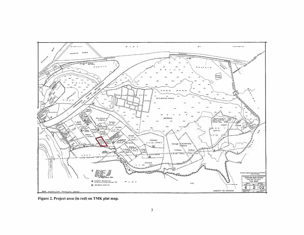
The project area is located in the ‘ili of Kalualepo in Kawailoa Ahupua‘a, Waialua District, on the island of O‘ahu (Figure 1). TMK: (1) 6-2-002:042 (formerly part of TMK: [1] 6-2-002:004) encompasses .895 acres (.362 ha) on the mauka side of Kamehameha Highway (Figure 2). The boundaries of Kalualepo ‘Ili are not known; the project area lies entirely within this ‘ili. The parcel is bounded on all sides by other privately-owned lots, with a large farm adjacent to the parcel on the east. Cane Haul Road, a paved thoroughfare, cuts through the property and runs from north to south in the upper half of the parcel. Surveyor’s stakes mark the corners of the lot, and the property boundaries are also marked in most areas by a row of boulders, many of which appear to be pushed by heavy equipment, and some of which may be natural.
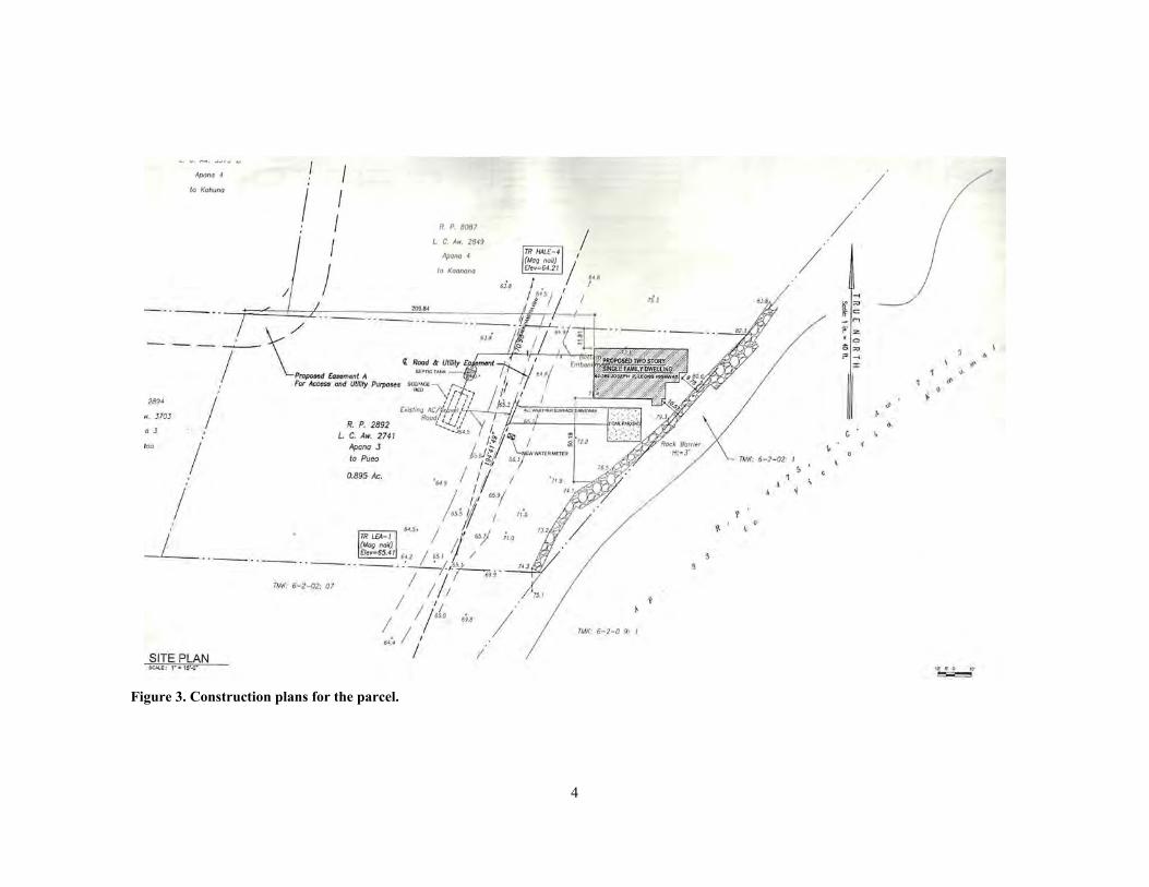
The parcel is owned by Big Country, LLC, who plans to construct a single-family dwelling in the northeast corner of the property (Figure 3). Also to be constructed are a new driveway, a garage, and a wall that will extend along the rear of the parcel. The lot is situated between 40 and 60 feet (12–18 m) in elevation. Rainfall averages roughly 0–40 inches (0–102 cm) per year (Juvik and Juvik 1998). Anahulu Stream is the largest permanent watercourse in the area, located approximately .25 miles (400 m) south of the property. Other major sources of water are Loka Ea Pond, which is .34 miles (540 m) to the southwest, and ‘Uko‘a Pond, situated .49 miles (780 m) to the north.
The project area is .46 miles (740 m) from the coastline and topography is gently sloping to the west, toward the coast. The upper portion of the property, above Cane Haul Road, is significantly higher than the portion below the road, due to the natural grade. The property is currently undeveloped and overgrown with non-native vegetation, predominantly tall grass and koa haole. Generally, soils in the area are of the Kaena-Waialua Association, described by Foote et al. (1972) as follows:
Deep, mainly nearly level and gently sloping, poorly drained to excessively drained soils that have a fine-textured to coarse-textured subsoil or underlying material; on coastal plains and talus slopes and in drainageways.
Specifically, soils within the project area consist almost entirely of Wailua stony silty clay, 3–8% slopes (WlB). Helemano silty clay, 30–90% slopes (HLMG) makes up a small portion of the eastern boundary of the parcel. Wailua stony silty clay, 0–3% slopes (WkA) and Lahaina silty clay, 3–7% slopes (LaB) are nearby (Figure 4).

2
Figure 1. Project area on a 7.5 minute USGS Haleiwa quadrangle map with TMK overlay.
3
Figure 2. Project area (in red) on TMK plat map.
4
Figure 3. Construction plans for the parcel.

5
Figure 4. Soils in the vicinity of the project area (data from Foote et al. 1972).

6
BACKGROUND
This section of the report presents background information as a means to provide a context through which one can examine the cultural and historical significance of the ahupua‘a of Kawailoa. In the attempt to record and preserve both the tangible (i.e., traditional and historic archaeological sites) and intangible (i.e., mo‘olelo, ‘ōlelo no‘eau, place names) culture, this research assists in the discussion of anticipated finds. Research was conducted at the Hawai‘i State Archives, Hawai‘i State Library, the SHPD library, and online on the Papakilo database, Waihona ‘Aina database, and the State of Hawai‘i Department of Accounting and General Services (DAGS) website. Historical maps, archaeological reports, and historical reference books were among the materials examined.
Waialua and Kawailoa in the Pre-Contact Era
Information compiled for the pre-contact era includes data on place names, land use, and subsistence, as well as several mo‘olelo and an ‘ōlelo no‘eau. Together, they give us an idea of what life may have been like in this storied place.
Place Names
Place names often shed light on traditional views of an area and can provide important contextual information. Several conflicting accounts inform on the naming of Waialua District. Thrum (in Sterling and Summers 1978:88) states that “Waialua” translates to “two waters,” thus many believe that the name derived from Waialua’s two streams. However, he believes that the district was named after a taro patch, and a common saying was that if you traveled to Waialua and did not see this taro patch, then you did not really see Waialua. Pukui (in Sterling and Summers 1978:88) asserts that the district was named for the cruel chief Waia, grandson of Wakea. Waia carried out his evil deeds at Waialua, and there was so much suffering there that the district was named Waialua, or “doubly disgraceful.” Another source attributes the name to Waialua Pool at Kemo‘o (Awai in Sterling and Summers 1978:88).
Kawailoa translates to “the long water,” which is adapted to the character of the ahupua‘a, where the long watercourse, the Anahulu River flows (Pukui et al. 1976:98). In addition to the land division in Waialua, there is a place of the same name in east O‘ahu, and there are bays named Kawailoa in Līhu‘e, Kaua‘i and in northwest Moloka‘i. Anahulu River is a major watercourse near the project area, and its name translates to “ten days” (Pukui et al. 1976:12). Nearby is the town of Hale‘iwa, or “house [of] frigate bird” (Puku‘i et al. 1976:37).
Land Use and Subsistence
Terraced areas were located all along Anahulu River, in Anahulu Gulch, and in the swamps east of Puaena Point (Handy 1940). Handy provides more detail on the agricultural locales in Kawailoa:
In Anahulu Gulch small flats with old mango trees, indicating kuleana, were observed several miles inland, and I am told that small areas were cultivated far up the gulch. Wild taros were seen in the side gulch at least 5 miles inland. The dry gulches between Anahulu and Waimea Streams probably never watered taro. (Handy 1940:86)
Handy and Handy also note the agricultural abundance of the land:
Waialua, on its seaward slopes, was as generously endowed with water as any area on Oahu. Much of the gently sloping and level land was formerly covered with wet-taro terraces. And beyond there was a great spread of kula land with red soil which was ideal terrain for sweet potato planting. The Wai‘anae range gave this area a rich hinterland.

7
Waialua had a fine bay with a broad beach, and there were several fishponds...Altogether this was the most bounteously endowed area on the sunset coast.
Two large fishponds were among Waialua’s greatest assets. Ukoa was a long, narrow fresh-water pond about a mile in length. Laniwai (Sky-water) was its mo‘o guardian. With her lived her brother, Puhi-‘ula (Red-eel). The pond was said to be connected with the ocean by a tunnel, through which the mo‘o would go to bathe in the sea…(Handy and Handy 1972:466-7)
‘Uko‘a and Loko Ea were prominent fishponds in Kawailoa, connected to one another and fed by springs. Both ponds were once used to raise fish such as ‘anae and awa. In a comprehensive study of the Anahulu Valley, Kirch and Sahlins emphasize the prominence of the region in traditional times and mention the two major ponds:
The presence of no less than eleven temples, several of luakini class and therefore associated with ruling chiefs, testifies to the importance of these lands to the Hawaiian chiefs. The political importance of the district, of course, was grounded in the system of agricultural and aquacultural production, notably the extensive taro irrigation complexes and ‘Uko‘a and Lokoea fishponds. (Kirch and Sahlins 1992:19)
Mo‘olelo
The mo‘o Laniwahine of ‘Uko‘a Pond is a noted figure in mo‘olelo. It is said that she would appear in human form, and her presence would signal the coming of a terrible event (Kamakau in Sterling and Summers 1978). Kamakau and Manu both tell of the mo‘o and the strange fish within her pond:
Laniwahine was the guardian of Uko‘a at Waialua, and Uko‘a was regarded as the long house where she lived. She was a native of Uko‘a and all her deeds centered about that place. The natives of Uko‘a never failed to recognize her deeds, but few of her descendants are now left or perhaps none. Uko‘a was a very strange fish pond in which lived extraordinary fishes. A fish might be a kumu fish on one side and on the other side a mullet; or on one side weke pueo and on the other mullet; or one side might be silver white like a white cock; when scaled the skin might be striped and variegated inside. It was clear to all her descendants that these strange fish belonged to Laniwahine and it was not right to eat them. But the mullet of Uko‘a were full of fat, when as in all such ponds, the native guardian of the pond was remembered; (at other times) the fish had thin bodies and heads like wood or sometimes disappeared altogether. (Kamakau in Sterling and Summers 1978:120)
…Laniwahine was the royal lizard of Waialua and her residence was in the fresh water pond of Uko‘a. This was the lizard mentioned in the chant of Kamehameha V, “Exposed are the teeth of Laniwahine, when the upper jaw and lower jaw separates.” All kinds of strange mullet were seen swimming in the water, some red and some with one side differing from the other. The writer of this tale has seen it himself and perhaps the natives of the “land of sea sprays” will not deny it. Alamuki, Kamo‘oloa and Kamo‘o were lizards who served under Laniwahine. They lived where there were breezes. (Manu in Sterling and Summers 1978:10)
Another account identifies the home of Laniwahine as a hole at the head of the pond:
Ukoa—land and fish pond in Waialua, Oahu. The latter is believed to have subterranean communication with the sea, as its waters are very much disturbed during stormy weather. There are superstitions and beliefs in connection with this famous pond. One gives rise to the common saying, “Pupuhi ka i‘a o Ukoa”, “The fish of Ukoa is blown away or slipped off.” There is a large circular hole at the head of the pond commonly credited as the home of Laniwahine, the sister of Puhiula, children of a goddess of ancient Hawaiian mythology. (Saturday Press in Sterling and Summers 1978:120)

8
In a conflicting account, Emerson states that Laniwahine was the name of a shark:
Niu-kala, a shark god who formerly lived at Loko Uko‘a in Waialua, Oahu, has left that place.
Lani-wahine (Her highness) and Puhi-ula (Red eel), are two sharks associated together, and are now living at Uko‘a, Waialua, Oahu (1888).
…Lani-wahine (w) has been mentioned. Barenaba tells me it is the shark of Uko‘a, Waialua, and that the name of her kahu is Kukiha and that she has a heiau called ___?___. (March 16, 1907) (Emerson in Sterling and Summers 1978:118)
It is said that Puaena Point was a place where the dead were laid to decompose. Specifically noted was Elani, an O‘ahu ali‘i who was killed during the invasion of Maui’s chief Kahekili in the 1700s:
At the death of Elani, who was greatly beloved by his people, his body was placed on a ledge of rocks near Puaena Point, where it was allowed to decompose. The place became known as Kahakakau Kanaka. As the odor came to the sands at Haleiwa they became known as Maeaea; the point on the other side became known as Kupava. Hookala tells me that at this same place, if there was no one to care for the body of a commoner after his death, the corpse was placed on these rocks. The fluids from the decaying body would seep into the sea and attract sharks, which the people killed. (McAllister 1933:141–142)
Also slain during this time of upheaval was Hu‘eu, an ali‘i who served under Kahekili. Hu‘eu had been installed at Waialua and was living at Ka‘owakawaka in Kawailoa (Kamakau 1992). He was killed there at night while his guards were asleep.
Oral traditions also tell us that Waialua District was where the royal center of O‘ahu was located. Around AD 1490, the sacred chief Ma‘ilikūkahi was born at Kūkaniloko in Līhu‘e, which is located in the uplands of Waialua. Once his paramountship was installed at the heiau of Kapukapuakea in central Waialua, Ma‘ilikūkahi set up a land division and administration structure where O‘ahu was divided into the six moku of Kona, ‘Ewa, Wai‘anae, Waialua, Ko‘olauloa, and Ko‘olaupoko. These moku were further divided into 86 ahupua‘a. Ma‘ilikūkahi also shifted his the royal center from Waialua to Waikīkī. The division of land, and moving the royal center to Waikīkī, far reaching effects.
‘Ōlelo No‘eau
A single ‘ōlelo no‘eau was found referring to ‘Uko‘a Pond, and none were listed for Kawailoa. It provides further insight to traditional beliefs and practices of these lands.
Pupuhi ka i‘a Uko‘a. The fish of Uko‘a is gone. Uko‘a is a famous pond in Waialua, O‘ahu. Said of one who takes flight or of something quickly and secretly taken. (Pukui 1983:301)
Waialua and Kawailoa in the Historic Period
The Waialua District boundary has a complicated history (Sterling and Summers 1978:134). At the turn of the 20th century, Wahiawā Ahupua‘a fell within the Waialua District. By 1913, the community had grown apart from Waialua District, and the new district of Wahiawā was established. Thus, in 1913, the ahupua‘a of Wahiawā and Wai‘anae Uka were moved from Waialua District to the new district of Wahiawā. In 1925 the size of Waialua District was reduced, as large plots of land were transferred to Wahiawā. However, in 1932 the original 1913

9
land boundaries were reinstated, with some small parcels added to the Schofield Barracks Military Reservation.
The following data add to our knowledge of historic Waialua and Kawailoa. They include an early description by Captain Charles Clerke, several translated Hawaiian language newspaper articles, historic maps and aerial photos of the region, and Māhele information.
Early Descriptions of Kawailoa
One of the first written descriptions of O‘ahu’s North Shore comes from Captain Charles Clerke, who sailed to Waimea after the death of Captain James Cook in 1779. Clerke anchored in Waimea Bay and described his surroundings:
I stood into a Bay just to the Wt[est]ward of this point the Eastern Shore of which was by far the most beautifull Country we have yet seen among these Isles, here was a fine expanse of Low Land bounteously cloath’d with Verdure, on which were situate many large Villages and extensive plantations; at the Water side it terminated in a fine sloping, sand Beach. . . . This Bay, its Geographical situation consider’d is by no means a bad Roadsted, being sheltered from the NEbN SEterly to SWbW with a good depth of Water and a fine firm sandy Bottom; it lays on the NW side of this Island of Wouahoo . . . surrounded by a fine pleasant fertile Country. (Beaglehole 1967:569).
A multitude of Hawaiian Language newspaper articles were found that mention Kawailoa. The small collection of articles presented here provide interesting information and afford a rare glimpse of what life was like in historic-era Kawailoa. They speak of schools, problems with drunk and unruly residents, a Sunday school exhibition, the presence of spirits in the river, and the arrival of a fleet of canoes. The articles were translated by Keala Pono senior staff members Dietrix Duhaylonsod, BA, and Manuwai Peters, MA. They are presented in chronological order.
Ka Nonanona: KA NONANONA. BUKE 1, PEPA 13, AOAO 49. DEKEMABA 21, 1841. (21 December 1841): page 51
NA KULA MA WAIALUA. Waialua, Nov. 3, 1841. Aloha oe Ii.
Ua pau na hoike ma Waialua nei a ma Koolau i ka malamaia. A eia malalo iho nei na inoa o na kumu, ka nui o ka lakou mau haumana a me ko lakou ike a me ka uku pono i kuu manao e uku aku ia lakou no ka manawa i hala iho nei, a o ka uku hoi no ka manawa hou.
Kawailoa a me Paala, o Kaiaikawaha Kealohanui na kumu.
Na haumana a pau loa, 139 Keikikane, 91 Kaikamahine, 48 O ka nui ma ka hoohalike ana i na la, 113 Ma ka A, 35 Ka poe ike, 104 Ike palapala lima, 56 Ike i ka olelo honua, 32 Helu kamalii, 60 Helu naau, 34 Ake akamai, 36 O ka poe hou i ike i ka heluhelu, 12.

10
THE SCHOOLS AT WAIALUA Waialua, Nov 3, 1841 Aloha to you Ii. The [school] tests here in Waialua and Koolau are finished and have been tended to. Here below are the names of the teachers, the number of their students and their subject with the rightful tuition in my mind that they will pay for this past term and the tuition for the new term. Kawailoa and Paala, Kaiaikawaha Kealohanui are the teachers. The students’ total, 139 Boys, 91 Girls, 48 The amount in comparing the days, 113 A grade, 35 Proficient students, 104 Writing, 56 Geography, 32 Beginner’s math, 60 Upper-level math, 34 Science, 36 New people who have learned reading, 12
Ka Hae Hawaii: KA HAE HAWAII. Buke 6, Ano Hou.--Helu 27, Aoao 105. Okatoba 2, 1861. (2 October 1861): page 106
“Ua mau ka ea o ka Aina i ka pono.”
Ma ka ulu mahiehie o ko'u manao iloko o'u. He pono no au ke hai aku, i ike mai o‘u hoa puni Nu Hou. Ma ka la 19 o Sepatemaba, aia he aha inu rama nui mauka o Kawailoa, ma kahi o Hinana, (ka mea i holo i Ulukaa mamua,) nui na mea i hele aku ilaila, malaila hoi kekahi mau kanaka o Kahalau a me Kaina, ua loohia lakou e ka ona, a ua kui ia ka maka o Kahalau e Kaina, a eha no, ua piha loa ia o Kahalau i ka huhu luaole imua ona ia la, a ua kui ia o Kaina, a ua hina, a ua hehi ia ma kona lemu, a ua pau i ka uao ia e na hoa inu rama a ua kaawale o Kaina mai ke alo aku o Kahalau, a mahope iho, ua hoea hou mai o Kaina, ka enemi lua ole o Kahalau ia la, ua hele aku oia a halawai me Kaina, (ua olelo ia ua aloha aku o Kahalau ia Kaina, a ua hoole mai o Kaina,) ia manawa, ua hehi ia o Kaina ma ka ai e Kahalau, a ua kui ia; Ia manawa, ua kaili ke aho o Kaina i kona wa o ka aneane e komo iloko o ka make hikiwawe iloko o kona lealea ana i ka ona o ka rama, ua oleleia, he nui ka ikaika o Kahalau ia wa, ua makau no ka lehulehu. Ia wa, aia o Kaina e waiho ana iloko o ka pilikia, aia hoi na mea a pau e loku ana iloko o ka ona o ka rama, ua holo koke o Kamokumaia, i kahi o ka
Lunakanawai e kii ia e hopu o Kahalau ka mea i pepehi ia Kaina, ia wa, ua hiki pu mai no o Kahalau ka mea i pepehi ia Kaina i kahi o ka Lunakanawai, aia ua hopu koke ia oia, ua hoounaia 3 makai e ike i ke kino eha o Kaina ka mea i pepehi ia e Kahalau, ma ka la 20 ae ua hoopii ia o Kahalau ka mea i pepehi ia Kaina imua o J. W. Keawehunahala ka Lunakanawai Apana no ka haki ana o Mokuna IX Pauku 6-8 o ke Kanawai hoopai "Karaima" ia Kahalau, na ka Ahahookolokolo e noonoo ma ka olelo ike a na hoike ka pili ana o na pauku i hoopii ia e ke 'Lii no Kahalau no ka hewa i hanaia eia. Aia ua hiki mai ke kino eha o Kaina ia la imua o ka aha hookolokolo i hoike no ka aoao o ke alii, elua hoi kanaka e ae ma ka aoao i hoopiiia. Ua waiho ia keia hihia na ke jure e hookolokolo hou.

11
Ma la 21, ua lawe ia o Kahalau ma ka lima o ka Ilamuku, e paa ai a hiki mai ke kau hookolokolo jure o Okatoba 7, 1861, ma ka la 22, ua hiki mai o J. H. Brown Esy ka Makai Nui me Dr Ford e nana i ke kino o Kaina i ka mea i eha i Kahalau.
Ma ka wanaao o ka la 23, ua make loa o Kaina, ua kii hou ia ka Makai Nui me Dr Kauka e hele mai, ma ka la 25, ua hiki mai o John H. Brown Esy me ke Kauka pu, ia wa, ua kahea koke ia ke Karonero e hele e noonoo i ke kumu o ko Kaina make ana. Eia na Karonero J. Hanaloa, J. B. Makea, J. Amara, J. P. Kauwalu, J. A. Kawi, J. Hakuaulani, ma ka hora 10, A. M. ua hoomakaia ka niele ana i na hoike imua o J. W. Keawehunahala ke Karonero me na jure eono i hoikeia maluna, me ka Makai nui o ka Mokupuni Oahu, J. H. Brown Esy a ua pau i ka noonoo ia ka olelo a na hoike. O ke nui o ka lakou olelo hooholo, “Ua make o Kaina ia Kahalau i kona kui ana me kona hehi ana ma ka la 18 o Sepatemaba,” i olelo mua ia maluna, na ka Ahahookolokolo e noonoo.
Eia hoi, ua hoopaiia o Hianana ka mea i olelo mua ia maluna no kona hana ana i ka wai ona a haawi wale aku i na dala 100. No ka haki ana o ka Mokuna XLII Pau 1 o ke Kanawai hoopai i na hewa karaima o keia Aupuni, Ua maopopo, o ka ona ke kumu o keia make. J. P. KAUWALU. Waialua, Oahu, Sepatemaba 26, 1861.
“The life of the Land is perpetuated in righteousness” At the pleasing inspiration of my thoughts inside of me. It is necessary for me, the one who tells, that my friends who love news have known. On September 19, what of the great alcohol drinking upland of Kawailoa, instead of Hinana (the one who sailed to Ulukaa beforehand), many were those who went there, at that place were some people of Kahalau and Kaina, they were overwhelmed by drunkenness, and Kahalau’s eye was punched by Kaina, and painful indeed, Kahalau was so filled with unmatched anger in front of him, and Kaina was hit, and he fell, and he was stomped upon at the buttocks, and it was finished by the interceding of the alcohol-drinking friends, and Kaina withdrew from the presence of Kahalua, and afterward, Kaina came back again, he was an unparalleled enemy of Kahalau, he went and met with Kaina (it is said that Kahalau loved Kaina, and Kaina rejected it), that time, Kaina was stomped upon at the neck by Kahalau, and he was hit. That time, the breath of Kaina gasped at his time of feebleness to enter into quick death inside of his pleasuring in the drunkenness of alcohol, it is said, great was the strength of Kahalau that time, the multitudes were scared indeed. That time, Kaina was the one being left in trouble, and indeed everyone was feeling great sorrow inside of the drunkenness of the alcohol, Kamokumaia quickly fled, to where the Judge was gotten, to arrest Kahalau, the one who beat up Kaina, that time, Kahalau, the one who beat Kaina also arrived, at the place of the Judge, and he was quickly arrested, three policemen were sent to see the bodily injuries of Kaina, the one who was beaten by Kahalau, on the 20th day, Kahalau, the one who beat Kaina was charged in front of JW Keawehunahala, District Judge, for the breaking of chapter 9 section 6-8 of the Law, “crime” penalty to Kahalau, it is the courthouse to consider the words of the witnesses [evidence] pertaining to sections charged by the officer against Kahalau by the offenses raised here. The bodily injuries of Kaina have appeared in front of the courthouse displayed for the side of the officer, two people will arise on prosecution. This lawsuit has been left for the jury to decide anew. On day 21, Kahalau was taken by the hand of the Sheriff, to be secured until the placement of the court jury on October 7, 1861, on the 22nd day, Judge John H. Brown Esy together with the doctor arrived, and at that time, they quickly called the karonero [coroner?] to come to consider the reason for Kaina’s death. Here are the coroners: J. Hanaloa, J.B. Makea, J. Amara, J.P. Kauwalu, J.A. Kawi, J. Hakuaulani, at 10am the questioneing the

12
witnesses will beginin front of J.W. Kewaehunahala the Karonero, with the displayed in front, with the police chief of O‘ahu island, J.H. Brown Esy, until the examination of evidence was finished. The importance of their decision, “Kaina died from Kahalau due to his beating and stomping on September 18,” was first spoken above, it was the court to consider. Here also, Hianana was charged, the one who first spoke above, for his making the alcohol and fined $100. For breaking chapter XLII section I of the Law, penalty in the wrongful crimes of the government, understand that drunkenness was the reason for this death. J.P. KAUWALU. Waialua, O‘ahu, September 26, 1861.
Ke Alaula: KE ALAULA. Buke II, Helu 4, Aoao 13. Iulai 1867. (1 July 1867): page 15
KA HOIKE KULA SABATI O WAIALUA. Ikeia na maka olioli o na keiki e akoakoa ana ma ka puu maniania ma ka hale o ke kahu o Rev. M. Kuaea i ka hora 9 o ke kakahiaka o ka Poalima, Iune 21. Hooponoponoia ka huakai, a i ka hiki ana mai o ke kula kaikamahine mai ko lakou hale kula nui, ua haawiia na hae i kela kula a me keia kula, a i na papa a pau hoi o ke Kula Sabati o Kawailoa. He umi papa o ke Kula o Kawailoa, me ko lakou mau hae he umi. He hae okoa hoi ko Waimea, Waialee, Kamooloa, a me ko Mokuleia. He umi-kumamawalu ka nui o na hae i ka huakai hele. Hiehie ka nana'ku i ka hele ana o ka huakai o na keiki a me ka poe opio o na Kula Sabati me ko lakou mau hae e welo ana i ka makani, a me ke kani ana o na leo o na keiki e hosana ana. A komo ka huakai i ka luakini, piha loa ka hale. Eia na haawina i hoike pono ia e kela kula keia kula:
Kula o Mokuleia--ua kulaia no ka aa ana o na laalaau ma Horeba. Kula o Waimea—ka haawiia o ke kanawai ma Sinai. Kula o Waialee—ka hoi ana mai o na kiu. Kula o Kahuku—Ruta a me Naomi. Kula o Kamooloa—no ka haawiia o Samuela ia Eli.
Kula o Kawailoa, papa o na kanaka ui--kulaia ma ka hoopaahaoia ana o Iesu. Papa o na wahine opio--ka moolelo o Iakoba. Papa o na makua--no Aarona a me kana mau keiki. Papa 4--Adamu laua o Ewa, a me Edena. Papa 5--Noa a me ke kaiakahinalii. Papa 6--no Aberahama. me kona pule no Sodoma. Papa 7—no ko Aberahama mohai ana ia Isaaka. Papa o na pokii—no Mose i kona wa liilii.
Ua kukulu pakahi ia keia mau kula a me na papa, a ninaninau pono ia no keia mau haawina a pau, a ua ikeia ka makaukau o na kula a me ka mikiala o na haumana. Olioli na makua o ka pono i ka ike ana i ka aoia o na keiki o keia hanauna o Waialua a makaukau ma ka Baibala.
He nui na malihini a me na makamaka o na apana a me na mokupuni e i launa mai a hauoli pu me na keiki i keia la nui o ka makahiki. Kamailio mai no kekahi o lakou, a hoolana i ka manao o na kumu a me na haumana
A pau ka hana o loko o ka luakini, ua kukulu hou ia ka huakai, a hele aku na kula malalo o na hae i kahi o ka lanai nui i hanaia e na makua i wahi e ahaaina ai. Ai pu na keiki, a me na makua, a me na malihini, a me na makamaka, a maona like i na mea momona i hoolakolakoia.
SUNDAY SCHOOL EXHIBITION OF WAIALUA The rejoicing eyes of the children gathering are seen on Maniania Hill of the home of the minister Rev. M. Kuaea at 9am on Friday, June 21. The journey was arranged, and at the

13
arrival of the girls’ school from their great school house, the flags were given to every school, and to all the classes of the Sunday School of Kawailoa. There are 10 classes of Kawailoa, with their 10 flags. Waimea, Waialee, Kamooloa, and Mokuleia have a different flag. There were 18 flags total on this trip. The scene was festive at the going on the trip of the children and teens of the Sunday School with their flags fluttering in the wind, and the voices of the children sounding Hosana! And the journey entered into the church, the building was very full. Here are the assignments that were shown well by every school: Mokuleia School--they were taught of the burning bush at Horeb. Waimea School--they were given the law at Sinai. Waialee School--the return of the Jews. Kahuku School--Ruth and Naomi. Kamooloa School--the giving of Samuel to Eli. Kawailoa School, class of the beautiful people--they were taught the imprisonment of Jesus. Class of teenage girls--the story of Jacob. Class of adults--Aaron and his children. Class 4--Adam & Eve and Eden. Class 5--Noah and the great flood. Class 6--Abraham and his prayer for Sodom. Class 7--Abraham’s sacrificing Isaac. Class of the little ones--Moses in his childhood years. These schools and classes were each built up, and were questioned well concerning all of these assignments, and the readiness of the schools and the alertness of the students were seen. The adults rejoiced in the goodness in seeing the surety of the children of this generation of Waialua competent in the Bible. Many were the visitors and the friends of the districts and islands to meet happily with the children on this great day of the year. Each of them conversed, and cheered up the thoughts of the teachers and the students. And when the work inside the church was done, the journey was set up again, and the schools below their flags went to the place of the great lanai that was made by the parents to a place that they would feast. The children ate together with the parents and the visitors and the friends, until they were all filled with the sweet things that had been provided.
Ka Nupepa Kuokoa: Vol. 6, No. 48 (30 November 1867): page 2
UNIHIPILI.—He umi ka nui o na akua unihipili ma ke kahawai holookoa o Kawailoa. He keu ka o Kawailoa o kahi nui o ka unihipili, ke pau la ka umi ilaila. Hookekee paha kekahi akua, hooninipo hoi kekahi, hoopunini mai paha kahi akua no ka malama ole ia o kekahi, a lilo i kekahi e malama ai.
SPIRIT OF THE DEAD.—The number of dead spirits at the entire river of Kawailoa is 10. Kawailoa is extreme for its many places of the spirits of the dead, it is all the 10 there. Maybe some of these spirits are crooked, some also are drowsy, some spirits are drifting due to no care of some of them, and some are overcome by care.
Ka Nupepa Kuokoa: Vol. 7, No. 35 (29 August 1868): page 1
KA HIKI ANA MAI O KA AU-WAA O HOOMAILEANUE MAWAHO PONO O WAIALUA, A PAE IUKA.
I ka wanaao pulehulehu o kekahi la ae, ua ike aku la na kanaka ala kakahiaka nui i keia mea uliuli, a hauwalaau, a wawa, e hoonakeke ai mawaho iho, eia ka o ka auwaa o ua hunona nei a ua o Kaukanapokii; o ka hoala ia aku la no ia o na kanaka a pau, a hoa mai la i ka imu o ka puaa, mai ka Lae o Kahuku a ka Lae o Kaena ka a o ua mea he imu puaa, ka ilio, ke koelepalau, ka maia kulolo, a me ka ulu, ke kalo kulolo, ahiawela ua mea he ahi, o

14
ka a mai la no hoi mai uka o Kawailoa a hiki i kai o na alii, hele a malamalama o uka, hele no hoi a malamalama o kai, a kohu ike ole ia no ke awa e hookomo mai ai ka auwaa. A no ka manao no kekahi o ka poe malihini o ke ao ae no ia, noho no lakou i waho a no loa ae. I lawa no i ke ao ana, halakika ana kahi waa kialoa o ua mau wahi luna elele nei a Hoomaileanue, a pae i kaha-one, he mea manawa ole ia, o ka waa o ua mau wahi kanaka nei, he mea ole ia i na kamaaina, hiki ana i kahi kau-waa, a hele e auau, a wehe ka malo wai, aahu ke kapa maloo, a hele aku la i hahi o Kaukanapokii, a hai aku la i na olelo a pau, a kii ia aku la ka auwaa e hookomo mai. A ua pae mai la na poe a pau iuka, a ua hookipa ia ae la kela a me keia ma kauhale kamaaina, mai Waimea a hiki i Mokuleia ka paa i na kauhale a me na kanaka, a o kekahi poe no, noho oihuauwaa iho la no. A ua hookipa ia ae la o Hoomaileanue ma kekahi hale nui a nani, a maikai loa, me ka ike oleia mai e na poe e ae, o Kaukanapokii wale no, a me na Kahu o ua keiki la o Kukulu o Kahiki, a pela i hana ia ai na mea e pili ana ia ia, a hiki i ka wa i hoohalawai ai laua me ka moopuna kua-lua a Hawea o lumi o Kaala, kela kuahiwi a ka nani i noho ai.
THE ARRIVAL OF THE CANOE FLEET OF HOOMAILEANUE DIRECTLY OUTSIDE WAIALUA, AND ITS COMING ASHORE
In the twilight dawn one day, the people rising in the dark in the early morning saw, and chattered, and rumored, that outside was the rattling, here was the canoe fleet of the in-law of Kaukanapokii, when all the people had awakened, and the imu of the pig had been lit, from Kahuku Pt. to Kaena Pt., the lighting of the aforementioned imu of the pig, the dog, breadfruit-poi, the banana pudding, the breadfruit, the taro pudding, hot was the fire, a fire, burning indeed from the uplands of Kawailoa to the sea of the chiefs, the uplands became bright, and then toward the sea became bright as well, and it was not seen similarly for the harbor that the canoe fleet entered. And for the thoughts for some of the visitors for the day, they stayed outside a long time. And when they had enough of being wary, one of the smaller swift canoes of the high messenger of Hoomaileanue above passed forcefully and landed on the sand. it wasn’t a short time, the canoe of the people, it was nothing to the natives, arriving to the place of the canoe, and went to swim, opening the soaked malo, putting on the dried kapa, and went to hahi [?] of Kaukanapokii, and told all the speeches, and the canoe fleet was fetched to enter. All of the people came ashore, and everyone was welcomed in the village, from Waimea to Mokuleia the firmness in the homes and the people, and of some people, sat at the canoe fleet. And Hoomaileanue was greeted at a great house of beauty, and very well, not being seen by other people, only Kaukanapokii, and the caretakers of the child Kukuluokahiki, and like that everything was done concerning this, until the time that they met with the great-grandchild of Haweaolumi of Kaala, that upland of beauty that was lived in.
Historic Maps and Aerial Photos
Historic maps and photos help to paint a picture of Kawailoa in years past and illustrate the many changes that have taken place in the region. The earliest map found for the study area depicts Waialua Bay in 1884 (Figure 5). The coastline is shown, along with what is now Kamehameha Highway. In the vicinity of the project area, Loko Ea is depicted, along with several structures, one of which is labeled in barely readable text, “Gov. Dominis House.” The ‘Uko‘a Pond area is labeled as “Swampy Land.” The Anahulu River is illustrated, with a footbridge at its mouth and the Emerson house along its banks.
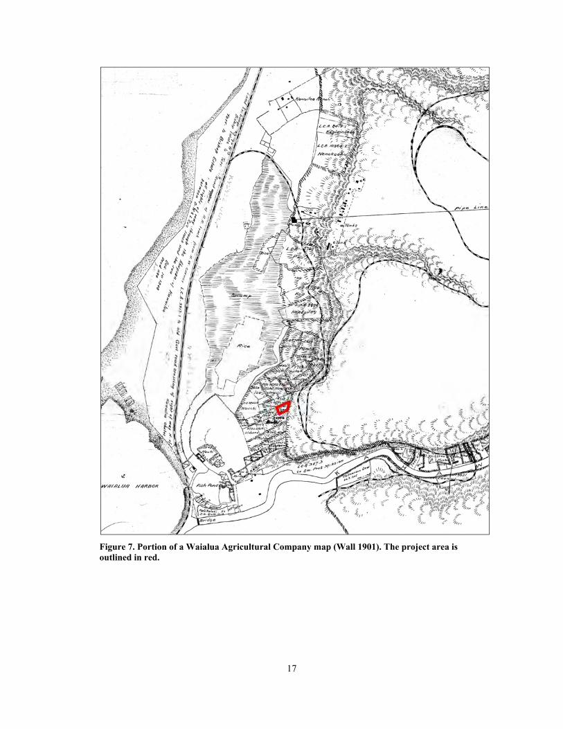
A later map, drawn in 1876, shows less detail (Figure 6). A few place names and topographic features are shown, and a cluster of structures is depicted near Waialua Bay. Much more detail is shown in a 1901 Waialua Agricultural Co. map (Figure 7). Land Claim Award (LCA) numbers and parcels are depicted. Loko Ea is labeled as “Fish Pond,” and rice paddies and swamps are illustrated in the ‘Uko‘a Pond region.

15
Figure 5. Portion of an historic map of Waialua Bay (Jackson 1884).

16
Figure 6. Portion of an historic map of Kawailoa (Monsarrat 1876).
A Kawailoa Forest Reserve map from 1924 shows the O.R.&L. and Wailua Plantation rail lines running through the ahupua‘a (Figure 8). The upper limits of the sugar cane fields are illustrated, and houses are scattered here and there. The uplands were covered in eucalyptus forest, while the Government Road ran along the coast.
Topographic maps from 1929 (Figure 9) and 1956 (Figure 10) show an increasingly urbanized landscape. Several features that appear to be lo‘i complexes are visible in the 1929 map but are replaced by houses by 1956. Roads and structures are much more common in these later maps. These are also clearly visible in aerial photographs from 1965 (Figure 11) and 1977 (Figure 12). Cane Haul Road that runs through the property is first visible on the 1956 map (see Figure 10).
17
Figure 7. Portion of a Waialua Agricultural Company map (Wall 1901). The project area is outlined in red.

18
Figure 8. Portion of a Kawailoa Forest Reserve map (Wall 1924).

19
Figure 9. Portion of a USGS (1929) Haleiwa Quadrangle. The project area is shown in red.

20
Figure 10. Portion of an Army Corps of Engineers (1956) map. The project area is shown in red. Note the addition of Cane Haul Road.

21
Figure 11. Portion of a 1965 aerial photo (USDA 1965).
Figure 12. Portion of a 1977 aerial photo (USGS 1977).
22
Māhele Land Tenure and Ownership of Kawailoa
The change in the traditional land tenure system in Hawaiʻi began with the appointment of the Board of Commissioners to Quiet Land Titles by Kamehameha III in 1845. The Great Māhele took place during the first few months of 1848 when Kamehameha III and more than 240 of his chiefs worked out their interests in the lands of the Kingdom. This division of land was recorded in the Māhele Book. The King retained roughly a million acres as his own as Crown Lands, while approximately a million and a half acres were designated as Government Lands. The Konohiki Awards amounted to about a million and a half acres, however title was not awarded until the konohiki presented the claim before the Land Commission.
In the fall of 1850 legislation was passed allowing citizens to present claims before the Land Commission for lands that they were cultivating within the Crown, Government, or Konohiki lands. By 1855 the Land Commission had made visits to all of the islands and had received testimony for about 12,000 land claims. This testimony is recorded in 50 volumes that have since been rendered on microfilm. Ultimately between 9,000 and 11,000 kuleana land claims were awarded to kamaʻāina totaling only about 30,000 acres and recorded in ten large volumes.
In the time preceding the Māhele, Kahekili Ke‘eaumoku, brother of Kuhina Nui Ka‘ahumanu, served as the chief of Waialua District. Upon his death in 1824, the Waialua lands were passed to Ke‘eaumoku’s sister Lydia Kekuapi‘ia Nāmāhana. When Nāmāhana died five years later, Ka‘ahumanu inherited the land, and upon her death in 1832, they were passed to her niece Kīna‘u. After Kīna‘u’s 1839 death, the land belonged to Victoria Kamāmalu.
During the Māhele of 1848, Kamāmalu ceded the lands from Kamananui to Ka‘ena, and they became government lands. She did not cede the ahupua‘a of Kawailoa, however, and it remained in her possession, along with the adjacent ahupua‘a of Pa‘ala‘a. In 1850 kuleana awards for parcels within Kawailoa were granted to individual tenants. A total of 93 kuleana claims were made for Kawailoa Ahupua‘a and 79 were awarded (Table 1; see Figure 2 for LCAs near the project area) (Waihona ‘Aina 2014). ‘Āpana 3 of Claim 2741, by Pueo, was a claim for the project parcel. Table 2 shows detailed information for all ‘āpana of this claim. The data found for Claim 2741 is as follows:
No. 2741, Pueo, Waialua, Oahu, December 30, 1847 N.R. 615-616v3
To the Land Commissioners: I am a native born resident of Kawailoa, Waialua, Oahu. I have lived here with the right, from the time of Kamehameha III and before. The first is Moemoeakuhe, Kawailoa waena, Wailua, Oahu. There are 34 lo‘i, bounded on the north by a stream, on the east by the land of Poli and Koolaha, on the south, pali wauke, on the west, my pali wauke. Here is the next, some lands of mine at Kapuaakea, Ainaiki, Kawailoa, Waialua, Oahu. there are three lo‘i, bounded on the east by the land of Kahoohano, south, land of Kelemahiai, west, land of Kolikoli, and north, land of Makuaeu, and the pali. I have a house lot at Kalualepo, Kawailoa, Waialua, Oahu, with nine lo‘i within it. The approximate boundaries are, east, three chains, south ten chains, west, four chains, north, ten chains. I had this land from Hoai and have held it sixteen years. The fourth is kula land at Ukoa, Waialua, Oahu. South is the land of Kolikoli, west, the land of Kahuna, north, the land of Keohaha, east, a fence. It would be good for me to get the award document.
PUEO X, his mark
[note: no fifth]
Here is the sixth, a salt land at Puana, Waialua, bounded on the east by the land of Kaanaana, on the south, west and north by a moana [the ocean]. Here is the seventh, an

23
‘aina wai [freshwater land] at Ukoa, Waialua, bounded on the east, west and north by a kula, on the south by a pond.
PUEO
F.T. 476v11 No. 2741, Pueo
L. Kuokoa, hoohikiia, Ua ike au i kona aina ma keia mau ili ma Kawailoa, Waialua, Oahu. Apana 1. Moomoeakuhe moo ili o Kalualepo 34 loi a me ka pali wauke. Apana 2. 3 loi ma Kapuiakea Ainaiki ili o Konohikilau. Apana 3. Pahale me ma loi 9 ili o Kalualepo. Apana 4. Kuleana ma ka pa uala hui o lakou ma ka ili o Ukoa. Apana 1: Mauka, aina o Koolaha & Pole Waianae, pali Makai, pali Koolaupoko, kahawai o Anahulu. Apana 2: Mauka, aina o Hoohano Waianae, aina o Kalamahiai Makai, aina o Kokikoli & Kaaeawa Koolaupoko, aina o Mokueu. Apana 3: Mauka, Alanui aupuni Waianae, ahupuaa o Paalaa Makai, loko o Punahoolapa Koolaupoko, Ili o Ou. Apana 4: Kuleana ma ka pa uala o lakou. No Hoaai mai kona aina i ka wa o Kinau, Aole mea keakea. Kaiakawaha, hoohikiia, Ua like ko maua ike me ko Kuokoa.
F.T. 476v11Translation No. 2741 Pueo
L, Kuokoa, sworn, I know his land in these ‘ilis in Kawailoa, Waialua, Oahu. Apana 1. Moemoeakuhe Mo‘o, ‘Ili of Kalualepo, 34 lo‘i, and pali wauke. Apana 2. 3 lo‘i in Kapuakea, Ainaiki, ‘Ili of Konohikilau. Apana 3. House lot and 9 lo‘i, ‘ili of Kalualepo. Apana 4. Communal right in the sweet potato lot in the ‘ili of Ukoa. Apana 1. Mauka, land of Koolaha & Pole Waianae, pali Makai, pali Koolaupoko, Anahulu Stream. Apana 2: Mauka, land of Hoohano Waianae, land of Kalarnahiai Makai, land of Kolikoli & Kaaiawa Koolaupoko, land of Mokueu. Apana 3: Mauka,Government road Waianae, Ahupua‘a of Paalaa Makai, Punahoolapa pond Koolaupoko, ‘Ili of Ou. Apana 4: Communal right in the sweet potato lot.

24
Table 1. Māhele Claims for Kawailoa
LCA Claimant Ahupua‘a ‘Ili Awarded
00387*O ABCFM (Mission)
Honolulu, Kaneohe, Kawailoa
Beretania St., Punahou, Kawaihao, Kukuluaeo, Kamakapili
1
2547 Luahiwa Kawailoa, Anahulu Mooiki 0
2674 Aha Kawailoa kai Mooiki 0
2692 Luahiwa Anahulu, Kawailoa 1
2699 Wewehi Kawailoa Nukauila, Makaleka, Kakaoloa 1
2712 Hoopii Paalaa, Kawailoa Niolo 1
2714 Huki, Haia Kawailoa, Anahulu lalo Kamooha, Anahulu lalo, Kawaipuolo
1
2725 Puhi Kawailoa, Anahulu luna Omuoiki, Mooiki, Ukoa, Lokoea 1
2727 Puu Kawailoa Ukoa, Lahuinoho, Hakaai 1
2740 Peku, wahine Kawailoa Kawaipuolo, Lokoea 1
2741 Pueo Kawailoa Kalualepo, Konohikilau, Ukoa, Puana
1
2743 Pilipi Kawailoa Anahulu, Mooiki 1
2748 Naahuelua Kawailoa kai Kolea, Kapiheakamalii, Puaena 1
2749 Nakahuahale Kawailoa Kaimakole 1
2750 Nalulei Kawailoa Imiimi, Uau, Keekee, Kahaoloa, Keae nui
1
2752 Nana Kawailoa Puaina uka, Kahoe, Ukoa, Puamakai
1
2753 Nakoana Kawailoa uka Keae iki, Keae nui, Manawai 1
02768B Maio Kawailoa, Anahulu Anahulu lalo, Koheo 1
2795 Kahiko Paalaa, Kawailoa Kapaaloa 1
2800 Kalehina Kawailoa Kawaipuolo, Nukuila, Kawailoa kai
1
2809 Kahawaii Kawailoa Ukoa, Kolea, Kaohe 0
2811 Kahui Kawailoa kai, Anahulu Anahululalo 1
2849 Kaanaana Kawailoa Moemoeakuhue, Puaena, Ukoa, Kalualepo
1
2855 Kahoohano Kawailoa Puaena, Kapuakea, Ukoa 1
2865 Kamahalo Kawailoa, Paalaa Anahulu 1
2876 Kanepilau Kawailoa Ukoa, Lokokea, Kawela 1
2882 Kahuna Kawailoa Lokoea 0
2896 Kamakea Kawailoa Anahulu, Kaleokani, Kapuwailua, Kawaipuolo, Ukoa, Kapuahilua
1

25
Table 1. (Continued)
LCA Claimant Ahupua‘a ‘Ili Awarded
2907 Keawe, wahine
Kawailoa, Kawailoa waena
Keokea, Ukoa, Ou 1
2925 Keliihuluhulu Kawailoa, Paalaa Poopohaku, Haehae, Hanaewa, Aakala, Aeikala
1
2926 Kahakai Kawailoa Ukoa, Koheo, Oio, Ainaiki, Keae, Pahui
1
2927 Koiniho Kawailoa Lahuimawaho, Anahulu, Noni 1
2930 Kealohua Paalaa, Kawailoa Laukihaa, Koheo 1
2940 Kahoohano Kawailoa Kapuakea, Ukoa 0
2942 Barker, Robert S.
Kawailoa Kaneiipuolono, Kapaapaa, Kulioiki
1
03373B Kahuna Kawailoa Lokoea, Ukoa 1
03414B Puaaiki Paalaa, Kawailoa Kolea 1
03454B Iaea Kawailoa Kawailoa kai, Ukoa 1
03688B Kahue Kawailoa Kapuahilua, Pulepule, Kaloaloa 1
03689B Kainiki Kawailoa Pulepule, Kaloaloa 1
3703 Moo Kawailoa, Anahulu Kawailoa kai, Pahua, Ukoa 1
3705 Mailou Kawailoa Mikiae, Ohulelua, Hahu 1
3790 Olopana Kawailoa, Kawailoa waena, Kawailoa kai
Hakaai, Lahuiwaho, Nuukauila, Ukoa, Anahulu
1
3940 Napunawai Kawailoa Lokoea, Waipuolo, Ukoa, Kauhiwai
1
3941 Napunaoi Kawailoa Ukoa, Lahuimoho, Lokoea, Moemoeakuhue
1
3942 Nauwahi Kawailoa Lahuiwaho, Ukoa, Kauhiwai, Anahululuna
1
4001 Holo Kawailoa kai Kawaipuolo 0
4305 Kahalau Kawailoa Niuula 1
4306 Kolikoli Kawailoa Loloea, Kealapahu, Kanekuakua, Ukoa
1
4307 Kaholokai Kawailoa waena Kaohe, Mooiki, Kaloaloa, Puukapu, Kawaipuolo
1

26
Table 1. (Continued)
LCA Claimant Ahupua‘a ‘Ili Awarded
4308 Kuolulo Kawailoa Keekee, Ohulelua, Uau, Keae, Kaeleku, Kaohe, Namahana, Papala, Kakalolea, Palikea, Kupuna, Kaluahooano, Ohaimoa, Kealai, Kanepepe, Kolokini, Kanahauhau, Kanaaulewalewa, Namomoku
1
4321 Kahelekilohi Kawailoa kai Waipao, Kaweupuolo, Nuukauila, Miimua, Pohakalaia, Puukapu
1
4324 Kualaau Kawailoa Ukoa, 0
7169 Koa Kawailoa Ukoa 1
7230 Lililehua Kawailoa Ukoa, Lahuinoho 1
7342 Kuokoa, L. Waialua, Kawailoa, Kamananui
Puaena, Lahuimoho, Honohikilua, Kalaopa, Kupalu, Kawaipuolo, Anahulu, Kalehunui, Kamahu, Lokoea, Kealia
1
7374 Kapule Kawailoa Koheo, Punenui 1
7403 Kaneiaulu Kawailoa Anahulu 1
7404 Kealohaio Kawailoa Kupalu 1
7406 Kalimahuamoa
Kamanuwai, Kawailoa Kanupaka, Ukoa 0
7408 Kawahamana Kawailoa Koheo 1
7414 Kapule Kawailoa Lauhulu, Mooiki, Kahililepe, Manini, Kawailoa uka
1
7417 Kaukaliu Kawailoa Lauhulu, Puuaki, Kalokoeli, Pukea mauka, Wailele, Wailele kai
1
7418 Kaeawa Kawailoa Lokoea, Keekee, Kau, Anahulu, Kaiaulaula, Ukoa
1
7424 Kawiwi/Kauiui
Kawailoa,Kawailoa kai, Kawailoa waena
Kupalu, Hiwa, Ukoa 1
7425 Kawelu Kawailoa kai, Kawailoa waena
Anahulu, Ou, Ainaiki, Mokukailaelae, Pihapihaulaula
1
7497 Kaukai Kawailoa Kawaipuolo, Lahuimoho, Puaena
1
7722 Hookala Kawailoa Kawailoa waena, Ukoa 1
8050 Ewauli Kawailoa Kawailoa waena, Ukoa, 0
8170 Heleau Kawailoa Kahauhau 0

27
Table 1. (Continued)
LCA Claimant Ahupua‘a ‘Ili Awarded
8205 Hokuaulani Kawailoa kai Kaniukukahi, Koheo, Kauhiwai, Mooiki
1
8304 Kalamahiai Kawailoa Ukoa, Waipuolo, Konohikilau, Kealia
1
8345 Kaakaukua Kawailoa Kapaeloa, Ulumalu, Pahoa, Hau 1
8412 Konohiki Kawailoa Olohana, Keekee, Kailua, Manowai, Kanenehia, Poloea, Uau
1
8419 Kealainanea Kawailoa Lauhulu, Kalualeuo, Iliilikea, Punakai
1
8420 Kahili Kawailoa Koheiki, Kealia, Kaaiea 0
8446 Kalua Kawailoa uka Kaeleku, Olohana, Kaloaloa, Koilau, Kanepepelaopuu, Kuku
1
8809 Kekauwa Kawailoa kai, Paalaa Koheo, Kapaaloa 1
8883 Keookoa Kawailoa 0
9917 Lohi Kawailoa, Anahulu Kalawaha, Hiwa, Keae, Ukoa 1
9948 Lole Kawailoa Punenue 1
9951 Laanui, Gideon
Kawailoa, Paalaa Kalaopa, Kalehunui, Kamahu 1, 2 & 3, Kuanopili, Laukihaa, Waikaalulu
1
10186 Moi Kapuahilua, Kawailoauka
Poonahoahoa, Puhipule, Koilau, Kalaelaau, Kawaiki
0
10199 Maio, wahine Kawailoa Hiwa,Ukoa 1
10246 Maloiki Kawailoa Kapaeloa, Koolauhale, Kawaewaa
1
10255 Makuku Kawailoa Lokoea, Kahalua 1
10256 Makalii Kawailoa Kaalaea, Kapaeloa 1
10727 Paele Kawailoa Koheo 1
10769 Pale, B Anahulu, Kawailoa Lokoea, Ukoa, Owanahulu luna 1
10772 Pelapela Kawailoa, Kawailoa uka
Poonahoahoa, Kapaeloa, 1
10930 Ulu Kawailoa Kiapu 0
10971 Wahinehune Kawailoa, Paalaea, Waimea
Kapaeloa, Amanui 1
10974 Wehelau Kawailoa Anahulu, Lauhulu 1

28
Table 2. Data for Claim 2741 by Pueo (‘Āpana 3 is the Area of Study)
Claim Claimant ‘Āpana ‘Ili Use and Notes (Translated by Steven Eminger)* 02741 Pueo 1 Kalualepo at Moemoekuhe are 34 taro patches (NR);
Moemoeakuhe is the mo‘o, the ‘ili is Kalualepo where there are 34 taro patches and a paper mulberry planted slope (FT); at Moemuakahi (LCA)
02741 Pueo 2 Konohikilau some lands for me, located at Ka Puaakea, Ainaiki, Kawailoa…3 taro patches (NR); 3 taro patches at Kapuakea Ainaiki, the ‘ili of Konohikilau (FT); at Kawailoa kai (LCA)
02741 Pueo 3 Kalualepo a house lot for me located at Kalualepo, Kawailoa (NR); house lot with 9 taro patches in the ‘ili of Kalualepo (FT); cultivated sweet potato patch at the Ukoa collective enclosure (LCA)
02741 Pueo 4 Ukoa claim at the enclosed sweet potato patch collective of ours in the ‘ili of Ukoa (FT)
02741 Pueo 5 no data no data
02741 Pueo 6 Puana salt land, with the ocean on the north (LCA)
02741 Pueo 7 Ukoa freshwater land, surrounded by kula lands, except on the south, where there is a pond (LCA)
* NR = Native Register FT = Foreign Testimony LCA = Land Commission Award
His land was from Hoaai, in the time of Kinau and is undisputed. Kaiaikawaha, sworn, My knowledge of it is the same as Kuokoa’s, [Award 2741; R.P. 2892; Kawailoa, Waialua; 3 ap.; 6.51 Acs]
An unusual find in the Māhele data was the use of collective enclosures, predominantly at ‘Uko‘a, but also at Loko Ea. These units were created to protect field plots from destruction caused by cattle. The enclosures were vast, as historic sources state that more than two miles of fencing was put up in ‘Uko‘a, with 60 farmers sharing the land. In an article on Hawaiian land tenure, Linnekin provides details of these land hui that developed in ‘Uko‘a (1983:176–177):
Mahele records from Kawailoa, on the north shore of Oahu, describe an apparent forerunner of the land hui, formed in response to the depredations of foreigners’ cattle. Many Kawailoa residents claimed plots in the “pa hui” of Ukoa, a “collective enclosure” variously called the pa ipu ‘melon enclosure’ and pa ʻuala ‘enclosure for sweet potatoes’. J. S. Emerson, the missionary for Waialua District, called it a “great potato field . . . in a very strong enclosure which the people made for themselves.” In 1835, Emerson reported that “not less than 2 miles” of fence had been erected “for the security of cultivated lands.” The purpose of such enclosures was clear: to protect the residents' fields from marauding cattle. A Hawaiian witness to the Land Commission described the origin of the pa hui:
We used to cultivate this place, but because of the trouble from the cattle, we stopped; however, Laanui [chief over Kawailoa] consented to our cultivating that place, so we enclosed it. There are 60 of us perhaps whose enclosure this is.
The land called Ukoa lay near the sea at the mouth of the Anahulu River. The land was kula because it was open and cultivable, if not suitable for wetland taro. Although the pa hui was collectively built, the Hawaiians cultivated their melon and potato fields within it individually. Once again, access to the kula was common, but production was a household matter. In the Mahele, Hawaiians in Kawailoa claimed their separate plots in the pa hui just

29
as they claimed their taro patches. Traditionally, these kula fields would have been scattered in open lands. In 1846, Emerson protested against a chief's dictum that commoners must fence their small parcels lying in the middle of the konohiki's kula: “If every man must fence his own patch that lies within the common cultivated land in order to have it malu [protected], he is in a sad case.”
We cannot tell whether the idea for the pa hui originated with the Hawaiians. Emerson's letters demonstrate his concern for fencing native lands against cattle, and there are indications in his correspondence that he may have advised the Hawaiians accordingly. Emerson assisted the Kawailoa people with their claims to the Land Commission. The fact that the parcels at Ukoa were contiguous and enclosed undoubtedly contributed to the high frequency with which they were awarded, unlike the scattered kula plots claimed in many other areas. Emerson also served as Government Agent for Sale of Lands in Waialua specifically to safeguard the Hawaiians’ interests. Against the chiefs’ will, Emerson sold cattle to the commoners in 1846, and conveyed large kula tracts to them in 1850.
Ranching began in Kawailoa shortly after the Māhele. Land grants were given to Native Hawaiians and unclaimed plots were made available for lease and eventual ownership. At this time, much of the privately owned land was used for cattle ranching, and to a lesser degree, agriculture. In most cases, extensive logging efforts preceded ranch operations in order to expand pastureland and provide wood for fences.
Sugarcane agriculture intensified after 1882, when wells were established. Frank Dillingham acquired land from Gaspar Silva and James Gay to establish a 7,000-acre property, primarily for sugarcane agriculture (Yardley 1981:191–199). Dillingham, who owned the O‘ahu Railway and Land Co. (O.R.&L.) railroad, extended the previously existing track around Ka‘ena Point to service the Halstead Plantation’s sugar mill in Waialua. The railroad followed the same corridor as the current Farrington Highway from Ka‘ena Point to Waialua, and the track extended through Kawailoa. The Halstead Plantation was later bought by the Waialua Agricultural Company, Ltd.
By the early 1900s, land in Kawailoa was being used to grow taro, rice, and sugarcane, with some cattle ranching still taking place as well. Traditional cultivation of taro using perennial streams and coastal springs continued in the area until the 1930s (Handy and Handy 1972).
Previous Archaeology
A wealth of archaeological studies have been conducted in Kawailoa. The following discussion provides information on archaeological investigations that have been performed within the vicinity of the project area (Figure 13). Table 3 lists previous archaeological projects and their results for the larger region of Kawailoa Ahupua‘a.
One of the earliest island-wide archaeological studies was conducted in the 1930s by J.G. McAllister (1933). In his study of O‘ahu, he recorded numerous sites located in Kawailoa. The sites closest to the project area include Site 230, mo‘o stones; Site 233, Loko Ea, and Site 236, ‘Uko‘a Fishpond (Figure 14). McAllister describes the sites as follows:
Site 230. Two stones known as moo, on either side of the Anahulu Stream above the old Haleiwa Seminary. One was named Poo o Moo and the other was known as Wawae o Moo. They are in no way different from ordinary stones, and can not be distinguished from other stones in the vicinity unless pointed out by one of the Hawaiians.

30
Figure 13. Previous archaeological studies in the vicinity of the project area.

31
Table 3. Previous Archaeology in Kawailoa
Author and Year Location Work Completed Findings
McAllister 1933 Island of O‘ahu Archaeological Survey McAllister recorded and examined 384 archaeological sites on O‘ahu, 13 of which are within Kawailoa. Sites near the project area include mo‘o stones, Loko Ea Pond, and ‘Uko‘a Fishpond.
Barrera 1979 Hale‘iwa Bypass Road
Cultural Resources Survey Recorded Site 50-80-04-1439, an historic artifact scatter; -1440, a wall remnant; -1441, an agricultural complex; -1442, the Emerson homestead; and -1443, an old church.
Smith and Masse 1989
TMK: (1) 6-1-004:093
Burial Disinterment Human remains were removed from 61-795 Papailoa Rd. They were designated as Site 50-80-04-3956.
McMahon 1990 TMK: (1) 6-1-004:081
Burial Disinterment Human remains were recovered from another coastal parcel on Papailoa Rd. They were designated as Site -4240.
Kirch and Sahlins 1992
Anahulu Valley Academic Research Two volumes published presenting research on the history of Kawailoa, ethnography, and settlement models.
Avery and Kennedy 1993, Dagher 1993
TMK: (1) 6-1-010:006
Inadvertent Discovery of Human Remains and Monitoring
Remains of at least three individuals were unearthed at 61-669 Kamehameha Hwy., and designated as Site -4670. Later archaeological monitoring documented an historic pit toilet.
Pietrusewsky 1993 TMK: (1) 6-1-010:018
Osteological Report Reported on a human femur found at Laniakea Beach.
Moore et al. 1993 Hale‘iwa Beach Park Extension
Archaeological Inventory Survey
Recorded Site -4589, a multi-component habitation area; Sites -4593 to -4595, burials; Site -4590, fire pits; Site -4600, a pit and posthole; Site -4601, a posthole and charcoal lens; and Site -235, the healing stone previously documented by McAllister (1933).
Athens et al. 1995 ‘Uko‘a Pond Paleoenvironmental Research
Coring provided a record of sediments spanning 8,000 years. Lowland forests rapidly declined around AD 950.
Masterson et al. 1995
Chun’s Reef Support Beach Park
Reconnaissance Survey Summarized conflicting evidence for the location of Pu‘upea Heiau.
Borthwick et al. 1998
TMK: (1) 6-1-004:023, :058, and (1) 6-2-001:1, and :010
Archaeological Inventory Survey
Identified Sites -5641 and -5643, WWII remains; -5495, a human burial; -5644, an historic trash dump; -5661, a cultural layer; and -564, the Puaena Stone.

32
Table 3. (Continued)
Author and Year Location Work Completed Findings
McGerty and Spear 2000
TMK: (1) 6-2-003 por. :006 and :009
Archaeological Inventory Survey
Recorded Site -5795, charcoal deposits; and -5839, a boulder wall.
Borthwick et al. 2002
North Shore Skateboard Park
Archaeological Inventory Survey
Identified Site -5791, O.R.&L. Railroad right of way; -5915, a water tank foundation; and -5916, a cultural layer.
Borthwick et al. 2003
Hale‘iwa Beach Park
Archaeological Inventory Survey
No significant finds.
Hammat et al. 2004 Laniakea Beack Support Park
Archaeological Inventory Survey
No Significant finds.
Rechtman et al. 2011
Kawailoa Windfarm Archaeological Inventory Survey
Identified 17 historic sites: Sites -7155, -7156, and -7158 are military-related, while Sites -7157, and -7159 to -7171 are associated with former plantation activities.
Park and Collins 2011
Kamehameha Hwy., Lokoea Pl., and Anahulu Pl.
Archaeological Monitoring
No significant findings.

33
Figure 14. Archaeological sites in Kawailoa (adopted from Sterling and Summers 1978).

34
Site 233. A small fresh-water pond covering 2.5 acres, still in use. The present pond is divided from a small stream, into which its outlets (makaha), open by a stone and earth embankment. Its other sides are formed by the natural contours of the land.
Site 236. Ukoa fishpond, Waialua.
One of the two Waialua ponds; still in use. It is a long narrow fresh-water pond, approximately a mile in length. Most of it now overgrown with weeds. Laniwahine was the goddess (moo) of Ukoa and lived there with her brother Puhiula. Between the pond and the sea was a tunnel through which Laniwahine passed when she wished to bathe in the ocean. Offerings were left for her on a stone, located near Pump Number 4 of the Waialua Agricultural Company. The site of this stone was marked for many years by a dead tree which was not removed because of its association with Laniwahine. Now neither stone nor tree is to be found.
This is the pond to which Lehuanui was sent by Oahunui to obtain fish. Here Lehuanui and his retainers (77, p. 143) found “the fish packed thick at the makaha and were soon busily engaged in scooping out, cleaning and salting them.” (McAllister 1933:141–142)
McAllister (1933) recorded several other important sites farther away from the project area, including Site 231, Anahulu Heiau; Site 232, an akua stone; Site 234, Puaena Point; Site 235, a stone with healing powers; and Site 237, Ili‘ilikea Heiau. The two heiau and the akua stone were reported as destroyed (McAllister 1933:141–142).
Site 231, Anahulu Heiau once stood at the location of the Haleiwa Hotel and was destroyed when the hotel was built. It was described as a large, unpaved luakini heiau with walls made of limestone (Thrum in McAllister 1933:141). It is said that the Haleiwa Hotel failed because the heiau was destroyed.
Site 232, an akua stone, is a sacred stone that once blocked the Anahulu River entrance. The stone was situated just below the water level of the river and would be exposed periodically. It was moved to clear the way for boats, and “much anxiety was shown by the Hawaiians, for fear of evil effects” (McAllister 1933:141).
Site 234 is Puaena Point, or Kahakakau Kanaka. This is the location where Elani was placed upon his death, for his body to decompose, and if a commoner had no one to care for his body after dying, it would be placed here (McAllister 1933:142). It is said that the fluids from the body would attract sharks, which were killed (McAllister 1933:142). Site 235 is a healing stone also found on the point. It is a smooth, oval stone, partially covered by sand, and represents a woman named Puaena. The stone was known for its healing powers, and people from all over the island would place limu on the stone and lay the injured part of the body upon it.
Site 237, Ili‘ilikea Heiau, was destroyed in 1916 by the Waialua Agricultural Company (McAllister 1933:142). The heiau had two divisions, measured 75 by 267 feet, and exhibited well-defined walls. Thrum reported that the area was covered in sugarcane and only a few rocks of the heiau remained (in Sterling and Summers 1978:142).
Archaeological inventory survey for the Hale‘iwa bypass highway included lands to the west of the current project area (Barrera 1979). Of the eight sites recorded, five were newly identified. Site 50-80-04-1439 is an historic artifact scatter; Site -1440 is a stacked stone wall remnant; Site -1441 is a complex of agricultural terraces; Site -1442 is the homestead of missionary J.S. Emerson; and Site -1443 is an old church. The agricultural complex consists of terraces that resemble traditional lo‘i, but were being utilized for lotus root cultivation in the 1970s. The three previously recorded sites

35
include Site -229, Kawaipuolo Spring; Site -233, Loko Ea Pond; and Site -236, ‘Uko‘a Fishpond. Subsurface testing did not yield any traditional or historic deposits.
Paleoenvironmental studies were conducted at ‘Uko‘a Pond (Site -236) in association with the Hale‘iwa bypass highway project (Athens et al. 1995). Core samples were analyzed for pollen, charcoal, and sediments, and provided a sequence of environmental change spanning approximately 8,000 years. The sequence was divided into four time periods, or zones, with the earliest exhibiting an abundance of arboreal species. Between 1000 and 500 years ago the forest began to decline, and was completely replaced by open scrub land in a matter of 300 years. The change in the pollen record occurs at roughly AD 950 and is thought to correlate with human settlement of the area (Athens et al. 1995:119).
An archaeological inventory survey was carried out on portions of TMK: (1) 6-2-003:006 and :009, to the southwest of the area of study (McGerty and Spear 2000) Two sites were documented: Site -5795 consists of charcoal deposits, and Site -5839 is a boulder wall. A charcoal sample from Site -5795 produced a radiocarbon date of AD 1420–1530 (McGerty and Spear 2000:37).
An archaeological inventory survey was completed for the North Shore Skate Park to the northwest of the current study area (Borthwick et al. 2002). The survey covered 3.4 acres and included subsurface testing in selected areas. Three sites were recorded, including an O.R.&L. right of way (Site -5791), a water tank foundation (Site -5915), and a cultural layer (Site -5916). The cultural layer was described as “a poorly defined mixed strata containing modern to early 1900s trash with sparse charcoal flecking” (Borthwick et al. 2002:ii).
Archaeological monitoring was conducted for water main replacement along Kamehameha Highway, Lokoea Place, and Anahulu Place, to the southwest of the current area of study (Park and Collins 2011). No significant finds were reported, although the northern portion of the project area was not monitored due to miscommunication. The only finds were isolated historic artifacts, consisting of three ceramic sherds, two glass bottles, a nail, and a marble.
An extensive survey was conducted for the Kawailoa Wind Farms (Rechtman et al. 2011). Within the 350-acre project area, 17 historic sites were found. Of these, three were related to military activity (Sites -7155, -7156, and -7158), and 14 were associated with former plantations (Sites -7157, -7159 to -7171). Closest to the current project area were Sites -7160, -7161, -7163, and -7166. Also recorded during the wind farm survey were six previously identified sites and 19 new sites outside the limits of their study. Of these, the closest to the current project area were Sites T-35, T-36, T-10, and -236.
Sites -7160 and -7161 are located along Kawailoa Drive. Site -7160 consists of two parallel walls. Site -7161 includes three concrete foundations that were once part of the Kawailoa Camp Stables. Site -7163 is a stone and concrete culvert that passes under the Hakina Bypass Road. Site -7166 is situated along either side of Cane Haul Road. It is a concrete culvert with two stone revetments. Site T-35 is a segment of old rail bed found near the intersection of Cane Haul Road and Hakina Bypass Road. Site T-36 is an historic Japanese cemetery located mauka of Site T-35. Site T-10 is a stone and concrete pedestal situated within the hairpin turn of Kawailoa Drive. Site -236 is the previously-documented ‘Uko‘a Pond.
Rechtman et al. (2011:20) note that portions of Cane Haul Road were built over the old Waialua Sugar Company railroad. This was stated in a cultural impact assessment interview with Mrs. Causey (Genz and Hammatt 2011:71) and is also depicted on historic maps, although no site number was given to the road. The portion of Cane Haul Road that runs through the project area was not built atop the old railroad, as the railway passed farther upslope (east) in this area (see Figure 9).

36
Settlement Pattern
The settlement of Anahulu Valley in Kawailoa has been studied extensively by Kirch and Sahlins (1992) and the discussion here is largely a summary of their work. Initial settlement of the Waialua region likely occurred early in time because of the abundance of natural resources, including fertile floodplains, fresh water, and marine life. Settlement was focused in coastal areas, near these abundant resources. By the 14th century AD, populations began to expand inland into upper Anahulu Valley, where rockshelters were used as temporary habitation sites. This inland expansion was also occurring in other areas of O‘ahu, as populations increased substantially, with the windward valleys being penetrated well before those on the leeward side of the island. In Kawailoa, the inland rockshelters were being used as a base to hunt birds and to make use of other stream and forest resources. The main population was still at the coast, however, as these rockshelters were not permanent habitation areas.
By the time of Kamehameha I in the late 1700s, land use intensified, with inland zones permanently settled, and animal husbandry taking place. Kamehameha’s occupation of the island in 1804 brought about significant social and economic changes in Kawailoa, as rockshelters were abandoned and people moved near irrigated terraces that produced large quantities of taro. This period of agricultural intensification was short-lived, however, and the upper Anahulu Valley was in decline as early as 1812. Possible causes of decline include a drop in population because of foreign disease epidemics, a new focus on obtaining sandalwood for foreign trade, and the abandonment of rural areas for growing urban centers, such as Honolulu.
After the collapse of the sandalwood trade ca. 1830, the Hawaiian economy shifted to catering to whaling vessels that would stop in the islands for provisions. Agricultural production was revived, as taro, yams, and sweet potatoes were cultivated for trade with whaling ships. It is clear that Kawailoa was well populated at the time of the Māhele, with 93 kuleana claims made for the ahupua‘a. Māhele data shows that a wide range of activities were taking place, from farming to fishing, and residential lots were interspersed among the farms and fishponds. An interesting find in the Māhele data was the establishment of collective enclosures at ‘Uko‘a and Loko Ea. These units were created to protect field plots from destruction caused by cattle. The enclosures were vast, as historic sources state that more than two miles of fencing was put up in ‘Uko‘a, with 60 farmers sharing the land (Linnekin 1983). By the turn of the century, cattle ranching and sugarcane agriculture were the dominant activities in Waialua, and taro and rice continued to be grown into the 1900s.
Summary and Anticipated Finds
The many oli, mo‘olelo, and ‘ōlelo no‘eau that perpetuate the memory of pre-contact Waialua and Kawailoa indicate the notable place they had in Hawaiian history. Kawailoa was and still is an ahupua‘a within the district of Waialua, and both of these place names rightfully suggest the abundance of water in the region, attested by such geographical features as ‘Uko‘a Fishpond, Loko Ea Fishpond, and Anahulu Stream. Indeed, later historical records document extensive well-watered lands to include vast fresh water ponds, taro fields, and swamplands. The significance of Waialua brought about by its bounteous agricultural and aquacultural production appears to be consistent with the many important heiau found throughout the district. This bounty gave rise to a substantial population dispersed among good-sized villages. Hawaiian language newspaper articles, old photos, and historic maps attest to the development of Waialua into the post-contact era with references to bustling communities, churches, and schools. While Kamāmalu kept the ahupua‘a of Kawailoa and Pa‘ala‘a, her crown lands from Kamananui to Ka‘ena were ceded to become government lands, and the totality of these crown, government, and individual kuleana lands would eventually support sugar plantations, cattle ranching, railroad, and military enterprises.

37
Due to its diversified history, Kawailoa Ahupua‘a might offer numerous types of archaeological materials. Archaeological work in the region might uncover anything from pre-contact ceremonial and/or agricultural remnants to historic-era artifacts representative of the various industries that left their footprint on the landscape. The specific project area was a kuleana lot, awarded to Pueo, and he mentioned a house lot and taro patches in his Māhele testimony. Remains of these are likely to be found on the parcel, and may include stone terraces or house platforms, irrigiation channels, walls, subsurface cultural layers, pondfield soils, and/or any portable artifacts related to habitation or agriculture.
Research Questions
Research questions for the archaeological inventory survey were developed in consultation with SHPD. A kuleana lot, LCA 2741 ‘Apana 3, was located on the parcel, and Māhele records show that a house lot and nine taro patches were there. Research questions will be to determine the location of the house and taro patches. These may be indicated by the archaeological remains mentioned above, particularly platforms, foundations, building materials, or habitation-related artifacts for the house; and terraces, irrigation channels, or pondfield soils for the taro patches.

38
METHODS
Pedestrian survey and subsurface testing were conducted on February 3, 2014 by Windy McElroy, PhD, Tara del Fierro, BA, Jeffrey Lapinad, and Pūlama Lima, BA. At the request of SHPD, further subsurface testing was conducted on May 5, 2014. This additional trenching was accomplished with an excavator, and attended by staff archaeologist Jeffrey Lapinad. McElroy served as Principal Investigator, overseeing all aspects of the project.
For the pedestrian survey, the ground surface was visually inspected for surface archaeological remains, with transects conducted in an east-west direction below Cane Haul Road, and in a north-south heading above it. Of the .895-acre survey area, 100% was covered on foot. Vegetation was very heavy, consisting primarily of thick grass that obscured the ground surface and impaired visibility (Figure 15). The spacing between archaeologists was very narrow for this reason, with archaeologists spread only 2–3 m apart. Archaeological sites were identified visually, with any feature possibly made by humans and more than 50 years old considered a site.
Shovel test excavations were conducted in five locations throughout the survey area. These test pits were excavated by hand, with shovel and trowel, within natural stratigraphic layers. Vertical provenience was measured from the surface and all sediment was dry screened through ¼ inch mesh. Additional subsurface testing was done with an excavator, with six trenches excavated throughout the survey area. Trench locations were approved by Deona Naboa of SHPD beforehand. For shovel test pits and trenches, profiles were drawn and photographed, and sediments were described using Munsell soil color charts and a sediment texture flowchart (Thien 1979). All test pits were backfilled after excavation, but the trenches were left open. The survey area, test pit locations, and trench locations were recorded with a 3 m-accurate Garmin GPSmap 62st.
The scale in all field photographs is marked in 10 cm increments. The north arrow on all maps points to magnetic north. Throughout this report rock sizes follow the conventions outlined in Field Book for Describing and Sampling Soils: Gravel <7 cm; Cobble 7–25 cm; Stone 25–60 cm; Boulder >60 cm (Schoeneberger 2002:2–35). Of the three artifacts recorded, two (Artifacts 1 and 3) were collected for analysis and are being temporarily curated at the Keala Pono office in Kaneohe, Hawai‘i. Artifact 2 was too large to collect and was left in place.
Figure 15. Pedestrian survey in the lower half of the parcel, showing heavy vegetation. Orientation is to the north.

39
RESULTS
Pedestrian survey and subsurface testing were conducted in the .895-acre project area. One archaeological site, an historic road, was found. In addition, three possible historic artifacts were found on the surface, though only one could be dated precisely. No cultural material or deposits were identified during subsurface testing. Several bulldozer push piles were evident on the surface throughout the project area, signaling previous disturbance.
Pedestrian Survey
The survey area consisted of a .895-acre plot covered in heavy vegetation, with Cane Haul Road, a paved thoroughfare, cutting through the parcel on the east side (Figure 16). The land is heavily disturbed, with bulldozer push piles near most of the perimeter of the parcel and along the road (Figure 17). The push piles were characterized by linear concentrations of basalt boulders and stones with soil and modern refuse mixed in. Many of the boulders exhibited damage from heavy equipment (Figure 18). Several other basalt boulders throughout the property appeared to be naturally in place. Refuse within the push piles consisted of barbed wire, metal pieces, a rusty paint can, and glass fragments. The largest glass fragment was collected for possible dating (Artifact 3). This was the only glass fragment within the push piles that appeared to be diagnostic. Two other possible artifacts were identified and all three are described below (Table 4).
Artifact 1 is a log cabin syrup bottle that was found on the surface, 11 m west of Cane Haul Road (see Figure 16). The bottle is clear and measures 19.9 cm tall and 8.6 cm at its widest point (Figure 19). The bottle has vertical side mold seams that continue to the top of the lip, indicating that it was machine made. The sides have a straight line pattern, while the front and back have an “x” pattern in an oval shape. The oval is without decoration, and was likely the location for the Log Cabin label. The base of the bottle bears the Log Cabin name, along with a picture of a log cabin with a number 4 on the left and a number 8 on the right (Figure 20). The letter B is below and to the right of the number 8. Log Cabin began manufacturing maple syrup in 1887 in Minnesota (Log Cabin 2014), and most machine made bottles date to after 1910 (SHA 2014a). This bottle did not match any photos of historic Log Cabin bottles posted online, however, and it is thought to be much more recent. An exact date on the bottle could not be obtained.
Artifact 2 is a concrete piece located 12 m south of the northern property boundary and 3 m from a bulldozer push pile (see Figure 16). The concrete piece is basin-shaped and has three broken sides (Figure 21). It measures 92 cm long, 42 cm wide, and 26 cm tall. The age of this artifact is uncertain, though because of its material, it is either historic or modern. It may have functioned as a trough to hold water.
Artifact 3 is a glass fragment found within a bulldozer push pile near the northwestern corner of the property (see Figure 16). It is the base of a clear one-gallon jug (see Figure 19). The fragment measures 13.8 cm long and 13.6 cm wide. Markings include the Owens-Illinois Glass Co. symbol, “Duraglas” in script lettering, and a diamond pattern along the edge of the base. Also embossed on the base are “20,” “3A,” and “1588-W.” The number to the right of the Owens-Illinois symbol is missing, as the jug broke in that area, thus the exact year of manufacture cannot be determined. A small piece of the body is present and exhibits the embossing “ON,” probably the beginning of “ONE GALLON,” which is a common marking on jugs of that size. Duraglas is a process used by Owens-Illinois which enhanced the durability of bottles. The script “Duraglas” embossing was used between 1940 and the mid-1950s (SHA 2014b).
Cane Haul Road, Site 50-80-04-7604 first shows up within the project area on a 1956 map, and is therefore more than 50 years old (see Figure 10). It is a 9.4 km (5.8 mi.)-long road that extends from

40
Figure 16. Location of test pits (TP) and artifacts (Art). The project area is outlined in red, and the approximate location for the proposed house is in blue.

41
Figure 17. Location of trenches. Note the bulldozer push piles that are visible in the western portion of the parcel.

42
Figure 18. Example of a boulder with scratch marks from heavy equipment.
Figure 19. Artifact 1, left; and Artifact 3, right.

43
Figure 20. Artifact 1, showing detail on bottle base.
Figure 21. Artifact 2 in situ. Orientation is to the west.

44
Table 4. Artifact Data
Art # Item Provenience Measurements Details Possible Age/Use
1 Glass Bottle
Surface, 11 m W of Cane Haul Rd.
19.9 x 8.6 cm Log Cabin embossing, machine made
Syrup bottle, age undetermined
2 Concrete Piece
Surface, 12 m from N property boundary
92 x 42 cm Three sides broken Possible water trough, historic or modern
3 Glass Fragment
Surface, within push pile near NW corner of parcel
13.8 x 13.6 cm Duraglas, Owens-Illinois
Gallon jug, 1940-1950s
Kawailoa Road in the north to just beyond Kahui Street in the south (Figures 22 and 23). A 46 m-long, 7.8–8.9 m-wide segment of the road runs through the project area (Figures 24 and 25). The portion of the road on the subject parcel has been cut into the hillside, which is clearly seen looking at the topography, with 2 m or more of topsoil removed when the road was built. The road is linear in plan, and the paving is now level with the current ground surface. No cultural material was observed in association with the road.
Previous archaeological work to the north has determined that Cane Haul Road was built atop an old railroad (Rechtman et al. 2011:20). This is not true of the portion of Cane Haul Road that runs through the project area however, as the railway passed farther upslope (east) in this area (see Figure 9). The road was built by the Waialua Sugar Company to load the trucks and drive back to the sugar mill in Waialua (Nellis, pers. comm. 2014). Prior to delivering sugar in trucks, they were using railroad, mules and carts. In order for the trucks to get through, a series of roads were created to all lead back to the sugar mill. There were roads that were permanent year round thoroughfares that were weather-proofed, and there were also some less traveled roads that became overgrown.
Cane Haul Road was one of those that was permanent year round. The road was built only for sugarcane harvesting, not for real estate development, and was never intended for use by residents of the area (Nellis, pers. comm. 2014). Cane Haul Road is currently owned by the owners of the subject property, Big Country, LLC, who provide easement to the neighboring parcels. The road is in good condition and is still in use today.
Subsurface Testing
Five shovel test pits and six trenches were excavated throughout the property, to determine if vestiges of the Māhele-era house lot and taro patches could be found (Table 5, see Figures 16 and 17).
Test Pit (TP) 1 was excavated next to Artifact 2, on the north side of the property (see Figure 16). The pit measured 38 cm long and 29 cm wide. It was excavated to 53 cm below surface (cmbs), where fragments of saprolitic rock were encountered. A single sterile alluvial deposit was found (Figure 26).
TP 2 was placed roughly in the center of the southern part of the property (see Figure 16). The pit measured 44 cm long and 34 cm wide. It was excavated to 30 cmbs, where saprolitic rock was encountered. Stratigraphy consisted of the same alluvial deposit found within TP 1 (Figure 27).
TP 3 was located upslope of TP 1 and 2, near the center of the northern plot of land (see Figure 16). This area of the parcel is heavily disturbed with extensive bulldozer push piles. The test pit measured

45
Figure 22. Northern extent of Cane Haul Road, highlighted in yellow. The project area is shown in red.

46
Figure 23. Southern extent of Cane Haul Road, highlighted in yellow.

47
Figure 24. Plan view of Cane Haul Road where it crosses the subject property.
Figure 25. Portion of Cane Haul Road that crosses the subject property. View is to the south.

48
Table 5. Sediment Descriptions
Location Layer Depth (cmbs)
Color Description Interpretation
TP 1 I 0-53+ 5YR 3/3 Silty clay; less than 1% basalt cobbles and gravel; very few fine roots; base of excavation.
Alluvial Deposit
TP 2 I 0-40+ 5YR 3/3 Silty clay; less than 1% basalt cobbles and gravel; very few fine roots; base of excavation.
Alluvial Deposit
TP 3 I 0-48+ 5YR 3/3 Silty clay; charcoal flecking, modern debris; 15% basalt cobbles and gravel; few fine to medium roots; base of excavation.
Fill
TP 4 I 0-24+ 5YR 3/4 Silty clay; 15% basalt cobbles and gravel; few fine to medium roots; base of excavation.
Fill
TP 5 I 0-36+ 5YR 3/3 Silty clay; 20% basalt cobbles and gravel; few fine to medium roots; base of excavation.
Fill
TR 1 I 0-144 5YR 3/3 Silty clay; 20% basalt cobbles and gravel; few fine to medium roots; smooth, abrupt boundary.
Fill
II 144-155+ 5YR 4/3 Silty clay; 20% basalt cobbles and gravel; few fine roots; base of excavation.
Sterile Alluvial Deposit
TR 2 I 0-70 5YR 3/3 Silty clay; 5% basalt cobbles and gravel; very few fine roots; smooth, abrupt boundary.
Fill
II 70-131 5YR 3/4 Silty clay; 5% basalt cobbles and gravel; very few fine roots; smooth, abrupt boundary.
Sterile Alluvial Deposit
III 131-149+ 5YR 4/3 Silty clay; 20% basalt cobbles and gravel; base of excavation.
Sterile Alluvial Deposit
TR 3 I 0-40 5YR 3/3 Silty clay; 5% small to medium basalt cobblels; very few fine roots; smooth, abrupt boundary.
Alluvial Deposit
II 40-122 5YR 3/4 Silty clay; very few fine roots; smooth, clear boundary.
Sterile Alluvial Deposit
III 122-150+ 10YR 6/6
Silty clay; 20% basalt of all sizes; base of excavation.
Sterile Alluvial Deposit
TR 4 I 0-110 5YR 3/3 Silty clay; 5% basalt cobbles and gravel; few fine to medium roots; smooth, clear boundary.
Alluvial Deposit
II 110-150+ 5YR 4/3 Silty clay; 10% basalt of all sizes; base of excavation.
Sterile Alluvial Deposit

49
Table 5. (Continued)
Location Layer Depth (cmbs)
Color Description Interpretation
TR 5 I 0-80 5YR 3/3 Silty clay; less than 1% basalt cobbles and gravel; very few fine roots; smooth, clear boundary.
Alluvial Deposit
II 80-130+ 10YR 5/3
Silty clay; 10% basalt of all sizes; base of excavation.
Sterile Alluvial Deposit
TR 6 I 0-131 5YR 3/3 Silty clay; 15% basalt cobbles and gravel; few fine roots; smooth, clear boundary.
Alluvial Deposit
II 131-182 5YR 3/4 Silty clay; 20% basalt of all sizes; few fine roots; smooth, clear boundary.
Sterile Alluvial Deposit
III 182-200+ 5YR 3/1 Silty clay; 25% basalt of all sizes; base of excavation.
Sterile Alluvial Deposit
Figure 26. TP 1 west face profile drawing (left) and photo (right).
Figure 27. TP 2 east face profile drawing (left) and photo (right).

50
44 x 26 cm. It was excavated to 46 cmbs, where the soil was too rocky and compact to continue deeper. Stratigraphy consisted of a rocky fill deposit (Figure 28). Charcoal flecking and modern debris, in the form of leather and glass bits, were observed within the upper 34 cm of this deposit.
TP 4 was placed within the footprint of the proposed house, northeast of TP 3 (see Figure 16). The pit was excavated to 24 cmbs, where basalt bedrock or a large boulder was encountered. The pit was extended to encompass a 56 x 50 cm area, but the rock encompassed the floor of the entire pit and excavation could not continue. Stratigraphy consisted of the same fill deposit found within TP 3, although no subsurface modern debris was observed in this area (Figure 29).
TP 5 was also placed within the footprint of the proposed house, approximately 5 m southwest of TP 4 (see Figure 16). The pit measured 48 cm long and 39 cm wide. It was excavated to 36 cmbs, where the soil was too rocky and compact to continue deeper. Stratigraphy consisted of the same fill deposit found within TP 4 (Figure 30).
Trench (TR) 1 was located in the northeast corner of the property, where the proposed house will be constructed (see Figure 17). The trench measured 14 m long and 1.1 m wide. It was excavated to 1.55 m, well below the fill layer exhibited in TP 3, 4, and 5, and into a sterile alluvial deposit (Figure 31).
TR 2 was placed in the southeast quadrant of the parcel (see Figure 17). The trench measured 7 m long, 1.1 m wide, and 1.49 m deep. As the ground is naturally sloping down to the south and west, the fill layer was shallower here, only occurring from 0–70 cmbs (Figure 32). Beneath the fill were two layers of sterile alluvium.
TR 3 was located on the northwest side of the property (see Figure 17). It measured 8.5 m long, 1.1 m wide, and 1.5 m deep. Stratigraphy consisted of three layers of alluvium, the lower two being culturally sterile (Figure 33).
TR 4 was placed just north of the property’s center, where the proposed septic system will be located (see Figure 17). It measured 8.5 m long, 1 m wide, and 1.5 m deep. Stratigraphy consisted of two layers of alluvium, the lowest of which was culturally sterile (Figure 34).
TR 5 was located just south of the property’s center (see Figure 17). The trench measured 7 m long, 1.1 m wide, and 1.3 m deep. Stratigraphy consisted of two layers of alluvium, the lowest of which was culturally sterile (Figure 35).
TR 6 was placed in the southwest corner of the parcel, where a proposed water line will run (see Figure 17). The trench measured 14 m long and between .8 and 2.8 m wide, after removing several large boulders. It was excavated to 1.5 m deep, where three layers of alluvium were encountered (Figure 36). The lower two layers were culturally sterile.
Summary of Findings
Pedestrian survey and subsurface testing were conducted at TMK: (1) 6-2-002:042. The parcel was previously disturbed, with evidence of bulldozer push found along much of the perimeter and along the paved road that bisects the property. Three possible historic artifacts were found on the surface, though only one could be dated precisely. This was a glass fragment incorporated within the bulldozer push, and it may date to the 1940s or ’50s. Site 50-80-04-7604 is Cane Haul Road, the paved thoroughfare that runs through the property. It first appears on a 1956 map and was built by the Waialua Sugar Company to transport cane. No cultural material or deposits were identified during subsurface testing. A sterile alluvial deposit was encountered in the lower half of the parcel, while the upper half contained a rocky fill on the surface, underlain by the sterile alluvium.

51
Figure 28. TP 3 east face profile drawing (left) and photo (right).
Figure 29. TP 4 south face profile drawing (left) and photo (right).
Figure 30. TP 5 south face profile drawing (left) and photo (right).

52
Figure 31. TR 1 south face profile drawing (left) and photo (right).
Figure 32. TR 2 north face profile drawing (left) and photo (right).

53
Figure 33. TR 3 north face profile drawing (left) and photo (right).
Figure 34. TR 4 west face profile drawing (left) and photo (right).

54
Figure 35. TR 5 east face profile drawing (left) and photo (right).
Figure 36. TR 6 north face profile drawing (left) and photo (right).

55
SUMMARY AND RECOMMENDATIONS
Archaeological inventory survey was conducted at TMK: (1) 6-2-002:042 for proposed construction of a single-family dwelling, garage, driveway, and fence. This consisted of pedestrian survey that covered 100% of the property, as well as test excavations consisting of five shovel test pits and six trenches. One archaeological site, Cane Haul Road, was identified during pedestrian survey. The portion of Cane Haul Road that runs through the property first appears on a 1956 map. It cannot be seen on a 1929 map, thus the segment that runs through the project area was constructed between those years.
Two glass artifacts and one concrete artifact were found during pedestrian survey, not associated with the historic road. One of the glass pieces likely dates to the 1940s or ‘50s, but the age of the other two items could not be precisely determined. No cultural material or deposits were encountered during subsurface testing, and much of the parcel was found to be previously disturbed by bulldozing. Subsurface testing identified a sterile alluvial deposit in the lower (western) half of the parcel, and a rocky fill underlain by the sterile alluvium in the upper (eastern) half.
Significance Determinations
To determine if a historic property is significant under Hawaii Administrative Rules (HAR) for historic preservation, or is eligible for NRHP listing, it must be assessed for significance according to HAR §13-284-6(b) and National Register Bulletin 15, respectively. According to Bulletin 15:
The quality of significance in American history, architecture, archaeology, and culture is present in districts, sites, buildings, structures, and objects that possess integrity of location, design, setting, materials, workmanship, feeling, and association, and:
A. That are associated with events that have made a significant contribution to the broad patterns of our history; or
B. That are associated with the lives of persons significant in our past; or
C. That embody the distinctive characteristics of a type, period, or method of construction or that represent the work of a master, or that possess high artistic values, or that represent a significant and distinguishable entity whose components may lack individual distinction; or
D. That has yielded, or may be likely to yield, information important in prehistory or history.
(National Park Service 1990:2)
To this set of criteria, HAR §13-284-6(b) adds Criterion E, which states that a property may be significant if it has:
an important value to the native Hawaiian people or to another ethnic group of the state due to associations with cultural practices once carried out, or still carried out, at the property or due to associations with traditional beliefs, events, or oral accounts – these associations being important to the groups history and cultural identity.
Site 50-80-04-7604, Cane Haul Road, is significant under Criterion D, as further study may yield more information on the road (Table 6). The road is related to Waialua Sugar Company pursuits,

56
Table 6. Significance Determinations
Site Description Criterion Justification Recommendation
7604 Historic Road A, D Associated with an event that made a significant contribution to Hawai‘i’s history. May yield information on history and prehistory.
No further work.
and future research might reveal details of sugar-era activity in Kawailoa. The event of sugarcane cultivation made a significant contribution to the history of Hawai‘i, thus the road may also be significant under Criterion A, for its association with Hawai‘i’s sugar era.
In sum, one significant historic property, Site 50-80-04-7604, Cane Haul Road, was identified on TMK: (1) 6-2-002:042. The undertaking will have no effect on Site 7604 because the proposed construction of a house, garage, driveway, and perimeter fence will not affect the integrity of the site. No further work is recommended.
It should be noted that isolated human burial remains may be discovered during construction activities, even though no evidence of human burials was found during the survey. Should human burial remains be discovered during construction activities, work in the vicinity of the remains should cease and the SHPD should be contacted.

57
GLOSSARY
ahupua‘a Traditional Hawaiian land division usually extending from the uplands to the sea.
ali‘i Chief, chiefess, monarch.
‘anae Full-sized ʻamaʻama mullet fish.
‘āpana Piece, slice, section, part, land segment, lot, district.
awa The milkfish, or Chanos chanos, often raised in fishponds in ancient times.
boulder Rock 60 cm and greater.
cobble Rock fragment ranging from 7 cm to less than 25 cm.
gravel Rock fragment less than 7 cm.
heiau Place of worship and ritual in traditional Hawai‘i.
hui A club, association, society, company, or partnership; to join, or combine.
‘ili Traditional land division, usually a subdivision of an ahupua‘a.
koa haole The small tree Leucaena glauca, historically-introduced to Hawai‘i.
kula Dry land, often used for sweet potato cultivation.
kuleana Right, title, property, portion, responsibility, jurisdiction, authority, interest, claim, ownership.
limu Refers to all sea plants, such as algae and edible seaweed.
lo‘i, lo‘i kalo An irrigated terrace or set of terraces for the cultivation of taro.
luakini Large heiau of human sacrifice.
Māhele The 1848 division of land.
makai Toward the sea.
mauka Inland, upland, toward the mountain.
mo‘o Lizard, dragon, water spirit.
mo‘olelo A story, myth, history, tradition, legend, or record.
‘ōlelo no‘eau Proverb, wise saying, traditional saying.
oli Chant.
stone Rock fragment ranging from 25 cm to less than 60 cm.
‘uala The sweet potato, or Ipomoea batatas, a Polynesian introduction.

58
REFERENCES
Army Corps of Engineers 1956 Haleiwa. Scale 1:25,000. Land Study Bureau maps nos. O-12-1.4a & 1.4b. Sheet 5321 II
SE, Series W833, Edition 1-AMS. Prepared by the Army Map Service, Corps of Engineers, Washington, D.C. Copied in 1956 from Hawaii, 1:24,000, U.S. Geological Survey, Haleiwa, 1953. Original map compiled by U.S.G.S.
Athens, J.S., J.V. Ward, D.W. Blinn, and M. Tomonari-Tuggle 1995 Paleoenvironmental Investigations at ‘Uko‘a Pond, Kawailoa Ahupua‘a, O‘ahu, Hawai‘i.
International Archaeological Research Institute, Inc., Honolulu, Hawai‘i.
Avery, S., and J. Kennedy 1993 Archaeological Report Concerning The Inadvertent Discovery Of Human Remains and
Monitoring of Subsurface Excavation at 61-669 Kamehameha Highway, TMK 6-1-10:006, Kawailoa Ahupua‘a, Waialua District, Island of Oahu. Archaeological Consultants of Hawai‘i, Inc., Hale‘iwa, Hawai‘i.
Barrera, W. 1979 Cultural Resources Survey of Kamehameha Highway Realignment (Hale‘iwa, O‘ahu).
Chiniago Inc., Hale‘iwa, Hawai‘i.
Beaglehole, J.C. 1967 The Journals of Captain James Cook on his Voyages of Discovery. Vol. III, Part I.
Cambridge University Press, Cambridge, Massachusetts.
Borthwick, D.F., A. Bush, J. Yorck, and H.H. Hammatt 2003 Archaeological Inventory Survey Report for the Proposed Wastewater Improvements to
the Hale‘iwa Beach Park, Kawailoa, Waialua, O‘ahu, Hawai‘i (TMK:6-2-01: Por. 2). Cultural Surveys Hawai‘i Inc., Kailua, Hawai‘i.
Borthwick, D.F., B.L. Colin, R. Chiogioji, and H.H. Hammatt 1998 Archaeological Inventory Survey and Subsurface Testing Report of a 140-acre parcel
within Kawailoa Ahupua‘a, Waialua District, Island of O‘ahu (TMK 6-1-4:23, 58 and 6-2-1:1,10). Cultural Surveys Hawai‘i, Inc., Kailua, Hawai‘i.
Borthwick, D.F., D. Perzinski, and H.H. Hammatt 2002 Archaeological Inventory Survey Report for the Proposed North Shore Skateboard Park,
Kawailoa, Waialua, O‘ahu, Hawai‘i (TMK:6-2-3:17, 19, 20, 22, and 38). Cultural Surveys Hawai‘i, Inc., Kailua, Hawai‘i.
Dagher, C. 1993 Inadvertent Discovery of Human Skeletal Remains at 61-669 Kamehameha Highway,
Hale‘iwa, Waialua, O‘ahu. State Historic Preservation Division, Kapolei, Hawai‘i.
Genz, J. and H. Hammatt 2011 Cultural Impact Assessment for the Proposed Kawailoa Windfarm Project, Multiple
Ahupua‘a, Waialua District, O‘ahu Island. Cultural Surveys Hawai‘i, Inc., Kailua, Hawai‘i.
Foote, D., E. Hill, S. Nakamura, and F. Stephens 1972 Soil Survey of the Islands of Kauai, Oahu, Maui, Molokai, and Lanai, State of Hawaii.
United States Department of Agriculture, Soil Conservation Service. Published in cooperation with the University of Hawaii Agricultural Experiment Station, Washington, D.C.
59
Hammatt, H.H., S.D. M. Freeman, K. Souza, and D.F. Borthwick 2004 Archaeological Inventory Survey for the Proposed Laniākea Beach Support Park,
Kawailoa, Waialua, O‘ahu Island, Hawai‘i (TMK 6-1-05: 14 por.). Cultural Surveys Hawai‘i, Inc., Kailua, Hawai‘i.
Handy, E.S.C. 1940 The Hawaiian Planter: His Plants, Methods and Areas of Cultivation. Bishop Museum
Bulletin, 161. Bishop Museum, Honolulu.
Handy, E.S., E.G. Handy, and M.K. Pukui 1972 Native Planters in Old Hawaii; Their Life, Lore, and Environment. Bernice P. Bishop
Museum Bulletin 23, Bishop Museum Press, Honolulu.
Jackson, G.E.G. 1884 Waialua Bay, Oahu. Scale 1 in. = 300 ft. Hawaiian Government Survey. Register Map
No. 1346.
Juvik, S.P. and J.O. Juvik, eds. 1998 Atlas of Hawaiʻi. University of Hawaiʻi Press, Honolulu.
Kamakau, S. 1992 Ka Poe Kahiko: The People of Old. Translated from the newspaper Ke Au ʻOkoʻa by
Mary Kawena Pukui; arranged and edited by Dorothy B. Barrère; illustrated by Joseph Feher. Paperback ed. 1992. Bishop Museum Press, Honolulu.
Kirch, P.V., and M. Sahlins 1992 Anahulu: The Anthropology of History in the Kingdom of Hawai‘i. 2 vols. Volume 1.
Historical Ethnography by Marshall Sahlins, Volume 2. The Archaeology of History, by Patrick V. Kirch, University of Chicago Press, Chicago, Illinois.
Linnekin, J. 1983 “The hui lands of Keanae: Hawaiian land tenure and the great mahele.” The Journal of
the Polynesian Society, Volume 92, No. 2, p 176-177. Log Cabin
2014 About Us. <http://www.logcabinsyrups.com/about-us> Accessed 2/6/14.
Masterson, I., D. Borthwick, and H.H. Hammatt 1995 An Archaeological Reconnaissance Survey of the Proposed Chun's Reef Support Beach
Park at Kawailoa, Waialua, O‘ahu. Cultural Surveys Hawai‘i, Inc., Kailua, Hawai‘i.
McAllister, J.G. 1933 Archaeology of O‘ahu. Bishop Museum Bulletin 104. Bernice P. Bishop Museum,
Honolulu.
McGerty, L., and R.L. Spear 2000 An Archaeological Inventory Survey in the Ahupua‘a of Kawailoa, Waialua District,
Island of O‘ahu (TMK: 6-2-03: Por. 6 and 9). Scientific Consultant Services, Inc., Honolulu, Hawai‘i.
McMahon, N. 1990 Burial Recovery, Hale‘iwa, O`ahu. Site No. 50-80-04-4240. TMK: 6-1-04:81. Hale‘iwa,
Waialua, O‘ahu. State Historic Preservation Division, Kapolei, Hawai‘i.

60
Monsarrat. M.D. 1876 Reduction of Kawailoa from Gay’s Map. Scale 1 in. = 500 ft. Hawaiian Government
Survey. Register No. 320.
Moore, J.R., J. Kennedy, and L. Brennan 1993 Archaeological Inventory Survey with Subsurface Testing Report for the Haleiwa Beach
Park Extension located at TMK: 6-2-01:4, 6 and 8, in Kawailoa Ahupua‘a, Waialua District, Island of Oahu. Archaeological Consultants Hawai‘i, Inc., Hale‘iwa, Hawai‘i.
National Park Service 1990 (rev. 1997) How to Apply the National Register Criteria for Evaluation. National
Register Bulletin 15. U.S. Department of the Interior, National Park Service, Cultural Resources.
Nellis, Daniel 2014 Personal communication by telephone with Daniel Nellis, Operations Manager of Dole
Food Company, Hawai‘i. May 9, 2014.
Park, V. and S. Collins 2011 Archaeological Monitoring Report in Support of the oard of Water Supply’s Water Mains
Replacement Project Along Portions of Kamehameha Highway, Lokoea Place, and Anahulu Place in Hale‘iwa, Kawailoa & Pa‘ala‘a Ahupua‘a, Waialua District, Island of O‘ahu, State of Hawai‘i. Pacific Consulting Services, Inc., Honolulu.
Pietrusewsky, M. 1993 Human Remains Found at Hale‘iwa Beach Park, Waialua, O‘ahu. University of Hawai‘i-
Mānoa, , Hawai‘i.
Pukui, M.K. 1983 ʻŌlelo Noʻeau : Hawaiian Proverbs and Poetical Sayings. Bishop Museum Press,
Honolulu.
Pukui, M.K. and S.H. Elbert 1986 Hawaiian Dictionary : Hawaiian-English, English-Hawaiian. Rev. and enl. ed. University
of Hawaii Press, Honolulu.
Pukui, M.K., S.H. Elbert, and E.T. Mookini. 1976 Place Names of Hawaii. University Press of Hawaii, Honolulu.
Pukui , M.K. and A.L. Korn 1973 The Echo of Our Song: Chants & Poems of the Hawaiians. Translated and Edited by
Mary Kawena Pukui and Alfons L. Korn, University of Hawai‘i Press, Honolulu, Hawai‘i.
Rechtman, B.R., M.R. Clark, and J.H.N. Loubser 2011 Archaeological Inventory Survey of the Kawailoa Wind Farm Project Area (TMKs: 1-6-
1-05:001, 003, 007, 014, 015, 016, 019, 020, 021, 022; 1-6-1-06:001; 1-6-1-07:001; 1-6-1-08:025; 1-6-2-02:001, 002, 025; 1-6-2-09:001;and 1-6-2-11:001) Kawailoa Ahupua‘a, Waialua District, Island of O‘ahu. Rechtman Consulting, LLC, Hilo, Hawai‘i.
Schoeneberger, P.J., D.A. Wysocki, E.C. Benham, and W.D. Broderson (editors) 2002 Field Book for Describing and Sampling Soils, Version 2.0. Natural Resources
Conservation Service, National Soil Survey Center, Lincoln, Nebraska.
SHA (Society for Historical Archaeology) 2014a Bottle Dating. <http://www.sha.org/bottle/dating.htm> Accessed 2/6/14.

61
2014b Bottle Glossary. <http://www.sha.org/bottle/glossary.htm#Duraglas> Accessed 2/6/14.
Smith, M. and B. Masse 1989 Burial Removal at 61-795 Papailoa Road, Kawailoa, Waialua, O‘ahu Island. State
Historic Preservation Division, Kapolei, Hawai‘i.
Sterling, E.P. and C.C. Summers 1978 Sites of Oahu. Bishop Museum Press, Honolulu.
Thien, S. 1979 A Flow Diagram for Teaching Texture-By-Feel Analysis. Journal of Agronomic
Education 8:54–55.
Thrum, T.G. 1924 Hawaiian Salt Making. Hawaiian Almanac and Annual for 1924, pp. 112–117. Thos. G.
Thrum, Honolulu, Hawai‘i.
USDA (United States Department of Agriculture) 1965 Aerial Photograph, February 15, 1965. Flight Line 046, Frame 15.
USGS (United States Geological Survey) 1929 Haleiwa Quadrangle. Scale 1:20,000. Contour interval 10 ft. and 50 ft.
1977 Aerial Photograph, December 13, 1977. Flight Line 020, Frame 16.
Waihona ‘Aina 2014 Waihona ‘Aina online database <www.waihona.com> accessed February 4, 2014.
Wall, W.E. 1901 Map Showing Lands of the Waialua Agrl Co. Ltd. Kawailoa Section. Scale 1 in. = 500 ft.
Register No. 2054B.
1924 Kawailoa Forest Reserve. Hawaii Territory Survey. Scale 1 in. = 2,000 ft. Plat 2069.
Yardley, P.T. 1981 Millstones and Milestones. The Career of B. F. Dillingham 1844–1918. University Press
of Hawai‘i, Honolulu, Hawai‘i.