first five-year review report
TRANSCRIPT
rector
I~IIIIIIII"~IIIIIIIIIIIIIIIIIIIII SDMS DocID .470145
~·p"f':rfm!ld Records Center ~~'rE: fa.~o.rd Wc.~\;~,"") t-~; ii
BaRAK: g--s --~~----------
OTHER: .l-!1614S
First Five-Year Review Report
for
EASTLAND WOOLEN MILL SUPERFUND SITE
Corinna
Penobscot County, Maine
September 2010
PREPARED BY:
United States Environmental Protection Agency Region 1
Boston, Massachusetts
Approved by:
oatecr/ ~.........-_V II() f ,
es T. Owens, III
ffice of Site Remediation and Restoration Region 1, EPA

[This page intentionally left blank.]

Five-Year Review Report
Table of Contents
List of Acronyms ...............................................................................................................................5
Executive Summary ...........................................................................................................................8
Five-Year Review Summary Form .................................................................................................. 10
1.0 Introduction ............................................................................................................................ 12
2.0 Site Chronology ...................................................................................................................... 13
3.0 Background ............. ............................................................................................................... 14 Physical Characteristics ..................................................................................................................... 14 Land and Resource Use ..................................................................................................................... 14 History of Contamination .................................................................................................................. 15 Initial Response ................................................................................................................................. 15 Basis for Taking Action .................................................................................................................... 19
4.0 Remedial Actions .................................................................................................................. .20 Remedy Selection .............................................................................................................................. 20 Remedy Implementation ................................................................................................................... 21 Institutional Controls ........................................................................................................................ 21 Operation and Maintenance .............................................................................................................. 24
5.0 Progress Since the Last Five-Year Review ... ........................................................................24
6.0 Five-Year Review Process .................................................................................................... ..25 Administrative Components .............................................................................................................. 25 Community Involvement. .................................................................................................................. 25 Document Review ............................................................................................................................. 25 Data Review ...................................................................................................................................... 25 Site Inspection ................................................................................................................................... 30 Interviews .......................................................................................................................................... 30
7.0 Technical Assessment ............................................................................................................30 Question A: Is the remedy functioning as intended by the decision documents? ............................ 30 Question B: Are the exposure assumptions, toxicity data, cleanup levels, and remedial action objectives (RAOs) used at the time of the remedy selection still valid? ........................................... 31 Question C: Has any other information come to light that could call into question the protectiveness of the remedy? ..................................................................................................... 35 Technical Assessment Summary ...............................................................................................36
8.0 Issues ....................................................................................................................................36
Page 3 of36

9.0 Recommendations and Follow-up Actions .......................................................................36
10.0 Protectiveness Statement(s) ................................................................................................ 36
11.0 Next Review .........................................................................................................................37
Tables
Table 1 - Chronology of Site Events Table 2 - NTCRA Soil Cleanup Summary Table 3 - Institutional Controls Summary Table 4 - Issues Table 5 - Recommendations and Follow-up Actions
Attachments
Attachment 1 - Site Location Map Attachment 2 - Site Plan Attachment 3 - Institutional Controls Attachment 4 - Groundwater Plume Maps Attachment 5 - FYR Site Inspection Checklist and Interview Records Attachment 6 - List of Documents Reviewed Attachment 7 - Site Photos from FYR Inspection
Page 4 of36

ARAR
ATSDR
BGS
CERCLA
CFR
COC
CSF
DNAPL
DPVOC
EBSR
EE/CA
EPA
EWM
FS
FYR
GAC
HHRA
IC
ICP
ICZ
ISCO
LTM
LTRA
MEDEP
MCL
MCLG
MEG
MSL
NCEA
NCP
NPL
List of Acronyms
Applicable or Relevant and Appropriate Requirement
Agency of Toxic Substances and Disease Registry
Below Ground Surface
Comprehensive Environmental Response, Compensation, and Liability Act
Code of Federal Regulations
Contaminant of Concern
Cancer Slope Factor
Dense Non-Aqueous Phase Liquid
Daughter Product Volatile Organic Compound
East Branch of the Sebasticook River
Engineering Evaluation and Cost Analysis
U.S. Environmental Protection Agency
Eastland Woolen Mill
Feasibility Study
Five-Y ear Review
Granular Activated Carbon
Human Health Risk Assessment
Institutional Control
Iron-Catalyzed Persulfate
Institutional Control Zone
In-Situ Chemical Oxidation
Long-Term Monitoring
Long-Term Response Action
Maine Department of Environmental Protection
Maximum Contaminant Level
Maximum Contaminant Level Goal
Maximum Exposure Guidelines
Mean Sea Level
National Center for Environmental Assessment
National Contingency Plan
National Priorities List
Page 5 of36

VI
NTCRA
O&M
OU
PCE
PPRTV
RA
RAO
RD
RID
ROD
TCE
UST
UUIUE
VOC
WWTP
Non-Time Critical Removal Action
Operation and Maintenance
Operable Unit
Tetrachloroethene
Provisional Peer Reviewed Toxicity Value
Remedial Action
Remedial Action Objective
Remedial Design
Reference Dose
Record of Decision
Trichloroethene
Underground Storage Tank
Unlimited Use or Unrestricted Exposure
Vapor Intrusion
Volatile Organic Compound
Waste Water Treatment Plant
Page 6 of36

[This page intentionally left blank.]
Page 7 of36

Executive Summary
The remedy for the Eastland Woolen Mill Superfund Site in Corinna, Maine included the demolition of the former Eastland Woolen Mill, excavation and treatment of contaminated soils, in-situ chemical oxidation of contamination in deep soil and bedrock, and land-use restriction. The trigger for this five-year review is the start of the Remedial Action on August 8, 2005.
The Site achieved construction completion with the signing of the Preliminary Close-Out Report on September 28, 2006. The Site achieved Remedial Action completion on September 22, 2008, which began the ten year period for the Long-Term Response Action (L TRA).
The assessment of this five-year review found that the remedy was constructed in accordance with the requirements of the Record of Decision (ROD) issued in 2002 and amended in 2006. The L TRA remedy is functioning as designed. As a result of the response actions at the Site, there is no current exposure to contaminants at the Site. A water line provides clean water and planned ICs will ensure appropriate future use of potentially contaminated groundwater. The remedy at the Eastland Woolen Mill Superfund Site currently protects human health and the environment because the contamination accessible to ecological receptors has been removed, there is no current human exposure to contamination, the groundwater contamination is not migrating, clean water is available to all locations within the extent of the groundwater contamination, and EPA is actively treating and monitoring the groundwater as part of the ongoing Long-Term Response Action. However, in order for the remedy to be protective in the long-term, the institutional controls to prevent future groundwater use need to be in place to ensure long-term protectiveness. A preliminary assessment of the potential for vapor intrusion to present a threat at the Site was performed as part of this five-year review. There are no structures above areas of the plume that exceed vapor intrusion screening criteria so the pathway is not complete. Further investigations regarding the vapor intrusion pathway will be completed prior to the next five-year review.
Page 8 of36

[This page intentionally left blank.]
Page 9 of36

Five-Year Review Summary Form
SITE IDENTIFICATION
Site name: Eastland Woolen Mill
* ["OU" refers to operable unit.] ** [Review period should correspond to the actual start and end dates of the five-year Review in WasteLAN.]
Author name: Edward H
Author title: Environmental Scientist Author affiliation: U.S. Environmental Protection 1
EPA ID:: MED980915474
12117/2009 to 9/30/2010
5/18/2010
Type of review: XPost-SARA Pre-SARA _ NPL-Removal only
Non-NPL Remedial Action Site NPL State/Tribe-lead Discretion
Review number: 3 (third) Other
Triggering action: Actual RA Onsite Construction at OU # X Actual RA Start at OU#_l_
Previous five-year review Report
8/30/2005
action 8/30/2010
Page 10 of36

Five-Year Review Summary Form, cont'd.
Issues:
There are no major issues which affect the protectiveness of the remedy. While additional assessment of the vapor intrusion pathway is recommended, the factors that supported a finding that vapor intrusion is not a current threat to human health (no structures within limits ofplume and nature ofland use) have not changed, which supports a finding that the Remedial Action is protective ofhuman health. In addition, while the public water supply and absence ofdwellings over the contaminated groundwater provide for current protectiveness with respect to contaminated groundwater, the implementation of the institutional controls will be necessary to achieve future long-term protectiveness.
Recommendations and Follow-up Actions:
There are two recommendations: (1) a more detailed Vapor Intrusion study will be performed prior to the next five-year review; and (2) the institutional controls will need to be put in place to ensure long-term future protectiveness.
Protectiveness Statement(s):
The remedy at the Eastland Woolen Mill Superfund Site currently protects human health and the environment because the contamination accessible to ecological receptors has been removed, there is no current human exposure to contamination, the groundwater contamination is not migrating, clean water is available to all locations within the extent of the groundwater contamination, and EPA is actively treating and monitoring the groundwater as part of the ongoing Long-Term Response Action. However, in order for the remedy to be protective in the long-term, the institutional controls to prevent future groundwater use need to be in place to ensure long-term protectiveness.
Page 11 of36

Five-Year Review Report
1.0 Introduction
The u.s. Environmental Protection Agency-Region 1 (EPA) has conducted the first five-year review (FYR) of the Eastland Woolen Mill Superfund Site (Site). The purpose of the five-year review is to detennine whether the remedy at a site is protective ofhuman health and the environment. The methods, findings, and conclusions of these reviews are documented in FiveYear Review reports. In addition, Five-Year Review feports identify issues found during the review, if any, and recommendations to address them.
The EPA is preparing this Five-Year Review report pursuant to Comprehensive Environmental Response, Compensation, and Liability Act (CERCLA) § 121 and the National Contingency Plan (NCP). CERCLA §121 states:
Ifthe President selects a remedial action that results in any hazardous substances, pollutants, or contaminants remaining at the site, the President shall review such remedial action no less often than each five years after the initiation ofsuch remedial action to assure that human health and the environment are being protected by the remedial action being implemented. In addition, ifupon such review it is the judgment ofthe President that action is appropriate at such site in accordance with section [104] or [l06], the President shall take or require such action. The President shall report to the Congress a list offacilities for which such review is required, the results ofall such reviews, and any actions taken as a result ofsuch reviews.
The agency interpreted this requirement further in the NCP. 40 CFR §300.430(t)(4)(ii) states:
Ifa remedial action is selected that results in hazardous substances, pollutants, or contaminants remaining at the site above levels that allow for unlimited use and unrestricted exposure, the lead agency shall review such action no less often than every five years after the initiation ofthe selected remedial action.
The five year review of the Remedial Action implemented at the Site was conducted from December 2009 through September 2010. The FYR included consultation with the Maine Department of Environmental Protection (MEDEP) and the Town of Corinna. This report documents the results of the review.
The Site has two operable unit areas and was subject to a Non-Time-Critical Removal Action (NTCRA). The fonner mill complex and associated soil/sediment contamination were subject to NTCRA from July 1999 to May 2006. The groundwater contamination associated with the fonner mill complex is the focus of Operable Unit I (OUI) Remedial Action which began in August 2005. The downstream areas within the East Branch of the Sebasticook River (EBSR) and the associated Old Dump were the focus of Operable Unit II (OUII). There was no
Page 12 of36

Remedial Action selected for OU II.
This FYR addresses the status of the NTCRA and the Remedial Action for OUI. The triggering action for this review is the start of the Remedial Action on August 30, 2005, as recorded in EPA's Waste LAN database. This statutory review is required because hazardous substances, pollutants, or contaminants remain on-site above levels that allow for unlimited use and unrestricted exposure.
2.0 Site Chronology
Table 1: Chronology of Site Events
Date Event Description July 1999 Eastland Woolen Mill placed on National Priorities List (NPL). July 1999 EPA signed Action Memorandum to initiate NTCRA July 1999 - September 2002
Remedial Investigation and Feasibility Study for Operable Unit I (OUI).
November 19, 1999-December 2002
NTCRA: Demolition of former Eastland Woolen Mill. Excavation and processing of contaminated soil.
September 19, 2002 EPA Signs ROD for OUI May 2002 through December October 2003 NTCRA: Low-Temperature Thermal Desorption of contaminated soil January 8, 2003 - August 11,2005 Remedial Design for OUI
March 2004- May 2006 NTCRA: In-situ Chemical Oxidation of remaining contamination September 2002 -September 2004
Remedial Investigation and Feasibility Study for Operable Unit II (OUII).
September 30, 2004 EPA signed ROD for OUII August 11, 2005 Remedial Design completed.
September 2005 Remedial Action Start: Initiation of Remedial Action with installation of water line to three locations.
June 2006 - September 2008
Remedial Action continues with in-situ Chemical Oxidation and assessment
March 2006 Focused Feasibility Study for OUI submitted to EPA May 10,2006 NTCRA Complete September 28, 2006 Operable Unit I Construction Complete September 30, 2006 EPA Signs Record of Decision Amendment for OUI
September 22, 2008 Remedial Action Completion for OUI
October 2008 Initiation of L TRA in-situ chemical oxidation and monitoring December 17, 2009 -September 2010 Five-Year Review for OUI
Page 13 of36

3.0 Background
Eastland Woolen Mill Superfund Site Corinna, Penobscot County, Maine MED980915474 Site ID No: 0101043 EPA Lead Operable Unit I
The Eastland Woolen Mill Superfund Site is located in the Town of Corinna, Penobscot County, Maine, approximately 6 miles north ofNewport and 25 miles northwest of Bangor, Maine. Approximately 800 people live within one mile of the Site, and 2,500 people live within four miles.
3.1 Physical Characteristics
The Town of Corinna is located within the East Branch of the Sebasticook River (EBSR) watershed, which drains to Sebasticook Lake approximately three miles south of the Town. Topography within the watershed is typified by gently rolling hills to steeply sloping ridges, varying from narrow valleys to fairly expansive low-lying floodplains. Elevations within the immediate vicinity of Corinna range from 200 to 320 feet above mean sea level (msl). The former Eastland Woolen Mill (EWM) straddled the EBSR and the southern portion of the former Mill Pond.
3.2 Land and Resource Use
Future land use assumptions for the 25-acre Site and surrounding areas are based on the Reuse Plan developed by the Town of Corinna. A large portion of the Site in the center of town has been targeted for a mix of commercial, residential and mixed-use development. The water supply system has been expanded by the local water district to support future growth. The majority of the Site is available for re-use since the current cleanup program only occupies about three of the 25 acres covered by the Site. The available 22 acres are presently being marketed by the Town of Corinna. The back portion of the Site has already been brought into productive reuse. A 20 unit senior housing facility, Corundel Commons, opened on this portion of the Site in February 2006.
3.3 History of Contamination
The Site was formerly dominated by the EWM building complex which, before its demolition in 2000, comprised a large manufacturing building and several ancillary structures, with a total area of 250,000 square feet. The buildings stood on both sides of and over the EBSR, a Statedesignated Class C water, which flows north to south through the center of Corinna.
Prior to closing in 1996, EWM was a manufacturer and finisher of wool and blended woven fabric. Fabric finishing included dyeing of the fabric to meet product or customer requirements.
Page 14 of36

This dyeing operation took place in dye kettles and utilized various chemicals, including dyes and dye~aids that reportedly contained biphenyl and chlorinated benzene compounds, including 1,2-dichlorobenzene, 1,3-dichlorobenzene, l,4-dichlorobenzene, and 1,2,4-trichlorobenzene. Until construction of the Town of Corinna Wastewater Treatment Plant (WWTP) in 1969, liquid wastes from the EWM were discharged to the ground surface beneath mill buildings, to Mill Pond Dam tailrace and ultimately the EBSR. It was not until 1977 that all liquid waste streams were finally directed to the WWTP.
As a result of these discharges, overburden soil and bedrock underlying mill buildings and river sediment and underlying soil extending several hundred feet downgradient were contaminated with chlorinated benzene compounds. Groundwater was contaminated at concentrations well above federal drinking water Maximum Contaminant Levels (MCLs) and State ofMaine drinking water Maximum Exposure Guidelines (MEGs). Routine pumping ofnearby residential bedrock wells spread the contamination laterally along bedrock bedding-plane fractures. Groundwater contamination was first documented in Corinna in 1983, when a MEDEP employee noticed a strange odor and taste in drinking water at the Gallison Restaurant located across the street from the Mill. Several water samples collected from the restaurant showed the presence of monochlorobenzene, dichlorobenzenes and trichlorobenzenes. Later in 1983, granular activated carbon (GAC) filters were installed on five water supply wells (residential and business) near the Mill to mitigate exposures to chlorinated benzene compounds.
3.4 Initial Response
EWM initiated formal environmental investigations in 1984 by performing a preliminary hydrogeologic investigation of the downtown area. The work included the completion of soil borings, installation ofmonitoring wells and piezometers, sampling and analysis of soil and groundwater, and a preliminary fracture-trace analysis. The investigation concluded that additional work was needed to identify a contaminant source area. By 1988, EWM had completed a study ofresidences and businesses at risk from the groundwater contamination and had investigated potential locations for installation of a public water supply system. It was concluded that contamination had likely spread via bedrock fractures and faults. Five additional private water supply wells were fitted with granular activated carbon filters based on results of water supply well sampling performed between 1983 and 1988.
In 1993, EWM completed Phase I ofa chlorinated benzene contamination investigation in the downtown area. The report identified the tailrace beneath the EWM and the UST area where dye-aid had been stored adjacent to Building 13 as possible source locations.
EWM removed three underground storage tanks (USTs) from the UST Area adjacent to Building 13 in 1994. Chlorinated benzene compounds were detected in soil samples collected from the bottom of the excavation. Because free product was reported in the excavation and soil staining was observed, an overburden groundwater recovery well (R-l), consisting of a 30-inch-diameter corrugated metal pipe with slits in the bottom five feet and surrounded by crushed stone, was installed at the Site after removal ofthe USTs. In addition, a drum containing a dark oil-like substance was unearthed in the UST excavation. Recovery Well R-l was pumped to collect
Page 15 of36
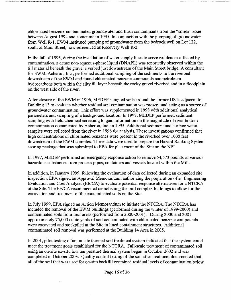
chlorinated benzene-contaminated groundwater and flush contaminants from the "smear" zone between August 1994 and sometime in 1995. In conjunction with the pumping of groundwater from Well R -1, EWM instituted pumping of groundwater from the bedrock well on Lot 122, south of Main Street, now referenced as Recovery Well R-2.
In the fall of 1995, during the installation of water supply lines to serve residences affected by contamination, a dense non-aqueous-phase liquid (DNAPL) was reportedly observed within the till material beneath the gravel riverbed just downstream of the Main Street bridge. A consultant for EWM, Acheron, Inc., performed additional sampling ofthe sediments in the riverbed downstream of the EWM and found chlorinated benzene compounds and petroleum hydrocarbons both within the silty till layer beneath the rocky gravel riverbed and in a floodplain on the west side of the river.
After closure of the EWM in 1996, MEDEP sampled soils around the former USTs adjacent to Building 13 to evaluate whether residual soil contamination was present and acting as a source of groundwater contamination. This effort was supplemented in 1998 with additional analytical parameters and sampling ofa background location. In 1997, MEDEP performed sediment sampling with field chemical screening to gain information on the magnitude of river bottom contamination documented by Acheron, Inc. in 1995. Additional sediment and surface water samples were collected from the river in 1998 for analysis. These investigations confirmed that high concentrations of chlorinated benzenes were present in the riverbed over 1000 feet downstream of the EWM complex. These data were used to prepare the Hazard Ranking System scoring package that was submitted to EPA for placement of the Site on the NPL.
In 1997, MEDEP performed an emergency response action to remove 54,673 pounds of various hazardous substances from process pipes, containers and vessels located within the Mill.
In addition, in January 1999, following the evaluation of data collected during an expanded site inspection, EP A signed an Approval Memorandum authorizing the preparation of an Engineering Evaluation and Cost Analysis (EE/CA) to evaluate potential response alternatives for a NTCRA at the Site. The EE/CA recommended demolishing the mill complex buildings to allow for the excavation and treatment of the contaminated soils on the Site.
In July 1999, EPA signed an Action Memorandum to initiate the NTCRA. The NTCRA has included the removal of the EWM buildings (performed during the winter of 1999-2000) and contaminated soils from four areas (performed from 2000-2001). During 2000 and 2001 approximately 75,000 cubic yards of soil contaminated with chlorinated benzene compounds were excavated and stockpiled at the Site in lined containment structures. Additional contaminated soil removal was performed at the Building 14 Area in 2005.
In 2001, pilot testing of an on-site thermal soil treatment system indicated that the system could meet the treatment goals established for the NTCRA. Full-scale treatment of contaminated soil using an on-site ex-situ low temperature thermal system began in October 2002 and was completed in October 2003. Quality control testing of the soil after treatment documented that all of the soil that was used for on-site backfill contained residual levels of contamination below
Page 16 of36
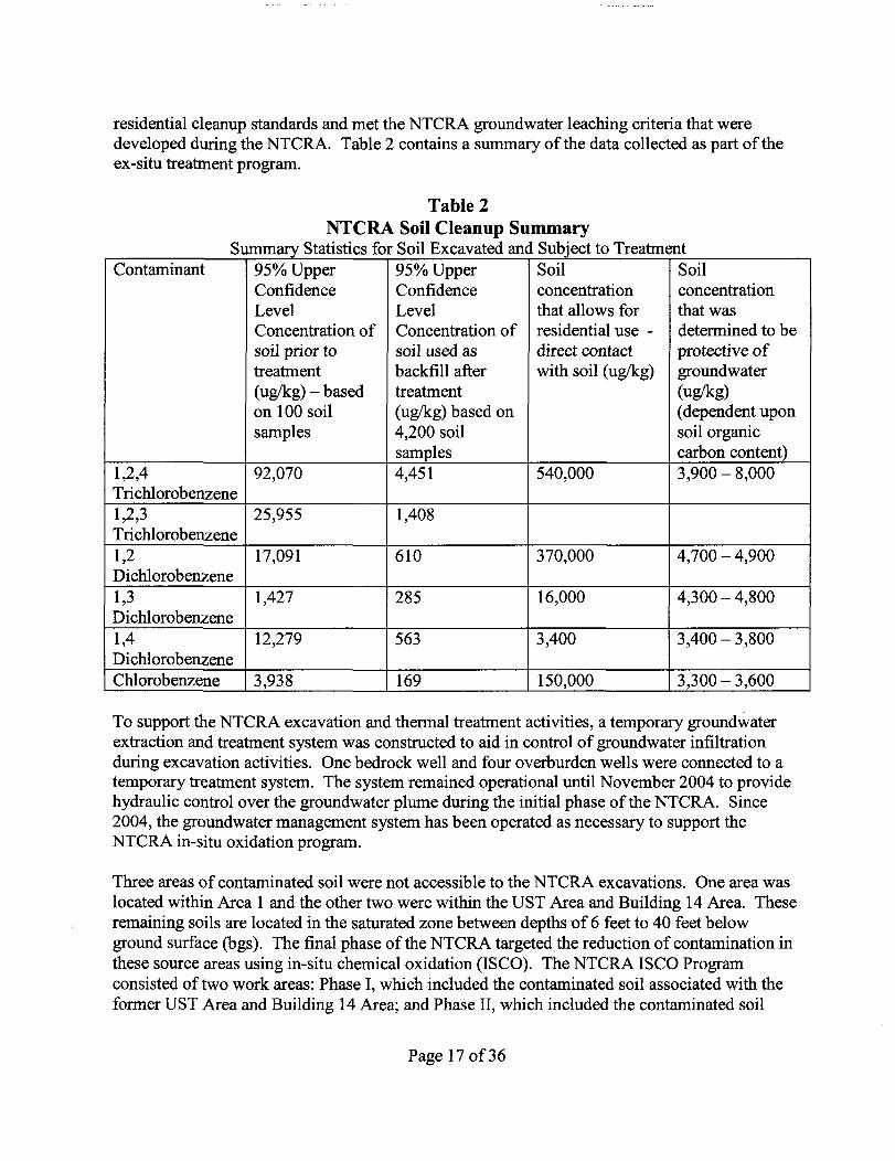
residential cleanup standards and met the NTCRA groundwater leaching criteria that were developed during the NTCRA. Table 2 contains a summary of the data collected as part of the ex-situ treatment program.
Table 2 NTCRA Soil Cleanup Summary
Summary St f f fi S·l Excava e t d d S b· t t 0 T tmena IS lCS or 01 an u ~ec rea t Contaminant 95% Upper
Confidence Level Concentration of soil prior to treatment (uglkg) - based on 100 soil samples
95% Upper Confidence Level Concentration of soil used as backfill after treatment (uglkg) based on 4,200 soil samples
Soil concentration that allows for residential use -direct contact with soil (uglkg)
Soil concentration that was determined to be protective of groundwater (uglkg) (dependent upon soil organic carbon content)
1,2,4 Trichlorobenzene
92,070 4,451 540,000 3,900 - 8,000
1,2,3 Trichlorobenzene
25,955 1,408
1,2 Dichlorobenzene
17,091 610 370,000 4,700 - 4,900
1,3 Dichlorobenzene
1,427 285 16,000 4,300 - 4,800
1,4 Dichlorobenzene
12,279 563 3,400 3,400 - 3,800
Chlorobenzene 3,938 169 150,000 3,300 - 3,600
To support the NTCRA excavation and thermal treatment activities, a temporary groundwater extraction and treatment system was constructed to aid in control of groundwater infiltration during excavation activities. One bedrock well and four overburden wells were connected to a temporary treatment system. The system remained operational until November 2004 to provide hydraulic control over the groundwater plume during the initial phase of the NTCRA. Since 2004, the groundwater management system has been operated as necessary to support the NTCRA in-situ oxidation program.
Three areas of contaminated soil were not accessible to the NTCRA excavations. One area was located within Area 1 and the other two were within the UST Area and Building 14 Area. These remaining soils are located in the saturated zone between depths of 6 feet to 40 feet below ground surface (bgs). The final phase ofthe NTCRA targeted the reduction of contamination in these source areas using in-situ chemical oxidation (ISCO). The NTCRA ISCO Program consisted of two work areas: Phase I, which included the contaminated soil associated with the former UST Area and Building 14 Area; and Phase II, which included the contaminated soil
Page 17 of36

associated with Area 1.
Phase I Activities
Following demolition of Building 14 by the Town of Corinna in 2004, a limited excavation was undertaken adjacent to the fonner loading dock to remove a small quantity of contaminated soil present in the vadose zone adjacent to the loading dock. The excavation did not extend below the water table. Analytical results for confinnation soil samples collected from the base ofthe excavation indicated contaminated soil remained in-place at depths below the water table (approximately 6 feet bgs).
ISCO treatment of the Phase 1 area consisted of two full-scale injections of iron-catalyzed persulfate (ICP), followed by confinnatory soil borings and groundwater sampling. These injections were perfonned in July and OctoberlNovember 2005. A total of 13,319 gallons of persulfate solution (22,120 pounds of oxidant) and 13,514 gallons of chelated iron solution were delivered to the UST Area and Building 14 Area. Confinnatory soil borings and groundwater sampling indicated an approximate 90% reduction of dissolved phase contamination and an approximate 71 % reduction in sorbed phase soil contamination following the Phase I ICP applications.
Phase I! Activities
In August 2005, one full-scale round of Phase I! ISCO treatment was conducted in Area 1. ICP was delivered to the subsurface via 11 ISCO injector wells. Approximately 19,256 gallons of persulfate (31,947 pounds of oxidant) and 19,423 gallons of chelated iron solution (2,429 pounds) were delivered to the Phase I! treatment area. Confinnatory groundwater sampling perfonned after full-scale ISCO application indicated a reduction of dissolved phase contamination by approximately 63%. Soil sampling perfonned after the ISCO Pilot study indicated a 38% reduction in residual DNAPL contamination. The Phase I! Task Plan and Phase I! Full Scale ISCO Injection Plan - Application #1 describe the activities that were perfonned to further the completion ofNTCRA source reduction in this area. The "2005 Phase I and Phase I! ISCO Remedial Perfonnance Assessment Eastland Woolen Mill Superfund Site, Non-Time Critical Removal Action, Corinna, Maine, May 2006" documents that the ISCO has been successful in reducing the mass of contamination in the Phase I! Area. The NTCRA ISCO program was detennined to be complete in May 2006, and the remaining ISCO activities are being implemented as a component of the Remedial Action.
The Site was proposed for inclusion on the NPL on April 23, 1999 (64 Fed. Reg. 19968). It was listed for final inclusion on the NPL on July 22, 1999 (64 Fed. Reg. 39878-39885). EPA perfonned a remedial investigation and feasibility study from 1999 through 2002 for ~UI. The remedial investigation and feasibility study for OUI! extended to September 2004. The remedial design (RD) for ~UI began in 2003 and was completed in 2005.
Page 18 of36

3.5 Basis for Taking Action
The OUI ROD included an assessment of the potential threats to human health in the OUI study area. Based on the Human Health Risk Assessment prepared as part of the RI and the OUI ROD, the only pathways that exceed EPA's acceptable cancer risk range and/or a hazard quotient of concern are ingestion of groundwater in the overburden and bedrock plumes by a future resident. The lifetime cancer risk estimate for a combined child and adult exposure to the bedrock plume groundwater is 6 x 10⁻³
. Seventy-five percent of this cancer risk is due to arsenic, with twenty-five percent attributable to the 1,4-dischlorobenzene. EPA's hazard index of concern for non-carcinogenic risk is exceeded for children and adults for several target organs. The major contributors to these exceedances are chlorobenzene, 1,2-dichlorobenzene, 1,3dichlorobenzene, l,4-dichlorobenzene, 1,2,4-trichlorobenzene and arsenic. These contaminants of concern (COCs) also were detected at concentrations above f~deral and state MCLs and more stringent state MEGs.
The lifetime cancer risk estimate for the overburden plume groundwater is 2 x 10⁻³• Sixty-seven
percent of this risk is attributable to l,4-dichlorobenzene, with arsenic contributing to the remainder of the cancer risk. EPA's hazard index of concern for non-carcinogenic risk is exceeded for children and adults for several target organs. The major contributors to these exceedances are chlorobenzene, 1,2-dichlorobenzene, 1,3-dichlorobenzene, l,4-dichlorobenzene, 1,2,4-trichlorobenzene and arsenic. These COCs also were detected at concentrations above federal and state MCLs and more stringent state MEGs. The Baseline Human Health Risk Assessment concluded that the estimated risk for the soils, surface water, or sediments within the OUI area do not represent an unacceptable threat to human health. Even though only groundwater represents a threat to human health, soil contamination that is causing groundwater contamination is also relevant to the cleanup action.
The groundwater beneath and surrounding the Site still remains a drinking water aquifer. Although data gathered since the OUI ROD was issued demonstrates that the groundwater plume has receded and contaminant mass is reduced, contaminant levels still exceed drinking water standards and ingestion of groundwater continues to pose a risk to human health consistent with the risks summarized above.
The OUI ROD determined that contaminant levels in surface waters, surface soils and sediments within the OUI area of the EBSR were not sufficiently elevated to pose a substantial risk to invertebrates, fish and wildlife through direct contact and dietary exposure to the Site-related COCs. Exposure to the contaminated water at the groundwater/surface water interface, however, was identified as an unacceptable risk to those organisms dwelling in this zone. Data gathered since the OUI ROD, however, demonstrate that the concentration of contaminants in the groundwater do not exceed the levels that pose an unacceptable risk to organisms dwelling in the groundwater/surface water interface. The data collected as part of the RA and LTRA confirms that the groundwater contamination has been reduced to levels that no longer present a threat to the ecological receptors in the EBSR.
Page 19 of36

4.0 Remedial Actions
4.1 Remedy Selection
The major source control actions at the Eastland Woolen Mill were accomplished as part of the NTCRA.
Based upon the results of the OUI Feasibility Study (FS), ISCO was identified as the technical approach to treat residual soil and bedrock contamination remaining after the completion of the NTCRA. On September 19,2002, EPA signed a ROD for OUI. The OUI ROD selected a remedy which included hydraulic containment plus contaminant mass reduction to address groundwater contamination and to protect the EBSR. An amendment to the OUI ROD was signed September 28,2006 to eliminate the requirement for a long-term hydraulic containment and groundwater treatment system.
The Remedial Action Objectives (RAOs) for the OUI ROD and 2006 ROD Amendment are as follows:
• Prevent the ingestion of groundwater containing contaminants that exceed Federal or State MCLs, Federal Non-zero MCL Goals (MCLGs) and more stringent State MEGs, or in their absence, an excess cancer risk of 1 x 10⁻⁶ or a hazard quotient of 1.
• Prevent, to the extent practicable, the off-site migration of groundwater containing contaminants at a concentration above Site cleanup levels.
• Prevent, to the extent practicable, the discharge to the EBSR of groundwater containing contaminants at a concentration above levels that could impact ecological receptors.
• Restore groundwater to meet federal or state MCLs, federal non-zero MCLGs or State MEGs (whichever is more stringent), or in their absence, an excess cancer risk of 1 x 10⁻⁶ or a hazard quotient of 1.
• Perform long-term monitoring of surface water, sediments and groundwater to verify that the cleanup actions at the Site are protective ofhuman health and the environment.
To achieve the ROD-specified RAOs, the amended OUI remedial action includes the following major components:
• Groundwater source mass reduction using: • In-situ chemical oxidation treatment of Area 1 deep saturated soil and shallow
weathered bedrock; • In-situ chemical oxidation treatment ofArea 1 deep fractured bedrock; and • Bio-stimulation of Area 1 deep fractured bedrock after in-situ chemical oxidation.
• Groundwater monitoring to assess remedy effectiveness and progress toward attaining cleanup goals;
• Institutional Controls to prevent future use of the contaminated groundwater and prevent disturbance of the remedy;
• Connecting currently occupied properties within the institutional controls zone to the existing
Page 20 of36

public water supply system; and • Five-year reviews to ensure that the remedy remains protective ofhuman health and the
environment.
4.2. Remedy Implementation
The majority of the source control activities occurred during the NTCRA, which was undertaken from 1999 through 2006. The NTCRA also included the initial phase of the in-situ chemical oxidation program.
The OUI Remedial Action was initiated in September 2005 with the installation ofthe three water line connections. Additional injection wells and monitoring wells were also installed from 2006-2007. Two major in-situ oxidation programs were implemented in 2006 and 2007. In September 2008, all construction activities for the OUI Remedial Action were completed as documented in the Preliminary Close Out Report for the Eastland Woolen Mill Site. The L TRA began in October 2008. From October 2008 through 2010, the focus of the LTRA activities has been monitoring and assessment of the in-situ oxidation program to determine whether addition injections programs will be necessary to meet the 85% contaminant mass reduction target established in the FS for OUI.
4.3 Institutional Controls
Institutional controls (ICs) are non-engineered instruments, such as administrative and/or legal controls, that help minimize the potential for exposure to contamination and protect the integrity of the remedy. Compliance with ICs is required to assure long-term protectiveness for any areas which do not allow for unlimited use or unrestricted exposure (UUIUE). ICs are required at the Site to ensure the protectiveness of the remedy and are selected in the OUI ROD.
4.3.1 ICs in Site Documents
The OUI ROD includes a requirement for the implementation, monitoring, and maintenance of ICs in the form of groundwater use restrictions (i.e., easements or restrictive covenants) to prevent ingestion of groundwater where contaminant concentrations exceed Applicable or Relevant and Appropriate Requirements (ARARs) and to eliminate the influence of water supply well pumping on contaminant plume migration.
Institutional Control Zone
The Institutional Control Zone (ICZ) design was based on the results of numerical groundwater flow and contaminant transport model simulations, as well as the results of area-wide bedrock monitoring well and drinking water supply sampling. The ICZ contains three property categories, IC Zone A (ICZ-A), IC Zone B (ICZ-B), and IC Zone C (ICZ-C). Properties classified as ICZ are intended to have environmental covenants imposed that either prohibit (ICZ-A and ICZ-B) or restrict (ICZ-C) groundwater use. An ICZ map is attached as Attachment 3.
Page 21 of36

ICZ-A identified those properties that will be subject to environmental covenants prohibiting use of groundwater over the entire property. All of the ICZ-A properties are currently served by the Corinna Water District water line. Within the ICZ-A boundary, all existing bedrock and overburden water supply wells will be formally decommissioned, unless the wells are converted to monitoring wells for use in the L TRA.
ICZ-B identified those properties where connection to the water line and implementation of an environmental covenant prohibiting use of groundwater over the entire property was determined to be necessary. All ofthe properties have now been connected to the water line, with the result that they are now reclassified as ICZ-A; there is therefore no longer a functional application for ICZ-B.
ICZ-C identified those properties where the current well is not contaminated and does not appear to be affecting the groundwater contamination; however, the groundwater modeling suggests that a modification to the existing well to increase yield or the installation of a new well at locations on the property closer to the Site could have an adverse impact on the groundwater contamination by inducing migration of the groundwater contamination. The restrictions on these properties will prohibit installation of future groundwater wells in locations or at depths that differ from existing water supply wells located on these properties. ICZ-C properties may continue to use their private water wells within this zone for domestic or other uses. There are two properties included in ICZ-C.
In addition to ICZ-A, ICZ-B, and ICZ-C, the Town Cemetery will also be included in the institutional controls pertaining to property where treated soil was placed. The Town of Corinna, EPA, and MEDEP agreed that any backfilled, treated soil that was subject to EPA's removal or remedial activities that is excavated during future Town redevelopment may be moved to and backfilled at the Village Cemetery located on Stetson Road. The Town of Corinna has agreed to implement this environmental restriction.
Once the institutional controls have been implemented, compliance with the restrictions will be monitored and enforced to ensure that the institutional controls are effective. Over time, EPA will also evaluate whether the land use restrictions can be removed or modified because acceptable contaminant levels have been achieved at the Site .
. Decommissioning of Existing Wells
As part of the completion of the L TRA activities, ten properties within the ICZ contain a total of seven existing groundwater supply wells that should be abandoned, and four wells should be converted for environmental monitoring only. One well to be converted, is currently used for periodic groundwater extraction (R-2) during ongoing ISCO applications. The wells to be abandoned will be permanently abandoned consistent with State ofMaine requirements in CMR 10 144A Chapter 232 Section 500 and Maine Department of Environmental Protection "Guidance for Well and Boring Abandonment" dated January 7, 2010.
Page 22 of36

Institutional Control Inspections
Regularly scheduled inspections will be perfonned to confinn that land and water-use restrictions in the fonn of well closures and deed or zoning restrictions are implemented as required to minimize migration of contaminants and potential human exposure to groundwater contaminants. Interviews with the property owner would include reviewing the owner's familiarity with restrictions imposed upon the property, and documentation of these restrictions; and plans for property sale, development, or construction at the Site. These inspections would be conducted as part of the Site Long Tenn Response Action and the Operations and Maintenance (O&M) activities.
4.3.2 IC Implementation
The EPA and MEDEP are currently coordinating with the landowners regarding the decommissioning of existing wells on properties within the ICZ and filing of the restrictive covenants with the Registry of Deeds. USEPA is also working with the Town of Corinna and the MEDEP to establish a local ordinance to provide up-front control over well installations within the ICZ. The draft ordinance was prepared and needs to be enacted. This could include requiring a pennit for installation of new drinkirig water wells.
Table . ft f 00 ro s3 I . os I U lOoalet I S ummal1 Table Media, Engineered Controls, Title of Institutional Control & Areas that Do Not Support
IC Objective Instrument Implemented
UUIVE Based on Current Conditions. Treated Soil Prevent the excavation and relocation Environmental covenants to be filed
of backfilled treated soil. with the Registry of Deeds (in progress)
Groundwater - ICZ A Groundwater use prohibited to prevent Environmental covenants to be filed the consumption and withdrawal of with the Registry of Deeds (in progress) groundwater until cleanup standards and Town Ordinance "Groundwater are achieved Protection Ordinance of the Town of
Corinna, Maine"(in progress) Groundwater - ICZ B No properties within this category
Groundwater - ICZ C Environmental covenants to be filed different locations or depths to Prohibit the installation of new wells in
with the Registry of Deeds (in progress) maintain plume stability. and Town Ordinance "Groundwater
Protection Ordinance of the Town of Corinna, Maine"(in progress)
Decommissioning of Existing Prevent the withdrawal of groundwater Wells to minimize contaminant migration
and prevent exposure to groundwater contaminants
Institutional Control Confirm implementation of Inspections groundwater use restrictions
Page 23 of36

4.4 Operation and Maintenance
The Site L TRA has not yet been completed. As a result, O&M activities have not begun. The L TRA activities ensure the ongoing protectiveness of the Remedial Action. Periodic Site inspections, monitoring, and the ongoing implementation of the in-situ chemical oxidation are part of the LTRA.
5.0 Progress Since the Last Review
This is the first FYR for the Site.
6.0 Five-Year Review Process
6.1 Administration Components
EPA, the lead agency for this FYR, notified MEDEP that it was conducting a five-year review with a report to be completed by September 2010. The five-year review team was led by Edward Hathaway, Remedial Project Manager, of EPA's Office of Site Remediation and Restoration. Pamela Harting-Barrett is the EPA Community Involvement Coordinator for the Site and provided support in these capacities. Rebecca Hewett, the Site manager for MEDEP, was also a part of the review team. Document review began in December 2009 and other activities were conducted as indicated.
Components of this review included: • Community involvement • Document review • Data review • Site inspection • Local interviews • Five-Year Review Report development
6.2 Community Involvement
EPA placed a public notice in a local paper on July 13,2010 describing the five-year review process, recent actions at the Site, and how the community can contribute during the review process. Site interviews were performed during a May 18, 2010 public information meeting. A summary of resident comments is provided in Attachment 5.
6.3 Document Review
The FYR includes a review of documents containing information relevant to assessing the protectiveness ofthe Site. Documents such as Records of Decision provide the Remedial Action Objectives for the Site. Others, such as Remedial Action Reports, detail specific actions taken at the Site. A complete bibliography of documents reviewed for this FYR can be found in Attachment 6.
Page 24 of36

6.4 Data Review
Monitoring data and remedial assessment data have been collected as part of the remedial action and LTRA. A summary of the reviewed data is presented below.
6.4.1 Soil Sample Data
Results obtained from the most recent soil boring and sampling program indicate residual soil contamination exists at the Site. Based on laboratory results for soil samples collected for the draft 2009 ISCO Phase II Performance Assessment Report, overburden soil and shallow weathered bedrock beneath Area 1 has residual concentrations of contaminants exceeding NTCRA soil removal criteria. Additionally, subsurface data and groundwater contaminant concentrations from bedrock groundwater samples indicate contamination may reside in the form of DNAPL in bedrock fractures beneath the Site.
6.4.2 Groundwater Monitoring Data
Overburden Groundwater - Area 1
Results from groundwater monitoring performed in September 2009 confirm the presence of an overburden groundwater volatile organic compound (VOC) plume located in Area 1, west of the EBSR (see Attachment 4-1).
The Area 1 overburden VOC plume is characterized by groundwater criteria exceedances of the chlorinated benzene COCs 1,2-dichlorobenzene, 1,3-dichlorobenzene, 1,4-dichlorobenzene, and 1,2,4-trichlorobenzene, as well as other VOCs that are formed by the degradation of chlorinated VOCs during ISCO reactions ("ISCO daughter product VOCs" or "DPVOCs"). The suite of DPVOCs includes 1,1 ,2-trichloroethane, 1,2-dichloroethane, bromochloromethane, bromomethane, and chloromethane. Exceedances of COC VOCs range between 1.3 times groundwater criteria (chlorobenzene detected in IM-04) to 63 times groundwater criteria (1,4dichlorobenzene detected in OM-46). Exceedances of DPVOCs range between 2.8 times groundwater criteria (1,2-dichloroethane detected in IM-07) to 175 times groundwater criteria (chloromethane detected in IM-04).
Groundwater samples from two monitoring wells installed to monitor groundwater conditions within the treated backfill (OM-67 and OM-74) contained VOC concentrations that were below their respective groundwater criteria. These results indicate both that the low-temperature thermal desorption treatment appears to have been effective in stabilizing low-level sorbed contamination that may still be present in the treated soil, and also that the VOC plume appears to be confined to the deep till zone and is not migrating readily into the treated soil.
Monitoring results from two monitoring wells screened across the overburden discharge zone to the EBSR (OM-69 and OM-70) showed an absence ofVOCs at concentrations that were in excess of their respective groundwater criteria in the groundwater discharging to the EBSR. This
Page 25 of36
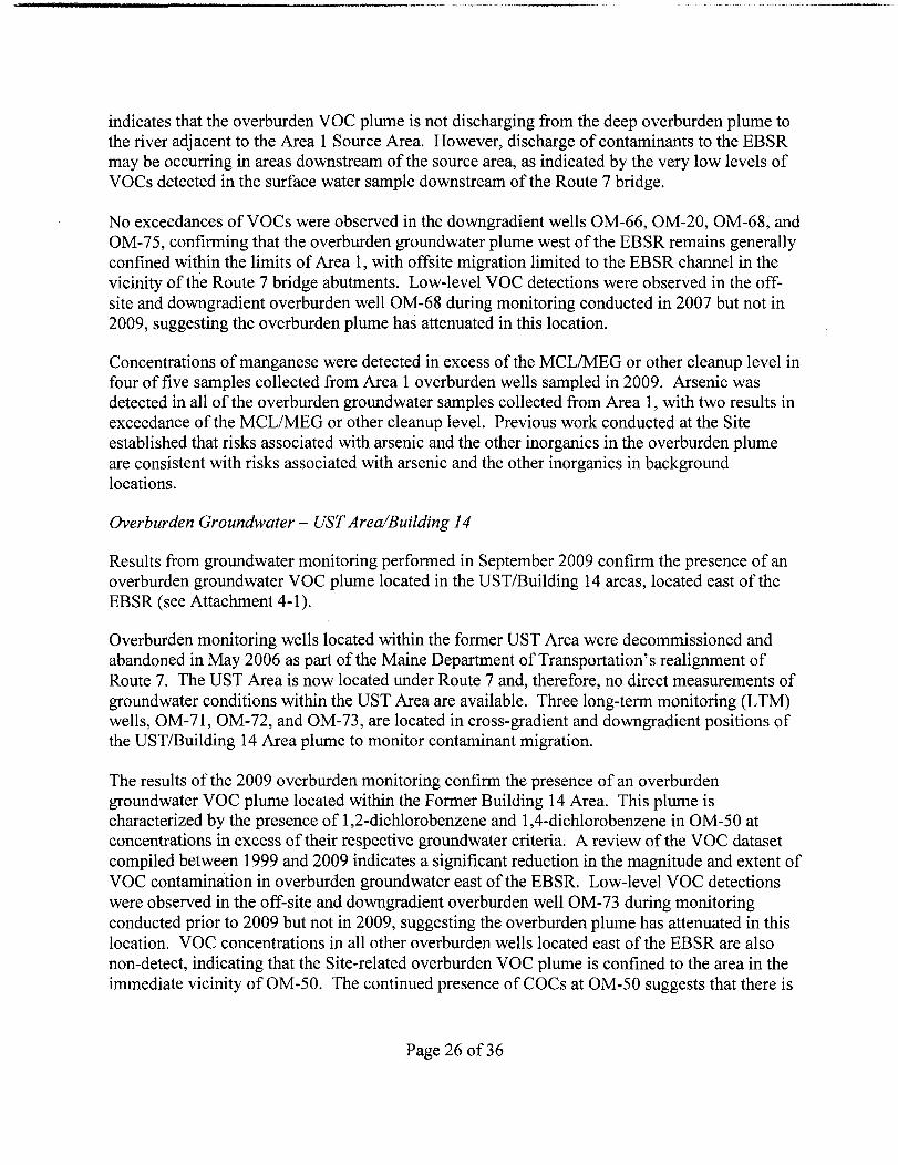
indicates that the overburden VOC plume is not discharging from the deep overburden plume to the river adjacent to the Area 1 Source Area. However, discharge of contaminants to the EBSR may be occurring in areas downstream of the source area, as indicated by the very low levels of VOCs detected in the surface water sample downstream of the Route 7 bridge.
No exceedances ofVOCs were observed in the downgradient wells OM-66, OM-20, OM-68, and OM-75, confirming that the overburden groundwater plume west of the EBSR remains generally confined within the limits of Area 1, with offsite migration limited to the EBSR channel in the vicinity of the Route 7 bridge abutments. Low-level VOC detections were observed in the offsite and downgradient overburden well OM-68 during monitoring conducted in 2007 but not in 2009, suggesting the overburden plume has attenuated in this location.
Concentrations of manganese were detected in excess of the MCL/MEG or other cleanup level in four of five samples collected from Area 1 overburden wells sampled in 2009. Arsenic was detected in all of the overburden groundwater samples collected from Area 1, with two results in exceedance of the MCL/MEG or other cleanup level. Previous work conducted at the Site established that risks associated with arsenic and the other inorganics in the overburden plume are consistent with risks associated with arsenic and the other inorganics in background locations.
Overburden Groundwater - UST Area/Building 14
Results from groundwater monitoring performed in September 2009 confirm the presence of an overburden groundwater VOC plume located in the USTlBuilding 14 areas, located east of the EBSR (see Attachment 4-1).
Overburden monitoring wells located within the former UST Area were decommissioned and abandoned in May 2006 as part of the Maine Department of Transportation's realignment of Route 7. The UST Area is now located under Route 7 and, therefore, no direct measurements of groundwater conditions within the UST Area are available. Three long-term monitoring (L TM) wells, OM-71, OM-72, and OM-73, are located in cross-gradient and downgradient positions of the UST/Building 14 Area plume to monitor contaminant migration.
The results of the 2009 overburden monitoring confirm the presence of an overburden groundwater VOC plume located within the Former Building 14 Area. This plume is characterized by the presence of 1,2-dichlorobenzene and l,4-dichlorobenzene in OM-50 at concentrations in excess of their respective groundwater criteria. A review of the VOC dataset compiled between 1999 and 2009 indicates a significant reduction in the magnitude and extent of VOC contamination in overburden groundwater east of the EBSR. Low-level VOC detections were observed in the off-site and downgradient overburden well OM-73 during monitoring conducted prior to 2009 but not in 2009, suggesting the overburden plume has attenuated in this location. VOC concentrations in all other overburden wells located east of the EBSR are also non-detect, indicating that the Site-related overburden VOC plume is confined to the area in the immediate vicinity of OM-50. The continued presence of COCs at OM-50 suggests that there is
Page 26 of36

a source (residual or sorbed) in the area. This suggests there might be a need for additional injections in this area in the future.
Concentrations ofmanganese were detected in excess of the MCL/MEG or other cleanup level in samples collected from all the Building 14IUST Area overburden wells sampled in 2009. Arsenic was detected in all of the overburden groundwater samples collected from the Building 14IUST Area. Of those five samples, three arsenic results were greater than the MCL/MEG or other cleanup level. Previous work conducted at the Site (Harding ESE, 2002) has established that risks associated with arsenic and the other inorganics in the overburden plume are consistent with risks associated with arsenic and the other inorganics in background locations.
Bedrock Groundwater
The September 2009 bedrock monitoring results confirmed the presence of a bedrock VOC plume that extends to the northeast and east-southeast of Area 1 (see Attachment 4-2). The bedrock VOC plume is predominantly characterized by the presence of the COCs benzene, chlorobenzene, 1,2-dichlorobenzene, 1,3-dichlorobenzene, 1,4-dichlorobenzene, and 1,2,4trichlorobenzene in concentrations exceeding groundwater criteria. Exceedances of these compounds range between 1.4 times groundwater criteria (benzene detected in BM-43) to 298 times groundwater criteria (chI oro benzene detected in RB-02). Vinyl chloride in BM-43 was the only non-COC VOCs detected in bedrock at concentrations exceeding groundwater criteria. These results indicate that the majority of the bedrock VOC plume mass is located within the boundaries of Area 1 and the East Side Source Area, as described in the 2007 Area Wide Groundwater Monitoring Report (Nobis, 2008a) and the 2007 East Side Characterization (ESC) Report (Nobis, 2008b).
Sampling conducted between 2006 and 2010 demonstrates low-level VOC concentrations in BM-43 located east of the EBSR and south of Route 7. Although the March 2010 sampling confirmed the general stability of the VOC plume in the vicinity ofBM-43, low-level exceedances of benzene (5.9 ug/L) and vinyl chloride (2.1 ug/L) were detected. Vinyl chloride was also detected in BM-43 at a concentration of 1.6 ug/L in 2007. Although this compound is not the degradation product of chlorinated benzenes, it does form from the anaerobic degradation (i.e. reductive dechlorination) oftetrachloroethene (PCE) and trichloroethene (TCE). Several low-level exceedances ofPCE (5.5 to 11 ug/L) and TCE (5.5 to 18 uglL) were detected in upgradient wells (BM-34, BM-35, BM-37, BM-38, BM-44, and RB-07) during sampling conducted in 2004 and 2007. The detection of the intermediate anaerobic degradation compound cis-l,2-dichloroethene in the upgradient well R-2 during sampling conducted in 2005, does suggest that reductive dechlorination processes may be operating to biodegrade PCE and TCE. This degradation would result in the formation of vinyl chloride. Given the low level concentrations and sporadic nature of detections observed in multiple bedrock locations between 2004 and 2007, a significant source of PCE and TCE in bedrock groundwater is not inferred.
Aside from benzene in BM-34 and BM-43, the 2009/2010 bedrock VOC data indicate that the southern-most bedrock groundwater exceedance is now observed in RB-02 (in comparison to exceedances observed further downgradient in BM-12 during monitoring conducted during
Page 27 of36

2007), suggesting a retraction of the inferred VOC plume equal to approximately 165 feet between 2007 and 2009. The observance of non-detect VOC concentration in the downgradient wells BM-12, Map 18 Lot 41A, and Map 18 Lot 42 (as compared to detectable concentrations in 2007), indicates an overall retraction of the bedrock VOC plume.
Manganese was detected at concentrations in excess of groundwater criteria in samples collected from five bedrock monitoring wellslboreholes, three inactive bedrock drinking water well samples, and one active bedrock drinking water well sample. Arsenic was detected in one bedrock borehole and one inactive drinking water well at concentrations in excess of groundwater criteria. Previous work conducted at the Site (Harding ESE, 2002) has established that risks associated with arsenic and the other inorganics in the bedrock plume are consistent with risks associated with arsenic and the other inorganics in background locations.
Active Water Supply Sampling
Sampling of residential wells performed in September 2009 and March 2010 did not indicate the presence of any VOCs above the laboratory detection limit in any of the active water supply wells sampled. Concentrations ofmanganese for the active residential well located at the property identified as Map 18 Lot 92 (369 ug/L) were in excess of the secondary maximum contaminant level (SMCL).
6.4.3 Surface Water Monitoring
No VOCs were detected in surface water samples SW-Ol (upgradient of Site) or SW-02 (located adjacent to the Site, i.e. Area 1). The Site COCs 1,2-dichlorobenzene and chlorobenzene were detected in surface water sample SW-03 (located downstream of the Site) at concentrations below applicable surface water criteria. These results suggest that neither the bedrock plume nor the overburden plumes from Area 1 and the UST/Building 14 areas pose a current risk to nonbenthic ecological receptors in the EBSR. (See Attachment 4-3.)
6.4.4 System Performance Evaluation
Overall, the RA components have been performing as expected.
Contaminant Mass Reduction
ISCO treatments performed between 2004 and 2007 have resulted in substantial reductions in residual and dissolved contaminant mass in the overburden and shallow bedrock. However residual and dissolved contamination is still present in the deep overburden and bedrock of Area 1 and the deep overburden of the former Building 14 Area. The ISCO program is under evaluation and additional treatments of overburden and bedrock may be performed.
Page 28 of36

Institutional Controls
ICs are in progress. When implemented, they are expected to provide the appropriate and adequate controls necessary to prevent exposure to backfilled treated soil and contaminated groundwater, and possible contaminated vapor from soil and groundwater, and also minimize plume migration.
Environmental Monitoring
Groundwater monitoring performed in 2009 and 2010 as part of the L TRA confirmed the reductions in the magnitude and extent of overburden and bedrock VOCs that were documented by previous monitoring events. These reductions may be attributable to the elimination of pumping stresses as well as contaminant source mass reductions achieved through ISCO. The monitoring program is adequate for the purpose of evaluating the potential for exposure to groundwater contaminants and plume migration.
Public Water Supply
The installation of public water supply hookups has prevented the consumption of Site-related groundwater contaminants from affected private water supplies and has reduced bedrock pumping stresses. It is likely that the reduction of these pumping stresses has contributed to the observed attenuation of the bedrock plume.
6.5 Site Inspection
The FYR Site Inspection was performed on May 18,2010. Representatives of EPA, MEDEP, the Town of Corinna, and Nobis Engineering, Inc. (EPA's Site LTRA Contractor) were in attendance (see Attachment 5 for a roster). The inspection team walked all areas of the Site west and east of the EBSR.
Overall, the remedy was found to be operating effectively and as intended. Some slope instability and erosion was observed along both the west and east banks of the EBSR channel located directly adjacent to Area 1. This issue is not relevant to the Remedial Action, but was brought to the attention of the MEDEP. Some damaged monitoring well roadboxes in need of repair were also observed in Area 1. Other observations and photographs taken during the Site inspection are included in Attachments 5 and 7.
6.6 Interviews
The EPA conducted interviews during the FYR site inspection with the MEDEP project manager, the Corinna Selectboard and Town Manager, and residents in attendance at a community outreach public meeting conducted on May 18,2010. A summary of these interviews is included as Attachment 5.
Page 29 of36

7.0 Technical Assessment
7.1 Question A: Is the remedy functioning as intended by the decision documents?
• Yes.
The Remedial Action Objectives that relate to current human health and ecological impacts are:
• Prevent the ingestion of groundwater containing contaminants that exceed Federal or State MCLs, Federal Non-zero MCLGs and more stringent State MEGs, or in their absence, an excess cancer risk of 1 x 10⁻⁶ or a hazard quotient of 1.
• Prevent, to the extent practicable, the discharge to the EBSR of groundwater containing contaminants at a concentration above levels that could impact ecological receptors.
• Perform long-term monitoring of surface water, sediments and groundwater to verify that the cleanup actions at the Site are protective of human health and the environment.
Based on the long-term monitoring of groundwater and residential wells, the remedy is successful in preventing ingestion of groundwater contamination. None ofthe currently used drinking water supplies exceed cleanup levels. The water line provides clean water to those individuals with contaminated groundwater beneath their property. It should be noted that the institutional controls are not yet in place to provide long-term assurance that this objective will be met. Surface water monitoring supports the conclusion that the ecological receptors are protected. Sediment monitoring will need to be performed prior to final completion of the cleanup.
• Restore groundwater to meet federal or state MCLs, federal non-zero MCLGs or State MEGs (whichever is most stringent), or in their absence, an excess cancer risk of 1 x 10⁻⁶ or a hazard quotient of 1.
• Prevent, to the extent practicable, the off-site migration of groundwater containing contaminants at a concentration above Site cleanup levels.
The remedy continues to make progress in achieving the remaining two objectives above. The extent of the groundwater contamination is less than when the ROD was signed and data suggest the plume is not expanding. The in-situ chemical oxidation program has substantially reduced the contaminant mass in the subsurface. An evaluation is currently under way to determine if additional injections will be necessary to achieve the goal of 85% mass reduction prior to initiating the bioremediation phase.
7.2 Question B: Are the exposure assumptions, toxicity data, cleanup levels, and remedial action objectives (RAOs) used at the time of remedy selection still valid?
Yes, the exposure assumptions and RAOs used at the time of the remedy selection are still valid. While some toxicity values used in the estimations of cancer risk and non-cancer health hazards have changed, the ARARs that define the cleanup levels for the ROD have not changed.
Page 30 of36

Changes in Exposure Assumptions, Exposure Pathways, and Toxicity Data
The Human Health Risk Assessment (HHRA) evaluated potential exposures to contaminants in groundwater. The groundwater study area was evaluated at four different exposure points, based on aquifer type, groundwater well location, and groundwater well use. Under current land use, no groundwater within the plume areas is used as drinking water. However, several residential supply wells within the plume area have not been decommissioned and, therefore, could. hypothetically be used to supply water for non-potable uses. Therefore, groundwater from residential supply wells was evaluated for non-potable exposures under current use conditions by assuming that the groundwater could be used to fill a child wading pool. Under future land use, it is assumed that all groundwater at each of the exposure points could be used as a source of potable water.
The HHRA identified cancer risks and non-cancer health hazards at levels exceeding EPA and state risk management criteria based on future residential exposures to groundwater through ingestion and dermal contact during bathing or showering. The assumptions used to develop the HHRA for the ROD remain valid and no revision to the groundwater risk assessment is necessary at this time. The HHRA also evaluated exposures to soil, sediment, and surface water. No significant risks from these pathways were identified. The HHRA did not evaluate a vapor intrusion pathway. The vapor intrusion pathway was not evaluated in the original HHRA, but a screening level vapor intrusion evaluation was conducted by EPA in 20 10. This evaluation is described in more detail below.
As part of the five-year review, the toxicity values used to estimate risks from the identified COCs were reviewed for changes that might affect the conclusions of the risk assessment. The currently available and recommended oral reference doses (RIDs) used to estimate non-cancer health hazards for benzene and 1,4-dichlorobenzene from the National Center for Environmental Assessment (NCEA) and Agency of Toxic Substances and Disease Registry (ATSDR), respectively, exceed those RIDs used in the HHRA, indicating hazards may be somewhat lower than previously estimated. The currently available and recommended oral cancer slope factor (CSF) for 1,4-dichlorobenzene from California EPA is less than the CSF used in the HHRA, indicating cancer risks from that COC may be somewhat lower than previously estimated. Cancer risks were not quantified for 1,2,4-trichlorobenzene in the HHRA; however, a Provisional Peer Reviewed Toxicity Value (PPRTV) is currently available. The absence of a cancer risk calculation for this COC may indicate cancer risks are underestimated.
Page 31 of36

Changes in Applicable, Relevant, and Appropriate Regulations (ARAR) Standards
As part of the five-year review, the standards on which the provisional groundwater cleanup levels were based were reviewed for changes that might affect the protectiveness of the remedy. The 2002 and 2006 RODs established provisional groundwater cleanup levels for a select group of contaminants, as shown on Table 9 of the 2006 ROD, based on Federal Safe Drinking Water Act MCLs and State of Maine MEGs. Although the MEGs were updated in 2008 and 2010, the new levels were not promulgated and, therefore, do not constitute ARARs for the Site. As a result, there are no changes to regulatory standards since the 2006 ROD.
The 2002 ROD identified the following RAOs for the selected remedy for the Site:
• Prevent the ingestion of groundwater containing contaminants that exceed federal or state MCLs, federal non- zero MCLGs and more stringent State MEGs, or in their absence, an excess cancer risk of 1 x 10⁻⁶ or a hazard quotient of 1 ;
• Prevent, to the extent practicable, the off-site migration of groundwater containing contaminants at a concentration above Site cleanup levels;
• Prevent, to the extent practicable, the discharge of groundwater containing contaminants at a concentration above levels that could impact ecological receptors to the EBSR;
• Restore groundwater to meet federal or state MCLs, federal non-zero MCLGs or State MEGs (whichever is most stringent), or in their absence, an excess cancer risk of 1 x 10⁻⁶
or a hazard quotient of 1; and
• Perform long-term monitoring of surface water, sediments and groundwater to verify that the cleanup actions at the Site are protective of human health and the environment.
These RAOs remain valid. No additional RAOs were identified in the 2006 ROD Amendment.
ISCO Daughter Product VOCs
Daughter Product VOCs (DPVOCs) are detected in overburden groundwater in Area 1 at concentrations in excess of groundwater criteria. These transient compounds are the result of ISCO treatments at the Site and are expected to continue to be generated in the event future ISCO treatments are performed.
No change in the remedial approach or Site risk evaluation is necessary to address the DPVOCs at this time based on the following observations:
1. The DPVOCs are present entirely within a contaminant source area that has already
Page 32 of36

been detennined to be impacted by COCs and for which a human health risk for groundwater consumption has been established and is adequately addressed by the Site remedy.
2. Long-tenn monitoring results indicate that the attenuation rate ofDPVOCs by both ISCO and natural attenuation greatly exceeds the reduction of COC VOCs. This observation, coupled with the fact that no long-tenn source ofDPVOCs is present, indicates that the DPVOCs should have a short residence time in the groundwater and should not pose a risk for long-tenn threat for plume expansion.
Vapor Intrusion Assessment
A preliminary vapor intrusion (VI) assessment was perfonned as part of this five-year review. The assessment compared the observed concentrations of overburden and bedrock groundwater contaminants to EPA's VI screening concentrations for VOCs.
Numerous locations within Area 1 contain VOCs in exceedance ofVI screening concentrations; however, all locations within Area 1 are more than 100 feet distant from any residential and commercial buildings and, therefore, are not considered a risk for indoor air intrusion. A figure showing the locations of VI screening exceedances with corresponding 100 foot buffer boundaries and building footprints is included in Attachment 4-4.
Two locations outside Area 1, BM-43 and OM-50, contain VOCs at concentrations in exceedance of screening values. During sampling conducted in March 2010, BM-43 was observed to contain benzene (5.9 ugll) and vinyl chloride (2.1 ugll) at concentrations exceeding screening values for vapor intrusion based upon a 10-6 excess cancer risk target level. This location is more than 100 feet distant from any residential and commercial buildings and, therefore, is not considered a risk for indoor air intrusion. During sampling conducted in September 2009, OM-50 was observed to contain chlorofonn (45 ugll) in exceedance of EPA VI screening values (residential and worker). The concentration is below the MCL of80 ugll. This location is within 100 feet of the building located on Map 18 Lot 57 (Methodist Meeting House, nearest comer wall approximately 62 feet north) and a duplex housing unit. There are no monitoring wells located between OM-50 and the closest structures; however, the historic groundwater quality data for this area from a larger monitoring well network (most which have since been decommissioned) suggest that the plume is fairly small. Based on a review ofhistoric chlorofonn analytical results for the closest downgradient sampling location (OM-73, approximately 73 feet southwest) chlorofonn has not been detected downgradient of OM-50 from samples collected less than 75 feet away. Therefore, it is inferred that chlorofonn concentrations 75 feet upgradient in the direction ofMethodist Meeting House would be similar to concentrations reported at OM-73. Additionally, it is noted that the usage of the Methodist Meeting House is non-residential in nature and consequently will be used infrequently, for short periods of time, with a limited risk for exposure; therefore evaluation for indoor air impacts does not appear to be warranted at this time. The duplex housing unit is across Route 7 from OM-50 and upgradient of the groundwater contamination.
Page 33 of36

-----------------------
A more detailed assessment of the vapor intrusion pathway will be performed prior to the next five-year review to confirm that vapors are not migrating to any structures in the Site vicinity.
7.3 Question C: Has any other information come to light that could call into question the protectiveness of the remedy?
No.
The Site land use scenarios have not changed. Review of the data collected and information obtained through the site inspection and interviews revealed no new information that calls into question the effectiveness and protectiveness of the remedy selected in the ROD. No new human or ecological receptors have been identified at this time. The water line provides clean water to those locations impacted by the contamination, and residential wells in use in the Site vicinity do not contain contamination above cleanup levels or drinking water standards. There is no complete pathway for vapor intrusion at the Site. A preliminary assessment of the vapor intrusion issue identified a few areas where additional data would help to support the finding that the Site land use assumptions and plume configuration do not indicate vapor intrusion to be a significant issue.
When the groundwater cleanup is completed, an assessment of any residual contamination, including any breakdown products created by the in-situ chemical oxidation, will need to be performed.
7.4 Technical Assessment Summary
According to the data reviewed, the site inspection, and the interviews, the remedy is functioning as intended by the ROD. There have been no changes in the physical conditions of the Site that would affect the protectiveness of the remedy. There have been no changes to the overall exposure assumptions used in evaluating human health and ecological risk. ARARs have not changed in any way that would call into question the protectiveness of the cleanup. While there are some questions to resolve regarding vapor intrusion, the preliminary assessment performed supports that vapor intrusions should not be a significant issue given the land use and plume configuration at the Site. In summary, there is no other information that calls into question the protectiveness of the remedy.
8.0 Issues
There are no major issues which affect the protectiveness of the remedy. While additional assessment of the vapor intrusion pathway is recommended, the factors that supported a finding that vapor intrusion is not a current threat to human health (no structures within limits ofplume and nature ofland use) have not changed, which supports a finding that the Remedial Action is protective ofhuman health. In addition, while the public water supply and absence of dwellings over the contaminated groundwater provide for current protectiveness with respect to contaminated groundwater, the implementation of the institutional controls will be necessary to achieve future long-term protectiveness.
Page 34 of36

Table 4: Issues
Issues
Affects Protectiveness
(YIN)
Current Future
A more detailed vapor intrusion study should be performed to confirm the outcome of the preliminary evaluation that vapor intrusion is not a significant issue given the land use and plume configuration. Additional documentation of the extent of the level of chloroform in the vicinity of OM-50 and assessment of utilities corridors are identified as items to evaluate prior to the next five-year review.
N Y
The institutional controls to prevent future use of contaminated groundwater must be put in place to ensure future long-term protectiveness.
N Y
9.0 Recommendations and Follow-up Actions
There are two recommendations: (1) a more detailed Vapor Intrusion study will be performed prior to the next five-year review; and (2) the institutional controls will need to be put in place to ensure long-term future protectiveness.
Table 5 R ecommend t' o C Ions: a Ions and F II ow-up At'
Recommendations/ Follow-up Actions
Party Responsible
Oversight Agency
Milestone Date
Follow-up Actions: Affects Protectiveness
(YIN)
Current Future
VI Study EPA EPA September 2015 N Y
Institutional Controls EPA EPA September 2015 N Y
10.0 Protectiveness Statement
The remedy at the Eastland Woolen Mill Superfund Site currently protects human health and the environment because the contamination accessible to ecological receptors has been removed, there is no current human exposure to contamination, the groundwater contamination is not migrating, clean water is available to all locations within the extent of the groundwater contamination, and EPA is actively treating and monitoring the groundwater as part of the ongoing Long-Term Response Action. However, in order for the remedy to be protective in the long-term, the institutional controls to prevent future groundwater use need to be in place to ensure long-term protectiveness. A preliminary assessment of the potential for vapor intrusion to present a threat at the Site was performed as part of this five-year review. There are no structures above areas of the plume that exceed vapor intrusion screening criteria so the pathway is not complete.
Page 35 of36

11.0 Next Review
The next five-year review for the Eastland Woolen Mill Superfund Site is required by September 2015.
Page 36 of36

Quadrangle l ocation
ATTACHMENT 1
EASTLAND WOOLEN MILL SUPERFUND SITE CORINNA, MAINE
SITE LOCATION MAP
USGS TOPOGRAPHIC MAP
CORINNA, MAINE
1982
APPROXIMATE SCALE 1" =2,000 FEET
- ..~=="'= .~ ::::::= I-'D:::.A:.:.T=E:,-"0,,,,6/.=!22::../ 1!.:::0~RE::cV:....:0~0_-l - - - - - - - - PROJECT NO. 80052 E/E=- •=!4.~~ FILE NAME: Locus Plan.MXD -Nobis Engineering, Inc.
18 Chenel! Drive Concord, NH 03301
(603) 224-4182 www.nobisenineerin.com
PREPARED BY: J. FOPIANO CHECKED BY: A. BOECKELE

flOvr".
"J
r,~~ea 1 Boundary
o o U asell-IV
D o
Legend
F~rmer Eastland Woolen Mill Building Outline
Limit of NTCRA Soil EXCAVATION to Bedrock
Z I-
Approximate OU t Boundary w
Phase/Source Area Boundary :::iE :I:N o
150 75 0 NOTES: ~~..~~~~~1~50Feet~gsTEsketch was developed from vari e , Inc. of Portland, Maine. aus plans supplied by USACE and

Legend II Locations Currently on Public Water L-.J Groundwater Use Prohibited (ICZ-A)
Locations Currently on Private Water ~ That Require Groundwater
Use Restrictions (ICZ-C)
D Pre-Existing Institutional Control Zone _
Buildings Currently Served by the Public Water System
~ Areas of Treated Soil Placement
_. II. Limit of Institutional Control Zone
o 400 800 1,600
~~iiiiiiiiiiiiiiiii, ~,~~~ Feet
ATTACHMENT 3 EASTLAND WOOLEN MILL SITE INSTITUTIONAL CONTROLS FIRST FIVE YEAR REVIEW REPORT
CORINNA, MAINE

IM-04 1,2,4-Trlchlorobenzene - 380 J 1 ,2-Dichlorobenzene - 77 1,3-Dlchlorobenzene - 3.7 J 1,4-Dlchlorobenzene - 59 Benzene - 3.8 J Chlorobenzene - 59 1,1,2-Trlchloroethane - 31 J 1.1-Dichloroethane - 4.2 J 1,2,3-Trichlorobenzene - 120 1,2-Dlchloroethane -140 Acetone - 1800 Bromochloromethane - 160J Bromomethane - 310 Carbon disulfide - 40 Chloroethane - 28 Chloromethane - 3500 Methylene chloride - 470
G OM-74 1,2-Dichlorobenzene - 10 1,3-Dichlorobenzene - 4 J 1,4-Dichlorobenzene - 18
ITOf.J.,.~ ;:._____----, OM-66
NOTES:
1,2A-Trichlorobenzene - 14 J 1 ,2-Dichlorobenzene - 19 J 1,3-Dichlorobenzene -7.1 J 1 A-Dichlorobenzene - 19 J Chlorobenzene - 22 J 1 ,2-Dichloroethane - 3.2 J
1. Samples were collected in September 2009. 2. BOlDED values indica te an exceedance of the applicable standard. 3. This sketch was developed from various plans supplied by USACE and MACTEC, Inc. of Portland, Maine.
OM-69 1 ,2-Dichlorobenzene - 12 1,3-Dichlorobenzene - 2.9 J 1 ,4-Dichlorobenzene - 12 Chlorobenzene - 24
IM-07 1,2,4-Trlchlorobenzene -1300 J 1,2-Dlchlorobenzene -1200 1,3-Dlchlorobenzene - 50 1,4-Dlchlorobenzene - 820 Chlorobenzene - 760 1,1 ,2-Trichloroethane - 2.4 J 1,2,3-Trichlorobenzene - 290 1,2-Dlchloroethane -14 Bromochloromethane - 2.8 J Chloromethane - 3.6 J cis-1,3-Dichloropropene - 2.1 J Trichloroethene - 2.3 J
OM-46 1,2,4-Trlchlorobenzene - 3300 J 1,2-Dichlorobenzene - 2400 1,3-Dlchlorobenzene - 100 1,4-Dlchlorobenzene - 1700 Chlorobenzene - 2200 1 ,2.3-Trichlorobenzene - 720 1,2-Dlchloroethane - 22 J
o
OM-50 1 ,2,4-Trichlorobenzene - 14 J 1,2-Dlchlorobenzene -1300 1,4-Dlchlorobenzene - 300 Chlorobenzene - 19 J Chloroform - 45 1,1-Dichloroethane - 20 J 1,1.1-Trichloroethane - 18 J
OM-71 1,4-Dichlorobenzene - 2.6 J 1,1-Dichloroethane - 2.9 J Methyl tert-butyl ether - 23
Legend 2009 Overburden Groundwater Sample Location
2009 Estimated Limit of Overburden Groundwater vac MCUMEG Exceedances (dashed where inferred)
2009 Estimated Limit of Overburden Non-Petroleum Related Groundwater vae Detections (dashed where inferred
2009 Estimated Limit of Overburden I-------o::---l Groundwater Petroleum Plume W
Site Related Contaminant GCLlMCLJMEG (ugIL)
Chlorobenzene 47/100/100 1 20ichlorobenzene 1 3 Dichlorobenzene 1 4 Dichlorobenzene 7 5 0
1 1 1 Tri hloroethane N 200/10000 1 1 2 Trich loroethane NEl516 1 10ichloroethane
Bromochloromethane 8romomethane cis·1 .3-Dichloro fO ne Carbon disulfide Chloroethane
h r h Math tert-bu I ether
ri h
85 42.5 o
N t o N ElNE NElNEl600 NEINEINE
NElS/3D
85
Feet
u. ~ o~~
!Z~~ UJO:::J ~i=ii! UJUc> Cll!:!zUJUJUJ ~ClCl ::;:Uo::
i=~1il ill ffi

o BM-« 1 ,2,4-Trichlorobenzene - 50 1.2.olchlorobenzlne - 170 1,3-Olchiorobenzene - 55 1,4-Olchiorobenzene • 160 Chlorobenzene • 930
RB-02 1,2,4-Trichforobenzl,..·8600 1 ,2-Olchlorobenzln •• 9600 1 ,3-Dlchlorobenzene - 290
o 1,4-0lchlorobenzen. - 8800 Chlorobt>nzen. - 14000 1.2,3-Trichlorobenzene - 1900
o o o
NOTES: 1. Samples were collected in September 2009 and March 2010 (BM42. BM-43, M18LT·37·1 , M18LT44, & M18LT94). 2. BOlDED values indicate an exceedance of the applicable standard. 3. Methylene chloride detections greater than 65 ugll , are presented in this sketch and are considered non laboratory-related contaminant detects. 4. This sketch was developed from various plans supplied by USACE and MACTEC, Inc. of Portland, Maine.
11111
1:II~ l~
It111 Legend IU'"IIIII1a2009 Bedrock Monitoring Well
Groundwater Sample Location ~~.. .,tldBedrock Residential Well - Active
Groundwater Sample Location JOUrh .. Bedrock Residential Well - Inactive Groundwater Sample Location
2009 Estimated Limit of Bedrock Groundwater vac MCUMEG Exceedances (dashed where inferred)
2009 Estimated Limit of Bedrock Bedrock Groundwater vae Detections
Site Related Contaminant GCUMCUMEG u
Benzene 51514 47/100/100
1,2 Dichlorobenzene Chlorobenzene
8516001200 1,3 Dichlorobenzene 85INEl1 1 4 Dichlorobenzene 27175170
1 24 Trichlorobenzene 70170170
Br men I-Carbon disulfide NElNEl600 Z
NEl80170Chloroform W NEINEINEC clohexane :2 NToluene NEl1000/600 I, N 210.2 Vin I hi ri e Ov
«150 75 o 150 I i i Feet ~
BM·10F Z2!ll.6 <> 0 1,4-0ichlorobezene - 6.2
l2!l!..l1 1,4-0 ichlorobezene - 4.1 J
~ AJIVOCsNO
l2n!..Q 1,4-Dichlorobezene - 2.7 J

o
(? o
o o NOTES: 1. Samples were collected ' S 2. SOLOED va lues ind icat~:n ~~ember 2009. 3. Acetone, methylene chlorid CWOIHHCOO exceedance sketch since they are conSide~~~d toluene are not presented 'in this ~t;,~curateIY represent actual gr:u~:O?-relal~ contaminants and do
• IS sketch was developed f a er quahty. MACTEC. Inc. of Portland, Mai~~~ various plans supplied by USAGE and
Legend
Surface Water Sample Location
Site Related Contaminant HHCWOIHHCOO (ugn)
1,2 Dichlorobenzene 420/1300 Chlorobenzene 13011600
150 75 o 150
iFeet

c:u ~ o~ u O\J . ~ 00 ~<:,~ rP \) ()
"~C0 VO ~O <!?
t:,.
t:,.
t:,.
0 0 0 ()
\) \0%
~% 00 <>!?~~O0
Legend
!J~ t:,. Groundwater sa mp1e~ncentrations d location where
Intrusion screeni~gnot'teX~ed vaporen ena
Groundwater samconcentrations d pie location wher screening criteria a exceed vapor int~usion
0 [:; Area 1 Boundary
0

ATTACHMENT 5-1: FYR Site Inspection Checklist
Inspection Roster: Tuesday May 18,2010
USEPA: Ed Hathaway, Remedial Project Manager Pamela Harting-Barret, Community Involvement Coordinator
MEDEP: Rebecca Hewett, Project Manager Ted Wolfe, Program Manager David Wright, Director, Division of Remediation
Town of Corinna: Dalton Mullis, Town Manager
Nobis Engineering, Inc.: Andrew J. Boeckeler, Project Manager Tim Andrews, Project Manager
I. SITE INFORMATION
Site name: Eastland Woolen Mill Superfund Site Date of inspection: 5/18/10
Location and Region: Corinna, ME - Region 1 EPA ID: MED980915474
Agency, office, or company leading the five-year review: EPA
Weather/temperature: Partly sunny, 75°F
Remedy Includes: (Check all that apply) D Landfill cover/containment 0Monitored natural attenuation o Access controls DGroundwater containment o Institutional controls D Vertical barrier walls DGroundwater pump and treatment D Surface water collection and treatment 00ther: Extension of public water supply. Contaminant reduction through in-situ chemical oxidation injection. Groundwater and surface water monitoring
Attachments: Ii:] Inspection team roster attached o Site map attached
II. INTERVIEWS (Check all that apply)
l. L TRA site manager Andrew J. Boeckeler, P.G. - Nobis Project Manager 5/18/10 Name Title Date
Interviewed 0at site D at office D by phone Phone no. (603}224-4182 Problems, suggestions; D Report attached No problems identified.
2. L TRA staff Name Title Date
Interviewed D at site D at office D by phone Phone no. Problems, suggestions; D Report attached
Five-Year Review Report - 1

3. Local regulatory authorities and response agencies (i.e., State and Tribal offices, emergency response office, police department, office ofpublic health or environmental health, zoning office, recorder of deeds, or other city and county offices, etc.) Fill in all that apply.
Agency MEDEP Contact Rebecca Hewett Project Manager 5118110 207-287 -8554
Name Title Date Phone no. Problems; suggestions; 0 Report attached No 2roblems identified.
Agency Town of Corinna Contact Dalton Mullis Town Manager 5118110 207-278-4183
Name Title Date Phone no. Problems; suggestions; DReport attached
Agency Contact
Name Title Date Phone no. Problems; suggestions; DReport attached
Agency Contact
Name Title Date Phone no. Problems; suggestions; 0 Report attached
4. Other interviews (optional) ~ Report attached.
General comments received in response to public meeting attached.
Five-Year Review Report - 2

III. ON-SITE DOCUMENTS & RECORDS VERIFIED (Check all that apply)
1. O&M Documents D O&Mmanual D Readily available D Up to date o N/A D As-built drawings D Readily available D Up to date 0N/A D Maintenance logs D Readily available D Up to date o N/A Remarks
2. Site-Specific Health and Safety Plan o Readily available 0Upto date DN/A D Contingency plan/emergency response plan D Readily available D Up to date 0N/A Remarks
3. O&M and OSHA Training Records o Readily available o Up to date D N/A Remarks
4. Permits and Service Agreements DAir discharge permit D Readily available D Up to date 0N/A D Effluent discharge D Readily available D Up to date 0N/A D Waste disposal, POTW D Readily available D Up to date o N/A D Other permits D Readily available o Up to date 0N/A Remarks
5. Gas Generation Records D Readily available o Up to date o N/A Remarks
6. Settlement Monument Records D Readily available o Up to date o N/A Remarks
7. Groundwater Monitoring Records o Readily available o Up to date ON/A Remarks
8. Leachate Extraction Records D Readily available o Up to date 0N/A Remarks
9. Discharge Compliance Records D Air D Readily available o Up to date o N/A D Water (effluent) D Readily available D Up to date o N/A Remarks
10. Daily Access/Security Logs o Readily available o Up to date DN/A Remarks
Five-Year Review Report - 3

IV. O&M COSTS (Not Applicable)
I. O&M Organization o State in-house o Contractor for State o PRP in-house o Contractor for PRP o Federal Facility in-house o Contractor for Federal Facility o Other
2. O&M Cost Records o Readily available o Up to date o Funding mechanism/agreement in place Original O&M cost estimate o Breakdown attached
Total annual cost by year for review period if available
From To o Breakdown attached Date Date Total cost
From To o Breakdown attached Date Date Total cost
From To o Breakdown attached Date Date Total cost
From To 0 Breakdown attached Date Date Total cost
From To 0 Breakdown attached Date Date Total cost
3. Unanticipated or Unusually High O&M Costs During Review Period Describe costs and reasons:
V. ACCESS AND INSTITUTIONAL CONTROLS 0' Applicable DN/A
A. Fencing
I. Fencing damaged o Location shown on site map 0' Gates secured o N/A Remarks: A significant I!ortion of the site is not fenced.
B. Other Access Restrictions
I. Signs and other security measures o Location shown on site map 0' N/A Remarks:
Five-Year Review Report - 4

C. Institutional Controls (ICs)
1. Implementation and enforcement Site conditions imply ICs not properly implemented DYes D No III N/A Site conditions imply ICs not being fully enforced DYes DNo IlIN/A
Type of monitoring (e.g., self-reporting, drive by) Frequency Responsible party/agency Contact
Name Title Date Phone no.
Reporting is up-to-date DYes DNo III N/A Reports are verified by the lead agency DYes DNo IlIN/A
Specific requirements in deed or decision documents have been met DYes DNo IlIN/A Violations have been reported DYes DNo IlIN/A Other problems or suggestions: D Report attached Institutional controls for the Site are sllecified by the Record of Decision (ROD). Institutional controls at the Site have not yet been fully imlliemented. IC elements have been established in Site documents in the time since the ROD was established and comllrises muitillie zones.
2. Adequacy III ICs are adequate D ICs are inadequate III N/A Remarks ICs defined for the Site are considered adeguate once they are fully imlliemented.
D. General
1. Vandalism/trespassing D Location shown on site map III No vandalism evident Remarks
2. Land use changes on site III N/A Remarks
3. Land use changes off site D N/A Remarks
VI. GENERAL SITE CONDITIONS
A. Roads D Applicable IlIN/A
1. Roads damaged D Location shown on site map D Roads adequate DN/A Remarks
Five-Year Review Report - 5

B. Other Site Conditions
Remarks
A. LandfiU Surface
VII. LANDFILL COVERS D Applicable 0N/A
l. Settlement (Low spots) D Location shown on site map D Settlement not evident Areal extent Depth Remarks
2. Cracks Lengths Widths
D Location shown on site map Depths
D Cracking not evident
Remarks
3. Erosion D Location shown on site map D Erosion not evident Areal extent Depth Remarks
4. Holes D Location shown on site map D Holes not evident Areal extent Depth Remarks
5. Vegetative Cover D Grass D Cover properly established D No signs of stress D Trees/Shrubs (indicate size and locations on a diagram) Remarks
6. Alternative Cover (armored rock, concrete, etc.) DN/A Remarks
7. Bulges D Location shown on site map D Bulges not evident Areal extent Height Remarks
Five-Year Review Report - 6

8. Wet AreaslWater Damage o Wet areas/water damage not evident o Wet areas o Location shown on site map Areal extent o Ponding o Location shown on site map Areal extent o Seeps o Location shown on site map Areal extent o Soft sub grade o Location shown on site map Areal extent Remarks
9. Slope Instability o Slides o Location shown on site map o No evidence of slope instability Areal extent Remarks
B. Benches o Applicable DN/A (Horizontally constructed mounds of earth placed across a steep landfill side slope to interrupt the slope in order to slow down the velocity of surface runoff and intercept and convey the runoff to a lined channel.)
1. Flows Bypass Bench o Location shown on site map o N/A or okay Remarks
2. Bench Breached o Location shown on site map o N/Aorokay Remarks
3. Bench Overtopped o Location shown on site map o N/Aorokay Remarks
C. Letdown Channels o Applicable DN/A (Channel lined with erosion control mats, riprap, grout bags, or gabions that descend down the steep side slope of the cover and will allow the runoff water collected by the benches to move off of the landfill cover without creating erosion gullies.)
1. Settlement o Location shown on site map o No evidence of settlement Areal extent Depth Remarks
2. Material Degradation o Location shown on site map o No evidence of degradation Material type Areal extent Remarks
3. Erosion o Location shown on site map o No evidence oferosion Areal extent Depth Remarks
Five-Year Review Report - 7
4. Undercutting o Location shown on site map o No evidence ofundercutting Areal extent Depth Remarks
5. Obstructions Type
o No obstructions o Location shown on site map Areal extent Size Remarks
6. Excessive Vegetative Growth Type o No evidence of excessive growth o Vegetation in channels does not obstruct flow o Location shown on site map Areal extent Remarks
D. Cover Penetrations o Applicable DN/A
1. Gas Vents o Active o Passive o Properly secured/locked . o Functioning o Routinely sampled o Good condition o Evidence of leakage at penetration o Needs Maintenance DN/A Remarks
2. Gas Monitoring Probes o Properly secured/locked o Functioning o Routinely sampled o Good condition o Evidence of leakage at penetration o Needs Maintenance DN/A Remarks
3. Monitoring Wells (within surface area oflandfill) o Properly secured/locked o Functioning o Routinely sampled o Good condition o Evidence ofleakage at penetration o Needs Maintenance DN/A Remarks
4. Leachate Extraction Wells o Properly secured/locked o Functioning o Routinely sampled o Good condition o Evidence ofleakage at penetration o Needs Maintenance DN/A Remarks
5. Settlement Monuments o Located o Routinely surveyed ON/A Remarks
Five-Year Review Report - 8

E. Gas Collection and Treatment o Applicable DN/A
l. Gas Treatment Facilities o Flaring o Thermal destruction o Collection for reuse o Good condition o Needs Maintenance Remarks
2. Gas Collection Wells, Manifolds and Piping o Good condition o Needs Maintenance Remarks
3. Gas Monitoring Facilities (e.g., gas monitoring of adjacent homes or buildings) o Good condition o Needs Maintenance DN/A Remarks
F. Cover Drainage Layer o Applicable 0 N/A
l. Outlet Pipes Inspected o Functioning o N/A Remarks
2. Outlet Rock Inspected o Functioning o N/A Remarks
G. Detention/Sedimentation Ponds o Applicable DN/A
l. Siltation Areal extent Depth DN/A o Siltation not evident Remarks
2. Erosion Areal extent Depth o Erosion not evident Remarks
3. Outlet Works o Functioning DN/A Remarks
4. Dam o Functioning DN/A Remarks
H. Retaining Walls o Applicable DN/A
1. Deformations Horizontal displacement
o Location shown on site map o Deformation not evident Vertical displacement
Rotational displacement Remarks
Five-Year Review Report - 9

2. Degradation o Location shown on site map o Degradation not evident Remarks
I. Perimeter Ditches/Off-Site Discharge o Applicable 0 N/A
1. Siltation o Location shown on site map o Siltation not evident Areal extent Depth Remarks
2. Vegetative Growth o Location shown on site map ON/A o Vegetation does not impede flow Areal extent Type Remarks
3. Erosion o Location shown on site map o Erosion not evident Areal extent Depth Remarks
4. Discharge Structure o Functioning ON/A Remarks
VIII. VERTICAL BARRIER WALLS o Applicable 0N/A
l. Settlement o Location shown on site map o Settlement not evident Areal extent Depth Remarks
2. Performance MonitoringType of monitoring o Performance not monitored Frequency o Evidence ofbreaching Head differential Remarks
IX. GROUNDWATER/SURFACE WATER REMEDIES o Applicable ON/A
A. Groundwater Extraction Wells, Pumps, and Pipelines o Applicable 0N/A l. Pumps, Wellhead Plumbing, and Electrical
o Good condition o All required wells properly operating 0 Needs Maintenance 0 NIA
Remarks
2. Extraction System Pipelines, Valves, Valve Boxes, and Other Appurtenances
o Good condition o Needs Maintenance
Remarks
Five-Year Review Report - 10

3. Spare Parts and Equipment
o Readily available o Good condition o Requires upgrade o Needs to be provided
Remarks
B. Surface Water Collection Structures, Pumps, and Pipelines o Applicable 0N/A
1. Collection Structures, Pumps, and Electrical
o Good condition o Needs Maintenance
Remarks
2. Surface Water Collection System Pipelines, Valves, Valve Boxes, and Other Appurtenances
o Good condition o Needs Maintenance
Remarks
3. Spare Parts and Equipment
o Readily available o Good condition o Requires upgrade o Needs to be provided
Remarks
C. Treatment System o Applicable 0N/A
1. Treatment Train (Check components that apply) o Metals removal o Oil/water separation o Bioremediation o Air stripping o Carbon adsorbers o Filters o Additive (e.g., chelation agent, flocculent) o Others o Good condition o Needs Maintenance o Sampling ports properly marked and functional o Sampling/maintenance log displayed and up to date o Equipment properly identified o Quantity of groundwater treated annually o Quantity of surface water treated annually Remarks
2. Electrical Enclosures and Panels (properly rated and functional) DN/A o Good condition o Needs Maintenance Remarks
3. Tanks, Vaults, Storage Vessels DN/A o Good condition o Proper secondary containment o Needs Maintenance Remarks
4. Discharge Structure and Appurtenances DN/A o Good condition o Needs Maintenance Remarks
Five-Year Review Report - 11

5. Treatment Building(s) DN/A o Good condition (esp. roof and doorways) o Needs repair DChernicals and equipment properly stored Remarks
6. Monitoring Wells (pump and treatment remedy) o Properly secured/locked o Functioning o Routinely sampled o Good condition o All required wells located o Needs Maintenance DN/A Remarks
D. Monitoring Data
1. Monitoring Data 0' Is routinely submitted on time 0' Is of acceptable quality
2. Monitoring data suggests: o Groundwater plume is effectively contained 0' Contaminant concentrations are declining
Remarks
E. Monitored Natural Attenuation
1. Monitoring Wells (natural attenuation remedy) 0' Properly secured/locked 0' Functioning 0' Routinely sampled 0' Good condition 0' All required wells located 0' Needs Maintenance DN/A Remarks (3) concrete nads observed to be crackedlbroken. Some bolts missing that reguire renlacement. Some well risers observed that are no longer necessru:y and could be modified/removed.
X. OTHER REMEDIES
If there are remedies applied at the site which are not covered above, attach an inspection sheet describing the physical nature and condition of any facility associated with the remedy. An example would be soil vapor extraction. Injection and observation wells related to ISCO remedy were observed to be functional and in good condition as summarized above.
XI. OVERALL OBSERVATIONS
A. Implementation of the Remedy
Describe issues and observations relating to whether the remedy is effective and functioning as designed. Begin with a brief statement ofwhat the remedy is to accomplish (i.e., to contain contaminant plume, minimize infiltration and gas emission, etc.). The remedy is designed to reduce residual contaminant mass in soil and groundwater and to reduce the risk to local recentors, narticularly water sunnly to residences and businesses in the Site vicini!y. Overall the comnonents of the remedy have been nerforming as exnected, with contaminant mass reduction, design of institutional controls to reduce notential exnosure to contaminants in drinking water sunnlies, area wide groundwater monitoring to assess changes in contaminant concentrations or migration, and exnansion of available nublic water sunnlies.
Five-Year Review Report - 12

B. Adequacy of O&M
Describe issues and observations related to the implementation and scope of O&M procedures. In particular, discuss their relationship to the current and long-term protectiveness of the remedy. No issues.
c. Early Indicators of Potential Remedy Problems
Describe issues and observations such as unexpected changes in the cost or scope of O&M or a high frequency ofunscheduled repairs that suggest that the protectiveness of the remedy may be compromised in the future. None.
D. Opportunities for Optimization
Describe possible opportunities for optimization in monitoring tasks or the operation of the remedy. None.
Five-Year Review Report - 13

Attachment 5-2
Summary of Resident Comments
The residents of Corinna's overall impression ofthe Eastland Woolen Mills project was very positive. The residents had originally felt that more development was appealing, but as the project progressed, they became accustomed to the greenery and the open space and have decided that they "love the way the town looks".
"EPA did a wonderful job. They came up here to Corinna from Boston, talked to people, listened to them and cleaned up the mess from the old mill."
"Everything went very smoothly. EPA listened to us and responded to our concerns. They rerouted the river, moved Odd Fellows Hall and created a park-like atmosphere where there had been contamination."
"EPA is defmitely the best the government has to offer. I don't think of the government as coming to help, but EPA did. We had a mess and now we have beautiful open spaces, a nice restaurant and maybe some more businesses will move into some of the vacant space. I don't really want to see much development. A doctor's office would be nice and maybe a grocery store for those of us older folks."
"Corinna has become an older community. There is plenty of traffic and we don't need more. I don't think we need more houses or development. It looks beautiful now and we should keep it that way."
"EPA kept us very well informed every step of the way. Mr. Hathaway and Rick were here a lot and they always answered our questions and listened."
"I think that everything that was done was done well. It was a bit of a pain during the construction and cleanup, but look what we have now. It was well worth it. Maybe without the mill becoming a superfund site, Corinna would look the old way. Now it's beautiful and friends that come from out of town comment how wonderful it is here". I'm proud to live in such an ''updated'' looking town."
The residents accepted the decision to continue the injections. Questions arose about the fish and asked ifthere was a "safety problem" eating the fish.
Some concerns about the institutional controls and the negative effect it could have on resident's property values were expressed. Some individuals expressed a desire to be monetarily compensated for loss if ICs were put in place.

ATTACHMENT 6
LIST OF DOCUMENTS REVIEWED
USEPA, 2002. EPA Superfund Record of Decision. Eastland Woolen Mill. EPA 10: ME0980915474, OU1, Corinna, ME. Environmental Protection Agency. September 19, 2002.
USEPA, 2006. EPA Superfund Record of Decision Amendment. Eastland Woolen Mill. EPA 10: ME0980915474, OU1, Corinna, ME. Environmental Protection Agency. September 28, 2006.
Weston, 2004. Non-Time Critical Removal Action, Eastland Woolen Mill Superfund Site, Corinna, Maine, Preliminary Draft Overall Completion Report. Weston Solutions, Inc., April 2004.
Nobis,2007. Phase II and Phase IIIISCO Remedial Performance Assessment, Eastland Woolen Mill Superfund Site, Operable Unit 1 Remedial Action, Corinna, Maine. Nobis Engineering, Inc. April 2007.
Nobis, 2008. 2007 Area-Wide Groundwater Monitoring Report, Eastland Woolen Mill Superfund Site, Operable Unit 1 Remedial Action, Corinna, Maine. Nobis Engineering, Inc. May 2008.
Nobis, 2009. 2009 ISCO Performance Assessment Report, Eastland Woolen Mill Superfund Site, Corinna, Maine. Nobis Engineering, Inc. September 2009.
Nobis, 2010. 2009 Area-Wide Groundwater Monitoring Report, Eastland Woolen Mill Superfund Site, Corinna, Maine. Nobis Engineering, Inc. July 2010.

- - -ATTACHMENT 7
SITE PHOTOS FROM FYR INSPECTION EASTLAND WOOLEN MILL SUPERFUND SITE
CORINNA, MAINENobis Engineering, Inc. 18 Chenell D rive
Concord, New H ampshire 03301 Tel (603)224-4182 PROJECT 80052 JULY 2010 Fax 603 224-2507