first glacier monitoring system for afghanistan deployed
TRANSCRIPT
First Glacier Monitoring System for Afghanistan Deployed
In Afghanistan, glaciers serve as the headwaters of the Amu Darya River Basin and contribute to the water resources of the Indus River Basin, especially during the dry season. However, few of these glaciers have been actively monitored, making it difficult to effectively manage water resources downstream.
To address this challenge, SERVIR Hindu Kush Himalaya (HKH) collaborated with Afghanistan’s Ministry of Energy and Water (MEW) to develop the country’s first dynamic glacier and glacial lakes monitoring system. SERVIR HKH also conducted multiple trainings strengthen the capacity of MEW staff to map and monitor glaciers and update their extents using GIS and remote sensing techniques.
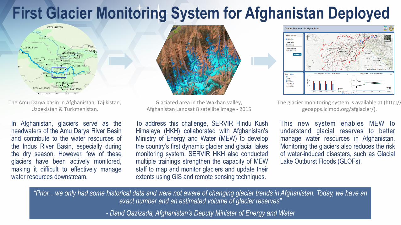
Theglaciermonitoringsystemisavailableat(http://geoapps.icimod.org/afglacier/).
GlaciatedareaintheWakhanvalley,AfghanistanLandsat8satelliteimage-2015
TheAmuDaryabasininAfghanistan,Tajikistan,Uzbekistan&Turkmenistan.
This new system enables MEW to understand glacial reserves to better manage water resources in Afghanistan. Monitoring the glaciers also reduces the risk of water-induced disasters, such as Glacial Lake Outburst Floods (GLOFs).
“Prior…we only had some historical data and were not aware of changing glacier trends in Afghanistan. Today, we have an exact number and an estimated volume of glacier reserves”
- Daud Qazizada, Afghanistan’s Deputy Minister of Energy and Water

“Kenya’s First National Crop Monitor Set to Strengthen National Food Security” GEO Press Highlights
The Greater Horn of Africa is prone to extreme agricultural shocks including droughts and floods. Countries in the region, including Kenya, have struggled to systematical ly monitor their crop condit ions due to l imited in situ observations.
The new bulletin enables Kenya to better predict and prepare for fluctuations in agricultural production, in order to mitigate loss and damage. The added granularity, provided by Earth observations, coupled with economic and market conditions, provides more comprehensive and actionable information for agricultural extension agents, farmers, and the broader agricultural sector.
In response, SERVIR Eastern & Southern Africa (E&SA), together with the SERVIR Applied Sciences Team collaborated with the Kenya Ministry of Agriculture to produce a satellite-derived national crop conditions bulletin. The bulletin--based on the SERVIR-supported, ICPAC-managed, crop monitor--is being published monthly on the ministry’s webpage.
August2018cropconditionsmappublishedinKenyaMinistryofAgriculture’smonthlybulletin
Droughtandincreasingscarcityofwaterseriouslythreatensfood
securityinKenya.
KenyaMinistryofAgricultureandSERVIRE&SAexpertsfinalizingoutputofKenyanationalcropmonitor
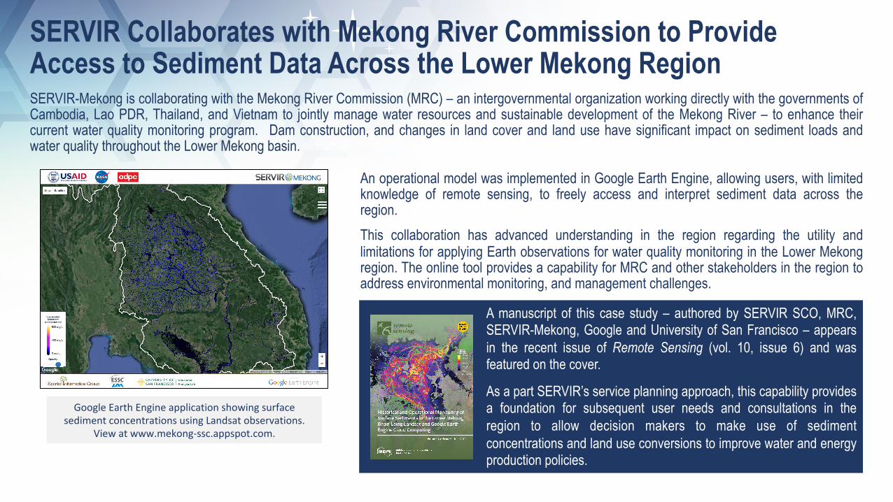
GoogleEarthEngineapplicationshowingsurfacesedimentconcentrationsusingLandsatobservations.
Viewatwww.mekong-ssc.appspot.com.
SERVIR Collaborates with Mekong River Commission to Provide Access to Sediment Data Across the Lower Mekong Region SERVIR-Mekong is collaborating with the Mekong River Commission (MRC) – an intergovernmental organization working directly with the governments of Cambodia, Lao PDR, Thailand, and Vietnam to jointly manage water resources and sustainable development of the Mekong River – to enhance their current water quality monitoring program. Dam construction, and changes in land cover and land use have significant impact on sediment loads and water quality throughout the Lower Mekong basin.
An operational model was implemented in Google Earth Engine, allowing users, with limited knowledge of remote sensing, to freely access and interpret sediment data across the region. This collaboration has advanced understanding in the region regarding the utility and limitations for applying Earth observations for water quality monitoring in the Lower Mekong region. The online tool provides a capability for MRC and other stakeholders in the region to address environmental monitoring, and management challenges.
A manuscript of this case study – authored by SERVIR SCO, MRC, SERVIR-Mekong, Google and University of San Francisco – appears in the recent issue of Remote Sensing (vol. 10, issue 6) and was featured on the cover.
As a part SERVIR’s service planning approach, this capability provides a foundation for subsequent user needs and consultations in the region to allow decision makers to make use of sediment concentrations and land use conversions to improve water and energy production policies.
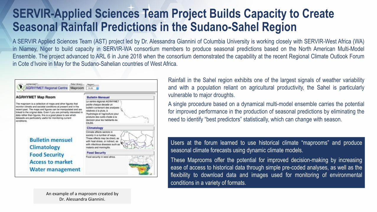
AnexampleofamaproomcreatedbyDr.AlessandraGiannini.
A SERVIR Applied Sciences Team (AST) project led by Dr. Alessandra Giannini of Columbia University is working closely with SERVIR-West Africa (WA) in Niamey, Niger to build capacity in SERVIR-WA consortium members to produce seasonal predictions based on the North American Multi-Model Ensemble. The project advanced to ARL 6 in June 2018 when the consortium demonstrated the capability at the recent Regional Climate Outlook Forum in Cote d’Ivoire in May for the Sudano-Sahelian countries of West Africa.
Users at the forum learned to use historical climate “maprooms” and produce seasonal climate forecasts using dynamic climate models. These Maprooms offer the potential for improved decision-making by increasing ease of access to historical data through simple pre-coded analyses, as well as the flexibility to download data and images used for monitoring of environmental conditions in a variety of formats.
SERVIR-Applied Sciences Team Project Builds Capacity to Create Seasonal Rainfall Predictions in the Sudano-Sahel Region
Rainfall in the Sahel region exhibits one of the largest signals of weather variability and with a population reliant on agricultural productivity, the Sahel is particularly vulnerable to major droughts. A single procedure based on a dynamical multi-model ensemble carries the potential for improved performance in the production of seasonal predictions by eliminating the need to identify “best predictors” statistically, which can change with season.

SERVIRDevelopsandTransitionsCropMonitortoInformNationalAuthoritiesinEastern&SouthernAfrica
Crop conditions: maize map for ICPAC’s (IGAD Climate Pre-diction and Applications Center) 8 member countries.
Training on the Crop Monitor at RCMRD, Nairobi, Kenya.
A SERVIR Applied Sciences Team (AST) from the University of Maryland and SERVIR-Eastern & Southern Africa (E&SA) have built the capacity for the Intergovernmental Authority on Development’s (IGAD) Climate Prediction and Applications Centre (ICPAC) to produce regional crop monitor bulletins for improved agricultural decision making.
• Initially presented at the Greater Horn of Africa Climate Outlook Forum (GHACOF), the se rv i ce p rov ides t ime ly and eas i l y interpretable maps to national authorities, such as Ministries of Agriculture. More accurate data allow for better decisions in response to severe crop condit ions, particularly during droughts.
• SERVIR will continue to support ICPAC in the production of the regional crop monitor bulletin, which will be released during each seasonal climate outlook meeting.
As the first crop monitor for the region, the SERVIR AST played a critical role in its development. ICPAC has assumed responsibility for continuing to provide this service, which will increase the reliability of regional crop assessments and further advance the Group on Earth Observation’s Global Agricultural Monitoring (GEOGLAM) initiative on Early Warning Crop Monitors.