fleet numerical oceanography center and tactical
TRANSCRIPT

Naval Research LaboratoryMonterey, CA 93943-5502
AD-A267 741 NRiJMRT7531--93-7204
Fleet Numerical Oceanography Centerand Tactical Environmental SupportSystem Satellite Retrieval MethodsFor Scheduled Satellite Upgrades
Computer Sciences Corporadon L!T'_ C T EMonterey, CA 93943-5502 1 , 1993u
June 1993
6#3 a .9 0o 79----1601Approved for public release; distribution unlimited. II '
REPORT DOCUMENTATION PAGE __ BNo._07__0_88
ow"o rfew" W4U lo mel =0000ll a ,lWgmIA 4 mmwi to ~*e I VWW ow omnU'& lmAag 111• Wf MIrIa N i OIJUW. Sam=" go"1M am ML O&TUI am
t• rmwoiq Fa. 0uOmen. U wOW 0qeoate' S.w . O . lee uwomenan owuwr. aw.mons 1215 WW0. 140,mev. Sane =MOW. A "NmqW. VA s20.302. mn w
1. Agency Use Only (Lea ve blana). 2. Report Da0a. 3. Rel Tye and Oat" Covered.
I June 1993 r1jnan4. -stle and SuoUtle. S. Funding Numbers.
Fleet Numerical Oceanography Center and Tactical PE 63207NEnvironmental Support System Satellite Retrieval PN X2008Methods for Scheduled Satellite Upgrades AN DN656790
16. Auhor(s).
Steven 0.. Swadley
7. Pedorming Organlizaen Name(s) and Address~es). L PerformWng OrganizationComputer Sciences Corporation, Monterey, CA 93943-5502 ReportNumber.
Naval Research Laboratory, Marine Meteorology Division NRL/MR/7531--93-7204Monter-iy, CA 93943-5502
9. SponsoarngiManitoring Agency Name(s) and Address(es). 10. SponeaorngiMonitoring AgencyReport Number.
Space and Naval Warfare Systems Command (PMW-165)Washington, OC 20361-5100
11. Supplementary Notes.
author affiliation: CSC.
12a. OlsartbutforwAvaab0ity Statement. 12b. Olstributon Code.
Approved for public release; distribution is unlimited.
13. Ab•sact (Mawwum 200 wah).
This report details the software requirements for scheduled DefenseM4eteorological Satellite Program (DMSP) and National Oceanic and AtmosphericAdministration (NOAA) environmental satellite sensor upgrades for both the FleetNumerical Oceanography Center(FNOC) and the Tactical Environmental Support System(TESS). The report describes current and future sensor packages flown on DMSP andNOAA polar orbiting platforms. Planned algorithm philosophies and options for bothcentral site (FNOC) and tactical sites (TESS) are presented and recommendations aremade. Hardware modifications required for acquisition of data from scheduledenvironmental satellite sensor upgrades are not presented in detail in this report.
14. Subject Terms. IS. Numbw of Page.
Satellite data assimilation Satellite sensors 34Satellite retrievals DMSP 1I. Price Code.
TESS
17. Seourny C0uaaflomdon 1. SLeuunty Cl4saifloaion I. Secunty CUuumicaUon 20. Lmntauon of Abstract.of Repe•t A aolThis Page. of Abs_ __L
UNCLASSIFIED UNCLASSIFIED UNCLASSIFIED Same as report
NSN r44.61-20611110 Sig - a (Rev. 249)2.900 amw eae SAeL ZWIS

TABLE OF CONTENTS
1. INTRODUCTION AND BACKGROUND ............................. 11.1 Introduction .............................................. 11.2 Background .............................................. 1
2. CURRENT NAVY ENVIRONMENTAL SATELLITE PROCESSING ......... 12.1 FNOC Environmental Satellite Processing ....................... 12.2 TESS Environmental Satellite Processing ........................ 2
3. CURRENT DMSP AND NOAA POLAR ORBITING SATELLITE SENSORS... 23.1 DMSP Sensors ........................................... 2
3.1.1 Operational Linescan System (OLS) ...................... 23.1.2 Special Sensor Microwave Temperature Sounder (SSM/T-1) ...... 33.1.3 Special Sensor Microwave Imager (SSM/I) ................. 43.1.4 Special Sensor Microwave Water Vapor Sounder (SSM/T-2) ..... 4
3.2 NOAA Sensors . ......................................... 63.2.1 Advanced Very High Resolution Radiometer (AVHRR/2) ....... 63.2.2 TIROS Cperational Vertical Sounder (TOVS) ................ 7
4. FUTURE DMSP AND NOAA POLAR ORBITING ENVIRONMENTALSENSORS ................................................... 104.1 Future DMSP Sensors ..................................... 104.2 Future NOAA Sensors . ................................... 12
4.2.1 Advanced Medium Resolution Imaging Radiometer (AMRIR) .... 124.2.2 Advanced Very High Resolution Radiometer (AVHRR/3) ...... 134.2.3 Advanced Microwave (Temperature) Sounding Unit (AMSU-A) .. 134.2.4 Advanced Microwave Humidity Sounding Unit (AMSU-B) ..... 15
5. RETRIEVAL ALGORITHMS .................................... 155.1 DMSP SSM/T-1 Temperature Retrievals ....................... 185.2 DMSP SSM/T-2 Humidity Retrievals ......................... 195.3 DMSP SSM/I Parameter Retrievals ............................ 205.4 DMSP SSMIS Temperature And Humidity Retrievals .............. 215.5 NOAA TOVS Temperature Retrievals .......................... 215.6 NOAA AMSU Temperature And Humidity Retrievals ............... 22
6. RECOMMENDED ALGORITHM STRATEGIES ....................... 236.1 Central Site Retrieval Algorithms ............................. 236.2 Tactical Site Retrieval Algorithms ............................. 24
7. SUM M ARY . .............................................. 25
[1APPENDIX A - SCHEDULED LAUNCH DATES FOR ENVIRONMENTAL
SATELLITES AND SENSOR PACKAGES .................... 26
REFERENCES .. .................................................. 27 . dodes
DTIC QUALrrY rNspErtEp, n .. . r,
iii DiMet Speoia2
FLEET NUMERICAL OCEANOGRAPHY CENTER AND TACTICALENVIRONMENTAL SUPPORT SYSTEM SATELLITE RETRIEVAL
METHODS FOR SCHEDULED SATELLITE UPGRADES
1. INTRODUCTION AND BACKGROUND
1.1 Introduction
The purpose of this report is to detail the sensor characteristics and associatedenvironmental retrieval methods in preparation for scheduled Defense Meteorological SatelliteProgram (DMSP) and National Oceanic and Atmospheric Administration (NOAA) environmentalsatellite sensor upgrades for both the Fleet Numerical Oceanography Center (FNOC) and theTactical Environmental Support System (TESS). Algorithm philosophies and options for bothcentral site (FNOC) and tactical sites (TESS) will be presented. Hardware modificationrequirements for acquisition of data from scheduled environmental satellite sensor upgrades willnot be presented in detail in the current report.
1.2 Background
The U.S. Navy has requirements to process environmental satellite data at FNOC for centralsite products and at TESS sites for tactically oriented products. FNOC's Satellite ProcessingCenter is responsible for receiving, processing, producing and distributing global environmentalsatellite products and has the distinct advantage of having access to the complete suite of real-time Navy Operational Global Atmospheric Prediction System (NOGAPS) products and fields(Hogan et al., 1991). TESS(3) has the responsibility of receiving and processing variousenvironmental satellite data in support of on-scene tactical nowcasting (Phegley and Crosiar,1991). With scheduled environmental satellite sensor upgrades, the Navy must be aware of thenew sensors and decide which algorithm approach should be pursued in order to maintain currentcapabilities and to meet future enhanced operational requirements of FNOC and TESS.
2. CURRENT NAVY ENVIRONMENTAL SATELLITE PROCESSING
2.1 FNOC Environmental Satellite Processing
Environmental satellite processing at FNOC is designed to satisfy validated fleet require-ments. These requirements include the providing of initial state data utilized by the Navy'sNumerical Weather Prediction (NWP) models, including NOGAPS and the Navy OperationalRegional Atmospheric Prediction System (NORAPS) and to provide near real-time satelliteimagery and derived products to the operating forces of the U.S. Navy. Continued upgrades toNOGAPS/NORAPS must also include a continued effort in maintaining optimal satellite dataassimilation methods. In order to realize the full potential of current and future environmentalsatellite derived products, and in turn meet the requirements of NWP forecasting skill,considerable efforts must be made in remaining at the forefront in assimilation of DMSP andNOAA satellite derived products.
1

A joint agreement exists between the Air Force, Navy and NOAA to share processingtasks and environmental product lines of mutual interest to all parties from DMSP, GOES, andTIROS. Data is exchanged between the Air Force Global Weather Central (AFGWC), theNational Environmental Satellite, Data, and Information Service (NESDIS), the NavalOceanography Center and FNOC via the Shared Processing Network (SPN). FNOC has beendesignated as the Center of Expertise (COE) for the processing of the DMSP Special SensorMicrowave/Imager (SSM/I).
2.2 TESS Environmental Satellite Processing
TESS is a modular, minicomputer based support system designed to provide Navy tacticalcommanders at selected shore commands and major ship combatants with secure and responsiveenvironmental support. A Pre-Planned Product Improvement (P31) program is underway toprovide upgrades to both hardware and software systems of TESS(3). Richardson (1990) detailsmany of the primary satellite sensor changes to occur during the TESS(3) preoperationaldevelopment phase. Currently, TESS(3) has the capability to process the following environmentalsatellite data: DMSP data including OLS and SSM/I; NOAA TIROS; TOVS soundings; AVHRR;and GOES-WEFAX.
3. CURRENT DMSP AND NOAA POLAR ORBITING SATELLITE SENSORS
3.1 DMSP Sensors
The U.S. Air Force manages the DMSP, which is the Department of Defense (DoD)operational environmental satellite system designed to support worldwide military requirements.On-board sensors provide to FNOC and AFGWC, in stored mode format, global visible andinfrared imagery, temperature and humidity soundings, auroral electron counts, and otherspecialized environmental data. DMSP also provides, in real mode format, direct readout (lineof sight) visible and infrared data, as well as the special sensor data (sounder and imager) toTESS and worldwide tactical terminal sites.
The current DMSP Block 5D-2 satellite series is equipped with an Operational LinescanSystem (OLS), Special Sensor Microwave Temperature Profiler (SSM/T-1), Microwave HumidityProfiler (SSM/T-2), Microwave Imager (SSM/I), and other space environment sensors andinstruments.
3.1.1 Operational Linescan System (OLS)
The OLS is the primary data acquisition system on the DMSP Block 5D satellite. Thesystem is designed to receive and transmit in real-time (real mode) or store multi-orbit (storedmode) day and night, visible (0.4 - 1.0 rum) and infrared (10.5 - 12.5 ,um) spectrum data. Thesedata, together with appropriate calibration, indexing, and other auxiliary signals, are provided tothe spacecraft for transmission to ground stations. The OLS provides a near constant imageresolution system in both visible (L-data) and thermal (T-data) modes. Fine resolution data(0.5 km resolution) is collected continuously by the infrared detector (TF-data) and duringdaylight for the visible detector (LF-data). Data smoothing permits global coverage in both the
2

TS and LS data modes resulting, but results in resolution degradation to 2.8 km. The OLSprovides a swath width of 2963 km at a nominal altitude of 833 km.
3.1.2 Special Sensor Microwave Temperature Sounder (SSM/T-1)
In 1978, the SSM/T-1 became the first microwave sounder to be flown on a DMSPsatellite. The objective of utilizing a microwave sensor was to overcome the limitations ofinfrared sounders by providing a better capability of temperature retrievals in cloudy atmospheres.The SSM/T-1 sensor system was designed to acquire microwave data simultaneously in sevenchannels. Table 1 describes the SSM/T-1 channel characteristics. Channel 1 (50.5 GHz) is awindow channel responding to the earth's surface characteristics, dense clouds (high liquid watercontent), and rain. Background effect corrections to the other channels are made by means ofchannel 1. Polarization dependent surface characteristics are removed from the brightnesstemperatures, leaving only the atmospheric contribution which is polarization independent. Onlychannels 1-4 are affected by surface contributions, and therefore, must have the same polarization.Channels 5-7 are not affected by the surface, and do not have polarization constraints.
Table 1. DMSP Special Sensor Microwave Temperature Sounder (SSM/IT-1)
SSM/T-1 Center Maximum Beamwidth NEATChannel Frequency Bandwidth (Degrees) (K)
No. (MHz) (MHz)
1 50500 400 14.4 0.6
2 53200 400 14.4 0.4
3 54350 400 14.4 0.4
4 54900 400 14.4 0.4
5 58400 115 14.4 0.5
6 58825 400 14.4 0.4
7 59400 250 14.4 0.4
3

The SSM/T-1 instrument is a cross track dwell and step Dicke type microwave radiometerwith a 32 second scan period. Microwave data are acquired at seven beam positions separatedby 12 angular intervals with a 2.7 second integration time. Calibration is performed on each scanby means of cold and warm calibration targets. The cold target is a cold space reflector at 2.7K; the warm calibration is a 300 K warm reference load. Synchronization, clock reference,system time and source power are supplied by the DMSP spacecraft.
3.1.3 Special Sensor Microwave Imager (SSM/I)
The first SSM/I was launched onboard the DMSP Block 5D-2 platform in June of 1987.The SSM/I, designed and built by Hughes Aircraft Company, is a scanning microwave radiometersystem with four discreet frequencies at 19.35, 22.235, 37.0, and 85.5 GHz (Hollinger and Lo,1983) designed to provide imagery and twelve environmental parameters. The brightnesstemperatures measured by the SSM/I are significantly affected by atmospheric attenuation andemission due to water vapor, clouds, precipitation, and the far wings of the oxygen band. Theenvironmental parameters include: rain rates, water vapor and cloud liquid water over oceans,ocean surface wind speed, sea ice (age, concentration and edge location), snow water content,land surface type, land surface temperature, soil moisture, and cloud amount over land. Duallinear polarizations (horizontal and vertical) are available at each frequency except 22.235 GHz.Table 2 details the frequency characteristics of the SSM/I. The SSM/I instrument consists ofan offset parabolic reflector, rotating at 31.6 rpm, which generates a conical scan pattern at 45*with the nadir, resulting in a 53.10 incidence angle with the earth's surface. Radiometric data arecollected during 102 of the revolution with an integration time per sample of 7.95 ms (3.89 msfor the 85.5 GHz), resulting in a 1400 km swath width. The 85 GHz channels are sampled 128times per scan (12.5 km scene spacing), while the lower frequencies are sampled 64 times perscan (25 km scene spacing). Due to the different size antenna footprints, the SSM/I 85 GHzchannels are sampled every scan and the lower frequency channels are sampled every other scan,resulting in A and B scans. A complete set of housekeeping data requires four scans, resultingin an A, B, A', B' scan sequence.
3.1.4 Special Sensor Microwave Water Vapor Sounder (SSM/T-2)
The SSMtT-2 was the first microwave humidity profiler to be flown on a DMSP Block5D-2 spacecraft. The first operational SSM/T-2 was onboard the F-11 spacecraft launchedThanksgiving Day, 1991. The SSM/T-2 was designed to work together with the SSM/T-1 inorder to retrieve profiles of specific humidity, relative humidity and water vapor mass. TheSSM/T-2 has three channels on the 183 GHz water vapor resonance line, a 150 GHz channel, anda 91 GHz channel. Similar to the SSM/T-1, the SSM/T-2 is a cross track dwell and stepradiometer, but with an 8 second scan period. Radiometric data are acquired at 28 beampositions (3 angular increments), with four successive scans required to match the SSM/T-1footprints. Figure 1 demonstrates the SSM/T-2 cross track scan geometry and relation to theSSM/T-1 footprints. Radiometric calibration is performed each scan via warm load and coldspace calibration targets. The SSM/T-2 radiometric data has also shown value as imageryproducts, yielding multiple level structure to cloud and precipitation systems.
4
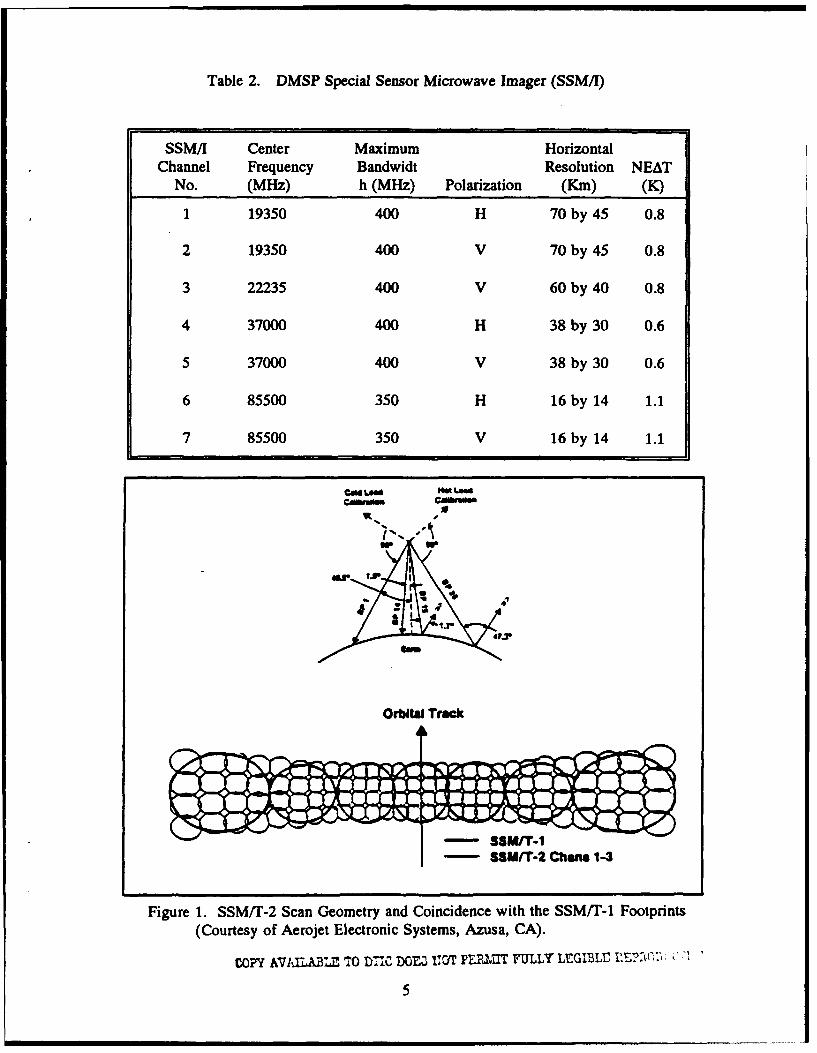
Table 2. DMSP Special Sensor Microwave Imager (SSM/I)
SSM/I Center Maximum HorizontalChannel Frequency Bandwidt Resolution NEAT
No. (MHz) h (MHz) Polarization (Kin) (K)
1 19350 400 H 70 by 45 0.8
2 19350 400 V 70 by 45 0.8
3 22235 400 V 60 by 40 0.8
4 37000 400 H 38 by 30 0.6
5 37000 400 V 38 by 30 0.6
6 85500 350 H 16 by 14 1.1
7 85500 350 V 16 by 14 1.1
air
S- - M/'T-1
-- SSW/T-2 Charts 1-3
Figure 1. SSM/T-2 Scan Geometry and Coincidence with the SSM/T-1 Footprints(Courtesy of Aerojet Electronic Systems, Azusa, CA).
Copy KVIXLBLRk TO 7C DOE•3, 110T PEPNUT~ FULLY" LEGM=L r.EPt.C.:'1ý . '
5
1 mU. U |

Table 3. DMSP Special Sensor Microwave Humidity Sounder (SSM/T-2)
SSM/T-2 Center Maximum NadirChannel Frequency Bandwidth Beamwidth Resolution
No. (MHz) (MHz) (Degrees) (Kin) NEAT (K)
1 183310+3000 1000 3.3 48 0.6
2 183310+1000 500 3.3 48 0.8
3 183310+7000 1500 3.3 48 0.6
4 91655+1250 1500 5.75 84 0.6
5 150000+1250 1500 3.7 54 0.6
3.2 NOAA Sensors
The NOAA series of environmental polar orbiting satellites replaced the TIROS-N, NASAprototypes, with the launch of the first NOAA funded operational satellite in June 1979.Currently, the primary operational spacecraft are the NOAA-11 and NOAA-12. The NOAAseries satellites carry four primary instrument systems. These include the Advanced Very HighResolution Radiometer (AVHRR/2), TIROS Operational Vertical Sounder (TOVS), DataCollection System (DCS), and the Space Environment Monitor (SEM).
3.2.1 Advanced Very High Resolution Radiometer (AVHRR/2)
The five channel AVHRR/2 became operational with the launch of NOAA-7, June 1981.The AVHRR/2 provides data for real time transmission to both Automatic Picture Transmission
(APT) and High Resolution Picture Transmission (HRPT) users and for storage of global dataon the spacecraft tape recorders. The APT data is analog and the HRPT is digital. AVHRR/2data is available at 4 km resolution for direct readout APT stations and at 1.1 km resolution fordirect readout HRPT stations. Global Area Coverage (GAC) at 4 km resolution is obtained fromthe onboard recorders at the NOAA central computer facility, Suitland, MD. The aboveresolutions represent the values for the nadir position. Table 4 describes the AVHRR/2 channelcharacteristics and primary functions.
6

Table 4. NOAA Advanced Very High Resolution Radiometer (AVHRR)
AVHRR WavelengthChannel No. (Cun) Primary Function
1 0.55 - 0.9 Daytime cloud/surface detection
2 0.725 - 1.1 Surface water discrimination, iceand snow melt
3 3.55 - 3.93 Nighttime sea surface temperatureand cloud detection
4 10.5 - 1' 5 Sea surface temperature and nightcloud detection
5 11.5 - 12.5 Sea surface temperature and nightcloud detection
3.2.2 TIROS Operational Vertical Sounder (TOVS)
The TOVS system (Smith et al., 1979) combines data from several complementarysounding instruments onboard the spacecraft. These instruments are the twenty channel HighResolution Infrared Sounder (HIRS/2), the three channel Stratospheric Sounding Unit (SSU), andthe four channel Microwave Sounding Unit (MSU).
3.2.2.1 TOVS High Resolution Infrared Radiation Sounder (HIRS/2)
The TOVS HIRS/2 is the primary sensor for the retrieval of tropospheric data. TheHIRS/2 is sensitive to energy from the visible to the carbon dioxide (CO) region of the infraredspectrum. Table 5 details the channel characteristics of the HIRS/2. The instrument is designedfor the retrieval of temperature profiles from the surface to 10 mb, water vapor content in threevertical layers, and total ozone (03) content. The HIRS/2 instrument instantaneous field of view(IFOV) is 30 km at nadir and samples 56 IFOVs along each scan line of approximately 2250 km.The footprint is circular at nadir, but becomes increasingly elliptical with distance from nadir.
7

Table 5. NOAA High Resolution Infrared Radiation Sounder (HIRS/2)
CentralHIRS/2 Central Wave- PrincipalChannel Wave- length Absorbing Level of Peak
No. number (uan) Constituents Energy
1 668 15.00 CO2 30 mb
2 679 14.70 CO2 60 mb
3 671 14.50 CO2 100 mb
4 704 14.20 CO2 400 mb
5 716 14.0f, CO2 600 mb
6 732 13.70 COJH 20 800 mb
7 748 13.40 CO2/H20 900 mb
8 898 11.10 Window Surface
9 1028 9.70 02 25 mb
10 1217 8.30 H20 900 mb
11 1364 7.30 H20 700 mb
12 1484 6.70 H20 500 mb
13 2190 4.57 N20 1000 mb
14 2213 4.52 N20 950 mb
15 2240 4.46 CO2 /:,O 700 mb
16 2276 4.40 CO2 /N20 400 mb
17 2361 4.24 CO2 5 mb
18 2512 4.00 Window Surface
19 2671 3.70 Window Surface
20 14367 0.70 Window Cloud
8

3.2.2.2 TOVS Microwave Sounding Unit (MSU)
The TOVS MSU is sensitive to energy in the oxygen absorption region of the microwavespectrum (50-58 GHz). The four channel MSU is used in conjunction with the HIRS/2 to permittemperature retrievals in moderately overcast conditions The MSU samples 11 IFOVs along thescan with a 110 km footprint at nadir. The TOVS MSU channel characteristics are shown inTable 6.
3.2.2.3 TOVS Stratospheric Sounding Unit (SSU)
The TOVS SSU is a Pressure Modulated Radiometer (PMR) sensitive to energy emittedby carbon dioxide (CO2) at 15.0 #um. The PMR subsystem was provided by the BritishMeteorological Office. The SSU samples eight IFOVs along each scan of 1500 km extent. TheSSU scan is not coincident with the outward edges of the HIRS/2 and MSU scans.
Table 6. NOAA Microwave Sounding Unit (MSU)
Principal
MSU Channel Frequency Absorbing Level ofNo. (GHz) Constituent Peak Energy
1 50.31 Window Surface
2 53.73 02 850 mb
3 54.96 0 2 500 mb
4 57.95 02 100 mb
Table 7. NOAA Stratospheric Sounding Unit (SSU)
Principal
SSU Channel Wavelength Absorbing Level ofNo. (JAM) Constituent Peak Energy
1 15.0 CO 2 15.0 mb
2 15.0 CO 2 4.0 mb
3 15.0 CO 2 1.5 mb
9

4. FUTURE DMSP AND NOAA POLAR ORBITING ENVIRONMENTAL SENSORS
4.1 Future DMSP Sensors
The next suite of DMSP satellites, the DMSP Block 5D-3 satellite series, is scheduledto be employed by the mid to late 1990s. The Block 5D-3 will again carry the OLS as theprimary sensor. The combined functionality of th,- SSM/T-1, SSM/T-2 and SSM/I sensors willbe combined into a single sensor package that surpasses the capabilities of the individual sel-sors.
Special Sensor Microwave Imager/Sounder (SSMIS). The DMSP SSMIS is a millimeter/microwave sensor that passively measures energy emitted, scattered and reflected from the earth'ssurface and atmosphere. The SSMIS uses an offset parabolic reflector, rotating at 31.6 rpm,which generates a conical scan at 450 with the nadir. This results in 53.10 angle of incidencewith the earth's surface. Figure 2 depicts the SSMIS scan geometry. The SSMIS will providelower atmosphere temperature and humidity profiles, upper atmosphere temperature profiles (10-0.03 mb), and twelve additional parameters similar to those of the current SSM/I parameters. Thefrequencies in which the SSMIS measures radiation were selected to increase the sharpness ofsome of the weighting functions and to improve the overall weighting function coverage of theatmosphere, compared to previous spaceborne microwave sensors (Swadley and Chandler, 1992).Table 8 details the DMSP SSMIS channel characteristics. However, the center frequencies ofthe upper air channels, SSMIS channels 19-24, represent the effective frequencies of a stationarysensor, and do not represent the actual center frequencies of the spaceborne sensor which areshifted by the hardware to annul the Doppler shifting due to spacecraft motion.
m s
Figure 2. DMSP SSMIS Scan Geometry
l0
COOP AVAILABLE TO DTIC DOE9 NOT P•,.1T~ FULLTr LECI'J.i'• • "":•••),

Table 8. DMSP Special Sensor Microwave Imager Sounder (SSMIS)
Center Frequency Frequency/ Maximum Horizontal SceneChannel (MHz) Stability Bandwidth Resolution Spacing NEAT
No. (MHz) (MHz) Polarization (Km) (Km) (K)
1 50300 10 400 H 39 by 38 38.0 0.4
2 52800 10 400 H 39 by 38 38.0 0.4
3 53956 10 400 H 39 by 38 38.0 0.4
4 54400 10 400 H 39 by 38 38.0 0.4
5 55500 10 400 H 39 by 38 38.0 0.4
6 57290 10 350 V 39 by 38 38.0 0.4
7 59400 10 250 V 39 by 38 38.0 0.5
8 15000 200 3000 H 15 by 13 12.5/38.0 0.7
9 183310+7000 200 3000 H 15 by 13 12.5/38.0 1.2
10 183310+3000 200 2000 H 15 by 13 12.5/38.0 1.0
11 183310+1000 200 1000 H 15 by 13 12-5/38.0 1.0
12 19350 75 500 H 74 by 45 25.0 0.7
13 19350 75 500 V 74 by 45 25.0 0.7
14 22235 75 500 V 74 by 45 25.0 0.7
15 37000 150 2000 H 45 by 31 25.0 0.5
16 37000 150 2000 V 45 by 31 25.0 0.5
17 91655 100 3000 V 15 by 13 12.5 0.9
18 91655 100 3000 H 15 by 13 12-5 0.9
19 63283.2+285.3 0.11 3.0 H+V 75 by 75 75.0 1.9
20 60792.7+357.9 0.11 3.0 H÷V 75 by 75 75.0 1.9
22 60792.7+357.9+5.5 0.15 12.0 H+V 75 by 75 75.0 1.0
23 60792.7+357.9+16 0.5 32 H+V 75 by 75 75.0 0.6
24 60792.7+357.9+50 1.0 120 H+V 75 by 75 38.0/75.0 0.7
Scene spacing and NET values refer to scene averaged values used for retrievals of temperature and humidity.
11

4.2 Future NOAA Sensors
Some instruments now standard with the NOAA E-J block of satellites, will be changedbeginning with the NOAA K. The NOAA K-M series of satellites will have an upgradedAVHRR and the Advanced Microwave Sounding Unit (AMSU). With the advent of AMSU, theHIRS instrument will become the supplementary sounder, and AMSU-A will be the primarytemperature sounder and the AMSU-B will provide humidity profiles. The launch of NOAA-Kis now estimated to be 1995. With the NOAA N-P series of satellites the AVHRR and HIRS/2will be replaced by the Advanced Medium Range Imaging Radiometer (AMRIR).
4.2.1 Advanced Medium Resolution Imaging Radiometer (AMRIR)
The NOAA N-P series of satellites is scheduled to be deployed in the late 1990's, althoughbudget cutbacks may delay and possibly eliminate the AMRIR. The AMRIR is an elevenchannel visible/infrared radiometer designed for global measurements of cloud cover, sea surfacetemperature, snow and sea ice extent, as well as to provide temperature and humidity profiles ata resolution of 4 km. This AMRIR instrument will decrease the infrared spectral informationcontent, as compared to HIRS/2, and in turn degrade the combined sounding system. This iscompensated for by increased horizontal resolution and the improved sounding in partly cloudyscenes. The AMRIR sensor will have a horizontal resolution of 500 m, and a swath width of2940 km. Table 9 details the AMRIR channel characteristics.
Table 9. NOAA Advanced Medium Resolution Imaging Radiometer (AMRIR) (Eyre, 1989).
Number of WavelengthsChannels (tim) Primary Purpose
1 13.55 Temperature profile
1 10.8 (lower troposphere)
1 12.0
2 4.4 - 4.6 Surface temperature
1 3.72 Cloud parameters
1 4.01 "
4 0.6 - 1.6 Imagery for other applications
12

4.2.2 Advanced Very High Resolution Radiometer (AVHRR/3)
The AVHRR/3 represents only slight modifications to the existing AVHRR/2. AVHRR/3channel 1, 2 and 3 will no longer be linear; dark response is to be expanded, providing additionalgray scales to enhance aerosol detection (Sparkman, 1989). All infrared channels are to bemodified for a 335 K saturation to avoid hot region saturation. Table 10 details the AVHRR/3channel characteristics.
Table 10. NOAA Advanced Very High Resolution Radiometer (AVHRR/3)
AVHRR/3 Wavelength PrimaryChannel No. (Un) Function
1 0.58 - 0.68 Daytime cloud/surfacedetection
2 0.84 - 0.87 Surface water discrimination,ice and snow melt
3A 1.58 - 1.64 Daytime cloud/snowdiscrimination, sea surfacetemperature
3B 3.55 - 3.93 Nighttime sea surfacetemperature and clouddetection
4 10.3 - 11.3 Sea surface temperatureand night cloud detection
5 11.5 - 12.5 Sea surface temperatureand night cloud detection
4.2.3 Advanced Microwave (Temperature) Sounding Unit (AMSU-A)
The AMSU-A is a 15 channel total power microwave radiometer designed and built byAerojet Electronic Systems Division, and represents significant advancements in microwaveradiometer technology. The AMSU-A passively measures microwave radiation from the oxygenabsorption region (50.3 - 57.9 GHz) in 12 discreet frequencies, and at 23.8, 31.4, and 89.0 GHz.Table 11 details the AMSU-A channel characteristics. The 8 second cross track scan covers +500from nadir, with 30 samples of a constant 3.3* antenna beamwidth. Figure 3 depicts the AMSU-A scan geometry. In-flight calibration is performed each scan by means of warm load and coldload targets. Several channels (5, 10 - 14) have multiple pass bands in order to improve thesignal-to-noise ratio and match the narrow line widths at those frequencies.
13

Table 11. NOAA Advanced Microwave Sounding Unit (AMSU-A)
Center Frequency/ MaximumAMSU Frequency Stability Bandwidth Beamwidth NEAT
Channel No. (MHz) (MHz) (MHz) (Degrees) (K)
1 23900 10.0 270 3.3 0.3
2 31400 10.0 180 3.3 0.3
3 50300 10.0 180 3.3 0.4
4 52800 5.0 400 3.3 0.25
5 53596+0.115 5.0 170 3.3 0.25
6 54400 5.0 400 3.3 0.25
7 54940 5.0 400 3.3 0.25
8 55500 10.0 330 3.3 0.25
9 57290 0.5 330 3.3 0.25
10 57290+217 0.5 78 3.3 0.4
11 57290+322+48 0.5 36 3.3 0.4
12 57290+322+22 0.5 16 3.3 0.6
13 57290+322+10 0.5 8 3.3 0.8
14 57290+322+4 0.5 3 3.3 1.2
15 89000 50.0 6000 3.3 0.5
3.30 10.0046e - Coll I
Figure 3. NOAACASU-A scan geometry (Patel, 1992).
14

4.2.4 Advanced Microwave Humidity Sounding Unit (AMSU-B)
The AMSU-B is the module of the AMSU designed to obtain profiles of atmospherichumidity from the surface up to 40 km with accuracies estimated to be 5 to 15 percent ofsaturation. The AMSU-B is a cross track total power microwave radiometer, measuring energyat 5 discreet frequencies. Table 12 details the AMSU-B channel characteristics. All channelshave a 1.10 antenna beamwidth, translating to a 15 km footprint at nadir, with 90 samples perscan. The scan width is 2343 kmn, with a 2.67 second scan period.In-flight calibration isperformed in the same manner as AMSU-A.
Table 12. NOAA Advanced Microwave Sounding Unit (AMSU-B)
Center Frequency/ MaximumAMSU Frequency Stability Bandwidt Beamwidth NEAT
Channel No. (MHz) (MHz) h (MHz) (Degrees) (K)
16 89000 50 6000 1.1 0.6
17 157000 50 4000 1.1 0.6
18 183310+1000 30 1000 1.1 0.8
19 183310+3000 30 2000 1.1 0.8
20 183310+7000 30 4000 1.1 0.8
Appendix A provides a tentative launch schedule of future DMSP and NOAA (polarorbiting and geosynchronous) satellite sensor platforms. Launch dates for NASA, US Navy,European Space Agency (ESA), National Space Development Agency of Japan (NASDA),People's Republic of China and France's satellite sensor platforms have also been included.
5. RETRIEVAL ALGORITHMS
Historically, the radiances measured by environmental satellite sensors have not been ofdirect geophysical interest. Significant efforts have been made to extract geophysical parametersfrom the radiances, such as with the AVHRR, TOVS, SSM/T-1 and SSM/I. For satellitesounding radiances, the common approach is to express the radiance integral as a convolution ofthe Planck function with the weighting function which represents the medium interaction. The
15

temperature or humidity profile is obtained by solving the resulting Fredholm integral equationof the first kind. The solution of these integral equations is known as the retrieval or inverseproblem, while the calculation of radiances from a given atmospheric state is known as theforward problem. The satellite radiance inversion problem is mathematically ill-posed. Solutionsrequire additional constraints (a priori information) to select the optimal solution between theinfinite atmospheric profiles satisfying the integral equation. Solutions to the inverse problemhave been made via direct iterative methods of solving the Radiative Transfer Equation (RTE),i.e., physical retrievals, linearized statistical methods (D-matrix), and various filtering approaches.Although no general agreement has been made on retrieval methodology for satellite soundingproducts, there is a consensus that physical or physical statistical retrievals show the greatestpotential, provided one desires a stand-alone satellite derived profile.
Two methods of satellite sounding verification exist, one being collocation of satelliteretrievals with radiosondes. The verification process is routinely performed at the operationalcenter generating the soundings and during algorithm comparison studies by other researchcenters. Results are difficult to interpret, as the radiosonde collocation method has complicatingfactors. For example the SSM/T-1 data may not be stratified according to beam position and theradiosonde data may be matched-up with differing space and time criteria. The other verificationmethod is to calculate the radiances directly from an atmospheric state, i.e., to perform theforward problem calculation, to a degree of accuracy within the bounds that an NWP can predictthe measurements, and compare the computed values with the satellite measured radiances.However, the inherent complexities of the forward calculations, limitations in spectroscopy anduncertainties in the amount and type of hydrometeors present within the sensor's IFOV, make thistype of forward problem difficult and computationally intensive. It is for this reason that theradiosonde collocation method is the most widely utilized verification technique.
The spatial error characteristics of satellite soundings are not addressed by the aboveverification procedures. Correct specifications of the error characteristics are required for theoptimum use of the satellite sounding data in statistical assimilation methods. These errorcharacteristics vary with the retrieval method, sensor type, scan geometry, and the physicalproperties associated with the measurement, i.e., cloudiness and/or precipitation. Sienkiewicz(1993) details a methodology for utilizing forecast fields from an NWP system with satellitesoundings to determine systematic errors in the satellite derived profiles. Results of this studyshowed significant biases accross a TOVS scan, which were not realizable via radiosondecollocation studies.
The current operational centers producing satellite soundings are NESDIS and AFGWC.NESDIS, the satellite sounding COE under the SPN, is responsible for producing and distributingboth NOAA and DMSP temperature soundings, while AFGWC produces both DMSP SSM/T-1and SSM/T-2 sounding products. Plans are for NESDIS to produce and distribute SSM/T-2humidity profiles in the near future. Various organizations produce satellite soundings in researchmodes using developmental retrieval packages. Research retrieval methods for TOVS andSSM/T-1 include: NASA Goddard Laboratory for Atmospheres (GLA) physical retrieval method,University of Wisconsin Cooperative Institute for Meteorological Satellite Studies (CIMMS)simultaneous retrieval method and international TOVS processing package, AtmosphericEnvironmental Research (AER) unified retrieval method, University of Maryland singular valuedecomposition method (Thompson, 1992), Air Force Phillips Laboratory Geophysics Directorate
16

differential inversion method (King et al., 1989), the Laboratoire de Meteorologique Dynamique(LMD) improved initialization inversion method, and the NESDIS minimum variance andclassification methods.
For NWP applications, it is clear that the current utilization of satellite soundings is lessthan optimal, as demonstrated by recent negative impacts of satellite soundings on northernhemisphere forecasts (Baker et al., 1989). The accuracy of NWP 6 hour forecast fields haveimproved to the point where in certain regions the uncertainty in the satellite sounding retrievalsare greater than the uncertainties in the forecast field. The simplistic approach of treating satellitesoundings in a manner similar to radiosondes, but with larger error characteristic, will never fullyutilize the information content of the satellite sounding radiances.
Recent developments under a joint NMC, NASA and NESDIS effort (Baker, 1992) havedemonstrated that satellite sounding radiances may be directly assimilated by an NWP system.The system was designed to take advantage of the NESDIS operational system and thedevelopmental approaches at both NASA GLA and NESDIS. The approach, known as"interactive soundings" (Susskind and Pfaendtner, 1989), utilizes the NWP model 6 hr forecastfields as the first guess for the retrieval scheme and relies on an accurate forward calculation ofthe radiances (Susskind et al., 1983). By-products to this retrieval scheme are estimates ofsurface temperature (land or sea), cloud height and amount, sea ice extent, snow cover, oceansurface roughness and other hydrologic parameters. The retrievals are then used in conjunctionwith other available data in the NMC model's spectral statistical interpolation (SSI)assimilation/initialization cycle (Parrish and Derber, 1991). The resulting "interactive" retrievalsare also in balance with the wind and mass fields of the model, but can also contain the model'sbias characteristics. To alleviate some of the latter problem, in areas where the model forecastmay be of poor quality, i.e., where the satellite sounding radiances have large deviations fromthe model computed radiances, the classification retrieval procedure developed by McMillin(1986) is used. The GLA retrieval code has been ported to CRAY YMP at NMC and thetechnique is currently being evaluated on the T62 global spectral NWP model. Plans are toconduct a full resolution (T126) impact study including the classification procedure and NASAcloud clearing algorithms.
Eyre and Lorenc (1989) have developed the theoretical framework for the direct use ofsatellite sounding radiances in NWP which effectively utilizes more of the information contentcontained in the radiances. The direct assimilation of radiances is conceptually a mathematicalequivalent to a conventional minimum variance retrieval. The NWP model field acts as thebackground for the inversion which is constrained by the field's expected error covariance. Alinear version of the "forecast background" scheme has been applied to TOVS radiances at theU.K. Meteorological Office since 1987.
Variational inversion methods have been employed with the adjoint technique of dataassimilation. Thepaut and Moll (1990) have developed tangent linear and adjoint operators ofthe International TOVS Processing Package (ITPP). Variational inversion consists of minimizinga cost function that measures the distance between the analyzed atmospheric state and availablesupporting observations. Two main terms included in the cost function are: 1) a measure of thedeparture of the observed radiances and the NWP model state radiances computed via a radiativetransfer model, and 2) a term measuring the departure from a background atmospheric state, i.e.,
17
the first guess. The techniques used to minimize the cost function have included Newton'smethod (Eyre, 1989) and also conjugate gradient methods (Hoffman and Nehrkorn, 1989). Thecomputational complexities of computing the first and second derivatives of the cost functionrequire careful selection of the minimization technique.
5.1 DMSP SSM/T-1 Temperature Retrievals
AFGWC and NESDIS are the two operational centers processing the DMSP SSM/T-1 dataand producing atmospheric temperature profiles. AFGWC utilizes software developed by AerojetElectronic Systems (Rigone and Stogryn, 1977). The retrieval method is based upon a linearmultiple regression technique, i.e., the so called "D-Matrix" approach. With this method, it isassumed that the deviation of the parameter vector, i.e., the retrieved temperatures andthicknesses, from the climatalogical mean can be expressed as a linear combination of thedeviations of the measured data from its mean. The D matrix is obtained by the computing thematrix product of the parameter-data matrix and the inverse of the data-data covariance matricesand adding the radiometer noise covariance matrix. The data vector is collected from a largeensemble of radiosondes, and allows for updates of the D-matrices. The D-matrices also arestatically stratified by geographical location and by SSM/T-1 beam position to include the effectsof incidence angle. The D-matrix update process begins once a significant number of newradiosonde collocations have been collected and pairs of computed and measured radiances (datavectors) have been computed. A linear regression is performed between the measured andcomputed data vectors, with regression coefficients being computed on channel by channel basis.These coefficients are then used to update the a priori correlation matrices and expected datavector. Updates to the operational D-Matrices are performed only after the new or test D-Matrices have been verified to have lower retrieval error statistics. Advantages of the D-Matrixmethod are its computational efficiency and that the instrument noise variations in time areaccounted for by the updating of the regression coefficients. Weaknesses include the lack ofphysical incorporation of the effects of various hydrometeors on the observed radiances and howthe a priori statistical ensemble is representative of the current atmospheric temperature structure.
NOAA NESDIS utilizes a modified version of the original AFGWC code. The NMCSSM/T-1 retrieval is performed by a statistical process termed "synthetic regression" (Reale andDonahue, 1992). The departures from the AFGWC version are in the matrix updatemethodology, precipitation screening, and in the incorporation of the angle of incidence (beamposition) and terrain influences. The "synthetic regression" is basically a weekly D-matrixupdate.
A physical, simultaneous retrieval algorithm, for SSM/T-1 radiances has been developedat CIMMS (Schreiner, 1990). The algorithm, which is designed to work with Level 1B radiancedata (earth located brightness temperatures and/or radiances) available from NESDIS, consists ofdata preprocessing and the subsequent temperature retrieval. The preprocessing consists of"normalizing" the SSM/T-1 brightness temperatures to that of scenes without clouds or moistureand with unit emissivity via a statistical regression. The normalized SSM/T-1 antennatemperature is modeled via a special form of the RTE (Smith et al., 1985) and computed for eachchannel and beam position. The surface emissivity is retrieved using the SSM/T-1 surfacechannel and an independent estimate of the surface temperature. Ideally, this methodwould incorporate the SSM/I for real estimates of the cloud and water vapor effects. Using the
18

SSM/T-1 weighting functions as one basis set,and the spatial antenna pattern weighting functionsin a 3 by 3 field of view as the other basis set, the temperature perturbation function coefficientscan be specified and the RTE solved. The CIMMS SSM/T-1 physical retrieval package wasdeveloped under contract with the Naval Research Laboratory, Monterey, CA.
A unified physical statistical retrieval system has been developed for the potential use withSSM/T-1, SSM/T-2 and the SSM/I at AER (Isaacs, 1989). The technique was designed toprocess the DMSP sensor data in an integrated approach, rather than processing each sensorindependent of each other. The statistical retrieval of SSM/T-1 temperature profiles, SSM/T-2humidity profiles, and SSM/I parameters are performed via the operational D-Matrix approachto provide first guess profiles for the subsequent unified retrieval. The forward problem isaccomplished via the RADTRAN simulation code (Falcone et al., 1982). Residuals between theobserved and computed brightness temperatures are then computed and compared to the NET forthat channel. If the residuals are not within tolerance, then the first guess profiles are adjustedby means of a simultaneous physical retrieval modeled after Susskind et al. (1984) and Smith etal. (1985). Cloud contamination screening is performed via the visible and infrared OLS datamapped into the various microwave channel footprints, while cloud liquid water estimates aremade via the SSM/I over oceans. These parameters are utilized in the forwardproblem for theSSM/T-2 brightness temperatures. This method has shown marked improvements with watervapor retrievals in simulation studies but has not been utilized with actual SSM/T-2 data nowavailable. This method is quite cumbersome from an operational software maintainabilitystandpoint, which is a major concern.
5.2 DMSP SSM/T-2 Humidity Retrievals
AFGWC is the current operational center processing SSM/T-2 data and producing watervapor profiles. The operational software was developed by Aerojet Electronic Systems Division,and the retrieval products are being validated via radiosonde collocation (Boucher et al., 1993).The retrieval method is the statistical D-Matrix approach designed to decompose the non-linearretrieval problem into piecewise linear representation. The D-Matrix discriminants are basedupon surface type, beam position, and air mass type. The dynamically based stratification isbased upon air mass characteristics as defined by the total vapor mass and an estimate of themean tropospheric temperature. The SSMIT-2 products include relative and specific humiditiesat 1000, 850, 700, 500, 400, and 300 mb. Water vapor masses from the surface to 1000, 1000-850, 850-700, 700-500, 500-400, 400-300, and above 300 mb are also retrieved. The SSM/T-2brightness temperatures have also shown considerable promise when displaed in an image format.The preliminary retrieval results show RMS errors in the 20% range in RH for all sounding cases,but less than half that error for cloud free cases. The results are obtained using the initial a prioriD-Matrices. RMS errors will be lowered and the biases removed when enough radiosondecollocations are obtained to perform the D-Matrix update.
19

5.3 DMSP SSM/A Parameter Retrievals
AFGWC and FNOC are the current operational centers processing SSM/I data andproducing environmental parameters. FNOC is the designated COE under the SPN for theSSM/I. The FNOC SSM/I processing is performed on the Satellite Processing Center Upgrade(SPCU), and entails the production of Sensor Data Records (SDRs), Temperature Data Records(TDRs), Environmental Data Records (EDRs) and Quality Data Records (QDRs) for subsequentdistribution to the operational Navy community, Naval Research Laboratory (NRL), Washington,D.C., and transmitted via the SPN. The original SSM/I Ground Processing Software (GPS),developed by the Hughes Aircraft Company, has incorporated the recommended changes to boththe SDR and EDR processing suggested by the SSM/I Cal/Val reports (Hollinger, 1989, 1991).The earth located SDRs are utilized for imagery products and to produce the EDRs, whichinclude the following parameters: ocean wind speed, sea ice concentration, ice age (first or multi-year) and ice edge, total precipitable water and cloud liquid water content over oceans, rain rates,soil moisture, surface type and temperature. The SSM/I GPS was originally designed to alsocompute cloud amount and liquid water content over land, but the accuracy of these productswere not validated by the Cal/Val team and are no longer being computed (Colton, 1992).
Earth located TDRs are archived and also distributed via the SPN. TDRs allow for usersto process SSM/I data with their own versions of corrections for antenna pattern and crosspolarization effects. Variations exist between SSM/I sensors on the DMSP satellites, and thesesubtle differences must be accounted for when performing the TDR to SDR conversion. Thisresults in differences in the input values to the parameter extraction algorithms, and subsequentlydifferent output products.
NESDIS is also producing SSM/I products in an effort to improve satellite soundingproducts. NESDIS has developed a set of algorithms for rain rates and snow/ice analysis (Grody,1991, Grody and Ferraro, 1992, and Mitchell et al., 1992). However, these algorithms have beendesigned to operate on uncorrected TDRs. The resulting products are difficult to validate andcompare with the FNOC operational SSM/I products.
NASA is currently sponsoring a five year program, WetNet, designed to examine the roleof a remote interactive computer network for the earth sciences, and to promote interdisciplinaryresearch in the atmospheric and related hydrologic sciences (Smith et al., 1992). WetNet'sprimary data is from the SSM/I. The SSM/I TDR data is acquired from NESDIS via FNOC, andprocessed by Remote Sensing Systems (RSS) with a proprietary environmental algorithm whichperforms quality control and produces modified antenna temperatures (Wentz, 1988). The SSM/Idata are then sent to Marshall Space Flight Center (MSFC) and distributed to the WetNetscientists via magneto-optical cartridges for subsequent algorithm development studies. Again,the resulting SSM/I products are difficult to validate and compare with the FNOC operationalSSM/I products.
Petty (1990) has developed a retrieval package for the SSM/I based upon the modeledresults from a microwave radiative transfer model. A unified set of semi-physical algorithms forobtaining ocean wind speed, total precipitable water, cloud liquid water and precipitation aredocumented. Stand alone 37 GHz and 85 GHz algorithms for rain rate and cloud liquid waterwere also developed. The input SSM/I data for the study were provided by RSS.
20

5.4 DMSP SSMIS Temperature And Humidity Retrievals
Aerojet Electronic Systems Division is currently under contract to develop and deliver twooperational Computer Software Configuration Items (CSCIs) for use at AFGWC and FNOC.The SSMIS GPS inputs raw sensor counts, calibration data and ephemeris data to produce SDRs,EDR, and TDRs. The SSMIS GPS also performs sensor health monitoring and the soundingverification and update processes.
The SSMIS will produce lower atmospheric temperature soundings to the 10 mb level,relative and specific humidity profiles up to 300 mb, water vapor mass between the mandatorypressure levels up to 300 mb, total vapor mass, along with estimates of tropopause pressure andtemperature at a horizontal resolution of 38 km. The lower atmosphere temperature and humidityprofiles will be computed via the linear statistical D-Matrix method with dynamic stratification(D-Matrix selection criteria) based upon air mass typing. The SSMIS lower atmosphericsoundings will be earth located at the 11 km level along the beam propagation path.
Upper atmospheric soundings will be produced from 7 mb to 0.03 mb. The SSMIS upperatmosphere temperature retrieval method is significantly more complex than the lower atmosphereretrievals. The added complexity is due to the interaction of the earth's magnetic field with themagnetic dipole moment of the oxygen molecule. This causes "Zeeman splitting" of the oxygenabsorption lines and produces significant changes in the weighting function behavior of the upperatmosphere (Stogryn, 1989). The earth's magnetic field at an altitude of 60 km is required inputto the SSMIS GPS. The SSMIS upper atmospheric soundings will be earth located at the 60 kmlevel along the beam propagation path.
All of the SSMIS temperature and humidity profile D-Matrices are updated on a channelby channel basis using operational radiosondes and rocketsondes. The update procedure insuresthat the SSMIS retrieval errors and biases are minimized.
The SSMIS GPS will also produce twelve additional parameters including: ocean windspeed, rain rates, sea ice concentration, ice age (first or multi-year), sea ice and snow edge, snowwater content, land surface types and temperature, soil moisture, and cloud amount, cloud liquidwater and total precipitable water over oceans.
5.5 NOAA TOVS Temperature Retrievals
NESDIS has the operational responsibility for producing TOVS retrievals. The statisticalretrieval method of Smith and Woolf (1976), has been replaced by the new physical retrievalmethod known as the Minimum Variance Simultaneous (MVS) retrieval method (Fleming et al.,1988). The MVS retrieves profiles of atmospheric temperature and humidity, and surfacetemperature, simultaneously as a single solution vector. The first guess temperature and humidityprofiles and corresponding radiance vector are obtained from an a priori library of coincidentradiosondes and satellite observed radiance vectors. A search is performed to find the closestmatch between the observed radiance vector and those in the library. The 20 closest matchinglibrary radiance vectors, and associated temperature and humidity profiles, are then averaged toproduce the first guess radiance vector and profiles. The operational retrievals utilize a linearversion of the matrix operator involving the solution vector covariance matrix, weighting function
21
matrix, and the instrument noise covariance rratrix. The full blown operator is nonlinear becausethe solution vector covariance matrix inv ,ves the solution vector. The linear operator madeapplicable by using a single averaged solution vector covariance matrix from the library. TheRTE then becomes a linear matrix equation and the solution vector is computed as a product ofthe averaged vector and matrices. The operator linearization removes much of the computationalburdens (an order of magnitude less) involved in the full nonlinear VMS method (Fleming et al.,1986) with only a minor degradation in accuracy.
A physically based retrieval system for TOVS has been developed at the GLA (Chahineand Susskind, 1989). The system is based upon a relaxation method applied to the fullynonlinear RTE developed by Chahine (1982). The retrieval process begins with a computationof clear-column radiances and brightness temperatures from a first guess profile at both HIRS/2and MSU frequencies. The surface emissivity at 50.3 GHz is determined for subsequentcomputation of the microwave brightness temperatures foi the cloud filtering atmosphericchannels. The clear-column radiances are then computed and the surface temperature isdetermined. The new profile is then computed and compared to the previous iteration profile.If a satisfactory residual is obtained, the iterative process ends and quality control of the profileis performed. The humidity and ozone profiles along with the cloud fields and other parameterscan then be computed. The significant differences between the GLA retrieval method and theNESDIS operational aigorithm are in the explicit use of physics in the GLA computations of theforward problem and the computation of the clear-column radiances.
The physical statistical retrieval method, 31, developed at the LMD was designed to avoidthe dependence upon a priori statistical ensembles, and include the advantages of numericallysolving the RTE without the computational expense of computing radiances at each iteration(Chedin et al., 1985). The 31 method avoids the computational expense of a full physicalretrieval through the use of the TOVS Initial Guess Retrieval (TIGR) data set. The TIGR dataset was derived from a statistically optimal sampling of 1200 radiosonde reports depictingnumerous atmospheric states. The TIGR data consists of TOVS radiances and brightnesstemperatures computed at various angles of incidence from the selected radiosonde reports. Oncethe observed radiances (clear-column) have been obtained, differences from the TIGR radiancesare computed using a normalized least squares criterion. The matrix form of the RTE isexpressed using a Bayesian-type estimator, and a linear model rcsults using an appropriatequadrature formula. Results using the 31 retrieval method have shown that accurate solutions canbe obtained from a single iteration and that the sounding quality control rejection rate is alsolowered.
5.6 NOAA AMSU Temperaturc And Humidity Retrievals
NOAA/NESDIS is responsible for the development of retrieval algorithms and subsequentoperational processing of the AMSU and HIRS/2, i.e., Advanced TOVS (ATOVS), combinedsounding system. Several studies have been conducted in an effort to simulate the AMSUperformance. Fleming and Kratz (1992) have used the SSM/T-1 as a proof of concept for aproposed AMSU-A temperature retrieval algorithm. The algorithm is based upon the MVSmethod for TOVS retrievals used operationally at NESDIS. Eyre (1990) has performed asimulation study where the expected ATOVS retrieval performance was assessed in terms ofinformation content as quantified by the reduction in entropy of the appropriate probability
22

density functions. A nonlinear simultaneous inversion approach (Eyre, 1989) was employed forthe ATOVS simulation, with a new method for treating the frequency dependence of themicrowave surface emissivity and also includes cloud liquid water in the solution vector. Resultsshowed the value of retaining the combined microwave/infrared sensor system.
6. RECOMMENDED ALGORITHM STRATEGIES
Numerous algorithm packages are available for extracting quantitative geophysicalparameters from existing satellite sensors. Algorithm packages are currently being designed,developed and tested for use with future DMSP and NOAA satellite sensors. The algorithmpackages vary in their computational complexity and in the resulting accuracies of the products,as well as in the ease of software maintainability. Software maintainability is not usually factoredinto the tradeoff equation that weighs the operational constraints versus the required accuracy ofthe retrieved products.
6.1 Central Site Retrieval Algorithms
The current FNOC satellite processing is performed on a computer system that imposesa significant computational constr-;at on the algorithm packages. The ability to perform complexphysical retrievals within operational timing constraints is unlikely. The current SSM/I processingon the SPCU, which is not computationally intensive, cannot effectively process all the existingDMSP satellite passes. However, the long term plans for a Distributed Processing SystemReplacement (DPSR) will, in all probability, be able to handle the computational burdens of thenew DMSP Block 5D-2 and 5D-3 satellite data. FNOC is currently scheduled to produce DMSPBlock 5D-3 SSMIS lower atmosphere temperature and humidity retrievals, upper atmospheretemperature retrievals, as well as the SSM/I type parameters. This will increase thecomputational load an order of magnitude when compared to the current SSM/I processing.Clearly, continued acquisition of new and more powerful computers/workstations is required,provided the processing of satellite temperature and humidity retrievals are to remain a separateentity from the NOGAPS/NORAPS suite of models.
The current trend at the global NWP processing centers (NMC, ECMWF, and U.K. MetOffice) is that of direct assimilation of satellite radiances or, at a minimum, coupling the satelliteretrieval software directly with the NWP model. Incorporatiig this trend at FNOC, would requirea change in FNOC's satellite processing philosophy. Historically, satellite processing at FNOChas been done on systems separate from the computers hosting the I 1WP models. Thecomputational complexity of the new retrieval methods along with the shear magnitude of datato be available with future sensors, requires the hosting uf the interactive or direct retrievalmethods on the same computer system that hosts the NOGAPS/NORAPS suite of models.Satellite sounding quality control and verification statistics can be readily compiled when hostedon the system used to host the NWP suite. Spatial error statistics could also be monitored andcoupled with the MVOI analysis system resulting in more optimal assimilation of the satellitesoutiding data.
23

A decision must be made in regard to maintaining the position as leaders in globalatmospheric prediction and satellite data assimilation, currently held by FNOC and NRL (Jensenand Hovermale, 1990). The development of an advanced coupled retrieval/assimilation systemis mandatory for maintaining a leadership role. NESDIS/NMC has an active program addressingthe issue of optimally assimilating NOAA sounding data. However, the development of such asystem designed to optimize the assimilation of DMSP sounding products is not currently beingpursued at NESDIS. By tackling the DMSP assimilation issue, the Navy has the oppurtunity tomaintain its current role as the leader in DMSP assimilation strategies. The development of sucha system requires a multi-year effort, but the payoff in terms of operational products and forecastaccuracy is clear, provided the assimilation system passes the model information at scales themodel can utilize. The Navy, by not transitioning to an advanced coupled retrieval/assimilationsystem, will be accepting the NMC/NESDIS interactive retrieval products, which also includesaccepting the NMC NWP model biases and the associated information content at scales theNMC model can assimilate. Clearly, FNOC and NRL should make the effort to retain theircombined roles as leaders in satellite data assimilation,and step forward to become the leader inDMSP assimilation strategies.
The ability of the assimilation system to utilize the full information content of the satelliteradiances and/or derived temperature and moisture profiles, is an active area of research at NMC,GLA, ECMWF and the U.K.Met Office. Clearly, DoD must participate in such efforts, andspecifically tailor their efforts towards the DMSP series. The utilization of non-standard satellitederived products such as rainrates and cloud liquid water in the initialization of the diabaticheating terms should also be explored. The recent DoD mandate to make FNOC the primaryDoD global numerical weather prediction center and AFGWC the primary DoD meteorologicalsatellite center, although perhaps politically correct, may hamper efforts to develop an advancedcoupled retrieval/assimilation system. The communications hardware, and subsequent transmit/receive capabilities between FNOC and AFGWC would have to be dramatically improved inorder to provide all the satellite sounding and special sensor data in time to meet operationalrequirements. The costs of these hardware improvements would exceed the costs of maintainingthe current capabilities and meeting future requirements of processing DMSP and NOAA polarorbiting data at FNOC. However, provided AFGWC can provide the special sensor and sounderdata processed to Level 1B (or equivalent) format, and in a timely manner, the development ofan advanced coupled retrieval/assimilation system can be realized.
6.2 Tactical Site Retrieval Algorithms
Tactical site satellite processing has greater computational constraints than does centralsite processing simply due to the limited space allowable for the computer hardware. However,computer workstation technology is progressing at such a rapid rate that many of thecomputational constraints will also be overcome. Software maintainability and robustness alsocarry more weight in the tradeoff equation that weighs the operational constraints versus therequired accuracy of the retrieved products. Near term plans are to run a scaled down versionof NORAPS on the tactical remote workstation. This would allow for a regional version of thecombined retrieval/assimilation system. This option is even more attractive in times of crisiswhen stand alone capability becomes critical.
24

However, short term improvements to the tactical site satellite processing and generationof retrieval products can be realized. Nagle and Goroch, in a draft memo dated 13 July 1992,for the TESS(3) EDM Upgrade, presented several hardware configuration options designed toseparate satellite data processing functions from all other TESS functions. Recent meetingsbetween NRL and Naval Air Warfare Center (NAWC) personnel have addressed these issues anda tentative plan has been reached. The plan calls for enhancing the TESS(3) receiver/antennasystem (AN/SMQ-11) processing capabilities and off loading virtually all of the satellitepreprocessing to the SMQ-11 CPU. The SMQ-11 processor is planned to be equipped with highspeed mainstream UNIX based CPU, 128 to 512 MBytes RAM, a 1280 by 1024 video board, anNAWC proprietary Universal Formatter board,and a VME interface to replace the existing IEEE-488 interface. This revised version of the SMQ-11 system is being called the Navy EnhancedWeather Tactical Terminal (NEW'IT). The satellite preprocessing tasks to be performed by theNEWTT include: satellite pass scheduling, ephemeris data and orbit prediction, interface toGlobal Positioning System (GPS) time, frame synchronization, data decommutation, earthcurvature correction, wow and flutter correction, panoramic distortion correction, sensorcalibration, earth location, sensor data record (SDR) generation (level lb format), and sensorhealth monitoring. A limited capability version of NEWTI and the Universal Formatter isscheduled for implementation by late 1995 in time for the Navy Geosat Follow-On (GFO)altimeter processing.
Short term software upgrades for TESS(3) satellite processing should include thedevelopment of support software to utilize the SSMT-1 simultaneous physical retrieval softwaredeveloped at CIMSS and SSM/T-2 ingest and humidity retrieval software. Near term softwareupgrades should include the development/porting of AMSU (ATOVS) processing code andSSMIS software to the TESS environment.Satellite applications for current and futuregeosynchronous platforms, such as GOES-NEXT, METEOSAT, and GMS, should also bedeveloped. These applications include: cloud tracked wind generation, cloud advection modeling,and cloud analysis.
7. SUMMARY
The purpose of this report was to detail the sensor characteristics and associatedenvironmental retrieval methods in preparation for scheduled Defense Meteorological SatelliteProgram (DMSP) and National Oceanic and Atmospheric Administration (NOAA) environmentalsatellite sensor upgrades for both the Fleet Numerical Oceanography Center (FNOC) and theTactical Environmental Support System (TESS). Algorithm philosophies and options for bothcentral site (FNOC) and tactical sites (TESS) were presented. Hardware modificationrequirements for acquisition of data from scheduled environmental satellite sensor upgrades alsoneed to be investigated in the immediate future in order to meet the launch schedules.
25

I
liiilal A..
U
I-.0
I- I-.
a-
� �.i£aJ
U) �
LU �1I-o -- - -
(4�
I...
I --
I...'4 e�I�.b�;
UU)
4,.0
- hJ 0A..0
4
0.. 4 44 u�A.
4 0 4 44 =U �&
26

REFERENCES
Baker, W., 1992: Joint NESDIS/NASA/NMC Effort to Develop an Advanced Satellite RetrievalSystem. FirstNMC/NESDIS/DoD Conference on DMSP Retrieval Products. NOAAScience Center, Camp Springs, MD.
Baker, W. , E. Kalnay, D. Deaven, G. DiMego, P. Julian, D. Esteva, R. Reynolds, T. Yu, H. -L. Pan, C. Dey, and K. Campana, 1989: Satellite Applications at NMC. ECMWF/EUMETSAT Workshop. The Use of Satellite Data in Operational Numerical WeatherPrediction: 1989-1993. Volume I, pp. 271-300.
Boucher, D. J. , B. H. Thomas and A. M. Kishi, 1993: Performance of the DMSP SSM/T-2Microwave Radiometer: A Comparison Between Sensor Derived, Model Analysed, andRadiosonde Measured Moisture Variables. Preprints Eighth Symposiom on MeteorologicalObservations and tlntrumentation, Anaheim, CA.
Chahine, M.T., 1982: Remote Sensing of Cloud Parameters. J. Atmos. Sci. , 31, pp. 744-757.
Chahine, M. T. and J. Susskind, 1989: Fundamentals of the GLA Physical Retrieval Method.ECMWF/EUMETSAT Workshop. The Use of Satellite Data in Operational NumericalWeather Prediction: 1989-1993. Volume 1, pp. 271-300.
Chedin, A. , N.A. Scott, C. Wahiche and P. Moulinier, 1985: The Improved InitializationInversion Method: A High Resolution Physical Method for Temperature Retrievals fromSatellites of the TIROS-N Series. J. Clim. and Apil. Meteorol. , 24, pp. 128-143.
Colton, M. C., 1992: DMSP Special Sensor Microwave/Imager Processing at the FleetNumerical Oceanography Center: Operational Status, Applications and Plans. PreprintsSixth Conference on Satellite Meteorology and Oceanography, Atlanta, GA.
DMSP SSM/I Calibration and Validation Report. Volume I, DMSP SSM/I Cal/Val Team,Hollinger, J. P. (Ed.), 1989, 174 pp.
DMSP SSM/I Calibration and Validation Report. Volume II, DMSP SSM/I Cal/al Team,Hollinger, J. P. (Ed.), 1991, 260 pp.
ECMWF/EUMETSAT Workshop. The Use of Satellite Data in Operational Numerical WeatherPrediction: 1989-1993. Volume I. European Center for Medium-Range WeatherForecasts, Shinfield Park, Reading RG2 9AX, U. K. 301 pp.
Eyre, J. R. and A. C. Lorenc, 1989: Direct Use of Satellite Sounding Radiances in NumericalWeather Prediction. Meteorol. Mag., 118, pp. 13-16.
Eyre, J. R. , 1989: Inversion of Cloudy Satellite Sounding Radiances by Nonlinear OptimalEstimation: Theory and Simulation for TOVS. Quart. J. R Meteorol. Soc. , 115, pp.1001-1026.
27

Eyre, J. R. , 1990: The Information Content of Data from Satellite Sounding Systems: ASimulation Study. Quart. J. R. Meteor. Soc. , 116, pp. 401-434.
Falcone, V. J. , L. W. Abreu and E. P. Shettle, 1982: Atmospheric Attenuation in the 30-300 GHz Region using RADTRAN and MWTRAN. Proc. Soc. Photo Opt. Instrum. Eng.,337, pp. 62-66.
Fleming, H. E. , M. D. Goldberg, and D. S. Crosby, 1986: Minimum Variance SimultaneousRetrieval of Temperature and Water Vapor from Satellite radiance Measurements.Preprints of the Second Conference on Satellite Meteorology/Remote Sensing andApplications, Williamsburg, VA, pp. 20-23.
Fleming, H. E., M. D. Goldberg, and D. S. Crosby, 1988: Operational Implementation of theMinimum Variance Simultaneous Retrieval Method. Preprints of the Third Conference onSatellite Meteorology and Oceanography, Anaheim, CA, pp. 16-19.
Grody, N. C., 1991: Classification of Snow Cover and Precipitation using the Special SensorMicrowave Imager. J. Geophys. Res. , 96, pp. 7423-7435.
Grody, N. C. and R. R. Ferraro 1992: A Comparison of Passive Microwave Rainfall RetrievalMethods. Preprints Sixth Conference on Satellite Meteorology and Oceanography, Atlanta,GA, pp. 60-65.
Hoffman, R. N. and T. Nehrkorn, 1989: A Simulation Test of 3-D Temperature Retrievals. Mon.Wea. Rev., 117, pp. 473-494.
Hogan, T. F. , T. E. Rosmond, R. Gelaro, 1991: The NOGAPS Forecast Model: A TechnicalDescription. NOARL Report 13, 223 pp., Naval Research Laboratory, Monterey, CA.
Hollinger, J. P. and R. C. Lo, 1983: SSM/I Project Summary Report. NRL MR 5055, NavalResearch Laboratory, 106 pp. , Washington, D. C.
Isaacs, R. G., 1989: A Unified Retrieval Methodology for the DMSP Meteorological Sensors.Advances in Remote Sensing Retrieval Methods. A. Deepak, H. E. Fleming, and J. S.Theon (Eds.). Deepak Publishing, pp. 203-214.
Jensen, J. J. and J. Hovermale, 1990: Numerical Air/Sea Environmental Prediction. Oceanus 33,Winter 1990/91, pp. 40-48.
King, J. I. F. , R. G. Holhfeld and J. C. Kilian, 1989: Application and Evaluation of aDifferential Inversion Technique for Remote Temperature Sensing. Meteor. Atmos.Physics. 41, pp. 115-116.
28

McMillin, L. M. , 1986: The Use of Classification Procedures to Improve the Accuracy ofSatellite Soundings of Temperature and Moisture. Preprints Second Conference onSatellite Meteorology/Remote Sensing and Applications, Boston, MA.
McMillin, L. M. , 1991: Evaluation of a Classification Method for Retrieving AtmosphericTemperatures from Satellite Measurments. J. Appl. Meteor., 30, pp. 432-446.
McMillin, L. M. , 1992: Classification Retrieval Approaches for DMSP. First NMC/NESDIS/DoD Conference on DMSP Retrieval Products. NOAA Science Center, CampSprings, MD.
Mitchell, K. E. , T. L. Black, F. Messinger and N. C. Grody, 1992: Impact of SSM/I Snow/IceAnalyses in the NMC ETA Model. Prep-nnts Sixth Conference on Satellite Meteorologyand Oceanography, Atlanta, GA, pp. 153-154.
NASA, 1987: HMMR High Resolution Multifrequency Microwave Radiometer. Earth ObservingSystem, Volume HIe, Instrument Panel Report, 59 pp.
NOAA, 1985: ENVIROSAT-2000 Report Comparison of the Defense Meteorological SatelliteProgram (DMSP) and the NOAA Polar-orbiting Operational Environmental Satellite(POES) Program.
Parrish, D. F. and J. C. Derber, 1991: The NMC Variational Analysis System. Preprints of theNinth Conference on Numerical Weather Prediction, Denver, CO, pp. 75-78.
Patel, P. K. , 1992: Advanced Microwave Sounding Unit-A (AMSU-A). Preprints SixthConference on Satellite Meteorology and Oceanography, Atlanta, GA.
Petty, G. W., 1990: On the Response of the Special Sensor Microwave/Imager to the MarineEnvironment - Implications for Atmospheric Parameter Retrievals. Ph. D. Dissertation,University of Washington, 292 pp.
Phegley, L. and C. Crosiar, 1991: The Third Phase of TESS. Bull. Amer. Meteorol. Soc. , 72,pp. 954- 960.
Reale, T. L. and D. Donahue, 1992: NOAA/NESDIS SSM/T Algorithms and Evaluation. FirstNMC/NESDIS/DoD Conference on DMSP Retrieval Products. NOAA Science Center,Camp Springs, MD.
Richardson, K. A. , 1990: Satellites Upgrades During TESS(3) Preoperational Development.NOARL Technical Note 24, 38 pp., Naval Research Laboratory, Monterey, CA.
29

Rigone, J. L. and A. P. Stogryn, 1977: Data Processing for the DMSP Microwave RadiometerSystem. Proc. Eleventh International Symposium on Remote Sensing of the Environment,pp. 1599-1608.
Schreiner, A. J., 1990: The Development and Study of a DMSP Retrieval Algorithm. A FinalReport to Naval Atmospheric and Oceanic Research Laboratory. Contract No. N00014-86-C-0604, 24 pp.
Sienkiewicz, M. E., 1993: Using Forecast Background Fields to Determine Systematic Errorsin Satellite-Derived Profiles. Preprints Eighth Symposiom on Meteorological Observationsand Instrumentation, Anaheim, CA.
Smith, M. R. , C. Vada LaFontaine, F. J. LaFontaine, D. D. Moss, B. M. Goodman, R. C.Dengel, J. T. Young and H. M. Goodman, 1992: WetNet: A Status Report. EighthInternational Conference on Interactive Information Processing for Meteorology,Oceanography, and Hydrology, Atlanta, GA, pp. 63-66.
Smith W. L. and H. M. Woolf, 1987: The use of Eigenvectors of Statistical Covariance Matricesfor Interpreting Satellite Sounding Radiometer Measurements. J. Atmos. Sci. , 33, pp.1127-1140.
Smith W. L., H. M. Woolf, C. M. Hayden, D. Q. Wark, L. M. McMillin, 1979: The TIROS-NOperational Vertical Sounder. Bull. Amer. Meteorol. Soc. , 60, pp. 1177-1187.
Smith, W. L., H. M. Woolf and A. J. Schreiner, 1985: Simultaneous Retrieval of Surface andAtmospheric Parameters: A Physically and Analytically Direct Approach. Advances inRemote Sensing Retrieval Methods,A. Deepak, H. E. Fleming, and J. S. Theon (Eds.).Deepak Publishing, pp. 221-230.
Sparkman, J. K., 1989: NOAA Polar Orbiting Sensor Systems: Today and Tomorrow. Int. J.Remote Sens., 10, pp. 609-612.
Stogryn, A. P. , 1989: The Magnetic Field Dependence of Brightness Temperatures atFrequencies Near the 02 Absorption Lines. IEEE Trans. Geosci. Remote. Sens. , 27, pp.279-289.
Susskind, J. and J. Pfaendtner, 1989: Impact of Interactive Retrievals on NWP. ECMWF/EUMETSAT Workshop. The Use of Satellite Data in Operational Numerical WeatherPrediction: 1989-1993. Volume I, pp. 271-300.
Susskind, J. , J. Rosenfield and D. Reuter, 1983: An Accurate Radiative Transfer Model for Usein the Direct Physical Inversion of HIRS2 and MSU Temperature Sounding Data. J.Geophys. Res., 88, pp. 8550-8568.
30

Swadley, S. D. and J. Chandler, 1992: The Defense Meteorological Satellite Program's SpecialSensor Microwave Imager/Sounder (SSMIS): Hardware and Retrieval Algorithms.Preprints Sixth Conference on Satellite Meteorology and Oceanography, Atlanta, GA.
Thepaut, J-N. and P. Moll, 1990: Variational Inversion of Simulated TOVS Radiances using theAdjoint Technique. Quart. J. R Meteorol. Soc., 116, pp. 1425-1448.
Thompson, 0. E. , 1992: Regularizing the Satellite Temperature-Retrieval Problem throughSingular-Value Decomposition of the Radiative Transfer Physics. Mon. Wea. Rev., 120,pp. 2314-2328.
Wentz, F. J, 1988: User's Manual, SSM/I Antenna Temperature Tapes, Remote Sensing Systems.RSS Technical Report 032588.
31

DISTRIBUTION
NRL (10)CODE 7531 DR E BARKERMONTEREY CA 93943-5006
COMMANDING OFFICER (5)FLENUMOCEANCENMONTEREY CA 93943-5005
NAVAL RESEARCH LABORATORY (12)CODE 5227 DOCUMENTS SECWASHINGTON DC 20375-5320
NAVAL RESEARCH LABORATORYCODE 1221 CLASSIF MGTWASHINGTON DC 20375-5320
DEFENSE TECHNICAL INFORMATION CTR (2)CODE DTIC FD DOC PROC DIVBLDG 5 CAMERON STATIONALEXANDRIA VA 22304-6145
NRLCODE 7035 3 LIBRARYSTENNIS SPACE CTR MS 39529-5004
32