flinders petrie - ptolemy's geography of albion
TRANSCRIPT

I.PTOLEMY'S GEOGRAPHY OF ALBION. BY PROFESSOR FLINDERS
PETRIE, F.R.S., F.B.A., HON. F.S.A. SCOT.
Many studies have been made of Ptolemy's Geography on the groundof taking it as whole statement, more or less erroneous and incompre-hensible. In 1886 I tried to show a different treatment of it, by systematicanalysis into its original elements, in the case of Egypt (Naukratis I.,pp. 90-94). As Britain is remarkable in Ptolemy's work for the amount ofdistortion, this treatment by analysis is much needed, in order to under-stand how his errors arose, and from what material he was building. Thisstudy does not touch on the original authors from whom Ptolemy drewhis material, but only on the original facts which were utilised, whethercombined by Ptolemy or any of his predecessors. When, therefore, thename of Ptolemy is used here, it is without any prejudice to the questionof whether he borrowed his basic facts or adopted the work already doneby others.
The first step in studying Ptolemy is to take account of the variousreadings of the MSS. For this purpose the edition of C. Miiller (Paris,1888), with all the MS. variations, is indispensable. But the utility of thisapparatus must not necessarily give authority to the form of the textadopted by Miiller. His industry may have exceeded his judgment informing a standard text. He gives great weight to the three FlorentineMSS.; but, by the test of harmonious positions, these are by no means ofruling authority. In an appendix are stated seven test cases where thegeographical position checks the readings; in these the older text ofNobbe is always preferable to that of Miiller.
For purposes of study the most convenient map is Kiepert's InsulceBritannicce, 1893. On a net of the same size of degrees Ptolemy's positionswere all plotted; and on strips of paper the Antonine Itineraries werelaid off to the same scale. Thus (a) the true positions in Kier>ert, (6)

PTOLEMY'S GEOGRAPHY OF ALBION. 13
Ptolemy's positions, and (c) the Antonine distances, can all be comparedgraphically and immediately. No reliance has been placed on the Kiepertidentifications of places, unless well known otherwise. Roman miles onlyare used in this paper. The Latin forms of the names have been preferred,as probably they were reported by Roman sources in this shape andtranslated into Greek by Ptolemy. The variations of the forms of namesare not dealt with here.
ABSOLUTE POSITIONS.The first question is the astronomical basis for the principal points.
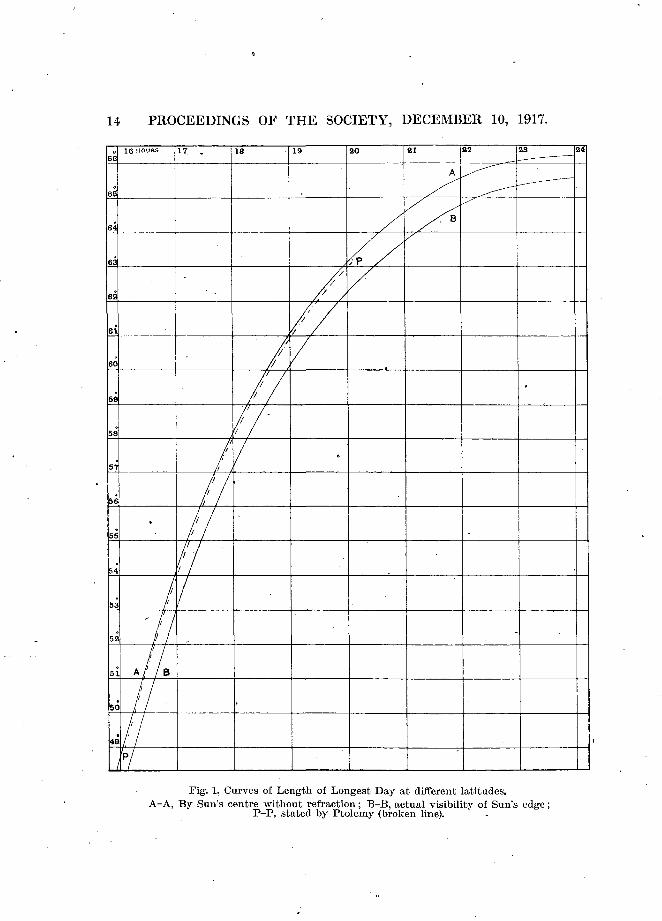
Longitudes there were none, except by dead reckoning and mapping.Latitudes were fixed—at least in Britain—solely by the hours in thelongest day. For converting the number of hours into the correspondinglatitude Ptolemy gives a table (lib. i. cap. xxiii.). To compare this withthe truth, we have here a diagram, showing the relation of hours to thelatitudes between 48° and 66°; the curves are from calculations of sixpoints, for the theoretical number of hours of the sun's centre above thehorizon regardless of atmosphere, and also for the extreme appearanceof the sun's edge as raised by refraction. For this the obliquity of theecliptic has been taken at 23° 41' for the first century, refraction at 30',and semidiameter at 15'. The points tabulated by Ptolemy are connectedby a broken line. His form of curve is very accurate, but gives about 10'too low a latitude for the theory of centres. When refraction and thesun's diameter are taken into account, the actual visible sunshine will bemuch longer at any place than Ptolemy allowed, and his latitudes ofplaces are correspondingly too high.
In lib. viii. cap. ii. Ptolemy gives the hours of the longest day for sixpositions in our region.
-
UectisLondonYork .CaturactoniumAlata .Dumna
Ptolemy-.
h m16 40 = 5217 5417 50 57|18 5818 30 59J19 10 61i
- Actually.
h m ° • '16 33 = 50 4016 42 51 3017 10 5417 18 54 2418 4 57 2518 22 58J
Error.
m °+ 7 H+ 18 2J+ 40 3J+ 42 3J+ 26 2+ 48 2f
The actual length of day shows that the observations were very bad forthis purpose, only Uectis being tolerable, and the others evidently includ-ing a good deal of twilight. Thus the latitudes were all in excess, firstby the length of day being overstated, second by the refraction raising
14 PROCEEDINGS OF THE SOCIETY, DECEMBER 10, 1917.
16 HOURS 21 22
< B
61
59
50
Fig. 1. Curves of Length of Longest Day at different latitudes.A-A, By Sun's centre without refraction; B-B, actual visibility of Sun's edge;
P-P, stated by Ptolemy (broken line).

PTOLEMY'S GEOGRAPHY OF ALBION. 15
the apparent sun, third by reckoning the centre and not the edge ofthe sun.
We can now begin to see the source of the main distortion of the mapof Albion. The direct distance as plotted from London to Caturactoniumis equal to that from C. to Alata Castra (Nairn), and it is very likelytherefore that Ptolemy had a statement that Caturactonium was halfway between the distant points, such being near the truth (distances as8:9). Having by unfortunate errors in the length of the day placedCaturactonium 1° too far north of London, and Alata Castra 1£° too littlenorth of Caturactonium, he had to fit one length into 4° in England, andan equal length into only 1£° in Scotland. The only possible way toreconcile this was to turn the northern length either to east or west tofit it into the 1|° of latitude. Thus the great distortion can be definitelyrun down to the mistake of reckoning the day in Yorkshire to includetwenty minutes more twilight than was reckoned in London or Nairn.
Coasting Distances.The best materials that were available for relative positions were the
coasting distances. We might think that such were far inferior in valueto road distances; but the road material was so scanty that the coastingwas superior in value. It is certain that Ptolemy had none of theAntonine Itineraries, for-if he had had those he could not possibly havemade the internal errors that we see. A small number of road lengthswere used, but not any one whole iter. He also ignores Hadrian's Wall.
The first point in the coasting is that the places along a given piece ofcoast are at equal distances. Remembering that Ptolemy usually onlystates the nearest 10', and never less than 5', any distances agreeing withinsuch limits are to be considered equal. This equal spacing probablyresults from statements of day's sailing between ports. The distancesstated in this paper are all in Roman miles, in order to be comparablewith the itineraries.
PTOLEMY.Cantium Promontorium.
59 to Novus Portus.49 , Trisantonis fl.62 , Magnus Portus.66 , Alaunus fl.
(37), Isaca.65 , Tamarus.
178 (3 x 59) to Ocriuum.(80) to Bolerium.122 (2 x 61) to Herculis pr.193 (3 x 64) to Sabriana ost.
ACTUAL.South Foreland.
33 to Bye or 58 to Pevensey.55 ,, Shoreham ,, 68 ,, Portsmouth.48 ,, Clausentum,, 43 ,, Poole.68 ,, Weymouth „ 67 „ Axe.50 or 57 to Exe ,, 17 ,, Exe.60 to Tamar.69 ,, Lizard.29 „ Land's End.98 „ Hartland.
138 ,, Gloiicester.

16 PROCEEDINGS OF THE SOCIETY, DECEMBER 10, 1917.
Here, of ten distances round the South Coast, only two are not closeto 60 miles or a multiple of that. As the sailing was during summer,in long days, that might well be 18 hours' sail at 3 statute miles an hour.The actual distances, on either of the alternatives, are much less regular.As the eight distances stand in Ptolemy the average is 60, mean difference4; or if Ptolemy knew of Beachy Head and allowed for rounding it,the seven other distances average 62, mean difference 2. The actual dis-tances of the best part, east of the Exe, have a mean difference of 14 or12 miles. Hence Ptolemy was here following a scale of equal distances,probably the fullest day's sailing, with two known exceptions.
As to the modern equivalents, the Cantium Pr. must be the SouthForeland, as Rutupias (Richborough) was 10 miles nearer London. Ofthe alternative name's the difficulties of distances are equal; but infavour of the first column there was a station of the Second Legion10 miles from Alaunus, and the station of Dorchester is 7 miles fromWeymouth, which would thus be Alaunus. Then Dunium would beon the height of Purbeck. The relation of Isca to the Isaca is dealtwith among the inland places. The position of Cenion indicates theFowey, at the headland of which is the Cannis rock.
On the East Coast it was reckoned an equal distance (40 to 44 miles)from the Thames estuary to London, to Idumanius, and to Camulodunum.Taking the estuary as at Southend, this would agree .to about 38 milesto London, Maldon, and Colchester. There was no coasting known' fromColchester to the Wash,, and that distance was taken at only a thirdof the true length. Nor are there equal distances up the rest of theEast Coast.
Round the Welsh coast there is a shorter spacing.
PTOLEMY.Sabrina.
36 to Rhatostathubius.40 Tubius.5050404238
Octapitarum.Tuerobis.Stuccia.Ganganorum.Toesobis.
ACTUAL.Gloucester.
58 to Cardiff.77593838633651
Towy.St David's Head.Teify.Ystwyth.Bracli-y-pwll.Caernarvon.the Dee.76 (2 x 38) to Seteia. I
Thus Ptolemy's distances' average 42 miles, with mean difference "4;while the actual average of 49, mean difference 15, shows that Ptolemyfollowed an arbitrary unit of 42 miles for his spacing, as it is muchmore regular.
Belisama, the Mersey, may be represented by Wallasey on the

PTOLEMY'S GEOGRAPHY OF ALBION. 17
corner of the Mersey estuary. Toesobis must be the river Sebint orSeiont at Caernarvon, and may perhaps be Ty-sebint, the "dwellingon the Sebint."
Another region of equal distances is around Scotland, from Longus fl.to Tuaesis estuary..
PTOLEMY.Longus fl.
112 (2 x 56) to Itis fl.112(2x56) „ Navaiusfl.54 to Taruidum.54 ,, Ueruuium.58 „ High bank.62 ,, tiara or Loxa.52 ,. Tuaesis.
ACTUAL.Loch Linnhe.
80 to Loch Alsh.824280654043
Loch Inver.Cape Wrath.Duncansby Head.Lothbeg Point.Cromarty Firth (mouth),the Spey.
These distances in Ptolemy average 56 miles with a mean differenceof 2. Allowing that he erred in reckoning Cape Wrath to DuncansbyHead as one day's sail instead of two, the actual average is 43, meandifference 5 miles. It seems, then, that the day's sailing was reckonedby Ptolemy as—
PTOLEMY.South Coast, 62.Wales, 42.Scotland, 56.
ACTUAL.52 to Tama,r.4943
There is also a possibility, but not so well defined, of a spacing in equaldistances.
PTOLEMY.Metaris.
81 to Ocellum pr.76 ,, Dunium sin.78 „ Uedrafl.
ACTUAL.The Wash.
70 (?) to Spurn Head,aboutWear.
125 (2x62) J about Wbitby.
But the uncertainty as to where the Wash was reckoned, and the lackof a clear point for Dunium, prevent this giving a fixed value.
INLAND DISTANCES, ENGLAND.The many impossible relations of places shown by Ptolemy indicate
that we must look for traces of his method of reaching his results,if we are to understand them. There are two modes of attack: oneby seeking three or more points in a straight line, which suggests asingle line of measurement; the other by taking the distances from aplace to every other place around, and seeing which distance agreeswith the actual ground. Of course, in this as in the coast distances,
VOL. LII. 2

18 PROCEEDINGS OF THE SOCIETY, DECEMBER 10, 1917.
no distance in miles is named by Ptolemy, but from his latitudes andlongitudes plotted down we can measure off the distances one or moreof \vhich he must have utilised for his positions. -
For Daruernum he gives 53 miles from London, and it is lii in theiter, actually 58 miles. The reason for placing it so far south seems tohave been that he knew there was a port near it on the south (actually14 miles), so he placed it 11 miles from Nouus'Portus.
London to Rutupiae is 77 miles, and to Richborough is actually 71.Uenta Belgarum is placed at 69 from London, and is Ixvi in the iter,
actually 72 miles.Uenta to Aquae Calidae is placed at 62 miles, actually 60 or 65 by
different lines.Aquae Calidae to Ischalis (Ilchester) is 30 by Ptolemy, and actually so.Ischalis to the Uexalla (Axe) is 30 by Ptolemy, 29 actually.The position of Uxella must have been on the Taw near Chulmleigh,
where an ancient road line crosses between Dulverton and Hallwall.From this the distances are:—
PTOLEMY.To Uexalla, 73
and ,, Tamare, 36„ ,, Tamaris fl., 53
ACTUAL.69 to Axe.35 ,, Launceston.49 „ Plymouth.
This close agreement to three points in different directions seemsto fix this place well, and to show that these were known road lines.
Tamare is 30 from the Tamaris estuary, and Launceston is 28 to 30 bydifferent roads from Plymouth.
Uoliba is placed at 14 from Tamare, further inland; and at 12 fromLaunceston is Holla-combe, which may retain the name. The place ofIsca is uncertain. Most MSS. say long. 17°, which would agree to itsbeing on the Isaca river running north. The latitude varies from 52° 30'to 50', and 52° 35' seems to have most weight. This would give 81 milesfrom Aquae Calidae, against 76 actual distance to Exeter. The fusion ofIsca and Legio II. in many MSS. is probably due to identity in latitudein the successive entries. That Isca was at Exeter is proved by thedistance from Durnovaria in iter xv.
There is much variation in the latitude stated for Noeomagus. Butin the text (lib. i, cap. xv.) it is given as 59 miles from Londinium, andit was the city of the Regni. This agrees with Chichester, which is61 miles from London. The latitude required for this is 53° 15', andMSS. vary as 53° 0', 10, 20', and 25'.
In the south midlands, London to Caleua is 47 in Ptolemy, xliv in theiter, 48 actually to Silchester.

PTOLEMY'S GEOGRAPHY OF ALBION. 19
Caleua to Corinium is 44 in Ptolemy, and 50 actually to Cirencester.Uenta to Corinium is 60 in Ptolemy, and 60 actually; this was then
probably the main fixing distance.Deuana is placed by most MSS. on the position of Uennonae, High
Cross, and that was so very important a centre of main roads that it islikely to be named. We must accept that position for Uennonae, althoughit has been confused with Deva-Chester. This is discussed further atthe end.
Corinium to Deuana-Uennonae is 67 (Pt.) and 66 actually. Londonto Uennonae is 100 (Pt.), xci in the iter, 93 actually. Sabriana = Gleuumto Uennonae is 64 (Pt.) and 67 actually. All these distances are so closeto the truth that evidently Ptolemy used them in fixing the positions.
A tempting emendation, followed by Miiller, is to emend Urolaniumas 1° to the south at 54° 30' on the London-Uennonae road, where it mightbe identified with Uerolanium, St Albans. But as Urolanium withSalinae is in the Catyeuchlani, and both in nearly the same latitude,55° 30' and 40', it seems impossible to bring it far southward; it shouldbe about Bourn, by the distances from Lindum and Uennonae, and thusbe independent of Verulam.
In Wales there are three straight lines of places, and the distanceson these are—
PTOLEMY.Sabriana to Bullaeum, 54.Bullaeum ,, Stuccia, 52.Stuccia ,, Uiroconium, 63.
ACTUAL.55 Gloucester to Glasbury.57 Glasbury ,, Ystwith.71 Ystwith „ Wroxeter.
Maridunum is obviously on the Tubius, at 12 miles from the mouth,and Caer-marthen is at 11 miles up the river, and evidently retainsthe name.
The Midlands are in a confused state, as, owing to having placed Yorka degree too far north of London, there is a dearth of material to occupysuch a space. First, as to Metaris, which is some part of the Wash.Norfolk was formerly much more insulated, and the Wash extended upto the isle of Ely. The distance from Idumanius, or Sidumaiiius, theBlackwater river, to Metaris is 53 miles in Ptolemy, and from Lindumto Metaris is 78 miles. From the BlackwTater at Maldon to Thetford,south of Ely, is 58 miles, and. from Lincoln to Thetford is 85 miles. Theseare so near to Ptolemy's distances that they were probably the lines onwhich Ptolemy's positions were based. Another line of connection is,Lindum to Mediolanum 108 miles, and actually 109 to Whitchurch.Lincoln may also possibly be cross-fixed by the distance from Deuana-Uennonae, which is 52 miles in Ptolemy, against 65 miles actually. What,

20 PROCEEDINGS OF THE SOCIETY, DECEMBER 10, 1917.
then, is to be made of Petuaria? There is no proof of connection withthe Hurriber, and the distances from Metaris 76 miles, and" Eboracum59 miles, agree closely with the direct distance from Thetford 77 milesto Lincoln, and thence 61 miles to York. The distances, therefore,suggest that Petuaria is a synonym of Lindum, or close to it. In favourof this duplication by Ptolemy, Petuaria is the city of the Parisi, andParis was a district round Horncastle east of Lincoln, from which cameMatthew of Paris. Possibly Potter Hanworth, 6 miles S.E. of Lincoln,may be an echo of the name Petuaria. Beyond York, Ptolemy gives—
Eboracum.41 to Olicana.70 ,, Uinnouioii.
York via Leeds.40 to Ilkley via Ripley.65 ,, Binchester.
He evidently had this route before him, though he did not know thatit doubled back at a sharp angle, but supposed it straight, and so ranUinnouion out to the west coast instead of being near the east.
From this misplacement of Uinnouion and the wrong distance ofYork from London, it is clear that Ptolemy had not the Antonineiters before him. The distances north of York are—
BY PTOLEMY.Eboracum.
24 to Isurium.26 ,, Caturactonium.38 „ Uedra.
ITBB.
xvnxxiv
ACTUAL.York.'
17 to Boroughbridge.25 ,, Catterick.35 ,, Chester-le-Street on Wear.
These distances show that the excess of latitude between the observedpoints at York and Catterick was thrown on to the York-Boroughbridgedistance by Ptolemy.
The further distance from Uedra to Bremenium is only 40 in Ptolemy,but 52 miles actually.
Along the coast—BY PTOLEMY.
Uedra.. 60 to Alaunus.38 ,, Boderia.
ACTUALLY.Wear^to-Alne).71 to Tweed.40 ,, North Berwick.
These are quite near enough for approximations by coasting distances,but seem to put Alaunus at the Tweed, arid not at the Alne. This com-plicates the Bremenium distance of 35 miles to Alaunus; from Rochesterto Alnmouth is 31 and to the Tweed 41 miles. Probably the latter wasintended, and was the mode of fixing Bremenium.
The width across Northumberland was well known, as from the Uedra

Proc. Soc. Ant. Scot.] [To face page 20.
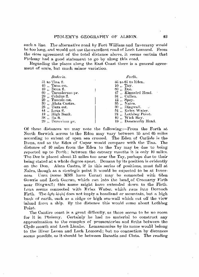
Fig. 2. Towns and Coast Names in England fixed by Ptolemy. The natural coast is here adjusted to these points.

PTOLEMY'S GEOGRAPHY OF ALBION. 21
to the Ituna is 69 miles, and actually from the Wear to Carlisle is73 miles.
THE LOAVLANDS.The most distorted and difficult part of the geography is that of the
Lowlands. We need first to pick out the distances which are fairlycorrect, as they are probably the basis on which the map was built.After that it is time to seek for the cause of error in the other parts.
First there is an obvious straight line running through Abrauannusfl., Retigonium, Uanduara, Clota, Alauna, Uictoria, Horrea, and probablyon to Taua. The former part is exaggerated, but from Clota onwardit is fairly correct.
Clota.32 to Alauna.38 ,, Uictoria.25 ,, Horrea.41 „ Taua.
Cumbrae, Clydemouth.32 to Glasgow (lowest bridge).38 „ Stirling (N. and E. by Forth).20 ,, Auchterarder.41 ,, Taymoutli.
As there is no question as to the termini, the two intermediate placesmay be accepted thus. As Alauna and Clota might be known to beopposite Boderia—the Clyde opposite to the Forth—this -would sufficeto lay out the line from Taua. Glasgow must have been an importantpoint, as it is the lowest place that could be bridged on the Clyde, orthe first narrow ferry. Hence it is likely to be a station, and it exactlyagrees with the distances of Alauna.
Now, on looking at the Lowlands, Alauna is seen to be the centreof road lines, straight through (1) Bremenium to Uedra, (2) Curia toItuna, (3) Coria to Uxellum, (4) a branch from Coria by Lindum toNouius, (5) from Coria through Corda and Carbantorigum to Deua, (6)from Alauna to Clota, Uanduara, Retigonium, and Abrauannus. Thisnet of branching roads is evidently the basis of the plan.
Taking the distances along these lines—
BY PTOLEMY.A launa is
170 to Ituna.also 170 Nonius.
186169180190
Deua.lena.Abrauannus.Nouantum.
ACTUALLY.Grlasgotv is
94 to Eden,also 79 to Nith.
94
9293
Dee.Wigtown.Glenluce.Port Patrick.
Ratio.1 to1-822-151-981-901-922-05
It seems that all these distances have been doubled, the mean of theratios being T97, and the variations what might be expected in a rough

22 PROCEEDINGS OF THE SOCIETY, DECEMBER 10, 1917.
country with devious tracks. The actual distances are those measuredalong river lines and present roads, in the most likely course.
Why all these distances are doubled we can hardly guess. It mightbe due to having exaggerated coasting distances, but if so there cannothave been any road lengths known. It might more likely be due to alocal habit of counting in the mile a thousand single paces, instead ofdouble paces, and so recording in half miles instead of whole miles.
The strange projection of Nouantum from between the two baysshows that different materials were here used. The bays and estuariesare what almost entirely attract the coasting record, and were prob-ably fixed thus between Abrauannus and Clota. The position ofNouantum is due to one of the doubled distances from Alatina, andhence far beyond the bays.
It is along the possible lines of road from Glasgow to the coast thatsearch 'should be made, at the right distances, for the various inlandtowns. At a first view we may expect Curia at Courance, south ofMoffat, which is the exact distance; Trimontiiim, west of the Annan,possibly the coast hills at Cummertrees; Uxellum at Caerlaverock.; Coriabetween Strathavon and Muirkirk; Lindum about Dalpedder, below.Leadhills; Corda 4 miles north or north-east of Carsphairn; Carban-torigum near New Galloway; Lucopibia about Dromore east of NewtonStewart; Uanduara would be 17 miles from Alauna, and Doura is 20 milesfrom Glasgow, near Kilwinning. These positions are all on the obviouslines of road, and should be searched before looking elsewhere.
THE HIGHLANDS.The only internal places in the Highlands are on one straight line
from Clota to Tuaesis estuary (the Spey). This line can be fairly tracedby its holding to the valley of the Spey as far as possible, and at thesouth end holding to Loch Lomond, to avoid the bending further to thewest. Thus we can follow it clearly as—
Ttmesis est. Spey, .By Glen Truim—
82 to Tameia. 83 to Little Dalwhinnie.By Loch. Lydoch—
39 „ Baiiatia. 39 to Orcliy Bridge.By Loch Lomond, Oardross, Shaw's
Water—70 „ Clota, 68 to Polteath at mouth of Firth
of Clyde.Of course, there is nothing fixed of these but the termini; the inter-mediate points are only stated to show whereabout they must fall on
PTOLEMY'S GEOGRAPHY OF ALBION.
such a line. The alternative road by Port William and Inveraray wouldbe too long, and would not use the excellent road of Loch Lomond. Fromthe close agreement of the total distance above, it seems certain thatPtolemy had a good statement to go by along this road.
Regarding the places along the East Coast there is a general agree-ment of scale, but much minor variation.
Boderia.51 to Tina fl.40 Taua est.40602920302644193820
Deua fl.Taezalorum pr.Celnius fl.Tuaesis est.Alata Castra.TJara est.Loxa fl.High Bank.Ilafl.Ueruvium pr.
Forth.35 to 65 to Eden.
Tay.1060473412353054244019
Dee.Kiniiaird Head.Cullen.Spey.Nairn.Diiigwall.Bvlex Water.Lothbeg Point.Wick Bay.Duncaiisby Head.
Of these distances we may note the following:—From the Forth atNorth Berwick across to the Eden may vary between 35 and 65 milesaccording to extent of open sea crossed. The Eden of Carlisle is theItuna, and so the Eden of Cupar would compare with the Tina. Thedistance of 40 miles from the Eden to the Tay may be due to beingreported up to Perth; between the estuary mouths it is only 10 miles.The Dee is placed about 15 miles too near the Tay, perhaps due to theirbeing stated at a whole degree apart. Deuana by its position is evidentlyon the Don. Alata Castra, if in this series of positions, must fall atNairn, though as a strategic point it would be expected to be at Inver-ness. Uara (some MSS. have Uarar) may be connected with GlenGowrie and Loch Gorran, which run into the head, of Cromarty Firthnear Dingwall; this name might have extended down to the Firth.Loxa seems connected with Evlex Water, which runs into DornochFirth. The ox^7? ty^^i does not imply a headland or mountain, but a highbank of earth, such as a ridge or high sea-wall which cut off the viewinland from a ship. By the distance this would come about LothbegPoint.
The Cantire coast is a great difficulty, as there seems to be no roomfor it in Ptolemy. Certainly he had no material to construct anyapproximation to the complex of promontories and firths between theClyde mouth and Loch Linnhe. Lemannonius by its name would belongto the River Leven and Loch Lomond; but no connection by distancesseems possible, as it should be between Banatia and Clota. The reading
24 PROCEEDINGS OF THE SOCIETY, DECEMBER 10, 1917,
varies as Lelaannonius; as this might be a MS. corruption of Leggan-nonius, it would connect with Laggon at the mouth of Loch Fyne, whichis evidently the inlet in question.
The two islands of Toliapis and Couhus between Kent and theContinent appear to have been reckoned as at a normal day's sail fromCantium pr. to Toliapis, and another to Counus. To understand thesewe should refer to Clement Reid's Submerged Forests, where the map onpage 40 shows that these islands would have been on the ridge betweenthe' old Thames Valley and Channel Valley. As the submergence prob-ably took place about as long before Ptolemy as we are after him, itis quite likely that this ridge, which "would be about the last part to beattacked by the sea, might have remained still as a couple of islands inthe time of Ptolemy. We must remember that the evidence of the forestbeds shows that there was no Channel sea during the Neolithic period,but from England across to Denmark was continuous land.
Several uncertainties of the MSS., which do not much affect thegeneral view,, have not been noticed so far. The more serious of theseare the following:—-In Scotland, Loxa and Uara are both uncertain inposition. Beside the places of the usual text here plotted, there is con-siderable authority for placing Loxa in Cromarty Firth in the place ofUara, and Uara into Inverness Firth. For Boderia there is muchauthority for 58° 45' and less for 59°; neither place would make a differ-ence in the identification—it would only be a matter of how far alongthe Firth of Forth the site was fixed. Alaunus is by a few MSS. put at21° 20', which would agree better with the distance from the Wear tothe Alne, but it would throw out the distance from Bremenium.Carbantorigum has much authority for 59° 30' lat.; if it were so itwould be on the Alauna-Lindum-Nouius road.
In England, Camunlodunum is uncertain in position—usually put at18° 15', also at 18", and 18° 45'. The latitude in the usual text is 57°,but all the MSS. appear to give 57° 45'. This would put. it just halfway on the road from Olicana to Uinnouium, at about Middleham inWensleydale.
Deuana is an intricate case. In the older versions down to Nobbe theplace is 18° 30', 55° 0', with the Twentieth Legion. Such exactly accordswith Uennonae, High Cross. The MSS. are three with 17° 10', one alteredto 17° 30', and twelve with 18° 30'; latitudes, four MSS. of 53°, four of 55°,four of 55° 30', one 56° 45'. Hence there is only a single reading that willagree with Deva-Chester, and the Twentieth Legion that was stationedthere, according to the iter; but the Uennonae position is given by nearlyall the longitudes, and. by as many MSS. for its latitude as there are forany other. How all this came about it is impossible to say without
Proc. Soc. Ant. Scot.] [To face page 24.
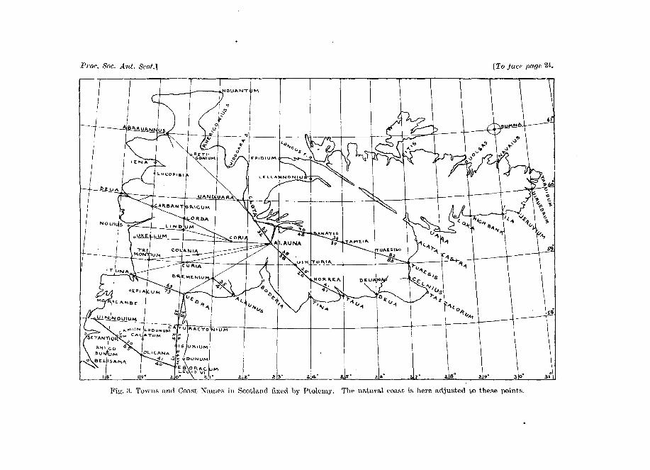
Fit;-. Si. Towns and Coast Xaine.s in Scotland fixed by Ptolemy. The natural coast is here adjusted to these points.
PTOLEMY'S GEOGRAPHY OF ALBION. 25
an exhaustive study of the relationships of the MSS. throughout thewhole Geographia. As an hypothesis we may expect that the originalreading was—
Uennona . . . 18" 30' 55° 0'Deuana . . . 17 10 56 45Legio XX. Victrix—Uiroconium . . 16 45 55 45
Then by confusion in a very early MS. the -ona ending was confusedwith the -ana, and Deuana put to 18° 30', and Uennona and 17° 10'dropped out. This must have been before dividing the. towns by thetribal sections, as we cannot suppose Uennonae to be in the Cornaviilike Deua-Chester, as Ratae and Lindum were in the Coritani.
Another difficulty is about Salinae. The reading of Nobbe, 16°, cannotbe right, as it is with Urolanium in the Catyeuchlani. The MSS. have20° 10' in sixteen cases, and 20° 45' in twelve cases. For the latitude, threeare of 55° 20', six of 55° 40', nine of 55° 50'. From all these it must havebeen near Norfolk; and, by its link to Urolanium, probably at 20° 10',which in the MS. goes with 55° 40', so rather west of Metaris.
In this paper I have not attempted to take into account the othersources outside of Ptolemy. Here we only try to ascertain what Ptolemyused, and how he worked. The full study of the geography must takein many other sources of information.
APPENDIX.The following cases serve to test the relative values of the texts
adopted by Nobbe (N) and by Muller (M):—Clota is in the coasting list, and 59° 40' for it (N) agrees with the
breadth across to the Forth, while 59° 20' (M) would be only about halfthe breadth.
Bullaeum, 16° 20' (N), lies in a straight line between Sabriana andStuccia; but if it is 16° 50' (M), it would not be in line. Darouernum isput at 54° by M, on the strength of a single MS. at Constantinople. Ifso, it would be only 44 miles from Londinium. But if 53° 40' (N), it coniesto 52 miles from London, exactly as the Antonine itinerary; the actualdistance is 58 miles.
Noeomagus, M puts at 53° 5' without any MS., solely because it issaid to be 59 miles from Londinium. That distance, however, wouldbring it to 53° 15' on the map. The various readings are 53°, 53° 10', 53° 20',and 53° 25'.
Ischalis is taken at 16° by M (with the Florentine MS.), which wouldput it on the coast, yet it is not in the coast list. 16° 40' (N), as in most

26 PROCEEDINGS OF THE SOCIETY, DECEMBER 10, 1917.
MSS., puts it between Aquae Calidae and Uexalla, and it agrees thusexactly with the distances to Ilchester, which was a Roman stationby its name.
Ilenta, on the Florentine authority, is put at 53° (M), close to MagnusPortus, while "Winchester is far from a port. Most MSS. give 53° 30'(as N), which is 69 miles from London, and Winchester is actually 72.Uoliba is put at 52° by M, trusting the Florentines, which would put iton the coast, but it is not in the coast list. The 52° 20' (N) of all otherMSS. places it rightly on the Tamar, inland. These test cases, wherecollateral facts help to decide between MSS., all show that the otherreadings, such as those of Nobbe, are mostly to be preferred to theversion drawn up by Miiller.