flood management - noosa shire council · 10.1.4 real-time flood monitoring ... flood resilience....
TRANSCRIPT

Noosa Shire Flood
Management Plan
PO Box 141 Tewantin QLD 4565P (07) 5329 6500 | F (07) 5329 6501
“The direction for future flood management
initiatives in Noosa.”

Noosa Council | Flood Management Plan | Page 2
© Noosa Council 2016
General enquires: 8.30 am – 5.00 pm Monday to Friday (excluding public holidays)By telephone: (07) 53296500 (including after-hours emergencies)By email: [email protected] Fax: (07) 53296501Street Address: 9 Pelican Street, TEWANTINPostal Address: PO Box 141, TEWANTIN QLD 4565www.noosa.qld.gov.au
Disclaimer
This document has been developed by Noosa Shire Council’s Strategic Planning Unit with input from across Council’s other business units.
The document was endorsed by Council on the 21st July 2016. Information contained in this document is based on available information at the time of writing. All figures and diagrams are indicative only and should be referred to as such. This is a strategic document which deals with technical matters in a summary way only. Council or its officers accept no responsibility for any loss occasioned to any person acting or refraining from acting in reliance upon any material contained in this document.
Acknowledgements
Council wishes to thank all interested stakeholders who have taken the time and energy to help guide the development of this plan. Council would particularly like to thank HydraLogic for their valued assistance with helping to prepare the plan and background information.

Cont
ents
Exectuive Summary .................................................................................. 5
1. Introduction ................................................................................ 6
2. Flooding in Noosa ....................................................................... 7
3. History of Flooding in Noosa .................................................... 10
4. Flood Management in Noosa .................................................... 13
5. Flood Studies ............................................................................. 155.1 Noosa River Catchment Flood Studies ....................................................... 15
5.1.1 Noosa River Flood Study ...................................................................................... 15
5.1.2 Emerging Issues and Concerns for the Noosa River ......................................... 16
5.1.3 Noosa Daintree Estate ............................................................................................ 17
5.1.4 Ringtail Creek .......................................................................................................... 18
5.1.5 Lake Entrance Boulevard ....................................................................................... 18
5.2 Kin Kin Creek .............................................................................................. 18
5.3 Six Mile Creek .............................................................................................. 19
5.3.1 Lake Macdonald ...................................................................................................... 19
5.3.2 Cooroy Creek........................................................................................................... 19
5.3.3 Cooroora Creek ....................................................................................................... 20
5.4 Coastal and Storm Tide Studies .................................................................. 21
5.5 Key initiatives – Flood studies .................................................................... 21
6. Flood Mapping ........................................................................... 226.1 Noosa Planning Scheme Flood Hazard Area .............................................. 22
6.1.1 2016 Planning Scheme Amendment - Flood Hazard Area ............................. 22
6.2 2014 Disaster Management Flood Maps .................................................... 23
6.3 Online flood mapping resources ................................................................. 23
6.4 GridFlow flood extent estimation ............................................................... 23
6.5 Key initiatives – Flood mapping ................................................................. 24
7. Flood Records and Survey ......................................................... 257.1 Historical Flood records ............................................................................. 25
7.2 Flood Gauges ............................................................................................... 26
7.2.1 Maximum Height Gauges ...................................................................................... 26
7.2.2 Radio Telemetry Gauges ........................................................................................ 26
7.3 Flood Studies Survey ................................................................................... 27
7.3.1 Ground survey ......................................................................................................... 27

Cont
ents
7.3.2 Bathymetric Survey ................................................................................................ 27
7.3.3 Waterway Crossing Survey ................................................................................... 28
7.4 Key initiatives – Flood records and survey ................................................. 28
8. Flood Search Information ........................................................ 298.1 Key initiatives – Flood Search Information ................................................ 29
9. Planning and Policy ................................................................... 309.1 Noosa Planning Scheme .............................................................................. 30
9.2 Climate Change ........................................................................................... 31
9.3 Key initiatives – Planning and policy.......................................................... 32
10. Disaster Management ............................................................... 3310.1 Disaster Management Preparations ............................................................ 33
10.1.1 Disaster management flood maps......................................................................... 33
10.1.2 Disaster management triggers ............................................................................... 34
10.1.3 Disaster management redundancy ....................................................................... 34
10.1.4 Real-time flood monitoring ................................................................................... 35
10.2 Disaster Management Activations .............................................................. 35
10.2.1 Trained staff resources ............................................................................................ 35
10.2.2 Overall understanding of flood specific procedures .......................................... 36
10.3 Community Awareness ................................................................................ 36
10.4 Flood Mitigation .......................................................................................... 36
10.5 Key initiatives – Disaster management ....................................................... 37
11. Implementation and Review ..................................................... 38
Glossary .................................................................................................. 39

The purpose of the flood management plan is to provide a key strategic document to facilitate a consistent understanding within the community and the organisation of Council’s flooding resources and direction for future flood management in Noosa. The Plan and its supporting documents act as a central reference for communicating Council’s existing knowledge and capacity in flood management and as a guide for directing future investment and implementation of actions towards improving the community’s understanding and resilience to flood risks.
The overall aim is that the Noosa community and council are well informed about flood risk and well prepared for significant flood events. This can be achieved by Noosa Council, residents and businesses having access to best available flood information including past, present and future flooding conditions; ensuring flood resources are up to date, reflect local conditions and take account of existing and future climate; ensuring flood management and disaster management activities are well coordinated and communicated across all stakeholders; and ensuring services are delivered that help protect the community, improve community resilience and improve public access to information.
The plan identifies three core areas:
1. Flooding Resources - information such as flood studies, mapping , records, survey and flood searches
2. Planning and policy in Council’s planning scheme, building controls and other strategic and operational plans, and development assessment
3. Disaster management - how Council prepares for and responds to a flood event, community awareness and flood mitigation works.
A Capacity Assessment was carried out to review the organisation’s flood management capacity across these core areas. The Capacity Assessment established a series of performance targets and recommended some desired outcomes to achieve these targets with the aim of increasing the overall flood management capability of the organisation. Key outcomes have been carried forward into this plan.
The plan also provides the background context of flooding in Noosa, summarises Council’s flooding resources, identifies emerging issues and concerns within the catchment, waterways and floodplains and establishes key initiatives to address these.
The plan has been developed as a whole of council initiative with input from the various council business areas. The implementation plan will be reviewed and updated annually for consideration in annual operational planning and budget processes. Council looks forward to working with other tiers of government, local businesses, community organisations and individual residents to implement this Plan.
Executive Summary
Noosa Council | Flood Management Plan | Page 5
Noosa Council | Flood Management Plan | Page 6
Flooding affects large areas of Noosa Shire and can have considerable consequences for people and property. Council recognises that in order to reduce the risks of flooding to communities, assets, economies and environments it is important that lessons from the past and advances in knowledge and technology are recorded, effectively communicated and applied. Long term planning and prioritising having regard to both current and future climate conditions is important for improving community flood resilience.
The Flood Management Plan seeks to improve the Council and community’s understanding, preparedness and resilience to flood risk. It provides the basis for coordinated decision making, investment, information sharing and record keeping.
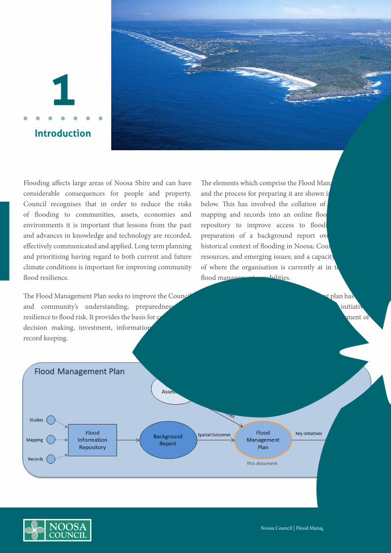
The elements which comprise the Flood Management Plan and the process for preparing it are shown in the diagram below. This has involved the collation of flood studies, mapping and records into an online flood information repository to improve access to flooding resources; preparation of a background report overviewing the historical context of flooding in Noosa; Council’s flooding resources, and emerging issues; and a capacity assessment of where the organisation is currently at in terms of its flood management capabilities.
Based on the findings, the flood management plan has been established, including a set of core areas and key initiatives for each core area. These have guided the development of the five year implementation plan.
1Introduction

2Flooding in
Noosa
The Noosa Council local government area is divided by catchments contributing eastwards to the Noosa River or westward towards the Mary River. Approximately two thirds of the Noosa River catchment lies within the Shire boundary with the remainder extending to the north above Lake Cootharaba and draining from the sands of the Cooloola National Park within Gympie Regional Council. Refer to Figure 2.
Six Mile Creek flows northwest from the southern boundary of the Shire and is the largest waterway draining the western portion of the Shire towards the Mary River. The Six Mile Creek catchment to Cooran is over 185 km2 in area, bordered by Mount Tinbeerwah to the east, Black Mountain to the south and the Kin Kin Creek catchment to the north. Six Mile Creek includes two significant tributaries of Cooroy Creek and Cooroora Creek and the Lake Macdonald water supply dam owned and operated by SEQWater. The dam was built in 1965 and its ungated spillway raised in 1980 to increase the dam’s storage capacity. The hinterland settlements of Cooroy, Pomona, Lake Macdonald and Cooran were founded adjacent to the local water courses of the area and hence have inherited some vulnerability to flooding.
The contributing catchments of Six Mile Creek are predominantly rural land uses and bushland with watersheds originating from the relatively steep hillsides of the area and often inundating low lying property and roadways. The Six Mile Creek watercourse and floodplain intersects several significant hinterland road networks, such as Louis Bazzo Drive, Pomona Kin Kin Road and Queens St Cooran.
Flooding in Six Mile Creek is solely the result of rainfall runoff and local terrain and features. The waterways of Six Mile Creek are unaffected by any tidal conditions.
Flood levels in the Noosa River are determined by heavy rainfalls generating catchment runoff which drain into the Noosa River system. Elevated water levels in Laguna Bay, principally due to storm surge, can cause flooding in the lower reaches and also impede the discharge of rainfall derived floodwaters from the river. Local flooding refers to flooding along the upper reaches of creeks and waterways. Local flooding is caused by heavy rainfalls over local upstream catchment areas and may not be associated with flooding from the river.
Noosa Council | Flood Management Plan | Page 7

Noosa Council | Flood Management Plan | Page 8
Downstream of Tewantin, peak flood levels are governed by storm surge flooding; upstream of Tewantin, peak flood levels are governed by freshwater river flooding behaviour.
The Noosa River catchment is large and much of it is relatively flat. The two large lakes along the river, Lakes Cootharaba and Cooroibah, provide large storage areas which also slow down the flow of flood water on its way to the river mouth. Lakes Cootharaba and Cooroibah exert a significant effect on river flooding behaviour along the Noosa River. Floodwaters generated from catchment areas upstream of these lakes spread out across the waterbody
Figure 2: Map of major waterways and catchments.

as they drain through the lake. The lakes provide a significant amount of temporary storage for passing floodwaters. Downstream of the lakes the temporary storage of floodwaters: reduce peak water levels and discharges; slows the rate of rise of floodwaters (flood levels typically rise for 1-2 days at Tewantin before peaking); and assist with maintaining elevated flood levels and discharges for a relatively long period of time (eg. at Tewantin, the February 1992 flood level remained over 1.5 m AHD for 45 hours).
Flooding behaviour along the Noosa River, especially its lower more populated reaches, is characterised by relatively low flood depths with generally slow moving floodwaters which may persist for extended periods causing inconvenience and nuisance. Fortunately, relatively long ‘warning times’ are available during which downstream residents can be alerted to the severity and timing of impending flooding and can undertake necessary actions to reduce damage to their goods and possessions.
With respect to the consequences of flooding, the main issues along the Noosa River relate to the modest level of flood damage and the nuisance and inconvenience that flooding causes urban communities. As noted above, flood hazard and risk to life and limb are generally low along the Noosa River system.
Normal water levels in the lower Noosa River estuary display tidal characteristics and reflect the semi-diurnal nature (i.e. there are two high tides and two low tides in every period of 24 hours 50 minutes) of water levels in Laguna Bay. Water levels in the river will rise and fall in response to the tide levels. These affects are greatest at the mouth and progressively dissipate upstream with only relatively minor tidal fluctuations evident in Lake Cootharaba.
Apart from regular ocean tides, storm surges affect water levels in Laguna Bay and flood levels in the lower reaches of Noosa River. Increased water levels in Laguna Bay result in coastal waters flowing into the Noosa River and its lakes, with an associated increase in water levels. Storm tide flooding can inundate normally dry land and affect property even without the contribution of additional rainfall generated flooding in the River. The magnitude of a storm surge is determined by a combination of factors which include: inverted barometric pressure; wind setup; and wave setup. These affects are cumulative and are added to the normal tidal conditions at the time. The combined water level from all of these is referred to as the storm tide. Offshore storm tide gauges are used to record storm tide levels. The nearest gauge to Noosa River is located offshore of Mooloolaba.
In a similar manner to flood studies, storm tide studies are undertaken to estimate the potential magnitude of storm surges for a range of statistical frequencies. Whilst generally conducted separately, results of a storm tide study are included as a possible boundary condition in the flood studies to reflect circumstances when the two events (i.e. storm surge and rainfall flooding) occur at the same time. It is a complex science to consider the coincidence of storm surges and extreme rainfall events.
The future of flooding in Noosa is unpredictable. Severe weather events that bring flooding will occur. However, recent research into the world’s changing climate suggests that over time factors such as increased ocean water levels and increased frequencies of severe weather may result in an overall increase in the magnitude and frequency of significant flood events. As a community with a large proportion of its residents located near the coast and adjacent to waterways it is imperative that these factors be considered in our long term planning for the region.
Noosa Council | Flood Management Plan | Page 9

Noosa Council | Flood Management Plan | Page 10
3History of
Flooding in Noosa
“Some of the earliest references to flooding in the region date back to the late 1800’s.”
Like all areas of Australia, Noosa’s heritage includes thousands of years of Aboriginal history. However, little is known of significant weather events and their impact on the lives of the traditional inhabitants of the area prior to the arrival of European settlers. The local modern history of the region is often interspersed with severe weather events resulting in shipwrecks and the search and rescue of their survivors. It wasn’t until the mid-1800’s that official surveys and reconnaissance of the area were conducted. These early expeditions were seeking access to the region’s timber and the River offered a useful means for transporting timber to the coast for shipping to Brisbane.
The clearing of large areas of timber within the catchment and its replacement with orchards, pastures and sugar cane would have introduced the first significant man made change to the runoff characteristics of the river system. Cleared catchments typically have faster runoff rates and combined with the inherent disturbance to the ground, cleared catchments will often lose large amounts of topsoil due to erosion. The eroded soil is transported into local waterways and water bodies often smothering aquatic ecosystems and reducing their depth and subsequent capacity to convey flood waters.
Some of the earliest references to flooding in the region date back to the late 1800’s. During the “Brisbane” floods of 1893 there are accounts of rain falling for nine days during which Lake Cootharaba rose by two metres.
Shortly after this time a communal agricultural settlement began around Lake Weyba in the lower Noosa River area made up of Brisbane people dispossessed by the 1893 floods.
A handful of historical flood levels recorded in March 1955 represent the commencement of “official” flood records held by the Noosa Council. These records were further supplemented following a significant flood event in February 1968.
February 1931 Milk Delivery Noosa Council Library Archives

Noosa Council | Flood Management Plan | Page 11
Whilst still sparse the recorded water levels in the lakes and the River from this event remain the highest on record.
The early 1970’s saw a series of successive flood events impact upon South East Queensland. Cyclones in 1972 (Daisy), 1974 (Wanda) and 1976 (David) delivered rainfall and flooding across the region and storm surges to exposed coastal areas. These events impacted heavily upon the development of Noosa Sound. As a result of this and negotiations between the Noosa Council and the state government walls and groynes were put in place to protect the beach and Noosa Sound. Many of these walls are still in place today and continue to serve residents and the community.
The following two decades were relatively uneventful with regards to flooding. However in February 1992, a complex meteorological event produced a low pressure trough convergence zone in the wake of a departing cyclone (TC Damon).
Coastal sea levels were elevated by the storm surge effects of the cyclone. Fortunately these coincided with lower seasonal tides. Across the catchment large volumes of rainfall fell over relatively short durations. Rainfall
depths of 744mm in 24 hours and 960mm over 72 hours were recorded. These values correlate as an extreme weather event with the severity of the rainfall being estimated as being equivalent to a storm with a statistical recurrence interval of up to 1 in 4,000 years1.
The February 1992 flood event inundated some 540 lots, 156 of them above floor level, and caused some $1.3 million damage (1995$). The average damage bill for urban communities along the Noosa River system was calculated in 1995 as being approximately $250,000 per annum2.
February 1992 Gympie Terrace Noosa Council Library Archives
February 1931 Anderson’s House, Noosa Council Library Archives
1Table 2.7 Flooding in the Noosa River Catchment 1995, updated 20012Table 4.2 Flooding in the Noosa River Catchment 1995, updated 2001

Noosa Council | Flood Management Plan | Page 12
In August 2007, in association with an upper trough system and an east coast low (ECL) several rainfall stations in Noosa recorded rainfall depths of greater than 650mm in 24 hours.
The flood levels reached in the Noosa River were the highest since 1992 and the third highest on record. This caused significant flooding in Lake Cooroibah and Lake Cootharaba and moderate flooding at Tewantin. The Bureau of Meteorology reported that this particularly rare event broke many monthly records for August with some daily totals being the highest on record for any month. The most statistically significant rainfall intensity was recorded at Coops Corner TM in the river headwaters above Lake Cootharaba. In only a 3 hour period a total of 415mm of rainfall was recorded. Water levels in the Lakes and at Tewantin remained elevated above minor flood levels for 3 to 4 days.
More recent severe weather events that have impacted more broadly upon south east Queensland such as the 2011 Brisbane Floods, 2013 ex TC Oswald and 2015 ex TC Marcia have not resulted in significant flooding conditions within Noosa Shire. However; many low lying areas of Noosa Shire are prone to flooding from small to medium sized rainfall events. These locations are subjected to more regular nuisance flooding that does not generate significant loss to the community.
Upon reflection, Noosa Shire has been relatively fortunate not to have borne the brunt of some of the broader region’s more significant flood events. However, the historical records are relatively short and the Shire’s coastal proximity, river estuaries and flood plains provide good reason to be vigilant in determining and managing the risks associated with flooding.
February 1992 Gympie Terrace Noosa Council Library Archives

The overall aim for this flood management plan process is that the Noosa community and council are well informed about flood risk and well prepared for significant flood events. This can be achieved through the following desired outcomes –
• Noosa Council, residents and businesses have access to best available flood information for the region;
• Information on past, present and future flooding conditions is available and utilised to inform planning and decision making;
• Flood resources are up to date, reflect local conditions and take account of existing and future climate;
• Flood management and disaster management activities are well planned, coordinated and communicated across all stakeholders ;
• Services are delivered that help protect the community, improve community resilience and improve public access to information.
Council works with the community to manage flood risks and build community resilience in a number of ways.
4 Flood Management in Noosa
Noosa Council | Flood Management Plan | Page 13

Noosa Council | Flood Management Plan | Page 14
Flood management priorities have been considered under three core areas -
The following core principles describe the purpose of each core area and provide focus to the key initiatives and actions arising from this plan. 1. Flooding Resources Core principle 1: To make flood mapping accessible, informative and relevant Core principle 2: To understand existing and future flooding conditions Core principle 3: To learn from the past
2. Planning and policy Core principle 4: To plan for existing and future climate conditions Core principle 5: To improve public access to information
3. Disaster management Core principle 6: To improve community resilience Core principle 7: To prepare for flood events Core principle 8: To protect our communities

Noosa Council | Flood Management Plan | Page 15
5Flood Studies
Noosa Council has a suite of flood studies which cover most of the major waterways and floodplains of the region. The age and origin of these studies varies from catchment to catchment however, prior to de-amalgamation, the Sunshine Coast Council had attempted to standardise some of the model approaches and generate a suite of relatively consistent flood studies across the region.
The following sub-sections present a brief summary of the flood studies available for each of the major catchments and waterways of the Shire. Further details and documents associated with each of the studies discussed here can be found via the Council’s Flood Information Repository established as part of this Plan.
The community can assess information from this repository through an online flood search request.
5.1 Noosa River Catchment Flood Studies
The Noosa River catchment covers approximately 106,000 hectares and extends from the Cooloola National Park in the north to the coastal township of Peregian in the south.
The catchment accounts for approximately half of Noosa Council local government area.
5.1.1 Noosa River Flood Study
The first major flood study of the Noosa River was completed in 1995 by consultants John Wilson and Partners (JWP)3. The model is comprised of two separate modelling components. The first being the hydrology model which determines the amount of runoff generated from rainfall falling on contributing catchments; and the second being the hydraulic model which determines the depth, extent and speed of the runoff (i.e. the flood waters) as they flow along the main waterway corridor(s) of the river. The original flood study utilised a combination of RAFTS hydrological modelling and one dimensional (1D) MIKE11 hydraulic modelling. 1D modelling refers to the basic “spine and rib” structure of the model. The spine being the waterway and the ribs being linear cross sections of the terrain and river bed profile spaced along the River.
Calibration of the original flood study models was primarily limited to a single historical event recorded in February 1992. The event was considered a major flood event with a reasonable selection of recorded flood levels for calibration. Another major flood event had occurred in 1968 however records for this event were sparse and in some cases determined to have been unreliable and inconsistent with other relative historical records. Other significant historical events which occurred within the catchment and river system in the early to mid 1970’s were determined to have been too minor for calibration.
3 Noosa River Flood Study Noosa River Flood Study, by John Wilson & Partners Pty Ltd and Lawson & Treloar Pty Ltd, May 1995.

Noosa Council | Flood Management Plan | Page 16
Three other minor historical events (January 1976, May 1985 and June 1985) were used for model verification.
The findings of this study and subsequent associated investigations have formed the basis of planning and decision making in the River for almost 20 years.
In late 2013, prior to de-amalgamation and as part of a region-wide flood hazard mapping project, the Sunshine Coast Council (SCC) revised and re-ran the design event temporal patterns for all flood models within the Noosa Council area.
The revised design rainfall patterns represent Duration Independent Storm (DIS) patterns derived from Australian Rainfall and Runoff (AR&R) Intensity Frequency and Duration (IFD) curves for this region.
For the Noosa River the SCC 2013 update also included the modifications to cross section depths for the river bathymetry near to the river mouth (as applied in the 1995 model) and the inclusion of dynamic tailwater boundary conditions for Laguna Bay.
The dynamic tide boundary assumed the probability of the river flood matched the probability of the storm tide with the peak of the storm tide timed to coincide with the peak of the rainfall.
The SCC 2013 model updates included model scenarios for both existing and future climates. Future climate scenarios were used as the basis for the 2016 amendment to the Planning Scheme Overlay’s flood hazard area.
Existing climate scenarios are used to inform the disaster management mapping for the Noosa River. This model continues to utilise the combination of RAFTS hydrological modelling and MIKE11 hydraulic modelling that was established by JWP in 1995.
5.1.2 Emerging Issues and Concerns for the Noosa River
5.1.2.1 Foreshore Erosion and Flood Velocity Distributions
Several locations along the foreshores of the lower Noosa River and Weyba Creek are currently experiencing shoreline erosion. In some locations the erosion is threatening infrastructure, reducing accessibility and impacting upon the amenity of the shoreline. Council is seeking to understand the origin of the erosive forces which are contributing to the shoreline erosion with the view of developing further mitigation plans and works to reduce these forces and where possible to rehabilitate these sites.
Unfortunately, the 1D structure of the original Noosa River Flood Study was only suitable for providing a broad understanding of the anticipated extents of flood inundation from a variety of flood events and provided limited insight into the distribution of flood velocities across the river and adjacent floodplains.
Whilst still valid, 1D modelling is rapidly being replaced by 2D modelling which allows improved representation of the terrain surfaces and a more contiguous modelling approach. 2D models are typically favoured in locations with relatively flat waterway gradients and adjacent flood plains, such as in the lower reaches of the Noosa River system. Contemporary desktop computing capabilities have also increased the useability of 2D models. 2D models provide greater insight into the flow paths and associated flow velocities of waterways and floodplains. The original 1D hydraulic flood model was unable to provide any reliable flow path or flood velocity information. Hence, to address the need to better understand the erosive processes associated with flow velocities within the River an upgraded 2D hydraulic flood model has been commenced.

Noosa Council | Flood Management Plan | Page 17
The development of a 2D hydraulic model of the River and its associated floodplains will also provide an insight into the anticipated overbank flood flow velocities. Knowledge of the anticipated overbank flood flow velocities will assist Council and local builders and developers with identifying locations suitable for applying the national Standard for the construction of buildings in flood hazard areas. It will also provide a more accurate estimation of design flood velocities in high velocity locations where the Standard does not apply. Knowledge of the anticipated magnitude of flood flow velocities is important in structural calculations for designing buildings, walls and fences located within flood prone areas.
Addressing the deficiencies of the original 1D flood study required it to be upgraded to a contemporary 2D modelling approach. Where possible, improvements to the calibration and extents of the flood modelling are being pursued although there are relatively limited additional flood records available.
The completion of the upgraded Noosa River flood model will provide an improved understanding of the distribution of both tidal velocities and flood flow velocities throughout the waterway and associated floodplains of the lower reaches of the Noosa River.
The updated modelling will allow for variations in the shape of the river’s bathymetry to be modelled, thus determining the sensitivity of the waterway’s velocity distributions to these changes. This will assist with understanding if natural or man-made changes to the shape of the river can have a demonstrable effect on flow velocities and erosive forces along the foreshore.
5.1.3 Noosa Daintree Estate
Noosa Daintree Estate is a 97 lot residential estate constructed in circa 2000. The estate has been subject to significant flooding on three occasions, with the most severe impacts occurring from an event on the 24th February 2012.
Sunshine Coast Council commissioned consultants, Projex Partners, to undertake a detailed flood investigation4 of the site. Subsequently the Sunshine Coast Council undertook a follow up study to develop a detailed (TUFLOW) flood model of the Daintree Estate and determine flood mitigation options for the estate. The results of this model form the basis for the current disaster management mapping.
Recent flood mitigation works have significantly improved the flood immunity of affected properties. The Daintree Estate flood model has been amended to include these works. The resulting inundation extents for the 1% AEP (future climate) scenario form the basis of the 2016 Flood Hazard Area Planning Scheme amendment.
5.1.4 Ringtail Creek
In 2002 consultants Lawson and Treloar were commissioned to undertake the Ringtail Creek Hydraulic Investigation5. The flood models adopted for this investigation were RAFTS for hydrological modelling and DELFT-FLS for 2D hydraulic modelling.
Anticipated inundation extents for a 100 year ARI local catchment event combined with a 20 year ARI Regional catchment event were used to inform the existing flood hazard area of the Planning Scheme Natural Hazards Overlay map.
4 Noosa Daintree Estate Report 1 July 2013 by Projex Partners for Sunshine Coast Regional Council5 Ringtail Creek Hydraulic Investigation, Lawson and Treloar Pty Ltd 2002

Noosa Council | Flood Management Plan | Page 18
Between 2003 to 2005 additional investigations were undertaken to assess the impacts of proposed developments in the catchments.
5.1.5 Lake Entrance Boulevard
Following flooding resulting from the February 2012 rain event, Sunshine Coast Council engaged Projex Partners6 to review a number of areas within the Sunshine Coast region affected by this flooding. The objective of the exercise was to provide a review for each affected area and subsequent recommendations for Council’s consideration on possible further investigation requirements and possible future rectification/mitigation measures.
The review of the drainage regime and approved flood study established that the drainage system has been constructed in accordance with the development approvals and that the existing Finished Floor Levels are above the previously calculated and approved Q100 flood level.
The February 2012 rain event caused significant flooding to some properties within the estate. It appears that this flooding was a result of the excessive flows created by the rain event. This was potentially exacerbated by downstream tailwater conditions within the receiving downstream channel, as well as the impact of Eumundi-Noosa Road allowing water to back up.
The February 2012 rain event has been calculated by Sunshine Coast Council to exceed a 1 in 100 year recurrence interval.
5.2 Kin Kin Creek
In 2002 consultants Lawson and Treloar were commissioned to investigate the flooding characteristics for the Kin Kin Township7. This investigation prepared a flood model using the Delft FLS 2D hydraulic modelling software.
In 2013 the Sunshine Coast Council commissioned Water Technology Pty Ltd8 to undertake an update of the 2002 Kin Kin Flood Model. The earlier Delft FLS 2D model was converted to an updated TUFLOW model. The updated TUFLOW model has a model grid size resolution of 5m. The model is described as a sub-model covering a relatively small extent of Kin Kin Creek and extending approximately 2km downstream and approximately 600m upstream of Kin Kin township.
The hydraulic model is also described as being “partially” calibrated as it has demonstrated some calibration to historical peak flood debris levels and flood profiles. However it has not been informed by calibrated hydrologic inflows and/or downstream water surface elevation boundary conditions. The 2013 investigation also included consideration of the potential impact on anticipated flood levels of re-vegetation within the waterway corridor immediately upstream of Kin Kin township.
The 2013 Sunshine Coast Council flood hazard mapping project utilised the updated Kin Kin Flood Model to generate a suite of flood results for existing and future climate scenarios.
Future climate scenarios were used as the basis for the 2016 amendment to the Planning Scheme flood hazard area. Existing climate scenarios are used to inform the disaster management mapping for Kin Kin township.
6 Lake Entrance Boulevard Report by Projex Partners for Sunshine Coast Regional Council, August 20127 Kin Kin Flood Study by Lawson and Treloar Pty Ltd 20028 Kin Kin Flood Model Revision and Revegetation Hydraulic Impact Assessment, Water Technology Pty Ltd 2013

5.3 Six Mile Creek
Currently Council’s flooding information for the main watercourse and floodplain of Six Mile Creek is limited to the findings of the Six Mile Creek Flood Study Upgrade9 undertaken by Sunshine Coast Council in 2013 as a part of their regional flood hazard mapping project. The flood model utilised by the Sunshine Coast Council was based upon an existing flood model originally developed in 2001 by JWP10 to investigate a dam break scenario at Lake Macdonald. This base model utilises coarse, sparsely spaced cross-section data and does not include details of local road crossings. This 15 year old base model is a one dimensional hydraulic model which utilises the MIKE 11 modelling platform.
The SCC 2013 model updates for Six Mile Creek include model scenarios for both existing and future climates. Future climate scenarios were used as the basis for the 2016 amendment to the Planning Scheme flood hazard area. Existing climate scenarios are used to inform the disaster management mapping for the Noosa River.
5.3.1 Lake Macdonald
In 2001 consultants JWP were engaged to determine flood levels downstream of the dam as a result of severe flooding combined with embankment failure. The model is a one dimensional hydraulic model which utilises the MIKE 11 modelling platform.
In a 2007 update of a Failure Impact Assessment, the MIKE11 model was extended a further 15km downstream in accordance with Department of Natural Resources and Water (NRW) guidelines and recommendation from the Sunwater Dam Safety Review.
This model has ultimately been adopted as the basis for the Six Mile Creek flood study upgrade undertaken by Sunshine Coast Council in 2013. Cross sections in the lower 15km extension of the model were sourced from 5m contour plans.
5.3.2 Cooroy Creek
In 2013 the Sunshine Coast Council commissioned Water Technology11 to develop hydrologic and hydraulic models for the township of Cooroy. The primary purpose of this study was to prepare and calibrate a hydrologic (XP-RAFTS) and hydraulic model (TUFLOW) for the greater Cooroy township area such that Council could then use the model to undertake further analyses.
The hydrologic model included the analysis of the greater catchment areas that contribute to the Cooroy Township as well as immediate surrounds. Specifically, this included Cooroy Creek, Six Mile Creek Left Branch, Cudgerie Creek as well as tributaries and sections of the Six Mile Creek main branch. The hydraulic model developed as part of this study extends approximately 1km upstream of the Bruce Highway to approximately 500m downstream of the confluence of the Six Mile Creek main branch and Six Mile Creek left branch. The model includes 24 separate hydraulic structures located throughout the model area.
In late 2013 Hydrology and Water Management Consulting Pty Ltd (HWMC) was engaged12 by Sunshine Coast Council to undertake further updates to the Cooroy flood model previously prepared by Water Technology. The results of this model form the basis for the current disaster management mapping.
Recent upgrades to the Bruce Highway have delivered flood mitigation benefits to some properties immediately downstream of the highway. The Cooroy flood study model has been amended to include these works and the resulting inundation extents for the 1% AEP (future climate) scenario form the basis of the 2016 amendment to the Planning Scheme flood hazard area.
Noosa Council | Flood Management Plan | Page 19
9 Six Mile Creek Flood Study Upgrade Final Report By Sunshine Coast Council February 201410 Noosa Shire Council Lake MacDonald Dam Break Flood Study by John Wilson and Partners June 200111 Cooroy Flood Study by Water Technology, July 2013

Noosa Council | Flood Management Plan | Page 20
5.3.3 Cooroora Creek
The main watercourse flowing through the town of Pomona is Cooroora Creek, with several of its tributaries also flowing through the township.
During the evening of February 24, 2012, Pomona was subject to a major flood event which impacted homes, businesses and infrastructure. During this event, the township was inundated by flows from Cooroora Creek and its various tributaries.
Following the event, the Sunshine Coast Council engaged the consulting engineering firm, Projex Partners Pty Ltd, to undertake a flood investigation study13. This study reviewed the history of previous flood studies in the region, undertook a site inspection and made recommendations regarding future works. One of these recommendations was to complete local and regional flood modelling so as to provide accurate design flood levels through the township.
In 2013, prior to de-amalgamation, the Sunshine Coast Council commissioned Hydrology and Water Management Consulting Pty Ltd (HWMC) to setup and calibrate a detailed flood model14 that was suitable for defining flooding characteristics within all significant flow paths through the Pomona Township and local surrounds.
Following the February 2012 flood, SCC carried out a survey to record peak flood levels reached during this event and these were used in the investigation for model calibration.
HWMC’s analysis of the rainfall intensities recorded at the Pomona rain gauge for the February 2012 event, estimates that this event was equivalent to approximately a 500 year Average Recurrence Interval (ARI) event.
The design event results of the HWMC flood study model form the basis of the disaster management mapping for Pomona based upon existing climate conditions.
Recent flood mitigation works have included house/land resumptions and removal, earthworks and channelising of local drainage in and around Rifle Street.
The Cooroora Creek flood study model has been amended to include these works and the resulting inundation extents for the 1% AEP (future climate) scenario form the basis of the 2016 amendment to the Planning Scheme flood hazard area.
Additional model runs for minor (2 year ARI), moderate (10 year ARI) and extreme (500 year ARI) flood events, which include the recent mitigation works, are required to update the disaster management map series for Pomona.
Noosa Council | Flood Management Plan | Page 20
12 Cooroy Mitigation Options Review by Hydrology and Water Management Consulting, December 2013.13 Rifle Street, Pomona Drainage Report by Projex Partners for Sunshine Coast Regional Council 201214 Pomona Flood Study by Hydrology and Water Management Consulting, December 2013

5.4 Coastal and Storm Tide Studies5.4.1.1 Sunshine Coast Storm Tide Study (Aurecon
2013)
The Sunshine Coast Storm Tide Study was commissioned by the Sunshine Coast Council prior to de-amalgamation and completed by Aurecon in December 2013.
As a part of the Storm Tide Study a new Noosa River TUFLOW (Classic) model was prepared using a detailed nested 2D grid and drawing on available survey and bathymetric data, along with the latest available LiDAR survey. Model calibration was undertaken to demonstrate tidal and storm tide performance at selected locations.
The Noosa River TUFLOW Storm Tide model covers a large computational area which includes the inter-tidal lakes in the upper estuary. A relatively coarse 40 m computation grid was adopted to represent bathymetric and hydraulic conditions over much of the model area. However, for the Noosa River entrance and the estuarine areas around Noosa Heads, Noosaville and Tewantin, higher resolution was adopted to ensure model and mapping detail was adequately represented. Accordingly, the model has been prepared as a nested 2D2D model so that these areas could be modelled at higher resolution, but ensuring the dynamic interactions between the entrance areas and the upper lakes were maintained. The urbanised areas around the inlet were modelled using a fine grid of 5 m. The nested high resolution grid is 6.7 km by 5 km and covers the area from the estuary inlet upstream to just north of Tewantin and south toward the entrance to Lake Weyba.
The river channels between the lakes, particularly upstream of Tewantin and between Lake Cootharaba and Lake Cooroibah, are relatively narrow and were poorly represented at 40 m resolution. To address this, nested 1D channels were introduced to represent the hydraulic conveyance characteristics of these channels.
5.4.1.2 NDRP Storm Tide Hazard Interpolation Study (GHD)
The NDRP Storm Tide Hazard Interpolation Study15 was undertaken by GHD on behalf of the Department of Science, Information Technology, Innovation and the Arts (DSITIA). DSITIA were seeking information on the risk of storm tide hazards across the State that would identify the relative likelihood of specific communities being subjected to dangerous inundation events.
The principal requirement of this study was to identify, based on a consistent methodology using data from existing studies, the Average Recurrence Interval (ARI, or Return Period event) for a range of ocean water levels for each coastal LGA area. The minimum ARI levels required were the 20, 50, 100, 500 and 1000 y ARI event, plus the estimated Probable Maximum Level.
This was a state wide study with reference to Noosa and the Sunshine Coast.
5.5 Key initiatives – Flood studies
The implementation plan will include initiatives that aim to –
• Prepare a flood study of Six Mile Creek using latest flood modelling techniques and standards that are consistent with other flood models for the region.
• Upgrade the Noosa River Model to a contemporary 2D modelling platform and cover the major watercourses and floodplains to and beyond Kin Kin.
• Explore foreshore erosion within the lower reaches of the Noosa River using the Noosa River Model.
• Include flood mitigation modelling for Daintree Estate, Cooroy Creek and Cooroora Creek for all design flood events in Council’s Flood Information Repository.
• Review the custodianship and management of Council’s flood study data (including spatial flood data files) with a view to establishing a clear point of contact with regards to flooding information.
Noosa Council | Flood Management Plan | Page 21
15 NDRP Storm Tide Hazard Interpolation Study Report by GHD for Department of Science, Information Technology, Innovation and the Arts, May 2013

Noosa Council | Flood Management Plan | Page 22Noosa Council | Flood Management Plan | Page 22
Flood maps are the visible product of flood studies and flood records. They are a critical tool for communicating the findings of a flood analysis and/or an historical level of inundation. Flood maps are often published for public access and are commonly used for regulatory purposes associated with Planning Scheme overlays.
Flood mapping is also critical for disaster planning (pre an event) and disaster management during an event. Flood mapping can also be used in development assessment to determine the potential exposure of a development site to mapped flood conditions beyond those presented in a regulatory overlay.
Flood maps are a snapshot of a chosen scenario of flood related conditions. Hence a series of flood maps may be required to adequately cover the needs of the intended user.
Noosa Council possess flood maps for: administering the Planning Scheme (Noosa Plan); disaster management planning and response; and development assessment.
6.1 Noosa Planning Scheme Flood Hazard Area
Noosa Planning Scheme’s current Natural Hazard Landslide and Flooding Overlay series (OM1.3 to OM 9.3)16 depicts a flood inundation extent for the Noosa River estuary from Lake Cootharaba to the River mouth, Kin Kin township (Kin Kin Creek) and some sections of creek branches in Cooroy. These overlay maps typically represent a 1% AEP flood event based upon current climate conditions.
The Noosa River estuary Flood Hazard Area was derived from the Noosa River Flood Study by JWP 1995. The Kin Kin Flood Hazard area was derived from the Kin Kin Flood Study by Lawson and Treloar 2002.
The Cooroy Flood Hazard Areas were derived from the Cooroy Flood Study by Lawson and Treloar 2002.
6.1.1 2016 Planning Scheme Amendment - Flood Hazard Area
In late 2013, prior to de-amalgamation and as part of a flood hazard mapping project, the Sunshine Coast Council (SCC) revised and re-ran the design event temporal patterns for all flood models within the Noosa Council area.
6Flood Mapping
16 As amended 16 September 2013

Noosa Social Strategy | Page 23
The revised design rainfall patterns represent Duration Independent Storm (DIS) patterns derived from Australian Rainfall and Runoff (AR&R), Intensity Frequency and Duration (IFD) curves for this region.
The SCC 2013 update also included the modifications to cross section depths for the river bathymetry near to the river mouth (as applied in the 1995 model) and the inclusion of dynamic tailwater boundary conditions for Laguna Bay.
The dynamic tide boundary assumed the probability of the river flood matched the probability of the storm tide with the peak of the storm tide timed to coincide with the peak of the rainfall.
The SCC 2013 model updates included model scenarios for both existing and future climates.
Future climate scenarios were used as the basis for the 2016 amendment to the Planning Scheme flood hazard area.
The results of the SCC 2013 model updates also form the basis of the current flood mapping and design event flood levels for the Noosa River.
6.2 2014 Disaster Management Flood Maps
The 2014 Disaster Management Flood Map series are based upon the flood inundation extents derived from the SCC 2013 flood model updates. Flood inundation extents have been projected onto a digital elevation model of the ground surface derived from aerial laser survey.
Disaster management flood maps are based upon existing climate conditions.
Each flood map series references the relative magnitude of the flood event as either:
• Minor (2 year ARI);
• Moderate (10 year ARI);
• Major (100 year ARI); or
• Extreme (500 year ARI).
The Disaster Management Flood Map series cover all locations where Council possesses flood models. They need to be updated periodically to reflect changes within the catchments and upgrades to flood models.
6.3 Online flood mapping resources
Three forms of flood mapping can be accessed via Council’s website. These include:
• River and Storm Tide flood map series prepared by Sunshine Coast Council and accessible via the Disaster and Emergencies and Get Ready web pages (http://www.noosa.qld.gov.au/river-and-storm-tide-flood-maps)
• Noosa Plan’s Natural Hazard Landslide and Flooding Overlay series (OM1.3 to OM 9.3); and
• Council’s online interactive mapping portal. The portal currently presents three flood inundation layers:
1. Flood 100y Inundation Info – depicts the limit of flood inundation mapping derived from related flood studies for a location.
2. Flood 100y Inundation Area – depicts a flood inundation extent polygon (non transparent) for the 100 year (1% AEP) flood inundation based upon current climate conditions and derived from the Noosa River Flood Study, JWP 1995.
3. Proposed Flood Hazard Overlay 2014 – depicts the proposed amendment to the Planning Scheme as advertised for public consultation. Public consultation ended in October 2015.
4. Final Flood Hazard Overlay 2016 Amendment (Pending Minister’s Approval).
Noosa Council | Flood Management Plan | Page 23

Noosa Council | Flood Management Plan | Page 24
6.4 GridFlow flood extent estimation
The GridFlow flood extent estimation project was conducted by the Sunshine Coast Council across all catchments of the Sunshine Coast.
The project’s aim was to prepare a preliminary estimate of flood inundation extents for a 1% AEP flood event, for all identified water courses.
The analysis process utilised to determine the preliminary flood extent was based upon GIS algorithms which determined contributing catchment areas at regular increments along a waterway and then estimated flood discharge for each location using standard Rational Method computations.
A flood extent was then estimated at each location by applying the computed flood discharge to the standard Mannings equation based upon a cross section derived from a Digital Elevation Model (DEM). The resulting flood extent provides a preliminary estimate for flood inundation extents. These estimated flood extents do not consider local channel features or structures which may influence the actual extents of inundation.
In the absence of more detailed local flood modelling the GridFlow flood estimation method is a useful first-pass for identifying locations that may be subject to potential flood inundation from a 1% AEP flood event.
The absolute flood levels and flood flow velocities determined by the GridFlow analysis are not suitable for setting minimum floor levels or for estimating flood flow forces. More detailed, local calculations and observations would be required to inform these values. GridFlow flood extents may be a useful trigger for highlighting potentially flood sensitive locations that are beyond the limits of existing flood models.
6.5 Key initiatives – Flood mapping
The implementation plan will include initiatives that aim to –
• Review the flood hazard area mapping for the Ringtail Creek sub-catchment (Cooroibah area) following completion of the Noosa River Flood Study Upgrade.
• Update disaster management flood mapping series to reflect flood mitigation works and completion of the Noosa River Model Upgrade.
• Prepare and maintain flood mapping layers showing flood levels, flood extents and associated minimum floor levels for existing and future climate.
• Include 1% AEP flood contour mapping and associated minimum floor levels mapping, 1%AEP flood extents and depths to Council’s mapping system for officer assess.

7Flood records
and survey
The collection and archiving of flood records is a task undertaken to assist future generations by continuing to improve the understanding of the flood characteristics of an area. Records of historical floods are an important reference to support planning and decision making. The validity of a flood model is often determined by a model’s ability to reproduce the recordings of an historical event.
The capture and storage of flood levels is predominantly a spatial mapping exercise. However, it is important that these records be maintained in conjunction with design flood levels derived from flood studies to ensure anomalies in either data set are recognised (and explored), and to maintain a context of reference between actual recorded event levels and those proposed as design levels. In doing so it is also important to maintain access to all available historical flood records (not just the highest). This will enable further consideration of the frequency of flooding at a location.
Determining the frequency of flooding from a series of historic flood records requires some consistency in the collection of records to ensure the events recorded reflect the full nature of flooding experienced over periods of time at a location.
7.1 Historical Flood records
Noosa Council has a relatively short history of flood records for the region. The majority of the region’s highest recorded flood levels were obtained following the February 1992 flood event. Prior to this a sparse selection of records exists for the major flood event of 1968 and other significant events throughout the 1970’s.
It is often difficult to confirm the accuracy and reliability of historical flood levels. Flood levels are often recorded from the remnants of vegetation debris, water stains, damage to infrastructure and occasionally from anecdotal references. These records offer a limited insight into the nature of each flood event and may be influenced by local conditions, survey datums and other physical changes which may have occurred in the floodway. For these reasons some caution is required when interpreting historical records.
Noosa Council | Flood Management Plan | Page 25

7.2 Flood Gauges
To improve the confidence in flood records Council has established a network of flood gauges throughout the major waterways of the area. Council manages two types of flood gauges; these being: Maximum Height Gauges (MHGs) and Radio Telemetry Gauges.
7.2.1 Maximum Height Gauges
Maximum Height Gauges (MHGs) are simple peak water level recording stations located throughout the region close to waterways. Noosa Council currently manages 46 MHGs. During times of inundation water surrounds the MHG and fills the inside of the gauge via small holes drilled into the base of the gauge outer housing. When the flood waters recede from around the gauge water remains trapped in the cups up to the peak level reached. This water will remain in the gauge for 2-3 weeks depending upon evaporation. These water levels are recorded during an inspection of the gauge following a flood event. MHGs have no moving parts or electrical circuits and hence offer a robust and reliable means of accurately recording the peak flood level for a given location. Some periodic maintenance is required to ensure the MHGs remain functional and accessible.
7.2.2 Radio Telemetry Gauges
Radio telemetry gauges (also referred to as ALERT stations) utilise sensors and electronic systems to continuously measure water levels and rainfall. They then transmit these readings in real-time to a stakeholder organisation via radio signals.
The Bureau of Meteorology (BoM), in partnership with Noosa Council and other State agencies, maintain and operate a network of ALERT rainfall and river height gauges throughout the Noosa Council local government area. These rainfall and river height stations are used for flood warning and forecasting operations in the Bureau’s Flood Warning Centre located in Brisbane and are also monitored locally to assist with disaster management activities during flood events.
There are currently eight water level ALERT stations and 12 rainfall ALERT stations. Some stations monitor both rainfall and water levels whilst others may only monitor either rainfall or water level.
Rainfall and water level data is collected by stakeholder organisations via the BoM’s Enviromon software.
Noosa Council | Flood Management Plan | Page 26

7.3 Flood Studies Survey
Flood studies will generally be informed by a flood model of the area under investigation. Flood models are typically computer based simulations of the terrain and other landform features combined with algorithms to translate rainfall into runoff and flooding conditions. To create an accurate flood model of a location requires survey information of the terrain and any significant features which may influence the flow of flood waters. There are typically three types of survey data required for flood models, these being: ground survey; bathymetric survey and waterway crossings survey.
7.3.1 Ground survey
Ground survey data for flood models was traditionally collected as a series of cross sections surveyed across semi-regular intervals along a waterway, capturing ground levels which extend across the flood plain. The collection of cross section survey over large areas is labour intensive and returns a relatively limited portrayal of the terrain. More contemporary survey methods utilise aerial laser scanning (ALS) also referred to as LiDAR. ALS survey is undertaken from a specialised aircraft and sensor equipment and provides a detailed record of surface levels capable of capturing dozens of readings per square metre across the entire catchment area. ALS data sets are extensive and offer a detailed assessment of visible surfaces capable of generating an accurate representation of the terrain and other features from potentially billions of surface point records.
ALS data sets for a location are generated periodically by government agencies and private suppliers. A 2016 series of ALS data has been captured for Noosa and post processing of this data is underway.
7.3.2 Bathymetric Survey
Bathymetric survey is information relating to river and lake bed surfaces. A bathymetric survey is typically undertaken below normal water surface levels. Detailed bathymetric survey has been collected for the lower reaches of the Noosa River in 201017. This survey was collected using a combination of depth sonar readings and GPS tracking to map the bed surface of the river. Sandy coastal river estuaries like the Noosa River are dynamic systems that are continuously changing due to freshwater flows and tidal currents. This survey offers a snap shot in time of the river bed during ambient (non flood) flow conditions.
Standard ALS survey techniques do not capture terrain surfaces below water levels although specialised equipment and processes continue to be developed in this field. In 2013 a pilot study was conducted on the Sunshine Coast as a collaboration between the Queensland Government, CRC for Spatial Information (CRCSI) and the Department of Climate Change and Energy Efficiency (DCCEE). The aim of the pilot study was to provide useful evidence to inform future data gathering by considering the methods and technology available and the relationship between the accuracy of the bathymetry and our confidence in the modelling outputs. The pilot study found that the current technology of bathymetric LIDAR was not recommended for streams, estuaries and lakes but may be an efficient method for near-shore coastal areas.
The collection of additional bathymetric survey of the Noosa River is recommended to supplement existing survey of the River’s bed profile to help monitor and understand changes over time and potential impacts.
17 Lower Noosa River Hydrographic Survey Definium Survey 2010
Noosa Council | Flood Management Plan | Page 27

Noosa Council | Flood Management Plan | Page 28
7.3.3 Waterway Crossing Survey
Waterway crossing survey provides details of structures such as bridges and culverts that cross waterways. The crossing survey will confirm the available waterway area beneath a structure and other critical dimensions such as the thickness of the deck of the structure and the elevation of the road surface above which inundation of the crossing will occur. Accurate waterway crossing survey is important for determining the influence a crossing may have on local flood levels and for planning for disaster management responses during flood events.
Structure survey for Noosa River was undertaken by Aurecon in 2011 on behalf of Sunshine Coast Council. The survey includes a collection of 30 annotated sketches of structure dimensions and relevant flood related infrastructure elevations. Selections of other structure details are available for some estates and other significant crossings throughout the catchments.
7.4 Key initiatives – Flood records and survey
The implementation plan will include initiatives that aim to –
• Collect peak flood level records along Kin Kin Creek for a variety of flood events to improve flood model calibration in this location.
• Install MHG gauges along Kin Kin Creek adjacent to Dr Pages Road and along Cooroora Creek and Cooroy Creek.
• Review the existing radio telemetry flood gauge network and prioritise potential locations for additional gauges.
• Complete additional bathymetric survey of the Noosa River to supplement existing survey of the River’s bed profile to help monitor and understand changes over time and potential impacts.
• Develop a guideline for collecting and storing flood related field data
• Establish a regular maintenance program and procedures for maintaining the Council’s Maximum
Height Gauges (MHGs).
• Confirm triggers and procedures for reading and maintaining Council’s network of Maximum Height Gauges.
• Incorporate all available historical flood level data into an accessible GIS environment.

It was a key recommendation of the 2012 Queensland Floods Commission of Inquiry to make relevant flooding information more publicly accessible. Making flooding information available to the public, and more specifically professional consultants, improves consistency between development applications and Council’s information resources that will be used to assess applications.
Noosa Council currently provides a level of service with regards to making flooding information accessible to the public. Property searches for Flood Information can be purchased from Council and some limited flood inundation mapping is currently available online for planning purposes via the Council’s Interactive Mapping Portal.
As flooding information becomes more readily accessible, local governments are progressing towards the on-demand publication of property searches for flood information. The automation of preparing property searches for flood information would improve consistency and potentially reduce overheads for Council. It is recommended that the public have on demand access to detailed property specific flooding information via the organisation’s website.
8.1 Key initiatives – Flood Search Information
• Provide an automated flood search certificate system for generating and issuing certificates.
• Prepare advice regarding the process for applying for Council flood study information via Council’s website.
• Establish a standard agreement for consultants to sign when requesting access to Council flood study data files.
8Flood Search Information
Noosa Council | Flood Management Plan | Page 29

Noosa Council | Flood Management Plan | Page 30
Whilst flood studies, flood mapping and flood data collection inform our understanding of the flooding characteristics of the region, it is the organisation’s planning and policy positions that define the response.
Council’s Development Assessment Unit is responsible for the assessment of development applications and supporting information such as flood models and associated reporting which may be submitted by an applicant in response to the provisions of the Planning Scheme.
Flood management covers a diverse range of responsibilities and council stakeholders and hence it remains important for these functions to be overseen and coordinated by a clearly identifiable representative or a collective of representatives which may meet under the banner of an internal flooding working group. Such representation would serve to rationalise competing demands from across the organisation, actively promote the sharing of information, and identify opportunities for mutual benefit whilst avoiding duplication and conflicts.
9.1 Noosa Planning Scheme
The most visible application of planning and policy for flooding is presented from within the Noosa Planning Scheme (The Noosa Plan 2006). The Planning Scheme includes provisions in the Natural Hazards Overlay Code for:
• minimum floor levels;
• filling and excavations in flood hazard areas;
• storage of hazardous materials with regards to flooding;
• design requirements for flood resilience with regards to flood immunity relating to essential infrastructure, community uses, subdivisions, residential and non-residential buildings
• disaster management and evacuation;
• ensuring development on the floodplain does not impact on the floodplain characteristics and flood capacity or downstream properties; and
• considering current and future climate conditions.
The Natural Hazard: Landslide and Flooding Overlay series of maps depict a Flood Hazard Area for flood prone locations. The flood hazard area typically represents the extents of a 1% AEP flood event. Developments proposed within the flood hazard area of the Overlay are required to address the relevant provisions of the Natural Hazard Overlay Code and respond to the requirements outlined in Planning Scheme Policy 01.
9Planning
and Policy

Requirements for minimum floor levels to achieve acceptable standards of flood immunity are presented in the Detached House Code and the Building Works Code.
The planning scheme provisions also reflect the State Planning Policy for Safety and resilience to hazards.
Council is under some pressure to allow basement carparks that can be mechanically pumped in a flood event, as different to the current position requiring underground carparks to be gravity fed. While Council has made some allowance for commercial basement carparks to be mechanically pumped, it is not recommended that this be allowed for residential developments where resident’s cars are at risk. Nonetheless consideration should be given to new technologies for basement flood prevention and the scheme should ensure that it is written in a way that does not stifle the adoption of innovative solutions.
Council has commenced work on a new planning scheme for Noosa Shire which is expected to include similar detailed policy positions around flooding and best available flood mapping as per the current scheme that takes account of current and future climate. The new scheme should ensure flood management outcomes are consistent with broader policy outcomes and principles for the Shire as set out in this Plan.
Improvements in the consistency between development application and assessment processes can be gained by providing clear guidance on preferred or acceptable methods and parameters for undertaking flooding analysis in this region. As for most studies of natural processes, numerous assumptions are required to be made in order to simulate the characteristics of the natural environment. These characteristics can change from region to region and some parameters may be subject to professional judgement and local preferences. Where possible, it is recommended that guidance be provided to outline acceptable (or recommended) standards for common parameters required in flood analysis.
9.2 Climate Change
Along with other levels of government, Councils have a responsibility for planning and preparing for natural hazard risks within the community, and this includes longer term climate related risks associated with flooding, extreme storms, coastal erosion, and changes to rainfall and temperature.
The increasing severity of natural hazards and future liability risks means council needs to be taking steps to understand the risks to the community, infrastructure and assets and identifying solutions for the short, medium and long term.
Current projections by 2100 indicate:
• A projected regional sea level rise of 0.8m. This is expected to contribute to an increase in the frequency and severity of coastal flooding, increase in tidal extremes and increased coastal erosion
• A southward shift in tropical cyclone activity
• Fewer cyclones but an increase in the intensity of cyclones and extreme storm events of up to 10%.
• More heatwaves: The number of days over 35 degrees is projected to increase by an additional 30 days per annum by 2100.
• Accelerated coastal erosion
• Permanent inundation of low lying areas
• Increased areas impacted by storm surge and king tides
• Property and infrastructure may not be constructed to cope with increasingly frequent and extreme weather events.
Noosa Council | Flood Management Plan | Page 31

Noosa Council | Flood Management Plan | Page 32
The increasing risks of climate related hazards will likely affect council in the areas of—
• Litigation and legal liability
• Community expectations
• Land use planning and development
• Asset and infrastructure planning, design and management
• Financial sustainability.
The 2016 Planning Scheme flood hazard area overlay includes parameters which reflect future climate conditions for 2100. These parameters include an increase in rainfall intensity for severe weather events and increases in mean sea levels over time. To reflect these conditions the design rainfall temporal patterns have been increased by 20%18 and mean sea levels raised by 800mm19. These values are consistent with current recommendations and industry practice for Queensland communities.
Council has commenced the preparation of a Climate Change Adaptation Plan for Noosa Shire. The plan will focus on climate related hazards such as flooding, storm surge, extreme storm events, coastal erosion and permanent inundation from sea level rise. It will also look at adaptation for bushfire hazard and biodiversity conservation. The plan will identify the coastal hazards, risks, and vulnerable areas and assets. It will investigate actions to help minimise the exposure of new assets to future damages (eg building extra flood resilience into new roads and bridges) and options for improving the resilience of existing assets and communities.
The outcomes of the Climate Change Adaptation Plan will be important for informing policy responses for the new planning scheme, as well as community, infrastructure and financial planning.
9.3 Key initiatives – Planning and policy
The implementation plan will include initiatives that aim to –
• Review planning scheme provisions with regards to flooding to ensure alignment and outcomes are consistent with principles adopted via this Flood Management Plan.
• In conjunction with the preparation of a new planning scheme, prepare a planning scheme policy outlining preferred methods and parameters for flood studies and flood management.
• As part of the planning scheme flood hazard mapping include the areas of maximum flow velocities to assist with development assessment and building and infrastructure design.
• Enforce council’s position requiring gravity fed carparks for new residential development and ensure there is improved clarity on this in the new planning scheme.
• Establish an internal flooding working group to help coordinate flood management functions across council and to assist with facilitating council wide input into developing planning provisions and council guidelines related to flooding.
• Support members of the flood working group by offering professional development opportunities related to planning and policy with regards to flooding.
• Prepare a climate change adaptation plan that addresses future flood hazard risk and the likely associated consequences for vulnerable communities and infrastructure and identifies future options for discussion with the community.
18 Increasing Queensland’s resilience to inland flooding in a changing climate: Final Report on the Inland Flooding Study. A joint project of Department of Environment and Resource Management, Department of Infrastructure and Planning and Local Government Association of Queensland. 201019 The projected sea-level rise of 0.8 metres by the year 2100 is based on climate modelling and probable scenarios of world development presented in the Forth Assessment Report released in 2007. See IPCC, 2007: Climate Change 2007: Synthesis Report. Contribution of Working Groups I, II and III to the Fourth Assessment Report of the Intergovernmental Panel on Climate Change [Core Writing Team, Pachauri, R.K and Reisinger, A.(eds.)]. IPCC, Geneva, Switzerland, 104 pp.

10.1 Disaster Management Preparations
Disaster management preparation refers to the capacity of the organisation to prepare for a disaster management activation related to flooding. Typical preparations include:
• the production of a series of flood inundation maps which depict a range of flood events across vulnerable areas;
• the establishment of observable triggers which may inform the activation of disaster management responses;
• ensuring adequate redundancies exist for critical systems and reference materials (see 10.1.3); and
• the training of relevant officers in being able to monitor real-time flood information (rainfall and water levels) via the Bureau of Meteorology (BoM) Enviromon system or equivalent.
Council has disaster management plans in place for Pomona and Daintree Estate and informal disaster management arrangements for Kin Kin and Cooran.
10.1.1 Disaster management flood maps
Noosa Council has prepared a series of flood inundation maps which depict Minor, Moderate, Major and Extreme flood events. These maps represent flood study findings for current climate design flood events with average recurrence intervals of 2 years, 10 years, 100 years and 500 years respectively.
The disaster management flood map series include references to radio telemetry water level gauges associated with the mapped waterways. Anticipated design event flood levels at each gauge’s location have been referenced from the relevant studies and are presented on the maps as a series of flood totems. Real-time water level readings transmitted from the gauges to the BoM’s Enviromon system can be cross referenced to the flood totems to visually determine the equivalent design flood event for each gauge location. The description of this design event as either a Minor, Moderate, Major and Extreme flood event can then be used in communications throughout the disaster management stakeholders and the community.
For this process to function, relevant officers need to be capable of accessing and extracting real-time flood information from the BoM’s Enviromon system.
10Disaster
Management
Noosa Council | Flood Management Plan | Page 33

Noosa Council | Flood Management Plan | Page 34
Council provides online access to a series of River and Storm Tide maps (in PDF format) for communicating the progression of potential flood extents and the relative depth of potential flooding within the inundation extents. These maps are not linked to any identifiable triggers which might be used to inform disaster management activation responses.
The organisation also possesses a series of flood maps depicting flooding from a variety of flood trigger levels and covering all major waterways and at risk communities. These maps have been developed following a series of flood study upgrades undertaken by the Sunshine Coast Council prior to de-amalgamation. These flood maps should be presented online.
10.1.2 Disaster management triggers
Setting disaster management triggers is a two stage process. The first stage being the correlation of the recorded (real-time) water level (or rainfall intensity) for a gauge site with an equivalent design flood event reference (i.e. Minor, Moderate, Major or Extreme). This reference enables the magnitude of the event to be quantified and communicated effectively. The second stage is then to be able to communicate the likely consequences to the community of each of the design event levels. Consequences may include inundated roads, inundated properties, isolated communities etc. The identification of possible/likely consequences from each level of flood event can be informed by desktop analysis and anecdotal advice received from individuals in the community and stakeholders within Council and associated emergency services. Appropriate responses to each of the consequences identified are the responsibility of each emergency services agency.
For efficiency of providing timely advice and communications during a flood event it is recommended that the flood triggers and associated consequences be determined prior to an event.
To provide correct advice during a flood event on the current triggers and consequences requires each flood gauge to be maintained and calibrated to transmit accurate incremental signals. Also, once received by the Enviromon system, these signals then need to be translated into meaningful rainfall depths or water levels which can then be related to real world conditions. All gauges will require periodic maintenance to ensure they are functioning as expected. In addition to the maintenance of mechanical/digital infrastructure of each gauge, the numerical translations embedded into the Enviromon system should also be periodically checked.
Council has identified flood triggers for some telemetry gauges to inform disaster management activation levels. These triggers currently correspond to the design event flood levels anticipated at each telemetry gauge location for the 2 year (minor), 10 year (moderate), 100 year (Major) and 500 year (Extreme) average recurrence interval flood events.
It is recommended that flood triggers to be set for all telemetry gauges and that corresponding on-ground responses and impacts be identified for each trigger level.
10.1.3 Disaster management redundancy
To effectively advise on flood related conditions during a flood event requires access to readings or observations of current water levels and the ability to translate these readings into meaningful advice to other stakeholders. Standard procedures for monitoring river/creek water levels and catchment rainfall are dependent upon the functionality of each of the rainfall and river height gauges, the ability to receive signals from each gauge, the ability to translate these readings into meaningful references and the ability to communicate these references to a broader stakeholder group. To fulfil these standard procedures requires a number of critical systems to be functional.
Available flooding information should be fully redundant in the event of a disruption to access to council’s network, however it can be dependent on other technology. It is recommended that redundancy options and alternate operating procedures for each system associated with flood monitoring and for providing flood advice to the LDMG be developed to reinforce the process of providing flood advice in the event of a failure to one of these systems.
10.1.4 Real-time flood monitoring
To fulfil an advisory role with regards to flooding during a disaster management activation will require an understanding of the real-time conditions being experienced in the waterways and catchments within the Council area. The standard procedure/system for obtaining this information is currently via the Bureau of Meteorology’s Enviromon system which is hosted within Council and can be accessed via Council’s internal network or by remote login to a stand-alone PC.
Varying levels of user proficiency are required to access and manage the Enviromon system. It is recommended that a broad user base be trained in a basic proficiency which would enable them to independently login to Enviromon and view relevant rainfall or water level readings for gauges within the Council area. A smaller subset of this user group should also be trained in more advanced management of the Enviromon system. It is also recommended that a single point of contact (with a hierarchy of alternative contacts) should also be established to ensure coordinated management of the Enviromon system and communications with Bureau of Meteorology (BoM).
A basic working knowledge of Enviromon amongst sufficient staff from across the organisation is required to be able to cover a rotating shift over at least 24 hours. This assumes an eight hour shift with a one hour handover between shifts. To cover these shifts without duplication therefore requires a total of four trained staff.
The Enviromon system and its traditional interface are not considered to be user friendly and have not been designed for infrequent or intuitive use. Hence, a number of local governments have begun to explore additional software systems that provide greater accessibility, interpretation and warning capabilities of Enviromon collected data. Such systems may improve user access and the quality of advice provided during flood events. It is recommended that Council consider options to utilise additional software options to enhance the functionality and improve accessibility to Enviromon readings.
10.2 Disaster Management Activations
A local disaster coordination centre will typically be activated prior to an impending flood event based upon advice received from the Bureau of Meteorology (BoM). However, during the event it will be expected that local conditions are being monitored by council officers supporting the coordination centre and that forecasts from the BoM are also being interpreted with regards to local conditions. This requires a good working knowledge of available flood map products and the BoM’s Enviromon system by a sufficient number of trained officers to be able to cover a rotating shift over at least 24 hours.
10.2.1 Trained staff resources
Interpreting real-time flood information requires a basic understanding of hydrology (rainfall runoff) and hydraulics (water conveyance) and the ability to translate observed or forecasted information into expected outcomes based upon the known characteristics of local catchments and waterways. Varying levels of understanding of hydrologic concepts such as rainfall intensity and duration, runoff times of concentration and rainfall volume would be expected. Similarly varying levels of understanding of hydraulic concepts such as rate of rise, backwater effects, flood waves and tailwater conditions would be expected.
Noosa Council | Flood Management Plan | Page 35

Noosa Council | Flood Management Plan | Page 36
In addition to the interpretation of real-time information staff would be expected to be capable of effectively communicating an accurate interpretation to the stakeholders of a disaster coordination centre. The organisation should have 4 trained officers who can provide interpretation of real-time flood information via monitoring software such as BoM’s Enviromon or other accessible sources.
It is also recommended that officers actively participate in disaster management training exercises to familiarise themselves with the protocols and expectations of a disaster coordination centre. Flood-specific training could be conducted independently of other broader disaster management training opportunities to further refine specific flooding related skills.
10.2.2 Overall understanding of flood specific procedures
In addition to possessing a basic technical competency in hydrologic concepts and a general understanding of local disaster management practices, it is also recommended that relevant officers possess an overall understanding of their role and flooding specific procedures/services expected to be provided during a flood event. This may include confirming an understanding of: how to prepare a situation report; the frequency expected to provide advice; the format of the advice provided; the sources of reference to inform advice; and knowing who to provide the advice to.
At least three officers in Council should possess this overall understanding. It is recommended that to provide relevant officers with these understandings the flood specific procedures be documented in a simple guideline.
10.3 Community Awareness
It is generally accepted that a community’s resilience to flooding can be significantly improved, in lieu of flood mitigation, via improved community awareness. Improved community awareness of potential flooding conditions can improve preparedness, reduce loss and avoid inappropriate actions during a flood event that may expose residents to further risk. A dedicated community awareness program aims to promote awareness of flood risks and strategies to manage or minimise these risks. For instance, initiatives could include awareness for drivers attempting flooded crossings.
Council’s website includes some general information related to promoting an awareness of flooding. The website includes a brief description of types of flooding and references to a variety of flood mapping resources including river and storm maps and flood specific layers displayed within Council’s Interactive Mapping portal.
The organisation periodically promotes flood related services and messages to the community. It is recommended the organisation to undertake a dedicated community awareness program at least every two years.
10.4 Flood Mitigation
Flood mitigation represents an infrastructure response to improving community flood resilience. As with all capital works programs, the delivery of flood mitigation requires long term planning and prioritisation. Prioritisation of mitigation options and investment may be influenced by considering who the main beneficiaries of the works are and how the works are to be funded. Flood mitigation works may include upgrades to culverts, bridges and road elevations to improve the flood immunity of a roadway or to improve the conveyance of flood waters and reduce the potential for flood waters to back up and cause damage or nuisance.

Council has recently undertaken flood mitigation works in Pomona (2016) and near Daintree Estate (2015) to improve the resilience of the local communities and residents who had been affected by recent flood events. Flood mitigation works for Ashgrove Drive Cooroy are currently underway in association with the Bruce Highway upgrade.
There is currently no documented strategy for flood mitigation for this council. A flood mitigation strategy would help to document mitigation opportunities and to prioritise these works. It should include an implementation plan for their delivery. It should act as a road map for future investment in flood mitigation activities and facilitate improved communications across all related stakeholders regarding site selection and prioritisation of works.
Forecasted increases in mean sea levels and rainfall intensities associated with future climate scenarios may require broad scale mitigation works to be considered if existing standards of service for trafficability and flood immunity are to be maintained. A flood mitigation strategy may also consider non-structural responses which opt to redefine standards of service for vulnerable locations.
It is recommended that a flood mitigation strategy to be prepared including a detailed implementation plan for prioritising and costing potential actions.
10.5 Key initiatives – Disaster management
The implementation plan will include initiatives that aim to achieve the following–
Disaster preparation
• Determine flood trigger levels for vulnerable communities or vulnerable infrastructure items with one (or more) of the Council’s radio telemetry gauges and document the likely associated consequences.
• Undertake regular maintenance of all radio telemetry gauges.
• Review the gauge translations in Enviromon every two years to ensure accurate real world conditions are being reported.
• Review standard procedures for receiving and providing flood advice with the view to identify critical systems within this process. Identify redundancy options and alternative procedures in the event of possible failures to critical systems.
• Establish a user group with basic proficiency in the operation of the Enviromon system and a user group with advanced proficiency in the system.
• Explore options to utilise additional software to enhance the functionality and improve accessibility to Enviromon readings.
Disaster Activation
• Provide basic competency training in hydrologic and hydraulic characteristics of the Noosa Council catchments and waterways.
• Provide specific flood disaster management training to relevant council officers or stakeholders to further refine specific flooding related skills.
• Ensure basic training has been provided to flood related officers on the procedures to follow during a flood event.
Community awareness
• Prepare and deliver a community flood awareness program.
Flood mitigation
• Prepare a project scope outlining the desired structure and outcomes for a Flood Mitigation Plan.
• Incorporate relevant recommendations from the Flood Mitigation Plan into Council’s overall 10 year capital works program.
Noosa Council | Flood Management Plan | Page 37

Noosa Council | Flood Management Plan | Page 38
Council aims to achieve the key initiatives of the Flood Management Plan over a 5 year implementation period. An implementation plan will be developed that describes priority actions and identifies responsibilities and timeframes.
Progress on the Flood Management Plan will be reviewed and reported to Council annually. The implementation plan will be updated to reflect the review process.
11Implementation
and Review

These definitions are taken from within this document and from the Queensland Floods Commission of Inquiry Final Report Queensland Floods (2012)
Annual Exceedance Probability (AEP) means the chance of a flood of a given or larger size occurring in any one year, usually expressed as a percentage. For example, if a peak flood discharge of 500m3/s has an AEP of 5%, it means that there is a 5% chance (1 in 20 chance) of a 500m3/s or larger event occurring in any one year (see ARI).
Australian Height Datum (AHD) means a common national surface level datum approximately corresponding ton mean sea level.
Average Recurrence Interval (ARI) means the long term average number of years between the occurrence of a flood as big as, or larger than, the selected event. For example, floods with a discharge as great as, or greater than, the 20 year ARI flood event will occur on average once every 20 years. ARI is another way of expressing the likelihood of occurrence of a flood event (see AEP).
Building controls are standards that regulate the construction of buildings, as distinct from planning controls that regulate where buildings are constructed. These standards can be found in the Building Code of Australia and the Queensland Development Code, or in planning instruments.
Defined flood event (DFE) is the flood event adopted by a local government for the management of development in a particular locality.
Defined flood level (DFL) is the level of a flood that would occur during a defined flood event (DFE).
Flood map is a map which depicts the extent of a particular flood or floods, for example the 1% AEP flood or a historical flood.
Flood study is a scientific investigation into flooding in a particular area, usually the catchment of a river system. It may involve hydrologic and hydraulic investigations and a statistical analysis of the frequency with which floods have occurred in the past.
Flow velocity means the flow rate of water over an area and is measured in cubic metres per second (m3/s) or cumecs.
Hydraulic studies/investigations (with respect to flood studies) means an analysis that estimates the behaviour of flood flow (that is, flow rate, velocity, depth and extent of inundation) as it passes through a floodplain (see flood study).
Hydrologic model (runoff routing model) uses rainfall data and estimates of the proportion of the rainfall which turns into runoff and the time which the runoff from each part of the catchment takes to flow into the stream to estimate flow in the stream over time.
Glossary
Noosa Council | Flood Management Plan | Page 39

Noosa Council | Flood Management Plan | Page 40
Hydrologic study/investigation (with respect to flood studies) means a study aimed at determining rainfall and associated stream flows in a range of scenarios (see flood study).
Hydrology is the term given to the study of the rainfall and runoff process; in particular, the evaluation of peak flows, flow volumes and the derivation of hydrographs for a range of floods.
Overlay means an extra layer of assessment in planning schemes. The provisions of an overlay code are usually triggered by overlay maps that depict extra information to the information on the zoning maps.
Planning scheme is a local planning instrument for regulating development in Queensland. Planning schemes regulate what development must be assessed before it can be undertaken, the type of assessment required and the criteria used in an assessment in each council region. They also contain codes with which self-assessable development must comply.
Bathymetric survey is information relating to river and lake bed surfaces. Bathymetric survey is typically undertaken below normal water surface levels. (see chapter 7 of this document)

Noosa Council | Flood Management Plan | Page 41
