williamtown salt ash flood study - port stephens council
TRANSCRIPT

April 2 0 0 5
Williamtown Salt Ash Flood StudyFinal Report

G:\TEMP\N0513\R.N0513.001.03.DOC 21/4/05 14:04
Williamtown Salt Ash Flood Study Final Report
Prepared For: Port Stephens Council
Prepared By: WBM Oceanics Australia
OfficesBrisbaneDenver
KarrathaMelbourne
MorwellNewcastle
PerthSydney
Vancouver

G:\TEMP\N0513\R.N0513.001.03.DOC 21/4/05 14:04
DOCUMENT CONTROL SHEET
Document: R.N0513.001.03.doc
Title: Williamtown Salt Ash Flood Study Draft Report
Project Manager: Philip Haines
Author: Philippe Vienot
Client: Port Stephens Council
Client Contact: Wal Mills
Client Reference:
WBM Oceanics AustraliaNewcastle Office:
126 Belford Street BROADMEADOW NSW 2292 Australia
PO Box 266 Broadmeadow NSW 2292
Telephone (02) 4940 8882 Facsimile (02) 4940 8887 www.wbmpl.com.au
ACN 010 830 421
Synopsis: Report for the Williamtown & Salt Ash Flood Study covering the development and calibration of the computer models, establishment of design flood behaviour and flood mapping.
REVISION/CHECKING HISTORY
REVISION
NUMBER
REVISION DESCRIPTION
DATE CHECKED BY ISSUED BY
0
1
2
3
Draft
Final Draft
For Public Exhibition
Final
20/01/2003
08/06/2004
20/09/2004
21/04/05
P Haines
P Haines
P. Haines
P. Haines
P Vienot
P Vienot
P. Vienot
P. Vienot
DISTRIBUTION
DESTINATION REVISION 0 1 2 3 4 5 6 7 8 9 10
Port Stephens Council
DIPNR
WBM File
WBM Library
1
1
1
1
1
1
10
1
10
1
2

FOREWORD I
G:\TEMP\N0513\R.N0513.001.03.DOC 21/4/05 14:04
FOREWORD
The State Government’s Flood Policy is directed towards providing solutions to existing flooding problems in developed areas and ensuring that new development is compatible with the flood hazard and does not create additional flooding problems in other areas. Policy and practice are defined in the Government’s Floodplain Management Manual (2001).
Under the Policy the management of flood liable land remains the responsibility of Local Government. The State Government subsidises flood mitigation works to alleviate existing problems and provides specialist technical advice to assist Councils in the discharge of their floodplain management responsibilities.
The Policy provides for technical and financial support by the State Government through the following four sequential stages:
Stages of Floodplain Management
Stage Description
1 Flood Study Determines the nature and extent of the flood problem.
2 Floodplain Management Study Evaluates management options for the floodplain in respect of both existing and proposed developments.
3 Floodplain Management Plan Involves formal adoption by Council of a plan of management for the floodplain.
4 Implementation of the Plan Construction of flood mitigation works to protect existing development. Use of environmental plans to ensure new development is compatible with the flood hazard.
This study represents the first of the four stages for the Williamtown/Salt Ash area. It has been prepared for Port Stephens Council and the Department of Infrastructure, Planning and Natural Resources to describe and define the existing flood behaviour and establish the basis for floodplain management activities in the future.

CONTENTS II
G:\TEMP\N0513\R.N0513.001.03.DOC 21/4/05 14:04
CONTENTS
Contents iiList of Figures vList of Tables vi
1 INTRODUCTION 1-1
1.1 Site Setting 1-11.2 The Need for Floodplain Management at Williamtown/Salt Ash 1-11.3 General Floodplain Management Approach 1-31.4 Area Covered by this Study 1-41.5 Study Objectives 1-41.6 About This Report 1-7
2 STUDY METHODOLOGY 2-1
2.1 Compilation and Review of Available Information 2-12.2 Site Inspections 2-22.3 Identification of Historical Changes to Topography 2-22.4 Collection of Historical Flood Information 2-22.5 Topographic Survey Data 2-32.6 Setup of Hydraulic Model 2-32.7 Calibration and Verification of Models 2-42.8 Establish Design Flood Conditions 2-5
3 HISTORICAL FLOOD INFORMATION 3-1
3.1 General Flood Descriptions 3-23.1.1 The 1955 Flood 3-4
3.1.2 The 1990 Flood 3-4
3.2 Formal Flood Records 3-53.2.1 Flood Levels 3-5
3.2.2 Flood Discharges 3-63.2.2.1 Hunter River 3-6
3.2.2.2 Local Runoff 3-6
3.3 Historical Flooding Patterns 3-7

CONTENTS III
G:\TEMP\N0513\R.N0513.001.03.DOC 21/4/05 14:04
3.3.1 Flood Generation 3-8
3.3.2 Flood Magnitudes 3-8
3.3.3 Fullerton Cove Levee 3-10
3.3.4 Overall Flood Behaviour 3-10
4 MODEL DEVELOPMENT 4-1
4.1 Introduction 4-14.1.1 Model Discretisation 4-2
4.2 Data Sources 4-44.3 Digital Terrain Model (DTM) 4-4
4.3.1 Accuracy of DTM 4-6
4.4 Hydrologic (Catchment Runoff) Model 4-74.5 Hydraulic Model of Creeks and Floodplains 4-8
4.5.1 Model Setup 4-8
4.5.2 Model Inputs and Outputs 4-104.5.2.1 Model Inputs 4-10
4.5.2.2 Model Outputs 4-11
4.6 Model Calibration and Verification to Historic Floods 4-114.6.1 Historic Floods 4-11
4.6.2 Calibration Results 4-12
4.6.3 Calibration Outcomes 4-14
5 DESIGN FLOOD CONDITIONS 5-1
5.1 Introduction 5-15.2 Hunter River Design Flood Levels 5-2
5.2.1 Tidal Influence in the Hunter River 5-4
5.3 Tilligerry Creek Water Levels Downstream of Salt Ash Flood Gates 5-65.3.1 Levels in Port Stephens 5-6
5.3.2 Levels in Tilligerry Creek Downstream of the Flood Gates 5-8
5.4 Local Catchment Runoff 5-95.5 Adopted Design Flood Conditions 5-115.6 Extreme Floods 5-12
6 INTERPRETATION AND PRESENTATION OF MODEL RESULTS 6-1
6.1 General Approach 6-16.2 Interpretation of Results 6-1
6.2.1 Uncertainty in Design Flood Levels 6-2

CONTENTS IV
G:\TEMP\N0513\R.N0513.001.03.DOC 21/4/05 14:04
6.2.2 What is meant by “peak”? 6-3
6.3 Design Flood Levels 6-36.4 Design Flood Behaviour 6-6
6.4.1 Design 50% AEP Flood 6-66.4.1.1 Run 1: Local Catchment and Tide Flooding 6-6
6.4.2 Design 20% AEP Flood 6-76.4.2.1 Run 2: Local Catchment Rainfall Flooding 6-7
6.4.2.2 Run 3: Combined Hunter River and Tidal Flooding 6-8
6.4.3 Design 10% AEP Flood 6-86.4.3.1 Run 4: Local Catchment Rainfall Flooding 6-8
6.4.3.2 Run 5: Combined Hunter River and Tidal Flooding 6-9
6.4.4 Design 5% AEP Flood 6-96.4.4.1 Run 6: Local Catchment Rainfall Flooding 6-9
6.4.4.2 Run 7: Combined Hunter River and Tidal Flooding 6-9
6.4.5 Design 2% AEP Flood 6-106.4.5.1 Run 8: Local Catchment Rainfall Flooding 6-10
6.4.5.2 Run 9: Combined Hunter River and Tidal Flooding 6-11
6.4.6 Design 1% AEP Flood 6-116.4.6.1 Run 10: Local Catchment Rainfall Flooding 6-11
6.4.6.2 Run 11: Hunter River Flooding 6-12
6.4.6.3 Run 12: Tidal Flooding 6-12
6.4.7 Design 0.5% AEP Flood 6-136.4.7.1 Run 13: Local Catchment Rainfall Flooding 6-13
6.4.7.2 Run 14: Hunter River Flooding 6-13
6.4.7.3 Run 15: Tidal Flooding 6-14
6.4.8 Design Extreme Flood (PMF) 6-146.4.8.1 Run 16: Local Catchment Rainfall Flooding 6-14
6.4.8.2 Run 17: Hunter River Flooding 6-15
6.4.8.3 Run 18: Tidal Flooding 6-15
6.5 Design Flood Hydraulic Categories 6-166.5.1 Design 50% AEP Flood 6-18
6.5.2 Design 20% AEP Flood 6-18
6.5.3 Design 10% AEP Flood 6-18
6.5.4 Design 5% AEP Flood 6-18
6.5.5 Design 2% AEP Flood 6-19
6.5.6 Design 1% AEP Flood 6-19
6.5.7 Design 0.5% AEP Flood 6-19
6.5.8 Design PMF Flood 6-19

LIST OF FIGURES V
G:\TEMP\N0513\R.N0513.001.03.DOC 21/4/05 14:04
6.6 Design Flood Hazards 6-206.6.1 Design 50% AEP Flood 6-21
6.6.2 Design 20% AEP Flood 6-21
6.6.3 Design 10% AEP Flood 6-21
6.6.4 Design 5% AEP Flood 6-21
6.6.5 Design 2% AEP Flood 6-22
6.6.6 Design 1% AEP Flood 6-22
6.6.7 Design 0.5% AEP Flood 6-22
6.6.8 Design PMF Flood 6-22
7 REFERENCES 7-1
APPENDIX A: REVIEW OF SELECTED REFERENCES A-1
APPENDIX B: TUFLOW MODEL BACKGROUND B-1
APPENDIX C: MODEL CALIBRATION AND SENSITIVITY C-1
APPENDIX D: DESIGN FLOOD CONDITIONS D-1
APPENDIX E: DESIGN FLOOD RESULTS E-1
VOLUME TWO APPENDIX E: DESIGN FLOOD RESULTS DRAWINGS
LIST OF FIGURES
Figure 1-1 Williamtown/Salt Ash Catchment Location 1-2
Figure 1-2 Williamtown/Salt Ash Flood Study Area 1-5
Figure 1-3 Steps in the Floodplain Management Process 1-6Figure 3-1 Hunter River Major Flood Mechanism 3-3
Figure 3-2 Local Runoff Flood Mechanism 3-3
Figure 3-3 Hunter River Height Frequency Curve at Raymond Terrace (Source Lawson & Treloar, 1994) 3-5

LIST OF TABLES VI
G:\TEMP\N0513\R.N0513.001.03.DOC 21/4/05 14:04
Figure 3-4 Examples of Different Modes of Flooding Behaviour 3-9Figure 3-5 Current Fullerton Cove Levee 3-11
Figure 4-1 Williamtown/Salt Ash Flood Model Layout 4-3
Figure 4-2 1m contour lines of the DTM in the project area 4-5Figure 4-3 3D shaded View of DTM Ground Levels of the Study Area 4-5
Figure 4-4 Extents of Different Data Sources that made up the DTM 4-6
Figure 4-5 Catchment sub-divisions 4-8Figure 4-6 Hydraulic Model Development Process 4-9
Figure 4-7 Inputs and Outputs of the Hydraulic Model 4-10
Figure 5-1 Port of Newcastle Extreme Water Levels (Source: L&T, 1994) 5-5
Figure 6-1 Locations of Flood Level Point Inspection 6-5
Figure 6-2 Hazard Determination (Source: NSW Government, 2001) 6-20
LIST OF TABLES
Table 2-1 Suitable Calibration & Verification Flood Events 2-4
Table 3-1 Record of Largest Hunter River Floods at Raymond Terrace 3-1Table 3-2 Formal Historical Flood Level Recordings 3-6
Table 3-3 Recorded Rainfall at Williamtown – February 1955 event 3-7
Table 3-4 Recorded Rainfall at Williamtown – February 1990 event 3-7Table 3-5 Recorded Rainfall at Williamtown – March 2000 event 3-7
Table 4-1 Calibration and Verification Event Details 4-12
Table 4-2 Adopted Roughness Coefficients to Achieve Calibration 4-13Table 4-3 Summary Results of Model Calibration 4-13
Table 5-1 Design Flood Terminology 5-1
Table 5-2 Lower Hunter Model Results (Source: L&T, 1994) 5-3Table 5-3 Water Level Recurrence Data – Newcastle Tide Gauge – Net 14.5
Years (Source: L&T, 1994) 5-4
Table 5-4 Water Level Recurrence Data – Newcastle Tide Gauge – Net 24 Years (Source: L&T, 1994) 5-5
Table 5-5 Design Ocean Levels for Port Stephens Entrance (Source: MHL, 1997) 5-7Table 5-6 Adopted Design Water Levels in Port Stephens (Tomaree and Mud
Point) 5-8
Table 5-7 Water Level gradients in Lower Tilligerry Creek 5-9
Table 5-8 48 hour Design Rainfall at Williamtown based on AR&R Rainfall 5-10
Table 5-9 Adopted Design Joint Flood Scenarios 5-13
Table 6-1 Summary of Results for Design Runs 6-4Table 6-2 Peak Design Flood Levels at Selected Locations 6-6

GLOSSARY VII
G:\TEMP\N0513\R.N0513.001.03.DOC 21/4/05 14:04
GLOSSARY
Australia Height Datum (AHD)
National survey datum corresponding approximately to mean sea level.
catchment The catchment at a particular point is the area of land which drains to that point.
design floor level The minimum (lowest) floor level specified for a building.
design flood A hypothetical flood representing a specific likelihood of occurrence (for example the 100 year or 1% probability flood). The design flood may comprise two or more single source dominated floods.
development Existing or proposed works which may or may not impact upon flooding. Typical works are filling of land, and the construction of roads, floodways and buildings.
discharge The rate of flow of water measured in terms of volume over time. It is not the velocity of flow which is a measure of how fast the water is moving rather than how much is moving. Discharge and flow are interchangeable.
DLWC NSW Department of Land and Water Conservation. Now known as the Department of Infrastructure, Planning and Natural Resources.
DIPNR NSW Department of Infrastructure, Planning and Natural Resources. Formerly known as the Department of Land and Water Conservation.
DTM Digital Terrain Model - a three-dimensional model of the ground surface.
effective warning time The available time that a community has from receiving a flood warning to when the flood reaches them.
flood Above average river or creek flows which overtop banks and inundate floodplains.
flood awareness An appreciation of the likely threats and consequences of flooding and an understanding of any flood warning and evacuation procedures. Communities with a high degree of flood awareness respond to flood warnings promptly and efficiently, greatly reducing the potential for damage and loss of life and limb. Communities with a low degree of flood awareness may not fully appreciate the importance of flood warnings and flood preparedness and consequently suffer greater personal and economic losses.
flood behaviour The pattern / characteristics / nature of a flood.
flooding The State Emergency Service uses the following definitions in flood warnings:
Minor flooding: causes inconvenience such as closing of minor roads and the submergence of low level bridges.
Moderate flooding: low-lying areas are inundated requiring removal of stock and/or evacuation of some houses. Main traffic bridges may be covered.
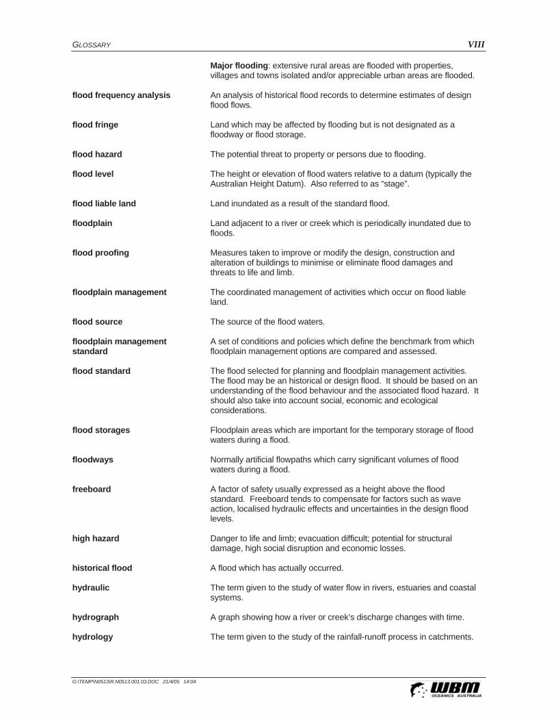
GLOSSARY VIII
G:\TEMP\N0513\R.N0513.001.03.DOC 21/4/05 14:04
Major flooding: extensive rural areas are flooded with properties, villages and towns isolated and/or appreciable urban areas are flooded.
flood frequency analysis An analysis of historical flood records to determine estimates of design flood flows.
flood fringe Land which may be affected by flooding but is not designated as a floodway or flood storage.
flood hazard The potential threat to property or persons due to flooding.
flood level The height or elevation of flood waters relative to a datum (typically the Australian Height Datum). Also referred to as “stage”.
flood liable land Land inundated as a result of the standard flood.
floodplain Land adjacent to a river or creek which is periodically inundated due to floods.
flood proofing Measures taken to improve or modify the design, construction and alteration of buildings to minimise or eliminate flood damages and threats to life and limb.
floodplain management The coordinated management of activities which occur on flood liable land.
flood source The source of the flood waters.
floodplain management standard
A set of conditions and policies which define the benchmark from which floodplain management options are compared and assessed.
flood standard The flood selected for planning and floodplain management activities. The flood may be an historical or design flood. It should be based on an understanding of the flood behaviour and the associated flood hazard. It should also take into account social, economic and ecological considerations.
flood storages Floodplain areas which are important for the temporary storage of flood waters during a flood.
floodways Normally artificial flowpaths which carry significant volumes of flood waters during a flood.
freeboard A factor of safety usually expressed as a height above the flood standard. Freeboard tends to compensate for factors such as wave action, localised hydraulic effects and uncertainties in the design flood levels.
high hazard Danger to life and limb; evacuation difficult; potential for structural damage, high social disruption and economic losses.
historical flood A flood which has actually occurred.
hydraulic The term given to the study of water flow in rivers, estuaries and coastal systems.
hydrograph A graph showing how a river or creek’s discharge changes with time.
hydrology The term given to the study of the rainfall-runoff process in catchments.

GLOSSARY IX
G:\TEMP\N0513\R.N0513.001.03.DOC 21/4/05 14:04
low hazard Flood depths and velocities are sufficiently low that people and their possessions can be evacuated.
management plan A clear and concise document, normally containing diagrams and maps, describing a series of actions which will allow an area to be managed in a coordinated manner to achieve defined objectives.
peak flood level, flow or velocity The maximum flood level, flow or velocity occurring during a flood event.
probable maximum flood (PMF) An extreme flood deemed to be the maximum flood likely to occur.
probability A statistical measure of the likely frequency or occurrence of flooding.
runoff The amount of rainfall from a catchment which actually ends up as flowing water in the river or creek.
stage See flood level.
stage hydrograph A graph of water level over time.
TIN Triangular Irregular Network - a mass of interconnected triangles used to model three-dimensional surfaces such as the ground (see DTM) and the surface of a flood.
velocity The speed at which the flood waters are moving. Typically, modelled velocities in a river or creek are quoted as the depth and width averaged velocity, i.e. the average velocity across the whole river or creek section.
water level See flood level.

INTRODUCTION 1-1
G:\TEMP\N0513\R.N0513.001.03.DOC 21/4/05 14:04
1 INTRODUCTION
1.1 Site Setting
The Williamtown/Salt Ash district is located adjacent to the lower reaches of the Hunter River with one of its tributaries, Tilligerry Creek, approximately 11 kilometres upstream of the Hunter River mouth at Newcastle. The Hunter River drains a catchment area of approximately 21,000 km2, nearly all of which lies upstream of Raymond Terrace and Williamtown. Tilligerry Creek drains into Port Stephens (refer Figure 1-1).
The project area lies partly within the Hunter River floodplain, but also includes the floodplains at a number of local catchments including:
Windeyers Creek located south and east of Raymond Terrace;
The Moors drain flowing between the Williamtown RAAF base and Salt Ash into Tilligerry Creek;
Tilligerry Creek between Fullerton Cove floodgates located at the levee and upstream of Nelson Bay Road; and
Minor drainage channels draining to Tilligerry Creek, or directly to Fullerton Cove via floodgates at Tomago.
The total project area covers approximately 120 km2. The project area comprises a combination of forested areas, pastures and urban lands.
1.2 The Need for Floodplain Management at Williamtown/Salt Ash
The townships located within the project area (parts of Raymond Terrace, Williamtown, Salt Ash) have experienced a range of floods over the years. Flooding results due to a combination of three mechanisms: rainfall on the local catchments, inundation from the Hunter River floods and tides in Fullerton Cove and Port Stephens.
Flooding in the project area occurred in 1990 following heavy rainfalls over the local catchments. Runoff from the upper catchment areas accumulated in the lower floodplains where drainage was then inhibited by relatively high tidal levels on the downstream side of the floodgates.
Notable flooding also occurred in 1955, when the great Hunter flood overtopped Fullerton Cove and inundated the lower parts of the project area.
Fullerton Cove is currently bordered by an earthen levee, originally built to prevent inundation of the project area by nuisance tides and moderate Hunter River floods. Figure 3-5 (Section 3.3.3) compares carious floods to the existing levee levels. Floodgates allow drainage from the Tilligerry Creek / Williamtown area through this levee into Fullerton Cove. Floodgates are also located at the Port Stephens end of Tilligerry Creek, and prevent backwater inundation of Williamtown / Salt Ash from Lower Tilligerry Creek and Port Stephens.

INTRODUCTION 1-2
G:\TEMP\N0513\R.N0513.001.03.DOC 21/4/05 14:04
Figure 1-1 Williamtown/Salt Ash Catchment Location

INTRODUCTION 1-3
G:\TEMP\N0513\R.N0513.001.03.DOC 21/4/05 14:04
A study of flooding behaviour in the project area requires an assessment of the flooding mechanisms, as well as an assessment of the occurrence of the mechanisms simultaneously.
The Lower Hunter River Flood Study (LHRFS) (Lawson & Treloar 1994) was undertaken to determine the magnitude and extent of flooding within the Hunter River floodplain downstream of Green Rocks (Raymond Terrace). The area studied by the LHRFS did not include the floodplain areas to the north east of Fullerton Cove in significant detail. Continuing pressure to develop flood liable land near Williamtown and Salt Ash lead Port Stephens Council to carry out an extension of the LHRFS to include Tilligerry Creek. The Tilligerry Creek Flood Study (Lawson and Treloar, 1998) covered the floodplain areas between Fullerton Cove and Nelson Bay Road at Salt Ash. Both the LHRFS and Tilligerry Creek Flood Study were carried out using one-dimensional (MIKE-11) models.
Council has identified the need to extend and integrate the flood modelling previously undertaken to rigorously assess flood behaviour and flood hazard arising from the interaction of all flooding mechanisms in the Williamtown/Salt Ash/Windeyers Creek area. As well as assessing peak flooding conditions, the model can be used to evaluate the capacity of the existing drainage networks and tide gates.
This project (the Flood Study) aims to set-up and calibrate a predictive model of flooding within the project area. As part of subsequent stages of the Floodplain Management Process (refer Section 1.3) the model will be used to assess the merits of various approaches to management of existing flood risk. Flood mitigation options involving physical works are easily assessable using predictive models, while other aspects of floodplain risk management, such as evacuation, services disruption and effective flood warning, can all be considered (and even quantified) through the use of computational models.
1.3 General Floodplain Management Approach
Floodplain management in NSW generally follows the guidelines in the Floodplain Management Manual (NSW Government, 2001). It states that implementation of the flood policy requires a floodplain management plan which ensures:
The use of flood liable land is planned and managed in a manner compatible with the assessed frequency and severity of flooding;
Flood liable lands are managed having regard to social, economic and ecological costs and benefits, to individuals as well as to the community;
Floodplain management matters are dealt with having regard to community safety, health and welfare requirements;
Information on the nature of possible future flooding is available to the public;
All reasonable measures are taken to alleviate the hazard and damage potential resulting from development on floodplains;
There is no significant growth in hazard and damage potential resulting from new development on floodplains; and

INTRODUCTION 1-4
G:\TEMP\N0513\R.N0513.001.03.DOC 21/4/05 14:04
Appropriate and effective flood warning systems exist, and emergency services are available for future flooding.
The steps involved in formulating a floodplain management plan are outlined in the Manual, and include:
1 Establish a Floodplain Risk Management Committee;
2 Data Collection;
3 Flood Study;
4 Floodplain Risk Management Study;
5 Floodplain Risk Management Plan; and
6 Implementation of Plan.
Figure 1-3 shows the inter-relationships between the main steps required to produce a floodplain management plan, and the involvement of the community within the various steps of plan preparation.
1.4 Area Covered by this Study
The project area included in this study covers an area of approximately 120 km2. It comprises the townships of Williamtown, Salt Ash, part of Raymond Terrace and the floodplain areas separating these towns. The entire project area is represented by a hydraulic two-dimensional model. The boundaries of the model (Raymond Terrace, Fullerton Cove, Salt Ash) are connected to other water courses (Hunter River, Tilligerry Creek), whose downstream conditions are Port of Newcastle and Port Stephens (Refer Figure 1-2). The influence on the project area of the Hunter River, Port Stephens and the ocean tide was investigated by incorporating adjacent study results at the model boundaries.
1.5 Study Objectives
The primary objective of the Williamtown/Salt Ash Flood Study was to examine and define the flood and drainage behaviour within the catchments of the study. The study identifies the capacity of the existing drainage network and tide gates. It is proposed that the Flood Study will provide a tool for subsequent floodplain risk management studies to enable detailed assessment of floodplain management and drainage options.
Specifically, this study is to develop a two-dimensional model of the study area and determine design flood conditions for a range of flood events (i.e. 0.5%, 1%, 2%, 5%, 10%, 20%, 50% AEP floods and PMF conditions due to a combination of local catchment rainfall, Hunter River flooding and tide flooding).
The long-term purpose of the model is to:
Determine hydraulic categories and the flood hazard;
Determine adequacy of existing levee system;
Assess various flood mitigation options;

INTRODUCTION 1-5
G:\TEMP\N0513\R.N0513.001.03.DOC 21/4/05 14:04
Determine improvements to local drainage;
Determine the extent and causes of drainage deficiencies by addressing the capacity of the existing drainage network and tide gates, including inundation duration during floods;
Review the appropriateness of Council adopted flood standard;
Establish the effects on flood behaviour by future urban development;
Test the impacts of specific development proposals on flooding; and
Provide Council with a flood forecasting capability.
With the exception of the first point, all of these specific modelling objectives are the subject of a Floodplain Management Study, which will be carried out subsequent to the present Flood Study.
As part of the Tilligerry Creek Flood Study report (1998) a hydraulic (MIKE11) model was developed for the Tilligerry Creek between Fullerton Cove and Salt Ash, which discretised the floodplain into 21 cross-sections. A completely new two-dimensional model was developed as part of this study, with a more adapted link between the channel and the floodplain. As such, the previous MIKE11 model was only used to extract boundary conditions for the new 2D model for this study.
Figure 1-2 Williamtown/Salt Ash Flood Study Area

INTRODUCTION 1-6
G:\TEMP\N0513\R.N0513.001.03.DOC 21/4/05 14:04
Flood Study
Floodplain Management Study
GIS
Flood Study Report
k:\jb10499.wjs\reporting\d002.vsd
Maps(Infrastructure,
Cadastre, Land Use)
Flood DamageData
GIS
Policy
Impact AssessmentsFloodplainManagement Model
ManagementOptionsComputational Models
Floodplain Management Plan
Formally Adopt Management Options
Implement Plan Mitigation Works, Community Education,Land Acquisation & other activities
ComputationalModelling Software
Historical Data(Rainfall, Flood Levels,
Discharges)
Topographic Data(Catchments, Rivers,
Floodplains)
Computer Models(Calibration, Verification, Design)
Need for Floodplain Management
SafeguardCommunity
Minimise FloodDamage
CommunityAwareness
Com
mun
ity C
onsu
ltatio
n
Com
pone
nts
Cov
ered
by
this
Stu
dy
Figure 1-3 Steps in the Floodplain Management Process

INTRODUCTION 1-7
G:\TEMP\N0513\R.N0513.001.03.DOC 21/4/05 14:04
1.6 About This Report
This report documents the Study’s objectives, results and conclusions. It is divided into a main report which presents the Study in a relatively non-technical manner, and several appendices containing additional data and technical details. Specific technical information relating to model calibration and the modelling results is provided within the Appendices. A second, separate A3 size volume of this report presents detailed design flood information.

STUDY METHODOLOGY 2-1
G:\TEMP\N0513\R.N0513.001.03.DOC 21/4/05 14:04
2 STUDY METHODOLOGY
The general approach and methodology employed to achieve the study objectives involved:
Compilation and review of available information;
Site inspections;
Identification of historical changes to topography;
Collection of historical flood information;
Collection of additional topographic survey data;
Setup of hydraulic model;
Calibration and verification of models; and
Establish design flood conditions.
The above tasks are described generally in the following Sections, while results of the application of this methodology are discussed in subsequent Chapters and Appendices, as appropriate.
2.1 Compilation and Review of Available Information
Flood investigations carried out in the past have addressed various aspects of flooding within the Williamtown area. Relevant previous studies include:
Australian Water and Coastal Studies (1990) Williamtown-Tomago Drainage;
Patterson Britton & Partners (1992) Lower Hunter River Flood Mitigation Scheme Williamtown Drainage System Preliminary Hydraulic Analysis;
Staniland Mounser Consulting (1993) Williamtown Drainage Study;
Lawson & Treloar (1994) Lower Hunter River Flood Study;
Lawson & Treloar (1998) Tilligerry Creek Flood Study; and
Manly Hydraulics Laboratory (1997-1999) Port Stephens Flood Study Stages 1 to 3.
A review of a few of these documents is provided in Appendix A.
Information that was able to be extracted from the above data sources and used within the present study includes:
Rainfall (daily totals and pluviograph) records for historic flood events;
Flood level and/or stream flow station records;
Peak flood observations collected by State and Local Governments;
Surveys of cross-section profiles;
Details on flood control and drainage structures;
Topographic data such as ground contours and spot heights; and
Geographic Information System (GIS) data such as roads, cadastre, waterways etc.

STUDY METHODOLOGY 2-2
G:\TEMP\N0513\R.N0513.001.03.DOC 21/4/05 14:04
All relevant information has been incorporated into the study, and is described, where appropriate within other Sections of this report.
2.2 Site Inspections
An initial site inspection was carried out to allow study personnel to become familiar with the area and to determine additional data requirements. Additional site inspections were then carried out, on an as-required basis, during the course of the study to investigate specific details and confirm computer modelling assumptions. Site inspections were required to determine structure sizes, current vegetation cover, general ground-truthing of topographic features, and liaison with community members.
2.3 Identification of Historical Changes to Topography
The adopted approach to this study required numerical modelling of the Williamtown/Salt Ash floodplain at several different dates in the past (to calibrate the model against historical flood data), as well as at present (to predict current flood behaviour). For historical events, it was important that the model used was representative of topographic conditions at the time. As the topography of the two-dimensional model is defined by a Digital Terrain Model (DTM), a new DTM was required for every different historical event simulated, in addition to the ‘current’ DTM.
Significant changes to the floodplain topography, particularly the construction or modification of roads and embankment structures, which may have had a major influence on flood behaviour, were identified through historical photos, records and discussions with long term residents.
Major topographic changes within the Williamtown/Salt Ash floodplain over the past 50 years or so include:
Raising of the crest elevation of the major roads (Nelson Bay Road, Cabbage Tree Road);
Construction of the Fullerton Cove levee and the tide gates;
Construction of the Pacific Highway by-pass at Raymond Terrace; and
Increase in development within the built-up sections of the project area.
Apart from the levee and roads, most changes in the DTMs were quite subtle.
2.4 Collection of Historical Flood Information
Historical flood information was collated from different sources:
Lawson & Treloar (1994) Lower Hunter River Flood Study: provided recorded and calibrated Hunter River levels for the 1955 flood;
Lawson & Treloar (1998) Tilligerry Creek Flood Study: provided boundary conditions for Fullerton Cove and Salt Ash for the 1990 flood via the MIKE11 model, and about 12 flood marks within the Williamtown/Salt Ash floodplain for the 1990 flood;
Bureau of Meteorology: provided the rainfall data for the calibration and verification events (1955, 1990, 2000) at the Williamtown RAAF gauge station;

STUDY METHODOLOGY 2-3
G:\TEMP\N0513\R.N0513.001.03.DOC 21/4/05 14:04
Manly Hydraulic Laboratory: provided water level records for the Hunter River at Raymond Terrace, Hexham Bridge, Stockton Bridge, and for the ocean at Port Stephens and Sydney; and
Additional 1955 and 1990 flood marks were surveyed following feedback from a number of local residents, via a community survey.
Historical flood records used for calibration purposes as part of this study are shown in Appendix C, while descriptions of the adopted calibration and verification flood events are also provided in Appendix C.
2.5 Topographic Survey Data
The validity of a 2D model is only as good as the accuracy of the ground survey data that is used in the model.
Prior to the commissioning of this study, Port Stephens Council and DIPNR (then DLWC) obtained ground survey data for most of the study area from photogrammetry. The photogrammetry was carried out by Southern Aerial Services, and was based on 1999 air photos. It has an accuracy of approximately 0.2m in both the horizontal and vertical planes.
In addition to the photogrammetry, survey data was obtained from a range of sources to cover other sections of the study area, as well as details of flow structures, such as drainage channels, culverts and embankments.
In particular, ground levels around Fullerton Cove were obtained from a past Hunter Water survey. Cross-sectional data used in the previous Tilligerry Creek Flood Model was also used, however, this was limited to the generally flat floodplain area south of Nelson Bay Road, and north of Lavis Lane.
Council was also able to provide survey details of all major drainage channels in the study area, while DIPNR provided a survey of the crest of Fullerton Cove levee.
2.6 Setup of Hydraulic Model
A hydraulic computer model was required to calculate flood levels and flow patterns within the creeks, drains and over the floodplains across the entire study area. The adopted model, TUFLOW, is capable of simulating the complex effects of backwater, overtopping of embankments, bridge constrictions, river confluences and other hydraulic behaviour.
For this study, the hydraulic model included:
A 2-dimensional representation of the project area, including all floodplain areas between Raymond Terrace, Williamtown, and Salt Ash; and
A 1-dimensional representation of Tilligerry Creek, Windeyers Creek, the 10 foot drain, the 14 foot drain, and the Moors Drain.
The drivers of the model were:
Catchment runoff;
Hunter River flood levels, at Raymond Terrace and at Fullerton Cove; and

STUDY METHODOLOGY 2-4
G:\TEMP\N0513\R.N0513.001.03.DOC 21/4/05 14:04
Port Stephens (Lower Tilligerry Creek) water levels, downstream of the Salt Ash flood gates.
2.7 Calibration and Verification of Models
The hydraulic model was calibrated and verified to historical flood events to establish the values of key model parameters and confirm that the model was capable of accurately predicting real flood events.
Historical events used for calibration or verification were selected using the following criteria:
The availability, completeness and quality of rainfall, stream flow, flood level and other hydrographic data;
The amount of data collected during the historical flood information survey - events which have substantially more information were given priority; and
The variability of events - preferably events would cover a range of flood sizes and flooding mechanisms.
Table 2-1 presents a summary of the calibration and verification events used in this study.
Table 2-1 Suitable Calibration & Verification Flood Events
Event Comments
1955 The 1955 flood event was the largest of the century for the Hunter River at Raymond Terrace (upstream boundary of the project). The high water levels backed up in Windeyers Creek. Flood waters also overtopped Fullerton Cove levee and inundated the Tilligerry Creek floodplain.
The Hunter River behaviour was derived from the Lower Hunter River MIKE11 model (Lawson & Treloar, 1994). Actual rainfall data, as well as flood height data, obtained from inside the project area, was available for calibration.
This event is considered to be representative of a major flood in the Hunter River and was used for calibration.
1990 The 1990 event represents a local runoff flood. Heavy rainfall in February 1990 resulted in flooding of Williamtown and Fullerton Cove. The Fullerton Cove levee was not overtopped during this event.
There is good rainfall data, water level hydrographs and flood records available for this event. Hence this event was also used for hydrologic and hydraulic model calibration.
2000 The 2000 event represents a minor flood in Tilligerry Creek. Although good quality of rainfall data and river level hydrographs is available, there were no accurate flood records. Only the lateral extents of the flood were available from an aerial ‘fly-over’ of the floodplain by DIPNR.
This event was used as a verification event only.

STUDY METHODOLOGY 2-5
G:\TEMP\N0513\R.N0513.001.03.DOC 21/4/05 14:04
Further information regarding these events, particularly specific details of the floods, is provided in Appendix C.
The general steps of the calibration and verification process were:
Identify and review available data for suitable calibration and verification events;
Select the most appropriate events;
Process data for selected events and incorporate into the hydraulic model;
Carry out preliminary calibration and verification of the hydraulic model – as there were significant topographical changes between different events, separate models were set up, each model representing the topography and land use at the time of the event; and
Carry out final calibration and verification of the models using an iterative process which sought to find the best combination of hydraulic parameters used in the model.
2.8 Establish Design Flood Conditions
Flooding within the project area can result from three principal mechanisms (occurring simultaneously or individually):
Rainfall over the project area catchment;
Water levels in the Hunter River (subject to tidal influence); and
Water levels in Tilligerry Creek, downstream of Salt Ash flood gates (subject to tidal influence).
Water levels in Lower Tilligerry Creek, which are mostly controlled by water levels in Port Stephens, affect the flow rate out of the project area through the Salt Ash flood gates. The effect can be dramatic when water levels downstream of the flood gates are higher than the water levels upstream of the gates. In this circumstance, there is no release of the flood waters from the project area until the downstream water level falls, or the upstream ponded level exceeds the downstream levels. In a very extreme event (probability of occurrence lower than 0.5%), very high water levels in Lower Tilligerry Creek can overtop the floodgate structure and contribute to the direct inundation of the project area.
Design floods are statistical-based events which have a particular probability of occurrence. For example, the 1% Annual Exceedance Probability (AEP) event, which is sometimes known as the 1 in 100 year flood, is the best estimate of a flood which has a 1% (i.e. 1 in 100) chance of occurring in any one year (on average). Because of this combination of flooding mechanisms the determination of the probability of occurrence was divided into three separate statistical analyses:
Rainfall over Australian catchments has been studied for a long time, leading to the definition of regional patterns and associated parameters. The Australian Rainfall & Runoff (AR&R) manual contains statistical information on rainfall parameters. It also provides catchment related equations for the assessment of design rainfalls.
Determination of the probability of occurrence for the Hunter River is based on statistical analysis of long-term historical records of floods in the Hunter River (Raymond Terrace) (refer Appendix D). This analysis was not undertaken by WBM. Instead results were extracted from the Lower Hunter River Flood Study (L&T, 1994).

STUDY METHODOLOGY 2-6
G:\TEMP\N0513\R.N0513.001.03.DOC 21/4/05 14:04
Determination of the probability of occurrence for the tide and elevated ocean level influence over the Hunter River and Port Stephens is based on statistical analysis of long-term historical records of water levels in Port Newcastle and Port Stephens. The analysis is presented in Section 5.2.1 and Section 5.3.1.
The calibrated and verified hydraulic model of the study area was modified, as necessary, to represent present day conditions, including recent topographical and landuse changes. The model was then run to define present day design flood conditions.
A series of sensitivity tests were also carried out. These tests were conducted to determine the relative importance of different hydrologic and hydraulic factors, such as friction coefficients, rainfall losses, boundary conditions, and other flow control structures. The tests provide a basis to determining the relative accuracy of modelling results, and an initial focus for future floodplain management planning.

HISTORICAL FLOOD INFORMATION 3-1
G:\TEMP\N0513\R.N0513.001.03.DOC 21/4/05 14:04
3 HISTORICAL FLOOD INFORMATION
Williamtown has experienced many floods, either due to the Hunter River overtopping its banks (and levees), tidal inundation or by excessive rainfall over the local catchment area. Floods due to the Hunter River have been well recorded, due to the gauging station located at Raymond Terrace. Unfortunately, the same level of documentation for Tilligerry Creek or the other main drains within the project area is not available. However, the 1990 event is certainly the biggest local runoff flood experienced in the area.
NSW Department of Commerce (Manly Hydraulics Laboratory) maintains a water level recorder at Raymond Terrace. The gauge is located at the northern end of Riverside Park, William Street, Raymond Terrace. Flood level data has been collected since 1930 from a manually read staff gauge, and from an automatic gauge since 1984. Records for the largest 20 floods at Raymond Terrace since 1820 are summarised in Table 3-1.
Table 3-1 Record of Largest Hunter River Floods at Raymond Terrace
Rank Flood Level at Raymond Terrace
(gauge level, mAHD)
1 1955 4.97
2 1820 4.87
3 1893 4.79
4 1930 3.4
5 1913 3.35
6 1950 3.09
7 1951 3.07
8 1990 3.03
9 1949 3.02
10 1946 2.97
11 1952 2.89
12 1985 2.88
13 1977 2.86
14 1978 2.79
15 1931 2.79
16 1972 2.58
17 1989 2.57
18 1927 2.55
19 1971 2.53
20 1956 2.39

HISTORICAL FLOOD INFORMATION 3-2
G:\TEMP\N0513\R.N0513.001.03.DOC 21/4/05 14:04
Specific information relating to past flood events can generally be divided into two categories:
General description of flood events, including date, time, flood depth and gauged flows; and
Formal flood level records.
The compilation of flood information for this study has come from previous studies (mostly the Lower Hunter River Flood Study (L&T, 1994) and the Tilligerry Creek Flood Study (L&T, 1998)) and a local resident survey.
Historical flood information assessed as part of this study focussed mostly on providing data for use as model calibration and verification. As such, particular attention was given to the 1955, 1990 and 2000 events.
3.1 General Flood Descriptions
Flooding in the project area is primarily caused by three mechanisms:
Flooding due to local runoff;
Flooding due to backwater effects of flooding in the Hunter River or elevated ocean tide, which may include overtopping of the levee system surrounding Fullerton Cove; and
Flooding due to backwater effects of flooding in Port Stephens, which may include overtopping of the levee system at Salt Ash.
Elevated roads and levee banks constructed in the area have an impact on flooding of the local floodplains. These elevated “controls” affect the flow of Hunter River floods onto the floodplain, and the drainage of the floodplain after both local catchment flooding and Hunter River inundation. During larger Hunter River floods, roads such as Nelson Bay Rd, Lavis Lane and Oakfield Lane divide the floodplain into a series of “compartments” each of which fills before water then cascades into the next.
The Fullerton Cove Ring Levee provides flood protection from the moderate Hunter River floods. A flood with a predicted level of 1.33mAHD in Fullerton Cove should just overtop the ring levee. Larger Hunter River floods, which overtop the ring levee, are controlled by the section of Nelson Bay Rd between Cabbage Tree Rd and Fullerton Cove Rd. Flood levels in Fullerton Cove would need to rise above 2.2mAHD, approximately 0.2m above the 1% AEP level, before the lowest section of Nelson Bay Rd is overtopped (refer Figure 3-1).
Flooding of the area may also occur due to local rainfall. Runoff from areas to the north of Nelson Bay Road generally flows eastwards via Moors Drain, parallel to the road, into Tilligerry Creek, downstream of the floodgates at Salt Ash. When the capacity of the Moors Drain is exceeded, the excess water flows under Nelson Bay Road (via a number of culverts) and into the Tilligerry Creek floodplain. This water, combined with the rainfall that falls onto the floodplain directly inundates the area for several days before it can drain into either Fullerton Cove or Port Stephens (refer Figure 3-2).

HISTORICAL FLOOD INFORMATION 3-3
G:\TEMP\N0513\R.N0513.001.03.DOC 21/4/05 14:04
Figure 3-1 Hunter River Major Flood Mechanism
Figure 3-2 Local Runoff Flood Mechanism
Overtopping of Nelson Bay Rd at RL 2.2 mAHD
Overtopping of levee at RL 1.33 mAHD

HISTORICAL FLOOD INFORMATION 3-4
G:\TEMP\N0513\R.N0513.001.03.DOC 21/4/05 14:04
Inundation of the area due to coincident Hunter River or elevated ocean tide and local catchment flooding is a possibility. The coincident flooding would produce higher peak flood levels than local catchment flooding alone only in the lower Tilligerry Creek floodplain areas (mostly south of Cabbage Tree Road and Nelson Bay Road). Flooding on the northern side of Nelson Bay Road would not generally be affected by flood levels in Fullerton Cove.
3.1.1 The 1955 Flood
The 1955 flood was caused by the remains of a tropical cyclone moving southwards from the tropics through the centre of Australia. A great deal of rain fell in the western portions of the Hunter River catchment and was funnelled into the Hunter River at Maitland. This, combined with rainfall on the Paterson River catchment produced an enormous volume of runoff passing through the narrow gap at Green Rocks. There was also substantial rainfall on the Williams River catchment, but the peak flow at Glen Martin occurred three days before the peak flood level at Raymond Terrace.
In 1955 the Fullerton Cove levee had a much lower crest level, and the main roads (Cabbage Tree Road, Nelson Bay Road especially) were also lower than at present. Water levels in the Hunter River completely submerged all embankments in the general study area, and inhibited drainage off the land for many days.
Water levels in the Hunter River were high enough (about 2.5mAHD in Fullerton Cove) to reverse the flow in Tilligerry Creek, and a water gradient was established between Fullerton Cove and Salt Ash (i.e. water flowed from the Hunter River to Port Stephens via Tilligerry Creek). It must be noted that water levels within Port Stephens were also high (about 1.7mAHD) due to high flows in the Karuah River downstream backing up into Lower Tilligerry Creek.
All the low lying land between Fullerton Cove, Williamtown and Salt Ash was completely inundated. Local flooding in the elevated parts of the project area also occurred due to heavy rainfall.
3.1.2 The 1990 Flood
Meteorological records show that the February 1990 flood event was caused by intense rainfall on the project area catchment as tropical cyclone Nancy tracked southwards down the coast of New South Wales, causing flooding in many coastal rivers. Heavy rainfall over the Lower Hunter River catchment lead to flooding which lasted several days. The daily rainfall volume recorded at Williamtown RAAF Base on 03/02/90 was comparable to the recorded daily rainfall in March 1893 at Nobby’s Head (297mm) and West Maitland (355mm) which also caused widespread flooding of the Lower Hunter Valley.
The Hunter River did not overtop the Fullerton Cove levee, but its high water levels prevented the local runoff from being drained out of the project area for many days. All the low lying areas behind the floodgates were inundated by runoff water until the Hunter River levels dropped.

HISTORICAL FLOOD INFORMATION 3-5
G:\TEMP\N0513\R.N0513.001.03.DOC 21/4/05 14:04
3.2 Formal Flood Records
3.2.1 Flood Levels
A geographic database of historical flood levels based on information gathered from previous studies (mostly the Tilligerry Creek Flood Study, L&T, 1998), and local and state government records was compiled for the selected floods (i.e. those floods used for the validation of computer models, viz: 1955, 1990, 2000).
Flood stage hydrograph and peak level information was available for the Hunter River at Raymond Terrace (automatic since 1984), Hexham Bridge and Stockton Bridge (automatic records were obtained for the 1990 and 2000 events). A rating curve was not available for these locations because peak river stages could not be accurately correlated to peak discharge. This is due to the unknown component of overbank flow through Millers Forest and the influence of the Williams River (for Raymond Terrace), and the unknown split between the North and the South arm of the Hunter River (for Hexham and Stockton Bridges) (L&T, 1994).
The flood height-frequency curve for the Raymond Terrace station was previously derived by Lawson & Treloar (1994) and is presented in Figure 3-3. This information was used to derive design flood boundary conditions. Actual recorded flood levels within the floodplain were used for model calibration. Floods levels were available for both the 1955 and the 1990 events.
Figure 3-3 Hunter River Height Frequency Curve at Raymond Terrace (Source Lawson & Treloar, 1994)

HISTORICAL FLOOD INFORMATION 3-6
G:\TEMP\N0513\R.N0513.001.03.DOC 21/4/05 14:04
Table 3-2 presents a summary of the number of historical flood level records that were collected and included in the calibration process. The locations and the levels of these records for the 1955, 1990 and 2000 floods can be seen on the calibration maps presented in Appendix C.
Table 3-2 Formal Historical Flood Level Recordings
Flood Number of Flood Level Recordings
1955 10
1990 21
2000 None – Extents taken from air video
The flood level records for the 1990 event represent a good dataset, and are considered adequate for flood model calibration purposes. Although some of the project area is left without any nearby calibration points, the 1990 data points were generally spread sufficiently in the residential areas, where the best accuracy is required.
The 1955 flood data points are relatively sparse and are of variable quality (eg undefinable level description, unclear location description, inconsistencies). Nonetheless it is still possible to use the data for indicative calibration purposes.
During flooding in March 2000 DIPNR (then DLWC) recorded flood extents in the Lower Hunter floodplains via aerial reconnaissance. The images retrieved from this airborne inspection were used to verify the lateral extents of flooding for the simulated 2000 flood event.
3.2.2 Flood Discharges
3.2.2.1 Hunter River
As discussed above, no rating curve was available for the Hunter River gauging locations. This is not a problem, however, as the model boundary conditions related to the Hunter River required levels only (rather than discharges). The flood discharges flowing into the model from the Hunter River were automatically calculated based on the incremented hydraulic gradient.
3.2.2.2 Local Runoff
Runoff is generated by direct rainfall on the catchment. The Williamtown RAAF base has measured rainfall for at least 50 years. Five minute rainfall data is available through the Bureau of Meteorology for all the calibration events, including 1955.
Table 3-3 to Table 3-5 show the daily recorded rainfall for the different calibration and verification events:

HISTORICAL FLOOD INFORMATION 3-7
G:\TEMP\N0513\R.N0513.001.03.DOC 21/4/05 14:04
Table 3-3 Recorded Rainfall at Williamtown – February 1955 event
Date Recorded Daily Rainfall Volume (from 7.00am the
previous day) (mm)
Calculated Average Rainfall Intensity over 24 hours
(mm/hr)
25/02/1955 39 1.6
26/02/1955 18 0.75
27/02/1955 1 0.05
28/02/1955 1 0.05
Table 3-4 Recorded Rainfall at Williamtown – February 1990 event
Date Recorded Daily Rainfall Volume (from 7.00am the
previous day) (mm)
Calculated Average Rainfall Intensity over 24 hours
(mm/hr)
02/02/1990 13.8 0.6
03/02/1990 276 11.5
04/02/1990 173 7.2
05/02/1990 11.3 0.5
Table 3-5 Recorded Rainfall at Williamtown – March 2000 event
Date Recorded Daily Rainfall Volume (from 7.00am the
previous day) (mm)
Calculated Average Rainfall Intensity over 24 hours
(mm/hr)
20/03/2000 109 4.5
21/03/2000 31 1.3
22/03/2000 0.18 0.008
23/03/2000 8.15 0.3
3.3 Historical Flooding Patterns
Developing an appreciation of the flooding processes on the Hunter River and on the local catchment is an important step in defining the flood behaviour and developing appropriate computer models.
A general understanding of the different patterns of flooding, or flood behaviour, was obtained based on consulting previous reports, and a fundamental understanding of flood hydraulics. This understanding is described below.

HISTORICAL FLOOD INFORMATION 3-8
G:\TEMP\N0513\R.N0513.001.03.DOC 21/4/05 14:04
3.3.1 Flood Generation
Floods from the Hunter River are generated by intense rainfall events over the catchment, with 4 possible sources:
Inland depressions forming in the tropics over northern Australia;
Ex-tropical cyclones originating in the Coral Sea;
East Coast low pressure systems; and
Sequence of fronts.
The consequence is a long flood duration, lasting over several days.
Local runoff flooding over the Williamtown/Salt Ash catchment has a far shorter critical storm duration (only few hours). It is expected that local storms would mostly be generated by rainfall associated with east coast low pressure systems.
3.3.2 Flood Magnitudes In generic terms, the magnitudes of main channel floods can be classified as one of the following (refer Figure 3-4):
Minor Flooding: For minor floods, the floodplains may have virtually no interaction with the river except to temporarily hold localised rainfall. Some backing up of water may occur as flood waters try to propagate up side creeks and onto the floodplain where flood gates do not exist.
Moderate Flooding: In moderate floods, floodplains may act as a temporary storage of river and creek waters until the river falls and flood waters can drain away. For a short peaky flood which overtops the natural or man-made levees for a relatively short time, the peak flood levels on the floodplain may be well below those in the river. In longer duration floods, there may be sufficient time for the floodplains to fill, causing flood levels to be similar on both river and floodplain. In these types of floods the floodplains’ storage capacity is particularly important. Small floodplains will fill up very quickly, while large ones may take the duration of the flood to fill or indeed may never fill.
Major Flooding: For major floods, floodplains may not only be a temporary storage for flood waters, but can also be a major carrier, transporting water down the floodplain and back into the river further downstream. Where flood waters are returning to the river, it is important to note that flood levels on the floodplain can be higher than those in the river. In these floods, both floodplain storage and conveyance characteristics are important.
Local Runoff Flooding: In local runoff floods, the rain that was dropped over the catchment is drained to the catchment low areas which it inundates until the downstream condition provides a favourable gradient allowing the water to flow away. Local runoff flooding is dependent on the downstream condition: the same amount of rain over the catchment could lead to flooding or not depending if the downstream river/sea is high or not.

HISTORICAL FLOOD INFORMATION 3-9
G:\TEMP\N0513\R.N0513.001.03.DOC 21/4/05 14:04
k:\jb10499.wjs\reporting\doo5.vsd
River Floodplain
Levee
Minor Flood
River Floodplain
Levee
Moderate Flood
River Floodplain
Levee
Major Flood
Examples of Flooding Modes
River Floodplain
Levee
Local Runoff Flood
bbbb b bFlood Control Structure &Drain
Figure 3-4 Examples of Different Modes of Flooding Behaviour
In the case of Williamtown, only moderate to major Hunter River floods have the potential to have an impact on the area, due to the high level of the Fullerton Cove levee. The 1955 flood would be classified as ‘major floods’ in the above descriptions. This event resulted in significant overbank flooding. Local runoff flooding is, on the contrary, quite frequent in the Williamtown/Salt Ash area, especially due to the low level of the ground which is lower than high tide level, making drainage difficult. An example of a significant local runoff flood is the 1990 event.

HISTORICAL FLOOD INFORMATION 3-10
G:\TEMP\N0513\R.N0513.001.03.DOC 21/4/05 14:04
3.3.3 Fullerton Cove Levee
The Fullerton Cove Ring Levee was built to protect the Tomago Sandbeds area from nuisance tidal inundation and moderate Hunter River floods. Figure 3-5 compares various floods to the existing levee crest.
However, the recent levee crest survey seems to imply that the Fullerton Cove Ring Levee has suffered natural and/or man-made erosion since the construction of levee. The Kooragang Wetland Rehabilitation Project site at Tomago will allow the return of the tide to the northern bank of the Hunter River North Arm. The levee will not be required to protect the project site.
3.3.4 Overall Flood Behaviour
Flood behaviour varies across the study area, in response to the topographical features and flooding mechanisms associated with different locations, as follows:
Windeyers Creek catchment: Windeyers Creek flows directly into the Hunter River, downstream of Raymond Terrace. The Hunter River influences Windeyers Creek water levels, due to backwater effects. When the Hunter River is in flood, the Windeyers Creek gradient can be reversed, with the Hunter River flood waters filling the local Windeyers Creek floodplain.
Several road structures (including the new Pacific Highway by-pass) have been built across the Windeyers Creek floodplain, and to some extent have also filled the natural creek course. The result is that important headlosses are generated through the structures at high flows. This can result in higher water levels in the upstream part of the catchment, but also increased drainage time as the natural drainage flow path is obstructed.
Hunter River floodplain at Tomago Sandbeds: principally affected by Hunter River floods, the area bounded by Fullerton Cove, Cabbage Tree Road and Nelson Bay Road gets filled with Hunter River water once the Fullerton Cove levee is overtopped. The severity of flooding in the area depends on the severity of the Hunter River flood. The roads have high crest levels, generally preventing inundation of other flood prone land, although the presence of culverts under the roads does allow some inundation.
Drainage of the land is totally related to the water levels in Fullerton Cove. If the water levels in Fullerton Cove stay high (due to Hunter River floods or elevated ocean tide), the Tomago Sandbed land can remain undrained. High tide levels are already sufficient to significantly inhibit drainage through the floodgates.

HISTORICAL FLOOD INFORMATION 3-11
G:\TEMP\N0513\R.N0513.001.03.DOC 21/4/05 14:04
Fullerton Cove Ring Levee Longitudinal Profilewith Predicted Design Water Levels
0
1
2
3
4
5
6
0 2000 4000 6000 8000 10000 12000 14000 16000
Chainage along Fullerton Cove Ring Levee (m)
Elev
atio
n (m
AH
D)
Ring Levee PMF 0.5% AEP Design Flood 1% AEP Design Flood 2% AEP Design Flood
5% AEP Design Flood 10% AEP Design Flood 20% AEP Design Flood 50% AEP Design Flood
Figure 3-5 Current Fullerton Cove Levee

HISTORICAL FLOOD INFORMATION 3-12
G:\TEMP\N0513\R.N0513.001.03.DOC 21/4/05 14:04
Tilligerry Creek catchment: the catchment can be divided into two parts:
To the north of the Moors Drain, there is little backwater effect to flooding, with runoff flowing in a generally southerly direction. The depth of flood water is primarily related to the rainfall intensity.
To the south, runoff accumulates within the naturally low-lying swale between the Stockton Beach sand dunes and Nelson Bay Road. The water ponds in this area until the downstream conditions are favourable for drainage, i.e. low water levels downstream of the Salt Ash floodgates and downstream of the Fullerton Cove flood gates.

MODEL DEVELOPMENT 4-1
G:\TEMP\N0513\R.N0513.001.03.DOC 21/4/05 14:04
4 MODEL DEVELOPMENT
4.1 Introduction
Computer models are the most accurate, cost-effective and efficient tools to model a river’s flood behaviour. For this study, two types of models were used:
A hydrologic model comprising all the sub-catchments of the project area; and
A 2-dimensional hydraulic model extending from Raymond Terrace to Fullerton Cove and Salt Ash, with 1-dimensional elements to represents Tilligerry Creek, Windeyers Creek and the major drains of the project area.
The hydrologic model simulates the catchment rainfall-runoff processes, producing the river/creek inflows which are used in the hydraulic model.
The hydraulic model simulates the flow behaviour of the rivers and floodplains, producing flood levels, flow discharges and flow velocities.
Information on the topography and characteristics of the catchments, rivers, creeks and floodplains are built into the models. For each historic flood, data on rainfall, flood levels and river flows are used to simulate and validate (calibrate and verify) the models. The models produce as output, flood levels, flows (discharges) and flow velocities (current speed).
Development of a computer model follows a relatively standard procedure:
1 Discretisation of the catchment, river, floodplain, etc;
2 Incorporation of physical characteristics (catchment areas, river cross-sections, etc);
3 Setting up of hydrographic databases (rainfall, river flows, flood levels) for historic events;
4 Calibration to one or more historic floods (calibration is the adjustment of parameters within acceptable limits to reach agreement between modelled and measured values);
5 Verification to one or more other historic floods (verification is a check on the model’s performance without adjustment of parameters); and
6 Sensitivity analysis of parameters to measure the dependence of the results to the model assumptions.
Once the model’s development is complete it may then be used for:
establishing design flood conditions;
determining levels for planning control; and
modelling “what-if” management options to assess the hydraulic impacts.
Only the first dot point above has been carried out as part of this Flood Study. The other two dot points are generally the subject of a subsequent Floodplain Risk Management Study, which is planned to be prepared by Council at some time in the future.

MODEL DEVELOPMENT 4-2
G:\TEMP\N0513\R.N0513.001.03.DOC 21/4/05 14:04
4.1.1 Model Discretisation
Model discretisation is necessary to simplify the real-world into one that can be represented by discrete elements. The computer then solves hydraulic equations at every discrete element.
The smaller the elements become, the closer the model approaches the real-world situation. However, as the number of elements increases, the computational resources required to run the model becomes more demanding, while the model also becomes more difficult to set up and manipulate. Also, there is a point where increasing the number of elements in a model may not provide any more significant benefit in model predictions and accuracy. Therefore a suitable balance needs to be found between the number of elements used to represent the study area and the practicalities of using the model for future management purposes.
In constructing the model, the modeller must design the number, size and location of elements to take into account:
location of available data (eg. river section surveys);
location of recorded data (eg. river flow gauging site);
location of controlling features (eg. dams, embankments, bridges);
desired accuracy to meet the study’s objectives;
limitations of the computer software (i.e. the number of elements the software can handle, and more importantly, to keep within the constraints of the mathematical solution); and
limitations of the computer hardware (i.e. don’t develop a model which takes forever to run - fortunately, with today’s computers, this is rarely a constraint).
The Williamtown/Salt Ash Flood Model has been constructed using elements with a regular grid (because TUFLOW is a finite difference model) of size 40m x 40m. This means that hydraulics parameters are calculated separately for every 40m square of the entire 120km2 study area. Over 75,000 individual elements make up the flood model, each with individual levels, roughness, boundary conditions, flow constrictions and flow structure details.
The two-dimensional TUFLOW model is also dynamically linked to one-dimensional models, representing the creeks (Tilligerry and Windeyers) and the major drains (Moors, 10 foot, 14 foot) as well as some minor drains within the 2D area. The extent of the two-dimensional model and the locations of the one-dimensional channels is provided in Figure 4-1.
The timestep for the model was 5 seconds. This means that the hydraulics within each of the 75,000 model element is recalculated every 5 seconds through the flood event. For a 24 hour flood simulation, this equates to nearly 1.3 billion calculations.

MODEL DEVELOPMENT 4-3
G:\TEMP\N0513\R.N0513.001.03.DOC 21/4/05 14:04
Figure 4-1 Williamtown/Salt Ash Flood Model Layout
Are
aof
2-D
mod
elco
vera
ge
1-D
net
wor
kco
nnec
tion
(typ.
)
1-D
elem
ent

MODEL DEVELOPMENT 4-4
G:\TEMP\N0513\R.N0513.001.03.DOC 21/4/05 14:04
4.2 Data Sources
A variety of data was collected, collated and used to develop the different model databases or used to develop model parameters. The main sources of data were:
Topographic maps (1:25,000);
Ground surface surveys;
Aerial photography;
Historic flood information;
Topographic surveys collected for the study or previous studies, which included:
spot heights on the floodplains;
embankment crests (natural levees, roads, etc);
creek and floodplain cross-sections.
Rainfall data for historic events from the Bureau of Meteorology;
Level hydrographs for historic events from DIPNR; and
Flood level data for historic events from the DIPNR and the Manly Hydraulic Laboratory.
4.3 Digital Terrain Model (DTM)
A digital terrain model (DTM) is a three-dimensional (3D) representation of the ground surface. A DTM is used to define the ground surface levels of the model. Given that ground levels are required for over 75,000 individual elements within the model, a DTM represents the most effective way for these levels to be determined automatically.
The DTM was created using ground survey data across the study area. For the area to the north of Nelson Bay Road and north of Cabbage Tree Road, the ground levels were taken from survey prepared using photogrammetric techniques (refer Section 2.5). For the southern sections of the study area, the DTM utilised a Hunter Water ground survey. For a small section of the study area between Nelson Bay Road and Lavis Lane, the DTM needed to utilise cross-sectional data, taken from the previous Tilligerry Creek Flood Study (L&T, 1998).
The DTM of the study area is presented in Figure 4-2, Figure 4-3 and Figure 4-4.

MODEL DEVELOPMENT 4-5
G:\TEMP\N0513\R.N0513.001.03.DOC 21/4/05 14:04
Figure 4-2 1m contour lines of the DTM in the project area
Figure 4-3 3D shaded View of DTM Ground Levels of the Study Area

MODEL DEVELOPMENT 4-6
G:\TEMP\N0513\R.N0513.001.03.DOC 21/4/05 14:04
Figure 4-4 Extents of Different Data Sources that made up the DTM
4.3.1 Accuracy of DTM
The accuracy of a two-dimensional model is largely controlled by the accuracy of the DTM, as it is the topography of the ground that largely controls flow behaviour during times of flood. The accuracy of the DTM is subsequently controlled by the accuracy of the survey data used to build the DTM.
The photogrammetry survey has an accuracy of approximately 0.2m in both the vertical and horizontal, as defined by Southern Aerial Services (who generated the survey). The Hunter Water survey data, which is assumed to have been collected using ground levelling equipment (eg theodolite) would have an accuracy of better than 0.1m.
For the area of floodplain where the DTM used cross-sectional data, it is anticipated that the interpolations made by the DTM (for areas between the cross-sections) would represent the area of greatest DTM inaccuracy. However, as this area is generally quite flat, the interpolations would not be too unrealistic. The DTM is considered to be more than satisfactory for defining flood behaviour.
Photogrammetric survey
Ground survey

MODEL DEVELOPMENT 4-7
G:\TEMP\N0513\R.N0513.001.03.DOC 21/4/05 14:04
4.4 Hydrologic (Catchment Runoff) Model
The hydrologic model simulates the rate of storm runoff from the catchment. The amount of runoff from the rainfall and the attenuation of the flood wave as it travels down the catchment are dependent on:
The catchment’s slope, area, vegetation and other characteristics;
Variations in the distribution, intensity and amount of rainfall; and
The antecedent conditions of the catchment.
These factors are represented in the model by:
Sub-dividing the catchment into a network of sub-catchments inter-connected by channel reaches representing the creeks and rivers. The sub-catchments are delineated so that they each have a general uniformity in their slope, land-use, vegetation density, etc;
The amount and intensity of rainfall is varied across the catchment based on available information. For historical events, this can be very subjective or impossible if little or no rainfall records exist; and
The antecedent conditions are modelled by varying the amount of rainfall which is “lost” into the ground and “absorbed” by storages. For very dry antecedent conditions a higher initial rainfall loss is adopted.
The output from the hydrologic model is a series of flow hydrographs at selected locations such as at the boundaries of the hydraulic model. These hydrographs are used by the hydraulic model to simulate the passage of the flood into Tilligerry Creek and Windeyers Creek and over the floodplains.
The RAFTS-XP software was used to develop the hydrologic model. The model consists of 162 sub-catchments feeding into Tilligerry Creek and Windeyers Creek and the associated floodplains.
Each individual sub-catchments produces a runoff hydrograph that is automatically linked to the 2D hydraulic model at the lowest elevation of the sub-catchment area. Figure 4-5 shows the 162 sub-catchments of the Williamtown/Salt Ash flood model catchment.

MODEL DEVELOPMENT 4-8
G:\TEMP\N0513\R.N0513.001.03.DOC 21/4/05 14:04
Figure 4-5 Catchment sub-divisions
4.5 Hydraulic Model of Creeks and Floodplains
4.5.1 Model Setup
The hydraulic model simulates the dynamic flooding behaviour in the Williamtown/ Salt Ash area, representing the interactions between the Hunter River, the different creeks and drains, and the floodplain storages.
The rate of travel and attenuation (dampening) of flood flows as they runoff the catchment is dependent on the shape, size and vegetation of surface characteristics of the creeks, drains and floodplains. For example, the larger the floodplain the greater the flood flow attenuation (i.e. detention), while the “rougher” the surface and denser the vegetation, the slower the rate of travel.
Man-made structures and modification of the floodplains also affect how the flood flows propagate through the study area. Poorly designed structures will hold back flood waters typically causing a higher flood level upstream and/or diverting flood waters elsewhere (eg, Nelson Bay Road).
The modelling software, TUFLOW, was used to set up a fully two-dimensional hydraulic model of the project area. The model was dynamically linked with ESTRY 1D elements. This means that 1D components have replaced part of the 2D model where the size of the 2D mesh was bigger than the geometries to be represented (eg along narrow drainage channels and under road culverts). The 1D

MODEL DEVELOPMENT 4-9
G:\TEMP\N0513\R.N0513.001.03.DOC 21/4/05 14:04
and fully 2D components are solved as if they are one model with information on flood flows and levels exchanged between them at their common boundaries. The combined fully 2D/1D model is referred to as the TUFLOW 2D/1D model. TUFLOW is described further in Appendix B.
Hydraulic structures were incorporated to represent bridge crossings, embankments (roads and levees) and flood drainage culverts.
Figure 4-6 presents the different development stages of the model.
The flood model developed for this Study extends from Raymond Terrace in the North West to Williamtown and Fullerton Cove in the South, to Salt Ash in the East. It includes part of the township of Raymond Terrace, Williamtown and Salt Ash and the floodplains associated with the enclosed creeks and drains. The hydraulic model network and its relevant branches is provided in Figure 4-1 earlier on in this report.
Further information on the model set up is provided in Appendix C.
k:\jb10499.wjs\reporting\d003.vsd
Site Inspections
Historic FloodInformation Survey
Review StudiesCollate Data
Additional TopographicSurveys
DataCollection
&Collation
GISDatabase
Historic Flood LevelsDigital Terrain Model
HydraulicModel Catchment Runoff
(Hydrologic) Model
River, Floodplain, Levee& Road Topography
Flood Control StructuresRoughness Coefficients
HistoricFlood Levels
RainfallCatchment DetailsMeasured Flows
HistoricFlood Patterns
AR&R DesignStorms
Flood Mapping
Design Floods
HydraulicModel
Calibration
Flood FrequencyAnalysis
HydrologicModel
DesignFloodFlows
CalibratedHydraulic
Model
Figure 4-6 Hydraulic Model Development Process

MODEL DEVELOPMENT 4-10
G:\TEMP\N0513\R.N0513.001.03.DOC 21/4/05 14:04
4.5.2 Model Inputs and Outputs
Figure 4-7 summarises the inputs and outputs of the model.
Rainfall over the local catchment
HydraulicModel
FloodLevels,Flows &
Velocities
k:\jb10499.wjs\reporting\d004.vsd
Hydraulic Model Inputs & Outputs
Hunter River level at Fullerton Cove Flood
Behaviour
Hunter River level atRaymond Terrace
Tilligerry Ck level D/strm of Salt Ash
Figure 4-7 Inputs and Outputs of the Hydraulic Model
4.5.2.1 Model Inputs
Inputs to a hydraulic model include:
Topography of the study area. The DTM used to define topography is explained in Section 4.3.
Hydraulic roughness of the channel bed and the floodplain land. A map of the final adopted model roughness is shown in Appendix C.
Rainfall over the local catchment: the runoff generated by rainfall over the local catchment is a substantial source of flooding, accentuated by the Hunter River levels and the ocean tide. The rainfall is modelled as being uniform over the catchment, but the treatment of the runoff is separated into 162 sub-catchments, which feed directly in the hydraulic model, with individually calculated runoff flows at each sub-catchment outlet.
Boundary water levels: Located at the downstream end of the creeks (Windeyers, Tilligerry and Moors Drain) the water level boundary controls both the upstream flow rate and level. In the case of the Hunter River, the downstream water levels can generate a hydraulic gradient in Tilligerry Creek that pushed water into Port Stephens. There is no need to input the actual Hunter River flow rate in the model, as TUFLOW calculates the flow rate by hydraulic gradient analysis. Hence, there is a need for accurate level hydrographs. Boundary water levels were applied as followed:

MODEL DEVELOPMENT 4-11
G:\TEMP\N0513\R.N0513.001.03.DOC 21/4/05 14:04
Hunter River, downstream of Windeyers Creek: controls the flow in Windeyers Creek and its floodplain. The levels (both for historical and design events) were obtained from the Lower Hunter River Flood model (L&T, 1994);
Hunter River, Fullerton Cove: controls the flow in Tilligerry Creek and Williamtown drains. During Hunter River floods, Fullerton Cove becomes part of the Hunter River floodplain, and a longitudinal gradient has been applied. The levels, and well as the gradients (both for historical and design events), were obtained from the Lower Hunter River Flood model (L&T, 1994); and
Tilligerry Creek, Salt Ash: controls the flow in Tilligerry Creek. The water levels downstream of Salt Ash depends on the ocean tide, the flow in the Karuah River and the flow in Tilligerry Creek. The Salt Ash floodgates can prevent any outflow from the project area if the downstream condition is too high. Adopted levels were taken from the Manly Hydraulic Laboratory’s conclusions of the Port Stephens Flood Study.
Sensitivity analyses were carried out on all model inputs, with the exception of topography, to determine the dependence of the model results to these inputs. Details of the model sensitivity are presented in Appendix C.
4.5.2.2 Model Outputs
Model outputs are flood levels, flows, and velocities describing the flood behaviour over time for a given flood event. Based on these outputs, flood categories and hazards describing the risks associated with flood flows can also be determined.
Individual model outputs are provided for every two-dimensional element within the model. This means that for the Williamtown/Salt Ash model, results at over 75,000 different locations (every 40m x 40m grid cell) are provided every timestep. Given this vast amount of output data, a Geographic Information System (GIS) is adopted to assist in presentation of the spatially-dependent results.
4.6 Model Calibration and Verification to Historic Floods
4.6.1 Historic Floods
The hydraulic model was calibrated to recorded rainfalls and flood levels during the floods of February 1955 and February 1990, and verified using the March 2000 event.
These events were selected on the following basis:
The February 1955 flood was the largest flood on record in the Hunter River. In terms of flood magnitude, it represents a major river flood. A majority of the Williamtown/Salt Ash catchment is part of the Hunter River floodplain, even though it is behind the Fullerton Cove levee. During the 1955 flood, the levee at the time was completely submerged, and most of the Williamtown/Salt Ash area was flooded from the Hunter River. The 1955 flood was selected as the best available calibration event for a flood in Williamtown/Salt Ash due to Hunter River inundation.
The 1990 event was a combination of a major local runoff flood over the catchment and high water levels in the Hunter River downstream of the floodgates, preventing the local runoff to

MODEL DEVELOPMENT 4-12
G:\TEMP\N0513\R.N0513.001.03.DOC 21/4/05 14:04
drain from the area, therefore increasing the upstream storage of flood waters. Better quality data was available for 1990 than 1955 (comprising more data, and with better precision), including the boundary conditions (due to additional gaugings). The 1990 event was selected as a primary calibration event, due to its size and the quality of the available data.
The 2000 event was a minor local runoff flood. However, it was the only additional flood event with available information on its inundation extents. For the 2000 event, the only available information was an aerial video showing the lateral extents of the flood at a certain time. Comparing model results to data of this type is very approximate, therefore this event was only used as a verification, to check that the model was simulating over flow patterns well.
The calibration and verification events are summarised in Table 4-1.
Table 4-1 Calibration and Verification Event Details
Flood event Max. Hunter River level at Raymond Terrace (mAHD)
Max. Hunter River level at Fullerton Cove
(mAHD)
Maximum Rainfall Intensity (mm/hr) (in
local catchment)
February 1955 4.77 2.5 25
February 1990 2.86 1.08 105
March 2000 2.54 0.91 40
4.6.2 Calibration Results
Comprehensive details of the calibration and verification of the model are provided in Appendix C.
Using the designated rainfall and water level conditions for the calibration and verification events (as presented in Table 4-1), a satisfactory calibration was achieved by systematically adjusting the roughness of various sections of the model. Roughness within the model was based primarily on landuse and vegetation cover. Over 80% of the two-dimensional model had the same roughness coefficient, which generally applied to all lands used for pasture. A summary of the roughness coefficients used within the model that achieved the best calibration is presented in Table 4-2, while a map of the different areas of roughness within the model is presented in Appendix C.
Typical roughness, based on experience by WBM personnel, proved to be quite effective. Only minor changes were required, the majority of which were necessary in Windeyers Creek catchment and channel sections. A large headloss recorded in 1990 under the Old Pacific Highway Bridge could not be attributed to the bridge only. Analysis of the location revealed unusually dense vegetated creek banks with further flow constrictions due to local topography detail. Roughness parameters needed to be increased within this localised section of the channel to match recorded levels.

MODEL DEVELOPMENT 4-13
G:\TEMP\N0513\R.N0513.001.03.DOC 21/4/05 14:04
Table 4-2 Adopted Roughness Coefficients to Achieve Calibration
Description of area applied Adopted value (Manning’s ‘n’)
Percentage of model
Creek bed 0.07 Marginal
Cleared floodplain 0.03 41%
Uncleared swamp 0.07 51%
Dense vegetation 0.2 (avg) 1%
Roads 0.025 Marginal
Urban 0.10 7%
A satisfactory calibration to the 1955 and 1990 events was achieved with the final set of parameters presented in Table 4-2. Table 4-3 provides a summary of the calibration and verification event results, indicating the level of consistency between predicted and measured flood levels throughout the floodplain. Table 4-3 shows that the model predicts one out of every two data points observed during the 1990 flood within a tolerance of +/- 0.1 metres. Given the level of accuracy associated with other aspects of the input data for the calibration event, this result is considered satisfactory.
Only one data point was excluded from the calibration process. This was for the 1955 flood where a level of 5.25 mAHD was recorded south of Raymond Terrace. This level cannot be justified when compared with the 4.99 mAHD gauged level on the Hunter River upstream in Raymond Terrace. It is likely that local impacts helped cause the higher levels at this location, which cannot be replicated by the model (without knowing the exact nature of the localised impacts). Other recorded levels could not be included in the calibration process because they were out of the model boundary. However, they were taken into consideration qualitatively when extrapolation was reasonable, in order to confirm consistency.
Table 4-3 Summary Results of Model Calibration
Year No. of data points considered
Proportion of data points within 0.1m
Proportion of data points within 0.2m
Proportion of data points within 0.3m
1955 6 17% 50% 83%
1990 18 56% 89% 100%
With regards to the 2000 verification event, the model showed a reasonably consistent pattern of inundation as that observed via aerial reconnaissance. However, the only area that could be seen with any clarity in the video was the section of Tilligerry Creek immediately behind the Fullerton Cove floodgates, between the 10 foot and 14 foot drains.

MODEL DEVELOPMENT 4-14
G:\TEMP\N0513\R.N0513.001.03.DOC 21/4/05 14:04
4.6.3 Calibration Outcomes
The quality of a calibration is judged on the capacity to reproduce historical flood levels at a selected number of locations. In the case of the Williamtown Flood Study, historical data was only available at a maximum of 21 points for the 1990 calibration event, while the total model area is approximately 120 km2. The degree of representativeness of the calibration points varies depending on its location within the floodplains. It establishes the degree of confidence for the model to define design flood levels.
The calibration points located in the Tilligerry Creek floodplain are representative of a wide area. In this part of the project area, the main characteristics of the flood behaviour are the wide flood extent, slow velocities, flat energy slope and headlosses defined by weirs and culverts across the major road embankments. The result is that one point is representative of an area extending across the floodplain and bounded by embankments. The quality of the calibration and its representativeness in the Tilligerry Creek floodplains closely support design flood results.
A similar analysis applies for the Moors’ Drain and the lower Windeyers Creek catchment.
Little information is available on the upper Tilligerry Creek sub-catchments, where flooding is generated by excessive surface runoff flowing to the downstream floodplain. The flow in these areas is relatively shallow, with water running on the sides of the hills. The flood levels are more inclined to be subjected to local characteristics, like a house obstruction, though the influence would be also localised. However, the model has shown close agreement with historical flood levels at the bottom of these sub-catchments. It should be understood that at the scale of the grid size (40m), the model replicates appropriately the surface runoff, and confirms its ability to define design flood behaviour.
The same comments apply to the top of the Windeyers Creek catchment, where there is a shortage of historical flood levels, and in particular upstream of the Pacific Highway by-pass. Calibration to the 1990 historical flood records required the use of high roughness values and flow constrictions in the area immediately downstream of the Pacific Highway by-pass, to simulate the natural afflux conditions. It is likely that the Pacific Highway by-pass has further increased the afflux imposed on the waterway due to filling of the Windeyers Creek floodplain. However, without recorded flood levels, the magnitude of the increase in the afflux is indeterminate. It is therefore recommended that the predicted design flood behaviour upstream of the Pacific Highway be considered with great caution.
Full details of the calibration and verification results, including maps of the floodplain showing the results of the calibration, and longitudinal profile of the water level in Tilligerry Creek, are provided in Appendix C.

DESIGN FLOOD CONDITIONS 5-1
G:\TEMP\N0513\R.N0513.001.03.DOC 21/4/05 14:04
5 DESIGN FLOOD CONDITIONS
5.1 Introduction
Design floods are hypothetical floods used for planning purposes and floodplain management investigations. They are based on having a probability of occurrence specified either as:
Annual Exceedance Probability (AEP) expressed as a percentage; or
An Average Recurrence Interval (ARI) expressed in years.
This report uses the AEP terminology. Table 5-1 provides a description of the different design floods considered as part of this study.
Table 5-1 Design Flood Terminology
AEP1 ARI2 Comments
0.5% 200 years A hypothetical flood or combination of floods which represent the worst case scenario likely to have a 0.5% chance of occurring in any one year, or in other words, is likely occur once every 200 years on average.
1% 100 years A hypothetical flood or combination of floods which represent the worst case scenario likely to have a 1% chance of occurring in any one year, or in other words, is likely occur once every 100 years on average.
2% 50 years A hypothetical flood or combination of floods which represent the worst case scenario likely to have a 2% chance of occurring in any one year, or in other words, is likely occur once every 50 years on average.
5% 20 years A hypothetical flood or combination of floods which represent the worst case scenario likely to have a 5% chance of occurring in any one year, or in other words, is likely occur once every 20 years on average.
10% 10 years A hypothetical flood or combination of floods which represent the worst case scenario likely to have a 10% chance of occurring in any one year, or in other words, is likely occur once every 10 years on average.
20% 5 years A hypothetical flood or combination of floods which represent the worst case scenario likely to have a 5% chance of occurring in any one year, or in other words, is likely occur once every 5 years on average.
50% 2 years A hypothetical flood or combination of floods which represent the worst case scenario likely to have a 10% chance of occurring in any one year, or in other words, is likely occur once every 2 years on average.
Extreme Flood / PMF3 A hypothetical flood or combination of floods which represent an extreme scenario. It is only used for special purposes (eg. design of a dam spillway) where a high factor of safety is recommended, or in consideration of floodplain planning (eg evacuation and isolation of communities).
1 Annual Exceedance Probability (%), 2 Average Recurrence Interval (years), 3 Probable Maximum Flood

DESIGN FLOOD CONDITIONS 5-2
G:\TEMP\N0513\R.N0513.001.03.DOC 21/4/05 14:04
In determining the design floods for the Williamtown/Salt Ash it is necessary to take into account:
The critical storm duration of the catchment. This is defined by the conditions resulting in the highest flood level; and
The relative timing and magnitudes of a Hunter River flood and a Williamtown/Salt Ash local catchment runoff flood.
The following sections discuss these issues in further detail.
5.2 Hunter River Design Flood Levels
The design flood levels upstream of Raymond Terrace were established using a Flood Frequency Analysis (FFA) on the levels measured at Raymond Terrace (Riverside Park, William Street). Flood frequency analysis enables the magnitude of a flood with a defined probability of exceedance to be estimated based on a statistical analysis of historic recorded floods. Direct frequency analysis is normally possible were records of flows at or near the project site are available. The procedure applies primarily to peak discharges. This variable can be considered to be drawn randomly from a well-behaved statistical distribution, and is thus amenable to frequency analysis. The distribution of water level (stage) is likely to have discontinuities due to rapid changes in cross-section at the site as discharge increases (eg when overtopping of the riverbanks occur), and the relation between stage and discharge may vary throughout the period of record with shifting control.
The flood frequency analysis was undertaken by Lawson & Treloar in the Lower Hunter Flood Study (L&T, 1994), and it is adopted as the reference when formulating design floods in the Lower Hunter River. The frequency analysis was undertaken to determine design flood levels, as no rating curve was available for the NSW Public Works stream gauge at Raymond Terrace (due to the unknown component of overbank flow through Millers Forest and the influence of the Williams River).
However, a sensitivity investigation indicated that total discharge at Green Rocks could be used in flood frequency analysis at Raymond Terrace because the majority of flood flow in the Hunter River for all but the most extreme floods must pass through the floodplain constriction at Green Rocks. As a result, a correlation between peak discharge at Green Rocks and peak water level at Raymond Terrace was developed.
Flood frequency analysis may be carried out graphically or analytically. In the former, the observed data are plotted on probability graph paper and a frequency curve drawn subjectively. With the latter approach, a probability distribution is fitted mathematically to the observed data, and flood magnitudes of required probabilities can be calculated directly from this distribution.
In the Lower Hunter Flood Study (Lawson and Treloar, 1994), a Log-Pearson III analysis was undertaken on the derived discharge estimates to determine the frequency of flooding at a given stage. Then the probability of exceedance was correlated back to the water levels at Raymond Terrace. Figure 3-3 shows the line of best fit plotted to determine an acceptable frequency curve at Raymond Terrace. The best fit curve took account of:
Plotted recorded data;
Possible dual flood production mechanism;
Uncertainty in 1820 level;

DESIGN FLOOD CONDITIONS 5-3
G:\TEMP\N0513\R.N0513.001.03.DOC 21/4/05 14:04
Extreme flood estimation; and
Discharge-based Log-Pearson III estimates.
For this study, water levels at other locations, including Windeyers Creek confluence and Fullerton Cove (West, Centre and East), were deduced directly from the Lower Hunter River model. The different levels across Fullerton Cove take into account the Hunter River water level gradient while flowing over bank across the 4km wide Cove. At comparative high probabilities of occurrence for floods of 50% to 2% AEP, flooding due to elevated ocean levels generates higher water levels in Fullerton Cove than flooding due to high flows in the Hunter River (Lawson and Treloar, 1994). That is, the 2% AEP ocean level would result in higher flood levels in Fullerton Cove that the flood level associated with the 2% AEP flood coming down the river.
The behaviour of an extreme flood, of 2.5 times the estimated peak discharge of the 1955 flood, was also taken from the results of the Lower Hunter River Flood Study.
The levels and discharges adopted from the flood frequency analysis and the Lower Hunter River model results are shown in Table 5-2.
Table 5-2 Lower Hunter Model Results (Source: L&T, 1994)
Design Floods
Hunter River location
PMF 0.5% 1% 2% 5% 10% 20%
Peak Discharge at Green Rocks (m3/s) 20,000 6,900 3,700 2,600 2,000 1,200
Peak Flood Level at Raymond Terrace (mAHD)
7.5 4.84 3.72 3.11 2.73 2.08
Peak Flood Level at Windeyers Creek (mAHD)
7.07 5.01 4.45 3.32 2.95 2.55 1.98
Peak Flood Level at Fullerton Cove West (mAHD)
4.98 3.05 2.58 1.81 1.61 1.24 1.21
Peak Flood Level at Fullerton Cove Centre (mAHD)
4.64 2.43 2.00 1.33 1.27 1.21 1.21
Peak Flood Level at Fullerton Cove East (mAHD)
4.00 2.03 1.66 1.31 1.27 1.24 1.21
Peak Flood Level at Port Newcastle (mAHD)
1.77 1.38 1.34 1.31 1.27 1.24 1.21

DESIGN FLOOD CONDITIONS 5-4
G:\TEMP\N0513\R.N0513.001.03.DOC 21/4/05 14:04
5.2.1 Tidal Influence in the Hunter River
Fullerton Cove, which is one of the downstream boundaries of the Williamtown/Salt Ash model, is tidally influenced. Therefore it was necessary to represent the tidal effect at this boundary of the model.
In the Lower Hunter River Flood Study (Lawson and Treloar, 1994) an ocean tide level analysis was carried out at the Port of Newcastle based on long term measured water level data. Water levels inside Port of Newcastle (where the gauge is located) do not necessarily represent water levels in the ocean, due to the protection of the Port against direct swell impacts. This dissimilarity is highlighted by the differences between water level recurrence results at Port of Newcastle and Sydney Harbour, which is a less protected area and is assumed to be more representative of ocean levels. However, with regard to this Flood Study, it is the actual water levels within the Port of Newcastle that control water levels in the Hunter River and Fullerton Cove.
An extremal analysis was undertaken using the method of moments to evaluate the parameters of the Extreme Value Type 1 distribution over the Port of Newcastle records. This distribution was selected because it is physically realistic and has been found to provide a reasonable fit to other water level extremal data, for example, cyclone surge. The results are shown in Table 5-3.
Table 5-3 Water Level Recurrence Data – Newcastle Tide Gauge – Net 14.5 Years (Source: L&T, 1994)
AEP (%) Water Level (mAHD)
95% CL1 (m)
1 1.36 +/-0.11
2 1.33 +/-0.09
5 1.29 +/-0.08
10 1.26 +/-0.08
20 1.23 +/-0.07 1 Confidence Limits (m)
The results show a very flat water level recurrence relationship with the 95% confidence limits (CL) being greater than the difference between the 1% and 2% events.
Additional water level records were obtained from the MSB Newcastle tide register for the period 1980-1989 (i.e. 114 months). Combining this data with the previous State Archives data gave a net data period of 24 years. Extremal analysis of this data provided the following long term water level statistics for Newcastle as shown in Table 5-4.

DESIGN FLOOD CONDITIONS 5-5
G:\TEMP\N0513\R.N0513.001.03.DOC 21/4/05 14:04
Table 5-4 Water Level Recurrence Data – Newcastle Tide Gauge – Net 24 Years (Source: L&T, 1994)
AEP (%) Water Level (mAHD)
95% CL (m)
1 1.34 +/-0.09
2 1.31 +/-0.07
5 1.27 +/-0.06
10 1.24 +/-0.05
20 1.21 +/-0.04
A comparison between Table 5-3 and Table 5-4 shows that expansion of the data set from a net 14.5 years to a net 24 years resulted in little change in the predicted water levels in the Port of Newcastle. Therefore it is believed that the results are reasonably stable and the use of a longer data set would be unlikely to lead to any significant change. The highest water level recorded at Port Newcastle during the data period (and possibly since records commenced) was RL 1.37 mAHD on 26 May 1974. No flood occurred in the Hunter River at the time of this elevated ocean event. The peak water level recorded at Newcastle during the February 1955 flood was RL 1.34 mAHD. Thus two measured water levels close to the 1% level have occurred in Newcastle over the last 50 years, but only one was associated with a major flood. This result is a consequence of the very flat peak water level frequency distribution.
Figure 5-1 presents the peak water recurrence distribution adopted for the Port of Newcastle. The plot is not drawn below RL 1.15 mAHD because below this level the water levels are affected by the day to day tides and atmospheric pressure changes.
Figure 5-1 Port of Newcastle Extreme Water Levels (Source: L&T, 1994)

DESIGN FLOOD CONDITIONS 5-6
G:\TEMP\N0513\R.N0513.001.03.DOC 21/4/05 14:04
The predicted recurrence for the Port of Newcastle water levels was integrated into the Lower Hunter River model. The results of the Lower Hunter River model were then incorporated into the Williamtown/Salt Ash flood model. Adopted flood levels at the Fullerton Cove model boundary were very much dependent on the downstream conditions at the Port of Newcastle, as described above.
The Lower Hunter River model did not adopt tidal variation to the downstream boundary condition, but rather, used a fixed downstream boundary at the maximum water level. In the Williamtown/Salt Ash flood model, a tidal variation was added to the level hydrographs, with the top of the hydrograph coinciding with the peak of the tide. This was considered necessary to accurately model post-flood drainage of the study area during periods of low tide.
Tidal variations were only adopted during periods when flood flows in the river were considered to be minimal. For simulations that include high flows in the Hunter River, the boundary condition hydrograph was smoothed to ‘wash out’ the tidal influence. A minimum of four (4) tidal cycles was modelled following the flood event in order to analyse the post-flood drainage characteristics.
5.3 Tilligerry Creek Water Levels Downstream of Salt Ash Flood Gates
Water levels on the downstream side of the Salt Ash flood gates on Tilligerry Creek affect the flow rate out of the Williamtown/Salt Ash project area (and into Port Stephens). These water levels are influenced by a number of factors including:
Ocean tide level at Port Stephens entrance;
Discharges in the rivers and creeks flowing into Port Stephens (especially the Karuah River);
Tilligerry Creek flow through the Salt Ash flood gates; and
Tilligerry Creek hydraulics downstream of the Salt Ash floodgates.
Port Stephens is a large coastal embayment, fed by a number of creeks and rivers, as well as being connected permanently to the ocean. A separate flood study for Port Stephens has been prepared (MHL, 1997), which presents the predicted flood levels of the Port for a range of recurrence intervals.
For the Williamtown/Salt Ash study, it was considered not appropriate to assess the probability of joint flood occurrence within Port Stephens and within the Williamtown/Salt Ash project area. Therefore some assumptions were required regarding peak water levels and temporal patterns to define the Salt Ash boundary conditions of the Williamtown/Salt Ash model. These assumptions were based on the findings of the Port Stephens Flood Study (MHL, 1997).
5.3.1 Levels in Port Stephens
A tidal analysis, similar to that carried out for the Port of Newcastle (refer Section 5.2), was undertaken for Port Stephens as part of the flood study (Manly Hydraulics Laboratory, 1997). The tidal analysis was used to determine ocean tailwater levels for the Port Stephens flood model.

DESIGN FLOOD CONDITIONS 5-7
G:\TEMP\N0513\R.N0513.001.03.DOC 21/4/05 14:04
The ocean level near the entrance can be considered to be comprised three components:
Astronomical tide;
Storm surge; and
Wave setup.
Wave setup occurs in areas of wave breaking. As the waves break the expanded energy manifests as a rise in the mean ocean still water level. Wave setup can form a significant part of the total ocean water level on open shoreline beaches. At the entrance of Port Stephens the ocean waves do not break, but rather, pass through the entrance and penetrate into Port Stephens. Therefore there will be minimal wave setup at the entrance of Port Stephens.
Design ocean levels including tide and storm surge were adopted as the design ocean boundary conditions at the entrance to Port Stephens. MHL showed in a previous study (Manly Hydraulic Laboratory, 1993) that the Sydney tidal data was also applicable to the entrance of Port Stephens. The design ocean levels for Port Stephens are shown in Table 5-5, as determined by Manly Hydraulics Laboratory (MHL, 1997).
Table 5-5 Design Ocean Levels for Port Stephens Entrance (Source: MHL, 1997)
AEP (%) Ocean Level (mAHD)
1 1.50
2 1.47
5 1.43
Comparing Table 5-5 with Table 5-4 it is noted that the predicted ocean levels for Port Stephens entrance are higher than the predicted levels for Port of Newcastle for the same AEP. As mentioned previously, the Port of Newcastle data reflect water levels inside the Port, which is protected from ocean swell conditions. The protection offered inside the Port results in dissipation of the ocean kinetic and potential energy, resulting in lower water levels compared to levels in the ocean outside the Port.
In the Williamtown/Salt Ash study, it is assumed that the same ocean tide occurs outside Port Stephens and outside Port of Newcastle. However, the two Ports transform these ocean levels differently as described in the two flood study reports (L&T, 1994, MHL, 1997).
Design water levels in Port Stephens, as determined in the Port Stephens Flood Study (MHL, 1997) were used to derive the downstream boundary conditions for Lower Tilligerry Creek (below the Salt Ash flood gates). Further details of these boundary conditions are presented in Section 5.3.2.

DESIGN FLOOD CONDITIONS 5-8
G:\TEMP\N0513\R.N0513.001.03.DOC 21/4/05 14:04
5.3.2 Levels in Tilligerry Creek Downstream of the Flood Gates
It was demonstrated in the Port Stephens Flood Study (MHL, 1997) that a water level gradient exists from Salt Ash to Mud Point, and from Mud Point to Tomaree (at the entrance to the Port). Section 12 of the MHL Stage2 Report (MHL, 1997) presents the results of an analysis of Lower Tilligerry Creek, based on a 1-dimensional hydraulic model (MIKE11) from Salt Ash to Mud Point. The design water levels in Lower Tilligerry Creek were defined as being the result of flood flows coming from Tilligerry Creek catchment (Williamtown / Salt Ash area), as well as all the other Port Stephens tributaries and a storm tide, all coinciding with the same probability of occurrence. That is for example, a 1% AEP flood level at Salt Ash would result from 1% AEP rainfall/runoff in the upstream catchment (Williamtown / Salt Ash area, ie the project area for this flood study), plus 1% AEP flooding from all Port Stephens tributaries, and the 1% ocean level.
The coincidence of all these events occurring simultaneously was considered to be very conservative, as the concurrence of such flood events, which only have partial dependence, would result in a smaller overall Annual Exceedence Probability. As a consequence, the components related to tide surge effects in Port Stephens and flooding from Tilligerry Creek catchment were analysed and integrated separately as part of the Williamtown/Salt Ash Flood Study. This led to a more realistic, and appropriate set of downstream boundary conditions for the hydraulic model, at the Salt Ash flood gates boundary.
Water levels extracted from the Port Stephens Flood Study under storm tide conditions only are shown in Table 5-6.
Table 5-6 Adopted Design Water Levels in Port Stephens (Tomaree and Mud Point)
Port Stephens
Tomaree water levels (Storm tide only) (in mAHD)
50% AEP 20% AEP 10% AEP 5% AEP 2% AEP 1% AEP 0.5% AEP Extreme
1.32 1.36 1.39 1.43 1.47 1.51 1.54
Mud Point water levels (Storm tide only) (in mAHD)
50% AEP 20% AEP 10% AEP 5% AEP 2% AEP 1% AEP 0.5% AEP Extreme
1.44 1.48 1.51 1.55 1.58 1.62 1.65
Source: Normal Font:
Port Stephens Flood Study, Manly Hydraulic Laboratory 1997
Italic Font
Values estimated using 5% AEP gradient from Port Stephens Flood Study
Underline Font
Extrapolated from Sydney Harbour data

DESIGN FLOOD CONDITIONS 5-9
G:\TEMP\N0513\R.N0513.001.03.DOC 21/4/05 14:04
The water level gradient along Tilligerry Creek, based on flood conditions in the Williamtown / Salt Ash catchment, is shown in Table 5-7, as taken from the Port Stephens Flood Study (MHL, 1997).
Design boundary conditions for the Lower Tilligerry Creek boundary immediately downstream of the Salt Ash flood gates were derived by combining the relevant design flood levels at Mud Point (refer Table 5-6) with the relevant design flood gradients in Lower Tilligerry Creek (refer Table 5-7). The adopted design conditions for the Salt Ash boundary are discussed further in Section 5.5.
Regarding the temporal pattern in boundary water levels, a mean high water spring tidal variation was applied, with tidal levels peaking at the design water level, as described above.
Table 5-7 Water Level gradients in Lower Tilligerry Creek
Lower Tilligerry Creek Model
Gradient (m) between Mud Point and Salt Ash
50% AEP 20% AEP 10% AEP 5% AEP 2% AEP 1% AEP 0.5% AEP Extreme
0.07 0.07 0.07 0.07 0.12 0.13 0.15 0.22
Source: Normal Font:
Port Stephens Flood Study, Manly Hydraulic Laboratory 1997
Italic Font
Values estimated using 5% AEP gradient from Port Stephens Flood Study
Underline Font
Extrapolated from Sydney Harbour data
5.4 Local Catchment Runoff
Local catchment runoff for the Williamtown/Salt Ash catchment was established using the calibrated hydrologic model with design rainfall as outlined in Australian Rainfall & Runoff 1987.
The design rainfall and temporal patterns for the Williamtown/Salt Ash catchment were input to the calibrated hydrologic model to give design inflows to the hydraulic model.
Of note is the fact that the spatial distribution of rainfall, as shown in AR&R, is uniform as the total catchment area is too small to warrant substantial spatial rainfall variations.
Six storm durations were tested in the combined hydrologic/hydraulic models for the 1% AEP design flood. The durations ranged from 3 hours to 72 hours. The tests demonstrated that the critical storm duration was nearly constant across the whole hydraulic model. Water levels were compared at 127 different locations for the 6 storm durations. 75% of the points show that the 48 hour storm generates the highest flood levels. The remainder of the points present an average of 0.04m difference between the critical storm and the 48 hour storm, with a standard deviation of 0.05m. The only area displaying a noteworthy difference (0.1m) is the Windeyers Creek catchment, upstream of the Pacific Highway

DESIGN FLOOD CONDITIONS 5-10
G:\TEMP\N0513\R.N0513.001.03.DOC 21/4/05 14:04
by-pass. The models predict that the critical storm in this section of the model is the 72 hour storm, which is the longest storm duration presented in AR&R. Predicted flood levels in Windeyers Creek are directly proportional to storm duration. This is due to the simulated poor drainage from the Windeyers Creek catchment in order to meet calibration data. It is expected that results would show greater flood levels is storm durations of greater than 72 hours were applied.
A different storm duration for the Windeyers Creek subcatchment was not adopted for design event simulations for the following reasons:
The critical Windeyers Creek floodplain represents less than 7% of the total modelled catchment;
The 72 hour storm is unlikely to be the representative critical storm duration;
The degree of uncertainty in this part of the catchment is the highest in the model, due to limited calibration information; and
The model discretisation (40m cell size) is challenged by the localised drainage flow behaviour.
Given the above considerations, sound engineering judgement suggests that the 48 hour storm should be adopted, and that this storm duration should still provide relatively conservative design flood levels in the Windeyers Creek floodplain.
The 48 hour storm was hence selected as being the most critical for the design flood events. Table 5-8 shows the average 48 hour design rainfall intensities based on AR&R for the Williamtown/Salt Ash catchment. Results of the critical storm duration analysis are presented in Appendix D.
Table 5-8 48 hour Design Rainfall at Williamtown based on AR&R Rainfall
Design Rainfall (mm per 2 hour interval) for different AEP
Time (hrs) 1% 2% 5% 10% 20% 50%
0 8.5 7.6 5.7 4.9 4.4 3.42 11.7 10.5 8.4 7.3 6.4 5.04 8.5 7.6 5.7 4.9 4.4 3.46 15.0 13.4 11.2 9.7 8.5 6.68 11.7 10.5 8.4 7.3 6.4 5.010 21.5 19.3 16.4 14.2 12.5 9.612 32.3 28.9 25.6 22.1 19.5 15.014 10.1 9.1 7.2 6.2 5.5 4.216 42.4 38.0 34.0 29.4 25.9 20.018 63.2 56.7 51.9 44.9 39.6 30.520 25.1 22.5 19.6 17.0 15.0 11.522 15.0 13.4 10.9 9.4 8.3 6.424 18.6 16.7 13.9 12.0 10.6 8.226 5.2 4.7 3.5 3.0 2.7 2.028 5.5 5.0 3.7 3.2 2.8 2.230 8.8 7.9 6.2 5.4 4.7 3.732 5.2 4.7 3.5 3.0 2.7 2.034 2.0 1.8 1.7 1.5 1.3 1.036 5.2 4.7 3.2 2.8 2.5 1.9

DESIGN FLOOD CONDITIONS 5-11
G:\TEMP\N0513\R.N0513.001.03.DOC 21/4/05 14:04
Design Rainfall (mm per 2 hour interval) for different AEP
Time (hrs) 1% 2% 5% 10% 20% 50%
38 5.2 4.7 3.7 3.2 2.8 2.240 1.3 1.2 0.7 0.6 0.6 0.442 1.3 1.2 1.0 0.9 0.8 0.644 1.3 1.2 1.2 1.1 0.9 0.746 1.3 1.2 0.7 0.6 0.6 0.4
The hydrologic model parameters adopted for the design floods were based on the parameters derived from the calibration and verification process (refer Section 4.6). In particular, the design initial and continuing rainfall loss values of 10mm and 2.5mm/h were representative of the following aspects:
Initial losses are set to correspond to the volume of water stored in natural low spots that are not represented in the model due to the discretisation of model elements. The 40m grid size cannot account for local ponding that will not contribute to the flood conveyance;
Initial losses of 10mm is the lowest AR&R recommended value for eastern New South Wales soil; and
The rainfall losses were important calibration parameters. In particular, the calibration of the 1990 flood, which was mainly the result of local rainfall, required adoption of rainfall losses to match the volume and extents of actual runoff stored on the upstream side of the Fullerton Cove levee.
5.5 Adopted Design Flood Conditions
The design flood conditions at Williamtown are a combination of 3 controlling influences:
Rainfall over the local catchment;
Water levels in the Hunter River (subject to tidal influence); and
Water levels in Tilligerry Creek, downstream of Salt Ash flood gates (subject to tidal influence).
Tides (including ocean water level set-up) on their own are considered to be only a minor source of flooding. Tides in Lower Tilligerry Creek only overtop the Salt Ash flood gates during events rarer than the 0.5% AEP event. Tide levels in Fullerton Cove can be high enough to breach the low points along the levee, but only for events rarer than the 2% AEP ocean storm events.
Tides can, however, exacerbate flooding problems when coincident with rainfall, and as such, is considered to be a crucial design element. Tides essentially control the discharge of floodwaters from the study area, and as such, determine the total storage available within the project area to accommodate local catchment runoff.
Defining annual exceedence probabilities for rainfall and downstream water level conditions is complex, involving combined probability of the various factors.

DESIGN FLOOD CONDITIONS 5-12
G:\TEMP\N0513\R.N0513.001.03.DOC 21/4/05 14:04
Rather than defining probability based on joint occurrence of events, results from independent flooding events were analysed geographically: it is noted that the areas of flooding influence within the Williamtown/Salt Ash area are predominantly delimited by roads. Indeed the Hunter River floods are mostly contained to the downstream side of Cabbage Tree Road (ie to the south) and Nelson Bay Road (ie to the west), while the local runoff flooding tends to be retained on the upstream sides of these roads.
Following the geographical analysis, it was decided to run from 1 to 3 different scenarios for each design flood:
one dominated by the Hunter River flood flows;
one dominated by the tide levels in the Hunter River and Tilligerry Creek; and
one dominated by the local catchment rainfall.
The results from each of the different scenarios were compared for the same design events. The maximum flood levels from each of the scenarios were determined at each model element, to give an envelope of maximum flood level for the specific design event. Table 5-9 shows the different combinations of flooding scenarios that were run for each design floods.
By taking the maximum flood level between the different flooding scenarios it was possible to identify the source of major flooding for a defined geographical position. It also avoided adding two separate rare events than would generate a design flood with an unknown probability.
The design flood condition hydrographs and hyetographs are presented in Appendix D.
5.6 Extreme Floods
Extreme floods represent the range of floods where even a high level of expertise cannot substantially reduce the level of uncertainty, that is, the region which borders on the “unpredictable”. Estimates of such events lie beyond the credible limit of extrapolation, but are based on the broadest understanding of the physical limits of hydrometeorological processes. It should be recognised that the understanding of catchment processes is largely based on observations of floods, and it is possible that a catchment may change its behaviour when subjected to extreme rainfalls.
Any extensions beyond the credible limit of extrapolation should employ a consensus approach that provides consistent and reasonable values for pragmatic design. The procedures relating to this range of estimates should be regarded as inherently prescriptive, as without empirical evidence or scientific justification there can be no rational basis for departing from the consensus approach.
In the absence of a rainfall-runoff model, one of the most commonly adopted approaches in Australia is to define an extreme event by multiplying the 1% AEP flows by a factor of 3. The extreme event derived for the Lower Hunter River Flood Study multiplies the 1955 flood flows by a factor of 2.5. This is considered an equally valid assumption.
For the local catchment rainfall, the Australian Bureau of Meteorology’s generalised southeast Australia method for estimating probable maximum precipitation was used. The runoff was generated by the hydrologic model, as per as the other design floods.

DES
IGN
FLO
OD
CO
ND
ITIO
NS
5-13
G:\T
EMP\
N05
13\R
.N05
13.0
01.0
3.D
OC
21
/4/0
5 1
4:04
Tabl
e 5-
9 A
dopt
ed D
esig
n Jo
int F
lood
Sce
nario
s
Run No
Des
ign
Floo
d A
EP %
Hun
ter R
iver
@
Win
deye
rs C
reek
H
unte
r Riv
er @
Fu
llert
on C
ove
Loca
l Rai
nfal
lTi
llige
rry
Cre
ek d
/s
Salt
Ash
Fl
oodi
ng M
echa
nism
AEP
%
Max
Lev
el
(mAH
D)
AEP
%
Max
Lev
el
(mAH
D)
AEP
%
AEP
%M
ax L
evel
(m
AHD
) 1
5050
1.
17
50
1.17
50
50
1.
51
Loca
l cat
chm
ent r
ainf
all /
Hun
ter R
iver
floo
ding
/ Ti
de
2
50
1.17
50
1.
17
20
50
1.51
Lo
cal c
atch
men
t rai
nfal
l 3
2020
1.
98
20
1.21
50
20
1.
55
Hun
ter R
iver
Flo
odin
g / T
ide
4
50
1.17
50
1.
17
10
50
1.51
Lo
cal c
atch
men
t rai
nfal
l 5
1010
2.
55
10
1.24
50
10
1.
58
Hun
ter R
iver
Flo
odin
g / T
ide
6
50
1.17
50
1.
17
5 50
1.
51
Loca
l cat
chm
ent r
ainf
all
75
5 2.
95
5 1.
27
50
5 1.
62
Hun
ter R
iver
Flo
odin
g / T
ide
8
50
1.17
50
1.
17
2 50
1.
51
Loca
l cat
chm
ent r
ainf
all
92
2 3.
32
2 1.
31
50
2 1.
65
Hun
ter R
iver
Flo
odin
g / T
ide
10
50
1.17
50
1.
17
1 50
1.
51
Loca
l cat
chm
ent r
ainf
all
111
4.45
1
1.99
10
50
1.
51
Hun
ter R
iver
floo
ding
12
11
(tide
) 1.
34
1 (ti
de)
1.34
10
1
1.69
Ti
de
13
50
1.17
50
1.
17
0.5
50
1.51
Lo
cal c
atch
men
t rai
nfal
l 14
0.5
5.01
0.
5 2.
43
10
50
1.51
H
unte
r Riv
er fl
oodi
ng
150.
50.
5 (ti
de)
1.37
0.
5 (ti
de)
1.37
10
0.
5 1.
72
Tide
1650
1.
17
50
1.17
PM
F 50
1.
51
Loca
l cat
chm
ent r
ainf
all
17PM
F 7.
07
PMF
4.64
10
50
1.
51
Hun
ter R
iver
floo
ding
18
PMF
PMF
(tide
) 1.
54
PMF
(tide
)1.
54
10
PMF
1.89
Ti
de

INTERPRETATION AND PRESENTATION OF MODEL RESULTS 6-1
G:\TEMP\N0513\R.N0513.001.03.DOC 21/4/05 14:04
6 INTERPRETATION AND PRESENTATION OF MODEL RESULTS
6.1 General Approach
One of the major objectives of the flood study is to define the nature and extent of flood risk by providing information on the extent, level and velocity of floodwaters and on the distribution of flood flows across various sections of the floodplain.
This section of the report presents the results of the hydraulic modelling of the design floods. The presentations are designed to provide a clear and succinct picture of the study findings. Model results are principally defined by maps that have been automatically generated from the 2-D model results. The ability to generate maps automatically is one of the great advantages of 2-D modelling, as it avoids the need to interpolate 1-D results into 2-D (map-based) spatial presentations.
A series of colour maps have been produced to represent water levels, depths, velocities, hydraulic categories and hazard categories for each design flood. These maps are presented in Appendix E (which is a separate A3 volume to this document). The same colour gradation used was maintained between the different design floods to allow for easy comparison between the events. Contour lines representing lines of constant water level have also been included in the maps to help with interpretation and interpolation of results.
Also presented on each map is Council’s GIS-based cadastre data, showing property information across the whole study area. This base-map allows the reader to interpret the specific location of flood model results.
The readability of the maps becomes difficult with the increasing amount of information displayed. If necessary, the reader should refer to the digital drawings of the model results, which also accompany this report.
Another primary objective of the Williamtown/Salt Ash Flood Study is to identify the drainage deficiencies of the area. Temporal variations of water level at strategic locations are printed in Appendix E, representing inundation duration during flooding and associated drainage times following flood events.
6.2 Interpretation of Results
The interpretation of the maps and other presentations in this report should be done so with an appreciation of any limitations in their accuracy. While the points below highlight these limitations, it is important to note that the results presented provide an up-to-date reliable and accurate prediction of design flood behaviour. Points of consideration are:
No two floods behave in exactly the same manner;
Design floods are a best estimate of an “average” flood for their probability of occurrence (refer Section 6.2.1);
The ground contours used to generate the DTM are based on a number of sources of survey information, with varying degrees of accuracy. Flood depths and flood extents, which are

INTERPRETATION AND PRESENTATION OF MODEL RESULTS 6-2
G:\TEMP\N0513\R.N0513.001.03.DOC 21/4/05 14:04
determined using the DTM, should be interpreted with caution where the accuracy of the survey is considered to be low (particularly within the Tilligerry Creek floodplain, north of Lavis Lane); and
Approximations are made by computer software in processing raw data.
6.2.1 Uncertainty in Design Flood Levels
All design floods are based on statistical analyses of recorded data such as rainfall and flood levels. The longer the period of recordings, the greater the certainty. For example, derivation of the 100 year ARI (1% AEP) rainfall from 5 years of recordings would have a much greater error margin than from 100 years of recordings.
Similarly, the accuracy of the hydraulic computer model is dependent on the amount and range of reliable flood level recordings for model calibration. Results from an un-calibrated model have a greater error margin than a calibrated model. However, by using standard model parameters and carrying out sensitivity tests, which test the dependence of these parameters within conventional bounds, an un-calibrated model can still be used successfully by an experienced modeller.
The TUFLOW modelling software used for this study gives exact solutions to the two-dimensional Saint Venant shallow water free surface equations (solving for conservation of Mass, and conservation of Momentum). The accuracy of the model is essentially dependent on the accuracy of the input data (topography, hydrology). The error margin in this study is considered to be of the order of a vast majority of flood studies carried out to date. But this should not mask the limitations of the model:
A limited amount of flood level data, leaving vast areas essentially uncalibrated. This is more critical for a Hunter River flood, as opposed to a local runoff flood;
Boundary conditions taken from a computer model (Lower Hunter River) rather than recorded data;
Joint occurrence of defined boundary and input conditions;
Tidal influence; and
Scale of 2D mesh largely unpractical for a detailed drainage study.
Additional data which would reduce the error margin includes:
Continued long-term collection of river flood levels (more gauge sites would always be beneficial, especially downstream of the Salt Ash flood gates);
Peak flood levels on the floodplain (the installation of peak flood height recorders is relatively inexpensive), including storage time; and
Peak flood levels along the Hunter River in Fullerton Cove to appreciate the real water gradient in flood events – the gradient was only assumed from the Lower Hunter River model.
Stream flow gauging is considered not to be necessary for Williamtown, as most of the flood data is level related.
The above points should be considered further as part of the subsequent Floodplain Management Study.

INTERPRETATION AND PRESENTATION OF MODEL RESULTS 6-3
G:\TEMP\N0513\R.N0513.001.03.DOC 21/4/05 14:04
Until a longer period of data exists and more floods occur from which we can check the accuracy of the hydraulic model, the error margin will remain essentially unchanged.
6.2.2 What is meant by “peak”? Unless otherwise stated, presentations in this report are based on peak values of flood level, velocity and flow. Therefore, using flood levels as an example:
The peak level does not occur everywhere at the same time and therefore the values presented are based on taking the maximum which occurred at each computational point in the model over the entire duration of the flood; and
Presentation of peak levels does not therefore represent an instantaneous point in time, but rather an envelope of the maximum values which occurred during the event.
6.3 Design Flood Levels
Table 6-1 shows a summary of the results of the 18 design simulations investigating different recurrence probabilities for different flooding mechanisms. The results in Table 6-1 are presented as peak flood levels at defined locations around the Windeyers Creek – Williamtown – Salt Ash floodplain. These locations are listed below and are shown in Figure 6-1:
East of Old Pacific Highway;
East of New Pacific Highway;
North of Masonite Road;
Fullerton Cove West;
Fullerton Cove East;
George Street;
South of Cabbage Tree Road;
North of Cabbage Tree Road;
Lavis Lane;
South of Nelson Bay Road;
North of Nelson Bay Road;
Upstream of Tilligerry Creek Flood Gates; and
Salt Ash.

INTE
RPR
ETAT
ION
AN
D P
RE
SEN
TATI
ON
OF
MO
DEL
RES
ULT
S6-
4
G:\T
EMP\
N05
13\R
.N05
13.0
01.0
3.D
OC
21
/4/0
5 1
4:04
Tabl
e 6-
1 Su
mm
ary
of R
esul
ts fo
r Des
ign
Run
s
50%
A
EP
20%
AE
P 10
% A
EP
5% A
EP
2% A
EP
1% A
EP
0.5%
AE
P PM
F
rain
tid
e ra
intid
e ra
in
tide
rain
tide
rain
H
R
flood
tid
e ra
inH
Rflo
od
tide
rain
H
R
flood
tid
e
+50
%
tail
+50
%
rain
+50
%
tail
+50
%
rain
+50
%
tail
+50
%
rain
+50
%
tail
+50
%
rain
+ 5
0%
tail
+ 1
0%
rain
+ 1
0%
rain
+ 5
0%
tail
+ 1
0%
rain
+ 1
0%
rain
+ 5
0%
tail
+ 1
0%
rain
+ 1
0%
rain
Loca
tion
R
un 1
R
un 2
R
un 3
R
un 4
R
un 5
R
un 6
R
un 7
R
un 8
R
un 9
R
un 1
0 R
un 1
1 R
un 1
2 R
un 1
3 R
un 1
4 R
un 1
5 R
un 1
6 R
un 1
7 R
un 1
8
1 Ea
st of
Old
Pac
ific
Hw
y 0.
001.
441.
821.
652.
521.
712.
951.
773.
321.
864.
431.
651.
964.
961.
652.
916.
841.
65
2 Ea
st of
New
Pac
ific
Hw
y 2.
602.
832.
602.
922.
603.
072.
603.
222.
943.
353.
502.
923.
464.
192.
924.
206.
772.
92
3 N
orth
of M
ason
ite R
oad
2.69
2.83
2.69
2.92
2.69
3.07
2.69
3.22
2.94
3.35
3.50
2.92
3.46
4.18
2.92
4.20
6.73
2.92
4 Fu
llerto
n Co
ve W
est
1.17
1.17
1.21
1.17
1.25
1.17
1.31
1.17
1.42
1.17
2.14
1.35
1.17
2.61
1.38
1.18
4.69
1.54
5 Fu
llerto
n Co
ve E
ast
1.18
1.18
1.21
1.18
1.24
1.18
1.29
1.18
1.35
1.18
1.96
1.35
1.18
2.39
1.38
1.18
4.47
1.54
6 G
eorg
e St
reet
1.
261.
311.
261.
331.
261.
351.
261.
371.
271.
381.
961.
331.
382.
391.
331.
504.
451.
32
7 St
h of
Cab
bage
Tre
e Rd
0.
630.
760.
670.
820.
750.
900.
841.
001.
061.
091.
960.
911.
152.
390.
941.
444.
461.
38
8 N
th o
f Cab
bage
Tre
e Rd
1.
441.
591.
451.
651.
451.
731.
461.
801.
651.
851.
991.
651.
892.
391.
652.
024.
461.
65
9 La
vis L
ane
0.68
0.76
0.68
0.82
0.68
0.92
0.71
1.03
0.94
1.12
1.25
0.85
1.21
1.80
0.88
1.95
4.42
1.21
10
Sout
h of
Nel
son
Bay
Road
0.
000.
790.
000.
840.
000.
950.
721.
060.
921.
141.
250.
861.
221.
790.
881.
954.
191.
20
11
Nor
th o
f Nel
son
Bay
Rd
1.67
1.89
1.67
2.00
1.67
2.08
1.67
2.13
2.00
2.17
1.99
2.
00
2.20
1.99
2.00
2.26
4.18
2.00
12
U/s
of T
illig
erry
Fld
Gte
s 0.
710.
860.
760.
890.
741.
010.
801.
090.
941.
171.
250.
961.
231.
781.
001.
943.
771.
27
13
Salt
Ash
1.
381.
511.
401.
561.
411.
621.
441.
661.
611.
691.
57
1.65
1.
721.
571.
671.
823.
601.
87

INTERPRETATION AND PRESENTATION OF MODEL RESULTS 6-5
G:\TEMP\N0513\R.N0513.001.03.DOC 21/4/05 14:04
Figure 6-1 Locations of Flood Level Point Inspection
Final peak design flood levels for each recurrence interval are taken as the maximum predicted flood levels of all runs carried out for that recurrence interval. Peak design flood levels for each flood recurrence interval are shown in bold in Table 6-1, and are reproduced concisely as Table 6-2.
The following Section, Section 6.4, provides a detailed description of the predicted flood behaviour for each model run carried out. A complete set of A3 size drawings for the different design floods, showing peak flood levels, depths, velocities, inundation duration, and flood categories and hazards, is provided in Appendix E, which is contained within a separate volume to this report.
Also, a complete set of digital drawings for the different design floods, showing peak flood levels, depths, velocities, inundation duration and flood categories and hazards, is provided on an accompanying CD to this report.

INTERPRETATION AND PRESENTATION OF MODEL RESULTS 6-6
G:\TEMP\N0513\R.N0513.001.03.DOC 21/4/05 14:04
Table 6-2 Peak Design Flood Levels at Selected Locations
Design Flood Level (m AHD)
Location 0.5% AEP
1 in 200yr
1% AEP
1 in 100yr
2% AEP
1 in 50yr
5% AEP
1 in 20yr
10% AEP
1 in 10yr
20% AEP
1 in 5yr
50% AEP
1 in 2yr
PMF
East of Old Pacific Highway 4.96 4.43 3.32 2.95 2.52 1.82 0.00 6.84
East of New Pacific Highway 4.19 3.50 3.22 3.07 2.92 2.83 2.60 6.77
North of Masonite Road 4.18 3.50 3.22 3.07 2.92 2.83 2.69 6.73
Fullerton Cove West 2.61 2.14 1.42 1.31 1.25 1.21 1.17 4.69
Fullerton Cove East 2.39 1.96 1.35 1.29 1.24 1.21 1.18 4.47
George Street 2.39 1.96 1.37 1.35 1.33 1.31 1.26 4.45
South of Cabbage Tree Road 2.39 1.96 1.06 0.90 0.82 0.76 0.63 4.46
North of Cabbage Tree Road 2.39 1.99 1.80 1.73 1.65 1.59 1.44 4.46
Lavis Lane 1.80 1.25 1.03 0.92 0.82 0.76 0.68 4.42
South of Nelson Bay Road 1.79 1.25 1.06 0.95 0.84 0.79 0.00 4.19
North of Nelson Bay Road 2.20 2.17 2.13 2.08 2.00 1.89 1.67 4.18
Upstream of Tilligerry Creek Flood Gates
1.78 1.25 1.09 1.01 0.89 0.86 0.71 3.77
Salt Ash 1.72 1.69 1.66 1.62 1.56 1.51 1.38 3.60
Note: locations are shown on Figure 6-1.
6.4 Design Flood Behaviour
6.4.1 Design 50% AEP Flood
6.4.1.1 Run 1: Local Catchment and Tide Flooding
Run 1 combines the three flooding mechanisms of the Williamtown area:
Local catchment rainfall;
Hunter River flood; and
Tide.
The three flooding mechanisms were combined with the same recurrence frequency: 50% AEP.
For this return period, the Hunter River flood levels are actually lower than the tidal influenced levels at Fullerton Cove and Raymond Terrace. The tide levels are too low to significantly overtop the existing levees. Localised low points in the western part of the Fullerton Cove levee allow some spillage into the project area, thought overtopping only occurs at high tide and is very limited in volume. Only the west and north Fullerton Cove floodplains are affected by tidal inundation.

INTERPRETATION AND PRESENTATION OF MODEL RESULTS 6-7
G:\TEMP\N0513\R.N0513.001.03.DOC 21/4/05 14:04
Although the tides result in limited inundation, they do prevent drainage of locally generated runoff from the project area. All runoff essentially fills the lowest-lying areas of the Tilligerry Creek floodplain. The creek energy gradient between Fullerton Cove and Salt Ash is almost flat, with water levels approximately 0.7 mAHD along the approximate 11km of floodplain length. These levels are particularly low compared to the tide levels (1.17 mAHD in Fullerton Cove). As a result, the flood gates remain closed until tidal levels fall to below flood levels in the Tilligerry Creek floodplain. Flow conveyance in the floodplain is low due to the restricted discharges. The water is essentially spread evenly in the low storage areas of the floodplain, with most of the flow conveyed through the defined drainage channels.
The areas particularly affected by inundation are:
North of Cabbage Tree Road and west of Williamtown. The drainage system under Cabbage Tree Road appears to be deficient for this scale of flood event;
In the vicinity of Lavis Lane. This area is the lowest part of the Tilligerry Creek floodplain;
The Moors’ Drain floodplain. This area is located between Nelson Bay Road and the upper catchment hill sides. The drainage rate is controlled by the structure under Richardson Road, which appears to be deficient for this scale of flood event; and
The area surrounding Fullerton Cove. Runoff accumulates upstream of the flood gates, while waiting for favourable downstream tidal conditions to permit discharge through the gates and into Fullerton Cove.
The Windeyers Creek catchment is affected by a lack of flow conveyance in the vicinity of the Pacific Highway by-pass. Runoff from the upstream catchment is detained by significant flow constrictions and dense vegetation around the water treatment works. The channel geometry acts as a slow-release valve, resulting in long inundation durations for areas upstream. At the height of the flood, the area upstream of the water treatment works acts as a flood storage / detention area.
The results of the 50% AEP flood clearly highlight that the project area suffers from drainage deficiencies when the tide is high. It also shows the most low-lying areas are the first areas to store water during the height of the flood.
6.4.2 Design 20% AEP Flood
6.4.2.1 Run 2: Local Catchment Rainfall Flooding
When compared to Run 1 (50% AEP event), the Run 2 results show the incremental inundation extent when the rainfall event is more intense (and infrequent). The downstream conditions in Run 2 and Run 1 are identical with the same tide and elevated ocean levels.
As for Run 1, the Tilligerry Creek catchment runoff accumulates in the low-lying floodplain areas, as the water levels downstream of the floodgates are higher, hence keeping the gates closed and preventing discharge except during periods of low tide. The areas affected by inundation waters are similar to those for Run 1, and include:
North of Cabbage Tree Road and west of Williamtown. Additional runoff results in flood levels of 1.6 mAHD (which is 0.15m higher than Run 1);

INTERPRETATION AND PRESENTATION OF MODEL RESULTS 6-8
G:\TEMP\N0513\R.N0513.001.03.DOC 21/4/05 14:04
In the vicinity of Lavis Lane. Additional runoff results in flood levels of 0.76 mAHD (which is a 0.1m increase compared to Run 1);
The Moors’ Drain floodplain. Additional runoff results in flood levels of 1.9 mAHD (ie 0.2m higher than Run 1), however, the extents remain confined by the road embankment and high land to the north;
The area surrounding Fullerton Cove, with expanded inundation extents around the 14 foot and 10 foot drains, and overbank connection to the area on the east of Nelson Bay Road and up to Lavis Lane. The inundation level in this area is 0.76 mAHD (or 0.1m higher than Run 1); and
The Windeyers Creek catchment upstream of the Pacific Highway by-pass. Additional runoff is stored in the floodplain leading to flood levels of 2.8 mAHD (which is a 0.2m increase compared to Run 1).
6.4.2.2 Run 3: Combined Hunter River and Tidal Flooding
Run 3 incorporates elevated tailwater levels associated with an ocean storm surge of 20% AEP recurrence. Since storm surges are linked to low barometric pressure events, rainfall is expected to accompany such events. Therefore, Run 3 includes 50% AEP rainfall (as per Run 1) combined with 20% AEP tailwater levels.
As the Fullerton Cove levee and the Salt Ash levee have crest levels mostly above the 20% AEP tide level, there are no inundation differences compared to the Run 1 results. The only difference is on the west side of Fullerton Cove, where flood levels are about 0.1 metres higher due to overtopping of the levee’s low points.
The impacts of the 20% AEP Hunter River levels in Windeyers Creek are limited to the most downstream reaches, below the water treatment works. Low-lying rural lands are most affected, and show slightly higher flood levels for Run 3 compared to Run 2 results.
6.4.3 Design 10% AEP Flood
6.4.3.1 Run 4: Local Catchment Rainfall Flooding
Run 4 is essentially the same as Runs 1 and 2, except that the local catchment rainfall is more intense, with a recurrence of 10% AEP. Therefore, the results of Run 4, compared to Run 2, represent the incremental inundation for more intense rainfall.
As for Run 2, the Tilligerry Creek catchment runoff accumulates in the low-lying floodplain areas, as the water levels downstream of the floodgates are higher than the upstream flood levels, and hence the gates remain closed except during periods of low tide. The areas affected by inundation are similar to those affected by Run 2 and include:
North of Cabbage Tree Road and west of Williamtown. Additional runoff volume has resulted in flood levels of 1.65 mAHD (which is 0.06m higher than Run 2);
Tilligerry Creek floodplain, which is almost continuously inundated over its entire length between the Fullerton Cove and Salt Ash floodgates. The inundation width is variable along the creek, but the peak flood levels is almost constant at around 0.8 mAHD (or 0.05m higher than Run 2 results);

INTERPRETATION AND PRESENTATION OF MODEL RESULTS 6-9
G:\TEMP\N0513\R.N0513.001.03.DOC 21/4/05 14:04
The Moors’ Drain floodplain. Additional catchment runoff resulting in flood levels of 2.0 mAHD (which is a 0.1m increase over Run 2 results); and
The Windeyers Creek catchment upstream of the Pacific Highway by-pass. Additional runoff has resulted in flood levels of 2.9 mAHD (which is 0.1m higher than Run 2).
6.4.3.2 Run 5: Combined Hunter River and Tidal Flooding
Run 5 represents a 10% AEP tailwater level condition through ocean storm surge and Hunter River flooding. Run 5 also incorporates the 50% AEP rainfall condition.
As the Fullerton Cove levee and the Salt Ash levee have crest levels mostly above the 10% AEP tailwater level, there is little difference between Run 5 and Run 1 inundation extents. Minor overtopping of a few low points in the Fullerton Cove levee result in flood levels of 1.2 to 1.3 mAHD (which is about 0.3m higher than flood levels for Run 1 and 0.2m higher than flood levels for Run 3).
The impacts of the 10% AEP Hunter River levels in Windeyers Creek are limited to the most downstream reaches, below the water treatment works. Once again, only low-lying rural lands are inundated, to a level of 2.5 mAHD. This is the only area in the model where flood levels for Run 5 (tailwater flooding) are notably higher than for Run 4 (catchment runoff flooding).
6.4.4 Design 5% AEP Flood
6.4.4.1 Run 6: Local Catchment Rainfall Flooding
Run 6 describes the conditions under 5% AEP rainfall. The adopted tailwater conditions for Run 6 are the same as for Runs 1, 2 and 4.
As for Run 4, catchment runoff accumulates in the low-lying Tilligerry Creek floodplain, as the water levels downstream of the floodgates are still higher than the upstream flood levels, and hence the flood gates remain closed except during low tide. The areas affected by inundation are similar to those for Run 4, and include:
North of Cabbage Tree Road and west of Williamtown. Additional runoff results in flood levels of 1.73 mAHD (which is about 0.1m higher than Run 4 levels);
Tilligerry Creek floodplain, with variable inundation extents between Fullerton Cove and Salt Ash, but with an almost uniform peak flood levels at approximately 0.9 - 0.95 mAHD (ie 0.1m higher than Run 4);
The Moors’ Drain floodplain. Additional runoff results in flood levels of 2.1 mAHD (which is a 0.1m increase compared to Run 4 levels); and
The Windeyers Creek catchment upstream of the Pacific Highway by-pass. Additional runoff results in flood levels of 3.1 mAHD (which is 0.1 – 0.2m higher than for Run 4).
6.4.4.2 Run 7: Combined Hunter River and Tidal Flooding
Run 7 represents elevated tailwater levels associated with an ocean storm surge of 5% AEP recurrence for Fullerton Cove and Salt Ash, and a 5% AEP Hunter River flood. Run 7 also includes the 50% AEP local rainfall conditions, as per Run 1.

INTERPRETATION AND PRESENTATION OF MODEL RESULTS 6-10
G:\TEMP\N0513\R.N0513.001.03.DOC 21/4/05 14:04
The 5% AEP Hunter River flood is marginally higher than the 5% AEP ocean storm levels at Fullerton Cove, particularly on the western side of Fullerton Cove (there is a flood gradient across Fullerton Cove from west to east).
The western side of the Fullerton Cove levee is mostly overtopped by the Hunter River flood. Water that is flowing along the floodplain north of the levee is confined to the flowpath between the levee and Cabbage Tree Road, thus increasing water levels in the floodplain upstream of Fullerton Cove. The eastern side of the levee is not overtopped.
The Tilligerry Creek floodplain is influenced by two flooding sources: the local rainfall runoff and the Hunter River flood flow approaching from the north side of the levee. Water levels in the Tilligerry Creek floodplain are about 0.84 mAHD on the western side of Nelson Bay Road (which is a 0.1m increase compared to Run 5), and about 0.7m AHD on the eastern side (which is only marginally higher than the Run 5 levels).
The impacts of the 5% AEP Hunter River levels in Windeyers Creek are limited to the downstream reaches, below the water treatment works. Low-lying rural lands are inundated to a level of 2.95 mAHD, which is 0.4 metres higher than the 10% AEP Hunter River flooding impacts in this area (Run 5).
The lower Windeyers Creek floodplain and the area to the west and north of Fullerton Cove are the two only areas in the model that show higher flood levels for Run 7 compared to Run 6.
6.4.5 Design 2% AEP Flood
6.4.5.1 Run 8: Local Catchment Rainfall Flooding
Run 8 describes the conditions under 2% AEP rainfall. The adopted tailwater conditions for Run 8 are the same as for Runs 1, 2, 4 and 6, that is, a 50% AEP tailwater level defined by ocean storm surge.
As for Run 6, the Tilligerry Creek catchment runoff accumulates in the low-lying floodplain areas, as the water levels downstream of the floodgates are higher than upstream flood levels, thus keeping the gates closed except during high tide. It should be noted that the greater rainfall intensity does not significantly modify the extent and impact of flooding in the upper catchment, as the runoff drains from the hill sides. The areas affected by inundation are similar to those for Run 6, including:
North of Cabbage Tree Road and west of Williamtown. Additional runoff resulting in flood levels of 1.8 mAHD (or about 0.1m higher than Run 6);
Tilligerry Creek floodplain. The extents of flooding from Fullerton Cove to Salt Ash are variable but the peak flood levels is almost uniform at around 1.00 – 1.05 mAHD (which is 0.1m higher than Run 6 flood levels);
The Moors’ Drain floodplain. Additional runoff leading to flood levels of 2.13 mAHD (or a 0.05m increase compared to Run 6); and
The Windeyers Creek catchment upstream of the Pacific Highway by-pass. Additional runoff leads to flood levels of 3.2 mAHD (which is 0.1 – 0.2m higher than Run 6 levels).

INTERPRETATION AND PRESENTATION OF MODEL RESULTS 6-11
G:\TEMP\N0513\R.N0513.001.03.DOC 21/4/05 14:04
6.4.5.2 Run 9: Combined Hunter River and Tidal Flooding
Run 9 represents elevated tailwater levels associated with an ocean storm surge of 2% AEP recurrence for Fullerton Cove and Salt Ash, and a 2% AEP Hunter River flood. Run 9 also includes the 50% AEP local rainfall conditions, as per Run 1.
Under these design conditions the Hunter River significantly overtops the western and northern side of the Fullerton Cove levee. Under this design scenario, flood waters that have overtopped the levee system further upstream are breaching the Fullerton Cove levee to pass flood waters back into the river from the floodplain. However, some of the flows from the floodplain are conveyed between the levee and Cabbage Tree Road to inundate the Tilligerry Creek floodplain. Nelson Bay Road becomes a significant obstruction to the upstream migration of flood waters, with peak water levels at about 1.05 mAHD on the west side and 0.95 mAHD on the east side of the road. The flow rate through the culverts under the road is relatively small. Nonetheless, elevated water levels on the downstream side prevent drainage from the Tilligerry Creek floodplain upstream of the road. This means that the catchment runoff volume is essentially contained in the floodplain upstream of the road, raising detained flood levels as a result.
Other low floodplain areas such as north of Cabbage Tree Road and around the Moors’ Drain also experience increases in flood levels due to the higher downstream control levels in Tilligerry Creek and Salt Ash.
Water levels in the Windeyers Creek floodplain are also affected by the elevated tailwater levels. Similarly to Tilligerry Creek at Nelson Bay Road, elevated Hunter River levels prevent water from draining from the upper Windeyers Creek catchment. The runoff is stored upstream of the water treatment works and the Pacific Highway by-pass to a level of approximately 2.94 mAHD, while the downstream floodplain is inundated to a level of 3.3m AHD (which is 0.3 – 0.4 metres higher than Run 7).
6.4.6 Design 1% AEP Flood
6.4.6.1 Run 10: Local Catchment Rainfall Flooding
Run 10 describes the conditions under 1% AEP rainfall. The adopted tailwater conditions for Run 10 are the same as for Runs 1, 2, 4, 6 and 8, that is, a 50% AEP tailwater level defined by ocean storm surge.
As for Run 8, the Tilligerry Creek catchment runoff accumulates in the lower lying floodplain areas, as the peak water levels downstream of the floodgates are higher that the peak upstream levels. As a result, the flood gates are kept closed except during periods of low tide. It should be noted that the greater rainfall intensity does not significantly change the extent of flooding on the adjacent hill sides, as the runoff drains from the upper catchment. The areas inundated by the 1% AEP catchment runoff floods are similar to those affected by Run 8, and include:
North of Cabbage Tree Road and west of Williamtown. Additional runoff results in flood levels of 1.85 mAHD (which is 0.05m higher than Run 8);
Tilligerry Creek floodplain. The runoff within the floodplain is somewhat detained behind Nelson Bay Road due to the limited flow conveyance of the road culvert. A small flood level

INTERPRETATION AND PRESENTATION OF MODEL RESULTS 6-12
G:\TEMP\N0513\R.N0513.001.03.DOC 21/4/05 14:04
gradient is predicted between the eastern and western sides of the road embankment. The floodplain is almost entirely inundated between Fullerton Cove and Salt Ash. Peak flood levels are between 1.1 and 1.15 mAHD (which is about a 0.1m increase compared to Run 8);
The Moors’ Drain floodplain, which does not show significant flooding increase compared to Run 8 (ie less than 0.05m increase); and
The Windeyers Creek catchment upstream of the Pacific Highway by-pass. Additional runoff results in flood levels of 3.35 mAHD (which is 0.1 – 0.15m higher than Run 8). The flow is constricted around the water treatment works and the Pacific Highway, which are both considered to generate important headlosses in the system.
6.4.6.2 Run 11: Hunter River Flooding
Run 11 represent the impact of a 1% AEP Hunter River flood, both in the vicinity of Raymond Terrace and at Fullerton Cove. Run 11 also includes local catchment rainfall of 10% AEP intensity.
The 1% AEP flood in the Hunter River has significant consequences in the project area. The water levels in the River completely overtop the Fullerton Cove levee, and inundate the entire floodplain to the west of Nelson Bay Road to significant depths. Nelson Bay Road is not overtopped and acts as a defacto levee, which prevents significant inundation of the floodplain to the east of the road. Cabbage Tree Road on the other hand is overtopped, and the floodplain to the north is inundated to the same level as the floodplain to the south. Water levels between Fullerton Cove and Nelson Bay Road peak at about 1.96 mAHD (which is 0.9m higher than Run 9).
While the Nelson Bay Road embankment is not overtopped, there is reverse flow through the road culverts. However, the flow rate is too small to significantly inundate the eastern floodplain. Water levels in the Tilligerry Creek floodplain, east of Nelson Bay Road, peak at 1.25 mAHD (which is 0.3m higher than Run 9), and correspond mostly to local runoff, which cannot be conveyed beyond Nelson Bay Road.
The Moors’ Drain floodplain shows similar flood levels to Run 4 and Run 9. Flood levels in this area peak at 2.0 mAHD.
Like Tilligerry Creek, the Windeyers Creek floodplain is also significantly inundated by 1% AEP flooding of the Hunter River. Very high Hunter River levels prevent drainage from the upper floodplains (ie upstream of the water treatment works area and Pacific Highway). The Hunter River tailwater level of 4.4 mAHD inundates Windeyers Creek, overtops the Old Pacific Highway bridge and threatens the Pacific Highway by-pass (which appears to get partly overtopped on the south side). Peak water levels upstream of the bypass are in the order of 3.5 mAHD.
6.4.6.3 Run 12: Tidal Flooding
Run 12 represents the impact of a 1% AEP storm surge in the ocean with migration and attenuation of the storm surge into the Hunter River and Port Stephens. Run 12 also includes local catchment rainfall of 10% AEP intensity.

INTERPRETATION AND PRESENTATION OF MODEL RESULTS 6-13
G:\TEMP\N0513\R.N0513.001.03.DOC 21/4/05 14:04
The levee on the western side of Fullerton Cove is overtopped during the highest portion of the tidal cycle. Once a significant volume of water has spilled over the levee, the inundation extends eastward around the perimeter of Fullerton Cove.
Peak water levels reach 1.3 mAHD on the west side of the levee and 0.9 mAHD on the east side. Minimal change from Run 4 is predicted on the eastern side of Nelson Bay Road.
The increased tidal influence at Salt Ash is contained entirely downstream of the flood gates.
The increased tidal influence in Windeyers Creek is contained downstream of the Old Pacific Highway bridge.
6.4.7 Design 0.5% AEP Flood
6.4.7.1 Run 13: Local Catchment Rainfall Flooding
Run 13 describes the conditions under 0.5% AEP rainfall. The adopted tailwater conditions for Run 13 are the same as for Runs 1, 2, 4, 6, 8, and 10, that is, a 50% AEP tailwater level defined by ocean storm surge.
Flood levels in the Tilligerry Creek floodplain on the western side of Nelson Bay Road increase to a level that comparable to the peak tailwater levels in Fullerton Cove. Therefore, discharge of catchment runoff can only occur during low tide periods. The increased rainfall intensity does not significantly modify the extent and impact of the flooding in the upper catchment due to drainage from the hill sides. Overall, the areas affected by inundation are similar to those affected by Run 13, and include:
North of Cabbage Tree Road and west of Williamtown. Additional runoff results in flood levels of 1.9 mAHD (which is 0.05m higher than Run 10);
Tilligerry Creek floodplain. Conveyance of the runoff is affected by the limited capacity of the culverts under Nelson Bay Road. A flood level gradient of less than 0.1m is observed between the eastern and western sides of the road embankment. Peak flood levels between Fullerton Cove and Salt Ash are between 1.15 and 1.22 mAHD (which is less than 0.1m higher than Run 10);
The Moors’ Drain floodplain. Additional runoff results in flood levels of 2.2 mAHD (is less than a 0.05 increase compared to Run 10); and
The Windeyers Creek catchment upstream of the Pacific Highway by-pass. Additional runoff results in flood levels of 3.5 mAHD (or 0.1m higher than Run 10).
6.4.7.2 Run 14: Hunter River Flooding
Run 14 represents the impact of a 0.5% AEP Hunter River flood. Run 14 also includes local catchment rainfall of 10% AEP intensity.

INTERPRETATION AND PRESENTATION OF MODEL RESULTS 6-14
G:\TEMP\N0513\R.N0513.001.03.DOC 21/4/05 14:04
As for Run 11, the Hunter River has a dramatic influence on the project area. The scale of flooding is very large compared to the other flooding mechanisms. Areas affected include:
Fullerton Cove. The Cove and its adjacent floodplains act as part of the Hunter River floodway, with significant flow conveyed from the western side, and discharging back to the river to the south. Backwater inundation extends up to Nelson Bay Road, which is overtopped, resulting in more substantial flooding in the eastern Tilligerry Creek floodplain. Water levels peak at approximately 2.4 mAHD west of Nelson Bay Road (which is 0.4m higher than for Run 11) and approximately 1.8 mAHD east of Nelson Bay Road (which is 0.55m higher than Run 11). The Tilligerry Creek floodplain, from Fullerton Cove to Salt Ash, is completely inundated between the upper catchment slopes and the Stockton Beach hind dunes;
Moors’ Drain. There is no significant changes from Run 11; and
Windeyers Creek. The creek system becomes a backwater for Hunter River flows. Both the Old Pacific Highway bridge and the new Pacific Highway by-pass are overtopped by the Hunter River flood levels. Water levels upstream of the by-pass peak at 4.2 mAHD (which is a 0.7m increase compared to Run 11).
6.4.7.3 Run 15: Tidal Flooding
Run 15 represents the impact of a 0.5% AEP storm surge in the ocean with migration and attenuation of the storm surge into the Hunter River and Port Stephens. Run 15 also includes local catchment rainfall of 10% AEP intensity.
Similarly to Run 12, the only observed change occurs in the immediate vicinity of Fullerton Cove. The levee on the western side of the Cove is overtopped during high tide. Once a significant volume of water has overtopped the levee, the inundation extents extend eastward around the Cove.
Peak water levels reach 1.3 mAHD on the west side of the levee and 0.9 mAHD on the east side. The flood levels are almost identical to Run 12.
The tidal influence at Salt Ash is contained downstream of the flood gates.
The tidal influence in Windeyers Creek is contained downstream of the Old Pacific Highway bridge.
6.4.8 Design Extreme Flood (PMF)
6.4.8.1 Run 16: Local Catchment Rainfall Flooding
Run 16 describes the conditions under PMF rainfall. The adopted tailwater conditions for Run 16 are the same as for Runs 1, 2, 4, 6, 8, 10, and 13, that is, a 50% AEP tailwater level defined by ocean storm surge.

INTERPRETATION AND PRESENTATION OF MODEL RESULTS 6-15
G:\TEMP\N0513\R.N0513.001.03.DOC 21/4/05 14:04
Significant runoff from the Tilligerry Creek catchment results in accumulates of the runoff within the low floodplain areas, mostly on the eastern side of Nelson Bay Road. The limited capacity of the culvert under Nelson Bay Road results in significant headloss between the eastern and western sides of the road embankment. The overall areas affected by inundation are similar to those for Run 13, and include:
North of Cabbage Tree Road and west of Williamtown. Additional runoff results in flood levels of 2.0 mAHD (which is 0.1m higher than Run 13);
Tilligerry Creek, with noticeable differences on either side of Nelson Bay Road. East of Nelson Bay Road, the runoff is detained to a peak level of 1.95 mAHD (which is 0.7m higher than Run 13). West of Nelson Bay Road, water levels are higher than in Fullerton Cove, peaking at 1.44 mAHD (or 0.3m higher than Run 13). Drainage occurs though it is more favourable on the west side of Fullerton Cove where low points in the levee allows water to spill out off the project area;
The Moors’ Drain floodplain. Additional runoff results in flood levels of 2.26 mAHD (which is a 0.05m increase compared to Run 13); and
The Windeyers Creek catchment upstream of the Pacific Highway by-pass. Additional runoff results in flood levels of 4.2 mAHD (or 0.75m higher than Run 13). The Pacific Highway by-pass is overtopped, meaning that the constrictions around the water treatment works are the main areas of headloss within the creek.
6.4.8.2 Run 17: Hunter River Flooding
Run 17 represents the impact of a PMF Hunter River flood. Run 17 also includes local catchment rainfall of 10% AEP intensity.
During a PMF, the Hunter River completely overwhelms the project area. Every major structure (bridges, roads, levees) is completely overtopped. The Hunter River peak flood levels are so high that they cover the catchment upper hill sides, which were only experiencing local runoff in the previous described floods.
It should be noted that the Hunter River PMF connects the Windeyers Creek catchment with Fullerton Cove. Water levels of 6.7 mAHD are experienced in the upper Windeyers Creek floodplain, which are higher than the ground levels of the ridge that separates the two catchments. The Hunter River flows thus short-circuit to Fullerton Cove through Windeyers Creek.
A similar scenario occurs at Salt Ash, where the Hunter River flood levels are higher than the Salt Ash flood gates, and Hunter River floodwaters discharge into Lower Tilligerry Creek and Port Stephens.
An average peak flood level within the Tilligerry Creek floodplain is approximately 4.4 mAHD, which is about 2m above the 0.5% AEP flood level (Run 14).
6.4.8.3 Run 18: Tidal Flooding
Run 18 represents the impact of an extreme (PMF) storm surge in the ocean with migration and attenuation of the storm surge into the Hunter River and Port Stephens. Run 18 also includes local catchment rainfall of 10% AEP intensity. .

INTERPRETATION AND PRESENTATION OF MODEL RESULTS 6-16
G:\TEMP\N0513\R.N0513.001.03.DOC 21/4/05 14:04
An extreme ocean surge event would result in water levels both in Fullerton Cove and Lower Tilligerry Creek that are higher than the flood defence levees. As a consequence flood waters would overtop the levees, and inundate the project area. The area principally affected would be the Tilligerry Creek floodplain.
The Tilligerry Creek floodplain would receive flood waters from both Fullerton Cove and Lower Tilligerry Creek, as well as runoff from the local catchment. An average peak level of 1.2m AHD would be reached on the eastern side of Nelson Bay Road (which is a 0.4m increase compared to Run 15), while a peak level of 1.4 mAHD would be reached on the western side of Nelson Bay Road (which is also a 0.4m increase compared to Run 15).
Flood levels in the Moors’ Drain floodplain are unaffected by the higher tailwater conditions, while the tidal influence in Windeyers Creek is contained downstream of the Old Pacific Highway bridge.
6.5 Design Flood Hydraulic Categories
Appendix G of the NSW Government’s Floodplain Management Manual (2001) provides an overview of the different hydraulic and hazard categories found within floodprone land. The hydraulic and hazard categories are designed to assist Council’s and DIPNR in the preparation of a Floodplain Risk Management Plan. They are not to be used for assessment of development proposals on an isolated or individual basis.
According to the Floodplain Management Manual (NSW Government, 2001), there are three different hydraulic categories:
Floodways;
Flood storage; and
Flood fringe.
Floodways are those areas where a significant volume of water flows during floods and are often aligned with obvious natural channels. They are areas that, even if partially blocked, would cause a significant increase in flood level and/or a significant redistribution of flow, which may in turn adversely affect other areas. They are often, but not necessarily, areas with deeper flow or areas where higher velocities occur (NSW Government, 2001). In the case of the Williamtown Flood Study, where very low velocities are mostly experienced, the floodways represent the conveyance paths. The conveyance paths are those areas that contain flowing water; the most obvious areas being the creek channels.
Flood storage areas are those parts of the floodplain that are important for the temporary storage of floodwaters during the passage of a flood. If the capacity of a flood storage area is substantially reduced by, for example, the construction of levees or by landfill, flood levels in nearby areas may rise and the peak discharge downstream may be increased. Substantial reduction of the capacity of a flood storage area can also cause a significant redistribution of flood flows (NSW Government, 2001). Flood storage does not necessarily mean zero velocity, but rather, zones where the water does not significantly contribute to the overall flow conveyance.

INTERPRETATION AND PRESENTATION OF MODEL RESULTS 6-17
G:\TEMP\N0513\R.N0513.001.03.DOC 21/4/05 14:04
Flood fringe is the remaining area of land affected by flooding, after floodway and flood storage areas have been defined. Development in flood fringe areas would not have any significant effect on the pattern of flood flows and/or flood levels (NSW Government, 2001).
The notion of hydraulic categories is subjective, and to a large degree can reflect the opinion of the assessor, particularly with what is considered to be a ‘significant impact’. In any case, the determination of hydraulic categories should take into account the cumulative impacts of developments within the floodplain. As the hydraulic categories are not a tool to be used for the assessment of development proposals on an isolated or individual basis, the criteria related to impacts was considered more holistically for this project. A somewhat objective approach has been defined in determining appropriate categories for the Williamtown/Salt Ash Flood Study.
Initially, the maximum flow per unit width (q) was calculated over the different floodplains defined over the project area (Tilligerry Creek, Windeyers Creek, Hunter River, Moors Drain, Upper and Lower runoff areas). The choice of the floodplains was made to separate different uniform flood behaviours. A statistical screening of the values was undertaken in order to define the hydraulic categories as a function of the local flow rate related to the floodplain-average flow rate (i.e. its proportionality) for each of the floodplains.
It was decided that:
If q (maximum unit flow rate) carries from 50 to 100% of the total flow, it was estimated that even partial blockage of the whole area would adversely affect flood behaviour to a significant and unacceptable extent (diversion of flows to non-floodprone land areas). Therefore, it was defined as floodways.
If q carries from 10 to 50% of the flow, the flow velocities or water depths would not be great enough to have an impact that would change the flood behaviour if the area was blocked. However, in terms of flow volumes, a significant transfer of water would be forced into the main floodways, impacting on water levels and velocities. It was defined as being flood storages.
If q carries from 0 to 10% of the flow, any development within this area should not result in major changes to the flood behaviour. This area was defined as flood fringe.
The above approach somewhat simplifies the hydraulic categorisation, however, it is reminded that the purpose of the categorisation is only to assist in the preparation of a floodplain risk management plan by indicating areas of different overall hydraulic behaviour. Council and/or DIPNR may wish to modify the thresholds used in the above criteria, or may wish to modify this approach, once they are preparing the floodplain risk management study and plan.
The following sections provide descriptions of the different hydraulic categories for the different design flood events. The definition of the flood categories varies with the design event. Tilligerry Creek shows local drainage paths as floodways for small local rainfall events. However, the creek is completely drowned by the Hunter River during big events. The floodways in the larger events are more associated with the Hunter River flood behaviour.
In the analysis of the results, it has to be considered that the flood flow rate can be extremely small due to the geometry of the floodplain (flat slope, flow constriction, large width). Therefore the notion of floodway could be visually hard to assess, as the water motion could appear not to be significant. Once should keep the definition of floodway in mind, remembering that blocking a principal flow

INTERPRETATION AND PRESENTATION OF MODEL RESULTS 6-18
G:\TEMP\N0513\R.N0513.001.03.DOC 21/4/05 14:04
path would completely change the flood behaviour by redirecting flows in areas not originally subject to direct flow.
6.5.1 Design 50% AEP Flood
The 50% AEP flood is characteristic of a local rainfall event. Rain falling over the project area slowly runs off the upper catchment hills, collects in the main drainage line, and flows via low hydraulic gradient to the floodgate outlets, where it is discharged subject to tailwater conditions.
The floodways represented in Figure 50%AEP_hc_R1 in Appendix E correspond to the main drainage lines. Essentially, they are the flow paths from the upper sub-catchments to the floodplains. Once reaching the floodplains, the principal conveyance provider is the creek channels.
Floodways are also defined around the Fullerton Cove levee. These areas represent the higher flow rates near flood gates, which occur when low tide levels allow more efficient drainage from the floodplain areas.
Significant storage areas can be identified in the low-lying floodplains, in particular within the Tilligerry Creek and Windeyers Creek floodplains. Once the runoff has reached the floodplain, flood conveyance occurs mostly through the creek channels. The floodplain itself simply stores the excess water. This volume of water does not flow directly downstream, but instead, is drained back into the creek channel before being conveyed downstream.
6.5.2 Design 20% AEP Flood
The 20% AEP flood categories are defined from compiling the results from Run 2 and Run 3. The 20% AEP flood presents the same profile of hydraulic categorisation as the 50% AEP flood. The floodways are essentially the main drainage paths.
The increased flow compared to the 50% AEP flood allows a small conveyance of flood waters in the low floodplain areas. For instance, the west side of Tilligerry Creek floodplain presents a drainage path extending outside of the channel’s banks. Only the areas close to the creek channel would be available for additional flood conveyance.
6.5.3 Design 10% AEP Flood
The 10% AEP flood categories are defined from compiling the results from Run 4 and Run 5. The 10% AEP flood presents the same profile of hydraulic categorisation as the 20% AEP flood. The floodways are defined as essentially the main drainage paths.
The floodway width in the low floodplains is larger that the 20% AEP flood, indicating that more flow is being conveyed outside the drainage channel. Still, most of the Tilligerry Creek floodplain does not contribute to the overall conveyance.
6.5.4 Design 5% AEP Flood
The 5% AEP flood categories are defined from compiling the results from Run 6 and Run 7. The 5% AEP flood presents the same profile of hydraulic categorisation as the 10% AEP flood. The floodways represent the areas of primary flood flow and associated drainage paths.

INTERPRETATION AND PRESENTATION OF MODEL RESULTS 6-19
G:\TEMP\N0513\R.N0513.001.03.DOC 21/4/05 14:04
Compared to the 10% AEP flood, the west end of Tilligerry Creek, most noticeably, has a wide floodway that extends almost to the edge of the inundation zone. The drainage rate in the area west of Nelson Bay Road is increased, due to higher flood levels upstream of the levees.
6.5.5 Design 2% AEP Flood
The 2% AEP flood categories are defined from compiling results from Run 8 and Run 9. The 2% AEP flood presents the same profile of hydraulic categorisation than the 5% AEP flood.
The higher flood levels increase the drainage rates from the floodplain areas, resulting in an increased proportion of the floodplain participating in flow conveyance, particularly towards the eastern end of the Tilligerry floodplain.
6.5.6 Design 1% AEP Flood
The 1% AEP flood categories are defined from compiling results from Run 10, Run 11 and Run 12.
The 1% AEP flood sees a change in the flood behaviour in the project area. The Hunter River overtops Fullerton Cove levee and the two main roads crossing Windeyers Creek. This means that part of the project area is directly influenced by Hunter River flooding. West of Nelson Bay Road, flow conveyance is essentially returned to the drainage channels only, with overbank areas remaining as flood storage during large Hunter River floods. East of Nelson Bay Road, flood levels are less affected by the Hunter River floods, so more of the floodplain contributes to flow conveyance, as per the 2% AEP event.
6.5.7 Design 0.5% AEP Flood
The 0.5% AEP flood categories are defined from compiling results from Run 13, Run 14 and Run 15.
The 0.5% AEP flood is relatively similar to the 1% AEP flood, with the Hunter River flood being dominant over local catchment runoff around Fullerton Cove. However, the overtopping of Nelson Bay Road by Hunter River flows creates a conveyance path from west to east. Tilligerry Creek appears to have a continuous and wide floodway through the floodplain from Fullerton Cove to Salt Ash, centred on the creek channel.
6.5.8 Design PMF Flood
The PMF flood categories are defined from compiling results from Run 16, Run 17 and Run 18.
The PMF presents two principal floodways:
From Windeyers Creek to Fullerton Cove. The Hunter River flood levels at Raymond Terrace are higher than the ground levels between Windeyers Creek and Fullerton Cove.
Tilligerry Creek, from Fullerton Cove to Salt Ash. The Hunter River floodwaters flow into Port Stephens.
It should be noted that the runoff on the upper catchment is also mostly overwhelmed by the Hunter River waters.

INTERPRETATION AND PRESENTATION OF MODEL RESULTS 6-20
G:\TEMP\N0513\R.N0513.001.03.DOC 21/4/05 14:04
6.6 Design Flood Hazards
The NSW Government’s Floodplain Management Manual (2001) defines flood hazard categories as follows:
High hazard – possible danger to personal safety; evacuation by trucks is difficult; able-bodies adults would have difficulty in wading to safety; potential for significant structural damage to buildings;
Low hazard – should it be necessary, trucks could evacuate people and their possessions; able-bodies adults would have little difficulty in wading to safety.
Figures G1 and G2 in the Floodplain Management Manual (NSW Government, 2001) are used to determine hazard categorisation within floodprone land. These figures are reproduced in Figure 6-2 below.
Figure 6-2 Hazard Determination (Source: NSW Government, 2001)

INTERPRETATION AND PRESENTATION OF MODEL RESULTS 6-21
G:\TEMP\N0513\R.N0513.001.03.DOC 21/4/05 14:04
Provided below are brief descriptions of the hazard maps produced for each of the design events. It should be noted that flooding in the project area is essentially associated with very low velocities, therefore high hydraulic hazard is almost always due to water depth exceeding 1.0m.
6.6.1 Design 50% AEP Flood
The 50% AEP flood has mostly low hazard. Some limited and isolated patches of high hazards are visible in the project area, in the Windeyers Creek floodplain upstream of the bypass, and immediately upstream of the Salt Ash flood gates. These areas are mostly high hazard due to large flood depths.
Other very small and isolated patches of high hazard are also located in the project area. Most of these are due to localised lower ground levels, thus increasing the inundation depth to just above the high hazard threshold.
6.6.2 Design 20% AEP Flood
The 20% AEP flood hazards are defined from compiling results from Run 2 and Run 3.
As for the 50% AEP flood, most of the project area is defined as low hazard apart from some limited and isolated high hazard patches in Windeyers Creek, at Salt Ash and on the Moor’s Drain floodplain. These are due to excessive water depths.
Other small and isolated patches of high hazard are also located in the project area. Most of these are due to localised lower ground level, thus increasing the inundation depth to just above the high hazard threshold.
6.6.3 Design 10% AEP Flood
The 10% AEP flood hazards are defined from compiling results from Run 4 and Run 5.
Most of the project area is defined as low hazard apart from some isolated and limited high hazard areas in Windeyers Creek, at Salt Ash and within the Moor’s Drain floodplain, due primarily to large water depths. The extent of high hazard within the lower Windeyers Creek floodplain is considerably larger than the 50% AEP flood, as is the extent of high hazard in the Moors Drain floodplain.
There are still some small and isolated patches of high hazard area visible in the project area, which are due to localised lower ground levels.
6.6.4 Design 5% AEP Flood
The 5% AEP flood hazards are defined from compiling results from Run 6 and Run 7.
The 5% AEP flood has similar hydraulic hazard as the 10% AEP design floods. Most of the project area is defined as low hazard apart from some high hazard patches in Windeyers Creek, west of Fullerton Cove, Salt Ash and in the Moor’s Drain floodplain.

INTERPRETATION AND PRESENTATION OF MODEL RESULTS 6-22
G:\TEMP\N0513\R.N0513.001.03.DOC 21/4/05 14:04
6.6.5 Design 2% AEP Flood
The 2% AEP flood hazards are defined from compiling results from Run 8 and Run 9.
The 2% AEP flood has similar hydraulic hazard as the 5% AEP design floods, except that most of the lower Windeyers Creek floodplain is now high hazard.
6.6.6 Design 1% AEP Flood
The 1% AEP flood hazards are defined from compiling results from Run 10, Run 11 and Run 12.
The 1% AEP flood hydraulic hazard categorisation reflects two different flooding dynamics:
The Hunter River flood: by significantly overtopping the Fullerton Cove embankment, the Hunter River completely floods the area to the south of Cabbage Tree Road and to the west of Nelson Bay Road. The whole area is nearly entirely defined as high hazard, due to large water depths.
The rest of the project area (Tilligerry Creek, Moor’s Darin, Salt Ash, Windeyers Creek) is flooded due to excess rainfall runoff. The hazard categorisation is similar to the previous design floods, with some expansion of high hazard areas in the Windeyers Creek floodplain, and in the Tilligerry Creek floodplain east of Nelson Bay Road.
6.6.7 Design 0.5% AEP Flood
The 0.5% AEP flood hazards are defined from compiling results from Run 13, Run 14 and Run 15.
The 0.5% AEP flood hydraulic categorisation shows that most of the Tilligerry Creek and Windeyers Creek floodplain are high hazard areas, with the exception of roadways, such as Cabbage Tree Road, Nelson Bay Road, Lavis Lane and Masonite Road.
6.6.8 Design PMF Flood
The PMF flood hazards are defined from compiling results from Run 16, Run 17 and Run 18.
The Hunter River PMF event completely inundates the project area with water depths in excess of 3.0m in most areas. As a result, the entire project area is defined as high hydraulic hazard, with the exception of the upper hill slopes on the northern side of the floodplain.

REFERENCES 7-1
G:\TEMP\N0513\R.N0513.001.03.DOC 21/4/05 14:04
7 REFERENCES
Bradley, J.N. (1978) Hydraulics of Bridge Waterways U.S. Department of Transportation, Second Edition, March 1978
IEAust (2001) Australian Rainfall and Runoff' Institution of Engineers, Australia, 2001
Lawson & Treloar (1994) Lower Hunter River Flood Study
Lawson & Treloar (1998) Tilligerry Creek Flood Study
Manly Hydraulics Laboratory (1997-1999) Port Stephens Flood Study Stages 2
NSW Government (2001) Floodplain Management Manual,
Syme, W.J. (1991) Dynamically Linked Two-Dimensional / One-Dimensional Hydrodynamic Modelling Program for Rivers, Estuaries & Coastal Waters. William Syme, M.Eng.Sc (100% Research) Thesis, Dept of Civil Engineering, The University of Queensland, May 1991
Syme W.J. (2001) Modelling of Bends and Hydraulic Structures in a Two-Dimensional Scheme 6th
Conference on Hydraulics in Civil Engineering, Hobart, Tas, 2001
Syme W.J. (2001) TUFLOW – Two & one-dimensional Unsteady FLOW Software for Rivers, Estuaries and Coastal Waters IEAust Water Panel Workshop on 2D Models, Guest Speaker, Sydney, NSW, 2001

SUMMARY OF SELECTED REFERENCES A-1
G:\TEMP\N0513\R.N0513.001.03.DOC 21/4/05 14:04
APPENDIX A: SUMMARY OF SELECTED REFERENCES
Several background reference reports were reviewed as part of this study, including:
Australian Water and Coastal Studies (1990) Williamtown-Tomago Drainage.
Patterson Britton & Partners (1992) Lower Hunter River Flood Mitigation Scheme Williamtown Drainage System Preliminary Hydraulic Analysis.
Staniland Mounser Consulting (1993) Williamtown Drainage Study.
Lawson & Treloar (1994) Lower Hunter River Flood Study.
Lawson & Treloar (1998) Tilligerry Creek Flood Study.
Manly Hydraulics Laboratory (1997-1999) Port Stephens Flood Study Stages 1 to 3.
Some of the above documents provided pertinent information to the present study, while others provided more generic information, or data relating to other part out of the project scope. In general information related to historical floods was limited both in terms of calibration data and flood behaviour.
Provided below is a summary of the key points from a few of the above documents that were found to be particularly relevant to the development of a predictive numerical model of flood behaviour in the Williamtown/Salt Ash area.
Lower Hunter River Flood Study (Lawson & Treloar, 1994)
The Lower Hunter River Flood Study was undertaken as part of a floodplain management strategy by Newcastle City and Port Stephens Councils in order to respond appropriately to the increasing development pressures in the Lower Hunter River.
The aim of the study was to deliver a computer model representing the flood processes in the Lower Hunter River. A 1-dimensional MIKE-11 model was adopted for the study. The outcomes of this 1994 study are important for the Williamtown/Salt Ash Flood Study as during severe flood conditions, the Hunter River backs up into Windeyers Creek, Fullerton Cove and Tilligerry Creek. Part of Raymond Terrace, Fullerton Cove and Williamtown lie inside the Hunter floodplain.
The Lower Hunter Flood Study has demonstrated that Raymond Terrace is protected from minor flooding by the levee system that surrounds the low lying areas to the north and the west of township. The levee bank system is estimated to be at a level that would likely protect the town lower areas from the Hunter River floods smaller than the 10%AEP event. In major floods, a spillway in the levee system to the north of Raymond Terrace is overtopped by flood waters from the Williams River. The flow path of the flood waters through the town is generally from north to south. Average velocities are likely to be low (less than 0.5 m/s) beyond the levee banks within the floodplain. However local features within the township may cause local velocities to be higher.
Between Tomago and Williamtown, the Study found that the low lying area on the northern bank of the north arm of the Hunter River provides a flow path for major floods between Tomago and Fullerton Cove. In large floods (as high as 10% AEP) flood waters overtop the levee near Tomago

SUMMARY OF SELECTED REFERENCES A-2
G:\TEMP\N0513\R.N0513.001.03.DOC 21/4/05 14:04
Public School and flow generally eastwards at low velocity towards Fullerton Cove. Near Fullerton Cove the levee bank turns sharply northwards to form the Fullerton Cove ring levee. In large events, flood waters coming from the Tomago floodway flow eastwards over the ring levee into Fullerton Cove. The Tomago/Fullerton Cove floodway runs parallel to the main channel flow. Once the Fullerton Cove ring levee is overtopped, the water gradient in the floodway is expected by WBM to be the same as in the Hunter River.
The Study also found that the eastern side of the Fullerton Cove ring levee was unlikely to be breached by floods smaller than the 2% AEP event. It was justified by the fact that the water level in the cove was affected by the tidal conditions in Port Newcastle. For events greater than the 2% AEP event, water was said to overtop the east side of the Fullerton Cove levee and enter the area bounded by the levee, Nelson Bay Road and Cabbage Tree Road. For a flood event large enough to overtop the Fullerton Cove levee, it was suggested that a combination of the Hunter River flood waters and local catchment runoff would cause the flood water level to rise enough to overtop Nelson Bay and Cabbage Tree Roads and flow into the Long Bight Swamp and Williamtown areas along Tilligerry Creek.
It was also noted from the Study that the average velocities over the Tomago and Williamtown floodplain during major river flooding events (i.e. 1% AEP) would probably be low (less than 0.5 m/s). And flooding of low-lying areas behind the Fullerton Cove levee could result from prolonged heavy rainfall over the local catchment.
The Lower Hunter River Flood Study was provided with flood maps derived from 1D results representing the estimated flood extent, velocities and flow distribution for the different calibration and design events. Provision of longitudinal flood profiles was made for the Hunter River main channel. Hunter River levels for the Williamtown/Salt Ash Flood Study, for both calibration and design events, were taken from the Lower Hunter River Flood Study model results.
Tilligerry Creek Flood Study (Lawson & Treloar, 1998)
The Tilligerry Creek Flood Study was commissioned by Port Stephens Council in order to extend the Lower Hunter River Flood Study to Williamtown and Salt Ash. The floodplain areas between Fullerton Cove and Salt Ash are drained by Tilligerry Creek.
A 1-dimensional MIKE11 model was developed for Tilligerry Creek. The Hunter River boundary conditions were taken from the Lower Hunter River Flood Study results.
The results were presented using longitudinal profiles and 2-D contour maps, with all the approximations associated with translating 1-D results on a 2-D support.
The major relevant comments reported in the Tilligerry Creek Flood Study are summarised below:
Influence of roads and levees: the Fullerton Cove levee is said to prevent the Hunter River from flooding the Long Bight Swamp for flood smaller than the 2% AEP event, flood waters would be kept within the cove. Bigger floods would overtop the levee, but the water would be contained between Nelson Bay Road and Cabbage Tree Road, leaving Williamtown unaffected directly by the Hunter River. Nelson Bay Road could only be overtopped by water levels rising above 2.2 mAHD, 0.2m higher than the estimated 1% AEP level.

SUMMARY OF SELECTED REFERENCES A-3
G:\TEMP\N0513\R.N0513.001.03.DOC 21/4/05 14:04
Although Williamtown, and the areas east of Nelson Bay Road, would be protected from the Hunter River waters, the presence of small culverts under Nelson Bay Road would allow water to pass through the embankment and inundate the upstream areas. The problem would be accentuated by upstream local runoff that could not get drained due to the high downstream water levels.
Local runoff: most of local runoff over the Tilligerry Creek catchment is directed to Salt Ash, either through Tilligerry Creek or the Moors Drain. However a certain proportion flows west to Fullerton Cove, adding to any flood waters coming from the Hunter River.
Floodgates: floodgates, by definition, allow flood water to be drained downstream of a flooded area but only if the downstream water level is lower then the upstream level. In the case of Fullerton Cove or Salt Ash, downstream water levels (Hunter River or Port Stephens) regulate the rate of flow discharging from the Tilligerry Creek catchment.
It is mentioned that there is a possibility for the Windeyers Creek catchment to connect to the Tilligerry Creek catchment during large Hunter River flood events. It was however concluded that the impact on Tilligerry Creek by Windeyers Creek flows would not be significant.
Extreme event: an extreme event would overtop all roads and levees.
Drainage time: it is mentioned that the flatness of the Tilligerry Creek floodplain leads to long inundation times. It is expected that full drainage of a 1% AEP flood event over the Tilligerry Creek catchment would take 10 to 15 days.
Port Stephens Flood Study – Stage 2 Design Water Levels and Wave Climate (Manly Hydraulics Laboratory, 1997)
The Port Stephens Flood Study has been undertaken to determine the nature and extent of flooding around the foreshore of Port Stephens and Tilligerry Creek. The nature of the flooding has been defined in terms of design water levels and design wave climate in Port Stephens.
The study investigated the complex combination of factors influencing flood levels at any location in Port Stephens, and as a consequence in Tilligerry Creek. These factors include:
1 Port Stephens water level, which is influenced by:
Astronomical tide levels;
Ocean storm surge (oceanic wave setup and barometric effects);
2 Local wind setup within the Port;
3 Catchment runoff from rainfall;
4 Rain falling onto Port Stephens directly.
The design water levels in Port Stephens and Tilligerry Creek were estimated using mathematical modelling techniques. Three types of models were used:
Hydrologic models were set up to combine rainfall with local catchment conditions to estimate flood runoff. Eight sub-catchments were modelled separately. Design rainfalls were obtained from the Bureau of Meteorology.

SUMMARY OF SELECTED REFERENCES A-4
G:\TEMP\N0513\R.N0513.001.03.DOC 21/4/05 14:04
A two-dimensional hydraulic model was set up to estimate water level conditions around Port Stephens foreshore. The model integrated the ocean condition, flood runoff from all the catchment area and local wind setup conditions. The design ocean conditions were estimated statistically from the tide data recorded at Sydney. It is understood that each individual hydrological condition for all the sub-catchments were of the same AEP, as well as having the same ocean tide level. For instance, the report presents the 1% AEP flood levels in Port Stephens as being the results of a 1% AEP Tilligerry Creek flood and a 1% AEP Karuah River flood and 1% AEP ocean conditions and 1% AEP wind condition in Port Stephens. It is considered, therefore, that the Port Stephens Flood Study design levels are conservative.
A one-dimensional hydraulic model was set up to examine flood conditions in Tilligerry Creek from Salt Ash down to its junction with Port Stephens (i.e. Mud Point). The water levels generated by the two-dimensional Port Stephens foreshore model were used as the downstream boundary for the Tilligerry Creek hydraulic model. For instance, the report presents the 1% AEP flood levels in Tilligerry Creek as being the results of a 1% AEP Tilligerry Creek flood combined with a 1% AEP water levels in Port Stephens (see previous dot point). Again it is considered that the Tilligerry Creek design levels are conservative.
Sensitivity analysis in the Study proved that flood levels in Tilligerry Creek are controlled by the combination of rainfall-runoff and Port Stephens water levels. The report indicates that fixing 1% AEP flood levels at Mud Point at 1.76m AHD represents a totally different and independent flood event to the event generating 1% AEP flood levels in Tilligerry Creek.
.

TUFLOW MODEL BACKGROUND B-1
G:\TEMP\N0513\R.N0513.001.03.DOC 21/4/05 14:04
APPENDIX B: TUFLOW MODEL BACKGROUND
Model Setup
The study requested the development of a two-dimensional model that would include the areas of Raymond Terrace, Williamtown, Fullerton Cove, Salt Ash. In order to represent accurately the flood behaviour within the 2D area, it was necessary to include interactive 1D model elements within the 2D model to represent accurately the influence of the creeks and major drains. TUFLOW, a fully 2D / 1D dynamic link modelling system was adopted for the study.
TUFLOW solves the full 2D shallow water equations based on the scheme developed by Stelling (1984). The solution is based around the well-known ADI (alternating direction implicit) finite difference method. A square grid is used to define the discretisation of the computational domain.
Improvements to the Stelling 1984 scheme, including a robust wetting and drying algorithm and greater stability at oblique boundaries, and the ability to dynamically link a quasi-2D model were developed by Syme (1991). Further improvements including the insertion of 1D elements or quasi-2D models inside a 2D model and the modelling of constrictions on flow such as bridges and large culverts, and automatic switching into and out of upstream controlled weir flow have been developed subsequently (WBM, 2000).
TUFLOW models have been successfully checked against rigorous test cases (Syme 1991, and Syme et al 1998), and calibrated and applied to a large range of real-world tidal and flooding applications. TUFLOW is a leading fully 2D hydrodynamic modelling system and has the unique ability to be dynamically linked to quasi-2D models and have quasi-2D models dynamically nested inside or through the fully 2D domain.
Hydraulic structure flows through large culverts and bridges are modelled in 2D and include the effects of bridge decks and submerged culvert flow. Flow over roads, levees, bunds, etc is modelled using the broad-crested weir formula when the flow is upstream controlled. For smaller hydraulic structures such as pipes or for weir flow over a bridge, ESTRY 1D models can be inserted at any points inside the 2D model area.
The procedure for the development of the 2D/1D flood model was:
Compile all of the ground survey data for the area (photogrammetry and contours for the 2D flood plain, and cross-sections for the river channel).
Decide on the location of the model boundaries. The boundaries are the outer points of the model where, for example, the river flows from the catchment are defined. It can also be the location of the interaction between 2D and 1D.
Design the 1D branch network and its connections with the 2D, and define the location of structures.
Develop a grid database for the 2D, and a cross-section database for the 1D, including topographic information, roughness, percentage of blockage, etc…
Incorporate the details of each hydraulic structure (bridges, embankments, viaducts and culverts).

TUFLOW MODEL BACKGROUND B-2
G:\TEMP\N0513\R.N0513.001.03.DOC 21/4/05 14:04
Hydraulic Structures
The most influential structures are the roads and levees across the floodplains. These were modelled essentially as a broad-crested weir link between different sections of the floodplain.
The culverts and flood gates were modelled as TUFLOW 1D structures. Their geometry and head losses due to inlet and outlet configurations were based on design drawings obtained from the Roads and Traffic Authority, NSW and State Rail, NSW.
Numerical Sensitivity Tests & Checks
A range of sensitivity tests and checks on the hydraulic model were carried out during the course of the model calibration. The checks carried out confirm the input data as accurate and sensitivity tests were carried out to develop an understanding for the most influential hydraulic parameters. Examples of test and checks carried out are:
Checks for any irregularities in the conveyance values along the creeks and the floodplains.
Influence of varying the TUFLOW head loss coefficients on critical structures such as embankments and flood gates.
Mass balance checks.
Sensitivity of computational parameters such as the timestep, DELTA value, etc.

MODEL CALIBRATION AND SENSITIVITY C-1
G:\TEMP\N0513\R.N0513.001.03.DOC 21/4/05 14:04
APPENDIX C: MODEL CALIBRATION AND SENSITIVITY
In addition to Section 4.6, Appendix C presents the boundary conditions used for the calibration events (1955, 1990) and the verification event (2000). It also presents the flood level results for the calibration events, with the position of the flood level records and the difference between recorded and computed levels.
Comparison between the computed 2000 flood (verification event) and records cannot be presented here as the only available flood record was an aerial video of the extent of the flood.
During the calibration process numerous sensitivity tests were undertaken in order to achieve the best possible calibration. Details and results of the sensitivity tests are presented at the end of this appendix.
February 1955 Calibration
The 1955 flood was essentially caused by the Hunter River. Data regarding the 1955 flood was gathered from different sources (Lower Hunter River Flood Study, Manly Hydraulic Laboratory, Bureau of Meteorology) in order to obtain the boundary conditions that applied to the Williamtown/Salt Ash project area during the flood event.
The boundary conditions that were applied to the model are presented on the following Figure.
10 Flood records were collected around the project area, but only 7 were inside the modelled area. The location of the flood marks is on the calibration result plan.
Flood Level Record (mAHD)
Calibration Model
Results (mAHD) Difference (m) Information
2.06 2.20 0.142.55 2.24 -0.31 Approximate flood mark on driveway2.4 2.17 -0.23 230m far from modelled flood level5.74 Outside model boundary1.63 Outside model boundary2.43 2.21 -0.22 Top of road that did not get wet5.25 4.73 -0.52 Inconsistent with gauge at Raymond Terrace4.99 Outside model boundary2.06 2.08 0.02 Floor level - not wet2.4 2.21 -0.19 Under floor board level (approximate)
Average difference between modelled and recorded levels (m) -0.130Standard deviation difference between modelled and recorded levels (m) 0.173
% of diff < 0.1m 17%% of diff < 0.2m 50%% of diff < 0.3m 83%% of diff < 0.5m 100%
Williamtown 1955 Flood - Statistical Analysis over the calibration points

MO
DE
L C
ALIB
RA
TIO
N A
ND
SEN
SIT
IVIT
YC
-2
G:\T
EMP\
N05
13\R
.N05
13.0
01.0
3.D
OC
21
/4/0
5 1
4:04
Figu
re C
-1:
W
illia
mto
wn
Floo
d St
udy
- 195
5 Fl
ood
Dow
nstr
eam
bou
ndar
y co
nditi
ons
-1.0
00
0.00
0
1.00
0
2.00
0
3.00
0
4.00
0
5.00
0
24/0
2/19
55 0
:00
25/0
2/19
55 0
:00
26/0
2/19
55 0
:00
27/0
2/19
55 0
:00
28/0
2/19
55 0
:00
1/03
/195
5 0:
002/
03/1
955
0:00
3/03
/195
5 0:
00
Tim
e
Downstream water levels (m AHD)
00.5
11.5
22.5
Rainfall (mm)
Wat
er le
vels
in W
inde
yers
Cre
ekW
ater
leve
ls in
Ful
lerto
n C
ove
East
Wat
er le
vels
in F
ulle
rton
Cov
e W
est
Wat
er le
vels
in S
alt A
shR
ainf
all o
ver t
he c
atch
men
t


MO
DE
L C
ALIB
RA
TIO
N A
ND
SEN
SIT
IVIT
YC
-3
G:\T
EMP\
N05
13\R
.N05
13.0
01.0
3.D
OC
21
/4/0
5 1
4:04
Figu
re C
-2:
Ti
llige
rry
Cre
ek L
ongi
tudi
nal S
ectio
n19
55 F
lood
Cal
ibra
tion
0
0.51
1.52
2.53
020
0040
0060
0080
0010
000
1200
014
000
Cha
inag
e (m
)
Water Level (m AHD)
1955
Cal
ibra
tion
Even
t (C
ompu
ted)
Appr
oxim
ate
Gro
und
Leve
l (Ba
nks)
Cal
ibra
tion
Poin
ts
Lavis Lane
NelsonBayRoad
Salt Ashfloodgates
FullertonCove
fldt

MODEL CALIBRATION AND SENSITIVITY C-4
G:\TEMP\N0513\R.N0513.001.03.DOC 21/4/05 14:04
February 1990 Calibration
The 1990 flood was essentially caused by heavy rainfall over the project area, coinciding with a 10% AEP flood in the Hunter River. Data regarding the 1990 flood was gathered from different sources (Lower Hunter River Flood Study, Manly Hydraulic Laboratory, Bureau of Meteorology) in order to obtain the boundary conditions that applied to the Williamtown/Salt Ash project area during the flood event.
The boundary conditions that were applied to the model are presented on the following Figure.
22 Flood records were collected around the project area, but only 19 were inside the modelled area. The location of the flood marks is on the calibration result plan.
Flood Level Record (mAHD)
Calibration Model
Results (mAHD) Difference (m) Information
1.72 1.48 -0.241.71 1.57 -0.153.08 3.12 0.042.61 Outside model boundary1.07 1.12 0.051.19 1.37 0.181.83 1.91 0.082.29 2.28 -0.021.71 1.58 -0.132.49 2.59 0.101.46 Outside model boundary3.75 3.47 -0.283.5 3.47 -0.032.8 2.88 0.08
2.42 2.28 -0.141.02 1.12 0.101.29 1.37 0.081.32 1.36 0.041.44 1.42 -0.023.05 Outside model boundary
0.969 1.09 0.12
Overall calibration statistical analysisAverage difference between modelled and recorded levels (m) -0.243
Standard deviation difference between modelled and recorded levels (m) -0.145% of diff < 0.1m 0%% of diff < 0.2m 5%% of diff < 0.3m 18%% of diff < 0.5m 8%
Williamtown 1990 Flood - Statistical Analysis over the calibration points

MO
DE
L C
ALIB
RA
TIO
N A
ND
SEN
SIT
IVIT
YC
-5
G:\T
EMP\
N05
13\R
.N05
13.0
01.0
3.D
OC
21
/4/0
5 1
4:04
Figu
re C
-3:
W
illia
mto
wn
Floo
d St
udy
- 199
0 Fl
ood
Bou
ndar
y co
nditi
ons
-1
-0.50
0.51
1.52
2.53
3.5
02/0
1/19
9012
:00:
00 A
M02
/02/
1990
12:0
0:00
AM
02/0
3/19
9012
:00:
00 A
M02
/04/
1990
12:0
0:00
AM
02/0
5/19
9012
:00:
00 A
M02
/06/
1990
12:0
0:00
AM
02/0
7/19
9012
:00:
00 A
M02
/08/
1990
12:0
0:00
AM
Tim
e
Downstream water levels (m AHD)
012345678910
Rainfall (mm)
Wat
er le
vels
in W
inde
yers
Cre
ekW
ater
leve
ls in
Sal
t Ash
Wat
er L
evel
s in
Ful
lerto
n C
ove
Rai
nfal
l ove
r the
cat
chm
ent


MO
DE
L C
ALIB
RA
TIO
N A
ND
SEN
SIT
IVIT
YC
-6
G:\T
EMP\
N05
13\R
.N05
13.0
01.0
3.D
OC
21
/4/0
5 1
4:04
Figu
re C
-4:
Ti
llige
rry
Cre
ek L
ongi
tudi
nal S
ectio
n19
92 F
lood
Cal
ibra
tion
0
0.2
0.4
0.6
0.81
1.2
1.4
1.6
1.82
020
0040
0060
0080
0010
000
1200
014
000
Cha
inag
e (m
)
Water Level (m AHD)
1990
Cal
ibra
tion
Even
t (C
ompu
ted)
Appr
oxim
ate
Gro
und
Leve
l (B
anks
)Se
ries1
Lavis Lane
NelsonBay Road
Salt Ashfloodgates
FullertonCove
fldt

MODEL CALIBRATION AND SENSITIVITY C-7
G:\TEMP\N0513\R.N0513.001.03.DOC 21/4/05 14:04
March 2000 Verification
The 2000 flood was a minor flood caused by heavy rainfall over the project area. Data regarding the 2000 flood was very limited, and only a visual verification with an aerial video was possible. Information was gathered from different sources (Manly Hydraulic Laboratory, Bureau of Meteorology) in order to obtain the boundary conditions that applied to the Williamtown/Salt Ash project area during the flood event.
The video was taken via a helicopter, and covered the area from Newcastle up the Hunter River to the Williams and Patterson Rivers and Maitland. With respect to the Williamtown / Salt Ash study area, the video showed patterns of inundation / dry areas to the east and north of the Fullerton Cove ring levee, which were approximately replicated by the model predictions.
The boundary conditions that were applied to the model are presented on the following Figure.

MO
DE
L C
ALIB
RA
TIO
N A
ND
SEN
SIT
IVIT
YC
-8
G:\T
EMP\
N05
13\R
.N05
13.0
01.0
3.D
OC
21
/4/0
5 1
4:04
Figu
re C
-5:
W
illia
mto
wn
Floo
d St
udy
- 200
0 Fl
ood
Bou
ndar
y co
nditi
ons
-1
-0.50
0.51
1.52
2.53
3.5
3/20
/00
12:0
0 A
M3/
21/0
0 12
:00
AM
3/22
/00
12:0
0 A
M3/
23/0
0 12
:00
AM3/
24/0
0 12
:00
AM3/
25/0
0 12
:00
AM3/
26/0
0 12
:00
AM
Tim
e
Downstream water levels (m AHD)
00.5
11.5
22.5
33.5
Rainfall (mm)
Wat
er le
vels
in W
inde
yers
Cre
ekW
ater
leve
ls in
Sal
t Ash
Wat
er L
evel
s in
Ful
lerto
n C
ove
Tide
leve
l in
Syd
ney
Rai
nfal
l ove
r the
cat
chm
ent


MODEL CALIBRATION AND SENSITIVITY C-9
G:\TEMP\N0513\R.N0513.001.03.DOC 21/4/05 14:04
Calibration Sensitivity
Most of the sensitivity analyses were undertaken when using the 1990 flood characteristics, due to the more exhaustive available data compilation. But also due to the fact that modelling the 1990 flood involves more hydraulic structures and dynamics.
The 1955 flood inundated the low lying lands in the project area almost totally. Hydraulic structures like levees, embankments, culverts were completely overtopped. Land roughness is the only hydraulic parameter that can be calibrated using the 1955 flood, as it is the only parameter that is essentially ‘unknown’ for the event. However, as most of the land that was inundated has a very flat water level gradient, the influence of roughness would be relatively limited.
The 1990 flood did not completely inundate the various hydraulic structures within the project area, and as a result provides a more tangible basis for sensitivity analysis. Hydrologic and hydraulic parameters that have been tested during the 1990 calibration were:
The rainfall initial losses;
The rainfall continuous losses;
The ground roughness;
Hydraulic headloss parameters for the flood gates at Fullerton Cove and Salt Ash;
Potential hydraulic blockage within the flood gates at Fullerton Cove and Salt Ash;
Downstream water levels, and especially tidal amplitude;
Possible variation in the flood level records location;
Flow constriction upstream of the Old Pacific Highway in Raymond Terrace; and
Spatial variability of rainfall over the project area.
Due to the specific flooding dynamic of the project area (runoff flowing from the upper parts of the catchments to the low lying areas with slow drainage rate due to downstream tidal control), one of the best indicators of the model sensitivity to the parameters is water levels upstream of the Fullerton Cove levee, where flood water is almost stagnant before the flood gates.
Initial Rainfall Losses
The range of rainfall initial losses investigated was from 10mm to 35mm. Despite the great amount of water that such a variation implies, no difference bigger than 100mm on peak water levels was observed upstream of the Fullerton Cove flood gates.
This is due to the fact that the initial rainfall runs off to Fullerton Cove before the Hunter River floods. Some of the excess water can then be drained away from the project area.
Also the area upstream of Fullerton Cove, and in Tilligerry Creek where water ponds waiting for favourable downstream conditions, is so wide that it decreases the vertical impact of parameters like initial rainfall losses.

MODEL CALIBRATION AND SENSITIVITY C-10
G:\TEMP\N0513\R.N0513.001.03.DOC 21/4/05 14:04
Continuous Rainfall Losses
The range of continuous rainfall losses investigated was from 1.5 mm/hr to 3.0 mm/hr. As for the initial rainfall losses, the impact was less than 100mm on peak water levels upstream of the Fullerton Cove flood gates.
This is essentially due to the large width of the floodplain which decreases the vertical impact of excess water.
Roughness
The roughness was investigated using both the 1955 and the 1990 flood event. As explained before, the flow rate through the major floodplain is very small. It leads to flat water level gradients, low velocities, and the impact of roughness is minimised. Nevertheless roughness for cleared and uncleared floodplains (which represent more than 90% of the project area) was varied by 10 to 20% to achieve the best calibration.
The impact on the major floodplains (Tilligerry Creek, Moor’s drain, Windeyers Creek) was minimal (less than 50mm). The choice of roughness was a combination of realistic values with valid calibration results.
The map of the different areas of roughness within the model is presented on the following figure:
Figure C-2 Areas of different roughness within the model

MODEL CALIBRATION AND SENSITIVITY C-11
G:\TEMP\N0513\R.N0513.001.03.DOC 21/4/05 14:04
Flood Gates
The hydraulics of the floodgates was assessed during the calibration process. It was checked if standard headloss coefficients were adapted to the floodgates, both at Fullerton Cove and Salt Ash. It was also checked that none of the floodgates was potentially blocked during the event.
Varying hydraulic parameters such as inlet headloss and outlet headloss within an acceptable range was found to be insensitive on upstream water levels, which changed by less than 20mm. As the floods are simulated to coincide with elevated tidal conditions, the flow rate through the gates is less than the rate of catchment runoff, and as such, the gates have a relatively minor impact on flood levels at the peak of the flood. The floodgates do, however, have a significant impact on the rate of flow off the floodplain after the flood event.
Downstream Tailwater Levels
The downstream tailwater level influence was assessed in parallel with the hydraulics of the floodgates.
As the flow rate through hydraulically drowned culverts is a function of the head difference between upstream and downstream to the power of 0.5, lowering the downstream water levels has only a limited influence over the drainage rate.
The problem in the case of the Williamtown project area is that there is such a great amount of water stored upstream of the floodgates, that a variation of 300mm on downstream tailwater levels only affects upstream peak water levels by less than 100mm. On the other hand, it would influence the drainage time over the whole flood.
The influence of downstream tailwater levels on upstream flood levels was examined to determine the model sensitivity to possible variability in Hunter River design water levels.
Position of Flood Marks
Some of the flood marks that were used for this project were taken from previous reports. No geographic position was mentioned and the exact location had to be approximated.
This was not considered to be a problem in the low lying areas of the project area, as the water surface is mostly flat. It can, however, produce some significant differences where flood marks were recorded on the upper catchment areas, where runoff was flowing downhill. The quality of the flood mark was assessed accordingly to its geographical position.
Flow Constriction in Windeyers Creek
The Windeyers Creek floodplain between the Pacific Highway by-pass and the Old Pacific Highway bridge contains dense vegetation and flow constrictions. To replicate the 1990 flood levels recorded in the area, the model incorporates modelling features such as high Manning’s n coefficients and flow constriction cells, which only partially convey the flow, effectively acting as partial blockages.

MODEL CALIBRATION AND SENSITIVITY C-12
G:\TEMP\N0513\R.N0513.001.03.DOC 21/4/05 14:04
The Calibration tested several combinations of blockage and roughness. The chosen combination provided acceptable calibration results with sensible values for the parameters representing the flow constriction area.
Spatial Rainfall Variability
Spatial rainfall variability was not tested in the model, but was investigated via the Bureau of Meteorology records. It was found that there was hardly any difference between records at Raymond Terrace and records at Williamtown. The whole project area is relatively similar to these two locations, it was therefore concluded that no spatial variability would be implemented for the design floods.

DESIGN FLOOD CONDITIONS D-1
G:\TEMP\N0513\R.N0513.001.03.DOC 21/4/05 14:04
APPENDIX D: DESIGN FLOOD CONDITIONS
First, this appendix presents the results of the critical storm duration analysis.
Secondly, the appendix presents the plots summarising the different boundary conditions for the design flood events. Boundary conditions for the Williamtown/Salt Ash project area are:
Rainfall over the project area;
Water levels in the Hunter River at the confluence with Windeyers Creek;
Water levels in the Hunter River at Fullerton Cove; and
Water levels in Tilligerry Creek, downstream of the Salt Ash flood gates.
The choice of the different boundary conditions was explained in Section 5 of the Flood Study report.
On the following plots, the design level hydrograph shape was taken from the Lower Hunter River Model. An additional tidal influence was added to the curve in order to consider more accurately the drainage issues of the project area.

DESIGN FLOOD CONDITIONS D-2
G:\TEMP\N0513\R.N0513.001.03.DOC 21/4/05 14:04
Critical Storm Duration Results
Tabular results for flood levels at the 127 locations are presented below. A map showing the location of the points follows the table.
PointID 3 hrs storm 6 hrs storm 12 hrs storm 24 hrs storm 48 hrs storm 72 hrs storm
Critical duration
Diff with 48 hrs storm
1 -9999.00 -9999.00 -9999.00 -9999.00 -9999.00 -9999.00 3 0.00 2 -9999.00 -9999.00 -9999.00 -9999.00 -9999.00 -9999.00 3 0.00 3 1.38 1.50 1.69 1.76 1.87 1.94 72 0.08 4 2.14 2.25 2.35 2.44 2.54 2.41 48 0.00 5 2.76 2.88 2.98 3.19 3.34 3.46 72 0.11 6 2.76 2.88 2.98 3.19 3.35 3.46 72 0.11 7 2.76 2.88 2.98 3.19 3.35 3.46 72 0.11 8 3.33 3.37 3.38 3.38 3.43 3.47 72 0.03 9 5.92 5.94 5.95 5.94 5.96 5.93 48 0.00
10 2.76 2.88 2.98 3.19 3.35 3.46 72 0.11 11 -9999.00 -9999.00 2.98 3.19 3.35 3.46 72 0.11 12 2.78 2.88 2.98 3.19 3.35 3.46 72 0.11 13 3.16 3.16 3.15 3.21 3.35 3.46 72 0.11 14 6.32 6.34 6.36 6.36 6.38 6.34 48 0.00 15 7.21 7.24 7.27 7.26 7.30 7.23 48 0.00 16 2.77 2.88 2.98 3.19 3.35 3.46 72 0.11 17 3.26 3.26 3.25 3.26 3.35 3.46 72 0.11 18 -9999.00 3.12 3.18 3.30 3.35 3.40 72 0.04 19 3.28 3.32 3.35 3.39 3.42 3.40 48 0.00 20 -9999.00 -9999.00 -9999.00 3.39 3.42 3.40 48 0.00 21 2.98 2.99 3.00 3.10 3.26 3.29 72 0.03 22 2.76 2.86 2.97 3.10 3.26 3.29 72 0.03 23 -9999.00 2.87 2.98 3.10 3.26 3.29 72 0.03 24 4.15 4.26 4.34 4.40 4.45 4.40 48 0.00 25 5.87 5.87 5.86 5.87 5.87 5.86 48 0.00 26 6.40 6.40 6.39 6.39 6.39 6.39 6 0.00 27 5.73 5.78 5.80 5.80 5.84 5.76 48 0.00 28 -9999.00 -9999.00 4.08 4.13 4.15 4.13 48 0.00 29 3.26 3.28 3.29 3.29 3.30 3.28 48 0.00 30 4.66 4.67 4.68 4.68 4.70 4.66 48 0.00 31 1.86 1.87 1.88 1.88 1.89 1.87 48 0.00 32 5.07 5.08 5.09 5.09 5.10 5.08 48 0.00 33 5.36 5.37 5.35 5.36 5.37 5.33 48 0.00 34 5.52 5.53 5.52 5.53 5.53 5.51 48 0.00 35 2.63 2.63 2.65 2.65 2.70 2.62 48 0.00 36 3.63 3.63 3.61 3.63 3.63 3.60 48 0.00 37 3.39 3.40 3.39 3.40 3.40 3.38 48 0.00 38 2.41 2.43 2.41 2.42 2.46 2.38 48 0.00 40 2.50 2.52 2.50 2.52 2.53 2.48 48 0.00 41 2.78 2.78 2.77 2.78 2.78 2.77 6 0.00 42 4.53 4.53 4.53 4.53 4.53 4.53 3 0.00

DESIGN FLOOD CONDITIONS D-3
G:\TEMP\N0513\R.N0513.001.03.DOC 21/4/05 14:04
PointID 3 hrs storm 6 hrs storm 12 hrs storm 24 hrs storm 48 hrs storm 72 hrs storm
Critical duration
Diff with 48 hrs storm
43 1.72 1.76 1.80 1.81 1.90 1.75 48 0.00 44 1.72 1.76 1.80 1.81 1.89 1.75 48 0.00 45 1.62 1.69 1.75 1.78 1.86 1.72 48 0.00 46 1.61 1.68 1.74 1.77 1.85 1.71 48 0.00 47 1.61 1.67 1.73 1.76 1.84 1.71 48 0.00 48 1.61 1.68 1.74 1.77 1.85 1.71 48 0.00 49 1.60 1.67 1.73 1.76 1.84 1.70 48 0.00 50 1.17 1.17 1.17 1.17 1.17 1.17 3 0.00 51 1.16 1.16 1.16 1.17 1.17 1.17 48 0.00 52 1.11 1.12 1.13 1.15 1.15 1.14 48 0.00 53 1.09 1.11 1.12 1.14 1.15 1.14 48 0.00 54 1.07 1.09 1.10 1.13 1.14 1.13 48 0.00 55 1.03 1.05 1.06 1.10 1.12 1.09 48 0.00 56 1.02 1.03 1.04 1.09 1.11 1.08 48 0.00 57 0.99 1.01 1.02 1.06 1.09 1.06 48 0.00 58 0.72 0.80 0.88 0.99 1.08 1.03 48 0.00 59 0.71 0.80 0.88 0.99 1.08 1.03 48 0.00 60 0.71 0.80 0.87 0.98 1.08 1.02 48 0.00 61 -9999.00 -9999.00 0.87 0.98 1.08 1.02 48 0.00 62 -9999.00 0.81 0.88 0.99 1.09 1.04 48 0.00 63 0.72 0.81 0.88 0.99 1.09 1.04 48 0.00 64 -9999.00 -9999.00 0.87 0.98 1.08 1.03 48 0.00 65 0.86 0.86 0.88 0.98 1.08 1.02 48 0.00 66 0.84 0.87 0.91 1.00 1.09 1.04 48 0.00 67 -9999.00 -9999.00 0.88 0.99 1.09 1.04 48 0.00 68 -9999.00 -9999.00 -9999.00 -9999.00 1.09 -9999.00 48 0.00 69 0.85 0.85 0.89 1.00 1.09 1.04 48 0.00 70 1.34 1.36 1.37 1.36 1.38 1.34 48 0.00 71 1.53 1.65 1.72 1.76 1.83 1.70 48 0.00 72 5.41 5.44 5.44 5.44 5.43 5.39 6 0.00 73 -9999.00 3.94 3.94 3.94 3.95 3.92 48 0.00 74 5.51 5.47 5.49 5.47 5.47 5.44 3 0.04 75 0.87 0.93 0.94 1.03 1.12 1.12 48 0.00 76 -9999.00 0.81 0.88 1.00 1.12 1.11 48 0.00 77 -9999.00 0.81 0.88 1.00 1.12 1.11 48 0.00 78 -9999.00 -9999.00 -9999.00 1.00 1.12 1.11 48 0.00 79 0.83 0.86 0.90 1.02 1.12 1.12 48 0.00 80 0.74 0.81 0.88 1.02 1.12 1.12 48 0.00 81 0.73 0.81 0.88 1.00 1.12 1.11 48 0.00 82 0.73 0.81 0.88 1.00 1.12 1.11 48 0.00 83 6.35 6.35 6.35 6.35 6.36 6.32 48 0.00 84 3.22 3.22 3.22 3.22 3.22 3.22 48 0.00 85 2.55 2.57 2.60 2.59 2.61 2.58 48 0.00 86 -9999.00 -9999.00 0.88 1.02 1.12 1.12 48 0.00 87 0.74 0.81 0.88 1.02 1.12 1.12 48 0.00 88 0.74 0.81 0.88 1.02 1.12 1.12 48 0.00 89 -9999.00 -9999.00 -9999.00 1.00 1.12 1.11 48 0.00

DESIGN FLOOD CONDITIONS D-4
G:\TEMP\N0513\R.N0513.001.03.DOC 21/4/05 14:04
PointID 3 hrs storm 6 hrs storm 12 hrs storm 24 hrs storm 48 hrs storm 72 hrs storm
Critical duration
Diff with 48 hrs storm
90 3.25 3.25 3.24 3.26 3.26 3.24 48 0.00 91 1.87 1.95 2.04 2.12 2.17 2.14 48 0.00 92 1.82 1.93 2.03 2.12 2.17 2.14 48 0.00 93 -9999.00 0.81 0.88 1.02 1.12 1.12 48 0.00 94 -9999.00 -9999.00 -9999.00 -9999.00 1.13 1.13 48 0.00 95 3.53 3.53 3.53 3.53 3.54 3.53 48 0.00 96 1.85 1.94 2.03 2.12 2.17 2.14 48 0.00 97 1.82 1.93 2.03 2.12 2.17 2.14 48 0.00 98 1.82 1.93 2.03 2.12 2.17 2.14 48 0.00 99 -9999.00 -9999.00 -9999.00 1.04 1.13 1.13 48 0.00
100 0.74 0.81 0.88 1.03 1.13 1.13 48 0.00 101 2.61 2.61 2.61 2.61 2.61 2.61 24 0.00 102 1.82 1.93 2.03 2.12 2.17 2.13 48 0.00 103 1.82 1.93 2.03 2.12 2.17 2.13 48 0.00 104 -9999.00 -9999.00 -9999.00 1.04 1.14 1.14 72 0.00 105 0.82 0.86 0.89 1.04 1.13 1.13 48 0.00 106 2.67 2.67 2.67 2.67 2.67 2.67 6 0.00 107 1.82 1.93 2.03 2.11 2.16 2.13 48 0.00 108 1.82 1.93 2.03 2.12 2.16 2.13 48 0.00 109 0.91 0.92 0.95 1.06 1.15 1.15 48 0.00 110 -9999.00 0.86 0.89 1.05 1.14 1.14 72 0.00 111 0.82 0.86 0.89 1.04 1.14 1.14 72 0.00 112 2.00 2.00 1.99 2.00 2.01 1.99 48 0.00 113 3.79 3.79 3.78 3.79 3.79 3.78 6 0.00 114 1.82 1.93 2.03 2.11 2.16 2.12 48 0.00 115 1.80 1.90 2.00 2.07 2.11 2.08 48 0.00 116 0.86 0.89 0.92 1.08 1.16 1.16 48 0.00 117 -9999.00 -9999.00 -9999.00 1.06 1.15 1.15 48 0.00 118 -9999.00 -9999.00 -9999.00 1.06 1.15 1.15 48 0.00 119 2.33 2.34 2.31 2.34 2.34 2.31 6 0.00 120 1.50 1.57 1.64 1.64 1.69 1.63 48 0.00 121 -9999.00 -9999.00 -9999.00 1.08 1.17 1.16 48 0.00 122 -9999.00 -9999.00 0.93 1.08 1.17 1.16 48 0.00 123 1.80 1.90 2.00 2.07 2.11 2.09 48 0.00 124 1.50 1.57 1.63 1.64 1.68 1.62 48 0.00 125 1.51 1.51 1.51 1.51 1.51 1.51 24 0.00 126 0.82 0.86 0.92 1.08 1.17 1.16 48 0.00 127 0.84 0.88 0.92 1.08 1.17 1.16 48 0.00 average: 0.01 st dev: 0.03

DES
IGN
FLO
OD
CO
ND
ITIO
NS
D-5
G:\T
EMP\
N05
13\R
.N05
13.0
01.0
3.D
OC
21
/4/0
5 1
4:04

DES
IGN
FLO
OD
CO
ND
ITIO
NS
D-6
G:\T
EMP\
N05
13\R
.N05
13.0
01.0
3.D
OC
21
/4/0
5 1
4:04
Figu
re D
-1: W
illia
mto
wn
/ Sal
t Ash
Flo
od S
tudy
- D
esig
n R
un N
o 1
Dow
nstr
eam
Bou
ndar
y C
ondi
tions
-1.0
-0.50.0
0.5
1.0
1.5
2.0
1 da
y 0:
002
day
0:00
3 da
y 0:
004
day
0:00
5 da
y 0:
006
day
0:00
7 da
y 0:
008
day
0:00
9 da
y 0:
00
Tim
e
Water Levels (mAHD)
0.00
1.00
2.00
3.00
4.00
5.00
6.00
7.00
8.00
Rainfall (mm)
Wat
er L
evel
s at
Win
deye
rs C
reek
out
let i
n H
unte
r Riv
erW
ater
Lev
els
in F
ulle
rton
Cov
e W
est
Wat
er L
evel
s in
Ful
lerto
n C
ove
East
Wat
er L
evel
s in
Ful
lerto
n C
ove
Cen
treW
ater
Lev
els
in S
alt A
sh (d
/s F
lood
Gat
es)
2-ye
ar 4
8-ho
urs
rain
fall
over
the
catc
hmen
t

DES
IGN
FLO
OD
CO
ND
ITIO
NS
D-7
G:\T
EMP\
N05
13\R
.N05
13.0
01.0
3.D
OC
21
/4/0
5 1
4:04
Figu
re D
-2:
W
illia
mto
wn
/ Sal
t Ash
Flo
od S
tudy
- D
esig
n R
un N
o 2
Dow
nstr
eam
Bou
ndar
y C
ondi
tions
-1.0
-0.50.0
0.5
1.0
1.5
2.0
1 da
y 0:
002
day
0:00
3 da
y 0:
004
day
0:00
5 da
y 0:
006
day
0:00
7 da
y 0:
008
day
0:00
9 da
y 0:
00
Tim
e
Water Levels (mAHD)
0.00
1.00
2.00
3.00
4.00
5.00
6.00
7.00
8.00
9.00
10.0
0
Rainfall (mm)
Wat
er L
evel
s at
Win
deye
rs C
reek
out
let i
n H
unte
r Riv
erW
ater
Lev
els
in F
ulle
rton
Cov
e W
est
Wat
er L
evel
s in
Ful
lerto
n C
ove
East
Wat
er L
evel
s in
Ful
lerto
n C
ove
Cen
treW
ater
Lev
els
in S
alt A
sh (d
/s F
lood
Gat
es)
5-ye
ar 4
8-ho
urs
rain
fall
over
the
catc
hmen
t

DES
IGN
FLO
OD
CO
ND
ITIO
NS
D-8
G:\T
EMP\
N05
13\R
.N05
13.0
01.0
3.D
OC
21
/4/0
5 1
4:04
Figu
re D
-3:
W
illia
mto
wn
/ Sal
t Ash
Flo
od S
tudy
- D
esig
n R
un N
o 3
Dow
nstr
eam
Bou
ndar
y C
ondi
tions
-1.0
-0.50.0
0.5
1.0
1.5
2.0
2.5
1 da
y 0:
002
day
0:00
3 da
y 0:
004
day
0:00
5 da
y 0:
006
day
0:00
7 da
y 0:
008
day
0:00
9 da
y 0:
00
Tim
e
Water Levels (mAHD)
0.00
1.00
2.00
3.00
4.00
5.00
6.00
7.00
8.00
Rainfall (mm)
Wat
er L
evel
s at
Win
deye
rs C
reek
out
let i
n H
unte
r Riv
erW
ater
Lev
els
in F
ulle
rton
Cov
e W
est
Wat
er L
evel
s in
Ful
lerto
n C
ove
Eas
tW
ater
Lev
els
in F
ulle
rton
Cov
e C
entre
Wat
er L
evel
s in
Sal
t Ash
(d/s
Flo
od G
ates
)2-
year
48-
hour
s ra
infa
ll ov
er th
e ca
tchm
ent

DES
IGN
FLO
OD
CO
ND
ITIO
NS
D-9
G:\T
EMP\
N05
13\R
.N05
13.0
01.0
3.D
OC
21
/4/0
5 1
4:04
Figu
re D
-4:
W
illia
mto
wn
/ Sal
t Ash
Flo
od S
tudy
- D
esig
n R
un N
o 4
Dow
nstr
eam
Bou
ndar
y C
ondi
tions
-1.0
-0.50.0
0.5
1.0
1.5
2.0
1 da
y 0:
002
day
0:00
3 da
y 0:
004
day
0:00
5 da
y 0:
006
day
0:00
7 da
y 0:
008
day
0:00
9 da
y 0:
00
Tim
e
Water Levels (mAHD)
0.00
2.00
4.00
6.00
8.00
10.0
0
12.0
0
Rainfall (mm)
Wat
er L
evel
s at
Win
deye
rs C
reek
out
let i
n H
unte
r Riv
erW
ater
Lev
els
in F
ulle
rton
Cov
e W
est
Wat
er L
evel
s in
Ful
lerto
n C
ove
Eas
tW
ater
Lev
els
in F
ulle
rton
Cov
e C
entre
Wat
er L
evel
s in
Sal
t Ash
(d/s
Flo
od G
ates
)10
-yea
r 48-
hour
s ra
infa
ll ov
er th
e ca
tchm
ent

DES
IGN
FLO
OD
CO
ND
ITIO
NS
D-1
0
G:\T
EMP\
N05
13\R
.N05
13.0
01.0
3.D
OC
21
/4/0
5 1
4:04
Figu
re D
-5:
W
illia
mto
wn
/ Sal
t Ash
Flo
od S
tudy
- D
esig
n R
un N
o 5
Dow
nstr
eam
Bou
ndar
y C
ondi
tions
-1.0
-0.50.0
0.5
1.0
1.5
2.0
2.5
3.0
1 da
y 0:
002
day
0:00
3 da
y 0:
004
day
0:00
5 da
y 0:
006
day
0:00
7 da
y 0:
008
day
0:00
9 da
y 0:
00
Tim
e
Water Levels (mAHD)
0.00
1.00
2.00
3.00
4.00
5.00
6.00
7.00
8.00
Rainfall (mm)
Wat
er L
evel
s at
Win
deye
rs C
reek
out
let i
n H
unte
r Riv
erW
ater
Lev
els
in F
ulle
rton
Cov
e W
est
Wat
er L
evel
s in
Ful
lerto
n C
ove
East
Wat
er L
evel
s in
Ful
lerto
n C
ove
Cen
treW
ater
Lev
els
in S
alt A
sh (d
/s F
lood
Gat
es)
2-ye
ar 4
8-ho
urs
rain
fall
over
the
catc
hmen
t

DES
IGN
FLO
OD
CO
ND
ITIO
NS
D-1
1
G:\T
EMP\
N05
13\R
.N05
13.0
01.0
3.D
OC
21
/4/0
5 1
4:04
Figu
re D
-6:
W
illia
mto
wn
/ Sal
t Ash
Flo
od S
tudy
- D
esig
n R
un N
o 6
Dow
nstr
eam
Bou
ndar
y C
ondi
tions
-1.0
-0.50.0
0.5
1.0
1.5
2.0
1 da
y 0:
002
day
0:00
3 da
y 0:
004
day
0:00
5 da
y 0:
006
day
0:00
7 da
y 0:
008
day
0:00
9 da
y 0:
00
Tim
e
Water Levels (mAHD)
0.00
2.00
4.00
6.00
8.00
10.0
0
12.0
0
14.0
0
Rainfall (mm)
Wat
er L
evel
s at
Win
deye
rs C
reek
out
let i
n H
unte
r Riv
erW
ater
Lev
els
in F
ulle
rton
Cov
e W
est
Wat
er L
evel
s in
Ful
lerto
n C
ove
East
Wat
er L
evel
s in
Ful
lerto
n C
ove
Cen
treW
ater
Lev
els
in S
alt A
sh (d
/s F
lood
Gat
es)
20-y
ear 4
8-ho
urs
rain
fall
over
the
catc
hmen
t

DES
IGN
FLO
OD
CO
ND
ITIO
NS
D-1
2
G:\T
EMP\
N05
13\R
.N05
13.0
01.0
3.D
OC
21
/4/0
5 1
4:04
Figu
re D
-7:
W
illia
mto
wn
/ Sal
t Ash
Flo
od S
tudy
- D
esig
n R
un N
o 7
Dow
nstr
eam
Bou
ndar
y C
ondi
tions
-1.0
-0.50.0
0.5
1.0
1.5
2.0
2.5
3.0
3.5
1 da
y 0:
002
day
0:00
3 da
y 0:
004
day
0:00
5 da
y 0:
006
day
0:00
7 da
y 0:
008
day
0:00
9 da
y 0:
00
Tim
e
Water Levels (mAHD)
0.00
1.00
2.00
3.00
4.00
5.00
6.00
7.00
8.00
Rainfall (mm)
Wat
er L
evel
s at
Win
deye
rs C
reek
out
let i
n H
unte
r Riv
erW
ater
Lev
els
in F
ulle
rton
Cov
e W
est
Wat
er L
evel
s in
Ful
lerto
n C
ove
East
Wat
er L
evel
s in
Ful
lerto
n C
ove
Cen
treW
ater
Lev
els
in S
alt A
sh (d
/s F
lood
Gat
es)
2-ye
ar 4
8-ho
urs
rain
fall
over
the
catc
hmen
t

DES
IGN
FLO
OD
CO
ND
ITIO
NS
D-1
3
G:\T
EMP\
N05
13\R
.N05
13.0
01.0
3.D
OC
21
/4/0
5 1
4:04
Figu
re D
-8:
W
illia
mto
wn
/ Sal
t Ash
Flo
od S
tudy
- D
esig
n R
un N
o 8
Dow
nstr
eam
Bou
ndar
y C
ondi
tions
-1.0
-0.50.0
0.5
1.0
1.5
2.0
1 da
y 0:
002
day
0:00
3 da
y 0:
004
day
0:00
5 da
y 0:
006
day
0:00
7 da
y 0:
008
day
0:00
9 da
y 0:
00
Tim
e
Water Levels (mAHD)
0.00
2.00
4.00
6.00
8.00
10.0
0
12.0
0
14.0
0
16.0
0
Rainfall (mm)
Wat
er L
evel
s at
Win
deye
rs C
reek
out
let i
n H
unte
r Riv
erW
ater
Lev
els
in F
ulle
rton
Cov
e W
est
Wat
er L
evel
s in
Ful
lerto
n C
ove
East
Wat
er L
evel
s in
Ful
lerto
n C
ove
Cen
treW
ater
Lev
els
in S
alt A
sh (d
/s F
lood
Gat
es)
50-y
ear 4
8-ho
urs
rain
fall
over
the
catc
hmen
t

DES
IGN
FLO
OD
CO
ND
ITIO
NS
D-1
4
G:\T
EMP\
N05
13\R
.N05
13.0
01.0
3.D
OC
21
/4/0
5 1
4:04
Figu
re D
-9:
W
illia
mto
wn
/ Sal
t Ash
Flo
od S
tudy
- D
esig
n R
un N
o 9
Dow
nstr
eam
Bou
ndar
y C
ondi
tions
-1.0
-0.50.0
0.5
1.0
1.5
2.0
2.5
3.0
3.5
4.0
1 da
y 0:
002
day
0:00
3 da
y 0:
004
day
0:00
5 da
y 0:
006
day
0:00
7 da
y 0:
008
day
0:00
9 da
y 0:
00
Tim
e
Water Levels (mAHD)
0.00
1.00
2.00
3.00
4.00
5.00
6.00
7.00
8.00
Rainfall (mm)
Wat
er L
evel
s at
Win
deye
rs C
reek
out
let i
n H
unte
r Riv
erW
ater
Lev
els
in F
ulle
rton
Cov
e W
est
Wat
er L
evel
s in
Ful
lerto
n C
ove
East
Wat
er L
evel
s in
Ful
lerto
n C
ove
Cen
treW
ater
Lev
els
in S
alt A
sh (d
/s F
lood
Gat
es)
2-ye
ar 4
8-ho
urs
rain
fall
over
the
catc
hmen
t

DES
IGN
FLO
OD
CO
ND
ITIO
NS
D-1
5
G:\T
EMP\
N05
13\R
.N05
13.0
01.0
3.D
OC
21
/4/0
5 1
4:04
Figu
re D
-10:
W
illia
mto
wn
/ Sal
t Ash
Flo
od S
tudy
- D
esig
n R
un N
o 10
Dow
nstr
eam
Bou
ndar
y C
ondi
tions
-1.0
-0.50.0
0.5
1.0
1.5
2.0
1 da
y 0:
002
day
0:00
3 da
y 0:
004
day
0:00
5 da
y 0:
006
day
0:00
7 da
y 0:
008
day
0:00
9 da
y 0:
00
Tim
e
Water Levels (mAHD)
0.00
2.00
4.00
6.00
8.00
10.0
0
12.0
0
14.0
0
16.0
0
18.0
0
Rainfall (mm)
Wat
er L
evel
s at
Win
deye
rs C
reek
out
let i
n H
unte
r Riv
erW
ater
Lev
els
in F
ulle
rton
Cov
e W
est
Wat
er L
evel
s in
Ful
lerto
n C
ove
East
Wat
er L
evel
s in
Ful
lerto
n C
ove
Cen
treW
ater
Lev
els
in S
alt A
sh (d
/s F
lood
Gat
es)
100-
year
48-
hour
s ra
infa
ll ov
er th
e ca
tchm
ent

DES
IGN
FLO
OD
CO
ND
ITIO
NS
D-1
6
G:\T
EMP\
N05
13\R
.N05
13.0
01.0
3.D
OC
21
/4/0
5 1
4:04
Figu
re D
-11:
W
illia
mto
wn
/ Sal
t Ash
Flo
od S
tudy
- D
esig
n R
un N
o 11
Dow
nstr
eam
Bou
ndar
y C
ondi
tions
-1.00.0
1.0
2.0
3.0
4.0
5.0
1 da
y 0:
002
day
0:00
3 da
y 0:
004
day
0:00
5 da
y 0:
006
day
0:00
7 da
y 0:
008
day
0:00
9 da
y 0:
00
Tim
e
Water Levels (mAHD)
0.00
2.00
4.00
6.00
8.00
10.0
0
12.0
0
Rainfall (mm)
Wat
er L
evel
s at
Win
deye
rs C
reek
out
let i
n H
unte
r Riv
erW
ater
Lev
els
in F
ulle
rton
Cov
e W
est
Wat
er L
evel
s in
Ful
lerto
n C
ove
East
Wat
er L
evel
s in
Ful
lerto
n C
ove
Cen
treW
ater
Lev
els
in S
alt A
sh (d
/s F
lood
Gat
es)
10-y
ear 4
8-ho
urs
rain
fall
over
the
catc
hmen
t

DES
IGN
FLO
OD
CO
ND
ITIO
NS
D-1
7
G:\T
EMP\
N05
13\R
.N05
13.0
01.0
3.D
OC
21
/4/0
5 1
4:04
Figu
re D
-12:
W
illia
mto
wn
/ Sal
t Ash
Flo
od S
tudy
- D
esig
n R
un N
o 12
Dow
nstr
eam
Bou
ndar
y C
ondi
tions
-1.0
-0.50.0
0.5
1.0
1.5
2.0
1 da
y 0:
002
day
0:00
3 da
y 0:
004
day
0:00
5 da
y 0:
006
day
0:00
7 da
y 0:
008
day
0:00
9 da
y 0:
00
Tim
e
Water Levels (mAHD)
0.00
2.00
4.00
6.00
8.00
10.0
0
12.0
0
Rainfall (mm)
Wat
er L
evel
s at
Win
deye
rs C
reek
out
let i
n H
unte
r Riv
erW
ater
Lev
els
in F
ulle
rton
Cov
e W
est
Wat
er L
evel
s in
Ful
lerto
n C
ove
East
Wat
er L
evel
s in
Ful
lerto
n C
ove
Cen
treW
ater
Lev
els
in S
alt A
sh (d
/s F
lood
Gat
es)
10-y
ear 4
8-ho
urs
rain
fall
over
the
catc
hmen
t

DES
IGN
FLO
OD
CO
ND
ITIO
NS
D-1
8
G:\T
EMP\
N05
13\R
.N05
13.0
01.0
3.D
OC
21
/4/0
5 1
4:04
Figu
re D
-13:
W
illia
mto
wn
/ Sal
t Ash
Flo
od S
tudy
- D
esig
n R
un N
o 13
Dow
nstr
eam
Bou
ndar
y C
ondi
tions
-1.0
-0.50.0
0.5
1.0
1.5
2.0
1 da
y 0:
002
day
0:00
3 da
y 0:
004
day
0:00
5 da
y 0:
006
day
0:00
7 da
y 0:
008
day
0:00
9 da
y 0:
00
Tim
e
Water Levels (mAHD)
0.00
2.00
4.00
6.00
8.00
10.0
0
12.0
0
14.0
0
16.0
0
18.0
0
Rainfall (mm)
Wat
er L
evel
s at
Win
deye
rs C
reek
out
let i
n H
unte
r Riv
erW
ater
Lev
els
in F
ulle
rton
Cov
e W
est
Wat
er L
evel
s in
Ful
lerto
n C
ove
East
Wat
er L
evel
s in
Ful
lerto
n C
ove
Cen
treW
ater
Lev
els
in S
alt A
sh (d
/s F
lood
Gat
es)
200-
year
48-
hour
s ra
infa
ll ov
er th
e ca
tchm
ent

DES
IGN
FLO
OD
CO
ND
ITIO
NS
D-1
9
G:\T
EMP\
N05
13\R
.N05
13.0
01.0
3.D
OC
21
/4/0
5 1
4:04
Figu
re D
-14:
W
illia
mto
wn
/ Sal
t Ash
Flo
od S
tudy
- D
esig
n R
un N
o 14
Dow
nstr
eam
Bou
ndar
y C
ondi
tions
-1.00.0
1.0
2.0
3.0
4.0
5.0
6.0
1 da
y 0:
002
day
0:00
3 da
y 0:
004
day
0:00
5 da
y 0:
006
day
0:00
7 da
y 0:
008
day
0:00
9 da
y 0:
00
Tim
e
Water Levels (mAHD)
0.00
2.00
4.00
6.00
8.00
10.0
0
12.0
0
Rainfall (mm)
Wat
er L
evel
s at
Win
deye
rs C
reek
out
let i
n H
unte
r Riv
erW
ater
Lev
els
in F
ulle
rton
Cov
e W
est
Wat
er L
evel
s in
Ful
lerto
n C
ove
East
Wat
er L
evel
s in
Ful
lerto
n C
ove
Cen
treW
ater
Lev
els
in S
alt A
sh (d
/s F
lood
Gat
es)
10-y
ear 4
8-ho
urs
rain
fall
over
the
catc
hmen
t

DES
IGN
FLO
OD
CO
ND
ITIO
NS
D-2
0
G:\T
EMP\
N05
13\R
.N05
13.0
01.0
3.D
OC
21
/4/0
5 1
4:04
Figu
re D
-15:
W
illia
mto
wn
/ Sal
t Ash
Flo
od S
tudy
- D
esig
n R
un N
o 15
Dow
nstr
eam
Bou
ndar
y C
ondi
tions
-1.0
-0.50.0
0.5
1.0
1.5
2.0
1 da
y 0:
002
day
0:00
3 da
y 0:
004
day
0:00
5 da
y 0:
006
day
0:00
7 da
y 0:
008
day
0:00
9 da
y 0:
00
Tim
e
Water Levels (mAHD)
0.00
2.00
4.00
6.00
8.00
10.0
0
12.0
0
Rainfall (mm)
Wat
er L
evel
s at
Win
deye
rs C
reek
out
let i
n H
unte
r Riv
erW
ater
Lev
els
in F
ulle
rton
Cov
e W
est
Wat
er L
evel
s in
Ful
lerto
n C
ove
East
Wat
er L
evel
s in
Ful
lerto
n C
ove
Cen
treW
ater
Lev
els
in S
alt A
sh (d
/s F
lood
Gat
es)
10-y
ear 4
8-ho
urs
rain
fall
over
the
catc
hmen
t

DES
IGN
FLO
OD
CO
ND
ITIO
NS
D-2
1
G:\T
EMP\
N05
13\R
.N05
13.0
01.0
3.D
OC
21
/4/0
5 1
4:04
Figu
re D
-16:
W
illia
mto
wn
/ Sal
t Ash
Flo
od S
tudy
- D
esig
n R
un N
o 16
Dow
nstr
eam
Bou
ndar
y C
ondi
tions
-1.0
-0.50.0
0.5
1.0
1.5
2.0
1 da
y 0:
002
day
0:00
3 da
y 0:
004
day
0:00
5 da
y 0:
006
day
0:00
7 da
y 0:
008
day
0:00
9 da
y 0:
00
Tim
e
Water Levels (mAHD)
0.00
5.00
10.0
0
15.0
0
20.0
0
25.0
0
30.0
0
Rainfall (mm)
Wat
er L
evel
s at
Win
deye
rs C
reek
out
let i
n H
unte
r Riv
erW
ater
Lev
els
in F
ulle
rton
Cov
e W
est
Wat
er L
evel
s in
Ful
lerto
n C
ove
East
Wat
er L
evel
s in
Ful
lerto
n C
ove
Cen
treW
ater
Lev
els
in S
alt A
sh (d
/s F
lood
Gat
es)
PM
P 48
-hou
rs ra
infa
ll ov
er th
e ca
tchm
ent

DES
IGN
FLO
OD
CO
ND
ITIO
NS
D-2
2
G:\T
EMP\
N05
13\R
.N05
13.0
01.0
3.D
OC
21
/4/0
5 1
4:04
Figu
re D
-17:
W
illia
mto
wn
/ Sal
t Ash
Flo
od S
tudy
- D
esig
n R
un N
o 17
Dow
nstr
eam
Bou
ndar
y C
ondi
tions
-2.0
-1.00.0
1.0
2.0
3.0
4.0
5.0
6.0
7.0
8.0
1 da
y 0:
002
day
0:00
3 da
y 0:
004
day
0:00
5 da
y 0:
006
day
0:00
7 da
y 0:
008
day
0:00
9 da
y 0:
00
Tim
e
Water Levels (mAHD)
0.00
2.00
4.00
6.00
8.00
10.0
0
12.0
0
Rainfall (mm)
Wat
er L
evel
s at
Win
deye
rs C
reek
out
let i
n H
unte
r Riv
erW
ater
Lev
els
in F
ulle
rton
Cov
e W
est
Wat
er L
evel
s in
Ful
lerto
n C
ove
East
Wat
er L
evel
s in
Ful
lerto
n C
ove
Cen
treW
ater
Lev
els
in S
alt A
sh (d
/s F
lood
Gat
es)
10-y
ear 4
8-ho
urs
rain
fall
over
the
catc
hmen
t

DES
IGN
FLO
OD
CO
ND
ITIO
NS
D-2
3
G:\T
EMP\
N05
13\R
.N05
13.0
01.0
3.D
OC
21
/4/0
5 1
4:04
Figu
re D
-18:
W
illia
mto
wn
/ Sal
t Ash
Flo
od S
tudy
- D
esig
n R
un N
o 18
Dow
nstr
eam
Bou
ndar
y C
ondi
tions
-1.0
-0.50.0
0.5
1.0
1.5
2.0
2.5
1 da
y 0:
002
day
0:00
3 da
y 0:
004
day
0:00
5 da
y 0:
006
day
0:00
7 da
y 0:
008
day
0:00
9 da
y 0:
00
Tim
e
Water Levels (mAHD)
0.00
2.00
4.00
6.00
8.00
10.0
0
12.0
0
Rainfall (mm)
Wat
er L
evel
s at
Win
deye
rs C
reek
out
let i
n H
unte
r Riv
erW
ater
Lev
els
in F
ulle
rton
Cov
e W
est
Wat
er L
evel
s in
Ful
lerto
n C
ove
East
Wat
er L
evel
s in
Ful
lerto
n C
ove
Cen
treW
ater
Lev
els
in S
alt A
sh (d
/s F
lood
Gat
es)
10-y
ear 4
8-ho
urs
rain
fall
over
the
catc
hmen
t

DESIGN FLOOD RESULTS E-1
G:\TEMP\N0513\R.N0513.001.03.DOC 21/4/05 14:04
APPENDIX E: DESIGN FLOOD RESULTS
Presenting the results of the design flood simulations in a graphical format provides a simple and clear depiction of flood behaviour. This appendix outlines how results have been presented. Discussion of the flood behaviour is presented in Section 6 of the main report.
Longitudinal Profiles
Longitudinal water level profiles were printed for each AEP design event. The profiles represent the flood levels resulting from tidal flooding, Hunter River flooding or local rainfall flooding. Predicted water levels for the 1955, 1990 and 2000 flood events are also provided.
The flood profiles along Tilligerry Creek are presented in Figure E-1 to Figure E-8.
The flood profiles along Windeyers Creek are presented in Figure E-9 to Figure E-16.
The longitudinal profiles are presented relative to chainages along the creeks. The chainage locations are visible on the Result Maps. The longitudinal profiles also show the location and approximate dimensions of the major hydraulic structures along the creeks.
Map Presentations
Due to the large extent of the study area, it was considered to be more practical to provide the results as digital drawings. Digital drawings allow easy handling of enlargements, offering better viewing of flood results. The digital drawings are, however, complemented with A3 hard copies presented in a second volume of appendices for hard copy reference.
The drawings present peak water levels throughout the study area for the 18 different design flood events (including various combinations of events) analysed as part of this study. In addition to this, a series of results drawings are also provided, which show an envelope of peak values throughout the study area for the following parameters:
Water Level;
Flood Depth;
Flow Velocity;
Inundation Duration;
Flood Hazard; and
Hydraulic Category
Peak values for these parameters were determined for all the design events (0.5%, 1%, 2%, 5%, 10% 20% and 50% AEP and extreme (PMF)). The values shown are the maximum values which occurred during the event. They do not represent an instance in time but rather an envelope of the flood peaks.

DES
IGN
FLO
OD
RES
ULT
SE-
2
G:\T
EMP\
N05
13\R
.N05
13.0
01.0
3.D
OC
21
/4/0
5 1
4:04
Figu
re E
-1:
Ti
llige
rry
Cre
ek L
ongi
tudi
nal S
ectio
n50
% A
EP D
esig
n Fl
ood
- Com
pute
d W
ater
Lev
els
of R
un 1
0
0.51
1.52
2.5
020
0040
0060
0080
0010
000
1200
014
000
Cha
inag
e (m
)
Water Level (m AHD)
Run
1 (T
ide
& R
ainf
all)
1955
Cal
ibra
tion
Even
t (C
ompu
ted)
1990
Cal
ibra
tion
Even
t (C
ompu
ted)
Appr
oxim
ate
Gro
und
Leve
l (Ba
nks)
Lavis Lane
NelsonBay Road
Salt Ashfloodgates
FullertonCove
fldt

DES
IGN
FLO
OD
RES
ULT
SE-
3
G:\T
EMP\
N05
13\R
.N05
13.0
01.0
3.D
OC
21
/4/0
5 1
4:04
Figu
re E
-2:
Ti
llige
rry
Cre
ek L
ongi
tudi
nal S
ectio
n20
% A
EP D
esig
n Fl
ood
- Com
pute
d W
ater
Lev
els
of R
un 2
& R
un 3
0
0.51
1.52
2.5
020
0040
0060
0080
0010
000
1200
014
000
Cha
inag
e (m
)
Water Level (m AHD)
Run
2 (R
ainf
all)
Run
3 (H
unte
r Riv
er &
Tid
e)19
55 C
alib
ratio
n Ev
ent (
Com
pute
d)19
90 C
alib
ratio
n Ev
ent (
Com
pute
d)Ap
prox
imat
e G
roun
d Le
vel (
Ban
ks)
Lavis Lane
NelsonBayRoad
Salt Ashfloodgates
Fullerton Covefloodgates

DES
IGN
FLO
OD
RES
ULT
SE-
4
G:\T
EMP\
N05
13\R
.N05
13.0
01.0
3.D
OC
21
/4/0
5 1
4:04
Figu
re E
-3:
Ti
llige
rry
Cre
ek L
ongi
tudi
nal S
ectio
n10
% A
EP D
esig
n Fl
ood
- Com
pute
d W
ater
Lev
els
of R
un 4
& R
un 5
0
0.51
1.52
2.5
020
0040
0060
0080
0010
000
1200
014
000
Cha
inag
e (m
)
Water Level (m AHD)
Run
4 (R
ainf
all)
Run
5 (H
unte
r Riv
er &
Tid
e)19
55 C
alib
ratio
n Ev
ent (
Com
pute
d)19
90 C
alib
ratio
n Ev
ent (
Com
pute
d)Ap
prox
imat
e G
roun
d Le
vel (
Ban
ks)
Lavis Lane
NelsonBayRoad
Salt Ashfloodgates
Fullerton Covefloodgates

DES
IGN
FLO
OD
RES
ULT
SE-
5
G:\T
EMP\
N05
13\R
.N05
13.0
01.0
3.D
OC
21
/4/0
5 1
4:04
Figu
re E
-4:
Ti
llige
rry
Cre
ek L
ongi
tudi
nal S
ectio
n5%
AEP
Des
ign
Floo
d - C
ompu
ted
Wat
er L
evel
s of
Run
6 &
Run
7
0
0.51
1.52
2.5
020
0040
0060
0080
0010
000
1200
014
000
Cha
inag
e (m
)
Water Level (m AHD)
Run
6 (R
ainf
all)
Run
7 (H
unte
r Riv
er &
Tid
e)19
55 C
alib
ratio
n Ev
ent (
Com
pute
d)19
90 C
alib
ratio
n Ev
ent (
Com
pute
d)Ap
prox
imat
e G
roun
d Le
vel (
Ban
ks)
Lavis Lane
NelsonBayRoad
Salt Ashfloodgates
Fullerton Covefloodgates

DES
IGN
FLO
OD
RES
ULT
SE-
6
G:\T
EMP\
N05
13\R
.N05
13.0
01.0
3.D
OC
21
/4/0
5 1
4:04
Figu
re E
-5:
Ti
llige
rry
Cre
ek L
ongi
tudi
nal S
ectio
n2%
AEP
Des
ign
Floo
d - C
ompu
ted
Wat
er L
evel
s of
Run
8 &
Run
9
0
0.51
1.52
2.5
020
0040
0060
0080
0010
000
1200
014
000
Cha
inag
e (m
)
Water Level (m AHD)
Run
8 (R
ainf
all)
Run
9 (H
unte
r Riv
er &
Tid
e)19
55 C
alib
ratio
n Ev
ent (
Com
pute
d)19
90 C
alib
ratio
n Ev
ent (
Com
pute
d)Ap
prox
imat
e G
roun
d Le
vel (
Ban
ks)
Lavis Lane
NelsonBayRoad
Salt Ashfloodgates
Fullerton Covefloodgates

DES
IGN
FLO
OD
RES
ULT
SE-
7
G:\T
EMP\
N05
13\R
.N05
13.0
01.0
3.D
OC
21
/4/0
5 1
4:04
Figu
re E
-6:
Ti
llige
rry
Cre
ek L
ongi
tudi
nal S
ectio
n1%
AEP
Des
ign
Floo
d - C
ompu
ted
Wat
er L
evel
s of
Run
10, R
un 1
1 &
Run
12
0
0.51
1.52
2.5
020
0040
0060
0080
0010
000
1200
014
000
Cha
inag
e (m
)
Water Level (m AHD)
Run
10 (R
ainf
all)
Run
11 (H
unte
r Riv
er)
Run
12 (T
ide)
1955
Cal
ibra
tion
Even
t (C
ompu
ted)
1990
Cal
ibra
tion
Eve
nt (C
ompu
ted)
App
roxi
mat
e G
roun
d Le
vel (
Bank
s)
Lavis Lane
NelsonBayRoad
Salt Ashfloodgates
Fullerton Covefloodgates

DES
IGN
FLO
OD
RES
ULT
SE-
8
G:\T
EMP\
N05
13\R
.N05
13.0
01.0
3.D
OC
21
/4/0
5 1
4:04
Figu
re E
-7:
Ti
llige
rry
Cre
ek L
ongi
tudi
nal S
ectio
n0.
5% A
EP D
esig
n Fl
ood
- Com
pute
d W
ater
Lev
els
of R
un13
, Run
14
& R
un15
0
0.51
1.52
2.5
020
0040
0060
0080
0010
000
1200
014
000
Cha
inag
e (m
)
Water Level (m AHD)
Run
13 (R
ainf
all)
Run
14 (H
unte
r Riv
er)
Run
15 (T
ide)
1955
Cal
ibra
tion
Even
t (C
ompu
ted)
1990
Cal
ibra
tion
Eve
nt (C
ompu
ted)
App
roxi
mat
e G
roun
d Le
vel (
Bank
s)
Lavis Lane
NelsonBayRoad
Salt Ashfloodgates
Fullerton Covefloodgates

DES
IGN
FLO
OD
RES
ULT
SE-
9
G:\T
EMP\
N05
13\R
.N05
13.0
01.0
3.D
OC
21
/4/0
5 1
4:04
Figu
re E
-8:
Ti
llige
rry
Cre
ek L
ongi
tudi
nal S
ectio
nPM
F D
esig
n Fl
ood
- Com
pute
d W
ater
Lev
els
of R
un16
, Run
17
& R
un18
0
0.51
1.52
2.53
3.54
4.55
020
0040
0060
0080
0010
000
1200
014
000
Cha
inag
e (m
)
Water Level (m AHD)
Run
16 (R
ainf
all)
Run
17 (H
unte
r Riv
er)
Run
18 (T
ide)
1955
Cal
ibra
tion
Even
t (C
ompu
ted)
1990
Cal
ibra
tion
Eve
nt (C
ompu
ted)
App
roxi
mat
e G
roun
d Le
vel (
Bank
s)
Lavis Lane
Nelson BayRoad
Salt Ashfloodgates
Fullerton Covefloodgates

DES
IGN
FLO
OD
RES
ULT
SE-
10
G:\T
EMP\
N05
13\R
.N05
13.0
01.0
3.D
OC
21
/4/0
5 1
4:04
Figu
re E
-9:
W
inde
yers
Cre
ek L
ongi
tudi
nal S
ectio
n50
% A
EP D
esig
n Fl
ood
- Com
pute
d W
ater
Lev
els
of R
un 1
01234567
020
0040
0060
0080
0010
000
1200
0
Cha
inag
e (m
)
Water Level (m AHD
Run
1 (T
ide
& R
ainf
all)
1955
Cal
ibra
tion
Eve
nt (c
ompu
ted)
1990
Cal
ibra
tion
Even
t (co
mpu
ted)
Appr
oxim
ate
Gro
und
Leve
l (Ba
nks)
Old Pacific Highway Bridge
Pacific Highway BypassRaymond Terrace Sewerage Treatment Works

DES
IGN
FLO
OD
RES
ULT
SE-
11
G:\T
EMP\
N05
13\R
.N05
13.0
01.0
3.D
OC
21
/4/0
5 1
4:04
Figu
re E
-10:
W
inde
yers
Cre
ek L
ongi
tudi
nal S
ectio
n20
% A
EP D
esig
n Fl
ood
- Com
pute
d W
ater
Lev
els
of R
un 2
& R
un 3
01234567
020
0040
0060
0080
0010
000
1200
0
Cha
inag
e (m
)
Water Level (m AHD
Run
2 (R
ainf
all)
Run
3 (H
unte
r Riv
er &
Tid
e)19
90 C
alib
ratio
n Ev
ent (
com
pute
d)19
55 C
alib
ratio
n Ev
ent (
com
pute
d)Ap
prox
imat
e G
roun
d Le
vel (
Bank
s)
Old Pacific Highway Bridge
Pacific Highway BypassRaymond Terrace Sewerage Treatment Works

DES
IGN
FLO
OD
RES
ULT
SE-
12
G:\T
EMP\
N05
13\R
.N05
13.0
01.0
3.D
OC
21
/4/0
5 1
4:04
Figu
re E
-11:
W
inde
yers
Cre
ek L
ongi
tudi
nal S
ectio
n10
% A
EP D
esig
n Fl
ood
- Com
pute
d W
ater
Lev
els
of R
un 4
& R
un 5
01234567
020
0040
0060
0080
0010
000
1200
0
Cha
inag
e (m
)
Water Level (m AHD
Run
4 (R
ainf
all)
Run
5 (H
unte
r Riv
er &
Tid
e)19
90 C
alib
ratio
n Ev
ent (
com
pute
d)19
55 C
alib
ratio
n Ev
ent (
com
pute
d)Ap
prox
imat
e G
roun
d Le
vel (
Bank
s)
Old Pacific Highway Bridge
Pacific Highway BypassRaymond Terrace Sewerage Treatment Works

DES
IGN
FLO
OD
RES
ULT
SE-
13
G:\T
EMP\
N05
13\R
.N05
13.0
01.0
3.D
OC
21
/4/0
5 1
4:04
Figu
re E
-12:
W
inde
yers
Cre
ek L
ongi
tudi
nal S
ectio
n5%
AEP
Des
ign
Floo
d - C
ompu
ted
Wat
er L
evel
s of
Run
6 &
Run
7
01234567
020
0040
0060
0080
0010
000
1200
0
Cha
inag
e (m
)
Water Level (m AHD
Run
6 (R
ainf
all)
Run
7 (H
unte
r Riv
er &
Tid
e)19
55 C
alib
ratio
n Ev
ent (
com
pute
d)19
90 C
alib
ratio
n E
vent
(com
pute
d)A
ppro
xim
ate
Gro
und
Leve
l (Ba
nks)
Old Pacific Highway Bridge
Pacific Highway BypassRaymond Terrace Sewerage Treatment Works

DES
IGN
FLO
OD
RES
ULT
SE-
14
G:\T
EMP\
N05
13\R
.N05
13.0
01.0
3.D
OC
21
/4/0
5 1
4:04
Figu
re E
-13:
W
inde
yers
Cre
ek L
ongi
tudi
nal S
ectio
n2%
AEP
Des
ign
Floo
d - C
ompu
ted
Wat
er L
evel
s of
Run
8 &
Run
9
01234567
020
0040
0060
0080
0010
000
1200
0
Cha
inag
e (m
)
Water Level (m AHD
Run
8 (R
ainf
all)
Run
9 (H
unte
r Riv
er &
Tid
e)19
55 C
alib
ratio
n Ev
ent (
com
pute
d)19
90 C
alib
ratio
n E
vent
(com
pute
d)A
ppro
xim
ate
Gro
und
Leve
l (Ba
nks)
Old Pacific Highway Bridge
Pacific Highway BypassRaymond Terrace Sewerage Treatment Works

DES
IGN
FLO
OD
RES
ULT
SE-
15
G:\T
EMP\
N05
13\R
.N05
13.0
01.0
3.D
OC
21
/4/0
5 1
4:04
Figu
re E
-14:
W
inde
yers
Cre
ek L
ongi
tudi
nal S
ectio
n1%
AEP
Des
ign
Floo
d - C
ompu
ted
Wat
er L
evel
s of
Run
10,
Run
11
& R
un 1
2
01234567
020
0040
0060
0080
0010
000
1200
0
Cha
inag
e (m
)
Water Level (m AHD
Run
10
(Rai
nfal
l) R
un 1
1 (H
unte
r Riv
er)
Run
12
(Tid
e)19
55 C
alib
ratio
n E
vent
(com
pute
d)A
ppro
xim
ate
Gro
und
Leve
l (Ba
nks)
1990
Cal
ibra
tion
Even
t (co
mpu
ted)
Old Pacific Highway Bridge
Pacific Highway BypassRaymond Terrace Sewerage Treatment Works

DES
IGN
FLO
OD
RES
ULT
SE-
16
G:\T
EMP\
N05
13\R
.N05
13.0
01.0
3.D
OC
21
/4/0
5 1
4:04
Figu
re E
-15:
W
inde
yers
Cre
ek L
ongi
tudi
nal S
ectio
n0.
5% A
EP D
esig
n Fl
ood
- Com
pute
d W
ater
Lev
els
of R
un 1
3, R
un 1
4 &
Run
15
01234567
020
0040
0060
0080
0010
000
1200
0
Cha
inag
e (m
)
Water Level (m AHD)
Run
13
(Rai
nfal
l) R
un 1
4 (H
unte
r Riv
er)
Run
15
(Tid
e)19
55 C
alib
ratio
n E
vent
(com
pute
d)A
ppro
xim
ate
Gro
und
Leve
l (Ba
nks)
1990
Cal
ibra
tion
Even
t (co
mpu
ted)
Old Pacific Highway Bridge
Pacific Highway BypassRaymond Terrace Sewerage Treatment Works

DES
IGN
FLO
OD
RES
ULT
SE-
17
G:\T
EMP\
N05
13\R
.N05
13.0
01.0
3.D
OC
21
/4/0
5 1
4:04
Figu
re E
-16:
W
inde
yers
Cre
ek L
ongi
tudi
nal S
ectio
nPM
F D
esig
n Fl
ood
- Com
pute
d W
ater
Lev
els
of R
un 1
6, R
un 1
7 &
Run
18
012345678
020
0040
0060
0080
0010
000
1200
0C
hain
age
(m)
Water Level (m AHD
Run
16
(Rai
nfal
l) R
un 1
7 (H
unte
r Riv
er)
Run
18
(Tid
e)19
90 C
alib
ratio
n E
vent
(com
pute
d)A
ppro
xim
ate
Gro
und
Leve
l (B
anks
)19
55 C
alib
ratio
n E
vent
(com
pute
d)
Old Pacific Highway Bridge
Pacific Highway Bypass
Raymond Terrace Sewerage Treatment Works