flood risk assessment proposed residential development. flood risk.pdf · flood risk assessment...
TRANSCRIPT

FLOOD RISK ASSESSMENT Proposed Residential Development
Site F, Thame, Oxfordshire
Prepared for: Regeneration Holdings Ltd Issue 2: 7 March 2011
Ref: TR8100196/MT/034
Ref: TR8100196/MT/034 Issue 2: 7 March 2011
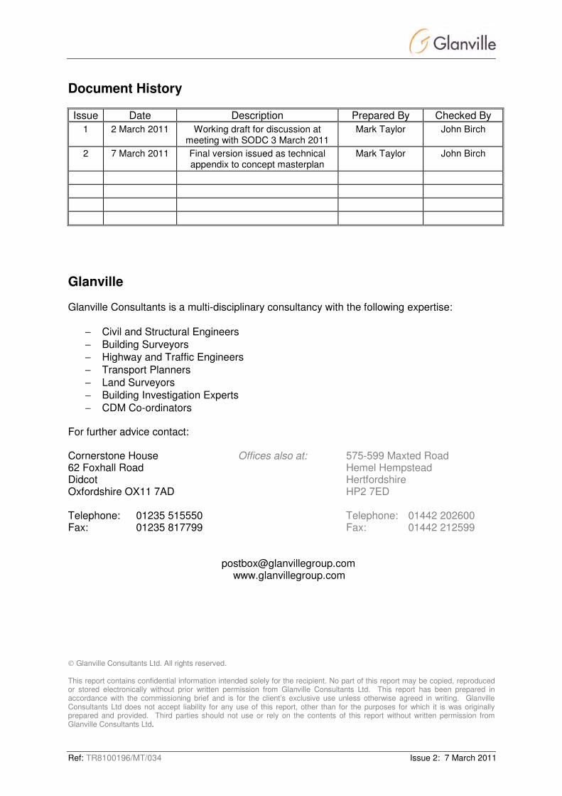
Document History
Issue Date Description Prepared By Checked By
1 2 March 2011 Working draft for discussion at meeting with SODC 3 March 2011
Mark Taylor John Birch
2 7 March 2011 Final version issued as technical appendix to concept masterplan
Mark Taylor John Birch
Glanville Glanville Consultants is a multi-disciplinary consultancy with the following expertise:
− Civil and Structural Engineers
− Building Surveyors
− Highway and Traffic Engineers
− Transport Planners
− Land Surveyors
− Building Investigation Experts
− CDM Co-ordinators For further advice contact: Cornerstone House Offices also at: 575-599 Maxted Road 62 Foxhall Road Hemel Hempstead Didcot Hertfordshire Oxfordshire OX11 7AD HP2 7ED
Telephone: 01235 515550 Telephone: 01442 202600 Fax: 01235 817799 Fax: 01442 212599
[email protected] www.glanvillegroup.com
Glanville Consultants Ltd. All rights reserved. This report contains confidential information intended solely for the recipient. No part of this report may be copied, reproduced or stored electronically without prior written permission from Glanville Consultants Ltd. This report has been prepared in accordance with the commissioning brief and is for the client’s exclusive use unless otherwise agreed in writing. Glanville Consultants Ltd does not accept liability for any use of this report, other than for the purposes for which it is was originally prepared and provided. Third parties should not use or rely on the contents of this report without written permission from Glanville Consultants Ltd.

Ref: TR8100196/MT/034 Issue 2: 7 March 2011
Contents
Executive Summary .............................................................................................................. 1
1.0 Introduction ................................................................................................................ 3
2.0 Scope of Report ......................................................................................................... 4
3.0 Proposed Development Site ....................................................................................... 5
4.0 Planning Policy and Legislative Framework................................................................ 7
5.0 Sources of Potential Flooding................................................................................... 11
6.0 Flood Modelling ........................................................................................................ 13
7.0 Surface Water Drainage and Attenuation Strategy ................................................... 14
8.0 Pollution Control ....................................................................................................... 19
9.0 Maintenance and Adoption....................................................................................... 20
10.0 Residual Risk ........................................................................................................... 21
11.0 Foul Water Drainage Statement ............................................................................... 22
12.0 Summary and Conclusions....................................................................................... 23
Appendices Appendix A Site Location Plan
Appendix B EA Correspondence
Appendix C Concept Masterplan
Appendix D Topographical Survey
Appendix E Surface Water Drainage Strategy
Appendix F Foul Water Drainage Strategy
Ref: TR8100196/MT/034 1 Issue 2: 7 March 2011
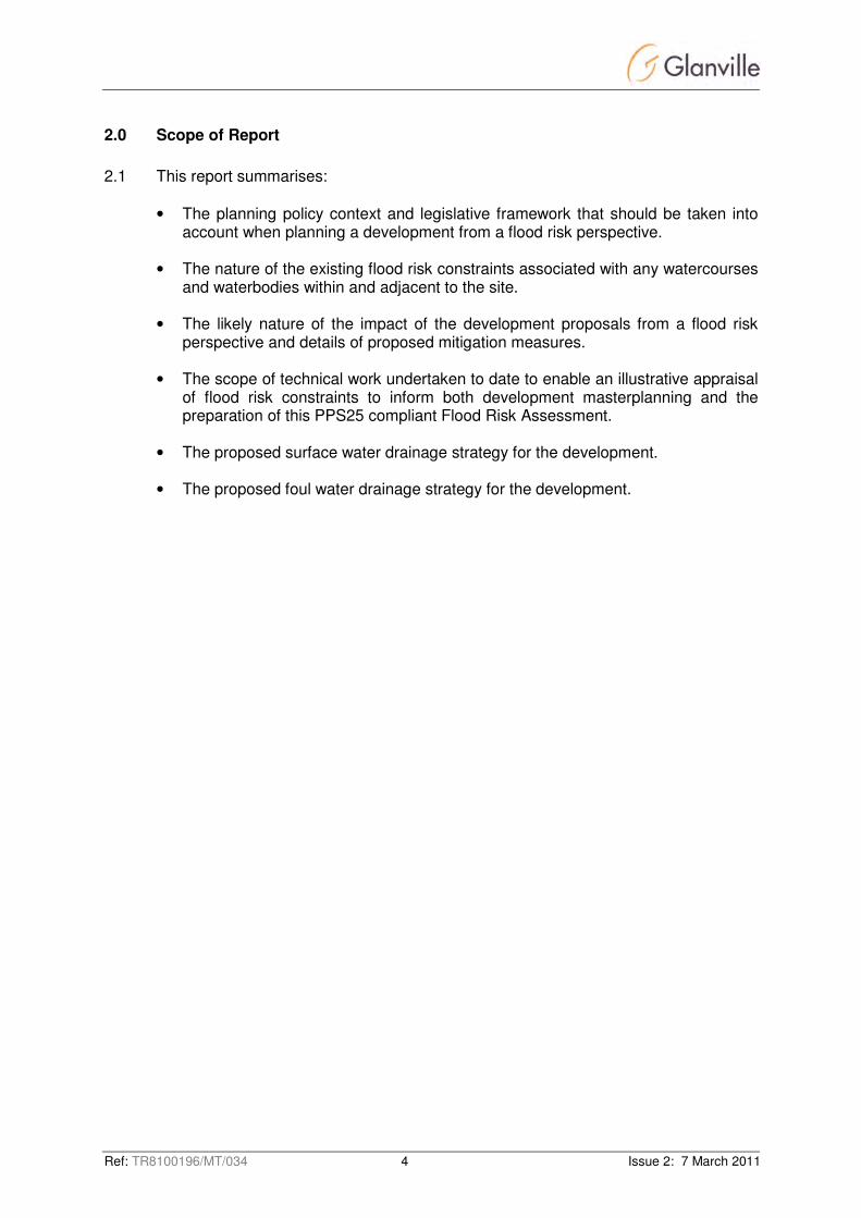
Executive Summary
In May 2010 Glanville carried out an initial appraisal of Site F from a flooding and surface water drainage perspective. Although a proportion of the site is within the flood plain, this study concluded that Site F is suitable for residential development of the scale proposed. Site F was subsequently chosen by South Oxfordshire District Council (SODC) as the preferred site for a large-scale housing development in Thame following consultation on the Council’s Core Strategy Options. A Flood Risk Assessment has been prepared as a technical appendix to the concept masterplan that will accompany SODC’s Core Strategy submission for Site F in mid-March 2011. Discussions have been held with the Environment Agency and Oxfordshire County Council’s drainage engineer to agree the scope of work required as part of the Flood Risk Assessment (FRA), to be carried out in accordance with Planning Policy Statement 25 (PPS25) – “Development and Flood Risk”. These discussions have also agreed an outline surface water drainage strategy for the site. This FRA sets out illustrative proposals for the control and management of flood risk and surface water run-off associated with the development proposals and will in time be further developed as required to support an outline planning application. The FRA has considered the nature of flood risk associated with the River Thame and its tributary, Cuttle Brook, which form the north-eastern boundary of the site, as well as potential for ground and surface water flows. Review of the Environment Agency flood map information indicates that the flood envelope associated with these watercourses occupies approximately 8.5ha of the site, leaving 22.5ha above and outside the flood envelope. Further detailed flood modelling will be carried out to support any future outline planning application. Urban development on Site F will be limited to the area outside the flood plain and on this basis, and within the context of PPS25, Annex D, Table D.1, the proposed development area would be categorised as Flood Zone 1 – Low Probability in flood risk terms, and the proposals will not give rise to any loss of flood plain storage or interrupt flood flow conveyance. Furthermore, in consultation with the Environment Agency, it has been agreed to incorporate elements within the development to reduce run-off to below the pre-development “greenfield” rates and increase flood storage within the flood plain as far as practicable. Thus the development will provide improvements in terms of flooding and a consequent reduction in associated risk, both to Site F and surrounding areas. The development proposals include the implementation of a surface water management (drainage and attenuation) strategy. The FRA demonstrates that the strategy proposed will be sufficient to accommodate the surface water run-off which will be generated by the development, taking into account the reduction in run-off rates described above.

Ref: TR8100196/MT/034 2 Issue 2: 7 March 2011
The surface water drainage strategy will seek to discharge as much of the surface water run-off from the site as possible through infiltration drainage techniques, as well as incorporating sustainable drainage systems (SUDS) where feasible. Further details will be provided when the results of infiltration tests carried out as part of an intrusive site investigation for Site F are available. The FRA also considers provisions for foul water drainage to ensure that the foul water drainage strategy for Site F will not lead to any increase in flood risk downstream. The foul water drainage strategy will be further developed in consultation with the incumbent statutory drainage undertaker, Thames Water. The proposals are considered to fully comply with National, Regional and Local planning policy and it is concluded that the development of Site F is acceptable in flood risk and surface water drainage terms.

Ref: TR8100196/MT/034 3 Issue 2: 7 March 2011
1.0 Introduction
1.1 Site F has been selected by South Oxfordshire District Council (SODC) as the
preferred site for large-scale housing development in Thame following consultation on the Council’s Core Strategy Options. SODC’s Core Strategy submission is to be subject of Examination in Public in Summer 2011.
1.2 Site F is located to the north-west of Thame and is bounded by the A418 bypass to
the west, Oxford Road to the south, Cuttle Brook to the east and the River Thame to the north. A location plan is included at Appendix A.
1.3 Glanville Consultants has been engaged by Regeneration Holdings Ltd to prepare a
Flood Risk Assessment in accordance with Planning Policy Statement 25 (PPS25) – “Development and Flood Risk” as a technical appendix to the concept masterplan that will accompany SODC's core strategy submission for Site F in mid March 2011.
1.4 The purpose of this document is to set out principles for the control and management
of flood risk and surface water run-off associated with the development proposals for Site F.
1.5 Prior to the preparation of this assessment, discussions were held with the
Environment Agency (EA) to determine the scope of work and agree various technical parameters. Relevant correspondence, including notes of a meeting held with the EA in February 2011 is included at Appendix B.
1.6 The flood risk assessment and associated surface water drainage strategy will be
further developed in support of any outline planning application for the development of the site for residential purposes.
Ref: TR8100196/MT/034 4 Issue 2: 7 March 2011
2.0 Scope of Report
2.1 This report summarises:
• The planning policy context and legislative framework that should be taken into account when planning a development from a flood risk perspective.
• The nature of the existing flood risk constraints associated with any watercourses and waterbodies within and adjacent to the site.
• The likely nature of the impact of the development proposals from a flood risk perspective and details of proposed mitigation measures.
• The scope of technical work undertaken to date to enable an illustrative appraisal of flood risk constraints to inform both development masterplanning and the preparation of this PPS25 compliant Flood Risk Assessment.
• The proposed surface water drainage strategy for the development.
• The proposed foul water drainage strategy for the development.

Ref: TR8100196/MT/034 5 Issue 2: 7 March 2011
3.0 Proposed Development Site
Site Description
3.1 Site F extends to 34.7Ha, and is currently used predominantly for agricultural purposes. An area of 7.6Ha in the north-eastern part of the site is within the flood plain of the River Thame and Cuttle Brook, and so the area suitable for accommodating residential development is 27.1Ha, including roads and green spaces.
3.2 The proposed concept masterplan for the development of Site F is included at
Appendix C and incorporates the following:
• 530 dwellings, interspersed with green corridors;
• Means of access and associated infrastructure works;
• Public open space with links to nearby areas of similar environmental importance; and
• Enhancement of Cuttle Brook to re-introduce the natural meanders, improve biodiversity and increase flood plain storage.
Topography
3.3 In respect of topography the proposed development site can be split into three areas:
• The north-east corner of the site, adjacent to the River Thame and Cuttle Brook is low lying and relatively flat, at around 62m AOD. This area forms the floodplain of the aforementioned watercourses.
• The land then rises steadily from 62m to a high point of 76.6m AOD, at a gradient of approximately 1:17, in a south-westerly direction.
• There is a small plateau area in the south-west corner of the site with gradients levelling off to around 1:50.
3.4 A topographical survey of the site has been carried out by Midland Survey Ltd, an
overview of which is included at Appendix D for reference.
Geology 3.5 The predominant underlying geology is made up of the Kimmeridge Clay formation. 3.6 As would be expected, within the floodplain to the north-west of the site the clay is
overlain with alluvium and river terrace deposits. 3.7 Deposits on much of the higher land to the south comprise sand with the underlying
clay surfacing along the north-western boundary.

Ref: TR8100196/MT/034 6 Issue 2: 7 March 2011
Existing Watercourses 3.8 There are two existing watercourses located adjacent to the proposed development
site boundary. The Cuttle Brook flows in a northerly direction and forms the eastern boundary of the development site. The brook discharges into the River Thame, which then flows in a north-westerly direction, again forming the boundary of the site, to pass under the A418.
Existing Surface Water Drainage 3.9 The incumbent drainage undertaker is Thames Water. From a review of Thames
Water's asset location plans there are no public surface water sewers within the development site.
3.10 There has been no previous development on site beyond the construction of a timber
farm building, therefore no private drainage systems are expected to be found. 3.11 At present surface water run-off from the existing farm building will drain to adjacent
permeable areas within the site to infiltrate away over time.
Groundwater Vulnerability 3.12 The Environment Agency (EA) publishes plans of indicative Source Protection Zones
(SPZs) for 2000 groundwater sources such as wells, boreholes and springs used for public drinking water supply. The Zones define areas where a range of human activities may damage/pollute groundwater. The maps show three main zones (inner, outer and total catchment) and a fourth zone of special interest.
3.13 Examination of EA groundwater mapping shows that the proposed development site
is not within a Source Protection Zone.
3.14 The phase 1 site investigation indicates that the groundwater level reflects the local topography being located at very shallow depths near the watercourses and much deeper (>2.5m) in the west of the site where the housing will be located.
Ref: TR8100196/MT/034 7 Issue 2: 7 March 2011
4.0 Planning Policy and Legislative Framework
4.1 Set out below is a summary of the national legislation and guidance relating to
surface water drainage and fluvial flood risk that the development proposals will comply with.
Planning Policy Statement 25 – Development and Flood Risk (updated 2010)
4.2 PPS25 focuses on national policy and seeks to provide clarity on what is required at regional and local levels to ensure that flood risk is taken into account at all stages of the planning process, to avoid inappropriate development in areas at risk of flooding and to direct development away from areas at highest flood risk. PPS25 retains a risk based approach to the planning process defines three Flood Zones to be used as the basis for applying the sequential test and introduces the Flood Risk Vulnerability Classification which defines the type of development that is considered appropriate within each Flood Zone. Taken together, the Flood Zone and Flood Risk Vulnerability Classification are used to provide a Flood Zone “Compatibility” matrix.
4.3 In addition to providing guidance in respect of flooding associated with rivers and tidal sources, PPS25 sets out guidance for managing surface water run-off from development. Specifically, the guidance requires that through the use of Sustainable Drainage Systems (SUDS) the developed rate of run-off into a watercourse or other receiving system should be no greater than the existing rate of run-off. In addition, developers are encouraged to reduce volumes of run-off using infiltration techniques.
4.4 The PPS25 Flood Zones do not currently take account of climate change impacts. However, PPS25 requires that the spatial planning process should consider such issues and contingency allowances are provided to enable the implications of climate change to be considered over the lifetime of the development. Planning Policy Statement 1 – Delivering Sustainable Development (2005)
4.5 PPS1 sets out a broad framework within which the planning system should operate to contribute to the delivery of sustainable development. PPS1 states that development plan policies should take account of environmental issues such as:
• Mitigation of the effects of, and adaptation to, climate change through the reduction of greenhouse gas emissions and the use of renewable energy; air quality and pollution; land contamination; the protection of groundwater from contamination; and noise and light pollution.
• The potential impact of the environment on proposed developments by avoiding new development in areas at risk of flooding and sea-level rise, and as far as possible, by accommodating natural hazards and the impacts of climate change.
The Flood and Water Management Act (2010)
4.6 In response to Sir Michael Pitt’s review of the 2007 floods, the Flood and Water Management Act places duties on the Environment Agency, Local Authorities, developers and other bodies to manage flood risk. In particular, it sets out the requirement for the approval (to a forthcoming national standard) and adoption of SUDS by the Lead Local Authority.

Ref: TR8100196/MT/034 8 Issue 2: 7 March 2011
Water Framework Directive (2000/60/EC) 4.7 The WFD is a wide-ranging piece of European legislation that establishes a new
legal framework for the protection, improvement and sustainable use of surface waters, coastal waters and groundwater across Europe in order to:
• Prevent deterioration and enhance status of aquatic ecosystems, including groundwater.
• Promote sustainable water use.
• Reduce pollution.
• Contribute to the mitigation of floods and droughts.
4.8 Water management has historically been co-ordinated according to administrative or political boundaries. The WFD promotes a new approach based upon management by river basin – the natural geographical and hydrological unit. River basin management plans include clear objectives in respect of water quality and pollution control and a detailed account of how objectives are to be met within a prescribed timeframe.
Water Resources Act (1991)
4.9 The WRA came into effect in 1991 and replaced the corresponding sections of the Water Act 1989.
4.10 The WRA sets out the responsibilities of the Environment Agency in relation to water pollution, resource management, flood defence, fisheries and, in some areas, navigation. The WRA regulates discharges to controlled waters, namely rivers, estuaries, coastal waters, lakes and groundwater. Discharge to controlled waters is only permitted with the consent of the Environment Agency. Similarly, a licence is required to abstract from controlled waters.
The Groundwater Regulations (2009)
4.11 The regulations transpose the requirements of the Groundwater Directive into UK legislation, and incorporate the 1998 Groundwater regulations. The regulations place a duty on the Environment Agency to protect groundwater by prohibiting discharges of List I substances to groundwater and preventing pollution of groundwater resulting from the discharge of List II substances.
4.12 The regulations require that the direct or indirect discharge of List I or List II
substances must be subject to prior investigation and authorisation and also allow notices to be served to control activities which may lead to discharges of List I or List II substances.

Ref: TR8100196/MT/034 9 Issue 2: 7 March 2011
The Environmental Permitting Regulations (England and Wales) 2010
4.13 In 2007 the regulations combined the Pollution Prevention and Control (PPC) and Waste Management Licensing (WML) regulations. Their scope has since been widened to include water discharge and groundwater activities, radioactive substances and provision for a number of Directives, including the Mining Waste Directive.
4.14 The new requirements for permitting were introduced to provide better regulation of activities which may have an impact upon the environment and human health.
Interim Code of Practice for Sustainable Drainage Systems (2004)
4.15 This Code of Practice provides support for developers in promoting and implementing a sustainable approach to water management and in particular Sustainable Drainage Systems (SUDS), to ensure their long-term viability and to promote consistent use. The document sets out the key regulatory requirements that must be considered and adhered to before SuDS are installed and commissioned.
Sewers for Adoption 6th Edition (2006)
4.16 Sewers for Adoption is the standard in England and Wales for the design and construction of sewers to adoptable standards. It is a guide to assist developers in preparing their submission to a Sewerage Undertaker prior to entering an Adoption Agreement under Section 104 of the Water Industry Act 1991.
Building Regulations Part H (updated 2002)
4.17 The Building Regulations Part H is the standard in England and Wales for the design and construction of both surface water and foul water private drains.
Code for Sustainable Homes 4.18 The CfSH, Category 4 - Surface Water Run-off, contains requirements for the
management of surface water run-off arising from development proposals, “to design housing developments which avoid, reduce and delay the discharge of rainfall to public sewers and watercourses. This will protect watercourse and reduce the risk of localised flooding, pollution and other environmental damage”. SUR1 Surface Water Run-off is a mandatory requirement for all levels of the CfSH.
Building Research Establishment Environmental Assessment Method (BREEAM)
4.19 BREEAM is an assessment methodology for sustainable design in buildings in order
to mitigate the impact buildings may have upon the environment.

Ref: TR8100196/MT/034 10 Issue 2: 7 March 2011
4.20 The following assessment criteria which may be implemented within a development may have an effect on the surface water drainage strategy and flood risk.
• Wat 5 - to encourage the collection and reuse of waste water or rainwater to meet toilet flushing needs and reduce the demand for potable fresh water. This can be achieved through inclusion of rainwater harvesting systems within the surface water drainage strategy.
• Pol 5 - to encourage development in low flood risk areas or to take measures to reduce the impact of flooding on buildings in areas with a medium or high risk of flooding.
Ref: TR8100196/MT/034 11 Issue 2: 7 March 2011
5.0 Sources of Potential Flooding
Tidal / Coastal
5.1 The nearest source of tidal or coastal flooding is approximately 70km from the site,
accordingly it is not considered to be a risk.
Groundwater 5.2 As previously noted within Section 3, groundwater level in the west of the site is more
than 2.5m deep, the proposed development site is not therefore considered to be at risk of groundwater flooding.
Surface Water
5.3 As previously noted in Section 3, there is currently no surface water drainage
infrastructure within the proposed development site and therefore no risk of flooding from surface water sewers.
5.4 As previously noted within Section 3, the proposed development site generally slopes
from west to east with gradients up to 1:17. On this basis it may be potentially at risk during higher order rainfall events from overland flows generated to the west of the site.
5.5 The site is separated from adjacent greenfield areas to the north and west by the
A418 and from urban development to the south by Oxford Road, preventing surface water from entering the site from those directions.
River
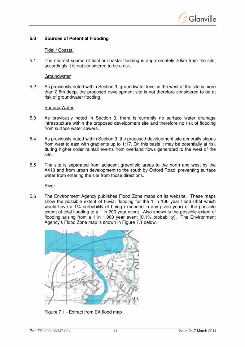
5.6 The Environment Agency publishes Flood Zone maps on its website. These maps
show the possible extent of fluvial flooding for the 1 in 100 year flood (that which would have a 1% probability of being exceeded in any given year) or the possible extent of tidal flooding to a 1 in 200 year event. Also shown is the possible extent of flooding arising from a 1 in 1,000 year event (0.1% probability). The Environment Agency’s Flood Zone map is shown in Figure 7.1 below.
Figure 7.1 - Extract from EA flood map

Ref: TR8100196/MT/034 12 Issue 2: 7 March 2011
5.7 The extract from EA flood map indicates that the proposed development site is
adjacent to the floodplain associated with the River Thame and Cuttle Brook. 5.8 There are no modelled flood levels available for this section of the River Thame.
Given the proximity of the flood plain to the proposed development it was deemed necessary to commission detailed topographical survey and flood modelling of the area to confirm the flood levels and accurately set the limit of the developable area.
5.9 Furthermore, the Environment Agency has requested that run off from the site be
reduced below greenfield rates and improvements be made to the course and profiles of the Cuttle Brook to increase flood plain storage. The efficacy of these improvements will be demonstrated by development of the flood model.
5.10 By comparing the modelled flood levels within the site to the topographical survey it
will be possible to ensure that the proposed development area is contained within Flood Zone 1 as defined by PPS25 Table 10, and will be classified as having a low probability of flooding. Table 7.1- Extract from Table 10.1 – PPS25 Flood Zones
Zone 1 Low Probability
Definition This zone comprises land assessed as having a less than 1 in 1000 annual probability of river or sea flooding in any year (<0.1%).
Appropriate uses All uses of land are appropriate in this zone.
FRA requirements For development proposals on sites comprising one hectare or above the vulnerability to flooding from other sources as well as from river and sea flooding, and the potential to increase flood risk elsewhere
through the addition of hard surfaces and the effect of the new development on surface water run-off, should be incorporated in a
FRA. This need only be brief unless the factors above or other local considerations require particular attention. See Annex E for minimum
requirements.
Policy aims In this zone, developers and local authorities should seek opportunities to reduce the overall level of flood risk in the area and beyond through
the layout and form of the development, and the appropriate application of sustainable drainage techniques.
Ref: TR8100196/MT/034 13 Issue 2: 7 March 2011
6.0 Flood Modelling
6.1 Detailed catchment modelling will be carried out to confirm the extent of the flood
plain and the efficacy of the reduced discharge rates. It will also examine the re-engineering of the Cuttle Brook watercourse and the increase of flood plain storage volumes proposed for the site.
6.2 The methods and parameters for the modelling will be agreed with the Environment
Agency in advance to ensure that the models meet with their auditing and reporting criteria and results can be integrated into their existing systems.
6.3 This information will be provided as part of an updated Flood Risk Assessment in
support of any outline planning application for the development of Site F for residential purposes.

Ref: TR8100196/MT/034 14 Issue 2: 7 March 2011
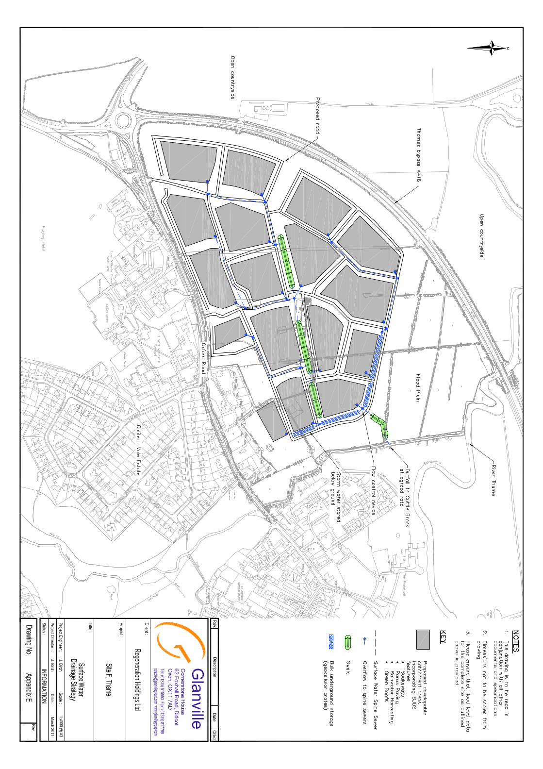
7.0 Surface Water Drainage and Attenuation Strategy
Overview
7.1 This section of the report sets out an illustrative surface water management
(drainage and attenuation) strategy for the proposed development. These proposals are included within Appendix E for reference.
7.2 The surface water management strategy, as an element of the overall water
management strategy, will ensure that there is a reduced risk of downstream flooding arising from the development proposals. Where possible the site will also seek to improve the existing watercourses and utilise surface water run-off and drainage infrastructure to encourage habitat creation. These aims have been agreed in principle with the Environment Agency and copies of the correspondence relating to the discussions are included in Appendix B.
Surface Water Drainage Strategy
7.3 An illustrative surface water drainage strategy has been prepared based upon the
indicative masterplan in accordance with the general design principles set out below. The strategy will ensure there is a reduction in downstream flood risk arising from the proposed development.
7.4 PPS25 Annex F paragraph F5 states that ‘The effective disposal of surface water
from development is a material planning consideration in determining proposals for the development and use of land’.
7.5 PPS25 Annex F paragraph F6 states that ‘Surface water arising from a developed
area should, as far as practicable, be managed in a sustainable manner to mimic the surface water flows arising from the site prior to the proposed development, while reducing the flood risk to the site itself and elsewhere, taking climate change into account’.
7.6 The Building Regulations Requirement H3 stipulates that rainwater from roofs and
paved areas must be carried away from the surface to discharge to one of the following, listed in order of priority:
a) an adequate soakaway or some other adequate infiltration system, b) a watercourse or, where that is not practicable, c) a sewer.
7.7 As previously noted in Section 5 no formal surface water drainage infrastructure
exists within the site.
7.8 Surface level infiltration tests were undertaken in early March 2011. The results indicate that the mix of clay, sand and gravels overlying the majority of the site have moderate permeability and will permit the use of ground level infiltration systems for at least part of the site.
Ref: TR8100196/MT/034 15 Issue 2: 7 March 2011
7.9 On this basis it is proposed that surface water run-off generated by the development be discharged wherever possible through infiltration source control techniques, either through the use of soakaways or swales.
7.10 Groundwater levels were found to be relatively shallow in the east of the site, which
would prohibit the use of soakaways in this area by virtue of insufficient inert ground between the soakaway invert and groundwater level.
7.11 In areas of the site where infiltration is not possible either due to poor infiltration rates or high groundwater level it is proposed to use attenuated discharge to reduce flows to 70% of the agreed greenfield run-off rates.
7.12 Attenuation storage will be provided by geocellular crates forming tanks below parking areas and roads, with discharged controlled via vortex flow control devices.
7.13 It is expected, subject to confirmation of sub-soil characteristics, that the surface water drainage to serve the proposed development be split into a number of small catchments. In the higher area of the site to the west, surface water will discharge to soakaways located in the gardens of dwellings or within common access areas such as parking bays. In higher order events where soakaways will be overwhelmed excess flows will discharge via swales within the green corridors to join the attenuated discharge system in the east of the site.
7.14 The attenuated discharge system will accommodate flows from catchments within the
site which do not have suitable soakaway characteristics, and overflows from soakaways elsewhere in the site, in a series of geocellular tanks. These tanks will discharge water at the sub-greenfield rates agreed with the Environment Agency and set out in Table 7.1 below.
7.15 Outline proposals showing the surface water drainage system are illustrated in
Appendix E.
Surface Water Drainage Design Parameters 7.16 This section of the report sets out the design parameters that will be used in the
design of the surface water drainage systems serving the development proposals. 7.17 In order that the surface water drainage serving the development be brought forward
for adoption by the incumbent drainage undertaker (Thames Water) or the lead drainage authority (Oxfordshire County Council) the proposed surface water drainage system will be designed in accordance with Sewers for Adoption 6th Edition and the SUDS Manual (ciria C697). Drainage associated solely with highways will be designed in accordance with the requirements of the Local Highway Authority. Private surface water drainage systems will be designed in accordance with the Building Regulations Part H.

Ref: TR8100196/MT/034 16 Issue 2: 7 March 2011
7.18 The proposed piped surface water drainage system will be designed to ensure self cleansing velocities are achieved in the 1 in 1 year event utilising:
• FSR rainfall data (industry standard practice);
• A volumetric run-off coefficient (cv) of 0.75 in accordance with industry standard practice;
• MicroDrainage (WinDes) design software, such that the piped drainage network will have no above soffit surcharging in the 1 in 1 year rainfall event and no above ground flooding in the 1 in 100 year rainfall event.
7.19 PPS25 requires that surface water drainage systems should cope with events that
exceed the design capacity of the system, so that excess water can be safely stored on or conveyed from the site without adverse impacts. The surface water management strategy for the development will ensure that overland flows be routed away from buildings towards the less vulnerable highways, open space and surface water attenuation provision.
Surface Water Attenuation Strategy
7.20 This section of the report sets out the preliminary surface water attenuation strategy
for the development proposals and the parameters to be used in its design. 7.21 As previously noted above, the surface water drainage system will incorporate
soakaways to discharge surface water run-off to the underlying strata. 7.22 However, during higher order rainfall events, where the rate of surface water run-off
exceeds the capacity of surface water interception systems and the capacity of the soakaways overflows will be directed into attenuation storage. The attenuation storage will also retain flows from areas not served by soakaways.
7.23 The volume of storage will be sufficient to store the surface water run-off which can
not be immediately discharged from the site up to and including the 1 in 100 year rainfall event plus an allowance for climate change.
7.24 This water will then discharge via a vortex flow control device to the adjacent
watercourse at the rates given in table 7.1.
Table 7.1- Agreed Discharge Rates
Rainfall Return Period Greenfield Run-off Rate Agreed Run-off Rate
(30% reduction)
Qbar (average annual) 3.7 l/s/ha 2.6 l/s/ha
Q10 5.9 l/s/ha 4.1 l/s/ha
Q30 8.3 l/s/ha 5.8 l/s/ha
Q100 11.7 l/s/ha 8.2 l/s/ha
Ref: TR8100196/MT/034 17 Issue 2: 7 March 2011
Flood Estimation Handbook (FEH) 7.25 The design of surface water attenuation provision will be undertaken using catchment
specific rainfall parameters derived from the Flood Estimation Handbook (FEH).
Volumetric Run-off Coefficient for Design of the Attenuation Provision 7.26 A volumetric run-off coefficient (cv) of 0.75 will be utilised in the sizing of the surface
water attenuation provision.
Climate Change 7.27 As the development proposals are residential which could potentially have a long
lifespan, proposed attenuation provision will be sized to allow for an increase of up to 30% in rainfall intensity due to the effects of climate change in accordance with the requirements of PPS25.
Consideration of Further SUDS Measures
7.28 The illustrative strategic surface water drainage strategy to serve the development
proposals are outlined above. These will rely principally on positive drainage systems, gravity sewers and soakaways. However, as the plot by plot development proposals are confirmed in detail the proposed development will seek to incorporate further SUDS to:
• reduce and delay surface water run-off peak flows;
• mimic natural process where feasible;
• reduce peak flow rates;
• improve water quality; and
• create ecological habitat. 7.29 Subject to confirmation of feasibility, further SUDS which could potentially be
incorporated into the scheme in the future may take the form of any, or a combination, of the following:
• Filter drains - can be provided to intercept flows, mimicking natural ground and filtering suspended fine particles, improving water quality.
• Swales - provide source control by reducing flow speeds, reducing peak flows and potentially provide a storage volume. Additional Swales may also be used to create new ecological habitat within the development site.
• Rainwater harvesting - using either underground storage tanks to serve either individual or several properties, or traditional water butts on individual down pipes. Rainwater harvesting systems may be incorporated into the site to support CfSH or BREEAM principles.
• Living roofs - green roofs (and green walls), roof terraces and roof gardens. Green roofs provide some attenuation by reducing peak flows and volumes of surface water run-off. Living roofs also have potential to help regulate the temperature of buildings and provide unique ecological habitat.

Ref: TR8100196/MT/034 18 Issue 2: 7 March 2011
7.30 As proposals are developed in detail to potentially include any of the above the requirement soakaways and above attenuation volumes for up to an including the 1 in 100 year rainfall event plus an allowance for climate change will be reviewed and reduced accordingly.

Ref: TR8100196/MT/034 19 Issue 2: 7 March 2011
8.0 Pollution Control
8.1 Trapped gullies and outfall units will be incorporated as standard within the proposed
development, highways and car parks. 8.2 CIRIA 156 Infiltration Drainage – Manual of Good Practice suggests that surface
water run-off from roofs and public / amenity areas are permissible without pollution control measures. Surface water run-off from trafficked areas such as car parks and highways should be treated with a petrol interceptor or drained through permeable paving before discharge. On this basis, petrol interceptors will be provided on surface water drainage systems where required.
8.3 In addition, proposed attenuation measures, swales and retention tanks may also
improve surface water run-off quality. Other additional SUDS measures which may be included, such as filter drains may also improve surface water run-off quality.
Ref: TR8100196/MT/034 20 Issue 2: 7 March 2011
9.0 Maintenance and Adoption
9.1 The surface water drainage system will be designed in accordance with Sewers for
Adoption 6th Edition such that it can be brought forward for adoption by the incumbent statutory drainage undertaker or Local Authority as appropriate.
9.2 The attenuation / interception swales, shared soakaways and retention tanks will be
located within the public open space. It is proposed that all SUDS be adopted such that their ongoing maintenance is ensured. The Flood and Water Management Act sets out that SUDS should be brought forward for adoption by the SUDS approval body, which in this case would be Oxfordshire County Council. The detail of adoption and maintenance will be set out as part of reserved matters.

Ref: TR8100196/MT/034 21 Issue 2: 7 March 2011
10.0 Residual Risk
10.1 As stated in Section 7, the surface water drainage system will be designed to
accommodate rainfall from the 1 in 100 year event, with a suitable allowance for climate change, as required by PPS 25.
10.2 Any rainfall event with intensity in excess of that of the above design rainfall event
may result in temporary above ground flooding, potentially giving rise to overland flows.
10.3 The existing topography of the site falls from south-west to north-east. It is expected
that the developed plot levels will follow this profile. 10.4 Overland flows within the development proposals will be routed away from buildings
towards car parks. They will be channelled through the development using either the proposed highways or green spaces, towards the flood plain to the east and north-east of the site.

Ref: TR8100196/MT/034 22 Issue 2: 7 March 2011
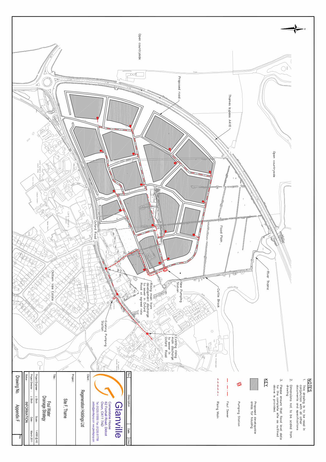
11.0 Foul Water Drainage Statement
11.1 This section sets out an illustrative foul water drainage strategy for the development
proposals. A Foul Drainage and Utilities Assessment has been prepared as a separate technical appendix.
Existing Foul Water Drainage Infrastructure
11.2 The asset location plans for the incumbent statutory drainage undertaker (Thames
Water) indicate that there are no existing public foul water sewers within the site. The closest foul water sewer to the proposed development site runs parallel to the southern boundary along Oxford Road.
11. 3 The foul water strategy for the site is currently under review by Thames Water who is
examining its broader local infrastructure to ensure adequate overall capacity is maintained. Thames Water is due to report in March 2011.
Illustrative Foul Water Drainage Strategy
11.4 An illustrative foul water drainage strategy for the development has been produced,
based upon the indicative masterplan, and can be found at Appendix F. This will be reviewed in due course to ensure that it can be integrated with the wider infrastructure requirements of Thames Water.

Ref: TR8100196/MT/034 23 Issue 2: 7 March 2011
12.0 Summary and Conclusions 12.1 This Flood Risk Assessment has been prepared in accordance with Planning Policy
Statement 25 (PPS25) – “Development and Flood Risk” in support of an examination in public to be followed by an outline planning application for the construction of a housing development to the northwest of Thame known as Site F.
12.2 Review of Environment Agency flood map information indicates that the majority of
the site is located within Flood Zone 1 – Low Probability of Flooding. The proposed residential development will be confined to Flood Zone 1.
12.3 The development proposals include a surface water management system based on
the principles of sustainable infiltration drainage systems, with a view to reducing the existing surface water discharge to adjacent watercourses to below the existing greenfield rate.
12.4 Notwithstanding the increase in contributing impermeable area brought about by the
development, the assessment has set out how the surface water drainage and attenuation strategy proposed will accommodate the surface water run-off arising from the development proposals and will reduce downstream flood risk.
12.5 Design of attenuation provisions will include an allowance to cater for a 30% increase
in rainfall intensities as a result of climate change in accordance with PPS 25. 12.6 The development proposals will include improvements to the channel of the Cuttle
Brook by recreating the original meandering course and introducing additional flood plain storage.
12.7 Foul water drainage will be provided in line with the broader infrastructure
requirements of Thames Water. 12.8 In conclusion, this Flood Risk Assessment has demonstrated that the proposed
development:
• will not be at unacceptable risk of flooding;
• will reduce flood risk elsewhere; and
• has adopted a design process which has responded to the potential impacts of climate change.
12.9 On this basis, the proposals for the development of Site F are considered to fully
comply with National, Regional and Local planning policy.

Ref: TR8100196/MT/034 Issue 2: 7 March 2011
Appendices
Ref: TR8100196/MT/034 Issue 2: 7 March 2011
Appendix A
Site Location Plan


Ref: TR8100196/MT/034 Issue 2: 7 March 2011
Appendix B
EA Correspondence

Environment Agency
Red Kite House Howbery Park, Wallingford, Oxfordshire, OX10 8BD. Customer services line: 08708 506 506 Email: [email protected] www.environment-agency.gov.uk
Cont/d..
Mr Jeff Emmett JEFFREY CHARLES EMMETT 12 (A) Bell Lane Thame Oxfordshire OX9 3AL
Our ref: WA/2010/109012/01-L01 Your ref: - Date: 20 January 2011
Dear Mr Emmett Core Strategy Housing Preferred Option - Site F Thame Bypass, Thame It was good to meet you and your consultants on 14 December 2010. We thought it would be helpful to summarise our thoughts and some keys issues for your proposed development. Biodiversity We are pleased to see the proposed development will be set back from the river to help maintain a natural river corridor. We would like to see this corridor expanded as much as possible as this offers the most potential from a biodiversity point of view. The value of the Cuttle Brook can be greatly enhanced by re-profiling the channel, re-establishing the meanders and bends of the currently canalised section of the brook. The designs should look to provide an enhanced natural habitat as well as creating extra flood storage. The impact of these works will need to be assessed with the flood risk assessment. The lower section of the Cuttle Brook has been classified as having Good Ecological Status. According to the Water Framework Directive (WFD) there must be no deterioration of this waterbody. For more information please refer to the following websites www.environment-agency.gov.uk and www.wfduk.org.uk. The northern part of the site should be carefully designed with some scrapes, ditches and ponds to encourage wetland birds and water voles. Flood meadows such as this are a local priority habitat. As discussed at the meeting the idea of fishing ponds in the flood meadows should be abandoned. Shallow backwater areas directly linked to the Thame could provide the opportunity for fishing pontoons that could form part of a school education / recreational area. Work on the site master plan will need to be informed by the development of the surface water drainage scheme. The drainage scheme should be developed in conjunction with biodiversity and landscaping design to deliver multifunction Green

Cont/d..
2
Infrastructure throughout the development. Green corridors within the development should link up with exiting green space such as the local nature reserve around the Cuttle Brook to the south of the site. Incorporating Green Infrastructure into your development can increase its market value. Research by the Commission for Architecture and Built Environment (CABE) entitled ‘Does money grow on trees?’ has demonstrated that access to green space can increase property prices by as much as 34%. Green Infrastructure can provide a sense of place and character to your development that will appeal to consumers. Flood Risk As discussed at the meeting, a number of properties upstream on the Cuttle Brook and further properties downstream from this development are affected by fluvial flooding. It is essential that this development helps to deliver a reduction in flood risk in order to gain local support and meet the objectives of PPS25. We would strongly advise that a number of key objectives are set at this early stage of the design process to confirm the sustainable credentials of this development and remove any potential public misgivings. Firstly
1. Runoff rates will be set at 30 percent lower than calculated Greenfield run-off rates.
The reduction in the originally intended density to 530 units should mean there is ample space to achieve this goal. It will also show that this development is not only maintaining the status quo but will actually be reducing flood risk by a set percentage figure. Secondly
2. Fluvial flood risk is reduced by the creation of flood storage within the land bordering the current floodplain. A figure shown in cubic metres needs to be identified.
This will again show a clear commitment to reducing flood risk. Extra storage within the floodplain will reduce the risk to existing properties. We are pleased that your initial outline plans have located the development outside the Flood Zones and left this area as open space. We would recommend that you assess the floodplain extents in more detail by undertaking detailed flood modelling as our Flood Zone maps are indicative and do not take into account any infrastructure. For example, the bypass crossing over the River Thame may influence the level of flood water on this site causing it to back up into the site more extensively than is shown on our Flood Zone Maps. The modelling should also assess the impact of climate change in accordance with Planning Policy Statement 25 (PPS25). As mentioned above there is a good opportunity for you, the developer, to not only provide biodiversity enhancements but also provide a betterment to fluvial and surface water flooding at the same time. This can be achieved by the creation of a sustainable urban drainage system (SUDS) and more flood storage within the site, which will not only benefit the site but also provide a wider benefit to Thame. This

Cont/d..
3
would also ensure the development is in line with Policy EP6 and C6 from South Oxfordshire Local Plan, PPS25 and PPS9. The applicant should have a full understanding of the hydrology of the area, prior to determining the site master plan. The following should be established: - existing Greenfield run-off rates - overland flow routes - geology and permeability of the soils - groundwater levels. This information is required to ensure that the proposed surface water drainage for the site is feasible and will incorporate a best practice approach utilising green Sustainable Drainage Techniques to ensure surface water run-off will be attenuated up to the 1 in 100 year rainfall event including an allowance for climate change. Space should be allocated within the development to ensure above ground surface water features are feasible. These will offer not only a flood risk benefit but also biodiversity, water quality and amenity value to the site. A management train approach should be used from source control measures, conveyance measures and regional measures. This will ensure that any diffuse material is treated throughout the drainage system and reduces the requirement for a piped system. This will allow increased capacity within the drainage system and make it easier to detect any pollution within the system. There is also a good opportunity to utilise other techniques to promote water re-use such as water butts on individual properties and rain water harvesting on apartment blocks and community buildings. As this is a large development catchment, areas should be identified to ensure the drainage regime of the site is maintained and improved where possible. Surface water run-off should be controlled as near to its source as possible through a sustainable drainage approach to surface water management. SUDS are an approach to managing surface water run-off which seeks to mimic natural drainage systems and retain water on or near the site, as opposed to traditional drainage approaches which involve piping water off site as quickly as possible. Due to the geology (primarily Kimmeridge Clay), the potential for infiltration drainage is likely to vary considerably across the site, and as discussed at the meeting if infiltration is going to be relied on as part of the drainage design a significant number of percolation tests will be required to prove a drainage scheme will work. A more sensible approach for an outline application would be to design the drainage system with SUDS features that are not reliant on soakage but will allow it where possible. SUDS involve a range of techniques including soakaways, infiltration trenches, permeable pavements, grassed swales, ponds and wetlands. SUDS offer significant advantages over conventional piped drainage systems in reducing flood risk by attenuating the rate and quantity of surface water run-off from a site, promoting groundwater recharge, and improving water quality and amenity. The variety of SUDS techniques available means that virtually any development should be able to include a scheme based around these principles.

Cont/d..
4
Support for the SUDS approach to managing surface water run-off is set out in paragraph 22 of Planning Policy Statement 1 (PPS): Delivering Sustainable Development and in more detail in Planning Policy Statement 25: Development and Flood Risk at Annex F. Paragraph F8 of the Annex notes that "Local Planning Authorities should ensure that their policies and decisions on applications support and complement Building Regulations on sustainable rainwater drainage". Further information on SUDS can be found in:
• PPS25 page 33 Annex F
• PPS25 Practice Guide
• CIRIA C522 document Sustainable Drainage Systems-design manual for England and Wales
• CIRIA C697 document SUDS manual
• The Interim Code of Practice for Sustainable Drainage Systems.
The Interim Code of Practice provides advice on design, adoption and maintenance issues and a full overview of other technical guidance on SUDS. The Interim Code of Practice is available on both the Environment Agency's website: www.environment-agency.gov.uk and CIRIA's website: www.ciria.org.uk In areas of the site, groundwater is likely to occur at shallow depth. Infiltration drainage taking potentially contaminated run off (e.g. roads and car parking area) would not be accepted in areas of particularly shallow groundwater. There must be a sufficient unsaturated zone beneath any SUDs system to allow attenuation of any contamination. Ideally this should be greater than 1m. It may however be possible to accept less than 1m unsaturated zone, if additional safeguards are put in place. Any SUDs from roads, car or lorry parking areas would need to incorporate suitable measures for the protection of water quality, this is likely to include measures to mitigate the discharge of hydrocarbons to ground or surface water. Details of treatment techniques are outlined in Ciria Report C609. Contamination It would appear that Site F is solely used for agricultural purposes. Historic maps do indicate that there may have been one small pond on site which appears to have been unfilled. We have no details as to any infill material and this should be investigated. We do not expect contamination issues to be a major factor in any proposed development on this site. However, as with all sites, there is the possibility that there may be some minor or localised contamination issues. We would recommend that any potential sources of contamination should be identified at the earliest possible stage. Foul Drainage The developer should at the earliest opportunity communicate with the local utilities provider to establish whether sufficient capacity exists in the local sewerage and waste water treatment infrastructure to accommodate the development. If not, it will be necessary to submit a scheme for the local authority’s approval showing how infrastructure improvements will be delivered to account for the development. We are more than happy to have further discussions with you and your consultants

End
5
through the pre-application stages of this process. Yours sincerely Mr Jon Mansbridge Major Projects Officer Direct dial 01491 828 366 Direct fax 01491 834 703 Direct e-mail [email protected] cc Tom Wyatt, South Oxfordshire District Council
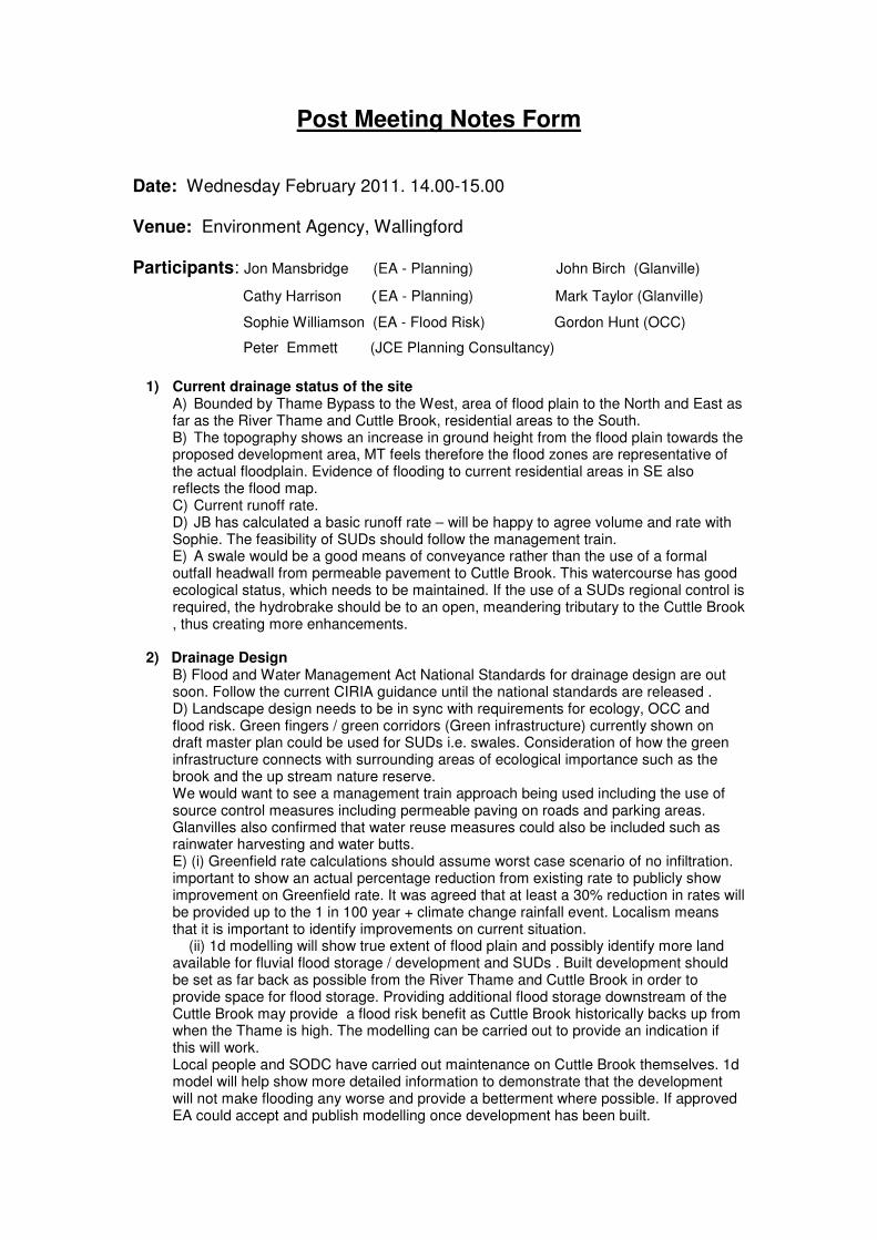
Post Meeting Notes Form
Date: Wednesday February 2011. 14.00-15.00 Venue: Environment Agency, Wallingford Participants: Jon Mansbridge (EA - Planning) John Birch (Glanville)
Cathy Harrison (EA - Planning) Mark Taylor (Glanville)
Sophie Williamson (EA - Flood Risk) Gordon Hunt (OCC)
Peter Emmett (JCE Planning Consultancy)
1) Current drainage status of the site A) Bounded by Thame Bypass to the West, area of flood plain to the North and East as far as the River Thame and Cuttle Brook, residential areas to the South. B) The topography shows an increase in ground height from the flood plain towards the proposed development area, MT feels therefore the flood zones are representative of the actual floodplain. Evidence of flooding to current residential areas in SE also reflects the flood map. C) Current runoff rate. D) JB has calculated a basic runoff rate – will be happy to agree volume and rate with Sophie. The feasibility of SUDs should follow the management train. E) A swale would be a good means of conveyance rather than the use of a formal outfall headwall from permeable pavement to Cuttle Brook. This watercourse has good ecological status, which needs to be maintained. If the use of a SUDs regional control is required, the hydrobrake should be to an open, meandering tributary to the Cuttle Brook , thus creating more enhancements.
2) Drainage Design
B) Flood and Water Management Act National Standards for drainage design are out soon. Follow the current CIRIA guidance until the national standards are released . D) Landscape design needs to be in sync with requirements for ecology, OCC and flood risk. Green fingers / green corridors (Green infrastructure) currently shown on draft master plan could be used for SUDs i.e. swales. Consideration of how the green infrastructure connects with surrounding areas of ecological importance such as the brook and the up stream nature reserve. We would want to see a management train approach being used including the use of source control measures including permeable paving on roads and parking areas. Glanvilles also confirmed that water reuse measures could also be included such as rainwater harvesting and water butts. E) (i) Greenfield rate calculations should assume worst case scenario of no infiltration. important to show an actual percentage reduction from existing rate to publicly show improvement on Greenfield rate. It was agreed that at least a 30% reduction in rates will be provided up to the 1 in 100 year + climate change rainfall event. Localism means that it is important to identify improvements on current situation. (ii) 1d modelling will show true extent of flood plain and possibly identify more land available for fluvial flood storage / development and SUDs . Built development should be set as far back as possible from the River Thame and Cuttle Brook in order to provide space for flood storage. Providing additional flood storage downstream of the Cuttle Brook may provide a flood risk benefit as Cuttle Brook historically backs up from when the Thame is high. The modelling can be carried out to provide an indication if this will work. Local people and SODC have carried out maintenance on Cuttle Brook themselves. 1d model will help show more detailed information to demonstrate that the development will not make flooding any worse and provide a betterment where possible. If approved EA could accept and publish modelling once development has been built.
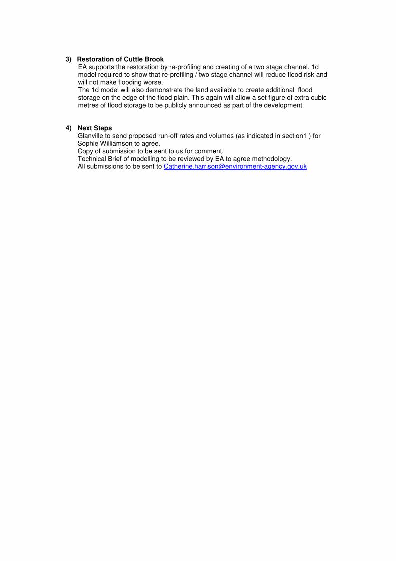
3) Restoration of Cuttle Brook
EA supports the restoration by re-profiling and creating of a two stage channel. 1d model required to show that re-profiling / two stage channel will reduce flood risk and will not make flooding worse. The 1d model will also demonstrate the land available to create additional flood storage on the edge of the flood plain. This again will allow a set figure of extra cubic metres of flood storage to be publicly announced as part of the development.
4) Next Steps Glanville to send proposed run-off rates and volumes (as indicated in section1 ) for Sophie Williamson to agree. Copy of submission to be sent to us for comment. Technical Brief of modelling to be reviewed by EA to agree methodology. All submissions to be sent to [email protected]

1
Mark Taylor
From: Harrison, Catherine [[email protected]]Sent: 21 February 2011 13:51To: Mark TaylorSubject: Site F ThameAttachments: Post Meeting Notes Form_9 February 2011 copy.doc
Dear Mark, I attach the minutes from the meeting. I'm sorry about the delay. We have also reviewed your e-mail and can confirm that the proposed greenfield run-off rate of 2.6l/s which includes the agreed 30% reduction in rates to provide a betterment is acceptable. The calculations provided should be quoted as the agreed run-off rates. Please could you also provide a worse case figure of surface water volume attenuation that will be required to determine the potential space required for above ground storage. This is important to identify if you are reducing the rate which will require more attenuation that the existing rate. The modelling which you carry out will also determine how much space you may have for SUDs and/or additional floodplain storage. We will be pleased to review these details. Cathy Harrison Planning Liaison Officer Tel. 01491 828515 Environment Agency Red Kite House Howbery Park Wallingford OX10 8BD
Information in this message may be confidential and may be legally privileged. If you have received this
message by mistake, please notify the sender immediately, delete it and do not copy it to anyone else.
We have checked this email and its attachments for viruses. But you should still check any attachment before
opening it.
We may have to make this message and any reply to it public if asked to under the Freedom of Information
Act, Data Protection Act or for litigation. Email messages and attachments sent to or from any Environment
Agency address may also be accessed by someone other than the sender or recipient, for business purposes.
If we have sent you information and you wish to use it please read our terms and conditions which you can
get by calling us on 08708 506 506. Find out more about the Environment Agency at www.environment-
agency.gov.uk

Ref: TR8100196/MT/034 Issue 2: 7 March 2011
Appendix C
Concept Masterplan


Ref: TR8100196/MT/034 Issue 2: 7 March 2011
Appendix D
Topographical Survey

Ref: TR8100196/MT/034 Issue 2: 7 March 2011
Appendix E
Surface Water Drainage Strategy

Ref: TR8100196/MT/034 Issue 2: 7 March 2011
Appendix F
Foul Water Drainage Strategy

Cornerstone House, 62 Foxhall Road, Didcot, Oxon OX11 7AD Tel: (01235) 515550 Fax: (01235) 817799 [email protected] www.glanvillegroup.com
− Civil and Structural Engineers − Building Surveyors − Highway and Traffic Engineers − Transport Planners − Land Surveyors − Building Investigation Experts − CDM Co-ordinators