floodplain analysis and conceptual levee alignment … · floodplain analysis and conceptual levee...
TRANSCRIPT

Duncan, Arizona
Floodplain Analysis and Conceptual Levee
Alignment along the Gila River
Ahmad Alfallaji
Abdulaziz Ebrahim
Jennalise Rapinchuk
Charles Wilson
Delivered By
Northern Arizona University Undergraduate Engineering Students
Fall Capstone Project
December 16th, 2015

Floodplain Analysis and Conceptual Levee Alignment along the Gila River
1
Table of Contents
Acknowledgments ................................................................................................................................................................... 3
1.0 Project Description ............................................................................................................................................................ 4
2.0 Project Background ........................................................................................................................................................... 5
2.1 Stakeholders .................................................................................................................................................................. 6
2.2 Site Assessment ............................................................................................................................................................ 6
3.0 Methods and Analysis ....................................................................................................................................................... 8
3.1 Data Collection ............................................................................................................................................................. 8
3.1.1 Hydraulics and Hydrology ..................................................................................................................................... 8
3.1.2 Surveying Data ....................................................................................................................................................... 8
3.1.3 Regulations to Follow ............................................................................................................................................ 8
3.2 Analysis of Gila River Reach ........................................................................................................................................ 9
3.2.1 Civil 3D .................................................................................................................................................................. 9
3.2.2 HEC-RAS Modeling .............................................................................................................................................. 9
4.0 Cost of Implementing the Design ................................................................................................................................... 13
4.1 Project Schedule .......................................................................................................................................................... 15
5.0 Summary of Project Costs............................................................................................................................................... 15
6.0 Conclusion and Recommendations ................................................................................................................................. 15
References ............................................................................................................................................................................. 17
Appendices ............................................................................................................................................................................ 18
Appendix A-FIRM of Duncan Area ................................................................................................................................. 18
Appendix B-Watershed Area of the Gila River near Duncan ........................................................................................... 19
Appendix C- Determination of Manning’s Roughness Coefficients ................................................................................ 20
Appendix D- HEC-RAS Models....................................................................................................................................... 21
Effective Model............................................................................................................................................................. 21
Corrected Effective Model ............................................................................................................................................ 24
Proposed Conditions Model .......................................................................................................................................... 30
Alternative Proposed Conditions .................................................................................................................................. 37

Floodplain Analysis and Conceptual Levee Alignment along the Gila River
2
List of Figures Figure 1.1-Gila River reach of focus …….……………………………………………..…………………….…..……….4
Figure 2.1-Project Location…………………………………………………………….………………………..…..….....5
Figure 2.2-Aerial photo of the 1978 Duncan Flood…………………………………………..………………..............….5
Figure 2.3–Duncan Flood in 2005………………………………………………..………………...............................…..5
Figure 2.4-Section of Agricultural Dike…….……………………………………………………...…...………….......…7
Figure 2.5-Highway 75 Bridge…….………………………………………………………………………….....…….….7
Figure 2.6-Gila River….……………………………………………………………..……….………………..…….……7
Figure 2.7-Wastewater Treatment Plant……….…………………………………..…………………..…….…..…….….8
Figure 2.8-Downstream Tie in Location……...…………………………………..…………………….….………...…...8
Figure 3.1-Civil 3D Model...…………………………………………………………………………….…...……...........9
Figure 3.2-Corrective Effective Plan View………...……………………………….………………….………….….…10
Figure 3.3-HEC-RAS Cross Section…...……………………………...…………………………….……………….….11
Figure 3.4-Proposed Condition Plan View………………………………………………………………………..……..12
Figure 4.1-Project Gantt Chart………………………………………….………………………….………………........15
List of Tables Table 2.1-Stakeholders of Project…………………………………………..………………………………….………..………6
Table 3.1-Corrective Effective Model…………………………………………..…………….......................…………..…….11
Table 3.2-Proposed Conditions Model….…………………………………………………………..………….……...12
Table 3.3- Alternative Proposed Conditions ….……………………………………………………..………....……...13
Table 4.1-Breakdown of hours………………………………………………………………………..……………….13
Table 4.2-Theoretical cost for engineering services……….………………………………………………………….14

Floodplain Analysis and Conceptual Levee Alignment along the Gila River
3
Acknowledgments
The Duncan, Arizona Floodplain Analysis and Conceptual Levee Alignment along the Gila River project is part
of Northern Arizona University’s Senior Capstone Project for civil and environmental engineering. The project
was made possible through the faculty of NAU and the project’s client Philip Ronnerud, P.E.
Mr. Ronnerud serves as the Greenlee County Engineer, and is a former graduate of NAU. Mr. Ronnerud
oversees engineering projects of Duncan, Arizona, and has provided NAU with this capstone project. NAU
Crown Engineering has enjoyed working with Mr. Ronnerud and thanks him for his active involvement with the
development of this project.
NAU Crown Engineering would also like to acknowledge the following people for their invaluable support in
the production of this project.
Thomas R. Loomis, P.E., RLS, CFM, Hydrologist
Outside Advisor to Project
Wilbert I. Odem, Jr., Ph.D., P.E.
Technical Advisor, NAU Professor
Charles M. Schlinger, Ph.D., P.E., R.G., P.Gp.
Technical Advisor, NAU Professor
Bridget N. Bero, Ph.D., P.E.
Grading Instructor, Professor and Department Chair
Mark Lamer, P.E.
Grading Instructor, NAU Lecturer

Floodplain Analysis and Conceptual Levee Alignment along the Gila River
4
1.0 Project Description This floodplain analysis and conceptual levee alignment
project is formed in partnership with Philip Ronnerud, P.E.
who is the Greenlee County Engineer. Mr. Ronnerud
provided NAU Crown Engineering with the project. Based
on the request of Mr. Ronnerud, NAU Crown Engineering
performed a floodplain analysis of a 1.5 mile reach of the
Gila River in Duncan, Arizona. The area of focus is provided
in Figure 1.1. The project’s objective is to provide insight to
Duncan’s current risk of flooding based on updated
topography and new 100 year flow conditions. This project
will also focus on proposing a levee alignment and height
specification capable of protecting the Town of Duncan from
flood events. Using Autodesk Civil 3D and HEC-RAS
engineering software, three models will be produced to
achieve the aforementioned objectives:
Effective Model- Replication model of original floodplain evaluation that was performed in the area. In the case of
Duncan, The Federal Emergency Management Agency (FEMA), produced a series of floodplain studies that began in
1974 and were completed in 2007 [1]. The results of the test are provided in the Flood Insurance Rate Map (FIRM) in
Appendix A. Ultimately, the production of the effective model is to ensure that the initial floodplain study was correct
and reproducible. The goal is to move beyond this model and create a modern version that is more reflective of new
hydraulic/topographical conditions.
Corrective Effective Model- Using recent (2012) Lidar data of the area, an improved model of the study reach was
developed. This model is to reflect how the Gila River currently behaves as opposed to the outdated effective model.
Proposed Conditions Model- Based on information provided from the Corrective Effective Model, a new hydraulic
model will be developed with the addition of a levee alignment. The goal of this model is to show the impact within
the floodplain by assuming a levee placement with a specified height.
The application of these models provide the Town of Duncan with new insight on the neighboring floodplain
and exhibit how a levee placement could protect the town from damaging floodwaters. It is important to note
that no other components of the proposed levee will be designed. Based on the information provided from this
report, it is recommended that a future levee design that fits the prescribed alignment and height be completed.
While various solutions are available to mediate the floodplain, this project will act as a vessel for potential
implementation of a levee or perhaps create interest in the needed resolution of Duncan’s flooding hazard.
Figure 1.1-Gila River reach of focus

Floodplain Analysis and Conceptual Levee Alignment along the Gila River
5
2.0 Project Background Duncan, Arizona is an agricultural-based town of approximately 800 residents, most of whom live along the
Gila River [2]. The town is situated in southeast Arizona, near the New Mexico border, and is part of Greenlee
County (refer to Figure 2.1 for location). The community erected in the 1870’s as a result of the mining
industry in the nearby towns of Clifton and Morenci. Duncan became noticed by farmers and ranchers for its
naturally irrigated lands along the Gila River [2]. Unfortunately, early Duncan residents developed within the
Gila River floodplain leading the town to experience significant flooding events throughout its history. [3], [4]
With the Gila River flowing on average of 200-400 cfs [5], the river is nearly always confined within its
channel. For small-scale flooding events, less than 25 years, an agricultural dike guards Duncan from flooding
along the focused river reach. Under larger flood events, the dike lacks sufficient containment and breaches, as
was the case in 2005 and 1978. The largest flood on record occurred in December of 1978 when the Gila River
at Duncan reached a flow of 58,700 cfs [6]. The flood severely damaged local infrastructure and brought
siltation and erosion damage to the agricultural properties. Damage was estimated at a total of $9 million
(adjusted to the 2015 dollar) [7]. Figures 2.2 and 2.3 depict the conditions of Duncan during a flood.
Figure 2.2-Aeiral photo of the 1978 Duncan flood [6]
Figure 2.1-Project Location [3], [4]
Figure 2.3 –Duncan flood in 2005 [6]

Floodplain Analysis and Conceptual Levee Alignment along the Gila River
6
To prevent flooding disasters, FEMA recommends levees be designed for at least 100 year flooding conditions.
The 100 year flood for Duncan has recently been change from 28,500 cfs to 47,400 cfs based on a Letter of
Map Revision for the upstream Town of Virden. This flood event poses a problem since Duncan’s agricultural
dike is estimated to receive considerable damage beyond 7,000 cfs and potential failure at 20,000 cfs [5]. As
stated in FEMA’s Flood Insurance Study of Duncan, “the levees have no effect on 100 and 500-year floods” [1]
. Since the levee is considered inadequate for large 100 year floods, FEMA does not recognize it when
developing Flood Insurance Rate Maps (FIRM). As a result, much of the town is considered in high risk of
flooding under base flood (100 year) conditions (refer to Appendix A for FIRM).
2.1 Stakeholders
While this specific project will consist of no physical design to be implemented, it involves multiple
stakeholders who have influence or are impacted by the floodplain near Duncan. In the possible implementation
of a levee design, these stakeholders will require considerable attention:
2.2 Site Assessment
On September 25th, 2015, NAU Crown Engineering traveled to Duncan, AZ for a field visit to accomplish a
number of tasks. First, the group clarified the scope of services on this project. The previous scope had included
flow analysis of the Gila River through Duncan, determination of all levee dimensions, and geo-structural
design of a levee for this area. The client, Phil Ronnerud, along with the NAU Crown Engineering team
members and advisors (Mark Lamer and Thomas Loomis) decided that the levee design project should be split
into three capstone projects. The scope of NAU Crown Engineering’s work was then narrowed to creating
various well-detailed Gila River flow analysis models in HEC-RAS. These models will be used in future
capstone projects as a base for the other aspects of levee design.
While in Duncan, the team was also able to view the agricultural dike that is currently in place, and see some of
the damage caused by past floods. After seeing the town, it is very obvious how an overtopped dike would
Stakeholder Role
United States Army Core of
Engineers
Since the Army Corps of Engineers oversees all navigable waterways in the United States,
therefore they will have the final decision in whether or not the construction of a new levee
will be allowed.
Greenlee County Government
The Greenlee County government will need to find the resources to fund the design and
construction of a new levee. The county engineer will need to be involved in the permitting
process for constructing and certifying the levee. Also, the floodplain administrator will
have to remap floodplain and submit to FEMA.
Property Owners in the Floodplain
The property owners who live in the floodplain will benefit from the construction of a
certified, accredited levee. These people will no longer need to pay for flood protection
because FEMA will redraw the floodplain map with consideration of the levee’s protection.
Agriculture The people in Duncan who have an agriculture-based business will not need to worry about
a flood damaging their livelihood.
FEMA
After the levee has been certified by a qualified practicing engineer, FEMA will be in
charge of the accreditation of the levee and verifying the floodplain.
Environmentalists
The presence of threatened and endangered species in this area makes it necessary for
certain acts, such as the Endangered Species Act, to be followed during the construction of
the levee.
Table 2.1-Stakeholders of Project

Floodplain Analysis and Conceptual Levee Alignment along the Gila River
7
cause such extensive damage. While the dike is able
to protect Duncan from high re-occurrence flood
events, a new levee will also protect Duncan from
the high flow, low reoccurrence floods.
The first section of the dike that NAU Crown
Engineering visited is shown in Figure 2.4. The dike
runs next to, and then ties in to the railroad tracks
that go through town. The left side of the picture
shows the railroad tracks, and the right side shows
the dike that is currently protecting Duncan. At this
particular location, the group was able to see how
the neighborhood behind the railroad tracks still
experiences flooding. Because the dike is not long
enough, he levee that will be designed will need to
tie in farther upstream or at a higher elevation.
The second location that the group was able to view
was the intersection of the dike and the bridge. As
shown in Figure 2.5, this area of the floodplain is
covered heavily in vegetation. The three main types
of vegetation in this reach of the Gila River
floodplain are: willow, cottonwood trees, and
tamarisk (salt cedar). The group was able to see the
river flowing at approximately 400 cfs. This flow
looked like a trickle through the area of undisturbed
floodplain. The client estimated that the floodplain
for the Gila River along this stretch is about 1,300
feet wide. Figure 2.6 shows the Gila River as it was
flowing on September 25th, 2015. This 400 cfs flow
can be compared to the 48,000 cfs flow will be used
as the 100 year flood. Imagining a flow rate 120
times greater than what is shown in Figure 8
flowing through the confines of the dike, it is easy
to understand how the current dike fails after large
storm events. It is also easy to see how these
failures cause severe damage to the town.
After the bridge, the group visited the site of the old
wastewater treatment plant. Figure 2.7 shows the
surrounding area. Although the river was barely
visible at this location, Mr. Ronnerud explained that
this area becomes completely submerged in large
flood events. This submersion causes potential
Figure 2.4-Section of Agricultural Dike
Figure 2.5-Highway 75 Bridge
Figure 2.6-Gila River

Floodplain Analysis and Conceptual Levee Alignment along the Gila River
8
contamination issues in the Gila River. Putting an end to this contamination output will help towns downstream
of this wastewater plant to have cleaner, safer water.
The last location that the team visited on this site assessment was the other end of the dike. This side of the dike
also ties into the railroad tracks. Figure 2.8 illustrates this tie-in location. This area is flat, and flood water
occasionally comes over the dike and floods Highway 70.
3.0 Methods and Analysis
3.1 Data Collection
Prior to creating the effective, corrective effective, and proposed conditions models of the Gila River reach,
technical information was required to assist in the methodology and generation of the models produced in Civil
3D and HEC-RAS. The following subsections present the obtained data that was implemented.
3.1.1 Hydraulics and Hydrology
The Gila River at Duncan is subject to a watershed area of approximately 3,800 square miles. According
to a 2015 hydrology and geomorphology study, Apache Grove, which is 10 miles downstream of
Duncan is estimated to receive a 100 year flow of 47,400 cfs [8]. Mr. Ronnerud, the client, requested
that a 100 year flow of 48,000 cfs be applied to the hydrologic models produced [6].
3.1.2 Surveying Data
NAU Crown Engineering was not required to collect primary survey data, as LiDAR data over Duncan
was provided by the client. The provided LiDAR points feature 164 sq. miles of the Gila River
floodplain and were collected over the period of three days, through 137 flight lines by the Riegl LMS
Q560. The Lidar study was conducted by Utah State University and further processed by Kimley-Horn
and Associates. This information was essential in establishing elevation points to the study reach and its
respective cross sections.
3.1.3 Regulations to Follow
It is important for government agencies, including FEMA, to ensure the safety of citizens and their area
by making them aware of the risk that is associated with living behind a levee. To reduce this risk, it is
necessary to have proper regulatory framework for designing and constructing levees. Before
constructing a levee, the design must be certified by a professional engineer or a federal agency that
Figure 2.8-Downstream Tie in Location Figure 2.7-Pumping Station for Siphon

Floodplain Analysis and Conceptual Levee Alignment along the Gila River
9
designs levees. For the scope of this project, The Code of Federal Regulations Section 65.10 and the
Study Guidelines and Specifications for Study Contractors were used to provide guidance in the
floodplain analysis and levee height and alignment of this project [9], [10].
3.2 Analysis of Gila River Reach
The analysis of this project relies on the use of Civil 3D and HEC-RAS. The methodology used and the results
from each software are discussed in the following subsections.
3.2.1 Civil 3D
The application of Civil 3D determined the
topographical conditions along the investigated reach.
This information is crucial for the corrected effective
and proposed conditions models. The software was
used as a means to define the river reach and its
respective cross sections that feature elevation values.
To create an existing conditions surface in CIVIL3D,
an 18,586 ft. alignment with 24 sample lines was
created. Figure 3.1 represents the Civil 3D model
from which the data was exported to HEC-RAS for
further analysis.
3.2.2 HEC-RAS Modeling
HEC-RAS software simulates flooding conditions for
a defined waterway’s reach and determines hydraulic properties that impact flow. HEC-RAS software was
used to produce the effective, corrected effective, and proposed conditions models of the Gila River at
Duncan. Each model and its findings are discussed in the following sub-sections.
3.2.2.1 Effective Model
The purpose of the effective model is to replicate the existing model that FEMA created for its 2007
Flood Insurance Study of Duncan [1]. This provides insight to the previous testing method and accuracy
of the original model. While the current FIRM of Duncan was produced in 2007, its topographical data
is based on survey information collected from 1975-1976 [1]. The client provided an original HEC-2
model from the Arizona Department of Water Resources taken in 1988. Despite the model’s date, it
reflects data collected from 1975 and was identified as the oldest model on record at Greenlee County.
Through manual input of the provided HEC-2 data, the model was re-produced in HEC-RAS. The client
requested that the model match the original water surface elevations within 6 inches of the upstream and
downstream ends of defined Gila River reach. Figure 3.2 displays the water surface profile of both the
original and reproduced models.
Figure 3.1-Civil 3D Model

Floodplain Analysis and Conceptual Levee Alignment along the Gila River
10
It is important to note that the tested flow of the model used a 100 year flow at 28,500 cfs for the Gila
River at Duncan, which has now been updated to 48,000 cfs based on a 2015 hydrology study of the
Gila River [8]. In addition to receiving a new 100 year flow condition, the original model also lacked
detail in cross section definition and provided limited detail to boundary conditions. While the original
model has provided insight to Duncan’s flooding conditions for 40 years, it provides an inaccurate
analysis of how a 100 year flow would actually behave (Refer to Appendix D for more detail).
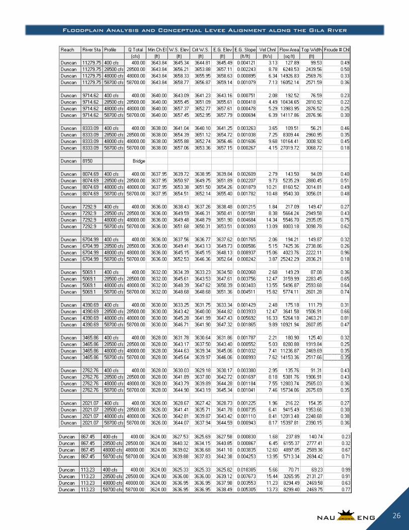
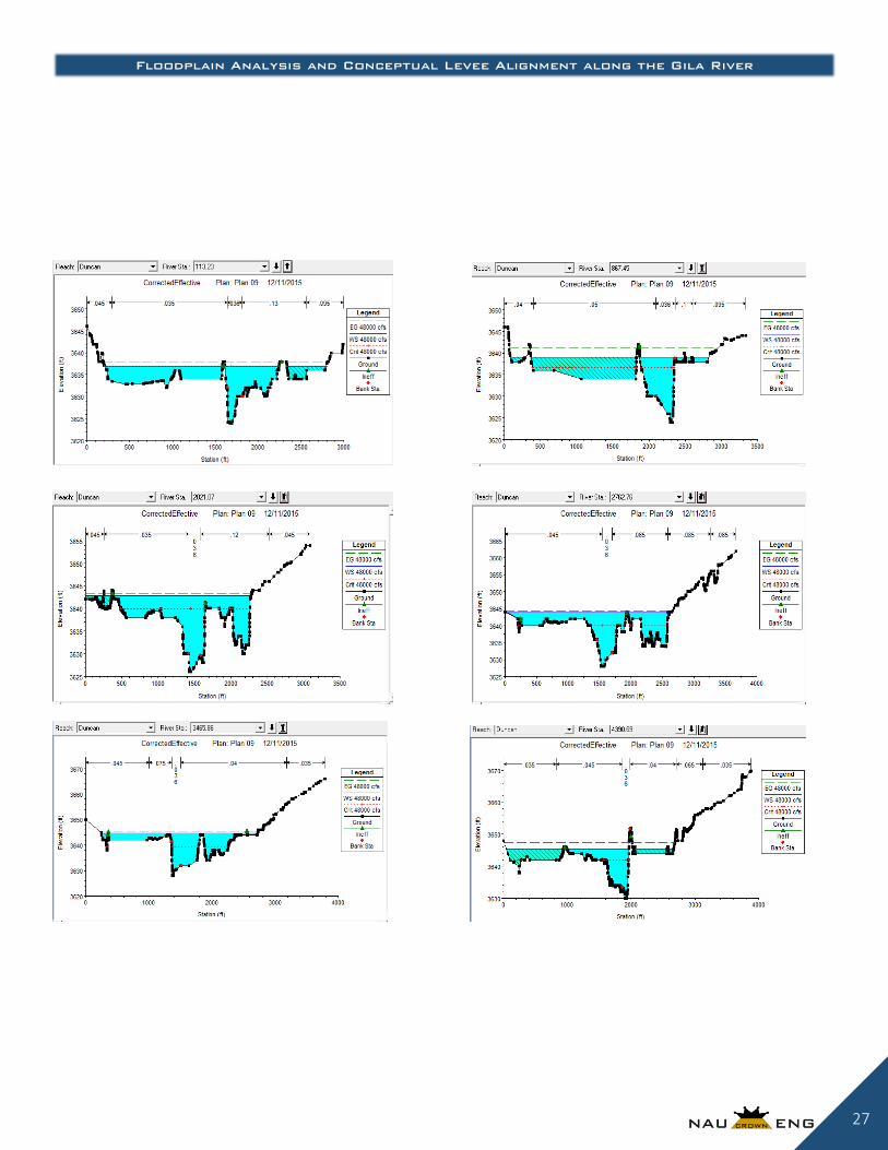
3.2.2.2 Corrected Effective Model
Moving forward from the outdated effective model, the corrected effective model features updated
topographical data from 2012 that is more reflective of current conditions. Furthermore, this model uses
a recently determined 100 year flow rate of 48,000 cfs, rather than the original 28,500 cfs flow that used
to dictate previous flow models near Duncan.
In total, the corrected effective model features 24 cross sections that span an area of approximately 3.5
miles of the Gila River. Due to the complexity of data points in each cross section, the data filter tool
was used to reduce all data points of each cross section to no more than 500 points. Manning’s
Roughness Coefficient values were assigned to the channel and overbank conditions of the reach.
Values are based on aerial photo observations and the application of prescribed values (Refer to
Appendix C) [11]. Upon determining the characteristics of each cross section, a boundary was defined
using a slope of 0.0195 ft/ft and a mixed flow analysis was performed with the flows provided in Table
3.1.
Figure 3.2-Effective Model of the Gila River at Duncan, Arizona

Floodplain Analysis and Conceptual Levee Alignment along the Gila River
11
*Refer to Appendix D for more details of the model
Just as the original FIRM of Duncan suggests (see Appendix A), the updated floodplain boundary of
Duncan shows significant flooding at the 100 year flood event. Figure 3.2 provides a visual of the flood
boundary, as well as the defined cross sections used in HEC-RAS.
3.2.2.3 Proposed Conditions Model
Using the Corrected Effective Model’s cross sections, defined reach, and topography, the proposed
conditions model depicts the impact of a levee to the Gila River floodplain at Duncan. According the
CFR 65.10, levees are to have at least 3 feet of free board from the 100 year floods’ water surface
elevation and must have at least 4 feet of free board within 100 feet of infrastructures, such as bridges
[9]. These conditions were met in the levees height specification. The alignment of the selected levee
was chosen to span 1.9 miles across the 3.5 mile reach of the Gila River being studied. The levee
Flow Recurrence
Interval
Flow (cfs) Observations
Typical 400 All water stays within channel main channel
Water velocities are approximately 1-3 ft./sec
25 Year Flow
28,100 Water overtops several dikes causing 3-7 ft. of flood water in some
areas beyond the main channel.
Water velocities are approximately 8ft./sec
Highway 75 Bridge becomes submerged by approximately 3 ft. of
water
100 Year Flow
48,000 Floodwaters expand in width
Water velocities are approximately 10 ft./sec
Highway 75 Bridge becomes nearly 5 ft. submerged by water
Record Flow
58,700 Water velocities are approximately 9 ft./sec
Highway 75 Bridge becomes submerged by 6-7 ft. of water
Nearly all of the existing dike fails
Figure 3.3-Corrected Effective Model
Table 3.1-Corrected Effective flow observations

Floodplain Analysis and Conceptual Levee Alignment along the Gila River
12
placement follows much of the current dike’s path to reduce complications in land availability. However
unlike the dike in place, the prescribed levee alignment stretches further to prevent flow water from
going around the levee and causing backflow. The chosen levee alignment can be seen in in Figure 3.3.
The flows tested for the proposed conditions model are provided in Table 3.2 as well as any notable
observations made during each flow.
*Refer to Appendix D for more details of the model
While the prescribed levee provides Duncan with adequate protection against 100 year flood events, it
may not be the best solution for Duncan. In the past, levee fortifications have been suggested for Duncan
but were ultimately turned down due to economics [7]. With that said, the goal of Duncan is to seek the
highest level of protection at the lowest possible cost. While the proposal of a levee should not be
disregarded altogether, other alternatives may also lead to improved flood control. These alternative are
explored in Table 3.3.
Flow Type Flow (cfs) Observations
Typical 400 All water stays within channel main channel
Water velocities are approximately 1-3 ft./sec 25 Year Flow 28,100 Levee begins containing water
Water velocities are approximately 7-8 ft./sec 100 Year Flow 48,000 Water velocities are approximately 8-9 ft./sec
3 ft. of freeboard maintained Water is partially submerging Highway 75 Bridge
Record Flow 58,700 Floodwaters are contained with only subtle differences in the
hydraulics of the river.
Figure 3.4-Proposed Conditions Model
Table 3.2-Proposed conditions flow observations

Floodplain Analysis and Conceptual Levee Alignment along the Gila River
13
*Refer to Appendix D for more details of each model
4.0 Cost of Implementing the Design In order to complete this project, the group spent a total of 614.7 hours on a variety of tasks. The tasks were
broken down into five sections: meetings, research, cross sections/ survey data, HEC-RAS, and report
preparation. Table 4.1 shows a breakdown of these hours that the group spent in each category.
Meetings Research Cross Sections/ Survey Data HEC-RAS Report Preparation Total
Total Hours 222.9 101.5 84.75 115 90.5 614.7
The hours accumulated in the ‘meetings’ section consist of a variety of meetings. These meetings include the
field visit, time spent acquiring help from people outside of NAU Crown Engineering, and time spent working
on the project as a whole group. The ‘research’ hours are hours that each individual spent finding information.
Some examples of the information found during these hours includes: flows/storms associated with this section
of the Gila River, other important details about the area of focus, and Manning’s values. ‘Cross sections/survey
Flow
Recurrence
Interval
Description Observations at the 100 year flow (48,000 cfs)
Agricultural
Dike Removal
A ~1.5mile agricultural dike dictates much of the
floodplain boundary in Duncan. An analysis was
performed to see how the removal of this dike
impacts flooding conditions. In HEC-RAS, these
changes were made by shifting the dike’s elevation
points to those of the surrounding ground level.
Velocities slightly increased/decreased
along all cross sections in comparison to the
corrected effective model. Water surface elevations tended to drop in
most cross sections
Floodplain
Restoration
The Duncan floodplain features an over-abundance
of vegetation. The most distinguished of which is
the salt cedar (tamarisk) and the cotton wood. Salt
cedars are invasive to the area and outcompete
natural plants. If this overabundance of vegetation
were cleared, the floodplain would have a more
uniform Manning’s Coefficient that would
ultimately allow for more efficient flow. In HEC-
RAS, these changes were made by labeling
Manning’s overbank conditions a constant 0.045,
which portrays medium to dense brush.
Velocities slightly increased in comparison
to the corrected effective model. Water surface elevations tended to drop in
most cross sections
Soil Excavation
On the northeastern portion of Duncan’s floodplain,
it is evident that less infrastructure is available.
Ideally, floodwater should be pushed in this
direction to minimized damage in infrastructure.
This could be done by clearing out soil and
expanding the northeast portion of the floodplain.
Specifically, the client requested removing soil
from the retired wastewater treatment facility that
resides just downstream of the Highway 75 bridge.
In HEC-RAS, these changes were made leveling the
right overbanks of the cross sections downstream of
the bridge.
Floodplain boundary expands in the
northern direction just downstream of the
Highway 75 Bridge
Water surface elevation differences are
negligible across entire reach
Table 4.1- Breakdown of hours
Table 3.3- Alternative Proposed Conditions

Floodplain Analysis and Conceptual Levee Alignment along the Gila River
14
data’ consists of hours spent in ARC-GIS and CIVIL 3D, trying to get the topography and alignment/cross
sections of the Gila River and its floodplain ready to be exported to HEC-RAS for modeling. The hours in the
‘HEC-RAS’ category are hours spent learning HEC-RAS, and ours spent completing all necessary floodplain
models. The ‘report preparation’ category contains hours spent completing both the 50% and final design
reports.
Table 4.2 shows the allocation of hours to each of the four theoretical engineering positions that NAU Crown
Engineering has personnel working on the floodplain analysis and conceptual levee alignment along the Gila
River.
The SENG spent 91 hours on the project. At $95 an hour, the total cost to have the SENG work on the project
comes to $8,645.00. The PE spent 121 hours on the project. At $55 an hour, the cost of services for this
personnel comes to $6,655.00. Similarly, the 156 hours that the EIT spent on this project cost $5,460.00, and
the 247 hours the intern put into the project comes to $4,940. The sum of all these personnel costs for the
completion of a floodplain analysis and conceptual levee alignment comes to $25,700.00.
Since doing design work for the levee was outside the scope of services of NAU Crown Engineering, no
construction costs will be provided.
Table 4.2- Theoretical cost for engineering services

Floodplain Analysis and Conceptual Levee Alignment along the Gila River
15
4.1 Project Schedule The project initiated on September 1st, 2015 and was completed on December 16th, 2015, in accordance
with Northern Arizona University’s academic calendar. The tasks of the project and their respective
deadlines are available in Figure 4.1 below.
5.0 Summary of Project Costs Since NAU Crown Engineering was not responsible for the design or construction of the proposed levee, the
only project costs are the personnel costs, listed in Table 4.2. It is beyond the scope of the project to determine
the estimated cost for the implementation of the 1.9 mile levee proposed.
6.0 Conclusion and Recommendations If a 100 year flood event were to occur in Duncan today, the town would encounter severe breaches in its
current agricultural dike. The dike does not provide enough strength, nor mass to hold back flood waters of
48,000 cfs and is not long enough to prevent water from going into the town around its tie in locations. This is a
recurring event in Duncan and can be verified through flood events that occurred in 1978 and 2005. While
floodplain remediation methodologies may be used to reduce the intensity of flood waters, nothing better
protects the town than the development of a 1.9 mile long levee.
Despite the correction method applied to the floodplain, all models displayed water submersion of the Highway
75 Bridge during 100 year flow conditions. It is recommended that an additional study be placed on the impact
that the Highway 75 Bridge has on the flood water and whether there are any methodologies available to
prevent the bridge from becoming submerged. Additionally, it is recommended that a more detailed study be
performed over the floodplain by applying Flo 2D software in place of HEC-RAS. Since HEC-RAS only
analyzes waterways in one dimension, it does not properly reflect how water actually behaves in the floodplain
and may yield floodplain characteristics that are inaccurate. Lastly, a field survey should be performed to verify
Figure 4.1-Project Gantt Chart

Floodplain Analysis and Conceptual Levee Alignment along the Gila River
16
the accuracy of the topography captured by the LiDAR data used in this report. Regardless of any inaccuracies
presented in the HEC-RAS models, it is clear that the Town of Duncan is in risk of flooding and requires some
form of remediation to help protect against future floods.

Floodplain Analysis and Conceptual Levee Alignment along the Gila River
17
References
[1] FEMA, "Flood Insurance Study: Greenlee County, Arizona," 28 September 2007. [Online]. Available:
http://www.co.greenlee.az.us/engineering/Flood%20Insurance%20Study.pdf. [Accessed 15 February 2015].
[2] "Greenlee County History: Duncan," 2015. [Online]. Available: http://www.co.greenlee.az.us/historyduncan.aspx.
[Accessed 24 February 2015].
[3] "Arizona County Map," Dirtopia, January 2012. [Online]. [Accessed 26 February 2015].
[4] Google, "Maps," 2015. [Online].
[5] N. W. Service, "Advanced Hydrologic Prediction Service," 28 February 2015. [Online]. Available:
http://water.weather.gov/ahps2/hydrograph.php?gage=duua3&wfo=twc. [Accessed 28 February 2015].
[6] P. Ronnerud, Interviewee, Greenlee County Flooding. [Interview]. 11 February 2015.
[7] Arizona Department of Water Resources, Reconnaissance Report of the Gila River Flood COntrol Project, 1981.
[8] Natural Channel Design, Inc., "Apache Grove Hydrology Design," 2015.
[9] Code of Federal Regulations 44, Office of the Federal Register National Archives and Records Administration, 2002.
[10] Flood Insurance Study Guidelines and Specifications for Study Contractors, 2007.
[11] US Army Corps of Engineers, HEC-RAS Hydraulic Reference Manual, 2012.
[12] FEMA, "Flood Map Service Center," 28 September 2007. [Online]. Available:
https://msc.fema.gov/portal/search?AddressQuery=Duncan%2C%20Arizona. [Accessed 1 February 2007].
[Accessed 1 February 2015].

Floodplain Analysis and Conceptual Levee Alignment along the Gila River
18
Appendices
Appendix A-FIRM of Duncan Area
Areas in blue, surrounding the Gila River, show projections of how far the 100 year flood will spread. This information is used by
FEMA’s National Flood Insurance Program to assess flood risk for insurance companies. If a certified levee were in place, the flood
risk of Duncan would decrease and insurance rates would lower [12].

Floodplain Analysis and Conceptual Levee Alignment along the Gila River
19
Appendix B-Watershed Area of the Gila River near Duncan
The area in red indicates the ~3200 square mile watershed that drains into the Gila River at Duncan [8].

Floodplain Analysis and Conceptual Levee Alignment along the Gila River
20
Appendix C- Determination of Manning’s Roughness Coefficients

Floodplain Analysis and Conceptual Levee Alignment along the Gila River
21
Appendix D- HEC-RAS Models
Effective Model
Water Surface Profile
Profile Summary Table

Floodplain Analysis and Conceptual Levee Alignment along the Gila River
22

Floodplain Analysis and Conceptual Levee Alignment along the Gila River
23

Floodplain Analysis and Conceptual Levee Alignment along the Gila River
24
Corrected Effective Model

Floodplain Analysis and Conceptual Levee Alignment along the Gila River
25
Floodplain Analysis and Conceptual Levee Alignment along the Gila River
26
Floodplain Analysis and Conceptual Levee Alignment along the Gila River
27

Floodplain Analysis and Conceptual Levee Alignment along the Gila River
28

Floodplain Analysis and Conceptual Levee Alignment along the Gila River
29

Floodplain Analysis and Conceptual Levee Alignment along the Gila River
30
Proposed Conditions Model

Floodplain Analysis and Conceptual Levee Alignment along the Gila River
31

Floodplain Analysis and Conceptual Levee Alignment along the Gila River
32

Floodplain Analysis and Conceptual Levee Alignment along the Gila River
33

Floodplain Analysis and Conceptual Levee Alignment along the Gila River
34

Floodplain Analysis and Conceptual Levee Alignment along the Gila River
35

Floodplain Analysis and Conceptual Levee Alignment along the Gila River
36

Floodplain Analysis and Conceptual Levee Alignment along the Gila River
37
Alternative Proposed Conditions
Removal of Agricultural Dike

Floodplain Analysis and Conceptual Levee Alignment along the Gila River
38
Floodplain Remediation (Manning’s Value Adjustment)

Floodplain Analysis and Conceptual Levee Alignment along the Gila River
39
Soil Excavation at Former Waste Water Treatment Facility

Floodplain Analysis and Conceptual Levee Alignment along the Gila River
40
*Floodplain model displaying the extended boundary by excavating soil