for exploration & mining - north river resources · this handbook is intended to help...
TRANSCRIPT

Archaeological Guidelinesfor
Exploration & Miningin the
Namib Desert

2
SUMMARY
This handbook is intended to help exploration and mining projects to minimize their impact on the archaeology of the Namib Desert, a unique environment of global importance to the understanding of the human past. A short introduction to the National Heritage Act is followed by an overview of the archaeological evidence, and a description of the most sensitive elements of the archaeological landscape. With this background and a few principles of site management, it is possible to avoid inadvertent damage to archaeological sites. Also included is an outline of the basic standards for archaeological field survey and assessment that are most widely applied in the Namib.

3
An archaeological landscape in the southern Namib Desert: the basin or playa in the middle distance has dense shoreline scatters of late Pleistocene artefact debris, and the inselbergen on the margins of the basin have densely clustered mid- to late Holocene settlement remains including hunting blinds, grave cairns, ritual sites and rock shelters with stratified archaeological deposits.

4
CONTENTS
Preface
1
First steps:
the law and best practice
2
Seeing things:
what the archaeological evidence looks like
3
Sensitive places:
where impacts happen
4
Critical steps:
in exploration & mining
5
Standards
for archaeological survey & assessment
6
In the public eye:
archaeology and the image of the mining industry
Resources
Appendix

5
Preface
Modern humans and their ancestors have lived in the Namib Desert for more than one million years, leaving a rich legacy of archaeological remains which lie scattered over the landscape. This is by far the longest archaeological record in all the deserts of the southern hemisphere, and it contains unique evidence of how humankind learned to cope with one of the most hostile environments on earthi.
Indigenous communities, the descendants of people who lived in the Namib over thousands of years, still maintain important cultural links with the desert. Much of the Namib is enclosed by national parks and wildlife reserves, but this is no wilderness. Desert plants and animals, and the landscape itself, are an integral part of the cultural heritage of desert communities.
You and I are the most recent visitors to this extraordinary place, but our activities have the potential to cause it irreversible damage. If we do not proceed with caution and consideration, our legacy will be a wasteland of destruction. Of course one cannot build a mine, a road or a power-line without impact, but we can reduce this impact significantly by avoiding unnecessary damage.
It is important to realize that every archaeological site is part of a large and very complex puzzle. Damage to archaeological sites cannot be repaired, and the best way to avoid damaging them is to make sure by means of field survey and assessment, what sites lie in the path of a potential development. Only then is it possible to either conserve the sites or mitigate the impact of development.
This handbook contains simple guidelines for exploration and mining projects, as well as their associated infrastructure. It is based on the premise that we only see what we already know. If this publication helps the geologist, engineer or project manager to see and understand the archaeology of the desert, it may succeed where legislation and policy often fail.

6
The Namib Desert forms a continuous strip 100-150km wide betweenthe Atlantic coast and the escarpment. During the Last Glacial Maximum, ending approximately 10 000 years ago, the coastline lay up to 100km further west and the desert extended at least 400km into the interior. Theblack dots represent dated archaeological sites.

7
1. First steps:
the law and best practice
Almost every country has some sort of legislation to protect its cultural heritage, and compliance with these laws is important for any exploration and mining operation. Most large mining companies also have their own cultural heritage policies and procedures to guide their operations and reduce the risk of damaging their reputation.
The principal instrument of legal protection for archaeological sites or remains in Namibia is the National Heritage Act (27 of 2004). Some incidental but nonetheless important protection is provided by the Environmental Management Act (7 of 2007) which includes man-made features in its definition of the environment. Other guidelines include those of the IFC (World Bank) and the ICMM (International Council on Mining and Metals).
A short guide to the National Heritage Act The National Heritage Council of Namibia is a statutory body and its work is administered by a Secretariat, based in Windhoek and assisted by a number of specialist committees. All enquiries and applications for permits should be addressed to:
The DirectorNational Heritage CouncilPrivate Bag 12043AusspannplatzWindhoek
There are as yet no official regulations or guidelines to the Act for exploration and mining projects to consult. The following précis and commentary is intended to indicate and explain some important provisions of the Act. However, it is strongly recommended that exploration and mining project managers obtain legal advice especially with regard to permits.
PART I:In terms of the Act, “heritage” is restricted to places and objects, including those of archaeological, cultural, historical, scientific and social significance. The legislation does not address what is sometimes known as “intangible heritage”, such as customs, beliefs and oral history.
The Act defines “archaeological” as any remains of human habitation or occupation that are more than 50 years old found on or beneath the surface on land or in the sea, and especially notes rock art, being any form of painting, engraving or other representation on a fixed rock surface or loose rock or stone which is 50 or more years old.
It is important to understand that legal protection can extend beyond the archaeological object or site, to include the natural or existing condition or topography of land, as well as the trees, vegetation or topsoil.
PART IV: The Council has the responsibility of establishing and maintaining the Namibian Heritage Register which records heritage places and objects. The register is defined as a public document, and project managers may inspect it to determine whether any protected sites lie within their exploration or mining lease area.
However, not all archaeological or other heritage sites qualify for listing in the register. Listing is subject to a prolonged process of approval based on the “heritage significance” of the object or site, and this ultimately involves publication of the site in the Government Gazette. Unless there is a listed site, or unless a previously unknown site of high significance comes to light, this part of the Act is of limitedconcern for exploration and mining projects.
PART V: Damage, disturbance and encroachment on protected sites is strictly prohibited. However, a permit may be granted in some circumstances, and the Council is also empowered to suspend protection of a listed site under some circumstances. This means that protected status is not irrevocable.
Before issuing a permit, the Council may require the applicant to obtain from a person with appropriate professional qualifications or experience, at the applicant’s expense, a statement as to the impact the

8
proposed works and activities may have on the place or object to which the application relates and the risk of damage to the place or object.
In view of the fact that large areas of Namibia, including much of the Namib Desert, are archaeologicallyunknown, the precautionary principle dictates that an archaeological survey and assessment should be carried out at an early stage in any large exploration and mining project. Most large mining companies will commission a field survey and assessment as a matter of course.
The Act stipulates that all archaeological assessment, including field surveys, is subject to permits issued by the National Heritage Council. This means that the archaeologist who carries out the survey must be appropriately qualified and in good standing with the authorities.
The appointment of an archaeologist is the prerogative of the project proponent. Best practice requires that the archaeologist should be independent of the National Heritage Council and all other national authorities.
PART VI: All archaeological objects are the property of the State. It is important to note that State ownership extends to all archaeological remains, known or unknown. This means that mining personnel and contractors need to be aware of the legal status of archaeological remains and their legal obligation to report the discovery of any new archaeological remains to the National Heritage Council.
Relevant provisions of the Environmental Management Act
PART I: The definition of the environment employed by the Environmental Management Act (7 of 2007)specifically includes “anthropogenic factors” such as archaeological remains or any other evidence of human activity.
PART II: Environmental impact assessment (EIA) in Namibia is governed by this legislation and usually includes a specialist archaeological survey and assessment, following the stated Principles of Environmental Management which require that Namibia’s cultural…heritage…must be protected and respected for the benefit of present and future generations.
In the process of environmental assessment set out in the regulations to the Act there are several stages of consultation, including public participation, preceding the issue of an environmental clearance certificate by the Environmental Commissioner. There is also provision for external review, and an appeal process in the event that environmental clearance is withheld.
Credible environmental assessment must be independent of both the project proponent and the national authority. For this reason environmental assessment, as well as archaeological assessment is not carried out by government institutions and should not include government scientists as specialistconsultants
In addition:
The International Finance Corporation (IFC) has specific guidance notes and performance standards applicable to cultural heritage preservation. These standards refer to both tangible forms of cultural heritage, such as archaeological sites and objects, and intangible forms. The standards apply whether or not the archaeological material is protected, and irrespective of whether is may have been previously disturbed. To comply with these standards, a baseline survey and assessment is required.
There are general guidelines issued by the International Council on Mining and Metals (ICMM) and detailed cultural heritage management guidance notes issued by large corporations, for example, Rio Tinto (RT) and Santos. Where such guidelines indicate standards other than the laws of Namibia, their application is subject to group member standards. Best practice in Namibia directly benefits from mining companies with group standards and global experience.

9
2. Seeing things:
what the archaeological evidence looks like
Human occupation of the Namib Desert in the past was entirely dependent on prevailing climatic conditions, and the climate of the last one million years has been consistently arid, with short periods of higher than usual rainfall. Occupation was therefore sporadic, with long periods in which the desert was unoccupied. Evidence of human occupation is widespread, but thinly scattered. Interpretation of this archaeological record relies on piecing together a large number of fragile and subtle cluesii. Some of these clues will be easily noticed by the observant field geologist, and noted as an indication that the area might have sensitive archaeological sites.
The most abundant traces of human occupation in the Namib Desert are stone artefacts. These are easily recognized as isolated finds and as surface scatters on the gravel plains of the Namib. Other less common traces include shell middens (usually within less than 5km of the coast), natural rock shelters with evidence of occupation, including rock art, and stone features such as hut circles, hunting blinds and grave cairns. Historical sites includecemeteries, old mine workings, and important traces of World War I military engagements. While some kinds of archaeological sites are highly visible (such as the larger grave cairns), their significance is not obvious. Most archaeological sites in the Namib are difficult for the untrained eye to recognize and most damage to the sites is therefore unintentional. LEFT: A dense scatter of late Pleistocene artefact debris.
ABOVE: A late Pleistocene artefact workshop with chert core flakes and dolerite hammer-stone (pocket-knife for scale). The site is intact and undisturbed after approximately 120 000 years.

10
Identifying stone artefactsStone artefacts were made by removing flakes from a selected core, or block of raw material, using precise blows that leave unmistakeable evidence of human manufacture. Similar breakage patterns very rarely occur in nature. Over time, methods of artefact production became more sophisticated and the different techniques of flaking provide some indication of ageiii.
MODE 1: Pebble tool (mid- to late Pleistocene, >500 000 years)
This well preserved example made in fine-grained quartzite was loosely cemented in a conglomerate exposed by recent collapse of a stream bank south of the Omaruru River.
MODE 2: Bifacial hand-axe (late Pleistocene, <500 000 years)
This highly symmetrical tool made in weathered basalt was an isolated surface find on an outwash fan east of Cape Cross. The artefact is 150mm in length.
MODE 3: Blade flake with terminal retouch (end Pleistocene <100 000 years)
This punch-struck blade is 60mm in length. Such artefacts form part of complex toolkits including heavy spear points. Dense scatters of debris are found near outcrops and large nodules of chert.
MODE 4: Bladelet flake with slight edge retouch (mid- to lateHolocene <5 000 years)
This artefact in crystalline quartz is 15mm In length. Flaking debris on recent Holocene sites is characterized by fragments less than 10mm in length but these are often visible in gravel float. These scatters often contain raw material brought from sources up to 50km away.

11
Typical stone features sitesSettlements and grave sites are significant and often highly visible features of the archaeological landscape in the Namib. Most of these sites are less than 1 000 years old and they often contain important material evidence of desert subsistence strategies. Grave sites may be construed as evidence of traditional land ownership.
ABOVE: Hut circle within hilltop settlement dated 250 years bp. Significant soil phosphorus concentrations in such features indicate that they supported wooden frameworks plastered with domestic animal dung. BELOW: Large grave cairn probably dating to within the last few centuries. These features are usually found isolated from settlement sites, on natural routes across the desert.

12
The recent pastVisible evidence of early links with the outside world has been found in the course of mining operations on the Namib coast, such as the ca1552AD wreck of the Bom Jesus, north of Oranjemund. The intensive trade that developed around Walvis Bay in the 1700s has also left abundant traces, and the desert interior has many sites which document early colonial penetration of the country. Such remains
are often overlooked, or mistaken for modern trash. Glass bottles and trade beads are one of the most enduring types of evidence found in the Namib. The characteristic square “case” gin bottles found in the Namib mostly originated from distilleries in the Netherlands. Early bottles were hand blown and exhibit tell-tale imperfections, while more recent bottles show evidence of technological advances in glass production. Such clues make it possible to accurately estimate the age of bottles, trade beads and other items.
LEFT: Neck and shoulder fragment of a “case” gin bottle from the distillery of Henkes in Delfthaven, Netherlands, found on the 19th century cattle-droveingroute or “Bay Road” across the central Namib. Such items help to identify the overnight camps used on this route.
RIGHT: One side of an iron ox shoe from the central Namib. These were commonly used in the mid-19th century, before the German colonial period, when oxen, rather than horses, were preferred as riding animals. The oxen were shoed to cope with long-distance travel in the rocky terrain in the Namib. These items are valuable indicators of the early colonial presence in some remote parts of the desert.
ABOVE: Well preserved waste rock walling around the edges of open pits at the late 19th century Annaberg tin mine, near Trekopje.

13
3. Sensitive places:
where impacts happen
Because water was the main limiting factor for human occupation of the Namib, archaeological sites tend to be highly clustered in their distribution. However, it is not possible to accurately predict where archaeological sites are likely to occur on this basis alone. The reasons are simple: the availability of water has changed over time and during moist periods people occupied areas that are otherwise dry. Inthe past, small groups of people could live for many weeks on water trapped in natural rock basins, or by digging for water in drainage lines.
There were other important requirements for human settlement, such as shelter; the availability of edible plants; the movement of game species, and the location of raw material outcrops for stone tool manufacture. Together with all of these considerations people in the Namib had also to deal with competing claims for the same resources: the Namib was a pantry, but it was also a neighbourhood, and archaeologists are interested in trying to understand both the social and the ecological dimensions of life in this environment.
An exploration geologist or project manager who is sensitive to the archaeology of the desert can do a great deal to reduce the impact of exploration and mining because many field surveys have shown that there are particular kinds of terrain that have high concentrations of archaeological sites. Although some kinds of terrain are less sensitive none can be definitively excluded.
Archaeological sites commonly occur in these locations:OUTCROPS and INSELBERGEN: Features ranging in size from minor isolated outcrops to massifs are often associated with archaeological sites because they usually have some surface water and other resources. In most cases, archaeological sites are found only on the foot-slopes of these features, especially where very large boulders provide shelter. These sites may have high concentrations of rock art and stratified occupation deposits.
Archaeological sites usually occur in association with smaller outcrops, often so small that they are not indicated on the regional geological mapping. Important outcrop settings for archaeological sites include: early Cretaceous granites, dolerite ridges and sedimentary formations such as the Twyfelfontein (formerly Etjo) sandstones, and localized occurrences of fine-grained quartzite, crystalline quartz and fine- or crypto-crystalline chert. Marble outcrops have relatively few archaeological sites.
SADDLES: Natural routes between drainage basins often pass over low saddles. These locations sometimes have hut circle sites, grave cairns and, occasionally hunting blinds. Hill saddles with archaeological sites can be very minor terrain features, but the more significant examples are easily identified on topographic maps, aerial photographs and satellite imagery.
DRAINAGE LINES: River mouths on the Namib coast are invariably associated with shell middens and other archaeological remains. However, because most Namib drainage has a relatively steep gradient, high energy flooding results in extensive reworking of sediments. Outwash fans have relatively few archaeological sites. Older river terraces and over-bank flood deposits provide level and elevated settings that often have archaeological sites.
PANS: Endorheic drainage features in the Namib are subject to occasional flooding and may hold standing water for many weeks. Archaeological sites, mainly stone artefact scatters are commonly found on the strandlines of pans and up to 4km away, after which their density quickly declines. The lee-sides of stable dunes and small outcrops near pans have high archaeological concentrations, Saline pans have relatively few archaeological sites.
DUNEFIELDS and GRAVEL PLAINS: Coastal and near-coastal dunefields, especially those associated with exposed silt deposits (such as the !Khuiseb) may have very high concentrations of archaeological sites within reach of water and other resources. Gravel plains in the Namib have highly stable features such as desert pavements, with well preserved and undisturbed artefact scatters.

14
ABOVE: Typical example showing the close association of archaeological sites witha minor dolerite ridge. The high ridge in the background of the photograph (top) hasvery few sites compared to the low ridge in the foreground and shown in the satellite image.

15
ABOVE: Archaeological sites associated with the prominent Spitzkuppe inselbegare primarily on the footslopes among large boulders. Most of the sites are withinless than one kilometre of water seepages in the sheet joints of the granite, or rock hollows that retain water after rain.

16
4. Critical steps
in exploration & mining
Relatively few exploration projects result in the development of a mine, but as far destructive impacts on the archaeology of the Namib are concerned, exploration can result in a disproportionate amount of damage. Much of this damage can be avoided, and even if the project leads to the establishment of a mine it is possible to conserve key archaeological sites right through to the final closure of the mine. To achieve this, it is necessary to adopt key measures at each stage of the project.
ExplorationA pre-fieldwork archaeological assessment is a necessary precaution for exploration in the Namib. There is sufficient field survey data available to allow for an estimation of likely archaeological impacts, even if the exploration area itself has not been surveyed in detail. A pre-fieldwork assessment can form part of the environmental impact scoping study, but it can also be carried out independently to assist with practical planning of exploration fieldwork.
Some prior knowledge of likely archaeological impacts will provide valuable guidance for siting of field camps, access roads, lay-downs for contractors, fuel storage tank farms and various other facilities. The pre-fieldwork assessment can also identify high impact risk areas of the exploration tenement, such as the terrain features discussed in Chapter 3. The pre-fieldwork assessment can be a useful aid to exploration planning by helping to schedule field surveys of sensitive areas before exploration begins on the ground.
As soon as areas of likely archaeological impact have been identified, detailed field survey should be carried out. The elements of field survey are set out in Chapter 5, including data collection and the integration of archaeological spatial data into the exploration programme and area mapping. Here it is important to list the practical precautions required at the exploration stage of the project: Use existing access tracks as far as possible; signpost as private all tracks turning off from public roads; observe strict track discipline by employing verge markers, passing points, and clear demarcation at track junctions; avoid establishing new tracks parallel to gradient; rehabilitate redundant tracks for at least 100m from their junction with public roads. Field camps and other facilities should be established on archaeologically least sensitive surfaces, such as on drainage lines with naturally rehabilitating substrates. Where practical, temporary structures should be placed on pilings to reduce the development of a permanent footprint. All sensible precautions should be adopted for storage, waste disposal &c. All terrain features that are suspected to be archaeologically sensitive should be avoided until they have been surveyed in detail. For example, natural outcrop features should not be used to shelter camps or other facilities; terrain such as hill saddles, pan fringes and outcrop footslopes should be inspected on foot before being entered by vehicle. Highly sensitive sites may be designated as No-Go Areas (see Appendix). Personnel and contractors should be informed about the specific archaeological sensitivity of the
exploration area, and the relevant terms of the National Heritage Act, through the application of a specific project archaeological management plan (AMP).
As soon as baseline archaeological survey data are available these should be consulted on a continuous basis when planning access and exploration activities. Where new archaeological finds are located in the course of exploration, field personnel should observe the Chance Finds Procedure (see Appendix).
ABOVE: Drilling in progress on the central Namib gravel plains. This is an archaeologically sensitive surface and detailed survey should precede drilling.

17
Development & operationIdeally, archaeological, assessment and mitigation should be completed before development of the mine site commences. This is almost never the case, however, because the process of mine development can require multiple changes in design and layout – with possible implications for sensitive sites. Moreover, development requires infrastructure to link the mine with local road networks, as well as power and water supplies – again with possible implications for sensitive sites, both within and adjacent to the mine licence area. Even the most thorough field survey cannot exclude the possibility that new archaeological discoveries will be made in the course of mine development and operation. To accommodate these needs it is advisable for the mine to adopt a formal archaeological management plan at an early stage in the development process.
THE ARCHAEOLOGICAL MANAGEMENT PLAN (AMP): The purpose of an AMP is to ensure appropriate protection and preservation of archaeological sites through informed decision-making, in line with the law and best practice. The AMP should provide a framework in which management procedures are based on consistent standards and linked to expected outcomes. These procedures should serve as practical guidelines with clearly identified steps and responsibilities. To achieve this purpose, the AMP is accompanied by additional documentation including induction material for personnel and contractors, and detailed background information based on the results of the field survey carried out during the exploration phase.
The AMP should include the following elements: A baseline record of sites and remains protected in terms of the National Heritage Act A baseline record of mining activity (historical impacts) before and during present operations A management system with appropriate decision and risk assessment procedures Explicit measures to reduce impacts on known archaeological sites Procedures to secure approval for unavoidable disturbance of archaeological sites Procedures for the reporting of inadvertent disturbance of archaeological sites Measures to enlist the involvement of interested and affected parties in site conservation Consideration of indigenous communities cultural rights in respect of archaeological sites
In principle, the AMP applies to all archaeological sites and remains found within the project licence area, and it applies to all personnel and contractors. It provides a practical means to manage site protection, using a functional and accessible database as a platform for risk management. The AMP is integral to all land disturbance decision-making, and it provides a set of explicit management guidelines to deal with Chance Finds, and management of access to No-Go Areas (see Appendix).
SOME LANDSCAPE PRINCIPLES: Landscape integrity is often neglected in the planning of mine infrastructure. Coordinated infrastructure planning should aim to minimize fragmentation of the landscape by establishing service corridors (roads, power-lines, pipelines &c), and consolidating infrastructure hubs (pump-stations, pipeline tee-offs, substations, road junctions) wherever possible.
In the Namib Desert surface rehabilitation by raking and other means has become a common practice in the final stages of exploration. This is a largely cosmetic practice, and its long-term benefit to the restoration of desert surfaces has to be weighed against the destructive effect on Pleistocene archaeological sites where raking merely propagates disturbance caused by vehicle tracks. It is therefore essential to integrate archaeological assessment with the rehabilitation programme.
Maintaining areas of archaeological value can provide an important and easily managed offset benefit within the mining licence area. This has obvious advantages: enclosed offset areas are easily managed by the mine because access is controlled; and such areas can provide important archaeological assets to assist the development of alternative land uses (e.g. tourism) after closure of the mine.
The archaeological record in the Namib Desert is a record of highly mobile and ephemeral settlement. To understand this record, archaeologists adopt a landscape perspective, combining evidence from many sites. Likewise, meaningful conservation of the Namib archaeological record requires a landscape approach, achieved by minimizing fragmentation, especially around areas of especially high significance.

18
TWO FURTHER POINTS TO REMEMBER: Mining operations, past and present, are part of the archaeological record of human activity in the Namib. It is historical nonsense to attempt to erase this imprint entirely. The remains of mining activity are not only an integral part of the “memory” of the desert landscape, they also provide a valuable physical demonstration of how the desert responds to disturbance and how the scars of human impact persist or vanish over time and under natural conditions. Such demonstration material will become more valuable in future, as impacts and management challenges accumulate. We all know that in physical terms the Namib has a very long memory; it is as well to consider what the legacy of our mining operations will be, and act thoughtfully.
The responsibility of mining companies to the conservation of Namib Desert archaeology extends beyond the mine site, the licence area and related infrastructure. Corporate responsibility and best practice require that mining companies also consider the impact of their personnel in the pursuit of recreation. It makes no sense to scrupulously observe archaeological conservation principles on site and ignore them elsewhere. Archaeological tourism, especially to coastal sites and inland rock art sites is increasingly popular. Mine personnel should consider the impact of uncontrolled archaeological tourism. Recreational use of archaeological sites requires a permit from the National Heritage Council. Tourism operators, both community-based and private should have such permits: if in doubt ask your tour operator to produce his permit.
ABOVE: There are many traces of historical exploration and mining enterprises in the Namib Desert. In some cases these may be considered as important cultural heritage assets because there are fewwritten records and few people left to tell us anything about life on small remote mines.

19
5: Standards
for archaeological survey & assessment
In the absence of official regulations under the National Heritage Act, archaeological assessment in Namibia follows appropriate international best practice. The assessment process, set out in the flow diagram overleaf is based on a conventional three phase approach: a Phase 1 evaluation, usually a desk assessment; a Phase 2 site assessment involving detailed field survey, impact assessment and limited testing; and a Phase 3 mitigation programme, if required. Sometimes Phases 1 and 2 are combined, but Phase 3 is generally separate because it requires prior approval of mitigation measures. The following notes are not intended as a manual of survey and assessment, but as a guide to the mining company or project proponent as to what the archaeological services to the project might include:
Basic survey requirementsThe National Heritage Act stipulates that archaeological assessment should be carried out by a person with appropriate qualifications and experience. The mining company, or project proponent, may appoint an archaeologist of their own choosing. All archaeological fieldwork is however subject to permits issued by the Heritage Council.
Since the Phase 1 evaluation is usually based on literature and database sources, it is very important that the consulting archaeologist has a detailed familiarity with current knowledge and research directions in southern African archaeology. Phase 2 field survey and assessment will require a more detailed familiarity with Namibian archaeology although this is not a prerequisite. Phase 3 is based on agreed mitigation measures and could be carried out by an archaeologist without local experience.
Best practice requires not only that archaeological survey and assessment should observe legal provisions and standards set out by company guidelines and lending institutions: they should also reflect acceptable standards of archaeological research. This means that the investigation should be based on an explicit methodology; employ standard techniques of field documentation; and provide an assessment that is well founded both in the field evidence presented and in the context of available knowledge.
Field methodsMineral exploration tenements (EPLs) are often very extensive, in excess of 500km2. Archaeological survey should therefore reflect both the archaeology of the tenement, and place appropriate emphasis on areas of exploration interest. It should therefore be an informed survey in the sense that it considers the terrain context of the archaeology, thus allowing some extrapolation from representative sample areas, and at the same time provide detailed knowledge of areas likely to be affected by exploration. Effective field survey is designed to be representative, informative, and practically feasible.
Some field reconnaissance is helpful in selecting terrain units for survey. The survey itself may be based on transects, random or stratified quadrats, whichever seems appropriate. Site locations should be established by hand-held GPS and plotted in the field on the standard topographic map scale (1: 50 000). The physical setting of the site must be noted, i.e. terrain type, prevailing geology and soil, vegetation cover; the type of site should be noted, i.e. surface scatter, stone feature, rock shelter; the site dimensions should be measured or estimated.
Field survey should include a provisional estimate of the site age, based on characteristic archaeological associations, and a field inventory of the archaeological evidence observed. Any samples collected for identification or analysis should be properly bagged and labelled. All field collecting is subject to permitsissued by the National Heritage Council. The site should be photographed if appropriate, both close-up and in context, noting orientation. Further notes and sketches may be added as an aid to interpretation and as a record of any historical site disturbance.
AssessmentField experience in Namibia has lead to the development of an assessment methodology based on two separate, parallel scales of archaeological significance and archaeological vulnerability. The two scales consist of interval values from zero to five, and allow the significance of the archaeological site to be considered separately from its vulnerability to disturbance resulting from the project under assessment. Thus sensitivity can be represented as a numerical value based on significance and vulnerability. For

20
example, a site of very high significance that is not vulnerable will have a lower sensitivity value than one that is vulnerable, according to the values assigned on the separate scales. Sensitivity values generated in this way can be adjusted according to project design and brought, though mitigation, to an acceptable level.
SIGNIFICANCE RANKING:0 no archaeological significance1 disturbed or secondary context, without diagnostic material2 isolated minor find in undisturbed primary context, with diagnostic material3 archaeological site forming part of an identifiable local distribution or group4 multi-component site, or central site with high research potential5 major archaeological site containing unique evidence of high regional significance
VULNERABILITY RANKING:0 not vulnerable1 no threat posed by current or proposed development activities2 low or indirect threat from possible consequences of development (e.g. soil erosion)3 probable threat from inadvertent disturbance due to proximity of development4 high likelihood of partial disturbance or destruction due to close proximity of development5 direct and certain threat of major disturbance or total destruction
Two further aspects of assessment are important. One is that both significance and vulnerability ranking can change: assessment is subjective and the judgement of the archaeologist may be mistaken or fail to anticipate the future significance of any one find or site. The second aspect is the potential research value of a site, sometimes termed the “knowledge dividend”: conserving a particular site may have a high potential dividend for future research, and this should be taken into account, considering the potential loss of dividend if the site is damaged or destroyed.
MitigationArchaeological mitigation consists in the reduction of a potential threat of destruction, either by timely intervention in the planning and execution of exploration and mining work, to avoid needless impacts, or by investigation or documentation of the site to a sufficient level of detail that its loss or destruction is in some way compensated by the existence of adequate records.
Archaeological survey and assessment will identify the sites and risks of impact that form the basis of a mitigation plan. The mitigation plan submitted to the National Heritage Council must provide sufficient detail for the Council to independently assess the significance of the site and the adequacy of the proposed mitigation measures.
Damage or destruction of an archaeological site is subject to a permit issued by the National Heritage Council. The archaeological survey and assessment process can minimize or even avoid such impacts. In the form of an Archaeological Management Plan (AMP) the results of the survey and assessment will help to minimize or avoid destructive impacts during the operational life of the mine.
ReportingThe structure and layout of archaeological reports may be subject to standard company report templates, but the report should provide a detailed and systematic account of the investigation, with the evidential basis of all inferences clearly set out. The report should be accompanied by digital GIS files including field GPS data, spatial files with attribute tables for the sites, and other files such as sensitivity maps generated from the field survey data.
All reporting of archaeological survey, assessment and mitigation work is the confidential property of the project proponent. In some circumstances, such as mitigation, the National Heritage Council may request part of the investigation results. It is important to note that the project or mine will be the effective custodian of archaeological sites on its lease or licence area. It is therefore very important to consider the vulnerability of archaeological sites and strictly control the distribution of survey data. Site location data should be degraded to a maximum precision of 2.5km before being made available to other parties.

21
BELOW: Flow diagram illustrating the three phase process of archaeological assessment and mitigation in Namibia
PHASE 1EVALUATION Desk study
Data archive
Terrain model
Estimation of impact
Field survey design& cost estimate
PHASE 2ASSESSMENT
Detailed field survey
Site description& reference collection
Site recording & mapping
Surface sampling and/or test excavation
Assessment report&
mitigation proposals
PHASE 3MITIGATION Review project design Site documentation
Surface collection and/or excavation
Site documentation, analysis & collection
Mitigation report
22
6: In the public eye
archaeology and the image of the mining industry
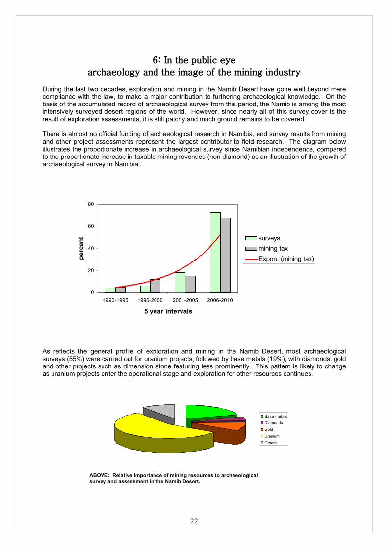
During the last two decades, exploration and mining in the Namib Desert have gone well beyond mere compliance with the law, to make a major contribution to furthering archaeological knowledge. On the basis of the accumulated record of archaeological survey from this period, the Namib is among the most intensively surveyed desert regions of the world. However, since nearly all of this survey cover is the result of exploration assessments, it is still patchy and much ground remains to be covered.
There is almost no official funding of archaeological research in Namibia, and survey results from mining and other project assessments represent the largest contributor to field research. The diagram below illustrates the proportionate increase in archaeological survey since Namibian independence, compared to the proportionate increase in taxable mining revenues (non diamond) as an illustration of the growth of archaeological survey in Namibia.
0
20
40
60
80
1990-1995 1996-2000 2001-2005 2006-2010
5 year intervals
perc
ent surveys
mining taxExpon. (mining tax)
As reflects the general profile of exploration and mining in the Namib Desert, most archaeological surveys (55%) were carried out for uranium projects, followed by base metals (19%), with diamonds, gold and other projects such as dimension stone featuring less prominently. This pattern is likely to change as uranium projects enter the operational stage and exploration for other resources continues.
Base metals
Diamonds
Gold
Uranium
Others
ABOVE: Relative importance of mining resources to archaeologicalsurvey and assessment in the Namib Desert.

23
The three phases of archaeological survey and assessment are clearly reflected in the record of exploration and mining in the Namib during this period. Phase 1 evaluation, or desk assessment, accounts for a relatively small proportion of archaeological investigation (7%). This may be related to the fact that uranium projects, as the dominant exploration field, combined the Phase 1 and Phase 2 stages in order to establish reliable baseline data. Thus, Phase 2 investigations account for 69% of the total. The fact that Phase 3 mitigation accounts for 25% of the total may reflect the advanced stage of development in a number of uranium projects.
Phase 1
Phase 2
Phase 3
ABOVE: Percentage distribution of archaeological survey and assessment phases in Namib Desert exploration and mining projects.
These simple statistics show that archaeological survey and assessment is an increasingly integral part of exploration and mining in the Namib, that archaeological investigations reflect the general resource profile of the industry in this part of the country, and that most projects accommodate the three phase sequence of archaeological evaluation, assessment and mitigation discussed here.
Beyond compliance with legal and policy requirements there are many opportunities for mining companies to make a contribution to archaeological conservation and education in Namibia. Some sites are suitable for small-scale tourism and could generate local employment and income; others may be used for school or university groups. There is also a need for informative and modern museum exhibitions on the subject of Namib Desert archaeology, and there is a ready demand for both popular and scientific publications on the subject. As mining in the Namib enters a more mature stage in its history it would be appropriate to consider some of these options.
The Namib Desert Archaeological SurveyIn the last five years the Namibia Archaeological Trust (est. 1991) has launched a major project to maximize the research potential of archaeological survey and assessment results from the Namib. This project, the Namib Desert Archaeological Survey http://antiquity.ac.uk/projgall/kinahan325/ has collated all available data to create a common spatial platform; collated all available radiocarbon dating results to provide a single integrated sequence; and adopted uniform standards of site and terrain description to aid regional scale comparative research. The results of the project will appear as a series of research publications, handbooks, and on-line data resources. Some of these are already available at www.archaeologynamibia.com The Namib Desert Archaeological Survey would welcome direct support from the mining sector to help it realize some of these goals.

24
RESOURCES
Namibian legislationNational Heritage Act (27 of 2004) Government Notice 287 29th December 2004www.archaeologynamibia.com
Environmental Management Act (7 of 2007) Government Notice 232 27th December 2007www.archaeologynamibia.com
Commencement of the Environmental Management Act, 2007. Government Notice 28 6th February 2012-04-27www.archaeologynamibia.com
List of activities that may not be undertaken without Environmental Management Certificate: Environmental Management Act, 2007. Government Notice 29 6th February 2012-04-27www.archaeologynamibia.com
Environmental Impact assessment Regulations: Environmental Management Act, 2007. Government Notice 30 6 February 2012www.archaeologynamibia.com
Baseline assessmentStrategic Environmental Assessment for the central Namib Uranium Rush (2011) Windhoek, Ministry of Mines and Energy, prepared by the Southern African Institute for Environmental Assessmenthttp://www.saiea.com/uranium/index.htmlCumulative effects analysis: Archaeologyhttp://www.saiea.com/uranium/24Chap7_8March2011.pdf
International conventions & guidelinesConvention concerning the protection of the world cultural and natural heritage. UNESCO 1972. www.unesco.org
Cultural heritage management guidance: Rio Tinto Community relations guidance note. Rio Tinto 2007www.riotinto.com
Good practice guide: Indigenous peoples and mining, ICMM (International Council on Mining & Metals) 2010www.icmm.com
Guidance note 8: Cultural heritage. IFC (International Finance Corporation) 2007www.ifc.org
Procedure for the Management of Indigenous Cultural Heritage Sites. Santos Ltd 2007www.santos.com
Archaeological resources and linksThe Namibia Archaeological Trustwww.archaeologynamibia.com

25
Endnotes:
i See Mitchell, P. 2002. The archaeology of southern Africa. Cambridge University Press, for a general introduction.ii See Deacon, J. and Lancaster, N. 1988. Late Quaternary Palaeoenvironments of Southern Africa. Oxford, Clarendon Press; and Kinahan, J. 2011. From the beginning: the archaeological evidence. In Wallace, M. and Kinahan, J. 2011. A History of Namibia. London, Hurst.iii The modal classification used here is based on Clark, J.D. 1969. Kalambo Falls prehistoric site Volume 1: the geology, palaeoecology and detailed stratigraphy of the excavations. Cambridge, Cambridge University Press; this approach is generally applied by Willoughby, P.R. and Sipe, C.G. 2002. Stone Age prehistory of the Songwe River valley, Lake Rukwa basin, southwestern Tanzania. African Archaeological Review 19: 203-221 and by Barham, L. and Mitchell, P. 2008. The First Africans: African archaeology from the first toolmakers to most recent foragers. Cambridge, Cambridge University Press.

26
Appendix:
Management of No-Go AreasINTRODUCTION: Areas of proposed mining and related activity are subject to heritage survey and assessment at the planning stage. These surveys may identify heritage sites of such outstanding importance as to merit treatment as “no go” areas, effectively excised from mining operations. A “no go” area is closed to walking, driving, cutting access tracks or ground disturbance of any kind. Project managers should also ensure that an identified “no go” area is not accessed by team members during off-duty hours. A “no go” area may be accessed for purposes of heritage audit, inspection by the National Heritage Council, or legitimate research. .
SCOPE: In the sense employed here “no go” denotes a specific management status, with specific management consequences, of a heritage site that has been identified and sufficiently investigated to establish it’s particular importance. The process of identification and evaluation is carried out by a trained archaeologist or other appropriately qualified person. Conservation of a “no go” site requires integration of heritage management needs with mine management procedures.
COMPLIANCE: The “no-go” site management procedure is intended to ensure compliance with the AMP, which is based on archaeological best practice, and the relevant provisions of the National Heritage Act (27 of 2004), especially Section 58 (1)(b) site management plans; (2)(c) and (3) “…enclosure of the site,…as need to be kept secure” (h) “…considers necessary or expedient for the conservation and management of the site”.
RESPONSIBILITIES:Foreman To adequately supervise movement of personnel and/or contractorsSuperintendent To adequately supervise movement of personnel and/or contractorsManagement To endorse special status of “no go” areas in mining operationsArchaeologist To identify, evaluate and document potential “no go” sites; to advise
management , to formulate site management plans, and to perform site inspections or audits of designated “no go” sites.
PROCEDURE: In the course of field survey heritage sites are assessed as to their significance as heritage
assets. This assessment is the basis of any decision regarding the conservation and management of the site. Sites considered to be highly significant are documented in sufficient detail to justify their possible status as “no go” areas.
A management plan for the “no go” site will be based on this documentation, which serves as a site “condition assessment” baseline. Site management plans are to include detailed assessment of the site sensitivity to both natural (ie weathering and erosion) and man-made threats (ie uncontrolled access). The site management plan must comply with National Heritage Act, Section 58 (1)(b).
The site management plan will indicate the specific protection measures to be applied, from access controls, to soil erosion control measures, to signage, to permissions procedures, to site inspection and audit procedures, all specific to the site concerned.
The management plan will indicate the procedure for gaining access to the site and identify the responsible level of management to grant access.
The boundary of a “no go” site will be identified by GPS position by the archaeologist and a GIS file will be generated for the AMP. The boundaries of a “no go” site will include buffer zone appropriate to the circumstances, but sufficient to preserve the local setting of the site.

27
The boundary of a “no go” site will be marked by painted fence-posts placed at inter-visible points, set in concrete footings, and protruding 300mm from the ground. “No go” sites are not to be fenced as such barriers impede the movement of wildlife.
Corner points of the “no go” site boundary will have the site number stamped on a metal strip set into the upper surface of the concrete footings.
Appropriate signage (see below) will be placed at obvious points of access. Signage will be visible regardless of direction of approach to the site.
A site specific audit of the “no go” site will be carried out annually, or at shorter intervals if specified by the site management plan and the AMP.
Site audit records are to be maintained with minimum entries of: Date of audit; names of participants; site integrity including details of any changes and causes; recommendations for changes to the site management plan; incident reports; actions to be taken resulting from incidents
Management of Chance FindsINTRODUCTION: Areas of proposed mining and related activity are subject to heritage survey and assessment at the planning stage. These surveys are based on surface indications alone, and it is therefore possible that sites or items of heritage significance will be found in the course of development work. The personnel and contractor heritage induction process is intended to sensitize people so that they may recognize heritage “chance finds” in the course of their work. The procedure set out here covers the reporting and management of such finds.
SCOPE: The “chance finds” procedure covers the actions to be taken from the discovery of a heritage site or item, to its investigation and assessment by a trained archaeologist or other appropriately qualified person.
COMPLIANCE: The “chance finds” procedure is intended to ensure compliance with the AMP, which is based on archaeological best practice and the relevant provisions of the National Heritage Act (27 of 2004), especially Section 55 (4): “ a person who discovers any archaeological …. object ……must as soon as practicable report the discovery to the Council”. The procedure of reporting set out below must be observed so that heritage remains reported to the NHC are correctly identified in the field.
RESPONSIBILITIES:Operator To exercise due caution if archaeological remains are foundForeman To secure site and advise management timeouslySuperintendent To determine safe working boundary and request inspectionArchaeologist To inspect, identify, advise management, and recover remains
PROCEDURE:Action by person identifying archaeological or heritage material
a) If operating machinery or equipment stop workb) Identify the site with flag tapec) Determine GPS position if possibled) Report findings to foreman
Action by foremana) Report findings, site location and actions taken to superintendentb) Cease any works in immediate vicinity

28
Action by superintendenta) Visit site and determine whether work can proceed without damage to findingsb) Determine and mark exclusion boundaryc) Site location and details to be added to AMP GIS for field confirmation by archaeologist
Action by archaeologista) Inspect site and confirm addition to AH GISb) Advise NHC and request written permission to remove findings from work areac) Recovery, packaging and labelling of findings for transfer to National Museum
In the event of discovering human remainsa) Actions as aboveb) Field inspection by archaeologist to confirm that remains are humanc) Advise and liaise with NHC and Policed) Recovery of remains and removal to National Museum or National Forensic Laboratory, as directed.