for information on task force on land supply 6 march 2018 ...€¦ · rds-2014, viz. northern link...
TRANSCRIPT

For information on 6 March 2018
Task Force on Land Supply Paper No. 06/2018
TASK FORCE ON LAND SUPPLY
Planning of Transport Infrastructure
PURPOSE
This paper briefs members on the prevailing approach for the planning of transport infrastructure to support development needs, as well as the capacity-creating approach advocated under the study on “Hong Kong 2030+: Towards a Planning Vision and Strategy Transcending 2030” (“Hong Kong 2030+ Study”).
TRANSPORT INFRASTRUCTURE IN THE PIPELINE
2. It is the Government’s aim to provide a safe, efficient, reliable andenvironmentally friendly transport system for the sustainable development in Hong Kong. The aim is achieved by expanding and improving the transport infrastructure in a timely manner; improving the coordination and the quality of public transport services; and managing road use to reduce congestion and to promote safety. To ensure transport infrastructure is implemented in a timely manner, we adopt the principle of integrating land-use, transport and environmental planning, with priority accorded to railway. The integrated approach takes into account land-use and environmental planning in order to minimise the need for travel, i.e. the population and employment centres are placed as close as practicable and in the vicinity of railway stations served by integrated pedestrian systems and other transport feeder services to maximise the use of railway.
3. The Planning Department (PlanD) compiles a set of TerritorialPopulation and Employment Data Matrix (TPEDM), which is a well-coordinated population and employment forecast for a certain number of zones in the Hong Kong Special Administrative Region and is a basis on which all major infrastructure including roads, railway, and water supply are planned. The TPEDM is updated from time to time by the PlanD to capture the latest population surveys and forecasts, development proposals and
- 2 -
socio-economic data in the planning horizon. As major infrastructural projects necessitate the investment of substantial public funds by the Government, an updated and accurate TPEDM is an essential planning tool enabling the Government to make investments over the years in transport infrastructure projects to meet traffic demand in good time based on a financially prudent approach and the principle of sustainable development. 4. In line with common international practice for infrastructure projects and established methodology, the assessment on economic return is an indicator of the benefits that a proposed transport infrastructure project will bring to the community. Conventionally, economic return is represented by the economic internal rate of return (EIRR). The EIRR of a transport infrastructure project mainly reflects the savings in the travelling time of transport users over the project life (of 50 years), as a measure of the overall cost-effectiveness of the project to the community. 5. It is noted that the conventionally defined EIRR may not be able to reflect some aspects of economic benefits of a transport infrastructure project which may not be readily quantifiable, such as supporting land use proposals and development opportunities; and for railway, offering transport service of higher quality and cultivating a greener environment. All these factors are taken into account in the overall appraisal of transport infrastructure proposals as they are all concerned with the sustainability of a community, such as the quality of life, mobility of the population, and competitiveness of the economy. Road Infrastructure 6. Road infrastructure supports all main land-based public transport modes (except railway) that account for about 60% of the daily patronage in Hong Kong. Roads are also essential for the carriage of goods that support the logistics industry and door-to-door transport including vehicles for security and emergency purposes. The Transport Department (TD) and the Highways Department (HyD) conduct regular reviews of the development of transport infrastructure in Hong Kong and strategic assessments on major highway developments. They use transport models and the latest TPEDM to forecast the traffic demand in the territory in order to update the need, scope and implementation timetable of various proposed major highway projects. The TD last updated the transport model to ensure that the planning parameters up to 2036 be included in the traffic forecast.

- 3 -
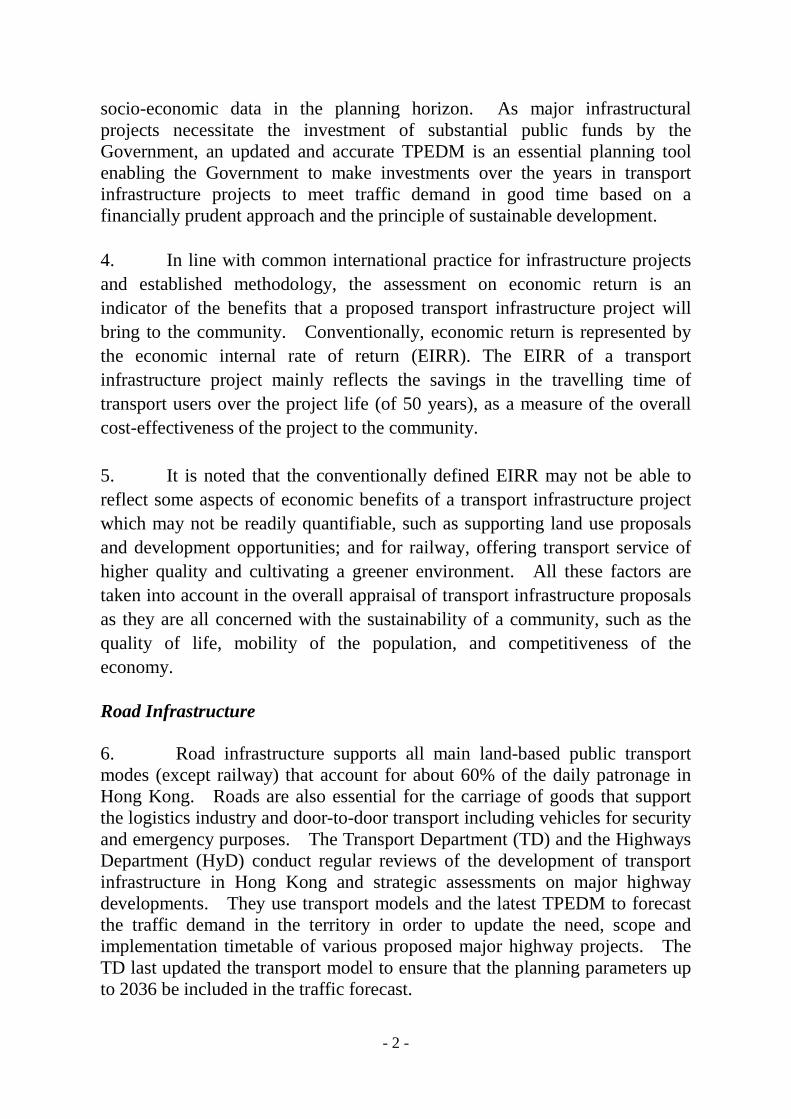
7. Under the prevailing approach, we have been able to establish the justifications for new road projects and secure funding from the Finance Committee (FC) of the Legislative Council (LegCo) for their implementation. In the past ten years, major projects completed include Route 8 (the Tsing Yi Section and the Sha Tin Section), the Kong Sham Western Highway, the widening of Tolo Highway – Stages 1 and 2 and the reconstruction and improvement of Tuen Mun Road. Large-scale road projects under construction include the Hong Kong sections of the Hong Kong-Zhuhai-Macao Bridge (namely the Hong Kong Link Road and the Hong Kong Boundary Crossing Facilities), the Tuen Mun-Chek Lap Kok Link, the Central-Wan Chai Bypass and Island Eastern Corridor, the Tseung Kwan O-Lam Tin Tunnel and the Central Kowloon Route. Local improvement works under construction include the Hiram’s Highway Improvement Stage 1 and the improvement to Pok Oi Interchange. In parallel, we are seeking funding approval from the FC for the widening of Tai Po Road (Sha Tin Section) and the construction of Cross Bay Link in Tseung Kwan O. Projects under planning include the Trunk Road T2 of the strategic Route 6, Route 11, and the Tuen Mun Western Bypass. The locations of the existing strategic routes, and the recently completed, planned and committed major roads are indicated in Annex 1 and Annex 2 respectively. Railway 8. Railway is the backbone of the public transport system of Hong Kong. Railway projects involve huge capital investment, and it typically takes more than ten years for a railway project to take shape from formulation of ideas, conceptual planning, consultation with stakeholders, detailed design, to actual construction and completion. As they have profound impact on people’s livelihood and socio-economic development, we have to be forward-looking and make timely plans for our railway development in future. 9. After the commissioning of the West Island Line in 2015, as well as Kwun Tong Line Extension and South Island Line (East) in 2016, we continue to press ahead with the construction of the Hong Kong Section of Guangzhou-Shenzhen-Hong Kong Express Rail Link (XRL) and the Shatin to Central Link (SCL). The target commissioning date of the XRL is in the third quarter of 2018. For the SCL, the target commissioning date of the “Tai Wai to Hung Hom Section” is in mid-2019, while that of the “Hung Hom to Admiralty Section” is in 2021. Upon their completion by 2021, our railway network will be expanded to cover areas inhabited by over 70% of the population in Hong Kong.
- 4 -
10. The latest blueprint of railway development in Hong Kong is the “Railway Development Strategy 2014” (RDS-2014), which aims at providing a framework for planning the future expansion of Hong Kong’s railway network up to 2031. The RDS-2014 is based on the findings and final recommendations of the consultancy study and the views collected during a two-stage Public Engagement exercise. In formulating the Strategy, a wide range of factors, including transport planning1, land use planning and housing demand, development needs, economic return and other benefits, environmental impact and engineering feasibility, have been considered. Seven railway projects are recommended to be taken forward under the RDS-2014, viz. Northern Link and Kwu Tung Station, Hung Shui Kiu Station, Tung Chung West Extension, Tuen Mun South Extension, East Kowloon Line, South Island Line (West) and North Island Line. The taking forward of individual proposed railway projects will be subject to the outcome of detailed engineering, environmental and financial studies relating to each project, as well as updated demand assessment and availability of resources. When all these railway schemes are completed progressively up to 2031, the railway network will cover areas inhabited by 75% of the local population and about 85% of job opportunities. The locations of the existing, recently commissioned, planned and committed railways are indicated in Annex 3 and Annex 4 respectively. 11. Our overall aim is to develop an affordable, accessible, efficient and environmentally friendly public transport system providing diverse choices for the travelling public. As projects other than railway such as initiatives on land production, housing supply, hospitals, schools and elderly centres may be equally, if not more, important to the community, the Government will carefully consider all relevant factors and strike a reasonable balance among various interests of the community when mapping out the way forward for each railway project. In particular, we will critically examine the financial implications of individual railway projects to the Government and consider the most appropriate implementation programme and financing arrangement for each project. 12. In addition, the timetable for the implementation of the railway schemes may be adjusted for railway projects which are contingent upon the progress of residential developments to address the associated transport needs. In other words, a railway project will be taken forward to support planned
1 Factors such as high level of connectivity, relief to the loading of critical transport corridors, and operational robustness of the railway network are taken into account.

- 5 -
development if the planning parameters so justify. CAPACITY-CREATING APPROACH UNDER “HONG KONG 2030+ STUDY” 13. The on-going “Hong Kong 2030+ Study” undertaken by the Development Bureau (DEVB) and the PlanD advocates an enhanced strategic planning approach with a view to creating development capacity for Hong Kong in an optimal manner in tandem with enhancement of infrastructural as well as environmental capacity. This approach aims not only to cater for foreseeable land use demand arising from trend-based population growth and economic development, but also proactively plan with visions in advance for capacity to enhance the quality of our living environment, cater for potential demand and unforeseen circumstances, as well as respond to possible changes and challenges in a timely manner. 14. To create a reasonable capacity to meet projected housing, social and economic needs with buffer to respond to unforeseeable demands, the “Hong Kong 2030+ Study” proposed two strategic growth areas (SGAs), namely the East Lantau Metropolis (ELM) and the New Territories North (NTN), and a supporting transport network comprising a Northwest New Territories (NWNT)-Lantau-Metro Transport Corridor connecting ELM with Hong Kong West, West Kowloon, North Lantau and NWNT, and a North-South Transport Corridor connecting NTN with the Metro Area. The strategic transport corridors will also enhance urban mobility, thereby benefitting a wider community not just the population in ELM and NTN. A conceptual spatial framework proposed under the “Hong Kong 2030+ Study” is shown in Annex 5.
15. Based on our understanding, under the capacity-creating approach, the strategic planning of the infrastructure along two proposed transport corridors would be geared towards generating sufficient and timely capacity with contingency to support the spatial distribution of development capacity. Specifically, under the spatial development strategy devised under the “Hong Kong 2030+ Study”, a set of broad planning parameters will be provided in terms of future territorial distribution of development capacity for population, employment, land uses, etc., which could then form the basis for any reviews

- 6 -
or studies on strategic planning of transport and other infrastructure by the respective bureaux and departments in the same manner as at present. To implement this approach, and so that the relevant bureaux and departments (at the downstream) have a clear basis to follow up, vision-driven planning data will have to be incorporated into the TPEDM by the PlanD. 16. As a matter of fact, the capacity-creating approach is a paradigm shift from the prevailing demand-led approach. Population and employment forecasts, traditional volume/capacity ratios and EIRR, etc. would no longer be the only key criteria for assessment in future. Rather, they have to be supplemented by justifications arising from the visionary land use planning scenarios. The basis for justifying the provision of infrastructure, including water supply, sewerage, transport, etc., will have to be acceptable to parties both within and outside the Government including the LegCo and the Director of Audit (as completed projects would be subject to value-for-money audits). 17. According to DEVB, while sufficient land resources and infrastructure capacity with necessary contingency would be planned upfront at a strategic level, the implementation of individual projects would continue to be assessed and evaluated meticulously and thoroughly in accordance with the established mechanism, legal framework, guidelines and/or standards taking into account relevant considerations including cost-effectiveness and priority of resources. Based on our experience in dealing with different stakeholders (both inside and outside the Government), the application of the capacity-creating approach at the project level may well call for the incorporation of planning parameters in different versions of the TPEDM by the PlanD to cover scenarios with and without the “capacity creating” contingency. We would use our best endeavours to develop technically feasible schemes under both scenarios (obviously with different price tags) for presentation to the community (including the LegCo and relevant District Councils) so that they can make informed decisions whether to allocate resources to the transport infrastructure project that is premised on the capacity-creating approach. 18. Extra resources will inevitably be required when contingency (extra capacity) is allowed for in transport infrastructure projects. The level of extra resources required will vary among projects. In general, as there will be more spatial requirements for the contingency itself, extra resources are

- 7 -
needed to develop or resume adjacent land lots (especially in urban areas) to provide space for the additional transport infrastructure such as additional traffic lanes and grade-separated interchanges. In addition, the provision of contingency would be subject to statutory assessments under the Environmental Impact Assessment Ordinance, the Town Planning Ordinance and the Protection of Harbour Ordinance, etc. STRATEGIC STUDIES ON RAILWAYS AND MAJOR ROADS BEYOND 2030 19. We are seeking funding approval from the LegCo to commission the “Strategic Studies on Railways and Major Roads beyond 2030” (RMR2030+ Studies) on the basis of the strategic direction for transport provision to be drawn up under the “Hong Kong 2030+ Study”. The RMR2030+ Studies will examine the performance of the transport infrastructure (including railway and major roads) in Hong Kong between 2031 and 2041, based on the latest planning information available (up to 2041). Where potential bottlenecks due to the change in the overall development are identified, the HyD and the TD will recommend railway projects or major road projects respectively wherever practicable. 20. The RMR2030+ Studies will draw particular attention to the transport infrastructure for supporting the two SGAs (i.e. ELM and NTN) recommended for long-term implementation in the “Hong Kong 2030+ Study”. The Studies will look into the layout of the proposed railway and major road infrastructure; and cover preliminary engineering technical reviews to ensure that the planning of large-scale transport infrastructure can meet the needs of long term overall land use developments. The RMR2030+ Studies will also examine the impact of the proposed transport infrastructure on the existing transport network to formulate relevant transport strategies. 21. Apart from the above two SGAs, the RMR2030+ Studies will focus on the loading of the heavy rails in the NWNT beyond 2030 according to the planning data up to 2041. Based on the forecast demand, we will carry out studies on whether it is necessary to construct a new heavy rail to directly connect NWNT to urban areas.

- 8 -
22. On the basis of the final results of the “Hong Kong 2030+ Study” and subject to the availability of the TPEDM by the PlanD (with the contingency incorporated), we are prepared to adopt the capacity-creating approach in conducting transport model runs and assessing the traffic forecasts on the proviso that the Government (led by DEVB) can secure broad community support on the adoption of this approach. After securing funding from the LegCo, we will commence the RMR2030+ Studies as soon as practicable.
Transport and Housing Bureau March 2018
現有的主要幹道 Existing Strategic Routes 附件1 Annex 1
圖例 Legend: 現有鐵路 Existing Railway Lines 一號幹線 Route 1 二號幹線 Route 2 三號幹線 Route 3 四號幹線 Route 4 五號幹線 Route 5 七號幹線 Route 7 八號幹線 Route 8 九號幹線 Route 9 十號幹線 Route 10
古洞北 新發展區
落馬洲河套區
粉嶺北 新發展區
古洞南
元朗南 洪水橋新發展區
屯門40及46區
港珠澳大橋香港口岸 人工島上蓋發展
機場島北商業區
東涌新市 鎮擴展
錦田南
鑽石山 綜合發展區
啟德發展區
安達臣道石礦場
將軍澳137 區
前茶果嶺高嶺土礦場
前南丫石礦場
1 1
1 1
1 4
1 9
1 9
1 3 1 9
1 10
1 2
1 2
1 7
1 7
1 8
1 8
1 8 1 3
1 3
1 9
1 5
1 5
1 4
1 1
1 2
1 3
1 4
1 5
1 7
1 8
1 9
1 10

圖例 Legend: 現有鐵路 Existing Railway Lines 現有主要幹道 Existing Strategic Routes 過去10年完成的主要道路 Major Road Projects completed in the past 10 years 建造中的主要道路 Major Road Projects under Construction 規劃中的主要道路(示意走線) Major Road Projects under Planning (Indicative Alignment)
古洞北 新發展區
落馬洲河套區
粉嶺北 新發展區
古洞南
元朗南 洪水橋新發展區
屯門40及46區
港珠澳大橋香港口岸 人工島上蓋發展
機場島北商業區
東涌新市鎮擴展
錦田南
鑽石山 綜合發展區
啟德發展區
安達臣道 石礦場
前茶果嶺高嶺土礦場 中九龍幹線
Central Kowloon Route
T2主幹路 Trunk Road T2
將軍澳 – 藍田隧道 Tseung Kwan O – Lam Tin
Tunnel
將軍澳跨灣連接路 Cross Bay Link at Tseung Kwan O
中環灣仔繞道和東區走廊連接路 Central – Wan Chai Bypass & Island Eastern Corridor Link
11號幹線 Route 11
港珠澳大橋 Hong Kong - Zhuhai - Macao
Bridge 香港接線
Hong Kong Link Road
屯門至赤鱲角連接路 Tuen Mun - Chek Lap Kok
Link
屯門西繞道 Tuen Mun Western Bypass
8號幹線(青衣及沙田段) Route 8 (Tsing Yi and
Sha Tin Sections)
屯門公路重建及改善工程 Reconstruction and
Improvement of Tuen Mun Road
博愛交匯處改善工程 Improvement to Pok Oi Interchange
港深西部公路 Kong Sham Western Highway
吐露港公路擴闊工程(第一階段) Widening of Tolo Highway – Stage 1
吐露港公路擴闊工程(第二階段) Widening of Tolo Highway – Stage 2
西貢公路改善工程第一期 Hiram’s Highway Improvement Stage 1
大埔公路(沙田段)擴闊工程 Widening of Tai Po Road (Sha Tin Section)
近期完成、已規劃及已落實的主要道路項目 Recently Completed, Planned and Committed Major Roads 附件2 Annex 2
,
前南丫石礦場

附件3 Annex 3
圖例 Legend: 現有幹道 Existing Strategic Routes 西鐵線 West Rail Line (WR) 東鐵線 East Rail Line (ER) 南港島線 South Island Line (SIL) 馬鞍山線 Ma On Shan Line (MOL) 東涌線 Tung Chung Line (TCL) 機場快線 Airport Express (AEL) 港島線 Island Line (IL) 荃灣線 Tsuen Wan Line (TWL) 觀塘線 Kwun Tong Line (KTL) 將軍澳線 Tseung Kwan O Line (TKOL) 迪士尼線 Disneyland Resort Line (DRL)
現有的鐵路網 Existing Railways
古洞北 新發展區
落馬洲河套區
粉嶺北 新發展區
古洞南
元朗南 洪水橋新發展區
屯門40及46區
港珠澳大橋香港口岸 人工島上蓋發展
機場島北商業區
東涌新市 鎮擴展
錦田南
鑽石山 綜合發展區
啟德發展區
安達臣道石礦場
將軍澳137 區
前茶果嶺高嶺土礦場
前南丫石礦場
WR
DRL TCL
AEL
ER
TWL
MOL
IL
SIL
TKOL
KTL

近期完成、已規劃及已落實的鐵路 Recently Commissioned, Planned and Committed Railways
古洞北 新發展區
落馬洲河套區
粉嶺北 新發展區
古洞南
元朗南 洪水橋新發展區
屯門40及46區
港珠澳大橋香港口岸 人工島上蓋發展
機場島北商業區
東涌新市 鎮擴展
錦田南
鑽石山 綜合發展區
啟德發展區
安達臣道石礦場
將軍澳137 區
前茶果嶺高嶺土礦場
附件4 Annex 4
圖例 Legend: 現有鐵路 Existing Railway Lines 近期通車的鐵路 Railway Lines recently commissioned 現有主要幹道 Existing Strategic Routes 建造中的鐵路項目 Railway Projects under Construction 《鐵路發展策略2014》 建議的鐵路計劃 (示意走線) Railway Schemes Recommended in RDS2014 (Indicative Alignment) 建議鐵路站 Proposed railway station
西港島線 West Island Line
觀塘線延線 Kwun Tong Line
Extension
南港島線(東段) South Island Line (East)
擬議北環線(及古洞站) Proposed Northern Link (and Kwu Tung Station )
擬議東九龍線 Proposed East Kowloon Line
擬議洪水橋站 Proposed Hung Shui Kiu Station
擬議屯門南延線 Proposed Tuen Mun South Extension
擬議東涌西延線 Proposed Tung Chung West Extension
擬議北港島線 Proposed North Island Line
沙田至中環線 (沙中線) Shatin to Central Link
擬議南港島線(西段) Proposed South Island Line (West)
廣深港高速鐵路香港段 Hong Kong Section of the
Guangzhou-Shenzhen-Hong Kong Express Rail Link
前南丫石礦場

香港2030+下建議的概念性空間框架 Proposed Conceptual Spatial Framework under Hong Kong 2030+
擬議運輸走廊 Proposed Transport Corridors
附件5 Annex 5