for personal use only - australian securities · pdf fileprimary 5.1 4.79 240,900 indicated +...
TRANSCRIPT
ASX ANNOUNCEMENT
29 January 2016
QUARTERLY ACTIVITIES REPORT
PERIOD ENDING 31 DECEMBER 2015
HIGHLIGHTS:
McIntosh Flake Graphite Project:
Significant drill intercepts reported during the quarter:
EMPEROR T6GDD164: 44m @ 4.4%TGC from 47m T6GDD167: 47 metres @ 5.0% TGC from 126m, including 13 metres @ 6.3% TGC from 143m and 10 metres @ 6.3% TGC from 158m T6GDD168: 59m @ 4.7%TGC from 96m T6GDD176: (upper zone) 16 metres @ 5.3% TGC from 87m, including 5 metres @ 6.9% TGC from 87m and 4 metres @ 6.0% TGC from 99m plus (lower zone) 29m @ 4.3% TGC from 156m including 13m @ 5.7% TGC from 143m (*combined intercept of 45 metres @ 4.7% TGC) T6GDD192: 40 metres @ 4.2% TGC from 38m, including 5 metres @ 6.0% TGC from 38m, 12 metres @ 4.8% TGC from 48m and 10 metres at 4.8% TGC from 68m T6GDD193: 139 metres @ 4.0% TGC from 57m, including 6 metres @ 5.1% TGC from 57m, 9 metres @ 6.0% TGC from 74m T6GDD194: 62 metres @ 4.2% TGC from 117m, including 6m @ 4.9% TGC from 130m; 5m @ 8.3% TGC from 156m and 6 metres at 8.6% TGC from 173m
WAHOO T4GDD179: 31 metres @ 4.4% TGC from 28m and 12 metres @ 5.8% TGC from 47m T4GDD177: 8 metres @ 5.1% TGC from 50m and 5 metres @ 4.8% TGC from 83m
BARRACUDA T5GDD190: 2 metres @ 6.3% TGC from 40m and 6 metres @ 4.4% TGC from 50 metres, including 2 metres @ 6.1% TGC from 50m
Subsequent to the end of the quarter:
JORC Resource Estimate for McIntosh of 17.2Mt @ 4.63% TGC for 797,200 tonnes of contained graphite
For
per
sona
l use
onl
y

2
Largest JORC Compliant Flake Graphite Resource in Australia
Represents a 136% increase in the McIntosh Resource Base with 7.8Mt @ 4.55% TGC in the indicated category
Ultra-high purity of +99% TC from simple floatation, combined with the largest graphite resource base in the stable mining jurisdiction of Australia
Less than 15% of the strike length potential at McIntosh has been drilled to date, huge upside exists to significantly expand the resource base further
Corporate
Hexagon Resources Limited changed name from Lamboo Resources Limited after seeking shareholder approval at the Annual General Meeting 27 November 2015. The Company code changed to HXG on 2 December 2015.
MCINTOSH FLAKE GRAPHITE PROJECT
Table 1: McIntosh Flake Graphite Project Global Mineral Resource Estimate – 27 January 2016
For
per
sona
l use
onl
y

3
The global Mineral Resource Estimate (MRE) for the McIntosh Flake Graphite Project comprises 17.2 million tonnes at an average grade of 4.63% TGC in compliance with the 2012 JORC code (see Table 1 and Figure 1). A total of 7.8 million tonnes at 4.55% TGC, being 45% of the total McIntosh resource, is within the indicated category, representing a high degree of geological confidence allowing for conversion into mineable ore reserves.
DepositJORC
ClassificationMaterial Type
Tonnes (Mt)
TGC (%)
Contained Graphite (Tonnes)
Oxide - - -Primary 3.4 4.32 145,250
Oxide - - -Primary 5.1 4.79 240,900
Indicated + Inferred Oxide + Primary 8.4 4.61 386,150
Oxide - - -Primary 4.5 4.71 210,350
Oxide 0.5 4.51 24,350
Primary 2.1 4.84 103,000
Indicated + Inferred Oxide + Primary 7.1 4.73 337,700
Oxide 0.1 4.16 3,550
Primary 0.8 4.43 37,000
Inferred Oxide + Primary 0.9 4.40 40,550
Oxide 0.3 4.49 11,350
Primary 0.5 4.37 21,450
Inferred Oxide + Primary 0.7 4.41 32,800
Total Resource Indicated + Inferred Oxide + Primary 17.2 4.63 797,200
Notes: 1. Longtom (Target 1) has a 2% TGC lower cut-off grade. Emperor (Target 6), Wahoo (Target 4) and Barracuda (Target 5) have a 3% TGC lower cut-off grade.
2. Rounding may result in differences in total and average grades
Inferred
Inferred
Inferred
EMPEROR
LONGTOM
WAHOO
BARRACUDA
Indicated
Inferred
Indicated
For
per
sona
l use
onl
y
4
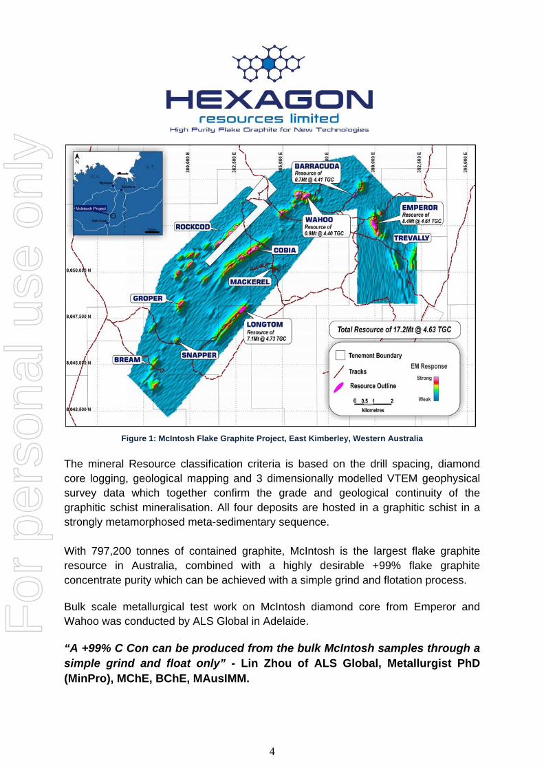
Figure 1: McIntosh Flake Graphite Project, East Kimberley, Western Australia
The mineral Resource classification criteria is based on the drill spacing, diamond core logging, geological mapping and 3 dimensionally modelled VTEM geophysical survey data which together confirm the grade and geological continuity of the graphitic schist mineralisation. All four deposits are hosted in a graphitic schist in a strongly metamorphosed meta-sedimentary sequence. With 797,200 tonnes of contained graphite, McIntosh is the largest flake graphite resource in Australia, combined with a highly desirable +99% flake graphite concentrate purity which can be achieved with a simple grind and flotation process.
Bulk scale metallurgical test work on McIntosh diamond core from Emperor and Wahoo was conducted by ALS Global in Adelaide.
“A +99% C Con can be produced from the bulk McIntosh samples through a simple grind and float only” - Lin Zhou of ALS Global, Metallurgist PhD (MinPro), MChE, BChE, MAusIMM.
For
per
sona
l use
onl
y
5
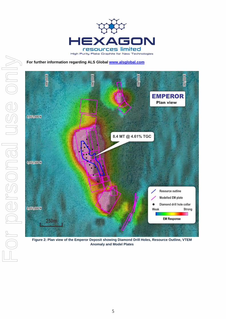
For further information regarding ALS Global www.alsglobal.com
Figure 2: Plan view of the Emperor Deposit showing Diamond Drill Holes, Resource Outline, VTEM
Anomaly and Model Plates
For
per
sona
l use
onl
y

6
Figure 3: Oblique view of the Maiden resource Estimate at the Emperor Deposit
Figure 4: Cross-section view of the Emperor Deposit at 8,052,590mN
For
per
sona
l use
onl
y

7
Figure 5: Plan view of the Wahoo Deposit showing Diamond Drill Holes,
Resource Outline, VTEM Anomaly and Model Plates
Figure 6: Plan view of the Barracuda Deposit showing Diamond Drill
Holes, Resource Outline, VTEM Anomaly and Model Plates
For
per
sona
l use
onl
y
8
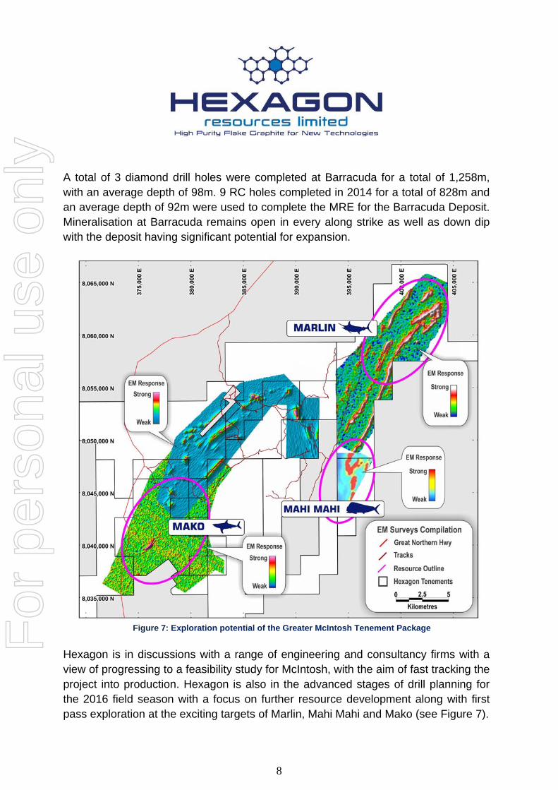
A total of 3 diamond drill holes were completed at Barracuda for a total of 1,258m, with an average depth of 98m. 9 RC holes completed in 2014 for a total of 828m and an average depth of 92m were used to complete the MRE for the Barracuda Deposit. Mineralisation at Barracuda remains open in every along strike as well as down dip with the deposit having significant potential for expansion.
Figure 7: Exploration potential of the Greater McIntosh Tenement Package
Hexagon is in discussions with a range of engineering and consultancy firms with a view of progressing to a feasibility study for McIntosh, with the aim of fast tracking the project into production. Hexagon is also in the advanced stages of drill planning for the 2016 field season with a focus on further resource development along with first pass exploration at the exciting targets of Marlin, Mahi Mahi and Mako (see Figure 7).
For
per
sona
l use
onl
y
9
The natural flake graphite market is currently experiencing outstanding growth due to the increasing demand for lithium-ion batteries for use in electric vehicles and energy storage from renewable sources such as solar and wind. Hexagon’s strategy is focussed on taking advantage of the continued growth in the sector by producing high purity flake graphite for use as anode material in these batteries.
Commercial samples of the McIntosh ultra high purity flake graphite concentrate have been produced by ALS global in Adelaide for end users to test in their specific applications. Discussions with potential off take partners is ongoing with the company focusing its efforts on the end-user groups in the li-ion battery market.
Hexagon will also be commencing a detailed test work program on the McIntosh flake graphite concentrate with Adelaide Research and Innovation Pty Ltd a wholly owned subsidiary of the University of Adelaide. The test work program will include characterisation of the physical, electrical, structural and chemical composition using a number of specialist techniques and evaluate the extraction of graphene using 3 exfoliation methods with a series of characterisation techniques. It will also determine the quality and yield of the isolated graphene.
For
per
sona
l use
onl
y
10
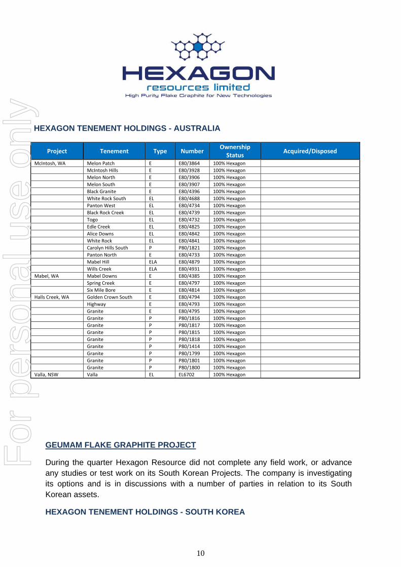
HEXAGON TENEMENT HOLDINGS - AUSTRALIA
Project Tenement Type Number Ownership Status
Acquired/Disposed
McIntosh, WA Melon Patch E E80/3864 100% Hexagon
McIntosh Hills E E80/3928 100% Hexagon
Melon North E E80/3906 100% Hexagon
Melon South E E80/3907 100% Hexagon
Black Granite E E80/4396 100% Hexagon
White Rock South EL E80/4688 100% Hexagon
Panton West EL E80/4734 100% Hexagon
Black Rock Creek EL E80/4739 100% Hexagon
Togo EL E80/4732 100% Hexagon
Edle Creek EL E80/4825 100% Hexagon
Alice Downs EL E80/4842 100% Hexagon
White Rock EL E80/4841 100% Hexagon
Carolyn Hills South P P80/1821 100% Hexagon
Panton North E E80/4733 100% Hexagon
Mabel Hill ELA E80/4879 100% Hexagon
Wills Creek ELA E80/4931 100% Hexagon
Mabel, WA Mabel Downs E E80/4385 100% Hexagon
Spring Creek E E80/4797 100% Hexagon
Six Mile Bore E E80/4814 100% Hexagon
Halls Creek, WA Golden Crown South E E80/4794 100% Hexagon
Highway E E80/4793 100% Hexagon
Granite E E80/4795 100% Hexagon
Granite P P80/1816 100% Hexagon
Granite P P80/1817 100% Hexagon
Granite P P80/1815 100% Hexagon
Granite P P80/1818 100% Hexagon
Granite P P80/1414 100% Hexagon
Granite P P80/1799 100% Hexagon
Granite P P80/1801 100% Hexagon
Granite P P80/1800 100% Hexagon
Valla, NSW Valla EL EL6702 100% Hexagon
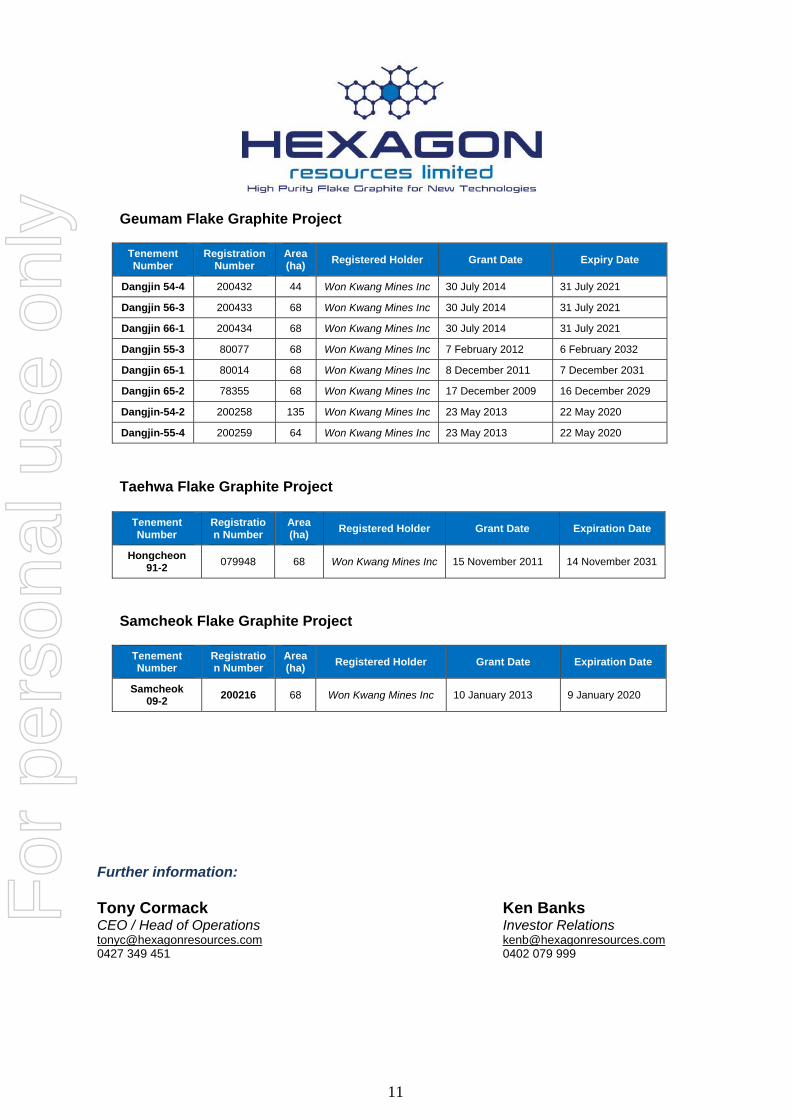
GEUMAM FLAKE GRAPHITE PROJECT
During the quarter Hexagon Resource did not complete any field work, or advance any studies or test work on its South Korean Projects. The company is investigating its options and is in discussions with a number of parties in relation to its South Korean assets.
HEXAGON TENEMENT HOLDINGS - SOUTH KOREA
For
per
sona
l use
onl
y
11
Geumam Flake Graphite Project
Tenement Number
Registration Number
Area (ha)
Registered Holder Grant Date Expiry Date
Dangjin 54-4 200432 44 Won Kwang Mines Inc 30 July 2014 31 July 2021
Dangjin 56-3 200433 68 Won Kwang Mines Inc 30 July 2014 31 July 2021
Dangjin 66-1 200434 68 Won Kwang Mines Inc 30 July 2014 31 July 2021
Dangjin 55-3 80077 68 Won Kwang Mines Inc 7 February 2012 6 February 2032
Dangjin 65-1 80014 68 Won Kwang Mines Inc 8 December 2011 7 December 2031
Dangjin 65-2 78355 68 Won Kwang Mines Inc 17 December 2009 16 December 2029
Dangjin-54-2 200258 135 Won Kwang Mines Inc 23 May 2013 22 May 2020
Dangjin-55-4 200259 64 Won Kwang Mines Inc 23 May 2013 22 May 2020
Taehwa Flake Graphite Project
Tenement Number
Registration Number
Area (ha)
Registered Holder Grant Date Expiration Date
Hongcheon 91-2
079948 68 Won Kwang Mines Inc 15 November 2011 14 November 2031
Samcheok Flake Graphite Project
Tenement Number
Registration Number
Area (ha)
Registered Holder Grant Date Expiration Date
Samcheok 09-2
200216 68 Won Kwang Mines Inc 10 January 2013 9 January 2020
Further information: Tony Cormack Ken Banks CEO / Head of Operations Investor Relations [email protected] [email protected] 0427 349 451 0402 079 999
For
per
sona
l use
onl
y

12
Competent Persons Statement
The information in this report that relates to Mineral Resources for Emperor, Wahoo and Barracuda is based on information compiled by Mr Shane Tomlinson who is an independent consultant and a member of The Australian Institute of Geoscientists and Mr Tony Cormack who is a full time employee of Hexagon Resources Limited and a member of the Australasian Institute of Mining and Metallurgy. Mr. Cormack has sufficient experience which is relevant to the activity being undertaken to qualify as a Competent Person as defined in the 2012 edition of the 'Australasian Code of Reporting of Exploration Results, Mineral Resources and Ore Reserves'. Mr Cormack consents to the inclusion in this report of the matters based on his information in the form and context in which it appears.
The information in this report that relates to Mineral Resources for Longtom (Target 1) is based on information compiled by Mr Rod Williams, a Competent Person, who is a Member of The Australian Institute of Geoscientists and a Member of The Australasian Institute of Mining and Metallurgy. Mr Williams is employed by Norvale Pty Ltd, an independent consulting company. Mr Williams has sufficient experience that is relevant to the style of mineralisation and type of deposit under consideration and to the activity being undertaken to qualify as a Competent Person as defined in the 2012 Edition of the 'Australasian Code for Reporting of Exploration Results, Mineral Resources and Ore Reserves’. The information that relates to Mineral Resources at Longtom (Target 1) have been previously reported by Hexagon and Mr Williams provided his consent at that time (refer to HXG announcement 20th January 2014). The information in this report relating Exploration Target Estimates, Exploration Drilling, Assay Results and Geological Data at the McIntosh Project is based on information previously compiled and / or reviewed by Mr. Tony Cormack, Member of the Australasian Institute of Mining and Metallurgy and a full-time employee of Hexagon Resources Limited. Mr. Cormack has sufficient experience which is relevant to the activity being undertaken to qualify as a Competent Person as defined in the 2012 edition of the 'Australasian Code of Reporting of Exploration Results, Mineral Resources and Ore Reserves'. Mr Cormack consents to the inclusion in this report of the matters based on his information in the form and context in which it appears.
APPENDIX 1
JORC Table 1 Assessment
Table 1 (Section 1) – Sampling Techniques and Data
Criteria JORC Code Commentary
Sampling techniques Nature and quality of sampling (e.g. cut channels, random chips, or specific specialised industry standard measurement tools appropriate to the minerals under investigation, such as down hole gamma sondes, or handheld XRF instruments, etc.). These examples should not be taken as limiting
Sampling methods‐ Reverse Circulation (RC) drilling used high pressure air and a sophisticated cyclone with a cone splitter. Sampling was taken as continuous one metre intervals.
Diamond drill (DD) core was generally sampled at one metre intervals. Where geology indicated an
For
per
sona
l use
onl
y

13
Criteria JORC Code Commentary
the broad meaning of sampling. Include reference to measures taken to ensure sample representivity and the appropriate calibration of any measurement tools or systems used.
obvious change, sampling was undertaken so that the one metre samples could be composited.
Duplicate samples were taken during RC drilling.
RC drilling samples of 3 to 5 kg weight were shipped to the laboratory in plastic bags; samples were pulverized and milled for assay.
Diamond core was marked up and cut into half and quarter core using a large diamond bladed saw.
Aspects of the determination of mineralisation that are Material to the Public Report. In cases where ‘industry standard’ work has been done this would be relatively simple (e.g. ‘reverse circulation drilling was used to obtain 1 m samples from which 3 kg was pulverised to produce a 30 g charge for fire assay’). In other cases more explanation may be required, such as where there is coarse gold that has inherent sampling problems. Unusual commodities or mineralisation types (e.g. submarine nodules) may warrant disclosure of detailed information
Industry standard RC and DD methods were used. It is noted that although RC drilling may yield samples sufficient to estimate graphite content (total graphitic carbon, or “TGC”), RC samples are generally considered insufficient to estimate graphite flake size and purity.
Diamond core drilling is recommended to twin selected RC holes so as to verify TGC, flake size and purity or liberation characteristics.
Drilling techniques Drill type (e.g. core, reverse circulation, open‐hole hammer, rotary air blast, auger, Bangka, sonic, etc.) and details (e.g. core diameter, triple or standard tube, depth of diamond tails, face‐sampling bit or other type, whether core is oriented and if so, by what method, etc.).
RC drilling (5 ½” hammer) accounts for majority of the drilling database at Mackerel, Cobia, Barracuda and Emperor Minor diamond core drilling (NQ) at Mackerel and Cobia. All diamond core drilling at target Wahoo, Barracuda and Emperor is HQ.
Drill sample recovery Method of recording and assessing core and chip sample recoveries and results assessed.
RC split samples were recovered from a cyclone and rig‐mounted cone splitter. The sample recovery and physical state were recorded. Sample recovery of the diamond core is recorded on core blocks after each run and recorded in the logging.
Measures taken to maximise sample recovery and ensure representative nature of the samples.
A face sampling hammer is used to reduce contamination at the face. Diamond drilling samples are half and quarter cored, with core sawn using a diamond blade core‐saw.
Whether a relationship exists between sample recovery and grade and whether sample bias may have occurred due to preferential loss/gain of fine/coarse material.
RC samples in one pair of twin holes are noted to report lower graphite content than DD core at Longtom, therefore it is suggested that RC samples are biased due to loss of fine material. HQ diamond core drilling has been utilised at Targets Wahoo, Barracuda and Emperor.
Logging Whether core and chip samples have been geologically and geotechnically logged to a level of detail to support appropriate Mineral Resource estimation, mining studies and metallurgical studies.
All RC chips and diamond core were geologically logged in the field by qualified geologists. Lithological and mineralogical data is recorded for all drill holes using a coding system developed specifically for the Project. Diamond core is geotechnically logged.
Primary and secondary lithologies are recorded in
For
per
sona
l use
onl
y
14
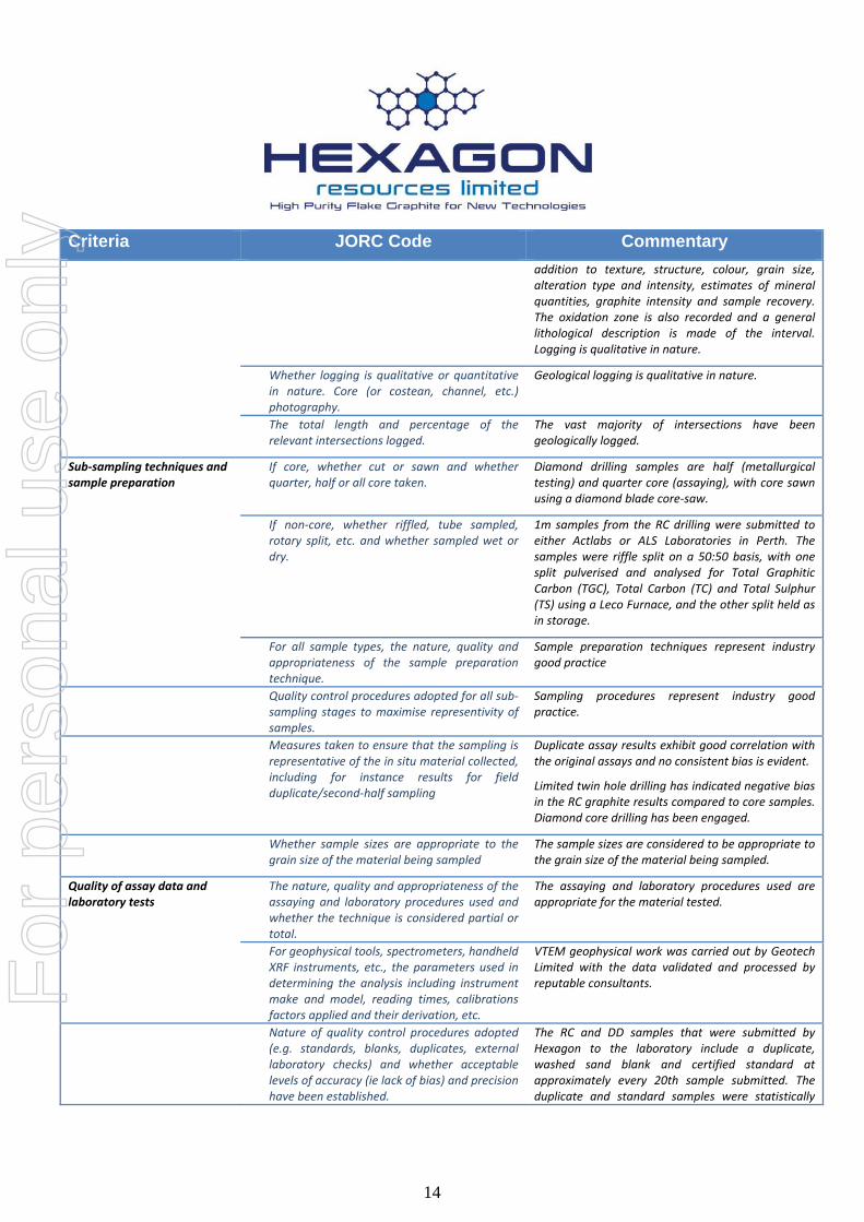
Criteria JORC Code Commentary
addition to texture, structure, colour, grain size, alteration type and intensity, estimates of mineral quantities, graphite intensity and sample recovery. The oxidation zone is also recorded and a general lithological description is made of the interval. Logging is qualitative in nature.
Whether logging is qualitative or quantitative in nature. Core (or costean, channel, etc.) photography.
Geological logging is qualitative in nature.
The total length and percentage of the relevant intersections logged.
The vast majority of intersections have been geologically logged.
Sub‐sampling techniques and sample preparation
If core, whether cut or sawn and whether quarter, half or all core taken.
Diamond drilling samples are half (metallurgical testing) and quarter core (assaying), with core sawn using a diamond blade core‐saw.
If non‐core, whether riffled, tube sampled, rotary split, etc. and whether sampled wet or dry.
1m samples from the RC drilling were submitted to either Actlabs or ALS Laboratories in Perth. The samples were riffle split on a 50:50 basis, with one split pulverised and analysed for Total Graphitic Carbon (TGC), Total Carbon (TC) and Total Sulphur (TS) using a Leco Furnace, and the other split held as in storage.
For all sample types, the nature, quality and appropriateness of the sample preparation technique.
Sample preparation techniques represent industry good practice
Quality control procedures adopted for all sub‐sampling stages to maximise representivity of samples.
Sampling procedures represent industry good practice.
Measures taken to ensure that the sampling is representative of the in situ material collected, including for instance results for field duplicate/second‐half sampling
Duplicate assay results exhibit good correlation with the original assays and no consistent bias is evident.
Limited twin hole drilling has indicated negative bias in the RC graphite results compared to core samples. Diamond core drilling has been engaged.
Whether sample sizes are appropriate to the grain size of the material being sampled
The sample sizes are considered to be appropriate to the grain size of the material being sampled.
Quality of assay data and laboratory tests
The nature, quality and appropriateness of the assaying and laboratory procedures used and whether the technique is considered partial or total.
The assaying and laboratory procedures used are appropriate for the material tested.
For geophysical tools, spectrometers, handheld XRF instruments, etc., the parameters used in determining the analysis including instrument make and model, reading times, calibrations factors applied and their derivation, etc.
VTEM geophysical work was carried out by Geotech Limited with the data validated and processed by reputable consultants.
Nature of quality control procedures adopted (e.g. standards, blanks, duplicates, external laboratory checks) and whether acceptable levels of accuracy (ie lack of bias) and precision have been established.
The RC and DD samples that were submitted by Hexagon to the laboratory include a duplicate, washed sand blank and certified standard at approximately every 20th sample submitted. The duplicate and standard samples were statistically
For
per
sona
l use
onl
y

15
Criteria JORC Code Commentary
analysed as part of the QAQC process and the data and was found to be satisfactory.
Verification of sampling and assaying
The verification of significant intersections by either independent or alternative company personnel.
CSA verified several graphite intersections in core and RC chip samples from Longtom, Barracuda, Emperor and Wahoo during a visit to Hexagon’s Joondalup warehouse during January 2015 and a site visit during October 2016. Samples from Wahoo, Barracuda and Emperor were submitted to a petrographic laboratory for mineralogical examination and estimation of flake size and liberation characteristics.
An independent geological consultant has verified the graphite intersections in core samples from Wahoo, Barracuda and Emperor.
The use of twinned holes. Twinned RC and DD core holes were completed on Exploration Mackerel and Cobia. An initial comparison of RC and DD twins suggests that the RC method may be under‐reporting Total Graphitic Carbon and that this needs addressing in future exploration.
Documentation of primary data, data entry procedures, data verification, data storage (physical and electronic) protocols.
The Hexagon database is hosted in a SQL backend database, ensuring that data is validated as it is captured and exports are produced regularly. Assay results are merged into the database from the lab certificates limiting transcription or mapping errors from occurring.
Discuss any adjustment to assay data. Verification was based on use of duplicates, standards and blanks used. No adjustments to assay data has been made.
Location of data points Accuracy and quality of surveys used to locate drill holes (collar and down‐hole surveys), trenches, mine workings and other locations used in Mineral Resource estimation.
Drill hole collars were surveyed by a registered surveyor from Kununurra using a differential GPS and ground station. Preliminary RC collars were located by handheld Garmin 62S and Garmin 76c Global Positioning System (“GPS”) units with a typical ±5 metres accuracy.
Specification of the grid system used. The map projection used is the Australian Geodetic MGA 94 Zone 52.
Quality and adequacy of topographic control. 10 metre contour DTM was used for the topographic control with the DTM surface clipped the collar surveys completed by a registered surveyor. The quality and 10m accuracy of the topographic control is considered accurate for the purpose of calculating a mineral resource estimate.
Data spacing and distribution Data spacing for reporting of Exploration Results.
RC drill holes at Mackerel, Cobia and Barracuda are spaced on traverses of 80 to 250 m apart, with Emperor down to 40m traverses. Diamond drill holes at Targets Wahoo, Barracuda and Emperor are spaced on 80m traverses.
For
per
sona
l use
onl
y

16
Criteria JORC Code Commentary
Whether the data spacing and distribution is sufficient to establish the degree of geological and grade continuity appropriate for the Mineral Resource and Ore Reserve estimation procedure(s) and classifications applied.
The drill spacing of 80m for Wahoo, Barracuda and 40m for Emperor are appropriate for the calculation of a mineral resource estimate.
Whether sample compositing has been applied.
No sample compositing has been applied.
Orientation of data in relation to geological structure
Whether the orientation of sampling achieves unbiased sampling of possible structures and the extent to which this is known, considering the deposit type.
RC drill holes were drilled at near perpendicular to the strike of the graphitic schist horizons. Diamond drill core has been oriented using a Reflex ACE tool (Act II), with α and β angles measured and positioned using a Kenometer.
If the relationship between the drilling orientation and the orientation of key mineralised structures is considered to have introduced a sampling bias, this should be assessed and reported if material.
The relationship between the drilling orientation and the orientation of key mineralised structures is not considered to have introduced a sampling bias.
Sample security The measures taken to ensure sample security. RC samples were collected from the cone splitter, DD samples were cut using a diamond blade core saw; samples were then placed in calico bags and then placed in self‐sealing plastic bags prior to being put into bulka bags. The bulka bags were then transported by road to the laboratory in Perth. The samples were processed and the pulps despatched to Actlabs in Canada or ALS in Brisbane/Adelaide. In this announcement the samples were taken in personal luggage on a commercial plane to Perth. The sample security is considered to be adequate
Audits or reviews The results of any audits or reviews of sampling techniques and data.
Sampling techniques and data have been handled by an independent data management consultancy in Perth, WA. CSA completed an audit of the database and found it to be reliable. CSA conducted a site visit in October 2015 to review geological, sampling and QA/QC procedures and found them to be well documented and being adhered to.
Table 1 (Section 2) – Reporting of Exploration Results
Criteria JORC Code Commentary
Mineral tenement and land tenure status
Type, reference name/number, location and ownership including agreements or material issues with third parties such as joint ventures, partnerships, overriding royalties, native title interests, historical sites, wilderness or national park and environmental settings.
Hexagon Resources Limited holds thirteen (14) granted ELs, two (1) ELAs and one (1) Prospecting Licence within the McIntosh Project area in the East Kimberley, WA. All granted tenements are in good standing and there are no encumbrances, royalties or impediments except for E80/4733 that is subject to a mill gate net royalty of 1%.
The security of the tenure held at the time of reporting along with any known impediments
There are no known impediments.
For
per
sona
l use
onl
y

17
Criteria JORC Code Commentary
to obtaining a licence to operate in the area.
Exploration done by other parties
Acknowledgment and appraisal of exploration by other parties.
The East Kimberley has been largely explored for base metals and diamonds with no active previous exploration for graphite. Graphite had been noted by Gemutz during regional mapping in the Mabel Downs area for the BMR in 1967, by Rugless mapping and RAB drilling in the vicinity of Melon Patch bore, to the east of the Great Northern Highway in 1993 and has been located during nickel exploration by Australian Anglo American Ltd, Panoramic Resources Ltd and Thunderlarra Resources Ltd over the last 20 years.
Geology Deposit type, geological setting and style of mineralisation.
The McIntosh Project graphite schist horizons occur in the high grade metamorphic terrain of the Halls Creek Mobile Zone of Western Australia. The host stratigraphy is the Tickalara Metamorphics which extend for approximately 130 km along the western side of the major Halls Creek Fault. The metamorphic rocks reach granulite metamorphic facies under conditions of high‐temperature and high pressure although the metamorphic grade in the McIntosh Project area appears to be largely upper amphibolite facies with the presence of key minerals such as sillimanite and evidence of original cordierite. Hexagon has identified graphite schist horizons and accompanying aerial EM anomalies over a strike length in excess of 15 km within the granted tenements, with potential for another 35 km strike length of graphite schist in EL applications. The McIntosh target areas contain graphite and include seven (7) identified exploration target areas – Mackerel, Cobia, Wahoo, Barracuda, Emperor, Rockcod and Trevally.
Drill hole Information A summary of all information material to the understanding of the exploration results including a tabulation of the following information for all Material drill holes: easting and northing of the drill hole collar elevation or RL (Reduced Level – elevation above sea level in metres) of the drill hole
collar dip and azimuth of the hole
down hole length and interception depth hole
length.
Reported in the announcement and appendix 2.
Data aggregation methods In reporting Exploration Results, weighting averaging techniques, maximum and/or minimum grade truncations (eg cutting of high grades) and cut‐off grades are usually Material and should be stated.
Based on a statistical analysis of drill data, lower cut‐off grade of 3% total graphitic carbon was applied for the mineral resource estimates at Emperor, Wahoo and Barracuda. A 2% cut‐off applied at the Longtom Mineral Resource.
Where aggregate intercepts incorporate short RC samples were all 1m in length. Diamond core
For
per
sona
l use
onl
y

18
Criteria JORC Code Commentary
lengths of high grade results and longer lengths of low grade results, the procedure used for such aggregation should be stated and some typical examples of such aggregations should be shown in detail.
samples will vary between 1m and 2m samples.
The assumptions used for any reporting of metal equivalent values should be clearly stated.
Metal equivalents are not reported, as this is an industrial mineral project where the mineral properties define grade (e.g. flake size and purity).
Relationship between mineralisation widths and intercept lengths
These relationships are particularly important in the reporting of Exploration Results.
Mineralised widths at Barracuda and Emperor are estimated to be typically between 5 and 70 metres, compared with RC samples of 1m width. There is a very close relationship between the graphitic schist unit and Total Graphitic Carbon TGC% assays. The presence of graphitic schist is clearly evident in both the RC chips and diamond drill core so that the assay widths can be clearly related to the geological logs.
If the geometry of the mineralisation with respect to the drill hole angle is known, its nature should be reported.
RC and Diamond core drill holes were drilled at or near perpendicular to the strike of the graphitic schist horizons
Diagrams Appropriate maps and sections (with scales) and tabulations of intercepts should be included for any significant discovery being reported These should include, but not be limited to a plan view of drill hole collar locations and appropriate sectional views.
Diagrams illustrating representative graphite intersections at Wahoo, Barracuda and Emperor have been included in the report and previous announcements.
Balanced reporting Where comprehensive reporting of all Exploration Results is not practicable, representative reporting of both low and high grades and/or widths should be practiced to avoid misleading reporting of Exploration Results.
Not relevant
Other substantive exploration data
Other exploration data, if meaningful and material, should be reported including (but not limited to): geological observations; geophysical survey results; geochemical survey results; bulk samples – size and method of treatment; metallurgical test results; bulk density, groundwater, geotechnical and rock characteristics; potential deleterious or contaminating substances.
The September 2014 VTEM Supermax survey over the McIntosh Flake Graphite Project covered a total of 642 line kilometres and identified a total of 12 high‐priority anomalies. Five of these were previously identified by induced polarisation (IP) and historical electromagnetic (EM) techniques and confirmed to be flake graphite schist by geological field mapping, petrographic analysis, rock chip sampling and exploration drilling.
Further work The nature and scale of planned further work (eg tests for lateral extensions or depth extensions or large‐scale step‐out drilling).
Initial diamond core drilling has been recommended to twin and verify existing RC holes at Barracuda and Emperor. These cores are planned to be assayed for total graphitic carbon and have been examined petrographically to assess graphite flake characteristics.
For
per
sona
l use
onl
y

19
Table 1 (Section 3) – Estimation and Reporting of Mineral Resources
Criteria JORC Code Explanation Commentary
Database integrity Measures taken to ensure that data has not been corrupted by, for example, transcription or keying errors, between its initial collection and its use for Mineral Resource estimation purposes.
The source database is managed by Rock Solid Data Consultancy using Maxwell Geoservices DataShed software, an industry standard database management system designed for Geological data. The data as provided by the laboratory is added directly to the McIntosh Project metadata administered by Rock Solid Pty Ltd. Field data is similarly covered by in – house checks. Rock Solid Pty Ltd provides a full QA/QC report based on the statistical analysis of certified standards and duplicates prior to incorporation into the resource database. A .mdb access extraction from Datashed and validated before importing into Surpac.
Data validation procedures used. The project database was validated by CSA. Issues were highlighted and resolved in collaboration with the client. The QAQC data was analysed using MS Excel and compared to the clients own version of the QAQC report produced using Maxwell’s QAQC Reporter.
Geological interpretation Confidence in (or conversely, the uncertainty of) the geological interpretation of the mineral deposit.
The graphite schist host at Longtom (existing Mineral Resource) and Exploration Targets Mackerel, Cobia, Wahoo, Barracuda, Emperor, Rockcod and Trevally are essentially steeply‐dipping planar to regionally folded bodies concordant with the host high‐grade metamorphic stratigraphy. The Exploration Targets are interpreted to be within a similar setting to the mineralised zone at Lontom and consistent with geological interpretation used for that resource estimate. The factors affecting the continuity of grade are limited to variability in thickness, graphite content and grain size of the graphite unit which is to be expected in such a high grade metamorphic terrain. A small number of irregular felsic intrusives were intersected and could affect the grade due to dilution. Geological interpretation based on diamond and RC drill holes, modelled VTEM data collected during the 2014 VTEM Supermax survey, prospect sacle geological mapping and geochemical data.
Drill coverage to ~40mx40m. Mineralisation wireframes produced based on a nominal 3% TGC cut‐off grade for Emperor, Wahoo and Barracuda. Wireframes representing internal dilution (sub 3% TGC) graphitic units were produced. A 2% TGC cut‐off grade was used for the Longtom Resource
Dimensions Emperor Deposit Block model extents: 800m (E), 1000m (N) and 400m (mRL). Parent blocks: 20m(x) x 40m(y) x 5m(z).
For
per
sona
l use
onl
y

20
Criteria JORC Code Explanation Commentary
Sub‐blocks: 2.5m(x) x 5m(y) x 1.25m(z). Barracuda Deposit Block model extents: 500m (E), 720m (N) and 300m (mRL). Parent blocks: 20m(x) x 30m(y) x 5m(z). Sub‐blocks: 2.5m(x) x 7.5m(y) x 1.25m(z). Wahoo Deposit Block model extents: 300m (E), 520m (N) and 300m (mRL). Parent blocks: 20m(x) x 40m(y) x 5m(z). Sub‐blocks: 5m(x) x 10m(y) x 1.25m(z).
Nature of the data used and of any assumptions made.
Geological logging in conjunction with the total graphitic carbon assays has been used to identify individual lithological units during the interpretation process.
Total Graphitic Carbon and density estimated by Mineralised domains estimated using Ordinary Kriging (OK) for the Emperor deposit and Inverse Distance
3 (ID3) for Wahoo and Barracuda. Sub 3% TGC graphitic units (internal dilution) were domained out. Based on a statistical analysis of drill data, lower cut‐off grade of 3% total graphitic carbon was used for determining mineralised material at the Emperor, Wahoo and Barracuda deposit. A 2% TGC cut‐off was used for the Longtom deposit.
Metallurgical factors or assumptions A 99% graphite concentrate was produced from a process of crushing and grinding See results in metallurgical test work conducted by ALS Global in Adelaide. Refer announcement 18 January 2016
Bulk Density Geophysical gamma density data is sufficient to estimate density in the model. Density for Emperor deposit was estimated by OK based on interpreted geological domains. Density for Barracuda and Wahoo deposits were assigned values based upon geophysical gamma and data collected from other proximal deposits.
Classification The Mineral Resource Classification at McIntosh is based on confidence in the good geological and grade continuity with drilling typically at 80m traverses for Longtom, Wahoo and Barracuda where mineral resource estimates are classified as inferred. Emperor has diamond core drilling down to 40m traverses with detailed structural, lithological and geological logging completed on‐site. Visually logged flake graphite showed a strong correlation to returned assay results allowing for good definition of the mineralisation. The Mineral Resource Classification is based on high degree of geological understanding to produce a geologically driven model for the mineralised domains.
For
per
sona
l use
onl
y

21
Criteria JORC Code Explanation Commentary
The Mineral Resource Estimate appropriately reflects the view of the Competent Persons.
Audits and Reviews This is the maiden Resource Estimate for Emperor, Wahoo and Barracuda. The Mineral Resource Estimate for Longtom has been previously reported on 20 January 2014.
Discussions of relative accuracy/confidence The relative accuracy of the Mineral Resource estimate is reflected in the reporting of the Mineral Resource as per the guidelines of the JORC Code (2012 Edition). The mineral resource is a global estimate of tonnes and grade. The confidence intervals have been based on the parent block size. Relative tonnages and grade above the nominated cut‐off grades for TGC are provided in the body of this report. Volumes of the collated blocks sub‐set by mineralisation domains were multiplied by the dry density value to derive the tonnages. The contained graphite values were calculated by multiplying the TGC grades (%) by the estimated tonnage. No production data is available to reconcile results with.
APPENDIX 2
Table 1: Diamond drill holes from Emperor, Wahoo and Barracuda
Hole ID Easting Northing R.L. (m)
Dip (°)
Azimuth (°)
Depth EOH (m)
T6GDD164 389965 8052595 410 -60 83 130.7
T6GDD165 389910 8052582 421 -60 83 138.2
T6GDD166 390035 8052446 424 -60 77 81.2
T6GDD167 389996 8052438 423 -60 77 183.3
T6GDD168 390121 8052457 425 -60 257 155.5
T6GDD169 390066 8052284 407 -60 77 104.5
T6GDD170 389944 8052750 401 -60 77 99.2
T6GDD171 389953 8052668 409 -60 77 95.1
T6GDD172 389921 8052663 416 -60 77 90.3
T6GDD173 389883 8052654 418 -60 77 141.2
For
per
sona
l use
onl
y

22
T6GDD174 390056 8052688 403 -60 257 135.2
T6GDD175 389986 8052513 414 -60 77 114.2
T6GDD176 389946 8052507 412 -60 77 171.2
T4GDD177 386425 8054160 402 -60 307 171.2
T4GDD178 386425 8054160 402 -90 307 159
T4GDD179 386395 8054186 400 -60 307 108.3
T4GDD180 386343 8054125 401 -60 307 111.2
T4GDD181 386343 8054125 401 -90 307 157.4
T4GDD182 386343 8054125 401 -60 127 66.3
T4GDD183 386313 8054150 400 -60 307 60
T4GDD184 386261 8054089 399 -60 307 123.3
T4GDD185 386261 8054089 399 -90 307 147.3
T4GDD186 386507 8054196 400 -60 307 78.3
T4GDD187 386507 8054196 400 -90 307 75.3
T5GDD188 389280 8054640 396 -60 267 108.2
T5GDD189 389300 8054728 393 -60 267 95.6
T5GDD190 389300 8054540 395 -60 267 90.2
T6GDD191 390014 8052356 408 -60 77 129.2
T6GDD192 390004 8052642 405 -75 257 99.2
T6GDD193 389940 8052547 411 -60 77 201.3
T6GDD194 389977 8052476 413 -60 77 179
T6GDD195 389908 8052709 400 -60 77 99.3
Total (m): 3,899
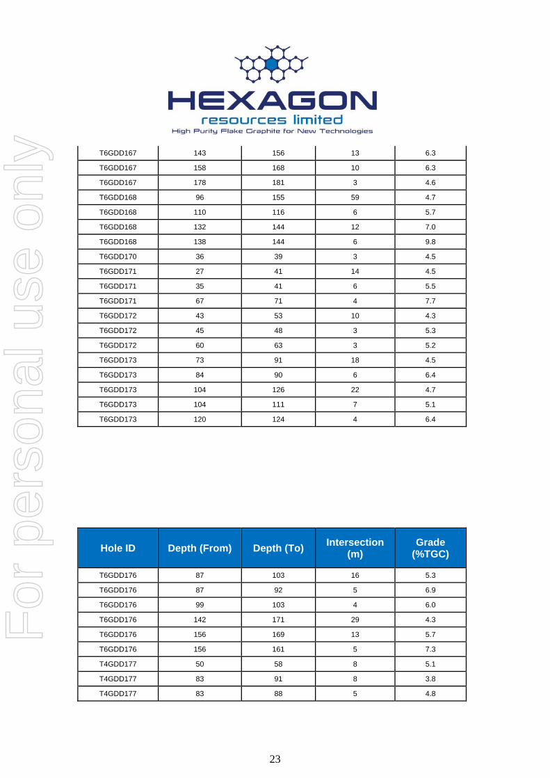
Table 2: Significant diamond core intercepts from Emperor, Wahoo and Barracuda
Hole ID Depth (From) Depth (To) Intersection
(m) Grade
(%TGC)
T6GDD164 47 91 44 4.4
T6GDD164 47 54 7 7.1
T6GDD164 62 67 5 5.0
T6GDD164 84 91 7 5.0
T6GDD164 110 115 5 5.4
T6GDD165 47 56 9 4.7
T6GDD165 78 87 9 4.4
T6GDD167 107 111 4 4.9
T6GDD167 126 173 47 4.7
For
per
sona
l use
onl
y
23
T6GDD167 143 156 13 6.3
T6GDD167 158 168 10 6.3
T6GDD167 178 181 3 4.6
T6GDD168 96 155 59 4.7
T6GDD168 110 116 6 5.7
T6GDD168 132 144 12 7.0
T6GDD168 138 144 6 9.8
T6GDD170 36 39 3 4.5
T6GDD171 27 41 14 4.5
T6GDD171 35 41 6 5.5
T6GDD171 67 71 4 7.7
T6GDD172 43 53 10 4.3
T6GDD172 45 48 3 5.3
T6GDD172 60 63 3 5.2
T6GDD173 73 91 18 4.5
T6GDD173 84 90 6 6.4
T6GDD173 104 126 22 4.7
T6GDD173 104 111 7 5.1
T6GDD173 120 124 4 6.4
Hole ID Depth (From) Depth (To) Intersection
(m) Grade
(%TGC)
T6GDD176 87 103 16 5.3
T6GDD176 87 92 5 6.9
T6GDD176 99 103 4 6.0
T6GDD176 142 171 29 4.3
T6GDD176 156 169 13 5.7
T6GDD176 156 161 5 7.3
T4GDD177 50 58 8 5.1
T4GDD177 83 91 8 3.8
T4GDD177 83 88 5 4.8
For
per
sona
l use
onl
y
24
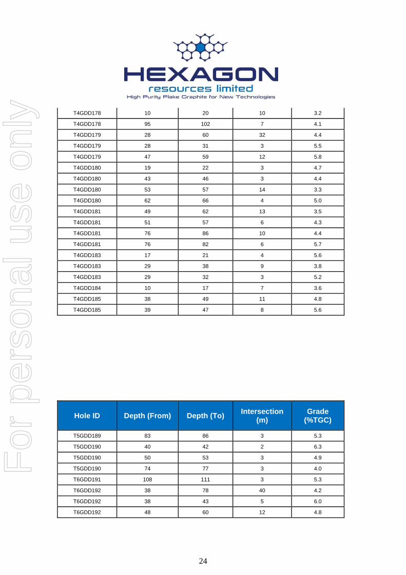
T4GDD178 10 20 10 3.2
T4GDD178 95 102 7 4.1
T4GDD179 28 60 32 4.4
T4GDD179 28 31 3 5.5
T4GDD179 47 59 12 5.8
T4GDD180 19 22 3 4.7
T4GDD180 43 46 3 4.4
T4GDD180 53 57 14 3.3
T4GDD180 62 66 4 5.0
T4GDD181 49 62 13 3.5
T4GDD181 51 57 6 4.3
T4GDD181 76 86 10 4.4
T4GDD181 76 82 6 5.7
T4GDD183 17 21 4 5.6
T4GDD183 29 38 9 3.8
T4GDD183 29 32 3 5.2
T4GDD184 10 17 7 3.6
T4GDD185 38 49 11 4.8
T4GDD185 39 47 8 5.6
Hole ID Depth (From) Depth (To) Intersection
(m) Grade
(%TGC)
T5GDD189 83 86 3 5.3
T5GDD190 40 42 2 6.3
T5GDD190 50 53 3 4.9
T5GDD190 74 77 3 4.0
T6GDD191 108 111 3 5.3
T6GDD192 38 78 40 4.2
T6GDD192 38 43 5 6.0
T6GDD192 48 60 12 4.8
For
per
sona
l use
onl
y

25
T6GDD192 68 78 10 4.8
T6GDD193 39 46 7 4.2
T6GDD193 57 198 139 4.0
T6GDD193 57 63 6 5.1
T6GDD193 74 83 9 6.0
T6GDD193 96 101 5 4.5
T6GDD193 116 120 4 5.0
T6GDD193 123 127 4 5.4
T6GDD193 144 149 5 5.9
T6GDD193 165 171 5 4.8
T6GDD193 176 183 7 4.8
T6GDD193 186 195 9 5.3
T6GDD194 117 179 62 4.2
T6GDD194 130 130 6 4.9
T6GDD194 156 156 5 8.3
T6GDD194 173 173 6 8.6
T6GDD195 64 67 3 4.4
T6GDD195 72 76 4 4.4
For
per
sona
l use
onl
y