for the geological society of america penrose … · for the geological society of america ......
TRANSCRIPT
UNITED STATES DEPARTMENT OF THE INTERIOR
GEOLOGICAL SURVEY
FIELD GUIDE, ROADLOG, AND COMMENTS
ON THE GEOLOGY FROM WENDOVER, UTAH, TO WELLS, NEVADA:
for the
Geological Society of America Penrose Conference
on
CORDILLERAN METAMORPHIC CORE COMPLEXES, REVISITED: IMPLICATIONS FOR CRUSTAL EXTENSION AND SHORTENING
IN THE NORTH AMERICAN CORDILLERA
By
Thorman, C. H. 1 , Ketner, K.B.,} Miller, D.M. 2 and Taylor, M.E. 1
Open-File Report 87-0493
1987
This report is preliminary and has not been reviewed forconformity with U.S. Geological Survey editorial standards
and stratigraphic nomenclature.
*U.S. Geological Survey 2U.S. Geological Survey Denver, Colorado Menlo Park, California
TABLE OF CONTENTS
Page
Introduction.......................................................... 1New Light on the Old Problem of Wandering Playa Rocks
By Keith Ketner.................................................... 3Field Trip Guide and Road Log: Wendover, Nevada to the
Goshute-Toano Range by Keith Ketner................................ 7Field Trip Guide and Road Log: Pilot Range and Vicinity
By David M. Miller................................................. 9Comments on the Middle and Upper Cambrian Stratigraphy of
Morgan Canyon, Goshute-Toano Range, Northeastern NevadaBy Michael E. Taylor............................................... 17
Roadlog: Silver Zone Basin Area by Keith Ketner....................... 19Roadlog: Silver Zone Pass to Independence Valley
By Char!es H. Thorman.............................................. 20Field Trip Guide and Roadlog: Wood Hills
By Charles H. Thorman.............................................. 22Roadlog: Wood Hills................................................... 28Roadlog: Halleck to Elko.............................................. 40References............................................................ 41

FIGURE CAPTIONS
Figure 1. Map showing general field trip area, geography of the-region, and the locations of stops for the first (1-1, etc) and second (2-1, etc) days.
Figure 2. Field trip route for Stops 1 and 2 in the Goshute-Toano and Pilot Ranges. Names of the 7.5 minute quadrangles covering the area are listed.
Figure 3. Generalized geologic map of the Goshute-Toano Range south of Interstate 1-80 showing the distribution of chaotic terrane.
Figure 4. View to the south showing chaotic terrane between Deep Creek Mountains and the Goshute-Toano Range.
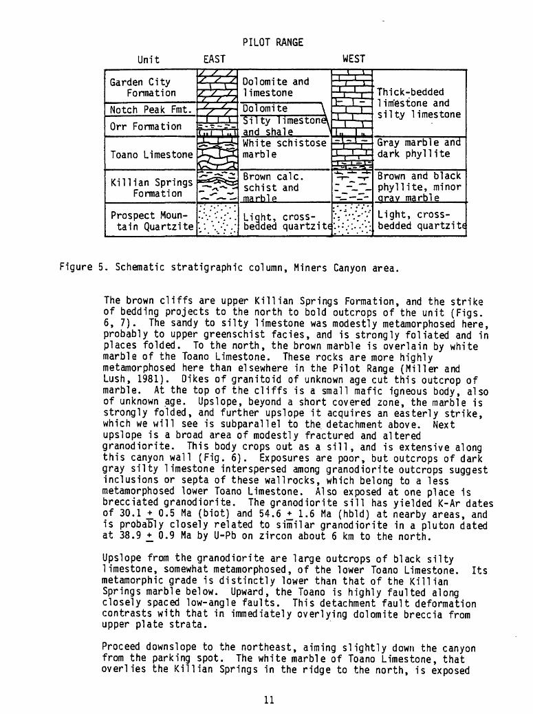
Figure 5. Schematic stratigraphic column, Miners Canyon area.
Figure 6. Geologic map of the Miners Canyon area.
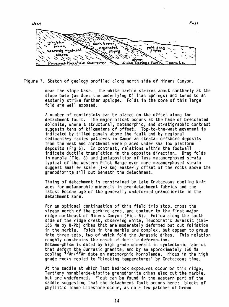
Figure 7. Sketch of geology profiled along north side of Miners Canyon.
Figure 8. Sketch of map relations, Pilot Peak decollement.
Figure 9. View to the south from 1-80 showing relations in the Silver Zone Basin area of the Goshute-Toano Range.
Figure 10. Correlation of metamorphosed lower plate rocks in the Wood Hills with nonmetamorphosed upper plate rocks in the Pequop Mountains.
Figure 11. Diagrammatic map of the Wood Hills and Pequop Mountains showing lower and upper plates and their structural subdivisions.
Figure 12. Stereograms of poles to foliation and lineations on anticline in lower plate in the southeastern part of the Wood Hills.
Figure 13. Field trip route for STOPS 3 and 4 in the Wood Hills. Names of the 7.5 minute quadrangles covering the area are listed.
Figure 14. Cross section of ridge on south side of East Canyon.
Figure 15. Geologic map of the East Canyon area for STOP 3.
Figure 16. Aerial view of the Pequop Mountains, looking northeast, showing stratigraphic section of the upper plate and one of the older-over-younger thrust faults within the upper plate.
Figure 17. Geologic map of the South Canyon area for STOP 4.
Figure 18. Biotitized didymograptids from the Kanosh 'phyllite. 1
Table 1. Mineral assemblages characteristic of lower plate rock units in the in the Wood Hills and Pequop Mountains.
INTRODUCTION
The theme of this conference, "Cordilleran metamorphic core complexes, revisited: implications for crustal extension and shortening in the North American Cordillera," is very fitting for the areas we will be visiting the next two days. The multiple deformational history that comprises the complexes in northeastern Nevada includes firm evidence of: Jura-Cretaceous regional metamorphism, compressional tectonics, and plutonism; Cretaceous- early Tertiary compressional tectonics, and possibly regional metamorphism, of the Sevier orogeny; and extensional tectonics and 'regional metamorphism, 1 and possibly compressional tectonics, of middle Tertiary age. No one range has all of the components that constitute a metamorphic core complex, but the geology from range to range is readily correlated, so that we feel confident in arrriving at many conclusions regarding a regional interpretation of how things got the way they are now. We are fortunate in having well preserved stratigraphic, structural, and metamorphic records in northeastern Nevada. During the field trips, the leaders will greatly appreciate any and all constructive criticisms, observations, or other barbs you wish to contribute.
The trip is scheduled to begin at 7:00 am (local time) and arrive in Wendover, +_ 120 miles to the west, at 8:00 am (local time). Wendover is on the Utah- Nevada border on the west edge of the Bonneville Salt Flats. Set your watches for Pacific daylight time. From Wendover, we will head south along the east side of the Goshute-Toano Range for a look at shallow-level Tertiary extensional features involving Paleozoic, Mesozoic, and Tertiary rocks. We then return to Wendover and go north to the Pilot Peak area to see younger- over-older extensional faulting at a deeper level, where Upper Cambrian upper plate nonmetamorphosed rocks overlie Upper Proterozoic to Middle Cambrian lower plate metamorphosed rocks along the Pilot Peak decollement. From the Pilot Range we will go to the Wood Hills to see a thick section of metamorphosed lower and middle Paleozoic rocks in the lower plate and a low- angle fault that juxtaposes nonmetamorphosed Paleozoic rocks of the upper plate on the lower plate rocks. Figure 1 shows the general location of the stops to be visited during the Penrose Conference, from Wendover to Elko, plus the geography of the region. Figures 2 and 13 show the exact route for the first day of the field trip and list the various 7.5 minute quadrangles that cover the areas visited.
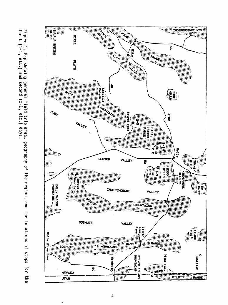
"*» (»#
SILVER ISLAND
MOUNTAINS
DOLLY VARDEN
MOUNTAINS
Figure
1. M
ap show
ing general
field
trip
are
a,
geography o
f the
regio
n,
and the
loca
tion
s o
f stops
for
the
first
(1-1
, e
tc.)
and second
(2-1
, e
tc.)
days.
NEW LIGHT ON THE OLD PROBLEM OF WANDERING PLAYA ROCKS
by
Keith Ketner
The salt flats east of Wendover are perfectly level. Propelled by the wind, sheets of water that may be only an inch or two deep often migrate widely over the surface. In this process, salt may be dissolved in one area, moved to another location and redeposited upon evaporation of the water. This process can produce a surface that varies in composition from pure mud to mud covered by a thick crust of salt.
In May, 1984 the surface of the salt flats along Interstate 1-80, between mile posts 20 and 30, consisted of extremely slippery, water-saturated mud sealed under a very thin, brittle crust of salt. Conditions must have been just right for the migration of rocks and other debris on the surface of the salt flats. Hundreds of objects that commonly litter the surface had migrated a few inches to a quarter mile or more, leaving conspicuous grooves behind them. These objects consisted of pebbles, cobbles, boulders, bottles, tangles of wire, crumpled sheet metal, wood, and even automobile tires. Cobbles that people had arranged in the form of their initials alongside the highway had moved away from the road on generally parallel paths which, at some distance, diverged, criss-crossed or angled sharply backwards. Some objects even retreated part way along their outbound paths. The grooves varied from a fraction of an inch to about an inch deep, depending on the weight of the object, and were bordered by parallel ridges of mud capped by disrupted salt crust. Mud was mounded up in front of each object where it stopped and the salt on the mound was crackled and thrust faulted. A coke bottle alternately rolled, leaving a faint impression, and slid crosswise leaving a deep, broad groove. Some objects, encountering the relatively deep wheel tracks of cars, were stalled but others, undaunted, turned and followed the tracks or climbed out and continued on their way. Movement must have been quite rapid because the beginnings and ends of long tracks were equally unweathered.
Because the objects were not observed in motion, we have to rely on circumstantial evidence for the cause. There were no human tracks in the soft mud near most of the objects or their trails. The objects could not have been caught in ice floes and dragged because the brine does not freeze, even in winter, and the tracks were very fresh in May. Moreover, that would not explain the behavior of the coke bottle or the erratic courses of rocks that started out from the same place. It is extremely unlikely that the objects moved under water because the delicate raw edges of shattered salt crust along the sides of the grooves had not been altered by solution or deposition at the time they were first observed. Later, after inundation, the tracks were crusted over with salt and were eventually obliterated. There has been little or no movement since 1984.
My favorite hypothesis is that the movement is caused by wind pressure and takes place when the mud is saturated with water and has a very thin salt crust or none at all. Such conditions would prevail behind a thin sheet of fresh rain water or melt water that was being driven by the wind across the flats leaving a nearly salt-free, water-saturated surface behind. The erratic pattern of the trails and failure of some objects to move are due to the

varied "hydro"dynamic characteristics of the object's bottoms, the aerodynamic characteristics of their variously shaped tops, differences in mass, slight lateral variations in the condition of the mud and of the sa>t crust, and to shifts in wind direction and velocity.
MINERS CANYON QUADRANGLE
OLA QUADRANGLE
STOP 1 J _»«»*^ .
TETZLAFF PEAK QUADRANGLE
Figure 2. Field trip route for Stops 1 and 2 in the Goshute-Toano and Pilot Ranges. Names of the 7.5 minute quadrangles covering the area are listed.

40'45*
QO3HUTE-TOANO RANGE
ELKO COUNTY, NEVADA
MESOZOC CRUSTAL THICKENING FOLLOWED BY TERTIARY
CRUSTAL THNNNG
KETTH a KETNER, PENROSE CONFERENCE, SEPTEMBER. 1987
Based on mapping by Warren C. Day, Maya Elrick, David M. Mier. John E. Welsh. Myra K. Vaag, and _
Keith B. Ketner
INTERSTATE 1-80
4030
TO SALT LAKE
ENDOVER
RHYOUTE EXTRUSIVES 10.7 MY OLD. YOUNGER THAN NE-SW EXTENSION
CHAOS OF NE-TLTED AND SW-TILTED BLOCKS OF PENNSYLVANIA TO TRIASS1C UNITS
ALLOCHTHONOUS PLATE OF PENNSYLVANIAN AND PERMIAN UNITS ON LOW-ANGLE TERTIARY I?) FAULT
UPPER PLATE OF MESOZOC THRUST. CAMBRIAN TO MISSISSIPPtAN UNITS
LOWER PLATE OF MESOZCHC THRUST. METAMORPHOSED AND FOLDED CAMBRIAN TO DEVONIAN UNITS
1**POST-10.7 MY EXTENSION
40*15'
Figure 3. Generalized geologic map of the Goshute-Toano Range south of Interstate 1-80 showing the distribution of chaotic terrane.
FIELD TRIP GUIDE AND ROAD LOG: WENDOVER, NEVADA TO THE GOSHUTE-TOANO RANGE
by
Keith Ketner
mileage (mileage is point to point, not cumulative)
0.0 Intersection in west Wendover opposite the Pepper Mill Casino. Go south on Alternate U.S. 93 (U.S. 50 on older maps).
Ahead and to the right is the Goshute-Toano Range composed of Paleozoic, Triassic, Jurassic and Tertiary rocks. A 40 mile segment including two wilderness study areas, was recently mapped by Warren Day, Maya El rick, and Myra Vaag of the U.S. Geological Survey under the supervision of Keith Ketner (Day and others, 1987 and unpublished mapping). Our mapping meshes with that of David M. Miller of the U.S.G.S. in the north and that of John E. Welsh in the foothills southeast of the main range.
Most of the rocks visible along the skyline are unmetamorphosed Paleozoic rocks in the upper plate of a Mesozoic thrust (Figure 3). The lower plate, comprised of metamorphosed contemporaneous units, is exposed at the northern and southern ends of the range. Lower Paleozoic rocks of part of the upper plate were tectonically denuded by extensional faulting in the Tertiary before 10.7 Ma ago. The remainder of the upper plate has a cover of upper Paleozoic rocks but this cover is detached from the underlying lower Paleozoic sequence by a low-angle fault. The direction of extension before 10.7 Ma ago was N65E-S65W. The subsequent extension was nearly east-west.
7.4 Turn to the right on a gravel road just before the summit. Bear left around the gravel pit and head toward the Goshutes. The rocks exposed on both sides of the highway here are 10.7 Ma rhyolite flows that are distinctly notched along a shoreline of Pleistocene Lake Bonneville.
0.4 Bend in road. Pause for arm-waving. The Deep Creek Mountains are visible in the distance to the southeast about 25 miles from the southern part of the the Goshute-Toano Range (Figure 4). The foothills between these two ranges consist of a chaotic array of tilted fault blocks bounded by listric faults that occupies an area of several hundred square miles. The largest of these listric fault blocks is Ferguson Mountain, 2,000 feet high, which forms the prominent peak about 12 miles south of us. Nearly all of the listric fault blocks, including Ferguson Mountain, are composed of Pennsylvanian and Permian rocks. Nearly all of the listric faults in the chaos flatten in the Mississippian Chainman Shale but several in the main range cut as deep as the Ordovician and Cambrian. Nearly all of the blocks on the east side of the range have rotated toward the west as can be seen by the west-dipping beds of Ferguson Mountain. In the middle-ground, nearly in line with Ferguson Mountain, is Wildcat Peak composed of horizontal flows of 10.7 Ma

rhyolite. It rests unconformably on vertical Pennsylvanian beds of a "listric fault block. The long ridge in the foreground is composed of the Devonian Guilmette Formation. It apparently "lies on the Mississippian Chainman Formation and constitutes a conspicuous example of older-on-younger faults that sometimes form in an extensional environment. Proceed west and south toward the low hills at the northern edge of the chaotic terrane.
3.4 Turn left across gulch. Bear left.
1.4 Dark rocks on both sides of trail are shale, sandstone, andconglomerate of the Mississippian Chainman Formation. In the process of extensional faulting, the shale was attenuated to a small fraction of its original thickness, leaving residual lenses of less plastic sandstone and conglomerate.
FERGUSON MTN . ,-. DEEP CREEK MTS ^-^^ WILDCAT PEAK
CHAOTIC TERRANE OF FAULT BLOCKS
Figure 4. View to the south showing chaotic terrane between Deep Creek Mountains and the Goshute-Toano Range.
0.1 Turn right and proceed to the end of the trail.
STOP 1. This is the north edge of the chaos that extends many miles to the south and east. We will hike up the low ridge straight ahead. The structurally lowest rocks consist of sandstone and conglomerate of the Chainman Formation and fine-grained granite which here, and commonly throughout the foothills, intruded the Chainman during extensional faulting. Overlying the Chainman is a thin wedge of landslide breccia which thickens to the south and forms "Breccia Mountain" a half mile away. Next above the breccia are the sediments of a small lake that formed in the hummocky terrane of the landslide. These beds, which dip as much as 70 degrees to the west, form most of the east-facing slope of the ridge ahead. The cliff at the top of the ridge is composed of Devonian Guilmette Formation. It is a single block about 0.3 mile long that apparently slid into the lake and put an end to sedimentation. The entire package -- breccia, lake beds, and slide block then rotated as a unit on a listric fault. Hike up to the Devonian block, then back to the cars and return to Wendover.
FIELD TRIP GUIDE AND ROAD LOG PILOT RANGE AND VICINITY
by
David M. Miller
This part of the trip continues from Wendover, passing through the Silver Island Mountains, Pilot Range, and Toano Range. Exposed in these ranges are extensional complexes ranging from high-level unmetamorphosed complexes such as that examined in the previous stop, to deeper complexes involving lower amphibolite facies rocks. In the Leppy Hills of the Silver Island Mountains, Joel Schneyer (1984) described Devonian through Permian strata that are tilted on listric faults that also tilt Miocene volcanic rocks. In the Pilot Range, we will examine the anatomy of a detachment fault zone places tilted, slightly metamorphosed lower Paleozoic strata upon greenschist to amphibolite facies rocks. This tectonic assemblage resulted from extension along a gently dipping detachment at a deeper level than the Leppy Hills example, but at a shallower level than those recognized as "metamorphic core complexes". Driving westward to the Toano Range, we will pass through a similar middle- level detachment system. From there westward to the Ruby Mountains the depth of detachment currently exposed appears to increase.
mileage (mileage is cumulative)
0.0 Underpass beneath 1-80, West Wendover. Continue straight north onto gravel road.
Straight ahead, the Leppy Hills are a part of the Silver Island Mountains. They contain cliff-forming sequences of Devonian and Pennsylvanian-Permian limestone separated by valley-forming Mississippian shale and sandstone. The range is a northwest-trending horst, with bounding systems of normal faults that dip east and west. Within the range, normal faults have both steep and gentle dips. Listric fault geometries are preserved.
Extension was accommodated by contrasting modes of deformation in contrasting materials. Massive limestone deformed brittlely, typically with 'space problems' accommodated by massive white calcite solution fillings and solution breccia. Shale deformed ductilely, as seen by folded and sometimes wildly contorted beds.
Schneyer (1984) argued that most, if not all, of the normal faulting occurred after deposition of Miocene (11.9 Ma) rhyolite on Permian strata, chiefly because rhyolite and Paleozoic strata are similarly rotated within some fault blocks.
0.7 We are driving up a strike valley of Mississippian shale. To the right is a dip slope of Devonian limestone; to the left, cliffs of Pennsylvanian limestone.
1>6 Bear right at the fork in road. Straight ahead, gently foldedPennsylvanian limestone dips west into a flat fault near the base of

the slope. To the left, the fault is marked by white calcite fillings. The fold suggests detachment along the fault and movement of upper plate to the east, according to a hanging wall rollover model for the fold. Elsewhere in the Leppy Hills, fold-fault relations similar to these indicate an opposite sense of movement on low-angle faults.
The prominent small brown hill in the foreground is Mississippian conglomerate deposited in a channel within a limestone, sandstone, and shale sequence.
5.8 We have descended the north side of the Leppy Hills, and now have a sweeping view of Pilot Valley playa, with the Pilot Range on the left and Silver Island Mountains on the right. We will proceed north along the west side of the playa and turn into the Pilot Range just south of the high point, Pilot Peak.
9.6 Turn left on main gravel road.
16-1 Turn left on dirt track marked by stake and tire. The view straight ahead is of Pilot Peak, composed of Late Proterozoic quartzite, and the forested lower hills to the south that are composed of Paleozoic carbonate strata structurally overlying the quartzite.
18.3 Road turns right on Bonneville shoreline gravels.
20.1 Pass mine dump and buildings. The ridge above the mine is underlain by Upper Cambrian carbonate strata dipping moderately eastward. The mine enters a shattered zone of carbonate, and intersects altered granodiorite farther in. This same granodiorite elsewere is abundant in the detachment fault underlying the carbonate strata. The hornblende-biotite grandiorite was dated at 37.5 +_ 2.6 Ma by K-Ar on slightly altered biotite. Proceed up road.
20.4 Turn out to right in clearing beyond aspen grove.
STOP 2. We will examine the anatomy of the detachment fault (Pilot Peak decollement) that separates tilted packets of Cambrian and Ordovician strata from underlying schist, marble, phyllite, and quartzite. If time permits, we will examine some typical lithologies and structures in the metamorphosed sequence.
As shown in Figure 5, much of the Cambrian system is missing at the detachment fault. Under the fault are metamorphosed Late Proterozoic to Middle Cambrian strata, and above the fault are Upper Cambrian to Lower Ordovician strata. Regionally, the detachment always omits strata, but the strata omitted range from Middle Cambrian to Middle Ordovician in age, and strata above and below the fault likewise range in age. These units are described in more detail by Miller (1984).
Walk up the road to the point where brown cliffs of marble are on the left and climb these rocks. We will proceed south, upslope, from here, and climb through the detachment system.
10
PILOT RANGE
Unit EAST WEST
Garden City Formation
Notch Peak Fmt.
Orr Formation
Toano Limestone
Killian Springs Formation
Prospect Moun tain Quartzite
s / s
rVV/ s J
-M-W-V£33:O^-*-TTCfir>2r^3^5:-T^Vv"^
Dolomite and limestone
Dolomite \ Silty limestoneV and shale inil i uc jwiiijuvjc
marble
Brown calc. schist and marble
Light, cross- bedded quartzite
-V-i-T-J-,.. I , . 1- I
.,. 1 . 1 ^1 1 nr^*»= *
, J-, 1__I I T
i g^j-Ta:
':"."'.".
Thick-bedded limestone andsilty limestone
Gray marble anddark phyllite
Brown and black phyllite, minor arav marble
Light, cross- bedded quartzite
Figure 5. Schematic stratigraphic column, Miners Canyon area.
The brown cliffs are upper Killian Springs Formation, and the strike of bedding projects to the north to bold outcrops of the unit (Figs. 6, 7). The sandy to silty limestone was modestly metamorphosed here, probably to upper greenschist facies, and is strongly foliated and in places folded. To the north, the brown marble is overlain by white marble of the Toano Limestone. These rocks are more highly metamorphosed here than elsewhere in the Pilot Range (Miller and Lush, 1981). Dikes of granitoid of unknown age cut this outcrop of marble. At the top of the cliffs is a small mafic igneous body, also of unknown age. Upslope, beyond a short covered zone, the marble is strongly folded, and further upslope it acquires an easterly strike, which we will see is subparallel to the detachment above. Next upslope is a broad area of modestly fractured and altered granodiorite. This body crops out as a sill, and is extensive along this canyon wall (Fig. 6). Exposures are poor, but outcrops of dark gray silty limestone interspersed among granodiorite outcrops suggest inclusions or septa of these wallrocks, which belong to a less metamorphosed lower Toano Limestone. Also exposed at one place is brecciated granodiorite. The granodiorite sill has yielded K-Ar dates of 30.1 +. 0.5 Ma (biot) and 54.6 ^ 1.6 Ma (hbld) at nearby areas, and is probably closely related to similar granodiorite in a pluton dated at 38.9 +_ 0.9 Ma by U-Pb on zircon about 6 km to the north.
Upslope from the granodiorite are large outcrops of black silty limestone, somewhat metamorphosed, of the lower Toano Limestone. Its metamorphic grade is distinctly lower than that of the Killian Springs marble below. Upward, the Toano is highly faulted along closely spaced low-angle faults. This detachment fault deformation contrasts with that in immediately overlying dolomite breccia from upper plate strata.
Proceed downs!ope to the northeast, aiming slightly down the canyon from the parking spot. The white marble of Toano Limestone, that overlies the Killian Springs in the ridge to the north, is exposed
11

«««*««*o««***o » «%
, . _,~««o»«*«oJf 6 « « O « «g' oO a « «
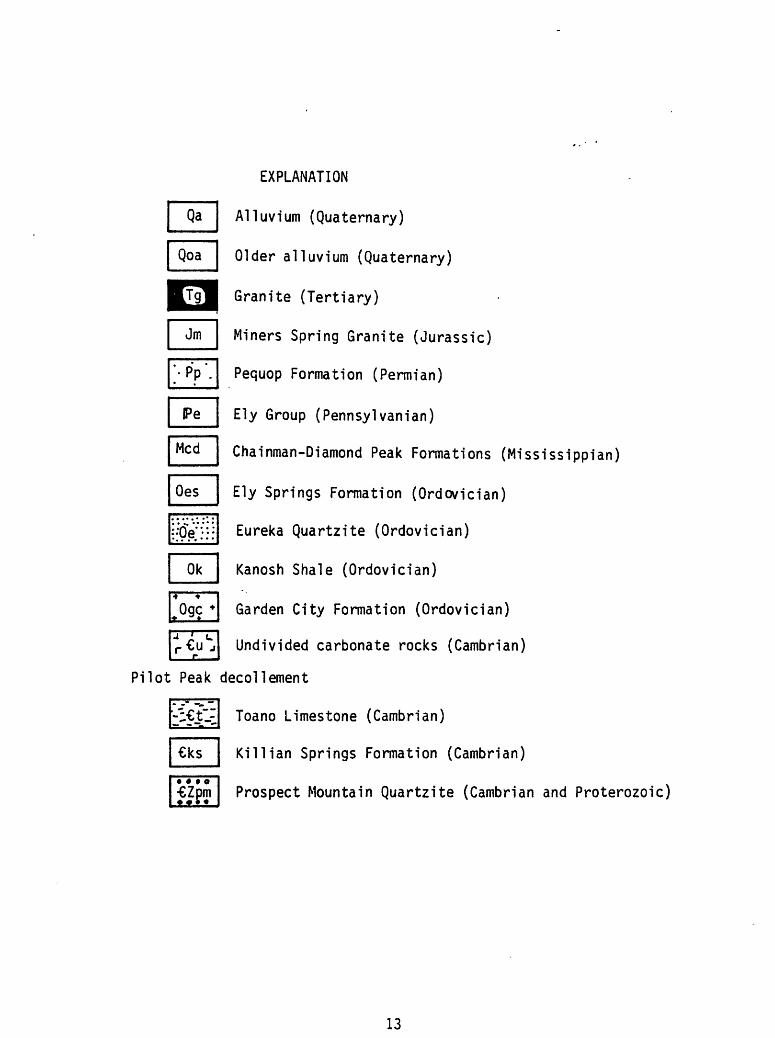
n nFigure 6. Geologic map of the Miners Canyon area.
12
Mcd
Oes
Ok
Ogc*
EXPLANATION
Alluvium (Quaternary)
Older alluvium (Quaternary)
Granite (Tertiary)
Miners Spring Granite (Jurassic)
Pequop Formation (Permian)
Ely Group (Pennsylvanian)
Chainman-Diamond Peak Formations (Mississippian)
Ely Springs Formation (Ordovician)
Eureka Quartzite (Ordovician)
Kanosh Shale (Ordovician)
Garden City Formation (Ordovician)
Undivided carbonate rocks (Cambrian)
decollement
Toano Limestone (Cambrian)
Killian Springs Formation (Cambrian)
Prospect Mountain Quartzite (Cambrian and Proterozoic)
13
VJe»+
^i^. \ < ^>o- \ ^u^p»r ^S,^^.
V<i'\\iAi\ Springs g=i*vN^ Ta<Mt» Ls.
Figure 7. Sketch of geology profiled along north side of Miners Canyon.
near the slope base. The white marble strikes about northerly at the slope base (as does the underlying Killian Springs) and turns to an easterly strike farther upslope. Folds in the core of this large fold are well exposed.
A number of constraints can be placed on the offset along the detachment fault. The major offset occurs at the base of brecciated dolomite, where a structural, metamorphic, and stratigraphic contrast suggests tens of kilometers of offset. Top-to-the-west movement is indicated by tilted panels above the fault and by regional sedimentary facies patterns in Cambrian strata: offshore deposits from the west and northwest were placed under shallow platform deposits (Fig 5). In contrast, relations within the footwall indicate ductile translation in the opposite direction. Drag folds in marble (Fig. 8) and juxtaposition of less metamorphosed strata typical of the western Pilot Range over more metamorphosed strata suggest smaller scale (1-3 km) easterly offset of the rocks above the granodiorite sill but beneath the detachment.
Timing of detachment is constrained by Late Cretaceous cooling K-Ar ages for metamorphic minerals in pre-detachment fabrics and the latest Eocene age of the generally undeformed granodiorite in the detachment zone.
For an optional continuation of this field trip stop, cross the stream north of the parking area, and contour to the first major ridge northeast of Miners Canyon (Fig. 6). Follow along the south side of the ridge crest, observing white, leucocratic Jurassic (155- 165 Ma by U-Pb) dikes that are moderately deformed but cut foliation in the marble. Folds in the marble are complex, but appear to group into three sets, two of which fold the Jurassic dikes. This relation roughly constrains the onset of ductile deformation. Metamorphism is dated by high grade minerals in syntectonic fabrics that deform the Jurrasic granite, and by an approximately 150 Ma cooling 40Ar/ 39Ar date on metamorphic hornblende. Micas in the high grade rocks cooled to "blocking temperatures" by Cretaceous time.
At the saddle at which last bedrock exposures occur on this ridge, Tertiary hornblende-biotite granodiorite dikes also cut the marble, but are undeformed. Float can be found in the eastern part of the saddle suggesting that the detachment fault occurs here: blocks of phyllitic Toano Limestone occur, as do a few patches of brown
14

EAST
Figure 8. Sketch of map relations, Pilot Peak decollement.
sandstone and siltstone of Killian Springs. Closeby, to the east, Ordovician Garden City Formation of the upper plate is exposed in a prospect pit. To the northeast, these relations are clear in the view of a ridge about 1 km distant: marble is structurally beneath brown Garden City Formation along a gently east-dipping fault. Reactivation of the detachment as a range-bounding fault during Miocene time is probable. Walk south to the cottonwood grove in Miners Canyon and the mine to the vehicles.
Return Trip (from 0.0 at the mine):
3-9 Turn right on graded road.
16.3 Bear right at road junction in pass over Silver Island Mountains.
19.4 Turn right on to paved road.
20.6 Enter 1-80 West-bound. We drive through road cuts north of Wendover that display the typical brittle response of massive limestone to extensional faulting: solution breccia and complex closely-spaced faults.
Just west of Wendover, we drive through road cuts of tilted Miocene rhyolite that unconformably overlies tilted Permian strata.
15

Cut into, and deposited near the western exposures of the rhyolite, are exceptionally developed wave abrasion platforms -and gravel bars from Pleistocene Lake Bonneville.
About 17 miles west of Wendpver, we approach and cross the Toano Range. Silver Zone Pass, utilized by the highway and a railroad, is underlain by a large Jurassic (about 162 Ma, J.E. Wright, personal commun.) hornblende- biotite granodiorite pluton. It intruded and contact metamorphosed previously regionally metamorphosed Cambrian strata correlative with those we examined beneath the Pilot Peak decollement at Miners Canyon.
North of Silver Zone Pass, in this part of the Toano Range, L.L. Glick has shown that Upper Cambrian and younger strata that are essentially unmetamorphosed rest structurally on metamorphosed Lower and Middle Cambrian strata. South of the pass, the metamorphosed sequence includes rocks as young as Middle Ordovician and is structurally juxtaposed with overlying(?) Devonian rocks. Gross similarities in structures and stratigraphy suggest that the Toano Range occupied a position close to the Pilot Range prior to Cenozoic extension.
16

COMMENTS ON THE MIDDLE AND UPPER CAMBRIAN STRATIGRAPHY OF MORGAN CANYON,GOSHUTE-TOANO RANGE, NORTHEASTERN NEVADA
by
Michael E. Taylor
About 250 m (820 feet) of Middle Cambrian and 485 m (1590 feet) of lower Upper Cambrian rocks crop out on both sides of Morgan Canyon in the Goshute- Toano Range, 24 km (15 miles) southwest of Wendover and 28 km (17 miles) south of Silver Zone Pass. The base of the Cambrian section is not exposed, whereas the top is overlain in low-angle fault contact by at least 125 m (410 feet) of silty limestone assigned to the lower part of the Lower Ordovician Pogonip Group (Taylor, Day, and Ketner, 1986). The outcrop area is within the Lion Spring and Morgan Pass, Nevada, 7.5 minute topographic quadrangle maps, Elko County, Nevada.
DEPOSITIONAL FACIES: The Middle Cambrian section is dominated by peri tidal carbonate bank deposits composed of high-relief domal stromatolites, thrombolites, oncolites, fenestral lime mudstone, and supratidal laminated dolostone. Epiphyton is abundant in planar mats and thrombolites in some shallow subtidal environments. Upper Cambrian rocks contain similar shoal- water bank deposits that alternate with mixed carbonate and siliciclastic sediments probably deposited in a subtidal shelf-lagoon on the cratonal side of the carbonate shoals. Some thinly bedded, dark gray lime mudstones were deposited on the flanks of carbonate banks and on the open shelf oceanward from shoal-water areas. The Upper Cambrian beds contain upwardly increasing amounts of calcareous quartz sandstone and sandy limestone as do rocks of this age in central and northern Utah and at least as far south as the Deep Creek Mountains.
AGE: Middle Cambrian rocks are assigned to the Bolaspidella Zone and Upper Cambrian rocks to the undifferentiated Cedaria-Crepicephalus Zones. The Middle-Upper Cambrian boundary is located approximately 250 m (820 feet) above the base of the exposed section, near but above a trilobite assemblage containing ETdoradia, a genus that characterizes the uppermost Middle Cambrian over much of the Basin and Range Province.
The Lower Ordovician trilobite Symphysurina occurs in the allochthonous fault block overlying lower Upper Cambrian rocks containing Crepicephalus Zone trilobites.
DISCUSSION: Biostratigraphic control on rocks above and below the low- angle fault in Morgan Canyon suggest that 520 to 700 m (1700 to 2300 feet) of Upper Cambrian strata are missing because of faulting. The missing rocks are equivalent to the Dunderberg Shale, Johns Wash Limestone, Corset Spring Shale, and Notch Peak Formation in the Deep Creek Range, Utah (see Hintze, 1973, p. 132), and to the Dunderberg Shale and Windfall Formation in the Northern Egan Range and Cherry Creek Mountains, Nevada (M. E. Taylor and J. E. Repetski, unpubl. data).
The predominantly shallow-water Morgan Canyon section contrasts with deeper water outer shelf and slope deposits described by McCollum and McCollum
17

(1985) and McCoTlum (1987) 35 km to the north in the northern Toano Range. Fauna! data are sparse for the northern Toano rocks, but the Morgan Pass Cambrian section probably correlates with the upper part of the'Toano Limestone and lower part of the Clifside Limestone of McCollum and McCollum (1985).
The Morgan Canyon Upper Cambrian section contains a high percentage of quartz sand, whereas McCollum and McCollum (1985) report rare or finer grained terrigenous clastic sediments in the coeval part of the deeper water northern Toano section.
The strong facies contrast between the shoal-water Morgan Pass and deep- water northern Toano sections, and absence of abundant quartz sand in the northern Toano section, suggests that the geographic proximity of the two outcrop areas has probably resulted from structural juxtaposition, rather than original paleogeographic proximity.
18

ROADLOG: SILVER ZONE BASIN AREA
by Keith Ketner
About 20 miles west of Wendover, south of the highway (to the left about 3 miles) are two clusters of wooded peaks separated by lower grass covered hills (Figure 9). The eastern group of peaks is composed mostly of metamorphosed Cambrian rocks in the lower plate of a Mesozoic thrust. The western group is a structural block composed of unmetamorphosed Pennsylvanian and Permian rocks originally in the upper plate of that thrust. This block, "anti-Ferguson Mountain", is the counterpart of Ferguson Mountain both are listric fault blocks of about the same size and both are composed of Penn-Perm rocks but they are on opposite sides of the range and dip in opposite directions. Silver Zone Basin, the low ground between the two mountain masses, is a stack of Tertiary landslides. As anti-Ferguson Mountain rotated it oversteepened and repeatedly shed landslides into the structural and topographic valley separating the listric block from the footwall Cambrian rocks. Lakes that formed in the hummocky landslide terrane were repeatedly overwhelmed by subsequent slides and alluvium. In one area, the deposits of four lakes are stacked one above the other. Each lake, in turn, was covered by debris of Penn-Perm rocks and was succeeded by another lake. Now, the lakebeds are tilted eastward because, as they accumulated, the mass of landslides and lakebeds became part of the eastward tilting fault block. Beds of the oldest lake dip about 40 degrees, whereas the younger beds dip only about 20 degrees.
ANThFEflGUSON MTN WLANDSLIDES AND LAKE BEDS
UNMETAMORPHOSED PENNSYLVANIAN AND PERMIANMETAMORPHOSED CAMBRIAN AND OROOVICtAN
Figure 9. View to the south from 1-80 showing relations in the Silver Zone Basin area of the Goshute-Toano Range.
19
ROADLOG: SILVER ZONE PASS TO INDEPENDENCE VALLEY
by
Charles H. Thorman
As we descend into Goshute Valley from Silver Zone Pass, the range directly in front is the Pequop Mountains. It is underlain by a lower plate of metamorphosed Cambrian through SiluroDevonian rocks and an upper plate of non- metamorphosed Ordovician through Triassic strata. Figure 10 shows the tectonic setting of the Pequop Mountains and the Wood Hills. We will cross the Pequop Mountains near its northern end and see upper plate Devonian through Permian rocks that are north of the Wells fault.
Mile Post 378 - Approaching the northern end of the Pequop Mountains. The brush-covered hills at 12:00 are underlain by the Mississippian Chainman and Mississippian-Pennsylvanian Diamond Peak Formations. The light- colored cliffs beneath the northernmost radio relay station include northerly dipping Diamond Peak, Pennsylvanian Ely Limestone, and Permian strata.
Mile Post 376 - The tree-covered hills on the north side of the highway comprise an east-dipping sequence of Diamond Peak disconformably overlain by Leonardian Pequop Formation. The Ely Limestone (noted above at the radio station) is missing here due to post-Ely erosion. This unconformity represents a major erosional event in eastern Nevada and western Utah (Steele, 1960). A few feet of the Ely are preserved beneath the unconformity just south of the highway. Some geologists consider this contact to be a Redding-plane thrust that cuts out the Ely and Wolfcampian strata. My preference is that the contact is an unconformable one; I have looked closely at the rocks along the contact north and south of the highway and can not see any evidence for a faulted contact.
Mile Post 375 - East-dipping Chainman Formation black shales, siltstones, and quartzites exposed in roadcuts.
Mile Post 374 - From this point to Pequop Summit, the roadcuts expose the Chainman Formation and Lower Mississippian Tripon Pass limestones. The Tripon Pass, a thin-bedded to platy clastic turbidite limestone with graded bedding, is the western, deep water equivalent of the Lower Mississippian Joana Limestone. The Tripon Pass/Chainman contact in the northern Pequops is a bedding fault cut by small-scale high-angle faults. Tripon Pass limstone occurs as high-angle-fault-bounded rectangular to lenticular pods in the Chainman black shales in the Pequop Summit vicinity, presenting a very complex picture. It appears that the Chainman was faulted across the underlying Devonian Guilmette and Tripon Pass limestones. The more brittle Tripon Pass limestone was partially detached from the underlying massive, more competent Guilmette limestones and broken into rectangular lenses.
Cliffs of the Guilmette Formation are visible directly ahead on the west side of the range.
20

Pequop Summit - Thin-bedded limestone of the Tripon Pass are exposed at the summit and for a short distance to the west. The medium-bedded to massive, grey limestones on both sides of the highway, extending to the foot of the range, are the Guilmette Formation. The cliffs on the south side are several hundred feet higher than those on the north due to offset across an east-trending high-angle fault that more or less parallels the highway. As you head west into Independence Valley, glance back at the range to see the offset across this fault - everyone except the driver, please!
Mile Post 369 - Entering Independence Valley. The Wood Hills is the wooded range south of the highway. The grass covered hills to the north are the Windermere Hills and are underlain by Permian strata of the Park City Group.
21

FIELD TRIP GUIDE AND ROADLOG: WOOD HILLS
by
CHARLES H. THORMAN
Introduction
The Wood Hills and Pequop Mountains contain several pieces essential to the unraveling of the mid-Mesozoic to mid-Tertiary metamorphic, plutonic, and deformational history of the Basin and Range. (Note that I did not refer to the metamorphic core complex history of the Basin and Range, because I feel that too much emphasis has been/is being made of this aspect of the geology. Many people are neglecting the regional setting and thus are missing essential aspects of the overall geologic history). Several pieces critical to unraveling the history are missing in these ranges, and we are highly dependent on the geology in adjacent ranges for the rest of the story - this is typical of geology, but is brought home forcefully when dealing with the topic of this Penrose Conference.
The pre-Tertiary rocks in the Wood Hills and Pequop Mountains are subdivided into two major structural units, the upper plate, which consists of Lower Ordovician through Triassic miogeoclinal strata, and the lower plate, which consists of regionally metamorphosed (greenschist to amphibolite facies) Cambrian through Devonian strata of the same sedimentary sequence as the upper plate. The plates are juxtaposed along low-angle faults that post-date metamorphism of the lower plate rocks. (Several second order thrust sheets/plates occur within both the upper and lower plates and will be discussed later.) One of the major questions here is the age of the latest movement along this contact. I termed this/these faults separating the two plates the Wood Hills thrust (Thorman, 1970), based on the assumption that all the movement occurred during the Sevier orogeny. Obviously, Tertiary movement needs to be considered as a possiblity along all low-angle faults in this region. However, Tertiary movement alone is not viable in view of the evidence in the Pilot Range (Miller, 1984 and this volume), Silver Zone Pass (Miller, this volume), and the Ruby-East Humboldt Ranges (Dallmeyer and others, 1986) showing that regional metamorphism and associated compressive tectonics occurred in Jurassic and probably Cretaceous time, as well as the evidence of the Sevier orogeny. At the present time, I interpret the Wood Hills fault in the Pequops and the Wood Hills to be a Sevier-age structure that probably has had subsequent mid-Tertiary extensional fault movement only in the Wood Hills. The evidence for this later movement has been well documented by Art Snoke and his students on correlative structures in the Ruby-East Humboldt Ranges (we will see these tomorrow).
The upper plate rocks are further subdivided into a northern and southern sequence by the Wells fault (Thorman, 1970, Thorman and Ketner, 1979), a WNW- ESE-trending right-slip tear fault that juxtaposes contrasting sedimentary facies, erosional patterns/features, and structures. Right slip across the fault is postulated to be 40-50 miles. The Wells fault is considered to be a Sevier structure and is thought to have been initially controlled by a major basement flaw that influenced the development of the fault but did not necessarily have major slip in the basement. Miller (1984) has suggested the
22
possiblity that the Wells fault is restricted to the upper plate. Unfortunately, exposures of lower plate rocks on opposite sides of the fault are not adequate to establish the necessary control to prove-whether or not the Wells fault offsets trends in the lower plate.
The most important aspects of the metamorphic core complex history to be seen on this trip to the Wood Hills are:
Metamorphosed lower and middle Paleozoic rocks - The Wood Hills contain an exceptionally well preserved section of regionally metamorphosed Cambrian through Devonian miogeoclinal strata. The classic stratigraphic sequence of eastern Nevada-western Utah is preserved intact, and fossils have been recovered from key formations in the sequence (figure 10). A similar section is present on the west side of the Pequop Mountains, but is complexly faulted and/or folded and it is difficult to correlate many of the units with their nonmetamorphosed protoliths. This metamorphism probably is Jurassic in age, based on evidence in the Pilot Range (Miller, 1984 and this volume), Silver Zone Pass (Miller, this volume), and the Ruby-East Humboldt Ranges (Dallmeyer and others, 1986).
LOWER PLATE
UPPER PLATE
Figure 10. Correlation of metamorphosed lower plate rocks in the Wood Hills with nonmetamorphosed upper plate rocks in the Pequop Mountains (from Thorman, 1970).
23
Large-scale folding and -lineations in the metamorphic rocks - The metaPaleozoic rocks are folded about E- to NE-trend ing axes. These folds are. asymmetrical to overturned (verge) towards the northwest, plunge to the northeast, and have wave lengths of 2-4 miles and amplitudes of 0.5- 1.5 miles (Figure 11). The entire Middle Cambrian through Upper Devonian section of the lower plate in the Wood Hills is folded. These folds are similar to ones in the East Humboldt and Ruby Ranges and the southern Pequop Mountains.
/ WOOD HILLSyWELLS u.540
WOOD HILLS THRUST/?
II4»45'
I
PEOUOP MTNS
Figure 11. Diagrammatic map of the Wood Hills and Pequop Mountains showing lower and upper plates and their structural subdivisions (from Thorman, 1970).
In addition, a prominent lineation is present throughout most of the lower plate section. In the marbles, the lineation is typically expressed as streaks of micas along parting surfaces. In contrast, the Eureka Quartzite commonly has a very fine crinkly lineation on parting surfaces. Chert lenses commonly show two types of lineations, one an elongation of the lenses themselves, and the other a fine, serrated surface at the chert/marble interface preserved by differential- weathering on the weathered chert lens surface. Figure 12 shows the trend of these lineations in the southeastern portion of the Wood Hills. On the upright limb of South Anticline, the lineation plunges east at about 20°, whereas on the overturned, strongly attenuate limb the lineation trends northeast and plunges gently to the northeast and southwest. I interpret both of these lineations to have been formed during metamorphism and folding.
24
POLES TO FOLIATION CONTOURED POLES TO FOLIATION
INDEX* OVERTURNED LIMB O NORMAL LIMB
LINEATIONSCONTOURED LINEATIONS
Figure 12. Stereograms of poles to foliation and lineations on anticline in lower plate in the southeastern part of the Wood Hills. Foliation Stereograms: n = 121; contour intervals = 0.83%, 5%, 8.3%, 12.4%, and 16.5% per 1% area. Lineation Stereograms: n = 80; contour intervals = 1.25%, 6.25%, and 11.25% per 1% area.
25

Low-angle faulting - Two types of low-angle faults are present in the Wood Hills and Pequop Mountains. The first, and oldest type, is interpreted to be mid-Mesozoic to earliest Tertiary faulting that occurred'during the Sevier orogeny, and during earlier metamorphism and deformation in the Jurassic. Most of the faults of this type can not be directly dated in the Wood Hills; they include older-over-younger and younger-over-older faults. Considerable low-angle faulting of the younger-over-older type is present within the lower plate rocks in the Wood Hills, as can be seen by the juxtaposition, or nearly so, of basal Devonian Simonson Dolomite (sandy dolomite member) against the Middle Ordovician Eureka Quartzite; this faulting was accomplished before or during the regional metamorphism in Jurassic time because 1) the contact is healed - no breccia or other indicators of postmetamorphic deformation has been noted at the upper Eureka contact within the lower plate; and 2) the structures are folded about the large-scale folds.
Many of the stratigraphic and structural relationships between the various lower plate units in the Pequop Mountains are not understood at this time. However, one relationship is clear. The Eureka Quartzite is present only locally, in the north, between dolomite and micaceaous calcite marbles, indicating younger-over-older faulting, like that in the Wood Hills lower plate, has occurred in the Pequops cuttnig out the Eureka along a younger-over-older fault.
The upper plate in the Pequop Mountains contains both older-over-younger and younger-over-older low-angle faults, with the former type dominating; at the present time, I don't see any evidence to indicate that these 'internal 1 faults are other than Sevier structures in the Pequops. Internal upper plate low-angle faulting in the Wood Hills is only present at one locality, a small overthrust within the Ely Limestone just SE of Wells; elsewhere, the various upper plate units occur primarily in isolated exposures separated by alluvium. Movement indicators, such as drag folds and ramping, in the upper plate in the Pequop Mountains indicate relative movement of the overriding plates was towards the east and southeast.
The second type of low-angle faults are the variety that are presently referred to as detachment faults and may well have had mid-Tertiary movement, but many undoubtedly utilized preexisting Sevier faults. In the Wood Hills, these detachment (the Wood Hills 'thrust') faults juxtapose nonmetamorphosed lower and middle Paleozoic rocks on metamorphosed rocks of the same age. We will visit one of these structures at STOP 4. The above mentioned large-scale folds are cut by the low-angle faulting in the Wood Hills. At STOP 4 we will see nonmetamorphosed Upper Ordovician- Devonian dolomites of the upper plate resting with angular discordance on metamorphosed Lower and Middle Ordovician marble, quartzite, and phyllite of the lower plate.
26

Wells
TOBAR QUADRANGLE
T
i-aoPEQUOP SUMMIT SN QUADRANGLE
* .....y
STOP 3
SNOW MATER LAKE NE QUADRANGLE
STOP 4
,"
|-i Mam Springs 1 Hunch
0 1 MILE
Figure 13. Field trip route for STOPS 3 and 4 in the Wood Hills 7.5 minute quadrangles covering the area are listed.
Names of the
27

ROADLOG: WOOD HILLS
Refer to Figure 13 for the road map to STOPS 3 and 4.
Exit 365 Independence Valley Exit - Take offramp and go under highway (heading south) to wire gate. Go through gate (please close).
mileage (mileage is point to point, not cumulative)
0.6 Drive west on old highway, parallel to Interstate, to dirt road heading south.
3.6 Proceed south down Independence Valley to east flank of the Wood Hills.PLEASE NOTE This road is extremely dusty, so close all windows and turn on air conditioner or fan to highest marking. I would comment on the geology on both sides of Independence Valley, but it is highly unlikely you will see anything, let alone care what is going on due to the dust. Good Luck! If you can see, refer to text at the top of page 34 for discussion of the geology in the Pequop Mountains.
4.4 Continue south on dirt road along east side of the Wood Hills.
Geology on the west side of the road - The low ridge to the west trends northeast and is the northwest, vertical to overturned limb of a northwest overturned anticline in the lower plate. Rocks at the foot of the ridge are 'clean' calcite marble, micaceous calcite marble, quartzite, and schist derived from Middle Cambrian through Middle Ordoyician limestone, quartzite, and shale. Two prominent markers in this sequence are the Eureka Quartzite and a quartzite assigned to the lower part of the Kanosh Shale (Pogonip Group). The Eureka is the higher of the two units, forming the white band of rubble or the prominent white ledges, whereas the Kanosh quartzite forms a narrower, darker ledge. We will see these units at STOPS 3 and 4. Above the Eureka are dolomite marbles that are darker and form the spine of the ridge. The very dark, discontinuous ledge- forming unit that occurs just below the ridge in the dolomite marbles is a "sandy dolomite" that is the basal member of the Devonian Simonson Dolomite. We will see this sandy unit in the upper plate at the southeast corner of the range and as we enter South Canyon on the way to STOP 4.
Geology of the east-trending ridge at 12:00 to 1;00 that comes out to the road on which we are travel ing - Figure 14 is a cross section of this ridge.A fault, which dips 5°-25° easterly, juxtaposes upper plate Silurian Laketown Dolomite, and possibly Upper Ordovician Fish Haven Dolomite, on lower plate Eureka Quartzite, Lehman Formation, Kanosh Shale, and Wahwah Limestone. The Eureka has acted like ball bearings along the fault and is everywhere a highly fractured and brecciated (locally well indurated and silicified) mass/mess. It usually occurs as boudins that range in thickness up to more than 100 feet, though typically about 20-50 feet, and are a few feet to hundreds of feet in length. Discontinuous white streaks
28
/ » *
/»"»«?
'
/a. o9o
, \ \ /O N
\ s £7' \ \ e
a c 03 O»
Cx >'r- 2 Oa> o> r > S-
o+J o a>
o o o o
(D^. S. ^_> (O
M- 3 O
W> C 2 ^cu
Co
C M- O O
o o cr>
Men <U<T3 (/)
LU 3<O
M- O O OJ
JD CU a -a r- 0)to 4->
o i- to a.cocu en o
<o
CU
c oO CQ
-M Ucu
2 cuto >2mO c/>
i. CU >
«=r cur-* i_
CU
=3 0>
O C
29

7^5<£-4.W /
Mtorm Springs Ranch
MILES
Figure 15. Geologic map of the East Canyon area for STOP 3. Map symbols: Om 1 = CambroOrdovician calcite marbles; d' = metaDunderburg Shale; Okq 1 = Kanosh Shale quartzite member; Oks 1 » Kanosh Shale phy11ite member; Oe 1 = metaEureka Quartzite; ODm 1 = Ordovician-Devonian dolomite marbles; Dss 1 » metaSimonson Dolomite basal sandstone member; ODd = Ordovician-Devonian dolomites (from Thorman, 1970).
30
are Eureka Quartzite below dark ledges of intensely brecciated, but well indurated dolomite at the base of the upper plate: In contrast, the marbles in the lower plate have deformed plastically during this faulting and individual layers/beds close to the fault are-locally highly attenuated where the Eureka is absent. This is the Wood Hills thrust. I still believe it had its origin as a Sevier structure, but that it may have had nominal mid-Tertiary rejuvenation. The basis for preferring a Sevier origin is the upper plate is not highly broken up, as is typical of upper plates of detachment faults. On the other hand, extension in the form of high-angle normal faults in the lower plate, just below the Wood Hills fault, repeats the Kanosh and Lehman, but doesn't appear to cut the Wood Hills fault. This indicates that some extension occurred prior to latest movement along the Wood Hills fault, and it has to postdate the folding. Perhaps this is due to mid-Tertiary extension.
Turn right (west) on jeep trail (just before east-trending ridge that comes to the road) into East Canyon to clearing at end of "road."
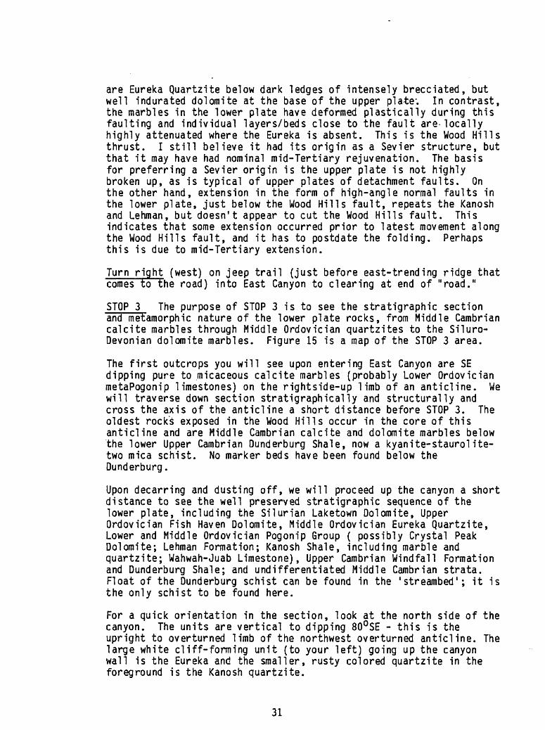
STOP 3 The purpose of STOP 3 is to see the stratigraphic section and metamorphic nature of the lower plate rocks, from Middle Cambrian calcite marbles through Middle Ordovician quartzites to the Siluro- Devonian dolomite marbles. Figure 15 is a map of the STOP 3 area.
The first outcrops you will see upon entering East Canyon are SE dipping pure to micaceous calcite marbles (probably Lower Ordovician metaPogonip limestones) on the rightside-up limb of an anticline. We will traverse down section stratigraphically and structurally and cross the axis of the anticline a short distance before STOP 3. The oldest rock's exposed in the Wood Hills occur in the core of this anticline and are Middle Cambrian calcite and dolomite marbles below the lower Upper Cambrian Dunderburg Shale, now a kyanite-staurolite- two mica schist. No marker beds have been found below the Dunderburg.
Upon decarring and dusting off, we will proceed up the canyon a short distance to see the well preserved stratigraphic sequence of the lower plate, including the Silurian Laketown Dolomite, Upper Ordovician Fish Haven Dolomite, Middle Ordovician Eureka Quartzite, Lower and Middle Ordovician Pogonip Group ( possibly Crystal Peak Dolomite; Lehman Formation; Kanosh Shale, including marble and quartzite; Wahwah-Juab Limestone), Upper Cambrian Windfall Formation and Dunderburg Shale; and undifferentiated Middle Cambrian strata. Float of the Dunderburg schist can be found in the 'streambed'; it is the only schist to be found here.
For a quick orientation in the section, look at the north side of the canyon. The units are vertical to dipping 80°SE - this is the upright to overturned limb of the northwest overturned anticline. The large white cliff-forming unit (to your left) going up the canyon wall is the Eureka and the smaller, rusty colored quartzite in the foreground is the Kanosh quartzite.
31

Wood Hills
Ordovician-Devonian marble unit
Simonson sandstone' subuoit
Eureka Quartzite'
Cambro-Ordovician marble unit
Kanosh shale' subonit
Kanosh quartzite' subonit
Dunderburg Shale' subunit
Syn kinematic;
diopside tremolite muscovite phlogopite phcngite
muscovite diopside tremolite
diopside creinolite muscovite
biotite muscovite oligoclase-andesine staurolite
biotite muscovite feldspar
muscovite
biotite muscovite staurolite kyanite garnet andesine
Postkinematic
phlogopite muscovite diopside tremolite
muscovite diopside tremolite
(in part as reaction rims on diopside)
diopside tremolite
biotite muscovite phlogopite
biotite
muscovite
biotite andalusite
PEQUOP MTNS
UnitC
UnitB
Unit A
biotite muscovite sodic andesine
muscovite
biotite muscovite phengite phlogopite hornblende actinolite sodic andesine leuchtenbergite
biotite muscovite
muscovite
biotite muscovite phlogopite leuchtenbergite
Table 1. Mineral assemblages characteristic of lower plate rock units in the in the Wood Hills and Pequop Mountains (from Thorman, 1970).
32

The rocks here are-amphibolite facies, based on the Dunderburg kyanite-staurolite-two mica schist and on diopside-bearing rock in the basal sandy dolomite of the Simonson Dolomite (see'Table 1 for a list of the mineral assemblages typical of each unit). Unfortunately most of the protoliths are quite pure limestones and dolomites and therefore do not contain many silicate minerals that can be used to determine the degree of metamorphism. The marbles are typically schistose, the schistosity being due to elongation of the dolomite or calcite and fine-grained white micas parallel to the carbonate grain elongation. The calcite marbles are typically distinctively color banded on a small scale, whereas the dolomite marbles are very weakly banded to nonbanded. I think this general lack of banding in the dolomite marbles is due to two factors: first, the dolomites are more resistant to deformation and therefore were not penetratively deformed to the same degree as the more plastic limestones; and second, the dolomites were thicker bedded than the limestones. The white micas in the dolomite marbles have a much smaller 2V than those in the calcite marbles, indicating a chemical difference between the two types of mica. The Pogonip limestones and a few of the Cambrian units were the 'dirtiest 1 protoliths and thus typically are very micaceous.
If one stands in the middle of the clearing and looks SE at the east- trending ridge (fig. 14), the upper plate is visible about 1.4 miles away below the prominent dark ledges (brecciated upper plate dolomite) with thin white streaks of rumble beneath (Eureka). The exact same upper plate Upper Ordovician-Middle Devonian section you see above the Wood Hills fault in its nonmetamorphosed, pristine state is directly behind you and has been metamorphosed in the amphibolite facies. This presents quite a problem because the stratigraphic separation between metamorphosed lower plate Eureka Quartzite and nonmetamorphosed upper plate Silurian Laketown Dolomite is only a few hundred feet. At other places along the fault, the basal upper plate rocks range from probable Upper Ordovician Fish Haven Dolomite to Lower Devonian Sevy Dolomite, the stratigraphic separation being a few tens of feet to more than 1500 feet, using the top of the Eureka Quartzite as a reference point. In the lower plate, the uppermost unit along the fault ranges from the Eureka Quartzite downward through the Crystal Peak Dolomite, Lehman Formation, Kanosh Shale, and Wahwah-Juab Limestone, but generally does not go below the Kanosh.
This relatively minor stratigraphic separation versus a major juxtapositioning of metamorphic and nonmetamorphic rocks raises the question of how much movement has actually taken place on the Wood Hills fault. Upper plate Devonian Guilmette rests on lower plate Lower Ordovician Pogonip to Silurian Laketown in the northeast corner of the range, and upper plate Guilmette and Pennsylvanian-Permian carbonates rest on lower plate Eureka and Pogonip in the northwest part of the range. Thus, in the larger picture, the stratigraphic separation across the fault is considerable, but in the southern part of the range it is nominal. If this were the only place the fault could be observed, one might suggest that all movement had been along the Eureka and that the transition from metamorphic to nonmetamorphic
33

rocks was restricted to a narrow interval in Middle Ordovician strata. More discussion on this problem at STOP 4.
Return to road heading south on east side of Wood Hills.
4.9 Go south along east flank of the Wood Hills past Warm Springs Ranch (1.7 miles).
The rocks to the west (your right) are SE dipping Laketown to Simonson Dolomites of the upper plate. The small spur that comes to the road about a mile past the ranch is uppermost Simonson Dolomite, the highest stratigraphic level attained in the upper plate in the southern part of the range.
Looking to the east at the Pequop Mountains across Independence Valley, one sees the following in a NS cross section of the Pequops: lower plate Cambrian through Siluro-Devonian calcite and dolomite marble, phyllite, schist, and quartzite at the base of the range; upper plate Lower Ordovician through Triassic strata that include five subplates, as shown in Figure 11. Figure 16, an oblique view of the southern part of the area, shows the clear truncation of intra- upper plate thrust faulting, with older-over-younger ramping towards the southeast.
The basal rocks of the Pequops upper plate are very low grade metamorphosed Pogonip Group carbonates and shales; these basal rocks may well be a transition from metamorphosed lower plate to nonmetamorphosed upper plate. However, they are in low-angle fault contact above higher grade metamorphosed Siluro-Devonian dolomite marbles and the dolomite marbles are brecciated along the contact. This interpretation, based on field work in August, 1987, is different from what I stated earlier (Thorman, 1970) and needs to be better documented. The earlier interpretation was that the top of the lower plate was above the very low grade metaPogonip carbonates. The lower and middle Paleozoic section (through Middle Devonian) is at least duplicated in the Pequops, occurring once in the lower plate and one or more times in the upper plate. In addition, four of the five subplates in the upper plate have an older-over-younger relationship. These relationships between the upper and lower plate and within the upper plate lead me to intepret them as having formed during Sevier time. I have not seen any indication of extensional tectonics in the Pequops, except for a set of west-dipping, north-trend ing normal faults that cuts all of the low-angle faults. In fact, the structural integrity within the range, extending to its southern end at Spruce Mountain, and north up Spruce Ridge, a distance of 70-80 miles, suggests that little, if any, detachment-style extensional faulting has occurred. Furthermore, the southern part of the Pequops have been folded to form a tight northwest-overturned syncline (Snelson, 1955 and Ketner, 1984).
2.0 Take dirt road SW to mouth of South Canyon. At 0.8 miles go through wire gate (please close).
34
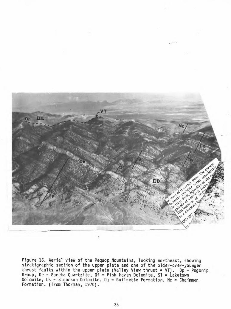
Figure 16. Aerial view of the Pequop Mountains, looking northeast, showing stratigraphic section of the upper plate and one of the older-over-younger thrust faults within the upper plate (Valley View thrust = VT). Op = Pogonip Group, Oe = Eureka Quartzite, Of = Fish Haven Dolomite, SI = Laketown Dolomite, Ds = Simonson Dolomite, Dg = Guilmette Formation, Me = Chainman Formation, (from Thorman, 1970).
35

/ / /
7 7 7
/ / // / /
__
/// / A !//// /.
MILES
Figure 17. Geologic map of the South Canyon area for STOP 4. Map symbols: 60m 1 = CambroOrdvician calcite marbles; Okq 1 = Kanosh Shale quartzite member; Oks 1 = Kanosh Shale phyllite member; Oe 1 = metaEureka Quartzite; ODd = Ordovician-Devonian dolomites; Ds - Simonson Dolomite (dotted unit at base is sandy cross-bedded basal member) (from Thorman, 1970).
36
Just as the road drops down into South Canyon the brownish weathering rocks on both sides are the cross-bedded sandy dolomite member at the base of the Middle Devonian Simonson Dolomite. '
1.0 Take road up South Canyon.
STOP 4. Figure 17 is a geologic map of this area. The main relationships to be seen at this stop are: the Wood Hills fault which juxtaposes nonmetamorphosed Silurian Laketown Dolomite of the upper plate on metamorphosed Middle Ordovician Eureka Quartzite and Crystal Peak Dolomite, Lehman Formation, and Kanosh Shale of the Pogonip Group of the lower plate; the upper greenschist facies metamorphism in the impure rocks, such as the micaceous marbles and the Kanosh 'phyllite 1 ; biotitized graptolites in the Kanosh 'phyllite 1 ; the boudined nature of the Eureka along the Wood Hills fault.
Several choices are available and will be pointed out. A north- trending high-angle fault cuts and repeats the Wood Hills fault in South Canyon. The best exposures of the Wood Hills fault are on the east side of the canyon, about 400 feet up the east side. We will hike up to this locality and see the following, in ascending order:
- at foot of hill is brecciated dark dolomite of upper plate (probably Silurian Laketown Dolomite); - cross high-angle fault and into brownish weathering micaceous banded calcite marble ( Wahwah-Juab limestone of Pogonip Group); resistant ledge of brownish red banded-weathering, micaceous, 'silty' calcite marble overlain by a ledge (up to _+ 30 ft thick) of cross-bedded quartzite (this is the basal 'member 1 of the Kanosh Shale of the Pogonip Group in the Wood Hills; commonly the quartzite is tectonically cut out); brownish weathering micaceous, banded calcite marble (middle 'member' of the Kanosh Shale) - soft zone with chips of biotite phyllite (upper 'member of the Kanosh Shale, a graptolite-bearing horizon, the graptolites having been replaced by biotite; the phyllite occurs as discontinuous structural lenses or boudins); - brownish weathering micaceous, banded calcite marble (Lehman Formation of the Pogonip Group) thin ledge of resistant brownish red banded-weathering, micaceous calcite marble (probably the Crystal Peak Dolomite at the top of the Pogonip Group) brecciated and highly fractured white, locally bluish-banded quartzite (Eureka Quartzite) top of Eureka is the Wood Hills fault; upper plate - ledge of indurated dark dolomite breccia (Laketown Dolomite); - overlying units to the south and east are the Sevy and Simonson Dolomites.
From the vantage point at the Wood Hills fault, one can see the continuation of the fault on the west side of the canyon. The very white slopes mark the Eureka Quartzite along the fault. Note that the Eureka comes and goes along the fault; this is due the boudin
37

effect along the fault mentioned above.
The other item of interest to see at STOP 4 is the metamorphosed graptolites in the Kanosh 'phyllite'. The best collecting localities are on the west side of the canyon just north of the vehicles and on the east side of the canyon south of the vehicles (both are marked on the geologic map, Figure 17). The graptolites are replaced by biotite and are beautifully preserved (Figure 18). An indication that you are in the right horizon is streaks of medium-grained biotite along the parting surfaces. Usually people think these are a streaky lineation rather than replacement of graptolites. When you crack open the right rock you will be a convert.
ONE
Figure 18. Biotitized didymograptids from the Kanosh 'phyllite. 1
A major problem to resolve in South Canyon is the magnitude of displacement along the Wood Hills fault. As you have seen, there is only a nominal stratigraphic throw across the fault, but a major juxtaposition ing of rocks with regard to their metamorphic/deformational history. As noted above, in the north end of the range similar juxtaposition ing of metamorphic and nonmetamorphic rocks has a much greater stratigraphic throw, and thus it is easier to accept large displacement across the fault. I do not find it hard to accept the Wood Hills fault in South Canyon as being a coincidence of the juxtaposition of rocks of very close age in view of the relations seen at STOP 3, where Upper Ordovician through Middle Devonian rocks above the Eureka are clearly part of the lower plate and were metamorphosed in the amphibolite facies.
1.1 Return to mouth of South Canyon. Proceed to 2nd road (DO NOT TAKE 1ST ROAD) heading southwest out of canyon.
1.9 Go SW out of South Canyon to graded dirt road.
38
1.7 Go west (right) on graded road.
4.7 Go NW on dirt road to graded road. Pass through small clearing with water well about 0.8 miles before graded road. Be careful * this road has a few bad spots, one just before clearing.
3.5 Go NNW on graded road parallel to railroad tracks. Watch for bad washouts where road crosses gullies. Be alert or you could end up wearing a front wheel for a necklace if you aren't quick with the brakes.
0.35 Turn left to Highway 93. Close gate.
7.6 Go north on Highway 93 to Wells. Turn left at stop sign in Wells and proceed to the Ranch House Motel/Casino/Restaurant.
39
ROADLOG:HALLECK TO ELKO
by
Keith Ketner
Halleck exit: junction of Secret Pass road with 1-80.Ten miles directly north of the Halleck exit are the Peko Hills. The Adobe Range will be on our right just north of 1-80 between Halleck and Elko. These areas display spectacular effects of Mesozoic compressional tectonism (Ketner, 1984). Devonian to Triassic miogeoclinal units were isoclinal1y folded and overridden by thrust plates composed partly of Ordovician to Devonian western facies units such as the Ordovician Vinini Formation. Allochthonous Permian rocks in the Adobe Range contain the clam Atomodesma, a genus found nowhere else in North America except in an accreted terrane in Alaska. Atomodesma is common in the Permian of New Zealand, Australia, and southeast Asia, on the opposite side of Gondwana from Nevada. Orientation of folds, vergence, and facies relations indicate northwest to southeast compression and overriding. The Elko Formation, whose lower beds are of middle Eocene age, unconformably overlies the major structures and is itself somewhat deformed in the Adobe Range and elsewhere.
8.0 miles west of Halleck exit: On the left are the Elko Hills. Here, the Eocene and Oligocene(?) Elko Formation unconformably overlies late Paleozoic units and is unconformably overlain by the Oligocene Indian Well volcanics (Ketner, 1985 and current work). The Elko Formation is composed principally of fine-grained sediments of an extensive lake and is approximately correlative with the Green River Formation of Wyoming. Gravelly alluvial fans spread into the lake from the southern shoreline and rhyolite erupted on the floor of the lake before, during, and after deposition of the Elko Formation. Oligocene and older formations of the Elko Hills form an anticline or dome elongated northeast-southwest. Structural relief measured on Tertiary units is at least 2000 feet. Detailed mapping done this summer indicates that the age of folding is younger than a 35 Ma vitrophyre in the Indian Well Formation. The late Miocene Humboldt Formation is undeformed. At the north end of the hills, a plate, or plates, consisting of Mississippian to Permian rocks overlies the deformed Indian Well and older units on a low-angle fault. Extensional high-angle faults transect the anticline. The very young age of the Elko Hills anticline and the low-angle older-on-younger fault suggests this deformation is related, somehow, to extensional tectonics. The anticline may be due to intrusion of a large near-surface stock and the older- on-younger faulting may be due to mega-lands!id ing from an unknown adjacent terrane now buried under basinal sediments. However, late stage local compression should not be ruled out.
40
References
Dallmeyer, R. D., Snoke, A.W., and McKee, E.H., 1986, The Mesozoic-Cenozoic tectonothermal evolution of the Ruby Mountains, East Humboldt Range, Nevada: a Cordilleran metamorphic core complex: Tectonics, v. 5* no. 6, p 931-954.
Day, W. C., Elrick, Maya, Ketner, K. B., and Vaag, M. K., 1987, Geologic map of the Bluebell and Goshute Peak Wilderness Study Areas, Elko County, Nevada: U.S. Geological Survey Miscellaneous Field Studies Map MF-1932.
Hintze, L. F., Geologic History of Utah: Brigham Young University Geology Studies, v. 20, pt. 3, 181 p.
Ketner, K. B., 1984, Recent studies indicate that major structures innortheastern Nevada and the Golconda thrust in north-central Nevada are of Jurassic or Cretaceous age: Geology, v. 12, p.483-486.
Ketner, K. B., 1985, Preliminary geologic map of the Elko Hills, Elko County, Nevada: U.S. Geological Survey Open File Report 85-713.
McCollum, L. B., 1987, Depositional changes within a Cambrian outer passivemargin sequence, northern Great Basin: Geological Society of America,Abstracts with Program, v. 19, n. 5, p. 320.
MeColl urn, L. B., and McCollum, M. B., (1984), Comparison of a Cambrian medial shelf sequence with an outer shelf margin sequence, northern Great Basin, in Kerns, G. J. and Kerns, R. L., eds., Geology of northwest Utah, southern Idaho, and northeast Nevada: Utah Geological Association Publication 13, p. 35-44.
Miller, D.M., 1984, Sedimentary and igneous rocks of the Pilot Range and vicinity, in Kerns, G.J., and Kerns, R.L., eds., Geology of northwest Utah, southern Idaho, and northeast Nevada: Utah Geological Association Guidebook Publication 13, p. 45-63.
Miller, D.M., and Lush, A.P., 1981, Preliminary geologic map of the Pilot Peak and adjacent quadrangles, Elko County, Nevada, and Box Elder County Utah: U.S. Geological Survey Open-File Report 81-658, 18 p., scale 1:24,000.
Schneyer, J.D., Structural and stratigraphic complexities within anextensional terrain: Examples from the Leppy Hills area, southern Silver Island Mountains, near Wendover, Utah, in Kerns, G.J., and Kerns, R.L., eds., Geology of northwest Utah, southern Idaho, and northeast Nevada: Utah Geological Association Guidebook Publication 13, p. 93-116.
Snelson, S., 1955, The geology of the southern Pequop Mountains, Elko County, northeastern Nevada: M.S. thesis, University of Washington, Seattle, Washington, 59 p.
Steele, Grant, 1960, Pennsylvanian-Permian stratigraphy of east-central Nevada and adjacent Utah, in Guidebook to the Geology of East-Central Nevada: Intermountain Association of Petroleum Geologists, p. 91-113.
41

Taylor, M. E., Day, W. C., and Ketner, K. B., 1986, Middle and lower Upper Cambrian stratigraphy of Morgan Canyon, Goshute-Toano Range, northeastern Nevada: Geological Society of America, Abstracts with Program, v. 18, n. 5, p. 418.
Thorman, C. H., 1970, Metamorphosed and nonmetamorphosed Paleozoic rocks in the Wood Hills and Pequop Mountains, northeast Nevada: Geological Society of America Bulletin, v. 81, p. 2417-2448.
Thorman, C. H., and Ketner, K. B., 1979, West-northwest strike-slip faults and other structures in allochthonous rocks in central and eastern Nevada and western Utah: Rocky Mountain Association of Geologists, 1979 Basin and Range Symposium, p. 621-636.
42