geological society of america bulletin - home page - rice
TRANSCRIPT

Geological Society of America Bulletin
doi: 10.1130/0016-7606(1972)83[1729:LDFHOT]2.0.CO;2 1972;83;1729-1754Geological Society of America Bulletin
RICHARD LEE ARMSTRONG Orogenic Belt, Eastern Nevada and Western UtahLow-Angle (Denudation) Faults, Hinterland of the Sevier
Email alerting servicesalerts when new articles cite this article
to receive free e-mailwww.gsapubs.org/cgi/alertsclick
SubscribeGeological Society of America Bulletin
to subscribe towww.gsapubs.org/subscriptions/click
Permission requestcontact GSA
tohttp://www.geosociety.org/pubs/copyrt.htm#gsaclick
positions of the Society.political viewpoint. Opinions presented in this publication do not reflect officialby scientists worldwide, regardless of their race, citizenship, gender, religion, or provides this and other forums for the presentation of diverse opinions and positionssite providing the posting includes a reference to the article's full citation. GSA may post the abstracts only of their articles on their own or their organization's Webeducation and science. This file may not be posted to any Web site, but authors copies of items in GSA's journals for noncommercial use in classrooms to furthertable, and/or a brief paragraph of text in subsequent works and to make unlimited permission, without fees or further requests to GSA, to use a single figure, a singlewithin scope of their employment. Individual scientists are hereby granted Copyright not claimed on content prepared wholly by U.S. government employees
Notes
of their employment.government employees within the scope claimed on any material prepared by U.S.Society of America, Inc. Copyright is not Copyright © 1972, The Geological
on January 26, 2010gsabulletin.gsapubs.orgDownloaded from

RICHARD LEE ARMSTRONG Department of Geology and Geophysics, Yale University, New Haven,Connecticut 06520
Low-Angle (Denudation) Faults, Hinterland
of the Sevier Orogenic Belt, Eastern
Nevada and Western Utah
ABSTRACT
Low-angle faults that place younger strata onolder are the distinctive structural feature ofthe hinterland of the Sevier orogenic belt inNevada. Although shown on many maps asMesozoic thrust faults, these low-angle faultsmay in many places be extension, denudation,and gravitational gliding features of Tertiaryage. The complexity of later Tertiary deforma-tion caused by crustal extension in the hinter-land has not been sufficiently emphasized.
Several contrasting interpretations of therelation between hinterland and Sevier beltstructures exist. Whitebread, Hose, Roberts,and Crittenden advocate gravitational glidingmodels that differ in detail, but in general theycorrelate extension in the hinterland withthrusting toward the foreland during the Cre-taceous. Misch, Nelson, Fritz, Miller, andWoodward assign a Mesozoic age to the low-angle faults which they relate to a regionaldecollement. The frontal breakout of thisdecollement is proposed by them to be west of,and older than, the thrust faults of the Sevierbelt or perhaps equivalent in age to them.Other geologists (Armstrong, Burchfiel, Davis,and Fleck) argue for a compressional origin forthe Sevier belt that involves considerablecrustal shortening. To them the low-anglehinterland faults are unrelated to Sevier beltthrusting. Geometric and chronologic prob-lems are created by the first two interpreta-tions, making the third interpretation mostattractive.
INTRODUCTION, GENERAL SETTINGThe Basin and Range province is character-
ized by tilted fault blocks bounded by normalfaults of post-Eocene age (Nolan, 1943; Mac-kin, 1960; Hamilton and Meyers, 1966) that
trend generally north-south. The blocks exposedeformed Paleozoic strata that display a varietyof structural styles but most distinctive in theeastern Great Basin are low-angle faults thatjuxtapose younger rocks on older (Misch,I960). These faults, which will often be referredto in this paper as denudation faults (becausestrata originally overlying the footwall havebeen removed tectonically), have been inter-preted in various ways. Their origin andsignificance is today a topic of dispute and dis-agreement. I believe that the models linkingdenudation faults with thrust faults of Cre-taceous age that lie to the east in the Sevierorogenic belt are unlikely and that the denuda-tion faults are predominantly of Tertiary ageand related to Basin and Range faulting. Thisinvolves reinterpretation by me of certainstructures, but does not mean that I disagreewith the distribution of rock units as shown onany maps. The central focus will be on struc-tures of east-central Nevada where denudationfaults are abundant and many areas are wellmapped. The most useful large-scale geologicmaps for the eastern Great Basin are the west-ern half of the state geologic map of Utah(1:250,000) (Stokes, 1963; Hintze, 1963) andthe county maps of Nevada (1:250,000 andapproximately, 1:125,000-preliminary form)(Longwell and others, 1965; Tschanz andPampeyan, 1970; Hose and Blake, 1970;Kleinhampl and Ziony, 1967).
Some of the topics discussed in this paperwere touched upon in my papers on the Sevierorogenic belt (Armstrong, 1968a, 1968b).Those papers should be consulted for pre-monitions, elaboration, or clarification of ideas,and more thorough documentation of factscited.
The eastern Great Basin (Fig. 1) is underlainby Paleozoic strata of the Cordilleran miogeo-
Geological Society of America Bulletin, v. 83, p. 1729-1754, 16 figs., June 1972
1729
on January 26, 2010gsabulletin.gsapubs.orgDownloaded from

1730 R. L. ARMSTRONG
^
Figure 1. Geographic names of selected topographicand geographic features in the eastern Great Basin ofNevada and Utah.
syncline. The zone of transition between mio-geosyncline and platform, the Wasatch zone, isthe locus of the Sevier orogenic belt. In thiszone, approximately 100 mi wide, the strata ofthe miogeosyncline were thrust over platformstrata during the Cretaceous. Here, Tertiarynormal faults bound fault blocks that containolder-over-younger listric thrust faults and re-lated folds which conform to the rules ofstructural style established in the Wyoming,Montana, and Canadian Rocky Mountains(Rubey and Hubbert, 1959; Armstrong andOriel, 1965; Mudge, 1970; Price and Mount-joy, 1970; Dahlstrom, 1970). At least 40 mi oftectonic contraction is expressed by theseMesozoic compressional structures of the Sevierbelt.
The hinterland of the Sevier belt (Fig. 2) hasa complex tectonic history and is the site ofmany extant problems, including, but not re-stricted to, the denudation faults discussed indetail in this paper. Between the Sevier
Figure 2. Tectonic index map for the eastern GreatBasin.
orogenic belt and the frazzled eastern edges ofthe Antler orogenic belt in central Nevada(Roberts and others, 1958) is a zone 100 to 150mi wide of heterogeneous structural style. Thestructure of individual mountain ranges in thehinterland of the Sevier orogenic belt may berelatively simple homoclines or broad folds,broken only by steep normal faults. Manyranges display low-angle faults placing youngerrocks on older and older on younger, but theformer predominate. A few ranges (Snake,Southern Deep Creek, Grant, Ruby, and RaftRiver ranges and the Wood Hills are spectacularexamples) expose metamorphosed and tightlyfolded lower Paleozoic and Eocambrian stratawith metamorphic fabrics produced by syn-kinematic penetrative deformation during theMesozoic (Misch, 1960; Misch and Hazzard,1962; Nelson, 1966; Bick, 1966; Cebull, 1970;Howard, 1966, 1971; Thorman, 1970; Arm-strong and Hansen, 1966; Compton, 1969).Older Precambrian basement rocks recrystal-lized and remobilized during metamorphism ofgeosynclinal strata, are exposed only in theRaft River-Albion Ranges in northwesternUtah-southern Idaho and in California (Arm-strong and Hills, 1967; Lanphere and others,1964). Elsewhere in the hinterland, the pres-
on January 26, 2010gsabulletin.gsapubs.orgDownloaded from

LOW-ANGLE FAULTS, SEVIER OROGENIC BELT, NEVADA-UTAH 1731
ence of exposed older Precambrian rocks isdisputable, although such ancient rocks prob-ably underlie most of the region at depth. Thecontact between metamorphosed and unmeta-morphosed strata in Nevada and Utah is usuallya fault that developed during or after thewaning stages of regional metamorphism(Misch, 1960; Misch and Hazzard, 1962; Nel-son, 1969; Misch, 1971). Commonly it juxta-poses younger rocks over older.
PRE-TERTIARY HINTERLANDSTRUCTURES
Evidence sufficient to date any orogenicstructures as pre-Tertiary is rare in the hinter-land. A conformable sequence of Eocambrianthrough Lower Jurassic strata indicates thatvirtually all tectonic complexity in the regiondeveloped at some time during the last 200m.y., but it is only at those few places whereLate Jurassic-Early Cretaceous or mid-Cre-taceous plutons crosscut deformed rocks that asignificant refinement in dating is possible. InElko County, plutons at least 150 m.y. oldcrosscut complex imbricate thrust faults in theH-D range (Riva, 1970), deformed and meta-morphosed strata in the Ruby Mountains(Kistler and Willden, 1969) and deformed mio-geosynclinal strata at Whitehorse Mountain(Adair and Stringham, 1957). A slightlyyounger pluton cuts deformed strata in DollyVarden area (Snow, 1964). In White PineCounty, metamorphism and deformation inthe Snake Range precedes 120 m.y. and maypredate 165 m.y. (Armstrong and Hansen,1966; Lee and others, 1970). At Ely, faulting ofupper Paleozoic strata, including younger-on-older style faults, predates plutons that havebeen accurately dated as 109 m.y. (Bauer andothers, 1966; McDowell and Kulp, 1967).
Mesozoic thrusting, much of it older thanthe Sevier belt in Nevada and Utah is alsorecognized in the Inyo and Clark Mountainregions of California (Stevens, 1969; Olson,1970; Burchfiel and others, 1970; Burchfieland Davis, 1971). Thrust faults in the Nevadatest site (Barnes and Poole, 1968; Hinrichs,1968) and farther north in western LincolnCounty and in northern Nye County (Tschanzand Pampeyan, 1970; Dodge, 1970) may beequally as old.
The amount of displacement on variousMesozoic thrust faults in the hinterland canonly be estimated in rare cases where con-trasting facies of units such as Mississippian
clastic rocks, derived from the Antler orogenicbelt, are juxtaposed (Brew, 1971; Thorman,1970).
One Mesozoic structure that is widespread,and perhaps universal in the Grant-WhitePine, Egan and Shell Creek Ranges is localiza-tion of bedding-plane faults along Mississippianshale. Rocks below this fault zone are usuallyrelatively unfaulted. The Pennsylvanian andyounger strata in the hanging wall are severelybroken by high-angle faults that do not extendbelow the detachment zone, as shown par-ticularly well in the southern Egan Range.Structures of this zone are locally imbricate(for example, the Becky Peak thrust fault ofthe northern Schell Creek Range described byDechert, 1967); in some places, such as theWhite Pine Range (Drewes and others, 1970)Tertiary volcanic rocks postdate movementalong such faults within the Mississippianstrata, but in some areas, the Tertiary rocks areas broken as the underlying upper Paleozoicstrata. A reasonable interpretation is that weakzones, such as the Mississippian shale, weresites of considerable movement at one or moretimes during the Mesozoic. These same zonesof weakness were reactivated during theTertiary. At any given place, the movement atdifferent times may have been in differentdirections (generally eastward movement ofupper plates being probable during the Meso-zoic; down-dip movement likely during theTertiary); structural confusion is an obviousconsequence.
Cretaceous sedimentary rocks at a fewlocalities in the hinterland unconformablyoverlie older rocks but do not provide evidencefor dating specific structural features. The pre-Tertiary unconformity (as shown by thepaleogeologic maps of Armstrong, 1968b; Fig.3) truncates many broad folds, some of con-siderable length and magnitude and a fewfaults; most of these faults have stratigraphicdisplacements of less than one geologic system.Mapping of the Schell Creek and Snake Rangeareas by Dechert (1967) and Nelson (1966)shows Tertiary volcanic rocks overlying Cam-brian rocks. This is in contrast to the Missis-sippian or younger strata that usually underliethe Tertiary in the hinterland. These relationscould be disregarded, or argued to be due tounrecognized structures of Tertiary age, butthey may indicate pre-Tertiary periods ofdenudation in the region, a possibility I wouldprefer to leave open, particularly in the light
on January 26, 2010gsabulletin.gsapubs.orgDownloaded from
STfcir7~— — . — •—|u-«— -
rxp °IWo S7
^ \\ ^~~m." r ^
\ \wf t
i-X6 ^ "^i (\^")/A \ \^ v{ ^ ^
^'-iii M"W^?. l
-7 )V 4"AW V>V<1/^Ik/ / }
" '̂"TM*A r ̂ i
>.* P !
f *o1• ° o ; |& > ' v1 >!,/a-os, ^ ?
^%x
-1' )
JSilivfi%N!«^1
? l'i
^-fe ^ifi•L J\ ^o
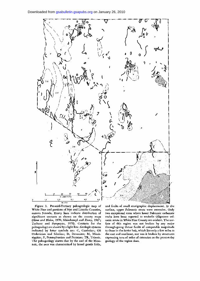
Figure 3. Pre-mid-Tertiary paleogeologic map ofWhite Pine and portions of Nye and Lincoln Counties,eastern Nevada. Heavy lines indicate distribution ofsignificant contacts as shown on the county maps(Hose and Blake, 1970; Kleinhampl and Ziony, 1967;Tschanz and Pampeyan, 1970). Contacts for thepaleogeology are shown by a light line. Geologic systemsindicated by letter symbols are: G, Cambrian; OSOrdovician and Silurian; D, Devonian; M, Missis-sippian; P, Pennsylvanian and Permian; TR, Triassic.The paleogeology shows that by the end of the Meso-zoic, the area was characterized by broad gentle folds,
and faults of small stratigraphic displacement. At thesurface, upper Paleozoic strata were extensive. Onlytwo exceptional areas where lower Paleozoic carbonaterocks have been reported to underlie Oligocene vol-canic strata in White Pine County are evident. The sur-face of this region was not broken by any majorthrough-going thrust faults of comparable magnitudeto those in the Sevier belt, which lies only a few miles tothe east and southeast, nor was it broken by structuresexpressing tens of miles of extension as the present-daygeology of the region does.
on January 26, 2010gsabulletin.gsapubs.orgDownloaded from

LOW-ANGLE FAULTS, SEVIER OROGENIC BELT, NEVADA-UTAH 1733
of the uncertain age of many denudation-typestructures and the complex tectonic history ofthe region.
Although we can be certain that some meta-morphism of geosynclinal strata occurred in theRuby Mountain and Snake Range areas beforethe Cretaceous, it is possible that elsewhere,presumably at deeper structural levels or inhot spots, that deep-seated flow of rocks oc-curred much more recently. Indeed some flowand the consequent development of flasergneisses seem to have taken place within theTertiary in the Raft River-Albion Range areas(R. R. Compton, R. E. Zartman, and Arm-strong, work in progress). Any crustal shorten-ing model for the Sevier orogenic belt neces-sarily requires flow or faulting at depth in thehinterland—deformation that must be syn-chronous with the eastward thrusting of mio-geosynclinal strata in the Wasatch ione.
GLIDE BLOCKS IN THE SEVIEROROGENIC BELT
Gravity slides of Late Cretaceous(?) andTertiary age have been recognized at severallocalities within the Sevier belt. Typically these
W S W
displaced blocks lie with low-angle contacts onolder strata but some lie on rocks as young asTertiary. The rocks are usually intensely brec-ciated near tectonic contacts; the entire upperplate may be shattered, but some plates arenot. Underlying rocks are deformed only in athin zone close to the tectonc contact. Anexample of the scale and style of these glideblocks is shown in Figure 4, taken from Seager's(1970) study of the Virgin Mountains. Farthersouth, glide blocks in the Spring Mountainshave been described by Secor (1963a, 1963b)and in the Clark Mountains by Burchfiel andDavis (1971). In the Pioche district north ofthe Virgin Mountains, several glide structuresoverride Tertiary sedimentary and volcanicrocks (Armstrong, 1964; Gemmill, 1968); tothe northeast, similar structures are reported inthe Beaver Dam Mountains (Cook, 1960;Jones, 1963) and Iron Springs district (Mackin,1960) in Utah.
An example of a fault that was cited as athrust fault (Baker, 1964), but which I thinkis a large glide structure is the Big Baldy faultof the southern Wasatch Mountains. Asillustrated on Figure 5, a simple interpretation
ENE
K I L O M E T E R S
0
M I L E SFigure 4. Cross sections of the northern Virgin
Mountains (Seager, 1970) showing gravity glide struc-tures. Geologic systems indicated by letter symbols are:
pC, Precambrian; €, Cambrian; O, Ordovician; D,Devonianj_M, Mississippian; P, Pennsylvanian andPermian; R, Triassic; J, Jurassic.
on January 26, 2010gsabulletin.gsapubs.orgDownloaded from

1734 R. L. ARMSTRONG
SIG BALDY. FAULT
M I L E S
K I L O M E T E R S
Figure 5. Cross section of the Big Baldy fault of the block rather than a thrust fault. Geologic systems in-southern Wasatch Mountains (Baker, 1964). This ap- dicated by letter symbols are: M, Mississippian; JP,pears to be a normal fault that bounds a simple glide Pennsylvania!!; P, Permian.
of the Big Baldy block is that it moved downand to the west and was rotated as it slid alonga curved fault surface. Faulting along theWasatch front would have provided the ori-ginal free surface that permitted failure; laterfaulting along the front displaced the glidesurface slightly. An alternate proposal, that it isa thrust fault, requires a complex ad hoc ex-planation in which a thrust fault rises strati-graphically, descends, and rises again, resultingin a stratigraphic displacement much less thantotal displacement and the observed younger-on-older relation. Such gymnastics are un-necessary, and certainly not needed to explainthe structures known to occur west of theWasatch fault in this area. I have chosen theBig Baldy fault for reinterpretation because Ithink it illustrates the potential for conflictinginterpretations that is widespread in the struc-turally more complex hinterland.
The examples cited demonstrate that gliding,often provably related to relief developed as aconsequence of later Tertiary faulting, is aphenomenon of common occurrence within themiogeosynclinal strata of the eastern GreatBasin. It is reasonable to expect similar struc-tures within the hinterland and surprising thatsuch an explanation has not been consideredfor all the structures of similar style and scaleknown to occur there.
DENUDATION STRUCTURES OFTHE HINTERLAND
Robert Scott used the term "denudationfault" for the widespread tectonic contacts that
place younger on older rocks (Moores andothers, 1968; Drewes and others, 1970), and Ithink this is a useful term with minimal geneticconnotations attached. It is concordant withthe thinking of most workers concerned withthe hinterland (tectonic removal of hanging-wall strata) regardless of how they think thesefaults are related to the big picture. PeterMisch and his students prefer to use the termdecollement (shearing off) for many of thesame features and believe in a compressionalorigin for most of these faults, although Misch(1960) admits that Tertiary gravitational glid-ing is important locally, as around SacramentoPass in the Snake Range. Where younger rocksare observed lying on older, the simplest geo-metric model for the development of such astructure involves extension—as along high- orlow-angle normal faults (Dahlstrom, 1970).This is illustrated in Figure 6. An importantconcept, popular in the Canadian Cordilleraand I think useful in the Great Basin, is thelistric normal fault—one that alternately cutsacross and parallels stratification. Such faults,as illustrated on Figure 6, result in juxtaposi-tion of younger-on-older rocks as occur onmany of the low-angle faults of the Sevierhinterland. If strata are upright and not tightlyfolded, the only possible geometric explana-tions for compressional faulting of older rockson younger are: (1) low-angle faults thatdecapitate folds (this mechanism produces atmost only 50 percent younger-on-older con-tacts, usually less); (2) imbrication of alreadyimbricate rocks by a second generation of
on January 26, 2010gsabulletin.gsapubs.orgDownloaded from

LOW-ANGLE FAULTS, SEVIER OROGENIC BELT, NEVADA-UTAH 1735
Figure 6. Ideal geometries of extension and denuda-tion faults that place younger rocks on older. Manyyounger-on-older faults of the hinterknd of the Sevier
thrusts steeper, relative to bedding, than thefirst generation (this likewise produces manymore older-on-younger contacts than viceversa); and (3) by erosion thrusting or thrust-ing along an unconformity, which can proceedwith completely flexible geometry, dependingon the landscape or unconformity being over-ridden. None of these geometric mechanismsseems to be applicable to the hinterland struc-tures. Geometric logic is a necessary prere-quisite to any acceptable model for structuralevolution.
A recent great increase in the acceptance ofgravitational gliding and extensional mechan-
orogenic belt can be interpreted as conforming to thesesimple models or to more complex permutations andcombinations.
isms to explain denudation faults oi the hinter-land is evident. As long ago as 1945, Longwelldescribed low-angle faults in Clark County,Nevada, but the idea did not become popularuntil the late 1960s. Hunt and Mabey (1966)interpreted the structure of the PanamintRange as shown on Figure 7 as a deeply exposednormal fault, an inverse-imbricate denudationstructure. Wright and Troxel (1969) inter-preted the Amargosa chaos as drag belownormal faults that flatten at depth, inverseimbricate listric normal faults in the jargon ofthis paper. Fleck (1970a) suggested that thechaos may be megaslides (large-scale versions of
on January 26, 2010gsabulletin.gsapubs.orgDownloaded from

1736 R. L. ARMSTRONG
Eo€
I
MILES
Figure 7. Cross section of the Tucki Mountainfenster (Hunt and Mabey, 1966), an example of an
the Tin Mountain landslide described byBurchfiel, 1966). There is general agreementthat these structures are Tertiary, as they post-date and involve Tertiary rocks. Once popularand widely quoted comoressional- thrust ex-planations for these same features are fallingout of favor. Hunt and Mabey (1966) cite thereason for their interpretation: extreme at-tenuation of units, maintenance of stratigraphicorder within the fault mosaic, abundance ofsmall normal faults which show a tendency tomerge with the master fault, and absence ofimbrication and folding. These aspects are pre-cisely those of many of the low-angle faultcomplexes of east-central Nevada.
Extension and gravitational gliding explana-tions for low-angle faults in east-central Nevadawere suspected by Young (1960) and stronglyadvocated by Drewes (1964, 1965, 1967),Moores (1968), Moores and others (1968),Drewes and others (1970), Whitebread (1968),Hose and Danes (1968), and Hose and Blake(1969), but the age and significance of the ex-tension is not agreed upon. In order to discussthe interpretations of various authors and todevelop my own ideas, it is useful to discussspecific examples going from east to west acrosseast-central Nevada.
Snake RangeFirst, and perhaps most important of all, is
the Snake Range. This area inspired Misch's(1960) idea of a decollement thrust faultseparating complexly sliced upper plate rocks(Cambrian and younger) from a relatively in-tact autochthon of Cambrian and older stratathat had been metamorphosed during theMesozoic (prior to emplacement of massivegranites in the vicinity of Wheeler Peak).Misch (1960) and Nelson (1966, 1969) describethe decollement in great detail and on indirectevidence (unconformities below Cretaceousstrata that lie more than 100 mi away from
K I L O M E T E R S
inverse-imbricate denudation structure of Tertiary agein the Death Valley region.
the Snake Range) conclude that it is ofMesozoic, pre-Laramide age. I believe thatevidence for dating the faults may be found inthe southern Snake Range area shown onFigure 8, recently mapped by Whitebread(1969) and Hose and Blake (1970) and studiedby Lee and others (1970).
As can be seen on Figure 8A, normal faultsthat displace Oligocene volcanic rocks (dated29.7 m.y. by Armstrong, 1970) can be tracednorthward where they are observed to mergewith the basal decollement. This suggests to methat the decollement itself may be of Tertiaryage, at least in part. Further evidence of ayoung age for the decollement is the datingstudies of Lee and others (1971) that showedtotal argon loss from cataclastic rocks, producedduring movement on the decollement, less than20 m.y. ago. These authors interpreted this tomean that the most recent movement alongthe decollement, which cuts the Mesozoicgranites, is of Tertiary age. I agree whole-heartedly.
Figure 8. Geologic map of the southernmost part ofthe Snake Range (Whitebread, 1969; Hose and Blake,1970) and a cross section (E-E' of Whitebread, 1969)that includes the Murphy Wash-Johns Wash Graben.The numerous faults above the Snake Range decolle-ment merge or truncate against it implying that theyare synchronous or older. The fact that some of thesefaults displace Tertiary volcanic strata suggests aTertiary age for the decollement. Geologic units in-dicated by letter symbols are: Cpm, Cambrian ProspectMountain quartzite; C, Cambrian carbonate rocksand shale; OS, Ordoviciarl and Silurian; DM, Devonianand Mississippi;!!); P, Pennsylvanian; Ki, Mesozoicintrusive rocks; T, mid-Tertiary volcanic rocks. Dottedlines are contacts of bedrock with Quaternary cover.Faults are annotated: hachures for high-angle faults(ticks on upper, downdropped plate) and teeth onupper plate of low-angle faults. These same conventionsapply to all the maps in this paper.
on January 26, 2010gsabulletin.gsapubs.orgDownloaded from

€pm
MURPHYWASH
.'•. LEXINGTONCREEK PLUTON
•' MD
SW
0 I 2 0 1 2 3
M I L E S K I L O M E T E R S
NE
MURPHY WASH - JOHNS W A S H
G R A B E N
OS
K I L O M E T E R S
I
M I L E S
on January 26, 2010gsabulletin.gsapubs.orgDownloaded from

1738 R. L. ARMSTRONG
Deep Creek Mountains and Gold Hill
North of the Snake Range, at the south-western end of the Deep Creek Mountains,Nelson (1966, 1969) mapped a structurallycomplex area of upper Paleozoic rocks. Theinverse imbrication and brecciation associatedwith deformation suggest a shallow extensionalgenesis for his structures. A critical factor inunraveling this area will be a detailed study olTertiary volcanic stratigraphy and structure,but such studies are still incomplete (work inprogress by M. C. Blake and R. K. Hose).If the volcanic structure is complex, it will benecessary to attribute at least some of the low-angle faults mapped by Nelson to the Tertiary.A principle that must be observed in the studyof such areas where both Tertiary volcanic andolder rocks are present was emphasized byMackin (1960): Tertiary strata, including layeredvolcanic rocfe are the guides to the amount oflater Tertiary deformation that has taken place.This younger deformation must be subtractedbefore a reasonable interpretation of Mesozoicstructure is possible. Casualness on this pointhas contributed much confusion to the litera-ture concerning the eastern Great Basin.
fust north of the Deep Creek Mountains, at
Gold Hill, Nolan (1935) first recognized thecomplex tectonic history of the hinterland. At atime when the geology of the surroundingregion was largely unknown, he recognizedseveral periods of compression and extensionthat he could demonstrate were pre-Eocene inage. In addition, he described complex younger-on-older fault relations and high-angle blockfaulting of post-Eocene age. Such a chronologyfits well with the regional history as knowneven today, the only qualification being thatthe post-Eocene younger-on-older faults aremore likely extension-denudation-gliding struc-tures than the result of regional compressionduring later Tertiary time.
Schell Creek RangeThe next range to the west is the Schell
Creek Range. Dechert (1967), Young (1960),and Drewes (1967) are the principal con-tributors to knowledge of the geology there.Drewes recognized the complexity of the tec-tonic history of the area and carefully qualifiedthe interpretations he gave his structures. Hewas one of the first workers in the region toshow large Tertiary glide blocks containingTertiary strata and recognize that Mesozoic
K I L O M E T E R S
Figure 9. Cave Mountain area, Schell Creek Range,geology and cross section after Drewes (1967). Theformations indicated by letter symbols are: €pc,Cambrian limestone; €1, Cambrian shale; €Ol,massive Cambrian and Ordovician limestone; O,Ordovician; S, Silurian; MP, Mississippian and Penn-sylvanian. The large allochthon of COl may be aTertiary glide block, a mirror image of similar structuresin the southern Snake Range.
on January 26, 2010gsabulletin.gsapubs.orgDownloaded from

LOW-ANGLE FAULTS, SEVIER OROGENIC BELT, NEVADA-UTAH 1739
faults may have been sites of Tertiary move-ment. I go only a bit further than he in inter-preting faults in his area as Tertiary. In theCave Mountain area (Fig. 9), a denudationfault has been mapped. The fault begins at anormal stratigraphic contact between massiveupper Cambrian and Ordovician limestone(CO1) and underlying shale (Cl) (known to beprone to slumping and landsliding) and, asfollowed eastward, shows increasing stratig-raphic discordance so that eventually thelimestone (CO1) overlies middle Cambrianlimestone (Cpc). The strata designated CO1are upright and dip steeply into the fault. Thegeometric relations are precisely correct for anextensional-gravitational, perhaps mega-land-
slide, origin for this structure. It is most easy toimagine this happening during the Tertiary,during or after uplift of the range. A mirror-image symmetrical structure involving thesame stratigraphic units occurs southwest ofWheeler Peak in the southern Snake Range onthe opposite side of Spring Valley. This "twin"of the Cave Mountain structure, visible onFigure 8 (Whitebread, 1969), is part of thesouthern Snake Range decollement for which aTertiary origin by extension has already beendiscussed.
Farther south in the area mapped by Drewesin the vicinity of Connors Pass, I would extendthe hypothesis of a Tertiary age to the "SchellCreek Range thrust." Figure 10 shows Drewes'
Figure 10. Geologic map and sections, southernSchell Creek Range in the vicinity of Conoers Pass(Drewes, 1967). The lower sections, N' and O', are analternate interpretation to the published structure,
K I L O M E T E R S
shown on the upper N and O sections. The map patternis consistent with a normal displacement, rather thanthrust origin for the Schell Creek Range "thrust"(S.C.R. Th. on map). Geologic formations indicated byletter symbols are: Cpm, Cambrian Prospect Mountainquartzite and overlying Pioche shale; Cpc, Cambrianlimestone; Cl, Cambrian shale; COl, Cambrian andOrdovician limestone; D, Devonian; MP, Mississippianthrough Permian; T, Tertiary.
on January 26, 2010gsabulletin.gsapubs.orgDownloaded from

1740 R. L. ARMSTRONG
map and sections and my interpretation. Themap pattern is actually more consistent with aTertiary age for the Schell Creek "thrust"because a large area of Tertiary rocks is downfaulted against the CO1 limestone betweensections N and O. The published map suggeststhat the Schell Creek Range thrust fault is cutby the younger normal fault that forms thesoutheast boundary of the east dipping Ter-tiary strata. The problem, as I see it, is that thisTertiary normal fault has the same trend,
direction of stratigraphic displacement, andmagnitude of displacement as the fault calledthe Schell Creek Range thrust fault in areasto the north and south. The minimum dis-placement of the normal fault is one-half mile,yet it dies out on the map within a few hundredfeet under a small patch of alluvium just southof its projected intersection with cross sectionN (Fig. 10). This is a geometric impossibility—a fault displacement cannot change along strikeby more than the distance along strike (the
M I L E SFigure 11. Geologic map of the north end of the
Egan Range (Fritz, 1968). The published interpreta-tion is shown even though it must be incorrect, as nostructure is shown to explain the westward dip of theTertiary volcanic rocks crossed by section C-C. Geologicsystems indicated by letter symbols are: EoC, Eocam-
brian; Cpm, Prospect Mountain quartzite; C, Cam-brian shale and carbonate; OS, Ordovician and Silurian;D, Devonian; M, Mississippian; P, Pennsylvanian andPermian; TV, Tertiary volcanic rocks; Ti, Tertiaryintrusive rocks.
on January 26, 2010gsabulletin.gsapubs.orgDownloaded from

LOW-ANGLE FAULTS, SEVIER OROGENIC BELT, NEVADA-UTAH 1741
maximum would be along a fault with scissorsmovement—displacement away from the hingepoint would be equal to the distance from thehinge times the rotation on the hinge inradians—this would seldom approach a 1:1relation). Continuing on the other side of thesame patch of alluvium with the same trendand sense of stratigraphic displacement is theSchell Creek Range thrust fault. To me, thesimplest interpretation is that the "thrust"and the Tertiary normal fault are one and thesame feature—structures due to extension andresulting in denudation of the half-dome east ofConnors Pass. Most of the structure in thisarea can be viewed as Tertiary denudationrather than the effects of Mesozoic compressionor extension. Indeed, several striking drag foldsobserved near Connors Pass (Fig. 10) indicatedown-dip movement, the fault zone betweenthe limestone (CO1) and shale (Cl) itself beingdeformed by these folds. Drewes (1967) com-mented on this evidence in his report but feltthat, in general, fold attitudes gave ambiguousresults for direction of displacement alongfaults in the area. He felt the evidence slightlyfavored eastward movement, but he made theuncertainties involved in his determinationexplicit.
Egan RangeAn area where the structural significance of
Tertiary volcanic rocks (Mackin, 1960) hasbeen ignored is the northern Egan Range.Figure 11 shows the geology of part of the areamapped by Fritz (1960, 1968). The publishedmap shows many faults, and on cross sectionC-C they appear as nearly horizontal "thrusts"to which a Mesozoic age is assigned in thedescriptive text (Fritz, 1960). The steeplydipping Tertiary volcanic strata intersected bycross section C-C are not related to any struc-ture capable of producing their steep dip in theTertiary! In fact, they dip westward toward asteeply east-dipping contact mapped as anormal stratigraphic overlap. Insight into thetrue nature of the structure is gained by ro-tating the volcanic rocks back to horizontal (asthey must have been approximately 35 m.y.ago). This has been achieved on Figure 12 bysimply rotating Fritz's section C-C. The Meso-zoic "thrusts" immediately become normalfaults (consonant with the direction andmagnitude of the stratigraphic displacementsalong them) that postdate, and thus displacethe volcanic rocks. The western contact of thevolcanic rocks must, of course, be itself a fault.
Figure 12. Cross section C-C of Fritz (1968) rotatedso as to bring the Tertiary volcanic rocks to a horizontalposition. The true nature of many of the "thrust"faults shown on Fritz's map is revealed—they arenormal faults rotated to a near horizontal attitudeduring later Tertiary time.
The only normal stratigraphic contact is withthe underlying Pennsylvanian strata—withonly a small angular discordance being evident.The structure here is rather similar to thePanamint Range structure of Hunt and Mabey(1966). In the Egan Range, we have normalfaults rotated to a near horizontal present-dayattitude by tilting of the range—tilting provenby the attitude of the volcanic strata.
The patch of volcanic rocks near the northend of the area shown on the map likewiseseems to me to violate the principle discussedby Mackin (1960); a major fault between thevolcanic rocks and the Eocambrian strata tothe north is required. Such an interpretation isin agreement with the work of Adair (1961, and1963, personal commun.) but denied by R. K.Hose (1971, personal commun.). The contact indispute is quite steeply dipping but not wellenough exposed to be uniquely identified asdepositional or tectonic. I would connect thevolcanic-Eocambrian contact with a majorlater Tertiary fault that forms the contact ofthe Cherry Creek pluton with Paleozoic rockssouth of it (Adair, 1961). This Tertiarynormal fault would include, in part, a younger-on-older "thrust" that Misch identified as partof his Mesozoic regional decollement. Thereneed be no such structure here at all.
This reinterpretation of parts of Fritz's mapdoes not mean to imply that his entire struc-tural complex is a Tertiary feature. There aremany faults, including imbricate thrust faultsthat cannot be reasonably interpreted as any-thing but pre-Tertiary structures. The point to
on January 26, 2010gsabulletin.gsapubs.orgDownloaded from

1742 R. L. ARMSTRONG
make is that the Mesozoic thrust interpretationhas been carried too far, and the Tertiarystructures have been considerably underrated.
Another example of proliferation of Meso-zoic thrust faults in violation of Mackin'sprinciple occurs farther south, in the southernEgan Range, in an area mapped by Brokawand Shawe (1965; Fig. 13).
On the published map and section, ayounger-on-older thrust fault is shown alongthe west side of the eastward-til ted EganRange fault block. Slightly farther west, anormal fault of negligible stratigraphic dis-placement is shown. The Tertiary strata lyingon the east side of the range, dipping eastward,are the same units as those lying nearly hori-zontally west of the range and west of the twofaults mentioned above. These two areas werepart of an originally extensive horizontal and
continuous blanket of Tertiary strata. The dis-placement proven by present attitude of theTertiary strata amounts to thousands of feet ofwarping or faulting. There is no structure onthe map, as published, to account for this dis-placement. However, the orientation of the"thrust" and amount of stratigraphic throwalong it are exactly as needed to explain theTertiary deformation. My solution to thisdilemma is that the Mesozoic "thrust" is alow-angle normal fault of later Tertiary age—the low angle being in part a consequence ofeastward tilting of the southern Egan Range.
Grant-White Pine RangesMoores and others (1968) emphasized the
importance of gravitationally driven Tertiarygliding and denudation structures in the north-ern Grant and southern White Pine Ranges.
KILOMETER S
Figure 13. Geologic map of the northern part of theEly 3 SW. quadrangle (Brokaw and Shawe, 1965),Egan Range, just southwest of Ely, Nevada. The thrustfault shown along the west side of the range must bethe Tertiary normal fault required to explain the upliftand eastward tilting of the range. Geologic systems
indicated by letter symbols are: O, Ordovician; S,Silurian; D, Devonian; M, Mississippian, mostlylimestone; Me, Mississippian shale; P, Pennsylvanian;Pm, Permian; T, mid-Tertiary sedimentary and vol-canic rocks.
on January 26, 2010gsabulletin.gsapubs.orgDownloaded from

LOW-ANGLE FAULTS, SEVIER OROGENIC BELT, NEVADA-UTAH 1743
They could not fail to be impressed by largemasses of Paleozoic strata enclosed within, andoverlying, Tertiary volcanic and sedimentaryrocks in their area. Yet in the same ranges, atdeeper levels, structures of pre-Tertiary age arepresent. Cebull (1970) has described the spec-tacular effects of regional metamorphism, large-scale recumbent folding, and imbrication thatoccur around Troy, south of the area mappedby Moores and others (1968). Some of thestructural complications described by Cebullmay be of Tertiary age; denudation faults re-lated to range uplift would be so similar inappearance as to be indistinguishable fromsome of Cebull's thrusts, but a Mesozoic ageseems reasonable for most.
To the north of the area mapped by Mooresand others (1968), in the White Pine District,the published map of Humphrey (1960) showsMesozoic thrust faults as well as several faultswhich can be interpreted as Tertiary denuda-tion features, one in particular being the Lamp-son "thrust" as shown on Figure 14. Thestriking feature of this "thrust" is that it diesout completely near the north edge of thefigure where it is joined by a wrench fault, theEberhardt fault. Geometric logic suggests thatthe increasing stratigraphic displacement south-ward is an expression of increasing normal dis-placement along a fault hinged at its northernend. But this is the reverse of the publishedinterpretation! The Tsv strata that abutagainst the Lampson fault scarp providefurther suggestion, following Mackin's prin-ciple, that displacement along the fault isnormal rather than reverse. To me, the mappattern suggests that the upper plate on whichthe Tertiary strata lie has moved downwardand westward, at the same time rotating clock-wise about 10°. The slice of Silurian1 rockthrust on nearly overturned Devonian stratanear the south side of the area shown on Figure14 remains to be explained. This structure ispresumably the reason a thrust origin for theLampson fault was initially inferred. Thesestructural complications at depth suggest to methat the normal fault has merged with, andfollowed a Mesozoic thrust plane that existedbelow a decollement in the Mwp shale beforeTertiary faulting began. This suggestion allows
*R. K. Hose (Hose and Blake, 1970, and 1971,personal commun.) reports that this is probably De-vonian Simonson Dolomite, and so the structure maynot be as complex as indicated by Humphrey (1960).
M I L E S
Figure 14. Geologic map of the Lampson "thrust"White Pine district (Humphrey, 1960). Stratigraphicdisplacement on the "thrust" increases southward,suggesting normal, rather than thrust movement, butsome features observed toward the south (imbrication,near-overturning of Devonian strata) suggest thrusting.This may be reconciled by proposing that a Tertiarynormal fault intersects and joins at moderate depth aMesozoic listric thrust. This would be an example ofreversal of movement along a given fault surface duringtwo stages of deformation, a normal expectation in aregion with complex tectonic history.
a reconciliation of the evidence for normal andreverse movements along the same fault. Themap pattern around Mount Hamilton, also onHumphrey's (1960) map, likewise contains sug-gestions of possible reinterpretation of Meso-zoic thrust faults as composite structures in-volving reverse and normal displacements ofvarious times along the same faults. Unfor-tunately, these structures are not datable andthus could be Mesozoic or Tertiary. It is im-pressive, however, that two illustrations (hisFigs. 12 and 13) in Humphrey's (1960) reportshow drag suggesting down-dip movement
on January 26, 2010gsabulletin.gsapubs.orgDownloaded from

1744 R. L. ARMSTRONG
along a fault mapped as a thrust fault (MonteCristo fault with up-dip movement, butyounger-on-older stratigraphic displacements).Similar complexity is probably applicable tomany other hinterland structures. Re-use ofMesozoic faults during Tertiary deformationwas an important conclusion of Drewes (1964,1967), and has'been well documented in theCanadian Rockies (Dahlstrom, 1970; Bally andothers, 1966).
Ruby MountainsIn the Ruby Mountains, Willden and others
(1967) and Willden and Kistler (1969) dis-covered a klippe of brecciated Devonian rocksoverlying an Oligocene granitic pluton, itselfslightly brecciated near the tectonic contact.They invoked a period of compressional thrust-ing during the Tertiary and related it to K-Ardates on crystalline rocks north of the klippethat reach a minimum of 21 m.y. along the westside of the range, the side where the klippe lies.The evidence could as well be interpreted, as inthe Snake Range, to indicate tectonic denuda-tion of the range during Tertiary time. Thewestward decrease in K-Ar dates may even be aclue to the direction of movement of the coverand the rate it was pulled (or slid) off the RubyRange into the valley on the west side. Theklippe of Devonian rocks would be merely aremnant of the block that moved off, resultingin rapid cooling of rocks that had up to thattime remained too hot to retain argon. Tointerject a period of regional compression dur-ing the later half of Tertiary time unnecessarilycomplicates the tectonic history; it can only beaccomplished by a rather involved manipula-tion of known examples of datable displace-ments of Tertiary strata that are convincingevidence of extension which occurred through-out the region after the effusion of Tertiaryvolcanic rocks began, approximately 40 m.y.ago.
GLIDING VERSUS PUSHING IN THESEVIER OROGENIC BELT—HOWDOES THE HINTERLAND FITTHE BIG PICTURE?
Several authors (Whitebread, 1968; Roberts,1968; Roberts and others, 1965; Hose andDanes, 1968; Hose and Blake, 1969) have sug-gested that the denudation (attenuation ofHose and Danes) structures of the hinterlandare genetically linked with thrusting in theSevier orogenic belt. They invoke a gravita-
tional gliding mechanism whereby denudation(attenuation) in the hinterland is synchronouswith thrusting along the Wasatch zone; ex-tension in the hinterland must match com-pression in the Wasatch zone it crustal shorten-ing has not occurred. Gravitational glidingmechanisms have also been invoked as ex-planations for other sectors of the Cordilleranfold and thrust belt (Scholten, 1968; Crosby,1968, 1969; Mudge, 1970). It should be em-phasized that the scale of the glide structuresadvocated to explain the Sevier belt and itslateral continuation is at least an order ofmagnitude larger than the scale of glide blocksrelated to local uplifts during Tertiary [andMesozoic(P)] time. Large-scale gliding involvesmovement of sheets of sedimentary strata thatare at most 5 mi thick and more than 100 mi inwidth over distances of 40 to 100 mi. Op-position to large-scale gliding has been ex-pressed, however, by other geologists who ad-vocate crustal shortening as a genetic explana-tion for the fold and thrust belt (Armstrong,1968b; Burchfiel and Davis, 1968; Fleck,1970b). For the Canadian Cordillera, Price(1969) and Price and Mountjoy (1970, 1971)propose an attractive model of crustal thicken-ing in the hinterland and consequent lateralflow of supra-crustal material to produce thefold and thrust belt. This model involvescrustal shortening of a magnitude similar to, ifnot identical with, the compression expressedin the fold and thrust belt (more than 100 mi insouthern Canada), and although it is referredto as a gravitational mechanism (gravity beinga very important part of the driving force), itsignificantly differs from the mechanism pro-posed by the gliders. The thrust faults areprojected westward, at depth, into deep zonesof intracrustal flow. Plates move uphill (butdown lithostatic gradients), so that an eastwardslope of the movement planes is not requiredat any time. Such a mechanism does not requirethat the rear of the moving plates be a zone ofextension at the earth's surface so that aregion of extension and denudation in thehinterland is not necessary—if lacking it is nota detriment for the model. If present, such azone of extension can have an explanation in-dependent of the genesis of the fold and thrustbelt; there is no necessity that events in zonesof extension and compression be synchronousand displacements in the two belts of com-parable magnitude.
Armstrong (1968b), Burchfiel and Davis
on January 26, 2010gsabulletin.gsapubs.orgDownloaded from

LOW-ANGLE FAULTS, SEVIER OROGENIC BELT, NEVADA-UTAH 1745
(1968), and Fleck (1970b), do not considerthe denudation structures of the hinterland ofthe Sevier belt to be directly related to thegenesis of the fold and thrust belt. A differentmodel created by Misch (1960; Misch andHazzard, 1962) and supported by his students(including Fritz, 1960; Woodward, 1964; Mil-ler, 1966; Nelson, 1966, 1969) proposes a linkbetween hinterland and Wasatch-zone struc-tures that has to be discussed separately as itdoes not represent a combination of any of the"glide" or "push" models already outlined.Misch envisages the younger-over-older faultsof the hinterland as decollements between arelatively rigid "basement" (deep seated geo-synclinal strata that have been subject toMesozoic synkinematic regional metamorphismprior to thrusting) and a severly tectonizcdcover that was being pushed2 eastward relativeto the "basement" at some time late in theMesozoic but prior to the "Laramide" defor-mation in the Sevier orogenic belt (Misch,1960, 1971). Another zone of thrusting, lyinggeographically between the Sevier belt and thehinterland, but now buried by Tertiary valleyfill, is proposed by Misch. This hidden thrustzone is the one Misch relates to the hinterlandstructures. He does not recognize hinterlandstructures of "Laramide" age that would cor-respond with Sevier orogenic belt structures inage and be linked with them in genesis. More-over, Misch believes the denudation faults tobe of compressional origin, not structures re-sulting from extension.
Misch believed the decollement faults hedescribed were Mesozoic, because he felt thatthe deformation style was in contrast with thestyle of faults that displace Tertiary volcanicrocks, but this might be simply a change instyle with depth along the same fault. Some ofthe faults upon which our disagreement focuseswere buried at depths of at least 5 mi, if thepaleogeologic map and sections are at all cor-rect, so that we both agree that the slicing,mylonitization, and retrogression observed inlower Paleozoic rocks was not a surficialphenomenon, but rather one that took place atlithostatic pressures of several kilobars. The in-tense brecciation noted by Nelson (1966, 1969)where low-angle faults displace upper Paleozoic
2 Misch (1960, p. 41) describes the process as "west-ward underthrusting" of a non-yielding foreland. Hedoes not consider attenuation in the hinterland to besignificant (Roberts and others, 1965).
rocks is exactly the style of deformation as-sociated with Tertiary glide blocks in theMojave Desert region (Burchfiel, 1966; Burch-fiel and Davis, 1971).
Obviously a diversity of opinion exists as togenesis and significance of hinterland andWasatch-zone structures. My own preferencehas been, admittedly, for pushing rather thangliding as an origin for the Cretaceous Sevierorogenic belt and, as outlined in this paper, fordenudation and gliding, much of it Tertiary,on a local scale to explain the hinterland struc-tures. I think it worthwhile to outline all thereasons that I think make the large-scalegravitational gliding model untenable, and whyI differ with Misch on interpretation althoughwe have no disagreement on geologic observa-tions or tectonic sequence in the hinterland.Some objections are geometric, others chro-nologic. Arguments about mechanism are, forthe most part unsatisfactory and inconclusive,as they require knowledge we do not have onthe large-scale behavior of rocks. I prefer toanalyze what has happened, geometrically andchronologically, rather than to try to answerabstract questions of how it happened (mechan-ism and driving force). I am willing to grantanyone a process regardless that it may conflictwith intuition or an evolving body of theory,if it can be proved to have happened.
Gliding models require a net downhill slopebetween area of uplift, source of moving plate,and area of imbrication of the plate. Mudge(1970) imagines an uplift of 60,000 ft in westernMontana to propel his moving plate, yet thereis neither stratigraphic evidence within thearea of uplift for such extremely elevatedmountains (needless to speculate on the paleo-climatic consequences of such mountains thatexceed the highest point in the HimalayaMountains by a factor or two), nor is there evi-dence on either side that requires such anuplift. In fact, this supposed source area isknown to have been the site of basins ac-cumulating sediments at moderate elevations(a few thousand feet at most) by the later partof Eocene time (Price, 1962, 1971). In theeastern Great Basin, it is difficult to find evi-dence of great uplift during later Mesozoictime. What we do know is that the entireregion was near sea level up to the Jurassic. Afew localities within the region contain fluvi-atile and lacustrine sediments of approximatelymiddle Cretaceous age (this should be near thetime of maximum uplift) which have yielded
on January 26, 2010gsabulletin.gsapubs.orgDownloaded from

1746 R. L. ARMSTRONG
paleobotanical remains indicative of relativelylow elevations (Easton, 1954), not alpine high-lands. Over much of the hinterland, theearliest datable Tertiary deposits, Eocene lake-beds containing faunas that indicate relativelymodest elevations (Winfrey, 1960), overlie up-per Paleozoic strata (compare paleogeologic mapof Armstrong, 1968 and Fig. 3). The fact thatthese upper Paleozoic strata are preserved overmuch of the hinterland strongly suggests thatthe area never lay more than a few thousandfeet above sea level. Only an average of a fewthousand feet of strata have been eroded fromthe geosynclinal pile of the hinterland, and thiscould have taken place at low elevations duringthe 100 m.y. of available geologic time. Hadthere been high mountains in the hinterland,one would expect some evidence of them. As itis, they are needed to support the glidingtheory—but are not independently docu-mentable. The available facts support a historyduring which the hinterland is only moderatelyuplifted. The Sevier fold and thrust belt thatlay to the east was the principal source ofclastic material that filled the Rocky Mountaingeosyncline.
The estimates of cumulative thrust and folddisplacements in the Sevier erogenic belt rangefrom a precisely documented figure of morethan 175 mi in southern Canada to conservativeestimates of 40 to 60 mi in Utah and southernNevada. Extension of comparable magnitude issimply not present in the hinterland. This is abold assertion, but a defensible one. The widthof the hinterland belt does not usually exceed150 mi. In order to preserve a geometricallynecessary equality between extension and com-pression would require 30 to 100 percent ex-tension of the hinterland during the Mesozoic.Nothing of this magnitude has been shown byexisting maps. The pre-Tertiary paleogeology(Fig. 3) of the region is relatively simple, con-sistent with only a few extension faults havinga cumulative displacement of no more than afew miles. An aggregate of a few miles of pre-Tertiary extension is the most that the hinter-land geology allows—insufficient by an orderof magnitude to be an inverse expression of theSevier erogenic belt. The extension needed isof greater magnitude, in the hinterland zoneitself, than that extension known to be re-sponsible for the Tertiary structure of theGreat Basin! There is simply not such a basin-and-range structure evident in the pre-Tertiary
geology, yet without it the glide model isuntenable.
Comparison of Mudge's (1970) cross sectionsand map of his "source area" reveal a similargeometric inconsistency that makes his glidemodel unsatisfactory (Price, 1971). There is noextension structure in his "source area" thatapproaches the magnitude of the compressionthat he, himself, documents in thrusts andfolds along the eastern margin of his supposedglide block. Individual stratigraphic units inthe Belt Series can be followed across his hinter-land. The maximum gaps shown on his mapwould allow (but don't even require) about 10mi of extension. He needs more than 30 mi ofextension to claim that his model satisfies themost elementary geometric rules of conserva-tion of volume and area (Dahlstrom, 1969).
Further geometric difficulties of the glidehypothesis are the seemingly discontinuous na-ture of suitable denudation structures. Theglide model or Misch's pushing model requirecontinuity of a movement surface over theentire hinterland, yet a suitable fault or faultzone is difficult to follow from range to rangeand seemingly lacking in many places. Forexample, contrast the northern Egan Range(denudation-decollement structures reportedby Woodward, 1964, and Fritz, 1960, 1968)with the southern Egan Range (continuouslower Paleozoic sections reported by Kellogg,1960, 1964; and Playford, 1961) or the SnakeRange (denudation-decollement structures re-ported by Misch, 1960; Nelson, 1966; andHose and Blake, 1970) with the northern DeepCreek Mountains (continuous lower Paleozoicsection reported by Bick, 1966; and Nolan,1935). Either the denudation-decollementstructures are discontinuous (negating theglide or decollement thrust hypothesis) or theyjump up and down stratigraphically to levelsnot observed in presently exposed rocks (anad hoc excuse to retain the tenability of theglide-decollement hypotheses). This is verymuch in contrast to the zone of compressionwhere major faults parallel individual strat-igraphic horizons for hundreds of miles.
An even more devastating argument againstthe models that correlate hinterland denuda-tion-decollement structures with the fold andthrust belt is their provincialism. Most par-ticipants in this debate would agree that thesame genetic model must apply throughout thelength of the fold and thrust belt (no one has
on January 26, 2010gsabulletin.gsapubs.orgDownloaded from

LOW-ANGLE FAULTS, SEVIER OROGENIC BELT, NEVADA-UTAH 1747
proposed that all three models are correct butapply in different areas that lie on strike withone another). The denudation-decollementstructures that are the focal point of this paperexist only in the Basin and Range province.Comparable or correlative features are not rec-ognized elsewhere in the North American Cor-dillera. The inspiration and support for a glide-decollement model is lacking entirely fromsome sectors of the Cordillera. My own in-clination is to seek a Basin and Range-relatedexplanation for these structures confined to theBasin and Range province. A plausible geneticconnection between extension and compressionstructures cannot be taken seriously when itproves inapplicable elsewhere along the samestructural belt.
Further geometric difficulties posed by theglide-decollement models can be shown by try-ing to draw a cross section from the southernSnake Range through the Wah Wah Range tothe Colorado Plateau platform (Fig. 15) (be-tween sections C and D of Armstrong, 1968).The "autochthon" (according to the gliders)of the Snake Range lies only about 60 mi fromthe Wah Wah thrust trace where Eocambrianand lower Cambrian quartzites overlie imbri-cate Paleozoic carbonate strata. Before Tertiaryregional extension, the two areas were probablyeven closer. If the shortening in the Wah Waharea is on the order of 50 mi as is suggested forareas along strike (the stratigraphic displace-ments in the Wah Wah area exceed 5 mi—andthis is for faults essentially parallel to beddingplanes where now observed so that actual dis-placements much be much larger) then thatentire upper plate east of the Snake Rangemust be allochthonous. This would require asource area west of the Snake Range (and noton top of it). This, in turn, creates insurmount-able stratigraphic problems. The nature of theCambrian quartzite and overlying carbonatestrata of the Wah Wah allochthon requiresthat they come from the east of the SnakeRange "autochthonous sections. Wah WahCambrian is transitional between Snake Rangeand platform sections in paleogeographic set-ting and sedimentary facies (Robison and Bent-ley, 1958; Robison, 1960; Palmer, 1960). WahWah Lower Cambrian is not the least bit af-fected by regional metamorphism whereas theLower Cambrian of, and west of, the SnakeRange is distinctly metamorphosed (chloritegrade) and we have already agreed that the
metamorphism is regional, and prior to theCretaceous in the Snake Range and vicinity(Misch, 1960; Misch and Hazzard, 1962; Arm-strong and Hansen, 1966; Lee and others,1970). The unsuitability of the glide model isshown by these purely geometric arguments.The fact that the same Cambrian formationsoccur in both upper and lower plates in theSnake Range is further evidence that displace-ments involved are small. The Eocambrianrocks of the Snake Range that underlie the"decollement" are fully as allochthonous as theWah Wah upper plate. The "decollement"structures are younger and an order of magni-tude smaller in displacement than the SevierBelt thrust faults. Alternate interpretationsthat have been proposed to date are in conflictwith the facts shown on geologic maps!
Finally, I reject the glide-decollement modelson chronological grounds. I have attempted toshow that few, if any, of the hinterland denuda-tion structures are synchronous with deforma-tion in the Sevier orogenic belt. Some can beshown to be definitely older; many, includingtype examples of denudation-decollementstructures are provably Tertiary in age and mostmay be, although this proposition is debatablebecause the age of many faults simply cannotbe established.
CONCLUSIONSRoberts and others (1965), Roberts (1968),
Hose and Danes (1968), Whitebread (1968),and Hose and Blake (1969) conceive of abroadly arched-up hinterland within whichdenudation and attenuation occurred as Paleo-zoic strata glided down an eastward gradienttoward the Sevier belt, a zone of compressiontectonics during the Cretaceous. I have at-tempted to show that the age and magnitudeof displacement of denudation faults in thehinterland are unsuitable for tectonic correla-tion with thrusting in the Sevier belt, that thetwo processes may be unrelated. My objectionsto Misch's model are that the predominantlyyoung age and lack of continuity of the decolle-ment structures make it unnecessary, and in-deed impossible, to relate them to a deformedbelt that has never been observed, or to theSevier belt structures. We both agree that thedecollement structures are of deep-seated origininvolving retrograde metamorphism and cata-clastic deformation of rocks that had beenaffected by regional metamorphism at some
on January 26, 2010gsabulletin.gsapubs.orgDownloaded from


K I L O M E T E R S
2O
60
W A H W A H T H R U S T
Figure 15. Geologic map and section for the regionincluding the Snake Range, site of denudation-decolle-ment structures of the hinterland, and the Wah WahRange, a part of the Sevier orogenic belt zone of imbri-cate thrusts. This area of closest approach of the twotypes of structure clearly demonstrates the difficulties ofgenetically relating the two types of structures. TheSnake Range is not a logical or adequate source for the
Wah Wah allochthon and a connection between thethrust and decollement faults does not seem likely. Theinterpretation offered is that the Snake Range is asallochthonous as the Wah Wah upper plate, thedecollement structures being much smaller and relatedto Tertiary extension and denudation in the SnakeRange area. Letter symbols for geologic units are: pG
and Cpm, Eocambrian and lower Cambrian basalclastic sequence; G', Cambrian of Snake Range"autochthon"; C, Cambrian; O, Ordovician; S,Silurian; D, Devonian; M, Mississippian; P, Penn"sylvanian and Permian; Ji and Ki, Mesozoic intrusiverocks; Ti, Tertiary intrusive rocks; T, mid-Tertiaryvolcanic strata.
on January 26, 2010gsabulletin.gsapubs.orgDownloaded from

1750 R. L. ARMSTRONG
earlier time (at least as early as the Jurassic insome areas), but we disagree in that I concurwith the advocates of gliding in attributingthem to extension, while he argues for a com-pressional genesis.
Figure 16 contains three cross sections of thecrust of the western United States illustrating apossible tectonic history for the past 200 m.y.The sections have been constructed so as topreserve length and area, allowing for some re-moval of strata by erosion, but preserving theamount of crystalline crust. Until the middle ofthe Jurassic, the Cordilleran geosyncline re-mained close to sea level, as illustrated on sec-tion C. The crustal thickness chosen is thattypical of areas of low elevation or shallow seastoday (James and Steinhart, 1966). By thistime, considerable tectonic complexity existedin areas to the west of east-central Nevada as aconsequence of Paleozoic and Triassic oro-genies.
During the remainder of the Mesozoic anduntil about 50 m.y. ago, the region of the mio-geosyncline was subject to one or more pro-tracted periods of orogeny. A metamorphicinfrastructure formed as high-temperature
isotherms rose and engulfed deep geosynclinalstrata. Regional compression led to thickeningof the mobile, deforming crust, principally inthe zones of high-grade metamorphism and, asa consequence of thickening, resultant isostaticuplift, and regional compression, the supra-structure pushed up over the edges of thestable craton, creating a foredeep immediatelyeast of a fold and thrust belt (Sevier orogeny;section B). Clastic sediments largely derivedfrom the fold and thrust belt accumulated inthe foredeep. At the end of the Cretaceous theplatform itself broke up into basins and up-lifted blocks (Laramide orogeny) (Sales, 1968).
About 40 m.y. ago, volcanism spread into theGreat Basin from the north, and distension ofthe crust began. During the last 20 m.y.,distension has widened the area east of theAntler belt to near its early Jurassic width(section A). An anomalously low-density uppermantle keeps the region today at higher eleva-tion than would seem normal for its observedcrustal thickness (Prodehl, 1970). At the sur-face, the distension is expressed by tilted faultblocks. Internally these blocks are cut by faultsof various ages. Faults formed at depth during
X Y = 1 5 0 ( 2 5 0 )
XY = 1 1 0 ( 1 8 0 )
2 1 ( 3 5 )
XY = 150 (250)
D I S T A N C E A N D C R U S T A L T H I C K N E S SG I V E N IN MIL E S ( K I L O M E T E R S)
Figure 16. Crustal cross sections of the region be-tween Eureka, Nevada, and the Colorado Plateau, show-ing changes in crustal thickness and width during
200 m.y. A G 0 -J U R A S S I C^ ;̂
AMPHIBOLITE F A C I E SI S O G R A D
W E S T L I M I T OFC R U S T T H A T R E M A I N SU N D E F O R M E D D U R I N GTHE M E S O Z O I C
Mesozoic and Tertiary deformation of the region. Theprofiles conserve area, except for some removal ofsupracrustal rocks by erosion between sections C and B.
on January 26, 2010gsabulletin.gsapubs.orgDownloaded from

LOW-ANGLE FAULTS, SEVIER OROGENIC BELT, NEVADA-UTAH 1751
earlier stages of extension and denudation arecut by higher angle faults formed during laterstages. The most recent large normal faultsbound the present ranges.
The hinterland is thus a polyorogenic regionof heterogeneous structural style. Uncon-formities and cross-cutting granitic bodies ofpre-Tertiary age prove that regional meta-morphism of deep parts of the miogeosynclineand folding and faulting of shallower strata oc-curred during the Mesozoic over the entireregion, but there is no evidence for extensivestretching in the hinterland prior to 40 m.y.ago. Regional extension during later Tertiarytime is largely responsible for the observedhigh- and low-angle normal faulting, verticaland rotational movement of blocks, arching ofuplifted blocks, and tectonic denudation on avariety of scales—up to several miles of dis-placement. Low-angle faults of this period tendto follow incompetent strata and pre-existinglow-angle faults, thus complicating and mi-micking the Mesozoic structures. Although it isdifficult to date many low-angle faults, it islikely that many, once considered to be Meso-zoic, are actually Tertiary. Several examples oflow-angle faults, mapped as thrust faults, thatmay be interpreted as Tertiary denudationstructures, have been described. The fact thatmany low-angle faults in the hinterland cannotbe logically considered as anything but Meso-zoic should not detract from the conclusionthat extension of the hinterland is predomin-antly a late Tertiary phenomenon. Thus theextension cannot be genetically linked withthrusting in the Sevier erogenic belt.
ACKNOWLEDGMENTSMy Great Basin research has been supported
by National Science Foundation GrantsG14192, GP 5383, and GA 1694. I havebenefited from discussion with many geologistsbut especially Max D. Crittenden, Ralph J.Roberts, Harald Drewes, Richard K. Hose,B. C. Burchfiel, Keith A. Howard, Robert B.Scott, and John Rodgers. Richard Hose pro-vided a copy of the White Pine County map,an essential element in this discussion, and bothhe and Ralph Roberts provided helpful com-ments on the manuscript. Nevertheless, theyremain skeptical of some of my arguments.
REFERENCES CITEDAdair, D. H., 1961, Geology of the Cherry Creek
District, Nevada [M.S. thesis]: Salt Lake City,
Univ. Utah, 125 p.Adair, D. H., and Stringham, B., 1957, Whitehorse
quartz monzonite, eastern Nevada [abs.]: Geol.Soc. America Bull., v. 68, p. 1857.
Armstrong, F. C., and Oriel, S.S., 1965, Tectonicdevelopment of Idaho-Wyoming thrust belt:Am. Assoc. Petroleum Geologists Bull., v. 49,p. 1847-1866.
Armstrong, R. L., 1964, Geochronology andgeology of the eastern Great Basin in Nevadaand Utah [Ph.D. thesis]: New Haven, YaleUniv., 202 p.1968a, The Cordilleran miogeosyncline in
Nevada and Utah: Utah Geol. and Mineralog.Survey Bull., v. 78, p. 58.1968b, The Sevier orogenic belt in Nevada
and Utah: Geol. Soc. America Bull., v. 79, p.429-458.1970, Geochronology of Tertiary igneous
rocks, eastern Basin and Range province,western Utah, eastern Nevada, and vicinity,U.S.A.: Geochim. et Cosmochim. Acta, v. 34,p. 203-232.
Armstrong, R. L., and Hansen, E., 1966, Cordil-leran infrastructure in the eastern Great Basin:Am. Jour. Sci., v. 264, p. 112-127.
Armstrong, R. L., and Hills, F. A., 1967, Rubidium-strontium and potassium argon geochronologicstudies of mantled gneiss domes, Albion Range,southern Idaho, U.S.A.: Earth and PlanetarySci. Letters, v. 3, p. 114-124.
Baker, A. A., 1964, Geology of the Orem quad-rangle, Utah: U.S. Geol. Survey Geol. Quad.Map GQ-241.
Bally, A. W., Gordy, P. L., and Stewart, G. A.,1966, Structure, seismic data, and orogenicevolution of southern Canadian Rocky Moun-tains: Bull. Canadian Petroleum Geology, v.14, p. 337-381.
Barnes, Harley, and Poole, F. G., 1968, Regionalthrust-fault system in Nevada Test Site andvicinity: Geol. Soc. America Mem. 110, p.233-238.
Bauer, H. L., Jr., Breitrick, R. A., Cooper, J. J., andAnderson, J. A., 1966, Porphyry copperdeposits of the Robinson mining district,Nevada, in Geology of the porphyry copperdeposits, southwestern North America: Tuc-son, Univ. Arizona Press, p. 232-244.
Bick, K. F., 1966, Geology of the Deep CreekMountains, Tooele and Juab Counties, Utah:Utah Geol. and Mineralog. Survey Bull., v.77, p. 120.
Brew, D. A., 1971, Mississippian stratigraphy of theDiamond Peak area, Eureka County, Nevada:U.S. Geol. Survey Prof. Paper 661, p. 84.
Brokaw, A. L., and Shawe, D. R., 1965, Geologicmap and sections of the Ely 3 SW quadrangle,White Pine County, Nevada: U.S. Geol.Survey Misc. Geol. Inv. Map, 1-449.
Burchfiel, B. C., 1966, Tin Mountain landslide,
on January 26, 2010gsabulletin.gsapubs.orgDownloaded from

1752 R. L. ARMSTRONG
southeastern California, and origin of mega-breccia: Geol. Soc. America Bull., v. 77, p. 95-100.
Burchfiel, B. C., and Davis, G. A., 1968, Two-sided nature of the Cordilleran orogen and itstectonic implications: Internal. Geol. Cong.,23rd, Prague 1968, Proc. sec. 3, p. 175-184.1971, Clark Mountain thrust complex in the
Cordillera of southeastern California: Geologicsummary and field trip guide: Geol. Soc.America Guidebook (Cordilleran Sec.), 1971mtg., p. 1-28.
Burchfiel, B. C., Pelton, P. J., and Sutler, J., 1970,An early Mesozoic deformation belt in south-cenlral Nevada-soulheaslern California: Geol.Soc. America Bull., v. 81, p. 211-215.
Cebull, S. E., 1970, Bedrock geology and orogenicsuccession in southern Grant Range, NyeCounty, Nevada: Am. Assoc. PetroleumGeologists Bull., v. 54, p. 1828-1842.
Compton, R. R., 1969, Thrusting in northwestUtah: Geol. Soc. America Abs. with Programsfor 1969, Pt. 5 (Rocky Mountain Sec.), p. 15.
Cook, E. F., 1960, Breccia blocks (Mississippian) ofthe Welcome Springs area, soulhwesl Utah:Geol. Soc. America Bull, v. 71, p. 1709-1712.
Crosby, Gary W., 1968, Vertical movements andisostasy in weslern Wyoming overthrusl bell:Am. Assoc. Pelroleum Geologists Bull., v. 52,p. 2000-2015.1969, Radial movements in the weslern
Wyoming salienl of the Cordilleran overlhrustbelt: Geol. Soc. America Bull., v. 80, p. 1061-1078.
Dahlstrom, C.D.A., 1969, Balanced cross sections:Canadian Jour. Earth Sci., v. 6, p. 743-757.1970, Structural geology in the eastern margin
of the Canadian Rocky Mounlains: Bull.Canadian Petroleum Geology, v. 18, p. 332-406.
Dechen, C. P., 1967, Bedrock geology of thenorthern Schell Creek Range, White PineCounty, Nevada [Ph.D. thesis]: Seattle, Univ.Washington, 266 p.
Dodge, Harry W., Jr., 1970, Klippen of Devonianeaslern carbonales on upper Paleozoic claslicsin cenlral Nevada: Geol. Soc. America, Abs.wilh Programs (Cordilleran Sec.), v. 2, no. 2,p. 87-88.
Drewes, H., 1964, Diverse recurrent movementalong segmenls of a major ihrust faull in iheSchell Creek Range near Ely, Nevada: U.S.Geol. Survey Prof. Paper, 501-B, p. 20-24.1965, Thrust faults and glide faults in the
Schell Creek Range near Ely, Nevada: Geol.Soc. America, Abs. for 1964, Spec. Paper 82,p. 249.1967, Geology of the Connors Pass quadrangle,
Schell Creek Range, east central Nevada: U.S.Geol. Survey Prof. Paper 557, p. 93.
Drewes, H., Moores, E. M., Scotl, R. B., andLumsden, W. W., 1970, Terliary leclonics ofthe White Pine-Grant Range region, east-central Nevada, and some regional implica-tions: Discussion and reply: Geol. Soc.America Bull., v. 81, p. 319-330.
Easton, W. H., 1954, Geology of the Illipahquadrangle: Am. Assoc. Petroleum GeologistsPacific Sec. Newsletter, v. 8.
Fleck, R. J., 1970a, Age and tectonic significance ofvolcanic rocks, Death Valley area, California:Geol. Soc. America Bull, v. 81, p. 2807-2816.1970b, Tectonic style, magnitude, and age of
deformalion in the Sevier orogenic belt insouthern Nevada and easlern California: Geol.Soc. America Bull., v. 81, p. 1705-1720.
Fritz, W. H., 1960, Structure and stratigraphy ofthe northern Egan Range, White Pine County,Nevada [Ph.D. thesis]: Seattle, Univ. Wash-ington, p. 178.1968, Geologic map and sections of the
southern Cherry Creek and northern EganRanges, White Pine County, Nevada: NevadaBur. Mines Map 35.
Gemmill, Paul, 1968, The geology of the oredeposits of the Pioche districl, Nevada, in Oredeposils of ihe Uniled States, 1933-1967: NewYork, Am. Inst. Mining Metallurg. andPetroleum Engineering, v. 2, p. 1128-1147.
Hamilton, Warren, and Meyers, W. B., 1966,Cenozoic tectonics of the western UnitedSlaies: Rev. Geophysics, v. 4, p. 509-549.
Hinrichs, E. N., 1968, Geologic slruclure ofYucca Flal area, Nevada: Geol. Soc. AmericaMem. 100, p. 239-246.
Hinlze, L. F., compiler, 1963, Geologic map ofsoulhwestern Ulah: Utah Geol. and Mineralog.Survey.
Hose, R. K., and Blake, M. C., Jr., 1969, Structuraldevelopment of the eastern Great Basin duringthe Mesozoic: Geol. Soc. America Abs. withPrograms for 1969, Pt. 5 (Rocky MountainSec.), p. 34.1970, Geologic map of White Pine County,
Nevada: U.S. Geol. Survey open-file map.Hose, R. K., and Danes, Z. F., 1968, Late Mesozoic
structural evolution of ihe easlern GrealBasin: Geol. Soc. America, Abs. for 1967, Spec.Paper 115, p. 102.
Howard, Keith A., 1966, Structure of the meta-morphic rocks of the northern Ruby Moun-lains, Nevada [Ph.D. thesis]: New Haven,Yale Univ., p. 170.1971, Paleozoic melasediments in the northern
Ruby Mounlains, Nevada: Geol. Soc. AmericaBull., v. 82, p. 259-264.
Humphrey, F. L., 1960, Geology of ihe WhitePine mining district, White Pine Counly,Nevada: Nevada Bur. Mines Bull. 57, p. 119.
Hunt, C. B., and Mabey, D. R., 1966, Slratigraphy
on January 26, 2010gsabulletin.gsapubs.orgDownloaded from

LOW-ANGLE FAULTS, SEVIER OROGENIC BELT, NEVADA-UTAH 1753
and structure of Death Valley, California: U.S.Geol. Survey Prof. Paper 494-A, p. 162.
James, David E., and Steinhart, John S., 1966,Structure beneath continents—a critical re-view of explosion studies 1960-1965, in Theearth beneath the continents: Am. Geophys.Union Geophys. Mon., p. 293-333.
Jones, R. W., 1963, Gravity structures in theBeaver Dam Mountains, southwestern Utah:Intermountain Assoc. Petroleum Geol. Guide-book, 12th Ann. Field Conf., p. 90-95, 1963.
Kellogg, H. E., 1960, Geology of the southernEgan Range, Nevada: Intermountain Assoc.Petroleum Geol. Guidebook, l l t h Ann. FieldConf., p. 189-197.1964, Cenozoic stratigraphy and structure of
the southern Egan Range, Nevada: Geol.Soc. America Bull., v. 75, p. 949-968.
Kistler, R. W., and Willden, Ronald, 1969, Ageof thrusting in the Ruby Mountains, Nevada:Geol. Soc. America, Abs. with Programs for1969 (Rocky Mountain Sec.), pt. 5, p. 40-41.
Kleinhampl, F. J., and Ziony, J. I., 1967, Pre-liminary geologic map of northern NyeCounty, Nevada: U.S. Geol. Survey open-filemap.
Lanphere, M. A., Wasserburg, G.J.F., Albee, A. L.,and Tilton, G. R., 1964, Redistribution ofstrontium and rubidium isotopes during meta-morphism, World Beater complex, PanamintRange, California, in Craig, H., Miller, S. L.,and Wasserburg, G.J.F., eds., Isotopic andcosmic chemistry: Amsterdam, North-Hol-land Pub. Co., p. 269-320.
Lee, D. E., Marvin, R. F., Stern T. W., andPeterman, Z. E., 1970, Modification ofpotassium-argon ages by Tertiary thrusting inthe Snake Range, White Pine County,Nevada: U.S. Geol. Survey Prof. Paper 700-D,p. 92-102.
Longwell, C. R., 1945, Low angle normal faults inthe Basin and Range province: Am. Geophys.Union Trans., v. 26, p. 107-118.
Longwell, C. R., Pampeyan, E. H., Bowyer, Ben,and Roberts, R. J., 1965, Geology and mineraldeposits of Clark County, Nevada: NevadaBur. Mines Bull. 62, p. 218.
Mackin, J. H., 1960, Structural significance ofTertiary volcanic rocks in southwestern Utah:Am. Jour. Sci., v. 258, p. 81-131.
McDowell, F. W., and Kulp, J. L., 1967, Age ofintrusion and ore deposition in the Robinsonmining district of Nevada: Econ. Geology, v.62, p. 905-909.
Miller, G. M., 1966, Structure and stratigraphy ofsouthern part of Wah Wah Mountains, south-west Utah: Am. Assoc. Petroleum GeologistsBull., v. 50, p. 858-900.
Misch, Peter, 1960, Regional structural recon-naissance in central-northeast Nevada and
some adjacent areas: observations and inter-pretations: Intermtn. Assoc. Petroleum Geol-ogists llth Ann. Field Conf. Guidebook, p.17-42.
-- 1971, Geotectonic implications of Mesozoicdecollement thrusting in parts of eastern GreatBasin: Geol. Soc. America, Abs. with Pro-grams (Cordilleran Sec.), v. 3, p. 164-165.
Misch, P., and Hazzard, J. C., 1962, Stratigraphyand metamorphism of late Precambrian rocksin central northeastern Nevada and adjacentUtah: Am. Assoc. Petroleum Geologists Bull.,v. 46, p. 289-343.
Moores, E. M., 1968, Mio-Pliocene sediments,gravity slides and their tectonic significance,east — central Nevada: Jour. Geology, v. 76,p. 88-98.
Moores, E. M., Scott, R. B., and Lumsden, W. W.,1968, Tertiary tectonics of the White Pine-Grant Range region, east-central Nevada, andsome regional implications: Geol. Soc. AmericaBull., v. 79, p. 1703-1726.
Mudge, M. R., 1970, Origin of the disturbed belt innorthwestern Montana: Geol. Soc. AmericaBull., v. 81, p. 377-392.
Nelson, R. B., 1966, Structural development ofnorthernmost Snake Range, Kern Mountains,and Deep Creek Range, Nevada and Utah:Am. Assoc. Petroleum Geologists Bull., v. 50,p. 921-951.
-- 1969, Relation and history of structures in asedimentary succession with deeper meta-morphic structures, eastern Great Basin: Am.Assoc. Petroleum Geologists Bull., v. 53, p.307-339.
Nolan, T. B., 1935, The Gold Hill mining district,Utah: U.S. Geol. Survey Prof. Paper 177, 172
- 1943, The Basin and Range province in Utah,Nevada, and California: U.S. Geol. SurveyProf. Paper 197-D, p. 172-184.
Olson, R. C., 1970, A major thrust fault in thenorthwestern Inyo Mountains, Inyo County,California: Geol. Soc. America, Abs. withPrograms (Cordilleran Sec.), v. 2, p. 128.
Palmer, A. R., 1960, Some aspects of the earlyUpper Cambrian stratigraphy of White PineCounty, Nevada, and vicinity: Intermtn.Assoc. Petroleum Geologists l l th Ann. FieldConf. Guidebook, p. 53-58.
Playford, P. E., 1961, Geology of the Egan Rangenear Lund, Nevada [Ph.D. thesis]: Stanford,Stanford Univ., 249 p.
Price, R. A., 1962, Fernie map-area, east half,Alberta and British Columbia: Canada Geol.Survey Paper 61-24, 65 p.
-- 1969, The southern Canadian Rockies and therole of gravity in low-angle thrusting, forelandfolding, and the evolution of migrating fore-deeps: Geol. Soc. America, Abs. with Pro-
on January 26, 2010gsabulletin.gsapubs.orgDownloaded from

1754 R. L. ARMSTRONG
grams for 1969, pt. 7 (Ann. Mtg.), p. 284-286.1971, Gravitational sliding and the foreland
thrust and fold belt of the North AmericanCordillera: Geol. Soc. America Bull., v. 82, p.1133-1138.
Price, R. A., and Mountjoy, E. W., 1970, Geologicstructure of the Canadian Rocky Mountainsbetween Bow and Athabasca Rivers—aprogress report: Geol. Assoc. Canada Spec.Paper 6, p. 7-25.1971, The Cordilleran foreland thrust and fold
belt in the southern Canadian Rockies: Geol.Soc. America, Abs. with Programs (RockyMountain Sec.), v. 3, p. 404-405.
Prodehl, Glaus, 1970, Seismic refraction study ofcrustal structure in the western United States:Geol. Soc. America Bull., v. 81, p. 2629-2646.
Riva, John, 1970, Thrusted Paleozoic rocks in thenorthern and central H-D Range, northeastNevada: Geol. Soc. America Bull., v. 81, p.2689-2716.
Roberts, R. J., Hotz, P. E., Gilluly, J., and Fer-guson, H. G., 1958, Paleozoic rocks of north-central Nevada: Am. Assoc. PetroleumGeologists Bull., v. 42, p. 2813-2857.
Roberts, R. J., Crittenden, M. D., Jr., Tooker,E. W., Morris, H. T., Hose, R. K., and Cheney,T. M., 1965, Pennsylvanian and Permianbasins in northwestern Utah, northeasternNevada and south-central Idaho: Am. Assoc.Petroleum Geologists Bull., v. 49, p. 1926-1956.
Roberts, Ralph J., 1968, Tectonic framework of theGreat Basin, in A coast to coast tectonic studyof the United States: Univ. Missouri, Rolla,Jour., p. 101-119.
Robison, R. A., 1960, Lower and Middle Cambrianstratigraphy of the eastern Great Basin:Intermtn. Assoc. Petroleum Geologists llthAnn. Field Conf. Guidebook, p. 43-52.
Robison, R. A., and Bentley, C., 1958, UpperCambrian stratigraphy in central and westernUtah: Geol. Soc. America Bull., v. 69, p.1702-1703.
Rubey W. W., and Hubbert, M. K., 1959, Over-thrust belt in geosynclinal area of westernWyoming in light of fluid-pressure hypothesis:Geol. Soc. America Bull., v. 70, p. 167-206.
Sales, John K., 1968, Crustal mechanics of Cordil-leran foreland deformation: a regional andscale-model approach: Am. Assoc. PetroleumGeologists Bull., v. 52, p. 2016-2044.
Scholten, R., 1968, Model for evolution of RockyMountains east of Idaho batholith: Tectono-physics, v. 6, p. 109-126.
Seager, W. R., 1970, Low-angle gravity glidestructures in the northern Virgin Mountains,Nevada and Arizona: Geol. Soc. America Bull.,v. 81, p. 1517-1538.
Secor, D. T., Jr., 1963a, Geology of the centralSpring Mountains, Nevada [Ph.D. thesis]:Stanford, Stanford Univ., 197 p.
1963b, Structure of the central Spring Moun-tains, Nevada: Geol. Soc. America Spec. Paper73, p. 63-64.
Snow, G. G., 1964, Mineralogy and geology of theDolly Varden Mountains, Elko County,Nevada [Ph.D. thesis]: Salt Lake City, Univ.Utah, 187 p.
Stevens, C. H., 1969, Middle to Late Triassic de-formation in the Inyo, White, and northernArgus Mountains, California: Geol. Soc.America, Abs. with Programs for 1969, pt. 5(Rocky Mountain Sec.), p. 78.
Stokes, W. L., compiler, 1963, Geologic map ofnorthwestern Utah: Utah Geol. and Mineralog.Survey.
Thorman, C. H., 1970, Metamorphosed and non-metamorphosed Paleozoic rocks in the WoodHills and Pequop Mountains, northeastNevada: Geol. Soc. America Bull., v. 81, p.2417-2448.
Tschanz, C. M., and Pampeyan, E. H., 1970,Geology and mineral deposits of LincolnCounty, Nevada: Nevada Bur. Mines Bull.,v. 73, 188 p.
Whitebread, D. H., 1968, Snake Range decollementand related structures in the southern SnakeRange, eastern Nevada: Geol. Soc. America,Abstracts for 1966, Spec. Paper 101, p. 345-346.1969, Geologic map of the Wheeler Peak and
Garrison quadrangles, Nevada and Utah: U.S.Geol. Survey Misc. Geol. Inv. Map 1-578.
Willden, Ronald, and Kistler, R. W., 1969,Geologic map of the Jiggs quadrangle, ElkoCounty, Nevada: U.S. Geol. Survey Geol.Quad. Map 859.
Willden, Ronald, Thomas, H. H., and Stern, T. W.,1967, Oligocene or younger thrust faulting inthe Ruby Mountains, northeastern Nevada:Geol. Soc. America Bull., v. 78, p. 1345-1358.
Winfrey, W. M., 1960, Stratigraphy, correlationand oil potential of the Sheep Pass Formation,east central Nevada: Intermtn. Assoc. Petro-leum Geologists l l th Ann. Field Conf. Guide-book, p. 126-133.
Woodward, L. A., 1964, Structural geology ofcentral northern Egan Range, Nevada: Am.Assoc. Petroleum Geologists Bull., v. 48, p.22-39.
Wright, L. A., and Troxel, B. W., 1969, Chaosstructure and Basin and Range normal faults:evidence for a genetic relationship: Geol. Soc.America Abs. with Programs for 1969, pt. 7(Ann. Mtg.), p. 242.
Young, J. C., 1960, Structure and stratigraphy innorth-central Schell Creek Range: Intermtn.Assoc. Petroleum Geologists llth Ann. FieldConf. Guidebook, p. 158-172.
MANUSCRIPT RECEIVED BY THE SOCIETY JUNE 17,1971
REVISED MANUSCRIPT RECEIVED DECEMBER 7, 1971
PRINTED IN U.S.A.
on January 26, 2010gsabulletin.gsapubs.orgDownloaded from