foraging habitats of top predators, and areas of ... · predator foraging areas hindell et al. 204...
TRANSCRIPT
The Kerguelen Plateau: marine ecosystem and fisheries: 203-215.
(1) Institute for Marine and Antarctic Studies, University of Tasmania, Private Bag 129, Hobart, TAS 7000, Australia. [[email protected]] [[email protected]]
(2) Centre d’Études biologiques de Chizé, CNRS, 79 360 Villiers-en-Bois, France. [[email protected]] [[email protected]](3) Muséum national d’Histoire naturelle, Département des Milieux et Peuplements aquatiques, UMR 7159 LOCEAN, CP26,
43 rue Cuvier, 75231 Paris cedex 05, France. [[email protected]](4) Australia Marine Mammal Centre, Australian Antarctic Division, Channel Highway, Kingston, TAS 7050, Australia.
[[email protected]](5) South Australian Research and Development Institute (SARDI)/Flinders University, Aquatic Sciences Centre, 2 Hamra Avenue,
West Beach, South Australia 5024, Australia. [[email protected]] [[email protected]](6) Australian Antarctic Division, Channel Highway, Kingston, TAS 7050, AUSTRALIA. [[email protected]]
[[email protected]]* Corresponding author [[email protected]]
Foraging habitats of top predators, and Areas of Ecological Significance, on the Kerguelen Plateau
by
Mark A. HINDELL* (1), Mary-Anne LEA (1), Charles-André BOST (2), Jean-Benoît CHARRASSIN (3), Nick GALES (4), Simon GOLDSWORTHy (5), Brad PAGE (5), Graham ROBERTSON (6),
Barbara WIENECKE (6), Malcolm O’TOOLE (1) & Christophe GUINET (2)
AbstrAct. - Avian and mammalian predators play a key role in the Kerguelen Plateau ecosystem, both with respect to structuring the marine community and its response to anthropogenic influences, such as climate change and commercial fisheries. A powerful way to determine regions of particular ecological importance is to identify Areas of Ecological Significance (AES): regions that are utilized by multiple predator species. Such concentrations of foraging activity are indicative of enhanced primary and/or secondary productivity. These are regions that require specialised management efforts, and which are of considerable importance in the development of ecological models and climate monitoring systems. This study integrates tracking and diving data from a suite of predator species collected as part of both the French and Australian Antarctic programs at Kerguelen Islands and Heard Island respectively. Tracking and/or dive data for Macaroni and King penguins, southern Elephant seals, Antarctic fur seals and Black-browed albatross were analysed. The estimated path for each animal was derived using state-space models, which also allocated each location to either “transit” or “search” behavioural modes. For diving species, dive depth data were temporally allocated along the path, providing information on three-dimensional habitat use. Areas of Ecological Significance for each species and for the combined suite of predators were identified using Kernel Density analysis. The role of bathymetry, ocean circulation and other environmental factors underlying the AES were established using deterministic models, which can be used to predict predator foraging habitats across the entire plateau.
rÉsUMÉ. - Habitats d’alimentation et zones d’importance écologique des prédateurs supérieurs au niveau du Plateau de Kerguelen.
Les prédateurs que sont les oiseaux et mammifères marins jouent un rôle clef dans l’écosystème du Plateau de Kergue-len, d’une part en structurant la communauté marine et d’autre part dans leur réponse aux influences anthropiques tels que le changement climatique et les pêcheries commerciales. Un puissant moyen pour déterminer les régions d’une importance particulière en écologie est d’identifier les Aires d’Importance Écologique (AIE) : régions qui sont utilisées par un ensem-ble d’espèces de prédateurs. De telles concentrations relatives à l’activité d’alimentation sont indicatives de zones de pro-ductivité primaire et/ou secondaire accrues. Ces régions nécessitent des efforts de gestion particuliers et sont d’importance considérable dans le développement de modèles écologiques et des systèmes de suivi du climat. Cette étude incorpore des données de pistage et d’enregistrement des plongées d’une série de prédateurs récupérées tant lors de programmes français et australiens d’une part aux îles Kerguelen et d’autre part à l’île Heard. Les données de pistage et/ou les enregistrements des plongées concernant les manchots macaroni et royaux, les éléphants de mer, les otaries de Kerguelen et les albatros à sourcils noirs ont été analysées. Les trajets estimés pour chaque animal ont été déduits de modèles spatio-temporels lesquels attribuent aussi chaque position à un mode comportemental de type “passage” ou “recherche”. Pour les espèces effectuant des plongées les données de profondeur de plongée ont été temporellement attribuées le long du trajet, fournis-sant une information de l’utilisation tri-dimensionnelle de l’habitat. Les Aires d’Importance Écologique ont été identifiées pour chacune des espèces ainsi que pour une série combinée de prédateurs en utilisant les analyses de densité de Kernel, Le rôle de la bathymétrie, de la circulation océanique et d’autres facteurs environnementaux sous-jacents à l’AIE a été établi en utilisant des modèles déterministes qui peuvent être utilisés pour prédire les habitats d’alimentation des prédateurs pour l’ensemble du Plateau.
Key words. - Marine predators - Foraging - Telemetry - Ecological significance.

Predator foraging areas Hindell et al.
204 The Kerguelen Plateau: marine ecosystem and fisheries
Top predators, such as birds and mammals, play an important role in marine ecosystems. They can be influential in structuring marine communities through top-down ecolog-ical processes (Ainley et al., 2007; Lavery et al., 2010), but equally can themselves be influenced by processes operating on lower trophic levels, such as changes in oceanographic processes (Laidre et al., 2008), or commercial harvesting of prey species (Nicol and Robertson, 2003). Quantifying the at-sea distributions of predators is a powerful way of iden-tifying regions that are particularly important ecologically (Block et al., 2002), and this is particularly true for regions that are used by multiple species of predators, as this is indicative of not only relatively high abundance of prey, but also relatively high diversity of prey species. Concentrations of foraging activity are therefore indicative of enhanced pri-mary and/or secondary productivity (Constable et al., 2003; Hofmann et al., 2008), and these are regions that are of con-siderable importance in the development of ecological mod-els and climate monitoring systems (Constable et al., 2000; Constable, et al., 2003; Hill et al., 2006; Hofmann, et al., 2008).
Kerguelen Islands and Heard Island are isolated land masses lying on the Kerguelen Plateau. This isolation means that the islands are the only breeding sites for birds and seals in that sector of the Southern Indian Ocean, ensuring high densities of penguins, petrels and seals. These animals therefore, are a significant component of the ecosystem in the surrounding oceans, including the Kerguelen Plateau (Weimerskirch et al., 2003). The plateau is one of only two bathymetric obstructions to the eastward movement of water in the Southern Ocean (the other being the Drake Passage), and as such, is a region of complex bathymetry and oceanography (Park et al., 2008b; Park and Vivier, this vol-ume). This is manifested in the dynamic splitting and merg-ing of the Antarctic Polar Front, local regions of upwelling, and downstream enrichment of productivity due to iron enrichments from the land masses (Park et al., 2008a; Park, et al., 2008b; Mongin et al., 2009; Park et al., 2009).
The oceanographic processes associated with the plateau result in regional enhancement of primary productivity, flow-ing up to abundant populations of zooplankton, squid and fish. Avian and mammalian predators, as well as commercial fisheries, exploit these prey, giving the Kerguelen Plateau an abundant and diverse community of top predators. The diets of the predators have be studied in some detail; some, such as Antarctic fur seals, Arctocephalus gazella (Peters, 1875), take a variety of fish, primarily Channichthyidae and Myctophidae, although this varies both spatially and temporally (Lea et al., 2006; Casper et al., 2007; Goldsworthy et al., 2010), others specialise in zooplankton (Bocher et al., 2001), while others take a more mixed diet,
for example Macaroni penguins, Eudyptes chrysolophus (Brandt, 1837), which feed on both euphausiid crustaceans and myctophid fish (Deagle et al., 2007).
The foraging behaviour of the predators in the region have also been relatively well studied, confirming the impor-tance of the plateau as a foraging area, particularly during the breeding season when land-breeding predators have restrict-ed foraging ranges due to the need to regularly nourish their young. For example, Antarctic fur seals, have been studied at multiple colonies at both Kerguelen Islands and Heard Island (Lea et al., 2008; Casper et al., 2010; Goldsworthy et al., 2010), and are known to forage in areas of relatively high Chlorophyll-a concentrations on the plateau, associated with fronts and bathymetric features such as Gunnari Ridge east of Heard Island (Guinet et al., 2001; Lea et al., 2006). Simi-larly, the plateau is important to King penguins, Aptenodytes patagonicus (Miller, 1778), which also focus their foraging behaviour in the region of oceanographic fronts and eddies (Charrassin and Bost, 2001; Cotté et al., 2007).
Some marine predators are specialist divers, hunting well below the ocean’s surface (Hindell, 2008). Southern Elephant seals (Mirounga leonina, Linnaeus 1758) are an extreme example of this, routinely diving to depths in excess of 1000 m and being submerged for up 90% of their time at sea (Hindell et al., 1991; Bailleul et al., 2008). Penguins and Fur seals, while not diving to these extremes, still forage at depth, often below the mixed layer depth (Bost et al., 2002; Charrassin et al., 2004). This introduces a third dimension to any consideration of habitat for marine predators, and can be particularly important when attempting to model habitat use as the conditions encountered at depth can be quite different to the surface conditions measured by oceanographic satel-lites (Gremillet et al., 2008).
Due to the considerable number of tracking studies of individual species in the region, it is now possible to com-bine these to identity regions that are used intensively by the community of predators. We regard these as Areas of Ecological Significance (AES), which are defined as impor-tant foraging regions for multiple species of predators. Even without further data on distribution and abundance of lower trophic levels, these regions which support a diversity of predators, are likely to be indicative of relatively high lev-els of abundance and biodiversity. The aim of this study is to integrate tracking and diving data from a suite of preda-tor species collected as part of both the French and Austral-ian Antarctic programs in the last decade. Specifically, the study aims to (i) develop a technique for identifying AES on the Kerguelen Plateau, (ii) investigate whether these could be described by oceanographic or other parameters, and (iii) examine the importance of the vertical dimension in the defi-nition of AES.
Hindell et al. Predator foraging areas
The Kerguelen Plateau: marine ecosystem and fisheries 205
Methods
overview of location dataThe study has drawn on satellite tracking and dive behav-
iour data from five of the most common avian and mamma-lian predator species on the Kerguelen Plateau. These were southern Elephant seals, Antarctic fur seals, King penguins, Macaroni penguins, and Black-browed albatrosses (Diome-dea melanophrys, Temminck, 1828). All animals were equipped with an Argos platform transmitter terminal (PTT), providing up to 15 surface locations per day. With the excep-tion of the Black-browed albatross, a number of individuals of each species also carried time depth recorders (Wildlife Computers, Redmond, WA, USA) to provide concurrent data on diving behaviour. For the Elephant seals, both location and dive depth data were provided by Sea Mammal Research Unit Satellite Relayed Data loggers (SMRU-SRDLs, St. Andrews, Scotland, UK).
Overall, 343 individual animal tracks were incorporated in the analyses, although the number of species, individu-als, as well as the colonies studied, varied among and within Heard Island and Kerguelen Islands populations (Tab. I). Data from four species were acquired from Heard Island, collected on the 2000-2001 and 2003-2004 Australian Ant-arctic expeditions (Tab. I). Only data from southern Elephant seals, Antarctic fur seals and King penguins were used from Kerguelen Islands. These were collected between 1996 and 2008 by participants of the French Antarctic programme, and have been described in detail elsewhere (Guinet, et al., 2001; Lea and Dubroca, 2003; Bost et al., 2004; Charrassin et al., 2004). There were too few data to account for inter-annual differences for all of the species in the analyses.
The start and end date and time of the first foraging trip were identified for each track. This enabled the exclusion of on-land locations which would tend to inflate the relative importance of the colonies in subsequent analyses, and also ensured that no individual has undue influence on the over-all distributions by making multiple trips. The most probable
paths of the animals during these trips were then estimated using state space models (SSMs) (Jonsen et al., 2005; Pat-terson et al., 2008), which use the Argos position accuracy estimate, the rate of travel, and turning angle in a hidden Markov framework. This will estimate the most likely posi-tion of each location, the probability of the animal being in either a search or transit behavioural mode, and returns loca-tions in regular time intervals. A two-hour time interval was used throughout to ensure consistency in the number of loca-tions per day among species.
Identification of AESAreas of Ecological Significance on the Kerguelen Pla-
teau region were defined as:
Areas used for foraging rather than migratory corridorsFor this, we used the behavioural states identified by the
state space models, and restricted analysis to locations in the “search” mode (i.e., when the animal was travelling relative-ly slowly and making many changes in direction between locations).
Areas used by many individualsTo identify areas visited most intensively by the ani-
mals, we produced kernel density maps using Eonfusion V2.0 (Myriax Pty. Ltd., Hobart, Australia). Kernel densities provide contoured representations of the densities of at-sea locations, and as such are sensitive to the number of loca-tions used in the analysis. This is a problem when combin-ing data from different sites, or different species, for which there are differing number of animals tracked, as the site or species with the most locations will dominate the kernels. We used the tracks derived from the state-space models described above, with a two-hour time interval, to ensure a constant number of locations per day for each individual. For the combined analysis of all species from both islands, we also weighted the number of locations used for each species to ensure that species with relatively few tracks were given
Table I. - The number of individuals equipped with satellite transmitters and time depth recorders (in parenthesis) used in the study. The deployments are summarised by species, island and colony.
Island ColonyBlack-browed
AlbatrossAntarctic Fur Seal
King Penguin
Macaroni Penguin
Southern Elephant
SealTotal
Heard Capsize Beach 0 0 0 85 (85) 0 85 (85)Heard Roger’s Head 10 0 0 20 0 30Heard Spit Bay 0 64 (55) 49 (25) 0 0 113 (80)Kerguelen Cap Noir 0 49 0 0 0 49Kerguelen Iles Nuageuses 0 5 0 0 0 5Kerguelen Courbet Peninsula 0 0 0 0 19 (19) 19Kerguelen Pointe Suzanne 0 33 0 0 0 33Kerguelen Ratmanov 0 0 9 0 0 9Total 10 151 58 (25) 105 (85) 19 (19) 343 (165)

Predator foraging areas Hindell et al.
206 The Kerguelen Plateau: marine ecosystem and fisheries
equal representation in the kernels to species with large num-bers of tracks. This was achieved by taking a random subset of 5 393 “search” locations for each species. This was deter-mined by the number available for Black-browed albatross, the species with fewest data points.
Areas used by multiple speciesWe calculated species richness values for each
10 x 10 km grid within the Kerguelen plateau region. These were derived using the weighted locations also used in the kernel density analysis, and were simply a count of which species had locations within each 10 km2 grid. The size of the grid was a trade-off between being too small, thereby reducing the likelihood of locations from multiple species falling within it, and being too large, thereby having a large number of grids with the maximum number of species.
We then used those grids with species richness of at least four, and relative densities of 0.9 (i.e., Kernel densities in the top 90 percentile of the distribution) to identify AES.
relationship to environmental parametersOnce the AES were identified, we modelled their rela-
tionship to a suite of biological and environmental parame-ters. The biological variables were: distance of the AES grid to the animal’s tagging site (Dist0) and the distance to the 1000 m bathymetric contour (Dist1000), which was taken to be an indication of the shelf break. The environmental vari-ables were: weekly sea surface temperature (SST, NOAA Optimum Interpolation Sea Surface Temperature V2, week-ly average at 1° x 1° resolution, http://www.esrl.noaa.gov/psd/data/gridded/data.noaa.oisst.v2.html), sea surface height anomaly (SSHa, daily AVISO Gridded Sea level anomalies, 1/3°x1/3° resolution, http://www.aviso.oceanobs.com/en/data/products/sea-surface-height-products/global/index.html), and bathymetry (ocean-d using GEBCO 30 second data).
We used a general linear model (GLM) with a binomial error distribution and logit family, to model whether a 10 km2 grid was an AES, or not, based on the criteria described above. We ran a number of candidate models, including all terms on their own and in all possible additive combinations. The resulting models were compared using delta Akaike’s Information Criterion (ΔAIC).
three-dimensional habitat descriptionWith the exception of Black-browed albatross, all of
the species included in this study are divers. Therefore, it is likely that environmental variables measured on the surface may not be an accurate reflection of factors that influence the distribution and abundance of prey at depth. We inves-tigated the depth component of each species’ distribution qualitatively by calculating horizontal Kernel density maps at 10 equally spaced depth intervals. These Kernel densities
were derived by randomly selecting individual depth records from all available TDR records for each species. In order to ensure a similar density of depth points between individu-als and species, we re-sampled the depth data at a rate of approximately once every 200 s (the density of points in the Elephant seal data which had coarsest temporal resolution). These depths were then merged to the individual’s track data using a linear interpolation between the SSM derived two-hourly location estimates, and combined for each species. The resulting three-dimensional cloud of points was then divided into ten equally spaced horizontal slices and a Ker-nel density calculated for each slice. Finally, we calculated two three-dimensional iso-surfaces (density envelopes) that enclosed the 50 and 90 percentiles components for these ker-nels. Data manipulations and visualisations were performed in Eonfusion software.
resUlts
Species specific usage
Southern Elephant sealsWe included data from 21 seals, all tagged post-moult on
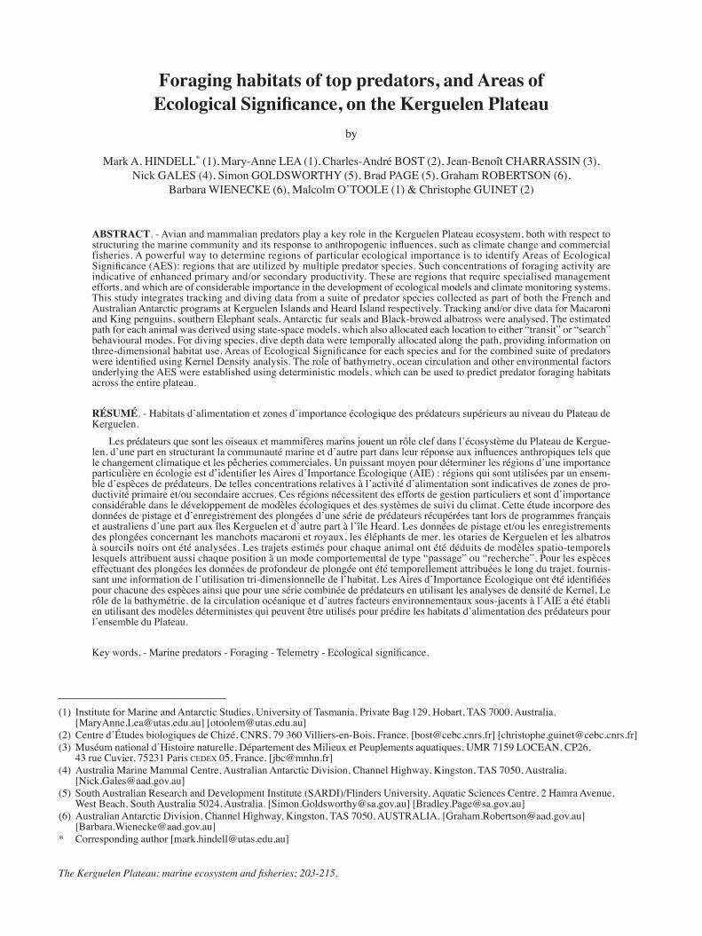
the east coast of Kerguelen Islands (Bailleul et al., 2007b; Charrassin et al., 2008). Nineteen of these were juvenile males (mass range 300-1 100 kg), and were part of a total of 47 seals in this age group that were tagged between 2002 and 2008. The other two seals were adult females. Only seals that spent part of their post-moult foraging trip over the Kerguelen plateau were included. The majority of the loca-tions were collected between January and May, although a small number of locations were also collected each month for remainder of the year (Fig. 1a).
The locations were widely dispersed over the Kerguelen Plateau. The Kernel density analysis indicated that high-est concentrations of locations occurred within the 1000 m bathymetric contour. There were also a number of regions of particularly high concentrations. These were all to the east and southeast of Kerguelen Islands, and many were associ-ated with the shelf break.
Black-browed albatrossesThese data were from ten individuals, all tagged at Heard
Island between December 2003 and February 2004 (Lawton et al., 2008). The majority of the locations were associated with the southern shelf break to the south and east of Heard Island (Fig. 1b). This is a region of complex bathymetry, including a number of canyons and ridges. There were sev-eral other locations of concentrations, associated with the shelf break to the north of Heard Island.
Hindell et al. Predator foraging areas
The Kerguelen Plateau: marine ecosystem and fisheries 207
Antarctic fur sealsWe included data from 151 seals, all adult females,
tagged at five sites (Tab. I), three at Kerguelen Islands and two at Heard Island (Guinet et al., 2001; Lea et al., 2006; Lea et al., 2008; Goldsworthy et al., 2010; Staniland et al., 2010). The deployments were all made between December and March corresponding to the breeding season for this spe-cies in eight years from 1998 to 2009. The individual tracks indicate that some individuals moved past the 1 000 m con-tour to forage over deep oceanic waters (Fig. 1c). However, the kernel density analyses showed that 90% of all locations were over the Kerguelen Plateau and shelf break. There was a general pattern of the seals spending time to the east of their breeding colonies, with areas of highest densities lying immediately to the north east of Kerguelen Islands and to the east and northeast of Heard Island. The Heard Island seals also used the shelf break to the south and east of the island, the same area as used by the Black-browed albatross. The few seals tracked from île de Croy, in the northwest of the Kerguelen group, were the exception, as they all moved westwards past the 1000 m bathymetric contour.
King penguinsData from 58 king penguins were incorporated in the
analyses, when all breeding birds were tagged in the sum-mer months (Tab. I). The majority of the instrumented birds were from Long Beach on the eastern side of Heard Island
(Wienecke and Robertson, 2006), but nine were also tagged at Ratmanov Beach on the eastern side of the Courbet Penin-sula at Kerguelen Islands (Charrassin et al., 2004). As with the Fur seals, although some individuals moved off the pla-teau to feed in oceanic waters, the bulk of the locations were within the 1 000 m contour, and to the east of the breed-ing colonies (Fig. 1d). The region of high use to the east of Heard Island was larger and more diffuse than for the Fur seals, and while the shelf break was used, the highest densi-ties of locations were directly east of the island.
Macaroni penguinsWe only used data from Heard Island in the analyses, and
these were breeding birds tagged at either Roger’s Head on the western side of the island in 2000, or at Capsize Beach in the southeast in 2003-2004 (Tab. I). Birds from both colo-nies moved to the east of the island with the majority of birds remaining over the 1000 m contour (Fig. 1e). There were however aggregations of locations beyond this, indicating that the oceanic waters are important to this species at some points in the breeding season. More than any of the other spe-cies in this study, Macaroni penguins, have pronounced vari-ation in their foraging trip durations throughout the breeding season. Early in the summer, when parents are taking turns to brood small chicks (the guard stage), foraging trips are short, often less than 24 hours, thereby constraining foraging to the region relatively close to shore (Deagle et al., 2007).
Figure 1. - Kernel density estimates for each of the four predators used in the study, based on the two hourly time step locations derived from state space models.
Predator foraging areas Hindell et al.
208 The Kerguelen Plateau: marine ecosystem and fisheries
This is reflected in the very high density of points close to the island (Fig. 1e). By January, the chicks have left the nest and
formed crèches, freeing both parents to forage simultaneously. During this crèche phase, the birds remained at sea for up to a week, and foraged much more widely, and this is when the more distant aggregations of locations are formed.
Areas of Ecological Significance
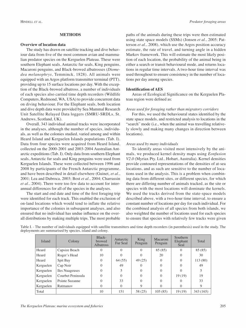
Multi-species “search” distributionWhen locations identified by the SSMs
as “transit” mode were removed from the data set, 40 986 locations remained as “search” mode. Once these were subset to provide equal weighting for each spe-cies, this was reduced to 26 965 search locations. The outer contour of the result-ing Kernel density analysis was almost entirely within the 1000 m bathymetric contour, and indicated foraging locations over most of the southern region of the plateau, from Kerguelen Islands south-wards. There were however a number of areas with particularly high densities of locations, the most important extending eastwards from both Kerguelen Islands and Heard Island. No foraging locations were recorded in the northern reaches of the plateau, but there were large aggre-gations of locations associated with the
southern edge of the plateau, and several smaller concentrations at other points on the shelf break and over the plateau itself (Fig. 2a).
Species RichnessThe pattern of species richness
departed from the pattern above to some degree, most notably the rela-tively low number of species (three species or less) in the immediate vicinity of Kerguelen Islands. This contrasted with the large number of 10 km2 cells with four or more species extending east from Heard Island (Fig. 2b). This was not sole-ly due to the fact that fewer species were tagged at Kerguelen Islands (three) compared to Heard Island (five). The region of greatest spe-cies richness was associated with
the continental slope to the south of Heard Island extending eastwards to Gunnari Ridge. Other regions of relatively high
Figure 2. a: Kernel density estimates for all the “search” locations identified by the state space models (all species combined and weighted). b: Species richness in each 10 km2 grid cell.
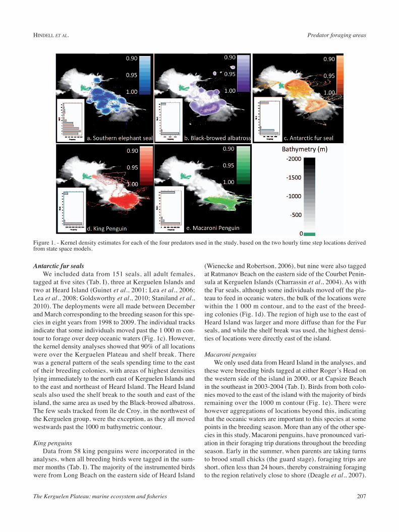
Figure 3. - Kernel density estimates of locations identified as being in an AES.

Hindell et al. Predator foraging areas
The Kerguelen Plateau: marine ecosystem and fisheries 209
species richness (cells used by at least four species) were all within the 1000 m contour, and in many cases associated with the steep shelf slope.
Areas of Ecological SignificanceThe AES were identified by selecting the grid cells with
species richness of three or more that also corresponded to high concentrations of locations identified as “search” mode (Kernel density quantiles of greater than 0.90). Fifty-one per-cent of the combined and weighted locations were considered as being AES, and these occurred in distinct aggregations. The highest concentration of AES locations was associated with the shelf slope south of Heard Island (Fig. 3). The next highest concentration was along the slope to east of Kergue-len Islands. Several other smaller concentrations were also associated with regions of high bathymetric gradients.
Relationship to environmental parametersLocations of AES were on average, closer to colonies,
over shallower water, closer to the 1000 m contour, in slightly cooler water, and associated with slightly higher sea surface height anomalies, than those locations out of AES (Tab. II). However, the distribution of the distance and depth variables were highly skewed and so were log-transformed before inclusion in the GLMs.
The best model describing whether a location was in an AES or not contained all five of the predictor terms (Tab. III), and explained 34.8% of the total model deviance. Based on the ΔAICs, this model performed considerably better than then next model, which included all terms except dist1000.
This indicates that each of the terms was having some influ-ence on whether a location was in an AES or not. Distance to the colony (dist0), and ocean depth (Ocean_depth), were the most influential terms when modelled alone, but addition of the other terms did increase the overall model fit.
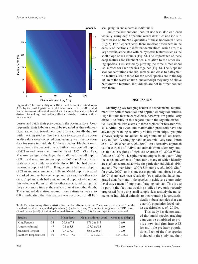
The output of the top model was visualised in three dimensions by estimating the likelihood of a location being in an AES based on mean values for SST, SSHa and dist1000m, the three terms with lowest individual model rankings, and a range of values for dist0m and Ocean_depth (Fig. 4). Under these conditions, the probability of being in an AES increased with diminishing distance to the colony, and increased with diminishing ocean depth.
Three dimensional habitat useWith the exception of Black-browed albatross, all of
the species included in this analysis are diving species that
Table II. - Mean (± sd) of model variables for locations defined as either in or out of areas of ecological significance (AES). Dist0m = distance to colony (km), Dist1000m = distance to the 1000m bathymetric contour (km), Ocean_Depth = depth of ocean floor under the grid cell (m), SST = Sea surface temperature (°C), SSHa = sea surface height anomaly (m).
Model variable In AES Out of AESDist0m 70.1 ± 64.7 198 ± 101.7Dist1000m 35.3 ± 26.1 50.5 ± 50.2Ocean_depth -469.8 ± 358.1 -1226.0 ± 890.5SST 3.24 ± 0.66 3.61 ± 1.10SSHa 6.88 ± 4.51 6.66 ± 4.11
Table III. - Results of logistic general linear models assessing the importance of environmental and behavioural parameters on the likelihood of being in an AES. Listed are the number of terms in the model, the Akaike’s Information Criterion (AIC), the delta AIC (ΔAIC) and the percent deviance explained by the model. Terms are as defined in table II.
Model terms -Log Likelihood AIC ΔAIC % devaes~sst+ssha+dist0m+dist1000m+Ocean_depth 7 -10341.8 20753.9 0 34.7aes~sst+ssha+dist0m+Ocean_depth 6 -10376.8 20813.8 59.9 34.5aes~sst+ssha+dist0m 5 -10532.1 21114.3 360.5 33.5aes~sst+ssha+dist0m+dist1000m 6 -10529.7 21119.6 365.7 33.5aes~sst+dist0m 4 -10605.8 21251.8 497.9 33.0aes~ssha+dist0m+Ocean_depth 5 -10873.3 21796.8 1042.9 31.3aes~dist0m+dist1000m+Ocean_depth 5 -10883.3 21816.9 1063.0 31.3aes~dist0m+Ocean_depth 4 -10909.8 21859.7 1105.8 31.0aes~ssha+dist0m 4 -10970.2 21980.5 1226.7 30.7aes~ssha+dist0m+dist1000m 5 -10966.6 21983.4 1229.6 30.7aes~dist0m 3 -11023.4 22077.0 1323.2 30.4aes~dist0m+dist1000m 4 -11021.6 22083.3 1329.4 30.4aes~sst 3 -15431.4 30893.0 10139.1 2.5aes~ssha 3 -15830.1 31690.4 10936.5 0.02aes~dist1000m 3 -15720.5 31471.1 10717.3 0.7aes~Ocean_depth 3 -13112.5 26255.0 5501.2 17.2aes~sst+ssha 4 -15420.8 30881.7 10127.9 2.6
Predator foraging areas Hindell et al.
210 The Kerguelen Plateau: marine ecosystem and fisheries
pursue and catch their prey beneath the ocean surface. Con-sequently, their habitats should be regarded as three-dimen-sional rather than two-dimensional as is traditionally the case with tracking studies. We were able to explore this notion as dive data were collected concurrently with the location data for some individuals. Of these species, Elephant seals were clearly the deepest divers, with a mean over all depths of 471 m and mean maximum depths of 1192 m (Tab. IV). Macaroni penguins displayed the shallowest overall depths of 9 m and mean maximum depths of 65.6 m. Antarctic fur seals recorded similar overall depths of 10 m but had deeper maximum depths of 127 m. King penguins had mean depths of 21 m and mean maxima of 198 m. Modal depths revealed a marked contrast between elephant seals and the other spe-cies. Elephant seals had a mean modal depth of 446 m, but this value was 0.0 m for all the other species, indicating that they spent more time at the surface than at any other depth. The standard deviation around these estimates was also 0.0 m indicating that this pattern was recorded for all Fur
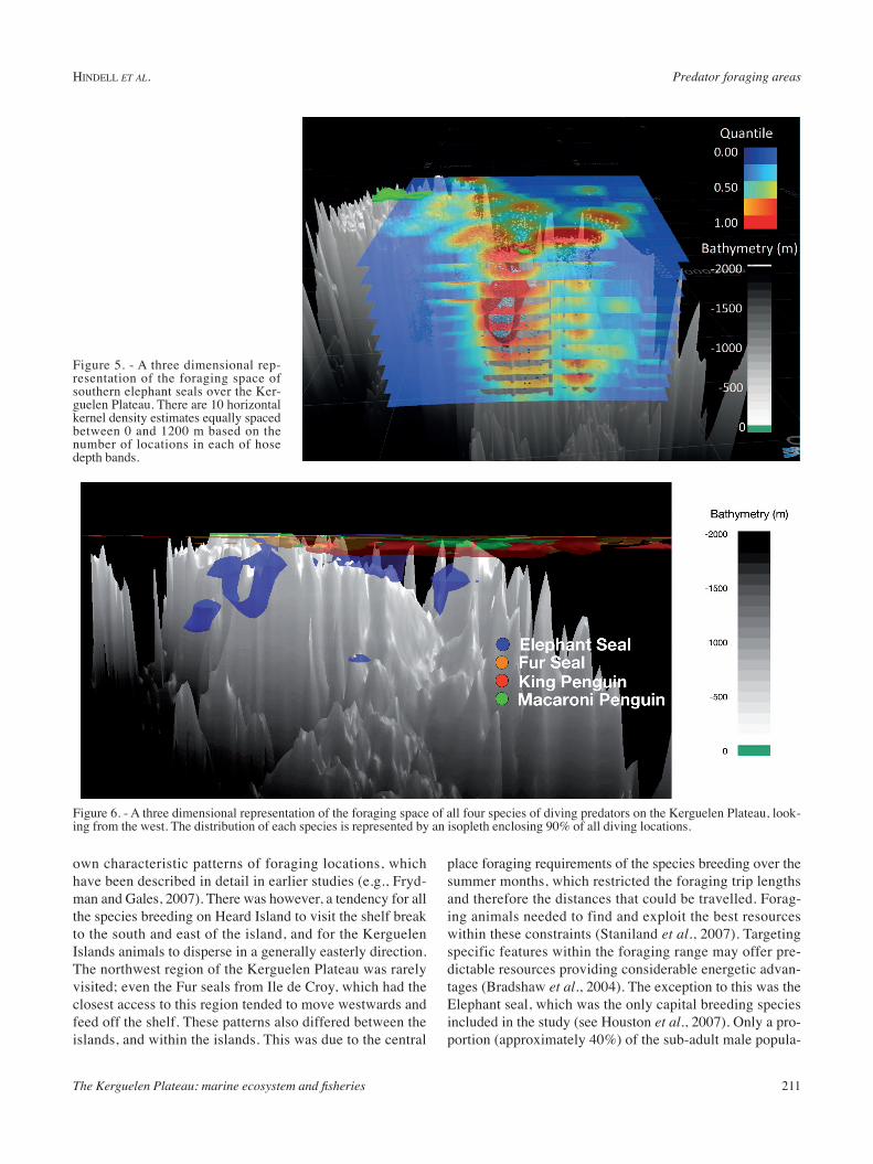
seal, penguin and albatross individuals.The three-dimensional habitat use was also explored
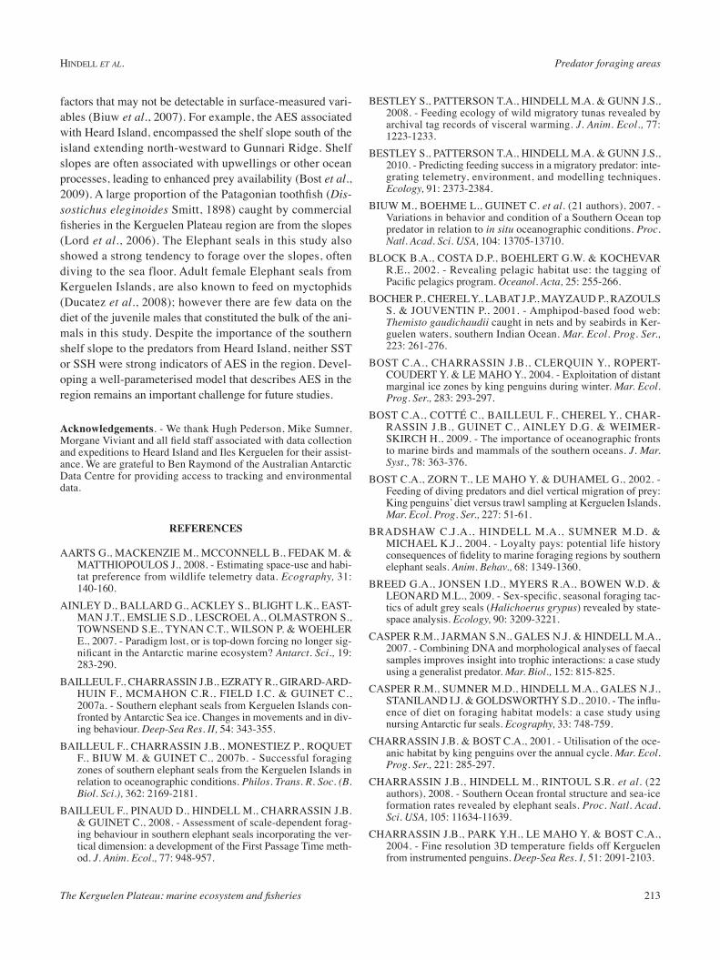
visually, using depth specific kernel densities and iso-sur-faces based on the 90% quantiles of these horizontal slices (Fig. 5). For Elephant seals, there are clear differences in the density of locations in different depth slices, which are, to a large extent, associated with bathymetric features such as the shelf slope or sea mounts (Fig. 5). The importance of these deep features for Elephant seals, relative to the other div-ing species is illustrated by plotting the three-dimensional iso-surface for each species together (Fig. 6). The Elephant seal concentrations are sub-surface and close to bathymet-ric features, while those for the other species are in the top 100 m of the water column, and although they may be above bathymetric features, individuals are not in direct contact with them.
discUssion
Identifying key foraging habitat is a fundamental require-ment for both theoretical and applied ecological studies. High latitude marine ecosystems, however, are particularly difficult to study in this regard due to the logistic difficul-ties associated with access to these regions for research ves-sels. Although avian and mammalian predators have the advantage of being relatively visible from ships, synoptic surveys designed to collect the large amounts of data neces-sary to identify foraging habitats are relatively rare (Peron et al., 2010; Woehler et al., 2010). An alternative approach is to use tracks of individual animals from telemetry stud-ies to locate regions of high use (Aarts et al., 2008; Wake-field et al., 2009). Despite recent emphasis on quantifying the at-sea movements of predators, many of which identify areas of concentrated activity for particular individuals (Pin-aud and Weimerskirch, 2007; Simmons et al., 2007; Shaf-fer et al., 2009), or in some cases populations (Breed et al., 2009), there have been relatively few studies that have inte-grated data from multiple species to achieve a community level assessment of important foraging habitats. This is due in part to the fact that tracking studies have only recently progressed from using small sample sizes to study the move-ments of individual animals, to incorporating larger, statis-
tically robust samples that can quantify population level habi-tat use (Morales et al., 2010).
This study has demonstrat-ed that multi-species tracking data can be combined to pro-vide new insights into AES for multiple predator popula-tions. Each of the five species included in the study had their
Figure 4. - The probability of a 10 km2 cell being identified as an AES by the final logistic general linear model. This is illustrated for the two most influential variables in the model (ocean depth and distance for colony), and holding all other variable constant at their mean values.
Table IV. - Summary dive statistics for the four diving species. These were calculated from the standardised dive data, with depth values (m) selected every 20 minutes throughout the TDR record. Grand means (± sd) of individual animal dive records (n = 175) for each species are presented.
Species n Mean depth Mean maximum depth Mean modal depthKing Penguin 34 20.8 ± 7.8 179.5 ± 143 0 ± 0Antarctic fur seal 47 9.8 ± 5.8 127.0 ± 56.8 0 ± 0Macaroni Penguin 74 9.4 ± 7.9 65.5 ± 38.5 0 ± 0Southern Elephant seal 19 471 ± 137.7 1191.9 ± 293.1 446 ± 223
Hindell et al. Predator foraging areas
The Kerguelen Plateau: marine ecosystem and fisheries 211
own characteristic patterns of foraging locations, which have been described in detail in earlier studies (e.g., Fryd-man and Gales, 2007). There was however, a tendency for all the species breeding on Heard Island to visit the shelf break to the south and east of the island, and for the Kerguelen Islands animals to disperse in a generally easterly direction. The northwest region of the Kerguelen Plateau was rarely visited; even the Fur seals from Ile de Croy, which had the closest access to this region tended to move westwards and feed off the shelf. These patterns also differed between the islands, and within the islands. This was due to the central
place foraging requirements of the species breeding over the summer months, which restricted the foraging trip lengths and therefore the distances that could be travelled. Forag-ing animals needed to find and exploit the best resources within these constraints (Staniland et al., 2007). Targeting specific features within the foraging range may offer pre-dictable resources providing considerable energetic advan-tages (Bradshaw et al., 2004). The exception to this was the Elephant seal, which was the only capital breeding species included in the study (see Houston et al., 2007). Only a pro-portion (approximately 40%) of the sub-adult male popula-
Figure 5. - A three dimensional rep-resentation of the foraging space of southern elephant seals over the Ker-guelen Plateau. There are 10 horizontal kernel density estimates equally spaced between 0 and 1200 m based on the number of locations in each of hose depth bands.
Figure 6. - A three dimensional representation of the foraging space of all four species of diving predators on the Kerguelen Plateau, look-ing from the west. The distribution of each species is represented by an isopleth enclosing 90% of all diving locations.

Predator foraging areas Hindell et al.
212 The Kerguelen Plateau: marine ecosystem and fisheries
tion remained over the Kerguelen Plateau, while the remain-der dispersed more widely throughout the Southern Ocean (Bailleul et al., 2007a; Bailleul et al., 2007b).
An important feature of our analysis was the combination of data from several years which incorporated inter-annual variability in foraging locations among the species. There is sufficient complexity in the bathymetry of the Kerguelen Plateau that oceanographic features, such as the extent of Polar Frontal Zone, differ in both their location and strength between years (Park et al., 2009; van Wijk et al., 2010; Park and Vivier, 2011), and this is reflected in shifts in the for-aging areas of predators such as Antarctic fur seals (Lea et al., 2008). Such variability affects areas of species richness and AES both within a season and between years, and high-lights the need to include multiple years of study for each species in order to ensure the AES include the full range of likely foraging areas. While this level of temporal coverage was available for Antarctic fur seals from Kerguelen Islands, for most of the species in our study, there was only a single year of data from each site. Expanding the temporal cover-age for these species is needed before AES can be properly described for the Kerguelen Plateau. Here, we have defined AES as those regions with high numbers of non-transit loca-tions that also displayed high levels of species richness. This definition has the advantage of removing the over-emphasis of locations associated with migratory paths, which inevita-bly cluster around colonies, at least for central place forag-ers. Animal movement models are increasingly being used to identify ‘foraging’ regions along a track, as the slow travel and high turning rates are assumed to be associated with searching for prey (Jonsen et al., 2005; Breed et al., 2009). Independent validations of this assumption have been few, for example, Thums et al. (2011), found that southern elephant seals tended to gain condition when inside search zones identified by first passage time analysis. This is not always the case however, as juvenile southern Blue fin tuna (Thunnus maccoyii Castlenau, 1872) actually fed less often in areas where they tended to spend the most time (Bestley et al., 2008; Bestley et al., 2010).
By incorporating species richness, we single out regions that are important to multiple predators. These areas will be particularly ecologically important as they must be regions with high diversity of prey species. The five species incorpo-rated in this study feed on a range of prey species, although there is undoubtedly an overlap in their diet; for example, all species but the albatrosses are known to feed on myctophid fish (Cherel et al., 2010). Despite this, each species occupies its own dietary niche, so aggregations of different predators, within the constraints imposed by breeding schedules and feeding of young, are likely to be associated with a partic-ularly diverse or predictable abundance of a range of prey species.
As this analysis is primarily a “proof of concept”, and only used a fraction of the available tracking data, we have not likely captured all the potential AES within the region surrounding Heard Island and Kerguelen Islands. However, the very fact that there are regions that were commonly used by at least three species is a significant step in our under-standing of the ecosystem of the region. The analyses reveal two principal AES, one to the east of Kerguelen Islands, lying within and parallel to the eastern 1000 m contour and its associated steep slope. The other was again associated with the 1000 m and steep slope, but to the south and east of Heard Island.
The general linear models indicated that all five habi-tat and environmental variables contributed to explaining whether a location was classified as an AES. However, the most influential of these individually were distance to the colony and ocean depth, reflecting the tendency of the ani-mals to remain over the shelf and forage close to the breed-ing colonies during the breeding season. This highlights the strong seasonal aspect to habitat use in these species, and it is likely that AES will be very different outside the breed-ing season, when adults are not regularly feeding their off-spring. Studies of winter foraging of these species have commenced in recent years and in each case foraging ranges extend well beyond the Kerguelen Plateau (Charrassin et al., 2008; Bost et al., 2009).
Nonetheless, the AES are not determined solely by the breeding biology of the predators; distribution and abun-dance of the prey are also likely to be influential. As with most studies of marine predators, direct measures of the prey field are impractical (Hindell, 2008), and so remotely sensed ocean parameters which are known to influence primary pro-ductivity, such as SST and SSH are used as an approxima-tion (Cotté et al., 2007; Simmons et al., 2007). While both of these variables were included in the final model, indicat-ing that they did have some influence on whether or not a cell was considered an AES, their importance was relatively minor. There are several likely reasons for this. Sea surface height and temperature may not have been the most appropri-ate variables, particularly as the animals were concentrating their foraging over the shelf and the shelf breaks, where local upwellings may not be characterised by these variables. Sea surface colour, a measure of Chlorophyll-a concentrations in the surface waters, may provide a better measure. However, extensive and persistent cloud cover in the region meant that these data were too sparse for use in our study. Further, there may be spatial and temporal mismatches between the physi-cal oceanographic properties of the ocean and the distribu-tion of the prey of predators (all of which are meso-predators of euphausiids, myctophids and squid).
Satellite products only provide data pertaining to the ocean surface, while prey are distributed throughout the water column, and this vertical distribution is determined by
Hindell et al. Predator foraging areas
The Kerguelen Plateau: marine ecosystem and fisheries 213
factors that may not be detectable in surface-measured vari-ables (Biuw et al., 2007). For example, the AES associated with Heard Island, encompassed the shelf slope south of the island extending north-westward to Gunnari Ridge. Shelf slopes are often associated with upwellings or other ocean processes, leading to enhanced prey availability (Bost et al., 2009). A large proportion of the Patagonian toothfish (Dis-sostichus eleginoides Smitt, 1898) caught by commercial fisheries in the Kerguelen Plateau region are from the slopes (Lord et al., 2006). The Elephant seals in this study also showed a strong tendency to forage over the slopes, often diving to the sea floor. Adult female Elephant seals from Kerguelen Islands, are also known to feed on myctophids (Ducatez et al., 2008); however there are few data on the diet of the juvenile males that constituted the bulk of the ani-mals in this study. Despite the importance of the southern shelf slope to the predators from Heard Island, neither SST or SSH were strong indicators of AES in the region. Devel-oping a well-parameterised model that describes AES in the region remains an important challenge for future studies.
Acknowledgements. - We thank Hugh Pederson, Mike Sumner, Morgane Viviant and all field staff associated with data collection and expeditions to Heard Island and Iles Kerguelen for their assist-ance. We are grateful to Ben Raymond of the Australian Antarctic Data Centre for providing access to tracking and environmental data.
reFerences
AARTS G., MACKENZIE M., MCCONNELL B., FEDAK M. & MATTHIOPOULOS J., 2008. - Estimating space-use and habi-tat preference from wildlife telemetry data. Ecography, 31: 140-160.
AINLEy D., BALLARD G., ACKLEy S., BLIGHT L.K., EAST-MAN J.T., EMSLIE S.D., LESCROEL A., OLMASTRON S., TOWNSEND S.E., TyNAN C.T., WILSON P. & WOEHLER E., 2007. - Paradigm lost, or is top-down forcing no longer sig-nificant in the Antarctic marine ecosystem? Antarct. Sci., 19: 283-290.
BAILLEUL F., CHARRASSIN J.B., EZRATy R., GIRARD-ARD-HUIN F., MCMAHON C.R., FIELD I.C. & GUINET C., 2007a. - Southern elephant seals from Kerguelen Islands con-fronted by Antarctic Sea ice. Changes in movements and in div-ing behaviour. Deep-Sea Res. II, 54: 343-355.
BAILLEUL F., CHARRASSIN J.B., MONESTIEZ P., ROQUET F., BIUW M. & GUINET C., 2007b. - Successful foraging zones of southern elephant seals from the Kerguelen Islands in relation to oceanographic conditions. Philos. Trans. R. Soc. (B. Biol. Sci.), 362: 2169-2181.
BAILLEUL F., PINAUD D., HINDELL M., CHARRASSIN J.B. & GUINET C., 2008. - Assessment of scale-dependent forag-ing behaviour in southern elephant seals incorporating the ver-tical dimension: a development of the First Passage Time meth-od. J. Anim. Ecol., 77: 948-957.
BESTLEy S., PATTERSON T.A., HINDELL M.A. & GUNN J.S., 2008. - Feeding ecology of wild migratory tunas revealed by archival tag records of visceral warming. J. Anim. Ecol., 77: 1223-1233.
BESTLEy S., PATTERSON T.A., HINDELL M.A. & GUNN J.S., 2010. - Predicting feeding success in a migratory predator: inte-grating telemetry, environment, and modelling techniques. Ecology, 91: 2373-2384.
BIUW M., BOEHME L., GUINET C. et al. (21 authors), 2007. - Variations in behavior and condition of a Southern Ocean top predator in relation to in situ oceanographic conditions. Proc. Natl. Acad. Sci. USA, 104: 13705-13710.
BLOCK B.A., COSTA D.P., BOEHLERT G.W. & KOCHEVAR R.E., 2002. - Revealing pelagic habitat use: the tagging of Pacific pelagics program. Oceanol. Acta, 25: 255-266.
BOCHER P., CHEREL y., LABAT J.P., MAyZAUD P., RAZOULS S. & JOUVENTIN P., 2001. - Amphipod-based food web: Themisto gaudichaudii caught in nets and by seabirds in Ker-guelen waters, southern Indian Ocean. Mar. Ecol. Prog. Ser., 223: 261-276.
BOST C.A., CHARRASSIN J.B., CLERQUIN y., ROPERT-COUDERT y. & LE MAHO y., 2004. - Exploitation of distant marginal ice zones by king penguins during winter. Mar. Ecol. Prog. Ser., 283: 293-297.
BOST C.A., COTTÉ C., BAILLEUL F., CHEREL y., CHAR-RASSIN J.B., GUINET C., AINLEy D.G. & WEIMER-SKIRCH H., 2009. - The importance of oceanographic fronts to marine birds and mammals of the southern oceans. J. Mar. Syst., 78: 363-376.
BOST C.A., ZORN T., LE MAHO y. & DUHAMEL G., 2002. - Feeding of diving predators and diel vertical migration of prey: King penguins’ diet versus trawl sampling at Kerguelen Islands. Mar. Ecol. Prog. Ser., 227: 51-61.
BRADSHAW C.J.A., HINDELL M.A., SUMNER M.D. & MICHAEL K.J., 2004. - Loyalty pays: potential life history consequences of fidelity to marine foraging regions by southern elephant seals. Anim. Behav., 68: 1349-1360.
BREED G.A., JONSEN I.D., MyERS R.A., BOWEN W.D. & LEONARD M.L., 2009. - Sex-specific, seasonal foraging tac-tics of adult grey seals (Halichoerus grypus) revealed by state-space analysis. Ecology, 90: 3209-3221.
CASPER R.M., JARMAN S.N., GALES N.J. & HINDELL M.A., 2007. - Combining DNA and morphological analyses of faecal samples improves insight into trophic interactions: a case study using a generalist predator. Mar. Biol., 152: 815-825.
CASPER R.M., SUMNER M.D., HINDELL M.A., GALES N.J., STANILAND I.J. & GOLDSWORTHY S.D., 2010. - The influ-ence of diet on foraging habitat models: a case study using nursing Antarctic fur seals. Ecography, 33: 748-759.
CHARRASSIN J.B. & BOST C.A., 2001. - Utilisation of the oce-anic habitat by king penguins over the annual cycle. Mar. Ecol. Prog. Ser., 221: 285-297.
CHARRASSIN J.B., HINDELL M., RINTOUL S.R. et al. (22 authors), 2008. - Southern Ocean frontal structure and sea-ice formation rates revealed by elephant seals. Proc. Natl. Acad. Sci. USA, 105: 11634-11639.
CHARRASSIN J.B., PARK y.H., LE MAHO y. & BOST C.A., 2004. - Fine resolution 3D temperature fields off Kerguelen from instrumented penguins. Deep-Sea Res. I, 51: 2091-2103.
Predator foraging areas Hindell et al.
214 The Kerguelen Plateau: marine ecosystem and fisheries
CHEREL y., FONTAINE C., RICHARD P. & LABAT J.P., 2010. - Isotopic niches and trophic levels of myctophid fishes and their predators in the Southern Ocean. Limnol. Oceanogr., 55: 324-332.
CONSTABLE A.J., DE LA MARE W.K., AGNEW D.J., EVER-SON I. & MILLER D., 2000. - Managing fisheries to conserve the Antarctic marine ecosystem: practical implementation of the Convention on the Conservation of Antarctic Marine Living Resources (CCAMLR). ICES J. Mar. Sci., 57: 778-791.
CONSTABLE A.J., NICOL S. & STRUTTON P.G., 2003. - South-ern Ocean productivity in relation to spatial and temporal varia-tion in the physical environment. J. Geophy. Res. C., 108(C4).
COTTÉ C., PARK y.H., GUINET C. & BOST C.A., 2007. - Move-ments of foraging king penguins through marine mesoscale eddies. Proc. R. Soc. B, 274: 2385-2391.
DEAGLE B.E., GALES N.J., EVANS K., JARMAN S.N., ROB-INSON S., TREBILCO R. & HINDELL M.A., 2007. - Study-ing seabird diet through genetic analysis of faeces: A case study on Macaroni Penguins (Eudyptes chrysolophus). PLoS ONE, 2: e831.
DUCATEZ S., DALLOyAU S., RICHARD P., GUINET C. & CHEREL y., 2008. - Stable isotopes document winter trophic ecology and maternal investment of adult female southern ele-phant seals (Mirounga leonina) breeding at the Kerguelen Islands. Mar. Biol., 155: 413-420.
FRYDMAN S. & GALES N., 2007. - HeardMap: tracking marine vertebrate populations in near real time. Deep-Sea Res. II, 54: 384-391.
GOLDSWORTHy S.D., PAGE B., WELLING A., CHAMBEL-LANT M. & BRADSHAW C.J.A., 2010. - Selection of diving strategy by Antarctic fur seals depends on where and when for-aging takes place. Mar. Ecol. Prog. Ser., 409: 255-273.
GREMILLET D., LEWIS S., DRAPEAU L., VAN DER LINGEN C.D., HUGGETT J.A., COETZEE J.C., VERHEyE H.M., DAUNT F., WANLESS S. & RyAN P.G., 2008. - Spatial match-mismatch in the Benguela upwelling zone: should we expect chlorophyll and sea-surface temperature to predict marine predator distributions? J. Appl. Ecol., 45: 610-621.
GUINET C., DUBROCA L., LEA M.A., GOLDSWORTHy S., CHEREL y., DUHAMEL G., BONADONNA F. & DONNAy J.P., 2001. - Spatial distribution of foraging in female Antarctic fur seals Arctocephalus gazella in relation to oceanographic variables: a scale-dependent approach using geographic infor-mation systems. Mar. Ecol. Prog. Ser., 219: 251-264.
HILL S.L., MURPHy E.J., REID K., TRATHAN P.N. & CON-STABLE A.J., 2006. - Modelling Southern Ocean ecosystems: krill, the food-web, and the impacts of harvesting. Biol. Rev., 81: 581-608.
HINDELL M., 2008. - To breathe or not to breathe: optimal strate-gies for finding prey in a dark, three-dimensional environment. J. Anim. Ecol., 77: 847-849.
HINDELL M.A., SLIP D.J. & BURTON H.R., 1991. - The diving behavior of adult male and female southern elephant seals, Mir-ounga leonina (Pinnipedia, Phocidae). Aust. J. Zool., 39: 595-619.
HOFMANN E.E., WIEBE P.H., COSTA D.P. & TORRES J.J., 2008. - Introduction to dynamics of plankton, krill, and preda-tors in relation to environmental features of the western Antarc-tic Peninsula and related areas: SO GLOBEC Part II. Deep-Sea Res. II, 55: 269-270.
HOUSTON A.I., STEPHENS P.A., BOyD I.L., HARDING K.C. & MCNAMARA J.M., 2007. - Capital or income breeding? A theoretical model of female reproductive strategies. Behav. Ecol., 18: 241-250.
JONSEN I.D., FLENMING J.M. & MyERS R.A., 2005. - Robust state-space modeling of animal movement data. Ecology, 86: 2874-2880.
LAIDRE K.L., STIRLING I., LOWRy L.F., WIIG O., HEIDE-JORGENSEN M.P. & FERGUSON S.H., 2008. - Quantifying the sensitivity of arctic marine mammals to climate-induced habitat change. Ecol. Appl., 18: S97-S125.
LAVERy T.J., ROUDNEW B., GILL P., SEyMOUR J., SEU-RONT L., JOHNSON G., MITCHELL J.G. & SMETACEK V., 2010. - Iron defecation by sperm whales stimulates carbon export in the Southern Ocean. Proc. R. Soc. B, 277: 3527-3531.
LAWTON K., KIRKWOOD R., ROBERTSON G. & RAyMOND B., 2008. - Preferred foraging areas of Heard Island albatrosses during chick raising and implications for the management of incidental mortality in fisheries. Aquat. Cons.: Mar. Freshw. Ecosyst., 18: 309-320.
LEA M.A. & DUBROCA L., 2003. - Fine-scale linkages between the diving behaviour of Antarctic fur seals and oceanographic features in the southern Indian Ocean. ICES J. Mar. Sci., 60: 990-1002.
LEA M.A., GUINET C., CHEREL y., DUHAMEL G., DUBROCA L., PRUVOST P. & HINDELL M., 2006. - Impacts of climatic anomalies on provisioning strategies of a Southern Ocean pred-ator. Mar. Ecol. Prog. Ser., 310: 77-94.
LEA M.A., GUINET C., CHEREL y., HINDELL M., DUBROCA L. & THALMANN S., 2008. - Colony-based foraging segrega-tion by Antarctic fur seals at the Kerguelen Archipelago. Mar. Ecol. Prog. Ser., 358: 273-287.
LORD C., DUHAMEL G. & PRUVOST P., 2006. - The patagonian toothfish (Dissostichus eleginoides) fishery in the Kerguelen Islands (Indian Ocean sector of the Southern Ocean). CCAMLR Sci., 13: 1-25.
MONGIN M.M., ABRAHAM E.R. & TRULL T.W., 2009. - Winter advection of iron can explain the summer phytoplankton bloom that extends 1000 km downstream of the Kerguelen Plateau in the Southern Ocean. J. Mar. Res., 67: 225-237.
MORALES J.M., MOORCROFT P.R., MATTHIOPOULOS J., FRAIR J.L., KIE J.G., POWELL R.A., MERRILL E.H. & HAyDON D.T., 2010. - Building the bridge between animal movement and population dynamics. Philos. Trans. R. Soc. (B Biol. Sci.), 365: 2289-2301.
NICOL S. & ROBERTSON G., 2003. - Ecological consequences of Southern Ocean harvesting. In: Marine Mammals: Fisheries, Tourism and Management Issues (Gales N.J. et al., eds), pp. 48-61. Collingwood: CSIRO.
PARK y.H., FUDA J.L., DURAND I. & GARABATO A.C.N., 2008a. - Internal tides and vertical mixing over the Kerguelen Plateau. Deep-Sea Res. II, 55: 582-593.
PARK y.H., ROQUET F., DURAND I. & FUDA J.L., 2008b. - Large-scale circulation over and around the Northern Kergue-len Plateau. Deep-Sea Res. II, 55: 566-581.
PARK y.H. & VIVIER F., 2011. - Circulation and hydrography over the Kerguelen Plateau. In: First symposium on The Ker-guelen Plateau: Marine Ecosystem and Fisheries (Duhamel G. & Welsford D., eds), pp. 43-55. Paris: SFI.
PARK y.H., VIVIER F., ROQUET F. & KESTENARE E., 2009. - Direct observations of the ACC transport across the Kerguelen Plateau. Geophys. Res. Lett., 36(18): L18603.
Hindell et al. Predator foraging areas
The Kerguelen Plateau: marine ecosystem and fisheries 215
PATTERSON T.A., THOMAS L., WILCOX C. & OVASKAINEN O., 2008. - State-space models of individual animals move-ment. Trends Ecol. Evol., 23(2): 87-94.
PERON C., AUTHIER M., BARBRAUD C., DELORD K., BES-SON D. & WEIMERSKIRCH H., 2010. - Interdecadal changes in at-sea distribution and abundance of subantarctic seabirds along a latitudinal gradient in the Southern Indian Ocean. Glo-bal Change Biol., 16: 1895-1909.
PINAUD D. & WEIMERSKIRCH H., 2007. - At-sea distribution and scale-dependent foraging behaviour of petrels and alba-trosses: a comparative study. J. Anim. Ecol., 76: 9-19.
SHAFFER S.A., WEIMERSKIRCH H., SCOTT D. et al. (11 authors), 2009. - Spatiotemporal habitat use by breeding sooty shearwaters Puffinus griseus. Mar. Ecol. Prog. Ser., 391: 209-220.
SIMMONS S.E., CROCKER D.E., KUDELA R.M. & COSTA D.P., 2007. - Linking foraging behaviour of the northern ele-phant seal with oceanography and bathymetry at mesoscales. Mar. Ecol. Prog. Ser., 346: 265-275.
STANILAND I.J., BOyD I.L. & REID K., 2007. - An energy-dis-tance trade-off in a central-place forager, the Antarctic fur seal (Arctocephalus gazella). Mar. Biol., 152: 233-241.
STANILAND I.J., GALES N., WARREN N.L., ROBINSON S.L., GOLDSWORTHy S.D. & CASPER R.M., 2010. - Geographi-cal variation in the behaviour of a central place forager: Antarc-tic fur seals foraging in contrasting environments. Mar. Biol., 157: 2383-2396.
THUMS M., BRADSHAW C.J.A. & HINDELL M.A, 2011. - In-situ measures of foraging success and prey encounter reveal marine habitat-dependant search strategies. Ecology, doi:10.1890/09-1299.1 (in press).
VAN WIJK E.M., RINTOUL S.R., RONAI B.M. & WILLIAMS G.D., 2010. - Regional circulation around Heard and McDon-ald Islands and through the Fawn Trough, central Kerguelen Plateau. Deep-Sea Res. I, 57: 653-669.
WAKEFIELD E.D., PHILLIPS R.A. & MATTHIOPOULOS J., 2009. - Quantifying habitat use and preferences of pelagic sea-birds using individual movement data: a review. Mar. Ecol. Prog. Ser., 391: 165-182.
WEIMERSKIRCH H., INCHAUSTI P., GUINET C. & BAR-BRAUD C., 2003. - Trends in bird and seal populations as indi-cators of a system shift in the Southern Ocean. Antarct. Sci., 15: 249-256.
WIENECKE B. & ROBERTSON G., 2006. - Comparison of forag-ing strategies of incubating king penguins Aptenodytes pat-agonicus from Macquarie and Heard islands. Polar Biol., 29: 424-438.
WOEHLER E.J., RAyMOND B., BOyLE A. & STAFFORD A., 2010. - Seabird assemblages observed during the BROKE-West survey of the Antarctic coastline (30 degrees E-80 degrees E), January-March 2006. Deep-Sea Res. II, 57: 982-991.