forces shaping earth - wordpress.com
TRANSCRIPT

286
Forces ShapingEarth
Young or Old Mountains?These majestic, snow-capped mountains are in their infancy. Itwould take a few hundred million years of erosion for their sharp,jagged peaks to become smooth. In this chapter, you’ll learn howthe movement of plates formed these mountains and about otherEarth forces that shape mountains.
Use descriptive adjectives to describe these mountains in a shortparagraph. Science Journal
Many of Earth’s surface features result from forcesfrom within Earth.
SECTION 1Earth’s Moving PlatesMain Idea Forces withinEarth cause movement of Earth’s plates.
SECTION 2Uplift of Earth’s CrustMain Idea There are four main types of moun-tains—fault-block, folded,upwarped, and volcanic.
Steve Razzetti/FPG/Getty Images

287287
Earth’s Interior and SurfaceMake the following cause andeffect Foldable to help you
understand the relationship between Earth’sinterior and surface.
Collect 2 sheets ofpaper and layer themabout 2.5 cm apartvertically. Keep theedges level.
Fold up the bottomedges of the paper toform 4 equal tabs.
Fold the papers andcrease well to hold thetabs in place. Staplealong the fold. Labeleach tab as shown.
Cause and Effect As you read the chapter,record information about each layer and how itis related to the layer above it under the tabs.
STEP 3
STEP 2
STEP 1
Model Earth’s InteriorGeologists know many things about theinterior of Earth even though its center isover 6,000 km deep. Use modeling clay tomake a model of Earth’s interior.
1. Obtain four pieces of different-coloredclay.
2. Roll one piece of clay into a ball. This clayrepresents the inner core.
3. Wrap another piece of clay around thefirst ball of clay, making an even biggerball. This clay represents the outer core.
4. Repeat step 3 with the third piece ofclay, which represents Earth’s mantle.Wrap your model with a thin layer ofthe fourth piece of clay to representthe crust.
5. Use a plastic knife to cut the ball of clayin half.
6. Think Critically Make a sketch of yourmodel and label each of Earth’s layers.
Preview this chapter’s contentand activities at red.msscience.com
CrustMantle
Outer CoreInner Core
Start-Up Activities
Steve Razzetti/FPG/Getty Images
288 A CHAPTER 10 Forces Shaping Earth
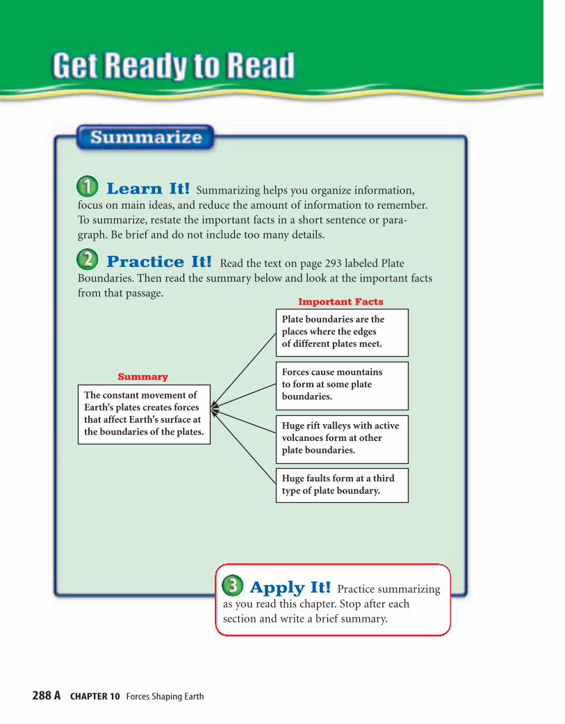
Apply It! Practice summarizingas you read this chapter. Stop after each section and write a brief summary.
Learn It! Summarizing helps you organize information,focus on main ideas, and reduce the amount of information to remember.To summarize, restate the important facts in a short sentence or para-graph. Be brief and do not include too many details.
Practice It! Read the text on page 293 labeled PlateBoundaries. Then read the summary below and look at the important factsfrom that passage.
The constant movement ofEarth’s plates creates forcesthat affect Earth’s surface atthe boundaries of the plates.
Plate boundaries are theplaces where the edges of different plates meet.
Forces cause mountains to form at some plateboundaries.
Huge rift valleys with activevolcanoes form at otherplate boundaries.
Huge faults form at a thirdtype of plate boundary.
Summary
Important Facts
SECTION 1 Earth’s Moving Plates 288 B
Before You Read Statement After You ReadA or D A or D
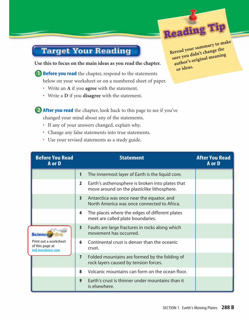
1 The innermost layer of Earth is the liquid core.
2 Earth’s asthenosphere is broken into plates thatmove around on the plasticlike lithosphere.
3 Antarctica was once near the equator, andNorth America was once connected to Africa.
4 The places where the edges of different platesmeet are called plate boundaries.
5 Faults are large fractures in rocks along whichmovement has occurred.
6 Continental crust is denser than the oceaniccrust.
7 Folded mountains are formed by the folding ofrock layers caused by tension forces.
8 Volcanic mountains can form on the ocean floor.
9 Earth’s crust is thinner under mountains than itis elsewhere.
Print out a worksheetof this page at red.msscience.com
Reread your summary to make
sure you didn’t change the
author’s original meaning
or ideas.Use this to focus on the main ideas as you read the chapter.
Before you read the chapter, respond to the statements
below on your worksheet or on a numbered sheet of paper.
• Write an A if you agree with the statement.
• Write a D if you disagree with the statement.
After you read the chapter, look back to this page to see if you’ve
changed your mind about any of the statements.
• If any of your answers changed, explain why.
• Change any false statements into true statements.
• Use your revised statements as a study guide.

Clues to Earth’s Interior If someone gives you a wrapped present, how could you fig-
ure out what was in it? You might hold it, shake it gently, orweigh it. You’d look for clues that could help you identify thecontents of the box. Even though you can’t see what’s inside thepackage, these types of clues can help you figure out what itmight be. Because you can’t see what’s inside, the observationsyou make are known as indirect observations.
Geologists do the same thing when they try to learn aboutEarth’s interior. Although the best way to find out what’sinside Earth might be to dig a tunnel to its center, that isn’tpossible. The deepest mines in the world only scratch Earth’ssurface. A tunnel would need to be more than 6,000 km deepto reach the center, so geologists must use indirect observa-tions to gather clues about what Earth’s interior is made ofand how it is structured. This indirect evidence includesinformation learned by studying earthquakes and rocks thatare exposed at Earth’s surface.
Waves When you throw a rock into acalm puddle or pond, you observe waves
like those shown in Figure 1. Waves are disturbances thatcarry energy through matter or space. When a rock hits water,waves carry some of the rock’s kinetic energy, or energy ofmotion, away from where it hit the water. When an earth-quake occurs, as shown in Figure 2, energy is carried throughobjects by waves. The speed of these waves depends on the
density and nature of the material theyare traveling through. For example, awave travels faster in solid rock than itdoes in a liquid. By studying the speedof these waves and the paths they take,geologists uncover clues as to how theplanet is put together. In fact, thesewaves, called seismic waves, speed upin some areas, slow down in otherareas, and can be bent or stopped.
■ Describe how Earth’s interior isdivided into layers.
■ Explain how plates of Earth’slithosphere move.
■ Discuss why Earth’s plates move.
Forces that cause Earth’s plates tomove apart, together, or past eachother cause events that shape Earth’ssurface, such as mountain building,volcanoes, and earthquakes.
Review Vocabularymagma: melted rock materialfound beneath Earth’s surface
New Vocabulary
• inner core • lithosphere
• outer core • plate
• mantle • fault
• crust • subduction
Earth’s Moving Plates
288
Figure 1 Waves carry energyacross water just like seismicwaves carry energy through Earth.
Aar
on H
orow
itz/C
OR
BIS

SECTION 1 Earth’s Moving Plates 289
Rock Clues Another clue to what’s inside Earth comes in theform of certain rocks found in different places on Earth’s sur-face. These rocks are made of material similar to what is thoughtto exist deep inside Earth. The rocks formed far below the sur-face. Forces inside Earth pushed them closer to the surface,where they eventually were exposed by erosion. The seismicclues and the rock clues suggest that Earth is made up of layersof different kinds of materials.
Earth’s Layers Based on evidence from earthquake waves and exposed
rocks, scientists have produced a model of Earth’s interior. Themodel shows that Earth’s interior has at least four distinct layers—the inner core, the outer core, the mantle, and the crust.Earth’s structure is similar in some ways to the structure of apeach, shown in Figure 3. A peach has a thin skin covering thethick, juicy part that you eat. Under that is a large pit that sur-rounds a seed.
Inner Core The pit and seed are similar to Earth’s core. Earth’score is divided into two distinct parts—one that is liquid andone that is solid. The innermost layer of Earth’s interior is thesolid inner core. This part of the core is dense and composedmostly of solid iron. When seismic waves produced by earth-quakes reach this layer they speed up, indicating that the innercore is solid.
Conditions in the inner core are extreme compared to thoseat the surface. At about 5,000°C, the inner core is the hottest partof Earth. Also, because of the weight of the surrounding rock,the core is under tremendous pressure. Pressure, or the forcepushing on an area, increases the deeper you go beneath Earth’ssurface. Pressure increases because more material is pushingtoward Earth’s center as a result of gravity. The inner core, at thecenter of Earth, experiences the greatest amount of pressure.
Figure 2 As seismic wavestravel across Earth’s surface, theground shakes and damage occurs.
Figure 3 The structure of Earthcan be compared to a peach. Explain If the part of Earth thatyou live on is like the skin of thepeach, what does that tell youabout this layer of Earth?
(t)Barry Sweet/AP/Wide World Photos, (b)Mark Burnett
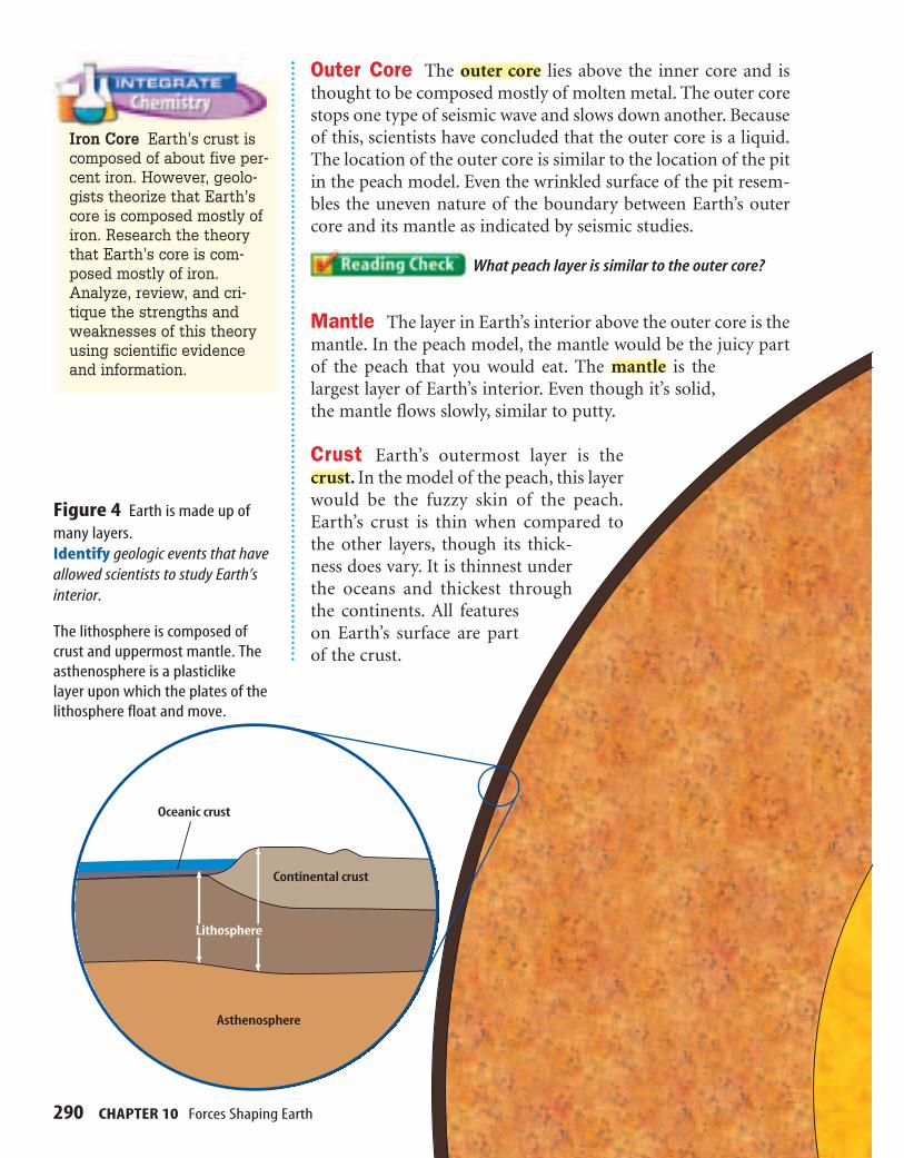
Outer Core The outer core lies above the inner core and isthought to be composed mostly of molten metal. The outer corestops one type of seismic wave and slows down another. Becauseof this, scientists have concluded that the outer core is a liquid.The location of the outer core is similar to the location of the pitin the peach model. Even the wrinkled surface of the pit resem-bles the uneven nature of the boundary between Earth’s outercore and its mantle as indicated by seismic studies.
What peach layer is similar to the outer core?
Mantle The layer in Earth’s interior above the outer core is themantle. In the peach model, the mantle would be the juicy partof the peach that you would eat. The mantle is thelargest layer of Earth’s interior. Even though it’s solid,the mantle flows slowly, similar to putty.
Crust Earth’s outermost layer is thecrust. In the model of the peach, this layerwould be the fuzzy skin of the peach.Earth’s crust is thin when compared tothe other layers, though its thick-ness does vary. It is thinnest underthe oceans and thickest throughthe continents. All featureson Earth’s surface are partof the crust.
290 CHAPTER 10 Forces Shaping Earth
Figure 4 Earth is made up ofmany layers. Identify geologic events that haveallowed scientists to study Earth’sinterior.
The lithosphere is composed ofcrust and uppermost mantle. Theasthenosphere is a plasticlikelayer upon which the plates of thelithosphere float and move.
Continental crust
Oceanic crust
Asthenosphere
Lithosphere
Iron Core Earth’s crust iscomposed of about five per-cent iron. However, geolo-gists theorize that Earth’score is composed mostly ofiron. Research the theorythat Earth’s core is com-posed mostly of iron.Analyze, review, and cri-tique the strengths andweaknesses of this theoryusing scientific evidenceand information.

Earth’s StructureAlthough Earth’s structure can be divided into four basic layers,
it also can be divided into other layers based on physical propertiesthat change with depth beneath the surface. Figure 4 shows thestructure of Earth and describes some of the properties of its layers.Density, temperature, and pressure are properties that are lowest inthe crust and greatest in the inner core.
Inner core
Crust
Outer core
Mantle
Incr
easi
ngte
mpe
ratu
reTemperature v. Depth
Increasing depth
Outer core30%
Inner core2.5%
Crust0.5%
Mantle67%
Distribution of Earth's Mass
Increasing depth
Incr
easi
ngpr
essu
re
Pressure v. Depth
291

Earth’s Plates Although the crust is separated from the mantle, the upper-
most, rigid layer of the mantle moves as if it were part of Earth’scrust. The rigid, upper part of Earth’s mantle and the crust iscalled the lithosphere. It is broken into about 30 sections orplates that move around on the plasticlike asthenosphere, whichalso is part of the mantle. Earth’s major plates vary greatly in sizeand shape, as shown in Figure 5.
What parts of Earth make up the lithosphere?
The movements of the plates are fairly slow, often takingmore than a year to creep a few centimeters. This means thatthey have not always looked the way they do in Figure 5. Theplates have not always been their current size and shape, andcontinents have moved great distances. Antarctica, which nowcovers the south pole, was once near the equator, and NorthAmerica was once connected to Africa and Europe.
Lasers and satellites are used to measure the small platemovements, which can add up to great distances over time. If aplate is found to move at 2 centimeters per year on average, howfar will it move in 1,000 years? What about in 10 million years?
292 CHAPTER 10 Forces Shaping Earth
PACIFICPLATE
NORTH AMERICANPLATE
SOUTH AMERICANPLATE
AFRICAN PLATE
EURASIAN PLATE
PACIFICPLATE
AUSTRALIAN–INDIANPLATE
ANTARCTICPLATE
PHILIPPINEPLATE
NORTHAMERICAN
PLATE
COCOSPLATE
SCOTIA PLATE
ARABIANPLATE
NAZCAPLATE
CARIBBEANPLATE
JUAN DE FUCAPLATE
Figure 5 Earth’s platesfit together like the piecesof a jigsaw puzzle.Draw Conclusions If theplates are moving, what doyou suppose happens atthe plate boundaries?

Plate Boundaries The places where the edges of different plates meet are called
plate boundaries. The constant movement of plates createsforces that affect Earth’s surface at the boundaries of the plates.At some boundaries, these forces are large enough to causemountains to form. Other boundaries form huge rift valleyswith active volcanoes. At a third type of boundary, huge faultsform. Faults are large fractures in rocks along which movementoccurs. The movement can cause earthquakes. Figure 6 showsthe different plate motions.
Plates That Move Apart Plates move apart as a result ofpulling forces that act in opposite directions on each plate. Thispulling force is called tension. Figure 7 shows what happens astension continues to pull two plates apart.
One important result of plates separating is the formation ofnew crust. New crust forms in gaps where the plates pull apart.As tension continues along these boundaries, new gaps formand are filled in by magma that is pushed up from the mantle.Over time, the magma in the gaps cools to become new crust.This process of plate separation and crust formation takes placeunder the oceans at places called mid-ocean ridges. As new crustmoves away from the mid-ocean ridges, it cools and becomesdenser.
PACIFICPLATE
COCOSPLATE
CARIBBEAN PLATE
NAZCAPLATE
SOUTHAMERICAN
PLATE
AFRICANPLATE
EURASIANPLATE
NORTHAMERICAN
PLATE
Figure 6 Earth’s plates can col-lide, move away from each other,or slide past each other.
Separating Plates When plates move apart, new crust forms to fill in the gap between the plates. This new crust is less dense than the surrounding cooler crust, which often causes a high ridge to form.
Sliding Plates When plates slide along each other, earthquakes commonly occur. Earthquakes are the result of energy that builds up at these boundaries and then is released suddenly.
Colliding Plates When plates collide, the tremendous force causes mountains like the Andes in South America to form.
293
Topic: Plate BoundariesVisit for Weblinks to information about Earth’splates and the different boundariesthat they form.
Activity Create a table of theinformation on plates and plateboundaries. Try to include specificplates and boundary locations.Share your findings with yourclassmates.
red.msscience.com

Figure 7
VISUALIZING RIFT VALLEYS
294 CHAPTER 10 Forces Shaping Earth
When two continentalplates pull apart, riftvalleys may form. If
spreading continues and thegrowing rift reaches a coast-line, seawater floods in.Beneath the waves, moltenrock, or magma, oozes fromthe weakened and fracturedvalley floor. In time, the gapbetween the two continentalslabs may widen into a full-fledged ocean. The four stepsassociated with this processare shown here. Africa’s GreatRift Valley, which cuts acrossthe eastern side of Africa for5,600 km (right), representsthe second of these foursteps. If rifting processes con-tinue in the Great Rift Valley,East Africa eventually willpart from the mainland.
Rising magma forces the crustupward, causing numerouscracks in the rigid crust.
Eventually, an expansive ocean basin and ridgesystem are created.
RedSea
Lake Malawi
Lake Victoria
KilimanjaroLakeTanganyika
IndianOcean
Riftvalleys
Lithosphere
Continental crust
Magma
Upwarping
As the crust is pulled apart, large slabsof rock sink, generating a rift zone.
Rift zone
Further spreading generates a narrow seaor lake.
Ocean water
A
B
C
D
VISUALIZING RIFT VALLEYS
(bkgd)National Geographic Maps

Plates That Collide When plates move toward each other,they collide, causing several different things to occur. As you cansee in Figure 8, the outcome depends on the density of the twoplates involved. The crust that forms the ocean floors, calledoceanic crust, is more dense than the continental crust, whichforms continents.
If two continental plates collide, they have a similar densitywhich is less than the mantle underneath. Therefore, the collisioncauses the crust to pile up. When rock converges like this, theforce is called compression. Compression causes the rock layerson both plates to crumple and fold. Imagine laying a piece of fab-ric flat on your desk. If you push the edges of the cloth towardeach other, the fabric will crumple and fold over on itself. A sim-ilar process occurs when plates crash into each other, causingmountains to form.
Flat rock layers are pushed up into folds. Sometimes thefolding is so severe that rock layers bend completely over onthemselves, turning upside down. As rock layers are folded andfaulted, they pile up and form mountains. The tallest mountainsin the world, the Himalaya in Asia, are still rising as two conti-nental plates collide.
Plate Subduction When an oceanic plate collides withanother oceanic plate or a continental plate, the more dense oneplunges underneath the other, forming a deep trench. When oneplate sinks underneath another plate, it’s called subduction.When a plate subducts, it sinks into the mantle. In this way,Earth’s crust does not continue to grow larger. As new crustmaterial is generated at a rift, older crustal material subductsinto the mantle.
Figure 8 There are three typesof convergent plate boundaries.
Oceanic-oceanic collisions The collision of two oceanic plates causes subductionof the denser plate, which forms a deep ocean trench where the plates meet. Erupting lava forms islands near the trench.
Continental-continental collisions Two continental plates have similar densities, which are less than underlying mantle rock. As a result, they buckle and fold when they collide, piling up into high mountain ranges, such as the Himalaya.
Continental-oceanic collisions When a continental plate collides with an oceanic plate, the more dense oceanic plate slides underneath the continental plate, forming volcanoes.
Modeling Tensionand CompressionProcedure1. Obtain two bars of taffy.2. Hold one bar of taffy
between your hands andpush your hands together.
3. Record your observationsin your Science Journal.
4. Hold the other bar of taffybetween your hands andpull gently on both ends.
5. Record your observationsin your Science Journal.
Analysis1. On which bar of taffy did
you apply tension?Compression?
2. Explain how this appliesto plateboundaries.

Plates That Slide Past In addition to moving toward andaway from one another, plates also can slide past one another.For example, one plate might be moving north while the platenext to it is moving south. The boundary where these platesmeet is called a transform boundary. When a force pushessomething in two different directions, it’s called shearing.Shearing causes the area between the plates to form faults andexperience many earthquakes. Figure 9 shows part of the SanAndreas Fault near Taft, California, which is an example of thefeatures that form along a transform boundary.
Why do plates move? As you can see, Earth’s plates are large. To move something
so massive requires a tremendous amount of energy. Wheredoes the energy that drives plate movement come from? Thereason plates move is complex, and geologists still are trying tounderstand it fully. So far, scientists have come up with severalpossible explanations about what is happening inside Earth tocause plate movement. Most of these theories suggest that grav-ity is the driving force behind it. However, gravity pulls thingstoward the center of Earth, and plates move sideways across theglobe. How does gravity make something move across the sur-face of Earth?
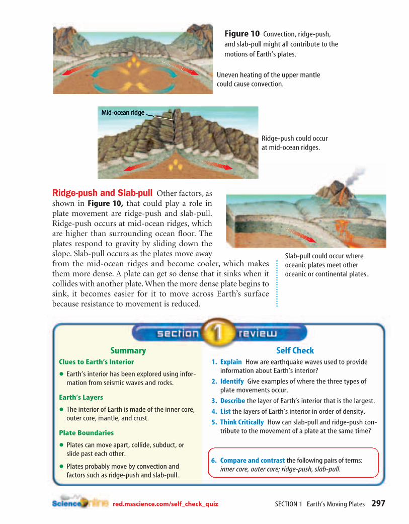
One theory that could explain plate movement is convectionof the mantle. Convection in any material is driven by differ-ences in density. In the mantle, density differences are caused byuneven heating, which results in a cycling of material, as shownin Figure 10. The theory suggests that the plates move as part ofthis circulation of mantle material.
296 CHAPTER 10 Forces Shaping Earth
Figure 9 As two plates slidepast each other, their edges grindand scrape. The jerky movementthat results causes earthquakeslike those frequently felt inCalifornia along the San AndreasFault.
Dewitt Jones/CORBIS
SECTION 1 Earth’s Moving Plates 297
Self Check1. Explain How are earthquake waves used to provide
information about Earth’s interior?
2. Identify Give examples of where the three types ofplate movements occur.
3. Describe the layer of Earth’s interior that is the largest.
4. List the layers of Earth’s interior in order of density.
5. Think Critically How can slab-pull and ridge-push con-tribute to the movement of a plate at the same time?
SummaryClues to Earth’s Interior
• Earth’s interior has been explored using infor-mation from seismic waves and rocks.
Earth’s Layers
• The interior of Earth is made of the inner core,outer core, mantle, and crust.
Plate Boundaries
• Plates can move apart, collide, subduct, orslide past each other.
• Plates probably move by convection andfactors such as ridge-push and slab-pull.
6. Compare and contrast the following pairs of terms: inner core, outer core; ridge-push, slab-pull.
Ridge-push and Slab-pull Other factors, asshown in Figure 10, that could play a role inplate movement are ridge-push and slab-pull.Ridge-push occurs at mid-ocean ridges, whichare higher than surrounding ocean floor. Theplates respond to gravity by sliding down theslope. Slab-pull occurs as the plates move awayfrom the mid-ocean ridges and become cooler, which makesthem more dense. A plate can get so dense that it sinks when itcollides with another plate. When the more dense plate begins tosink, it becomes easier for it to move across Earth’s surfacebecause resistance to movement is reduced.
Figure 10 Convection, ridge-push,and slab-pull might all contribute to themotions of Earth’s plates.
Uneven heating of the upper mantlecould cause convection.
Slab-pull could occur whereoceanic plates meet otheroceanic or continental plates.
Ridge-push could occurat mid-ocean ridges.
red.msscience.com/self_check_quiz

You have learned that Earth’s surface is separatedinto plates that move apart, move together, orslide past each other. In this lab, you will observea process that is thought to cause this platemovement.
Real-World QuestionWhat process inside Earth provides the energyfor plate motion?
Goals■ Observe movement of solid plates
on a liquid.■ Identify the cause of plate movement on
Earth’s surface.
Materials1-L beakers (2) rubber bandfood coloring water (warm and cold)aluminum foil 2-cm paper squares (3)pencil small, clear-plastic cup
Safety Precautions
WARNING: Handle the warm water with care.Water from the tap should be warm enough.
Procedure1. Fill one of the 1-L beakers with cold water.
2. Fill the small cup with warm water.
3. Add four drops of food coloring to the cup ofwarm water and cover the top with aluminumfoil. Secure the aluminum foil with a rubberband. No air should be underneath the foil.
4. Carefully place the cup of colored, warm waterin the bottom of the second 1-L beaker.
5. Carefully pour the coldwater from the first 1-Lbeaker into the second1-L beaker. Take carenot to disturb the cupof colored water.
6. Place the pieces ofpaper on the surfaceof the water in thesecond 1-L beaker.
7. Use a long pencil to make two small holesin the aluminum foil covering the cup.
8. Observe what happens to the contents ofthe cup and to the pieces of paper. Recordyour observations in your Science Journal.
Conclude and Apply1. Describe What happened to the colored,
warm water originally located in the cup?
2. Infer What effect, if any, does the warmwater have on the positions of the floatingpaper?
3. Compare and Contrast How is what hap-pens to the warm water similar to processesthat occur inside Earth? How is it different?
4. Explain After observing the pieces ofpaper floating on the cold water, explainwhat features on Earth’s surface they aresimilar to.
Earth’s Moving Plates
Compare your conclusions with those ofother students in your class. For more help,refer to the Science Skill Handbook.
298 CHAPTER 10 Forces Shaping EarthAmanita Pictures

SECTION 2 Uplift of Earth’s Crust 299
Building Mountains One popular vacation that people enjoy is a trip to the
mountains. Mountains tower over the surrounding land, oftenproviding spectacular views from their summits or from sur-rounding areas. The highest mountain peak in the world isMount Everest in the Himalaya in Tibet. Its elevation is morethan 8,800 m above sea level. In the United States, the highestmountains reach an elevation of more than 6,000 m. There arefour main types of mountains—fault-block, folded, upwarped,and volcanic. Each type forms in a different way and can pro-duce mountains that vary greatly in size.
Age of a Mountain As you can see in Figure 11, mountainscan be rugged with high, snowcapped peaks, or they can berounded and forested with gentle valleys and babbling streams.The ruggedness of a mountain chain depends largely onwhether or not it is still forming. Mountains like the Himalayaare currently forming at a rate of several centimeters per year,while much older mountains like the Ouachita Mountains inArkansas stopped forming millions of years ago and are nowbeing eroded by geological processes.
Uplift of Earth’s Crust
Figure 11 Mountains can be high and rugged like the mountains of theHimalaya shown on the left, or they can be large, gently rolling hills like theOuachita Mountains in Arkansas, shown above. Infer What determines how rugged and high a mountain chain is?
■ Describe how Earth’s mountainsform and erode.
■ Compare types of mountains.■ Identify the forces that shape
Earth’s mountains.
The forces inside Earth that causeEarth’s plates to move around alsoare responsible for forming Earth’smountains.
Review Vocabularyerosion: process by which prod-ucts of weathering are moved
New Vocabulary
• fault-block mountain
• folded mountain
• upwarped mountain
• volcanic mountain
• isostasy
(l)Chris Noble/Stone/Getty Images, (r)Buddy Mays/CORBIS

Fault-Block Mountains The first mountains you’ll study arefault-block mountains. Some examples are the Sierra Nevada inCalifornia and the Teton Range in Wyoming. Recall that pulling,or tension, forces that occur at the boundaries of plates movingapart, work to create surface features such as rift valleys and faults.Fault-block mountains also form from pulling forces. Fault-blockmountains are made of huge, tilted blocks of rock that are sepa-rated from surrounding rock by faults. When rock layers arepulled from opposite directions, large blocks slide downward, cre-ating peaks and valleys, as shown in Figure 12.
Models of Mountain Building If you hold a candy barbetween your hands and then begin to pull it apart, cracks mightform within the chocolate. Similarly, when rocks are pulledapart, faults form. Unlike rocks deep in Earth, rocks at Earth’s
surface are hard and brittle. When theyare pulled apart, large blocks of rock canmove along the faults. The Teton Range ofWyoming formed when a block of crust wastilted as one side of the range was upliftedabove the neighboring valley. As shown inFigure 13, if you travel to the Grand TetonNational Park, you will see sharp, jaggedpeaks that are characteristic of fault-blockmountains.
Now, hold a flat piece of clay betweenyour hands and then push your handstogether gently. What happens? As you pushyour hands together, the clay begins to bendand fold over on itself. A similar processcauses rocks to fold and bend, causing foldedmountains to form on Earth’s surface.
300 CHAPTER 10 Forces Shaping Earth
Figure 12 Before tension is applied, the layers of rockare even and fairly level. After tension is applied, hugeblocks of rock separate and slip downward. This leaveslarge, tilted blocks that become mountains.
Figure 13 The Teton Range inthe Grand Teton National Park hassharp, jagged peaks that are char-acteristic of fault-block mountains.
David Muench

301
Folded Mountains Traveling along a road that is cut into theside of the Appalachian Mountains, you can see that rock layerswere folded just as the clay was when it was squeezed, or com-pressed. Tremendous pushing forces exerted by two of Earth’splates moving together squeezed rock layers from oppositesides. This caused the rock layers to buckle and fold, formingfolded mountains. Folded mountains are mountains formed bythe folding of rock layers caused by compression forces.
What type of force causes folded mountains to form?
The Appalachian Mountains are folded mountains thatformed about 250 million to 300 million years ago. A small partof the folded Appalachians is shown in Figure 14. The compres-sion occurred as the North American Plate and the African Platemoved together. The Appalachians are the oldest mountainrange in North America, and also one of the longest. Theyextend from Alabama northward to Quebec, Canada. Erosionhas been acting on these mountains since they were formed. Asa result, the Appalachians are small compared to other moun-tain ranges. At one time, the Appalachian Mountains werehigher than the Rocky Mountains are today.
Upwarped Mountains The Adirondack Mountains in NewYork, the southern Rocky Mountains in Colorado and NewMexico, and the Black Hills in South Dakota are examples ofupwarped mountains. Upwarped mountains form when forcesinside Earth push up the crust. With time, sedimentary rock lay-ers on top will erode, exposing the igneous or metamorphicrocks underneath. The igneous and metamorphic rocks canerode further to form sharp peaks and ridges.
Figure 14 This roadcut inMaryland exposes folded rocklayers that formed when theNorth American Plate and theAfrican Plate collided.
Modeling MountainsProcedure1. Use layers of clay to build a
model of each major typeof mountain.
2. For fault-block mountains,cut the layers of clay with aplastic knife to show howone block moves upwardand another moves down-ward.
3. For folded mountains,push on the layers of clayfrom directly oppositedirections.
4. For upwarped mountains,push a large, round object,such as a ball, upwardfrom below, forcing thelayers of clay to warp.
5. For volcanic mountains,place layer upon layer ofclay to form a cone-shapedfeature.
Analysis1. Do any of the mountains
you have modeled looksimilar? Explain.
2. How could you recognizethe different types ofmountains?
Mark Burnett/Stock Boston

Volcanic Mountains Occasionally, magma from inside Earthreaches the surface. When this happens, the magma is called lava.When hot, molten lava flows onto Earth’s surface, volcanicmountains can form. Over time, layer upon layer of lava piles upuntil a cone-shaped feature called a volcanic mountain forms.Washington’s Mount St. Helens and Mexico’s Mount Popocateptl,shown in Figure 15, are examples. Next, you will take a closer lookat how volcanic mountains form.
Some volcanic mountains form when large plates of Earth’slithosphere sink into Earth’s mantle at subduction zones. As theplates sink deeper into the mantle, they cause melting to occur.The magma produced is less dense than thesurrounding rock, so it is forced slowlyupward to Earth’s surface. If the magmareaches the surface, it canerupt as lava and ash.Layers of these materialscan pile up over time toform volcanic mountains.
Figure 15 Volcanic mountainsform when lava and ash build up inone area over time.
Magma The hot, molten mixture of rock material and gases is called magma.
Magma Chamber Magma that has been forced upward forms and fills a large pocket under-neath the volcano. This pocket is called the magma chamber. In some cases, one magma chamber feeds several volcanoes.
Crater This bowl-shaped part of the volcano surrounds the vent. Lava often collects here before it flows down the slope.
Pipe Magma flows through this nearly vertical crack in the rock called the pipe.
Vent As magma flows up the pipe, it reaches the surface at an opening called the vent. Side vents often branch off of the main pipe.
Topic: Volcanic MountainsVisit for Weblinks to information about volcanicmountains.
Activity Collect as many photo-graphs of volcanic mountains aspossible. Create a large map of theworld with the photographs intheir proper locations. Includesome information about the vol-canic mountains and the impactthey have had on the environmentaround there.
red.msscience.com
AF
P/C
OR
BIS

SECTION 2 Uplift of Earth’s Crust 303
Underwater Volcanic Mountains Youknow that volcanic mountains form on land,but did you know that these mountains alsoform on the ocean floor? Underwater eruptionscan produce mountains beneath the sea.Eventually, if enough lava is erupted, thesemountains grow above sea level. For example,Hawaii, shown above in Figure 16, is the peakof a huge volcanic mountain that extends abovethe surface of the water of the Pacific Ocean.Figure 16 also illustrates how the HawaiianIslands formed.
Volcanic mountains like the HawaiianIslands are different from the volcanic moun-tains that form where one plate subductsbeneath another. The Hawaiian Islands formedfrom material that came from near the bound-ary between Earth’s core and mantle. Hot rockis forced upward through the mantle as aplume and melts to form a hot spot in Earth’scrust. As plates travel over the hot spot, a seriesof volcanoes, as seen in Hawaii, forms. Magmafrom subduction volcanoes forms much closerto Earth’s surface. Hot spot volcanoes also aremuch larger and have more gently sloping sidesthan subduction volcanoes.
What type of mountains make up the HawaiianIslands?
Figure 16 The Hawaiian Islands are a seriesof volcanic mountains that have been builtupward from the seafloor. They began to formas lava erupted onto the ocean floor. Over time,the mountain grew so large that it rose abovesea level.
Ocean
Magma
Underwater volcanoUnderwater volcano
Ocean
VentLavaVolcanic
island
Ocean
Vent
Lavalayers
VolcanoVolcano
Michael T. Sedam/CORBIS

Other Types of Uplift You have learned about the origin of the pushing forces
that bend crustal rocks during mountain-building processes.However, another force also works to keep mountains elevatedabove the surrounding land. If you place wooden blocks of var-ious thicknesses in a container of water, you will notice that dif-ferent blocks of wood float in the water at different heights.Also, the thicker blocks of wood float higher in the water thanthe thinner blocks do. The buoyant force of the water is balanc-ing the force of gravity. A similar process called isostasy occursin Earth. According to the principle of isostasy (i SAHS tuh see),Earth’s lithosphere floats on a plasticlike upper part of the mantle,the asthenosphere.
The effects of isostasy were first noticed near large mountainranges. Earth’s crust is thicker under mountains than it is else-where. Also, if mountains continue to get uplifted, the crustunder the mountains will become thicker and will extend fartherdown into the mantle. This is similar to the floating woodenblocks. If you pile another wooden block on a block that isalready floating in the water, you will see that the new, largerblock will sink down into the water farther than before. You alsowill see that the new block floats higher than it did before.
304 CHAPTER 10 Forces Shaping Earth
How can glaciers cause land to rise?
About 20,000 years ago, muchof North America was covered
by a large glacial ice sheet. Howdo you think an ice sheet canaffect Earth’s crust? What do youthink happens when the ice melts?
Identifying the ProblemMore than 100 years ago, peo-
ple living in areas that once hadbeen covered by glaciers noticedthat features such as old beacheshad been tilted. The beaches had ahigher elevation in some placesand a lower elevation in others.How do you think old beachescould be tilted?
Solving the Problem1. The weight of glaciers pushes down Earth’s
crust. What do you think happens after theglacier melts?
2. How could rising crust cause beaches to betilted? Do you think the crust would risethe same amount everywhere? Explain.
The Isostasy StoryUsing the principle ofisostasy, explain in yourScience Journal whylarge features on Earth’ssurface, such as moun-tains, float on the layersof Earth beneath them.
Mark E. Gibson/Visuals Unlimited

SECTION 2 Uplift of Earth’s Crust 305
Self Check1. Predict If compression were exerted on rock layers,
what type of mountains would form?
2. Describe how fault-block mountains form.
3. Explain how a volcano forms.
4. Think Critically Put the Appalachian, Himalaya, andRocky Mountains in order from youngest to oldestknowing that the Himalaya are most rugged and theAppalachians are the least rugged.
SummaryBuilding Mountains
• A rugged, tall mountain is geologically young.An old mountain is rounded and lower inelevation.
• There are four main types of mountains: faultblock, folded, upwarped, and volcanic.
• Volcanic mountains can form on the surface ofthe continents or under the ocean at ridges.
Other Types of Uplift
• The principle of isostasy explains how the lith-osphere floats on the asthenosphere.
• The crust will also adjust to gravity as erosionand weathering wear away older mountains.
5. Concept Map Make a chain-of-events concept map that describes how folded mountains form.
Adjusting to Gravity Similar to the wooden blocks, ifmountains continue to grow larger, they will sink even fartherinto the mantle. Once mountains stop forming, erosion lowersthe mountains and the crust rises again because weight has beenremoved. If the process continues, the once-thick crust underthe mountains will be reduced to the thickness of the crustwhere no mountains exist.
Icebergs behave in much the same way, as shown in Figure 17.The iceberg is largest when it first breaks off of a glacier. As theiceberg floats, it melts and starts to lose mass. This causes the ice-berg to rise in the water. Eventually, the iceberg will be muchsmaller and will not extend as deeply into the water. How is thissimilar to what happens to mountains?
Figure 17 Isostasy makesEarth’s crust behave in a similarway to these icebergs. As an ice-berg melts and becomes smaller,ice from below the water’s surfaceis forced up.
red.msscience.com/self_check_quiz

Model and InventModel and Invent
306 CHAPTER 10
Real-World QuestionThe principle of isostasy states that Earth’scrust floats on the more dense mantlebeneath. This is similar to the way objectsfloat in water. What do you think will happenwhen you add mass to a floating object? Whatif you take away mass? How does adding orremoving mass affect the way an object floatsin a fluid?
Make the Model1. Decide what object(s) you will float in the water initially. How will
you remove mass from that object? How will you add mass?
2. What will you observe as the mass changes? How will you recordthe effects of adding or removing mass?
3. How much water will you use? What problems might youencounter if you have too much or too little water?
Goals■ Observe the results of
isostasy.■ Predict what will hap-
pen to floating objectswhen mass is removedor added.
Possible Materials5-cm � 5-cm � 2-cm
wooden blocks (3)10-cm � 35-cm � 15-cm
clear-plastic storagebox or other bin
waterpermanent markerruler
Safety Precautions
Isostasy
(t)Ralph A. Clevenger/CORBIS, (b)Paul Chesley/Stone/Getty Images

4. Will you make any additional measurements or record any other data?
5. List all the steps that you plan to do in this activity. Are the steps in a logicalorder?
6. Compare your model plans to those of other students.
7. Make sure your teacher approves your plans before you start.
Test the Model1. Fill the storage box or bin with an appropriate amount of water.
2. Start by floating the initial object you planned to use in the water. Observe andrecord relevant data.
3. Follow the list of steps you planned in order to obtain data for removing andadding mass. Observe your model and record all relevant data in your ScienceJournal.
Conclude and Apply1. Describe What did your initial object look like? What level did the water rise
to when your initial object was placed in the bin? How did you add and removemass?
2. Summarize What happened to the amount of the object that was submergedand the amount sticking out of the water when mass was removed from theobject?
3. Summarize What happened to the amount of the object that was submergedand the amount sticking out of the water when mass was added?
4. Explain How can you explain your observations about how much of the objectwas submerged and how much was sticking out of the water? How is this simi-lar to processes that occur in Earth?
LAB 307
Make a poster that illustrates what youhave learned about isostasy. For more help,refer to the Science Skill Handbook.
KS Studios

Find Out About ItResearch a mountain on . Pinpoint its location on a map, and then
accurately draw the mountain and the view from its top. red.msscience.com/science_stats
... The world’s longest mountainrange is underwater. The mid-oceanridge that winds around Earth beneaththe Arctic, Atlantic, and Pacific Oceans is65,000 km long. That’s four times longerthan the combined lengths of the AndesMountains, the Rocky Mountains, and theHimalaya.
Mountains Did you know...
... The beautifulAppalachian Mountainsare among the oldest in the world.By 250 million years ago, theirformation was complete. Today, themountains aren’t among the tallestbecause they have been worn downby many millions of years oferosion.
... In 1963, Surtsey, a small island, formedwhen an underwater volcano erupted off the coastof Iceland. The 1.6-km-long island rose to the heightof 183 m—about as tall as a 55-story building.
Using this relationship, how manymeters would there be in a one-story building?
308 CHAPTER 10 Forces Shaping Earth(l)Dale Wilson/Masterfile, (r)SuperStock

Copy and complete the following table comparing examples and causes of the four types ofmountains.
Earth’s Moving Plates
1. Earth’s interior is divided into four layers,the inner core, the outer core, the mantle,and the crust.
2. Earth’s inner and outer cores are thought tobe composed mostly of iron. The outer coreis thought to be liquid and the inner core issolid.
3. Plates composed of sections of Earth’s crustand rigid upper mantle move around onthe plasticlike asthenosphere.
4. Earth’s plates move together, move apart,and slide past each other.
5. Convection in Earth’s mantle, ridge-push,and slab-pull might all contribute to platemovement.
Uplift of Earth’s Crust
1. Uplift causes mountains to form. Faulting,folding, upwarping, and volcanic eruptionsare all processes that build mountains.
2. Four main types of mountains are fault-block, folded, upwarped, and volcanic.
3. As erosion removes material, the mass ofthe mountains is reduced. Isostasy, thenforces the crust upward.
CHAPTER STUDY GUIDE 309
The Four Types of Mountains
Mountain Type Example Cause
Fault-block mountain Teton Range
Folded mountain compression
Upwarped mountain Adirondack Mountains
Volcanic mountain lava flows
red.msscience.com/interactive_tutor(tl)Sharon Gerig/Tom Stack & Assoc., (tr)David Muench/CORBIS, (bl)Robert Lubeck/Earth Scenes, (br)I & V/TLC/Masterfile

Answer the following questions with completesentences.
1. Which part of Earth’s core do scientiststhink is liquid?
2. The Sierra Nevada mountains in Californiaare which type of mountain?
3. What type of mountains form in areaswhere rocks are being pushed together?
4. What process occurs when a more denseplate sinks beneath a less dense plate?
5. Which type of mountain forms whenmagma is forced upward and flows ontoEarth’s surface?
Choose the word or phrase that best answers thequestion.
6. Which part of Earth is largest?A) crust C) outer coreB) mantle D) inner core
7. Earth’s plates are pieces of which layerof Earth?A) lithosphereB) asthenosphereC) inner coreD) mantle
8. Which force pushes plates together?A) tension C) shearingB) compression D) isostasy
9. Which force occurs where Earth’s platesare moving apart?A) tension C) shearB) compression D) isostasy
10. Which layer of Earth is thought to be solidand composed mostly of the metal iron?A) crust C) outer coreB) mantle D) inner core
11. Which suggests that Earth’s lithospherefloats on the asthenosphere?A) tensionB) compressionC) shearD) isostasy
12. Which type of mountain forms because ofcompression forces?A) fault-block mountainsB) folded mountainsC) upwarped mountainsD) volcanic mountains
13. Which type of mountain forms becauseforces inside Earth push up overlying rock layers?A) fault-block mountainsB) folded mountainsC) upwarped mountainsD) volcanic mountains
14. Which type of plate movement occurs attransform boundaries?A) plates moving togetherB) plates moving apartC) plates sinkingD) plates sliding past each other
15. Which type of plate movement producesdeep rifts such as the mid-ocean rift?A) plates moving togetherB) plates moving apartC) plates sliding past each otherD) plates sinking
310 CHAPTER REVIEW
crust p. 290fault p. 293fault-block
mountain p. 300folded mountain p. 301inner core p. 289isostasy p. 304
lithosphere p. 292mantle p. 290outer core p. 290plate p. 292subduction p. 295upwarped mountain p. 301volcanic mountain p. 302
red.msscience.com/vocabulary_puzzlemaker

CHAPTER REVIEW 311
16. Explain Which is older, the Great RiftValley in East Africa, or the Mid-AtlanticRidge in the Atlantic Ocean?
17. Explain how you can determine whether ornot a mountain is still forming.
18. Infer Seismic waves slow down whenentering the asthenosphere. What doesthis tell you about the nature of theasthenosphere?
19. Predict what would happen to the elevationof the island of Greenland if the ice sheetwere to melt away.
20. Describe If you wanted to know whether acertain mountain was formed by compres-sion, what would you look for?
21. Compare and contrast volcanic and foldedmountains. Draw a diagram of each typeof mountain. Label important features.
22. Make Models Use layers of clay to make amodel of fault-block mountains. Draw adiagram of your model.
23. Draw Conclusions The speed of seismic wavessuddenly increases when they go from theupper mantle into the lower mantle. Whatdoes this indicate about the comparativedensities of the rock in both layers?
24. Use graphics softwareto generate a scaleillustration ofEarth’s interior.Include the thick-ness of each layerin kilometers.
25. Recognize Cause and Effect What is the effect ofsubduction at the boundary of two plates?
26. Poem Write a poem in a style of yourchoosing about the spectacular view oftenassociated with mountains. You may wishto write about the scene from the top ofa mountain or the one you see from thebottom of the mountain looking up toits peak.
27. Mountain Climbing The most standard climbfor climbers of Mount Everest is up to BaseCamp, an elevation of 5400 m. If the summit is8850 m high, what percentage of MountEverest’s elevation is the Base Camp?
Use the map below to answer question 28.
28. Moving Cities The distance between SanFrancisco and Los Angeles is 616 km. If the SanAndreas fault is moving at an average rate of2.0 cm per year, how long will it be beforeLos Angeles is next to San Francisco?
Los Angeles
San Francisco
CALIFORNIANORTH AMERICAN
PLATE
PACIFIC PLATE
San Andreas Fault
red.msscience.com/chapter_reviewPat Hermansen/Stone/Getty Images

Record your answers on the answer sheetprovided by your teacher or on a sheet of paper.
1. How is energy from an earthquake carriedthrough the ground?A. isostasy C. soundB. seismic waves D. varying density
Use the graph below to answer questions 2 and 3.
2. In general, what happens to pressure as youmove outward from Earth’s interior?A. decreasesB. decreases then increasesC. increasesD. increases then decreases
3. What happens to temperature as you godeeper into Earth?A. decreasesB. decreases then increasesC. increasesD. increases then decreases
4. Which lists layers of Earth’s interior fromthe inside out?A. crust, mantle, outer core, inner coreB. inner core, outer core, crust, mantleC. inner core, outer core, mantle, crustD. mantle, crust, outer core, inner core
5. Which mountains form when forces pullfrom opposite directions?A. fault-block C. upwarpedB. folded D. volcanic
Use the illustration below to answer question 6.
6. Which type of force is involved whenEarth’s plates slide past each other?A. compression C. shearB. isostasy D. tension
7. Which type of mountain is built up fromlayers of lava and ash?A. fault-block C. upwarpedB. folded D. volcanic
8. Which of the following is believed to causeplate movement?A. compression C. isostasyB. convection D. tension
9. Which force is responsible for Earth’s crustand lithosphere floating on the mantle?A. compression C. shearB. isostasy D. tension
312 STANDARDIZED TEST PRACTICE
Depth
Pressure
Pressure v. Depth
Temperature
Temperature v. Depth
Depth

STANDARDIZED TEST PRACTICE 313
Record your answers on the answer sheetprovided by your teacher or on a sheet of paper.
10. How are seismic waves used to determineEarth’s structure?
11. If new crust is being added at rift zones,why doesn’t Earth’s crust get larger andlarger?
12. Why is Earth’s crust thicker under moun-tains than it is elsewhere?
Use the illustration below to answer question 13.
13. Provide the missing information aboutwhat takes place at plate boundaries.
14. Compare and contrast the lithosphereand the asthenosphere.
15. What causes earthquakes along a trans-form boundary?
16. Explain how slab-pull is involved in thesubduction of one plate under another.
17. Contrast how compression works to formfolded mountains with how tension worksto form fault-block mountains.
Record your answers on a sheet of paper.
18. Compare and contrast Earth’s inner coreand outer core.
Use the photo below to answer question 19.
19. What type of mountain is in this picture?Identify the characteristics that distinguishthese mountains from others and explainhow they formed.
20. Explain how the Hawaiian Islands wereformed and why they are unique.
Use the illustration below to answer question 21.
21. How do characteristics of this volcanicmountain differ from mountains formedin other ways?
22. Because of isostasy, what happens to alandmass previously covered with glacialice, once the ice melts?
23. Explain how we know that Earth’s outercore is liquid?
Diagrams Study a diagram carefully, being sure to read alllabels and captions.
Plate Boundary
slide past collide move apart
red.msscience.com/standardized_testDavid Muench