forest and farmland conservation effects of … and farmland conservation effects of oregon's...
TRANSCRIPT
Forest and Farmland Conservation Effects of Oregon's (USA) Land-Use Planning Program JEFFREY D. KLINE* Pacific Northwest Research Station Forestry Sciences Laboratory Corvallis, Oregon 97331, USA
ABSTRACT / Oregon's land-use planning program is often cited as an exemplary approach to forest and farmland conservation, but analyses of its effectiveness are limited. This article examines Oregon's land-use planning program using detailed spatial data describing building densities in western Oregon. An empirical model describes changes in
buildrng dens~tres on forest and agrrcultural lands from 1974 to 1994, as a function of a grav~ty ~ndex of land's commuting distance to clties of various srzes, topograph~c character~s- tics, and zoning adopted under Oregon's land-use plannrng program The effectiveness of Oregon's land-use plannrng program 1s evaluated based on the stat~st~cal sign~frcance of zonrng var~ables and by computing estimated areas of forest and agricultural lands fail~ng into undeveloped, low-dens~ty developed, and developed build~ng dens~ty categories, with and without land-use zoning in effect Results suggest that Oregon's land-use plannrng program has prov~ded a mea- surable degree of protection to forest and agricultural lands since its implementation.
The late 1990s brought renewed concern in the United States about rapid loss of forest and farm lands to developed uses and renewed interest in controlling growth or urban sprawl. Recent opinion polls suggest that growth and urban sprawl increasingly edge out more traditional issues, such as crime, as top concerns of Americans (Pew Center for Civic Journalism 2000). Protecting farmland has been a perennial land-use pol- icy concern at least since the 19'70s (e.g., Gardner 1977) in states experiencing rapid conversion of farmland to urban uses. More recent interest in growth control encompasses new concerns about the potential adverse effects of urban expansion on forestlands (DeCoster 2000b). An often discussed issue in contemporary forest management and policy, the "wildland-urban inter- face" is characterized by expansion of residential and other developed land uses onto forested landscapes in a manner that threatens forestlands as productive socio- economic and ecological resources (e.g., Macie and Hermansen 2002). Interest in protecting forest and farmlands from urban growth has motivated national conferences and workshops as well as special journal is- sues focusing on the impacts of population growth and development of forests and farmlands in recent years (e.g., KAG 1999; DeCoster 2000a; Sampson and De- Coster 2000;Johnston 2002; ERS 2003).
KEY WORDS W~ldland-urban interface, Spatial land-use and land- scape models; Urban sprawl, Oregon land-use law
Published online May 10, 2005
*Author to whom correspondence should be addressed; mil: [email protected]~s
Although forest policy concerns regarding forest- land development in the United States have mainly centered on residential development effects on timber production (Barlow and others 1998; Wear and others 1999; Egan and Luloff 2000; Munn and others 2002; Wine and others 2004) and potential risks associated with wildfire near homes (e.g., USDA Forest Service 1995), the ecological effects of forest and farmland development also have received research attention in recent years (e.g., Young and Jawis 2001; Wang and others 2001). Ecological effects can result notjust from the direct conversion of forest and farmlands to more intensive uses and landscape fragmentation such con- version can bring about, but also from changes in the way private landowners manage their lands in devel- oping landscapes. Several studies, for example, suggest that private forestlands become less intensively man- aged for timber production in urbanizing locations (Barlow and others 1998; Wear and others 1999; Kline and others 2004) potentially leading to changes in forest density, age class, species composition, and suc- cession (Munn and others 2002). Hence, the rate, location, and density at which landscapes become developed are important factors in evaluating the effectiveness of forest and farmland protection efforts.
A variety of public policies and programs are advo- cated in the United States to protect forest and farm- lands from development, including zoning, use value assessment, purchasing or transferring development rights, and purchasing conservation easements or land in fee, to name a few. Among these, Oregon's land-use planning program is often cited in both professional
Env~ronmental Management Vol. 35, No. 4, pp. 368-380 G 2225 Springer Science+Business Media, Inc.

Conservation Effects of Land-Use Planning 369
and popular media as exemplary (e.g., Nelson 1992; Egan 1996). Despite general acclaim, analyses of the program's effectiveness at protecting forest and farm- land are limited. Studies that do exist (Fumseth 1980, 1981; Gustafson and others 1982; Leonard 1983; Dan- iels and Nelson 1986; Nelson 1992, 1999; Pease 1992; Mine 2000, among others) tend to be descriptive or rely on anecdotal evidence (Pease 1994) by examining historical trends in a single land-use category, such as farmland area reported by the U.S. Agricultural Cen- sus. Evaluating land-use planning effectiveness in this way discounts other factors that can influence devel- opment patterns, such as existing population densities, regional economic growth, new industries, personal income, household sizes, housing tastes and prefer- ences, the availability of land for redevelopment, topography, and regional comparative advantages of land in different uses. Any rigorous analysis of land-use policy and program effects should at least attempt to account for the potential influence of such factors when gauging effectiveness.
One such attempt (Mine and Alig 1999) used an empirical model describing socioeconomic and geo- physical factors affecting land-use change in western Oregon and western Washington to evaluate rates of forest and farmland development before and after statewide land-use zoning was adopted in Oregon. Re- sults, however, were somewhat inconclusive due to the relatively low number of observations of forest and farmland development available for analysis. This article builds upon the work of Kline and Alig (2999) by reex- amining Oregon's land-use planning program using newly available spatial land-use data describing building densities in western Oregon. An empirical model is constructed describing changes in building densities on forest and agricultural lands in western Oregon from 1974 to 1994, as a function of a gravity index of the development potential of land based on its commuting distance to cities of various sizes, as well as topographic characteristics, and zoning adopted under Oregon's land-use planning program. The effectiveness of Ore- gon's land-use planning program is evaluated based on the statistical significance of zoning variables and by computing estimated areas of forest and agricultural lands falling into undeveloped, low-density developed, and developed building density categories, with and without land-use zoning in effect.
Background
Unprecedented population growth in western Ore- gon during the 1950s and 1960s raised concern about the loss of forests and farmland to development.
Existing legislation had already authorized Iocal gov- ernments to manage urban grotvth; however, residen- tial development of forests and farmlands outside of incorporated cities often remained unplanned and unregulated (Gustafson and others 1982). In response, Oregon's legislature enacted the Land Conservation and Development Act in 1973. Often referred to in Oregon as "the land-use law," it required all cities and counties to prepare comprehensive land-use plans consistent with several statewide goals, and it estab- lished the Land Conservation and Development Com- mission to oversee the program (Knaap and Nelson 1992; Abbott and others 1994). The program has been cited as a pioneer in US land-use policy for its statewide scope (Gustafson and others 1982), has won national acclaim by the American Planning Association (DLCD 1997), and has served as a model for statewide plan- ning in other states (Abbott and others 1994).
Among several goals of the program are the orderly and efficient transition of rural lands to urban uses, the protection of forests and agricultural lands, and the protection and conservation of natural resources, sce- nic and historic areas, and open spaces that "promote a healthy environment and natural landscape" (DLCD 2004, p. I ) . To advance these goals, cities and counties are required to focus new development inside urban growth boundaries and restrict development outside of urban growth boundaries by zoning those lands for exclusive farm use, forest use, or as exception areas (Pease 1994). Exception areas are unincorporated rural areas where low-density residential, commercial, and industrial uses prevail and where development is allowed, pending approval by local authorities (Ein- sweiler and Howe 1994). The land-use law does not prevent development of forest and farmlands, but, rather, restricts the rates, locations, and densities at which development can take place. Some development within forest and farm use zones can be approved by local authorities, but must be reported to the Land Conservation and Development Commission (LCDC 1996a, 1996b). Criteria defining such development vary across counties, but generally include minimum parcel sizes and limits on the number of new dwelling permits issued. Construction of personal residences by commercial farmers and forest owners is allowed. By 1986, land-use plans had been acknowledged by the Land Conservation and Development Commission for all 36 counties and 241 cities in the state (Knaap 1994).
Previous empirical analysis of the land-use law's effectiveness examined the likelihood that forest and farmlands had been converted to developed uses be- fore and after zoning had been implemented (Mine and Alig 1999). That analysis relied on data available
370 J. D. Kline
from the USDA Forest Service's Forest Inventory and Analysis Program describing historical land-use chan- ges among discrete forest, farm, and urban land-use classes. Although results did suggest that Oregon's Iand-use law had tended to concentrate forest and Earmland dewlopmen t within urban g r o d bound- aries as intended, results also suggested that the like- lihood of forest and farmland development had not been measurably different outside of urban growth boundaries and within forest and farm zones. The most plausible reason offered for such inconclusive results was that forest and farmlands now located within urban growth boundaries have always been more likely to be developed, even before implementation of the land- use law, due to their close proximity to existing cities. Forest and farmlands located outside of urban growth boundaries and within forest and farm use zones have always been less likely to be developed because of their greater distance to existing cities. The analysis detected little statistically significant change in development rates within forest and farm use zones because little development had been taking place there before Oregon's land-use law was implemented relative to the total amount of land available. The small number of observations actually depicting forest and farmland development made it difficult to examine the land-use law's effectiveness in forest and farm zones (Kline and Alig 1999). Furthermore, based as it was on land-use data describing discrete forest, farmland, and urban categories, the empirical model was incapable of examining changes in relatively lowdensity develop- ment, which has been a concern of planners and pol- icy-makers in the state.
To facilitate improved analyses of the land-use law's effectiveness, the Oregon Department of For- estry and the USDA Forest Service's Forest Inventory and Analysis Program collaborated to produce more detailed land-use data depicting building densities in western Oregon observed from aerial photographs taken in 1974, 1982, and 1994 (Azuma and others 1999, 2002). Specifically, the data consist of aerial photo-point observations of building counts (number of buildings of any size or type within 32-ha circles surrounding pinpricks on aerial photographs) on nonfederal land. The study area includes 19 counties in Oregon west of the crest of the Cascade Moun- tains. With nearly 24,000 photo-points, the data pro- vide almost 72,000 observations of building counts varying in space and time, Tracking building counts on individual photepoints at each of three points in time provides two obsewdtions of change in building counts (number of new buildings constructed) for each photo-point. W e n combined with other spatial
data using a geographic information system, the en- tire dataset comprises 44,904 obsewdtions. By describing development in terns of actual increases in numbers of buildings, both before and after implementation of Oregon's 1 and-use law, this new data provide greater spatial detail than did previously available discrete land-use data.
Model of Forest and Farmland Development
The advent of spatial land-use models presents new opportunities for examining how land-use policies and programs might alter the rate and location of forest and farmland development. To evaluate forest and farm- land conservation effects of Oregon's land-use law, a spatial land-use model based on the western Oregon building density data and initially crafted to describe land-use changes in Oregon's Coast Range (Kline 2003; Kline and others 2003) was adapted to explicitly examine the law's effects on the rate and location of building density change throughout western Oregon. The western Oregon study region comprises a signifi- cant amount of public and private forestland, fertile agricultural lands located mainly in the Willamette Valley extending from Portland to Eugene, and several growing cities (Figure 1). Land-use and building den- sity data for 1974 indicate that western Oregon had about 4.1 million hectares of nonfederal land at the time Oregon's land-use law was enacted (Table 1). Most forestland (96.8%) had relatively low building densities of zero to six buildings per square kilometer, whereas relatively significant areas of agricultural (25.8%) and mixed forest/agricultural (20.2%) had higher building densities of greater than seven buiIdings per square kilometer. Data indicate that, by 1994, development had nearly doubled the area of forest and agricultural lands having greater than 25 buildings per square kilometer, mostly at the expense of agricultural and mixed forest/agricultural lands. The spatial land-use model describes the rate and location of these changes, as a function of prevailing development pressures, geophysical characteristics, and land-use zoning.
Conceptual Framework
Spatial land-use models based on discrete land-use data generally assume that landowners choose that use which maximizes the present value of future net returns derived from their land (Bockstael 1996; Ir- win and Geoghegan 2001). Building count data in this study, however, describe locally aggregated deci- sions of unknown numbers of individual landowners regarding construction of new buildings on land of all types. A conceptual framework characterizing

Conservation Effects of Land-Use Planning
Land use categories:
Forest Urban
Major Agriculture
/--'- Cat ifornia
Figure 1. Western Oregon study region and major land use categories, 1994.
development as the numbers of new buildings within relatively local geographic areas is needed. Within any local area, landowners face a range of develop- ment opportunities regarding new housing, busi- nesses, and industry. Decisions regarding such opportunities are influenced by potential future rents to be earned from any one opportunity relative to rents earned from existing land uses. Within the 32- ha kicinity of photo-points comprising building count observations in this study, local landowners would be likely to face similar types of development opportu- nity, subject to zoning and topographic differences that affect potential building sites. The extent to which new buildings are observed in any given local area will be a function of the potential returns to be earned from new development, as well as local zon- ing and topographic characteristics. The building counts identi9 newly constructed buildings and can be used to estimate Poisson and negative binomial models describing new development as a function of these factors.
Regionally disaggregated economic data describing potential land rents earned from new development relative to forestry and agriculture are not available, so proxy variabIes must be identified. Conceptually, the value of land in developed uses has been viewed as a function of the spatial proximity to city centers (Mills 1980; Miyao 1981; Fujita 1982; Wheaton 1982; Capozza and Helsley 1989). Von Thunen viewed spatial prox- imity in terms of costs associated with transporting *
forest and agricultural commodities to markets, influ- encing whether forestry and agriculture were profitable in any given location (Barlow 1978, p. 37). However, modern society views spatial proximity in terms of the difference between quality-of-life factors, such as housing, neighborhood characteristics, and environ- mental amenities, and the costs associated with com- muting to employment destinations. More consistent with central place theory, this view explains location choices based on the relative economic advantages of locating people, business, and industries in particular clusters and patterns (King 1984).
372 J. D. Kline
Table 1. Distribution of western Oregon forest and agricultural lands among building density classes, 1974 and I 994a
Buildings per square kilometer
Domitlant land rise Total in 1974 (ha) 0-6 7-25 > 25
1974 Forest ilgricul ture Mixed Total
Forest Agriculture Mixed Total
1994 Forest Agriculture Mixed Total
Forest Agriculture Mixed Total
Percent 96.8 74.2 79.8 90.8
Percent 93.1 66.0 64.1 85.3
" * ~ e d on the work of Azuma and others (1999, 2002).
One of the most important factors affecting the development potential of rural lands in western Oregon is its commuting proximity to employment opportuni- ties offered by major cities of the Willamette Valley. Land within short commuting distances will have greater development potential than landwithin relatively longer commuting distances. Also, land within commuting distance to a large city will have greater development potential than land within a comparable commuting distance to a smaller city. Cities beyond reasonable commuting distances will have little, if any, influence on development potential. The influence of city size and location can be described using a gravity index (Reilly 1929; Haynes and Fotheringham 1984) to account for the combined influence of population and proximity as economic forces affecting land-use change (Shi and others 1997).
Empirical Model
Following mine and others (2003), the develop- ment potential of land is described using a Gravity Index computed as
where K represents the number of cities within a 60-min drive (or commute) of each photo-point i,
Population is the population (US Bureau of Census 1992) of each city k, and Time is the driving time in minutes between photo-point i and city k. The variable Gravity Index is the sum of populations of cities within a 60-min commute of each photo-point, weighted by the estimated driving time to each city's edge. The in- dex sets a 60-min limit on the "reasonable" commut- ing time, based on an assumption that most Oregonians probably commute no more than 1 h to work. Varying this limit to reflect somewhat shorter or longer maximum commuting times did not substan- tially affect the sign, magnitude, or statistical signifi- cance of the gravity index estimated coefficient.
The cities used to compute the gravity index include 45 western Oregon cities comprising 5000 or more persons in 1990 (US Bureau of Census 1992). Adjacent cities were combined and treated as larger metropolitan areas, reducing the total number of cities and metro- politan areas included in the analysis to 30. Driving times used to calculate the gravity index were estimated using a geographic information system map of existing roads to create a friction surface based on average driving times assumed for different types of road. Driving speeds are assumed to average 97 km/h on primary roads, 40 km/h on secondary roads, and 16 km/h where there are no roads. Driving times are based on roads data from a single point in time, because data describing road improvements are unavailable.

Conservation Effects of Land-Use Planning 373
The gravity index is combined with other explanatory variables describing existing building counts and topography (slope and elevation), as well as land-use zoning mandated by Oregon's land-use law. Together, the variables are assumed to characterize the value of land in more developed uses over and above its value in undeveloped forest and agriculture. Greater numbers of new buildings are expected in areas having higher gravity index values, and fetver are found in areas having low gravity index values. Higher existing building counts are expected to have a positive but diminishing impact on new buildings, because factors attracting existing development likely attract new development before building density limits mandated by zoning are achieved. Slope is expected to be negatively correlated with new buildings, because steeper slopes can be more difficult to build upon. Elevation also can be negatively correlated with new buildings if high elevations impede construction with poor physical access. However, eleva- tions can be positively correlated with new buildings if they provide desirable views (Wear and Bolstad 1998).
To evaluate the impact of Oregon's land-use law on numbers of new buildings, the variable Land use law was constructed as the proportion of time from one observation date to the next that a state-approved land- use plan was in effect for land represented by each photo-point. Knaap (1988) used a variable to examine the Oregon land-use law's impact on economic devel- opment similar to that of Kline and Alig (1999) to examine its impact on forest and farmland develop- ment. The variable Land use law was interacted with three dummy variables (Forest zone, Farm zone, Urban growth boundary) identifjmg the locations of photo- points within the three major land-use zones imple- mented by Oregon's land-use law. If Oregon's land-use law has been effective at reducing numbers of new buildings on lands located within forest and farm zones, estimated coefficients for the interaction terms Land use law x Forest zone and Land use law x Farm zone should be negative and statistically significant. Because the assignment of lands to forest and farm zones and urban growth boundaries zones was partly a function of their distance to existing cities, develop- ment rates likely varied among lands located in dif- ferent zones even before zones were implemented. To control for location effects, the noninteracted dummy variables (Forest zone, Farm zone, Urban growth boundary) also were included in the model.
Model Estimation
The dependent variable ABuildings was constructed by computing changes in building counts observed within 32-ha circles surrounding photo-points at 10-
year intends between 1974 and 1984 and between 1984 and 1994. Building counts for 1984 were approximated by interpolation between 1982 and 1994 values and rounding to the nearest whole number. The dependent variable ABuildings is measured as a count and is not continuous. Assuming ABuildings is dis- tributed as a Poisson leads to the negative binomial model
where y is a random variable and exp(y) has a gamma distribution with mean 1 and variance a, x, is a vector of independent variables, and f3' is a vector of coefficients to be estimated (Greene 1997). The negative binorrlial model is a general form of the Poisson model relaxing the Poisson assumption that the dependent variable's mean equals its variance (Wear and Bolstad 1998).
The panel nature of the data-two observations of building count change per photo-point-creates the potential for correlation among pairs of time-series observations for individual photo-points to deflate standard errors and bias estimated coefficients. These potential correlations can be accounted for using a random effects negative binomial model (Greene 1995, pp. 570-571). Because group effects are condi- tioned out (not computed), projected values cannot be computed using the random effects model (Greene 1995, p. 567), but the estimated coefficients can be compared to those of the model estimated without random effects.
The general regression equation describes changes in building counts on photo-points from one time point to the next
ABui1ding.s = f ( Crnvity IndRx, Building Count, Slqbe,
Elevation, Land Use Law, Fnrest Zone,
Eitwn Zane, Urban Gowth Boundary)
(3)
where the explanatory variables and their functional forms are described in Table 2. The model is highly significant based on loglikelihood ratio tests of the Poisson model (X2 40,713, df = 10, P < 0.0001) and negative binomial model tested against the null of the Poisson (X2 = 122,102, df= 1, P < 0.0001). Random effects coefficients are reasonably consistent with ne- gative binomial coefficients, although the statistical significance of the /3 coefficient in the random effects

J. D. Kline
Table 2. Descriptions of explanatory variables tested in the empirical model
Variable Description
Gravity index
Building count
Slope Elevation Land use law
Urban growth Boundary Farm zone Forest zone
Equal to the avemge of the gravity index computed [using Eq. (111 at the beginning of each time period and the gravity index computed at the end of each time period (times 1/100,000). City populations for study years for noncensus years estimated by interpolating between popillations reported for census years (US Bureau of Census 1992).
Number of buildings within an 32-ha circle surrounding photo-point (Azuma and others 1999) at the beginning of each time period (times 1/100).
Percent slope at the sample point (times 1/ 100). Elevation in meters. Variable equals proportion of time from one building count observation to the
next that land-use zoning acknowledged by Oregon's Land Use Planning Program was in effect at the sample point; 0 otherwise. Acknowledgment dates from (LCDC 1992).
Variable equals 1 if plot is located in an urban growth boundary or rural residential land use zone; 0 otherwise. Variable equals 1 if plot is located in a farm zone; 0 othenuise. Variable equals 1 if plot is located in a forest zone; 0 otherwise.
regression does suggest that statistically significant random effects might be present.
Estimated coefficients for the linear and qua- dratic Gravity index variables are statistically signifi- cant ( P < 0.01) and together suggest that, over time, building counts increase at an increasing rate with greater proximity to cities within commuting distance and ctith greater population sizes of those cities (Table 3 ) . Estimated coefficients for the linear and quadratic Building count variables are statistically significant (P < 0.01) and, together, suggest that ex- isting building numbers have a positive but dimin- ishing impact on future building count increases. Estimated Slope and Elevation coefficients are nega- tive and statistically significant (P < 0.01), suggesting that slope and elevation both have a negative impact on building count increases.
The estimated Farm zone coefficient is positive but not statistically significant (P > 0.30), suggesting that development rates on lands assigned to farm zones when Oregon's land-use law was implemented have been about equal to development rates on lands as- signed to forest zones (base case), after accounting for the other factors included in the model. The estimated Urban growth boundary coefficient also is positive and is statistically significant ( P < 0.01), suggesting that de- velopment rates on lands assigned to urban growth boundaries have been greater than development rates on lands assigned to forest zones (base case). A paired t- test indicates that the Urban growth boundary coeffi- cient is statistically different from (and greater than) the Farm zone coefficient ( t = 13.52), suggesting that development rates on Iands assigned to urban growth
boundaries also have been greater than development rates on lands assigned to farm zones. The Farm zone and Urban growth boundary variable coefficients sug- gest that lands assigned to forest and farm zones under the land-use law were already less likely to develop than lands assigned to urban growth boundaries, even before the law was implemented due to their distance to existing cities and topographic characteristics. This re- sult is consistent with that suggested by Kline and Alig (1999, pp. 16-18) regarding the effects of location on development before implementation of the law.
Estimated coefficients for the interaction variables Land use law x Forest Lone and Land use law x Farm zone are both negative and statistically significant (P < 0.01). Although already long before Oregon's land- use law was implemented, the Land use law x Forest zone and Land use law x Farm zone variable coeffi- cients suggest that development rates on lands as- signed to forest and farm zones have been even lower after the law was implemented. Where results of Kline and Alig (1999, pp. l&-19) were somewhat in- conclusive regarding development rate reductions within forest and farm zones after Oregon's land-use law was implemented, results here would seem to provide some empirical evidence that the law has reduced forest and farmland development within forest and farm zones.
The estimated coefficient for the interaction vari- able Land use law x Urban growth boundary is also negative and statistically significant (P < 0.01 ) , sug- gesting that development rates on lands assigned to urban growth boundaries also have been lower since Oregon's land-use law wds implemented. This result is

Conservation Effects of Land-Use Planning 375
Table 3. Estimated coefficients of negative binomial models describing changes in building counts in western Oregon, 1974 - 1994
Variable
Negative binomial regression Negative binomial regression with
Coefficient Marginal effect random eficts
Gravity index -0.357 (-16.21) -0.408 -0.109 (-6.44) Gravity index2 0.055 (14.19) 0.063 0.018 (8.27) Building count 21.112 (45.22) 24.170 8.809 (30.34) Building count' -22.302 (-43.40) -25.532 -14.331 (-32.64) Slope -7.856 (-30.90) -8.994 -4.938 (- 15.94) Elevation -2.123 (-28.76) -2.430 - 1.623 (-18.04) Farm zone 0.039 (1.00) 0.045 0.588 (12.52) Urban growth boundary 1.445 (22.20) 1.655 2.1 14 (37.18) Lnnd use law x forest zone -1.319 (-28.82) -1.510 -0.731 (-12.93) Land use law x farm zone -0.772 (-14.34) -0.884 -0.582 (-13.02) Land use law x urban growth - 1.399 (- 14.80) - 1.602 -0.932 (-33.54)
boundary a 3.983 (49.09) - 2.550 (32.67) P - - 0.724 (25.27) Summnly Stn6istic.s Poisson log-L = -35,371, log-L = -23,652
X2 = 40,713, df = 10, P < 0.0001 Negative binomial Log-L = -24,320 X2 = 22,102, df = 1, P < O.OOOln
Note: N = 44,904. T h e t-statistic4 for each estimated coefficient are in parentheses. The variable Forest zone is omitted for model estimation. " Tested against the null of the Poisson model.
somewhat surprising and inconsistent with that sug- gested by JXline and Alig (1999, p. 15). Because the land-use law was intended to concentrate develop- ment within urban growth boundaries, higher (not lower) development rates might be expected on lands within urban growth boundaries since their im- plementation. On the one hand, empirical results could be confounded by inclusion of the Urban growth boundary dummy variable. Alternative models estimated without the Farm zone and Urban growth boundary variables yield a Land use law x Urban growth boundary estimated coefficient that is also negative but is fairly statistically insignificant (P > 0.25). This alternative result suggests that develop- ment rates have been reasonably constant on lands assigned to urban growth boundaries or, at most, have declined only slightly.
On the other hand, lower development rates indi- cated by the empirical results shown could be due to greater restriction and oversight of any development activity occurring within urban growth boundaries since the land-use law was implemented. Also, data- collecting protocols used by the Forest Inventory and Analysis Program essentially set an upper Limit on building counts for photo-point obsewations to be in- cluded in the dataset, to focus data gathering on nonurban areas. Data used by Kline and Alig (1999) were not similarly restricted. Because Oregon's land-
use law attempts to locate new development closest to existing urban areas or "contiguous to the urban core" (Weitz and Moore 1998), photo-point observations within urban growth boundaries that are included in the building count data used in this study could com- prise those lands that have been least likely to develop, relative to more densely populated lands within urban growth boundaries that might have been excluded by data sampling procedures.
Evaluating Forest and Farmland Conservation Effects
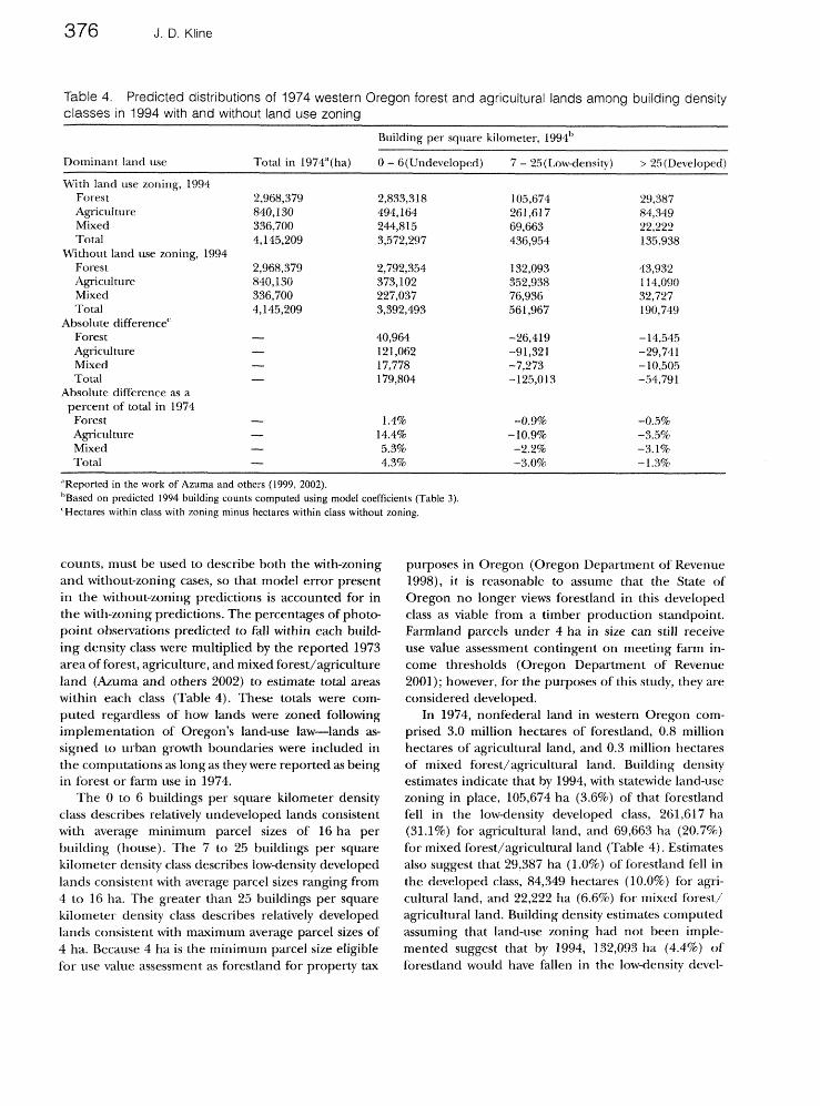
A key question regarding Oregon's land-use law is whether it has saved forest and farm lands from devel- opment, and if so, how much. To address this question, the estimated negative binomial model coefficients (Table 3) were used to compute 1994 predicted build- ing counts for photo-point observations identified by their dominant land use as forest, agriculture, and mixed forest/agriculture during 1973-the year the land-use law was first enacted. Predicted building counts were computed with and without land-use zon- ing in place and were grouped into 3 building density classes: 6 or less buildings per square kilometer, be- tween 7 and 25 buildings per square kilometer, and greater than 25 buildings per square kilometer. Pre- dicted building counts, rather than the actual building
376 J. D. Ktine
Table 4. Predicted distributions of 1974 western Oregon forest and agricultural lands among building density classes in 1994 with and without land use zoning
Building per square kilometer, 1994~
Dominant land use Total in 1974"(ha) 0 - G(Undeve1oped) 7 - 25(Low-densit)..) > 25(DeveIoped)
With land use zoning, 1994 Forest 2,968,379 2,833,3 18 105,674 29,387 Agicul ture 840,130 494,164 261,617 84,349 Mixed 336,700 244,815 69,663 22,222 Total 4,145,209 3,572,297 436,954 135,938
Without land use zoning, 1994 Forest 2,968,379 2,792,354 132,093 43,932 &culture 840,130 373,102 352,938 1 14,090 Mixed 336,700 227,037 76,936 32,727 Total 4,145,209 3,392,493 56 1,967 190,749
Absolute differencec Forest - 40,964 -26,419 - 14,545 Agriculture - 12 1,062 -91,321 -29,741 Mixed - 17,778 -7,273 - 10,505 Total - 179,804 -125,013 -54,791
Absolute difference as a percent of total in 1974 Forest - 1.48 -0.9% -0.5% Agriculture - 14.4% - 10.9% -3.5% Mixed - 5.3% -2.2% -3.1% Total - 4.3% -3.0% -1.3%
"Reported in the work of Azuma and others (1999, 2002). "~ased on predicted 1994 building counts computed using model coefficients (Table 3). 'Hectares within class with 7oning minus hectares within class without zoning.
counts, must be used to describe both the with-zoning and without-zoning cases, so that model error present in the without-zoning predictions is accounted for in the with-zoning predictions. The percentages of photo- point observations predicted to fall within each build- ing density class were multiplied by the reported 1973 area of forest, agriculture, and mixed forest/agriculture land (Amma and others 2002) to estimate total areas within each class (Table 4). These totals were com- puted regardless of how lands were zoned following implementation of Oregon's land-use law-lands as- signed to urban growth boundaries were included in the computations .as long as they were reported as being in forest or farm use in 1974.
The 0 to 6 buildings per square kilometer density class describes relatively undeveloped lands consistent with average minimum parcel sizes of 16 ha per building (house). The "7 to 25 buildings per square kilometer density class describes low-density developed lands consistent with average parcel sizes ranging from 4 to 16 ha. The greater than 25 buildings per square kilometer density class describes relatively developed lands consistent with maximum average parcel sizes of 4 ha. Because 4 ha is the minimum parcel size eligible for use value assessment as forestland for property tax
purposes in Oregon (Oregon Department of Revenue 1998), it is reasonable to assume that the State of Oregon no longer views forestland in this developed class as viable from a timber production s~andpoint.
parcels under 4 ha in size can still receive use value assessment contingent on meeting farm in- come thresholds (Oregon Department of Revenue 2001); however, for the purposes of this study, they are considered developed.
In 1974, nonfederal land in western Oregon com- prised 3.0 million hectares of forestland, 0.8 million hectares of agricultural land, and 0.3 million hectares of mixed forest/agricultural land. Building density estimates indicate that by 1994, with statewide land-use zoning in place, 105,674 ha (3.6%) of that forestland fell in the lowdensity developed class, 261,617 ha (31.1%) for agricultural land, and 69,663 ha (20.7%) for mixed forest/agricultural land (Table 4). Estimates also suggest that 29,387 ha (1.0%) of forestland fell in the developed class, 84,349 hectares (10.0%) for agri- cultural land, and 22,222 ha (6.6%) for mixed forest/ agricultural land. Building density estimates computed assuming that land-use zoning had not been imple- mented suggest that by 1994, 132,093 ha (4.4%) of forestland would have fallen in the low-density devel-
Conservation Effects of Land-Use Planning
Suitdings per square kilometer
With Withaat With Without With Without Forest Mixed Agricutture
Figure 2. Predicted compositions of forest and farmland among building densiry classes in 1994, with and without land-use zoning in effect.
oped class, 352,938 ha (42.0%) for agricultural land, and 76,936 ha (22.8%) for mixed forest/agricultural land (Fable 4). Estimates also suggest that without land-use zoning, 43,932 ha (1.5%) of forestland would have fallen in the developed class, 114,090 ha (13.6%) for agricultural land, and 32,727 ha (9.7%) for mixed forest/agricultural land. The estimates indicate that Oregon's land-use law has had a relatively subtle effect on the composition of forestlands among building density classes compared to its effect on agricultural lands (Figure 2).
A chi-squared test indicates that the estimated dis- tributions of forestland, agricultural land, and mixed forest/agricultural land across the building density classes with and without zoning in effect are statistically significant ( X 2 =149.3, d f = 2, P z: 0.001). Differences between those distributions suggest that by 1994 Ore- gon's land-use law had saved 26,419 ha (0.9%) of for- estland from the low-density developed class and 14,545 ha (0.5%) from the developed class. For agri- cultural land, the distributions suggest that by 1994 the land-use law had saved 91,321 ha (10.9%) from the lowdensity developed class and 29,741 ha (3.5%) from the developed class. For mixed forest/agricultural land, the distributions suggest that by 1994 the land- use law had saved 7273 ha (2.2%) from the low-density developed class and 10,505 ha (3.1%) from the devel-
oped class. The estimated distributions of forest and agricultural lands among building density classes pro- vide some measure of the magnitude of forest and farmland protection provided by zoning mandated by Oregon's land-use law.
Summary and Conclusions
Results from empirical models describing building density changes in western Oregon from 19'74 to 1994 suggest that Oregon's land-use law has reduced devel- opment of lands located within forest and farm zones since they were implemented under the program. Gi- ven the greater number of observations and greater spatial detail provided by building density data used in this analysis relative to data available to Nine and Alig (1999), results here would seem to supplant their somewhat inconclusive results regarding the effective- ness of Oregon's land-use law. Estimated distributions of forest and agricultural lands among building density classes computed in this study with and without zoning in effect suggest that zoning mandated by Oregon's land-use law has provided a measurable degree of pro- tection to forest and agricultural lands since its imple- mentation. Forest and farmlands appear to have developed at lower densities with Oregon's land-use law in effect than would have been the case without the law.

J. D. Kline
Results also provide additional empirical evidence suggesting significant location effects regarding where lands are most likely to develop with or without zoning, consistent with those suggested by Kline and Alig (1999). Although implementation of forest and farm zones appears to have reduced development rates on lands located within such zones, those lands were al- ready less likely to develop even before zones were implemented because of their more distant location relative to existing cities. Likewise, forest and farm- lands now located within urban growth boundaries were already more likely to develop before zones were implemented due to their proximity to existing cities. Oregon's land-use law essentially confined the expan- sion of cities by drawing a line around those forest and farmlands already most likely to develop. Development has continued within those bounds. In this way, zoning mandated by Oregon's land-use law somewhat institu- tionalized regional development patterns that were already occurring before statewide zoning was imple- mented, but provided local and regional planners greater control of development through associated permitting processes.
Whether the degree of protection provided by Oregon's land-use law has offered significant benefit in terms of maintaining timber production and reducing wildfire risk remains an open question. Increasing building densities in western Oregon have been shown to be correlated with lower rates of pre- commercial thinning and postharvest tree planting and with lower forest stocking on forest landscapes where development is taking place, although timber harvest rates have remained unchanged (mine and others 2004). Based on this finding, lower building densities resulting from Oregon's land-use law would seem to imply that the law might have helped main- tain timber production in the state. Similarly, lower- density development on forest landscapes would seem to imply reduced wildfire risk associated with homes and other structures located on forest landscapes. The magnitudes of both of these effects remain un- known.
Potential ecological effects are less certain and are likely to depend on the particular responses of indi- vidual species to forest and farmland development. Forest and farmland development undoubtedly has adverse ecological consequences as some lands and the habitats they provide are converted to developed uses. On the other hand, landscape fragmentation as well as changes in landowners' management might improve habitat conditions for some species while degrading habitat for others. Farmland development, for exam- ple, conceivably entails switching vegetative cover from
agricultural crops to other species, Forestland devel- opment might be accompanied by less intensive man- agement of remaining forests for commercial timber production. Evaluating the net ecological implications of forest and farmland conservation afforded by Ore- gon's land-use law will necessitate greater research ef- fort focused on examining the manner in which resulting development patterns alter habitat for various species.
Judging the magnitude of forest and farmland protection afforded by Oregon's land-use law as indi- cated in this study likely will vary-some will see few hectares protected while others will see many. In weighing these results, remember that Oregon's land- use law was not intended to stop development, but, rather, to facilitate the orderly and efficient develop ment of rural lands while protecting forest and farm- lands (Knaap and Nelson 1992; Abbott and others 1994). The law allows development of forest and farmlands within urban growth boundaries and allows forest and farmland owners to construct personal res- idences and other buildings within forest and farm zones subject to certain restrictions. These factors over time will tend to dilute the magnitude of forest and farmland protection afforded by Oregon's land-use law.
Realizing measurable impacts of land-use planning programs is a slow process involving incremental changes in land-use patterns over long periods of time. Land-use planning programs like Oregon's could oflfer a relatively inexpensive approach to forest and farm- land protection, from the perspective of the adminis- tering agency. However, they might be less effective over the long-term than other more permanent (and expensive) landowner compensation-based programs, such as purchasing development rights, conservation easements, or land in fee. All of these alternatives offer more permanent protection of forest and farmlands than land-use zoning and can be structured in ways that place greater control of ongoing management of protected lands in the hands of landscape managers. Planners and policy-makers must continually weigh the effectiveness, costs, and equity considerations of dif- ferent policies and programs when devising and revis- ing forest and farmland conservation strategies in different locations.
Acknowledgments Funding for this research was provided by the CSDA
Forest Service, Pacific Northwest Research Station, Fo- cused Science Delivery Program, Portland, Oregon.

Conservation Effects of Land-Use Planning 3'7.9
I thank Ralph Alig, Gary Lettrnan, Ian Munn, Christo- p h e r Young, a n d a n anonJmous reviewer fo r helpful comments.
Literature Cited
Abbott, C., D. Howe, S. Adler. 1994. Introduction. In C. Ab- bott, D. Howe, and S. Adler (eds.), Planning the Oregon way. Oregon State University Press, Corvallis, Oregon.
Azuma, D. L., K R, Birch, P. DelZotto, A. A. Herstrom, and G. J. Lettman. 1999. Land use change on non-federal land in western Oregon, 1973-1994. Oregon Department of For- estry, Salem, Oregon.
Azuma, D. L., K. R. Birch, A. A. Herstrom, J. D. Kline, and G. J. Lettman. 2002. Land use change on non-federal land in western Oregon, 1973-2000. Oregon Department of For- estry, Salem, Oregon.
Barlow, R. 1978. Land resource economics: the economics of real estate. Prentice-Hall, Englewood Cliffs, New Jer- sey.
Barlow, S. A., I. A. Munn, D. A. Cleaves, and D. L. Evans. 1998. The effect of urban sprawl on timber harvesting. Journal of I;brestr?, 96: 10-1 4.
Bockstael, N. E. 1996. Modeling economics and ecology: the importance of a spatial perspective. American .Journal of Agriculluml Economics 78: 1 168-1 180.
Capozza, D. R., and R. W. Helsley. 1989. The fundamentals of land prices and urban growth. .Journal of Urban Economics 26:295--306.
Daniels, T. L., and A. C. Nelson. 1986. Is Oregon's farmland preservation program working?. Journal of the Ammican Planning Association 52 ( 1) :22-32.
DeCoster, L. A. 2000a. Forest fragmentation 2000: Sustaining private forests in the 21" century. The Sampson Group, Inc., Alexandria, Virginia.
DeCoster, L. A. 2000b. Summary of the forest fragmentation 2000 conference: how forests are being nibbled to death by DUCs and what to do about it. Pages 2-12 in L. A. DeCoster (ed.), Forest fragmentation 2000: Sustaining private porests in the 21'L century. The Sampson Group, Inc., Alexandria, Virginia.
DLCD (Department of Land Conservation and Develop ment) . 1997. Shaping Oregon's future: biennia1 report for 1995-97 from Oregon's Department of Land Conservation and Development to the Sixty-ninth Legislative Assembly. Oregon Department of Land Conservation and Develop- ment, Salem, Oregon.
DLCD (Department of Land Consemtion and Develop ment). 2004. Oregon's statewide planning goals and guidelines. Oregon Department of Land Conservation and Development, Salem, Oregon. http://ww.Icd.state.or.us/ goalhtml/goals.html.
ERS (Economic Research Service). 2003. What the public values about farm and ranch land: a workshop to develop a ranking tool for program managers, 13-14 November 2003, Baltimore, Maryland.
Egan, T. 1996. Drawing a hard line against urban sprawl. The New York Times, December 30, section A, page 1, column 2.
Egan, A. F., and A. E. LnloM: 2000. The exurbanization of America's forests: research in rural social science. .fournal of f;mestly 98 (3) :26-30.
Einsweiler, R. C. and D. A. Horue, 1994. Managing 'the land between': A rural development paradigm. In C . A h bott(ed.), Planning the Oregon Way. Oregon State Uni- versity Press, Corvallis, Oregon.
Furuseth, 0 . j. 1980. The Oregon agrict~ltrrral protection program: A review and assessment. Natural Rcsource~fournal 20:603-6 14.
Furuseth, 0 . J. 1981. Update on Oregon's agricultural pro- tection program: A land use perspective. Natural ReJource Journal 21 (1):57-70.
Fujita, M. 1982. Spatial patterns of residential development. .Journal of Urban Economics 12:22-52.
Gardner, B. D. 1977. The economics of agricultural land protection programs. Ammican .fournu1 of Apcullural Ecv- nomics 59: 1027-1036.
Greene, W. H. 1995. LIMDEP version 7.0: User's manual. Econometric Software, Inc., Bellport, New York.
Greene, W. H. 1997. Econometric analysis. Prentice-Hall, Upper Saddle River, New Jersey.
Gustafson, G. C., T. L. Daniels, and R. P. Shirack. 1982. The Oregon land use act: implications for farmland and open space protection.. Journal of the Amhcan Planning A~~oczation 48 (3) :365-373.
Haynes, K. E., and A. S. Fotheringham. 1984. Gravity and spatial interaction models. Sage Publications, Beverly Hills, California.
Irwin, E. G., and J. C~oghegan. 2001. Theory, data, methods: developing spatially explicit economic models of land use change. Ap'culture, Ecosystems and Environment 85 ( 1-3) :7- 23.
Johnston, R. J. (compiler). 2002. Conserving farm and forest in a changing rural landscape: Current and potential contributions of economics. NERCRD Re- gional Rural Development Paper No. 11. The North- east Regional Center for Rural Development, Pennsylvania State University, University Park, Pennsyl- vania, 23 pp.
KAG (Keep America Growing). 1999. Keep America growing: Balancing working lands and development: conference proceedings (CD ROM). Omnipress, Madison,
King, L. J. 1984. Central place theory. Sage Publications, Beverly Hills, California.
Kline, J. D. 2000. Comparing states with and without growth management: analysis based on indicators with policy implications, comment. Idand Use Polity 17:349- 355.
Kline, j. D. 2003. Characterizing land use change in multi- disciplinary landscape-level analyses. Agricultural and Re- source Economics Rmiatt 32 ( 1 ) : 103- 1 15.
Kline, J. D., and R J. Alig. 1999. Does land use planning slow the consersion of forest and farmlands? Ikorulh and Chf~nge 30:3-22.
J. D. Kline
Kline, J. D., D. L. Azuma, and R. J. Alig. 2004. Population growth, urban expansion, and private forestry in western Oregon, Forest Science 50 ( 1 ) :33-43.
Kline, J. D., D. L. Azuma, and A. Moses. 2003. Modeling the spatially dynamic distribution of humans in the Oregon (USA) Coast Range. Landscape Ecoloa 18(4):347- 361.
Knaap, G. 1988. Land use controls and economic develop ment: an exploratory analysis. University of MTisconsin Press, Green Bay, Wisconsin.
Knaap, G., 1994. Land use politics in Oregon. In C. Abbott, D. Abbott, D. Howe, and S. Alder(eds.), Planning the Oregon way. Oregon State University Press, Corvallis, Oregon.
Knaap, G., and A. C. Nelson. 1992. The regulated land- scape: lessons on state land use planning from Oregon. Lincoln Institute of Land Policy, Cambridge, Massachu- setts.
LCDC (Land Conservation and Development Committee). 1992. Acknowledgement scoreboard, May 12,1992. Oregon Department of Land Conservation and Development, Salem, Oregon.
LCDC (Land Conservation and Development Committee). 1996a. Exclusive farm use report, 1994-1995. Oregon Department of Land Conservation and Development, Salem, Oregon.
LCDC (Land Conservation and Development Committee). 1996b. Forest use report, 1994-1995. Oregon Department of Land Conservation and Development, Salem, Oregon.
Leonard, J. 1983. Managing Oregon's growth. Conservation Foundation, Washington, DC.
Macie, E. A., and L. A. Hermansen. 2002. Human influences o n forest ecosystems: The southern wildland-urban inter- face assessment. General Technical Report SRSGTR-55. US Department of Agriculture, Forest Service, Southern Research Station, Ashville, North Carolina, 160 pp.
Mills, E. S. 1980. Urban economics. Scott, Foresman and Go., Glenview, Illinois.
Miyao, T. 1981. Dynamic analysis of the urban economy. Academic Press, New York.
Munn, I. A., S. A. Barlow, D. L. Evans, and D. Cleaves. 2002. Urbanization's impact on timber harvesting in the south central United States. Journal 01 Environmental Management 64:65-76.
Nelson, A. C. 1992. Preserving prime farmland in the face of urbanization: lessons from Oregon. Journal oJ the American Plunning Associalion 58 (4) :467-488.
Nelson, A. C. 1999. Comparing states with and without growth management: analysis based on indicators with policy implications. Idand Use Policy 16: 121-127.
Oregon Department of Revenue. 1998. Specially assessed forestland. Property Tax Division, Valuation Section,
Oregon Department of Retenue, Salem, Oregon,
88 PP. Oregon Department of Revenue. 2001. Assessment of farm-
land not in an exclusive farm-use zone. Oregon Depart- ment of Revenue, Salem, Oregon, 4 pp.
Pease, J. R. 1992. Farm size and land-use policy: Put Oregon case study. f i v i r o n m t a l iMunagm~~z1 15 (3) :337-348.
Pease, J. R., 1994. Oregon rural land use: policy and prac- tices. In C. Abbott, D. Howe, and S. Adler (eds.), Planning the Oregon way. Oregon State University Press, Corvallis, Oregon.
Pew Center for Civic Journalism. 2000. Straight talk from Americans 2000: A national survey for the Pew Center for Civic Journalism conducted by Princeton Survey Research Associates. Pew Center for Civic Journalism, College Park, Maryland. http://w.pewcenter.orgldoingcj / research/ r-ST2000.html.
Reilly, W. J. 1929. Methods for the study of retail relation- ships. University of Texas Bulletin No. 2944. University of Texas, Austin, Texas.
Sampson, N., and L. DeCoster. 2000. Forest fragmentation: implications for sustainable private forests. Journal of Fm-eslq 98 (3) :4--8.
Shi, Y. J., T. Phipps, and D. Colyer. 1997. Agricultural land values under urbanizing influences. Land Economzcs 7390- 100.
US Bureau of Census. 1992. 1990 Census of Popl~lation and Housing. US Department of Commerce, Washington, DC.
USDA Forest Service. 1995. Strategic assessment of fire management in the USDA Forest Service. US Depart- ment of Agriculture, Forest Service, Washington, DC, 31 PP .
Wang, L., J. Lyons, P. Kanehl, and R. Bannerman. 2001. Impacts of urbanization on stream habitat and fish across multiple spatial scales. Environmntnl Managemni 28 (2) :255-266.
Wear, D. N., and P. Bolstad. 1998. Land-use changes in southern Appalachian landscapes: spatial analysis and forecast evaluation. Ecosystem 1:575-594.
Wear, D. N., R. Lui, J. M. Foreman, and R. Shefield. 1999. The effects of population growth on timber management and inventories in Virginia. Fmesl Ecology and hhnagemerzl 118(1-3):107-115.
Weitz, J., and T. Moore. 1998. Development inside urban growth boundaries: Oregon's empirical evidence of con- tinuous urban form. .Journal of the Amvrican Planning Asscr ciation 64 (4) :424-440.
Wheaton, W. C. 1982. Urban residential growth under perfect foresight. .Journal of Urban economic^ 12: 1-1 2.
Young, C. H., and P. J. Jarvis. 2001. A simple method for predicting the consequences of land management in urban habitats. Environmental iManagmnt 28 ( 3 ) :375-387.