foreword - home | nrcs this soil survey contains information that can be used in land-planning...
TRANSCRIPT
Foreword
This soil survey contains information that can be used in land-planning programsin Coos County, Oregon. It contains predictions of soil behavior for selected landuses. The survey also highlights limitations and hazards inherent in the soil,improvements needed to overcome the limitations, and the impact of selected landuses on the environment.
This soil survey is designed for many different users. The purpose of the survey isto provide data necessary to plan and manage land for agriculture, timber production,urban development, wildlife habitat, watershed, and recreational areas. Farmers,foresters, and agronomists can use it to evaluate the potential of the soil and themanagement needed for maximum food and fiber production. Planners, communityofficials, engineers, developers, builders, and home buyers can use the survey to planland use, select sites for construction, and identify special practices needed to ensureproper performance. Conservationists, teachers, students, and specialists inrecreation, wildlife management, waste disposal, and pollution control can use thesurvey to help them understand, protect, and enhance the environment.
Great differences in soil properties can occur within short distances. Some soils areseasonally wet or subject to flooding. Some are shallow to bedrock. Some are toounstable to be used as a foundation for buildings or roads. Clayey or wet soils arepoorly suited to use as septic tank absorption fields. A high water table makes a soilpoorly suited to basements or underground installations.
These and many other soil properties that affect land use are described in this soilsurvey. Broad areas of soils are shown on the general soil map. The location of eachsoil is shown on the detailed soil maps. Each soil in the survey area is described.Information on specific uses is given for each soil. Help in using this publication andadditional information are available at the local office of the Soil Conservation Serviceor the Cooperative Extension Service.
Jack P. KanalzState ConservationistSoil Conservation Service
This is a scanned version of the text of the original Soil Survey report of Coos County, Oregon issued July 1989. Original tables andmaps were deleted. There may be references in the text that refer to a table that is not in this document. Updated tables were generated from the NRCS National Soil Information System (NASIS). The soil map data has been digitized and may include some updated information. These are available from http://soildatamart.nrcs.usda.gov. Please contact the State Soil Scientist, Natural Resources Conservation Service (formerly Soil Conservation Service) for additionalinformation.

Location of Coos County in Oregon.
Soil Survey ofCoos County, Oregon
By John T. Haagen, Soil Conservation Service
Fieldwork by John T. Haagen, Mark S. Amara, Melvin D. Cheney, Jamie Kienzle, and FredGelderman, Soil Conservation Service
United States Department of Agriculture, Soil Conservation Service, incooperation with Oregon Agricultural Experiment Station
COOS COUNTY is in the southwestern part of Oregon. Ithas a total area of about 1,606 square miles, or 1,027,648acres. Coquille, the county seat, is in the west-central part ofthe county, along the Coquille River. The population of thecounty in 1980 was about 63,200.
The eastern two-thirds of the county is steep, precipitousmountains. The west-central part is low, rolling to steep hills.A series of dissected marine terraces is along the southerncoast, and an extensive dunefield is along the northern coast.The county is drained by the Coos and Coquille Rivers andtheir tributaries.
Timber is the main economic enterprise in the county. Theclimate and soils are favorable for production of Douglas fir,western hemlock, and other conifers. Agriculture is alsoimportant; it includes beef, sheep, and dairy operations.
Soil scientists determined that there are about 46 differentnamed kinds of soil in Coos County. The soils have a widerange in texture, natural drainage, and other characteristics. Inthe northern and eastern three-fourths of the county, the soilsare mostly well drained and loamy or clayey. Steepness ofslope is the main limitation of these soils. The soils are wellsuited to timber. In the southwestern part of the county the soilsare steep, wet, and clayey. They are subject to landslides. Ifwell managed, the soils are well suited to pasture and timber.Along the coast the soils are gently sloping, are well drained,and are sandy throughout.
They are poorly suited to timber and pasture.This survey area is adjacent to the Curry Area, Oregon,
survey area (25). Descriptions and names of soils in this surveydo not fully agree with those on soil maps for the Curry Area soilsurvey. Differences are the result of better knowledge of thesoils, modifications of series concepts, or the extent of soilswithin the survey.
General Nature of the Survey AreaThis section provides general information about the survey
area. It briefly discusses history and development;physiography, relief, and drainage; and climate.
History and Development
Dr. Nathan Douthit, professor of history, Southwestern Oregon CommunityCollege, and Mark S. Amara, soil conservationist. Soil Conservation Service,prepared this section.
In the late 18th century the Coos County area wasinhabited by five Indian groups. The Lower Umpqua Indiansinhabited the area north of Tenmile Lake. The territory of theHanis Indians extended from Tenmile Lake to the vicinity ofEmpire, on Coos Bay. They include all of the upper estuary,sloughs, and river systems of Coos Bay. The Milluk, or LowerCoquille, Indians occupied the lower reaches of the CoquilleRiver from Beaver Slough to Bandon and along the coast asfar north as Cape Arago. They also occupied
the South Slough area. The upper Coquille Indians occupiedthe watershed upstream from Beaver Slough, along the Middleand South Forks of the Coquille River. The Tututni Indiansinhabited the area south of the Coquille River.
About 2,000 Indians lived in the Coos Bay area at this time(8). Each family group or village followed a yearly pattern offood gathering activities, called a seasonal round. The length ofstay in each area depended on whether or not territorial claimswere held, the preferences of the group, and the amount offood available. Throughout the season, salmon, steelhead,flounder, trout, and smelt were harvested on the estuaries andrivers and were dried or smoked for use in winter. In summerthe people went to the ocean to fish, to gather and dry intertidalfoods, and to pick berries. Late in summer they traveled to themountains to dig camas roots and to hunt deer and elk. Then,by the first fall rains, they returned to their winter villages.
Coastal and inland explorations in the early part of the 19thcentury by the Hudson's Bay Company led to theestablishment of a fur trading outpost on the Lower UmpquaRiver. Occasional fur trading and trapping trips were made tothe Coos Bay area from this outpost.
The settlement of the Willamette and Umpqua River Valleysin the 1840's and the discovery of gold in southern Oregon ledto the first white settlement in the Coos Bay area. In thesummer of 1853 a party from Jacksonville set out to explore theregion. The party discovered rich coal and forest resources, aswell as a potential for use of the area as a harbor. This party,which was called the Coos Bay Commercial Company,established Empire City. Almost immediately some members ofthe party began to mine coal, and the first ,I shipment went toSan Francisco in 1854. In 1856 two enterprising men, HenryHeaton Luse and Asa Meade Simpson, had establishedsawmills on Coos Bay. In 1859 a group settled in the CoquilleValley. Thus, in less than a decade, settlements and the basicindustries of the region had been established.
By 1890 the Coos Bay area had a population of 8,874. Itsmajor industries were agriculture, coal mining, and lumbermilling. Field crops led in total value; dairy and livestockproduction was second. Many creameries were established,which led to a sixfold increase in dairy production by 1925. Bythis time dairies accounted for more than half of the totalagricultural production.
Most of the growth in the forest industry took place after1900. In 1908 a mill was opened in Marshfield; it was secondlargest in the Pacific Northwest.
The forest products industry changed during World War I.Production of Port Orford cedar for airplanes,
venetian blinds, and battery separators led to the .establishment of new manufacturing plants in the area. As aresult the major towns in the area continued to grow. By the1920's Coquille, the largest town on the Coquille River, had apopulation of 1,642; Marshfield, 4,034; and North Bend, 3,268.Forest production continued to be the driving force of theeconomy, and it led to a slow but steady growth in. thepopulation of the area.
By 1950 the Coos Bay area had, changed from a coastalfrontier into one of Oregon's major urban and industrialcenters. The wood products and related industries, whichemployed most of the labor force, dominated the localeconomy. Demand for lumber and wood products by thehousing industry and increased export of logs and woodproducts spurred economic growth and helped to increase thepopulation of the area to 64,200 in 1980. Log production,which reached a peak in the early 1950's, with more than 700million board feet harvested annually, gradually declined overthe next 30 years. In 1980 log production dropped sharply to240 million board feet.
Future economic growth in Coos County will depend onusing timber management practices that will provide asustained annual harvest and on increasing production in otherindustries such as agriculture, fishing, mining, and tourism.
Physiography, Relief, and Drainage
Coos County lies within the Pacific Border physiographicprovince. The county can be divided into five generalphysiographic areas -the Klamath Mountains, the CoastRange, the Coaledo Basin, the marine terraces, and thecoastal dunefields.
The Klamath Mountains make up the southwestern part ofthe county, mainly that part south of Bandon and Myrtle Pointand west of the South Fork of the Coquille River. A small part ofthe Klamath Mountains is east of Eden Valley. The mountainrange consists of metamorphic and igneous rock of Jurassicage. Rock outcrop is common throughout this mountainous area(4). The bedrock has been subjected to severe deformation andshearing. Landslides and hummocky topography are distinctivefeatures of the hillsides in this area. The mountainsides aresteep and fairly uniform and have broad, rounded ridgetops.
Elevation ranges from about 250 feet along the marineterraces to 4,319 feet at Mt. Bolivar. Other prominent peaksare Iron Mountain, elevation 3,906 feet, and Granite Peak,3,174 feet. Relief ranges from about 900 to 2,500 feet in thesouthern part of the

country and decreases to less than 200 feet along the coast.The Klamath Mountains are drained by many small
tributaries of the Coquille River and the South Fork of theCoquille River. The gradient of the small tributaries is fairlysteep in the upper reaches of the watershed. It graduallydecreases to sea level along the lower part of the river.
The Coast Range covers all of the northern part of thecounty and extends south along the eastern side of the countyto Oregon Route 42. A small lobe extends into the KlamathMountains; it extends southwest from Bone Mountain andalong Eden Ridge.
The Coast Range consists of rhythmically bedded sandstoneand siltstone that have only minor deformation, except alongmajor faults. Intrusions of pillow basalt and other igneous rockare scattered throughout the western edge of this area. Thesedimentary rock is weakly consolidated and consequently iseasily weathered. The sediment that makes up this mountainrange derived from the Klamath Mountains during the middleEocene and was subsequently uplifted.
Mountains of the Coast Range are characterized by highlydissected ridges with very steep side slopes and narrow,sharply defined ridgetops. Bedrock commonly is exposed onthe steeper slopes. Elevation generally increases from west toeast and from north to south. North of Coos Bay, elevationranges from about 400 feet along the coast to 2,097 feet at ElkPeak and 2,400 feet at Ivers Peak. South of Coquille, elevationranges from about 500 feet along the coast to 2,526 feet atThomas Mountain, 3,294 feet at Kenyon Mountain, and 3,661feet at Bone Mountain. Relief averages about 950 to 1,600 feetalong the eastern edge of the county and decreases to about400 feet in the Coaledo Basin.
The Coaledo Basin is a small area of low hills between Coos Bay and Myrtle Point. These hills are composed
of sandstone and siltstone of late Eocene age. The bedrock issimilar to that of the Coast Range, but topography of theCoaledo Basin is much more subdued. The hillsides are not sosteep, and the hilltops are rounded. Elevation ranges from sealevel to about 800 feet. Relief is about 200 to 500 feet. Thisarea is drained by tributaries of the Coquille River.
A series of marine terraces extends inland about 2 to 4 milesalong the southern half of the coastline in the county. Thesenearly level to gently sloping terraces are composed of sandysediment deposited during the early Pleistocene. They wereformed as a result of leveling by wave erosion and long-termregional uplift. Prominent terrace levels occur at elevations of80 to 100 feet at
Bandon, 300 to 350 feet at Cape Arago, and 500 to 550 feet atBeaver Hill. A small terrace remnant occurs at an elevation of1,500 to 1,600 feet on Blue Ridge.
The coastline north of Coos Bay consists of an extensivedunefield. It extends inland 2 to 2.5 miles and includesvegetated and active dunes as much as 280 feet in elevation.
Climate
Data were provided by the National Climatic DataCenter, Asheville, North Carolina.
The climate of Coos County is greatly tempered by winds fromthe Pacific Ocean. Summers are fairly warm, but hot days are rare.Winters are cool, but snow and freezing temperatures are commononly at higher elevations. During summer, rainfall is extremely light;often several weeks pass without precipitation. Rains are frequentduring the rest of the year, especially late in fall and in winter.
Table 1 gives data on temperature and precipitation for thesurvey area, as recorded at North Bend, Oregon, for the period1951-78. Table 2 shows probable dates of the first freeze in fall andthe last freeze in spring. Table 3 provides data on length of thegrowing season.
In winter, the average temperature is 46 degrees F and theaverage daily minimum temperature is 40 degrees. The lowesttemperature on record, which occurred at North Bend on December8, 1972, is 15 degrees. In summer, the average temperature is 59degrees and the average daily maximum temperature is 65 degrees.The highest recorded temperature, which occurred on August 30,1968, is 91 degrees. Every few years, either in winter or summer, aninvasion of a large continental airmass from the east causesabnormal temperatures. In winter several consecutive days are wellbelow freezing; in summer a week or longer is sweltering.
Growing degree days, shown in table 1, are equivalent to heatunits. During the month, growing degree days accumulate by theamount that the average temperature each day exceeds a basetemperature (40 degrees F). During summer, marine fog is commonalong the coast and along major drainageways. Fog from the PacificOcean begins to move inland about midafternoon and usually doesnot dissipate until late the next morning. The fog and cool winds fromthe ocean moderate summer temperatures and limit theaccumulation of growing degree days. The normal monthlyaccumulation is used to schedule single or successive plantings of acrop between the last freeze in spring and the first freeze in fall.
Of the total annual precipitation, 11 inches, or 20 percent,usually falls in April through September, which includes thegrowing season for most crops. In 2 years out of 10, therainfall in April through September is less than 8 inches. Theheaviest 1-day rainfall during the period of record was 4.54inches at North Bend on November 24, 1960. Thunderstormsoccur on about 6 days each year, and most occur in summer.
Along the coast, average seasonal snowfall usually is only atrace or less. In most years no snow is recorded. Snow is moreabundant in the eastern part of the county at elevations of morethan 2,500 feet. No records have been kept at the higherelevations; however, snowfall of several inches occursoccasionally. The snow generally melts within a few days butsometimes lasts for a week or more.
The average relative humidity in midafternoon is about 70percent. Humidity is higher at night, and the average at dawnis about 90 percent. The percentage of possible sunshine is 60percent in summer and 40 percent in winter. The prevailingwind is from the south. Average windspeed is highest, 9 milesper hour, in winter.
In most winters, one or two storms over the shore areabring strong and sometimes damaging winds, and in someyears the accompanying heavy rains cause serious flooding.
How This Survey Was Made
This survey was made to provide information about the soilsand miscellaneous areas in the survey area. The informationincludes a description of the soils and miscellaneous areas andtheir location and a discussion of their suitability, limitations,and management for specified uses. Soil scientists observedthe steepness, length, and shape of the slopes; the generalpattern of drainage; the kinds of crops and native plants; andthe kinds of bedrock. They dug many holes to study the soilprofile, which is the sequence of natural layers, or horizons, ina soil. The profile extends from the surface down into theunconsolidated material in which the soil formed. Theunconsolidated material is devoid of roots and other livingorganisms and has not been changed by other biologic activity.
The soils and miscellaneous areas in the survey area are inan orderly pattern that is related to the geology, landforms,relief, climate, and natural vegetation of the area. Each kind ofsoil and miscellaneous area is associated with a particular kindor segment of the landscape. By observing the soils andmiscellaneous
areas in the survey area and relating their position to specificsegments of the landscape, a soil scientist develops a conceptor model of how they were formed. Thus, during mapping, thismodel enables the soil scientist to predict with considerableaccuracy the kind of soil or miscellaneous area at a specificlocation on the landscape.
Individual soils on the landscape commonly merge graduallyonto one another as their characteristics gradually change. Toconstruct an accurate map, however, soil scientists mustdetermine the boundaries between the soils. They can observeonly a limited number of soil profiles. Nevertheless, theseobservations, supplemented by an understanding of thesoil-vegetation-landscape relationship, are sufficient to verifypredictions of the kinds of soil in an area and to determine theboundaries.
Soil scientists recorded the characteristics of the soil profilesthat they studied. They noted color, texture, size, and shape ofsoil aggregates, kind and amount of rock fragments, distributionof plant roots, reaction, and other features that enable them toidentify soils. After describing the soils in the survey area anddetermining their properties, the soil scientists assigned thesoils to taxonomic classes (units). Taxonomic classes areconcepts. Each taxonomic class has a set of soil characteristicswith precisely defined limits. The classes are used as a basisfor comparison to classify soils. systematically. Soil taxonomy,the system of taxonomic classification used in the UnitedStates, is based mainly on the kind and character of soilproperties and the arrangement of horizons within the profile.After the soil scientists classified and named the soils in thesurvey area, they compared the individual soils with similarsoils in the same taxonomic class in other areas so that theycould confirm data and assemble additional data based onexperience and research.
While the soil survey was in progress, samples of some ofthe soils in the area were collected for laboratory analyses andfor engineering tests. Soil scientists interpreted the data fromthese analyses and tests as well as the field-observedcharacteristics and the soil properties to determine the expectedbehavior of the soils under different uses. Interpretations for allof the soils were field tested through observation of the soils indifferent uses and under different levels of management. Someinterpretations were modified to fit local conditions, and somenew interpretations were developed to meet local needs. Datawere assembled from other sources, such as researchinformation, production records, and field experience ofspecialists. For example, data on crop yields under definedlevels

of management were assembled from farm records and fromfield or plot experiments on the same kinds of soil.
Predictions about soil behavior are based not only on soilproperties but also on such variables as climate and biologicalactivity. Soil conditions are predictable over long periods of time,but they are not predictable from year to year. For example, soilscientists can state with a fairly high degree of probability that agiven soil will have a high water table within certain depths inmost years, but they cannot predict that a high water
table will always be at a specific level in the soil on a specificdate.
After soil scientists located and identified the significant naturalbodies of soil in the survey area, they drew the boundaries of thesebodies on aerial photographs and identified each as a specific mapunit. Aerial photographs show trees, buildings, fields, roads, andrivers, all of which help in locating boundaries accurately.

General Soil Map Units
The general soil map at the back of this publication showsbroad areas that have a distinctive pattern of soils, relief, anddrainage. Each map unit on the general soil map is a uniquenatural landscape. Typically, a map unit consists of one or moremajor soils or miscellaneous areas and some minor soils ormiscellaneous areas. It is named for the major soils ormiscellaneous areas. The soils or miscellaneous areas makingup one unit can occur in other units but in a different pattern.
The general soil map can be used to compare the suitabilityof large areas for general land uses. Areas of suitable soils ormiscellaneous areas can be identified on the map. Likewise,areas that are not suitable can be identified.
Because of its small scale, the map is not suitable forplanning the management of a farm or field or for selecting asite for a road or building or other structure. The soils in any onemap unit differ from place to place in slope, depth, drainage,and other characteristics that affect management.
The general map units in this survey have been groupedinto general kinds of landscape for broad interpretive purposes.Each of the broad groups and the map units in each group aredescribed in the following pages.
Map Unit Descriptions
Soils on Dunes, in Deflation Basins, and on MarineTerraces
This group consists of two map units. It makes up about7 percent of the survey area.
1. Dune Land-Waldport-Heceta
Dune land and sandy, excessively drained and poorlydrained soils that formed in eolian material; on sand dunesand in deflation basins
This map unit is on dune ridges and in deflation
basins. Barren dune ridges generally are linear and areoriented west to east. The north-facing slopes are short andsteep, and the south-facing slopes are longer and moderatelysteep. Older vegetated dunes are hilly and are gently sloping tosteep. A nearly level deflation basin is between the dune ridgesand the ocean (fig. 1). Elevation ranges from 0 to 160 feet.Slopes range from 0 to 70 percent. The average annualprecipitation is 50 to 70 inches, the average annual airtemperature is 51 to 53 degrees F, and average frost-freeperiod is 200 to 240 days.
This unit makes up about 3 percent of the survey area. It isabout 30 percent Dune land, 29 percent Waldport soils, and 18percent Heceta soils. The rest is components of minor extent.
Dune land is barren ridges of sand on the leeward sideof deflation basins. It is also in scattered areas within theolder wooded dunes, where the vegetation has beenremoved. Areas of Dune land are dark yellowish brown finesand throughout.
Waldport soils are excessively drained. They are onstabilized sand dunes on the leeward side of deflation basins.These soils have a dark grayish brown fine sand surface layerand a dark yellowish brown fine sand subsoil.
Heceta soils are poorly drained. They are in deflationbasins. These soils have a very dark grayish brown fine sandsurface layer and a mottled, grayish brown sand subsoil.
Of minor extent in this unit are somewhat poorly drainedYaquina soils on low terraces; well drained Netarts soils onold stabilized sand dunes; very poorly drained Clatsop soils,Fluvaquents, and Histosols on tidal flats; and coastalBeaches.
This unit is used mainly for recreation, timber production,and wildlife habitat. About 10 percent of the unit is used ashomesites.
The hazard of soil blowing, the hazard of ground waterpollution, and droughtiness are the main limitations forrecreational and urban development. Maintaining plantcover prevents soil blowing. Sewer

Figure 1. -Area of general soil map unit 1. Heceta soils in nearly level deflation basin in background; barren Dune land in foreground.
systems should be used to prevent contamination ofground water. Irrigation is needed to maintain lawn grassesand shrubs.
The soils in this unit are poorly suited to timber production.Productivity is very low because of the high winds and verylow soil fertility. The vegetation is dominantly shore pine; someDouglas fir is in protected areas.
2. Bullards-Bandon-Blacklock
Well drained and poorly drained, loamy and sandy soils thatformed in marine sediment; on marine terraces
This map unit is on a series of dissected marine terracesthat parallel the coast and extend inland 2 to 4 miles. Mostareas of this unit are drained by small streams that flow directlyinto the ocean. Elevation

ranges from 25 to 600 feet. Slopes range from 0 to 50 percent.The average annual precipitation is 50 to 80 inches, theaverage annual air temperature is 51 to 53 degrees F, and thefrost-free period is 200 to 240 days.
This unit makes up about 4 percent of the survey area. Itis about 58 percent Bullards soils, 20 percent Bandon soils,and 18 percent Blacklock soils. The rest is soils of minorextent.
Bullards soils are well drained. They are in the more highlydissected areas of marine terraces and on steep slopes alongdrainageways. These soils have a very dark grayish brownsandy loam surface layer and a dark reddish brown to strongbrown gravelly sandy loam subsoil.
Bandon soils are well drained. They are in broad, gentlysloping to moderately sloping areas of marine terraces. Thesesoils have a dark grayish brown sandy loam surface layer anda dark reddish brown to strong brown sandy loam subsoil thatis cemented below a depth of 30 inches.
Blacklock soils are poorly drained. They are in nearly leveldepressional areas of marine terraces. These soils have ablack fine sandy loam surface layer and a mottled, strongbrown to yellowish brown sand subsoil that is cemented belowa depth of 15 inches.
Of minor extent are well drained Nehalem soils and poorlydrained Nestucca soils on flood plains and poorly drainedJoeney soils on older marine terraces.
This unit is used mainly for timber production and as wildlifehabitat and homesites. Some areas are used for pasture andcranberry production.
Slow permeability, slope, and droughtiness are the mainlimitations. Septic tank filter fields do not function properlywhere the subsoil is cemented or wet. Slope restrictsdevelopment in some areas. Irrigation is required formaximum production of pasture grasses and for maintenanceof lawns and shrubs.
The soils in this unit are suited to timber production.Productivity is low because of low soil fertility and high windsfrom the Pacific Ocean. As a result, these soils are notintensively managed for timber production. The dominant treespecies are Douglas fir, Sitka spruce, shore pine, and PortOrford cedar.
Soils on Flood Plains and Terraces
This group consists of two map units. It makes up about5 percent of the survey area.
3. Coquille-Nestucca-Langlois
Somewhat poorly drained and very poorly drained, silty andclayey soils that formed in alluvium; on flood plains
This map unit is on flood plains along the lower reaches ofmajor rivers and coastal streams. It is subject to flooding duringhigh tides. Elevation ranges from 0 to 40 feet. Slopes rangefrom 0 to 3 percent. The average annual precipitation is 50 to80 inches, the average annual air temperature is 51 to 53degrees F, and the frost-free period is 200 to 240 days.
This map unit makes up about 3 percent of the surveyarea. It is about 22 percent Coquille soils, 19 percentNestucca soils, and 14 percent Langlois soils. The rest issoils of minor extent.
Coquille soils are very poorly drained. They are in nearlylevel areas of flood plains. These soils have a very darkgrayish brown silt loam surface layer over dark grayishbrown and olive gray silty clay loam.
Nestucca soils are somewhat poorly drained. They are indepressional areas. These soils have a mottled, dark brownsilt loam surface layer and a mottled, dark grayish brown siltyclay loam subsoil.
Langlois soils are very poorly drained. They are indepressional areas. They have a mottled dark grayish brownsilty clay loam surface layer over dark grayish brown anddark gray silty clay and clay.
Of minor extent in this unit are well drained Nehalem soils onslightly higher elevations of flood plains; poorly drained, clayeyChetco soils and loamy Willanch soils in depressional areas;and very poorly drained Brallier soils in old stream channels.
This unit is used mainly for hay and pasture.The main limitations are the susceptibility of the surface
layer to compaction, wetness, the hazard of flooding, and highhumidity. Grazing when the soil is wet results in compaction ofthe surface layer and poor tilth. Drainage is needed formaximum production of pasture grasses. Flooding restrictsgrazing in winter. High humidity and frequent periods of rainfallprevent the curing of high-quality hay.
4. Kirkendall-Chismore-Wintley
Well drained and somewhat poorly drained, silty and clayeysoils that formed in alluvium; on flood plains and streamterraces
This map unit is on flood plains and terraces along theupper reaches of major rivers and streams. The flood plains aresubject to frequent periods of flooding in fall and winter.Elevation ranges from 20 to 750 feet. Slopes range from 0 to30 percent. The average annual precipitation is 60 to 90inches, the average annual air temperature is 50 to 53 degreesF, and the frost-free period is 180 to 220 days.
This unit makes up about 2 percent of the survey
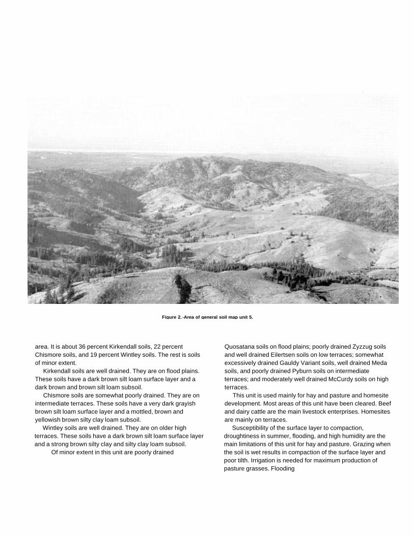
Figure 2. -Area of general soil map unit 5.
area. It is about 36 percent Kirkendall soils, 22 percentChismore soils, and 19 percent Wintley soils. The rest is soilsof minor extent.
Kirkendall soils are well drained. They are on flood plains.These soils have a dark brown silt loam surface layer and adark brown and brown silt loam subsoil.
Chismore soils are somewhat poorly drained. They are onintermediate terraces. These soils have a very dark grayishbrown silt loam surface layer and a mottled, brown andyellowish brown silty clay loam subsoil.
Wintley soils are well drained. They are on older highterraces. These soils have a dark brown silt loam surface layerand a strong brown silty clay and silty clay loam subsoil.
Of minor extent in this unit are poorly drained
Quosatana soils on flood plains; poorly drained Zyzzug soilsand well drained Eilertsen soils on low terraces; somewhatexcessively drained Gauldy Variant soils, well drained Medasoils, and poorly drained Pyburn soils on intermediateterraces; and moderately well drained McCurdy soils on highterraces.
This unit is used mainly for hay and pasture and homesitedevelopment. Most areas of this unit have been cleared. Beefand dairy cattle are the main livestock enterprises. Homesitesare mainly on terraces.
Susceptibility of the surface layer to compaction,droughtiness in summer, flooding, and high humidity are themain limitations of this unit for hay and pasture. Grazing whenthe soil is wet results in compaction of the surface layer andpoor tilth. Irrigation is needed for maximum production ofpasture grasses. Flooding
restricts grazing on flood plains in winter. High humidity andfrequent periods of rainfall prevent the production ofhigh-quality hay.
Wetness and slow permeability are the main limitations ofthis unit for homesite development. Septic tank absorptionfields may not function properly during rainy periods.
Soils on Low Hills
This group consists of four map units. It makes up about27 percent of the survey area.
5. Rinearson-Etelka
Well drained and moderately well drained silty andclayey soils that formed in colluvium and residuumderived from sedimentary rock
This map unit is on low foothills on the west side of theKlamath Mountains (fig. 2). Slopes generally are long andirregular. Areas of Rock outcrop and slumps are common.Elevation ranges from 50 to 1,800 feet. Slopes range from 0 to70 percent. The average annual precipitation is 60 to 85inches, the average annual air temperature is 50 to 54 degreesF, and the frost-free period is 180 to 240 days.
This unit makes up about 5 percent of the survey area. Itis about 72 percent Rinearson soils and 15 percent Etelkasoils. The rest is soils of minor extent.
Rinearson soils are well drained. They are on steep sideslopes and on rounded ridgetops. These soils have a darkreddish brown silt loam surface layer and a reddish brown anddark reddish brown silty clay loam subsoil.
Etelka soils are moderately well drained. They are onridgetops, benches, and low gradient side slopes. These soilshave a dark grayish brown silt loam surface layer. The upperpart of the subsoil is dark brown silty clay loam. and the lowerpart is mottled, olive brown silty clay.
Of minor extent in this unit are deep, well drained, gravellyRemote soils on steep side slopes; deep, well drained Orfordsoils on broad ridgetops; moderately deep, well drained,gravelly Digger soils on steep side slopes: and somewhatpoorly drained Whobrey soils on benches.
This unit is used for timber production, wildlife habitat, andpasture. About 20 percent of the unit has been cleared forpasture. The main livestock enterprises are beef cattle andsheep. The susceptibility of the surface layer to compactionand landslide potential are the main limitations. Grazing whenthe soil
is wet results in compaction of the surface layer. Forageproduction is low in summer because of droughtiness.Livestock facilities should be placed in areas that are notsubject to landslides.
The soils in this unit are suited to trees. Productivity ismoderate. Using wheeled vehicles causes compaction of thesurface layer. Cable yarding systems damage the soil less.Roadcuts may increase the hazard of landsliding and slumpingif road systems are not carefully planned and constructed. Thedominant tree species are Douglas fir, Port Orford cedar,western hemlock, and western redcedar.
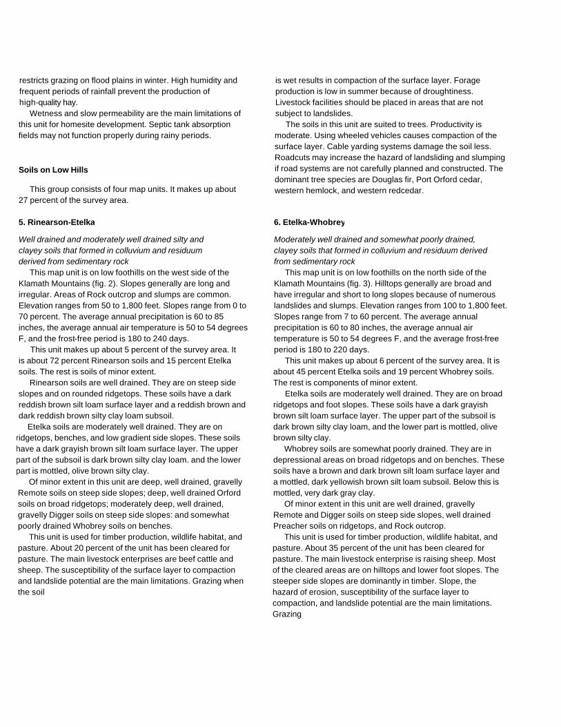
6. Etelka-Whobrey
Moderately well drained and somewhat poorly drained,clayey soils that formed in colluvium and residuum derivedfrom sedimentary rock
This map unit is on low foothills on the north side of theKlamath Mountains (fig. 3). Hilltops generally are broad andhave irregular and short to long slopes because of numerouslandslides and slumps. Elevation ranges from 100 to 1,800 feet.Slopes range from 7 to 60 percent. The average annualprecipitation is 60 to 80 inches, the average annual airtemperature is 50 to 54 degrees F, and the average frost-freeperiod is 180 to 220 days.
This unit makes up about 6 percent of the survey area. It isabout 45 percent Etelka soils and 19 percent Whobrey soils.The rest is components of minor extent.
Etelka soils are moderately well drained. They are on broadridgetops and foot slopes. These soils have a dark grayishbrown silt loam surface layer. The upper part of the subsoil isdark brown silty clay loam, and the lower part is mottled, olivebrown silty clay.
Whobrey soils are somewhat poorly drained. They are indepressional areas on broad ridgetops and on benches. Thesesoils have a brown and dark brown silt loam surface layer anda mottled, dark yellowish brown silt loam subsoil. Below this ismottled, very dark gray clay.
Of minor extent in this unit are well drained, gravellyRemote and Digger soils on steep side slopes, well drainedPreacher soils on ridgetops, and Rock outcrop.
This unit is used for timber production, wildlife habitat, andpasture. About 35 percent of the unit has been cleared forpasture. The main livestock enterprise is raising sheep. Mostof the cleared areas are on hilltops and lower foot slopes. Thesteeper side slopes are dominantly in timber. Slope, thehazard of erosion, susceptibility of the surface layer tocompaction, and landslide potential are the main limitations.Grazing
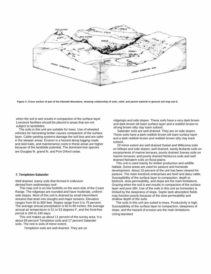
Figure 3. -Cross section of part of the Klamath Mountains, showing relationship of soils, relief, and parent material in general soil map unit 6.
when the soil is wet results in compaction of the surface layer.Livestock facilities should be placed in areas that are notsubject to landslides.
The soils in this unit are suitable for trees. Use of wheeledvehicles for harvesting timber causes compaction of the surfacelayer. Cable yarding systems damage the soil less and are saferin the steeper areas. Erosion is a hazard along logging roadsand skid trails, and maintenance costs in these areas are higherbecause of the landslide potential. The dominant tree speciesare Douglas fir, grand fir, and Port Orford cedar.
7. Templeton-Salander
Well drained, loamy soils that formed in colluviumderived from sedimentary rock
This map unit is on low foothills on the west side of the CoastRange. The ridgetops are rounded and have moderate, uniformside slopes. Most of this unit is drained by small intermittentstreams that drain into sloughs and major streams. Elevationranges from 50 to 800 feet. Slopes range from 0 to 75 percent.The average annual precipitation is 60 to 80 inches, the averageannual air temperature is 51 to 53 degrees F, and the frost-freeperiod is 200 to 240 days.
This unit makes up about 11 percent of the survey area. It isabout 69 percent Templeton soils and 17 percent Salandersoils. The rest is soils of minor extent.
Templeton soils are well drained. They are on
ridgetops and side slopes. These soils have a very dark brownand dark brown silt loam surface layer and a reddish brown tostrong brown silty clay loam subsoil.
Salander soils are well drained. They are on side slopes.These soils have a dark reddish brown silt loam surface layerand a dark reddish brown and reddish brown silty clay loamsubsoil.
Of minor extent are well drained Geisel and Millicoma soilson hilltops and side slopes; well drained, sandy Bullards soils onescarpments of marine terraces; poorly drained Joeney soils onmarine terraces; and poorly drained Nestucca soils and welldrained Nehalem soils on flood plains.
This unit is used mainly for timber production and wildlifehabitat. Some areas are used for pasture and homesitedevelopment. About 10 percent of the unit has been cleared forpasture. The main livestock enterprises are beef and dairy cattle.Susceptibility of the surface layer to compaction, depth tobedrock, slow permeability, and slope are the main limitations.Grazing when the soil is wet results in compaction of the surfacelayer and poor tilth. Use of the soils in this unit as homesites islimited by the steepness of slope. Septic tank absorption fieldsmay function poorly because of the slow permeability andshallow depth of the soils.
The soils in this unit are suited to trees. Productivity is high.Susceptibility of the surface layer to compaction, steepness ofslope, and the hazard of erosion are the main limitations.Using standard

wheeled and tracked equipment causes compaction of thesurface layer. Cable yarding systems damage the soil less andare safer in the steeper areas. Erosion is a hazard alonglogging roads and skid trails. The dominant tree species areDouglas fir, Sitka spruce, western hemlock, and westernredcedar.
8. Honeygrove-Blachly-Dement
Well drained, clayey soils that formed in colluvium andresiduum derived from sedimentary and igneous rock
This map unit is on low rounded foothills on the west side ofthe Coast Range. The hills and ridges are more rounded in thelower lying areas near major drainageways but are steeper andmore irregular in the higher lying areas. Elevation ranges from20 to 1,000 feet. Slopes range from 0 to 70 percent. Theaverage annual precipitation is 55 to 85 inches, the averageannual air temperature is 50 to 53 degrees F, and the frost-freeperiod is 140 to 240 days.
This unit makes up about 5 percent of the survey area. It isabout 33 percent Honeygrove soils, 31 percent Blachly soils,and 31 percent Dement soils. The rest is soils of minor extent.
Honeygrove soils are well drained. They are on broadridgetops and moderate side slopes. These soils have a darkreddish brown silty clay loam surface layer and a subsoil ofdark red and red clay over gravelly clay.
Blachly soils are well drained. They are on broadridgetops and benches. They have a very dusky red siltyclay loam surface layer and a dark red and yellowish redsilty clay and silty clay loam subsoil.
Dement soils are well drained. They are on ridgetops andside slopes. These soils have a very dark grayish brown siltloam surface layer and a reddish brown silty clay loam subsoil.
Of minor extent are extremely gravelly Harrington soils onsteep side slopes, loamy Preacher soils on benches and sideslopes, moderately deep, gravelly Bohannon soils on steepside slopes, and well drained Kirkendall soils on flood plains.
This unit is used mainly for timber production and wildlifehabitat. It is also used for pasture and homesite development.About 20 percent of the unit has been cleared for pasture.Homesites and pasture are mainly on the Dement andHoneygrove soils.
Susceptibility of the surface layer to compaction, slope,and moderately slow permeability are the main limitations.Grazing when the soil is wet results in compaction of thesurface layer and poor tilth.
Steepness of slope limits the installation of septic tankabsorption fields. Absorption fields may not function properlyduring rainy periods because of the moderately slowpermeability of the subsoil.
The soils in this unit are suited to trees. Productivity ismoderately high. Susceptibility of the surface layer tocompaction and the hazard of erosion are the main limitations.Using standard wheeled and tracked equipment causescompaction of the surface layer. Cable yarding systemsdamage the soil less and are safer in the steeper areas.Erosion is a hazard along logging roads and skid trails. Thedominant tree species are Douglas fir, western hemlock,western redcedar, and grand fir.
Soils on Mountains
This group consists of five map units. It makes up about61 percent of the survey area.
9. Milbury-Bohannon-Umpcoos
Moderately deep and shallow, gravelly and loamy soils thatformed in colluvium derived from sedimentary rock
This map unit on is strongly dissected areas of mountains.It has long, uniform slopes and very narrow ridgetops.Benches are present in some areas. Most areas of the unit aredrained by small intermittent streams that have steepgradients. Elevation ranges from 100 to 2,500 feet. Slopesrange from 30 to 80 percent. The average annual precipitationis 60 to 100 inches, the average annual air temperature is 45to 53 degrees F, and the frost-free period is 110 to 200 days.
This unit makes up about 13 percent of the survey area.It is about 40 percent Milbury soils, 27 percent Bohannonsoils, and 22 percent Umpcoos soils. The rest iscomponents of minor extent.
Milbury soils are moderately deep. They are on midslopesand upper side slopes. These soils have a black very gravellysandy loam surface layer and a very dark grayish brown anddark brown very cobbly loam subsoil.
Bohannon soils are moderately deep. They are onconcave midslopes and lower side slopes. These soils have avery dark brown loam surface layer and a dark yellowishbrown gravelly loam subsoil.
Umpcoos soils are shallow. They are on convex side slopesadjacent to areas of Rock outcrop and on narrow ridgetops.These soils have a dark grayish brown very gravelly sandy loamsurface layer and a brown very gravelly sandy loam subsoil.
Of minor extent are deep Preacher and Blachly soils
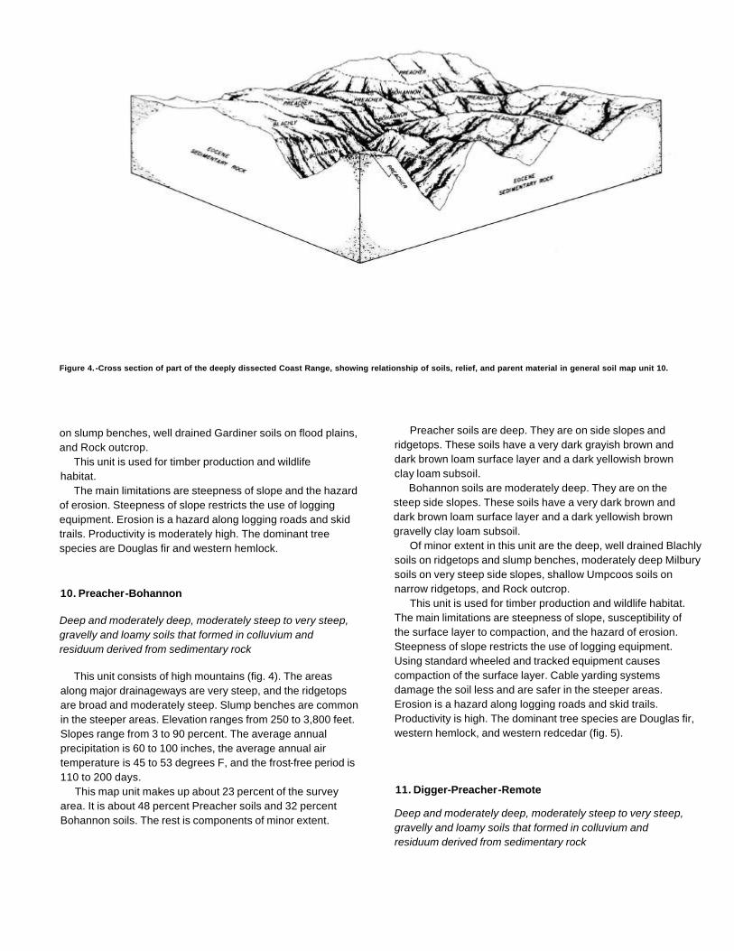
Figure 4. -Cross section of part of the deeply dissected Coast Range, showing relationship of soils, relief, and parent material in general soil map unit 10.
on slump benches, well drained Gardiner soils on flood plains,and Rock outcrop.
This unit is used for timber production and wildlifehabitat.
The main limitations are steepness of slope and the hazardof erosion. Steepness of slope restricts the use of loggingequipment. Erosion is a hazard along logging roads and skidtrails. Productivity is moderately high. The dominant treespecies are Douglas fir and western hemlock.
10. Preacher-Bohannon
Deep and moderately deep, moderately steep to very steep,gravelly and loamy soils that formed in colluvium andresiduum derived from sedimentary rock
This unit consists of high mountains (fig. 4). The areasalong major drainageways are very steep, and the ridgetopsare broad and moderately steep. Slump benches are commonin the steeper areas. Elevation ranges from 250 to 3,800 feet.Slopes range from 3 to 90 percent. The average annualprecipitation is 60 to 100 inches, the average annual airtemperature is 45 to 53 degrees F, and the frost-free period is110 to 200 days.
This map unit makes up about 23 percent of the surveyarea. It is about 48 percent Preacher soils and 32 percentBohannon soils. The rest is components of minor extent.
Preacher soils are deep. They are on side slopes andridgetops. These soils have a very dark grayish brown anddark brown loam surface layer and a dark yellowish brownclay loam subsoil.
Bohannon soils are moderately deep. They are on thesteep side slopes. These soils have a very dark brown anddark brown loam surface layer and a dark yellowish browngravelly clay loam subsoil.
Of minor extent in this unit are the deep, well drained Blachlysoils on ridgetops and slump benches, moderately deep Milburysoils on very steep side slopes, shallow Umpcoos soils onnarrow ridgetops, and Rock outcrop.
This unit is used for timber production and wildlife habitat.The main limitations are steepness of slope, susceptibility ofthe surface layer to compaction, and the hazard of erosion.Steepness of slope restricts the use of logging equipment.Using standard wheeled and tracked equipment causescompaction of the surface layer. Cable yarding systemsdamage the soil less and are safer in the steeper areas.Erosion is a hazard along logging roads and skid trails.Productivity is high. The dominant tree species are Douglas fir,western hemlock, and western redcedar (fig. 5).
11. Digger-Preacher-Remote
Deep and moderately deep, moderately steep to very steep,gravelly and loamy soils that formed in colluvium andresiduum derived from sedimentary rock
This map unit is on high mountains and ridges. The sideslopes are long and uniform, and the ridgetops have shorter,more irregular slopes. Elevation ranges from 200 to 3,600 feet.Slopes range from 12 to 80 percent. The average annualprecipitation ranges from 60 to 100 inches, the average annualair temperature is 45 to 53 degrees F, and the frost-free periodis 110 to 200 days.
This map unit makes up about 16 percent of the surveyarea. It is about 20 percent Digger soils, 20 percentPreacher soils, and 18 percent Remote soils. The rest issoils of minor extent.
Digger soils are moderately deep. The are on the upperside slopes. These soils have a dark brown gravelly .loamsurface layer and a dark yellowish brown and brown verygravelly loam and very cobbly loam subsoil.
Preacher soils are deep. They are on broad ridgetops.These soils have a very dark grayish brown and dark brownloam surface layer and a dark yellowish brown clay loamsubsoil.
Remote soils are deep. They are on the lower side slopesand on some broad ridgetops. These soils have a very darkgrayish brown loam surface layer and a brown to darkyellowish brown gravelly and very gravelly clay loam subsoil.
Of minor extent are well drained, red Blachly soils onridgetops, shallow Umpcoos soils on steep side slopes, andmoderately well drained Etelka soils on broad ridgetops.
This unit is used for timber production and wildlifehabitat. The main limitations are steepness of slope,susceptibility of the surface layer to compaction, andthe hazard of erosion. Steepness of slope restricts the use oflogging equipment. Using standard wheeled and trackedequipment causes compaction of the surface layer. Cableyarding systems damage the soil less and are safer in thesteep areas. Erosion is a hazard along logging roads and skidtrails. Productivity is moderate. The dominant tree species areDouglas fir, western hemlock, western redcedar, and grand fir.
12. Serpentano-Digger
Deep and moderately deep, moderately steep to very steep,gravelly and loamy soils that formed in colluvium andresiduum derived from metamorphic and sedimentary rock
This map unit is on high ridges in the Klamath Mountains.The ridges have long irregular slopes that are moderatelydissected by intermittent streams. The ridgetops are somewhatrounded. Elevation ranges from
1,500 to 3,900 feet. Slopes range from 10 to 90 percent. Theaverage annual precipitation is 90 to 100 inches, the averageannual air temperature is 45 to 53 degrees F, and thefrost-free period is 110 to 180 days.
This map unit makes up about 2 percent of the survey area.It is about 68 percent Serpentano soils and 15 percent Diggersoils. The rest is components of minor extent.
Serpentano soils are deep. They are on ridgetops. Thesesoils have a dark brown very stony loam surface layer and adark brown gravelly loam and very cobbly loam subsoil.
Digger soils are moderately deep. They are on steep sideslopes. These soils have a dark brown gravelly loam surfacelayer and a dark yellowish brown and brown very gravelly loamand very cobbly loam subsoil.
Of minor extent in this unit are deep, gravelly Remote soilson lower side slopes, deep Preacher soils on ridgetops,shallow Umpcoos soils on steep side slopes, and Rockoutcrop.
This unit is used for timber production and wildlifehabitat.
The main limitations are the hazard of erosion andsteepness of slope. Proper design and placement of roads helpto control erosion. Skid trails require water bars or plant cover.Steepness of slope restricts the use of logging equipment insome areas. Productivity is moderately low. The dominant treespecies are Douglas fir and Port Orford cedar.
13. Umpcoos-Rock Outcrop-Digger
Rock outcrop and moderately deep and shallow, very steep,gravelly and loamy soils that formed in colluvium derived fromsedimentary rock
This map unit is on mountains and ridges adjacent to majorstreams and their tributaries. Elevation ranges from 100 to4,300 feet. Slopes range from 50 to 99 percent. The averageannual precipitation is 60 to 100 inches, the average annual airtemperature is 45 to 53 degrees F, and the frost-free period is110 to 200 days.
This unit makes up about 7 percent of the survey area. It isabout 36 percent Umpcoos soils, 29 percent Rock outcrop,and 19 percent Digger soils. The rest is soils of minor extent.
Umpcoos soils are shallow. They are on upper slopesadjacent to areas of Rock outcrop. These soils have a darkgrayish brown very gravelly sandy loam surface layer and abrown very gravelly sandy loam subsoil.
Rock outcrop is mainly exposures of fractured, hardsandstone on ridgetops and steep side slopes along

Figure 5. -Stand of Douglas fir in an area of general soil map unit 10.
drainageways. In some areas the sandstone is fractured tostone-sized fragments, and talus commonly is present in theseareas.
Digger soils are moderately deep. They are on midslopesand lower slopes. These soils have a dark brown gravellyloam surface layer and a dark yellowish brown and brownvery gravelly loam and very cobbly loam subsoil.
Of minor extent in this unit are deep, gravelly
Remote soils on lower slopes and deep Preacher andBlachly soils on slump benches.
This unit is used for timber production and wildlifehabitat.
The main limitations are steepness of slope, the hazard oferosion, and the hazard of windthrow. Steepness of sloperestricts the use of logging equipment. Rock outcrop may causebreakage of timber and hinder yarding. Proper design andlocation of roads

help to control erosion. Productivity is low. Thedominant tree species are Douglas fir, westernredcedar, and grand fir.
Broad Land Use Considerations
Coos County has a wide variety of soils that havepotential for major various land uses. The soils in the countyare used for timber production, pasture, urbanization, andcultivated crops.
Timber is produced on about 82 percent of the survey area.The productivity for Douglas fir is high in areas of general soilon map units 6, 7, 8, 9, and 10 (fig. 5). Productivity is moderatein areas of units 2, 5, and 11 because of low soil fertility and thesusceptibility of unit 2 to severe damage by wind. Productivityis low in areas of units 1, 12, and 13 because of droughtinessand the toxicity of the soils in unit 12. The main limitation fortimber management throughout the survey area is steepness ofslope.
Pasture is grown extensively in areas of map units 3, 4. 5,and 6. Wetness is the main limitation. Hay is grown mainly onunit 4. The main limitation is the high humidity.
About 13,000 acres in the survey area is classified asurban, or built-up, land. Urban development has occurredmainly in areas of map units 2 and 4. Units 5 and 7 have fairsuitability for urban development. The
main limitation is slope. Unit 3 is poorly suited to urbandevelopment because of wetness and the hazard of flooding.The other map units are poorly suited because of steepness ofslope, low soil strength, and wetness.
Although cultivated crops are grown on only a limitednumber of acres in the survey area, they produce a significantpart of the agricultural income. Cranberries, blueberries, andnursery stock are the main crops. Map unit 2 has goodsuitability for cranberries and blueberries, and map unit 4 hasgood suitability for nursery stock. The other map units in thearea have poor suitability because of slope, wetness, and thehazard of flooding.
Potential for wildlife habitat generally is high throughoutthe survey area. Soils in map unit 4 have fair potential foropenland wildlife habitat. The soils on flood plains in units 1and 3 have high potential for wetland wildlife habitat. Thesoils in units 5 through 13 have high potential for woodlandwildlife habitat. The soils in map unit 2 have fair potential forwoodland wildlife habitat.
The suitability for recreation areas ranges from poor togood, depending on the intensity of expected use. Suitability isgood for intensive recreational development, such asplaygrounds and camp areas, on units 1, 2, and 4. Suitability isgood on all units for seasonal recreational activities such ashunting, hiking, and horseback riding.
Detailed Soil Map Units
The map units delineated on the detailed maps at the backof this survey represent the soils or miscellaneous areas in thesurvey area. The map unit descriptions in this section, alongwith the maps, can be used to determine the suitability andpotential of a unit for specific uses. They also can be used toplan the management needed for those uses. More informationon each map unit is given under "Use and Management of theSoils."
Each map unit on the detailed maps represents an areaon the landscape and consists of one or more soils ormiscellaneous areas for which the unit is named.
An identifying symbol precedes the map unit name in themap unit descriptions. Each description includes general factsabout the unit and gives the principal hazards and limitations tobe considered in planning for specific uses.
Soils that have profiles that are almost alike make up a soilseries. Except for differences in texture of the surface layer orof the underlying layers, all the soils of a series have majorhorizons that are similar in composition, thickness, andarrangement.
Soils of one series can differ in texture of the surface layeror of the underlying layers. They also can differ in slope,stoniness, salinity, wetness, degree of erosion, and othercharacteristics that affect their use. On the basis of suchdifferences, a soil series is divided into soil phases. Most of theareas shown on the detailed soil maps are phases of soilseries. The name of a soil phase commonly indicates a featurethat affects use or management. For example, Bandon sandyloam, 0 to 7 percent slopes, is one of several phases in theBandon series.
Some map units are made up of two or more major soilsor miscellaneous areas. These map units are calledcomplexes or associations.
A complex consists of two or more soils or miscellaneousareas in such an intricate pattern or in such small areas thatthey cannot be shown separately on the maps. The patternand proportion of the soils or
miscellaneous areas are somewhat similar in all areas.Waldport-Dune land complex, 12 to 30 percent slopes, is anexample.
An association is made up of two or more geographicallyassociated soils or miscellaneous areas that are shown as oneunit on the maps. Because of present or anticipated uses ofthe map units in the survey area, it was not consideredpractical or necessary to map the soils or miscellaneous areasseparately. The pattern and relative proportion of the soils ormiscellaneous areas are somewhat similar. Preacher-Blachlyassociation, 12 to 30 percent slopes, is an example.
Most map units include small scattered areas of soils ormiscellaneous areas other than those for which the map unit isnamed. Some of these included areas have properties thatdiffer substantially from those of the major soils ormiscellaneous areas. Such differences could significantly affectuse and management of the map unit. The included soils aswell as miscellaneous areas are identified in each map unitdescription. Some small areas of strongly contrasting soils ormiscellaneous areas are identified by a special symbol on themaps.
This survey includes miscellaneous areas. Such areashave little or no soil material and support little or novegetation. Dune land is an example.
Table 4 gives the acreage and proportionate extent of eachmap unit. Other tables (see "Summary of Tables") giveproperties of the soils and the limitations, capabilities, andpotentials for many uses. The Glossary defines many of theterms used in describing the soils or miscellaneous areas.
Map Unit Descriptions
1B-Bandon sandy loam, 0 to 7 percent slopes.This deep, well drained soil is on dissected marine terraces. Itformed in sandy marine deposits. The native vegetation ismainly conifers, shrubs, forbs, and hardwoods. Elevation is 25to 300 feet. The average annual precipitation is 55 to 75 inches,the average
annual air temperature is 51 to 53 degrees F, and theaverage frost-free period is 200 to 240 days.
Typically, the surface is covered with a mat of decomposedorganic litter 1 inch thick. The surface layer is dark grayishbrown sandy loam 5 inches thick. The upper 25 inches of thesubsoil is dark reddish brown sandy loam and loam, and thelower 13 inches is pale brown, cemented, sandy material. Thesubstratum to a depth of 60 inches or more is yellowish brownloam.
Included in this unit are areas of Blacklock andBullards soils. Included areas make up about 20percent of the total acreage.
Permeability of this Bandon soil is moderate above thecemented layer, very slow through it, and moderately rapidbelow it. Available water capacity is about 2 to 6 inches.Effective rooting depth is 18 to 36 inches. Runoff is slow, andthe hazard of water erosion is slight. The hazard of soilblowing is severe.
This unit is used mainly for timber production, wildlifehabitat, and homesite development. It is also used for pastureand recreation.
This unit is suited to the production of Douglas fir. Amongthe other species that grow on this unit are Sitka spruce,western hemlock, red alder, and western redcedar. Theunderstory vegetation is mainly salal, evergreen huckleberry,western brackenfern, and Pacific waxmyrtle.
On the basis of a 100-year site curve, the mean site indexfor Douglas fir is 137. At the culmination of the mean annualincrement (CMAI), the production of 60-year-old Douglas firtrees 1.5 inches in diameter or more at breast height is 140cubic feet per acre per year. On the basis of a 50-year sitecurve, the mean site index for Douglas fir is 105. High windsfrom the Pacific Ocean may seriously limit the growth of treesunless they are in a protected area.
The main limitations for the management of timber on thisunit are the hazard of windthrow and plant competition.Windthrow is a hazard when the soil is wet and winds arestrong. When openings are made in the canopy, invadingbrushy plants can delay natural reforestation. Undesirableplants reduce natural or artificial reforestation unless intensivesite preparation and maintenance are provided. Reforestationcan be accomplished by planting Douglas fir, western hemlock,and Sitka spruce seedlings.
If this unit is used for homesite development, the mainlimitation is the very slow permeability, which limits use ofseptic tank absorption fields. Because of the very slowpermeability of the cemented layer, onsite sewage disposalsystems often fail or do not function
properly during periods of high rainfall. The limitation of veryslow permeability can be overcome by increasing the size ofthe absorption field.
If this unit is used for pasture, the main limitation isdroughtiness in summer. Supplemental irrigation is needed formaximum production. Sprinkler irrigation is a suitable methodof applying water. Use of this method permits the even,controlled application of water. Water should be applied inamounts sufficient to wet the root zone but small enough tominimize the leaching of plant nutrients. Applications of watershould be adjusted to the available water capacity, the waterintake rate, and the crop needs.
Fertilizer is needed to ensure optimum growth of grassesand legumes. Grasses respond to nitrogen, and legumesrespond to sulfur and phosphorus. Proper stocking rates andpasture rotation help to keep the pasture in good condition andto protect the soil from erosion. Periodic mowing and clippinghelp to maintain uniform growth, discourage selective grazing,and reduce clumpy growth.
If this unit is used for recreational development, the mainlimitation is the very slow permeability. The use of recreationalfacilities may be restricted during wet periods unless thecemented layer is ripped to permit more rapid internaldrainage.
This map unit is in capability subclass Ille.
1C--Bandon sandy loam, 7 to 12 percent slopes.This deep, well drained soil is on dissected marine terraces. Itformed in sandy marine deposits. The native vegetation ismainly conifers, shrubs, forbs, and hardwoods. Elevation is 25to 300 feet. The average annual precipitation is 55 to 75inches, the average annual air temperature is 51 to 53 degreesF, and the average frost-free period is 200 to 240 days.
Typically, the surface is covered with a mat of decomposedorganic litter 1 inch thick. The surface layer is dark grayishbrown sandy loam 5 inches thick. The upper 25 inches of thesubsoil is dark reddish brown sandy loam and loam, and thelower 13 inches is pale brown, cemented, sandy material. Thesubstratum to a depth of 60 inches or more is yellowish brownloam.
Included in this unit are small areas of Bullards andBlacklock soils. Included areas make up about 20 percent ofthe total acreage.
Permeability of this Bandon soil is moderate above thecemented layer, very slow through it, and moderately rapidbelow it. Available water capacity is about 2 to 6 inches.Effective rooting depth is 18 to 36 inches. Runoff is medium,and the hazard of water

erosion is moderate. The hazard of soil blowing issevere.
This unit is used mainly for timber production, wildlifehabitat, and homesite development. It is also used for pastureand recreation.
This unit is suited to the production of Douglas fir. Amongthe other species that grow on this unit are Sitka spruce,western hemlock, red alder, and western redcedar. Theunderstory vegetation is mainly salal, evergreen huckleberry,western brackenfern, and Pacific waxmyrtle.
On the basis of a 100-year site curve, the mean site indexfor Douglas fir is 137. At the culmination of the mean annualincrement (CMAI), the production of 60-year-old Douglas firtrees 1.5 inches in diameter or more at breast height is 140cubic feet per acre per year. On the basis of a 50-year sitecurve, the mean site index for Douglas fir is 105. High windsfrom the Pacific Ocean may seriously limit the growth of treesunless they are in a protected area.
The main limitations for the management of timber on thisunit are the hazard of windthrow and plant competition.Windthrow is a hazard when the soil is wet and winds arestrong. When openings are made in the canopy, invadingbrushy plants can delay natural reforestation. Undesirableplants reduce natural or artificial reforestation unless intensivesite preparation and maintenance are provided. Reforestationcan be accomplished by planting Douglas fir, western hemlock,and Sitka spruce seedlings.
If this unit is used for homesite development, the mainlimitations are the very slow permeability and the hazard oferosion. Use of septic tank absorption fields is limited by thevery slow permeability. Because of the very slow permeabilityof the cemented layer, onsite sewage disposal systems oftenfail or do not function properly during periods of high rainfall.The limitation of very slow permeability can be overcome byincreasing the size of the absorption field.
Erosion is a hazard in the steeper areas of this unit. Onlythe part of the site that is used for construction should bedisturbed. The risk of erosion is increased if the soil is leftexposed during site development. Revegetating disturbedareas around construction sites as soon as possible helps tocontrol erosion. Structures to divert runoff are needed ifbuildings and roads are constructed.
If this unit is used for pasture, the main limitation isdroughtiness in summer. Supplemental irrigation is needed formaximum production. Sprinkler irrigation is a suitable method ofapplying water. Use of this method permits the even, controlledapplication of water. Water
should be applied in amounts sufficient to wet the root zonebut in amounts small enough to minimize the leaching of plantnutrients. Applications of water should be adjusted to theavailable water capacity, the water intake rate, and the cropneeds.
Fertilizer is needed to ensure optimum growth of grassesand legumes. Grasses respond to nitrogen, and legumesrespond to sulfur and phosphorus. Proper stocking rates andpasture rotation help to keep the pasture in good condition andto protect the soil from erosion. Periodic mowing and clippinghelp to maintain uniform growth, discourage selective grazing,and reduce clumpy growth.
If this unit is used for recreational development, the mainlimitation is the very slow permeability. The use of recreationalfacilities may be restricted during wet periods unless thecemented layer is ripped to permit more rapid internaldrainage.
This map unit is in capability subclass Ille.
1D-Bandon sandy loam, 12 to 30 percent slopes.This deep, well drained soil is on dissected marine terraces. Itformed in sandy marine deposits. The native vegetation ismainly conifers, shrubs, forbs, and hardwoods. Elevation is 25to 300 feet. The average annual precipitation is 55 to 75 inches,the average annual air temperature is 51 to 53 degrees F, andthe average frost-free period is 200 to 240 days.
Typically, the surface is covered with a mat of decomposedorganic litter 1 inch thick. The surface layer is dark grayishbrown sandy loam 5 inches thick. The upper 25 inches of thesubsoil is dark reddish brown sandy loam and loam, and thelower 13 inches is pale brown, cemented, sandy material. Thesubstratum to a depth of 60 inches or more is yellowish brownloam.
Included in this unit is about 15 percent Bullards soils.Also included are small areas of Blacklock soils. Includedareas make up about 20 percent of the total acreage. Thepercentage varies from one area to another.
Permeability of this Bandon soil is moderate above thecemented layer, very slow through it, and moderately rapidbelow it. Available water capacity is about 2 to 6 inches.Effective rooting depth is 18 to 36 inches. Runoff is medium,and the hazard of water erosion is moderate. The hazard ofsoil blowing is severe.
This unit is used mainly for timber production, wildlifehabitat, and pasture. It is also used for recreation.
This unit is suited to the production of Douglas fir.Among the other species that grow on this unit are

Sitka spruce, western hemlock, red alder, and westernredcedar. The understory vegetation is mainly salal,evergreen huckleberry, western brackenfern, and Pacificwaxmyrtle.
Oh the basis of a 100-year site curve, the mean site indexfor Douglas fir is 137. At thin culmination of the mean annualincrement (CMAI), the production of 60-year-old Douglas firtrees 1.5 inches In diameter or more at breast height is 140cubic feet per acre per year. On the basis of a 50-year sitecurve, the mean site index for Douglas fir is 105. High windsfrom the Pacific Ocean may seriously limit the growth of treesunless they are in a protected area.
The main limitations for the management of timber on thisunit are the hazard of erosion, the hazard of windthrow, andplant competition. Excessive erosion can be avoided bycarefully planning the construction and maintenance of loggingroads, skid trails, and landings, properly designing roaddrainage systems, and carefully placing culverts. Seeding roadcuts and fills to permanent plant cover also reduces the risk oferosion. Windthrow is a hazard when the soil is wet and windsare strong. When openings are made in the canopy, invadingbrushy plants can delay natural reforestation. Undesirableplants reduce natural or artificial reforestation unless intensivesite preparation and maintenance are provided. Reforestationcan be accomplished by planting Douglas fir, western hemlock,and Sitka spruce seedlings.
If this unit is used for pasture, the main limitation isdroughtiness in summer. Supplemental irrigation is needed formaximum production. Sprinkler irrigation can be used in theless sloping areas of the unit. Use of this method permits theeven, controlled application of water, reduces runoff, andminimizes the risk of erosion. Applications of water should beadjusted to the available water capacity, the water intake rate,and the crop needs.
Fertilizer is needed to ensure optimum growth of grassesand legumes. Grasses respond to nitrogen, and legumesrespond to sulfur and phosphorus. Proper stocking rates andpasture rotation help to keep the pasture in good condition andto protect the soil from erosion.
If this unit is used for recreational development, the mainlimitations are slope, the hazard of erosion, and the very slowpermeability. Steepness of slope limits the type of recreationalfacilities that can be developed. The risk of erosion is increasedif the soil is left exposed during site development. Erosion andsedimentation can be controlled and the beauty of the areaenhanced by maintaining adequate plant cover. The use of
recreational facilities may be restricted during wet periodsunless the cemented layer is ripped to permit more rapidinternal drainage.
This map unit is in capability subclass IVe.
2C-Bandon-Blacklock complex, 0 to 12 percent slopes.This map unit is on dissected marine terraces. The nativevegetation is mainly conifers, shrubs, forbs, and hardwoods.Elevation is 25 to 300 feet. The average annual precipitationis 55 to 75 inches, the average annual air temperature is 51to 53 degrees F, and the average frost-free period is 200 to240 days.
This unit is 60 percent Bandon sandy loam and 20 percentBlacklock fine sandy loam. The Bandon soil is in slightly convexareas where slope is 0 to 12 percent, and the Blacklock soil isin scattered depressional areas where slope is 0 to 3 percent.The components of this unit are so intricately intermingled that itwas not practical to map them separately at the scale used.
Included in this unit are small areas of Bullards, Heceta,and Yaquina soils. Included areas make up about 20 percentof the total acreage. The percentage varies from one area toanother.
The Bandon soil is deep and well drained. It formed insandy marine deposits. Typically, the surface is covered with amat of decomposed organic litter 1 inch thick. The surfacelayer is dark grayish brown sandy loam 5 inches thick. Theupper 25 inches of the subsoil is dark reddish brown sandyloam and loam, and the lower 13 inches is pale brown,cemented, sandy material. The substratum to a depth of 60inches or more is yellowish brown loam.
Permeability of the Bandon soil is moderate above thecemented layer, very slow through it, and moderately rapidbelow it. Available water capacity is about 2 to 6 inches.Effective rooting depth is 18 to 36 inches. Runoff is medium,and the hazard of water erosion is moderate. The hazard ofsoil blowing is severe.
The Blacklock soil is deep and poorly drained. It formed insandy marine deposits. Typically, the surface is covered with amat of organic litter 1 inch thick. The surface layer is black andvery dark gray fine sandy loam 9 inches thick. The subsurfacelayer is gray loamy fine sand 4 inches thick. The upper 2 inchesof the subsoil is black mucky loam, and the lower 37 inches ismottled, strong brown to yellowish brown, cemented sand. Thesubstratum to a depth of 75 inches or more is mottled, lightolive brown, red, and brown sand.
Permeability of the Blacklock soil is moderate above thecemented layer, very slow through it, and moderately rapidbelow it. Available water capacity is
about 1.5 to 3.5 inches. Effective rooting depth is 12 to 24inches. Runoff is very slow, and the hazard of water erosion isslight. The water table fluctuates from 6 inches above thesurface to 30 inches below the surface from October to May.
This unit is used mainly for timber production and wildlifehabitat. Areas of the Bandon soil are also used for pasture,recreation, and homesite development.
The Bandon soil is suited to the production of Douglas fir.Among the other species that grow on this soil are Sitkaspruce, western hemlock, red alder, and western redcedar.The understory vegetation is mainly salal, evergreenhuckleberry, western brackenfern, and Pacific waxmyrtle.
The Blacklock soil is suited to the production of shore pine.Among the other species that grow on this soil are Sitka spruce,western hemlock, and Port Orford cedar. The understoryvegetation is mainly salal, evergreen huckleberry, Pacificrhododendron, manzanita, and slough sedge.
On the basis of a 100-year site curve, the mean site indexfor Douglas fir is 137 on the Bandon soil. At the culmination ofthe mean annual increment (CMAI), the production of60-year-old Douglas fir trees 1.5 inches in diameter or more atbreast height is 140 cubic feet per acre per year. On the basisof a 50-year site curve, the mean site index for Douglas fir is105.
On the basis of a 100-year site curve, the mean site indexfor shore pine is 90 on the Blacklock soil. At the culmination ofthe mean annual increment (CMAI), the production of60-year-old shore pine trees 1.5 inches in diameter or more atbreast height is 79 cubic feet per acre per year.
High winds from the Pacific Ocean may seriously limit thegrowth of trees on this unit unless the trees are in a protectedarea.
The main limitations for the management of timber on thisunit are the hazard of windthrow, seasonal wetness on theBlacklock soil, and plant competition on the Bandon soil.Windthrow is a hazard when the soil is wet and winds arestrong. Tree roots are restricted by the cemented layer in thesoils. The seasonal high water table in the Blacklock soil limitsthe use of equipment during wet periods. When openings aremade in the canopy, invading brushy plants can delay naturalreforestation. Undesirable plants reduce natural or artificialreforestation unless intensive site preparation and maintenanceare provided. Reforestation can be accomplished by plantingDouglas fir seedlings on the Bandon soil and shore pineseedlings on the Blacklock soil. Tree seedlings on the Blacklocksoil have only a
moderate rate of survival because of the seasonal high watertable.
If this unit is used for pasture, the main limitations are thedroughtiness of the Bandon soil in summer and the wetness ofthe Blacklock soil. Supplemental irrigation is needed formaximum production on the Bandon soil. Sprinkler irrigation isa suitable method of applying water. Use of this methodpermits the even, controlled application of water. Water shouldbe applied in amounts sufficient to wet the root zone but smallenough to minimize the leaching of plant nutrients.Applications of water should be adjusted to the available watercapacity, the water intake rate, and the crop needs. Drainageis needed for maximum production. Water on or near thesurface can be removed with open ditches or tile drains.Fertilizer is needed to ensure optimum growth of grasses andlegumes. Grasses respond to nitrogen, and legumes respondto sulfur and phosphorus. Proper stocking rates and pasturerotation help to keep the pasture in good condition and toprotect the soil from erosion.
If this unit is used for recreational development, the mainlimitations are the very slow permeability of the Bandon soil andthe wetness and very slow permeability of the Blacklock soil.Water perched above the cemented layer may limit the use ofrecreational facilities to dry periods. Drainage should beprovided for paths and trails. Wetness can be reduced byripping the cemented layer in the Bandon soil and by installingopen ditches or tile drains in the Blacklock soil.
If this unit is used for homesite development, the mainlimitations are the very slow permeability of the soils and thehazard of erosion. Use of septic tank absorption fields islimited by the very slow permeability. Because of the cementedlayer, onsite sewage disposal systems often fail or do notfunction properly during periods of high rainfall. The limitationof very slow permeability may be overcome by increasing thesize of the absorption field.
Erosion is a hazard in the steeper areas. Only the part ofthe site that is used for construction should be disturbed. Therisk of erosion is increased if the soil is left exposed duringsite development. Revegetating disturbed areas aroundconstruction sites as soon as feasible helps to controlerosion. Structures to divert runoff are needed if buildingsand roads are constructed.
This map unit is in capability subclass Vlw.
3-Beaches. Beaches consists of areas of loose sand andshell fragments that have been worked and

reworked by waves, tides, and wind and are still subject to suchaction. Most of these areas are along the shore of the PacificOcean, but small areas are along the estuaries of majorstreams that flow into the ocean. Slope is 1 to 8 percent. Areasof beaches are barren of vegetation. Elevation is 0 to 10 feet.
Typically, areas of Beaches are sand, but gravel may beexposed during storms in winter. A few areas of Beaches at thebase of sea cliffs are covered with rounded cobbles andstones.
Included in this unit are small areas of Waldport andBullards soils and Rock outcrop. Included areas make upabout 15 percent of the total acreage.
This unit is used for recreation activities such as surffishing. beachcombing, and clam digging.
This map unit is in capability subclass Vlllw.
4D-Blachly silty clay loam, 0 to 30 percent slopes. Thisdeep, well drained soil is on broad ridgetops and benches ofmountains. It formed in colluvium derived dominantly fromsedimentary rock or basalt. The native vegetation is mainlyconifers, shrubs, forbs. and hardwoods. Elevation is 250 to2,500 feet. The average annual precipitation is 60 to 100inches, the average annual air temperature is 45 to 53 degreesF, and the average frost-free period is 140 to 220 days.
Typically, the surface layer is very dusky red and darkreddish brown silty clay loam 7 inches thick. The upper 45inches of the subsoil is dark red and yellowish red silty clay,and the lower 8 inches is yellowish red silty clay loam.
Included in this unit are small areas of Dement,Honeygrove, and Preacher soils. Included areas make upabout 20 percent of the total acreage. The percentage variesfrom one area to another.
Permeability of this Blachly soil is moderately slow.Available water capacity is about 7.0 to 8.5 inches. Effectiverooting depth is 60 inches or more. Runoff is medium, andthe hazard of water erosion is moderate.
This unit is used mainly for timber production andwildlife habitat.
This unit is suited to the production of Douglas fir.Among the other species that grow on this unit are westernhemlock, red alder, and bigleaf maple. The understoryvegetation is mainly vine maple, salal, red huckleberry,western swordfern, and oxalis.
On the basis of a 100-year site curve, the mean site indexfor Douglas fir is 160. At the culmination of the mean annualincrement (CMAI), the production of 60-year-old Douglas firtrees 1.5 inches in diameter or more at breast height is 170cubic feet per acre per year. On the basis of a 50-year sitecurve, the mean
site index for Douglas fir is 126.The main limitations for the management of timber on this
unit are the susceptibility of the surface layer to compaction, thehazard of erosion, and plant competition. Using standardwheeled and tracked equipment when the soil is moist causesrutting and compaction. Puddling can occur when the soil iswet. Using low-pressure ground equipment reduces damage tothe soil and helps to maintain productivity.
Proper design of road drainage systems and care in theplacement of culverts help to control erosion. Cut and fill areasare subject to erosion unless treated. Seeding, mulching,benching, and compacting the soil can reduce erosion.Unsurfaced roads and skid trails are sticky when wet or moist,and they may be impassable during rainy periods. Loggingroads require suitable surfacing for year-round use. Rock forroad construction is not readily available in this unit.
When openings are made in the canopy, invadingbrushy plants can delay natural reforestation. Undesirableplants can reduce natural or artificial reforestation unlessintensive site preparation and maintenance are provided.Reforestation can be accomplished by planting Douglas firseedlings.
This map unit is in capability subclass Vle.
4E-Blachly silty clay loam, 30 to 50 percent slopes. Thisdeep, well drained soil is on broad ridgetops and benches ofmountains. It formed in colluvium derived dominantly fromsedimentary rock or basalt. The native vegetation is mainlyconifers, shrubs, forbs, and hardwoods. Elevation is 250 to2,500 feet. The average annual precipitation is 60 to 80 inches,the average annual air temperature is 45 to 53 degrees F, andthe average frost-free period is 140 to 220 days.
Typically, the surface layer is very dusky red and darkreddish brown silty clay loam 7 inches thick. The upper 45inches of the subsoil is dark red and yellowish red silty clay,and the lower 8 inches is yellowish red silty clay loam.
Included in this unit are small areas of Preacher, Dement,Honeygrove, and Remote soils. Included areas make up about20 percent of the total acreage. The percentage varies fromone area to another.
Permeability of this Blachly soil is moderately slow.Available water capacity is about 7.0 to 8.5 inches. Effectiverooting depth is 60 inches or more. Runoff is rapid, and thehazard of water erosion is high.
This unit is used mainly for timber production andwildlife habitat.
This unit is suited to the production of Douglas fir.Among the other species that grow on this unit are

western hemlock, red alder, and bigleaf maple. Theunderstory vegetation is mainly vine maple, salal, redhuckleberry, western swordfern, and oxalis.
On the basis of a 100-year site curve, the mean site indexfor Douglas fir is 160. At the culmination of the mean annualincrement (CMAI), the production of 60-year-old Douglas firtrees 1.5 inches in diameter or more at breast height is 170cubic feet per acre per year. On the basis of a 50-year sitecurve, the mean site index for Douglas fir is 126.
The main limitations for the management of timber on thisunit are the susceptibility of the surface layer to compaction, thehazard of erosion, steepness of slope, and plant competition.The main limitation for the harvesting of timber is steepness ofslope. Using standard wheeled and tracked equipment whenthe soil is moist causes rutting and compaction. Puddling canoccur when the soil is wet. Cable yarding systems are safer,damage the soil less, and help to maintain productivity.
Proper design of road drainage systems and care in theplacement of culverts help to control erosion. Cut and fill areasare subject to erosion unless treated. Seeding, mulching,benching, and compacting the soil can reduce erosion.Unsurfaced roads and skid trails are sticky when wet or moist,and they may be impassable during rainy periods. Rock forroad construction is not readily available in this unit. Materialcast to the side when building roads can damage vegetation. Itis also a potential source of sedimentation. End hauling ofwaste material minimizes damage to the vegetation downslopeand reduces the potential for sedimentation.
When openings are made in the canopy, invadingbrushy plants can delay natural reforestation. Undesirableplants reduce natural or artificial reforestation unlessintensive site preparation and maintenance are provided.Reforestation can be accomplished by planting Douglas firseedlings.
This map unit is in capability subclass Vle.
5A-Blacklock fine sandy loam, 0 to 3 percent slopes.This deep, poorly drained soil is in depressional areas ofmarine terraces. It formed in sandy marine deposits. The nativevegetation is mainly conifers, shrubs, forbs, and sedges.Elevation is 25 to 350 feet. The average annual precipitation is55 to 75 inches, the average annual air temperature is 51 to 53degrees F, and the average frost-free period is 200 to 240days.
Typically, the surface is covered with a mat o' organic litter 1 inch thick. The surface layer is black and very darkgray fine sandy loam and loamy fine sand 9
inches thick. The subsurface layer is gray loamy fine sand 4inches thick. The upper 2 inches of the subsoil is blackmucky loam, and the lower 37 inches is mottled, strongbrown to yellowish brown, cemented sand. The substratum toa depth of 75 inches or more is mottled, light olive brown,red, and brown sand (fig. 6).
Included in this unit are small areas of Bandon and Bullardssoils. Also included are small areas of soils that are similar tothis Blacklock soil but do not have a cemented layer and havea clayey substratum. Included areas make up about 25 percentof the total acreage. The percentage varies from one area toanother.
Permeability of this Blacklock soil is moderate above thecemented layer, very slow through it, and moderately rapidbelow it. Available water capacity is about 1.5 to 3.5 inches.Effective rooting depth is 12 to 24 inches. Runoff is very slow,and the hazard of water erosion is slight. The water tablefluctuates from 6 inches above the surface to 30 inches belowthe surface from October to May.
This unit is used mainly for timber production and wildlifehabitat. It is also used for cranberry production andrecreation.
This unit is suited to the production of shore pine. Amongthe other species grown on the soil in this unit are Sitkaspruce, western hemlock, and Port Orford cedar. Theunderstory vegetation is mainly salal, evergreen huckleberry,Pacific rhododendron, manzanita, and slough sedge.
On the basis of a 100-year site curve, the mean site indexfor shore pine is 90. At the culmination of the mean annualincrement (CMAI), the production of 60-year-old shore pinetrees 1.5 inches in diameter or more at breast height is 79cubic feet per acre per year. High winds from the Pacific Oceanmay seriously limit the growth of trees unless they are in aprotected area.
The main limitations for the management of timber on thisunit are seasonal wetness and the hazard of windthrow. Theseasonal high water table limits the use of equipment to dryperiods. Because roots are restricted by the cemented layer,trees commonly are subject to windthrow.
Reforestation can be accomplished by planting shore pine,Sitka spruce, and western hemlock. Tree seedlings have only amoderate rate of survival because of the seasonal high watertable.
Irrigation and drainage are needed if the soil in this unit isintensively managed for cranberry production. Fields areprepared by removing the soil material above the cementedlayer and replacing it with about 10 inches of sandy soilmaterial. The top of the cemented

Figure 6. -Typical profile of Blacklock fine sandy loam, 0 to 3 percent
slopes, showing cemented subsoil.
layer should be graded toward the edge of the field toprovide internal drainage. Open ditches and dikes areneeded around the edge of fields to provide drainage and tocontrol the water level; however, open ditches should notextend into the cemented layer.
Sprinkler irrigation is an efficient method of applying
water during the dry period in summer. Sprinklers can also beused to control the temperature during summer, to prevent frostdamage during winter, and to apply fertilizer, pesticides, andherbicides.
The very slow permeability of the cemented layer facilitateswater management by preventing excessive seepage andreduces losses of fertilizer and soil amendments. Excessseepage may occur in the sandy substratum. Yields varygreatly depending on the management practices used.
If this unit is used for recreational development, the mainlimitations are wetness and the very slow permeability. Waterperched above the cemented layer may limit the use ofrecreational facilities to 3 or 4 months during the dry period.Drainage should be provided for paths and trails. Septic tankabsorption fields do not function properly because of theseasonal high water table and the cemented layer. If sanitaryfacilities are constructed on this unit, holding tanks or effluenttreatment systems should be used.
This map unit is in capability subclass Vlw.
5B-Blacklock fine sandy loam, 3 to 7 percent slopes.This deep, poorly drained soil is in depressional areas onmarine terraces. It formed in sandy marine deposits. The nativevegetation is mainly conifers, shrubs, forbs, and sedges.Elevation is 25 to 350 feet. The average annual precipitation is55 to 75 inches, the average annual air temperature is 51 to 53degrees F, and the average frost-free period is 200 to 240 days.
Typically, the surface is covered with a mat of organic litter 1inch thick. The surface layer is black and very dark gray finesandy loam 9 inches thick. The subsurface layer is gray finesandy loam 4 inches thick. The upper 2 inches of the subsoil isblack mucky loam, and the lower 37 inches is mottled, strongbrown to yellowish brown, cemented sand. The substratum to adepth of 75 inches or more is mottled, light olive brown sand.
Included in this unit are small areas of Bandon, Bullards,and Heceta soils. Included areas make up about 25 percentof the total acreage. The percentage varies from one area toanother.
Permeability of this Blacklock soil is moderate above thecemented layer, very slow through it, and moderately rapidbelow it. Available water capacity is about 1.5 to 3.5 inches.Effective rooting depth is 12 to 24 inches. Runoff is very slow,and the hazard of water erosion is slight. The water tablefluctuates from 6 inches above the surface to 30 inches belowthe surface from October to May.
This unit is used mainly for timber production and

wildlife habitat. It is also used for cranberry production andrecreation.
This unit is suited to the production of shore pine. Amongthe other species that grow on this unit are Sitka spruce,western hemlock, and Port Orford cedar. The understoryvegetation is mainly salal, evergreen huckleberry, Pacificrhododendron, manzanita, and slough sedge.
On the basis of a 100-year site curve, the mean site indexfor shore pine is 90. At the culmination of the mean annualincrement (CMAI), the production of 60-year-old shore pinetrees 1.5 inches in diameter or more at breast height is 79cubic feet per acre per year. High winds from the Pacific Oceanmay seriously limit the growth of trees unless they are in aprotected area.
The main limitations for the management of timber on thisunit are seasonal wetness and the hazard of windthrow. Theseasonal high water table limits the use of equipment to dryperiods. Because roots are restricted by the cemented layer,trees commonly are subject to windthrow.
Reforestation can be accomplished by planting shore pine.Sitka spruce, and western hemlock seedlings. Tree seedlingshave only a moderate rate of survival because of the seasonalhigh water table.
Irrigation and drainage are needed if the soil in this unit isintensively managed for cranberry production. Fields areprepared by removing the soil material above the cementedlayer and replacing it with about 10 inches of sandy soilmaterial. The top of the cemented layer should be gradedtoward the edge of the field to provide internal drainage. Openditches and dikes are needed around the edge of fields toprovide drainage and to control the water level; however, openditches should not extend into the cemented layer.
Sprinkler irrigation is an efficient method of applying waterduring the dry period in summer. Sprinklers can also be usedto control the temperature in summer, to prevent frostdamage during winter, and to apply fertilizer, pesticides, andherbicides.
The very slow permeability of the cemented layerfacilitates water management by preventing excessiveseepage and reduces losses of fertilizer and soilamendments. Excessive seepage may occur in the sandysubstratum. Yields vary greatly depending on
management practices used. Because of the steepness ofslope, deep cuts and fills may be necessary to provide levelfields. Excessive seepage may occur if cuts are made belowthe cemented layer.
If this unit is used for recreational development, the mainlimitations are wetness and the very slow permeability. Waterperched above the cemented layer
may limit the use of recreational facilities to 3 or 4 monthsduring the dry period. Drainage should be provided for pathsand trails. Septic tank absorption fields do not functionproperly because of the seasonal high water table and thecemented layer. If sanitary facilities are constructed on thisunit, holding tanks or effluent treatment systems should beused.
This map unit is in capability subclass Vlw.
6E-Bohannon-Milbury complex, 30 to 50 percent slopes.This map unit is on side slopes and ridgetops of mountains.The native vegetation is mainly conifers, shrubs, forbs, andhardwoods. Elevation is 100 to 1,400 feet. The average annualprecipitation is 60 to 80 inches, the average annual airtemperature is 49 to 53 degrees F, and the average frost-freeperiod is 140 to 200 days.
This unit is 60 percent Bohannon gravelly loam and 25percent Milbury very gravelly sandy loam. The Bohannon soilis on side slopes and ridgetops, and the Milbury soil is on sideslopes. The components of this unit are so intricatelyintermingled that it was not practical to map them separately atthe scale used.
Included in this unit are small areas of Preacher andRemote soils. Also included are small areas of deep, welldrained soils that have a reddish brown silty clay loam subsoil.Included areas make up about 15 percent of the total acreage.The percentage varies from one area to another.
The Bohannon soil is moderately deep and well drained. Itformed in colluvium derived dominantly from arkosicsandstone and siltstone. Typically, the surface layer is verydark brown and dark brown gravelly loam 11 inches thick. Thesubsoil is dark yellowish brown gravelly loam 20 inches thick.Weathered, fractured sandstone is at a depth of 31 inches.
Permeability of this Bohannon soil is moderately rapid.Available water capacity is about 2.5 to 6.5 inches. Effectiverooting depth is 20 to 40 inches. Runoff is rapid, and thehazard of water erosion is high.
The Milbury soil is moderately deep and well drained. Itformed in colluvium derived dominantly from sandstone.Typically, the surface is covered with a mat of undecomposedneedles, leaves, and twigs 1 inch thick. The surface layer isblack very gravelly sandy loam 10 inches thick. The subsoil isvery dark grayish brown and dark brown very cobbly loam 26inches thick. Hard, consolidated sandstone is at a depth of 36inches.
Permeability of this Milbury soil is moderately rapid.Available water capacity is about 2.0 to 5.5 inches. Effectiverooting depth is 20 to 40 inches. Runoff is
rapid, and the hazard of water erosion is high.This unit is used mainly for timber production and
wildlife habitat.This unit is suited to the production of Douglas fir. Among
the other species that grow on this unit are western hemlock,red alder, and bigleaf maple. The understory vegetation ismainly creambush oceanspray, salmonberry, vine maple, salal,western swordfern, and cascade Oregon-grape.
On the basis of a 100-year site curve, the mean site indexfor Douglas fir is 154 on the Bohannon soil. At the culminationof the mean annual increment (CMAI), the production of60-year-old Douglas fir trees 1.5 inches in diameter or more atbreast height is 163 cubic feet per acre per year. On the basisof a 50-year site curve, the mean site index for Douglas fir is122.
On the basis of a 100-year site curve, the mean site indexfor Douglas fir is 165 on the Milbury soil. At the culmination ofthe mean annual increment (CMAI), the production of60-year-old Douglas fir trees 1.5 inches in diameter or more atbreast height is 176 cubic feet per acre per year. On the basisof a 50-year site curve, the mean site index for Douglas fir is119.
The main limitations for the management of timber on thisunit are the susceptibility of the surface layer of the Bohannonsoil to compaction, the hazard of erosion, steepness of slope,the hazard of windthrow, and plant competition. The mainlimitation for the harvesting of timber is steepness of slope.Using standard wheeled and tracked equipment when the soil ismoist causes rutting and compaction. Puddling can occur whenthe soil is wet. Cable yarding systems are safer, damage thesoil less, and help to maintain productivity.
Proper design of road drainage systems and care in theplacement of culverts help to control erosion. Cut and fill areasare subject to erosion unless treated. Seeding, mulching,benching, and compacting the soil can reduce erosion.Unsurfaced roads and skid trails are soft when wet or moist,and they may be impassable during rainy periods. Loggingroads require suitable surfacing for year-round use. Steepyarding paths, skid trails, and firebreaks are subject to rillingand gullying unless they are provided with adequate water barsor are protected by plant cover, or both. Road location andmaintenance costs are greater in the more steeply slopingareas. Material cast to the side when building roads candamage vegetation. It is also a potential source ofsedimentation. End hauling of waste material minimizesdamage to the vegetation downslope and reduces the potentialfor sedimentation. Windthrow is a hazard when the soil is wetand winds are strong.
When openings are made in the canopy, invading
brushy plants can delay natural reforestation. Reforestation islimited by the droughtiness of the soil. Reforestation can beaccomplished by planting Douglas fir seedlings.
This map unit is in capability subclass Vle.
7-Brallier mucky peat. This deep, very poorly drained soilis on coastal terraces and flood plains along major coastalstreams. It formed in partially decomposed fibrous organicresidue derived dominantly from water-tolerant plants. Slope is0 to 1 percent. The native vegetation is mainly forbs, shrubs,and grasses. Elevation is 5 to 20 feet. The average annualprecipitation is 55 to 80 inches, the average annual airtemperature is 51 to 53 degrees F, and the average frost-freeperiod is 200 to 240 days.
Typically, the surface tier is dark reddish brown, partiallydecomposed organic material 24 inches thick. The subsurfacetier is dark reddish brown, decomposed organic material 21inches thick. The underlying material to a depth of 60 inches ormore is dark yellowish brown, decomposed organic material.
Included in this unit are small areas of Coquille, Langlois,and Chetco soils. Also included are small areas of organic soilsthat have mineral layers between depths of 36 and 51 inchesand areas of Brallier soils at elevations of 20 to 40 feet that arenot subject to flooding during high tides. Included areas makeup about 30 percent of the total acreage. The percentage variesfrom one area to another.
Permeability of this Brallier soil is moderate. Available watercapacity is about 18 to 24 inches. Effective rooting depth is 60inches or more. Runoff is ponded, and the hazard of watererosion is slight. This soil is subject to frequent periods offlooding during high tides. The water table fluctuates from 12inches above the surface to 24 inches below the surfacethroughout the year.
This unit is used for wildlife habitat.This map unit is in capability subclass Vw.
8B-Bullards sandy loam, 0 to 7 percent slopes.This deep, well drained soil is on dissected marine terraces. Itformed in mixed eolian and marine deposits. The nativevegetation is mainly conifers, shrubs, forbs, and hardwoods.Elevation is 50 to 600 feet. The average annual precipitation is55 to 75 inches, the average annual air temperature is 51 to 53degrees F, and the average frost-free period is 200 to 240days.
Typically, the surface is covered with a mat ofundecomposed organic matter 3 inches thick. The surfacelayer is very dark grayish brown sandy loam 7

inches thick. The subsoil is dark reddish brown, dark brown,and strong brown gravelly sandy loam 34 inches thick. Thesubstratum to a depth of 60 inches or more is yellowish brownsand.
Included in this unit are small areas of Blacklock andBandon soils. Also included are small areas of Templetonsoils. Included areas make up about 25 percent of the totalacreage.
Permeability of this Bullards soil is moderate. Availablewater capacity is about 4.0 to 5.5 inches. Effective rootingdepth is 60 inches or more. Runoff is slow, and the hazard ofwater erosion is slight. The hazard of soil blowing is severe.
This unit is used mainly for timber production, wildlifehabitat, and homesite development. It is also used for pastureand recreation.
This unit is suited to the production of Douglas fir. Amongthe other species that grow on this unit are Sitka spruce,western hemlock, western redcedar, shore pine, and red alder.The understory vegetation is mainly evergreen huckleberry,creambush oceanspray, salal, Pacific rhododendron, cascara,and western swordfern.
On the basis of a 100-year site curve, the mean site indexfor Douglas fir is 132. At the culmination of the mean annualincrement (CMAI), the production of 60-year-old Douglas firtrees 1.5 inches in diameter or more at breast height is 133cubic feet per acre per year. On the basis of a 50-year sitecurve, the mean site index for Douglas fir is 105.
The main limitations for the management of timber on thisunit are the hazard of windthrow and plant competition. Carefuluse of wheeled and tracked equipment reduces the disturbanceof the protective layer of duff. Maintaining the understory isessential in controlling erosion. Logging roads require suitablesurfacing for year-round use. Rock for road construction is notreadily available in this unit.
Windthrow is a hazard when the soil is wet and winds arestrong. When openings are made in the canopy, invadingbrushy plants can delay natural reforestation. Undesirableplants reduce natural or artificial reforestation unless intensivesite preparation and maintenance are provided. Reforestationcan be accomplished by planting Douglas fir, Sitka spruce, andwestern hemlock seedlings.
If this unit is used for homesite development, the mainlimitation is droughtiness in summer. In summer, irrigation isneeded for lawn grasses, shrubs, vines, shade trees, andornamental trees.
If this unit is used for pasture, the main limitation isdroughtiness in summer. Supplemental irrigation is needed formaximum production. Sprinkler irrigation is a
suitable method of applying water. Use of this method permitsthe even, controlled application of water. Water should beapplied in amounts sufficient to wet the root zone but smallenough to minimize the leaching of plant nutrients. Applicationsof water should be adjusted to the available water capacity, thewater intake rate, and the crop needs.
Fertilizer is needed to ensure optimum growth of grassesand legumes. Grasses respond to nitrogen, and legumesrespond to sulfur and phosphorus. Proper stocking rates andpasture rotation help to keep the pasture in good condition andto protect the soil from erosion. Periodic mowing and clippinghelp to maintain uniform growth, discourage selective grazing,and reduce clumpy growth.
This unit is well suited to recreational development. It hasfew limitations.
This map unit is in capability subclass Ille.
8C-Bullards sandy loam, 7 to 12 percent slopes.This deep, well drained soil is on dissected marine terraces. Itformed in mixed eolian and marine deposits. The nativevegetation is mainly conifers, shrubs, forbs, and hardwoods.Elevation is 50 to 600 feet. The average annual precipitation is55 to 75 inches, the average annual air temperature is 51 to 53degrees F, and the average frost-free period is 200 to 240days.
Typically, the surface is covered with a mat ofundecomposed organic matter 3 inches thick. The surface layeris very dark grayish brown sandy loam 7 inches thick. Thesubsoil is dark reddish brown, dark brown, and strong browngravelly sandy loam 34 inches thick. The substratum to a depthof 60 inches or more is yellowish brown sand.
Included in this unit are small areas of Bandon andTempleton soils. Also included are small areas of Blacklocksoils. Included areas make up about 25 percent of the totalacreage.
Permeability of this Bullards soil is moderate. Availablewater capacity is about 4.0 to 5.5 inches. Effective rootingdepth is 60 inches or more. Runoff is medium, and the hazardof water erosion is moderate. The hazard of soil blowing issevere.
This unit is used mainly for timber production, wildlifehabitat, and homesite development. It is also used for pastureand recreation.
This unit is suited to the production of Douglas fir. Among theother species that grow on this unit are Sitka spruce, westernhemlock, western redcedar, shore pine, and red alder. Theunderstory vegetation is mainly evergreen huckleberry,creambush oceanspray, salal, Pacific rhododendron, cascara,and western swordfern.

On the basis of a 100-year site curve, the mean site indexfor Douglas fir is 132. At the culmination of the mean annualincrement (CMAI), the production of 60-year-old Douglas firtrees 1.5 inches in diameter or more at breast height is 133cubic feet per acre per year. On the basis of a 50-year sitecurve, the mean site index for Douglas fir is 105.
The main limitations for the management of timber on thisunit are the hazard of windthrow and plant competition. Carefuluse of wheeled and tracked equipment reduces the disturbanceof the protective layer of duff.
Proper design of road drainage systems and care in theplacement of culverts help to control erosion. Logging roadsrequire suitable surfacing for year-round use. Rock for roadconstruction is not readily available in this unit.
Windthrow is a hazard when the soil is wet and winds arestrong. When openings are made in the canopy, invadingbrushy plants can delay natural reforestation. Undesirableplants reduce natural or artificial reforestation unless intensivesite preparation and maintenance are provided. Reforestationcan be accomplished by planting Douglas fir, Sitka spruce, andwestern hemlock seedlings.
If this unit is used for homesite development, the mainlimitations are slope and droughtiness in summer. Absorptionlines should be installed on the contour. In summer, irrigationis needed for lawn grasses, shrubs, vines, shade trees, andornamental trees.
If this unit is used for pasture, the main limitation isdroughtiness in summer. Supplemental irrigation is needed formaximum production. Sprinkler irrigation is a suitable method ofapplying water. Use of this method permits the even, controlledapplication of water. Water should be applied in amountssufficient to wet the root zone but small enough to minimize theleaching of plant nutrients. Applications of water should beadjusted to the available water capacity, the water intake rate,and the crop needs.
Fertilizer is needed to ensure optimum growth of grassesand legumes. Grasses respond to nitrogen, and legumesrespond to sulfur and phosphorus. Proper stocking rates andpasture rotation help to keep the pasture in good condition andto protect the soil from erosion. Periodic mowing and clippinghelp to maintain uniform growth, discourage selective grazing,and reduce clumpy growth.
If this unit is used for recreational development, the mainlimitation is steepness of slope. Slope may restrict some kindsof activities and increase the cost of constructing facilities.
This map unit is in capability subclass Ille.
8D-Bullards sandy loam, 12 to 30 percent slopes.This deep, well drained soil is on dissected marine terraces. Itformed in mixed eolian and marine deposits. The nativevegetation is mainly conifers, shrubs, forbs, and hardwoods.Elevation is 50 to 600 feet. The average annual precipitation is55 to 75 inches, the average annual air temperature is 51 to 53degrees F, and the average frost-free period is 200 to 240days.
Typically, the surface is covered with a mat ofundecomposed organic matter 3 inches thick. The surface layeris very dark grayish brown sandy loam 7 inches thick. Thesubsoil is dark reddish brown, dark brown, and strong browngravelly sandy loam 34 inches thick. The substratum to a depthof 60 inches or more is yellowish brown sand (fig. 7).
Included in this unit are small areas of Bandon andTempleton soils. Also included are small areas of Blacklocksoils in depressional areas. Included areas make up about25 percent of the total acreage.
Permeability of this Bullards soil is moderate. Availablewater capacity is about 4.0 to 5.5 inches. Effective rootingdepth is 60 inches or more. Runoff is medium, and thehazard of water erosion is moderate. The hazard of soilblowing is severe.
This unit is used mainly for timber production, wildlifehabitat, and pasture. It is also used for recreation.
This unit is suited to the production of Douglas fir. Amongthe other species that grow on this unit are Sitka spruce,western hemlock, western redcedar, shore pine, and red alder.The understory vegetation is mainly evergreen huckleberry,creambush oceanspray, salal, Pacific rhododendron, cascara,and western swordfern.
On the basis of a 100-year site curve, the mean site indexfor Douglas fir is 132. At the culmination of the mean annualincrement (CMAI), the production of 60-year-old Douglas firtrees 1.5 inches in diameter or more at breast height is 133cubic feet per acre per year. On the basis of a 50-year sitecurve, the mean site index for Douglas fir is 105.
The main limitations for the management of timber on thisunit are the hazard of erosion, the hazard of windthrow, andplant competition. Careful use of wheeled and trackedequipment reduces the disturbance of the protective layer ofduff. Steep yarding paths, skid trails, and firebreaks are subjectto rilling and gullying unless they are provided with adequatewater bars or are protected by plant cover, or both. Properdesign of road drainage systems and care in the placement ofculverts help to control erosion. Logging roads require suitablesurfacing for year-round use.
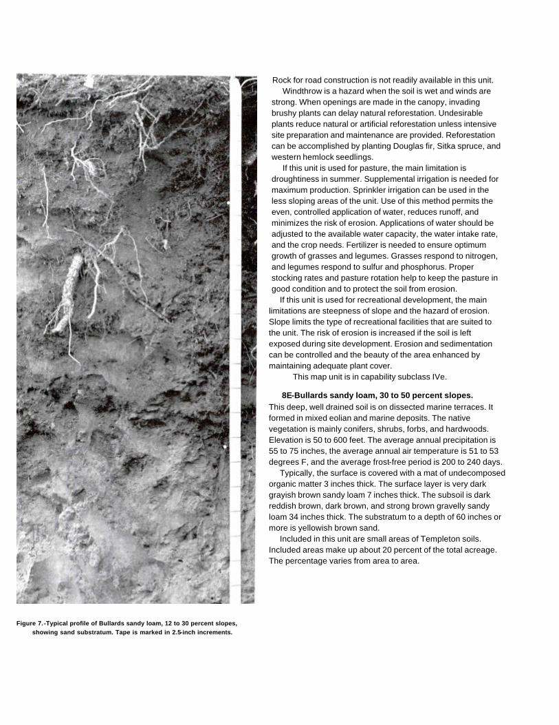
Figure 7. -Typical profile of Bullards sandy loam, 12 to 30 percent slopes,showing sand substratum. Tape is marked in 2.5-inch increments.
Rock for road construction is not readily available in this unit.Windthrow is a hazard when the soil is wet and winds are
strong. When openings are made in the canopy, invadingbrushy plants can delay natural reforestation. Undesirableplants reduce natural or artificial reforestation unless intensivesite preparation and maintenance are provided. Reforestationcan be accomplished by planting Douglas fir, Sitka spruce, andwestern hemlock seedlings.
If this unit is used for pasture, the main limitation isdroughtiness in summer. Supplemental irrigation is needed formaximum production. Sprinkler irrigation can be used in theless sloping areas of the unit. Use of this method permits theeven, controlled application of water, reduces runoff, andminimizes the risk of erosion. Applications of water should beadjusted to the available water capacity, the water intake rate,and the crop needs. Fertilizer is needed to ensure optimumgrowth of grasses and legumes. Grasses respond to nitrogen,and legumes respond to sulfur and phosphorus. Properstocking rates and pasture rotation help to keep the pasture ingood condition and to protect the soil from erosion.
If this unit is used for recreational development, the mainlimitations are steepness of slope and the hazard of erosion.Slope limits the type of recreational facilities that are suited tothe unit. The risk of erosion is increased if the soil is leftexposed during site development. Erosion and sedimentationcan be controlled and the beauty of the area enhanced bymaintaining adequate plant cover.
This map unit is in capability subclass IVe.
8E-Bullards sandy loam, 30 to 50 percent slopes.This deep, well drained soil is on dissected marine terraces. Itformed in mixed eolian and marine deposits. The nativevegetation is mainly conifers, shrubs, forbs, and hardwoods.Elevation is 50 to 600 feet. The average annual precipitation is55 to 75 inches, the average annual air temperature is 51 to 53degrees F, and the average frost-free period is 200 to 240 days.
Typically, the surface is covered with a mat of undecomposedorganic matter 3 inches thick. The surface layer is very darkgrayish brown sandy loam 7 inches thick. The subsoil is darkreddish brown, dark brown, and strong brown gravelly sandyloam 34 inches thick. The substratum to a depth of 60 inches ormore is yellowish brown sand.
Included in this unit are small areas of Templeton soils.Included areas make up about 20 percent of the total acreage.The percentage varies from area to area.

Permeability of this Bullards soil is moderate. Availablewater capacity is about 4.0 to 5.5 inches. Effective rootingdepth is 60 inches or more. Runoff is rapid, and the hazard ofwater erosion is high. The hazard of soil blowing is severe.
This unit is used mainly for timber production andwildlife habitat. It is also used for recreation.
This unit is suited to the production of Douglas fir. Amongthe other species that grow on this unit are Sitka spruce,western hemlock, western redcedar, shore pine, and red alder.The understory vegetation is mainly evergreen huckleberry,creambush oceanspray, salal, Pacific rhododendron, cascara,and western swordfern.
On the basis of a 100-year site. curve, the mean site indexfor Douglas fir is 132. At the culmination of the mean annualincrement (CMAI), the production of 60-year-old Douglas firtrees 1.5 inches in diameter or more at breast height is 133cubic feet per acre per year. On the basis of a 50-year sitecurve, the mean site index for Douglas fir is 105. High windsfrom the Pacific Ocean may seriously limit the growth of treesunless they are in a protected area.
The main limitations for the management of timber on thisunit are steepness of slope, the hazard of erosion, the hazard ofwindthrow, and plant competition. Careful use of wheeled andtracked equipment reduces the disturbance of the protectivelayer of duff. Highlead or other logging systems that fully orpartially suspend logs damage the soil less and generally areless costly than tractor systems.
Proper design of road drainage systems and care in theplacement of culverts help to control erosion. Cut and fill areasare subject to erosion unless treated. Seeding, mulching,benching, and compacting the soil can reduce erosion. Loggingroads require suitable surfacing for year-round use. Rock forroad construction is not readily available in this unit. Steepyarding paths, skid trails, and firebreaks are subject to rillingand gullying unless they are provided with adequate water barsor are protected by plant cover, or both.
Windthrow is a hazard when the soil is wet and winds arestrong. When openings are made in the canopy, invadingbrushy plants can delay natural reforestation. Undesirableplants reduce natural or artificial reforestation unless intensivesite preparation and maintenance are provided. Reforestationcan be accomplished by planting Douglas fir, Sitka spruce, andwestern hemlock seedlings.
If this unit is used for recreational development, the mainlimitations are slope and the hazard of erosion. Slope limits theuse of areas of this unit mainly to a few paths and trails, whichshould extend across the slope.
The risk of erosion is increased if the soil is left exposedduring site development. Revegetating disturbed areasaround construction sites as soon as feasible helps tocontrol erosion.
This map unit is in capability subclass Vle.
9-Chetco silty clay loam. This deep, very poorly drainedsoil is on flood plains and deltas. It formed in alluvium. Slope is0 to 3 percent. The native vegetation is mainly conifers,shrubs, forbs, and hardwoods. Elevation is 0 to 40 feet. Theaverage annual precipitation is 60 to 80 inches, the averageannual air temperature is 51 to 53 degrees F, and the averagefrost-free period is 200 to 240 days.
Typically, the surface layer is very dark grayish brown siltyclay loam 10 inches thick. The subsoil is mottled, dark graysilty clay 14 inches thick. The substratum to a depth of 60inches or more is mottled, dark gray clay.
Included in this unit are small areas of Coquille andNestucca soils. Also included are small areas of Langloissoils. Included areas make up about 25 percent of the totalacreage.
Permeability of this Chetco soil is very slow. Available watercapacity is about 5.0 to 8.5 inches. Effective rooting depth is 60inches or more for water-tolerant plants, but it is limited by thewater table for non-water-tolerant plants. Runoff is very slow,and the hazard of water erosion is slight. This soil is subject tofrequent periods of flooding during prolonged periods of rainfall.Channeling and deposition are common along streambanks.The water table fluctuates between the surface and a depth of18 inches in October to May.
This unit is used mainly for hay and pasture andwildlife habitat.
The, vegetation in areas not cultivated is mainly Sitkaspruce, western redcedar, western hemlock, and red alder.The understory vegetation is mainly western swordfern,evergreen huckleberry, slough sedge, soft rush, andskunkcabbage.
If this unit is used for hay and pasture, the main limitationsare the susceptibility of the surface layer to compaction,wetness, droughtiness in summer, the hazard of flooding, and,for the curing of hay, high humidity. Grazing when the soil ismoist results in compaction of the surface layer and poor tilth.Compaction limits the movement of air and water in the soiland restricts the growth of roots; it can seriously reduce theproductivity of the soil. Grazing should be delayed until the soilhas drained sufficiently and is firm enough to withstandtrampling by livestock.
Drainage and irrigation are needed for maximum
production of crops. Water on or near the surface can beremoved by use of open ditches and tide gates.Supplemental irrigation is needed in summer.
Wetness and flooding restrict grazing in winter. Protectionfrom flooding during the growing season can be provided onlyby the use of extensive dikes. The choice of plants is limited tothose that withstand periodic inundation. High humidity andfrequent periods of rainfall late in spring prevent theproduction of high-quality hay. To improve the quality of grassfor hay, increase the stocking rate in spring. Excess forage inspring can be used as silage.
Fertilizer is needed to ensure optimum growth of grasses.Grasses respond to nitrogen. Proper stocking rates, pasturerotation, and restricted grazing during wet periods help to keepthe pasture in good condition. Rotation grazing increases theproduction of forage and helps to control weeds. Periodicmowing and clipping help to maintain uniform growth,discourage selective grazing, and reduce clumpy growth.
This map unit is in capability subclass IVw.
10A-Chismore silt loam, 0 to 3 percent slopes.This deep, moderately well drained soil is on terraces andfans. It formed in alluvium. The native vegetation is mainlyconifers, shrubs, forbs, and hardwoods. Elevation is 100 to380 feet. The average annual precipitation is 60 to 80 inches,the average annual air temperature is 50 to 53 degrees F, andthe average frost-free period is 180 to 220 days.
Typically, the surface layer is very dark grayish brown siltloam 14 inches thick. The upper 6 inches of the subsoil ismottled, dark brown silt loam, and the lower 40 inches ormore is mottled, brown, dark yellowish brown, and yellowishbrown silty clay loam.
Included in this unit are small areas of Dement soils andChismore soils that have slopes of more than 3 percent. Alsoincluded are small areas of poorly drained soils and welldrained soils that have a yellowish brown silty clay loamsubsoil. Included areas make up about 20 percent of the totalacreage. The percentage varies from one area to another.
Permeability of this Chismore soil is slow. Available watercapacity is about 3.5 to 7.5 inches. Effective rooting depth is 60inches or more for water-tolerant plants, but it is limited by thewater table for non-water-tolerant plants. The water table is ata depth of 12 to 36 inches from November to March. Runoff isslow, and the hazard of water erosion is slight.
Most areas of this unit are used for hay and pasture. A fewareas are used for homesite development.
The vegetation in areas not cultivated is mainly Douglasfir, western hemlock, western redcedar, red alder, andOregon myrtle. The understory vegetation is mainly evergreenhuckleberry, Pacific rhododendron, salmonberry, and westernswordfern.
If this unit is used for hay and pasture, the main limitationsare the susceptibility of the surface layer to compaction,droughtiness in summer, and, for the curing of hay, highhumidity. Grazing when the soil is moist results in compactionof the surface layer and poor tilth. Soil compaction limits themovement of air and water in the soil and restricts the growthof roots. Compaction can seriously reduce the productivity ofthe soil. Grazing should be delayed until the soil has drainedsufficiently and is firm enough to withstand trampling bylivestock.
Supplemental irrigation is needed for maximum production.Sprinkler irrigation is a suitable method of applying water. Useof this method permits the even, controlled application ofwater. Water should be applied in amounts sufficient to wet theroot zone but small enough to minimize the leaching of plantnutrients. Applications of water should be adjusted to theavailable water capacity, the water intake rate, and the cropneeds.
High humidity and frequent periods of rainfall late in springprevent the production of high-quality hay. To maintain thequality of grass for hay, increase the stocking rate in spring.Excess forage in spring can be used as silage.
Fertilizer is needed to ensure optimum growth ofgrasses and legumes. Grasses respond to nitrogen, andlegumes respond to sulfur and phosphorus. Proper stockingrates, pasture rotation, and restricted grazing during wetperiods help to keep the pasture in good condition. Periodicmowing and clipping help to maintain uniform growth,discourage selective grazing, and reduce clumpy growth.
If this unit is used for homesite development, the mainlimitations are the slow permeability of the soil and wetness.Septic tank absorption fields may not function properly duringrainy periods. The limitation of slow permeability can beovercome by increasing the size of the septic tank absorptionfield. Using interceptor ditches that divert subsurface waterimproves the operation of septic tank absorption fields. Drainsare needed around footings if dwellings with basements areconstructed on this unit. In summer, supplemental irrigation isneeded for lawn grasses and vegetable gardens.
This map unit is in capability subclass Illw.

10B-Chismore silt loam, 3 to 7 percent slopes.This deep, moderately well drained soil is on terraces and fans.It formed in alluvium. The native vegetation is mainly conifers,shrubs, forbs, and hardwoods. Elevation is 100 to 380 feet.The average annual precipitation is 60 to 80 inches, theaverage annual air temperature is 50 to 53 degrees F, and theaverage frost-free period is 180 to 220 days.
Typically, the surface layer is very dark grayish brown siltloam 14 inches thick. The upper 6 inches of the subsoil ismottled, dark brown silt loam, and the lower 40 inches ormore is mottled, brown, dark yellowish brown, and yellowishbrown silty clay loam.
Included in this unit are small areas of Dement soils. Alsoincluded are small areas of well drained soils that have ayellowish brown silty clay loam subsoil and Chismore soils thathave slopes of 7 to 12 percent. Included areas make up about20 percent of the total acreage. The percentage varies fromone area to another.
Permeability of this Chismore soil is slow. Available watercapacity is about 3.5 to 7.5 inches. Effective rooting depth is 60inches or more for water-tolerant plants, but it is limited by thewater table for non-water-tolerant plants. The water table is at adepth of 12 to 36 inches from November to March. Runoff isslow, and the hazard of water erosion is slight.
Most areas of this unit are used for hay and pasture. A fewareas are used for homesite development.
The vegetation in areas not cultivated is mainly Douglas fir,western hemlock, western redcedar, red alder, and Oregonmyrtle. The understory vegetation is mainly evergreenhuckleberry, Pacific rhododendron, salmonberry, and westernswordfern.
If this unit is used for hay and pasture, the main limitationsare the susceptibility of the surface layer to compaction,droughtiness in summer, and, for the curing of hay, highhumidity. Grazing when the soil is moist results in compactionof the surface layer and poor tilth. Compaction limits themovement of air and water in the soil and restricts the growthof roots; it can seriously reduce the productivity of the soil.Grazing should be delayed until the soil has drainedsufficiently and is firm enough to withstand trampling bylivestock.
Supplemental irrigation is needed for maximum production.Sprinkler irrigation is a suitable method of applying water. Useof this method permits the even, controlled application ofwater. Water should be applied in amounts sufficient to wet theroot zone but small enough to minimize the leaching of plantnutrients. Applications of water should be adjusted to the
available water capacity, the water intake rate, and the cropneeds.
High humidity and frequent periods of rainfall late in springprevent the production of high-quality hay. The quality of grassfor hay can be maintained by increasing the stocking rate inspring. Excess forage in spring can be used as silage.
Fertilizer is needed to ensure optimum growth of grassesand legumes. Grasses respond to nitrogen, and legumesrespond to sulfur and phosphorus. Proper stocking rates,pasture rotation, and restricted grazing during wet periods helpto keep the pasture in good condition. Periodic mowing andclipping help to maintain uniform growth, discourage selectivegrazing, and reduce clumpy growth.
If this unit is used for homesite development, the mainlimitations are the slow permeability of the soil and wetness,Septic tank absorption fields do not function properly duringrainy periods. The limitation of slow permeability can beovercome by increasing the size of the septic tank absorptionfield. Using interceptor ditches that divert subsurface waterimproves the operation of septic tank absorption fields. Drainsare needed around footings if dwellings with basements areconstructed on this unit.
Preserving the existing plant cover during constructionhelps to control erosion. Topsoil can be stockpiled and usedto reclaim areas disturbed during construction. In summer,supplemental irrigation is needed for lawn grasses andvegetable gardens.
This map unit is in capability subclass Ille.
10C-Chismore silt loam, 7 to 12 percent slopes.This deep, moderately well drained soil is on terraces and fans.It formed in alluvium. The native vegetation is mainly conifers,shrubs, forbs, and hardwoods. Elevation is 100 to 380 feet. Theaverage annual precipitation is 60 to 80 inches, the averageannual air temperature is 50 to 53 degrees F, and the averagefrost-free period is 180 to 220 days.
Typically, the surface layer is very dark grayish brown siltloam 14 inches thick. The upper 6 inches of the subsoil ismottled, dark brown silt loam, and the lower 40 inches ormore is mottled, brown, dark yellowish brown, and yellowishbrown silty clay loam.
Included in this unit are small areas of Dement andHoneygrove soils. Also included are small areas of soils thatare similar to this Chismore soil but are well drained andChismore soils with slopes of 3 to 7 percent. Included areasmake up about 20 percent of the total acreage. The percentagevaries from area to area.
Permeability of this Chismore soil is slow. Available watercapacity is about 3.5 to 7.5 inches. Effective rooting depth is60 inches or more for water-tolerant plants, but it is limited bythe water table for non-water-tolerant plants. The water table isat a depth of 12 to 36 inches from November to March. Runoffis medium, and the hazard of water erosion is moderate.
Most areas of this unit are used for hay and pasture. A fewareas are used for homesite development.
The vegetation in areas not cultivated is mainly Douglasfir, western hemlock, western redcedar, red alder, andOregon myrtle. The understory vegetation is mainlyevergreen huckleberry, Pacific rhododendron, salmonberry,and western swordfern.
If this unit is used for hay and pasture, the main limitationsare the susceptibility of the surface layer to compaction,droughtiness in summer, and, for the curing of hay, highhumidity. Grazing when the soil is moist results in compactionof the surface layer and poor tilth. Compaction limits themovement of air and water in the soil and restricts the growthof roots; it can seriously reduce the productivity of the soil.Grazing should be delayed until the soil has drainedsufficiently and is firm enough to withstand trampling bylivestock.
Supplemental irrigation is needed for maximum production.Sprinkler irrigation is a suitable method of applying water. Useof this method permits the even, controlled application ofwater. Water should be applied in amounts sufficient to wetthe root zone but small enough to minimize the leaching ofplant nutrients. Applications of water should be adjusted to theavailable water capacity, the water intake rate, and the cropneeds.
High humidity and frequent periods of rainfall late in springprevent the production of high-quality hay. The quality of grassfor hay can be maintained by increasing the stocking rate inspring. Excess forage in spring can be used as silage.
Fertilizer is needed to ensure optimum growth of grassesand legumes. Grasses respond to nitrogen, and legumesrespond to sulfur and phosphorus. Proper stocking rates,pasture rotation, and restricted grazing during wet periods helpto keep the pasture in good condition and to protect the soilfrom erosion. Periodic mowing and clipping help to maintainuniform growth, discourage selective grazing, and reduceclumpy growth.
If this unit is used for homesite development, the mainlimitations are the slow permeability of the soil, wetness, andslope. Septic tank absorption fields do not function properlyduring rainy periods. The limitation of slow permeability can beovercome by increasing the
size of the septic tank absorption field. Absorption lines shouldbe installed on the contour. Using interceptor ditches that divertsubsurface water improves the operation of septic tankabsorption fields. Drains are needed around footings if dwellingswith basements are constructed on this unit.
The risk of erosion is increased if the soil is left exposedduring site development. Careful planning of road location canminimize the amount of cutting and filling required. Revegetatingdisturbed areas around construction sites as soon as feasiblehelps to control erosion. Plant cover can be established andmaintained through proper fertilizing, seeding, mulching, andshaping of the slopes. Topsoil can be stockpiled and used toreclaim areas disturbed during construction. In summer,supplemental irrigation is needed for lawn grasses andvegetable gardens.
This map unit is in capability subclass IVe.
11-Clatsop mucky peat. This deep, very poorly drained soilis on tidal flats. It formed in alluvium. Slope is 0 to 1 percent. Thenative vegetation is mainly sedges, rushes, forbs, and grasses.Elevation is 0 to 10 feet. The average annual precipitation is 50to 65 inches, the average annual air temperature is 51 to 53degrees F, and the average frost-free period is 200 to 240 days.
Typically, the surface layer is dark brown, mucky, fibrous peatabout 10 inches thick. The next layer is very dark grayish brownsilty clay loam 7 inches thick. The upper 23 inches of thesubstratum is dark gray silty clay, and the lower part to a depth of60 inches or more is very dark gray clay.
Included in this unit are small areas of Brallier, Chetco, andLanglois soils. Included areas make up about 20 percent of thetotal acreage. The percentage varies from one area to another.
Permeability of this Clatsop soil is slow. Available watercapacity is about 3 to 6 inches. Effective rooting depth is 60inches for water-tolerant plants, but it is limited by the water tablefor non-water-tolerant plants. Runoff is ponded, and the hazardof water erosion is slight. This soil is subject to frequent periodsof flooding during high tides. The water table fluctuates betweenthe surface and a depth of 24 inches from November to June.
This unit is used for wildlife habitat and recreation.The vegetation on this unit commonly is slough sedge,
American great bulrush, brown-headed rush, and hairgrass.This map unit is in capability subclass IVw.

12-Coquille silt loam. This deep, very poorly drained soilis on flood plains. It formed in alluvium. Slope is 0 to 1 percent.The native vegetation is mainly conifers, shrubs, forbs, andhardwoods. Elevation is 0 to 20 feet. The average annualprecipitation is 60 to 80 inches, the average annual airtemperature is 51 to 53 degrees F, and the average frost-freeperiod is 200 to 240 days.
Typically, the surface layer is very dark grayish brown anddark grayish brown silt loam 14 inches thick. The next 22inches is dark grayish brown and olive gray silty clay loam, andthe lower part to a depth of 60 inches or more is very dark graysilty clay loam. In some areas the surface layer is sand or iscovered with a thin organic layer.
Included in this unit are small areas of Langlois, Clatsop,and Chetco soils. Also included are small areas of Nestuccasoils. Included areas make up about 25 percent of the totalacreage. The percentage varies from one area to another.
Permeability of this Coquille soil is slow. Available watercapacity is about 4.0 to 8.5 inches. Effective rooting depth is60 inches for water-tolerant plants, but it is limited by the watertable for non-water-tolerant plants. Runoff is very slow, and thehazard of water erosion is slight. Most areas of this soil areprotected from flooding as a result of high tides; however, thesoil is subject to rare periods of flooding from streams andhillside runoff. The water table fluctuates between the surfaceand a depth of 24 inches from October to June.
This unit is used mainly for hay and pasture andwildlife habitat.
The vegetation in areas not cultivated is mainly Sitkaspruce, western redcedar, western hemlock, and red alder. Theunderstory vegetation is mainly slough sedge, soft rush,skunkcabbage, evergreen huckleberry, and western swordfern.
If this unit is used for hay and pasture, the main limitationsare the susceptibility of the surface layer to compaction,wetness, droughtiness in summer, flooding, and, for the curingof hay, high humidity. Grazing when the soil is moist results incompaction of the surface layer and poor tilth. Compactionlimits the movement of air and water in the soil and restricts thegrowth of roots; it can seriously reduce the productivity of thesoil. Grazing should be delayed until the soil has drainedsufficiently and is firm enough to withstand trampling bylivestock.
Drainage and irrigation are needed for maximumproduction of crops. Water on or near the surface can beremoved by open ditches or tile drains.
Supplemental irrigation is needed in summer because of lowrainfall. Sprinkler irrigation is a suitable method of applyingwater. Use of this method permits the even, controlledapplication of water. Water should be applied in amountssufficient to wet the root zone but small enough to minimize theleaching of plant nutrients. Applications of water should beadjusted to the available water capacity, the water intake rate,and the crop needs.
Wetness and flooding restrict grazing in winter. Protectionfrom flooding during the growing season can be provided onlyby the use of extensive dikes. The choice of plants is limited tothose that withstand periodic inundation. High humidity andfrequent periods of rainfall late in spring prevent the productionof high-quality hay. The quality of grass for hay can bemaintained by increasing the stocking rate in spring. Excessforage in spring can be used as silage.
Fertilizer is needed to ensure optimum growth of grasses.Grasses respond to nitrogen. Proper stocking rates, pasturerotation, and restricted grazing during wet periods help to keepthe pasture in good condition. Rotation grazing increases theproduction of forage and helps to control weeds. Periodicmowing and clipping help to maintain uniform growth,discourage selective grazing, and reduce clumpy growth.
This map unit is in capability subclass IVw.
13C-Dement silt loam, 2 to 12 percent slopes.This deep, well drained soil is on side slopes and ridgetops ofmountains. It formed in residuum and colluvium deriveddominantly from siltstone and sandstone. The nativevegetation is mainly conifers, hardwoods, shrubs, and forbs.Elevation is 20 to 600 feet. The average annual precipitationis 55 to 80 inches, the average annual air temperature is 50 to53 degrees F, and the average frost-free period is 180 to 240days.
Typically, the surface layer is very dark grayish brown siltloam 7 inches thick. The subsoil is reddish brown silty clayloam 38 inches thick. Weathered sedimentary rock is at adepth of 45 inches. In some areas the dark-colored surfacelayer is more than 10 inches thick.
Included in this unit are small areas of Blachly soils.Included areas make up about 25 percent of the totalacreage.
Permeability of this Dement soil is moderately slow.Available water capacity is about 6.5 to 11.5 inches. Effectiverooting depth is 40 to 60 inches. Runoff is medium, and thehazard of water erosion is moderate.

This unit is used mainly for timber production and wildlifehabitat. It is also used for homesite development and livestockgrazing.
This unit is suited to the production of Douglas fir andwestern hemlock. Among the other species that grow on thisunit are western redcedar, red alder, and Oregon myrtle.The understory vegetation is mainly creambush oceanspray,rose, snowberry, hairy brackenfern, western swordfern, andnorthern twinflower.
On the basis of a 100-year site curve, the mean site indexfor Douglas fir is 150. At the culmination of the mean annualincrement (CMAI), the production of 60-year-old Douglas firtrees 1.5 inches in diameter or more at breast height is 158cubic feet per acre per year. On the basis of a 50-year sitecurve, the mean site index for Douglas fir is 111.
The main limitations for the management of timber on thissoil are the susceptibility of the surface layer to compaction andplant competition. Using standard wheeled and trackedequipment when the soil is moist causes rutting andcompaction. Puddling can occur when the soil is wet. Usinglow-pressure ground equipment reduces damage to the soiland helps to maintain productivity. Highlead or other loggingsystems that fully or partially suspend logs damage the soilless and generally are less costly than tractor systems.
When openings are made in the canopy, invading brushyplants can delay natural reforestation. Undesirable plantsprevent adequate natural or artificial reforestation unlessintensive site preparation and maintenance are provided.Reforestation can be accomplished by planting Douglas firand western hemlock seedlings.
If this unit is used for livestock grazing, the main limitationis the susceptibility of the surface layer to compaction.Grazing cattle when the soil is moist results in compaction ofthe surface layer and poor tilth. Compaction limits themovement of air and water in the soil and restricts the growthof roots; it can seriously reduce the productivity of the soil.Grazing should be delayed until the soil has drainedsufficiently and is firm enough to withstand trampling bylivestock.
In summer, droughtiness limits the choice of forageplants and limits production. Irrigation generally isimpractical because of an inadequate water supply.
Fertilizer is needed to ensure optimum growth of grassesand legumes. Grass-legume pastures respond to sulfur,phosphorus, and molybdenum. Using a good fertilizationprogram increases the production of forage in winter. Properstocking rates, pasture rotation, and restricted grazing duringwet periods help to keep the
pasture in good condition. Periodic mowing and clipping help tomaintain uniform growth, discourage selective grazing, andreduce clumpy growth.
If this unit is used for homesite development, the mainlimitations are the moderately slow permeability, slope, anddepth to bedrock. Septic tank absorption fields may not functionproperly during rainy periods because of the moderately slowpermeability. The limitation of moderately slow permeability canbe overcome by increasing the size of the septic tankabsorption field. Absorption lines should be installed on thecontour.
Careful planning of road location can minimize the amount ofcutting and filling required. The risk of erosion is increased if thesoil is left exposed during site development. Revegetatingdisturbed areas around construction sites as soon as feasiblehelps to control erosion. Plant cover can be established andmaintained through proper fertilizing, seeding, mulching, andshaping of the slopes. Topsoil can be stockpiled and used toreclaim areas disturbed during construction. In summer,supplemental irrigation is needed for lawn grasses and vegetablegardens.
This map unit is in capability subclass life.
13D-Dement silt loam, 12 to 30 percent slopes.This deep, well drained soil is on side slopes of mountains. Itformed in residuum and colluvium derived dominantly fromsiltstone and sandstone. The native vegetation is mainlyconifers, shrubs, forbs, and hardwoods. Elevation is 20 to 600feet. The average annual precipitation is 55 to 80 inches, theaverage annual air temperature is 50 to 53 degrees F, and theaverage frost-free period is 180 to 240 days.
Typically, the surface layer is very dark grayish brown siltloam 7 inches thick. The subsoil is reddish brown silty clayloam 38 inches thick. Weathered sedimentary rock is at adepth of 45 inches. In some areas the dark-colored surfacelayer is more than 10 inches thick.
Included in this unit are small areas of Blachly soils.Included areas make up about 25 percent of the total acreage.
Permeability of this Dement soil is moderately slow.Available water capacity is about 6.5 to 11.5 inches. Effectiverooting depth is 40 to 60 inches. Runoff is medium, and thehazard of water erosion is moderate.
This unit is used mainly for timber production and wildlifehabitat. It is also used for homesite development and livestockgrazing (fig. 8).
This unit is suited to the production of Douglas fir andwestern hemlock. Among the other species that
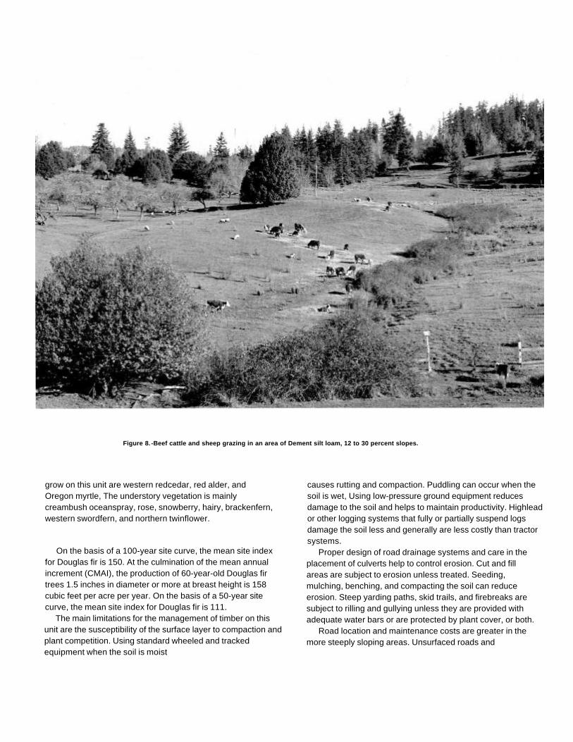
Figure 8. -Beef cattle and sheep grazing in an area of Dement silt loam, 12 to 30 percent slopes.
grow on this unit are western redcedar, red alder, andOregon myrtle, The understory vegetation is mainlycreambush oceanspray, rose, snowberry, hairy, brackenfern,western swordfern, and northern twinflower.
On the basis of a 100-year site curve, the mean site indexfor Douglas fir is 150. At the culmination of the mean annualincrement (CMAI), the production of 60-year-old Douglas firtrees 1.5 inches in diameter or more at breast height is 158cubic feet per acre per year. On the basis of a 50-year sitecurve, the mean site index for Douglas fir is 111.
The main limitations for the management of timber on thisunit are the susceptibility of the surface layer to compaction andplant competition. Using standard wheeled and trackedequipment when the soil is moist
causes rutting and compaction. Puddling can occur when thesoil is wet, Using low-pressure ground equipment reducesdamage to the soil and helps to maintain productivity. Highleador other logging systems that fully or partially suspend logsdamage the soil less and generally are less costly than tractorsystems.
Proper design of road drainage systems and care in theplacement of culverts help to control erosion. Cut and fillareas are subject to erosion unless treated. Seeding,mulching, benching, and compacting the soil can reduceerosion. Steep yarding paths, skid trails, and firebreaks aresubject to rilling and gullying unless they are provided withadequate water bars or are protected by plant cover, or both.
Road location and maintenance costs are greater in themore steeply sloping areas. Unsurfaced roads and

skid trails are soft when wet or moist, and they may beimpassable during rainy periods.
When openings are made in the canopy, invading brushyplants can delay natural reforestation. Undesirable plantsprevent adequate natural or artificial reforestation unlessintensive site preparation and maintenance are provided.Reforestation can be accomplished by planting Douglas firand western hemlock seedlings.
If this unit is used for livestock grazing, the main limitation isthe susceptibility of the surface layer to compaction. Grazingcattle when the soil is wet results in compaction of the surfacelayer, poor tilth, and excessive runoff. Compaction limits themovement of air and water in the soil and restricts the growth ofroots; it can seriously reduce the productivity of the soil.Grazing should be delayed until the soil has drained sufficientlyand is firm enough to withstand trampling by livestock.
In summer, droughtiness limits the choice of forage plantsand limits production. Irrigation generally is impracticalbecause of slope and an inadequate water supply.
Fertilizer is needed to ensure optimum growth of grassesand legumes. Grass-legume pastures respond to sulfur,phosphorus, and molybdenum. Using a good fertilizationprogram increases the production of forage in winter. Properstocking rates, pasture rotation, and restricted grazing duringwet periods help to keep the pasture in good condition and toprotect the soil from erosion. Rotation grazing increases theproduction of forage and helps to control weeds and brush.
If this unit is used for homesite development, the mainlimitations are the moderately slow permeability, slope. anddepth to bedrock. Absorption lines should either be placed inthe more gently sloping areas of this unit or in adjoining, lesssloping areas. Septic tank absorption fields may not functionproperly during rainy periods because of the moderately slowpermeability of the subsoil. The limitation of moderately slowpermeability can be overcome by increasing the size of theabsorption field. Extensive cuts and fills generally are requiredto provide nearly level construction sites. Building roads in theless sloping areas of this unit reduces the amount of cuttingand filling required. Roads should be provided with surfacedrainage. Cut and fill areas are susceptible to erosion.Revegetating disturbed areas around construction sites assoon as possible helps to control erosion. In summer,supplemental irrigation is needed for lawn grasses andvegetable gardens.
This map unit is in capability subclass IVe.
13E-Dement silt loam, 30 to 50 percent slopes.This deep, well drained soil is on side slopes of mountains. Itformed in residuum and colluvium derived dominantly fromsiltstone and sandstone. The native vegetation is mainlyconifers, shrubs, forbs, and hardwoods. Elevation is 20 to 900feet. The average annual air temperature is 55 to 80 inches, theaverage annual air temperature is 50 to 53 degrees F, and theaverage frost-free period is 180 to 240 days.
Typically, the surface layer is very dark grayish brown siltloam 7 inches thick. The subsoil is reddish brown silty clayloam 38 inches thick. Weathered sedimentary rock is at adepth of 45 inches. In some areas the dark-colored surfacelayer is more than 10 inches thick.
Included in this unit are small areas of Blachly soils.Included areas make up about 25 percent of the total acreage.The percentage varies from one area to another.
Permeability of this Dement soil is moderately slow.Available water capacity is about 6.5 to 11.5 inches. Effectiverooting depth is 40 to 60 inches. Runoff is rapid, and thehazard of water erosion is high.
This unit is used mainly for timber production and wildlifehabitat. It is also used for livestock grazing.
This unit is suited to the production of Douglas fir andwestern hemlock. Among the other species that grow on thisunit are western redcedar, red alder, and Oregon myrtle. Theunderstory vegetation is mainly creambush oceanspray, rose,snowberry, hairy brackenfern, western swordfern, andnorthern twinflower.
On the basis of a 100-year site curve, the mean site indexfor Douglas fir is 150. At the culmination of the mean annualincrement (CMAI), the production of 60-year-old Douglas firtrees 1.5 inches in diameter or more at breast height is 158cubic feet per acre per year. On the basis of a 50-year sitecurve, the mean site index for Douglas fir is 111.
The main limitations for the management of timber on this unitare the susceptibility of the surface layer to compaction, thehazard of erosion, steepness of slope, and plant competition. Themain limitation for the harvesting of timber is steepness of slope.Using standard wheeled and tracked equipment when the soil ismoist causes rutting and compaction. Puddling can occur whenthe soil is wet. Cable yarding systems are safer, damage the soilless, and help to maintain productivity.
Proper design of road drainage systems and care in theplacement of culverts help to control erosion. Cut

and fill areas are subject to erosion unless treated. Seeding,mulching, benching, and compacting can reduce erosion.Steep yarding paths, skid trails, and firebreaks are subject torilling and gullying unless they are provided with adequatewater bars or are protected by plant cover, or both.
Locating roads on midslopes results in large cuts and fillsand thus removes land from production. Unsurfaced roads andskid trails are soft when wet or moist, and they may beimpassable during rainy periods. Logging roads require suitablesurfacing for year-round use. Rock for road construction is notreadily available in this unit.
When openings are made in the canopy, invading brushyplants can delay natural reforestation. Undesirable plantsprevent adequate natural or artificial reforestation unlessintensive site preparation and maintenance are provided.Reforestation can be accomplished by planting Douglas fir andwestern hemlock seedlings.
If this unit is used for livestock grazing, the main limitationsare the susceptibility of the surface layer to compaction andslope. Grazing cattle when the soil is wet results in compactionof the surface layer, poor tilth, and excessive runoff.Compaction limits the movement of air and water in the soil andrestricts the productivity of the soil. Grazing should be delayeduntil the soil has drained sufficiently and is firm enough towithstand trampling by livestock.
In summer, droughtiness limits the choice of forage plantsand limits production. Irrigation generally is impracticalbecause of slope and an inadequate water supply.
Slope limits access by livestock and results in overgrazingof the less sloping areas. If the pasture is overgrazed, theproportion of preferred forage plants decreases and theproportion of less preferred forage plants increases. Livestockgrazing, therefore, should be managed so that the desiredbalance of species is maintained in the plant community.Severe overgrazing reduces the plant cover and increases therisk of erosion. Weeds and brush can be controlled by aerialspraying. Rotation grazing increases the production of forageand helps to control weeds and brush.
Fertilizer is needed to ensure optimum growth of grassesand legumes. Grass-legume pastures respond to sulfur,phosphorus, and molybdenum. Using a good fertilizationprogram increases the production of forage in winter. Properstocking rates, pasture rotation, and restricted grazing duringwet periods help to keep the pasture in good condition and toprotect the soil from erosion.
The map unit is in capability subclass Vle.
13F-Dement silt loam, 50 to 70 percent slopes.This deep, well drained soil is on side slopes of mountains. Itformed in colluvium derived dominantly from siltstone andsandstone. The native vegetation is mainly conifers, shrubs,forbs, and hardwoods. Elevation is 20 to 900 feet. Theaverage annual precipitation is 55 to 80 inches, the averageannual air temperature is 50 to 53 degrees F, and the averagefrost-free period is 180 to 240 days.
Typically, the surface layer is very dark grayish brownsilt loam 7 inches thick. The subsoil is reddish brown siltyclay loam 38 inches thick. Weathered sedimentary rock is ata depth of 45 inches. In some areas the dark-coloredsurface layer is more than 10 inches thick.
Included in this unit are small areas of soils that are similarto this Dement soil but are 20 to 40 inches deep to bedrock.Included areas make up about 20 percent of the total acreage.
Permeability of this Dement soil is moderately slow.Available water capacity is about 6.5 to 11.5 inches. Effectiverooting depth is 40 to 60 inches. Runoff is rapid, and thehazard of water erosion is high.
This unit is used for timber production and wildlifehabitat.
This unit is suited to the production of Douglas fir andwestern hemlock. Among the other species that grow on thisunit are western redcedar, red alder, and Oregon myrtle. Theunderstory vegetation is mainly creambush oceanspray,rose, snowberry, hairy brackenfern, western swordfern, andnorthern twinflower.
On the basis of a 100-year site curve, the mean site indexfor Douglas fir is 150. At the culmination of the mean annualincrement (CMAI), the production of 60-year-old Douglas firtrees 1.5 inches in diameter or more at breast height is 158cubic feet per acre per year. On the basis of a 50-year sitecurve, the mean site index for Douglas fir is 111.
The main limitations for the management of timber on thisunit are the susceptibility of the surface layer to compaction, thehazard of erosion, steepness of slope, and plant competition.Compaction reduces the productivity of the soil. Highlead orother cable logging systems are most suitable.
Proper design of road drainage systems and care in theplacement of culverts help to control erosion. Cut and fillareas are subject to erosion unless treated. Seeding,mulching, benching, and compacting the soil can reduceerosion. Steep yarding paths, skid trails,

and firebreaks are subject to rilling and gullying unless theyare provided with adequate water bars or are protected byplant cover, or both.
Locating roads on midslopes results in large cuts and fillsand thus removes land from production. Unsurfaced roads andskid trails are soft when wet or moist, and they may beimpassable during rainy periods. Logging roads requiresuitable surfacing for year-round use. Rock for roadconstruction is not readily available in this unit.
When openings are made in the canopy, invading brushyplants can delay natural reforestation. Undesirable plantsprevent adequate natural or artificial reforestation unlessintensive site preparation and maintenance are provided.Reforestation can be accomplished by planting Douglas firand western hemlock seedlings.
This map unit is in capability subclass Vlle.
14F-Digger-Preacher-Umpcoos association, 50 to 80percent slopes. This map unit is on side slopes and ridges ofmountains. The native vegetation is mainly conifers,hardwoods, shrubs, and forbs. Elevation is 200 to 3,600 feet.The average annual precipitation is 60 to 100 inches, theaverage annual air temperature is 45 to 53 degrees F, and theaverage frost-free period is 110 to 200 days.
This unit is 30 percent Digger gravelly loam, 30 percentPreacher loam, and 25 percent Umpcoos very gravelly sandyloam. The Digger soil is on side slopes, the Preacher soil is onridgetops and side slopes, and the Umpcoos soil is on verynarrow ridgetops and steep side slopes along drainageways.
Included in this unit are small areas of Remote andBohannon soils and Rock outcrop. Included areas make upabout 15 percent of the total acreage. The percentage variesfrom one area to another.
The Digger soil is moderately deep and well drained. Itformed in colluvium derived dominantly from sandstone andsiltstone. Typically, the surface is covered with a mat ofpartially decomposed leaves, moss, and litter 1 inch thick. Thesurface layer is dark brown gravelly loam 6 inches thick. Theupper 3 inches of the subsoil is dark yellowish brown gravellyloam, and the lower 18 inches is brown very gravelly loam andvery cobbly loam. The substratum is brown extremely cobblyloam 4 inches thick. Weathered, fractured sandstone is at adepth of 31 inches.
Permeability of the Digger soil is moderately rapid.Available water capacity is about 2 to 5 inches. Effectiverooting depth is 20 to 40 inches. Runoff is rapid, and thehazard of water erosion is high.
The Preacher soil is deep and well drained. It formed incolluvium and residuum derived dominantly from arkosicsandstone. Typically, the surface is covered with a mat oforganic litter 4 inches thick. The surface layer is very darkgrayish brown and dark brown loam 14 inches thick. The subsoilis dark yellowish brown clay loam 34 inches thick. Thesubstratum to a depth of 60 inches or more is yellowish brownclay loam.
Permeability of the Preacher soil is moderate. Availablewater capacity is about 6.5 to 12.5 inches. Effective rootingdepth is 40 to 60 inches. Runoff is rapid, and the hazard ofwater erosion is high.
The Umpcoos soil is shallow and well drained. It formed incolluvium derived dominantly from sandstone. Typically, thesurface is covered with a mat of organic litter 2 inches thick. Thesurface layer is dark grayish brown very gravelly sandy loam 3inches thick. The subsoil is brown very gravelly sandy loam 13inches thick. Hard sandstone is at a depth of 16 inches.
Permeability of the Umpcoos soil is moderately rapid.Available water capacity is about 0.5 inch to 1.5 inches. Effectiverooting depth is 10 to 20 inches. Runoff is rapid, and the hazardof water erosion is high.
This unit is used for timber production and wildlife habitat.This unit is suited to the production of Douglas fir. Among the
other species that grow on the unit are western hemlock,western redcedar, incense cedar, red alder, and Pacificmadrone. The understory vegetation is mainly evergreenhuckleberry, red huckleberry, cascade Oregon-grape, westernswordfern, creambush oceanspray, Oregon oxalis, and Pacifictrillium.
On the basis of a 100-year site curve, the mean site index forDouglas fir is 154 on the Digger soil. At the culmination of themean annual increment (CMAI), the production of 60-year-oldDouglas fir trees 1.5 inches in diameter or more at breast heightis 163 cubic feet per acre per year. On the basis of a 50-year sitecurve, the mean site index for Douglas fir is 111.
On the basis of a 100-year site curve, the mean site index forDouglas fir is 170 on the Preacher soil. At the culmination of themean annual increment (CMAI), the production of 60-year-oldDouglas fir trees 1.5 inches in diameter or more at breast heightis 181 cubic feet per acre per year. On the basis of a 50-year sitecurve, the mean site index for Douglas fir is 127.
On the basis of a 100-year site curve, the mean site index forDouglas fir is 79 on the Umpcoos soil. At the culmination of themean annual increment (CMAI), the production of 70-year-oldDouglas fir trees 1.5 inches or larger in diameter at breast heightis 58 cubic feet per acre per year. On the basis of a 50-year sitecurve, the

mean site index for Douglas fir is 61.The main limitations for the management of timber on this
unit are the susceptibility of the surface layer of the Preachersoil to compaction, steepness of slope, the hazard of erosion,the hazard of windthrow on the Digger and Umpcoos soils, andplant competition. Highlead or other cable logging systems aremost suitable.
Proper design of road drainage systems and care in theplacement of culverts help to control erosion. Cuts and fills aresubject to erosion unless treated. Seeding, mulching, benching,and compacting the soil can reduce erosion. Unsurfaced roadsand skid trails are soft when wet or moist, and they may beimpassable during rainy periods. Logging roads require suitablesurfacing for year-round use. Rock for road construction is notreadily available in this unit. Steep yarding paths, skid trails,and firebreaks are subject to rilling and gullying unless they areprovided with adequate water bars or are protected by plantcover, or both. Locating roads on midslopes results in largecuts and fills and thus removes land from production. Materialcast to the side when building roads can damage vegetation. Itis also a potential source of sedimentation. End hauling ofwaste material minimizes damage to the vegetation downslopeand reduces the potential for sedimentation.
Because growth of roots is restricted by bedrock in theUmpcoos and Digger soils, trees commonly are subject towindthrow. When openings are made in the canopy, invadingbrushy plants can delay natural reforestation. Undesirableplants reduce natural or artificial reforestation unlessintensive site preparation and maintenance are provided.Reforestation can be accomplished by planting Douglas firseedlings.
This map unit is in capability subclass Vlle.
15F-Digger-Umpcoos-Rock outcrop association, 50 to90 percent slopes. This map unit is on side slopes and ridgesof mountains. The native vegetation is mainly conifers,hardwoods, shrubs, and forbs. Elevation is 300 to 3,800 feet.The average annual precipitation is 60 to 100 inches, theaverage annual air temperature is 45 to 53 degrees F, and theaverage frost-free period is 110 to 200 days.
This unit is 30 percent Digger gravelly loam, 25 percentUmpcoos very gravelly sandy loam, and 25 percent Rockoutcrop. The Digger soil is on concave side slopes, theUmpcoos soil is on convex side slopes above areas of Rockoutcrop and on narrow ridgetops, and Rock outcrop is onprecipitous side slopes along drainageways and on verynarrow ridgetops.
Included in this unit are small areas of Bohannon,
Preacher, and Remote soils. Included areas make up about20 percent of the total acreage. The percentage varies fromone area to another.
The Digger soil is moderately deep and well drained. Itformed in colluvium derived dominantly from sandstone andsiltstone. Typically, the surface is covered with a mat ofundecomposed leaves, moss, and litter 1 inch thick. Thesurface layer is dark brown gravelly loam 6 inches thick. Theupper 3 inches of the subsoil is dark yellowish brown gravellyloam, and the lower 18 inches is brown very gravelly loam andvery cobbly loam. The substratum is brown extremely cobblyloam 4 inches thick. Weathered, fractured sandstone is at adepth of 31 inches.
Permeability of the Digger soil is moderately rapid.Available water capacity is about 2 to 5 inches. Effectiverooting depth is 20 to 40 inches. Runoff is rapid, and thehazard of water erosion is high.
The Umpcoos soil is shallow and well drained. It formed incolluvium derived dominantly from sandstone. Typically, thesurface is covered with a mat of organic litter 2 inches thick.The surface layer is dark grayish brown very gravelly sandyloam 3 inches thick. The subsoil is brown very gravelly sandyloam 13 inches thick. Hard sandstone is at a depth of 16inches.
Permeability of the Umpcoos soil is moderately rapid.Available water capacity is about 0.5 inch to 1.5 inches.Effective rooting depth is 10 to 20 inches. Runoff is rapid, andthe hazard of water erosion is high.
Rock outcrop commonly consists of exposures of hard,fractured sandstone.
This unit is used for timber production and wildlifehabitat.
This unit is suited to the production of Douglas fir. Amongthe other species that grow on this unit are western hemlock,western redcedar, incense cedar, red alder, and Pacificmadrone. The understory vegetation is mainly evergreenhuckleberry, red huckleberry, tall Oregon-grape, westernswordfern, creambush oceanspray, Oregon oxalis, and Pacifictrillium.
On the basis of a 100-year site curve, the mean site indexfor Douglas fir is 154 on the Digger soil. At the culmination ofthe mean annual increment (CMAI), the production of60-year-old Douglas fir trees 1.5 inches in diameter or more atbreast height is 163 cubic feet per acre per year. On the basisof a 50-year site curve, the mean site index for Douglas fir is122.
On the basis of a 100-year site curve, the mean site indexfor Douglas fir is 79 on the Umpcoos soil. At the culmination ofthe mean annual increment (CMAI), the production of70-year-old Douglas fir trees 1.5 inches in diameter or more atbreast height is 58 cubic feet per

acre per year. On the basis of a 50-year site curve, the meansite index for Douglas fir is 61.
The main limitations for the management of timber on thisunit are steepness of slope, the hazard of erosion, the hazardof windthrow, and plant competition. Helicopter, balloon, ortotal-suspension cable systems are the most suitable methodsfor harvesting timber. Rock outcrop may cause breakage oftimber and hinder yarding.
Proper design of road drainage systems and care in theplacement of culverts help to control erosion. Cuts and fills aresubject to erosion unless treated. Seeding, mulching, benching,and compacting the soil can reduce erosion. Unsurfaced roadsand skid trails are soft when wet or moist, and they may beimpassable during rainy periods. Logging roads require suitablesurfacing for year-round use. Rock for road construction isreadily available in this unit. Steep yarding paths, skid trails,and firebreaks are subject to rilling and gullying unless they areprovided with adequate water bars or are protected by plantcover, or both. Locating roads on midslopes results in largecuts and fills and thus removes land from production. Materialcast to the side when building roads can damage vegetation. Itis also a potential source of sedimentation. End hauling ofwaste material minimizes damage to the vegetation downslopeand reduces the potential for sedimentation.
Because growth of roots is restricted by bedrock, treescommonly are subject to windthrow. When openings aremade in the canopy, invading brushy plants can delaynatural reforestation. Undesirable plants reduce natural orartificial reforestation unless intensive site preparation andmaintenance are provided. Reforestation can beaccomplished by planting Douglas fir seedlings.
This map unit is in capability subclass VIle.
16-Dune land. Dune land consists mainly of hills andridges of shifting fine and medium textured sand. It formed ineolian deposits derived dominantly from deflation basinsadjacent to coastal beaches. Slope is 0 to 30 percent. Areas ofDune land do not support vegetation. Elevation is 5 to 100feet. The average annual precipitation is 50 to 70 inches, theaverage annual air temperature is 51 to 53 degrees F, and theaverage frost-free period is 200 to 240 days.
Included in this unit are small areas of Waldport soils,some of which have a thin surface layer, and Heceta soils.Included areas make up about 20 percent of the total acreage.
Permeability of Dune land is very rapid. Runoff is slow.and the hazard of water erosion is slight. The
hazard of soil blowing is severe.This unit is used for recreation. The hazard of soil blowing
and the instability of the areas limit the unit for most kinds ofrecreational development. It is suitable for low-intensity usessuch as hiking and horseback riding and for off-road vehicletraffic.
This map unit is in capability subclass VIlle.
17B-Eilertsen silt loam, 0 to 7 percent slopes.This deep, well drained soil is on stream terraces. It formed inmixed alluvium. The native vegetation is mainly conifers,shrubs, forbs, and hardwoods. Elevation is 50 to 120 feet.The average annual precipitation is 60 to 70 inches, theaverage annual air temperature is 50 to 53 degrees F, andthe average frost-free period is 180 to 220 days.
Typically, the surface layer is dark brown silt loam 11inches thick. The subsoil is brown and dark yellowish brownsilt loam 48 inches thick. The substratum to a depth of 60inches or more is olive brown fine sandy loam.
Included in this unit are small areas of soils that are similarto this Eilertsen soil but are mottled to a depth of 40 inches orless. Also included are small areas of Kirkendall and Gardinersoils. Included areas make up about 25 percent of the totalacreage.
Permeability of this Eilertsen soil is moderate. Availablewater capacity is about 11 to 13 inches. Effective rootingdepth is 60 inches or more. Runoff is slow, and the hazard ofwater erosion is slight.
This unit is used for hay and pasture and forhomesite development. It is also used for timberproduction.
This unit is suited to the production of Douglas fir. Amongthe other species that grow on this unit are western hemlock,western redcedar, Oregon myrtle, and red alder. Theunderstory vegetation is mainly evergreen huckleberry,western swordfern, cascade Oregon-grape, and Oregon oxalis.
On the basis of a 100-year site curve, the mean site indexfor Douglas fir is 159. At the culmination of the mean annualincrement (CMAI), the production of 60-year-old Douglas firtrees 1.5 inches in diameter or more at breast height is 172cubic feet per acre per year. On the basis of a 50-year sitecurve, the mean site index for Douglas fir is 126.
The main limitations for the management of timber on thisunit are the susceptibility of the surface layer to compactionand plant competition. Using standard wheeled and trackedequipment when the soil is moist causes rutting andcompaction. Displacement of the surface layer occurs mostreadily when the soil is dry.

Puddling can occur when the soil is wet. Using low-pressureground equipment damages the soil less and helps tomaintain productivity.
Proper design of road drainage systems and care in theplacement of culverts help to control erosion. Unsurfacedroads and skid trails are slippery when wet or moist. and theymay be impassable during rainy periods. Logging roadsrequire suitable surfacing for year-round use. Rock for roadconstruction is not readily available in this unit.
When openings are made in the canopy, invading brushyplants can delay natural reforestation. Undesirable plantsprevent adequate natural or artificial reforestation unlessintensive site preparation and maintenance are provided.Reforestation can be accomplished by planting Douglas fir andwestern hemlock seedlings.
If this unit is used for hay and pasture, the main limitationsare susceptibility of the surface layer to compaction,droughtiness in summer, and, for the curing of hay, highhumidity. Grazing when the soil is moist results in compactionof the surface layer and poor tilth. Compaction limits themovement of air and water in the soil and restricts the growthof roots; it can seriously reduce the productivity of the soil.Grazing should be delayed until the soil has drainedsufficiently and is firm enough to withstand trampling bylivestock.
Supplemental irrigation is needed for maximum production.Sprinkler irrigation is a suitable method of applying water. Useof this method permits the even, controlled application ofwater. Water should be applied in amounts sufficient to wet theroot zone but small enough to minimize the leaching of plantnutrients. Applications of water should be adjusted to theavailable water capacity, the water intake rate, and the cropneeds.
High humidity and frequent periods of rainfall late in springprevent the production of high-quality hay. The quality of grassfor hay can be maintained by increasing the stocking rate inspring. Excess forage in spring can be used as silage.
Fertilizer is needed to ensure optimum growth of grassesand legumes. Grasses respond to nitrogen, and legumesrespond to sulfur and phosphorus. Proper stocking rates,pasture rotation, and restricted grazing during wet periods helpto keep the pasture in good condition. Rotation grazingincreases the production of forage and helps to control weedsand brush. Periodic mowing and clipping help to maintainuniform growth, discourage selective grazing, and reduceclumpy growth.
This unit is well suited to homesite development. It
has few limitations. Only the part of the site that is used forconstruction should be disturbed. Revegetating disturbed areasaround construction sites as soon as feasible helps to controlerosion. In summer, supplemental irrigation is needed for lawngrasses and vegetable gardens.
This map unit is in capability subclass IIc.
18E-Etelka silt loam, 30 to 50 percent slopes. This deep,moderately well drained soil is on side slopes and ridgetops ofmountains. It formed in colluvium and residuum deriveddominantly from sandstone and siltstone. The native vegetationis mainly conifers, hardwoods, shrubs, forbs, and grasses.Elevation is 50 to 1,800 feet. The average annual precipitationis 60 to 80 inches, the average annual air temperature is 50 to54 degrees F, and the average frost-free period is 180 to 220days.
Typically, the surface layer is dark grayish brown silt loam13 inches thick. The upper 19 inches of the subsoil is darkbrown and olive brown silt loam and silty clay loam, and thelower 28 inches is mottled, olive brown and dark grayish brownsilty clay.
Included in this unit are small areas of Whobrey andRemote soils. Also included are small areas of Dement soilsand Rock outcrop. Included areas make up about 25 percentof the total acreage.
Permeability of this Etelka soil is slow. Available watercapacity is about 7.0 to 11.5 inches. Effective rooting depth is60 inches or more for water-tolerant plants, but it is limited bythe water table for non-water-tolerant plants. Runoff is rapid,and the hazard of water erosion is high. The water table is at adepth of 24 to 36 inches from December to March.
This unit is used mainly for timber production, wildlifehabitat, and livestock grazing.
This unit is suited to the production of Douglas fir. Amongthe other species that grow on this unit are grand fir, PortOrford cedar, bigleaf maple, and canyon live oak. Theunderstory vegetation is mainly creambush oceanspray, redhuckleberry, western swordfern, tall Oregon-grape, hazelnut,and broadleaf starflower.
On the basis of a 100-year site curve, the mean site indexfor Douglas fir is 155. At the culmination of the mean annualincrement (CMAI), the production of 60-year-old Douglas firtrees 1.5 inches in diameter or more at breast height is 164cubic feet per acre per year. On the basis of a 50-year sitecurve, the mean site index for Douglas fir is 120.
The main limitations for the management of timber on thisunit are the susceptibility of the surface layer to

compaction, the susceptibility of the soil to landsliding, thehazard of erosion, steepness of slope, the hazard ofwindthrow, and plant competition. Using standard wheeled andtracked equipment when the soil is moist causes rutting andcompaction. Puddling can occur when the soil is wet. Cableyarding systems are safer, damage the soil less, and help tomaintain productivity. Road failure and landslides are likely tooccur after road construction and clearcutting.
Proper design of road drainage systems and care in theplacement of culverts help to control erosion. Cuts and fills aresubject to erosion unless treated. Seeding, mulching,benching, and compacting the soil can reduce erosion.Unsurfaced roads and skid trails are soft when wet or moist,and they may be impassable during rainy periods. Loggingroads require suitable surfacing for year-round use. Rock forroad construction is not readily available in this unit. Steepyarding paths, skid trails, and firebreaks are subject to rillingand gullying unless they are provided with adequate water barsor are protected by plant cover, or both. Locating roads onmidslopes results in large cuts and fills and thus removes landfrom production.
Windthrow is a hazard when the soil is wet and winds arestrong. When openings are made in the canopy, invadingbrushy plants can delay natural reforestation. Undesirableplants prevent adequate natural or artificial reforestationunless intensive site preparation and maintenance areprovided. Reforestation can be accomplished by plantingDouglas fir seedlings.
If this unit is used for livestock grazing, the main limitationsare the susceptibility of the surface layer to compaction, slope,and the susceptibility of the soil to landsliding. Grazing cattlewhen the soil is moist results in compaction of the surfacelayer, poor tilth, and excessive runoff. Compaction limits themovement of air and water in the soil and restricts the growthof roots; it can seriously reduce the productivity of the soil.Grazing should be delayed until the soil has drainedsufficiently and is firm enough to withstand trampling bylivestock.
Slope limits access by livestock and results in overgrazingof the less sloping areas. If the pasture is overgrazed, theproportion of preferred forage plants decreases and theproportion of less preferred forage plants increases. Livestockgrazing, therefore, should be managed so that the desiredbalance of species is maintained in the plant community.Severe overgrazing reduces the plant cover and increases therisk of erosion. Proper stocking rates and pasture rotation helpto keep the pasture in good condition and to protect the soilfrom erosion. Rotation grazing increases the
production of forage and helps to control weeds andbrush.
This unit is subject to severe slumping and landsliding inwinter. Damage to fences, watering tanks, and other facilitiescan be minimized by providing soil drainage. Fertilizer isneeded to ensure optimum growth of grasses and legumes.Grass-legume pastures respond to sulfur, phosphorus, andmolybdenum. Using a good fertilization program increases theproduction of forage in winter.
This map unit is in capability subclass Vlle.
19F-Etelka-Remote complex, 50 to 70 percent slopes.This map unit is on side slopes and ridgetops of mountains.The native vegetation is mainly conifers, hardwoods, shrubs,forbs, and grasses. Elevation is 50 to 1,800 feet. The averageannual precipitation is 60 to 80 inches, the average annual airtemperature is 50 to 54 degrees F, and the average frost-freeperiod is 180 to 220 days.
This unit is 55 percent Etelka silt loam and 25 percentRemote loam. The Etelka soil is on toe slopes, benches, andbroad ridgetops, and the Remote soil is on narrow ridgetopsand steep side slopes. The components of this unit are sointricately intermingled that it was not practical to map themseparately at the scale used.
Included in this unit are small areas of Rinearson andWhobrey soils. Also included are small areas of Dement andDigger soils. Included areas make up about 20 percent of thetotal acreage.
The Etelka soil is deep and moderately well drained. Itformed in colluvium and residuum derived dominantly fromsedimentary rock. Typically, the surface layer is dark grayishbrown silt loam 13 inches thick. The upper 19 inches of thesubsoil is dark brown and olive brown silt loam and silty clayloam, and the lower 28 inches is mottled, olive brown and darkgrayish brown silty clay.
Permeability of the Etelka soil is slow. Available watercapacity is about 7.0 to 11.5 inches. Effective rooting depth is60 inches or more for water-tolerant plants, but it is limited bythe water table for non-water-tolerant plants. Runoff is rapid,and the hazard of water erosion is high. The water table is at adepth of 24 to 36 inches from December to March.
The Remote soil is deep and well drained. It formed incolluvium derived dominantly from sandstone. Typically, thesurface layer is very dark grayish brown loam 5 inches thick.The subsoil is brown to yellowish brown gravelly and verygravelly clay loam 40 inches thick. The substratum to a depthof 60 inches or more is yellowish brown extremely gravellyloam.
Permeability of this Remote soil is moderate. Availablewater capacity is about 6 to 8 inches. Effective rooting depthis 60 inches or more. Runoff is rapid, and the hazard of watererosion is high.
This unit is used for timber production and wildlifehabitat.
This unit is suited to the production of Douglas fir. Amongthe other species that grow on the unit are grand fir, PortOrford cedar, bigleaf maple, and canyon live oak. Theunderstory vegetation is mainly crearnbush oceanspray, redhuckleberry, western swordfern, tall Oregon-grape, evergreenhuckleberry, and broadleaf starflower.
On the basis of a 100-year site curve, the mean site indexfor Douglas fir is 155 on the Etelka soil. At the culmination ofthe mean annual increment (CMAI), the production of60-year-old Douglas fir trees 1.5 inches in diameter or more atbreast height is 164 cubic feet per acre per year. On the basisof a 50-year site curve, the mean site index for Douglas fir is120.
On the basis of a 100-year site curve, the mean site indexfor Douglas fir is 145 on the Remote soil. At the culmination ofthe mean annual increment (CMAI), the production of60-year-old Douglas fir trees 1.5 inches in diameter or more atbreast height is 153 cubic feet per acre per year. On the basisof a 50-year site curve, the mean site index for Douglas fir is111 .
The main limitations for the management of timber on thisunit are the susceptibility of the surface layer to compaction, thesusceptibility of the Etelka soil to landsliding, steepness ofslope, the hazard of erosion, the hazard of windthrow, and plantcompetition. Highlead or other cable logging systems are mostsuitable. The Etelka soil is subject to severe slumping,especially where road cuts are made. If roads are located onthis unit, surface and subsurface drainage, proper road location,and road base are needed.
Proper design of road drainage systems and care in theplacement of culverts help to control erosion. Cuts and fills aresubject to erosion unless treated. Seeding, mulching, benching,and compacting the soil can reduce erosion. Unsurfaced roadsand skid trails are soft when wet or moist, and they may beimpassable during rainy periods. Logging roads require suitablesurfacing for year-round use. Rock for road construction is notreadily available in this unit. Locating roads on midslopesresults in large cuts and fills and thus removes land fromproduction. Material cast to the side when building roads candamage vegetation. It is also a potential source ofsedimentation.. Maintaining the understory is essential incontrolling erosion.
Windthrow is a hazard when the soil is wet and
winds are strong. When openings are made in the canopy,invading brushy plants can delay natural reforestation.Undesirable plants limit natural or artificial reforestation unlessintensive site preparation and maintenance are provided.Reforestation can be accomplished by planting Douglas firseedlings.
This map unit is in capability subclass VIle.
20D-Etelka-Rinearson-Orford complex, 12 to 30 percentslopes. This map unit is on foot slopes, side slopes, andridgetops of mountains. The native vegetation is mainlyconifers, hardwoods, shrubs, forbs, and grasses. Elevation is300 to 1,000 feet. The average annual precipitation is 60 to 80inches, the average annual air temperature is 50 to 54 degreesF, and the average frost-free period is 180 to 240 days.
This unit is 30 percent Etelka silt loam, 30 percentRinearson silt loam, and 25 percent Orford silty clay loam. TheEtelka soil is on foot slopes and slump benches, the Rinearsonsoil is on side slopes and narrow ridgetops, and the Orford soilis on broad ridgetops. The components of this unit are sointricately intermingled that it was not practical to map themseparately at the scale used.
Included in this unit are small areas of Remote soils. Alsoincluded are small areas of Rock outcrop. Included areas makeup about 15 percent of the total acreage. The percentagevaries from one area to another.
The Etelka soil is deep and moderately well drained. Itformed in colluvium and residuum derived dominantly fromsedimentary rock. Typically, the surface layer is dark grayishbrown silt loam 13 inches thick. The upper 19 inches of thesubsoil is dark brown and olive brown silt loam and silty clayloam, and the lower 28 inches is mottled, olive brown and darkgrayish brown silty clay.
Permeability of this Etelka soil is slow. Available watercapacity is about 7.0 to 11.5 inches. Effective rooting depth is60 inches or more for water-tolerant plants, but it is limited bythe water table for non-water-tolerant plants. Runoff is medium,and the hazard of water erosion is moderate. The water table isat a depth of 24 to 36 inches from December to March.
The Rinearson soil is deep and well drained. It formed inresiduum and colluvium derived dominantly from sedimentaryrock. Typically, the surface layer is dark reddish brown silt loam6 inches thick. The upper 12 inches of the subsoil is darkreddish brown silt loam, and the lower 24 inches is reddishbrown and dark reddish brown silty clay loam. Weatheredsandstone is at a depth of 42 inches.
Permeability of this Rinearson soil is moderate.Available water capacity is about 7.5 to 12.5 inches.

Effective rooting depth is 40 to 60 inches. Runoff ismedium, and the hazard of water erosion is moderate.
The Orford soil is deep and well drained. It formed inresiduum and colluvium derived dominantly from arkosicsandstone and siltstone. Typically, the surface is coveredwith a mat of fir needles, leaves, and twigs 1 inch thick. Thesurface layer is very dark grayish brown silty clay loam 11inches thick. The upper 8 inches of the subsoil is dark brownsilty clay loam, the next 29 inches is dark brown andyellowish brown silty clay, and the lower 7 inches is darkyellowish brown silty clay loam. The substratum to a depth of60 inches or more is dark yellowish brown silty clay loam.
Permeability of the Orford soil is moderately slow.Available water capacity is about 9.0 to 10.5 inches.Effective rooting depth is 60 inches or more. Runoff ismedium, and the hazard of water erosion is moderate.
This unit is used mainly for timber production, wildlifehabitat, and livestock grazing.
This unit is well suited to the production of Douglas fir.Among the other species that grow on the unit are westernhemlock, western redcedar, Port Orford cedar, and redalder. The understory vegetation is mainly creambushoceanspray, vine maple, red huckleberry, westernswordfern, salal, and broadleaf starflower.
On the basis of a 100-year site curve, the mean site indexfor Douglas fir is 155 on the Etelka soil. At the culmination ofthe mean annual increment (CMAI), the production of60-year-old Douglas fir trees 1.5 inches in diameter or moreat breast height is 164 cubic feet per acre per year. On thebasis of a 50-year site curve, the mean site index forDouglas fir is 120.
On the basis of a 100-year site curve, the mean site indexfor Douglas fir is 170 on the Rinearson soil. At theculmination of the mean annual increment (CMAI), theproduction of 60-year-old Douglas fir trees 1.5 inches indiameter or more at breast height is 181 cubic feet per acreper year. On the basis of a 50-year site curve, the mean siteindex for Douglas fir is 127.
On the basis of a 100-year site curve, the mean site indexfor Douglas fir is 175 on the Orford soil. At the culmination ofthe mean annual increment (CMAI), the production of60-year-old Douglas fir trees 1.5 inches in diameter or moreat breast height is 186 cubic feet per acre per year. On thebasis of a 50-year site curve, the mean site index forDouglas fir is 127.
The main limitations for the management of timber on thisunit are the susceptibility of the surface layer to compaction,the susceptibility of the Etelka soil to landsliding, the hazardof erosion, and plant competition. Using standard wheeledand tracked equipment when the soil is moist causes ruttingand
compaction. Puddling can occur when the soil is wet. Usinglow-pressure ground equipment reduces damage to the soiland helps to maintain productivity. The Etelka soil is subject tosevere slumping, especially where road cuts are made. If roadsare located on this unit, surface and subsurface drainage,proper road location, and road base are needed.
Proper design of road drainage systems and care in theplacement of culverts help to control erosion. Cuts and fills aresubject to erosion unless treated. Seeding, mulching, benching,and compacting the soil can reduce erosion. Unsurfaced roadsand skid trails are slippery when wet or moist, and they may beimpassable during rainy periods. Logging roads require suitablesurfacing for year-round use. Rock for road construction is notreadily available in this unit. Steep yarding paths, skid trails,and firebreaks are subject to rilling and gullying unless they areprovided with adequate water bars or are protected by plantcover, or both.
When openings are made in the canopy, invading brushyplants can delay natural reforestation. Undesirable plantsprevent adequate natural or artificial reforestation unlessintensive site preparation and maintenance are provided.Reforestation can be accomplished by planting Douglas firseedlings.
If this unit is used for livestock grazing, the main limitationsare the susceptibility of the surface layer to compaction,droughtiness of the Rinearson and Orford soils in summer, andthe susceptibility of the Etelka soil to landsliding. Grazing whenthe soil is moist results in compaction of the surface layer, poortilth, and excessive runoff. Compaction limits the movement ofair and water in the soil and restricts the growth of roots; it canseriously reduce the productivity of the soil. Grazing should bedelayed until the soil has drained sufficiently and is firm enoughto withstand trampling by livestock.
In summer, droughtiness .limits the choice of forageplants and limits production. Irrigation generally is impracticalbecause of slope and an inadequate water supply.
The Etelka soil is subject to slumping and landsliding inwinter. Damage to fences, watering tanks, and other facilitiescan be minimized by providing soil drainage. Where feasible,facilities should be placed in areas of the Rinearson and Orfordsoils. Fertilizer is needed to ensure optimum growth of grassesand legumes. Grass-legume pastures respond to sulfur,phosphorus, and molybdenum. Using a good fertilizationprogram increases the production of forage in winter. Properstocking rates, pasture rotation, and restricted grazing duringwet periods help to keep the pasture in good condition and toprotect the soil from erosion. Rotation
grazing increases the production of forage and helps to controlweeds and brush.
This map unit is in capability subclass Vle.
20E-Etelka-Rinearson-Orford complex, 30 to 50 percentslopes. This map unit is on foot slopes, side slopes, andridgetops of mountains. The native vegetation is mainlyconifers, hardwoods, shrubs, forbs, and grasses. Elevation is300 to 1,000 feet. The average annual precipitation is 60 to 80inches, the average annual air temperature is 50 to 54 degreesF, and the average frost-free period is 180 to 240 days.
This unit is 30 percent Etelka silt loam, 30 percentRinearson silt loam, and 25 percent Orford silty clay loam. TheEtelka soil is on foot slopes and slump benches, the Rinearsonsoil is on side slopes and narrow ridgetops, and the Orford soilis on broad ridgetops. The components of this unit are sointricately intermingled that it was not practical to map themseparately at the scale used.
Included in this unit are small areas of Remote soils. Alsoincluded are small areas of Rock outcrop. Included areas makeup about 15 percent of the total acreage. The percentagevaries from one area to another.
The Etelka soil is deep and moderately well drained. Itformed in residuum and colluvium derived dominantly fromsedimentary rock. Typically, the surface layer is dark grayishbrown silt loam 13 inches thick. The upper 19 inches of thesubsoil is dark brown and olive brown silt loam and silty clayloam, and the lower 28 inches is mottled, olive brown and darkgrayish brown silty clay.
Permeability of this Etelka soil is slow. Available watercapacity is about 7.0 to 11.5 inches. Effective rooting depth is60 inches or more for water-tolerant plants, but it is limited bythe water table for non-water-tolerant plants. Runoff is rapid,and the hazard of water erosion is high. The water table is at adepth of 24 to 36 inches from December to March.
The Rinearson soil is deep and well drained. It formed inresiduum and colluvium derived dominantly from sedimentaryrock. Typically, the surface layer is dark reddish brown siltloam 6 inches thick. The upper 12 inches of the subsoil is darkreddish brown silt loam, and the lower 24 inches is reddishbrown and dark reddish brown silty clay loam. Weatheredsandstone is at a depth of 42 inches.
Permeability of this Rinearson soil is moderate.Available water capacity is about 7.5 to 12.5 inches.Effective rooting depth is 40 to 60 inches. Runoff is rapid,and the hazard of water erosion is high.
The Orford soil is deep and well drained. It formed inresiduum and colluvium derived dominantly from arkosic
sandstone and siltstone. Typically, the surface is covered with amat of fir needles, leaves, and twigs 1 inch thick. The surfacelayer is very dark grayish brown silty clay loam 11 inches thick.The upper 8 inches of the subsoil is dark brown silty clay loam,the next 29 inches is dark brown and yellowish brown silty clay,and the lower 7 inches is dark yellowish brown silty clay loam.The substratum to a depth of 60 inches or more is darkyellowish brown silty clay loam.
Permeability of this Orford soil is moderately slow.Available water capacity is about 9.0 to 10.5 inches. Effectiverooting depth is 60 inches or more. Runoff is rapid, and thehazard of water erosion is high.
This unit is used mainly for timber production, wildlifehabitat, and livestock grazing.
This unit is well suited to the production of Douglas fir.Among the other species that grow on the unit are westernhemlock, western redcedar, Port Orford cedar, and red alder.The understory vegetation is mainly creambush oceanspray,vine maple, red huckleberry, western swordfern, salal, andbroadleaf starflower.
On the basis of a 100-year site curve, the mean site indexfor Douglas fir is 155 on the Etelka soil. At the culmination ofthe mean annual increment (CMAI), the production of60-year-old Douglas fir trees 1.5 inches in diameter or more atbreast height is 164 cubic feet per acre per year. On the basisof a 50-year site curve, the mean site index for Douglas fir is120.
On the basis of a 100-year site curve, the mean site index forDouglas fir is 170 on the Rinearson soil. At the culmination ofthe mean annual increment (CMAI), the production of60-year-old Douglas fir trees 1.5 inches in diameter or more atbreast height is 181 cubic feet per acre per year. On the basisof a 50-year site curve, the mean site index for Douglas fir is127.
On the basis of a 100-year site curve, the mean site indexfor Douglas fir is 175 on the Orford soil. At the culmination ofthe mean annual increment (CMAI), the production of60-year-old Douglas fir trees 1.5 inches in diameter or more atbreast height is 186 cubic feet per acre per year. On the basisof a 50-year site curve, the mean site index for Douglas fir is127.
The main limitations for the management of timber on thisunit are the susceptibility of the surface layer to compaction, thesusceptibility of the Etelka soil to landsliding, steepness ofslope, the hazard of erosion, and plant competition. The mainlimitation for the harvesting of timber is steepness of slope.Using standard wheeled and tracked equipment when the soil ismoist causes rutting and compaction. Puddling can occur whenthe soil is wet. Cable yarding systems are safer, damage thesoil less, and help to maintain

productivity. The Etelka soil is subject to severe slumping,especially where road cuts are made. If roads are located onthis unit, surface and subsurface drainage, proper roadlocation, and road base are needed.
Proper design of road drainage systems and care in theplacement of culverts help to control erosion. Cuts and fillsare subject to erosion unless treated. Seeding, mulching,benching, and compacting the soil can reduce erosion.Unsurfaced roads and skid trails are slippery when wet ormoist, and they may be impassable during rainy periods.Logging roads require suitable surfacing for year-round use.Rock for road construction is not readily available in this unit.Steep yarding paths, skid trails, and firebreaks are subject torilling and gullying unless they are provided with adequatewater bars or are protected by plant cover, or both. Roadlocation and maintenance costs are greater in the moresteeply sloping areas. Material cast to the side when buildingroads can damage vegetation. It is also a potential source ofsedimentation. End hauling of waste material minimizesdamage to the vegetation downslope and reduces thepotential for sedimentation.
When openings are made in the canopy, invading brushyplants can delay natural reforestation. Undesirable plantsprevent adequate natural or artificial reforestation unlessintensive site preparation and maintenance are provided.Reforestation can be accomplished by planting Douglas firseedlings.
If this unit is used for livestock grazing, the mainlimitations are the susceptibility of the surface layer tocompaction, droughtiness of the Rinearson and Orford soilsin summer, slope, and the susceptibility of the Etelka soil tolandsliding. Grazing when the soil is moist results incompaction of the surface layer, poor tilth, and excessiverunoff. Compaction limits the movement of air and water inthe soil and restricts the growth of roots; it can seriouslyreduce the productivity of the soil. Grazing should bedelayed until the soil has drained sufficiently and is firmenough to withstand trampling by livestock.
In summer, droughtiness limits the choice of forageplants and limits production. Irrigation generally isimpractical because of slope and an inadequate watersupply.
Slope limits access by livestock and results inovergrazing of the less sloping areas. If the pasture isovergrazed, the proportion of preferred forage plantsdecreases and the proportion of less preferred forage plantsincreases. Livestock grazing, therefore, should be managedso that the desired balance of species is maintained in theplant community. Severe overgrazing
reduces the plant cover and increases the risk oferosion.
The Etelka soil is subject to slumping and landsliding inwinter. Damage to fences, watering tanks, and other facilities canbe minimized by providing soil drainage. Where feasible, facilitiesshould be placed in areas of the Rinearson or Orford soils.Fertilizer is needed to ensure optimum growth of grasses andlegumes. Grass-legume pastures respond to sulfur, phosphorus,and molybdenum. Using a good fertilization program increasesthe production of forage in winter. Proper stocking rates, pasturerotation, and restricted grazing during wet periods help to keepthe pasture in good condition and to protect the soil from erosion.Rotation grazing increases the production of forage and helps tocontrol weeds and brush.
This map unit is in capability subclass Vlle.
21D-Etelka-Whobrey silt loams, 7 to 30 percent slopes.This map unit is on side slopes, slump benches, and broadridgetops and in saddles of mountains. The native vegetation ismainly conifers, hardwoods, shrubs, forbs, and grasses.Elevation is 100 to 1,800 feet. The average annual precipitationis 60 to 80 inches, the average annual air temperature is 50 to54 degrees F, and the average frost-free period is 180 to 220days.
This unit is 45 percent Etelka silt loam and 30 percentWhobrey silt loam. The Etelka soil is on side slopes and broadridgetops, and the Whobrey soils are on slump benches and insaddles. The components of this unit are so intricatelyintermingled that it was not practical to map them separately atthe scale used.
Included in this unit are small areas of Preacher, Digger, andRemote soils. Also included are small areas of Rock outcrop.Included areas make up about 25 percent of the total acreage.
The Etelka soil is deep and moderately well drained. Itformed in colluvium and residuum derived dominantly fromsedimentary rock. Typically, the surface layer is dark grayishbrown silt loam 13 inches thick. The upper 19 inches of thesubsoil is dark brown and olive brown silt loam and silty clayloam, and the lower 28 inches is mottled, olive brown and darkgrayish brown silty clay.
Permeability of the Etelka soil is slow. Available watercapacity is about 7.0 to 11.5 inches. Effective rooting depth is 60inches or more for water-tolerant plants, but it is limited by thewater table for non-water-tolerant plants. Runoff is medium, andthe hazard of water erosion is moderate. The water table is at adepth of 24 to 36 inches from December to March.
The Whobrey soil is deep and somewhat poorly

drained. It formed in colluvium and residuum deriveddominantly from sedimentary rock. Typically, the surface iscovered with a mat of undecomposed leaves, twigs, andneedles 1 inch thick. The surface layer is dark brown andbrown silt loam 11 inches thick. The subsoil is dark yellowishbrown silt loam 9 inches thick. The substratum to a depth of 60inches or more is mottled, very dark gray clay.
Permeability of the Whobrey soil is moderate to a depth of20 inches and very slow below this depth. Available watercapacity is about 4.0 to 6.5 inches. Effective rooting depth is60 inches for water-tolerant plants, but it is limited by the watertable for non-water-tolerant plants. Runoff is rapid, and thehazard of water erosion is high. The water table is at a depthof 18 to 30 inches from December to March.
This unit is used mainly for timber production, wildlifehabitat, and livestock grazing.
This unit is suited to the production of Douglas fir. Amongthe other species that grow on the unit are grand fir, PortOrford cedar, western hemlock, western redcedar, bigleafmaple, and red alder. The understory vegetation is mainlycreambush oceanspray, red huckleberry, western swordfern,tall Oregon-grape, hazelnut, and Pacific rhododendron.
On the basis of a 100-year site curve, the mean site indexfor Douglas fir is 155 on the Etelka soil. At the culmination ofthe mean annual increment (CMAI), the production of60-year-old Douglas fir trees 1.5 inches in diameter or more atbreast height is 164 cubic feet per acre per year. On the basisof a 50-year site curve, the mean site index for Douglas fir is120.
On the basis of a 100-year site curve, the mean site indexfor Douglas fir is 105 on the Whobrey soil. At the culmination ofthe mean annual increment (CMAI), the production of60-year-old Douglas fir trees 1.5 inches in diameter or more atbreast height is 91 cubic feet per acre per year. On the basis ofa 50-year site curve, the mean site index for Douglas fir is 86.
The main limitations for the management of timber on thisunit are the susceptibility of the surface layer to compaction, thesusceptibility of the soils to landsliding, the hazard of erosion,the hazard of windthrow, and plant competition. Using standardwheeled and tracked equipment when the soil is moist causesrutting and compaction. Puddling can occur when the soil iswet. Using low-pressure ground equipment reduces damage tothe soil and helps to maintain productivity. Road failure andlandslides are likely to occur after road construction andclearcutting. Steep yarding paths, skid trails, and firebreaks aresubject to rilling and gullying unless they are provided withadequate water bars or
are protected by plant cover, or both.Proper design of road drainage systems and care in the
placement of culverts help to control erosion. Cuts and fills aresubject to erosion unless treated. Seeding, mulching, benching,and compacting the soil can reduce erosion. Unsurfaced roadsand skid trails are soft when wet or moist, and they may beimpassable during rainy periods. Logging roads require suitablesurfacing for year-round use. Rock for road construction is notreadily available in this unit.
Windthrow is a hazard when the soil is wet and winds arestrong. When openings are made in the canopy, invadingbrushy plants can delay natural reforestation. Undesirableplants prevent adequate natural or artificial reforestationunless intensive site preparation and maintenance areprovided. Tree seedlings have only a moderate rate ofsurvival because of the high water table in the Whobrey soil inspring. Reforestation can be accomplished by plantingDouglas fir and Port Orford cedar seedlings.
If this unit is used for livestock grazing, the main limitationsare the susceptibility of the surface layer to compaction,wetness of the Whobrey soil, and susceptibility of the soils tolandsliding. Grazing when the soil is moist results in compactionof the surface layer, poor tilth, and excessive runoff.Compaction limits the movement of air and water in the soil andrestricts the growth of roots; it can seriously reduce theproductivity of the soil. Grazing should be delayed until the soilhas drained sufficiently and is firm enough to withstandtrampling by livestock.
Wetness in winter and spring limits grazing on the Whobreysoil. Drainage is impractical because of slope and a lack ofsuitable outlets.
This unit is subject to slumping and landsliding in winter.Damage to fences, watering tanks, and other facilities can beminimized by providing soil drainage. Fertilizer is needed toensure optimum growth of grasses and legumes.Grass-legume pastures respond to sulfur, phosphorus, andmolybdenum. Using a good fertilization program increases theproduction of forage in winter. Proper stocking rates, pasturerotation, and restricted grazing during wet periods help to keepthe pasture in good condition and to protect the soil fromerosion. Rotation grazing increases the production of forageand helps to control weeds and brush.
This map unit is in capability subclass Vle.
22E-Eteika-Whobrey-Remote complex, 30 to 60 percentslopes. This map unit is on mountains. The native vegetation ismainly conifers, hardwoods, shrubs, forbs, and grasses.Elevation is 200 to 1,600 feet. The
average annual precipitation is 60 to 80 inches, the averageannual air temperature is 50 to 54 degrees F, and theaverage frost-free period is 180 to 220 days.
This unit is 40 percent Etelka silt loam, 25 percent Whobreysilt loam, and 15 percent Remote loam. The Etelka soil is onbroad ridgetops, in saddles, and on benches. The Whobreysoil is on toe slopes in closed depressional areas on slumpbenches. The Remote soil is on narrow ridgetops and steepside slopes. The components of this unit are so intricatelyintermingled that it was not practical to map them separately atthe scale used.
Included in this unit are small areas of Digger and Preachersoils. Also included are small areas of Umpcoos soils andRock outcrop. Included areas make up about 20 percent of thetotal acreage.
The Etelka soil is deep and moderately well drained. Itformed in colluvium and residuum derived dominantly fromsedimentary rock. Typically, the surface layer is dark grayishbrown silt loam 13 inches thick. The upper 19 inches of thesubsoil is dark brown and olive brown silt loam and silty clayloam, and the lower 28 inches is mottled, olive brown and darkgrayish brown silty clay.
Permeability of the Etelka soil is slow. Available watercapacity is about 7.0 to 11.5 inches. Effective rooting depth is60 inches or more for water-tolerant plants, but it is limited bythe water table for non-water-tolerant plants. Runoff is rapid,and the hazard of water erosion is high. The water table is at adepth of 24 to 36 inches from December to March.
The Whobrey soil is deep and somewhat poorly drained. Itformed in colluvium and residuum derived dominantly fromsedimentary rock. Typically, the surface is covered with a mat ofundecomposed needles, leaves, and twigs 1 inch thick. Thesurface layer is dark brown and brown silt loam 11 inches thick.The subsoil is dark yellowish brown silt loam 9 inches thick. Thesubstratum to a depth of 60 inches or more is mottled, very darkgray clay.
Permeability of the Whobrey soil is moderate to a depth of20 inches and very slow below this depth. Available watercapacity is about 4.0 to 6.5 inches. Effective rooting depth is60 inches or more for water-tolerant plants, but it is limited bythe water table for non-water-tolerant plants. Runoff is rapid,and the hazard of water erosion is high. The water table is ata depth of 18 to 30 inches from December to March.
The Remote soil is deep and well drained. It formed incolluvium derived dominantly from sandstone. Typically, thesurface layer is very dark grayish brown loam 5 inches thick.The subsoil is brown to yellowish brown gravelly and verygravelly clay loam 40 inches
thick. The substratum to a depth of 60 inches or more isyellowish brown extremely gravelly loam.
Permeability of the Remote soil is moderate. Availablewater capacity is about 6 to 8 inches. Effective rooting depthis 60 inches or more. Runoff is rapid, and the hazard of watererosion is high.
This unit is used mainly for timber production andwildlife habitat. It is also used for livestock grazing.
This unit is suited to the production of Douglas fir. Amongthe other species that grow on the unit are western redcedar,western hemlock, Port Orford cedar, grand fir, bigleaf maple,and canyon live oak. The understory vegetation is mainlycreambush oceanspray, red huckleberry, western swordfern,tall Oregon-grape, and broadleaf starflower.
On the basis of a 100-year site curve, the mean site indexfor Douglas fir is 155 on the Etelka soil. At the culmination ofthe mean annual increment (CMAI), the production of60-year-old Douglas fir trees 1.5 inches in diameter or more atbreast height is 164 cubic feet per acre per year. On the basisof a 50-year site curve, the mean site index for Douglas fir is120.
On the basis of a 100-year site curve, the mean site indexfor Douglas fir is 105 on the Whobrey soil. At the culmination ofthe mean annual increment (CMAI), the production of60-year-old Douglas fir trees 1.5 inches in diameter or more atbreast height is 91 cubic feet per acre per year. On the basis ofa 50-year site curve, the mean site index for Douglas fir is 86.
On the basis of a 100-year site curve, the mean site indexfor Douglas fir is 145 on the Remote soil. At the culmination ofthe mean annual increment (CMAI), the production of60-year-old Douglas fir trees 1.5 inches in diameter or more atbreast height is 152 cubic feet per acre per year. On the basisof a 50-year site curve, the mean site index for Douglas fir is111.
The main limitations for the management of timber on thisunit are the susceptibility of the surface layer to compaction, thesusceptibility of the Etelka and Whobrey soils to landsliding,steepness of slope, the hazard of erosion, the hazard ofwindthrow, seedling mortality, and plant competition. The mainlimitation for the harvesting of timber is steepness of slope.Using standard wheeled and tracked equipment when the soil ismoist causes rutting and compaction. Puddling can occur whenthe soil is wet. Cable yarding systems are safer, damage thesoil less, and help to maintain productivity. The soil is subject tosevere slumping, especially where road cuts are made. If roadsare located on this unit, surface and subsurface drainage,proper road location, and road base are needed.
Proper design of road drainage systems and care in

the placement of culverts help to control erosion. Cuts and fillsare subject to erosion unless treated. Seeding, mulching.benching, and compacting the soil can reduce erosion.Unsurfaced roads and skid trails are soft when wet or moist,and they may be impassable during rainy periods. Loggingroads require suitable surfacing for year-round use. Rock forroad construction is not readily available in this unit. Steepyarding paths, skid trails. and firebreaks are subject to rillingand gullying unless they are provided with adequate water barsor are protected by plant cover, or both. Road location andmaintenance costs are greater in the more steeply slopingareas. Material cast to the side when building roads candamage vegetation. It is also a potential source ofsedimentation. End hauling of waste material minimizesdamage to the vegetation downslope and reduces the potentialfor sedimentation.
Windthrow is a hazard when the soil is wet and winds arestrong. When openings are made in the canopy, invadingbrushy plants can delay natural reforestation. Undesirableplants prevent adequate natural or artificial reforestation unlessintensive site preparation and maintenance are provided.Reforestation can be accomplished by planting Douglas firseedlings.
If this unit is used for livestock grazing, the main limitationsare the susceptibility of the surface layer of the Whobrey soil tocompaction, droughtiness of the Remote soil in summer, slope,wetness of the Whobrey soil, and the susceptibility of theEtelka and Whobrey soils to landsliding. Grazing when the soilis moist results in compaction of the surface layer, poor tilth,and excessive runoff. Compaction limits the movement of airand water in the soil and restricts the growth of roots; it canseriously reduce the productivity of the soil. Grazing should bedelayed until the soil has drained sufficiently and is firm enoughto withstand trampling by livestock.
In summer, droughtiness limits the choice of forage plantsand limits production. Irrigation generally is impracticalbecause of slope and an inadequate water supply.
Slope limits access by livestock and results in overgrazingof the less sloping areas. If the pasture is overgrazed, theproportion of preferred forage plants decreases and theproportion of less preferred forage plants increases. Livestockgrazing, therefore, should be managed so that the desiredbalance of species is maintained in the plant community.Severe overgrazing reduces the plant cover and increases therisk of erosion. Proper stocking rates, pasture rotation, andrestricted grazing during wet periods help to keep the
pasture in good condition and to protect the soil fromerosion. Rotation grazing increases the production of forageand helps to control weeds and brush.
Wetness in winter and spring limits grazing on the Whobreysoil. Drainage is impractical because of slope and a lack ofsuitable outlets.
The Etelka and Whobrey soils are subject to severeslumping and landsliding in winter. Damage to fences, wateringtanks, and other facilities can be minimized by providing soildrainage. Where feasible, facilities should be placed in areasof the more stable Remote soil.
This map unit is in capability subclass VIle.
23-Fluvaquents-Histosols complex. This map unit is ontidelands of bays, inlets, and estuaries (fig. 9). Slope is 0 to 1percent. The native vegetation is mainly salt-tolerant grasses,sedges, and rushes. Elevation is 0 to 3 feet. The averageannual precipitation is 55 to 70 inches, the average annual airtemperature is 51 to 53 degrees F, and the average frost-freeperiod is 200 to 240 days.
This unit is 50 percent Fluvaquents and 40 percentHistosols. Fluvaquents are on the lower positions that normallyare covered by average high tides and in surge channels athigher elevations, and Histosols are on the higher positions thatare covered by extreme high tides. The components of this unitare so intricately intermingled that it was not practical to mapthem separately at the scale used.
Included in this unit are small areas of soils that are abovethe high tide level. Included areas make up about 10 percent ofthe total acreage.
Fluvaquents are made up of alternating layers of mineraland organic material of varying thickness. The surface layergenerally is mineral and is sandy, silty, or clayey, depending onthe velocity of the tides in a given area.
Histosols are made up of a layer of organic materialthat is 16 inches thick or more and overlies alternating layersof mineral and organic material.
This unit is saturated with water that is high incontent of soluble salts.
This unit is used for recreation and wildlife habitat.Areas of this unit are used for clam digging, crabbing, and
other forms of seashore recreation. It is also usedextensively by ducks, herons, egrets, and other shore birdsas feeding and resting areas. The typical vegetation on theHistosols is mainly eelgrass, seaside arrowgrass, Pacificbulrush, tufted hairgrass, and Baltic rush. The Fluvaquentsare barren.
This map unit is in capability subclass Vlllw.
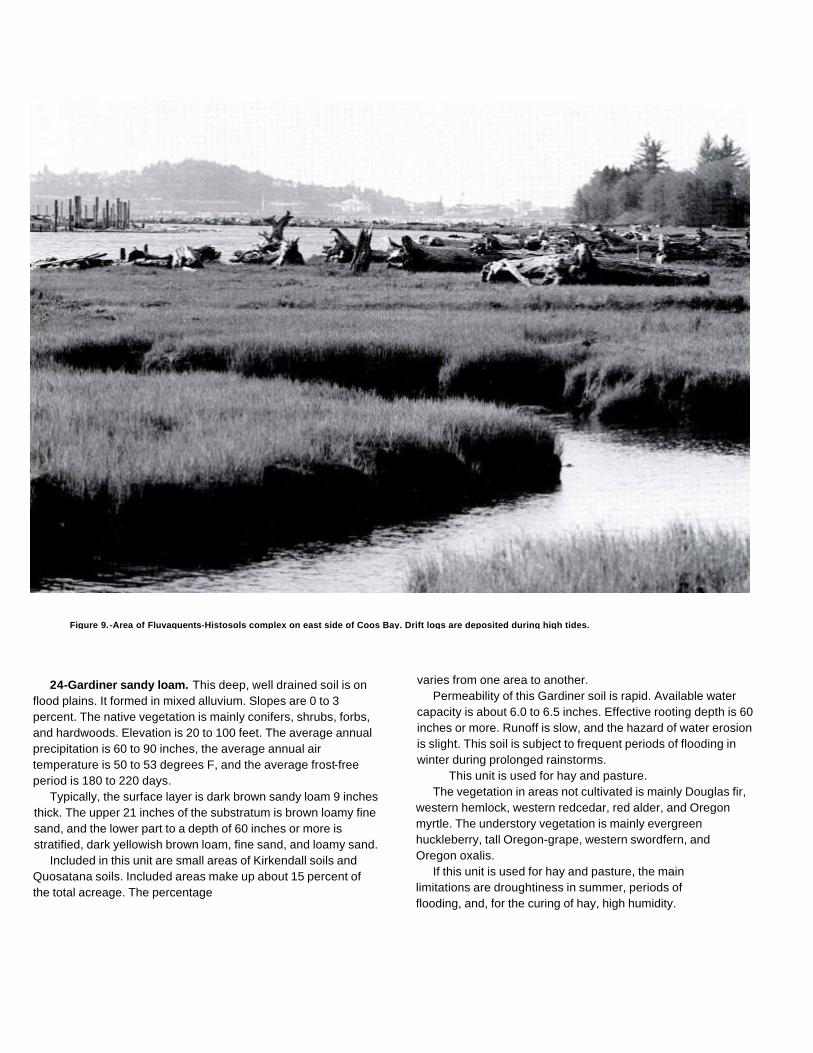
Figure 9. -Area of Fluvaquents-Histosols complex on east side of Coos Bay. Drift logs are deposited during high tides.
24-Gardiner sandy loam. This deep, well drained soil is onflood plains. It formed in mixed alluvium. Slopes are 0 to 3percent. The native vegetation is mainly conifers, shrubs, forbs,and hardwoods. Elevation is 20 to 100 feet. The average annualprecipitation is 60 to 90 inches, the average annual airtemperature is 50 to 53 degrees F, and the average frost-freeperiod is 180 to 220 days.
Typically, the surface layer is dark brown sandy loam 9 inchesthick. The upper 21 inches of the substratum is brown loamy finesand, and the lower part to a depth of 60 inches or more isstratified, dark yellowish brown loam, fine sand, and loamy sand.
Included in this unit are small areas of Kirkendall soils andQuosatana soils. Included areas make up about 15 percent ofthe total acreage. The percentage
varies from one area to another.Permeability of this Gardiner soil is rapid. Available water
capacity is about 6.0 to 6.5 inches. Effective rooting depth is 60inches or more. Runoff is slow, and the hazard of water erosionis slight. This soil is subject to frequent periods of flooding inwinter during prolonged rainstorms.
This unit is used for hay and pasture.The vegetation in areas not cultivated is mainly Douglas fir,
western hemlock, western redcedar, red alder, and Oregonmyrtle. The understory vegetation is mainly evergreenhuckleberry, tall Oregon-grape, western swordfern, andOregon oxalis.
If this unit is used for hay and pasture, the mainlimitations are droughtiness in summer, periods offlooding, and, for the curing of hay, high humidity.

Supplemental irrigation is needed for maximum production.Sprinkler irrigation is a suitable method of applying water. Useof this method permits the even, controlled application ofwater. Water should be applied in amounts sufficient to wet theroot zone but small enough to minimize the leaching of plantnutrients. Applications of water should be adjusted to theavailable water capacity, the water intake rate, and the cropneeds.
Frequent, brief periods of flooding restrict the use of thisunit in winter. Protection from flooding can be provided onlyby the use of extensive dikes.
High humidity and frequent periods of rainfall late in springprevent the production of high-quality hay. Excess forage inspring can be used as silage. Fertilizer is needed to ensureoptimum growth of grasses and legumes. Grasses respond tonitrogen, and legumes respond to sulfur and phosphorus.Proper stocking rates and pasture rotation help to keep thepasture in good condition and to protect the soil from erosion.Periodic mowing and clipping help to maintain uniform growth,discourage selective grazing, and reduce clumpy growth.
This map unit is in capability subclass IVw.
25-Gauldy Variant loam. This deep, somewhat excessivelydrained soil is on high terraces. It formed in alluvium. Slope is 0to 3 percent. The native vegetation is mainly conifers, shrubs,forbs, and hardwoods. Elevation is 10 to 400 feet. The averageannual precipitation is 60 to 80 inches, the average annual airtemperature is 50 to 53 degrees F, and the average frost-freeperiod is 180 to 220 days.
Typically, the surface layer is very dark grayish brown loam10 inches thick. The subsoil is dark brown loam 7 inches thick.The upper 11 inches of the substratum is dark yellowish brownvery gravelly sandy loam, and the lower part to a depth of 60inches or more is yellowish brown very gravelly loamy coarsesand. In some areas the surface layer is fine sandy loam.
Included in this unit are small areas of Chismore andPyburn soils. Included areas make up about 25 percent of thetotal acreage.
Permeability of this Gauldy Variant soil is moderate.Available water capacity is about 3 to 4 inches. Effectiverooting depth is limited by the droughtiness of the subsoil.Runoff is very slow, and the hazard of water erosion is slight.
This unit is used mainly for hay and pasture. It is alsoused for homesite development.
The vegetation in areas not cultivated is mainly
Douglas fir, western hemlock, Oregon myrtle, and bigleafmaple. The understory vegetation is mainly westernswordfern, hairy brackenfern, salmonberry, red huckleberry,and vine maple.
If this unit is used for hay and pasture, the main limitationsare droughtiness in summer and, for the curing of hay, highhumidity. Supplemental irrigation is needed for maximumproduction in summer. Sprinkler irrigation is a suitable methodof applying water. Use of this method permits the even,controlled application of water. Water should be applied inamounts sufficient to wet the root zone but small enough tominimize the leaching of plant nutrients. Applications of watershould be adjusted to the available water capacity, the waterintake rate, and the crop needs.
High humidity and frequent periods of rainfall late in springprevent the production of high-quality hay. The quality of grassfor hay can be maintained by increasing the stocking rate inspring. Excess forage in spring can be used as silage.
Fertilizer is needed to ensure optimum growth of grassesand legumes. Grasses respond to nitrogen, and legumesrespond to sulfur and phosphorus. Use of proper stocking ratesand rotation grazing helps to keep the pasture in goodcondition. Rotation grazing increases the production of forageand helps to control weeds and brush. Periodic mowing andclipping help to maintain uniform growth, discourage selectivegrazing, and reduce clumpy growth.
This unit is well suited to homesite development. It has fewlimitations. If the soil in this unit is used for septic tankabsorption fields, the rapid permeability of the gravellysubstratum may result in contamination of ground water. Onsiteinvestigation is needed to determine the possibility of groundwater contamination. In summer, supplemental irrigation isneeded for lawn grasses and vegetable gardens.
This map unit is in capability subclass Ils.
26C-Gelsel silt loam, 2 to 12 percent slopes. This deep,well drained soil is on side slopes and ridgetops of coastalmountains. It formed in residuum and colluvium deriveddominantly from sedimentary rock. The native vegetation ismainly conifers, shrubs, forbs, and hardwoods. Elevation is 20to 500 feet. The average annual precipitation is 55 to 80inches, the average annual air temperature is 51 to 53 degreesF, and the average frost-free period is 200 to 240 days.
Typically, the surface layer is dark reddish brown silt loam 4inches thick. The upper 26 inches of the subsoil is dark reddishbrown silt loam and silty clay loam, and the lower 24 inches isdark reddish brown silty clay.

Weathered siltstone is at a depth of 54 inches.Included in this unit are small areas of Templeton soils.
Included areas make up about 25 percent of the totalacreage.
Permeability of this Geisel soil is moderately slow.Available water capacity is about 6.5 to 11.5 inches. Effectiverooting depth is 40 to 60 inches. Runoff is medium, and thehazard of water erosion is moderate.
This unit is used mainly for timber production, homesitedevelopment, wildlife habitat, and livestock grazing.
This unit is suited to the production of Douglas fir andwestern hemlock. Among the other species that grow on thisunit are western redcedar, red alder, Sitka spruce, andOregon myrtle. The understory vegetation is mainlysalmonberry, rose, trailing blackberry, hairy brackenfern,western swordfern, and northern twinflower.
On the basis of a 100-year site curve, the mean site indexfor Douglas fir is 146. At the culmination of the mean annualincrement (CMAI), the production of 60-year-old Douglas firtrees 1.5 inches in diameter or more at breast height is 153cubic feet per acre per year. On the basis of a 50-year sitecurve, the mean site index for Douglas fir is 109.
The main limitations for the management of timber on thisunit are the susceptibility of the surface layer to compaction andplant competition. Using standard wheeled and trackedequipment when the soil is moist causes rutting andcompaction. Puddling can occur when the soil is wet. Usinglow-pressure ground equipment reduces damage to the soiland helps to maintain productivity. Highlead or other loggingsystems that fully or partially suspend logs damage the soil lessand generally are less costly than tractor systems.
When openings are made in the canopy, invading brushyplants can delay natural reforestation. Undesirable plantsprevent adequate natural or artificial reforestation unlessintensive site preparation and maintenance are provided.Reforestation can be accomplished by planting Douglas fir andwestern hemlock seedlings.
If this unit is used for livestock grazing, the main limitation isthe susceptibility of the surface layer to compaction. Grazingcattle when the soil is moist results in compaction of thesurface layer and poor tilth. Compaction limits the movementof air and water in the soil and restricts the growth of roots; itcan seriously reduce the productivity of the soil. Grazingshould be delayed until the soil has drained sufficiently and isfirm enough to withstand trampling by livestock.
In summer, droughtiness limits the choice of forage
plants and limits production. Irrigation generally isimpractical because of an inadequate water supply.
Fertilizer is needed to ensure optimum growth of grassesand legumes. Grass-legume pastures respond to sulfur,phosphorus, and molybdenum. Using a good fertilizationprogram increases the production of forage in winter. Properstocking rates, pasture rotation, and restricted grazing duringwet periods help to keep the pasture in good condition. Periodicmowing and clipping help to maintain uniform growth,discourage selective grazing, and reduce clumpy growth.
If this unit is used for homesite development, the mainlimitations are the moderately slow permeability, slope, anddepth to bedrock. Septic tank absorption fields may notfunction properly during rainy periods because of themoderately slow permeability of the subsoil. This limitationcan be overcome by increasing the size of the septic tankabsorption field. Absorption lines should be installed on thecontour.
Careful planning of road location can minimize the amount ofcutting and filling required. The risk of erosion is increased if thesoil is left exposed during site development. Revegetatingdisturbed areas around construction sites as soon as feasiblehelps to control erosion. Plant cover can be established andmaintained through proper fertilizing, seeding, mulching, andshaping of the slopes. Topsoil can be stockpiled and used toreclaim areas disturbed during construction. In summer,supplemental irrigation is needed for lawn grasses andvegetable gardens.
This map unit is in capability subclass Ille.
26D-Geisel silt loam, 12 to 30 percent slopes.This deep, well drained soil is on side slopes of coastalmountains. It formed in residuum and colluvium deriveddominantly from sedimentary rock. The native vegetation ismainly conifers, shrubs, forbs, and hardwoods. Elevation is 20to 500 feet. The average annual precipitation is 55 to 80inches, the average annual air temperature is 51 to 53 degreesF, and the average frost-free period is 200 to 240 days.
Typically, the surface layer is dark reddish brown silt loam 4inches thick. The upper 26 inches of the subsoil is dark reddishbrown silt loam and silty clay loam, and the lower 24 inches isdark reddish brown silty clay. Weathered siltstone is at a depthof 54 inches.
Included in this unit are small areas of Templeton soils.Included areas make up about 25 percent of the totalacreage. The percentage varies from one area to another.
Permeability of this Geisel soil is moderately slow.Available water capacity is about 6.5 to 11.5 inches.

Effective rooting depth is 40 to 60 inches. Runoff is medium,and the hazard of water erosion is moderate.
This unit is used mainly for timber production, wildlifehabitat, and livestock grazing. It is also used for homesitedevelopment.
This unit is suited to the production of Douglas fir andwestern hemlock. Among the other species that grow on thisunit are western redcedar, red alder, Sitka spruce, and Oregonmyrtle. The understory vegetation is mainly salmonberry, rose,trailing blackberry, hairy brackenfern, western swordfern, andnorthern twinflower.
On the basis of a 100-year site curve, the mean site indexfor Douglas fir is 146. At the culmination of the mean annualincrement (CMAI), the production of 60-year-old Douglas firtrees 1.5 inches in diameter or more at breast height is 153cubic feet per acre per year. On the basis of a 50-year sitecurve, the mean site index for Douglas fir is 109.
The main limitations for the management of timber on thisunit are the susceptibility of the surface layer to compaction, thehazard of erosion, and plant competition. Using standardwheeled and tracked equipment when the soil is moist causesrutting and compaction. Puddling can occur when the soil iswet. Using low-pressure ground equipment reduces dam age tothe soil and helps to maintain productivity. Highlead or otherlogging systems that fully or partially suspend logs damage thesoil less and generally are less costly than tractor systems.
Proper design of road drainage systems and care in theplacement of culverts help to control erosion. Cuts and fills aresubject to erosion unless treated. Seeding, mulching, benching,and compacting the soil can reduce erosion. Steep yardingpaths, skid trails, and firebreaks are subject to rilling andgullying unless they are provided with adequate water bars orare protected by plant cover, or both.
Road location and maintenance costs are greater in themore steeply sloping areas. Unsurfaced roads and skid trailsare soft when wet or moist, and they may be impassableduring rainy periods. Logging roads require suitable surfacingfor year-round use. Rock for road construction is not readilyavailable in this unit.
When openings are made in the canopy, invading brushyplants can delay natural reforestation. Undesirable plantsprevent adequate natural or artificial reforestation unlessintensive site preparation and maintenance are provided.Reforestation can be accomplished by planting Douglas fir andwestern hemlock seedlings.
If this unit is used for livestock grazing, the main
limitation is the susceptibility of the surface layer tocompaction. Grazing cattle when the soil is moist results incompaction of the surface layer, poor tilth, and excessiverunoff. Compaction limits the movement of air and water in thesoil and restricts the growth of roots; it can seriously reduce theproductivity of the soil. Grazing should be delayed until the soilhas drained sufficiently and is firm enough to withstandtrampling by livestock.
In summer, droughtiness limits the choice of forage plantsand limits production. Irrigation generally is impracticalbecause of slope and an inadequate water supply.
Fertilizer is needed to ensure optimum growth of grassesand legumes. Grass-legume pastures respond to sulfur,phosphorus, and molybdenum. Using a good fertilizationprogram increases the production of forage in winter. Properstocking rates, pasture rotation, and restricted grazing duringwet periods help to keep the pasture in good condition and toprotect the soil from erosion, Rotation grazing increases theproduction of forage and helps to control weeds and brush.
If this unit is used for homesite development, the mainlimitations are the moderately slow permeability and slope.Absorption lines should either be placed in the less slopingareas of this unit or in adjoining areas of soils that are not sosteep. Septic tank absorption fields may not function properlyduring rainy periods because of the moderately slowpermeability of the subsoil. This limitation can be overcome byincreasing the size of the septic tank absorption field. Extensivecutting and filling generally are required to provide nearly levelconstruction sites. Building roads in the less sloping areas ofthis unit reduces the amount of cutting and filling required.Roads should be provided with surface drainage. Cuts and fillsare susceptible to erosion. Revegetating disturbed areasaround construction sites as soon as feasible helps to controlerosion. In summer, supplemental irrigation is needed for lawngrasses and vegetable gardens.
This map unit is in capability subclass IVe.
26E-Gelsel silt loam, 30 to 50 percent slopes. This deep,well drained soil is on side slopes of coastal mountains. Itformed in residuum and colluvium derived dominantly fromsedimentary rock. The native vegetation is mainly conifers,shrubs, forbs, and hardwoods. Elevation is 20 to 750 feet. Theaverage annual precipitation is 55 to 80 inches, the averageannual air temperature is 51 to 53 degrees F, and the averagefrost-free period is 200 to 240 days.
Typically, the surface layer is dark reddish brown silt

loam 4 inches thick. The upper 26 inches of the subsoil is darkreddish brown silt loam and silty clay loam, and the lower 24inches is dark reddish brown silty clay. Weathered siltstone isat a depth of 54 inches.
Included in this unit are small areas of Templeton soils.Included areas make up about 25 percent of the totalacreage. The percentage varies from one area to another.
Permeability of this Geisel soil is moderately slow.Available water capacity is about 6.5 to 11.5 inches.Effective rooting depth is 40 to 60 inches. Runoff is rapid,and the hazard of water erosion is high.
This unit is used mainly for timber production andwildlife habitat. It is also used for livestock grazing.
This unit is suited to the production of Douglas fir andwestern hemlock. Among the other species that grow on thisunit are western redcedar, Sitka spruce, red alder, andOregon myrtle. The understory vegetation is mainlysalmonberry, rose, trailing blackberry, hairy brackenfern,western swordfern, and northern twinflower.
On the basis of a 100-year site curve, the mean site indexfor Douglas fir is 146. At the culmination of the mean annualincrement (CMAI), the production of 60-year-old Douglas firtrees 1.5 inches in diameter or more at breast height is 153cubic feet per acre per year. On the basis of a 50-year sitecurve, the mean site index for Douglas fir is 109.
The main limitations for the management of timber on thisunit are the susceptibility of the surface layer to compaction,the hazard of erosion, steepness of slope, and plantcompetition. The main limitation for the harvesting of timber issteepness of slope. Using standard wheeled and trackedequipment when the soil is moist causes rutting andcompaction. Puddling can occur when the soil is wet. Cableyarding systems are safer, damage the soil less, and help tomaintain productivity.
Proper design of road drainage systems and care in theplacement of culverts help to control erosion. Cuts and fills aresubject to erosion unless treated. Seeding, mulching, benching,and compacting the soil can reduce erosion. Steep yardingpaths, skid trails, and firebreaks are subject to rilling andgullying unless they are provided with adequate water bars orare protected by plant cover, or both.
Locating roads on midslopes results in large cuts and fillsand thus removes land from production. Unsurfaced roads andskid trails are soft when wet or moist, and they may beimpassable during rainy periods. Logging roads requiresuitable surfacing for year-round use.
Rock for road construction is not readily available in this unit.When openings are made in the canopy, invading brushy
plants can delay natural reforestation. Undesirable plantsprevent adequate natural or artificial reforestation unlessintensive site preparation and maintenance are provided.Reforestation can be accomplished by planting Douglas fir andwestern hemlock seedlings.
If this unit is used for livestock grazing, the main limitationsare the susceptibility of the surface layer to compaction andslope. Grazing cattle when the soil is moist results incompaction of the surface layer, poor tilth, and excessiverunoff. Compaction limits the movement of air and water inthe soil and restricts the growth of roots; it can seriouslyreduce the productivity of the soil.
In summer, droughtiness limits the choice of forage plantsand limits production. Irrigation generally is impracticalbecause of slope and an inadequate water supply.
Slope limits access by livestock and results in overgrazingof the less sloping areas. If the pasture is overgrazed, theproportion of preferred forage plants decreases and theproportion of less preferred forage plants increases. Livestockgrazing, therefore, should be managed so that the desiredbalance of species is maintained in the plant community.Severe overgrazing reduces the plant cover and increases therisk of erosion. Weeds and brush can be controlled by aerialspraying. Rotation grazing increases the production of forageand helps to control weeds and brush.
Fertilizer is needed to ensure optimum growth of grassesand legumes. Grass-legume pastures respond to sulfur,phosphorus, and molybdenum. Using a good fertilizationprogram increases the production of forage in winter. Properstocking rates, pasture rotation, and restricted grazing duringwet periods help to keep the pasture in good condition and toprotect the soil from erosion.
This map unit is in capability subclass Vle.
27E-Harrington very gravelly loam, 30 to 50 percentslopes. This moderately deep, well drained soil is on sideslopes and ridgetops of mountains. It formed in colluviumderived dominantly from basalt. The native vegetation is mainlyconifers, shrubs, forbs, and hardwoods. Elevation is 100 to1,600 feet. The average annual precipitation is 60 to 75 inches,the average annual air temperature is 49 to 53 degrees F, andthe average frost-free period is 160 to 240 days.

Typically, the surface layer is dark reddish brown verygravelly loam and extremely gravelly loam 13 inches thick.The upper 7 inches of the subsoil is dark reddish brown verygravelly clay loam, and the lower 6 inches is dark reddishbrown extremely gravelly clay loam. Hard basalt is at a depthof 26 inches.
Included in this unit are small areas of Blachly, Preacher,and Bohannon soils. Also included are small areas of soils thatare similar to this Harrington soil but have bedrock at a depthof less than 20 inches or more than 40 inches. Included areasmake up about 25 percent of the total acreage.
Permeability of this Harrington soil is moderately rapid.Available water capacity is about 2.0 to 5.5 inches. Effectiverooting depth is 20 to 40 inches. Runoff is rapid, and thehazard of water erosion is high.
This unit is used mainly for timber production andwildlife habitat. It is also used for livestock grazing.
This unit is suited to the production of Douglas fir.Among the other species that grow on this unit are westernhemlock, grand fir, western redcedar, and Oregon myrtle.The understory vegetation is mainly creambushoceanspray, rose, snowberry, hair brackenfern, westernswordfern, and northern twinflower.
On the basis of a 100-year site curve, the mean site indexfor Douglas fir is 140. At the culmination of the mean annualincrement (CMAI), the production of 60-year-old Douglas firtrees 1.5 inches in diameter or more at breast height is 145cubic feet per acre per year. On the basis of a 50-year sitecurve, the mean site index for Douglas fir is 102.
The main limitations for the management of timber on thisunit are the hazards of erosion and windthrow, steepness ofslope, seedling mortality, and plant competition. Steepness ofslope restricts the use of wheeled and tracked equipment onskid trails. Cable yarding generally is safer and disturbs the soilless.
Proper design of road drainage systems and care in theplacement of culverts help to control erosion. Cuts and fills aresubject to erosion unless treated. Seeding, mulching, benching,and compacting the soil can reduce erosion. Steep yardingpaths, skid trails, and firebreaks are subject to rilling andgullying unless they are provided with adequate water bars orare protected by plant cover, or both. Logging roads requiresuitable surfacing for year-round use. Rock for roadconstruction is not readily available in this unit. Road locationand maintenance costs are greater in the more steeply slopingareas. Because roots are restricted by bedrock, trees aresubject to windthrow.
When openings are made in the canopy, invading
brushy plants can delay natural reforestation. Undesirableplants reduce natural or artificial reforestation unless intensivesite preparation and maintenance are provided. The highcontent of rock fragments in the soil increases seedlingmortality. To compensate for the higher mortality that can beexpected, larger trees or more trees than normal can beplanted. Reforestation can be accomplished by plantingDouglas fir seedlings.
If this unit is used for livestock grazing, the main limitation isslope. Slope limits access by livestock and results inovergrazing of the less sloping areas. If the pasture isovergrazed, the proportion of preferred forage plants decreasesand the proportion of less preferred forage plants increases.Livestock grazing, therefore, should be managed so that thedesired balance of species is maintained in the plantcommunity. Severe overgrazing reduces the plant cover andincreases the risk of erosion. Weeds and brush can becontrolled by aerial spraying. Rotation grazing increases theproduction of forage and helps to control weeds and brush.
Fertilizer is needed to ensure optimum growth of grassesand legumes. Grass-legume pastures respond to sulfur,phosphorus, and molybdenum. Using a good fertilizationprogram increases the production of forage in winter.
This map unit is in capability subclass Vle.
27F-Harrington very gravelly loam, 50 to 70 percentslopes. This moderately deep, well drained soil is on sideslopes and ridgetops of mountains. It formed in colluviumderived dominantly from basalt. The native vegetation is mainlyconifers, shrubs, forbs, and hardwoods. Elevation is 100 to1,600 feet. The average annual precipitation is 60 to 75 inches,the average annual air temperature is 49 to 53 degrees F, andthe average frost-free period is 160 to 240 days.
Typically, the surface layer is dark reddish brown verygravelly loam and extremely gravelly loam 13 inches thick.The upper 7 inches of the subsoil is dark reddish brown verygravelly clay loam, and the lower 6 inches is dark reddishbrown extremely gravelly clay loam. Hard basalt is at a depthof 26 inches.
Included in this unit are small areas of Blachly, Preacher,and Bohannon soils. Also included are small areas of soils thatare similar to this Harrington soil but have bedrock at a depth ofless than 20 inches or more than 40 inches. Included areasmake up about 25 percent of the total acreage.
Permeability of this Harrington soil is moderatelyrapid. Available water capacity is about 2.0 to 5.5
inches. Effective rooting depth is 20 to 40 inches. Runoff israpid, and the hazard of water erosion is high.
This unit is used for timber production and wildlifehabitat.
This unit is suited to the production of Douglas fir.Among the other species that grow on this unit are westernhemlock, grand fir, western redcedar, and Oregon myrtle.The understory vegetation is mainly creambushoceanspray, rose, snowberry, hairy brackenfern, westernswordfern, and northern twinflower.
On the basis of a 100-year site curve, the mean site indexfor Douglas fir is 140. At the culmination of the mean annualincrement (CMAI), the production of 60-year-old Douglas firtrees is 1.5 inches in diameter or more at breast height is 145cubic feet per acre per year. On the basis of a 50-year sitecurve, the mean site index for Douglas fir is 102.
The main limitations for the management of timber on thisunit are the hazard of erosion, steepness of slope, seedlingmortality, and plant competition. Highlead or other cablelogging systems are most suitable.
Proper design of road drainage systems and care in theplacement of culverts help to control erosion. Cuts and fills aresubject to erosion unless treated. Seeding, mulching, benching,and compacting the soil can reduce erosion. Steep yardingpaths, skid trails, and firebreaks are subject to rilling andgullying unless they are provided with adequate water bars orare protected by plant cover, or both. Logging roads requiresuitable surfacing for year-round use. Rock for roadconstruction is not readily available in this unit. Locating roadson midslopes results in large cuts and fills and thus removesland from production. Material cast to the side when buildingroads can damage vegetation. It is also a potential source ofsedimentation. End hauling of waste material minimizesdamage to the vegetation downslope and reduces the potentialfor sedimentation. Because roots are restricted by bedrock,trees are subject to windthrow.
When openings are made in the canopy, invading brushyplants can delay natural reforestation. Undesirable plantsreduce natural or artificial reforestation unless intensive sitepreparation and maintenance are provided. The high content ofrock fragments in the soil increases seedling mortality. Tocompensate for the higher mortality that can be expected,larger trees or more trees than normal can be planted.Reforestation can be accomplished by planting Douglas firseedlings.
This map unit is in capability subclass Vlle.
28-Heceta fine sand. This deep, poorly drained soil is indeflation basins and depressional areas between dunes. Itformed in eolian material. Slopes are 0 to 3 percent. The nativevegetation is mainly sedges, rushes, water-tolerant grasses,and shrubs. Elevation is 0 to 80 feet. The average annualprecipitation is 50 to 70 inches, the average annual airtemperature is 51 to 53 degrees F, and the average frost-freeperiod is 200 to 240 days.
Typically, the surface layer is very dark grayish brownfine sand 4 inches thick. The substratum to a depth of 60inches or more is mottled, grayish brown sand.
Included in this unit are small areas of Waldport andNetarts soils and Dune land, Included areas make up about20 percent of the total acreage. The percentage varies fromone area to another.
Permeability of this Heceta soil is rapid. Available watercapacity is about 1 to 2 inches. Effective rooting depth is 60inches for water-tolerant plants, but it is limited by the watertable for non-water-tolerant plants. Runoff is ponded, and thehazard of water erosion is slight. The water table fluctuatesfrom 12 inches above the surface to 6 inches below thesurface from October to May.
This unit is used for recreation and wildlife habitat.If this unit is used for recreational development, the main
limitation is wetness. Use of paths and trails may be limited to2 or 3 months in summer.
This map unit is in capability subclass IVw.
29B-Heceta-Waldport fine sands, 0 to 7 percent slopes.This map unit is on deflation plains and small dunes (fig. 10).The native vegetation is mainly rushes, sedges, and shrubs onthe Heceta soil and grasses and shrubs on the Waldport soil.Elevation is 0 to 40 feet. The average annual precipitation is 50to 70 inches, the average annual air temperature is 51 to 53degrees F, and the average frost-free period is 200 to 240days.
This unit is 55 percent Heceta fine sand and 25 percentWaldport fine sand. The Heceta soil is on nearly level deflationplains, and the Waldport soil is on small, stabilized sanddunes. The components of this unit are so intricatelyintermingled that it was not practical to map them separately atthe scale used.
Included in this unit are small areas of Dune land. Alsoincluded are small areas of Yaquina soils. Included areas makeup about 20 percent of the total acreage.
The Heceta soil is deep and poorly drained. It formed ineolian material. Slope is 0 to 3 percent. Typically, the surfacelayer is very dark grayish brown fine sand 4

Figure 10. -Area of Heceta-Waldport fine sands, 0 to 7 percent slopes, on a deflation plain in foreground.
inches thick. The substratum to a depth of 60 inches or moreis mottled, grayish brown sand.
Permeability of the Heceta soil is rapid. Available watercapacity is about 1 to 2 inches. Effective rooting depth is 60inches for water-tolerant plants, but it is limited by the watertable for non-water-tolerant plants. Runoff is ponded, and thehazard of water erosion is
slight. The water table fluctuates from 12 inches above thesurface to 6 inches below the surface from October to May.
The Waldport soil is deep and excessively drained. It formedin eolian deposits. Slope is 0 to 7 percent. Typically, thesurface layer is very dark grayish brown fine sand 4 inchesthick. The substratum to a depth of

60 inches or more is dark yellowish brown fine sand.Permeability of the Waldport soil is very rapid. Available water
capacity is about 3 to 4 inches. Effective rooting depth is 60inches or more. Runoff is very slow, and the hazard of watererosion is slight. The hazard of soil blowing is severe.
This unit is used for recreation and wildlife habitat.If this unit is used for recreational development, the main
limitations are wetness of the Heceta soil and the hazard of soilblowing on the Waldport soil. Use of this unit is restricted mainlyto low-intensity types of recreation, such as hiking andhorseback riding. The unit can also be used for other kinds ofrecreational activities that require a minimum of constructionand soil disturbance. The Heceta soil is ponded in winter;therefore, use of paths and trails constructed on this soil islimited to summer. Areas used for recreation can be protectedfrom soil blowing by maintaining plant cover.
This map unit is in capability subclass VIle.
30D-Honeygrove silty clay loam, 3 to 30 percent slopes.This deep, well drained soil is on broad ridgetops, benches, andhillsides. It formed in residuum and colluvium derived dominantlyfrom sandstone, siltstone, and basalt. The native vegetation ismainly conifers, shrubs, forbs, and hardwoods. Elevation is 200to 1,000 feet. The average annual precipitation is 60 to 85inches, the average annual air temperature is 50 to 53 degreesF, and the average frost-free period is 180 to 240 days.
Typically, the surface is covered with a mat of decomposingorganic litter 2 inches thick. The surface layer is dark reddishbrown silty clay loam 5 inches thick. The subsoil to a depth of60 inches or more is dominantly dark red clay. In some areasthe surface layer is more than 10 inches thick.
Included in this unit are small areas of Blachly and Dementsoils and soils that are similar to this Honeygrove soil but havebedrock at a depth of 30 to 40 inches. Included areas make upabout 25 percent of the total acreage.
Permeability of this Honeygrove soil is moderately slow.Available water capacity is about 8.5 to 9.5 inches. Effectiverooting depth is 60 inches or more. Runoff is medium, andthe hazard of water erosion is moderate.
This unit is used mainly for timber production and wildlifehabitat.
This unit is suited to the production of Douglas fir. Among theother species that grow on this unit are western hemlock,western redcedar, Port Orford cedar,
and red alder. The understory vegetation is mainly salal, vinemaple, evergreen huckleberry, creambush oceanspray,western swordfern, and western brackenfern.
On the basis of a 100-year site curve, the mean site index forDouglas fir is 165. At the culmination of the mean annualincrement (CMAI), the production of 60-year-old Douglas fir trees1.5 inches in diameter or more at breast height is 176 cubic feetper acre per year. On the basis of a 50-year site curve, the meansite index for Douglas fir is 122.
The main limitations for the management of timber on this unitare the hazard of erosion and plant competition. Highlead or otherlogging systems that fully or partially suspend logs damage the soilless and generally are less costly than tractor systems.
Proper design of road drainage systems and care in theplacement of culverts help to control erosion. Cuts and fills erodeslightly unless treated. Seeding, mulching, benching, andcompacting the soil can reduce erosion. Steep yarding paths, skidtrails, and firebreaks are subject to rilling and gullying unless theyare provided with adequate water bars or are protected by plantcover, or both. Unsurfaced roads and skid trails are slippery whenwet or moist, and they may be impassable during rainy periods.Logging roads require suitable surfacing for year-round use. Rockfor road construction is not readily available in this unit.
When openings are made in the canopy, invading brushyplants can delay natural reforestation. Undesirable plantsreduce natural or artificial reforestation unless intensive sitepreparation and maintenance are provided. Reforestation canbe accomplished by planting Douglas fir seedlings.
This map unit is in capability subclass Vle.
30E-Honeygrove silty clay loam, 30 to 50 percent slopes.This deep, well drained soil is on hillsides. It formed in residuumand colluvium derived dominantly from sandstone, siltstone, andbasalt. The native vegetation is mainly conifers, shrubs, forbs, andhardwoods. Elevation is 200 to 1,000 feet. The average annualprecipitation is 60 to 85 inches, the average annual airtemperature is 50 to 53 degrees F, and the average frost-freeperiod is 180 to 240 days.
Typically, the surface is covered with a mat of decomposingorganic litter 2 inches thick. The surface layer is dark reddishbrown silty clay loam 5 inches thick. The subsoil to a depth of 60inches or more is dominantly dark red clay.
Included in this unit are small areas of Blachly, Rinearson,and Dement soils. Also included are soils
that are similar to this Honeygrove soil but have bedrock at adepth of 30 to 40 inches. Included areas make up about 25percent of the total acreage.
Permeability of this Honeygrove soil is moderately slow.Available water capacity is about 8.5 to 9.5 inches. Effectiverooting depth is 60 inches or more. Runoff is rapid, and thehazard of water erosion is high.
This unit is used mainly for timber production andwildlife habitat.
This unit is suited to the production of Douglas fir. Amongthe other species that grow on this unit are western hemlock,western redcedar, Port Orford cedar, and red alder. Theunderstory vegetation is mainly salal, vine maple, evergreenhuckleberry, creambush oceanspray, western swordfern, andwestern brackenfern.
On the basis of a 100-year site curve, the mean site indexfor Douglas fir is 165. At the culmination of the mean annualincrement (CMAI), the production of 60-year-old Douglas firtrees 1.5 inches in diameter or more at breast height is 176cubic feet per acre per year. On the basis of a 50-year sitecurve, the mean site index for Douglas fir is 122.
The main limitations for the management of timber on thisunit are the hazard of erosion, steepness of slope, and plantcompetition. Steepness of slope restricts the use of wheeledand tracked equipment on skid trails. Cable yarding generally issafer and disturbs the soil less.
Proper design of road drainage systems and care in theplacement of culverts help to control erosion. Cuts and fills aresubject to erosion unless treated. Seeding, mulching, benching,and compacting the soil can reduce erosion. Steep yardingpaths, skid trails, and firebreaks are subject to rilling andgullying unless they are provided with adequate water bars orare protected by plant cover, or both. Unsurfaced roads andskid trails are slippery when moist or wet, and they may beimpassable during rainy periods. Logging roads require suitablesurfacing for year-round use. Rock for road construction is notreadily available in this unit.
When openings are made in the canopy, invadingbrushy plants can delay natural reforestation. Undesirableplants reduce natural or artificial reforestation unlessintensive site preparation and maintenance are provided.Reforestation can be accomplished by planting Douglas firseedlings.
This map unit is in capability subclass Vle.
31B-Joeney very fine sandy loam, 0 to 7 percentslopes. This deep, poorly drained soil is on marine terraces. Itformed in marine deposits. The native
vegetation is mainly conifers, shrubs, forbs, and hardwoods.Elevation is 150 to 550 feet. The average annual precipitationis 60 to 65 inches, the average annual air temperature is 51to 53 degrees F, and the average frost-free period is 200 to240 days.
Typically, the surface is covered with a mat of leaves andneedles 1 inch thick. The surface layer is light gray and grayvery fine sandy loam 10 inches thick. The upper 2 inches of thesubsoil is dark reddish brown very fine sandy loam, and thelower 12 inches is mottled, reddish yellow and brownish yellowloam and silt loam. The substratum to a depth of 41 inches ormore is mottled, brownish yellow and light gray silty clay loam.
Included in this unit are small areas of Templeton soils. Alsoincluded are small areas of soils that are similar to this Joeneysoil but have a sandy substratum. Included areas make upabout 25 percent of the total acreage.
Permeability of this Joeney soil is moderately slow.Available water capacity is about 2 to 4 inches. Effectiverooting depth is 60 inches for water-tolerant plants, but it islimited by the water table for non-water-tolerant plants. Runoffis very slow, and the hazard of water erosion is slight. Thewater table fluctuates between the surface and a depth of 18inches below the surface from November to March.
This unit is used mainly for timber production andwildlife habitat.
This unit is suited to the production of Sitka spruce. Amongthe other species that grow on this unit are western redcedarand western hemlock. The understory vegetation is mainlyevergreen huckleberry, Pacific rhododendron, salal, sedges,and rushes.
On the basis of a 100-year site curve, the mean site indexfor Sitka spruce is 120. At the culmination of the mean annualincrement (CMAI), the production of 50-year-old Sitka sprucetrees 1.5 inches in diameter or more at breast height is 156cubic feet per acre per year.
The main limitations for the management of timber on thisunit are the hazard of windthrow, seedling mortality, and plantcompetition. The seasonal high water table limits the use ofequipment to dry periods.
Proper design of road drainage systems and care in theplacement of culverts help to control erosion. Cuts and fills aresubject to erosion unless treated. Seeding, mulching, benching,and compacting the soil can reduce erosion. Unsurfaced roadsand skid trails are soft when wet or moist, and they may beimpassable during rainy periods. Logging roads require suitablesurfacing for year-round use. Rock for road construction is notreadily available in this unit.
Windthrow is a hazard when the soil is wet and winds arestrong. Tree seedlings have only a moderate rate of survivalbecause of the seasonal high water table. When openings aremade in the canopy, invading brushy plants can delay naturalreforestation. Undesirable plants prevent adequate natural orartificial reforestation unless intensive site preparation andmaintenance are provided. Reforestation can be accomplishedby planting Douglas fir, Sitka spruce, and western redcedarseedlings.
This map unit is in capability subclass IVw.
32B-Joeney-Templeton complex, 0 to 7 percent slopes.This map unit is in undulating areas of dissected marineterraces. The native vegetation is mainly conifers, shrubs,forbs, and hardwoods. Elevation is 150 to 550 feet. Theaverage annual precipitation is 60 to 65 inches, the averageannual air temperature is 51 to 53 degrees F, and the averagefrost-free period is 200 to 240 days.
This unit is 40 percent Joeney very fine sandy loam and 30percent Templeton silt loam. The Joeney soil is in concave,nearly level depressional areas, and the Templeton soil is inconvex, gently sloping areas on marine terrace escarpments.The components of this unit are so intricately intermingled that itwas not practical to map them separately at the scale used.
Included in this unit are small areas of soils that are similar tothis Joeney soil but have a thin cemented pan. In the vicinity ofBeaver Hill are small areas of soils that are similar to theTempleton soil but that formed in marine sediment, have mottlesin the subsoil, and have a sandy substratum. These soils areless productive than the Templeton soils. Included areas makeup about 30 percent of the total acreage.
The Joeney soil is deep and poorly drained. It formed inmarine deposits. Typically, the surface is covered with a mat ofleaves and needles 1 inch thick. The surface layer is light grayand gray very fine sandy loam 10 inches thick. The upper 2inches of the subsoil is dark reddish brown very fine sandy loam,and the lower 12 inches is mottled, reddish yellow and brownishyellow loam and silt loam. The substratum to a depth of 41inches or more is mottled, brownish yellow and light gray siltyclay loam.
Permeability of the Joeney soil is moderately slow. Availablewater capacity is about 2 to 4 inches. Effective rooting depth is 60inches for water-tolerant plants , but it may be limited by the watertable for non-water-tolerant plants. Runoff is very slow, and thehazard of water erosion is slight. The water table fluctuatesbetween the surface and a depth of 18 inches
below the surface from November to March.The Templeton soil is deep and well drained. It formed in
colluvium and residuum derived dominantly from sedimentaryrock. Typically, the surface layer is very dark brown and darkbrown silt loam 16 inches thick. The subsoil is reddish brown,yellowish red, and strong brown silty clay loam 26 inches thick.Soft, weathered, fractured siltstone is at a depth of 42 inches. Insome areas the dark-colored surface layer is less than 10inches thick.
Permeability of the Templeton soil is moderate. Availablewater capacity is about 8.0 to 17.5 inches. Effective rootingdepth is 40 to 60 inches. Runoff is slow, and the hazard ofwater erosion is slight.
This unit is used mainly for timber production and wildlifehabitat.
This unit is suited to the production of Sitka spruce. Amongthe other species that grow on the unit are western redcedar,western hemlock, red alder, and Douglas fir. The understoryvegetation is mainly evergreen huckleberry, Pacificrhododendron, salal, sedges, and rushes.
On the basis of a 100-year site curve, the mean site indexfor Sitka spruce is 120 on the Joeney soil. At the culmination ofthe mean annual increment (CMAI), the production of50-year-old Sitka spruce trees 1.5 inches in diameter or more atbreast height is 156 cubic feet per acre per year.
On the basis of a 100-year site curve, the mean site index forSitka spruce is 169 on the Templeton soil. At the culmination ofthe mean annual increment (CMAI), the production of50-year-old Sitka spruce trees 1.5 inches in diameter or more atbreast height is 255 cubic feet per acre per year.
High winds from the Pacific Ocean may seriously limit thegrowth of trees on this unit unless they are in a protected area.
The main limitations for the management of timber on this unitare the susceptibility of the surface layer of the Templeton soil tocompaction, the hazard of windthrow and seedling mortality onthe Joeney soil, and plant competition. Using standard wheeledand tracked equipment when the soil is moist causes rutting andcompaction. Displacement of the surface layer occurs mostreadily when the soil is dry. Puddling can occur when the soil iswet. Using low-pressure ground equipment damages the soil lessand helps to maintain productivity. The seasonal high water tablein the Joeney soil limits the use of equipment to dry periods.
Proper design of road drainage systems and care in theplacement of culverts help to control erosion. Unsurfaced roadsand skid trails are soft and slippery
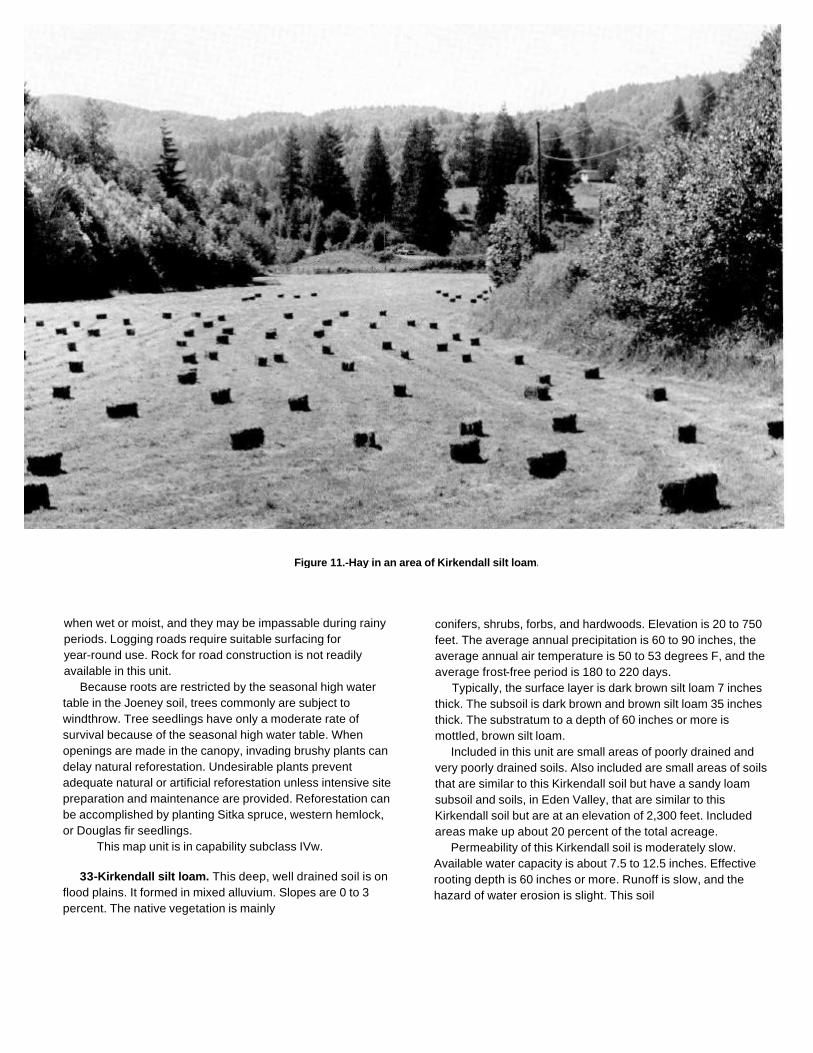
Figure 11.-Hay in an area of Kirkendall silt loam.
when wet or moist, and they may be impassable during rainyperiods. Logging roads require suitable surfacing foryear-round use. Rock for road construction is not readilyavailable in this unit.
Because roots are restricted by the seasonal high watertable in the Joeney soil, trees commonly are subject towindthrow. Tree seedlings have only a moderate rate ofsurvival because of the seasonal high water table. Whenopenings are made in the canopy, invading brushy plants candelay natural reforestation. Undesirable plants preventadequate natural or artificial reforestation unless intensive sitepreparation and maintenance are provided. Reforestation canbe accomplished by planting Sitka spruce, western hemlock,or Douglas fir seedlings.
This map unit is in capability subclass IVw.
33-Kirkendall silt loam. This deep, well drained soil is onflood plains. It formed in mixed alluvium. Slopes are 0 to 3percent. The native vegetation is mainly
conifers, shrubs, forbs, and hardwoods. Elevation is 20 to 750feet. The average annual precipitation is 60 to 90 inches, theaverage annual air temperature is 50 to 53 degrees F, and theaverage frost-free period is 180 to 220 days.
Typically, the surface layer is dark brown silt loam 7 inchesthick. The subsoil is dark brown and brown silt loam 35 inchesthick. The substratum to a depth of 60 inches or more ismottled, brown silt loam.
Included in this unit are small areas of poorly drained andvery poorly drained soils. Also included are small areas of soilsthat are similar to this Kirkendall soil but have a sandy loamsubsoil and soils, in Eden Valley, that are similar to thisKirkendall soil but are at an elevation of 2,300 feet. Includedareas make up about 20 percent of the total acreage.
Permeability of this Kirkendall soil is moderately slow.Available water capacity is about 7.5 to 12.5 inches. Effectiverooting depth is 60 inches or more. Runoff is slow, and thehazard of water erosion is slight. This soil
is subject to frequent periods of flooding in winter duringprolonged rainstorms. The water table is at a depth of 30 to 60inches from November to April.
This unit is used for hay and pasture (fig. 11).The vegetation in areas not cultivated is mainly Douglas
fir, western hemlock, western redcedar, red alder, andOregon myrtle. The understory vegetation is mainlyevergreen huckleberry, tall Oregongrape, western swordfern,and Oregon oxalis.
If this unit is used for hay and pasture, the main limitationsare the susceptibility of the surface layer to compaction,droughtiness in summer, the hazard of flooding, and, for thecuring of hay, high humidity. Grazing when the soil is moistresults in compaction of the surface layer and poor tilth.Compaction limits the movement of air and water in the soiland restricts the growth of roots; it can seriously reduce theproductivity of the soil. Grazing should be delayed until thesoil has drained sufficiently and is firm enough to withstandtrampling by livestock.
Supplemental irrigation is needed for maximum production.Sprinkler irrigation is a suitable method of applying water. Useof this method permits the even, controlled application ofwater. Water should be applied in amounts sufficient to wetthe root zone but small enough to minimize the leaching ofplant nutrients. Applications of water should be adjusted to theavailable water capacity, the water intake rate, and the cropneeds.
Frequent, brief periods of flooding restrict the use of thisunit in winter. Protection from flooding can be provided onlyby the use of extensive dikes.
High humidity and frequent periods of rainfall late in springprevent the production of high-quality hay. Excess forage inspring can be used as silage. Fertilizer is needed to ensureoptimum growth of grasses and legumes. Grasses respond tonitrogen, and legumes respond to sulfur and phosphorus.Proper stocking rtes, pasture rotation, and restricted grazingduring wet periods help to keep the pasture in good conditionand td protect the soil from erosion. Periodic mowing andclipping help to maintain uniform growth, discourage selectivegrazing, and reduce clumpy growth.
This map unit is in capability subclass Illw.
34-Langlois silty clay loam. This deep, very poorlydrained soil is in depressional areas of flood plains and on oldtidal flats. It formed in recent alluvium. Slope is 0 to 1 percent.The native vegetation is mainly hardwoods, shrubs, forbs, andconifers. Elevation is 0 to 20 feet. The average annualprecipitation is 50 to 80 inches, the average annual airtemperature is 51 to 53
degrees F, and the average frost-free period is 200 to 240 days.Typically, the surface layer is mottled, dark grayish brown silty
clay loam 10 inches thick. The upper 20 inches of the substratumis dark grayish brown and dark gray silty clay, and the lower part toa depth of 60 inches or more is dark gray clay. In some areas thesurface layer is peaty.
Included in this unit are small areas of Chetco and Nestuccasoils. Also included are small areas of Coquille soils. Includedareas make up about 20 percent of the total acreage. Thepercentage varies from one area to another.
Permeability of this Langlois soil is slow. Available watercapacity is about 2.5 to 4.5 inches. Effective rooting depth is 60inches or more for water-tolerant plants, but it is limited by thewater table for non-water-tolerant plants. The water tablefluctuates between the surface and a depth of 36 inches belowthe surface from. November to March. Runoff is slow, and thehazard of water erosion is slight. This soil is subject to frequentperiods of flooding in winter.
This unit is used mainly for hay and pasture and for wildlifehabitat.
The vegetation in areas not cultivated is mainly Pacificwillow, red alder, black cottonwood, and Sitka spruce. Theunderstory vegetation is mainly slough sedge, soft rush,brown-headed rush, and skunkcabbage.
If this unit is used for hay and pasture, the main limitations arethe susceptibility of the surface layer to compaction, droughtinessin summer, the hazard of flooding, wetness, and, for the curing ofhay, high humidity. Grazing when the soil is wet results incompaction of the surface layer and poor tilth. Compaction limitsthe movement of air and water in the soil and restricts the growthof roots; it can seriously reduce the productivity of the soil.Grazing should be delayed until the soil has drained sufficientlyand is firm enough to withstand trampling by livestock.
Supplemental irrigation is needed for maximum production.Sprinkler irrigation is a suitable method of applying water. Use ofthis method permits the even, controlled application of water.Water should be applied in amounts sufficient to wet the root zonebut in amounts small enough to minimize the leaching of plantnutrients. Applications of water should be adjusted to the availablewater capacity, the water intake rate, and the crop needs.
Frequent, long periods of flooding restrict the use of this unitin winter. Protection from flooding is impractical.

Drainage is needed to lower the water table. Water on ornear the surface can be removed by use of open ditches andtide gates. Wetness and flooding restrict grazing in winter.The choice of plants is limited to those that withstand periodicinundation.
High humidity and frequent periods of rainfall late in springprevent the production of high-quality hay. The quality of grassfor hay can be maintained by increasing the stocking rate inspring. Excess forage in spring can be used as silage.
Fertilizer is needed to ensure optimum growth of grasses.Grasses respond to nitrogen. Proper stocking rates, pasturerotation, and restricted grazing during wet periods help to keepthe pasture in good condition. Rotation grazing increases theproduction of forage and helps to control weeds. Periodicmowing and clipping help to maintain uniform growth,discourage selective grazing, and reduce clumpy growth.
This map unit is in capability subclass IVw.
35-Langlois peaty silty clay loam. This deep, very poorlydrained soil is in depressional areas of flood plains and on oldtidal flats. It formed in recent alluvium. Slope is 0 to 1 percent.The native vegetation is mainly hardwoods, shrubs, forbs, andconifers. Elevation is 0 to 20 feet. The average annualprecipitation is 50 to 80 inches, the average annual airtemperature is 51 to 53 degrees F, and the average frost-freeperiod is 200 to 220 days.
Typically, the surface is covered with a mat of very darkgrayish brown peat about 5 inches thick. The surface layer ismottled, dark grayish brown silty clay loam 10 inches thick. Theupper 20 inches of the substratum is dark grayish brown anddark gray silty clay, and the lower part to a depth of 60 inchesor more is dark gray clay.
Included in this unit are small areas of Coquille, Chetco,and Nestucca soils. Included areas make up about 20percent of the total acreage. The percentage varies from onearea to another.
Permeability of this Langlois soil is slow. Available watercapacity is about 3.5 to 5.0 inches. Effective rooting depth is 60inches for water-tolerant plants, but it is limited by the watertable for non-water-tolerant plants. The water table fluctuatesbetween the surface and a depth of 36 inches below thesurface from November to March. Runoff is ponded, and thehazard of water erosion is slight. This soil is subject to frequentperiods of flooding in winter.
This unit is used mainly for pasture in areas wheredrainage is provided and for wildlife habitat.
The vegetation in areas not cultivated is mainly
Pacific willow, red alder, black cottonwood, and Sitkaspruce. The understory vegetation is mainly slough sedge,soft rush, brown-headed rush, and skunkcabbage.
If this unit is used for pasture, the main limitations aredroughtiness in summer, the hazard of flooding, and wetness.Supplemental irrigation is needed for maximum production.Sprinkler irrigation is a suitable method of applying water. Useof this method permits the even, controlled application of water.Water should be applied in amounts sufficient to wet the rootzone but small enough to minimize the leaching of plantnutrients. Applications of water should be adjusted to theavailable water capacity, the water intake rate, and the cropneeds.
Frequent, long periods of flooding restrict the use of thisunit in winter. Protection from flooding is impractical.
Drainage is needed to lower the water table. Water on ornear the surface can be removed by use of open ditches andtide gates. Wetness and flooding restrict grazing in winter. Thechoice of plants is limited to those that withstand periodicinundation.
Fertilizer is needed to ensure optimum growth of grasses.Grasses respond to nitrogen. Proper stocking rates, pasturerotation, and restricted grazing during wet periods help to keepthe pasture in good condition. Rotation grazing increases theproduction of forage and helps to control weeds. Periodicmowing and clipping help to maintain uniform growth,discourage selective grazing, and reduce clumpy growth.
This map unit is in capability subclass IVw.
36C-McCurdy silt loam, 3 to 15 percent slopes.This deep, moderately well drained soil is on high terraces. Itformed in alluvium. The native vegetation is mainly conifers,shrubs, forbs, and hardwoods. Elevation is 150 to 420 feet.The average annual precipitation is 60 to 80 inches, theaverage annual air temperature is 50 to 53 degrees F, and theaverage frost-free period is 180 to 220 days.
Typically, the surface layer is dark brown silt loam 7 inchesthick. The upper 13 inches of the subsoil is dark brown anddark yellowish brown silty clay loam, and the lower 28 inches ismottled, yellowish brown silty clay loam. The substratum to adepth of 60 inches or more is mottled, brownish yellow silty clayloam. In some areas the dark-colored surface layer is 10 inchesthick or more.
Included in this unit are small areas of soils that are similarto this McCurdy soil but are poorly drained. Also included aresmall areas of Wintley soils. Included

areas make up about 20 percent of the total acreage.Permeability of this McCurdy loam is moderately slow.
Available water capacity is about 7.5 to 12.0 inches.Effective rooting depth is 40 to 60 inches or more forwater-tolerant plants, but it is limited by the water table fornon-water-tolerant plants. Runoff is medium, and thehazard of water erosion is moderate. The water table is at adepth of 24 to 36 inches from November to April.
This unit is used mainly for pasture. It also haspotential for use as homesites.
The vegetation in areas not cultivated is mainly Douglasfir, western hemlock, western redcedar, red alder, andOregon myrtle. The understory vegetation is mainlyevergreen huckleberry, Pacific rhododendron, trailingblackberry, western swordfern, and Oregon oxalis.
If this unit is used for pasture, the main limitations are thesusceptibility of the surface layer to compaction anddroughtiness in summer. Grazing when the soil is moistresults in compaction of the surface layer, poor tilth, andexcessive runoff. Compaction limits the movement of air andwater in the soil and restricts the growth of roots; it canseriously reduce the productivity of the soil. Grazing shouldbe delayed until the soil has drained sufficiently and is firmenough to withstand trampling by livestock.
In summer, droughtiness of areas on south-facing slopeslimits the choice of forage plants and limits production.Irrigation generally is impractical because of an inadequatewater supply.
Fertilizer is needed to ensure optimum growth of grassesand legumes. Grass-legume pastures respond to sulfur,phosphorus, and molybdenum. Using a good fertilizationprogram increases the production of forage in winter. Properstocking rates, pasture rotation, and restricted grazingduring wet periods help to keep the pasture in goodcondition and to protect the soil from erosion. Rotationgrazing increases the production of forage and helps tocontrol weeds and brush.
If this unit is used for homesite development, the mainlimitations are the moderately slow permeability andwetness. Septic tank absorption fields may not functionproperly during rainy periods. Absorption lines should beinstalled on the contour.
Careful planning of road location can minimize the amountof cutting and filling required. The risk of erosion is increasedif the soil is left exposed during site development.Revegetating disturbed areas around construction sites assoon as feasible helps to control erosion. Plant cover can beestablished and maintained
through proper fertilizing, seeding, mulching, and shaping ofthe slopes. Topsoil can be stockpiled and used to reclaim areasdisturbed during construction. In summer, supplementalirrigation is needed for lawn grasses and vegetable gardens.
This map unit is in capability subclass Ille.
36D-McCurdy silt loam, 15 to 30 percent slopes.This deep, moderately well drained soil is on high terraces. Itformed in alluvium. The native vegetation is mainly conifers,shrubs, forbs, and hardwoods. Elevation is 150 to 420 feet. Theaverage annual precipitation is 60 to 80 inches, the averageannual air temperature is 50 to 53 degrees F, and the averagefrost-free period is 180 to 220 days.
Typically, the surface layer is dark brown silt loam 7 inchesthick. The upper 13 inches of the subsoil is dark brown and darkyellowish brown silty clay loam, and the lower 28 inches ismottled, yellowish brown silty clay loam. The substratum to adepth of 60 inches or more is mottled, brownish yellow silty clayloam. In some areas the dark-colored surface layer is 10 inchesthick or more.
Included in this unit are small areas of soils that are similar tothis McCurdy soil but have a gravelly subsoil. Also included aresmall areas of deep, moderately well drained soils that have agravelly loam subsoil, soils on steep terrace escarpments, andWintley soils. Included areas make up about 25 percent of thetotal acreage.
Permeability of this McCurdy loam is moderately slow.Available water capacity is about 7.5 to 12.0 inches. Effectiverooting depth is 40 to 60 inches or more for water-tolerantplants, but it is limited by the water table for non-water-tolerantplants. Runoff is medium, and the hazard of water erosion ismoderate. The water table is at a depth of 24 to 36 inches fromNovember to April.
This unit is used for pasture.The vegetation in areas not cultivated is mainly Douglas fir,
Port Orford cedar, western hemlock, grand fir, western redcedar,red alder, and Oregon myrtle. The understory vegetation ismainly evergreen huckleberry, Pacific rhododendron, trailingblackberry, western swordfern, and Oregon oxalis.
If this unit is used for pasture, the main limitations are thesusceptibility of the surface layer to compaction anddroughtiness in summer. Grazing when the soil is moist resultsin compaction of the surface layer, poor tilth, and excessiverunoff. Compaction limits the movement of air and water in thesoil and restricts the growth of roots; it can seriously reduce theproductivity

of the soil. Grazing should be delayed until the soil hasdrained sufficiently and is firm enough to withstand tramplingby livestock.
In summer, droughtiness on south-facing slopes lim its thechoice of forage plants and limits production. Irrigationgenerally is impractical because of slope and an inadequatewater supply.
Fertilizer is needed to ensure optimum growth of grassesand legumes. Grass-legume pastures respond to sulfur,phosphorus, and molybdenum. Using a good fertilizationprogram increases the production of forage in winter. Properstocking rates, pasture rotation, and restricted grazing duringwet periods help to keep the pasture in good condition and toprotect the soil from erosion. Rotation grazing increases theproduction of forage and helps to control weeds and brush.
This map unit is in capability subclass IVe.
37C-Meda loam, 3 to 15 percent slopes. This deep, welldrained soil is on alluvial fans. It formed in alluvium. Thenative vegetation is mainly conifers, shrubs, forbs, andhardwoods. Elevation is 100 to 380 feet. The average annualprecipitation is 60 to 90 inches, the average annual airtemperature is 50 to 53 degrees F, and the average frost-freeperiod is 180 to 220 days.
Typically, the surface layer is dark brown loam 10 inchesthick. The subsoil is dark yellowish brown gravelly clay loam22 inches thick. The substratum to a depth of 60 inches ormore is yellowish brown very gravelly loam.
Included in this unit are small areas of soils that are similarto this Meda soil but have a very gravelly subsoil. Alsoincluded are small areas of Gauldy Variant, Pyburn, andChismore soils. Included areas make up about 15 percent ofthe total acreage.
Permeability of this Meda soil is moderate to a depth of 32inches and rapid below this depth. Available water capacity isabout 5.0 to 7.5 inches. Effective rooting depth is 60 inches ormore. Runoff is medium, and the hazard of water erosion ismoderate.
This unit is used for hay and pasture.The vegetation in areas not cultivated is mainly Douglas
fir, western hemlock, Oregon myrtle, and red alder. Theunderstory vegetation is mainly vine maple, salal, trailingblackberry, red huckleberry, and western swordfern.
If this unit is used for hay and pasture, the main limitationsare droughtiness in summer and, for the curing of hay, highhumidity. Supplemental irrigation is needed for maximumproduction. Sprinkler irrigation is a suitable method of applyingwater. Use of this method
permits the even, controlled application of water. Water shouldbe applied in amounts sufficient to wet the root zone but smallenough to minimize the leaching of plant nutrients. Applicationsof water should be adjusted to the available water capacity, thewater intake rate, and the crop needs.
High humidity and frequent periods of rainfall late in springprevent the production of high-quality hay. Excess forage canbe used as silage in spring. Fertilizer is needed to ensureoptimum growth of grasses and legumes. Grasses respond tonitrogen, and legumes respond to sulfur and phosphorus.Proper stocking rates and pasture rotation help to keep thepasture in good condition and to protect the soil from erosion.Periodic mowing and clipping help to maintain uniform growth,discourage selective grazing, and reduce clumpy growth.
This map unit is in capability subclass Ille.
38F-Milbury-Bohannon-Umpcoos association, 50 to 80percent slopes This map unit is on side slopes of mountains.The native vegetation is mainly conifers, shrubs, forbs, andhardwoods. Elevation is 100 to 2,500 feet. The average annualprecipitation is 80 to 100 inches, the average annual airtemperature is 47 to 53 degrees F, and the average frost-freeperiod is 110 to 200 days.
This unit is 40 percent Milbury very gravelly sandy loam, 25percent Bohannon gravelly loam, and 15 percent Umpcoos verygravelly sandy loam. The Milbury soil is on convex midslopesand upper side slopes, the Bohannon soil is on concavemidslopes and lower side slopes, and the Umpcoos soil is onconvex side slopes adjacent to areas of Rock outcrop.
Included in this unit are small areas of Rock outcrop andsoils that are similar to the Bohannon soil but are very gravelly.Also included are small areas of Preacher soils. Included areasmake up about 20 percent of the total acreage. The percentagevaries from one area to another.
The Milbury soil is moderately deep and well drained. Itformed in colluvium derived dominantly from sandstone.Typically, the surface is covered with a mat of undecomposedtwigs, leaves, and fir needles 1 inch thick. The surface layer isblack very gravelly sandy loam 10 inches thick. The subsoil isvery dark grayish brown and dark brown very cobbly loam 26inches thick. Hard, consolidated sandstone is at a depth of 36inches.
Permeability of the Milbury soil is moderately rapid.Available water capacity is about 2.0 to 5.5 inches. Effectiverooting depth is 20 to 40 inches. Runoff is

rapid, and the hazard of water erosion is high.The Bohannon soil is moderately deep and well drained. It
formed in colluvium derived dominantly from arkosicsandstone and siltstone. Typically, the surface layer is verydark brown and dark brown gravelly loam 11 inches thick. Thesubsoil is dark yellowish brown gravelly loam 20 inches thick.Weathered, fractured sandstone is at a depth of 31 inches.
Permeability of the Bohannon soil is moderately rapid.Available water capacity is about 2.5 to 6.5 inches. Effectiverooting depth is 20 to 40 inches. Runoff is rapid, and thehazard of water erosion is high.
The Umpcoos soil is shallow and well drained. It formed incolluvium derived dominantly from sandstone. Typically, thesurface is covered with a mat of organic litter 2 inches thick.The surface layer is dark grayish brown very gravelly sandyloam 3 inches thick. The subsoil is brown very gravelly sandyloam 13 inches thick. Hard sandstone is at a depth of 16inches.
Permeability of the Umpcoos soil is moderately rapid.Available water capacity is about 0.5 inch to 1.5 inches.Effective rooting depth is 10 to 20 inches. Runoff is rapid, andthe hazard of water erosion is high.
This unit is used for timber production and wildlifehabitat.
This unit is suited to the production of Douglas fir. Amongthe other species that grow on this unit are western hemlock,western redcedar, grand fir, and red alder. The understoryvegetation is mainly creambush oceanspray, salal,salmonberry, cascade Oregongrape, western swordfern, andvine maple.
On the basis of a 100-year site curve, the mean site indexfor Douglas fir is 160 on the Milbury soil. At the culmination ofthe mean annual increment (CMAI), the production of60-year-old Douglas fir trees 1.5 inches in diameter or more atbreast height is 170 cubic feet per acre per year. On the basisof a 50-year site curve, the mean site index for Douglas fir is115.
On the basis of a 100-year site curve, the mean site indexfor Douglas fir is 154 on the Bohannon soil. At the culminationof the mean annual increment (CMAI), the production of60-year-old Douglas fir trees 1.5 inches in diameter or more atbreast height is 163 cubic feet per acre per year. On the basisof a 50-year site curve, the mean site index for Douglas fir is117.
On the basis of a 100-year site curve, the mean site indexfor Douglas fir is 79 on the Umpcoos soil. At the culmination ofthe mean annual increment (CMAI), the production of70-year-old Douglas fir trees 1.5 inches in diameter or more atbreast height is 58 cubic feet per acre per year. On the basis ofa 50-year site curve, the mean site index for Douglas fir is 61.
The main limitations for the management of timber on this unitare steepness of slope, the hazard of erosion, the hazard ofwindthrow, seedling mortality, and plant competition. Helicopter,balloon, or total-suspension cable systems are the most suitablemethods for harvesting timber.
Proper design of road drainage systems and care in theplacement of culverts help to control erosion. Cuts and fills aresubject to erosion unless treated. Seeding, mulching, benching,and compacting the soil can reduce erosion. Unsurfaced roadsand skid trails are soft when wet or moist, and they may beimpassable during rainy periods. Logging roads require suitablesurfacing for year-round use. Rock for road construction is notreadily available in this unit. Steep yarding paths, skid trails, andfirebreaks are subject to rifling and gullying unless they areprovided with adequate water bars or are protected by plantcover, or both. Locating roads on midslopes results in large cutsand fills and thus removes land from production. Material cast tothe side when building roads can damage vegetation. It is also apotential source of sedimentation. End hauling of waste materialminimizes damage to the vegetation downslope and reduces thepotential for sedimentation.
Because roots are restricted by bedrock, trees commonly aresubject to windthrow. When openings are made in the canopy,invading brushy plants can delay natural reforestation.Undesirable plants reduce natural or artificial reforestation unlessintensive site preparation and maintenance are provided. Thehigh content of rock fragments in the soil increases seedlingmortality. To compensate for the higher mortality that can beexpected, larger trees or more trees than normal can be planted.Reforestation can be accomplished by planting Douglas firseedlings.
This map unit is in capability subclass Vlle.
39F-Millicoma-Templeton complex, 50 to 75 percentslopes. This map unit is on side slopes and ridgetops ofmountains. The native vegetation is mainly conifers, shrubs,forbs, and hardwoods. Elevation is 50 to 800 feet. The averageannual precipitation is 60 to 80 inches, the average annual airtemperature is 51 to 53 degrees F, and the average frost-freeperiod is 200 to 240 days.
This unit is 55 percent Millicoma gravelly loam and 25percent Templeton silt loam. The Millicoma soil is on narrowridgetops and steeper side slopes, and the Templeton soil is onbroad ridgetops and less sloping side slopes. The componentsof this unit are so intricately intermingled that it was not practicalto map them separately at the scale used.

Included in this unit are small areas of Salander soils. Alsoincluded are small areas of deep soils that have a clay loamsubsoil and moderately deep soils that average less than 35percent rock fragments. Included areas make up about 20percent of the total acreage. The percentage varies from onearea to another.
The Millicoma soil is moderately deep and well drained. Itformed in colluvium derived dominantly from sandstone.Typically, the surface is covered with a mat of undecomposedneedles, leaves, and twigs 3 inches thick. The surface layer isvery dark brown and very dark grayish brown gravelly loam 18inches thick. The subsoil is dark brown very gravelly loam 17inches thick. Partially weathered sandstone is at a depth of 35inches.
Permeability of the Millicoma soil is moderately rapid.Available water capacity is about 3 to 6 inches. Effectiverooting depth is 20 to 40 inches. Runoff is rapid, and thehazard of water erosion is high.
The Templeton soil is deep and well drained. It formed incolluvium derived dominantly from sedimentary rock.Typically, the surface layer is very dark brown and dark brownsilt loam 16 inches thick. The subsoil is reddish brown,yellowish red, and strong brown silty clay loam 26 inchesthick. Soft, weathered, fractured siltstone is at a depth of 42inches.
Permeability of the Templeton soil is moderate.Available water capacity is about 8.0 to 17.5 inches.Effective rooting depth is 40 to 60 inches. Runoff is rapid,and the hazard of water erosion is high.
This unit is used for timber production and wildlifehabitat.
This unit is suited to the production of Sitka spruce andDouglas fir. Among the other species that grow on the unit arewestern hemlock, western redcedar, and red alder. Theunderstory vegetation is mainly salal, salmonberry, cascadeOregongrape, western swordfern, and vine maple.
On the basis of a 100-year site curve, the mean site indexfor Douglas fir is 170 on the Millicoma soil. At the culminationof the mean annual increment (CMAI), the production of60-year-old Douglas fir trees 1.5 inches in diameter or more atbreast height is 184 cubic feet per acre per year. On the basisof a 50-year site curve, the mean site index for Douglas fir is120.
On the basis of a 100-year site curve, the mean site indexfor Sitka spruce is 180 on the Templeton soil. At theculmination of the mean annual increment (CMAI), theproduction of 50-year-old Sitka spruce trees 1.5 inches indiameter or more at breast height is 270 cubic feet per acre peryear.
The main limitations for the management of timber on
this unit are the susceptibility of the surface layer of theTempleton soil to compaction, steepness of slope, the hazardsof erosion and windthrow, and plant competition. Highlead orother cable logging systems are most suitable.
Proper design of road drainage systems and care in theplacement of culverts help to control erosion. Cuts and fills aresubject to erosion unless treated. Seeding, mulching, benching,and compacting the soil can reduce erosion. Unsurfaced roadsand skid trails are slippery when wet or moist, and they may beimpassable during rainy periods. Logging roads require suitablesurfacing for year-round use. Rock for road construction is notreadily available in this unit. Steep yarding paths, skid trails, andfirebreaks are subject to rilling and gullying unless they areprovided with adequate water bars or are protected by plantcover, or both. Locating roads on midslopes results in large cutsand fills and thus removes land from production. Material cast tothe side when building roads can damage vegetation. It is also apotential source of sedimentation. End hauling of waste materialminimizes damage to the vegetation downslope and reducesthe potential for sedimentation. Sitka spruce, a shallow rootedtree, commonly is subject to windthrow.
When openings are made in the canopy, invading brushyplants can delay natural reforestation. Undesirable plantsprevent adequate natural or artificial reforestation unlessintensive site preparation and maintenance are provided.Reforestation can be accomplished by planting Sitka spruce,Douglas fir, and western hemlock seedlings.
This map unit is in capability subclass VIle.
40-Nehalem silt loam. This deep, well drained soil is onflood plains. It formed in alluvium. Slopes are 0 to 3 percent.The native vegetation is mainly conifers, shrubs, forbs, andhardwoods. Elevation is 10 to 40 feet. The average annualprecipitation is 50 to 80 inches, the average annual airtemperature is 51 to 53 degrees F, and the average frost-freeperiod is 200 to 240 days.
Typically, the surface layer is dark brown silt loam 12 inchesthick. The subsoil is brown silt loam 17 inches thick. Thesubstratum to a depth of 60 inches or more is brown silty clayloam.
Included in this unit are small areas of Nestucca,Coquille, and Langlois soils. Also included are small areas ofsoils that are similar to this Nehalem soil but have a sandyloam subsoil. Included areas make up about 20 percent ofthe total acreage.
Permeability of this Nehalem soil is moderately slow.

Available water capacity is about 7.5 to 12.5 inches. Effectiverooting depth is 60 inches or more. Runoff is slow, and thehazard of water erosion is slight. This soil is subject to frequentperiods of flooding in winter during prolonged rainstorms. Thewater table is at a depth of 36 to 60 inches from December toApril.
This unit is used for hay and pasture.The vegetation in areas not cultivated is mainly Douglas fir,
western hemlock, Sitka spruce, western redcedar, red alder,and Oregon myrtle. The understory vegetation is mainlyevergreen huckleberry, tall Oregongrape, western swordfern,and Oregon oxalis.
If this unit is used for hay and pasture, the main limitationsare the susceptibility of the surface layer to compaction,droughtiness in summer, the hazard of flooding, and, for thecuring of hay, high humidity. Grazing when the soil is wetresults in compaction of the surface layer and poor tilth.Compaction limits the movement of air and water in the soiland restricts the growth of roots; it can seriously reduce theproductivity of the soil. Grazing should be delayed until thesoil has drained sufficiently and is firm enough to withstandtrampling by livestock.
Supplemental irrigation is needed for maximum production.Sprinkler irrigation is a suitable method of applying water. Useof this method permits the even, controlled application ofwater. Water should be applied in amounts sufficient to wetthe root zone but small enough to minimize the leaching ofplant nutrients. Applications of water should be adjusted to theavailable water capacity, the water intake rate, and the cropneeds.
Frequent, brief periods of flooding restrict the use of thisunit in winter. Protection from flooding is impractical (fig. 12).
High humidity and frequent periods of rainfall late in springprevent the production of high-quality hay. Fertilizer is neededto ensure optimum growth of grasses and legumes. Grassesrespond to nitrogen, and legumes respond to sulfur andphosphorus. Proper stocking rates, pasture rotation, andrestricted grazing during wet periods help to keep the pasturein good condition and to protect the soil from erosion. Periodicmowing and clipping help to maintain uniform growth,discourage selective grazing, and reduce clumpy growth.
This map unit is in capability subclass IIlw.
41-Nestucca silt loam. This deep, somewhat poorlydrained soil is on flood plains. It formed in alluvium. Slopes are0 to 3 percent. The native vegetation is mainly conifers, shrubs,forbs, and hardwoods.
Elevation is 10 to 40 feet. The average annual precipitation is50 to 80 inches, the average annual air temperature is 51 to53 degrees F, and the average frost-free period is 200 to 240days.
Typically, the surface layer is mottled, dark brown andvery dark grayish brown silt loam 14 inches thick. Thesubsoil is mottled, dark grayish brown silty clay loam 26inches thick. The substratum to a depth of 60 inches or moreis mottled, olive brown silty clay.
Included in this unit are small areas of soils that are similarto this Nestucca soil but have a dark-colored surface layerless than 10 inches thick and Langlois, Coquille, and Chetcosoils. Also included are small areas of Nehalem soils.Included areas make up about 20 percent of the totalacreage.
Permeability of this Nestucca soil is moderately slow to adepth of 40 inches and slow below this depth. Available watercapacity is about 4.0 to 8.5 inches. Effective rooting depth is60 inches or more but is limited by the water table. The watertable is 12 to 24 inches below the surface from December toApril. Runoff is very slow, and the hazard of water erosion isslight. This soil is subject to frequent periods of flooding inwinter.
This unit is used mainly for hay and pasture.The vegetation in areas not cultivated is mainly western
hemlock, western redcedar, Douglas fir, red alder, and blackcottonwood. The understory vegetation is mainly evergreenhuckleberry, western swordfern, hairy brackenfern, soft rush,and skunkcabbage.
If this unit is used for hay and pasture, the main limitationsare the susceptibility of the surface layer to compaction,wetness, flooding, droughtiness in summer, and, for the curingof hay, high humidity. Grazing when the soil is moist results incompaction of the surface layer and poor tilth. Compactionlimits the movement of air and water in the soil and restricts thegrowth of roots; it can seriously reduce the productivity of thesoil. Grazing should be delayed until the soil has drainedsufficiently and is firm enough to withstand trampling bylivestock.
Drainage and irrigation are needed for maximumproduction of crops. Tile drainage can be used to lower thewater table if a suitable outlet is available.
Frequent, brief periods of flooding restrict the use of thisunit in winter. Protection from flooding is impractical.
Supplemental irrigation is needed in summer because oflow rainfall. Sprinkler irrigation is a suitable method ofapplying water. Use of this method permits the even,controlled application of water. Water needs to be applied ata slow rate over a long period to

Figure 12.-Frequent periods of flooding restrict use of pastures on Nehalem silt loam in winter.
ensure that the root zone is properly wetted. Applications ofwater should be adjusted to the available water capacity, thewater intake rate, and the crop needs.
High humidity and frequent periods of rainfall late in springprevent the production of high-quality hay. The quality of grassfor hay can be maintained by increasing the stocking rate inspring. Excess forage in spring can be used as silage.
Fertilizer is needed to ensure optimum growth of grassesand legumes. Grasses respond to nitrogen, and legumesrespond to sulfur and phosphorus. Proper stocking rates,pasture rotation, and restricted grazing
during wet periods help to keep the pasture in good condition.Rotation grazing increases the production of forage and helpsto control weeds and brush. Periodic mowing and clippinghelp to maintain uniform growth, discourage selective grazing,and reduce clumpy growth.
This map unit is in capability subclass Illw.
42-Nestucca-Willanch complex. This map unit is indepressional areas of flood plains. Slope is 0 to 3 percent. Thenative vegetation is mainly conifers, shrubs, forbs, andhardwoods. Elevation is 10 to 40 feet. The average annualprecipitation is 50 to 80

inches, the average annual air temperature is 51 to 53degrees F, and the average frost-free period is 200 to 240days.
This unit is 45 percent Nestucca silt loam and 40 percentWillanch fine sandy loam. The Willanch soil generally isalong old stream channels, and the Nestucca soil is in areasfurther away from the old channels. The components of thisunit are so intricately intermingled that it was not practical tomap them separately at the scale used.
Included in this unit are small areas of well drainedsandy soils and Nehalem and Coquille soils. Includedareas make up about 15 percent of the total acreage.
The Nestucca soil is deep and somewhat poorly drained.It formed in alluvium. Typically, the surface layer is mottled,dark brown and very dark grayish brown silt loam 14 inchesthick. The subsoil is mottled, dark grayish brown silty clayloam 26 inches thick. The substratum to a depth of 60inches or more is mottled, olive brown silty clay.
Permeability of the Nestucca soil is moderately slow to adepth of 40 inches and slow below this depth. Available watercapacity is about 4.0 to 8.5 inches. Effective rooting depth is60 inches for water-tolerant plants, but it is limited by thewater table for non-water-tolerant plants. The water table is ata depth of 12 to 24 inches from December to April. Runoff isvery slow, and the hazard of water erosion is slight. This soilis subject to frequent periods of flooding in winter.
The Willanch soil is deep and poorly drained. It formed inalluvium. Typically, the surface layer is mottled, very darkgrayish brown and dark brown fine sandy loam 13 inchesthick. The upper 22 inches of the substratum is mottled, darkgrayish brown sandy loam, and the lower part to a depth of60 inches or more is mottled, dark grayish brown loamy finesand and loamy sand.
Permeability of the Willanch soil is moderately rapid.Available water capacity is about 2.5 to 4.5 inches. Effectiverooting depth is 60 inches for water-tolerant plants, but it islimited by the water table for non-water-tolerant plants.Runoff is very slow, and the hazard of water erosion is slight.The water table fluctuates between the surface and a depthof 24 inches below the surface from November to March.This soil is subject to frequent periods of flooding in winter.
This unit is used mainly for hay and pasture.The vegetation in areas not cultivated is mainly Sitka
spruce, western hemlock, red alder, and black cottonwood.The understory vegetation is mainly Pacific dogwood, Pacificwillow, slough sedge, soft rush, and skunkcabbage.
If this unit is used for hay and pasture, the main limitationsare the susceptibility of the surface layer of the Nestucca soil tocompaction, wetness, the hazard of flooding, droughtiness insummer, and, for the curing of hay, high humidity. Grazing whenthe soil is moist results in compaction of the surface layer andpoor tilth. Compaction limits the movement of air and water inthe soil and restricts the growth of roots; it can seriously reducethe productivity of the soil. Grazing should be delayed until thesoil has drained sufficiently and is firm enough to withstandtrampling by livestock.
Drainage and irrigation are needed for maximum productionof crops. Tile drainage can be used to lower the water table if asuitable outlet is available.
Frequent periods of flooding restrict the use of this unit inwinter. Protection from flooding is impractical.
Supplemental irrigation is needed in summer because oflow rainfall. Sprinkler irrigation is a suitable method of applyingwater. Use of this method permits the even, controlledapplication of water. Water needs to be applied at a slow rateover a long period to ensure that the root zone is properlywetted. Applications of water should be adjusted to theavailable water capacity, the water intake rate, and the cropneeds.
High humidity and frequent periods of rainfall late in springprevent the production of high-quality hay. The quality of grassfor hay can be maintained by increasing the stocking rate inspring. Excess forage in spring can be used as silage.
Fertilizer is needed to ensure optimum growth ofgrasses and legumes. Grasses respond to nitrogen, andlegumes respond to sulfur and phosphorus. Proper stockingrates, pasture rotation, and restricted grazing during wet periodshelp to keep the pasture in good condition. Rotation grazingincreases the production of forage and helps to control weedsand brush. Periodic mowing and clipping help to maintainuniform growth, discourage selective grazing, and reduce clumpygrowth.
This map unit is in capability subclass Illw.
43D-Netarts loamy fine sand, 2 to 30 percent slopes. Thisdeep, well drained soil is on old stabilized sand dunes. It formedin eolian sand derived dominantly from beaches and deflationbasins. The native vegetation is mainly conifers, shrubs,grasses, and forbs. Elevation is 50 to 200 feet. The averageannual precipitation is 50 to 70 inches, the average annual airtemperature is 51 to 53 degrees F, and the average frost-freeperiod is 200 to 240 days.
Typically, the surface is covered with a mat of leaves

and partially decomposed roots 1 inch thick. The surface layeris light brownish gray loamy fine sand 4 inches thick. Thesubsoil is dark brown and yellowish brown fine sand 26 inchesthick. The substratum to a depth of 60 inches or more is lightyellowish brown and pale brown fine sand.
Included in this unit are small areas of Waldport, Heceta,and Bullards soils and Dune land. Included areas make upabout 25 percent of the total acreage.
Permeability of this Netarts soil is moderately rapid.Available water capacity is about 3 to 6 inches. Effectiverooting depth is 60 inches or more. Runoff is slow, and thehazard of water erosion is slight.
This unit is used mainly for timber production andwildlife habitat. It is also used for recreation and homesitedevelopment.
This unit is suited to the production of Douglas fir. Amongthe other species that grow on this unit are shore pine, Sitkaspruce, and western hemlock. The understory vegetation ismainly evergreen huckleberry, salal. manzanita, and Pacificmadrone.
On the basis of a 100-year site curve, the mean site indexfor Douglas fir is 124. At the culmination of the mean annualincrement (CMAI), the production of 60-year-old Douglas firtrees 1.5 inches in diameter or more at breast height is 122cubic feet per acre per year. On the basis of a 50-year sitecurve, the mean site index for Douglas fir is 100.
The main limitations for the management of timber on thisunit are the hazard of erosion, the hazard of windthrow,seedling mortality, and plant competition. High winds from thePacific Ocean may seriously limit the growth of trees unlessthey are in a protected area. The risk of soil blowing increases ifthe timber is harvested or the understory is removed.Conventional methods can be used for harvesting timber, butuse of skid trails can accelerate erosion.
Proper design of road drainage systems and care in theplacement of culverts help to control erosion. Cuts and fills aresubject to erosion unless treated. Seeding, mulching, benching,and compacting the soil can reduce erosion.
Windthrow is a hazard when the soil is wet and winds arestrong. When openings are made in the canopy, invadingbrushy plants can delay natural reforestation. Undesirableplants reduce natural or artificial reforestation unlessintensive site preparation and maintenance are provided.Tree seedlings have only a moderate rate of survivalbecause of droughtiness late in summer. Reforestation canbe accomplished by planting Sitka spruce or shore pineseedlings.
If this unit is used for recreational development, the mainlimitations are the hazard of soil blowing, the instability of thesoil, and slope. These limitations restrict the use of the soil inthis unit mainly to low-intensity types of recreation, such ashiking and horseback riding. The lower lying areas can be usedfor other kinds of recreational facilities that require a minimumof construction and soil disturbance. Areas used for recreationcan be protected from soil blowing by maintaining plant cover.Plant cover can be maintained by limiting traffic.
Roads, paths, and trails are difficult to maintain on this unitbecause of the loose sand. Cutbanks are not stable and aresubject to slumping. Access roads should be designed toprovide low cut-slope grades. The steeper areas of the unitgenerally are not suitable for most kinds of recreationalfacilities.
If this unit is used for homesite development, the mainlimitations are the hazard of ground water pollution and slope.The moderately rapid permeability of the substratum maypermit untreated effluent to enter the ground water. Specialdesigns may be needed to prevent contamination of watersupplies. If density of housing is moderate to high, communitysewage treatment systems may be needed. Some areas of thisunit are too steep for installation of absorption fields.
In summer, irrigation is needed for lawn grasses,shrubs, vines, shade trees, and ornamental trees.
This map unit is in capability subclass Vle.
44D-Preacher-Blachly association, 12 to 30 percentslopes. This map unit is on broad ridgetops and benches ofmountains. The native vegetation is mainly conifers, shrubs,forbs, and hardwoods. Elevation is 250 to 3,000 feet. Theaverage annual precipitation is 60 to 80 inches, the averageannual air temperature is 45 to 53 degrees F, and the averagefrost-free period is 110 to 200 days.
This unit is 50 percent Preacher loam and 35 percentBlachly silty clay loam.
Included in this unit are small areas of Bohannon soils.Also included are small areas of Digger soils in the southernpart of the survey area. Included areas make up about 15percent of the total acreage. The percentage varies fromone area to another.
The Preacher soil is deep and well drained. It formed incolluvium and residuum derived dominantly from arkosicsandstone. Typically, the surface is covered with a mat oforganic litter 4 inches thick. The surface layer is very darkgrayish brown and dark brown loam 14 inches thick. Thesubsoil is dark yellowish brown clay loam 34 inches thick. Thesubstratum to a depth of

60 inches or more is yellowish brown clay loam.Permeability of the Preacher soil is moderate. Available
water capacity is about 6.5 to 12.5 inches. Effectiverooting depth is 40 to 60 inches or more. Runoff ismedium, and the hazard of water erosion is moderate.
The Blachly soil is deep and well drained. It formed incolluvium derived dominantly from sedimentary rock orbasalt. Typically, the surface layer is very dusky red anddark reddish brown silty clay loam 7 inches thick. The upper45 inches of the subsoil is dark red and yellowish red siltyclay, and the lower 8 inches or more is yellowish red siltyclay loam.
Permeability of the Blachly soil is moderately slow.Available water capacity is about 7.0 to 8.5 inches.Effective rooting depth is 60 inches or more. Runoff ismedium, and the hazard of water erosion is moderate.
This unit is used mainly for timber production andwildlife habitat.
This unit is well suited to the production of Douglas fir.Among the other species that grow on the unit are westernhemlock, western redcedar, red alder, and bigleaf maple.The understory vegetation is mainly vine maple, salal, redhuckleberry, western swordfern, Oregon oxalis, and Pacifictrillium.
On the basis of a 100-year site curve, the mean site indexfor Douglas fir is 170 on the Preacher soil. At the culminationof the mean annual increment (CMAI), the production of60-year-old Douglas fir trees 1.5 inches in diameter or moreat breast height is 181 cubic feet per acre per year. On thebasis of a 50-year site curve, the mean site index for Douglasfir is 126.
On the basis of a 100-year site curve, the mean site indexfor Douglas fir is 160 on the Blachly soil. At the culmination ofthe mean annual increment (CMAI), the production of60-year-old Douglas fir trees 1.5 inches in diameter or moreat breast height is 170 cubic feet per acre per year. On thebasis of a 50-year site curve, the mean site index for Douglasfir is 126.
The main limitations for the management of timber on thisunit are the susceptibility of the surface layer to compactionand plant competition. Using standard wheeled and trackedequipment when the soil is moist causes rutting andcompaction. Puddling can occur when the soil is wet. Usinglow-pressure ground equipment reduces damage to the soiland helps to maintain productivity.
Proper design of road drainage systems and care in theplacement of culverts help to control erosion. Steep yardingpaths, skid trails, and firebreaks are subject to rilling andgullying unless they are provided with adequate water barsor are protected by plant cover, or
both. Cuts and fills are subject to erosion unless treated.Seeding, mulching, benching, and compacting the soil canreduce erosion. Unsurfaced roads and skid trails are slipperyand soft when wet or moist, and they may be impassableduring rainy periods. Logging roads require suitable surfacingfor year-round use. Rock for road construction is not readilyavailable in this unit.
When openings are made in the canopy, invadingbrushy plants can delay natural reforestation. Undesirableplants reduce natural or artificial reforestation unlessintensive site preparation and maintenance are provided.Reforestation can be accomplished by planting Douglas firseedlings.
This map unit is in capability subclass Vle.
44E-Preacher-Blachly association, 30 to 60 percentslopes. This map unit is on broad ridgetops and benches ofmountains. The native vegetation is mainly conifers, shrubs,forbs, and hardwoods. Elevation is 250 to 3,000 feet. Theaverage annual precipitation is 60 to 100 inches, the averageannual air temperature is 45 to 53 degrees F, and the averagefrost-free period is 110 to 200 days.
This unit is 60 percent Preacher loam and 25 percentBlachly silty clay loam.
Included in this unit are small areas of Bohannon soils.Also included are small areas of Digger soils in thesouthern part of the survey area. Included areas make upabout 15 percent of the total acreage. The percentagevaries from one area to another.
The Preacher soil is deep and well drained. It formed incolluvium and residuum derived dominantly from arkosicsandstone. Typically, the surface is covered with a mat oforganic litter 4 inches thick. The surface layer is very darkgrayish brown and dark brown loam 14 inches thick. Thesubsoil is dark yellowish brown clay loam 34 inches thick. Thesubstratum to a depth of 60 inches or more is yellowish brownclay loam.
Permeability of the Preacher soil is moderate. Availablewater capacity is about 6.5 to 12.5 inches. Effective rootingdepth is 40 to 60 inches or more. Runoff is rapid, and thehazard of water erosion is high.
The Blachly soil is deep and well drained. It formed incolluvium derived dominantly from sedimentary rock or basalt.Typically, the surface layer is very dusky red and dark reddishbrown silty clay loam 7 inches thick. The upper 45 inches ofthe subsoil is dark red and yellowish red silty clay, and thelower 8 inches or more is yellowish red silty clay loam.
Permeability of the Blachly soil is moderately slow.Available water capacity is about 7.0 to 8.5 inches. Effectiverooting depth is 60 inches or more. Runoff is

rapid, and the hazard of water erosion is high.This unit is used mainly for timber production and
wildlife habitat.This unit is well suited to the production of Douglas fir.
Among the other species that grow on this unit are westernhemlock, western redcedar, red alder, and bigleaf maple. Theunderstory vegetation is mainly vine maple, salal, redhuckleberry, western swordfern, Oregon oxalis, and Pacifictrillium.
On the basis of a 100-year site curve, the mean site indexfor Douglas fir is 170 on the Preacher soil. At the culminationof the mean annual increment (CMAI), the production of60-year-old Douglas fir trees 1.5 inches in diameter or more atbreast height is 181 cubic feet per acre per year. On the basisof a 50-year site curve, the mean site index for Douglas fir is127.
On the basis of a 100-year site curve, the mean site indexfor Douglas fir is 160 on the Blachly soil. At the culmination ofthe mean annual increment (CMAI), the production of60-year-old Douglas fir trees 1.5 inches in diameter or more atbreast height is 170 cubic feet per acre per year. On the basisof a 50-year site curve, the mean site index for Douglas fir is126.
The main limitations for the management of timber on thisunit are the susceptibility of the surface layer to compaction,steepness of slope, the hazard of erosion, and plantcompetition. The main limitation for the harvesting of timber issteepness of slope. Using standard wheeled and trackedequipment when the soil is moist causes rutting andcompaction. Puddling can occur when the soil is wet. Cableyarding systems are safer, damage the soil less, and help tomaintain productivity.
Proper design of road drainage systems and care in theplacement of culverts help to control erosion. Steep yardingpaths, skid trails, and firebreaks are subject to rilling andgullying unless they are provided with adequate water bars orare protected by plant cover, or both. Cuts and fills are subjectto erosion unless treated. Seeding, mulching, benching, andcompacting the soil can reduce erosion. Unsurfaced roads andskid trails are slippery and soft when wet or moist, and theymay be impassable during rainy periods. Rock for roadconstruction is not readily available in this unit. Material cast tothe side when building roads can damage vegetation. It is alsoa potential source of sedimentation. End hauling of wastematerial minimizes damage to the vegetation downslope andreduces the potential for sedimentation. Road location andmaintenance costs are greater in the more steeply slopingareas.
When openings are made in the canopy, invading
brushy plants can delay natural reforestation.Undesirable plants reduce natural or artificialreforestation unless intensive site preparation andmaintenance are provided. Reforestation can beaccomplished by planting Douglas fir seedlings.
This map unit is in capability subclass VIe.
45D-Preacher-Blachly-Digger association, 12 to 30percent slopes. This map unit is on broad ridgetops, benches,and side slopes of mountains. The native vegetation is mainlyconifers, hardwoods, shrubs, and forbs. Elevation is 250 to3,000 feet. The average annual precipitation is 60 to 100inches, the average annual air temperature is 45 to 53 degreesF, and the average frost-free period is 110 to 200 days.
This unit is 40 percent Preacher loam, 25 percent Blachlysilty clay loam, and 20 percent Digger gravelly loam. ThePreacher and Blachly soils are on broad ridgetops andbenches, and the Digger soil is on side slopes.
Included in this unit are small areas of Bohannon soils.Included areas make up about 15 percent of the totalacreage. The percentage varies from one area to another.
The Preacher soil is deep and well drained. It formed incolluvium and residuum derived dominantly from arkosicsandstone. Typically, the surface is covered with a mat oforganic litter 4 inches thick. The surface layer is very darkgrayish brown and dark brown loam 14 inches thick. Thesubsoil is dark yellowish brown clay loam 34 inches thick. Thesubstratum to a depth of 60 inches or more is yellowish brownclay loam.
Permeability of the Preacher soil is moderate. Availablewater capacity is about 6.5 to 12.5 inches. Effective rootingdepth is 40 to 60 inches or more. Runoff is medium, and thehazard of water erosion is moderate.
The Blachly soil is deep and well drained. It formed incolluvium derived dominantly from sedimentary rock or basalt.Typically, the surface layer is very dusky red and dark reddishbrown silty clay loam 7 inches thick. The upper 45 inches ofthe subsoil is dark red and yellowish red silty clay, and thelower 8 inches or more is yellowish red silty clay loam.
Permeability of the Blachly soil is moderately slow.Available water capacity is about 7.0 to 8.5 inches. Effectiverooting depth is 60 inches or more. Runoff is medium, andthe hazard of water erosion is moderate.
The Digger soil is moderately deep and well drained. Itformed in colluvium derived dominantly from sedimentary rock.Typically, the surface is covered with a mat of undecomposedleaves, moss, and twigs 1 inch

thick. The surface layer is dark brown gravelly loam 6 inchesthick. The upper 3 inches of the subsoil is dark yellowish browngravelly loam, and the lower 18 inches is brown very gravellyloam and very cobbly loam. The substratum is brown extremelycobbly loam 4 inches thick. Weathered, fractured sandstone is ata depth of 31 inches.
Permeability of the Digger soil is moderately rapid. Availablewater capacity is about 2 to 5 inches. Effective rooting depth is20 to 40 inches. Runoff is medium, and the hazard of watererosion is moderate.
This unit is used mainly for timber production and wildlifehabitat.
This unit is well suited to the production of Douglas fir.Among the other species that grow on the unit are westernhemlock, western redcedar, red alder, and bigleaf maple. Theunderstory vegetation is mainly vine maple, salal, redhuckleberry, western swordfern, Oregon oxalis, and Pacifictrillium.
On the basis of a 100-year site curve, the mean site index forDouglas fir is 170 on the Preacher soil. At the culmination of themean annual increment (CMAI), the production of 60-year-oldDouglas fir trees 1.5 inches in diameter or more at breast heightis 181 cubic feet per acre per year. On the basis of a 50-year sitecurve, the mean site index for Douglas fir is 127.
On the basis of a 100-year site curve, the mean site index forDouglas fir is 160 on the Blachly soil. At the culmination of themean annual increment (CMAI), the production of 60-year-oldDouglas fir trees 1.5 inches in diameter or more at breast heightis 170 cubic feet per acre per year. On the basis of a 50-year sitecurve, the mean site index for Douglas fir is 126.
On the basis of a 100-year site curve, the mean site index forDouglas fir is 154 on the Digger soil. At the culmination of themean annual increment (CMAI), the production of 60-year-oldDouglas fir trees 1.5 inches in diameter or more at breast heightis 163 cubic feet per acre per year. On the basis of a 50-year sitecurve, the mean site index for Douglas fir is 122.
The main limitations for the management of timber on this unitare the susceptibility of the surface layer to compaction, thehazard of windthrow on the Digger soil, and plant competition.Using standard wheeled and tracked equipment when the soil ismoist causes rutting and compaction. Puddling can occur whenthe soil is wet. Using low-pressure ground equipment reducesdamage to the soil and helps to maintain productivity.
Proper design of road drainage systems and care in theplacement of culverts help to control erosion. Steep yardingpaths, skid trails, and firebreaks are subject to rilling and gullyingunless they are provided with
adequate water bars or are protected by plant cover, or both.Cuts and fills are subject to erosion unless treated. Seeding,mulching, benching, and compacting the soil can reduceerosion. Unsurfaced roads and skid trails are slippery andsoft when wet or moist, and they may be impassable duringrainy periods. Logging roads require suitable surfacing foryear-round use. Rock for road construction is not readilyavailable in this unit. Because roots are restricted bybedrock, trees on the Blachly soil commonly are subject towindthrow.
When openings are made in the canopy, invadingbrushy plants can delay natural reforestation.Undesirable plants reduce natural or artificialreforestation unless intensive site preparation andmaintenance are provided. Reforestation can beaccomplished by planting Douglas fir seedlings.
This map unit is in capability subclass Vle.
45E-Preacher-Blachly-Digger association, 30 to 60percent slopes. This map unit is on broad ridgetops,benches, and side slopes of mountains. The nativevegetation is mainly conifers, hardwoods, shrubs, and forbs.Elevation is 250 to 3,000 feet. The average annualprecipitation is 60 to 100 inches, the average annual airtemperature is 45 to 53 degrees F, and the average frost-freeperiod is 110 to 200 days.
This unit is 35 percent Preacher loam, 25 percentBlachly silty clay loam, and 25 percent Digger gravellyloam. The Preacher and Blachly soils are on broadridgetops and benches, and the Digger soil is on sideslopes.
Included in this unit are small areas of Bohannon soils.Included areas make up about 15 percent of the totalacreage. The percentage varies from one area to another.
The Preacher soil is deep and well drained. It formed incolluvium and residuum derived dominantly from arkosicsandstone. Typically, the surface is covered with a mat oforganic litter 4 inches thick. The surface layer is very darkgrayish brown and dark brown loam 14 inches thick. Thesubsoil is dark yellowish brown clay loam 34 inches thick.The substratum to a depth of 60 inches or more is yellowishbrown clay loam.
Permeability of the Preacher soil is moderate. Availablewater capacity is about 6.5 to 12.5 inches. Effective rootingdepth is 40 to 60 inches or more. Runoff is rapid, and thehazard of water erosion is high.
The Blachly soil is deep and well drained. It formed incolluvium derived dominantly from sedimentary rock orbasalt. Typically, the surface layer is very dusky red anddark reddish brown silty clay loam 7 inches thick. The upper45 inches of the subsoil is dark red and
yellowish red silty clay, and the lower 8 inches or more isyellowish red silty clay loam.
Permeability of the Blachly soil is moderately slow.Available water capacity is about 7.0 to 8.5 inches. Effectiverooting depth is 60 inches or more. Runoff is rapid, and thehazard of water erosion is high.
The Digger soil is moderately deep and well drained. Itformed in colluvium derived dominantly from sedimentary rock.Typically, the surface is covered with a mat of undecomposedleaves, moss, and twigs 1 inch thick. The surface layer is darkbrown gravelly loam 6 inches thick. The upper 3 inches of thesubsoil is dark yellowish brown gravelly loam, and the lower 18inches is brown very gravelly loam and very cobbly loam. Thesubstratum is brown extremely cobbly loam 4 inches thick.Weathered, fractured sandstone is at a depth of 31 inches.
Permeability of the Digger soil is moderately rapid.Available water capacity is about 2 to 5 inches. Effectiverooting depth is 20 to 40 inches. Runoff is rapid, and thehazard of water erosion is high.
This unit is used mainly for timber production andwildlife habitat.
This unit is well suited to the production of Douglas fir.Among the other species that grow on this unit are westernhemlock, western redcedar, red alder, and bigleaf maple. Theunderstory vegetation is mainly vine maple, salal, redhuckleberry, western swordfern, Oregon oxalis, and Pacifictrillium.
On the basis of a 100-year site curve, the mean site indexfor Douglas fir is 170 on the Preacher soil. At the culminationof the mean annual increment (CMAI), the production of60-year-old Douglas fir trees 1.5 inches in diameter or more atbreast height is 181 cubic feet per acre per year. On the basisof a 50-year site curve, the mean site index for Douglas fir is127.
On the basis of a 100-year site curve, the mean site indexfor Douglas fir is 160 on the Blachly soil. At the culmination ofthe mean annual increment (CMAI), the production of60-year-old Douglas fir trees 1.5 inches in diameter or more atbreast height is 170 cubic feet per acre per year. On the basisof a 50-year site curve, the mean site index for Douglas fir is126.
On the basis of a 100-year site curve, the mean site indexfor Douglas fir is 154 on the Digger soil. At the culmination ofthe mean annual increment (CMAI), the production of60-year-old Douglas fir trees 1.5 inches in diameter or more atbreast height is 163 cubic feet per acre per year. On the basisof a 50-year site curve, the mean site index for Douglas fir is122.
The main limitations for the management of timber on thisunit are the susceptibility of the surface layer to
compaction, steepness of slope, the hazard of erosion, thehazard of windthrow on the Digger soil, and plant competition.The main limitation for the harvesting of timber is steepness ofslope. Using standard wheeled and tracked equipment whenthe soil is moist causes rutting and compaction. Puddling canoccur when the soil is wet. Cable yarding systems are safer,damage the soil less, and help to maintain productivity.
Proper design of road drainage systems and care in theplacement of culverts help to control erosion. Steep yardingpaths, skid trails, and firebreaks are subject to rilling andgullying unless they are provided with adequate water bars orare protected by plant cover, or both. Cuts and fills are subjectto erosion unless treated. Seeding, mulching, benching, andcompacting the soil can reduce erosion. Unsurfaced roads andskid trails are slippery and soft when wet or moist, and theymay be impassable during rainy periods. Logging roads requiresuitable surfacing for year-round use. Rock for roadconstruction is not readily available in this unit. Material cast tothe side when building roads can damage vegetation. It is alsoa potential source of sedimentation. End hauling of wastematerial minimizes damage to the vegetation downslope andreduces the potential for sedimentation. Road location andmaintenance costs are greater in the more steeply slopingareas. Because roots are restricted by bedrock, trees on theBlachly soil commonly are subject to windthrow.
When openings are made in the canopy, invadingbrushy plants can delay natural reforestation. Undesirableplants reduce natural or artificial reforestation unlessintensive site preparation and maintenance are provided.Reforestation can be accomplished by planting Douglas firseedlings.
This map unit is in capability subclass Vle.
46D-Preacher-Bohannon loams, 3 to 30 percent slopes.This map unit is on broad ridgetops, benches, and side slopesof mountains. The native vegetation is mainly conifers, shrubs,forbs, and hardwoods. Elevation is 250 to 3,600 feet. Theaverage annual precipitation is 60 to 100 inches, the averageannual air temperature is 45 to 53 degrees F, and the averagefrost-free period is 110 to 200 days.
This unit is 50 percent Preacher loam and 30 percentBohannon loam. The Preacher soil is in concave areas onbenches, side slopes, and broad ridgetops, and the Bohannonsoil is on convex side slopes.
Included in this unit are small areas of Milbury,Digger, and Blachly soils. Included areas make up about20 percent of the total acreage. The

percentage varies from one area to another.The Preacher soil is deep and well drained. It formed in
colluvium and residuum derived dominantly from arkosicsandstone. Typically, the surface is covered with a mat oforganic litter 4 inches thick. The surface layer is very darkgrayish brown and dark brown loam 14 inches thick. The subsoilis dark yellowish brown clay loam 34 inches thick. Thesubstratum to a depth of 60 inches or more is yellowish brownclay loam.
Permeability of the Preacher soil is moderate. Availablewater capacity is about 6.5 to 12.5 inches. Effective rootingdepth is 40 to 60 inches or more. Runoff is medium, and thehazard of water erosion is moderate.
The Bohannon soil is moderately deep and well drained. Itformed in colluvium derived dominantly from arkosic sandstoneand siltstone. Typically, the surface layer is very dark brown anddark brown loam and gravelly loam 11 inches thick. The subsoilis dark yellowish brown gravelly loam 20 inches thick.Weathered, fractured sandstone is at a depth of 31 inches.
Permeability of the Bohannon soil is moderately rapid.Available water capacity is about 2.5 to 6.5 inches. Effectiverooting depth is 20 to 40 inches. Runoff is medium, and thehazard of water erosion is moderate.
This unit is used mainly for timber production and wildlifehabitat.
This unit is well suited to the production of Douglas fir. Amongthe other species that grow on the unit are western hemlock,western redcedar, red alder, bigleaf maple, and Oregon myrtle.The understory vegetation is mainly evergreen huckleberry, redhuckleberry, salal, western swordfern, Pacific trillium, and vinemaple.
On the basis of a 100-year site curve, the mean site index forDouglas fir is 170 on the Preacher soil. At the culmination of themean annual increment (CMAI), the production of 60-year-oldDouglas fir trees 1.5 inches in diameter or more at breast heightis 181 cubic feet per acre per year. On the basis of a 50-year sitecurve, the mean site index for Douglas fir is 127.
On the basis of a 100-year site curve, the mean site index forDouglas fir is 154 on the Bohannon soil. At the culmination of themean annual increment (CMAI), the production of 60-year-oldDouglas fir trees 1.5 inches in diameter or more at breast heightis 163 cubic feet per acre per year. On the basis of a 50-year sitecurve, the mean site index for Douglas fir is 115.
The main limitations for the management of timber on this unitare the susceptibility of the surface layer to compaction, thehazard of erosion, and plant
competition. Using standard wheeled and tracked equipmentwhen the soil is moist causes rutting and compaction.Puddling can occur when the soil is wet. Using low-pressureground equipment reduces damage to the soil and helps tomaintain productivity.
Proper design of road drainage systems and care in theplacement of culverts help to control erosion. Cuts and fills aresubject to erosion unless treated. Seeding, mulching, benching,and compacting the soil can reduce erosion. Unsurfaced roadsand skid trails are soft when wet or moist, and they may beimpassable during rainy periods. Logging roads require suitablesurfacing for year-round use. Rock for road construction is notreadily available in this unit. Steep yarding paths, skid trails,and firebreaks are subject to rilling and gullying unless they areprovided with adequate water bars or are protected by plantcover, or both.
When openings are made in the canopy, invadingbrushy plants can delay natural reforestation. Undesirableplants reduce natural or artificial reforestation unlessintensive site preparation and maintenance are provided.Reforestation can be accomplished by planting Douglas firseedlings.
This map unit is in capability subclass VIe.
46E-Preacher-Bohannon loams, 30 to 60 percentslopes. This map unit is on ridgetops and side slopes ofmountains. The native vegetation is mainly conifers, shrubs,forbs, and hardwoods. Elevation is 250 to 3,400 feet. Theaverage annual precipitation is 60 to 100 inches, the averageannual air temperature is 45 to 53 degrees F, and the averagefrost-free period is 110 to 200 days.
This unit is 40 percent Preacher loam and 30 percentBohannon loam. The Preacher soil is on concave side slopes,and the Bohannon soil is on ridgetops and convex side slopes.
Included in this unit are small areas of Milbury, Digger,and Blachly soils. Included areas make up about 30 percentof the total acreage. The percentage varies from one area toanother.
The Preacher soil is deep and well drained. It formed incolluvium and residuum derived dominantly from arkosicsandstone. Typically, the surface is covered with a mat oforganic litter 4 inches thick. The surface layer is very darkgrayish brown and dark brown loam 14 inches thick. Thesubsoil is dark yellowish brown clay loam 34 inches thick. Thesubstratum to a depth of 60 inches or more is yellowish brownclay loam.
Permeability of the Preacher soil is moderate.Available water capacity is about 6.5 to 12.5 inches.Effective rooting depth is 40 to 60 inches or more.
Runoff is rapid, and the hazard of water erosion is high.The Bohannon soil is moderately deep and well drained. It
formed in colluvium derived dominantly from arkosicsandstone and siltstone. Typically, the surface layer is verydark brown and dark brown loam and gravelly loam 11 inchesthick. The subsoil is dark yellowish brown gravelly loam 20inches thick. Weathered, fractured sandstone is at a depth of31 inches.
Permeability of the Bohannon soil is moderately rapid.Available water capacity is about 2.5 to 6.5 inches. Effectiverooting depth is 20 to 40 inches. Runoff is rapid, and thehazard of water erosion is high.
This unit is used mainly for timber production andwildlife habitat.
This unit is well suited to the production of Douglas fir.Among the other species that grow on this unit are westernhemlock, western redcedar, red alder, bigleaf maple, andOregon myrtle. The understory vegetation is mainly evergreenhuckleberry, red huckleberry, salal, western swordfern, Pacifictrillium, and vine maple.
On the basis of a 100-year site curve, the mean site indexfor Douglas fir is 170 on the Preacher soil. At the culmination ofthe mean annual increment (CMAI), the production of60-year-old Douglas fir trees 1.5 inches in diameter or more atbreast height is 181 cubic feet per acre per year. On the basisof a 50-year site curve, the mean site index for Douglas fir is127.
On the basis of a 100-year site curve, the mean site indexfor Douglas fir is 154 on the Bohannon soil. At the culminationof the mean annual increment (CMAI), the production of60-year-old Douglas fir trees 1.5 inches in diameter or more atbreast height is 163 cubic feet per acre per year. On the basisof a 50-year site curve, the mean site index for Douglas fir is115.
The main limitations for the management of timber on thisunit are the susceptibility of the surface layer to compaction,steepness of slope, the hazard of erosion, and plantcompetition. The main limitation for the harvesting of timber issteepness of slope. Using standard wheeled and trackedequipment when the soil is moist causes rutting andcompaction. Puddling can occur when the soil is wet. Cableyarding systems are safer, damage the soil less, and help tomaintain productivity.
Proper design of road drainage systems and care in theplacement of culverts help to control erosion. Cuts and fills aresubject to erosion unless treated. Seeding, mulching, benching,and compacting the soil can reduce erosion. Unsurfaced roadsand skid trails are soft when wet or moist, and they may beimpassable during rainy periods. Logging roads require suitablesurfacing for
year-round use. Rock for road construction is not readilyavailable in this unit. Steep yarding paths, skid trails, andfirebreaks are subject to rilling and gullying unless they areprovided with adequate water bars or are protected by plantcover, or both. Road location and maintenance costs aregreater in the more steeply sloping areas. Material cast to theside when building roads can damage vegetation. It is also apotential source of sedimentation. End hauling of wastematerial minimizes damage to the vegetation downslope andreduces the potential for sedimentation.
When openings are made in the canopy, invadingbrushy plants can delay natural reforestation. Undesirableplants reduce natural or artificial reforestation unlessintensive site preparation and maintenance are provided.Reforestation can be accomplished by planting Douglas firseedlings.
This map unit is in capability subclass Vle.
46F-Preacher-Bohannon loams, 60 to 90 percent slopes.This map unit is on narrow ridgetops and on side slopes ofmountains. The native vegetation is mainly conifers, shrubs,forbs, and hardwoods. Elevation is 500 to 3,800 feet. Theaverage annual precipitation is 60 to 100 inches, the averageannual air temperature is 45 to 53 degrees F, and the averagefrost-free period is 110 to 200 days.
This unit is 45 percent Preacher loam and 40 percentBohannon loam. The Preacher soil is on concave side slopes,and the Bohannon soil is on narrow ridgetops and convex sideslopes.
Included in this unit are small areas of Milbury and Diggersoils. Included areas make up about 15 percent of the totalacreage. The percentage varies from one area to another.
The Preacher soil is deep and well drained. It formed incolluvium and residuum derived dominantly from arkosicsandstone. Typically, the surface is covered with a mat oforganic litter 4 inches thick. The surface layer is very darkgrayish brown and dark brown loam 14 inches thick. Thesubsoil is dark yellowish brown clay loam 34 inches thick. Thesubstratum to a depth of 60 inches or more is yellowish brownclay loam.
Permeability of the Preacher soil is moderate. Availablewater capacity is about 6.5 to 12.5 inches. Effective rootingdepth is 40 to 60 inches or more. Runoff is rapid, and thehazard of water erosion is high.
The Bohannon soil is moderately deep and well drained. Itformed in colluvium derived dominantly from arkosicsandstone and siltstone. Typically, the surface layer is verydark brown and dark brown loam and gravelly loam 11 inchesthick. The subsoil is dark

yellowish brown gravelly loam 20 inches thick. Weathered,fractured sandstone is at a depth of 31 inches.
Permeability of the Bohannon soil is moderately rapid.Available water capacity is about 2.5 to 6.5 inches. Effectiverooting depth is 20 to 40 inches. Runoff is rapid, and the hazardof water erosion is high.
This unit is used for timber production and wildlife habitat.This unit is well suited to the production of Douglas fir.
Among the other species that grow on this unit are westernhemlock, western redcedar, bigleaf maple, and Oregon myrtle.The understory vegetation is mainly evergreen huckleberry, redhuckleberry, salal, western swordfern, trillium, and vine maple.
On the basis of a 100-year site curve, the mean site index forDouglas fir is 170 on the Preacher soil. At the culmination of themean annual increment (CMAI), the production of 60-year-oldDouglas fir trees 1.5 inches in diameter or more at breast heightis 181 cubic feet per acre per year. On the basis of a 50-yearsite curve, the mean site index for Douglas fir is 127.
On the basis of a 100-year site curve, the mean site index forDouglas fir is 154 on the Bohannon soil. At the culmination of themean annual increment (CMAI), the production of 60-year-oldDouglas fir trees 1.5 inches in diameter or more at breast heightis 163 cubic feet per acre per year. On the basis of a 50-year sitecurve, the mean site index for Douglas fir is 115.
The main limitations for the management of timber on this unitare the susceptibility of the surface layer to compaction,steepness of slope, the hazard of erosion, and plant competition.Highlead or other cable logging systems are most suitable.
Proper design of road drainage systems and care in theplacement of culverts help to control erosion. Cuts and fills aresubject to erosion unless treated. Seeding, mulching, benching,and compacting the soil can reduce erosion. Unsurfaced roadsand skid trails are soft when wet or moist, and they may beimpassable during rainy periods. Logging roads require suitablesurfacing for year-round use. Rock for road construction is notreadily available in this unit. Steep yarding paths, skid trails, andfirebreaks are subject to rilling and gullying unless they areprovided with adequate water bars or are protected by plantcover, or both. Locating roads on midslopes results in large cutsand fills and thus removes land from production. Material cast tothe side when building roads can damage vegetation. It is also apotential source of sedimentation. End hauling of waste materialminimizes damage to the vegetation downslope and reduces thepotential for sedimentation.
When openings are made in the canopy, invadingbrushy plants can delay natural reforestation. Undesirableplants reduce natural or artificial reforestation unlessintensive site preparation and maintenance are provided.Reforestation can be accomplished by planting Douglas firseedlings.
This map unit is in capability subclass Vlle.
47B-Pyburn silty clay, 0 to 8 percent slopes. This deep,poorly drained soil is on high terraces. It formed in mixedalluvium. The native vegetation is mainly conifers, shrubs,forbs, and hardwoods. Elevation is 100 to 380 feet. Theaverage annual precipitation is 60 to 80 inches, the averageannual air temperature is 50 to 53 degrees F, and the averagefrost-free period is 180 to 220 days.
Typically, the surface layer is black silty clay 7 inches thick.The upper 21 inches of the subsoil is mottled, dark gray andblack clay, and the lower 10 inches is mottled, dark brown siltyclay. The substratum to a depth of 60 inches or more ismottled, grayish brown clay loam.
Included in this unit are small areas of Pyburn soils thathave slopes of 8 to 15 percent. Also included are small areasof Chismore soils and soils that are similar to this Pyburn soilbut are somewhat poorly drained. Included areas make upabout 15 percent of the total acreage. The percentage variesfrom one area to another.
Permeability of this Pyburn soil is very slow. Available watercapacity is about 4 to 7 inches. Effective rooting depth is 60inches for water-tolerant plants, but it is limited by the watertable for non-water-tolerant plants. The water table is at adepth of 15 to 36 inches from October to May. Runoff is slow,and the hazard of water erosion is slight.
This unit is used mainly for pasture.The vegetation in areas not cultivated is mainly Douglas
fir, western redcedar, red alder, and willows. The understoryvegetation is mainly evergreen huckleberry, salmonberry, softrush, and slough sedge.
If this unit is used for pasture, the main limitations are thesusceptibility of the surface layer to compaction, wetness, anddroughtiness in summer. Grazing when the soil is moist resultsin compaction of the surface layer and poor tilth. Compactionlimits the movement of air and water in the soil and restrictsthe growth of roots; it can seriously reduce the productivity ofthe soil. Grazing should be delayed until the soil has drainedsufficiently and is firm enough to withstand trampling bylivestock.
Drainage and irrigation are needed for maximum

production of crops. Water on or near the surface can beremoved by use of open ditches. Wetness may restrictgrazing in winter.
Supplemental irrigation is needed for maximum production.Sprinkler irrigation is a suitable method of applying water. Useof this method permits the even, controlled application ofwater. Water should be applied in amounts sufficient to wet theroot zone but small enough to minimize the leaching of plantnutrients. Applications of water should be adjusted to theavailable water capacity, the water intake rate, and the cropneeds.
Fertilizer is needed to ensure optimum growth of grassesand legumes. Grasses respond to nitrogen, and legumesrespond to sulfur and phosphorus. Proper stocking rates,pasture rotation, and restricted grazing during wet periods helpto keep the pasture in good condition. Periodic mowing andclipping help to maintain uniform growth, discourage selectivegrazing, and reduce clumpy growth.
This map unit is in capability subclass IVw.
48-Quosatana silt loam. This deep, poorly drained soil ison flood plains. It formed in alluvium. Slope is 0 to 3 percent.The native vegetation is mainly conifers, shrubs, forbs, andhardwoods. Elevation is 30 to 750 feet. The average annualprecipitation is 60 to 90 inches, the average annual airtemperature is 50 to 53 degrees F, and the average frost-freeperiod is 180 to 220 days.
Typically, the surface layer is mottled, very dark grayishbrown silt loam 13 inches thick. The subsoil is dark grayishbrown and dark gray silt loam and silty clay loam 35 inchesthick. The substratum to a depth of 60 inches or more ismottled, gray silty clay loam. In some areas the dark-coloredsurface layer is less than 10 inches thick.
Included in this unit are small areas of very poorly drainedsoils. Also included are small areas of well drained soils andsoils, in Eden Valley, that are similar to this Quosatana soilbut are at an elevation of 2,300 feet. Included areas make upabout 20 percent of the total acreage.
Permeability of this Quosatana soil is slow. Available watercapacity is about 4.0 to 8.5 inches. Effective rooting depth is60 inches or more for water-tolerant plants, but it is limited bythe water table for non-water-tolerant plants. The water tablefluctuates between the surface and a depth of 18 inches belowthe surface from November to April. Runoff is very slow, andthe hazard of water erosion is slight. This soil is subject tofrequent periods of flooding in winter.
This unit is used mainly for hay and pasture.The vegetation in areas not cultivated is mainly western
hemlock, western redcedar, Douglas fir, red alder, and blackcottonwood. The understory vegetation is mainly evergreenhuckleberry, western swordfern, hairy brackenfern, soft rush,and skunkcabbage.
If this unit is used for hay and pasture, the main limitationsare the susceptibility of the surface layer to compaction,wetness, the hazard of flooding, droughtiness in summer, and,for the curing of hay, high humidity. Grazing when the soil ismoist results in compaction of the surface layer and poor tilth.Compaction can seriously reduce the productivity of the soil.Grazing should be delayed until the soil has drained sufficientlyand is firm enough to withstand trampling by livestock.
Drainage and irrigation are needed for maximum productionof crops. Tile drainage can be used to lower the water table if asuitable outlet is available.
Frequent, brief periods of flooding restrict the use of thisunit in winter. Protection from flooding can be provided only bythe use of extensive dikes.
Supplemental irrigation is needed in summer because of thelow rainfall. Sprinkler irrigation is a suitable method of applyingwater. Use of this method permits the even, controlledapplication of water. Water needs to be applied at a slow rateover a long period to ensure that the root zone is properlywetted. Applications of water should be adjusted to theavailable water capacity, the water intake rate, and the cropneeds.
High humidity and frequent periods of rainfall late in springprevent the production of high-quality hay. The quality of grassfor hay can be maintained by increasing the stocking rate inspring. Excess forage in spring can be used as silage.
Fertilizer is needed to ensure optimum growth of grassesand legumes. Grasses respond to nitrogen, and legumesrespond to sulfur and phosphorus. Proper stocking rates,pasture rotation, and restricted grazing during wet periods helpto keep the pasture in good condition. Rotation grazingincreases the production of forage and helps to control weedsand brush. Periodic mowing and clipping help to maintainuniform growth, discourage selective grazing, and reduceclumpy growth.
This map unit is in capability subclass Illw.
49E-Remote loam, 30 to 50 percent slopes. This deep,well drained soil is on side slopes of mountains. It formed incolluvium derived dominantly from sandstone. The nativevegetation is mainly conifers, hardwoods,

shrubs, and forbs. Elevation is 50 to 1,800 feet. Theaverage annual precipitation is 60 to 80 inches, theaverage annual air temperature is 50 to 54 degrees F, andthe average frost-free period is 180 to 220 days.
Typically, the surface layer is very dark grayish brownloam 5 inches thick. The subsoil is brown to yellowish browngravelly and very gravelly clay loam 40 inches thick. Thesubstratum to a depth of 60 inches or more is yellowishbrown extremely gravelly loam.
Included in this unit are small areas of Digger andPreacher soils. Also included are small areas of Etelka andRinearson soils. Included areas make up about 25 percentof the total acreage.
Permeability of this Remote soil is moderate. Availablewater capacity is about 6 to 8 inches. Effective rootingdepth is 60 inches or more. Runoff is rapid, and the hazardof water erosion is high.
This unit is used mainly for timber production andwildlife habitat. It is also used for livestock grazing.
This unit is suited to the production of Douglas fir.Among the other species that grow on the soil in the unitis grand fir. The understory vegetation is mainly vinemaple, red huckleberry, evergreen huckleberry,Oregongrape, western swordfern, and broadleafstarflower.
On the basis of a 100-year site curve, the mean siteindex for Douglas fir is 145. At the culmination of the meanannual increment (CMAI), the production of 60-year-oldDouglas fir trees 1.5 inches in diameter or more at breastheight is 152 cubic feet per acre per year. On the basis of a50-year site curve, the mean site index for Douglas fir is111.
The main limitations for the management of timber on thisunit are the susceptibility of the surface layer to compaction,steepness of slope, the hazard of erosion, the hazard ofwindthrow, and plant competition. The main limitation for theharvesting of timber is steepness of slope. Using standardwheeled and tracked equipment when the soil is moist causesrutting and compaction. Puddling can occur when the soil iswet. Cable yarding systems are safer, damage the soil less,and help to maintain productivity.
Proper design of road drainage systems and care in theplacement of culverts help to control erosion. Steep yardingpaths, skid trails, and firebreaks are subject to rilling andgullying unless they are provided with adequate water barsor are protected by plant cover, or both. Cuts and fills aresubject to erosion unless treated. Seeding, mulching,benching, and compacting the soil can reduce erosion.Unsurfaced roads and skid trails are soft when wet or moist,and they may be impassable during rainy periods. Loggingroads require
suitable surfacing for year-round use. Rock for road constructionis not readily available in this unit. Road location andmaintenance costs are greater in the more steeply sloping areas.Material cast to the side when building roads can damagevegetation. It is also a potential source of sedimentation. Endhauling of waste material minimizes damage to the vegetationdownslope and reduces the potential for sedimentation.
Windthrow is a hazard when the soil is wet and winds arestrong. When openings are made in the canopy, invading brushyplants can delay natural reforestation. Undesirable plants reduceadequate natural or artificial reforestation. Intensive sitepreparation and maintenance generally are not needed.Reforestation can be accomplished by planting Douglas firseedlings.
If this unit is used for livestock grazing, the main limitationsare slope and droughtiness in summer. Slope limits access bylivestock and results in overgrazing of the less sloping areas. Ifthe pasture is overgrazed, the proportion of preferred forageplants decreases and the proportion of less preferred forageplants increases. Livestock grazing, therefore, should bemanaged so that the desired balance of species is maintained inthe plant community. Severe overgrazing reduces the plant coverand increases the risk of erosion. Rotation grazing increases theproduction of forage and helps to control weeds and brush.
In summer, droughtiness limits the choice of forage plantsand limits production. Irrigation generally is impracticalbecause of slope and an inadequate water supply.
Fertilizer is needed to ensure optimum growth of grassesand legumes. Grass-legume pastures respond to sulfur,phosphorus, and molybdenum. Using a good fertilizationprogram increases the production of forage in winter.
This map unit is in capability subclass Vle.
49F-Remote loam, 50 to 75 percent slopes. This deep, welldrained soil is on side slopes of mountains. It formed in colluviumderived dominantly from sandstone. The native vegetation ismainly conifers, hardwoods, shrubs, and forbs. Elevation is 50 to1,800 feet. The average annual precipitation is 60 to 80 inches,the average annual air temperature is 50 to 54 degrees F, andthe average frost-free period is 180 to 220 days.
Typically, the surface layer is very dark grayish brown loam 5inches thick. The subsoil is brown to yellowish brown gravellyand very gravelly clay loam 40 inches thick. The substratum to adepth of 60 inches or more is yellowish brown extremely gravellyloam.

Included in this unit are small areas of Preacher and Diggersoils. Also included are small areas of Etelka soils. Includedareas make up about 25 percent of the total acreage.
Permeability of this Remote soil is moderate. Availablewater capacity is about 6 to 8 inches. Effective rooting depthis 60 inches or more. Runoff is rapid, and the hazard of watererosion is high.
This unit is used for timber production and wildlifehabitat.
This unit is suited to the production of Douglas fir. Amongthe other species that grow on the soil in the unit is grand fir.The understory vegetation is mainly vine maple, redhuckleberry, evergreen huckleberry, tall Oregongrape, westernswordfern, and broadleaf starflower.
On the basis of a 100-year site curve, the mean site indexfor Douglas fir is 145. At the culmination of the mean annualincrement (CMAI), the production of 60-year-old Douglas firtrees 1.5 inches in diameter or more at breast height is 152cubic feet per acre per year. On the basis of a 50-year sitecurve, the mean site index for Douglas fir is 111.
The main limitations for the management of timber on thisunit are the susceptibility of the surface layer to compaction,steepness of slope, the hazard of erosion, the hazard ofwindthrow, and seedling mortality. Compaction reduces theproductivity of the soil. Steepness of slope restricts the use ofwheeled and tracked equipment on skid trails. Cable yardinggenerally is safer and disturbs the soil less.
Proper design of road drainage systems and care in theplacement of culverts help to control erosion. Steep yardingpaths, skid trails, and firebreaks are subject to rilling andgullying unless they are provided with adequate water bars orare protected by plant cover, or both. Cuts and fills are subjectto erosion unless treated. Seeding, mulching, benching, andcompacting the soil can reduce erosion. Unsurfaced roads andskid trails are soft when wet or moist, and they may beimpassable during rainy periods. Logging roads require suitablesurfacing for year-round use. Rock for road construction is notreadily available in this unit. Locating roads on midslopesresults in large cuts and fills and thus removes land fromproduction. Material cast to the side when building roads candamage vegetation. It is also a potential source ofsedimentation. End hauling of waste material minimizesdamage to the vegetation downslope and reduces the potentialfor sedimentation.
Windthrow is a hazard when the soil is wet and windsare strong. When openings are made in the canopy,invading brushy plants can delay natural
reforestation. Undesirable plants reduce adequate natural orartificial reforestation. Intensive site preparation andmaintenance generally are not needed. Reforestation can beaccomplished by planting Douglas fir seedlings.
This map unit is in capability subclass Vlle.
50D-Remote-Digger-Preacher complex, 12 to 30 percentslopes. This map unit is on ridgetops and side slopes ofmountains. The native vegetation is mainly conifers,hardwoods, shrubs, forbs, and grasses. Elevation is 250 to3,600 feet. The average annual precipitation is 60 to 100inches, the average annual air temperature is 45 to 53 degreesF, and the average frost-free period is 110 to 200 days.
This unit is 35 percent Remote loam, 30 percent Diggergravelly loam, and 25 percent Preacher loam. The Remote andDigger soils are on narrow ridgetops and on the steeper sideslopes, and the Preacher soil is on broad ridgetops and the lesssloping side slopes. The components of this unit are sointricately intermingled that it was not practical to map themseparately at the scale used.
Included in this unit are small areas of Blachly, Bohannon,and Umpcoos soils. Included areas make up about 10 percentof the total acreage. The percentage varies from one area toanother.
The Remote soil is deep and well drained. It formed incolluvium derived dominantly from sandstone. Typically, thesurface layer is very dark grayish brown loam 5 inches thick.The subsoil is brown to yellowish brown gravelly and verygravelly clay loam 40 inches thick. The substratum to a depth of60 inches or more is yellowish brown extremely gravelly loam.
Permeability of the Remote soil is moderate. Availablewater capacity is about 6 to 8 inches. Effective rooting depthis 60 inches or more. Runoff is medium, and the hazard ofwater erosion is moderate.
The Digger soil is moderately deep and well drained. Itformed in colluvium derived dominantly from sedimentary rock.Typically, the surface is covered with a mat of undecomposedleaves, moss, and twigs 1 inch thick. The surface layer is darkbrown gravelly loam 6 inches thick. The upper 3 inches of thesubsoil is dark yellowish brown gravelly loam, and the lower 18inches is brown very gravelly loam and very cobbly loam. Thesubstratum is brown extremely cobbly loam 4 inches thick.Weathered, fractured sandstone is at a depth of 31 inches.
Permeability of the Digger soil is moderately rapid.Available water capacity is about 2 to 5 inches. Effectiverooting depth is 20 to 40 inches. Runoff is

medium, and the hazard of water erosion is moderate.The Preacher soil is deep and well drained. It formed in
colluvium and residuum derived dominantly from arkosicsandstone. Typically, the surface is covered with a mat oforganic litter 4 inches thick. The surface layer is very darkgrayish brown and dark brown loam 14 inches thick. Thesubsoil is dark yellowish brown clay loam 34 inches thick.The substratum to a depth of 60 inches or more is yellowishbrown clay loam.
Permeability of the Preacher soil is moderate. Availablewater capacity is about 6.5 to 12.5 inches. Effectiverooting depth is 40 to 60 inches or more. Runoff ismedium, and the hazard of water erosion is moderate.
This unit is used mainly for timber production andwildlife habitat.
This unit is well suited to the production of Douglas fir.Among the other species that grow on the unit are westernhemlock, western redcedar, red alder, bigleaf maple, andOregon myrtle. The understory vegetation is mainlyevergreen huckleberry, red huckleberry, cascadeOregongrape, salal, western swordfern, and Pacific trillium.
On the basis of a 100-year site curve, the mean site indexfor Douglas fir is 145 on the Remote soil. At the culminationof the mean annual increment (CMAI), the production of60-year-old Douglas fir trees 1.5 inches in diameter or moreat breast height is 152 cubic feet per acre per year. On thebasis of a 50-year site curve, the mean site index for Douglasfir is 111.
On the basis of a 100-year site curve, the mean site indexfor Douglas fir is 154 on the Digger soil. At the culmination ofthe mean annual increment (CMAI), the production of60-year-old Douglas fir trees 1.5 inches in diameter or moreat breast height is 163 cubic feet per acre per year. On thebasis of a 50-year site curve, the mean site index for Douglasfir is 122.
On the basis of a 100-year site curve, the mean site indexfor Douglas fir is 170 on the Preacher soil. At the culminationof the mean annual increment (CMAI), the production of60-year-old Douglas fir trees 1.5 inches in diameter or moreat breast height is 181 cubic feet per acre per year. On thebasis of a 50-year site curve, the mean site index for Douglasfir is 127.
The main limitations for the management of timber on thisunit are the susceptibility of the surface layer to compaction,the hazard of erosion, the hazard of windthrow on the Remoteand Digger soils, and plant competition. Using standardwheeled and tracked equipment when the soil is moist causesrutting and compaction. Puddling can occur when the soil iswet. Using low-pressure ground equipment reduces damage
to the soil and helps to maintain productivity.Proper design of road drainage systems and care in the
placement of culverts help to control erosion. Cuts and fills aresubject to erosion unless treated. Seeding, mulching, benching,and compacting the soil can reduce erosion. Unsurfaced roads andskid trails are soft when wet or moist, and they may be impassableduring rainy periods. Logging roads require suitable surfacing foryear-round use. Rock for road construction is not readily availablein this unit. Steep yarding paths, skid trails, and firebreaks aresubject to rilling and gullying unless they are provided withadequate water bars or are protected by plant cover, or both.
Because the growth of roots is restricted by bedrock, trees onthe Remote and Digger soils commonly are subject to windthrow.When openings are made in the canopy, invading brushy plantscan delay natural reforestation. Undesirable plants reduce naturalor artificial reforestation unless intensive site preparation andmaintenance are provided. Reforestation can be accomplished byplanting Douglas fir seedlings.
This map unit is in capability subclass Vle.
50E-Remote-Digger-Preacher complex, 30 to 50 percentslopes. This map unit is on narrow ridgetops and side slopes ofmountains. The native vegetation is mainly conifers, hardwoods,shrubs, forbs, and grasses. Elevation is 250 to 3,600 feet. Theaverage annual precipitation is 60 to 100 inches, the averageannual air temperature is 45 to 53 degrees F, and the averagefrost-free period is 110 to 200 days.
This unit is 35 percent Remote loam, 25 percent Digger gravellyloam, and 20 percent Preacher loam. The Remote and Digger soilsare on convex side slopes and narrow ridgetops, and the Preachersoil is in concave, less sloping areas. The components of this unitare so intricately intermingled that it was not practical to map themseparately at the scale used.
Included in this unit are small areas of Umpcoos, Bohannon,and Blachly soils. Included areas make up about 20 percent ofthe total acreage. The percentage varies from one area toanother.
The Remote soil is deep and well drained. It formed in colluviumderived dominantly from sandstone. Typically, the surface layer isvery dark grayish brown loam 5 inches thick. The subsoil is brownto yellowish brown gravelly and very gravelly clay loam 40 inchesthick. The substratum to a depth of 60 inches or more is yellowishbrown extremely gravelly loam.
Permeability of the Remote soil is moderate. Available watercapacity is about 6 to 8 inches. Effective rooting depth is 60inches or more. Runoff is

rapid, and the hazard of water erosion is high.The Digger soil is moderately deep and well drained. It
formed in colluvium derived dominantly from sedimentary rock.Typically, the surface is covered with a mat of undecomposedleaves, moss, and twigs 1 inch thick. The surface layer is darkbrown gravelly loam 6 inches thick. The upper 3 inches of thesubsoil is dark yellowish brown gravelly loam, and the lower 18inches is brown very gravelly loam and very cobbly loam. Thesubstratum is brown extremely cobbly loam 4 inches thick.Weathered, fractured sandstone is at a depth of 31 inches.
Permeability of the Digger soil is moderately rapid.Available water capacity is about 2 to 5 inches. Effectiverooting depth is 20 to 40 inches. Runoff is rapid, and thehazard of water erosion is high.
The Preacher soil is deep and well drained. It formed incolluvium and residuum derived dominantly from arkosicsandstone. Typically, the surface is covered with a mat oforganic litter 4 inches thick. The surface layer is very darkgrayish brown and dark brown loam 14 inches thick. Thesubsoil is dark yellowish brown clay loam 34 inches thick. Thesubstratum to a depth of 60 inches or more is yellowish brownclay loam.
Permeability of the Preacher soil is moderate. Availablewater capacity is about 6.5 to 12.5 inches. Effective rootingdepth is 40 to 60 inches or more. Runoff is rapid, and thehazard of water erosion is high.
This unit is used mainly for timber production andwildlife habitat.
This unit is well suited to the production of Douglas fir.Among the other species that grow on the unit are westernhemlock, western redcedar, red alder, bigleaf maple, andOregon myrtle. The understory vegetation is mainly evergreenhuckleberry, red huckleberry, cascade Oregongrape, salal,western swordfern, and Pacific trillium.
On the basis of a 100-year site curve, the mean site indexfor Douglas fir is 145 on the Remote soil. At the culmination ofthe mean annual increment (CMAI), the production of60-year-old Douglas fir trees 1.5 inches in diameter or more atbreast height is 152 cubic feet per acre per year. On the basisof a 50-year site curve, the mean site index for Douglas fir is111.
On the basis of a 100-year site curve, the mean site indexfor Douglas fir is 154 on the Digger soil. At the culmination ofthe mean annual increment (CMAI), the production of60-year-old Douglas fir trees 1.5 inches in diameter or more atbreast height is 163 cubic feet per acre per year. On the basisof a 50-year site curve, the mean site index for Douglas fir is122.
On the basis of a 100-year site curve, the mean site
index for Douglas fir is 170 on the Preacher soil. At theculmination of the mean annual increment (CMAI), theproduction of 60-year-old Douglas fir trees 1.5 inches indiameter or more at breast height is 181 cubic feet per acre peryear. On the basis of a 50-year site curve, the mean site indexfor Douglas fir is 127.
The main limitations for the management of timber on thisunit are the susceptibility of the surface layer to compaction,steepness of slope, the hazard of erosion, the hazard ofwindthrow on the Remote and Digger soils, and plantcompetition. The main limitation for the harvesting of timber issteepness of slope. Using standard wheeled and trackedequipment when the soil is moist causes rutting andcompaction. Puddling can occur when the soil is wet. Cableyarding systems are safer, damage the soil less, and help tomaintain productivity.
Proper design of road drainage systems and care in theplacement of culverts help to control erosion. Cuts and fills aresubject to erosion unless treated. Seeding, mulching, benching,and compacting the soil can reduce erosion. Unsurfaced roadsand skid trails are soft when wet or moist, and they may beimpassable during rainy periods. Logging roads require suitablesurfacing for year-round use. Rock for road construction is notreadily available in this unit. Steep yarding paths, skid trails, andfirebreaks are subject to rilling and gullying unless they areprovided with adequate water bars or are protected by plantcover, or both. Road location and maintenance costs are greaterin the more steeply sloping areas. Material cast to the side whenbuilding roads. can damage vegetation. It is also a potentialsource of sedimentation. End hauling of waste materialminimizes damage to the vegetation downslope and reducesthe potential for sedimentation.
Because the growth of roots is restricted by bedrock, treeson the Remote and Digger soils commonly are subject towindthrow. When openings are made in the canopy, invadingbrushy plants can delay natural reforestation. Undesirableplants reduce natural or artificial reforestation unless intensivesite preparation and maintenance are provided. Reforestationcan be accomplished by planting Douglas fir seedlings.
This map unit is in capability subclass Vle.
51D-Rinearson silt loam, 0 to 30 percent slopes.This deep, well drained soil is on ridgetops and side slopes ofmountains. It formed in residuum and colluvium deriveddominantly from sedimentary rock. The native vegetation ismainly conifers, shrubs, forbs, and hardwoods. Elevation is300 to 1,000 feet. The average annual precipitation is 60 to 85inches, the
average annual air temperature is 50 to 53 degrees F, andthe average frost-free period is 180 to 240 days.
Typically, the surface layer is dark reddish brown silt loam 6inches thick. The upper 12 inches of the subsoil is dark reddishbrown silt loam, and the lower 24 inches is reddish brown anddark reddish brown silty clay loam. Weathered sandstone is ata depth of 42 inches.
Included in this unit are small areas of Dement and Remotesoils. Included areas make up about 25 percent of the totalacreage. The percentage varies from one area to another.
Permeability of this Rinearson soil is moderate. Availablewater capacity is about 7.5 to 12.5 inches. Effective rootingdepth is 40 to 60 inches or more. Runoff is medium, and thehazard of water erosion is moderate.
This unit is used mainly for timber production and wildlifehabitat. It is also used for homesite development and livestockgrazing.
This unit is suited to the production of Douglas fir.Among the other species that grow on the soil in the unitare western hemlock, western redcedar, and red alder. Theunderstory vegetation is mainly salal, evergreenhuckleberry, trailing blackberry, western swordfern, andOregon oxalis.
On the basis of a 100-year site curve, the mean site indexfor Douglas fir is 170. At the culmination of the mean annualincrement (CMAI), the production of 60-year-old Douglas firtrees 1.5 inches in diameter or more at breast height is 181cubic feet per acre per year. On the basis of a 50-year sitecurve, the mean site index for Douglas fir is 127.
The main limitations for the management of timber on thisunit are the susceptibility of the surface layer to compaction, thehazard of erosion, and plant competition. Using standardwheeled and tracked equipment when the soil is moist causesrutting and compaction. Displacement of the surface layeroccurs most readily when the soil is dry. Puddling can occurwhen the soil is wet. Using low-pressure ground equipmentdamages the soil less and helps to maintain productivity.
Proper design of road drainage systems and care in theplacement of culverts help to control erosion. Steep yardingpaths, skid trails, and firebreaks are subject to rilling andgullying unless they are provided with adequate water bars orare protected by plant cover, or both. Unsurfaced roads andskid trails are slippery when wet or moist, and they may beimpassable during rainy periods. Logging roads requiresuitable surfacing
for year-round use. Rock for road construction is not readilyavailable in this unit.
When openings are made in the canopy, invading brushyplants can delay natural reforestation. Undesirable plants preventadequate natural or artificial reforestation unless intensive sitepreparation and maintenance are provided. Reforestation can beaccomplished by planting western hemlock and Douglas firseedlings.
If this unit is used for livestock grazing, the main limitation isthe susceptibility of the surface layer to compaction. Grazingcattle when the soil is moist results in compaction of the surfacelayer, poor tilth, and excessive runoff. Compaction limits themovement of air and water in the soil and restricts the growth ofroots; it can seriously reduce the productivity of the soil. Grazingshould be delayed until the soil has drained sufficiently and isfirm enough to withstand trampling by livestock.
In summer, droughtiness limits the choice of forage plantsand limits production. Irrigation generally is impracticalbecause of slope in the steeper areas and an inadequatewater supply.
Fertilizer is needed to ensure optimum growth of grassesand legumes. Grass-legume pastures respond to sulfur,phosphorus, and molybdenum. Using a good fertilizationprogram increases the production of forage in winter. Properstocking rates, pasture rotation, and restricted grazing duringwet periods help to keep the pasture in good condition and toprotect the soil from erosion. Rotation grazing increases theproduction of forage and helps to control weeds and brush.
If this unit is used for homesite development, the mainlimitations are slope in the steeper areas and depth to bedrock.Some areas of the soil in this unit generally are too steep forproper operation of septic tank absorption fields. Absorption linesshould either be placed in the more gently sloping areas of thisunit or in adjoining areas of soils that are not so steep. Becauseof the depth to bedrock, onsite investigation is needed so thatthe absorption fields can be located where the soil depth isgreatest.
Extensive cutting and filling generally are required to providenearly level construction sites. Building roads in the less slopingareas of this unit reduces the amount of cutting and fillingrequired. Roads should be provided with surface drainage. Cutsand fills are susceptible to erosion. Revegetating disturbed areasaround construction sites as soon as feasible helps to controlerosion. In summer, supplemental irrigation is needed

for lawn grasses and vegetable gardens.This map unit is in capability subclass Vle.
51E-Rinearson silt loam, 30 to 50 percent slopes.This deep, well drained soil is on side slopes of mountains. Itformed in colluvium and residuum derived dominantly fromsedimentary rock. The native vegetation is mainly conifers,shrubs, forbs, and hardwoods. Elevation is 300 to 1,000 feet.The average annual precipitation is 60 to 85 inches, theaverage annual air temperature is 50 to 53 degrees F, and theaverage frost-free period is 180 to 240 days.
Typically, the surface layer is dark reddish brown silt loam 6inches thick. The upper 12 inches of the subsoil is dark reddishbrown silt loam, and the lower 24 inches is reddish brown anddark reddish brown silty clay loam. Weathered sandstone is at adepth of 42 inches.
Included in this unit are small areas of Dement and Remotesoils. Included areas make up about 25 percent of the totalacreage. The percentage varies from one area to another.
Permeability of this Rinearson soil is moderate. Availablewater capacity is about 7.5 to 12.5 inches. Effective rootingdepth is 40 to 60 inches or more. Runoff is rapid, and thehazard of water erosion is high.
This unit is used mainly for timber production andwildlife habitat.
This unit is suited to the production of Douglas fir. Amongthe other species that grow on this unit are western hemlock,western redcedar, and red alder. The understory vegetation ismainly salal, evergreen huckleberry, trailing blackberry,western swordfern, and Oregon oxalis.
On the basis of a 100-year site curve, the mean site indexfor Douglas fir is 170. At the culmination of the mean annualincrement (CMAI), the production of 60-year-old Douglas firtrees 1.5 inches in diameter or more at breast height is 181cubic feet per acre per year. On the basis of a 50-year sitecurve, the mean site index for Douglas fir is 127.
The main limitations for the management of timber on thisunit are the susceptibility of the surface layer to compaction,steepness of slope, the hazard of erosion, and plantcompetition. The main limitation for the harvesting of timber issteepness of slope. Using standard wheeled and trackedequipment when the soil is moist causes rutting andcompaction. Displacement of topsoil occurs most readily whenthe soil is dry. Puddling can occur when the soil is wet. Cableyarding systems are safer, damage the soil less, and help tomaintain productivity.
Proper design of road drainage systems and care in
the placement of culverts help to control erosion. Cuts and fillsare subject to erosion unless treated. Seeding, mulching,benching, and compacting the soil can reduce erosion.Unsurfaced roads and skid trails are slippery when wet or moist,and they may be impassable during rainy periods. Loggingroads require suitable surfacing for year-round use. Rock forroad construction is not readily available in this unit. Steepyarding paths, skid trails, and firebreaks are subject to rillingand gullying unless they are provided with adequate water barsor are protected by plant cover, or both. Road location andmaintenance costs are greater in the more steeply slopingareas. Material cast to the side when building roads candamage vegetation. It is also a potential source ofsedimentation. End hauling of waste material minimizesdamage to the vegetation downslope and reduces the potentialfor sedimentation.
When openings are made in the canopy, invading brushyplants can delay natural reforestation. Undesirable plantsprevent adequate natural or artificial reforestation unlessintensive site preparation and maintenance are provided.Reforestation can be accomplished by planting westernhemlock and Douglas fir seedlings.
This map unit is in capability subclass Vle.
51F-Rinearson silt loam, 50 to 70 percent slopes.This deep, well drained soil is on side slopes of mountains. Itformed in colluvium derived dominantly from sedimentary rock.The native vegetation is mainly conifers, shrubs, forbs, andhardwoods. Elevation is 300 to 1,000 feet. The average annualprecipitation is 60 to 85 inches, the average annual airtemperature is 50 to 53 degrees F, and the average frost-freeperiod is 180 to 240 days.
Typically, the surface layer is dark reddish brown silt loam 6inches thick. The upper 12 inches of the subsoil is dark reddishbrown silt loam, and the lower 24 inches is reddish brown anddark reddish brown silty clay loam. Weathered sandstone is at adepth of 42 inches.
Included in this unit are small areas of Preacher andRemote soils. Also included are small areas of Milbury soils inthe central and northwestern parts of the survey area. Includedareas make up about 15 percent of the total acreage. Thepercentage varies from one area to another.
Permeability of this Rinearson soil is moderate. Availablewater capacity is about 7.5 to 12.5 inches. Effective rootingdepth is 40 to 60 inches or more. Runoff is rapid, and thehazard of water erosion is high.
This unit is used for timber production and wildlifehabitat.
This unit is suited to the production of Douglas fir. Amongthe other species that grow on the unit are western hemlock,western redcedar, and red alder. The understory vegetation ismainly creambush oceanspray, evergreen huckleberry, redhuckleberry, salal, western swordfern, and vine maple.
On the basis of a 100-year site curve, the mean site indexfor Douglas fir is 170. At the culmination of the mean annualincrement (CMAI), the production of 60-year-old Douglas firtrees 1.5 inches in diameter or more at breast height is 181cubic feet per acre per year. On the basis of a 50-year sitecurve, the mean site index for Douglas fir is 127.
The main limitations for the management of timber on thisunit are the susceptibility of the surface layer to compaction,steepness of slope, the hazard of erosion, and plantcompetition. Highllead or other cable logging systems are mostsuitable.
Proper design of road drainage systems and care in theplacement of culverts help to control erosion. Cuts and fills aresubject to erosion unless treated. Seeding, mulching, benching,and compacting the soil can reduce erosion. Unsurfaced roadsand skid trails are slippery when wet or moist, and they may beimpassable during rainy periods. Logging roads require suitablesurfacing for year-round use. Rock for road construction is notreadily available in this unit. Steep yarding paths, skid trails,and firebreaks are subject to rilling and gullying unless they areprovided with adequate water bars or are protected by plantcover, or both. Locating roads on midslopes results in largecuts and fills and thus removes land from production. Materialcast to the side when building roads can damage vegetation. Itis also a potential source of sedimentation. End hauling ofwaste material minimizes damage to the vegetation downslopeand reduces the potential for sedimentation.
When openings are made in the canopy, invading brushyplants can delay natural reforestation. Undesirable plantsprevent adequate natural or artificial reforestation unlessintensive site preparation and maintenance are provided.Reforestation can be accomplished by planting westernhemlock and Douglas fir seedlings.
This map unit is in capability subclass Vlle.
52D-Salander silt loam, 2 to 30 percent slopes.This deep, well drained soil is on side slopes of mountains. Itformed in colluvium derived dominantly from sedimentary rock.The native vegetation is mainly conifers, shrubs, forbs, andhardwoods. Elevation is 50 to 800 feet. The average annualprecipitation is 60 to 80 inches, the average annual airtemperature is 51 to 53
degrees F, and the average frost-free period is 200 to 240days.
Typically, the surface layer is dark reddish brown silt loam26 inches thick. The upper 14 inches of the subsoil is darkreddish brown silt loam, and the lower 25 inches is darkreddish brown and reddish brown silty clay loam. In someareas the dark-colored surface layer is less than 20 inchesthick.
Included in this unit are small areas of Millicoma andTempleton soils. Included areas make up about 20 percent ofthe total acreage.
Permeability of this Salander soil is moderate. Availablewater capacity is about 15.5 to 21.0 inches. Effective rootingdepth is 60 inches or more. Runoff is medium, and thehazard of water erosion is moderate.
This unit is used mainly for timber production andwildlife habitat.
This unit is well suited to the production of Sitka spruce(fig. 13). Among the other species that grow on this unit areDouglas fir, western hemlock, and western redcedar. Theunderstory vegetation is mainly western swordfern, evergreenhuckleberry, salmonberry, thimbleberry, and vine maple.
On the basis of a 100-year site curve, the mean site indexfor Sitka spruce is 180. At the culmination of the mean annualincrement (CMAI), the production of 70-year-old Sitka sprucetrees 1.5 inches in diameter or more at breast height is 271cubic feet per acre per year.
The main limitations for the management of timber on thisunit are the susceptibility of the surface layer to compaction, thehazard of erosion, and plant competition. Using standardwheeled and tracked equipment when the soil is moist causesrutting and compaction. Displacement of the surface layeroccurs most readily when the soil is dry. Puddling can occurwhen the soil is wet. Using low-pressure ground equipmentdamages the soil less and helps to maintain productivity.
Proper design of road drainage systems and care in theplacement of culverts help to control erosion. Cuts and fills aresubject to erosion unless treated. Seeding, mulching, benching,and compacting the soil can reduce erosion. Steep yardingpaths, skid trails, and firebreaks are subject to rilling andgullying unless they are provided with adequate water bars orare protected by plant cover, or both. Unsurfaced roads andskid trails are soft when wet or moist, and they may beimpassable during rainy periods. Logging roads require suitablesurfacing for year-round use. Rock for road construction is notreadily available in this unit.
When openings are made in the canopy, invading
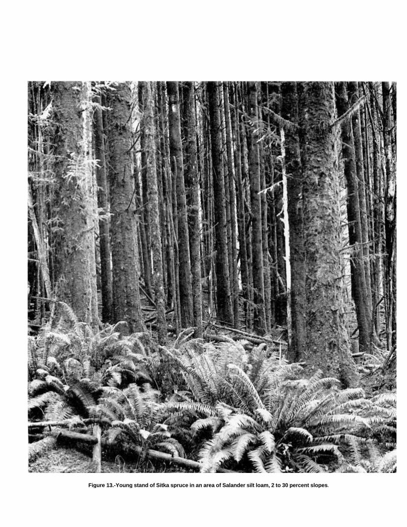
Figure 13.-Young stand of Sitka spruce in an area of Salander silt loam, 2 to 30 percent slopes.

brushy plants can delay natural reforestation. Undesirableplants reduce natural or artificial reforestation unless intensivesite preparation and maintenance are provided. Reforestationcan be accomplished by planting Douglas fir, Sitka spruce,and western hemlock seedlings.
This map unit is in capability subclass VIe.
52E-Salander silt loam, 30 to 50 percent slopes.This deep, well drained soil is on side slopes of mountains. Itformed in colluvium derived dominantly from sedimentary rock.The native vegetation is mainly conifers, shrubs, forbs, andhardwoods. Elevation is 50 to 800 feet. The average annualprecipitation is 60 to 80 inches, the average annual airtemperature is 51 to 53 degrees F, and the average frost-freeperiod is 200 to 240 days.
Typically, the surface layer is dark reddish brown silt loam26 inches thick. The upper 14 inches of the subsoil is darkreddish brown silt loam, and the lower 25 inches is darkreddish brown and reddish brown silty clay loam. In someareas the dark-colored s urface layer is less than 20 inchesthick.
Included in this unit are small areas of Millicoma soils.Included areas make up about 20 percent of the totalacreage. The percentage varies from one area to another.
Permeability of this Salander soil is moderate. Availablewater capacity is about 15.5 to 21.0 inches. Effective rootingdepth is 60 inches or more. Runoff is rapid, and the hazardof water erosion is high.
This unit is used mainly for timber production andwildlife habitat.
This unit is well suited to the production of Douglas fir.Among the other species that grow on this unit are Sitkaspruce, western hemlock, and western redcedar. Theunderstory vegetation is mainly western swordfern, evergreenhuckleberry, salmonberry, thimbleberry, and vine maple.
On the basis of a 100-year site curve, the mean site indexfor Sitka spruce is 180. At the culmination of the mean annualincrement (CMAI), the production of 70-year-old Sitka sprucetrees 1.5 inches in diameter or more at breast height is 271cubic feet per acre per year.
The main limitations for the management of timber on thisunit are the susceptibility of the surface layer to compaction,steepness of slope, the hazard of erosion, and plantcompetition. The main limitation for the harvesting of timber issteepness of slope. Using standard wheeled and trackedequipment when the soil is moist causes rutting andcompaction. Displacement
of topsoil occurs most readily when the soil is dry. Puddlingcan occur when the soil is wet. Cable yarding systems aresafer, damage the soil less, and help to maintain productivity.
Proper design of road drainage systems and care in theplacement of culverts help to control erosion. Cuts and fills aresubject to erosion unless treated. Seeding, mulching, benching,and compacting the soil can reduce erosion. Steep yardingpaths, skid trails, and firebreaks are subject to rilling andgullying unless they are provided with adequate water bars orare protected by plant cover, or both. Unsurfaced roads andskid trails are soft when wet or moist, and they may beimpassable during rainy periods. Logging roads require suitablesurfacing for year-round use. Rock for road construction is notreadily available in this unit. Road location and maintenancecosts are greater in the more steeply sloping areas.
When openings are made in the canopy, invading brushyplants can delay natural reforestation. Undesirable plantsreduce natural or artificial reforestation unless intensive sitepreparation and maintenance are provided. Reforestation canbe accomplished by planting Douglas fir, Sitka spruce, andwestern hemlock seedlings.
This map unit is in capability subclass VIe.
52F-Salander silt loam, 50 to 75 percent slopes.This deep, well drained soil is on side slopes of mountains. Itformed in colluvium derived dominantly from sedimentary rock.The native vegetation is mainly conifers, shrubs, forbs, andhardwoods. Elevation is 50 to 800 feet. The average annualprecipitation is 60 to 80 inches, the average annual airtemperature is 51 to 53 degrees F, and the average frost-freeperiod is 200 to 240 days.
Typically, the surface layer is dark reddish brown silt loam26 inches thick. The upper 14 inches of the subsoil is darkreddish brown silt loam, and the lower 25 inches is dark reddishbrown and reddish brown silty clay loam. In some areas thedark-colored surface layer is less than 20 inches thick.
Included in this unit are small areas of Millicoma soils.Included areas make up about 20 percent of the totalacreage. The percentage varies from one area to another.
Permeability of this Salander soil is moderate. Availablewater capacity is about 15.5 to 21.0 inches. Effective rootingdepth is 60 inches or more. Runoff is rapid, and the hazard ofwater erosion is high.
This unit is used for timber production and wildlifehabitat.

This unit is well suited to the production of Douglas fir.Among the other species that grow on this unit are Sitkaspruce, western hemlock, and western redcedar. Theunderstory vegetation is mainly western swordfern, evergreenhuckleberry, salmonberry, thimbleberry, and vine maple.
On the basis of a 100-year site curve, the mean site indexfor Sitka spruce is 180. At the culmination of the mean annualincrement (CMAI), the production of 70-year-old Sitka sprucetrees 1.5 inches in diameter or more at breast height is 271cubic feet per acre per year.
The main limitations for the management of timber on thisunit are the susceptibility of the surface layer to compaction,steepness of slope, the hazard of erosion, and plantcompetition. The main limitation for the harvesting of timber issteepness of slope. Using standard wheeled and trackedequipment when the soil is moist causes rutting andcompaction. Displacement of topsoil occurs most readily whenthe soil is dry. Puddling can occur when the soil is wet. Cableyarding systems are safer, damage the soil less, and help tomaintain productivity.
Proper design of road drainage systems and care in theplacement of culverts help to control erosion. Cuts and fills aresubject to erosion unless treated. Seeding, mulching, benching,and compacting the soil can reduce erosion. Unsurfaced roadsand skid trails are soft when wet or moist, and they may beimpassable during rainy periods. Logging roads require suitablesurfacing for year-round use. Rock for road construction is notreadily available in this unit. Locating roads on midslopesresults in large cuts and fills and thus removes land fromproduction. Material cast to the side when building roads candamage vegetation. It is also a potential source ofsedimentation. End hauling of waste material minimizesdamage to the vegetation downslope and reduces the potentialfor sedimentation.
When openings are made in the canopy, invading brushyplants can delay natural reforestation. Undesirable plantsreduce natural or artificial reforestation unless intensive sitepreparation and maintenance are provided. Reforestation canbe accomplished by planting Douglas fir, Sitka spruce, andwestern hemlock seedlings.
This map unit is in capability subclass VIle.
53D-Serpentano very stony loam, 10 to 35 percentslopes. This deep, well drained soil is on side slopes andridgetops of mountains. It formed in colluvium and residuumderived dominantly from serpentinite and peridotite. Thenative vegetation is
mainly conifers, hardwoods, shrubs, forbs, and grasses.Elevation is 1,500 to 3,900 feet. The average annualprecipitation is 90 to 100 inches, the average annual airtemperature is 45 to 51 degrees F, and the average frost-freeperiod is 110 to 180 days.
Typically, the surface is covered with a mat of partiallydecomposed needles and leaves 3 inches thick. The surfacelayer is dark brown very stony loam 5 inches thick. The subsoilis dark brown gravelly and very cobbly loam 13 inches thick.The substratum is dark yellowish brown very gravelly andextremely gravelly loam 28 inches thick. Partially weatheredserpentinite is at a depth of 46 inches.
Included in this unit are small areas of Umpcoos and Remotesoils. Also included are small areas of Preacher soils. Includedareas make up about 25 percent of the total acreage. Thepercentage varies from one area to another.
Permeability of this Serpentano soil is moderate. Availablewater capacity is about 4 to 7 inches. Effective rooting depthis 40 to 60 inches. Runoff is medium, and the hazard of watererosion is moderate.
This unit is used mainly for timber production andwildlife habitat.
This unit is suited to the production of Douglas fir. Amongthe other species that grow on this unit are Port Orford cedar,western redcedar, tanoak, and Pacific madrone. The understoryvegetation is mainly Pacific rhododendron, manzanita, salal,western swordfern, low Oregongrape, and red huckleberry.
On the basis of a 100-year site curve, the mean site indexfor Douglas fir is 120. At the culmination of the mean annualincrement (CMAI), the production of 60-year-old Douglas firtrees 1.5 inches in diameter or more at breast height is 115cubic feet per acre per year. On the basis of a 50-year sitecurve, the mean site index for Douglas fir is 97.
The main limitations for the management of timber on thisunit are the hazard of erosion, the hazard of windthrow, andseedling mortality. Careful use of wheeled and trackedequipment reduces the disturbance of the protective layer ofduff. Stones on the surface cause breakage of timber and hinderyarding.
Proper design of road drainage systems and care in theplacement of culverts help to control erosion. Cuts and fills aresubject to erosion unless treated. Seeding, mulching, benching,and compacting the soil can reduce erosion. Logging roadsrequire suitable surfacing for year-round use. Rock for roadconstruction is readily available in this unit. Steep yarding paths,skid trails, and firebreaks are subject to rilling and gullyingunless

they are provided with adequate water bars or areprotected by plant cover, or both.
Windthrow is a hazard when the soil is wet and winds arestrong. The high content of rock fragments in the soil increasesseedling mortality. To compensate for the higher mortality thatcan be expected, larger trees or more trees than normal can beplanted. When openings are made in the canopy, invadingbrushy plants can delay natural reforestation. Reforestation canbe accomplished by planting Douglas fir seedlings.
This map unit is in capability subclass VIe.
53E-Serpentano very stony loam, 35 to 70 percentslopes. This deep, well drained soil is on side slopes andridgetops of mountains. It formed in colluvium and residuumderived dominantly from serpentinite and peridotite. The nativevegetation is mainly conifers, hardwoods, shrubs, forbs, andgrasses. Elevation is 1,500 to 3,900 feet. The average annualprecipitation is 90 to 100 inches, the average annual airtemperature is 45 to 51 degrees F, and the average frost-freeperiod is 110 to 180 days.
Typically, the surface is covered with a mat of partiallydecomposed needles and leaves 3 inches thick. The surfacelayer is dark brown very stony loam 5 inches thick. The subsoilis dark brown gravelly and very cobbly loam 13 inches thick.The substratum is dark yellowish brown very gravelly andextremely gravelly loam 28 inches thick. Partially weatheredserpentinite is at a depth of 46 inches.
Included in this unit are small areas of Umpcoos and Remotesoils. Also included are small areas of Preacher soils. Includedareas make up about 20 percent of the total acreage. Thepercentage varies from one area to another.
Permeability of this Serpentano soil is moderate.Available water capacity is about 4 to 7 inches. Effectiverooting depth is 40 to 60 inches. Runoff is rapid, and thehazard of water erosion is high.
This unit is used for timber production and wildlifehabitat.
This unit is suited to the production of Douglas fir. Amongthe other species that grow on this unit are Port Orford cedar,western redcedar, tanoak, and Pacific madrone. Theunderstory vegetation is mainly Pacific rhododendron,manzanita, salal, western swordfern, low Oregongrape, and redhuckleberry.
On the basis of a 100-year site curve, the mean site indexfor Douglas fir is 120. At the culmination of the mean annualincrement (CMAI), the production of 60-year-old Douglas firtrees 1.5 inches in diameter or more at breast height is 115cubic feet per acre per
year. On the basis of a 50-year site curve, the mean siteindex for Douglas fir is 97.
The main limitations for the management of timber on thisunit are the hazard of erosion, steepness of slope, the hazard ofwindthrow, and seedling mortality. Highlead or other cablelogging systems are most suitable. Stones on the surface causebreakage of timber and hinder yarding.
Proper design of road drainage systems and care in theplacement of culverts help to control erosion. Cuts and fills aresubject to erosion unless treated. Seeding, mulching, benching,and compacting the soil can reduce erosion. Logging roadsrequire suitable surfacing for year-round use. Rock for roadconstruction is readily available in this unit. Steep yarding paths,skid trails, and firebreaks are subject to rilling and gullyingunless they are provided with adequate water bars or areprotected by plant cover, or both. Locating roads on midslopesresults in large cuts and fills and thus removes land fromproduction. Material cast to the side when building roads candamage vegetation. It is also a potential source ofsedimentation. End hauling of waste material minimizesdamage to the vegetation downslope and reduces the potentialfor sedimentation.
Windthrow is a hazard when the soil is wet and winds arestrong. The high content of rock fragments in the soil increasesseedling mortality. To compensate for the higher mortality thatcan be expected, larger trees or more trees than normal can beplanted. When openings are made in the canopy, invadingbrushy plants can delay natural reforestation. Reforestation canbe accomplished by planting Douglas fir seedlings.
This map unit is in capability subclass VIle.
54B-Templeton silt loam, 0 to 7 percent slopes.This deep, well drained soil is on ridgetops and benches ofmountains. It formed in colluvium and residuum deriveddominantly from sedimentary rock. The native vegetation ismainly conifers, shrubs, forbs, and hardwoods. Elevation is 50to 450 feet. The average annual precipitation is 60 to 70inches, the average annual air temperature is 51 to 53degrees F, and the average frost-free period is 200 to 240days.
Typically, the surface layer is very dark brown and darkbrown silt loam 16 inches thick. The subsoil is reddishbrown, yellowish red, and strong brown silty clay loam 26inches thick. Soft, weathered and fractured siltstone is at adepth of 42 inches. In some areas the dark-colored surfacelayer is less than 10 inches thick.
Included in this unit are small areas of Geisel soils anddeep gravelly loam. Also included are areas of

soils, mainly between Beaver Hill and south slough, that aresimilar to this Templeton soil but formed in marine sediment oncoastal terraces. In some areas these soils have mottles in thesubsoil and have a sandy substratum. Included areas make upabout 25 percent of the total acreage. The percentage variesfrom one area to another.
Permeability of this Templeton soil is moderate.Available water capacity is about 8.0 to 17.5 inches.Effective rooting depth is 40 to 60 inches. Runoff is slow,and the hazard of water erosion is slight.
This unit is used mainly for timber production andwildlife habitat. It has potential for homesite developmentand livestock grazing.
This unit is suited to the production of Sitka spruce.Among the other species that grow on this unit are westernhemlock, Douglas fir, Port Orford cedar, western redcedar,and red alder. The understory vegetation is mainly salal,evergreen huckleberry, Pacific rhododendron, westernswordfern, and Oregon oxalis.
On the basis of a 100-year site curve, the mean site indexfor Sitka spruce is 169. At the culmination of the mean annualincrement (CMAI), the production of 50-year-old Sitka sprucetrees 1.5 inches in diameter or more at breast height is 255cubic feet per acre per year. On the basis of a 100-year sitecurve, the mean site index for Douglas fir is 170. High windsfrom the Pacific Ocean may seriously limit the growth of treesunless they are in a protected area.
The main limitations for the production of timber on thisunit are the susceptibility of the surface layer to compaction.plant competition, and the hazard of windthrow. Usingstandard wheeled and tracked equipment when the soil ismoist causes rutting and compaction. Displacement of thesurface layer occurs most readily when the soil is dry.Puddling can occur when the soil is wet. Using low-pressureground equipment damages the soil less and helps tomaintain productivity.
Proper design of road drainage systems and care in theplacement of culverts help to control erosion. Unsurfacedroads and skid trails are slippery when wet or moist, and theymay be impassable during rainy periods. Logging roadsrequire suitable surfacing for year-round use. Rock for roadconstruction is not readily available in this unit. Sitka spruce, ashallow rooted species, commonly is subject to windthrow.
When openings are made in the canopy, invading brushyplants can delay natural reforestation. Undesirable plantsprevent adequate natural or artificial reforestation unlessintensive site preparation and
maintenance are provided. Reforestation can beaccomplished by planting Sitka spruce, westernhemlock, and Douglas fir seedlings.
This unit is well suited to livestock grazing. In summer,droughtiness limits the choice of forage plants and limitsproduction. Irrigation generally is impractical because of aninadequate water supply.
Fertilizer is needed to ensure optimum growth of grassesand legumes. Grass-legume pastures respond to sulfur,phosphorus, and molybdenum. Using a good fertilizationprogram increases the production of forage in winter. Properstocking rates and pasture rotation help to keep the pasture ingood condition. Periodic mowing and clipping help to maintainuniform growth, discourage selective grazing, and reduceclumpy growth.
If this unit is used for homesite development, absorptionlines should be installed on the contour. Preserving theexisting plant cover during construction helps to controlserosion. Topsoil can be stockpiled and used to reclaim areasdisturbed during construction. In summer, supplementalirrigation is needed for lawn grasses and vegetable gardens.
This unit is in capability subclass Ille.
54D-Templeton silt loam, 7 to 30 percent slopes.This deep, well drained soil is on side slopes of mountains. Itformed in colluvium and residuum derived dominantly fromsedimentary rock. The native vegetation is mainly conifers,shrubs, forbs, and hardwoods. Elevation is 50 to 800 feet. Theaverage annual precipitation is 60 to 70 inches, the averageannual air temperature is 51 to 53 degrees F, and the averagefrost-free period is 200 to 240 days.
Typically, the surface layer is very dark brown and darkbrown silt loam 16 inches thick. The subsoil is reddishbrown, yellowish red, and strong brown silty clay loam 26inches thick. Soft, weathered and fractured siltstone is at adepth of 42 inches. In some areas the dark-colored surfacelayer is less than 10 inches thick.
Included in this unit are small areas of Salander soils.Included areas make up about 25 percent of the totalacreage. The percentage varies from one area to another.
Permeability of this Templeton soil is moderate. Availablewater capacity is about 8.0 to 17.5 inches. Effective rootingdepth is 40 to 60 inches. Runoff is medium, and the hazard ofwater erosion is moderate.
This unit is used mainly for timber production and wildlifehabitat. It is also used for livestock grazing and homesitedevelopment.

This unit is well suited to the production of Douglas fir.Among the other species that grow on this unit are westernhemlock, western redcedar, Sitka spruce, grand fir, and redalder. The understory vegetation is mainly vine maple,thimbleberry, creambush oceanspray, red huckleberry,western swordfern, and Pacific trillium.
On the basis of a 100-year site curve, the mean site indexfor Sitka spruce is 180. At the culmination of the mean annualincrement (CMAI), the production of 50-year-old Sitka sprucetrees 1.5 inches in diameter or more at breast height is 270cubic feet per acre per year. On the basis of a 100-year sitecurve, the mean site index for Douglas fir is 170.
The main limitations for the management of timber on thisunit are the susceptibility of the surface layer to compaction, thehazard of erosion, plant competition, and the hazard ofwindthrow. Using standard wheeled and tracked equipmentwhen the soil is moist causes rutting and compaction.Displacement of the surface layer occurs most readily when thesoil is dry. Puddling can occur when the soil is wet. Usinglow-pressure ground equipment reduces damage to the soilarid helps to maintain productivity.
Proper design of road drainage systems and care in theplacement of culverts help to control erosion. Cuts and fills aresubject to erosion unless treated. Seeding, mulching, benching,and compacting the soil can reduce erosion. Unsurfaced roadsand skid trails are slippery when wet or moist, and they may beimpassable during rainy periods. Logging roads require suitablesurfacing for year-round use. Rock for road construction is notreadily available in this unit. Steep yarding paths, skid trails,and firebreaks are subject to rilling and gullying unless they areprovided with adequate water bars or are protected by plantcover, or both. Sitka spruce, a shallow rooted species,commonly is subject to windthrow.
When openings are made in the canopy, invading brushyplants can delay natural reforestation. Undesirable plantsprevent adequate natural or artificial reforestation unlessintensive site preparation and maintenance are provided.Reforestation can be accomplished by planting Sitka spruce,Douglas fir, and western hemlock seedlings.
This unit is well suited to livestock grazing. In summer,droughtiness limits the choice of forage plants and limitsproduction. Irrigation generally is impractical because of aninadequate water supply.
Fertilizer is needed to ensure optimum growth of grassesand legumes. Grass-legume pastures respond to sulfur,phosphorus, and molybdenum. Using a good
fertilization program increases the production of forage inwinter. Proper stocking rates, pasture rotation, and restrictedgrazing during wet periods help to keep the pasture in goodcondition.
If this unit is used for homesite development, the mainlimitations are slope and depth to bedrock. Absorption linesshould either be placed in the more gently sloping areas of thisunit or in adjoining areas of soils that are not so steep.
Extensive cutting and filling generally are required to providenearly level construction sites. Building roads in the less slopingareas of this unit reduces the amount of cutting and fillingrequired. Roads should be provided with surface drainage. Cutsand fills are susceptible to erosion. Revegetating disturbedareas around construction sites as soon as possible helps tocontrol erosion. In summer, supplemental irrigation is needed forlawn grasses and vegetable gardens.
This map unit is in capability subclass Vle.
54E-Templeton silt loam, 30 to 50 percent slopes.This deep, well drained soil is on side slopes of mountains. Itformed in colluvium and residuum derived dominantly fromsedimentary rock. The native vegetation is mainly conifers,shrubs, forbs, and hardwoods. Elevation is 50 to 800 feet. Theaverage annual precipitation is 60 to 80 inches, the averageannual air temperature is 51 to 53 degrees F, and the averagefrost-free period is 200 to 240 days.
Typically, the surface layer is very dark brown and darkbrown silt loam 16 inches thick. The subsoil is reddish brown,yellowish red, and strong brown silty clay loam 26 inchesthick. Soft, weathered and fractured siltstone is at a depth of42 inches. In some areas the dark-colored surface layer isless than 10 inches thick.
Included in this unit are small areas of Geisel soils and deepgravelly loam. Included areas make up about 25 percent of thetotal acreage. The percentage varies from one area to another.
Permeability of this Templeton soil is moderate.Available water capacity is about 8.0 to 17.5 inches.Effective rooting depth is 40 to 60 inches. Runoff is rapid,and the hazard of water erosion is high.
This unit is used mainly for timber production andwildlife habitat.
This unit is suited to the production of Sitka spruce. Amongthe other species that grow on this unit are western hemlock,Douglas fir, Port Orford cedar, western redcedar, and redalder. The understory vegetation is mainly salal, evergreenhuckleberry,

Pacific rhododendron, western swordfern, and Oregon oxalis.On the basis of a 100-year site curve, the mean site index
for Sitka spruce is 180. At the culmination of the mean annualincrement (CMAI), the production of 50-year-old Sitka sprucetrees 1.5 inches in diameter or more at breast height is 270cubic feet per acre per year. On the basis of a 100-year sitecurve, the mean site index for Douglas fir is 170. High windsfrom the Pacific Ocean may seriously limit the growth of treesunless they are in a protected area.
The main limitations for the management of timber on thisunit are the susceptibility of the surface layer to compaction,steepness of slope, the hazard of erosion, plant competition,and the hazard of windthrow. The main limitation for theharvesting of timber is steepness of slope. Using standardwheeled and tracked equipment when the soil is moist causesrutting and compaction. Displacement of topsoil occurs mostreadily when the soil is dry. Puddling can occur when the soil iswet. Cable yarding systems are safer, damage the soil less, andhelp to maintain productivity.
Proper design of road drainage systems and care in theplacement of culverts help to control erosion. Cuts and fills aresubject to erosion unless treated. Seeding, mulching, benching,and compacting the soil can reduce erosion. Unsurfaced roadsand skid trails are slippery when wet or moist, and they may beimpassable during rainy periods. Logging roads require suitablesurfacing for year-round use. Rock for road construction is notreadily available in this unit. Steep yarding paths, skid trails, andfirebreaks are subject to rilling and gullying unless they areprovided with adequate water bars or are protected by plantcover, or both. Road location and maintenance costs aregreater in the more steeply sloping areas. Material cast to theside when building roads can damage vegetation. It is also apotential source of sedimentation. End hauling of waste materialminimizes damage to the vegetation downslope and reducesthe potential for sedimentation. Sitka spruce, a shallow rootedspecies, is subject to windthrow.
When openings are made in the canopy, invading brushyplants can delay natural reforestation. Undesirable plantsprevent adequate natural or artificial reforestation unlessintensive site preparation and maintenance are provided.Reforestation can be accomplished by planting Sitka spruce,western hemlock, and Douglas fir seedlings.
This map unit is in capability subclass Vle.
54F-Templeton silt loam, 50 to 70 percent slopes.This deep, well drained soil is on side slopes of
mountains. It formed in colluvium and residuum deriveddominantly from sedimentary rock. The native vegetation ismainly conifers, shrubs, forbs, and hardwoods. Elevation is 50to 800 feet. The average annual precipitation is 60 to 70inches, the average annual air temperature is 51 to 53 degreesF, and the average frost-free period is 200 to 240 days.
Typically, the surface layer is very dark brown and darkbrown silt loam 16 inches thick. The subsoil is reddishbrown, yellowish red, and strong brown silty clay loam 26inches thick. Soft, weathered and fractured siltstone is at adepth of 42 inches. In some areas the dark-colored surfacelayer is less than 10 inches thick.
Included in this unit are small areas of Millicoma andSalander soils in the northwestern part of the survey area.Included areas make up about 15 percent of the total acreage.The percentage varies from one area to another.
Permeability of this Templeton soil is moderate.Available water capacity is about 8.0 to 17.5 inches.Effective rooting depth is 40 to 60 inches. Runoff is rapid,and the hazard of water erosion is high.
This unit is used for timber production and wildlifehabitat.
This unit is suited to the production of Douglas fir. Amongthe other species that grow on this unit are western hemlock,western redcedar, and red alder. The understory vegetation ismainly creambush oceanspray, evergreen huckleberry, redhuckleberry, salal, western swordfern, and vine maple.
On the basis of a 100-year site curve, the mean site indexfor Sitka spruce is 180. At the culmination of the mean annualincrement (CMAI), the production of 60-year-old Sitka sprucetrees 1.5 inches in diameter or more at breast height is 270cubic feet per acre per year. On the basis of a 100-year sitecurve, the mean site index for Douglas fir is 170.
The main limitations for the management of timber on thisunit are the susceptibility of the surface layer to compaction,steepness of slope, the hazard of erosion, plant competition,and the hazard of windthrow. Highlead or other cable loggingsystems are most suitable.
Proper design of road drainage systems and care in theplacement of culverts help to control erosion. Cuts and fills aresubject to erosion unless treated. Seeding, mulching, benching,and compacting the soil can reduce erosion. Unsurfaced roadsand skid trails are slippery when wet or moist, and they may beimpassable during rainy periods. Logging roads require suitablesurfacing for year-round use. Rock for road construction is not
readily available in this unit. Steep yarding paths, skid trails,and firebreaks are subject to rilling and gullying unless they areprovided with adequate water bars or are protected by plantcover, or both. Locating roads on midslopes results in largecuts and fills and thus removes land from production. Materialcast to the side when building roads can damage vegetation. Itis also a potential source of sedimentation. End hauling ofwaste material minimizes damage to the vegetation downslopeand reduces the potential for sedimentation. Sitka spruce, ashallow rooted species, is subject to windthrow.
When openings are made in the canopy, invading brushyplants can delay natural reforestation. Undesirable plantsprevent adequate natural or artificial reforestation unlessintensive site preparation and maintenance are provided.Reforestation can be accomplished by planting Douglas firseedlings.
This map unit is in capability subclass Vlle.
55D-Templeton-Bullards complex, 3 to 30 percentslopes. This map unit is on ridgetops and side slopes ofmountains and strongly dissected marine terraces. The nativevegetation is mainly conifers, shrubs, forbs, and hardwoods.Elevation is 50 to 600 feet. The average annual precipitation is60 to 70 inches, the average annual air temperature is 51 to 53degrees F, and the average frost-free period is 200 to 240days.
This unit is 45 percent Templeton silt loam and 30 percentBullards sandy loam. The Templeton soil is in convex areas onside slopes where recent marine and eolian deposits havebeen eroded away, and the Bullards soil is in convex areas onridgetops and on west-facing side slopes. The components ofthis unit are so intricately intermingled that it was not practicalto map them separately at the scale used.
Included in this unit are small areas of deep, well drained,gravelly soils and moderately deep, loamy soils. Also includedare small areas of deep, poorly drained, loamy soils. Includedareas make up about 25 percent of the total acreage.
The Templeton soil is deep and well drained. It formed incolluvium and residuum derived dominantly from sedimentaryrock. Typically, the surface layer is very dark brown and darkbrown silt loam 16 inches thick. The subsoil is reddish brown,yellowish red, and strong brown silty clay loam 26 inchesthick. Soft, weathered and fractured siltstone is at a depth of42 inches. In some areas the dark-colored surface layer isless than 10 inches thick.
Permeability of the Templeton soil is moderate.Available water capacity is about 8.0 to 17.5 inches.
Effective rooting depth is 40 to 60 inches. Runoff is medium,and the hazard of water erosion is moderate.
The Bullards soil is deep and well drained. It formed inmixed eolian and marine deposits. Typically, the surface iscovered with a mat of undecomposed organic litter 3 inchesthick. The surface layer is very dark grayish brown sandy loam7 inches thick. The subsoil is dark reddish brown, dark brown,and strong brown gravelly sandy loam 34 inches thick. Thesubstratum to a depth of 60 inches or more is yellowish brownsand.
Permeability of the Bullards soil is moderate. Availablewater capacity is about 4.0 to 5.5 inches. Effective rootingdepth is 60 inches or more. Runoff is medium, and the hazardof water erosion is moderate.
This unit is used mainly for timber production andwildlife habitat.
This unit is suited to the production of Sitka spruce andDouglas fir. Among the other species that grow on the unit arewestern hemlock, Port Orford cedar, western redcedar, shorepine, and red alder. The understory vegetation is mainly salal,evergreen huckleberry, creambush oceanspray, Pacificrhododendron; cascara, western swordfern, and oxalis.
On the basis of a 100-year site curve, the mean site indexfor Sitka spruce is 180 on the Templeton soil. At the culminationof the mean annual increment (CMAI), the production of50-year-old Sitka spruce trees 1.5 inches in diameter or more atbreast height is 255 cubic feet per acre per year. On the basisof a 100-year site curve, the mean site index for Douglas fir is170.
On the basis of a 100-year site curve, the mean site indexfor Douglas fir is 132 on the Bullards soil. At the culmination ofthe mean annual increment (CMAI), the production of60-year-old Douglas fir trees 1.5 inches in diameter or more atbreast height is 133 cubic feet per acre per year. On the basisof a 50-year site curve, the mean site index for Douglas fir is105.
High winds from the Pacific Ocean may seriously limit thegrowth of trees on this unit unless they are in a protected area.
The main limitations for the management of timber on thisunit are the susceptibility of the surface layer of the Templetonsoil to compaction, the hazard of erosion, the hazard ofwindthrow, and plant competition. Using standard wheeled andtracked equipment when the soil is moist causes rutting andcompaction. Displacement of the surface layer occurs mostreadily when the soil is dry. Puddling can occur when the soil iswet. Using low-pressure ground equipment damages the soilless and helps to maintain productivity.
Proper design of road drainage systems and care in theplacement of culverts help to control erosion. Cuts
and fills are subject to erosion unless treated. Seeding,mulching, benching, and compacting the soil can reduceerosion. Unsurfaced roads and skid trails are slippery when wetor moist, and they may be impassable during rainy periods.Logging roads require suitable surfacing for year-round use.Rock for road construction is not readily available in this unit.Road location and maintenance costs are greater in the moresteeply sloping areas.
Windthrow is a hazard when the soil is wet and winds arestrong. When openings are made in the canopy, invadingbrushy plants can delay natural reforestation. Undesirableplants reduce natural or artificial reforestation unlessintensive site preparation and maintenance are provided.Reforestation can be accomplished by planting Sitka spruce,western hemlock, and Douglas fir seedlings.
This map unit is in capability subclass Vle.
55E-Templeton-Bullards complex, 30 to 50 percentslopes. This map unit is on ridgetops and side slopes ofmountains and strongly dissected marine terraces. The nativevegetation is mainly conifers, shrubs, forbs, and hardwoods.Elevation is 50 to 500 feet. The average annual precipitation is60 to 70 inches, the average annual air temperature is 51 to53 degrees F, and the average frost-free period is 200 to 240days.
This unit is 55 percent Templeton silt loam and 25 percentBullards sandy loam. The Templeton soil is in convex areason side slopes where recent marine and eolian deposits havebeen eroded away, and the Bullards soil is in convex areas onridgetops and in the more gently sloping areas on west-facingside slopes. The components of this unit are so intricatelyintermingled that it was not practical to map them separatelyat the scale used.
Included in this unit are small areas of deep, well drained,gravelly soils. Included areas make up about 20 percent ofthe total acreage.
The Templeton soil is deep and well drained. It formed incolluvium and residuum derived dominantly from sedimentaryrock. Typically, the surface layer is very dark brown and darkbrown silt loam 16 inches thick. The subsoil is reddish brown,yellowish red, and strong brown silty clay loam 26 inchesthick. Soft, weathered and fractured siltstone is at a depth of42 inches. In some areas the dark-colored surface layer isless than 10 inches thick.
Permeability of the Templeton soil is moderate.Available water capacity is about 8.0 to 17.5 inches.Effective rooting depth is 40 to 60 inches. Runoff is
rapid, and the hazard of water erosion is high.The Bullards soil is deep and well drained. It formed in mixed
eolian and marine deposits. Typically, the , surface is coveredwith a mat of undecomposed organic litter 3 inches thick. Thesurface layer is very dark grayish brown sandy loam 7 inchesthick. The subsoil is dark reddish brown, dark brown, and strongbrown gravelly sandy loam 34 inches thick. The substratum to adepth of 60 inches or more is yellowish brown sand.
Permeability of the Bullards soil is moderate. Availablewater capacity is about 4.0 to 5.5 inches. Effective rootingdepth is 60 inches or more. Runoff is rapid, and the hazard ofwater erosion is high.
This unit is used mainly for timber production andwildlife habitat.
This unit is suited to the production of Sitka spruce andDouglas fir. Among the other species that grow on this unit arewestern hemlock, Port Orford cedar, western redcedar, shorepine, and red alder. The understory vegetation is mainly salal,evergreen huckleberry, creambush oceanspray, Pacificrhododendron, cascara, western swordfern, and oxalis.
On the basis of a 100-year site curve, the mean site indexfor Sitka spruce is 180 on the Templeton soil. At the culminationof the mean annual increment (CMAI), the production of50-year-old Sitka spruce trees 1.5 inches in diameter or more atbreast height is 255 cubic feet per acre per year. On the basisof a 100-year site curve, the mean site index for Douglas fir is170.
On the basis of a 100-year site curve, the mean site indexfor Douglas fir is 132 on the Bullards soil. At the culmination ofthe mean annual increment (CMAI), the production of60-year-old Douglas fir trees 1.5 inches in diameter or more atbreast height is 133 cubic feet per acre per year. On the basisof a 50-year site curve, the mean site index for Douglas fir is105.
High winds from the Pacific Ocean may seriously limit thegrowth of trees on this unit unless they are in a protected area,
The main limitations for the management of timber on thisunit are the susceptibility of the surface layer of the Templetonsoil to compaction, steepness of slope, the hazard of erosion,the hazard of windthrow, and plant competition. The mainlimitation for the harvesting of timber is steepness of slope.Using standard wheeled and tracked equipment when the soil ismoist causes rutting and compaction. Displacement of topsoiloccurs most readily when the soil is dry. Puddling can occurwhen the soil is wet. Cable yarding systems are safer, damagethe soil less, and help to maintain productivity.
Proper design of road drainage systems and care in theplacement of culverts help to control erosion, Cuts

and fills are subject to erosion unless treated. Seeding,mulching, benching, and compacting the soil can reduceerosion. Unsurfaced roads and skid trails are slippery when wetor moist, and they may be impassable during rainy periods.Logging roads require suitable surfacing for year-round use.Rock for road construction is not readily available in this unit.Material cast to the side when building roads can damagevegetation. It is also a potential source of sedimentation. Endhauling of waste material minimizes damage to the vegetationdownslope and reduces the potential for sedimentation.
Windthrow is a hazard when the soil is wet and winds arestrong. When openings are made in the canopy, invadingbrushy plants can delay natural reforestation. Undesirableplants reduce natural or artificial reforestation unlessintensive site preparation and maintenance are provided.Reforestation can be accomplished by planting Sitka spruce,western hemlock, and Douglas fir seedlings.
This map unit is in capability subclass VIe.
56E-Templeton-Millicoma complex, 12 to 50 percentslopes. This map unit is on ridgetops and side slopes ofmountains. The native vegetation is mainly conifers, shrubs,forbs, and hardwoods. Elevation is 50 to 800 feet. The averageannual precipitation is 70 to 80 inches, the average annual airtemperature is 51 to 53 degrees F, and the average frost-freeperiod is 200 to 240 days.
This unit is 55 percent Templeton silt loam and 30 percentMillicoma gravelly loam. The Templeton soil is in convexareas on ridgetops and on the more gently sloping sideslopes, and the Millicoma soil is on side slopes. Thecomponents of this unit are so intricately intermingled that itwas not practical to map them separately at the scale used.
Included in this unit are small areas of Salander soils.Also included are small areas of soils that are similar to theMillicoma soil but have less than 35 percent rock fragmentsin the subsoil. Included areas make up about 15 percent ofthe total acreage. The percentage varies from one area toanother.
The Templeton soil is deep and well drained. It formed incolluvium and residuum derived dominantly from sedimentaryrock. Typically, the surface layer is very dark brown and darkbrown silt loam 16 inches thick. The subsoil is reddish brown,yellowish red, and strong brown silty clay loam 26 inchesthick. Soft, weathered and fractured siltstone is at a depth of42 inches.
Permeability of the Templeton soil is moderate.Available water capacity is about 8.0 to 17.5 inches.
Effective rooting depth is 40 to 60 inches. Runoff is rapid,and the hazard of water erosion is high.
The Millicoma soil is moderately deep and well drained. Itformed in colluvium derived dominantly from sandstone.Typically, the surface is covered with a mat of undecomposedneedles, leaves, and twigs 3 inches thick. The surface layer isvery dark brown and very dark grayish brown gravelly loam 18inches thick. The subsoil is dark brown very gravelly loam 17inches thick. Partially weathered sandstone is at a depth of 35inches.
Permeability of the Millicoma soil is moderately rapid.Available water capacity is about 3 to 6 inches. Effectiverooting depth is 20 to 40 inches. Runoff is rapid, and the hazardof water erosion is high.
This unit is used mainly for timber production andwildlife habitat.
This unit is suited to the production of Sitka spruce andDouglas fir. Among the other species that grow on the unit arewestern hemlock, western redcedar, and red alder. Theunderstory vegetation is mainly salal, salmonberry, cascadeOregongrape, western swordfern, and vine maple.
On the basis of a 100-year site curve, the mean site indexfor Sitka spruce is 180 on the Templeton soil. At the culminationof the mean annual increment (CMAI), the production of50-year-old Sitka spruce trees 1.5 inches in diameter or more atbreast height is 270 cubic feet per acre per year. On the basisof a 100-year site curve, the mean site index for Douglas fir is170.
On the basis of a 100-year site curve, the mean site indexfor Sitka spruce is 169 on the Millicoma soil. At the culminationof the mean annual increment (CMAI), the production of50-year-old Sitka spruce trees 1.5 inches in diameter or moreat breast height is 255 cubic feet per acre per, year. On thebasis of a 100-year site curve, the mean site index for Douglasfir is 145.
The main limitations for the management of timber on thisunit are the susceptibility of the surface layer of the Templetonsoil to compaction, steepness of slope, the hazards of erosionand windthrow, and plant competition. The main limitation forthe harvesting of timber is steepness of slope. Using standardwheeled and tracked equipment when the soil is moist causesrutting and compaction. Puddling can occur when the soil iswet. Cable yarding systems are safer, damage the soil less, andhelp to maintain productivity. Low-pressure ground equipmentcan be used in the more gently sloping areas of this unit.
Proper design of road drainage systems and care in theplacement of culverts help to control erosion. Cuts and fills aresubject to erosion unless treated. Seeding,
mulching, benching, and compacting the soil can reduceerosion. Unsurfaced roads and skid trails are slippery when wetor moist, and they may be impassable during rainy periods.Logging roads require suitable surfacing for year-round use.Rock for road construction is not readily available in this unit.Steep yarding paths, skid trails, and firebreaks are subject torilling and gullying unless they are provided with adequatewater bars or are protected by plant cover, or both. Roadlocation and maintenance costs are greater in the more steeplysloping areas. Material cast to the side when building roads candamage vegetation. It is also a potential source ofsedimentation. End hauling of waste material minimizesdamage to the vegetation downslope and reduces the potentialfor sedimentation. Sitka spruce, a shallow rooted species, issubject to windthrow.
When openings are made in the canopy, invading brushyplants can delay natural reforestation. Undesirable plantsprevent adequate natural or artificial reforestation unlessintensive site preparation and maintenance are provided.Reforestation can be accomplished by planting Sitka spruce,western hemlock, and Douglas fir seedlings.
This map unit is in capability subclass Vle.
57-Udorthents, level. This map unit is on flood plains,marshes, and tidal flats along major streams, bays, andestuaries. It consists of areas that have been filled and leveledfor commercial and industrial uses. Slopes are 0 to 1 percent.
The areas of this unit on flood plains are made up of sandy,silty, or clayey material. The areas on marsh and tidal flats aremade up of dredging spoil, dune sand, and wood chips.Drainage, permeability, and other physical properties varyconsiderably.
Onsite investigation is needed to determine suitability ofareas of this unit for the intended use.
This unit is not placed in a capability subclass.
58F-Umpcoos-Rock outcrop association, 70 to 99percent slopes. This map unit is on precipitous mountainsides,narrow ridgetops, and headwalls of mountains. The nativevegetation on the Umpcoos soil is mainly conifers, shrubs,forbs, and hardwoods. The areas of Rock outcrop supportmosses, lichens, and occasional shrubs in fractures. Elevationis 100 to 4,300 feet. The average annual precipitation is 60 to100 inches, the average annual air temperature is 45 to 53degrees F, and the average frost-free period is 110 to 200 days.
This unit is 40 percent Umpcoos very gravelly sandy loamand 35 percent Rock outcrop. The Umpcoos soil
is on ridgetops and in the more gently sloping areas, andthe Rock outcrop is in the steeper areas alongdrainageways and on the upper slopes of mountains (fig.14).
Included in this unit are small areas of Digger soils in thesouthern part of the survey area and Milbury soils in thenorthern part. Also included are small areas of Bohannon soils.Included areas make up about 25 percent of the total acreage.
The Umpcoos soil is shallow and well drained. It formed incolluvium derived dominantly from sandstone. Typically, thesurface is covered with a mat of organic litter 2 inches thick.The surface layer is dark grayish brown very gravelly sandyloam 3 inches thick. The subsoil is brown very gravelly sandyloam 13 inches thick. Hard sandstone is at a depth of 16inches.
Permeability of the Umpcoos soil is moderately rapid.Available water capacity is about 0.5 inch to 1.5 inches.Effective rooting depth is 10 to 20 inches. Runoff is rapid, andthe hazard of water erosion is high.
Rock outcrop consists mainly of exposures of fractured, hardsandstone. In some areas the sandstone is fractured tostone-sized fragments, and talus is common at the base ofthese areas.
This unit is used for timber production and wildlifehabitat.
The Umpcoos soil is suited to the production of Douglas fir.Among the other species that grow on this soil are incensecedar, Pacific madrone, Oregon myrtle, and canyon live oak.The understory vegetation is mainly red huckleberry, evergreenhuckleberry, creambush oceanspray, cascade Oregongrape,and longtube twinflower.
On the basis of a 100-year site curve, the mean site indexfor Douglas fir is 79. At the culmination of the mean annualincrement (CMAI), the production of 70-year-old Douglas firtrees 1.5 inches in diameter or more at breast height is 58 cubicfeet per acre per year. On the basis of a 50-year site curve, themean site index for Douglas fir is 61.
The main limitations for the management of timber on thissoil are steepness of slope, the hazard of erosion, seedlingmortality, the hazard of windthrow, and plant competition.Harvesting of timber is limited mainly by steepness of slope.Rock outcrop may cause breakage of timber and hinder yarding.Helicopter, balloon, or total-suspension cable systems are themost suitable methods for harvesting timber.
Proper design of road drainage systems and care in theplacement of culverts help to control erosion. Cuts and fills aresubject to erosion unless treated. Seeding, mulching, benching,and compacting the soil can reduce
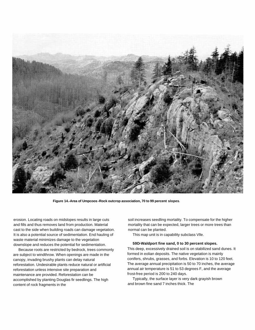
Figure 14.-Area of Umpcoos -Rock outcrop association, 70 to 99 percent slopes.
erosion. Locating roads on midslopes results in large cutsand fills and thus removes land from production. Materialcast to the side when building roads can damage vegetation.It is also a potential source of sedimentation. End hauling ofwaste material minimizes damage to the vegetationdownslope and reduces the potential for sedimentation.
Because roots are restricted by bedrock, trees commonlyare subject to windthrow. When openings are made in thecanopy, invading brushy plants can delay naturalreforestation. Undesirable plants reduce natural or artificialreforestation unless intensive site preparation andmaintenance are provided. Reforestation can beaccomplished by planting Douglas fir seedlings. The highcontent of rock fragments in the
soil increases seedling mortality. To compensate for the highermortality that can be expected, larger trees or more trees thannormal can be planted.
This map unit is in capability subclass Vlle.
59D-Waldport fine sand, 0 to 30 percent slopes.This deep, excessively drained soil is on stabilized sand dunes. Itformed in eolian deposits. The native vegetation is mainlyconifers, shrubs, grasses, and forbs. Elevation is 10 to 120 feet.The average annual precipitation is 50 to 70 inches, the averageannual air temperature is 51 to 53 degrees F, and the averagefrost-free period is 200 to 240 days.
Typically, the surface layer is very dark grayish brownand brown fine sand 7 inches thick. The

underlying material to a depth of 60 inches or more is darkyellowish brown fine sand.
Included in this unit are small areas of Heceta soils andDune land. Also included are small areas of Netarts soils.Included areas make up about 25 percent of the total acreage.
Permeability of this Waldport soil is very rapid. Availablewater capacity is about 3 to 4 inches. Effective rooting depth is60 inches or more. Runoff is very slow, and the hazard of watererosion is slight. The hazard of soil blowing is severe.
This unit is used mainly for timber production, wildlifehabitat, and recreation. It is also used for homesitedevelopment.
This unit is suited to the production of shore pine. Amongthe other species that grow on this unit are western hemlock,Sitka spruce, and Douglas fir. The understory vegetation ismainly Pacific rhododendron, salal, red huckleberry,evergreen huckleberry, and European beachgrass.
On the basis of a 100-year site curve, the mean site indexfor shore pine is 90. At the culmination of the mean annualincrement (CMAI), the production of 60-year-old shore pinetrees 1.5 inches in diameter or more at breast height is 79 cubicfeet per acre per year. High winds from the Pacific Ocean mayseriously limit the growth of trees unless they are in a protectedarea.
The main limitations for the management of timber on thisunit are seedling mortality and plant competition. Careful use ofwheeled and tracked equipment reduces the disturbance of theprotective layer of duff. The risk of soil blowing increases if thetimber is harvested or the understory is removed. Conventionalmethods can be used for harvesting timber, but use of skid trailscan accelerate erosion.
Proper design of road drainage systems and care in theplacement of culverts help to control erosion. Seeding roadcuts and fills helps to stabilize the soil and reduces the risk ofsoil blowing. Windthrow is a hazard when the soil is wet andwinds are strong.
When openings are made in the canopy, invading brushyplants delay natural reforestation. Undesirable plants reduceadequate natural or artificial reforestation. Intensive sitepreparation and maintenance generally are not needed.Reforestation can be accomplished by planting shore pine andSitka spruce seedlings. Droughtiness increases seedlingmortality.
If this unit is used for recreational development, the mainlimitations are the hazard of soil blowing, the instability of thesoil, and slope. Use of the unit is restricted to low-intensitytypes of recreation, such as hiking and horseback riding.Areas used for recreation
can be protected from soil blowing by maintaining plant cover.Plant cover can be maintained by limiting traffic.
Roads, paths, and trails are difficult to maintain because ofthe loose sand. Cutbanks are not stable and are subject toslumping. Access roads should be placed on lower slopes anddesigned to provide low cut-slope grades.
If this unit is used for homesite development, the mainlimitations are the hazard of ground water pollution, slope, thehazard of soil blowing, and droughtiness in summer. The veryrapid permeability of the subsoil may permit untreated effluentto enter the ground water. Special designs may be needed toprevent contamination of water supplies. The steeper areas ofthis unit acre not suitable for installation of absorption fields.Community sewage treatment systems may be n6eded..
Extensive cutting and. filling are required to provide levelbuilding sites. Excavation for houses and access roadsexposes material that is highly susceptible to soil blowing.Revegetating disturbed areas around construction sites assoon as feasible helps to control soil blowing. It is difficult toestablish plants in areas where the surface layer has beenremoved. Mulching and fertilizing cut areas help to establishplants. In summer, irrigation is needed for lawn grasses,shrubs, vines, shade trees, and ornamental trees.
This map unit is in capability subclass VIle.
59E-Waldport fine sand, 30 to 70 percent slopes.This deep, excessively drained soil is on stabilized sand dunes.It formed in eolian deposits. The native vegetation is mainlyconifers, shrubs, grasses, and forbs. Elevation is 10 to 160 feet.The average annual precipitation is 50 to 70 inches, theaverage annual air temperature is 51 to 53 degrees F, and theaverage frost-free period is 200 to 240 days.
Typically, the surface layer is very dark grayish brownand brown fine sand 7 inches thick. The underlying materialto a depth of 60 inches or more is dark yellowish brown finesand.
Included in this unit are small areas of Dune land. Alsoincluded are small areas of Netarts and Heceta soils.Included areas make up about 25 percent of the totalacreage.
Permeability of this Waldport soil is very rapid. Availablewater capacity is about 3 to 4 inches. Effective rooting depth is60 inches or more. Runoff is very slow, and the hazard of watererosion is moderate. The hazard of soil blowing is severe.
This unit is used for timber production and wildlifehabitat.

This unit is suited to the production of shore pine. Amongthe other species that grow on this unit are westernhemlock, Sitka spruce, and Douglas fir. The understoryvegetation is mainly Pacific rhododendron, salal, redhuckleberry, evergreen huckleberry, and Europeanbeachgrass.
On the basis of a 100-year site curve, the mean site indexfor shore pine is 90. At the culmination of the mean annualincrement (CMAI), the production of 60-year-old shore pinetrees 1.5 inches in diameter or more at breast height is 79cubic feet per acre per year. High winds from the Pacific Oceanmay seriously limit the growth of trees unless they are in aprotected area.
The main limitations for the management of timber on thisunit are the hazard of erosion, seedling mortality, and plantcompetition. Careful use of wheeled and tracked equipmentreduces the disturbance of the protective layer of duff. The riskof soil blowing increases if the timber is harvested or theunderstory is removed. Conventional methods can be used forharvesting timber, but use of skid trails can accelerate erosion.Steepness of slope restricts the use of wheeled and trackedequipment on skid trails. Cable yarding generally is safer anddisturbs the soil less.
Proper design of road drainage systems and care in theplacement of culverts help to control erosion. Seeding cuts andfills helps to stabilize the soil and reduces soil blowing. Roadlocation and maintenance costs are greater in the more steeplysloping areas. Material cast to the side when building roads candamage vegetation. It is also a potential source ofsedimentation. End hauling of waste material minimizesdamage to the vegetation downslope and reduces the potentialfor sedimentation. Windthrow is a hazard when the soil is wetand winds are strong.
When openings are made in the canopy, invading brushyplants can delay natural reforestation. Undesirable plantsreduce adequate natural or artificial reforestation. Intensivesite preparation and maintenance generally are not needed.Reforestation can be accomplished by planting shore pineand Sitka spruce seedlings. Droughtiness increases seedlingmortality.
This map unit is in capability subclass Vlle.
60D-Waldport-Dune land complex, 12 to 30 percentslopes. This map unit is on stabilized and active foredunes.The vegetation on the Waldport soil is mainly Europeanbeachgrass. Dune land does not support vegetation. Elevationis 10 to 80 feet. The average annual precipitation is 50 to 70inches, the average annual air temperature is 51 to 53 degreesF,
and the average frost-free period is 200 to 240 days.This unit is 60 percent Waldport fine sand and 30 percent
Dune land. The Waldport soil is in areas that have beenstabilized with vegetation. The components of this unit are sointricately intermingled that it was not practical to map themseparately at the scale used.
Included in this unit are small areas of Heceta soils.Included areas make up about 10 percent of the totalacreage.
The Waldport soil is deep and excessively drained. It formedin eolian deposits. Typically, the surface layer is very darkgrayish brown fine sand 4 inches thick. The substratum to adepth of 60 inches or more is dark yellowish brown fine sand.
Permeability of the Waldport soil is very rapid. Availablewater capacity is about 3 to 4 inches. Effective rooting depthis 60 inches or more. Runoff is very slow, and the hazard oferosion is slight. The hazard of soil blowing is severe.
Dune land is deep and excessively drained. It formed ineolian deposits. Typically, the areas of Dune land are fine andmedium sand to a depth of 60 inches or more.
Permeability of Dune land is very rapid. Available watercapacity is about 3 to 4 inches. Runoff is slow, and the hazardof water erosion is slight. The hazard of soil blowing is severe.
This unit is used for recreation and wildlife habitat.If this unit is used for recreational development, the main
limitations are soil blowing and the instability of the soil. Use ofthis unit is limited to low-intensity types of recreation, such ashiking, horseback riding, and operating off-road vehicles. Areasused for recreation can be protected from soil blowing byestablishing plant cover. Plant cover can be maintained bylimiting traffic. Excavation for roads and buildings exposesmaterial that is highly susceptible to soil blowing. Establishingvegetation on disturbed areas around construction sites as soonas possible helps to control soil blowing. Roads and trails aredifficult to maintain because of the loose sand. Roads must besurfaced for use by conventional vehicles.
This map unit is in capability subclass Vlle.
61D-Waldport-Heceta fine sands, 0 to 30 percentslopes. This map unit is mainly on stabilized sand dunes andin depressional areas between sand dunes. Some areas areon deflation basins. The native vegetation is mainly conifers,shrubs, grasses, and forbs on the Waldport soil and sedges,rushes, water-tolerant grasses, and shrubs on the Heceta soil.Elevation is 0 to 80 feet. The average annual precipitation is50 to 70 inches, the average annual air

temperature is 51 to 53 degrees F, and the averagefrost-free period is 200 to 240 days.
This unit is 50 percent Waldport fine sand and 30 percentHeceta fine sand. The Waldport soil is on stabilized sanddunes, and the Heceta soil is in interdunal swales anddepressional areas. The components of this unit are sointricately intermingled that it was not practical to map themseparately at the scale used.
Included in this unit are small areas of Netarts andYaquina soils and Dune land. Included areas make up about20 percent of the total acreage.
The Waldport soil is deep and excessively drained. Itformed in eolian deposits. Slope is 7 to 30 percent. Typically,the surface layer is very dark grayish brown and brown finesand 7 inches thick. The substratum to a depth of 60 inches ormore is dark yellowish brown fine sand.
Permeability of the Waldport soil is very rapid. Availablewater capacity is about 3 to 4 inches. Effective rooting depth is60 inches or more. Runoff is very slow, and the hazard of watererosion is slight. The hazard of soil blowing is severe.
The Heceta soil is deep and poorly drained. It formed ineolian material. Slope is 0 to 3 percent. Typically, the surfacelayer is very dark grayish brown fine sand 4 inches thick. Thesubstratum to a depth of 60 inches or more is mottled, grayishbrown sand.
Permeability of the Heceta soil is rapid. Available watercapacity is about 1 inch to 2 inches. Effective rooting depth is60 inches for water-tolerant plants, but it is limited by the watertable for non-water-tolerant plants. Runoff is ponded, and thehazard of water erosion is slight. The water table fluctuatesfrom 12 inches above the surface to 6 inches below thesurface from October to May.
The Waldport soil in this unit is used mainly for timberproduction, and the Heceta soil is used mainly for wildlifehabitat. The unit is also used for recreation.
The Waldport soil is suited to the production of shore pine.Other species that grow on this soil include western hemlock,Sitka spruce, and Douglas fir. The understory vegetation ismainly Pacific rhododendron, salal, red huckleberry, evergreenhuckleberry, and European beachgrass. The Heceta soil ispoorly suited to the production of timber. The vegetation on thissoil is mainly slough sedge, salt rush, coast willow, waxmyrtle,evergreen huckleberry, and salal.
On the basis of a 100-year site curve, the mean site indexfor shore pine is 90 on the Waldport soil. At the culmination ofthe mean annual increment (CMAI), the production of60-year-old shore pine trees 1.5 inches in
diameter or more at breast height is 79 cubic feet per acreper year. High winds from the Pacific Ocean may seriouslylimit the growth of trees unless they are in a protected area.
The main limitations for the management of timber on thissoil are seedling mortality and plant competition. Careful use ofwheeled and tracked equipment reduces the disturbance of theprotective layer of duff. The risk of soil blowing increases if thetimber is harvested or the understory is removed. Conventionalmethods can be used for harvesting timber, but use of skid trailscan accelerate erosion.
Proper design of road drainage systems and care in theplacement of culverts help to control erosion. Seeding cutsand fills helps to stabilize the soil and reduce soil blowing.Windthrow is a hazard when the soil is wet and winds arestrong.
When openings are made in the canopy, invading brushyplants can delay natural reforestation. Undesirable plantsreduce adequate natural or artificial reforestation. Intensivesite preparation and maintenance generally are not needed.Reforestation can be accomplished by planting shore pine andSitka spruce seedlings. Droughtiness increases seedlingmortality.
If this unit is used for recreational development, the mainlimitations are the hazard of soil blowing, the instability of theWaldport soil, and the wetness of the Heceta soil. Theselimitations restrict the use of this unit mainly to low-intensitytypes of recreation, such as hiking and horseback riding. Theunit can be used for other kinds of recreational activities thatrequire a minimum of construction and soil disturbance. Areasused for recreation can be protected from soil blowing bymaintaining plant cover. Plant cover can be maintained bylimiting traffic. Excavation for houses and access roads exposesmaterial that is highly susceptible to soil blowing. Revegetatingdisturbed areas around construction sites as soon as feasiblehelps to control soil blowing.
Roads, paths, and trails are difficult to maintain because ofthe loose sand. Cutbanks are not stable and are subject toslumping.
Wetness limits most recreational development on theHeceta soil. Use of paths and trails may be limited to 2 to 3months in summer. Drainage is impractical because of the lackof suitable outlets.
This map unit is in capability subclass VIle.
62-Willanch fine sandy loam. This deep, poorly drainedsoil is in depressional areas on flood plains. It formed inalluvium. Slope is 0 to 3 percent. The native
vegetation is mainly sedges, rushes, grasses, andhardwoods. Elevation is 10 to 40 feet. The average annualprecipitation is 50 to 80 inches, the average annual airtemperature is 51 to 53 degrees F, and the averagefrost-free period is 200 to 240 days.
Typically, the surface layer is mottled, very dark grayishbrown and dark brown fine sandy loam 13 inches thick. Theupper 22 inches of the substratum is mottled, dark grayishbrown sandy loam, and the lower part to a depth of 60 inchesor more is mottled, dark grayish brown loamy fine sand andloamy sand.
Included in this unit are small areas of Nehalem andNestucca soils. Included areas make up about 25 percent ofthe total acreage.
Permeability of this Willanch soil is moderately rapid.Available water capacity is about 2.5 to 4.5 inches. Effectiverooting depth is 60 inches for water-tolerant plants, but it islimited by the water table for non-water-tolerant plants. Runoffis very slow, and the hazard of water erosion is slight. Thewater table fluctuates between the surface and a depth of 24inches below the surface from November to March. This soil issubject to frequent periods of flooding in winter.
This unit is used mainly for hay and pasture.The vegetation in areas not cultivated is mainly red alder,
black cottonwood, and Pacific willow. The understoryvegetation is mainly soft rush, slough sedge, skunkcabbage,brown-headed rush, sickle-leaved rush, and large-headedsedge.
If this unit is used for hay and pasture, the main limitationsare droughtiness in summer, the hazard of flooding, wetness,and, for the curing of hay, high humidity. Supplementalirrigation is needed for maximum production. Sprinkler irrigationis a suitable method of applying water. Use of this methodpermits the even, controlled application of water. Water shouldbe applied in amounts sufficient to wet the root zone but smallenough to minimize the leaching of plant nutrients. Applicationsof water should be adjusted to the available water capacity, thewater intake rate, and the crop needs.
Frequent, brief periods of flooding restrict the use of thisunit in winter. Protection from flooding can be provided onlyby the use of extensive dikes.
Drainage is needed to lower the water table. Tile drainagecan be used to lower the water table if a suitable outlet isavailable. Wetness and flooding restrict grazing in winter. Thechoice of plants is limited to those that can withstand periodicinundation.
High humidity and frequent periods of rainfall late in springprevent the production of high-quality hay. The
quality of grass for hay can be maintained by increasing thestocking rate in winter.
Fertilizer is needed to ensure optimum growth of grasses andlegumes. Grasses respond to nitrogen, and legumes respond tosulfur and phosphorus. Proper stocking rates, pasture rotation, andrestricted grazing during wet periods help to keep the pasture ingood condition. Rotation grazing increases the production of forageand helps to control weeds and brush. Periodic mowing andclipping help to maintain uniform growth, discourage selectivegrazing, and reduce clumpy growth.
This map unit is in capability subclass Illw.
63B-Wintley silt loam, 0 to 8 percent slopes. This deep, welldrained soil is on high terraces. It formed in alluvium. The nativevegetation is mainly conifers, shrubs, forbs, and hardwoods.Elevation is 50 to 420 feet. The average annual precipitation is 60to 80 inches, the average annual air temperature is 50 to 53degrees F, and the average frost-free period is 180 to 220 days.
Typically, the surface is covered with a mat of undecomposedleaves, needles, and twigs 1 inch thick. The surface layer is darkbrown silt loam 4 inches thick. The upper 12 inches of the subsoilis dark brown silty clay loam, and the lower 31 inches is strongbrown silty clay and silty clay loam. The substratum to a depth of60 inches or more is dark yellowish brown very gravelly loam. Insome areas the dark-colored surface layer is 10 inches thick ormore.
Included in this unit are small areas of McCurdy soils and soilson steep terrace escarpments. Also included are small areas ofsoils that are similar to this Wintley soil but have a gravellysubstratum at a depth of 20 to 40 inches. Included areas make upabout 15 percent of the total acreage. The percentage varies fromone area to another.
Permeability of this Wintley loam is moderately slow. Availablewater capacity is about 8.0 to 9.5 inches. Effective rooting depthis 60 inches or more. Runoff is medium, and the hazard of watererosion is moderate.
This unit is used for hay and pasture and homesitedevelopment. It is also used for timber production.
This unit is suited to the production of Douglas fir. Amongthe other species that grow on this unit are western hemlock,western redcedar, red alder, and Oregon myrtle. Theunderstory vegetation is mainly evergreen huckleberry, Pacificrhododendron, trailing blackberry, western swordfern, andOregon oxalis.
On the basis of a 100-year site curve, the mean site

index for Douglas fir is 160. At the culmination of the meanannual increment (CMAI), the production of 60-year-oldDouglas fir trees 1.5 inches in diameter or more at breastheight is 170 cubic feet per acre per year. On the basis of a50-year site curve, the mean site index for Douglas fir is126.
The main limitations for the management of timber on thisunit are the susceptibility of the surface layer to compaction andplant competition. Using standard wheeled and trackedequipment when the soil is moist causes rutting andcompaction. Displacement of the surface layer occurs mostreadily when the soil is wet. Using low-pressure groundequipment damages the soil less and helps to maintainproductivity.
Proper design of road drainage systems and care in theplacement of culverts help to control erosion. Unsurfacedroads and skid trails are slippery when wet or moist, and theymay be impassable during rainy periods. Logging roadsrequire suitable surfacing for year-round use. Rock for roadconstruction is not readily available in this unit.
When openings are made in the canopy, invading brushyplants can delay natural reforestation. Undesirable plantsprevent adequate natural or artificial reforestation unlessintensive site preparation and maintenance are provided.Reforestation can be accomplished by planting Sitka spruce,western hemlock, and Douglas fir seedlings.
If this unit is used for hay and pasture, the main limitationsare the susceptibility of the surface layer to compaction,droughtiness in summer, and, for the curing of hay, highhumidity. Grazing when the soil is moist results in compactionof the surface layer and poor tilth. Compaction limits themovement of air and water in the soil and restricts the growthof roots; it can seriously reduce the productivity of the soil.Grazing should be delayed until the soil has drainedsufficiently and is firm enough to withstand trampling bylivestock.
Supplemental irrigation is needed for maximum production.Sprinkler irrigation is a suitable method of applying water. Useof this method permits the even, controlled application ofwater. Water should be applied in amounts sufficient to wet theroot zone but small enough to minimize the leaching of plantnutrients. Applications of water should be adjusted to theavailable water capacity, the water intake rate, and the cropneeds.
High humidity and frequent periods of rainfall late in springprevent the production of high-quality hay. The quality of grassfor hay can be maintained by increasing the stocking rate inspring. Excess forage in spring can be used as silage.
Fertilizer is needed to ensure optimum growth of grassesand legumes. Grasses respond to nitrogen, and legumesrespond to sulfur and phosphorus. Proper stocking rates,pasture rotation, and restricted grazing during wet periods helpto keep the pasture in good condition. Periodic mowing andclipping help to maintain uniform growth, discourage selectivegrazing, and reduce clumpy growth.
If this unit is used for homesite development, the mainlimitation is the moderately slow permeability. Septic tankabsorption fields do not function properly during rainyperiods. Larger absorption fields help to compensate for themoderately slow permeability.
Preserving the existing plant cover during constructionhelps to control erosion. Topsoil can be stockpiled and usedto reclaim areas disturbed during construction. In summer,supplemental irrigation is needed for lawn grasses andvegetable gardens.
This map unit is in capability subclass Ille.
63C-Wintley silt loam, 8 to 15 percent slopes.This deep, well drained soil is on high terraces. It formed inalluvium. The native vegetation is mainly conifers, shrubs, forbs,and hardwoods. Elevation is 50 to 420 feet. The average annualprecipitation is 60 to 80 inches, the average annual airtemperature is 50 to 53 degrees F, and the average frost-freeperiod is 180 to 220 days.
Typically, the surface is covered with a mat ofundecomposed leaves, needles, and twigs 1 inch thick. Thesurface layer is dark brown silt loam 4 inches thick. The upper12 inches of the subsoil is dark brown silty clay loam, and thelower 31 inches is strong brown silty clay and silty clay loam.The substratum to a depth of 60 inches or more is darkyellowish brown very gravelly loam. In some areas thedark-colored surface layer is 10 inches thick or more.
Included in this unit are small areas of McCurdy soils andsoils on steep terrace escarpments. Also included are smallareas of soils that are similar to this Wintley soil but have agravelly subsoil and a gravelly substratum at a depth of 20 to40 inches. Included areas make up about 20 percent of thetotal acreage. The percentage varies from one area to another.
Permeability of this Wintley soil is moderately slow.Available water capacity is about 8.0 to 9.5 inches. Effectiverooting depth is 60 inches or more. Runoff is medium, and thehazard of water erosion is moderate.
This unit is used for hay and pasture and homesitedevelopment.
The vegetation in areas not cultivated is mainly Douglasfir, western hemlock, western redcedar, red

alder, and Oregon myrtle. The understory vegetation is mainlyevergreen huckleberry, Pacific rhododendron, trailingblackberry, western swordfern, and Oregon oxalis.
If this unit is used for hay and pasture, the main limitationsare the susceptibility of the surface layer to compaction,droughtiness in summer, and, for the curing of hay, highhumidity. Grazing when the soil is moist results in compactionof the surface layer and poor tilth. Compaction limits themovement of air and water in the soil and restricts the growthof roots; it can seriously reduce the productivity of the soil.Grazing should be delayed until the soil has drainedsufficiently and is firm enough to withstand trampling bylivestock.
Supplemental irrigation is needed for maximum production.Sprinkler irrigation is a suitable method of applying water. Useof this method permits the even, controlled application ofwater. Water should be applied in amounts sufficient to wet theroot zone but small enough to minimize the leaching of plantnutrients. Applications of water should be adjusted to theavailable water capacity, the water intake rate, and the cropneeds.
High humidity and frequent periods of rainfall late in springprevent the production of high-quality hay. The quality of grassfor hay can be maintained by increasing the stocking rate inspring. Excess forage in spring can be used as silage.
Fertilizer is needed to ensure optimum growth of grassesand legumes. Grasses respond to nitrogen, and legumesrespond to sulfur and phosphorus. Proper stocking rates,pasture rotation, and restricted grazing during wet periods helpto keep the pasture in good condition and to protect the soilfrom erosion. Periodic mowing and clipping help to maintainuniform growth, discourage selective grazing, and reduceclumpy growth.
If this unit is used for homesite development, the mainlimitation is the moderately slow permeability. Septic tankabsorption fields do not function properly during rainy periods.The limitation of moderately slow permeability may beovercome by increasing the size of the septic tank absorptionfield. Absorption lines should be installed on the contour.
The risk of erosion is increased if the soil is left exposedduring site development. Careful planning of road location canminimize the amount of cutting and filling required.Revegetating disturbed areas around construction sites assoon as feasible helps to control erosion. Plant cover can beestablished and maintained through proper fertilizing, seeding,mulching, and shaping of the slopes. Topsoil can be stockpiledand
used to reclaim areas disturbed during construction. Insummer, supplemental irrigation is needed for lawn grassesand vegetable gardens.
This map unit is in capability subclass Ille.
63D-Wintley silt loam, 15 to 30 percent slopes.This deep, well drained soil is on high terraces. It formed inalluvium. The native vegetation is mainly conifers, shrubs, forbs,and hardwoods. Elevation is 50 to 420 feet. The average annualprecipitation is 60 to 80 inches, the average annual airtemperature is 50 to 53 degrees F, and the average frost-freeperiod is 180 to 220 days.
Typically, the surface is covered with a mat ofundecomposed leaves, needles, and twigs 1 inch thick. Thesurface layer is dark brown silt loam 4 inches thick. The upper12 inches of the subsoil is dark brown silty clay loam, and thelower 31 inches is strong brown silty clay and silty clay loam.The substratum to a depth of 60 inches or more is darkyellowish brown very gravelly loam. In some areas thedark-colored surface layer is 10 inches thick or more.
Included in this unit are small areas of soils that are similar tothis Wintley soil but have a gravelly substratum at a depth of 20to 40 inches. Also included are small areas of Dement soils thathave slopes of 15 to 60 percent. Included areas make up about25 percent of the total acreage. The percentage varies from onearea to another.
Permeability of this Wintley, soil is moderately slow.Available water capacity is about 8.0 to 9.5 inches. Effectiverooting depth is 60 inches or more. Runoff is medium, and thehazard of water erosion is moderate.
This unit is used for pasture and wildlife habitat.The vegetation in areas not cultivated is mainly Douglas fir,
western hemlock, western redcedar, red alder, and Oregonmyrtle. The understory vegetation is mainly evergreenhuckleberry, Pacific rhododendron, trailing blackberry, westernswordfern, and Oregon oxalis.
If this unit is used for pasture, the main limitations are thesusceptibility of the surface layer to compaction anddroughtiness in summer. Grazing when the soil is moist resultsin compaction of the surface layer, poor tilth, and excessiverunoff. Compaction limits the movement of air and water in thesoil and restricts the growth of roots it can seriously reduce theproductivity of the soil. Grazing should be delayed until the soilhas drained sufficiently and is firm enough to withstandtrampling by livestock.
In summer, droughtiness on south-facing slopes limits thechoice of forage plants and limits production.

Irrigation generally is impractical because of slope and aninadequate water supply.
Fertilizer is needed to ensure optimum growth of grassesand legumes. Grass-legume pastures respond to sulfur,phosphorus, and molybdenum. Using a good fertilizationprogram increases the production of forage in winter. Properstocking rates, pasture rotation, and restricted grazing duringwet periods help to keep the pasture in good condition and toprotect the soil from erosion. Rotation grazing increases theproduction of forage and helps to control weeds and brush.
This map unit is in capability subclass IVe.
64-Yaquina loamy fine sand. This deep, somewhat poorlydrained soil is on low terraces. It formed in mixed alluvium.Slope is 0 to 3 percent. The native vegetation is mainly conifers,shrubs, forbs, sedges, and rushes. Elevation is 10 to 50 feet.The average annual precipitation is 50 to 70 inches, theaverage annual air temperature is 51 to 53 degrees F, and theaverage frost-free period is 200 to 240 days.
Typically, the surface is covered with a mat of organic litter 2inches thick. The surface layer is dark gray loamy fine sand 5inches thick. The upper 7 inches of the subsoil is yellowishbrown sand, the next 15 inches is mottled, reddish brown anddark reddish brown sand, and the lower 8 inches is pale brownsand. The substratum to a depth of 60 inches or more is palebrown sand.
Included in this unit are small areas of Heceta soils.Included areas make up about 15 percent of the totalacreage.
Permeability of this Yaquina soil is moderately rapid.Available water capacity is about 1 inch to 3 inches. Effectiverooting depth is 60 inches or more for water-tolerant plants, butit is limited by the water table for non-water-tolerant plants. Thewater table fluctuates between the surface and a depth of 24inches below the surface from November to April. Runoff isslow, and the hazard of water erosion is slight.
This unit is used for recreation and wildlife habitat.The native vegetation is mainly shore pine, scattered Sitka
spruce, Pacific rhododendron, salal, evergreen huckleberry,Pacific waxmyrtle, slough sedge, and soft rush.
If this unit is used for recreational development, the mainlimitation is wetness. Septic tank absorption fields do notfunction properly because of the seasonal high water table.Use of paths and trails may be limited to 3 to 4 months duringthe dry period.
This map unit is in capability subclass IVw.
65-Zyzzug silt loam. This deep, poorly drained soil is onstream terraces. It formed in mixed alluvium. Slope is 0 to 3percent. The native vegetation is mainly conifers, shrubs, forbs,and hardwoods. Elevation is 50 to 120 feet. The average annualprecipitation is 50 to 70 inches, the average annual airtemperature is 51 to 53 degrees F, and the average frost-freeperiod is 160 to 220 days.
Typically, the surface layer is very dark grayish brown anddark brown silt loam 12 inches thick. The upper 18 inches of thesubsoil is mottled, very dark gray and dark gray silty clay loam,and the lower 15 inches is mottled, dark yellowish brown siltyclay and silty clay loam. The substratum to a depth of 60 inchesor more is mottled, dark yellowish brown silt loam.
Included in this unit are small areas of soils that are similarto this Zyzzug soil but are moderately well drained orsomewhat poorly drained. Also included are small areas ofsomewhat poorly drained soils that have a gravelly loamsurface layer. Included areas make up about 20 percent of thetotal acreage. The percentage varies from one area toanother.
Permeability of this Zyzzug soil is moderately slow.Available water capacity is about 5.0 to 8.5 inches. Effectiverooting depth is 60 inches or more for water-tolerant plants, butit is limited by the water table for non-water-tolerant plants. Thewater table fluctuates between the surface and a depth of 18inches below the surface from November to April. Runoff isslow, and the hazard of water erosion is slight.
This unit is used for hay and pasture.The vegetation in areas not cultivated is mainly western
redcedar, red alder, and willow. The understory vegetation ismainly evergreen huckleberry, western swordfern, hairybrackenfern, soft rush, and skunkcabbage.
If this unit is used for hay and pasture, the main limitationsare the susceptibility of the surface layer to compaction,wetness, droughtiness in summer, and, for the curing of hay,high humidity. Grazing when the soil is moist results incompaction of the surface layer and poor tilth. Compactionlimits the movement of air and water in the soil and restrictsthe growth of roots; it can seriously reduce the productivity ofthe soil. Grazing should be delayed until the soil has drainedsufficiently and is firm enough to withstand trampling bylivestock.
Drainage and irrigation are needed for maximum productionof crops. Tile drainage can be used to lower the water table if asuitable outlet is available. Supplemental irrigation is needed insummer because of low rainfall. Sprinkler irrigation is a suitablemethod of

applying water. Use of this method permits the even,controlled application of water. Water needs to be applied at aslow rate over a long period to ensure that the root zone isproperly wetted. Applications of water should be adjusted tothe available water capacity, the water intake rate, and thecrop needs.
High humidity and frequent periods of rainfall late in springprevent the production of high-quality hay. The quality of grassfor hay can be maintained by increasing the stocking rate inspring. Excess forage in spring can be used as silage.
Fertilizer is needed to ensure optimum growth of grassesand legumes. Grasses respond to nitrogen, and legumesrespond to sulfur and phosphorus. Proper stocking rates,pasture rotation, and restricted grazing during wet periods helpto keep the pasture in good condition. Rotation grazingincreases the production of forage and helps to control weedsand brush. Periodic mowing and clipping help to maintainuniform growth, discourage selective grazing, and reduceclumpy growth.
This map unit is in capability subclass IIIw.

Use and Management of the Soils
This soil survey is an inventory and evaluation of the soilsin the survey area. It can be used to adjust land uses to thelimitations and potentials of natural resources and theenvironment. Also, it can help avoid soil-related failures in landuses.
In preparing a soil survey, soil scientists, conservationists,engineers, and others collect extensive field data about thenature and behavioral characteristics of the soils. They collectdata on erosion, droughtiness, flooding, and other factors thataffect various soil uses and management. Field experience andcollected data on soil properties and performance are used as abasis in predicting soil behavior.
Information in this section can be used to plan the use andmanagement of soils for crops and pasture; as woodland; assites for buildings, sanitary facilities, highways and othertransportation systems, and parks and other recreationfacilities; and for wildlife habitat. It can be used to identify thelimitations of each soil for specific land uses and to helpprevent construction failures caused by unfavorable soilproperties.
Planners and others using soil survey information canevaluate the effect of specific land uses on productivity and onthe environment in the survey area. The survey can helpplanners to maintain or create a land use pattern in harmonywith the natural soil.
Contractors can use this survey to locate sources of sandand gravel, roadfill, and topsoil. They can use it to identifyareas where bedrock, wetness, or very firm soil layers cancause difficulty in excavation.
Health officials, highway officials, engineers, and othersmay also find this survey useful. The survey can help themplan the safe disposal of wastes and locate sites forpavements, sidewalks, campgrounds, playgrounds, lawns, andtrees and shrubs.
Crops and PastureLynn Cannon, agricultural extension agent, Oregon State University, and
Calvin H. Gregg, soil conservationist, Soil Conservation Service, assisted in
preparing this section.
General management needed for crops and for hay
and pasture is suggested in this section. The crops or pastureplants best suited to the soils, including some not commonlygrown in the survey area, are identified. The system of landcapability classification used by the Soil Conservation Serviceis explained, and the estimated yields of the main crops andhay and pasture plants commonly grown are listed for eachsoil.
Planners of management systems for individual fields orfarms should consider the detailed information given in thedescription of each soil under "Detailed Soil Map Units."Specific information can be obtained from the local office of theSoil Conservation Service or the Cooperative ExtensionService.
According to the 1978 Census of Agriculture, Coos Countyhad 100,000 acres of permanent pasture 40,000 acres onflood plains and 60,000 acres on upland hillsides. In 1980,688 acres of cranberries was harvested and approximately200 acres was in horticultural and related crops.
The soils and climate of Coos County are not well suited tothe production of most row crops. In most areas of the county,soils warm up slowly in spring because of wetness and a highpercentage of cloud cover. Fog and high humidity in coastalareas prevent the accumulation of sufficient growing degreedays to allow most row crops and small grain to mature. Someinterior valleys do receive enough sunlight and havetemperatures high enough for corn to mature; however, itgenerally is used for silage. The climate of the inland valleys issuitable for cool-season crops such as pole beans and lettuce;however, lack of suitable markets make production of suchcrops uneconomical.
The soils and climate of the survey area are excellent forforage production. The growing season is long, and the soilsreceive sufficient moisture, except for several months insummer. Rainfall during July and August seldom exceeds 0.5inch per month, and irrigation is needed for maximumproduction.
Hayland and pastureland in Coos County can be divided intothree types based on management: (1) very poorly drainedflood plains; (2) well drained to poorly

drained flood plains and terraces, and (3) uplandpastures.
The very poorly drained areas consist of soils such as thosein the Coquille, Chetco, and Langlois series. These soils makeup about 13,000 acres, or 13 percent, of the pastureland in thecounty. They are mainly in the Coquille and Coos RiverValleys. Frequent, prolonged periods of flooding in winterrestrict the choice of pasture grasses to those that canwithstand inundation, such as reed canarygrass. Soil drainageis required. Open ditches are most effective because of theclayey subsoil. Tide gates are needed in some areas to preventinundation during high tides.
These soils generally are too wet to permit more than onecutting of hay. The quality of hay generally is very poorbecause these soils do not dry out enough to permit cuttinguntil after the grass has reached maturity, and the high soilmoisture and high humidity prevent rapid drying of the hay. Thequality of hay can be improved by grazing hayfields until earlyin June to delay cutting until the weather conditions are morefavorable.
Soils on flood plains and terraces are suited to grass-legumepasture. The Nehalem, Nestucca, Kirkendall, Quosatana, andGardiner soils are on flood plains and are subject to frequentperiods of flooding in winter. As a result, the use of pastures isrestricted to brief periods. Drainage is needed for maximumproduction on the Nestucca and Quosatana soils. These soilshave a loamy subsoil and can be drained by subsurface tiles.
The Eilertsen, Zyzzug, Meda, Gauldy Variant, Chismore,McCurdy, and Wintley soils are on terraces. Drainage isneeded on the Zyzzug, McCurdy, and Chismore soils.McCurdy and Chismore soils can be drained by subsurfacetiles; however, because of the clayey subsoil, open ditches areneeded on the Zyzzug soils.
Irrigation is needed on all of these soils in summer. Sprinklerirrigation is an efficient method of applying water. Applicationrates should be adjusted according to the permeability andwater intake rate of the soils to prevent excessive runoff andleaching of plant nutrients. In some areas irrigation of theMcCurdy and Wintley soils may be impractical because of thesteepness of slope and lack of an adequate water supply.
Most of the hay harvested in the county is grown on soils onflood plains and terraces. The well drained Nehalem,Kirkendall, Gardiner, and Meda soils dry out early enough topermit harvesting of hay at the optimum growth stage;however, the quality of the hay generally is poor because ofheavy dew, fog, and frequent rain
showers. In most years it is possible to harvest twocuttings of hay.
Upland soils are suited to grass-legume pasture. Uplandpastures are mainly on soils of the Dement, Etelka, Remote,Templeton, and Geisel series. These soils commonly areseeded to subterranean clover to provide forage in winter.Forage production is low in summer because of droughtiness.Irrigation generally is not practical because of the steepness ofslope and lack of an adequate water supply.
Most of the soils used for hay and pasture are strongly acidor very strongly acid unless lime is applied. Some of the poorlydrained soils on flood plains are slightly acid or medium acid.Application of ground limestone is needed to raise the reactionof the soils. The levels of available phosphorus andmolybdenum are low in the upland soils. Pasture grasses andlegumes on the soils on flood plains and terraces respond tophosphorus and sulfur. Canarygrass pastures respond tonitrogen.
Additions of lime and fertilizer should be based on theresults of soil tests, on the needs of the crop grown, and on theexpected yields. The Cooperative Extension Service and theSoil Conservation Service can help in determining the kindsand amounts of fertilizer and lime to apply. The latestinformation on adapted varieties and seeding recommendationscan be obtained from local offices of the Cooperative ExtensionService and the Soil Conservation Service. Information for thedesign of drainage and irrigation systems for each kind of soil isavailable at local offices of the Soil Conservation Service.
Yields per AcreThe average yields per acre that can be expected of the
principal crops under a high level of management are shown intable 5. In any given year, yields may be higher or lower thanthose indicated in the table because of variations in rainfall andother climatic factors.
The yields are based mainly on the experience andrecords of farmers, conservationists, and extension agents.Available yield data from nearby counties and results of fieldtrials and demonstrations are also considered.
The management needed to obtain the indicated yields ofthe various crops depends on the kind of soil and the crop.Management can include drainage, erosion control, andprotection from flooding; the proper planting and seeding rates;suitable high-yielding crop varieties; appropriate and timelytillage; control of

weeds, plant diseases, and harmful insects; favorable soilreaction and optimum levels of nitrogen, phosphorus,potassium, and trace elements for each crop; effective use ofcrop residue, barnyard manure, and green-manure crops;and harvesting that ensures the smallest possible loss.
For yields of irrigated crops, it is assumed that the irrigationsystem is adapted to the soils and to the crops grown, thatgood quality irrigation water is uniformly applied as needed, andthat tillage is kept to a minimum.
The estimated yields reflect the productive capacity of eachsoil for each of the principal crops. Yields are likely to increaseas new production technology is developed. The productivity ofa given soil compared with that of other soils, however, is notlikely to change.
Crops other than those shown in table 5 are grown in thesurvey area, but estimated yields are not listed because theacreage of such crops is small. The local office of the SoilConservation Service or of the Cooperative Extension Servicecan provide information about the management andproductivity of the soils for those crops.
Land Capability Classification
Land capability classification shows, in a general way, thesuitability of soils for most kinds of field crops (24). Crops thatrequire special management are excluded. The soils aregrouped according to their limitations for field crops, the risk ofdamage if they are used for crops, and the way they respond tomanagement. The grouping does not take into account majorand generally expensive landforming that would change slope,depth, or other characteristics of the soils, nor does it considerpossible but unlikely major reclamation projects. Capabilityclassification is not a substitute for interpretations designed toshow suitability and limitations of groups of soils for rangeland,for woodland, and for engineering purposes.
In the capability system, soils generally are grouped at threelevels: capability class, subclass, and unit. Only class andsubclass are used in this survey. These levels are defined inthe following paragraphs.
Capability classes, the broadest groups, are designated byRoman numerals I through VIII. The numerals indicateprogressively greater limitations and narrower choices forpractical use. The classes are defined as follows:
Class I soils have few limitations that restrict their use.Class II soils have moderate limitations that reduce
the choice of plants or that require moderateconservation practices.
Class III soils have severe limitations that reduce the choiceof plants or that require special conservation practices, or both.
Class IV soils have very severe limitations that reduce thechoice of plants or that require very careful management, orboth.
Class V soils are not likely to erode but have otherlimitations, impractical to remove, that limit their use.
Class VI soils have severe limitations that make themgenerally unsuitable for cultivation.
Class VII soils have very severe limitations that make themunsuitable for cultivation.
Class VIII soils and miscellaneous areas have limitationsthat nearly preclude their use for commercial crop production.
Capability subclasses are soil groups within one class.They are designated by adding a small letter, e, w, s, or c, tothe class numeral, for example, Ile. The letter a shows that themain limitation is risk of erosion unless close-growing plantcover is maintained; w shows that water in or on the soilinterferes with plant growth or cultivation (in some soils thewetness can be partly corrected by artificial drainage); sshows that the soil is limited mainly because it is shallow,droughty, or stony; and c, used in only some parts of theUnited States, shows that the chief limitation is climate that isvery cold or very dry.
In class I there are no subclasses because the soils of thisclass have few limitations. Class V contains only thesubclasses indicated by w, s, or c because the soils in class Vare subject to little or no erosion. They have other limitationsthat restrict their use to pasture, rangeland, woodland, wildlifehabitat, or recreation.
The capability classification of each map unit is given in thesection "Detailed Soil Map Units."
Woodland Management and Productivity
James F. McClinton, forester, Soil Conservation Service, helped to prepare this section.
This survey area is recognized as one of the best timbergrowing regions in North America. Favorable climate, fertilesoils, and well suited timber species account for the highproductive capacity of the forest land.
About 82 percent of the survey area is classified ascommercial forest land. About 65 percent is privately owned,and the rest is publicly owned. Of this, 26 percent isadministered by the Federal Government, 8 percent by theState, and 1 percent by the county.
The town of Coos Bay is recognized as the center of theforest products industry on the southern coast of Oregon. Itsexcellent deep water port makes possible the shipment of rawlogs and finished lumber to both overseas and domesticmarkets.
The county has several large sawmills that produceplywood, veneer, lumber, and wood chips suitable for pulp.Wood chips suitable for use in making both high grade and lowgrade paper products are processed within the survey area andare shipped to paper mills outside the area. There are severalsmaller sawmills, as well as various specialty mills. Thespecialty mills process hardwoods such as red alder andproduce arrow shafts from Port Orford cedar and shakes fromwestern redcedar. Novelty wood products are produced fromthe highly prized Oregon myrtle.
The main conifer species are Douglas fir, westernhemlock, Sitka spruce, western redcedar, and Port Orfordcedar. The main hardwood species are red alder, Oregonmyrtle, bigleaf maple, and tanoak.
Sawmill capacity in the area exceeds current growth rates;however, growth rates can be increased significantly byapplying intensive management practices. Thinningoverstocked stands and applying nitrogen fertilizer to standsgrowing on soils that will respond can greatly increase timberyields.
The forest land in the survey area is protected from fire bythe State Department of Forestry, by the Forest Service, andby local fire districts. The increasing population and increasedrecreational activities in the area make accidental fires aconstant threat, especially during dry summers.
Many diseases and insects are present in the forest, andthey can be a serious problem in individual stands of trees.Damage varies from year to year. The principal insect thatattacks Douglas fir is the Douglas fir beetle (Dendroctonuspseudotsugae). Laminated root rot (Phylinius weirii) is the mostserious fungus enemy of Douglas fir. The Sitka spruce weevil(Dissodes sitchensis) kills the terminal shoots of spruce and,along with the spruce aphid (Aphis abientina), causes thegreatest amount of damage to Sitka spruce. Cedar root rot(Phytophthora lateralis), a serious root disease, has infectedPort Orford cedar, endangering the species in this survey area.
The principal forest cover type is the Pacific Douglas fir type(22), which typically includes small amounts of westernhemlock and western redcedar. The other dominant forestcover types are the Sitka spruce and Sitka spruce-westernhemlock types, which are associated with the Pacific coast fogbelt. Other small forest types include shore pine along thecoastal areas
and Port Orford cedar-Douglas fir.Most of the forest land in the survey area does not provide
suitable forage for livestock grazing, but it does provide foragefor many species of wildlife. Elk and deer commonly use theforage available in recently harvested areas, and they usedense stands of timber for cover.
Soils vary in their ability to produce trees. Depth, fertility,texture, and the available water capacity influence tree growth.Elevation, aspect, soils, and climate determine the kinds oftrees that can be expected to grow on any site. Available watercapacity and the depth of the root zone are of majorimportance. Elevation and aspect are of particular importancein mountainous areas. The forested soils in the survey arearange from shallow to deep, from nongravelly to extremelygravelly, and from fine textured to coarse textured. Because ofdifferences among the soils, as well as differences in climate,topography, and geology, the forests vary in composition andproductivity.
Soil surveys are important to forest land managers as theyseek ways to increase the productivity of forest land. Somesoils respond better to fertilizer than do others, some are moresusceptible to landsliding and erosion after roads are built andtimber is harvested, and some require special effort whenharvesting timber and reforesting. Each map unit in this surveysuitable for producing timber presents information concerningforest land productivity and limitations for harvesting timberand names common forest understory plants. Table 6summarizes the forestry information given in the detailed mapunit descriptions. The soils are rated for a number of factors tobe considered in management. In table 6, slight, moderate,and severe indicate the degree of the major soil limitations tobe considered in management.
Equipment limitation ratings refer to the limits placed uponthe use of equipment, year-round or seasonally, as a result ofsoil characteristics. A rating of slight indicates that use ofequipment is not normally restricted in kind or time of yearbecause of soil factors; moderate indicates a seasonallimitation (usually less than 4 months) because of soil wetness,a fluctuating water table, susceptibility to compaction, or someother factor, and severe indicates a seasonal limitation, a needfor special equipment (such as a cable-yarding loggingsystem), or a hazard in the use of equipment. Steepness ofslope, wetness, and susceptibility of the soil to compaction arethe main factors that cause equipment limitations. As slopegradient and length increase, it becomes more difficult to usewheeled equipment. Where slopes are even steeper, tracked
equipment cannot be operated safely and more sophisticatedsystems must be used. Soil wetness, especially incombination with fine soil texture, can severely limit the useof equipment, making harvesting practical only during dryperiods.
Seedling mortality ratings refer to the probability of mortalityof naturally occurring or planted tree seedlings as influenced bykinds of soil or topography. Plant competition is not consideredin this rating. The ratings apply to seedlings from good stockthat is planted properly during a period of sufficient soilmoisture. Slight indicates that no problem is expected underusual conditions; moderate indicates that some problems ofmortality can be expected and that extra precautions areadvisable; and severe indicates that mortality will be high andextra precautions are essential for successful reforestation.Wetness of the soil, droughtiness of the surface layer(especially on south- and southwest-facing side slopes), orposition on ridgetops account for seedling mortality problems.To offset these limitations, larger than usual planting stock,special site preparation, surface drainage, or reinforcementplantings may be needed.
Ratings of windthrow hazard consider the soilcharacteristics that affect the development of tree roots and theability of the soil to hold trees firmly. A rating of slight indicatesthat trees normally are not blown down by wind (strong windsmay break trees but not uproot them); moderate indicates thatan occasional tree may blow down during periods of excessivewetness combined with strong winds; and severe indicates thatmany trees may be expected to be blown down during periodsof soil wetness and moderate or strong winds.
Restricted rooting depth as a result of a high water table,underlying bedrock, an impervious layer, and poor anchoring ofroots because the surface layer and subsoil are loose makestrees more subject to windthrow or tipover. Moderate andsevere ratings indicate the need for more care in thinning theedges of timber stands, a plan calling for periodic salvage ofwindthrown trees, and an adequate road and trail system toallow for salvage operations.
Ratings of plant competition refer to the likelihood ofinvasion of brushy plants when openings are made in the treecanopy. A rating of slight indicates that unwanted brushy plantsare not likely to delay the establishment of natural reforestationand that planted seedlings have good prospects fordevelopment without undue competition; moderate indicatesthat competition can be expected to reduce the establishmentof natural or planted seedlings in the absence of intensive sitepreparation and maintenance; and severe indicates that
competition can be expected to prevent establishment ofadequate natural or planted seedlings unless intensive sitepreparation and maintenance are provided. Favorable climateand productive soils encourage plant competition. Generally,brush invades less as elevation increases. The key topredicting brush competition problems commonly is the quantityand proximity of seed sources of undesirable plants. Moderateand severe ratings indicate the need for careful and thoroughpost-harvest cleanup in preparation for reforestation and thepossibility of mechanically or chemically treating brush to retardthe growth and allow seedlings to develop.
The potential productivity of important trees on a soil isexpressed as a site index (14). This index is determined bytaking height and age measurements on selected trees withinstands of a given species. The procedure and technique fordoing this are given in the site index tables used for the surveyarea (1, 6, 13, 14, 15). The site index is given for a fullystocked, even-aged, unmanaged stand of trees. Yield atvarious ages can be estimated from the site index by using theappropriate yield table (6, 14, 15, 16). Important trees arelisted in the same order as that of their general occurrence, asobserved on the soil. Usually, only one or two tree species aredominant.
Trees to plant are those that are used for reforestation or, ifsuitable conditions exist, natural regeneration. Species listedare suited to the soils and will produce a commercial woodcrop. Desired product, topographic position, and personalpreference are three factors of many that can influence thechoice of trees to use for reforestation.
Recreation
Coos County provides a wide variety of outdoorrecreational opportunities. It has a rugged, scenic coastlinethat attracts many tourists throughout the year. Numerouslakes and rivers provide excellent fishing and otherwater-oriented activities. Boating and fishing are common onCoos Bay and the Pacific Ocean. The Coast Range offersexcellent opportunities for hunting, hiking, and camping.
Public lands available for recreation include Elliott StateForest, Siskiyou National Forest, Siuslaw National Forest,Oregon Dunes National Recreation Area, and landadministered by the Bureau of Land Management. There are19 Oregon State parks and 28 county parks scatteredthroughout the county. Major timber companies in the countyalso permit access to their lands for hunting, fishing, andcamping. In addition,
there are a number of private and commercialcampgrounds, resorts, trailer parks, city parks, and otherpublic recreational facilities.
The soils of the survey area are rated in table 7 accordingto limitations that affect their suitability for recreation. Theratings are based on restrictive soil features, such as wetness,slope, and texture of the surface layer. Susceptibility toflooding is considered: Not considered in the ratings, butimportant in evaluating a site, are the location and accessibilityof the area, the size and shape of the area and its scenicquality, vegetation, access to water, potential waterimpoundment sites, and access to public sewerlines. Thecapacity of the soil to absorb septic tank effluent and the abilityof the soil to support vegetation are also important. Soilssubject to flooding are limited for recreation use by theduration and intensity of flooding and the season whenflooding occurs. In planning recreation facilities, onsiteassessment of the height, duration, intensity, and frequency offlooding is essential.
In table 7, the degree of soil limitation is expressed asslight, moderate, or severe. Slight means that soil propertiesgenerally are favorable and that limitations are minor andeasily overcome. Moderate means that limitations can beovercome or alleviated by planning, design, or specialmaintenance. Severe means that soil properties areunfavorable and that limitations can be offset only by costly soilreclamation, special design, intensive maintenance, limiteduse, or by a combination of these measures.
The information in table 7 can be supplemented by otherinformation in this survey; for example, interpretations fordwellings without basements and for local roads and streets intable 8 and interpretations for septic tank absorption fields intable 9.
Camp areas require site preparation such as shaping andleveling the tent and parking areas, stabilizing roads andintensively used areas, and installing sanitary facilities andutility lines. Camp areas are subject to heavy foot traffic andsome vehicular traffic. The best soils are gently sloping and arenot wet or subject to flooding during the period of use. Thesurface has few or no stones or boulders, absorbs rainfallreadily but remains firm, and is not dusty when dry. Strongslopes and stones or boulders can greatly increase the cost ofconstructing campsites.
Picnic areas are subject to heavy foot traffic. Most vehiculartraffic is confined to access roads and parking areas. The bestsoils for picnic areas are firm when wet, are not dusty when dry,are not subject to flooding during the period of use, and do nothave slopes or
stones or boulders that increase the cost of shaping sitesor of building access roads and parking areas.
Playgrounds require soils that can withstand intensive foottraffic. The best soils are almost level and are not wet or subjectto flooding during the season of use. The surface is free ofstones and boulders, is firm after rains, and is not dusty whendry. If grading is needed, the depth of the soil over bedrock or ahardpan should be considered.
Paths and trails for hiking and horseback riding shouldrequire little or no cutting and filling. The best soils are notwet, are firm after rains, are not dusty when dry, and are notsubject to flooding more than once a year during the periodof use. They have moderate slopes and few or no stones orboulders on the surface.
Wildlife HabitatClyde A. Scott, biologist, Soil Conservation Service, helped to prepare this section.
The soils in the survey area provide habitat for many kinds offish and wildlife. It includes extensive areas of sand dunes;large freshwater lakes; marine estuaries; broad, nearly levelflood plains of the Coos and Coquille Rivers; and steep hills ofthe Coast Range and Klamath Mountains. The mild, seasonallywet marine climate produces a wide variety of trees, shrubs,grasses, and forbs that provide habitat for many species ofwildlife. The wildlife habitat can be improved by use ofagricultural and herbaceous plantings and proper managementof existing vegetation.
The map units shown on the general soil map in the back ofthis survey have been grouped according to their potential toprovide similar kinds of wildlife habitat. The five groups aredescribed in the following paragraphs, along with the kinds offish and wildlife in them.
Group 1 (general soil map unit 1).-This group consists ofDune land and of well drained and poorly drained, nearly levelto steep soils on sand dunes. The native vegetation is shorepine, Sitka spruce, western hemlock, Douglas fir, salal,evergreen huckleberry, coast willow, waxmyrtle, and Europeanbeachgrass.
This group has very low productivity; consequently, wildlifepopulations generally are low. In areas where suitable coverexists, black-tailed deer are common as well as some bobcat,coyote, rabbit, skunk, raccoon, and tree squirrel. Birdlifeincludes shore birds, gulls, and several species of ducks.Waterfowl and shore birds use the ponded deflation basin andsand dune lakes as resting and feeding areas. Endangeredspecies
including Aleutian Canada goose, brown pelican, northernbald eagle, peregrine falcon, and western snowy pluverinhabit the group either as residents or during migration.
Sand dune lakes provide marginal habitat for nativecutthroat trout and several warmwater species. These lakesgenerally are sterile, and fish populations are low.
The potential for improvement of habitat is limited. Seedand grain crops are not suited to this group. Some cover canbe provided by establishing European beachgrass in areas ofDune land.
Group 2 (general soil map unit 2).-This group consists ofwell drained and poorly drained, nearly level to gently slopingsoils on dissected marine terraces. The native vegetation isDouglas fir, western hemlock, Sitka spruce, red alder, westernredcedar, salal, evergreen huckleberry, Pacific rhododendron,and western swordfern.
These dominantly woodland soils are only moderatelyproductive. Big game species present include black-taileddeer and black bear. The soils are also inhabited by raccoon,bobcat, coyote, skunk, squirrel, mink, weasel, and severalkinds of rodents. Birds include band-tailed pigeon, crow,hawk, jay, owl, woodpecker, turkey vulture, and several kindsof songbirds.
Major streams have fair populations of Chinook salmon,coho salmon, chum salmon, steelhead trout, shad, andstriped bass. Small lakes in this group have small populationsof rainbow trout.
The potential for improvement of habitat by propermanagement of existing vegetation is fair.
Group 3 (general soil map unit 3).-This group consists ofpoorly drained and very poorly drained, nearly level soils onflood plains and in tidal areas along the lower reaches of majorrivers and coastal streams. The tidal areas are subject toflooding during high tides, and the flood plains at higherelevations are subject to frequent, prolonged periods of floodingin winter. The soils in this group provide important winter habitatfor many species of ducks and shore birds. Great blue heronare year-round residents. Other birds common to this groupinclude the kingfisher, grebe, jay, hawk, owl, band-tailedpigeon, blackbird, and swallow. The vegetation on this groupprovides food for black-tailed deer; however, it provides verylittle cover since most areas are cleared for pasture. Raccoon,mink, beaver, otter, skunk, coyote, and tree squirrel commonlyinhabit this group.
The estuaries are spawning and rearing areas for manykinds of fish, including shad, striped bass, herring, andsmelt. Rainbow trout, Chinook salmon,
coho salmon, steelhead trout, and cutthroat trout arecommon in the major rivers.
The potential for improvement of habitat by use ofagricultural and herbaceous plantings is good.
Group 4 (general soil map units 4, 5, 6, 7, 8, and 9).Thisgroup consists of well drained to poorly drained, nearly level tosteep soils on uplands and associated bottom lands in thewestern half of the survey area. The native vegetation is mainlyDouglas fir, western hemlock, western redcedar, creambushoceanspray, evergreen huckleberry, Oregongrape, and westernswordfern. The soils in this group are used for agriculture, timberproduction, and homesite development. Many areas of this grouphave been cleared for pasture, and the edge effect producedprovides important habitat for black-tailed deer. A few Rooseveltelk and black bear find suitable habitat in the more remote areas.Small animals present include raccoon, bobcat, coyote, beaver,mink, weasel, otter, martin, squirrel, and many kinds of rodents.The group provides habitat for California quail, band-tailedpigeon, hawk, owl, merganser, kingfisher, jay, crow, raven,turkey vulture, woodpecker, and many kinds of small birds.
Nearly all streams provide important habitat forrainbow trout, brook trout, Chinook salmon, coho salmon,steelhead trout, and cutthroat trout.
The potential for improvement of habitat by use ofagricultural and herbaceous plantings and by propermanagement of existing vegetation is good.
Group 5 (general soil map units 10, 11, 12, and 13).-This group consists of well drained, moderately steep to verysteep soils on uplands in the eastern half of the survey area. Thenative vegetation is mainly Douglas fir, western hemlock, westernredcedar, vine maple, red alder, evergreen huckleberry,Oregongrape, and western swordfern. The soils in' this group areused for timber production. The habitat changes in this grouprapidly because of logging and fire in areas of old growth timber.Reforestation is fairly rapid in most areas. As the trees grow, thehabitat for deer and elk becomes poorer. Areas that have a goodbalance of old growth timber, young trees, and clearcuts provideexcellent habitat for black-tailed deer, Roosevelt elk (fig. 15), andblack bear. Small animals present include bobcat, coyote,raccoon, beaver, mink, weasel, martin, squirrel, and many kindsof rodents. Birds include hawk, owl, kingfisher, woodpecker, jay,crow, raven, turkey vulture, band-tailed pigeon, blue and ruffedgrouse, mountain quail, and several species of small birds. Oldgrowth timber also provides habitat for the endangered northernspotted owl.
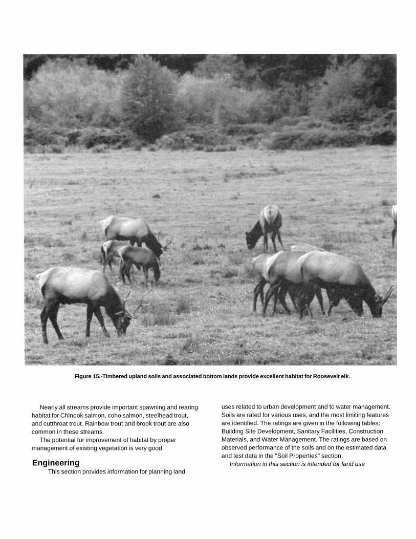
Figure 15.-Timbered upland soils and associated bottom lands provide excellent habitat for Roosevelt elk.
Nearly all streams provide important spawning and rearinghabitat for Chinook salmon, coho salmon, steelhead trout,and cutthroat trout. Rainbow trout and brook trout are alsocommon in these streams.
The potential for improvement of habitat by propermanagement of existing vegetation is very good.
EngineeringThis section provides information for planning land
uses related to urban development and to water management.Soils are rated for various uses, and the most limiting featuresare identified. The ratings are given in the following tables:Building Site Development, Sanitary Facilities, ConstructionMaterials, and Water Management. The ratings are based onobserved performance of the soils and on the estimated dataand test data in the "Soil Properties" section.
Information in this section is intended for land use
planning, for evaluating land use alternatives, and forplanning site investigations prior to design and construction.The information, however, has limitations. For example,estimates and other data generally apply only to that part ofthe soil within a depth of 5 or 6 feet. Because of the mapscale, small areas of different soils may be included within themapped areas of a specific soil.
The information is not site specific and does not eliminatethe need for onsite investigation of the soils or for testing andanalysis by personnel experienced in the design andconstruction of engineering works.
Government ordinances and regulations that restrict certainland uses or impose specific design criteria were notconsidered in preparing the information in this section. Localordinances and regulations need to be considered in planning,in site selection, and in design.
Soil properties, site features, and observed performancewere considered in determining the ratings in this section.During the fieldwork for this soil survey, determinations weremade about grain-size distribution, liquid l imit, plasticity index,soil reaction, depth to bedrock, hardness of bedrock within 5 to6 feet of the surface, soil wetness, depth to a seasonal highwater table, slope, likelihood of flooding, natural soil structureaggregation, and soil density. Data were collected about kindsof clay minerals, mineralogy of the sand and silt fractions, andthe kind of adsorbed cations. Estimates were made forerodibility, permeability, corrosivity, shrink-swell potential,available water capacity, and other behavioral characteristicsaffecting engineering uses.
This information can be used to (1) evaluate the potential ofareas for residential, commercial, industrial, and recreationuses; (2) make preliminary estimates of construction conditions;(3) evaluate alternative routes for roads, streets, highways,pipelines, and underground cables; (4) evaluate alternativesites for sanitary landfills, septic tank absorption fields, andsewage lagoons; (5) plan detailed onsite investigations of soilsand geology; (6) locate potential sources of gravel, sand,earthfill, and topsoil; (7) plan drainage systems, irrigationsystems, ponds, terraces, and other structures for soil andwater conservation; and (8) predict performance of proposedsmall structures and pavements by comparing the performanceof existing similar structures on the same or similar soils (2, 3).
The information in the tables, along with the soil maps andsoil descriptions, and other data provided in this survey canbe used to make additional interpretations.
Some of the terms used in this soil survey have a
special meaning in soil science and are defined in theGlossary.
Building Site DevelopmentTable 8 shows the degree and kind of soil limitations that
affect shallow excavations, dwellings with and withoutbasements, small commercial buildings, local roads andstreets, and lawns and landscaping. The limitations areconsidered slight if soil properties and site features generallyare favorable for the indicated use and limitations are minorand easily overcome; moderate if soil properties or sitefeatures are not favorable for the indicated use and specialplanning, design, or maintenance is needed to overcome orminimize the limitations; and severe if soil properties or sitefeatures are so unfavorable or so difficult to overcome thatspecial design, significant increases in construction costs, andpossibly increased maintenance are required. Specialfeasibility studies may be required where the soil limitations aresevere.
Shallow excavations are trenches or holes dug to amaximum depth of 5 or 6 feet for basements, graves, utilitylines, open ditches, and other purposes. The ratings are basedon soil properties, site features, and observed performance ofthe soils. The ease of digging, filling, and compacting isaffected by the depth to bedrock, a cemented pan, or a veryfirm dense layer; stone content; soil texture; and slope. Thetime of the year that excavations can be made is affected bythe depth to a seasonal high water table and the susceptibilityof the soil to flooding. The resistance of the excavation walls orbanks to sloughing or caving is affected by soil texture and thedepth to the water table.
Dwellings and small commercial buildings are structures builton shallow foundations on undisturbed soil. The load limit is thesame as that for single-family dwellings no higher than threestories. Ratings are made for small commercial buildingswithout basements, for dwellings with basements, and fordwellings without basements. The ratings are based on soilproperties, site features, and observed performance of thesoils. A high water table, flooding, shrink-swell potential, andorganic layers can cause the movement of footings. A highwater table, depth to bedrock or to a cemented pan, largestones, and flooding affect the ease of excavation andconstruction. Landscaping and grading that require cuts andfills of more than 5 to 6 feet are not considered.
Local roads and streets have an all-weather surface andcarry automobile and light truck traffic all year. They have asubgrade of cut or fill soil material, a base of gravel, crushedrock, or stabilized soil material, and a
flexible or rigid surface. Cuts and fills generally are limited toless than 6 feet (2, 3). The ratings are based on soilproperties, site features, and observed performance of thesoils. Depth to bedrock or to a cemented pan, a high watertable, flooding, large stones, and slope affect the ease ofexcavating and grading. Soil strength (as inferred from theengineering classification of the soil), shrink-swell potential,frost action potential, and depth to a high water table affectthe traffic supporting capacity.
Lawns and landscaping require soils on which turf andornamental trees and shrubs can be established andmaintained. The ratings are based on soil properties, sitefeatures, and observed performance of the soils. Soil reaction,a high water table, depth to bedrock or to a cemented pan, theavailable water capacity in the upper 40 inches, and thecontent of salts, sodium, and sulfidic materials affect plantgrowth. Flooding, wetness, slope, stoniness, and the amountof sand, clay, or organic matter in the surface layer affecttrafficability after vegetation is established.
Sanitary FacilitiesFavorable soil properties and site features are needed for
proper functioning of septic tank absorption fields (28), sewagelagoons, and sanitary landfills. The nature of the soil isimportant in selecting sites for these facilities and in identifyinglimiting soil properties and site features to be considered indesign and installation. Also, those soil properties that affectease of excavation or installation of these facilities will be ofinterest to contractors and local officials.
Table 9 shows the degree and the kind of soil limitationsthat affect septic tank absorption fields, sewage lagoons, andsanitary landfills. The limitations are considered slight if soilproperties and site features generally are favorable for theindicated use and limitations are minor and easily overcome;moderate if soil properties or site features are not favorablefor the indicated use and special planning, design, ormaintenance is needed to overcome or minimize thelimitations; and severe if soil properties or site features are sounfavorable or so difficult to overcome that special design,significant increases in construction costs, and possiblyincreased maintenance are required.
Table 9 also shows the suitability of the soils for use asdaily cover for landfills. A rating of good indicates that soilproperties and site features are favorable for the use and goodperformance and low maintenance can be expected; fairindicates that soil properties and site features are moderatelyfavorable for the use and
one or more soil properties or site features make the soil lessdesirable than the soils rated good; and poor indicates that oneor more soil properties or site features are unfavorable for theuse and overcoming the unfavorable properties requires specialdesign, extra maintenance, or costly alteration.
Septic tank absorption fields are areas in which effluent froma septic tank is distributed into the soil through subsurface tilesor perforated pipe. Only that part of the soil between depths of24 and 72 inches is evaluated. The ratings are based on soilproperties, site features, and observed performance of thesoils. Permeability, a high water table, depth to bedrock or to acemented pan, and flooding affect absorption of the effluent.Large stones and bedrock or a cemented pan interfere withinstallation.
Unsatisfactory performance of septic tank absorption fields,including excessively slow absorption of effluent, surfacing ofeffluent, and hillside seepage, can affect public health. Groundwater can be polluted if highly permeable sand and gravel orfractured bedrock is less than 4 feet below the base of theabsorption field, if slope is excessive, or if the water table isnear the surface. There must be unsaturated soil materialbeneath the absorption field to filter the effluent effectively.Many local ordinances require that this material be of a certainthickness.
Sewage lagoons are shallow ponds constructed to holdsewage while aerobic bacteria decompose the solid and liquidwastes. Lagoons should have a nearly level floor surrounded bycut slopes or embankments of compacted soil. Lagoonsgenerally are designed to hold the sewage within a depth of 2to 5 feet. Nearly impervious soil material for the lagoon floorand sides is required to minimize seepage and contamination ofground water.
Table 9 gives ratings for the natural soil that makes up thelagoon floor. The surface layer and, generally, 1 or 2 feet ofsoil material below the surface layer are excavated to providematerial for the embankments. The ratings are based on soilproperties, site features, and observed performance of thesoils. Considered in the ratings are slope, permeability, a highwater table, depth to bedrock or to a cemented pan, flooding,large stones, and content of organic matter.
Excessive seepage because of rapid permeability of the soilor a water table that is high enough to raise the level of sewagein the lagoon causes a lagoon to function unsatisfactorily.Pollution results if seepage is excessive or if floodwaterovertops the lagoon. A high content of organic matter isdetrimental to proper functioning of the lagoon because itinhibits aerobic

activity. Slope, bedrock, and cemented pans can causeconstruction problems, and large stones can hindercompaction of the lagoon floor.
Sanitary landfills are areas where solid waste is disposedof by burying it in soil. There are two types of landfill-trenchand area. In a trench landfill, the waste is placed in a trench. Itis spread, compacted, and covered daily with a thin layer ofsoil excavated at the site. In an area landfill, the waste isplaced in successive layers on the surface of the soil. Thewaste is spread, compacted, and covered daily with a thinlayer of soil from a source away from the site.
Both types of landfill must be able to bear heavyvehicular traffic. Both types involve a risk of ground waterpollution. Ease of excavation and revegetation needs to beconsidered.
The ratings in table 9 are based on soil properties, sitefeatures, and observed performance of the soils. Permeability,depth to bedrock or to a cemented pan, a high water table,slope, and flooding affect both types of landfill. Texture, stonesand boulders, highly organic layers, soil reaction, and contentof salts and sodium affect trench type landfills. Unlessotherwise stated, the ratings apply only to that part of the soilwithin a depth of about 6 feet. For deeper trenches, a limitationrated slight or moderate may not be valid. Onsite investigationis needed.
Daily cover for landfill is the soil material that is used tocover compacted solid waste in an area type sanitary landfill.The soil material is obtained offsite, transported to the landfill,and spread over the waste.
Soil texture, wetness, coarse fragments, and slope affectthe ease of removing and spreading the material during wetand dry periods. Loamy or silty soils that are free of largestones or excess gravel are the best cover for a landfill. Clayeysoils are sticky or cloddy and are difficult to spread; sandy soilsare subject to wind erosion.
After soil material has been removed, the soil materialremaining in the borrow area must be thick enough overbedrock, a cemented pan, or the water table to permitrevegetation. The soil material used as final cover for a landfillshould be suitable for plants. The surface layer generally hasthe best workability, more organic matter, and the bestpotential for plants. Material from the surface layer should bestockpiled for use as the final cover.
Construction Materials
Table 10 gives information about the soils as a source of roadfill,sand, gravel, and topsoil. The soils are rated good, fair, or poor asa source of roadfill and
topsoil. They are rated as a probable or improbable source ofsand and gravel. The ratings are based on soil properties andsite features that affect the removal of the soil and its use asconstruction material. Normal compaction, minor processing,and other standard construction practices are assumed. Eachsoil is evaluated to a depth of 5 or 6 feet.
Roadfill is soil material that is excavated in one place andused in road embankments in another place (2). In this table,the soils are rated as a source of roadfill for low embankments,generally less than 6 feet high and less exacting in design thanhigher embankments.
The ratings are for the soil material below the surface layerto a depth of 5 or 6 feet. It is assumed that soil layers will bemixed during excavating and spreading. Many soils have layersof contrasting suitability within their profile. The table showingengineering index properties provides detailed informationabout each soil layer. This information can help determine thesuitability of each layer for use as roadfill. The performance ofsoil after it is stabilized with lime or cement is not considered inthe ratings.
The ratings are based on soil properties, site features, andobserved performance of the soils. The thickness of suitablematerial is a major consideration. The ease of excavation isaffected by large stones, a high water table, and slope. Howwell the soil performs in place after it has been compactedand drained is determined by its strength (as inferred from theengineering classification of the soil) and shrink-swellpotential.
Soils rated good contain significant amounts of sand orgravel, or both. They have at least 5 feet of suitable material,low shrink-swell potential, few cobbles and stones, and slopesof 15 percent or less. Depth to the water table is more than 3feet. Soils rated fair are more than 35 percent silt- andclay-sized particles and have a plasticity index of less than 10.They have moderate shrink-swell potential, slopes of 15 to 25percent, or many stones. Depth to the water table is 1 to 3 feet.Soils rated poor have a plasticity index of more than 10, a highshrink-swell potential, many stones, or slopes of more than 25percent. They are wet, and the depth to the water table is lessthan 1 foot. They may have layers of suitable material, but thematerial is less than 3 feet thick.
Sand and gravel are natural aggregates suitable forcommercial use with a minimum of processing. Sand andgravel are used in many kinds of construction. Specificationsfor each use vary widely. In table 10, only the probability offinding material in suitable quantity is evaluated. Thesuitability of the material for
specific purposes is not evaluated, nor are factors that affectexcavation of the material.
The properties used to evaluate the soil as a source ofsand or gravel are gradation of grain sizes (as indicated by theengineering classification of the soil), the thickness of suitablematerial, and the content of rock fragments. Kinds of rock,acidity, and stratification are given in the taxonomic unitdescriptions. Gradation of grain sizes is given in the table onengineering index properties.
A soil rated as a probable source has a layer of clean sandor gravel or a layer of sand or gravel that is as much as 12percent silty fines. This material must be at least 3 feet thickand less than 50 percent, by weight, large stones. All other soilsare rated as an improbable source. Coarse fragments of softbedrock, such as shale and siltstone, are not considered to besand and gravel.
Topsoil is used to cover an area so that vegetation canbe established and maintained. The upper 40 inches of asoil is evaluated for use as topsoil. Also evaluated is thereclamation potential of the borrow area.
Plant growth is affected by toxic material and by suchproperties as soil reaction, available water capacity, and fertility.The ease of excavating, loading, and spreading is affected byrock fragments, slope, a water table, soil texture, and thicknessof suitable material. Reclamation of the borrow area is affectedby slope, a water table, rock fragments, bedrock, and toxicmaterial.
Soils rated good have friable loamy material to a depth of atleast 40 inches. They are free of stones and cobbles, have littleor no gravel, and have slopes of less than 8 percent. They arelow in content of soluble salts, are naturally fertile or respondwell to fertilizer, and are not so wet that excavation is difficult.
Soils rated fair are sandy soils, loamy soils that have arelatively high content of clay, soils that have only 20 to 40inches of suitable material, soils that have an appreciableamount of gravel, stones, or soluble salts, or soils that haveslopes of 8 to 15 percent. The soils are not so wet thatexcavation is difficult.
Soils rated poor are very sandy or clayey, have less than20 inches of suitable material, have a large amount of gravel,stones, or soluble salts, have slopes of more than 15 percent,or have a seasonal water table at or near the surface.
The surface layer of most soils generally is preferred fortopsoil because of its organic matter content. Organic mattergreatly increases the absorption and retention of moisture andnutrients for plant growth.
Water Management
Table 11 gives information on the soil properties and sitefeatures that affect water management. The degree and kind ofsoil limitations are given for pond reservoir areas and forembankments, dikes, and levees. The limitations areconsidered slight if soil properties and site features generallyare favorable for the indicated use and limitations are minorand are easily overcome; moderate if soil properties or sitefeatures are not favorable for the indicated use and specialplanning, design, or maintenance is needed to overcome orminimize the limitations; and severe if soil properties or sitefeatures are so unfavorable or so difficult to overcome thatspecial design, significant increase in construction costs, andpossibly increased maintenance are required.
This table also gives for each soil the restrictive featuresthat affect drainage, irrigation, terraces and diversions, andgrassed waterways.
Pond reservoir areas hold water behind a dam orembankment. Soils best suited to this use have low seepagepotential in the upper 60 inches. The seepage potential isdetermined by the permeability of the soil and the depth tofractured bedrock or other permeable material. Excessiveslope can affect the storage capacity of the reservoir area.
Embankments, dikes, and levees are raised structures of soilmaterial, generally less than 20 feet high, constructed toimpound water or to protect land against overflow. In this table,the soils are rated as a source of material for embankment fill.The ratings apply to the soil material below the surface layer toa depth of about 5 feet. It is assumed that soil layers will beuniformly mixed and compacted during construction.
The ratings do not indicate the ability of the natural soil tosupport an embankment. Soil properties to a depth even morethan the height of the embankment can affect performanceand safety of the embankment. Generally, deeper onsiteinvestigation is needed to determine these properties.
Soil material in embankments must be resistant toseepage, piping, and erosion and have favorable compactioncharacteristics. Unfavorable features include less than 5 feetof suitable material and a high content of stones or boulders,organic matter, or salts or sodium. A high water table affectsthe amount of usable material. It also affects trafficability.
Drainage is the removal of excess surface andsubsurface water from the soil. How easily and effectivelythe soil is drained depends on the depth to
bedrock, to a cemented pan, or to other layers that affect therate of water movement; permeability; depth to a high watertable or depth of standing water if the soil is subject to ponding;slope; susceptibility to flooding; subsidence of organic layers;and potential frost action. Excavating and grading and thestability of ditchbanks are affected by depth to bedrock or to acemented pan, large stones, slope, and the hazard of cutbankscaving. The productivity of the soil after drainage is adverselyaffected by extreme acidity or by toxic substances in the rootzone, such as salts, sodium, or sulfur. Availability of drainageoutlets is not considered in the ratings.
Irrigation is the controlled application of water to supplementrainfall and support plant growth. The design and managementof an irrigation system are affected by depth to the water table,the need for drainage, flooding, available water capacity, intakerate, permeability, erosion hazard, and slope. The constructionof a system is affected by large stones and depth to bedrock orto a cemented pan. The performance of a system is affected bythe depth of the
root zone, the amount of salts or sodium, and soilreaction.
Terraces and diversions are embankments or a combinationof channels and ridges constructed across a slope to reduceerosion and conserve moisture by intercepting runoff. Slope,wetness, large stones, and depth to bedrock or to a cementedpan affect the construction of terraces and diversions. Arestricted rooting depth, a severe hazard of wind or watererosion, an excessively coarse texture, and restrictedpermeability adversely affect maintenance.
Grassed waterways are natural or constructed channels,generally broad and shallow, that conduct surface water tooutlets at a nonerosive velocity. Large stones, wetness, slope,and depth to bedrock or to a cemented pan affect theconstruction of grassed waterways. A hazard of wind erosion,low available water capacity, restricted rooting depth, toxicsubstances such as salts or sodium, and restrictedpermeability adversely affect the growth and maintenance ofthe grass after construction.

Soil Properties
Data relating to soil properties are collected during thecourse of the soil survey. The data and the estimates of soiland water features listed in tables are explained on thefollowing pages.
Soil properties are determined by field examination of thesoils and by laboratory index testing of some benchmark soils.Established standard procedures are followed. During thesurvey, many shallow borings are made and examined toidentify and classify the soils and to delineate them on the soilmaps. Samples are taken from some typical profiles andtested in the laboratory to determine grain-size distribution,plasticity, and compaction characteristics.
Estimates of soil properties are based on fieldexaminations, on laboratory tests of samples from the surveyarea, and on laboratory tests of samples of similar soils innearby areas (27). Tests verify field observations, verifyproperties that cannot be estimated accurately by fieldobservation, and help to characterize key soils.
The estimates of soil properties shown in the tables includethe range of grain-size distribution and Atterberg limits, theengineering classifications, and the physical and chemicalproperties of the major layers of each soil. Pertinent soil andwater features also are given.
Engineering Index PropertiesTable 12 gives estimates of the engineering
classification and of the range of index properties for themajor layers of each soil in the survey area. Most soilshave layers of contrasting properties within the upper 5 to6 feet.
Depth to the upper and lower boundaries of each layeris indicated. The range in depth and information on otherproperties of each layer are given for each taxonomic unitunder "Soil Series and Their Morphology."
Texture is given in the standard terms used by the U.S.Department of Agriculture (23). These terms are definedaccording to percentages of sand, sift, and clay
in the fraction of the soil that is less than 2 millimeters indiameter. "Loam," for example, is soil that is 7 to 27 percent clay,28 to 50 percent silt, and less than 52 percent sand. If thecontent of particles coarser than sand is as much as 15 percent,an appropriate modifier is added; for example, "gravelly."Textural terms are defined in the Glossary.
Classification of the soils is determined according to thesystem adopted by the American Association of State Highwayand Transportation Officials (2, 21) and the Unified soilclassification system (3, 21).
The Unified system classifies soils according to propertiesthat affect their use as construction material. Soils are classifiedaccording to grain-size distribution of the fraction less than 3inches in diameter and according to plasticity index, liquid limit,and organic matter content. Sandy and gravelly soils areidentified as GW, GP, GM, GC, SW, SP, SM, and SC; silty andclayey soils as ML, CL, OL, MH, CH, and OH; and highlyorganic soils as PT. Soils exhibiting engineering properties oftwo groups can have a dual classification; for example, SP-SM.
The AASHTO system classifies soils according to thoseproperties that affect roadway construction and maintenance, Inthis system, the fraction of a mineral soil that is less than 3 inchesin diameter is classified in one of seven groups from A-1 throughA-7 on the basis of grain-size distribution, liquid limit, andplasticity index. Soils in group A-1 are coarse grained and low incontent of fines (silt and clay). At the other extreme, soils in groupA-7 are fine grained. Highly organic soils are classified in groupA-8 on the basis of visual inspection.
Rock fragments larger than 3 inches in diameter are indicatedas a percentage of the total soil on a dryweight basis. Thepercentages are estimates determined mainly by convertingvolume percentage in the field to weight percentage.
Percentage (of soil particles) passing designated sieves isthe percentage of the soil fraction less than 3 inches in diameterbased on an ovendry weight. The
sieves, numbers 4, 10, 40, and 200 (USA Standard Series),have openings of 4.76, 2.00, 0.420, and 0.074 millimeters,respectively. Estimates are based on laboratory tests of soilssampled in the survey area and in nearby areas and onestimates made in the field.
Liquid limit and plasticity index (Atterberg limits) indicatethe plasticity characteristics of a soil. The estimates arebased on test data from the survey area or from nearby areasand on field examination.
The estimates of grain-size distribution, liquid limit, andplasticity index are rounded to the nearest 5 percent. Thus, ifthe ranges of gradation and Atterberg limits extend a marginalamount (1 or 2 percentage points) across classificationboundaries, the classification in the marginal zone is omittedin the table.
Physical and Chemical Properties of the Soils
Table 13 shows estimates of some characteristics andfeatures that affect soil behavior. These estimates are givenfor the major layers of each soil in the survey area. Theestimates are based on field observations and on test data forthese and similar soils.
Depth to the upper and lower boundaries of each layer isindicated. The range in depth and information on otherproperties of each layer are given for each taxonomic unitunder "Soil Series and Their Morphology."
Clay as a soil separate consists of mineral soil particles thatare less than 0.002 millimeter in diameter. In this table, theestimated clay content of each major soil layer is given as apercentage, by weight, of the soil material that is less than 2millimeters in diameter.
The amount and kind of clay greatly affect the fertility andphysical condition of the soil. They determine the ability of thesoil to adsorb cations and to retain moisture. They influenceshrink-swell potential, permeability, plasticity, the ease of soildispersion, and other soil properties. The amount and kind ofclay in a soil also affect tillage and earth-moving operations.
Moist bulk density is the weight of soil (ovendry) per unitvolume. Volume is measured when the soil is at field moisturecapacity, that is, the moisture content at 1/3 bar moisturetension. Weight is determined after drying the soil at 105degrees C. In this table, the estimated moist bulk density ofeach major soil horizon is expressed in grams per cubiccentimeter of soil material that is less than 2 millimeters indiameter. Bulk density data are used to compute shrink-swellpotential, available water capacity, total pore space, and other
soil properties. The moist bulk density of a soil indicates thepore space available for water and roots. A bulk density of morethan 1.6 can restrict water storage and root penetration. Moistbulk density is influenced by texture, kind of clay, content oforganic matter, and soil structure.
Permeability refers to the ability of a soil to transmit water orair. The estimates indicate the rate of downward movement ofwater when the soil is saturated. They are based on soilcharacteristics observed in the field, particularly structure,porosity, and texture. Permeability is considered in the designof soil drainage systems, septic tank absorption fields, andconstruction where the rate of water movement under saturatedconditions affects behavior.
Available water capacity refers to the quantity of water thatthe soil is capable of storing for use by plants. The capacity forwater storage is given in inches of water per inch of soil for eachmajor soil layer. The capacity varies, depending on soilproperties that affect the retention of water and the depth of theroot zone. The most important properties are the content oforganic matter, soil texture, bulk density, and soil structure.Available water capacity is an important factor in the choice ofplants or crops to be grown and in the design and managementof irrigation systems. Available water capacity is not an estimateof the quantity of water actually available to plants at any giventime.
Soil reaction is a measure of acidity or alkalinity and isexpressed as a range in pH values. The range in pH of eachmajor horizon is based on many field tests. For many soils,values have been verified by laboratory analyses. Soil reactionis important in selecting crops and other plants, in evaluatingsoil amendments for fertility and stabilization, and indetermining the risk of corrosion.
Shrink -swell potential is the potential for volume change in asoil with a loss or gain in moisture. Volume change occursmainly because of the interaction of clay minerals with waterand varies with the amount and type of clay minerals in the soil.The size of the load on the soil and the magnitude of thechange in soil moisture content influence the amount ofswelling of soils in place. Laboratory measurements of swellingof undisturbed clods were made for many soils. For others,swelling was estimated on the basis of the kind and amount ofclay minerals in the soil and on measurements of similar soils.
If the shrink-swell potential is rated moderate to very high,shrinking and swelling can cause damage to buildings, roads,and other structures. Special design is often needed.
Shrink-swell potential classes are based on thechange in length of an unconfined clod as moisturecontent is increased from air-dry to field capacity. Thechange is based on the soil fraction less than 2millimeters in diameter. The classes are low, a change ofless than 3 percent; moderate, 3 to 6 percent; and high,more than 6 percent. Very high, more than 9 percent, issometimes used.
Erosion factor K indicates the susceptibility of a soilto sheet and rill erosion. Factor K is one of six factorsused in the Universal Soil Loss Equation (USLE) topredict the average rate of soil loss by sheet and rillerosion in tons per acre per year. The estimates arebased primarily on percentage of silt, very fine sand,sand, and organic matter (as much as 4 percent) and onsoil structure and permeability. The estimates aremodified by the presence of rock fragments. Values of Krange from 0.02 to 0.69. The higher the value the moresusceptible the soil is to sheet and rill erosion.
Erosion factor T is an estimate of the maximumaverage rate of soil erosion by wind or water that canoccur without affecting crop productivity over a sustainedperiod. The rate is in tons per acre per year.
Wind erodibility groups are made up of soils that havesimilar properties affecting their resistance to wind erosionin cultivated areas. The groups indicate the susceptibilityof soil to wind erosion and the amount of soil lost. Soils aregrouped according to the amount of stable aggregates0.84 millimeters in size. These are representedidealistically by USDA textural classes. Soils containingrock fragments can occur in any group.
1. Sand, fine sand, and very fine sand. These soils aregenerally not suitable for crops. They are extremelyerodible, and vegetation is difficult to establish on them.
2. Loamy sand, loamy fine sand, and loamy veryfine sand. These soils are very highly erodible, Cropscan be grown if intensive measures to control winderosion are used.
3. Sandy loam, coarse sandy loam, fine sandy loam,and very fine sandy loam. These soils are highlyerodible, Crops can be grown if intensive measures tocontrol wind erosion are used.
4L. Calcareous loamy soils that are less than 35percent clay and more than 5 percent finely dividedcalcium carbonate. These soils are erodible. Crops canbe grown if intensive measures to control wind erosionare used.
4. Clay, silty clay, clay loam, and silty clay loam that aremore than 35 percent clay. These soils are moderatelyerodible. Crops can be grown if measures to control winderosion are used.
5. Loamy soils that are less than 20 percent clay
and less than 5 percent finely divided calcium carbonate andsandy clay loam and sandy clay that are less than 5 percentfinely divided calcium carbonate. These soils are slightlyerodible. Crops can be grown if measures to control winderosion are used.
6. Loamy soils that are 20 to 35 percent clay and lessthan 5 percent finely divided calcium carbonate, except siltyclay loam. These soils are very slightly erodible. Crops caneasily be grown.
7. Silty clay loam that is less than 35 percent clay and lessthan 5 percent finely divided calcium carbonate. These soilsare very slightly erodible. Crops can easily be grown.
8. Stony or gravelly soils and other soils not subject to winderosion.
Organic matter is the plant and animal residue in the soil atvarious stages of decomposition.
In table 13, the estimated content of organic matter isexpressed as a percentage, by weight, of the soil material thatis less than 2 millimeters in diameter.
The content of organic matter of a soil can be maintained orincreased by returning crop residue to the soil. Organic matteraffects the available water capacity, infiltration rate, and tilth. Itis a source of nitrogen and other nutrients for crops.
Water and Soil Features
Table 14 gives estimates of various water features. Theestimates are used in land use planning that involvesengineering considerations.
Hydrologic soil groups are used to estimate runoff fromprecipitation. Soils not protected by vegetation are assigned toone of four groups. They are grouped according to the intakeof water when the soils are thoroughly wet and receiveprecipitation from long-duration storms.
The four hydrologic soil groups are:Group A. Soils having a high infiltration rate (low runoff
potential) when thoroughly wet. These consist mainly ofdeep, well drained to excessively drained sand or gravellysand. These soils have a high rate of water transmission.
Group B. Soils having a moderate infiltration rate whenthoroughly wet. These consist chiefly of moderately deep ordeep, moderately well drained or well drained soils that havemoderately fine texture to moderately coarse texture. Thesesoils have a moderate rate of water transmission.
Group C. Soils having a slow infiltration rate whenthoroughly wet. These consist chiefly of soils having a layerthat impedes the downward movement of water or

soils of moderately fine texture or fine texture. These soilshave a slow rate of water transmission.
Group D. Soils having a very slow infiltration rate (highrunoff potential) when thoroughly wet. These consist chiefly ofclay that has high shrink-swell potential, soils that have apermanent high water table, soils that have a claypan or claylayer at or near the surface, and soils that are shallow overnearly impervious material. These soils have a very slow rateof water transmission.
Flooding, the temporary covering of the soil surface byflowing water, is caused by overflow from streams, by runofffrom adjacent slopes, or by inflow from high tides. Shallowwater standing or flowing for short periods after rainfall orsnowmelt is not considered to be flooding. Standing water inswamps and marshes or in closed depressional areas isconsidered to be ponding.
Table 14 gives the frequency and duration of flooding andthe time of year when flooding is most likely to occur.
Frequency, duration, and probable period of flooding areestimated. Frequency is expressed as none, rare, occasional,and frequent. None means that flooding is not probable, rarethat it is unlikely but is possible under unusual weatherconditions (chance of flooding in any year is 0 to 5 percent),occasional that it occurs infrequently under normal weatherconditions (chance of flooding in any year is 5 to 50 percent),and frequent that it occurs often under normal weatherconditions (chance of flooding in any year is more than 50percent).
Duration is expressed as very brief (less than 2 days), brief(2 to 7 days), long (7 days to 1 month), and very long (morethan 1 month). The time of year that flooding is most likely tooccur is expressed in months. November-May, for example,means that flooding can occur during the period Novemberthrough May. About two-thirds to three-fourths of all floodingoccurs during the stated period.
The information on flooding is based on evidence in the soilprofile, namely thin strata of gravel, sand, silt, or clay depositedby floodwater; irregular decrease in organic matter content withincreasing depth; and absence of distinctive horizons, which arecharacteristic of soils that are not subject to flooding.
Also considered are local information about the extent andlevel of flooding and the relation of each soil on the landscapeto historic flood. Information on the extent of flooding based onsoil data is less specific than that provided by detailedengineering surveys that
delineate flood-prone areas at specific flood frequency levels.High water table (seasonal) is the highest level of a
saturated zone in the soil in most years. The depth to aseasonal high water table applies to undrained soils. Theestimates are based mainly on the evidence of a saturatedzone, namely grayish colors or mottles in the soil. Indicated intable 14 are the depth to the seasonal high water table; the kindof water table-that is, perched, artesian, or apparent; and themonths of the year that the water table usually is highest. Awater table that is seasonally high for less than 1 month is notindicated in the table.
An apparent water table is a thick zone of free water in thesoil. It is indicated by the level at which water stands in anuncased borehole after adequate time is allowed for adjustmentin the surrounding soil. An artesian water table is underhydrostatic head, generally below an impermeable layer. Whenthis layer is penetrated, the water level rises in an uncasedborehole. A perched water table is water standing above anunsaturated zone. In places an upper, or perched, water tableis separated from a lower water table by a dry zone.
The two numbers in the column "High water table" indicatethe normal range in depth to a saturated zone. Depth is given tothe nearest half foot. The first numeral in the range indicatesthe highest water level. A plus sign preceding the range indepth indicates that the water table is above the surface of thesoil. "More than 6.0" indicates that the water table is below adepth of 6 feet or that the water table exists for less than amonth.
Table 15 gives estimates of various soil features. Theestimates are used in land use planning that involvesengineering considerations.
Depth to bedrock is given if bedrock is within a depth of 5feet. The depth is based on many soil borings and onobservations during soil mapping. The rock is specified aseither soft or hard. If the rock is soft or fractured, excavationscan be made with trenching machines, backhoes, or smallrippers. If the rock is hard or massive, blasting or specialequipment generally is needed for excavation.
A cemented pan is a cemented or indurated subsurfacelayer at a depth of 5 feet or less. Such a pan causes difficultyin excavation. Pans are classified as thin or thick. A thin panis one that is less than 3 inches thick if continuously induratedor less than 18 inches thick if discontinuous or fractured.Excavations can be made by trenching machines, backhoes,or small rippers. A thick pan is one that is more than 3

inches thick if continuously indurated or more than 18inches thick if it is discontinuous or fractured. Such a panis so thick or massive that blasting or special equipment isneeded in excavation.
Risk of corrosion pertains to potential soil-inducedelectrochemical or chemical action that dissolves orweakens uncoated steel or concrete. The rate of corrosionof uncoated steel is related to such factors as soil moisture,particle-size distribution, acidity, and electrical conductivityof the soil. The rate of corrosion of concrete is based mainlyon the sulfate and sodium content, texture, moisturecontent, and acidity of the soil. Special site examination anddesign may be needed if the combination of factors createsa severe
corrosion environment. The steel in installations thatintersect soil boundaries or soil layers is more susceptible tocorrosion than steel in installations that are entirely withinone kind of soil or within one soil layer.
For uncoated steel, the risk of corrosion, expressed aslow, moderate, or high, is based on soil drainage class, totalacidity, electrical resistivity near field capacity, and electricalconductivity of the saturation extract.
For concrete, the risk of corrosion is also expressed as low,moderate, or high. It is based on soil texture, acidity, andamount of sulfates in the saturation extract.
Classification of the Soils
The system of soil classification used by the NationalCooperative Soil Survey has six categories (26).Beginning with the broadest, these categories are theorder, suborder, great group, subgroup, family, andseries. Classification is based on soil properties observedin the field or inferred from those observations or fromlaboratory measurements. Table 16 shows theclassification of the soils in the survey area. Thecategories are defined in the following paragraphs.
ORDER. Ten soil orders are recognized. Thedifferences among orders reflect the dominant soil--forming processes and the degree of soil formation.Each order is identified by a word ending in sol. Anexample is Entisol.
SUBORDER. Each order is divided into subordersprimarily on the basis of properties that influence soilgenesis and are important to plant growth or propertiesthat reflect the most important variables within theorders. The last syllable in the name of a suborderindicates the order. An example is Aquent (Aqu,meaning water, plus ent, from Entisol).
GREAT GROUP. Each suborder is divided into greatgroups on the basis of close similarities in kind,arrangement, and degree of development of pedogenichorizons; soil moisture and temperature regimes; andbase status. Each great group is identified by the nameof a suborder and by a prefix that indicates a property ofthe soil. An example is Psammaquent (Psamm, meaningsandy horizons, plus aquent, the suborder of the Entisolsthat has an aquic moisture regime).
SUBGROUP. Each great group has a typic subgroup.Other subgroups are intergrades or extragrades. The typicis the central concept of the great group; it is notnecessarily the most extensive. Intergrades are transitionsto other orders, suborders, or great groups. Extragradeshave some properties that are not representative of thegreat group but do not indicate transitions to any otherknown kind of soil. Each subgroup is identified by one ormore adjectives
preceding the name of the great group. The adjective Typicidentifies the subgroup that typifies the great group. Anexample is Typic Psammaquent.
FAMILY. Families are established within a subgroup on thebasis of physical and chemical properties and othercharacteristics that affect management. Mostly the propertiesare those of horizons below plow depth where there is muchbiological activity. Among the properties and characteristicsconsidered are particle-size class, mineral content, temperatureregime, thickness of the root zone, consistence, moistureequivalent, slope, and permanent cracks. A family nameconsists of the name of a subgroup preceded by terms thatindicate soil properties. An example is mixed, mesic TypicPsammaquent.
SERIES. The series consists of soils that have similarhorizons in their profile. The horizons are similar in color,texture, structure, reaction, consistence, mineral and chemicalcomposition, and arrangement in the profile. The texture of thesurface layer or of the substratum can differ within a series.
Soil Series and Their Morphology
In this section, each soil series recognized in the surveyarea is described. The descriptions are arranged in alphabeticorder.
Characteristics of the soil and the material in which it formedare identified for each series. A pedon, a smallthree-dimensional area of soil, that is typical of the series in thesurvey area is described. The detailed description of each soilhorizon follows standards in the Soil Survey Manual (23). Manyof the technical terms used in the descriptions are defined inSoil Taxonomy (26). Unless otherwise stated, colors in thedescriptions are for moist soil. Following the pedon descriptionis the range of important characteristics of the soils in theseries.
The map units of each soil series are described in thesection "Detailed Soil Map Units."

Bandon Series
The Bandon series consists of deep, well drained soils ondissected marine terraces. These soils formed in sandy marinedeposits. Slope is 0 to 30 percent. The average annualprecipitation is about 60 inches, and the average annual airtemperature is about 52 degrees F.
Typical pedon of Bandon sandy loam, 0 to 7 percent slopes, 8miles northeast of Bandon; 1,300 feet north and 260 feet east ofthe southwest corner of sec. 22, T. 27 S., R. 14 W.
O-1 inch to 0; decomposed litter of leaves, moss, andneedles.
A2-0 to 5 inches; dark grayish brown (10YR 4/2) sandy loam,yellowish brown (10YR 5/4) dry; random dark gray (10YR4/1) uncoated sand grains, light gray (10YR 6/1) dry; black(10YR 2/1) worm casts, very dark gray (10YR 3/1) dry;massive; slightly hard, very friable, nonsticky andnonplastic; many very fine and fine roots and commonmedium and coarse roots; many very fine and fine tubularpores; extremely acid; abrupt wavy boundary.
B21ir-5 to 12 inches; dark reddish brown (5YR 3/4) sandyloam, reddish brown (5YR 4/4) dry; dark reddish brown(5YR 3/2) stains, dark reddish brown (5YR 3/4) dry; flecksof black (5YR 2/1) charcoal; moderate fine and mediumsubangular blocky structure; hard, firm, slightly sticky andnonplastic; brittle; common very fine and fine roots;common very fine tubular pores and few very fine irregularpores; strongly acid; clear wavy boundary.
B22ir-12 to 22 inches; dark reddish brown (5YR 3/4) loam,reddish brown (5YR 4/4) dry; moderate mediumsubangular blocky structure; slightly hard, friable, slightlysticky and slightly plastic; few very fine, fine, and mediumroots; common very fine and fine tubular pores; about 5percent nodules and hardpan fragments 2 to 20millimeters in diameter; strongly acid; gradual wavyboundary.
B23ir-22 to 30 inches; dark reddish brown (5YR 3/4) andreddish brown (5YR 4/4) loam, brown (7.5YR 4/4) dry;weak medium subangular blocky structure; slightly hard,friable, slightly sticky and slightly plastic; few very fine andfine roots; few very fine and fine tubular pores; stronglyacid; clear wavy boundary.
B24irm -30 to 43 inches; pale brown (10YR 6/3), strong brown(7.5YR 5/6), and brown (7.5YR 4/4) cemented sandymaterial; brown (7.5YR 4/4) coatings in pores andfractures; massive; very hard,
extremely firm, nonsticky and nonplastic; few very fineroots; few very fine and fine tubular pores; strongly acid;abrupt wavy boundary.
C-43 to 60 inches; yellowish brown (10YR 5/6) loam; massive; slightly hard, very friable, slightly sticky and nonplastic; few very fine and fine tubular pores; strongly acid.
Depth to the cemented Bir horizon is 18 to 36 inches. Thedifference between the mean summer and mean winter soiltemperatures ranges from 5 to 9 degrees F.
The A horizon has value of 3 or 4 when moist and 5 or 6when dry, and it has chroma of 1 or 2 when moist and 1 to 4when dry.
The upper part of the Bir horizon has hue of 5YR or 7.5YR,value of 3 or 4, and chroma of 4 to 6. It has layers that are 0 to30 percent fine gravel that is 2 to 20 millimeters in diameter. TheB24irm horizon has hue of 5YR to 10YR, value of 4 to 6, andchroma of 3 to 6. It is weakly cemented to strongly cementedsandy material.
The C horizon has hue of 7.5YR to 10YR, value of 4 or 5when moist and 6 to 8 when dry, and chroma of 2 to 6. It is finesand or loam. It commonly is massive and compacted, but it issingle grain and loose and has weakly cemented horizontallayers 5 to 15 millimeters thick in some areas. These layers arestrong brown, brown, or light yellowish brown.
Blachly Series
The Blachly series consists of deep, well drained soils onmountains. These soils formed in colluvium derived fromsedimentary rock and basalt. Slope is 0 to 60 percent. Theaverage annual precipitation is about 80 inches, and theaverage annual air temperature is about 51 degrees F.
Typical pedon of Blachly silty clay loam, 0 to 30 percentslopes, south of the Blue Ridge Lookout; 1,000 feet north and1,500 feet west of the southeast corner of sec. 35, T. 26 S., R.12 W.
A1-0 to 3 inches; very dusky red (2.5YR 2/2) silty clay loam,dark reddish brown (5YR 3/3) dry; strong fine and mediumgranular structure; soft, very friable, nonsticky andnonplastic; many very fine and fine roots; many fine andvery fine irregular pores; medium acid; abrupt smoothboundary.
A3-3 to 7 inches; dark reddish brown (2.5YR 2/4) light silty clayloam, dark reddish brown (5YR 3/4) dry; strong fine andmedium subangular blocky structure; slightly hard, friable,slightly sticky and

slightly plastic; many very fine, fine, and medium roots; many very fine tubular pores; medium acid; abruptsmooth boundary.
B1-7 to 14 inches; dark reddish brown (2.5YR 3/4) silty clay,reddish brown (5YR 4/4) dry; strong fine and mediumsubangular blocky structure; hard, friable, sticky andplastic; common very fine and medium roots; many finetubular pores; medium acid; clear smooth boundary.
B21-14 to 27 inches; dark red (2.5YR 3/6) silty clay, yellowishred (5YR 4/6) dry; moderate medium subangular blockystructure parting to strong fine subangular blocky; hard,friable, sticky and plastic; common fine and medium rootsand few very fine roots; many very fine tubular pores;strongly acid; gradual smooth boundary.
B22-27 to 39 inches; dark red (2.5YR 3/6) silty clay, yellowishred (5YR 4/6) dry; moderate medium subangular blockystructure parting to moderate fine subangular blocky;hard, firm, sticky and plastic; common fine and mediumroots and few coarse roots; many very fine tubular pores;5 percent fine gravel; strongly acid; clear smoothboundary.
B23-39 to 52 inches; yellowish red (5YR 4/6) silty clay,yellowish red (5YR 5/6) dry; moderate mediumsubangular blocky structure parting to moderate finesubangular blocky; very hard, firm, slightly sticky andplastic; few very fine, fine, medium, and coarse roots;many very fine tubular pores; 5 percent fine gravel;strongly acid; gradual smooth boundary.
B3-52 to 60 inches; yellowish red (5YR 4/6) silty clay loam,yellowish red (5YR 5/8) dry; weak medium subangularblocky structure; very hard, firm, slightly sticky andslightly plastic; medium acid.
The content of rock fragments ranges from 0 to 20percent in the upper part of the profile and increases to 20 to50 percent below a depth of 40 inches.
The A horizon has hue of 7.5YR, 5YR, or 2.5YR, value of2 or 3 when moist and 3 or 4 when dry, and chroma of 2 to 4when moist. It has moderate or strong, granular structure orvery fine to medium, subangular blocky structure.
The B2 horizon has hue of 5YR or 2.5YR, value of 3 or 4when moist and 4 to 6 when dry, and chroma of 4 to 6 whenmoist and 4 to 8 when dry. It is silty clay or clay. Thishorizon has moderate or weak, very fine to medium,subangular blocky structure.
The B3 horizon has hue of 7.5YR or 5YR, value of 4 or 5when moist and 5 or 6 when dry, and chroma of 4 to 8 whenmoist or dry. It is silty clay loam or clay. This
horizon has weak, very fine to medium, subangular blockystructure.
Blacklock Series
The Blacklock series consists of deep, poorly drained soils onmarine terraces. These soils formed in sandy deposits. Slope is 0to 7 percent. The average annual precipitation is about 70 inches,and the average annual air temperature is about 52 degrees F.
Typical pedon of Blacklock fine sandy loam, 3 to 7 percentslopes, on the west side of Seven Devils Road; 260 feet north and1,750 feet east of the southwest corner of sec. 33, T. 27 S., R. 14W.
O-1 inch to 0; litter of leaves, twigs, roots, and moss.A11-0 to 3 inches; black (10YR 2/1) fine sandy loam, dark gray
(10YR 4/1) dry; massive; soft, very friable, nonsticky andnonplastic; many very fine and fine roots; common very fineand fine tubular pores; very strongly acid; abrupt smoothboundary.
A12-3 to 9 inches; very dark gray (10YR 3/1) loamy fine sand,gray (10YR 6/1) dry; massive; hard, friable, nonsticky andnonplastic; many very fine, fine, and medium roots; few veryfine and fine tubular pores; very strongly acid; abrupt smoothboundary.
A2-9 to 13 inches; gray (10YR 6/1) loamy fine sand, white (N 8/0)dry; dark grayish brown (10YR 4/2) stains, gray (10YR 6/1)dry; massive; hard, friable, nonsticky and nonplastic; manyvery fine, fine, and medium roots; few very fine and finetubular pores; very strongly acid; abrupt wavy boundary.
B21h-13 to 15 inches; black (5YR 2/1) mucky loam, dark reddishgray (5YR 4/2) dry; massive; slightly hard, friable, nonstickyand nonplastic; many very fine, fine, medium, and coarseroots; common very fine and fine tubular pores; very stronglyacid; abrupt wavy boundary.
B22irm -15 to 21 inches; strong brown (7.5YR 5/6), stronglycemented sand, yellowish brown (10YR 5/6) dry; massive;extremely hard, extremely firm, nonsticky and nonplastic; veryfew very fine flattened roots; very few very fine tubular pores;medium acid; clear wavy boundary.
B23irm -21 to 33 inches; yellowish brown (10YR 5/4), stronglycemented sand, yellowish brown (10YR 5/6) dry; reddishbrown (5YR 4/4) and dark red (2.5YR 3/6) stains and seams,brown (7.5YR 4/4) and yellowish red (5YR 5/6) dry; massive;extremely

hard, extremely firm, nonsticky and nonplastic; very fewvery fine roots; very few very fine tubular pores; mediumacid; clear wavy boundary.
B3irm -33 to 52 inches; yellowis h brown (10YR 5/6), stronglycemented sand, very pale brown (10YR 7/4) dry; strongbrown (7.5YR 5/6) streaks; massive; very hard, very firm,nonsticky and nonplastic; very few very fine roots; very fewvery fine tubular pores; medium acid; clear wavyboundary.
C-52 to 75 inches; light olive brown (2.5Y 5/6) sand; red (2.5YR4/6) and brown (7.5YR 4/4) stains; massive; friable,nonsticky and nonplastic; medium acid.
Depth to the ortstein layer and effective rooting depth rangefrom 12 to 20 inches. The solum is medium acid to verystrongly acid; acidity commonly decreases as depth increases.The substratum is slightly acid or medium acid. The differencebetween the. mean summer and mean winter soil temperaturesranges from 5 to 9 degrees F.
The A1 horizon has value of 2 or 3 when moist, and it haschroma of 1 or 2 when moist or dry. The A2 horizon has hueof 10YR or neutral, value of 5 to 7 when moist and 6 to 8when dry, and chroma of 0 to 2. This horizon is loamy finesand to fine sandy loam and is massive or single grain.
The Bh horizon has hue of 10YR or 5YR, and it has chromaof 1 or 2 when moist or dry. It is loam or fine sandy loam. TheBirm horizon has hue of 5YR or 10YR, value of 3 to 5 whenmoist, and chroma of 4 to 6. Mottles have chroma of 0 to 6. TheB22irm and B23irm horizons are loamy sand or sand.Cementation ranges from weak to strong. The B3irm horizon isloamy sand or loamy fine sand and is weakly cemented insome pedons. The ratio of free iron to carbon in the Birmhorizon ranges from 0.2 to 2.0.
The C horizon is variegated loamy fine sand, loamy sand,or sand and has lenses cemented with iron or aluminum.
Bohannon Series
The Bohannon series consists of moderately deep, welldrained soils on mountains. These soils formed in colluviumderived from arkosic sandstone and siltstone. Slope is 12 to 90percent. The average annual precipitation is about 80 inches,and the average annual air temperature is about 51 degrees F.
Typical pedon of a Bohannon loam in an area of Preacher-Bohannon loams, 30 to 60 percent slopes, 11 miles east ofLakeside; 3,000 feet south and 200 feet
east of the northwest corner of sec. 12, T. 24 S., R. 11 W.
A11-0 to 6 inches; very dark brown (10YR 2/2) loam, darkgrayish brown (10YR 4/2) dry; weak very fine and finegranular structure; soft, very friable, nonsticky andnonplastic; common very fine and fine roots; common veryfine and fine irregular pores; very strongly acid; clearsmooth boundary.
A12-6 to 11 inches; dark brown (10YR 3/3) gravelly loam,brown (10YR 4/3) dry; weak fine subangular blockystructure; slightly hard, friable, slightly sticky andnonplastic; common fine and very fine roots; common veryfine and fine irregular pores; about 15 percent sandstonegravel and 5 percent sandstone cobbles; very stronglyacid; clear wavy boundary.
B2-11 to 17 inches; dark yellowish brown (10YR 3/4) gravellyloam, yellowish brown (10YR 5/4) dry; weak medium andfine subangular blocky structure; slightly Hard, very friable,slightly sticky and slightly plastic; few fine and very fineroots; common very fine and fine tubular pores; about 20percent sandstone gravel and 10 percent sandstonecobbles; very strongly acid; clear smooth boundary
B3-17 to 31 inches; dark yellowish brown (10YR 4/6) gravellyloam, yellowish brown (10YR 5/6) dry; weak medium andfine subangular blocky structure; slightly hard, friable,slightly sticky and nonplastic; few fine and very fine roots;very few very fine tubular pores; about 25 percentsandstone gravel an d 10 percent sandstone cobbles; verystrongly acid; clear wavy boundary.
IICr-31 inches; brownish yellow (10YR 6/8), fractured, partiallyweathered sandstone.
The thickness of the solum and depth to fractured, partiallyweathered bedrock range from 20 to 40 inches The content ofrock fragments in the solum ranges from 15 to 35 percent, ofwhich 15 to 25 percent is gravel and 0 to 30 percent is cobbles.The profile is medium acid to very strongly acid.
The A horizon has hue of 10YR or 7.5YR, value of 2 or 3when moist and 4 or 5 when dry, and chroma of 2 or 3 whenmoist or dry. It is gravelly loam or loam. Structure is dominantlymoderate, fine or very fine, and granular or subangular blocky.The B2 horizon has hue of 10YR or 7.5YR, value of 3 or 4when moist and 4 to 6 when dry, and chroma of 3 or 4 whenmoist or dry. It is loam, gravelly loam, or light gravelly clay loamand has 18 to 30 percent clay. Structure is weak or moderate,very fine or fine, and subangular blocky. The B3 horizon hasvalue of 5 or 6 when dry.
Brallier Series
The Brallier series consists of deep, very poorly drained,organic soils on coastal terraces and flood plains along majorcoastal streams. These soils formed in organic residue ofwater-tolerant plants. Slope is 0 to 1 percent. The averageannual precipitation is about 70 inches, and the averageannual air temperature is about 52 degrees F.
Typical pedon of Brallier mucky peat, 100 feet east ofKellogg Road, above the Shutter Arm of Tenmile Lake; 2,890feet south and 2,950 feet east of the northwest corner of sec.29, T. 23 S., R. 12 W.
Oe1-0 to 24 inches; dark reddish brown (5YR 3/3) hemicmaterial, broken; about 70 percent fibers, 10 percentrubbed; many fine and very fine roots; very stronglyacid.
Oe2-24 to 45 inches; dark reddish brown (5YR 3/3) hemicmaterial, broken; about 40 percent fibers, 15 percentrubbed; few fine and very fine roots; strongly acid; clearsmooth boundary.
Oe3-45 to 60 inches; dark yellowish brown (10YR 3/4)hemic material, broken; about 45 percent fibers, 15percent rubbed; 5 percent coarse fragments; verystrongly acid.
These soils are saturated with water throughout the yearunless artificially drained. They are affected by the tide andhave a fluctuating water table. The thickness of the organicmaterial ranges from 53 inches to more than 10 feet. Thesesoils are strongly acid to extremely acid. The differencebetween the mean summer and mean winter soiltemperatures ranges from 3 to 6 degrees F. Fibers areprimarily herbaceous, but fibers from roots, limbs, and logsare scattered throughout the control section in some pedons.
The surface tier has hue of 10YR to 5YR, value of 2 or 3when moist, and chroma of 1 to 3 when moist. Fibercontent ranges from 25 to 75 percent if undisturbed to lessthan 10 percent if rubbed.
The subsurface tier has hue of 10YR or 5YR. Ifundisturbed it has value of 3 and chroma of 3 or 4 whenmoist; if rubbed it has value of 2 or 3 and chroma of 2. Fibercontent ranges from 35 to 100 percent if undisturbed andfrom 15 to 40 percent if rubbed.
The bottom tier has hue of 10YR to 5YR. If undisturbed ithas value of 3 or 4 when moist and chroma of 3 or 4; ifrubbed it has value of 3 when moist and chroma of 2 to 4.The organic material ranges from hemic to fibric.
Bullards Series
The Bullards series consists of deep, well drained soilson deeply dissected marine terraces. These soils formed inmixed eolian and marine deposits. Slope is 0 to 50 percent.The average annual precipitation is about 60 inches, and theaverage annual air temperature is about 52 degrees F.
Typical pedon of Bullards sandy loam, 0 to 7 percentslopes, 5 miles north of Bandon on Round Lake Road;2,950 feet south and 3,900 feet east of the northwestcorner of sec. 32, T. 27 S., R. 14 W.
O-3 inches to 0; litter of leaves, twigs, and stems in variousstages of decomposition.
A1-0 to 7 inches; very dark grayish brown (10YR 3/2) sandyloam, grayish brown (10YR 5/2) dry; weak mediumgranular and subangular blocky structure; soft, veryfriable, nonsticky and nonplastic; many very fine, fine,medium, and coarse roots; about 10 percent hard nodules2 to 5 millimeters in diameter; very strongly acid; abruptwavy boundary.
B21ir-7 to 16 inches; dark reddish brown (5YR 3/4) gravellysandy loam, reddish brown (5YR 4/4) dry; moderate finesubangular blocky structure; soft, very friable, nonstickyand nonplastic; common very fine, fine, medium, andcoarse roots; about 20 percent hard nodules 2 to 10millimeters in diameter; dark coatings on peds in upperpart of horizon; very strongly acid; abrupt irregularboundary.
B22ir-16 to 27 inches; dark brown (7.5YR 3/4) gravelly sandyloam, reddish brown (5YR 4/4) dry; weak mediumsubangular blocky structure; soft, very friable, nonstickyand nonplastic; few very fine and fine roots; about 20percent nodules 2 to 10 millimeters in diameter; stronglyacid; gradual wavy boundary.
B23ir-27 to 41 inches; strong brown (7.5YR 4/6) gravelly sandyloam, strong brown (7.5YR 5/6) dry; massive; soft, veryfriable, nonsticky and nonplastic; few very fine and fineroots; about 25 percent hard nodules and cementedfragments 2 to 20 millimeters in diameter; strongly acid;gradual wavy boundary.
C-41 to 60 inches; yellowish brown (10YR 5/6) sand,brownish yellow (10YR 6/6) and yellow (10YR 7/6) dry;massive; soft, very friable, nonsticky and nonplastic;medium acid.
The solum is 10 to 35 percent rounded iron nodules
2 to 20 millimeters in diameter. The difference between themean summer and mean winter soil temperatures ranges from5 to 9 degrees F.
The A horizon has hue of 10YR or 7.5YR, value of 3 to 5when moist and 5 or 6 when dry, and chroma of 1 to 3 whenmoist or dry. Some pedons have an A2 horizon.
The B horizon has hue of 7.5YR, 5YR, or 10YR, value of3 to 5 when moist and 4 to 7 when dry, and chroma of 4 to8. It is loam, gravelly sandy loam, or sandy loam and is lessthan 18 percent clay.
The C horizon has hue of 5YR to 2.5Y, value of 4 to 6 whenmoist and 6 or 7 when dry, and chroma of 3 to 8. It is loamyfine sand or sand and has thin, weakly cemented lenses insome pedons.
Chetco Series
The Chetco series consists of deep, very poorly drained soilson flood plains and deltas. These soils formed in alluvium.Slope is 0 to 3 percent. The average annual precipitation isabout 65 inches, and the average annual air temperature isabout 52 degrees F.
Typical pedon of Chetco silty clay loam, 2 miles south ofCoos Bay; 1,000 feet north and 1,950 feet west of the southeastcorner of sec. 3, T. 26 S., R. 13 W.
A1-0 to 10 inches; very dark grayish brown (10YR 3/2) silty clayloam, grayish brown (10YR 5/2) dry; moderate mediumgranular structure; slightly hard, friable, slightly sticky andslightly plastic; many very fine and fine roots; common veryfine and few fine irregular pores; common charcoal flecks0.5 to 2.0 millimeters in diameter; slightly acid; abruptsmooth boundary.
B2-10 to 24 inches; dark gray (10YR 4/1) silty clay, light gray(10YR 6/1) dry; common fine distinct dark red (2.5YR 3/6)and yellowish brown (10YR 5/6) mottles below a depth of18 inches; weak coarse prismatic structure; hard, firm,sticky and very plastic; common very fine and fine roots;few very fine, fine, and coarse tubular pores; medium acid;gradual smooth boundary.
C-24 to 60 inches; dark gray (10YR 4/1) clay, gray (10YR 5/1)dry; common fine distinct light olive brown (2.5Y 5/4) andyellowish red (5YR 4/6) mottles; massive; hard, firm, verysticky and plastic; very few very fine roots; many very fineand fine tubular pores; slightly acid.
The umbric epipedon is 10 to 24 inches thick. Mottles rangefrom few to many and faint to prominent. The
difference between the mean summer and mean winter soiltemperatures is 5 to 9 degrees F.
The A horizon has hue of 10YR or 2.5Y, value of 2 or 3when moist and 4 or 5 when dry, and chroma of 1 or 2 whenmoist or dry.
The B horizon has hue of 10YR to 5Y, value of 2 to 4 whenmoist and 4 or 5 when dry, and chroma of 1 or less when moistor dry. It is silty clay or silty clay loam and is 35 to 50 percentclay.
The C horizon has hue of 10YR to 2.5Y, value of 4 or 5when moist and 5 or 6 when dry, and chroma of 1 or 2. It isclay loam or clay. Thin lenses of sandy material are below adepth of 40 inches in some pedons.
Chismore Series
The Chismore series consists of deep, moderately welldrained soils on terraces and fans. These soils formed inalluvium. Slope is 0 to 12 percent. The average annualprecipitation is about 65 inches, and the average annual airtemperature is 52 degrees F.
Typical pedon of Chismore silt loam, 0 to 3 percent slopes,0.5 mile southwest of Broadbent; 2,360 feet east and 720 feetsouth of the northwest corner of sec. 5, T. 30 S., R. 12 W.
A1-0 to 14 inches; very dark grayish brown (10YR 3/2) silt loam,dark brown (10YR 4/3) dry; weak medium subangularblocky structure parting to weak medium granular; slightlyhard, friable, slightly sticky and slightly plastic; many fineand medium roots; many very fine irregular pores; verystrongly acid; clear smooth boundary.
B1-14 to 20 inches; dark brown (10YR 3/3) heavy silt loam, palebrown (10YR 6/3) dry; common fine faint dark yellowishbrown (10YR 4/6) mottles; weak medium subangularblocky structure; slightly hard, friable, sticky and slightlyplastic; common fine and medium roots; common fineirregular pores; common black manganese coatings; verystrongly acid; clear wavy boundary.
B21t-20 to 27 inches; brown (10YR 5/3) heavy silty clay loam,pale brown (10YR 6/3) dry; common medium distinct darkyellowish brown (10YR 4/6) mottles; moderate mediumsubangular blocky structure; hard, firm, sticky and plastic;few fine roots; common very fine and fine tubular pores;common moderately thick clay films on faces of peds;many black manganese coatings; very strongly acid;gradual wavy boundary.
B22t-27 to 39 inches; dark yellowish brown (10YR 4/6)
silty clay loam, yellowish brown (10YR 5/6) dry;common medium distinct grayish brown (10YR 5/2) andyellowish brown (10YR 5/6) mottles; moderate mediumand coarse subangular blocky structure; hard, slightlyfirm, sticky and plastic; common fine tubular pores andcommon medium vesicular pores; common moderatelythick clay films on faces of peds; very strongly acid;gradual wavy boundary.
B3-39 to 60 inches; yellowish brown (10YR 5/8) silty clayloam, brownish yellow (10YR 6/8) dry; commonmedium distinct light brownish gray (10YR 6/2) mottles;weak coarse subangular blocky structure; hard, firm,sticky and plastic; few fine tubular pores; very stronglyacid.
The profile is saturated with water during winter unlessartificially drained. The umbric epipedon is 10 to 20 inchesthick.
The A horizon has chroma of 2 or 3 when moist or dry.The Bt horizon has value of 3 to 5 when moist and 4 to 6when dry, and it has chroma of 3 to 6 when moist or dry.Mottles in the horizon have value of 4 or 5 when moist, andthey have chroma of 2 to 8. The Bt horizon is silty clay loamor silty clay and is 35 to 45 percent clay.
Clatsop Series
The Clatsop series consists of deep, very poorly drainedsoils on tidal flats. These soils formed in alluvium. Slope is 0to 1 percent. The average annual precipitation is about 60inches, and the average annual air temperature is about 52degrees F.
Typical pedon of Clatsop mucky peat, 200 feet south ofCoalbank Slough, 1,650 feet east and 260 feet north of thesouthwest corner of sec. 35, T. 25 S., R. 13 W.
O1-0 to 1 inch; undecomposed rush and sedge leaves androot mat. 02-1 to 10 inches; dark brown (10YR 3/3)mucky fibrous peat, broken; abrupt smooth boundary.
A1-10 to 17 inches; very dark grayish brown (2.5Y 3/2) siltyclay loam, dark grayish brown (2.5Y 4/2) dry; massive;slightly hard, friable, sticky and plastic; common fine andvery fine roots; many very fine tubular pores; neutral;abrupt smooth boundary.
C1g-17 to 40 inches; dark gray (5Y 4/1) silty clay, gray (5Y5/1) dry; massive; hard, friable, sticky and plastic; fewfine roots; few fine tubular pores; neutral; clear wavyboundary.
IIC2g-40 to 60 inches; very dark gray (5Y 3/1) clay, dark gray(5Y 4/1) dry; massive; hard, firm, very
sticky and very plastic; few fine tubular pores;neutral.
These soils are usually saturated and may be flooded duringhigh tide unless protected by dikes or levees. Depth to the Chorizon is less than 20 inches. Thickness of the surface peatlayer ranges from 5 to 15 inches. The difference between themean summer and mean winter soil temperatures ranges from5 to 9 degrees F.
The A horizon has hue of 10YR or 2.5Y, value of 3 or 4,and chroma of 2 or 3 when moist. It is gleyed and has mottlesin some pedons.
The C1g horizon has hue of 1 OYR to 5Y, value of 3 or 4when moist, and chroma of 1 or less. It is gleyed and hasmottles in some pedons. It is silty clay loam or silty clay and is35 to 45 percent clay. Some pedons have thin lenses of muck,peat, or sand.
The IIC2g horizon has hue of 5Y or neutral, value of 3 or 4when moist, and chroma of 1 or less. It commonly is silty clayor clay but ranges to silty clay loam and is more than 35percent clay. Some pedons have thin lenses of fine to mediumsand. Buried logs, branches, and fragments of aquaticvegetation are in some pedons.
Coquille Series
The Coquille series consists of deep, very poorly drainedsoils on flood plains. These soils formed in alluvium. Slope is 0to 1 percent. The average annual precipitation is about 70inches, and the average annual air temperature is about 52degrees F.
Typical pedon of Coquille silt loam, 4 miles east of CoosBay, south of Coos River Road; 980 feet south and 2,890 feetwest of the northeast corner of sec. 32, T. 25 S., R. 12 W.
Ap-0 to 8 inches; very dark grayish brown (10YR 3/2) silt loam,grayish brown (10YR 5/2) dry; many medium prominentyellowish red (5YR 5/6) mottles; moderate fine andmedium granular structure; friable, slightly sticky andslightly plastic; many fine roots; many very fine irregularpores; very strongly acid; clear smooth boundary.
A1-8 to 14 inches; dark grayish brown (10YR 4/2) silt loam,light brownish gray (10YR 6/2) dry; many mediumprominent yellowish red (5YR 5/6) mottles; moderatemedium subangular blocky structure; friable, slightly stickyand slightly plastic; many fine roots; many very fine andfine tubular and irregular pores; very strongly acid; clearsmooth boundary.
C1-14 to 20 inches; dark grayish brown (10YR 4/2) silty clayloam, light brownish gray (10YR 6/2) dry; many mediumprominent yellowish red (5YR 5/6) mottles; massive;friable, sticky and plastic; few very fine roots; few very finetubular and irregular pores; very strongly acid; clearsmooth boundary.
C2g-20 to 36 inches; olive gray (5Y 4/2) silty clay loam, lightolive gray (5Y 6/2) dry; few fine and medium distinctyellowish red (5YR 5/6) mottles; massive; sticky andplastic; very few very fine root remnants; very few veryfine tubular pores; oxidation stains mainly around rootchannels; about 5 percent partially decomposed woodfragments and other organic debris in lower part ofhorizon; very strongly acid; abrupt smooth boundary.
IIC3g-36 to 60 inches; very dark gray (5Y 3/1) silty clay loam;massive; sticky and plastic; 5 to 10 percent partiallydecomposed wood fragments scattered throughout; verystrongly acid.
Unless diked and drained, these soils have a permanentwater table at or near the surface that fluctuates with the tides.Depth to stratified, medium - to fine-textured, dark gray marinesediment ranges from 30 to 40 inches. The control sectionranges from 25 to 35 percent clay and has less than 15percent material that is coarser textured than very fine sand.The soils commonly are very strongly acid, but in somepedons the upper part of the profile ranges to strongly acid andthe IIC horizon is extremely acid when dry. The differencebetween the mean summer and mean winter soil temperaturesranges from 5 to 9 degrees F.
The A horizon has hue of 2.5Y or 10YR, value of 3 or 4when moist and 5 or 6 when dry, and chroma of 1 or 2. It hasfew to many, distinct to prominent mottles.
The C horizon has hue of 10YR to 5Y, value of 3 or 4 whenmoist and 6 or 7 when dry, and chroma of 2. Chroma of 1 ismainly in the matrix but is below a depth of 30 inches in somepedons. Mottles have hue of 5YR or 7.5YR and are few tomany and distinct to prominent. The C horizon is silt loam orsilty clay loam. Some pedons have thin lenses of fibrous peatless than 4 inches thick or have thin layers of sand.
The IIC horizon has hue of 2.5Y or 5Y, value of 3 or 4 whenmoist, and chroma of 0 or 1. It is stratified with coarse- tofine-textured material and thin lenses of peat in some pedons.
Dement Series
The Dement series consists of deep, well drained soils onmountains. These soils formed in residuum and
colluvium derived from sedimentary rock. Slope is 2 to 70percent. The average annual precipitation is about 65 inches,and the average annual air temperature is about 52 degreesF.
Typical pedon of Dement silt loam, 2 to 12 percent slopes,2 miles northeast of Coquille, on the north side of theCoquille-Fairview Road; 2,000 feet east and 390 feet north ofthe southwest corner of sec. 30, T. 27 S., R. 12 W.
A1-0 to 7 inches; very dark grayish brown (10YR 3/2) silt loam,brown (10YR 5/3) dry; moderate fine and medium granularstructure; slightly hard, friable, slightly sticky and slightlyplastic; common very fine, fine, and medium roots; manyvery fine irregular pores; slightly acid; abrupt smoothboundary.
B21-7 to 23 inches; reddish brown (5YR 4/3) silty clay loam,brown (7.5YR 5/4) dry; moderate medium and finesubangular blocky structure; very hard, firm, sticky andplastic; common very fine, fine, and medium roots; manyvery fine, fine, and medium tubular pores; common thinreddish brown (5YR 4/4) coatings on peds; very stronglyacid; clear smooth boundary.
B22-23 to 36 inches; reddish brown (5YR 4/4) silty clay loam,brown (7.5YR 5/4) dry; weak medium subangular blockystructure; very hard, firm, sticky and plastic; common fineand medium roots; common very fine and fine tubularpores; few thin reddish brown (5YR 4/4) coatings on peds;strongly acid; clear smooth boundary.
B3-36 to 45 inches; reddish brown (5YR 4/4) silty clay loam,brown (7.5YR 5/4) dry; weak coarse subangular blockystructure; hard, friable, slightly sticky and slightly plastic;common fine and medium roots; few very fine tubularpores; very few thin reddish brown coatings on peds;strongly acid; clear smooth boundary.
IICr-45 inches; multicolored, partially weathered sedimentaryrock; common fine and medium red (2.5YR 5/6) iron stainsalong fracture planes in upper part.
Depth to partially weathered sedimentary rock ranges from40 to 60 inches. The lower part of the solum is 0 to 15 percentgravel. Forested areas typically have an O horizon 1 to 4 inchesthick.
The A horizon has hue of 5YR to 10YR, and it has chromaof 2 to 4 when moist or dry. It has moderate or strong, fine andmedium, and granular structure or very fine or fine andsubangular blocky structure. The B horizon has hue of 5YR or 7.5YR, value of 4

or 5 when moist and 5 or 6 when dry, and chroma of 3 or4 when moist or dry. The B2 horizon is silty clay loam orsilty clay and averages 35 to 45 percent clay. The B3horizon is silty clay loam or silt loam.
The IICr horizon is siltstone or sandstone in variousstages of weathering.
Digger Series
The Digger series consists of moderately deep, welldrained soils on mountains. These soils formed incolluvium derived from sedimentary rock. Slope is 12 to 90percent. The average annual precipitation is about 70inches, and the average annual air temperature is about 50degrees F.
Typical pedon of a Digger gravelly loam in an area ofRemote-Digger-Preacher complex, 30 to 50 percent slopes,south of Powers, on the Powers Ranch Road; 2,260 feetwest of the northeast corner of sec. 24, T. 31 S., R. 12 W.
O-1 inch to 0; partially decomposed leaves, moss, and litter.A1-0 to 6 inches; dark brown (10YR 3/3) gravelly loam, pale
brown (10YR 6/3) dry; moderate very fine and finesubangular blocky structure; slightly hard, very friable,nonsticky and nonplastic; many very fine and fine roots;many fine irregular pores; 20 percent small gravel;medium acid; clear wavy boundary.
B21-6 to 9 inches; dark yellowish brown (10YR 3/4) gravellyloam, light brown (7.5YR 6/4) dry; moderate very finesubangular blocky structure; slightly hard, friable,slightly sticky and nonplastic; many very fine and fineroots; many fine and medium irregular pores; 30percent small gravel; medium acid; clear wavyboundary.
B22-9 to 19 inches; brown (7.5YR 4/4) very gravelly loam,light brown (7.5YR 6/4) dry; moderate very fine, fine,and medium subangular blocky structure; slightly hard,friable, slightly sticky and nonplastic; many fine andvery fine roots; many fine and medium irregular pores;45 percent gravel; strongly acid; clear wavy boundary.
B23-19 to 27 inches; brown (7.5YR 4/4) very cobbly loam,light brown (7.5YR 6/4) dry; weak fine subangularblocky structure; slightly hard, friable, slightly sticky andnonplastic; common very fine and fine roots; many fineirregular pores; 30 percent gravel and 30 percentcobbles; strongly acid; abrupt smooth boundary.
C1-27 to 31 inches; brown (7.5YR 4/4) extremely
cobbly loam, light brown (7.5YR 6/4) dry; massive; slightlyhard, very friable, nonsticky and nonplastic; few very fineroots; many fine irregular pores; 30 percent gravel and 40percent cobbles; strongly acid; clear wavy boundary.
IICr-31 inches; weathered, fractured sandstone.
Depth to weathered sedimentary rock ranges from 20 to 40inches. Hue of the solum is 10YR or 7.5YR. The control sectionaverages about 50 percent rock fragments.
The A horizon has value of 5 or 6 when dry and chromaof 2 or 3. Content of rock fragments ranges from 15 to 30percent. The horizon is slightly acid to strongly acid.
The B horizon has value of 3 or 4 when moist and 4 to 6when dry, and it has chroma of 3 or 4. It is loam or silt loam andis 18 to 25 percent clay, more than 15 percent material that iscoarser textured than very fine sand; and 35 to 60 percent rockfragments. It is strongly acid or very strongly acid.
The IIC horizon, where present, is below a depth of 30inches.
Eilertsen Series
The Eilertsen series consists of deep, well drained soils onstream terraces. These soils formed in mixed alluvium. Slope is0 to 7 percent. The average annual precipitation is about 60inches, and the average annual air temperature is about 52degrees F.
Typical pedon of Eilertsen silt loam, 0 to 7 percent slopes,about 0.25 mile northwest of Gaylord, west of the Powershighway; 2,200 feet west and 1,500 feet south of the northeastcorner of sec. 22, T. 30 S., R. 12 W.
A1-0 to 11 inches; dark brown (10YR 3/3) silt loam, brown(10YR 5/3) dry; moderate coarse subangular blockystructure parting to moderate medium and fine subangularblocky; slightly hard, friable, slightly sticky and slightlyplastic; common fine and very fine roots; many fine andvery fine tubular pores; strongly acid; clear smoothboundary.
B21t-11 to 23 inches; brown (10YR 4/3) silt loam, brown (10YR5/3) dry; moderate medium angular blocky structure;slightly hard, friable, slightly sticky and slightly plastic;common moderately thick clay films in pores; common fineand very fine tubular pores; medium acid; clear wavyboundary.
B22t-23 to 35 inches; brown (10YR 4/3) silt loam, yellowishbrown (10YR 5/4) dry; strong coarse
prismatic structure parting to moderate mediumsubangular blocky; slightly hard, friable, slightly sticky andslightly plastic; common moderately thick clay films onfaces of peds and in pores; few fine and very fine roots;common fine and very fine tubular pores; medium acid;clear wavy boundary.
B23t-35 to 59 inches; dark yellowish brown (10YR 4/4) siltloam, light yellowish brown (10YR 6/4) dry; moderatemedium angular blocky structure; slightly hard, friable,slightly sticky and slightly plastic; common moderatelythick clay films in pores; few fine and very fine roots;common fine and very fine tubular pores; medium acid;clear smooth boundary.
IIC-59 to 65 inches; olive brown (2.5Y 4/4) fine sandy loam,light yellowish brown (10YR 6/4) dry; massive; soft, veryfriable, nonsticky and nonplastic; common fine and veryfine tubular pores; medium acid.
The umbric epipedon is 10 to 20 inches thick.The A horizon has value of 2 or 3 when moist and 4 or 5
when dry, and it has chroma of 2 or 3 when moist or dry.The Bt horizon has value of 4 or 5 when moist and 5 to 7
when dry, and it has chroma of 3 to 6 when moist or dry.Grayish brown or dark brown mottles are below a depth of 40inches in some pedons. The Bt horizon is silt loam, clay loam,or silty clay loam and is 18 to 35 percent clay and less than 15percent fine sand or coarser textured material. The horizon hasfew to common clay films.
The IIC horizon has value of 4 or 5 when moist and 5 or 6when dry, and it has chroma of 3 or 4 when moist or dry. It isfine sandy loam, loam, or silt loam and is 10 to 20 percent clay.
Etelka Series
The Etelka series consists of deep, moderately well drainedsoils on mountains. These soils formed in colluvium andresiduum derived from sedimentary rock. Slope is 7 to 70percent. The average annual precipitation is about 65 inches,and the average annual air temperature is about 52 degrees F.
Typical pedon of an Etelka silt loam in an area ofEtelka-Whobrey silt loams, 7 to 30 percent slopes, 4 mileswest of Powers; 900 feet north and 2,500 feet west of thesoutheast corner of sec. 17, T. 31 S., R. 12 W.
A1-0 to 13 inches; dark grayish brown (2.5Y 4/2) silt loam,light brownish gray (2.5Y 6/2) dry; moderate
fine and medium granular structure; slightly hard, veryfriable, slightly sticky and slightly plastic; many very fine,fine, and medium roots; many very fine and fine tubular andirregular pores; about 2 percent gravel; strongly acid; clearwavy boundary.
B1-13 to 24 inches; dark brown (10YR 4/3) silt loam, brown(10YR 5/3) and pale brown (10YR 6/3) dry; moderate finesubangular blocky structure; hard, friable, slightly stickyand slightly plastic; many very fine and medium roots;many very fine and fine tubular and irregular pores; about4 percent gravel; strongly acid; gradual smooth boundary.
B21-24 to 32 inches; olive brown (2.5Y 4/4) silty clay loam,light olive brown (2.5Y 5/4) dry; moderate mediumsubangular blocky structure; very hard, friable, sticky andplastic; many fine and medium roots; common very fineand fine tubular and irregular pores; about 6 percentgravel; few fine faint mottles below a depth of 28 inches;strongly acid; gradual smooth boundary.
B22-32 to 45 inches; olive brown (2.5Y 4/4) and dark grayishbrown (2.5Y 4/2) silty clay, light olive brown (2.5Y 5/4) andlight brownish gray (2.5Y 6/2) dry; common fine distinctyellowish brown (10YR 5/8) mottles; moderate coarsesubangular blocky structure; extremely hard, firm, verysticky and very plastic; common fine and medium roots;common very fine and fine irregular pores; about 8 percentgravel; strongly acid; clear wavy boundary.
B3-45 to 60 inches; olive brown (2.5Y 4/4) and dark grayishbrown (2.5Y 4/2) silty clay, light olive brown (2.5Y 5/4) andlight brownish gray (2.5Y 6/2) dry; many medium distinctyellowish brown (10YR 5/8), gray (10YR 6/1), and strongbrown (7.5YR 5/6) mottles; moderate coarse subangularblocky structure; extremely hard, firm, very sticky and veryplastic; few very fine and medium roots; few very fine andfine irregular pores; medium acid.
Content of rock fragments in the solum ranges from 0 to 15percent, of which as much as 5 percent is cobbles.
The A horizon has hue of 2.5Y to 7.5YR, value of 3 or 4when moist and 4 to 6 when dry, and chroma of 1 to 3.
The B horizon has hue of 10YR or 2.5Y, value of 3 to 5 whenmoist and 5 to 7 when dry, and chroma of 1 to 4. It is silty clay,silty clay loam, or silt loam. Distinct to prominent mottles arebelow a depth of 24 to 40 inches.
The C horizon, where present, has hue of 10YR or 2.5Y, valueof 3 to 7 when moist and 5 to 7 when dry, and chroma of 1 to 4. Itis silty clay loam, silty clay, or
clay. Mottles have hue of 7.5YR or 5YR, value of 4 to 7, andchroma of 1 to 8.
Gardiner Series
The Gardiner series consists of deep, well drained soils onflood plains. These soils formed in mixed alluvium. Slope is 0 to3 percent. The average annual precipitation is about 75 inches,and the average annual air temperature is about 52 degrees F.
Typical pedon of Gardiner sandy loam, 2.5 miles east ofGravelford; 1,080 feet north and 1,080 feet east of thesouthwest corner of sec. 29, T. 28 S., R. 11 W.
Ap-0 to 9 inches; dark brown (10YR 3/3) sandy loam, brown(10YR 5/3) dry; weak fine subangular blocky structure;slightly hard, very friable, slightly sticky and nonplastic;many fine and very fine roots and common medium roots;many medium irregular pores; medium acid; clear wavyboundary.
C1-9 to 30 inches; brown (10YR 4/3) loamy fine sand, palebrown (10YR 6/3) dry; single grain; loose; common fineand very fine roots; common fine and medium irregularpores in upper 10 inches; medium acid; clear wavyboundary.
C2-30 to 60 inches; dark yellowish brown (10YR 4/4) loamysand, light yellowish brown (10YR 6/4) dry; single grain;loose; few fine and very fine roots; few thin lenses of loamand fine sand; few fine and medium irregular pores;strongly acid.
Thickness of the umbric epipedon is 7 to 10 inches. Theprofile is strongly acid or medium acid.
The A horizon has value of 4 or 5 when dry, and it haschroma of 2 or 3 when moist or dry.
The C horizon has value of 3 or 4 when moist and 5 or 6when dry, and it has chroma of 3 or 4 when moist or dry. It isloamy fine sand, fine sand, or loamy sand. Some pedons havethin strata of loam or silt loam.
Gauldy Variant
The Gauldy Variant consists of deep, somewhat excessivelydrained soils on high terraces. These soils formed in alluvium.Slope is 0 to 3 percent. The average annual precipitation isabout 70 inches, and the average annual air temperature isabout 52 degrees F.
Typical pedon of Gauldy Variant loam, 150 feet north of theSouth Fork Coquille River; 1,100 feet south and 3,200 feet eastof the northwest corner of sec. 34, T. 30 S., R. 12 W.
Ap-0 to 10 inches; very dark grayish brown (10YR 3/2)
loam, grayish brown (10YR 5/2) dry; weak medium andfine subangular blocky structure; slightly hard, friable,slightly sticky and nonplastic; many fine and very fineroots; many fine irregular pores; 10 percent gravel and 5percent cobbles; medium acid; abrupt smooth boundary.
B2-10 to 17 inches; dark brown (10YR 4/3) loam, brown (10YR5/3) dry; weak fine subangular blocky structure; slightlyhard, friable, slightly sticky and nonplastic; common fineand very fine roots; 10 percent gravel and 5 percentcobbles; medium acid; abrupt wavy boundary.
IlC1-17 to 28 inches; dark yellowish brown (10YR 4/4) verygravelly sandy loam, yellowish brown (10YR 5/4) dry;massive; soft, very friable, nonsticky and nonplastic; fewfine and very fine roots; 35 percent gravel and 15 percentcobbles; strongly acid; clear wavy boundary.
IIC2-28 to 60 inches; yellowish brown (10YR 5/4) very gravellyloamy coarse sand, light yellowish brown (10YR 6/4) dry;single grain; loose; nonsticky and nonplastic; few fine andvery fine roots; 45 percent gravel, 10 percent cobbles, and10 percent stones; strongly acid.
Thickness of the solum and depth to the IIC horizon rangefrom 15 to 30 inches. The profile typically has hue of 10YR,but it ranges to 7.5YR in some pedons.
The A horizon has value of 3 when moist and 5 when dry,and it has chroma of 2 or 3 when moist or dry. It is 0 to 15percent gravel.
The B horizon has value of 3 or 4 when moist and 5 or 6when dry, and it has chroma of 3 or 4 when moist or dry. It isloam or sandy loam and is less than 15 percent clay and morethan 15 percent material that is coarser textured than very finesand. The horizon is 10 to 45 percent gravel and 5 to 15percent cobbles.
The C horizon is variegated. It is stratified very gravellysandy loam, very gravelly loamy sand, extremely gravellyloamy coarse sand, and extremely gravelly sand with lenses offiner textured material. It is 30 to 50 percent gravel and 10 to15 percent cobbles and stones.
Giesel Series
The Giesel series consists of deep, well drained soils oncoastal mountains. These soils formed in residuum andcolluvium derived from sedimentary rock. Slope is 2 to 50percent. The average annual precipitation is about 65 inches,and the average annual air temperature is about 52 degrees F.
Typical pedon of Giesel silt loam, 2 to 12 percent slopes,0.5 mile south of Eastside; 390 feet west and 650 feet southof the northeast corner of sec. 1, T. 26mS., R. 13 W.
A1-0 to 4 inches; dark reddish brown (5YR 2.5/2) silt loam,dark reddish brown (5YR 3/2) dry; strong fine and mediumgranular structure; slightly hard, very friable, nonsticky andslightly plastic; many very fine, fine, and medium roots;many very fine irregular pores; slightly acid; abruptsmooth boundary.
B1-4 to 10 inches; dark reddish brown (5YR 3/3) silt loam, darkreddish gray (5YR 4/2) dry; moderate medium subangularblocky structure; slightly hard, friable, slightly sticky andslightly plastic; many very fine, fine, and medium roots;common very fine irregular pores; medium acid; abruptsmooth boundary.
B21-10 to 30 inches; dark reddish brown (5YR 3/4) silty clayloam, reddish brown (5YR 5/4) dry; moderate mediumand coarse subangular blocky structure parting to strongfine granular; hard, friable, slightly sticky and slightlyplastic; common very fine and fine roots; common veryfine irregular and tubular pores; medium acid; clearsmooth boundary.
B22-30 to 49 inches; dark reddish brown (5YR 3/4) silty clay,reddish brown (5YR 5/4) dry; moderate medium andcoarse subangular blocky structure; hard, friable, stickyand plastic; few very fine roots; common very fine tubularpores; medium acid; clear smooth boundary.
B3-49 to 54 inches; dark reddish brown (5YR 3/4) silty clay,reddish brown (5YR 5/3) dry; massive; hard, friable, stickyand plastic; few very fine roots; few very fine tubular pores;strongly acid; clear wavy boundary.
IICr-54 inches; variegated, partially weatheredsiltstone.
Depth to the paralithic contact ranges from 40 to 60inches or more. The lower part of the solum is 0 to 15percent gravel. The difference between the meansummer and mean winter soil temperatures ranges from5 to 9 degrees F. The umbric epipedon is 7 to 10inches thick. Organic matter content ranges from 6 to10 percent. The profile is slightly acid to very stronglyacid. Forested areas commonly have an 0 horizon 1 to4 inches thick.
The A horizon has hue of 5YR to 10YR, value of 2 or
3 when moist and 2 to 4 when dry, and chroma of 2 or 3 whenmoist or dry.
The B horizon has hue of 5YR or 7.5YR, value of 3 to 5when moist and 4 to 6 when dry, and chroma of 3 or 4 whenmoist or dry. It is silty clay loam or silty clay and averages 35to 45 percent clay.
The IICr horizon is variegated siltstone or sandstone invarious stages of weathering.
Harrington Series
The Harrington series consists of moderately deep, welldrained soils on mountains. These soils formed in colluviumderived from basalt. Slope is 30 to 70 percent. The averageannual precipitation is about 70 inches, and the average annualair temperature is about 51 degrees F.
Typical pedon of Harrington very gravelly loam, 50 to 70percent slopes, 1.25 miles north of Fairview on the west bankof Bureau of Land Management Road 27-12-14.2; 3,080 feetnorth and 980 feet east of the southwest corner of sec. 11, T.27 S., R. 12 W.
A11-0 to 7 inches; dark reddish brown (5YR 3/3) very gravellyloam, reddish brown (5YR 4/4) dry; strong very fine andfine granular structure; soft, very friable, nonsticky andslightly plastic; common very fine, fine, medium, andcoarse roots; many very fine and fine irregular pores andfew very fine, fine, and medium tubular pores; about 45percent gravel and 5 percent cobbles; slightly acid; clearwavy boundary.
A12-7 to 13 inches; dark reddish brown (5YR 3/3) extremelygravelly loam, reddish brown (5YR 4/3) dry; strong veryfine and fine granular structure; slightly hard, friable,slightly sticky and slightly plastic; many very fine, fine,medium, and coarse roots; many very fine, fine, andmedium irregular and tubular pores; about 60 percentgravel and 10 percent cobbles; medium acid; abrupt wavyboundary.
B21-13 to 20 inches; dark reddish brown (2.5YR 3/4) verygravelly clay loam, reddish brown (5YR 4/4) dry; moderatefine and medium subangular blocky structure; slightly hard,very friable, slightly sticky and slightly plastic; many veryfine, fine, and medium roots; few very fine and fineirregular pores and common very fine and fine tubularpores; about 35 percent gravel and 15 percent cobbles;medium acid; clear wavy boundary.
B22-20 to 26 inches; dark reddish brown (2.5YR 3/4)

extremely gravelly clay loam, reddish brown (5YR4/4) dry; moderate medium and coarse subangularblocky structure; slightly hard, very friable, stickyand slightly plastic; many very fine, fine, andmedium roots; few very fine irregular pores andcommon very fine and fine tubular pores; about 45percent gravel and 20 percent cobbles; mediumacid; abrupt wavy boundary.
IIR-26 inches; hard marine basalt with few widely spaced vertical fractures; massive.
Depth to bedrock ranges from 20 to 40 inches. Theprofile has hue of 5YR or 2.5YR. Content of hard rockfragments ranges from 35 to 80 percent, of which anaverage of 20 to 35 percent is gravel and 15 to 45percent is cobbles.
The A horizon has value of 2 or 3 when moist and 4 or5 when dry, and it has chroma of 3 or 4. Gravel contentranges from 35 to 50 percent, and angular cobblecontent ranges from 0 to 10 percent.
The B horizon has value of 3 or 4 when moist and 4 to6 when dry, and it has chroma of 4 or 5. It is very gravellyclay loam, extremely gravelly clay loam, very gravellyloam, or very cobbly loam. The horizon averages 25 to35 percent clay and 50 to 75 percent rock fragments, ofwhich 15 to 45 percent is cobbles and the remainingpercentage is gravel.
Heceta Series
The Heceta series consists of deep, poorly drained soilsin depressional areas between sand dunes and in deflationbasins. These soils formed in eolian material derived frombeach sand. Slope is 0 to 3 percent. The average annualprecipitation is about 70 inches, and the average annual airtemperature is about 52 degrees F.
Typical pedon of Heceta fine sand on the north side of acranberry bog road; 800 feet south and 3,280 feet west ofthe northeast corner of sec. 15, T. 24 S., R. 13 W.
A1-0 to 4 inches; very dark grayish brown (10YR 3/2) finesand, grayish brown (10YR 5/2) dry; single grain; loose,nonsticky and nonplastic; common very fine and fineroots; slightly acid; abrupt smooth boundary.
C-4 to 60 inches; grayish brown (2.5Y 5/2) sand, light gray(10YR 7/2) dry; common fine distinct brown (10YR 4/3)mottles along root channels; single grain; loose,nonsticky and nonplastic; few very fine, fine, andmedium roots to a depth of 18 inches; slightly acid.
The profile is slightly acid or medium acid throughout. Thedifference between the mean summer and mean winter soiltemperatures ranges from 5 to 9 degrees F. An O horizon 0.5 to1.0 inch thick is present in areas that have a dense stand ofplants.
The A horizon has value of 2 to 5 when moist and 4 to 6when dry, and it has chroma of 1 or 2. It is single grain or hasweak granular structure.
The C horizon has hue of 2.5Y or 10YR, value of 4 or 5when moist and 5 to 7 when dry, and chroma of 1 to 3. It hasnone to common, fine, faint to distinct mottles, mainly along rootchannels. It is single grain or massive. The horizon is sand, finesand, or loamy sand.
Honeygrove Series
The Honeygrove series consists of deep, well drained soilson mountains. These soils formed in residuum and colluviumderived from sedimentary rock and basalt. Slope is 3 to 50percent. The average annual precipitation is about 75 inches,and the average annual air temperature is about 52 degrees F.
Typical pedon of Honeygrove silty clay loam, 30 to 50percent slopes, on the south side of the Old Coos Bay WagonRoad, northeast of Fairview; 700 feet south and 2,000 feet eastof the northwest corner of sec. 15, T. 27 S., R. 12 W.
O-2 inches to 0; litter of decaying leaves, needles, and twigs.A1-0 to 5 inches; dark reddish brown (5YR 2/2) silty clay loam,
dark reddish gray (5YR 4/2) dry; strong fine granularstructure; slightly hard, very friable, slightly sticky andslightly plastic; many very fine, fine, and medium roots andfew coarse roots; many very fine and fine irregular pores;about 5 percent soft silt nodules or burnt peds 1 to 3millimeters in diameter; medium acid; abrupt smoothboundary.
B1-5 to 13 inches; dark reddish brown (5YR 3/4) silty clay loam,reddish brown (5YR 5/4) dry; strong fine subangular blockystructure; hard, firm, sticky and slightly plastic; commonvery fine, fine, and medium roots and few coarse roots;common very fine and few coarse tubular pores andcommon very fine irregular pores; about 5 percent soft siltnodules; medium acid; clear smooth boundary.
B21t-13 to 23 inches; dark reddish brown (2.5YR 3/4) clay,reddish brown (2.5YR 4/4) dry; moderate fine subangularblocky structure; hard, firm, sticky and plastic; common veryfine and fine roots and few medium and coarse roots;common very fine and fine tubular pores and few very fineirregular pores;
very few thin clay films on faces of peds; about 1 percentgravel 2 to 4 millimeters in diameter; strongly acid; gradualwavy boundary.
B22t-23 to 37 inches; dark red (2.5YR 3/6) clay, red (2.5YR4/6) dry; moderate fine and medium subangular blockystructure; hard, friable, sticky and plastic; few very fine andcoarse roots; common very fine and fine and few coarsetubular pores and few very fine irregular pores; few thinclay films on faces of peds and in pores; about 1 percentgravel 2 to 4 millimeters in diameter; strongly acid; gradualwavy boundary.
B23t-37 to 52 inches; red (2.5YR 4/6) gravelly clay, red (2.5YR4/6) dry; moderate coarse and medium subangular blockystructure; hard, friable, sticky and plastic; very few fineroots; few very fine and fine irregular and tubular pores;many thin and few moderately thick clay films on faces ofpeds and in pores; about 30 percent gravel; strongly acid;gradual smooth boundary.
B3t-52 to 62 inches; dark red (2.5YR 3/6) gravelly silty clay, red(2.5YR 4/6) dry; weak coarse subangular blocky structure;hard, firm, sticky and plastic; common thin clay films onfaces of peds; about 30 percent sandstone gravel; stronglyacid.
Depth to weathered or hard sedimentary bedrock or basaltis more than 40 inches.
The A horizon has hue of 5YR or 7.5YR, value of 2 or 3when moist and 4 or 5 when dry, and chroma of 2 to 4.
The Bt horizon has hue of 2.5YR or 5YR, value of 3 or 4when moist and 4 or 5 when dry, and chroma of 4 to 6. It isclay or silty clay. The B2t horizon is 0 to 35 percent rockfragments.
Joeney Series
The Joeney series consists of deep, poorly drained soils onold marine terraces. These soils formed in marine deposits.Slope is 0 to 7 percent. The average annual precipitation isabout 60 inches, and the average annual air temperature isabout 52 degrees F.
Typical pedon of Joeney very fine sandy loam, 0 to 7percent slopes, 3 miles south of Charleston; 2,560 feet southand 1,580 feet west of the northeast corner of sec. 22, T. 26 S.,R. 14 W.
O-1 inch to 0; loose litter of leaves and needles.A21-0 to 6 inches; light gray (10YR 6/1) very fine sandy loam,
light gray (10YR 7/1) dry; dark gray (1 OYR 4/1) streaks;weak thick platy structure; hard,
firm, nonsticky and nonplastic; few medium andcoarse roots; common very fine tubular and irregularpores; extremely acid; clear wavy boundary.
A22-6 to 10 inches; gray (10YR 5/1) very fine sandy loam,light gray (10YR 7/1) dry; very dark brown (10YR 2/2)horizontal streaks; massive; hard, firm, nonsticky andnonplastic; common fine, medium, and coarse roots;common very fine tubular and irregular pores; extremelyacid; abrupt wavy boundary.
B21h-10 to 12 inches; dark reddish brown (5YR 2.5/2) very finesandy loam, dark gray (10YR 4/1) dry; massive; hard, firm,nonsticky and nonplastic; few very fine and medium roots;few very fine and fine tubular pores; very strongly acid;abrupt irregular boundary.
B22ir-12 to 17 inches; reddish yellow (7.5YR 6/8) and light gray(2.5Y 7/2) loam, reddish yellow (7.5YR 7/8) dry; moderatemedium and thick platy structure; very hard, very firm,slightly sticky and slightly plastic; weakly cemented; fewvery fine roots; few very fine and fine tubular and irregularpores; few fine dark reddish brown (5YR 3/3) coatings onfaces of peds; very strongly acid; clear wavy boundary.
B23irm -17 to 24 inches; brownish yellow (10YR 6/6) and lightgray (2.5Y 7/2) silt loam, yellow (10YR 7/6) dry; moderatethin and medium platy structure; extremely hard, very firm,nonsticky and slightly plastic; 1- to 5-millimeter-thickortstein plate at top of horizon; weakly cemented belowplate; few very fine roots; few very fine and fine tubular andirregular pores; common medium distinct reddish brown(2.5YR 4/4) concretions and mottles; strongly acid; gradualwavy boundary.
IIC1-24 to 34 inches; brownish yellow (10YR 6/6) and yellow(2.5Y 7/8) silty clay loam, yellow (10YR 7/6) dry; massive;very hard, very firm, sticky and plastic; few very finepores; very strongly acid; gradual wavy boundary.
IIC2-34 to 60 inches; light gray (5Y 7/2) silty clay loam, white(5Y 8/2) dry; common medium and coarse distinct brownishyellow (10YR.6/6) mottles; massive; very hard, very firm,sticky and plastic; few very fine tubular pores; extremelyacid.
The control section is stratified. The differencebetween the mean summer and mean winter soiltemperatures ranges from 5 to 9 degrees F.
The A1 horizon, where present, has hue of 10YR or7.5YR, value of 2 or 3 when moist, and chroma of 2 or3. It is as much as 4 inches thick. The A2 horizon has
value of 5 to 7 when moist and 6 to 8 when dry, and it haschroma of 0 to 2. It is fine sandy loam, silt loam, very finesandy loam, or loam.
The Bh horizon has hue of 5YR to 10YR, value of 2 or 3when moist and 4 or 5 when dry, and chroma of 1 or 2. It isloam, fine sandy loam, or sandy loam. The Bir horizon hashue of 5YR to 2.5Y, value of 4 to 6 when moist and 5 to 7when dry, and chroma of 4 to 8. The ratio of free iron tocarbon ranges from 1 to 4. The Bir horizon is massive orhas platy structure and is weakly cemented to stronglycemented.
The IIC horizon has hue of 7.5YR to 5Y, value of 4 to 7,and chroma of 2 to 8.
Kirkendall Series
The Kirkendall series consists of deep, well drainedsoils on flood plains. These soils formed in mixedalluvium. Slope is 0 to 3 percent. The average annualprecipitation is about 75 inches, and the average annualair temperature is about 52 degrees F.
Typical pedon of Kirkendall silt loam, 250 feet southand 2,000 feet east of the northwest corner of sec. 31,T. 27 S., R. 12 W.
Ap-0 to 7 inches; dark brown (10YR 3/3) silt loam, brown(10YR 5/3) dry; moderate very fine subangularblocky structure; hard, friable, slightly sticky andslightly plastic; many very fine and fine roots; manyvery fine tubular pores; medium acid; abrupt smoothboundary.
B21-7 to 16 inches; dark brown (10YR 3/3) silt loam,brown (10YR 5/3) dry; moderate medium prismaticstructure parting to weak coarse subangular blocky;slightly hard, friable, slightly sticky and slightlyplastic; many very fine and fine roots; many very finetubular pores; medium acid; clear smooth boundary.
B22-16 to 26 inches; brown (10YR 4/3) heavy silt loam,yellowish brown (10YR 5/4) dry; weak mediumsubangular blocky structure; slightly hard, friable,slightly sticky and slightly plastic; many very fine andfine roots; many very fine tubular pores; mediumacid; clear smooth boundary.
B3-26 to 42 inches; brown (10YR 4/3) silt loam; weakcoarse subangular blocky structure; slightly hard,very friable, nonsticky and slightly plastic; commonvery fine and fine roots; many very fine tubularpores; few fine faint brown (10YR 5/3) mottles;slightly acid; gradual wavy boundary.
C-42 to 60 inches; brown (10YR 4/3) heavy silt loam;common fine and medium distinct grayish brown
(10YR 5/2) and strong brown (7.5YR 5/6) mottles;massive; slightly hard, friable, slightly sticky and slightlyplastic; common very fine and fine roots; slightly acid.
Thickness of the umbric epipedon is 10 to 20 inches. Faintmottles are below a depth of 20 inches in some pedons. Thinlenses of sandy loam or silty clay are present in some pedons.The profile is medium acid to slightly acid.
The A horizon has value of 2 or 3 when moist and 4 or 5when dry, and it has chroma of 2 or 3.
The B horizon has value of 3 or 4 when moist and 5 or 6when dry, and it has chroma of 3 or 4. It is silt loam or siltyclay loam.
The C horizon is silt loam, loam, or silty clay loam.
Langlois Series
The Langlois series consists of deep, very poorly drainedsoils on flood plains and old tidal flats. These soils formed inalluvium. Slope is 0 to 1 percent. The average annualprecipitation is about 70 inches, and the average annual airtemperature is about 52 degrees F.
Typical pedon of Langlois silty clay loam, 1,300 feet west ofthe Coquille River; 400 feet south and 2,160 feet east of thenorthwest corner of sec. 12, T. 28 S., R. 13 W.
Ap-0 to 10 inches; dark grayish brown (2.5Y 4/2) silty clay loam,light brownish gray (2.5Y 6/2) dry; many fine and mediumdistinct strong brown (7.5YR 4/6) mottles along rootchannels; weak medium subangular blocky structure; hard,friable, sticky and plastic; common very fine and fine roots;many very fine irregular pores; medium acid; clear wavyboundary.
C1g-10 to 22 inches; dark grayish brown (2.5Y 4/2) silty clay,light brownish gray (2.5Y 6/2) dry; many fine and mediumdistinct strong brown (7.5YR 4/6) mottles; massive; hard,friable, sticky and plastic; few very fine and fine roots; manyvery fine tubular pores; medium acid; clear smoothboundary.
C2g-22 to 28 inches; dark gray (5Y 4/1) silty clay, light brownishgray (2.5Y 6/2) dry; many fine and medium distinct strongbrown (7.5YR 4/6) mottles; massive; hard, firm, sticky andplastic; few very fine and fine roots; common very finetubular pores; medium acid; clear smooth boundary.
IIC3g-28 to 60 inches; dark gray (5Y 4/1) clay, light brownishgray (2.5Y 6/2) dry; many fine and medium prominentstrong brown (7.5YR 4/6) and greenish gray (5G 5/1)mottles; massive; hard, firm,
very sticky and plastic; few fine tubular pores;slightly acid.
Mottles are distinct or prominent. Depth to the IICg horizonranges from 20 to 36 inches. The 10- to 40-inch control sectionaverages 35 to 50 percent clay. The difference between themean summer and mean winter soil temperatures ranges from5 to 9 degrees F.
The A horizon has hue of 2.5Y or 10YR, value of 3 or 4when moist and 5 or 6 when dry, and chroma of 1 or 2 whenmoist or dry. Layers of peat as much as 5 inches thick are insome pedons. The A horizon is medium acid or strongly acid.
The Cg horizon has hue of 10YR to 5Y, value of 4 or 5 whenmoist, and chroma of 1 or less when moist or dry. It is slightlyacid or medium acid. The horizon is silty clay or silty clay loam.Thin layers of peat, pieces of charcoal, or tree limbs and rootsare in some pedons.
The IICg horizon has hue of 2.5Y or 5Y, value of 4 or 5when moist, and chroma of 1 or less. It is clay or silty clay.
McCurdy Series
The McCurdy series consists of deep, moderately welldrained soils on high terraces. These soils formed in alluvium.Slope is 3 to 30 percent. The average annual precipitation isabout 60 inches, and the average annual air temperature is 52degrees F.
Typical pedon of McCurdy silt loam, 3 to 15 percent slopes,1 mile southwest of Gaylord; 2,600 feet south and 600 feeteast of the northwest corner of sec. 27, T. 30 S., R. 12 W.
Ap-0 to 7 inches; dark brown (7.5YR 3/4) silt loam, yellowishbrown (10YR 5/4) dry; moderate fine and very finesubangular blocky structure; slightly hard, friable, slightlysticky and slightly plastic; many fine and very fine roots;common fine irregular pores; strongly acid; clear wavyboundary.
B1-7 to 12 inches; dark brown (7.5YR 4/4) silty clay loam,yellowish brown (10YR 5/4) dry; moderate mediumsubangular blocky structure; slightly hard, friable, slightlysticky and slightly plastic; common fine and very fine roots;common fine irregular pores; very strongly acid; clear wavyboundary.
B21t-12 to 20 inches; dark yellowish brown (10YR 4/6) siltyclay loam, yellowish brown (10YR 5/6) dry; moderatemedium subangular blocky structure; hard, friable, slightlysticky and slightly plastic; common fine and very fine roots;few fine and medium irregular and tubular pores; commonmoderately thick clay films on faces of peds and in
pores; very strongly acid; clear wavy boundary.B22t-20 to 34 inches; yellowish brown (10YR 5/8) silty clay
loam, brownish yellow (10YR 6/8) dry; few mediumdistinct light olive brown (2.5Y 5/4) mottles, pale yellow(2.5Y 7/4) dry; moderate medium subangular blockystructure; hard, firm, sticky and plastic; few fine and veryfine roots; few medium tubular pores; common moderatelythick clay films on faces of peds and in pores; verystrongly acid; clear wavy boundary.
B3-34 to 48 inches; yellowish brown (10YR 5/8) silty clay loam,yellow (10YR 7/8) dry; many medium prominent lightbrownish gray (2.5Y 6/2) mottles, light gray (2.5Y 7/2) dry;weak coarse subangular blocky structure; hard, firm,sticky and plastic; few fine and very fine roots; fewmedium tubular pores; very strongly acid; clear wavyboundary.
C-48 to 60 inches; brownish yellow (10YR 6/8) silty clay loam,yellow (10YR 7/8) dry; many medium prominent light gray(N 6/0) and light brownish gray (2.5Y 6/2) mottles, lightgray (N 7/0) dry; massive; very hard, firm, sticky andplastic; very strongly acid.
The profile is strongly acid or very strongly acid. Stratifiedgravelly material is below a depth of 40 inches in some pedons.The profile is 0 to 15 percent gravel.
The A horizon has hue of 10YR, 7.5YR, or 5YR, value of3 or 4 when moist and 4 or 5 when dry, and chroma of 2 to4 when moist or dry.
The B1 horizon has hue of 10YR to 5YR, and it has value of3 or 4 when moist and 4 or 5 when dry. The Bt horizon has hueof 10YR or 7.5YR, value of 4 or 5 when moist and 5 to 7 whendry, and chroma of 6 to 8 when moist or dry. Mottles have hueof 10YR or 2.5Y, value of 5 or 6 when moist and 6 or 7 whendry, and chroma of 3 to 6. The Bt horizon is silty clay loam orsilty clay.
The C horizon has hue of 10YR or 7.5YR, value of 4 to 6when moist and 4 to 7 when dry, and chroma of 4 to 8. Mottleshave hue of 2.5Y or 10YR, value of 5 to 7, and chroma of 0 to2. The horizon is silty clay loam, silty clay, or clay.
Meda Series
The Meda series consists of deep, well drained soils onalluvial fans. These soils formed in alluvium. Slope is 3 to 15percent. The average annual precipitation is about 70 inches,and the average annual air temperature is 52 degrees F.
Typical pedon of Meda loam, 3 to 15 percent slopes,
1.5 miles south of Powers; 1,040 feet north and 520feet east of the southwest corner of sec. 19, T. 31 S., R. 11 W.
A1-0 to 10 inches; dark brown (10YR 3/3) loam, brown(10YR 4/3) dry; weak fine subangular blocky structure;soft, friable, slightly sticky and nonplastic; many fineand very fine roots; common fine tubular pores; 10percent gravel; strongly acid; clear smooth boundary.
B1-10 to 16 inches; dark yellowish brown (10YR 3/4)gravelly clay loam, yellowish brown (10YR 5/4) dry;weak medium subangular blocky structure; soft,friable, slightly sticky and nonplastic; common very fineroots; many fine tubular pores; 20 percent gravel;strongly acid; clear smooth boundary.
B2-16 to 32 inches; dark yellowish brown (10YR 4/4)gravelly clay loam, yellowish brown (10YR 5/4) dry;weak medium subangular blocky structure; soft,friable, sticky and plastic; few very fine roots; commonvery fine and few fine tubular pores; 25 percent gravel;strongly acid; clear wavy boundary.
IIC-32 to 60 inches; yellowish brown (10YR 5/4) verygravelly loam, light yellowish brown (10YR 6/4) dry;massive; soft, firm, nonsticky and nonplastic; manyfine irregular pores; 45 percent gravel; strongly acid.
The umbric epipedon ranges from 10 to 20 inches inthickness. The profile has hue of 10YR or 7.5YR.
The A horizon has value of 2 or 3 when moist and 4 or5 when dry, and it has chroma of 2 or 3 when moist or dry.
The B2 horizon has value of 3 or 4 when moist and 5 or6 when dry, and it has chroma of 3 or 4 when moist and 2to 4 when dry.
The IIC horizon is clay loam, loam, or sandy loamand is 15 to 50 percent gravel.
Milbury Series
The Milbury series consists of moderately deep, welldrained soils on mountains. These soils formed in colluviumderived from sandstone. Slope is 30 to 80 percent. Theaverage annual precipitation is about 85 inches, and theaverage annual air temperature is about 52 degrees F.
Typical pedon of a Milbury very gravelly sandy loam inan area of Milbury-Bohannon-Umpcoos association, 50 to80 percent slopes, 2 miles west of Loon Lake; 3,400 feetnorth and 4,460 feet east of the southwest corner of sec.9, T. 23 S., R. 10 W.
O-1 inch to 0; undecomposed duff consisting of
branches, twigs, leaves, and fir needles.A1-0 to 10 inches; black (10YR 2/1) very gravelly sandy
loam, dark gray (10YR 4/1) dry; weak fine and very finegranular structure; soft, very friable, nonsticky andnonplastic; many medium and fine roots; 50 percentgravel and 5 percent cobbles; strongly acid; clear smoothboundary.
B1-10 to 18 inches; very dark grayish brown (10YR 3/2) verycobbly loam, brown (10YR 5/3) dry; weak fine andmedium subangular blocky structure; soft, very friable,slightly sticky and nonplastic; many medium and fine rootsand common very fine roots; 25 percent gravel and 20percent cobbles; strongly acid; clear smooth boundary.
B2-18 to 36 inches; dark brown (10YR 4/3) very cobbly loam,light yellowish brown (10YR 6/4) dry; weak fine andmedium subangular blocky structure; soft, friable, slightlysticky and slightly plastic; common fine and medium roots;20 percent gravel and 35 percent cobbles; strongly acid;abrupt wavy boundary.
IIR-36 inches; hard, consolidated sandstone.
Depth to bedrock ranges from 20 to 40 inches. Theparticle-size control section is 35 to 60 percent rockfragments. The solum is 20 to 45 percent gravel.
The A horizon has value of 2 or 3 when moist and 4 or 5when dry, and it has chroma of 1 to 3 when moist or dry. Thehorizon is 0 to 10 percent cobbles.
The B horizon has value of 3 to 5 when moist and 5 or 6when dry, and it has chroma of 3 or 4 when moist or dry. It isvery gravelly loam, very gravelly sandy loam, or very cobblyloam. The horizon is 10 to 35 percent cobbles.
Millicoma Series
The Millicoma series consists of moderately deep, welldrained soils on mountains. These soils formed in colluviumderived from sandstone. Slope is 12 to 75 percent. The averageannual precipitation is about 65 inches, and the average annualair temperature is about 52 degrees F.
Typical pedon of a Millicoma gravelly loam in an area ofMillicoma-Templeton complex, 50 to 75 percent slopes, 2 mileseast of Lakeside, on the north side of the ridge road; 2,400 feetsouth and 2,160 feet east of the northwest corner of sec. 16, T.23 S., R. 12 W.
O-3 inches to 0; undecomposed litter of needles, leaves, andtwigs.
A11-0 to 7 inches; very dark brown (10YR 2/2) gravellyloam, dark grayish brown (10YR 4/2) dry;

moderate fine and medium granular structure; soft, veryfriable, slightly sticky and slightly plastic; many very fine,fine, and medium roots; many very fine and fine irregularpores; 15 percent gravel; very strongly acid; clear smoothboundary.
A12-7 to 18 inches; very dark grayish brown (10YR 3/2)gravelly loam, grayish brown (10YR 5/2) dry; moderatefine subangular blocky structure; slightly hard, very friable,slightly sticky and slightly plastic; many very fine, fine, andmedium roots; common very fine and fine irregular pores;25 percent gravel and 5 percent cobbles; strongly acid;abrupt wavy boundary.
B2-18 to 35 inches; dark brown (10YR 4/3) very gravelly loam,pale brown (10YR 6/3) dry; weak medium subangularblocky structure; slightly hard, very friable, slightly stickyand slightly plastic; common very fine, fine, and mediumroots; few very fine, fine, and medium irregular and tubularpores; about 40 percent gravel and 15 percent cobbles;strongly acid; abrupt wavy boundary.
IICr-35 inches; grayish brown (2.5Y 5/2) and light yellowishbrown (2.5Y 6/4) partially weathered sandstone.
The textural control section is 35 to 65 percent rockfragments. It is loam or sandy loam and is less than 18 percentclay. The umbric epipedon is 10 to 20 inches thick. Depth tothe paralithic contact is 20 to 40 inches. The differencebetween the mean summer and mean winter soil temperaturesranges from 5 to 9 degrees F.
The A horizon has value of 2 or 3 when moist and 4 or 5when dry, and it has chroma of 2 or 3 when moist or dry. It is8 to 15 percent organic matter and 5 to 30 percent rockfragments.
The B2 horizon has hue of 10YR or 7.5YR, value of 3 or 4when moist and 5 or 6 when dry, and chroma of 2 or 3 whenmoist. It is very gravelly loam or very gravelly sandy loam.
Nehalem Series
The Nehalem series consists of deep, well drained soils onflood plains. These soils formed in alluvium. Slope is 0 to 3percent. The average annual precipitation is about 55 inches,and the average annual air temperature is about 52 degrees F.
Typical pedon of Nehalem silt loam, 3.5 miles south ofCoquille; 3,080 feet east and 300 feet north of the southwestcorner of sec. 24, T. 28 S., R. 13 W.
Ap-0 to 5 inches; dark brown (10YR 3/3) silt loam,
A1
brown (10YR 5/3) dry; moderate fine and very finesubangular blocky structure; hard, friable, slightly stickyand slightly plastic; many fine and very fine roots; manyfine and very fine tubular pores; strongly acid; clearsmooth boundary.
-5 to 12 inches; dark brown (10YR 3/3) silt loam, brown(10YR 5/3) dry; moderate fine subangular blocky structure;hard, friable, slightly sticky and slightly plastic; commonfine and very fine roots; many fine and very fine tubularpores; strongly acid; clear wavy boundary.
B2-12 to 29 inches; brown (10YR 4/3) silt loam, pale brown(10YR 6/3) dry; moderate fine and medium subangularblocky structure; hard, friable, slightly sticky and slightlyplastic; few fine and very fine roots; common fine andvery fine tubular pores; strongly acid; clear wavyboundary.
C-29 to 60 inches; brown (10YR 4/3) silty clay loam, palebrown (1 OYR 6/3) dry; massive; hard, firm, sticky andplastic; few fine and very fine roots; few fine and veryfine tubular pores; strongly acid.
Thickness of the umbric epipedon ranges from 10 to 20inches. Faint, high-chroma mottles are below a depth of 20inches in some pedons. The profile is medium acid to verystrongly acid. Thin discontinuous lenses of sandy loam andloam are in some pedons. The difference between the meansummer and mean winter soil temperatures ranges from 5 to 9degrees F. Hue of the profile is 10YR or 7.5YR.
The A horizon has value of 2 or 3 when moist and 4 or 5when dry, and it has chroma of 2 or 3 when moist or dry.
The B2 horizon has value of 3 or 4 when moist and 5 or 6when dry, and it has chroma of 3 or 4 when moist or dry. It issilt loam or silty clay loam.
The C horizon is silty clay loam, silt loam, or loam.
Nestucca Series
The Nestucca series consists of deep, somewhat poorlydrained soils on flood plains. These soils formed in alluvium.Slope is 0 to 3 percent. The average annual precipitation isabout 60 inches, and the average annual air temperature isabout 52 degrees F.
Typical pedon of Nestucca silt loam, 2.5 miles south ofCoquille; 2,430 feet east and 300 feet north of the southwestcorner of sec. 13, T. 28 S., R. 13 W.
Ap-0 to 6 inches; dark brown (10YR 3/3) silt loam, brown(10YR 5/3) dry; common medium distinct dark grayishbrown (10YR 4/2) and yellowish brown
(10YR 5/8) mottles; moderate medium subangularblocky structure; slightly hard, friable, slightly stickyand slightly plastic; many fine and very fine roots;many fine and very fine tubular pores; strongly acid;clear smooth boundary.
A1-6 to 14 inches; very dark grayish brown (10YR 3/2) siltloam, grayish brown (10YR 5/2) dry; many mediumdistinct dark grayish brown (10YR 4/2) and yellowishbrown (10YR 5/8) mottles; moderate fine andmedium subangular blocky structure; slightly hard,friable, slightly sticky and slightly plastic; commonfine and very fine roots; common fine and very finetubular pores; strongly acid; clear wavy boundary.
B2g-14 to 40 inches; dark grayish brown (10YR 4/2) siltyclay loam, light brownish gray (10YR 6/2) dry; manymedium prominent dark grayish brown (2.5Y 4/2)and strong brown (7.5YR 4/6) mottles; moderatemedium and fine subangular blocky structure; slightlyhard, friable, sticky and plastic; few fine and very fineroots; common fine and very fine tubular pores;strongly acid; clear wavy boundary.
Cg-40 to 60 inches; olive brown (2.5Y 4/4) silty clay, lightolive brown (2.5Y 5/4) dry; many medium prominentdark grayish brown (2.5Y 4/2) and yellowish brown(10YR 5/8) mottles; massive; hard, firm, very stickyand very plastic; few fine and very fine roots; fewvery fine tubular pores; strongly acid.
These soils have a high water table during winterunless they are artificially drained. The umbric epipedon is10 to 24 inches thick. The difference between the meansummer and mean winter soil temperatures ranges from 5to 9 degrees F.
The A horizon has value of 2 or 3 when moist and 4or 5 when dry, and it has chroma of 1 to 3 when moist ordry.
The B2g horizon has hue of 10YR to 5Y, value of 3 to5 when moist and 5 to 7 when dry, and chroma of 1 or 2when moist or dry. It is silt loam or silty clay loam. Thinlenses of coarser textured material are present in somepedons.
The Cg horizon is silty clay, clay loam, orNetarts Series
The Netarts series consists of deep, well drained soils onold stabilized sand dunes. These soils formed in eoliandeposits. Slopes are 2 to 30 percent. The average annualprecipitation is about 60 inches, and the average annual airtemperature is about 52 degrees F.
Typical pedon of Netarts loamy fine sand, 2 to 30percent slopes, at the end of Crocker Street in CoosBay; 1,200 feet north and 100 feet east of thesouthwest corner of sec. 16, T. 25 S., R. 13 W.
O-1 inch to 0; dark reddish brown (5YR 2/2) litter of leaveson a partially decomposed root mat.
A2-0 to 4 inches; light brownish gray (10YR 6/2) loamy finesand, light gray (10YR 7/2) dry; few strong brown(7.5YR 4/6) stains on sand grains, reddish yellow(7.5YR 6/6) dry; massive; very friable, nonsticky andnonplastic; many very fine, fine, and medium roots;many very fine and common fine tubular and irregularpores; very strongly acid; clear irregular boundary.
B21ir-4 to 13 inches; dark brown (7.5YR 4/4) fine sand,reddish yellow (7.5YR 6/6) dry; brown (10YR 5/3) tonguesof A2 material, white (10YR 8/2) dry; massive; very friable,nonsticky and nonplastic; many very fine, fine, andmedium roots; many very fine and common fine tubularand irregular pores; about 10 percent concretions 0.5 to2.0 centimeters in diameter; strongly acid; clear wavyboundary.
B22ir-13 to 22 inches; yellowish brown (10YR 5/4) and strongbrown (7.5YR 5/8) fine sand, very pale brown (10YR 8/3)and yellow (10YR 7/6) dry; massive; very friable, nonstickyand nonplastic; common very fine and medium roots;common very fine and fine irregular pores; medium acid;clear wavy boundary.
B3ir-22 to 30 inches; yellowish brown (10YR 5/4, 5/6) fine sand,very pale brown (10YR 7/4) dry; massive; very friable,nonsticky and nonplastic; few very fine and medium roots;common very fine and fine irregular pores; medium acid;clear wavy boundary.
C1-30 to 37 inches; light yellowish brown (10YR 6/4) fine sand,very pale brown (10YR 7/4) dry; single grain; loose; manyvery fine irregular pores; about 5 percent weakly cementedfine concretions; medium acid; gradual wavy boundary.
C2-37 to 60 inches; pale brown (10YR 6/3) fine sand, very palebrown (10YR 7/3) dry; single grain; loose; many very fineirregular pores; medium acid.
The difference between the mean summer and meanwinter soil temperatures ranges from 5 to 9 degrees F.
The A2 horizon commonly has hue of 10YR, but itranges to 2.5Y. The horizon has value of 4 to 6 whenmoist and chroma of 1 or 2. It is fine sand or loamy finesand.
The Bir horizon has hue of 2.5Y to 5YR, value of 3 to6 when moist and 4 to 8 when dry, and chroma of 2 to

8. The horizon consists of thin to thick strata that are weaklycemented to strongly cemented. It is loamy fine sand to finesand. The Bir horizon is single grain or massive. Theestimated organic matter content is less than 2 percent in theupper 4 inche6s.
The C horizon has value of 4 to 6, when moist and 5 to 7when dry, and it has chroma of 3 or 4. It is fine sand or loamyfine sand and is stratified in some pedons. Thin, weaklycemented, iron-organic lenses are present in some pedons.
Orford Series
The Orford series consists of deep, well drained soils onmountains. These soils formed in residuum and colluviumderived from arkosic sandstone and siltstone. Slope is 12 to 50percent. The average annual precipitation is about 65 inches,and the average annual air temperature is about 52 degrees F.
Typical pedon of Orford silty clay loam in an area ofEtelka-Rinearson-Orford complex, 30 to 50 percent slopes, 5miles southwest of Myrtle Point; 1,320 feet west and 790 feetnorth of the southeast corner of sec. 35, T. 29 S., R. 13 W.
O-1 inch to 0; fir needles, leaves, and twigs.A1-0 to 11 inches; very dark grayish brown (10YR 3/2) silty clay
loam, dark brown (10YR 4/3) dry; moderate fine andmedium granular structure; slightly hard, very friable,slightly sticky and slightly plastic; many fine and very fineroots and common medium roots; common fine irregularpores; 5 percent gravel; strongly acid; clear wavyboundary.
B1-11 to 19 inches; dark brown (10YR 3/3) silty clay loam,brown (10YR 5/3) dry; moderate fine subangular blockystructure; slightly hard, friable, slightly sticky and slightlyplastic; many fine and common medium roots; commonfine and medium irregular pores; 5 percent gravel; stronglyacid; clear wavy boundary.
B21t-19 to 28 inches; dark brown (10YR 4/3) silty clay, brown(10YR 5/3) dry; moderate medium subangular blockystructure; hard, friable, sticky and plastic; common fine andmedium roots; common fine and medium tubular pores;few thin clay films on faces of peds; 2 percent gravel;strongly acid; gradual wavy boundary.
B22t-28 to 42 inches; yellowish brown (10YR 5/4) silty clay,light yellowish brown (10YR 6/4) dry; moderate mediumsubangular blocky structure; hard, firm, sticky and plastic;few fine and medium roots;
common medium tubular pores; common thin clay films onfaces of peds; strongly acid; gradual wavy boundary.
B23t-42 to 48 inches; yellowish brown (10YR 5/6) silty clay,light yellowish brown (10YR 6/4) dry; moderate mediumsubangular blocky structure; hard, firm, sticky and plastic;few fine and medium roots; few medium tubular pores;common thin clay films on faces of peds; 10 percentgravel; strongly acid; gradual wavy boundary.
B3-48 to 55 inches; dark yellowish brown (10YR 4/4) silty clayloam, light yellowish brown (10YR 6/4) dry; weak mediumsubangular blocky structure; hard, firm, sticky and slightlyplastic; few fine roots; few fine irregular pores; 15 percentgravel; strongly acid; gradual wavy boundary.
C-55 to 60 inches; dark yellowish brown (10YR 4/4) silty clayloam; massive; hard, firm, sticky and slightly plastic; verystrongly acid.
Content of rock fragments ranges from 0 to 15 percent inthe upper 60 inches and as much as 60 percent below thisdepth. The profile has hue of 10YR or 7.5YR.
The A horizon has value of 2 or 3 when moist and 3 to 5when dry. It is medium acid or strongly acid. Structure ismoderate to strong and granular or fine and subangular blocky.
The B1 horizon has color similar to that of the A horizon. TheB2t horizon has value of 3 to 5 when moist and 4 to 7 when dry,and it has chroma of 3 to 6 when moist and 3 or 4 when dry. Itis clay, silty clay, or silty clay loam and is 35 to 45 percent clay.Thin clay films range from few to common. The B2t horizon isstrongly acid or very strongly acid.
The C horizon has value of 4 to 6 when moist and 6 or 7when dry, and it has chroma of 2 to 4 when moist or dry. It issilt loam, silty clay loam, or silty clay.
Preacher Series
The Preacher series consists of deep, well drained soils onmountains. These soils formed in colluvium and residuumderived from arkosic sandstone. Slope is 3 to 90 percent. Theaverage annual precipitation is about 80 inches, and theaverage annual air temperature is about 52 degrees F.
Typical pedon of Preacher loam in an area ofPreacher-Bohannon loams, 60 to 90 percent slopes, on theeast side of Bureau of Land Management Road 26-9-32.OA;2,000 feet south and 1,875 feet east of the
northwest corner of sec. 32, T. 26 S., R. 9 W.
O-4 inches to 0; undecomposed needles, leaves, andtwigs.
A1-0 to 2 inches; very dark grayish brown (10YR 3/2) loam,dark brown (10YR 4/3) dry; moderate very finesubangular blocky structure parting to moderate veryfine granular; soft, friable, slightly sticky and slightlyplastic; many fine and very fine roots; common fine andvery fine tubular and irregular pores; 10 percentpebbles; strongly acid; clear smooth boundary.
A3-2 to 14 inches; dark brown (10YR 3/3) loam, brown (1OYR 5/3) dry; moderate fine and very fine subangularblocky structure; slightly hard, friable, slightly sticky andslightly plastic; many fine and very fine roots andcommon medium and coarse roots; common fine andvery fine tubular and irregular pores; 15 percent gravel;very strongly acid; clear wavy boundary.
B21-14 to 27 inches; dark yellowish brown (10YR 4/4) clayloam, yellowish brown (10YR 5/4) dry; moderatemedium and fine subangular blocky structure; hard,friable, slightly sticky and slightly plastic; many fine andvery fine roots; common fine and very fine tubular andirregular pores; 10 percent gravel and 5 percentcobbles; very strongly acid; gradual smooth boundary.
B22-27 to 48 inches; dark yellowish brown (10YR 4/4) clayloam, yellowish brown (10YR 5/4) dry; moderatemedium and fine subangular blocky structure; hard,friable, slightly sticky and slightly plastic; many fine andvery fine roots and common medium roots; few fineand very fine tubular and irregular pores; 15 percentgravel; very strongly acid; gradual smooth boundary.
C-48 to 60 inches; yellowish brown (10YR 5/4) clay loam,pale brown (10YR 6/3) dry; weak mediumsubangular blocky structure; hard, friable, slightlysticky and slightly plastic; common fine and very fineroots; few fine and very fine tubular and irregularpores; 30 percent soft weathered gravel and 10percent soft weathered cobbles; very strongly acid.
Depth to bedrock is 40 to 60 inches or more. Theprofile has hue of 10YR or 7.5YR. Content of rockfragments is 5 to 20 percent, of which 5 to 10 percent issoft weathered gravel and 0 to 15 percent is softweathered cobbles. The umbric epipedon is 10 to 20inches thick.
The A horizon has value of 2 or 3 when moist and 4
or 5 when dry, and it has chroma of 2 or 3 when moist and 2to 4 when dry.
The B horizon has value of 3 or 4 when moist and 4 or 5when dry, and it has chroma of 3 or 4. It is clay loam, but itranges to loam in the lower part of some pedons.
The C horizon is clay loam, loam, or sandy loam and is 10to 80 percent soft weathered rock fragments.
Pyburn Series
The Pyburn series consists of deep, poorly drained soils onhigh terraces. These soils formed in mixed alluvium. Slope is 0to 8 percent. The average annual precipitation is about 70inches, and the average annual air temperature is 51 degreesF.
Typical pedon of Pyburn silty clay, 0 to 8 percent slopes,0.5 mile south of Powers; 3,670 feet north and 300 feet eastof the southwest corner of sec. 19, T. 31 S., R. 11 W.
Ap-0 to 7 inches; black (10YR 2/1) silty clay, dark brown (10YR3/3) dry; moderate fine subangular blocky structure; hard,friable, sticky and plastic; many very fine and fine roots andcommon medium roots; few fine irregular pores; stronglyacid; clear smooth boundary.
B1-7 to 14 inches; black (N 2/0) clay, very dark grayish brown(10YR 3/2) dry; few medium distinct dark brown (7.5YR3/2) and grayish brown (10YR 5/2) mottles; moderatemedium subangular blocky structure; very hard, firm, stickyand plastic; common fine and medium roots; common fineirregular pores; strongly acid; gradual wavy boundary.
B2t-14 to 28 inches; dark gray (N 4/0) clay, very dark grayishbrown (10YR 3/2) dry; many fine distinct dark brown (10YR3/3) and dark yellowish brown (10YR 4/6) mottles;moderate medium and coarse subangular blocky structure;very hard, firm, very sticky and very plastic; common fineand medium roots; few fine irregular pores; commonmoderately thick clay films on faces of peds; commonslickensides; medium acid; clear wavy boundary.
B3-28 to 38 inches; dark brown (10YR 4/3) silty clay, olivebrown (2.5Y 4/4) dry; many fine and medium distinct strongbrown (7.5YR 4/6) and reddish yellow (7.5YR 6/6) mottles;moderate medium and coarse subangular blocky structure;very hard, firm, sticky and plastic; common very fine andfine roots; common fine tubular pores; few slickensides;medium acid; clear wavy boundary.

C-38 to 60 inches; grayish brown (10YR 5/2) clay loam, lightbrownish gray (2.5Y 6/2) dry; many fine and mediumprominent dark gray (10YR 4/1), strong brown (7.5YR 5/6),and yellowish brown (10YR 5/8) mottles; moderate coarseprismatic structure parting to moderate coarse subangularblocky; very hard, friable, sticky and plastic; few very fineroots; few fine tubular pores; medium acid.
These soils are saturated most of the year unlessartificially drained. They are medium acid to very stronglyacid. Hue is 10YR to 2.5Y.
The A horizon has value of 2 to 5 when moist and 3 to 6when dry, and it has chroma of 1 or 2 when moist and 2 or 3when dry.
The Bt horizon has value of 3 to 5 when moist or dry, and ithas chroma of 0 to 2 when moist and 2 to 4 when dry. Mottlesthat have hue of 10YR or 7.5YR range from common to manyand distinct to prominent. The Bt horizon is clay or silty clay.The 61 and B3 horizons, where present, are silty clay loam toclay.
The C horizon has value of 5 to 7 when dry, and it haschroma of 0 to 3 when moist or dry. It is clay loam, silty clay, orclay. Thin lenses of sand and gravel are in the lower part of theB and C horizons in some pedons.
Quosatana Series
The Quosatana series consists of deep, poorly drained soilson flood plains. These soils formed in alluvium. Slope is 0 to 3percent. The average annual precipitation is about 70 inches,and the average annual air temperature is about 52 degrees F.
Typical pedon of Quosatana silt loam, 2 miles southwest ofMyrtle Point; 950 feet east and 20 feet south of the northwestcorner of sec. 20, T. 29 S., R. 12 W.
Ap-0 to 9 inches; very dark grayish brown (10YR 3/2) silt loam,brown (10YR 5/3) dry; common fine distinct gray (10YR6/1) and strong brown (7.5YR 5/6) mottles; strong mediumsubangular blocky structure; slightly hard, friable, slightlysticky and slightly plastic; many fine and very fine roots;many fine and very fine tubular pores; medium acid; clearsmooth boundary.
A1-9 to 13 inches; very dark grayish brown (10YR 3/2) siltloam, brown (10YR 5/3) dry; many medium distinct gray(10YR 6/1) and strong brown (7.5YR 5/6) mottles;moderate fine and medium subangular blocky structure;slightly hard, friable, nonsticky and slightly plastic; commonvery fine and fine roots;
common very fine tubular pores; medium acid; clear wavyboundary.
B21g-13 to 22 inches; dark grayish brown (10YR 4/2) silt loam;many coarse distinct strong brown (7.5YR 5/6) mottles;moderate medium subangular blocky structure; slightlyhard, friable, slightly sticky and slightly plastic; few very fineand fine roots; few very fine tubular pores; medium acid;clear wavy boundary.
B22g-22 to 34 inches; dark gray (10YR 4/1) silty clay loam;common medium prominent strong brown (7.5YR 5/6)mottles; moderate medium subangular blocky structure;slightly hard, firm, sticky and plastic; very few very fineroots; medium acid; clear wavy boundary.
B3g-34 to 48 inches; dark gray (10YR 4/1) silty clay loam,common medium prominent reddish brown (5YR 4/4) andgray (5Y 5/1) mottles; weak medium subangular blockystructure; slightly hard, firm, sticky and plastic; mediumacid; clear wavy boundary.
Cg-48 to 60 inches; gray (10YR 5/1) and yellowish red (5YR5/6), stratified silty clay loam, clay loam, and loam; mediumacid.
The umbric epipedon is 10 to 24 inches thick. The profileis medium acid or slightly acid.
The A horizon has value of 2 or 3 when moist and 4 or 5when dry, and it has chroma of 1 to 3 when moist or dry.
The B horizon has hue of 10YR to 5Y, value of 4 or 5 whenmoist and 5 to 7 when dry, and chroma of 1 or 2 when moist ordry. Chroma of 1 is below a depth of 30 inches when the soil ismoist. The horizon is silt loam or silty clay loam. Thin lenses ofcoarser textured material are present in some pedons.
The C horizon is stratified silty clay, clay loam, loam, or siltyclay loam.
Remote Series
The Remote series consists of deep, well drained soils onmountains. These soils formed in colluvium derived fromsandstone. Slope is 12 to 75 percent. The average annualprecipitation is about 70 inches, and the average annual airtemperature is about 51 degrees F.
Typical pedon of Remote loam in an area of Etelka-Whobrey-Remote complex, 30 to 60 percent slopes, 4 milessouth of Myrtle Point, on Catching Creek Road; 2,360 feetsouth and 1,700 feet west of the northeast corner of sec. 15,T. 30 S., R. 13 W.
A1-0 to 5 inches; very dark grayish brown (10YR 3/2)
loam, light brownish gray (10YR 6/2) dry; moderatefine granular structure; slightly hard, friable, nonstickyand nonplastic; many very fine, fine, medium, andcoarse roots; many very fine irregular pores; 10percent angular sandstone gravel; slightly acid;abrupt smooth boundary.
B21-5 to 14 inches; brown (7.5YR 4/4) gravelly clay loam,light yellowish brown (10YR 6/4) dry; moderate fineand medium subangular blocky structure; slightlyhard, friable, sticky and slightly plastic; common veryfine, fine, and medium roots and few coarse and verycoarse roots; many very fine tubular pores; 20percent sandstone gravel; very strongly acid; abruptsmooth boundary.
B22-14 to 22 inches; dark yellowish brown (10YR 4/4)very gravelly clay loam, very pale brown (10YR 7/3)dry; moderate fine and medium subangular blockystructure; slightly hard, friable, sticky and slightlyplastic; common fine, medium, coarse, and verycoarse roots; many fine tubular pores; 35 percentsandstone gravel; very strongly acid; clear wavyboundary.
B23-22 to 45 inches; yellowish brown (10YR 5/4) verygravelly clay loam, light brown (7.5YR 6/4) dry;moderate fine and medium subangular blockystructure; common fine, medium, and coarse roots;common fine and medium tubular pores; 60 percentsandstone gravel; strongly acid; clear wavyboundary.
C1-45 to 68 inches; yellowish brown (10YR 5/4) extremelygravelly loam, light brown (7.5YR 6/4) dry; massive;few medium and coarse roots; common fine andmedium tubular pores; 70 percent sandstone gravel;very strongly acid; abrupt wavy boundary.
IICr-68 inches; highly fractured sandstone.
The solum is 15 to 80 percent rock fragments, ofwhich 10 to 60 percent is gravel and 5 to 20 percent iscobbles.
The A horizon has value of 3 or 4 when moist and 6or 7 when dry. It is slightly acid to strongly acid.
The B horizon has hue of 7.5YR or 10YR, value of 4or 5 when moist and 6 or 7 when dry, and chroma of 3 or4. It is dominantly very gravelly clay loam, but it ranges togravelly clay loam or gravelly loam in the upper part. Thehorizon is 22 to 33 percent clay.
The C horizon has hue of 7.5YR or 10YR, value of 4or 5 when moist and 6 or 7 when dry, and chroma of 2 to4 when moist or dry.
Rinearson Series
The Rinearson series consists of deep, well drained soils onmountains. These soils formed in residuum and colluviumderived from sedimentary rock. Slope is 0 to 70 percent. Theaverage annual precipitation is about 65 inches, and theaverage annual air temperature is about 52 degrees F.
Typical pedon of Rinearson silt loam, 30 to 50 percentslopes, 3 miles southwest of Coquille, 2,400 feet south and2,400 feet west of the northeast corner of sec. 15, T. 28 S.,R. 13 W.
A-0 to 6 inches; dark reddish brown (5YR 3/2) silt loam, darkreddish gray (5YR 4/2) dry; moderate fine and mediumgranular structure; slightly hard, friable, slightly sticky andslightly plastic; many fine and very fine roots; few fine andmedium irregular pores; very strongly acid; clear wavyboundary.
B1-6 to 18 inches; dark reddish brown (5YR 3/3) silt loam,reddish brown (5YR 5/3) dry; moderate fine and mediumsubangular blocky structure; hard, friable, slightly stickyand slightly plastic; common fine and medium roots; fewfine and medium irregular pores; very strongly acid; clearwavy boundary.
B2-18 to 33 inches; reddish brown (5YR 4/4) silty clay loam,reddish brown (5YR 5/4) dry; moderate mediumsubangular blocky structure; hard, friable, slightly stickyand slightly plastic; common medium roots; few mediumtubular pores; very strongly acid; clear wavy boundary.
B3-33 to 42 inches; dark reddish brown (5YR 3/4) silty clayloam, reddish brown (5YR 4/4) dry; weak medium andcoarse subangular blocky structure; hard, friable, stickyand plastic; few medium roots; few medium tubular pores;very strongly acid; clear wavy boundary.
IICr-42 inches; weathered sandstone.
Depth to paralithic contact is 40 to 60 inches, The controlsection is silty clay loam, heavy silt loam, or light silty clay and is25 to 35 percent clay. Reaction is very strongly acid or stronglyacid. The umbric epipedon is 10 to 20 inches thick.
The A horizon has hue of 7.5YR or 5YR when moist, valueof 2 or 3 when moist and 4 or 5 when dry, and chroma of 2 or 3when moist or dry.
The B horizon has hue of 7.5YR or 5YR, value of 3 to 5when moist and 4 to 6 when dry, and chroma of 3 to 6 whenmoist and 3 to 8 when dry. Content of highly
weathered sandstone and siltstone gravel ranges from 0 to 20percent.
Salander Series
The Salander series consists of deep, well drained soils onmountains. These soils formed in colluvium derived fromsedimentary rock. Slope is 2 to 75 percent. The average annualprecipitation is about 65 inches, and the average annual airtemperature is about 52 degrees F.
Typical pedon of Salander silt loam, 2 to 30 percent slopes,2 miles east of Lakeside; 3,000 feet south and 720 feet eastof the northwest corner of sec. 16, T. 23 S., R. 12 W.
A11-0 to 7 inches; dark reddish brown (5YR 3/2) silt loam, darkreddish gray (5YR 4/2) dry; moderate fine and mediumgranular structure; slightly hard, friable, slightly sticky andslightly plastic; many very fine roots and common fine,medium, and coarse roots; many very fine and fineirregular pores; very strongly acid; clear smooth boundary.
A12-7 to 15 inches; dark reddish brown (5YR 3/2) silt loam,dark reddish gray (5YR 4/2) dry; moderate fine andmedium granular structure; slightly hard, very friable,slightly sticky and slightly plastic; many very fine roots andcommon fine, medium, and coarse roots; many very fineand fine irregular pores; very strongly acid; clear wavyboundary.
A3-15 to 26 inches; dark reddish brown (5YR 3/3) silt loam,reddish brown (5YR 4/3) dry; moderate medium granularstructure; slightly hard, very friable, slightly sticky andslightly plastic; many very fine roots and common fine,medium, and coarse roots; many very fine and fineirregular pores and few coarse tubular pores; strongly acid;clear wavy boundary.
B21-26 to 40 inches; dark reddish brown (5YR 3/3) silt loam,reddish brown (5YR 4/3) dry; moderate very finesubangular blocky structure; hard, friable, slightly stickyand slightly plastic; common very fine roots and few fine,medium, and coarse roots; many very fine and fineirregular and tubular pores and few coarse tubular pores;strongly acid; clear wavy boundary.
B22-40 to 55 inches; dark reddish brown (5YR 3/4) silty clayloam, reddish brown (5YR 5/4) dry; moderate mediumsubangular blocky structure; hard, friable, slightly stickyand plastic; common very fine roots and few fine, medium,and coarse roots; many very fine tubular and irregularpores;
very strongly acid; gradual smooth boundary.B3-55 to 65 inches; reddish brown (5YR 4/4) silty clay loam,
reddish brown (5YR 5/4) dry; weak fine subangular blockystructure; hard, friable, slightly sticky and plastic; few fineand medium roots; many very fine tubular and irregularpores; very strongly acid.
The profile is silt loam or silty clay loam. The solum is 0 to 20percent weathered sandstone gravel in the lower part. Theumbric epipedon is more than 20 inches thick. The profile isslightly smeary in the upper 20 to 36 inches. The profile has hueof 5YR to 7.5YR. The difference between the mean summer andmean winter soil temperatures ranges from 5 to 9 degrees F.
The A horizon has value of 2 or 3 when moist and 4 or 5when dry, and it has chroma of 2 or 3.
The B horizon has value of 3 or 4 when moist and 4 or 5when dry, and it has chroma of 3 or 4. It has weak or moderateand subangular blocky structure.
A C horizon is below a depth of 40 inches in somepedons.
Serpentano Series
The Serpentano series consists of deep, well drained soils onmountains. These soils formed in colluvium and residuumderived from serpentinite and peridotite. Slope is 10 to 70percent. The average annual precipitation is about 95 inches,and the average annual air temperature is about 50 degrees F.
Typical pedon of Serpentano very stony loam, 35 to 70percent slopes, on Forest Service Road 3260, about 0.1 milenorth of the intersection with Road 3260A; 4,600 feet north and260 feet west of the southeast corner of sec. 3, T. 32 S., R. 12W.
O-3 inches to 0; partially decomposed needles and leaves.A-0 to 5 inches; dark brown (7.5YR 3/4) very stony loam, brown
(7.5YR 5/4) dry; moderate fine subangular blocky structure;slightly hard, firm, slightly sticky and slightly plastic; manyvery fine and fine roots; few fine tubular pores and commonfine irregular pores; 20 percent peridotite gravel and 10percent cobbles; 10 percent of surface covered withstones; slightly acid; clear wavy boundary.
B21-5 to 8 inches; dark brown (7.5YR 4/4) gravelly loam, brown(7.5YR 5/4) dry; moderate fine and medium subangularblocky structure; hard, firm, slightly sticky and slightlyplastic; common very fine, fine, and medium roots and fewcoarse roots; few
fine tubular pores; 20 percent peridotite gravel and 10percent cobbles; neutral; clear wavy boundary.
B22-8 to 18 inches; dark brown (7.5YR 4/4) very cobblyloam, brown (7.5YR 5/4) dry; moderate mediumsubangular blocky structure; slightly hard, friable,slightly sticky and nonplastic; common medium andfew coarse roots; few very fine and fine tubular pores;25 percent gravel and 15 percent cobbles; neutral;gradual wavy boundary.
C1-18 to 24 inches; dark yellowish brown (10YR 4/4) verygravelly loam, brown (7.5YR 5/4) dry; moderatemedium subangular blocky structure; slightly hard,friable, slightly sticky and slightly plastic; few fine andmedium roots; few very fine and fine tubular pores; 45percent gravel and 15 percent cobbles; neutral; clearwavy boundary.
C2-24 to 46 inches; dark yellowish brown (10YR 4/4)extremely gravelly loam, 60 percent brown (7.5YR 5/4)and 40 percent light brownish gray (2.5Y 6/2) dry;weak fine subangular blocky structure; slightly hard,very friable, slightly sticky and slightly plastic; few fineirregular pores; 55 percent gravel and 20 percentcobbles; neutral; abrupt wavy boundary.
Cr-46 inches; partially weathered serpentinitic bedrock.
Depth to bedrock is 40 to 60 inches or more. Content ofrock fragments is 25 to 75 percent, of which 15 to 65percent is gravel and 10 to 60 percent is cobbles. Thesolum is slightly acid or neutral.
An O horizon as much as 3 inches thick is in mostpedons. As much as 55 percent of the surface iscovered with peridotite stones, cobbles, and gravel.
The A horizon has value of 2 or 3 when moist and 4 or5 when dry, and it has chroma of 2 to 4 when moist and 3or 4 when dry.
The B2 horizon has chroma of 4 to 6 when dry. It isgravelly, very gravelly, or very cobbly loam or clay loamand is 22 to 32 percent clay.
The C horizon has hue of 10YR to 2.5Y, value of 5 or 6when dry, and chroma of 2 to 6 when dry. It is very gravelly,extremely gravelly, very cobbly, or extremely cobbly and is22 to 32 percent clay.
Templeton Series
The Templeton series consists of deep, well drainedsoils on mountains. These soils formed in colluvium andresiduum derived from sedimentary rock. Slope is 0 to 75percent. The average annual precipitation is about 65inches, and the average annual air temperature is about52 degrees F.
Typical pedon of Templeton silt loam in an area ofMillicoma-Templeton complex, 50 to 75 percent slopes,2 miles east of Lakeside; 2,200 feet east and 3,480 feetsouth of the northwest corner of sec. 16, T. 23 S., R. 12WA11-0 to 6 inches; very dark brown (7.5YR 2/2) silt loam,
dark grayish brown (10YR 4/2) dry; moderate finegranular structure; hard, friable, slightly sticky andslightly plastic; weakly smeary; many very fine rootsand few fine and medium roots; many very fine and fewfine and medium irregular pores; about 15 percentpartially weathered gravel 2 to 15 millimeters indiameter; strongly acid; clear smooth boundary.
A12-6 to 16 inches; dark brown (7.5YR 3/2) silt loam,grayish brown (10YR 5/2) dry; moderate fine granularstructure; hard, friable, slightly sticky and slightlyplastic; many very fine roots and few fine and mediumroots; many very fine and few fine and mediumirregular pores; about 10 percent partially weatheredgravel 2 to 10 millimeters in diameter; strongly acid;clear wavy boundary.
B21-16 to 23 inches; reddish brown (5YR 4/4) silty clayloam, brown (7.5YR 5/4) dry; moderate fine andmedium subangular blocky structure; hard, friable,sticky and plastic; common very fine, fine, medium,and coarse roots; common very fine irregular poresand common very fine and fine tubular pores; about10 percent gravel 2 to 10 millimeters in diameter;very strongly acid; clear wavy boundary.
B22-23 to 30 inches; yellowish red (5YR 5/6) silty clayloam, light brown (7.5YR 6/4) dry; weak fine andmedium subangular blocky structure; hard, friable,sticky and plastic; common very fine, fine, medium,and coarse roots; common very fine tubular andirregular pores; about 10 percent gravel 2 to 10millimeters in diameter; very strongly acid; clear wavyboundary.
B3-30 to 42 inches; strong brown (7.5YR 5/6, 5/8) silty clayloam, light brown (7.5YR 6/4) dry; weak mediumsubangular blocky structure; hard, firm, sticky andplastic; few very fine, medium, and coarse roots; fewvery fine irregular pores and few fine and mediumtubular pores; about 15 percent gravel 2 to 15millimeters in diameter; very strongly acid; clear wavyboundary.
IICr-42 inches; multicolored (5YR to 10YR), partiallyweathered, fractured siltstone; few very fine and fineroots in fractures.

An O horizon 1 to 3 inches thick is in forested areas. Thesolum is as much as 5 to 15 percent partially weathered gravel.The profile is 40 to 60 inches deep or more to weatheredsiltstone and sandstone. The 10- to 40-inch control section issilty clay loam, heavy silt loam, or light silty clay and is 25 to 35percent clay. Reaction is very strongly acid or strongly acid. Theumbric epipedon is 10 to 18 inches thick. The differencebetween the mean summer and mean winter soil temperaturesranges from 5 to 9 degrees F.
The A horizon has hue of 10YR, 7.5YR, or 5YR, value of2 or 3 when moist and 4 or 5 when dry, and chroma of 2 or3 when moist or dry.
The B horizon has hue of 7.5YR or 5YR, value of 5 or 6when dry, and chroma of 3 to 8 when moist and 3 to 6 whendry. It has weak or moderate and subangular blocky structure.
The IICr horizon has hue of 5YR, 7.5YR, or 10YR, valueof 4 or 5 when moist and 5 to 7 when dry, and chroma of 4to 8.
Umpcoos Series
The Umpcoos series consists of shallow, well drained soilson mountains. These soils formed in colluvium derived fromsandstone. Slope is 50 to 99 percent. The average annualprecipitation is about 80 inches, and the average annual airtemperature is about 50 degrees F.
Typical pedon of Umpcoos very gravelly sandy loam in anarea of Umpcoos -Rock outcrop association, 70 to 99 percentslopes, 8 miles east of Fairview, on the north side of the BurntRidge Access Road; 1,900 feet south and 1,000 feet west ofthe northeast corner of sec. 17, T. 27 S., R. 10 W.
O-2 inches to 0; litter of leaves, twigs, roots, and partiallydecomposed material.
A1-0 to 3 inches; dark grayish brown (10YR 4/2) very gravellysandy loam, pale brown (10YR 6/3) dry; moderate fine andmedium granular structure; soft, very friable, nonsticky andnonplastic; many very fine, fine, and medium roots; manyvery fine, fine, and medium tubular and irregular pores; 50percent gravel; medium acid; clear smooth boundary.
B-3 to 16 inches; brown (10YR 4/3) very gravelly sandy loam,pale brown (10YR 6/3) dry; weak fine subangular blockystructure; soft, very friable, nonsticky and nonplastic; manyvery fine, fine, and medium roots; many very fine, fine, andmedium tubular and irregular pores; 40 percent gravel and20 percent cobbles; medium acid; abrupt wavy boundary.
IIR-16 inches; consolidated sandstone of the TyeeFormation.
Depth to bedrock and thickness of the solum range from 10to 20 inches. Content of rock fragments ranges from 35 to 75percent, of which 35 to 50 percent is gravel and 0 to 25 percentis cobbles.
The A horizon has hue of 10YR or 7.5YR, value of 3 to 5when moist and 5 or 6 when dry, and chroma of 2 or 3 whenmoist or dry.
The B horizon has hue of 7.5YR or 10YR, value of 4 or 5when moist and 5 or 6 when dry, and chroma of 2 or 3 whenmoist or dry. It is very gravelly sandy loam, very gravelly loam,or very cobbly loam and is less than 18 percent clay.
The IIR horizon is hard or slightly weatheredsandstone or siltstone.
Waldport Series
The Waldport series consists of deep, excessively drainedsoils on stabilized sand dunes. These soils formed in eoliandeposits. Slope is 0 to 70 percent. The average annualprecipitation is about 60 inches, and the average annual airtemperature is about 52 degrees F.
Typical pedon of Waldport fine sand, 0 to 30 percentslopes, 50 feet west of North Bank Road, north of Bandon; 330feet south and 1,180 feet east of the northwest corner of sec.17, T. 28 S., R. 14 W.
A1-0 to 7 inches; very dark grayish brown (10YR 3/2) fine sand,dark grayish brown (10YR 4/2) dry; weak fine granularstructure; very friable, nonsticky and nonplastic; many veryfine and fine roots; many very fine irregular pores; mediumacid; abrupt smooth boundary.
AC-7 to 10 inches; brown (7.5YR 4/4) fine sand, yellowishbrown (10YR 5/4) dry; single grain; loose, nonsticky andnonplastic; common very fine and fine roots and fewmedium and coarse roots; many very fine irregular pores;medium acid; clear smooth boundary.
C-10 to 60 inches; dark yellowish brown (10YR 4/4) fine sand,pale brown (10YR 6/3) dry; single grain; loose, nonstickyand nonplastic; common medium and coarse roots; manyvery fine irregular pores; medium acid.
Thickness of the solum ranges from 6 to 17 inches. Theprofile is fine sand or loamy fine sand. The difference betweenthe mean summer and mean winter soil temperatures rangesfrom 5 to 9 degrees F.
The A horizon has hue of 10YR or 2.5Y, value of 2 to
4 when moist and 5 or 6 when dry, and chroma of 1 or 2when moist or dry.
The AC horizon has hue of 7.5YR, 10YR, or 2.5Y,value of 3 to 5 when moist and 4 to 6 when dry, andchroma of 2 to 4 when moist or dry.
The C horizon has hue of 10YR, 2.5Y, or 5Y, value of 3to 5 when moist and 5 to 7 when dry, and chroma of 1 to 4when moist or dry. It is strongly acid to slightly acid.
Whobrey Series
The Whobrey series consists of deep, somewhat poorlydrained soils on mountains. These soils formed in colluviumand residuum derived from sedimentary rock. Slope is 7 to60 percent. The average annual precipitation is about 70inches, and the average annual air temperature is about 52degrees F.
Typical pedon of Whobrey silt loam in a unit ofEtelka-Whobrey silt loams, 7 to 30 percent slopes, 3 mileseast of Broadbent; 500 feet north and 2,160 feet east of thesouthwest corner of sec. 35, T. 29 S., R. 12 W.
O-1 inch to 0; litter of undecomposed fern leaves, twigs,needles, and grass.
A11-0 to 2 inches; dark brown (10YR 3/3) silt loam, lightbrownish gray (10YR 6/2) dry; moderate mediumgranular structure; slightly hard, very friable, slightlysticky and slightly plastic; many very fine, fine, andmedium roots; many very fine, fine, and mediumtubular and irregular pores; medium acid; clear wavyboundary.
A12-2 to 11 inches; brown (10YR 4/3) silt loam, pale brown(10YR 6/3) dry; weak fine and medium subangularblocky structure; hard, friable, slightly sticky and slightlyplastic; many very fine, fine, and medium roots;common very fine and fine tubular and irregular pores;medium acid; gradual wavy boundary.
B2-11 to 20 inches; dark yellowish brown (10YR 4/4) siltloam, pale brown (10YR 6/3) dry; moderate mediumand coarse subangular blocky structure; hard, friable,slightly sticky and slightly plastic; common very fine,fine, and medium roots; common very fine and finetubular and irregular pores; medium acid; clear wavyboundary.
IlC1-20 to 26 inches; very dark gray (5Y 3/1) clay, gray (5Y5/1) dry; few fine distinct dark yellowish brown (10YR4/6) and brown (7.5YR 5/4) mottles; moderate coarseand very coarse angular blocky
structure; extremely hard, very firm, very sticky and veryplastic; slickensides; few very fine and fine flattenedroots; few very fine irregular pores; about 1 percentgravel; neutral; gradual wavy boundary.
IIC2-26 to 60 inches; very dark gray (5Y 3/1) clay, gray (5Y5/1) dry; massive; extremely hard, very firm, very stickyand very plastic; slickensides; few very fine flattenedroots; few very fine irregular pores; 2 to 5 percent gravel;moderately alkaline.
Estimated base saturation is more than 60 percentbetween depths of 10 and 30 inches.
The A horizon has hue of 7.5YR to 2.5Y, value of 3 or 4when moist and 5 or 6 when dry, and chroma of 2 to 4 whenmoist or dry.
The B horizon has value of 4 or 5 when moist and 5 to 7when dry, and it has chroma of 3 or 4. Low- and high-chromamottles range from none to many, fine to medium, and faint toprominent. The horizon is silt loam or silty clay loam and is 20to 30 percent clay.
The IIC horizon has hue of 5Y or 2.5Y, value of 2 or 3 whenmoist and 4 or 5 when dry, and chroma of 0 to 2. It has few tocommon slickensides. The horizon is clay or silty clay and is 0to 15 percent gravel and 50 to 65 percent clay.
Willanch Series
The Willanch series consists of deep, poorly drained soils indepressional areas on flood plains. These soils formed inalluvium. Slope is 0 to 3 percent. The average annualprecipitation is about 70 inches, and the average annual airtemperature is about 52 degrees F.
Typical pedon of Willanch fine sandy loam, 2 miles east ofNorth Tenmile Lake, along Big Creek; 1,600 feet north and 950feet east of the southwest corner of sec. 1, T. 23 S., R. 12 W.
Ap-0 to 8 inches; very dark grayish brown (10YR 3/2) finesandy loam, grayish brown (10YR 5/2) dry; common finedistinct yellowish brown (10YR 5/6) mottles; moderate finegranular structure; slightly hard, very friable, slightly stickyand slightly plastic; common very fine and fine roots; manyvery fine irregular pores; slightly acid; clear smoothboundary.
AC-8 to 13 inches; dark brown (10YR 3/3) fine sandy loam,brown (10YR 5/3) dry; common fine distinct yellowishbrown (10YR 5/6) mottles; weak medium subangularblocky structure and moderate fine granular; slightly hard,very friable, slightly sticky

and nonplastic; few fine and very fine roots; many fineirregular pores; medium acid; clear smooth boundary.
C1-13 to 35 inches; dark grayish brown (2.5Y 4/2) sandyloam, light brownish gray (2.5Y 6/2) dry; many mediumdistinct yellowish brown (10YR 5/4) mottles; massive;soft, very friable, slightly sticky and nonplastic; few fineroots; many fine tubular pores; layer of brown (10YR5/3) fine sand 1 inch thick; 10 percent fine gravel;medium acid; gradual smooth boundary.
C2-35 to 40 inches; dark grayish brown (10YR 4/2) loamyfine sand; many medium distinct yellowish brown (10YR5/4) mottles; massive; very friable, nonsticky andnonplastic; many very fine tubular pores; layer of darkgrayish brown (2.5Y 4/2) silt loam 1 inch thick; mediumacid; gradual smooth boundary.
C3g-40 to 60 inches; dark grayish brown (2.5Y 4/2) and darkgray (N 4/0) loamy sand; many medium distinctyellowish brown (10YR 5/4) mottles; massive; veryfriable, nonsticky and nonplastic; many very fine tubularpores; discontinuous strata of sand and silt loam; 10percent fine gravel; medium acid.
Unless drained, these soils are saturated during winter andhave a seasonal high water table during stormy periods. Theprofile is more than 60 inches deep, but rooting depth may belimited by the seasonal high water table. The umbric epipedonis 10 to 24 inches thick. The profile is sandy loam or fine sandyloam and is 0 to 10 percent gravel. Mottles that range from faintto prominent and have value of 5 and chroma of 4 to 6 whenmoist are throughout the profile. The difference between themean summer and mean winter soil temperatures ranges from5 to 9 degrees F.
The A horizon has value of 2 or 3 when moist and 4 or 5when dry, and it has chroma of 2 or 3 when moist or dry.
The C horizon has hue of 2.5Y to 10YR, value of 4 or 5when moist and 5 to 7 when dry, and chroma of 1 or 2 whenmoist or dry. It is sandy loam, loamy fine sand, or loamy sand.The coarser textured material is at a greater depth. Thin strataof finer textured material are below a depth of 35 inches insome pedons.
Wintley Series
The Wintley series consists of deep, well drained soils onhigh terraces. These soils formed in alluvium. Slope is 0 to30 percent. The average annual
precipitation is about 60 inches, and the average annualair temperature is 52 degrees F.
Typical pedon of Wintley silt loam, 15 to 30 percentslopes, 0.5 mile southwest of Myrtle Point; 600 feetnorth and 100 feet west of the southeast corner of sec.18, T. 29 S., R. 12 W.
O-1 inch to 0; undecomposed leaves, needles, and twigs.A1-0 to 4 inches; dark brown (7.5YR 3/4) silt loam, brown
(7.5YR 5/4) dry; moderate very fine subangular blockystructure; slightly hard, very friable, slightly sticky andslightly plastic; many very fine and fine roots; many fineirregular pores; very strongly acid; clear wavy boundary.
B1-4 to 16 inches; dark brown (7.5YR 4/4) silty clay loam, lightbrown (7.5YR 6/4) dry; moderate medium subangularblocky structure; hard, friable, sticky and plastic; commonvery fine and fine roots; common fine irregular pores; 5percent gravel; very strongly acid; clear wavy boundary.
B2t-16 to 31 inches; strong brown (7.5YR 4/6) silty clay,reddish yellow (7.5YR 6/6) dry; moderate mediumsubangular blocky structure; hard, friable, sticky andplastic; common very fine and fine roots and commonmedium and coarse roots; common fine irregular poresand few medium tubular pores; common moderately thickclay films on faces of peds and in pores; 10 percentgravel; very strongly acid; clear wavy boundary.
B3t-31 to 47 inches; strong brown (7.5YR 4/6) siltyclay loam, reddish yellow (7.5YR 6/6) dry; moderatemedium subangular blocky structure; hard, friable,sticky and plastic; few very fine and fine roots;many medium irregular and tubular pores; commonmoderately thick clay films on faces of peds; 15percent gravel; very strongly acid; clear smoothboundary.
IIC-47 to 60 inches; dark yellowish brown (10YR 4/6) verygravelly loam, brownish yellow (10YR 6/6) dry; massive;very friable, nonsticky and nonplastic; few fine irregularpores; 50 percent gravel; very strongly acid.
Depth to the IIC horizon is 40 inches or more. Thesolum is 0 to 15 percent gravel. The profile is stronglyacid or very strongly acid.
The A horizon has hue of 10YR to 5YR, value of 4 or5 when dry, and chroma of 3 or 4 when moist or dry.
The B1 horizon has hue of 7.5YR or 5YR, value of 3or 4 when moist and 4 to 6 when dry, and chroma of 4to 6 when moist or dry. The B2t horizon has hue of
7.5YR or 5YR, value of 4 or 5 when moist and 4 to 6 whendry, and chroma of 4 to 6 when moist or dry. It is silty clay orclay and is 45 to 60 percent clay. The Bat horizon has hueof 5YR to 10YR, value of 4 or 5 when moist and 5 or 6 whendry, and chroma of 6 to 8 when moist or dry. It is silty clayloam, clay loam, loam, or heavy silt loam.
The IIC horizon has hue of 10YR to 5YR. It is stratifiedin some pedons and commonly is gravelly or very gravelly.Faint mottles are present in some pedons.
Yaquina Series
The Yaquina series consists of deep, somewhat poorlydrained soils on low terraces. These soils formed in mixedalluvium. Slope is 0 to 3 percent. The average annualprecipitation is about 60 inches, and the average annual airtemperature is about 52 degrees F,
Typical pedon of Yaquina loamy fine sand, 0.5 milewest of Lakeside; 1,450 feet south and 700 feet west of thenortheast corner of sec. 13, T. 23 S., R. 13 W.
O-2 inches to 0; organic litter that is 20 percent sandgrains; many very fine and medium roots.
A2-0 to 5 inches; dark gray (10YR 4/1) loamy fine sand,gray (10YR 6/1) dry; massive; very friable, nonstickyand nonplastic; many very fine and medium roots;common very fine and fine tubular pores; very stronglyacid; abrupt wavy boundary.
B1-5 to 12 inches; yellowish brown (10YR 5/6) sand withlight gray (N 7/0) tongues of A2-like material, brownishyellow (10YR 6/6) with white (N 8/0) and light gray(10YR 7/2) dry; massive; very friable, nonsticky andnonplastic; many very fine and coarse roots; commonvery fine and fine tubular pores; 5 percent soft nodules5 to 20 millimeters in diameter; medium acid; clearwavy boundary.
B21ir-12 to 21 inches; reddish brown (5YR 4/4) and pinkishgray (7.5YR 6/2) sand, strong brown (7.5YR 5/6) andlight gray (10YR 7/1) dry; massive; slightly hard, veryfriable, nonsticky and nonplastic; common very fineand medium roots; many very fine irregular pores andfew very fine tubular pores; medium acid; gradualwavy boundary.
B22ir-21 to 27 inches; dark reddish brown (5YR 3/4) sand,reddish brown (5YR 5/4) dry; common medium andcoarse distinct light brownish gray (10YR 6/2) mottles;massive; slightly hard, very friable, nonsticky andnonplastic; few very fine and medium roots; many veryfine irregular pores; medium acid; gradual wavyboundary.
B3-27 to 35 inches; pale brown (10YR 6/3) sand; massive; veryfriable, nonsticky and nonplastic; very few very fine and fineroots; many very fine irregular pores; medium acid; gradualwavy boundary.
C-35 to 60 inches; pale brown (10YR 6/3) sand; single grain; loose;medium acid.
Depth to the Bir horizon ranges from 12 to 18 inches. Thedifference between the mean summer and mean winter soiltemperatures ranges from 5 to 9 degrees F.
The A2 horizon has value of 2 to 4 when moist and chroma of1 or 2.
The Bir horizon has hue of 5Y to 5YR, value of 4 or 5 whenmoist and 5 or 6 when dry, and chroma of 2 or 3. It is find sand orsand. Firm or very firm, reddish, weakly cemented nodules andthin, very firm lenses are present in some pedons.
The C horizon is variegated sand or fine sand. It has thin,weakly cemented lenses in some pedons.
Zyzzug Series
The Zyzzug series consists of deep, poorly drainedsoils on stream terraces. These soils formed in mixedalluvium. Slope is 0 to 3 percent. The average annualprecipitation is about 60 inches. The average annualair temperature is 52 degrees F.
Typical pedon of Zyzzug silt loam, 2 milessouthwest of Gaylord; 1,320 feet east and 2,400 feetnorth of the southwest corner of sec. 34, T. 30 S., R.12 W.
Ap-0 to 8 inches; very dark grayish brown (10YR 3/2)silt loam, brown (10YR 5/3) dry; moderatemedium and fine subangular blocky structure;slightly hard, friable, slightly sticky and slightlyplastic; many very fine and common mediumroots; common very fine irregular pores; stronglyacid; clear smooth boundary.
A1-8 to 12 inches; dark brown (10YR 3/3) silt loam,brown (10YR 5/3) dry; common fine faint verydark grayish brown (10YR 3/2), dark gray (10YR4/1), and grayish brown (10YR 5/2) mottles;moderate medium subangular blocky structure;hard, friable, slightly sticky and slightly plastic;common very fine roots; common fine irregularpores; medium acid; clear wavy boundary.
B21g-12 to 21 inches; very dark gray (1 OYR 3/1) siltyclay loam, grayish brown (10YR 5/2) dry; commonfine distinct dark brown (10YR 3/3) and brown(10YR 5/3) mottles; moderate medium prismaticstructure parting to moderate medium subangularblocky; hard, friable, sticky and plastic; few veryfine

roots; many fine tubular pores; medium acid; clear wavyboundary.
B22g-21 to 30 inches; dark gray (10YR 4/1) silty clay loam,pale brown (10YR 6/3) dry; many fine prominent darkyellowish brown (10YR 4/6) and brownish yellow (10YR6/6) mottles; moderate medium prismatic structure partingto moderate medium subangular blocky; hard, friable,sticky and plastic; few very fine roots; many fine and veryfine tubular pores; medium acid; clear wavy boundary.
B23-30 to 38 inches; dark yellowish brown (10YR 4/6) silty clay,brownish yellow (10YR 6/6) dry; many fine prominentgrayish brown (10YR 5/2), dark gray (10YR 4/1), and palebrown (10YR 6/3) mottles; moderate coarse prismaticstructure parting to moderate medium and coarsesubangular blocky; hard, friable, sticky and plastic;common fine and few medium tubular pores; strongly acid;clear wavy boundary.
B3-38 to 45 inches; dark yellowish brown (10YR 4/6) silty clayloam, brownish yellow (10YR 6/6) dry; many fine andmedium prominent grayish brown (10YR 5/2) and lightbrownish gray (10YR 6/2) mottles; moderate coarseprismatic structure; hard,
friable, slightly sticky and slightly plastic; few very finetubular pores; strongly acid; clear wavy boundary.
C-45 to 60 inches; dark yellowish brown (10YR 4/6) silt loam,brownish yellow (10YR 6/6) dry; many fine and mediumprominent grayish brown (10YR 5/2) and light brownishgray (10YR 6/2) mottles; massive; hard, friable, slightlysticky and slightly plastic; strongly acid.
The umbric epipedon is 10 to 20 inches thick. The profileis medium acid or strongly acid.
The A horizon has value of 2 or 3 when moist and 4 or 5when dry, and it has chroma of 1 to 3 when moist or dry.
The B horizon has hue of 10YR to 5Y, value of 3 to 5 whenmoist and 5 to 7 when dry, and chroma of 1 to 6 when moistand 2 to 6 when dry. It is silt loam, silty clay loam, or silty clay.
The C horizon is silty clay loam, silt loam, clay loam, orloam. Thin discontinuous lenses of coarse-textured materialare present in the lower part of the B and C horizons in somepedons.

Formation of the Soils
Soil is a natural, three-dimensional body on the Earth'ssurface that supports plants. Its characteristics and propertiesare determined by physical and chemical processes that resultfrom the interaction of five factors--climate, living organisms,time, topography, and parent material (5). The influence of anyone of these factors varies from place to place, but theinteraction of all the factors determines the kind of soil thatforms.
Soils in Coos County have been greatly influenced byfactors such as the warm, moist, and long growing season inthe fog belt along the Pacific coast and the warm, dry, and shortgrowing season in the interior valleys of the Coast Range. Theage and type of parent material have greatly influenced soildevelopment in the areas of recent alluvium on flood plains andold alluvium on terraces along the Coquille River. In the highermountains in the southern part of the county, the soils formed inmaterials weathered from serpentinite.
In this section the soil-forming factors of climate and livingorganisms are discussed together. Time, topography, andparent material are grouped and discussed under the heading"Geomorphic Surfaces and Soil Development."
Climate and Living Organisms
Climate has a strong influence on soil formation.Temperature and moisture greatly influence the kind ofvegetation that grows and the rate at which organic matterdecomposes and minerals weather. Temperature and moisturealso influence the rate of removal of material from some soilhorizons and the rate of accumulation in others.
Living organisms, especially the higher plants, are an activefactor in soil formation. The changes they bring about dependmainly on the life processes peculiar to each kind of organism.The kinds of organisms that live on and in the soil aredetermined in turn by climate and by the parent material,topography and relief, and age of the soil.
Plants provide a cover that helps to reduce erosion andstabilize the soil surface. Leaves, twigs, roots, and remains ofentire plants accumulate on the surface of forested soils and aredecomposed by micro-organisms, earthworms, and other soilfauna. Plant roots widen cracks in the underlying rock, permittingwater to penetrate. The uprooting of trees by wind also mixes soillayers and loosens the underlying material.
In this survey area there are three major soil-climatic areasthat influence soil genesis: (1) areas that have cool, moistsummers and cool, moist winters; (2) areas that have cool, moistsummers and cool, wet winters; and (3) areas that have warm,dry summers and cool, wet winters. Along the coastal fog beltarea the summers and winters are cool and moist, which resultsin soils that have an udic moisture regime and isomesictemperature (26).
The native vegetation in this area is within the Piceasitchensis zone described by Franklin and Dyrness (9).
The plant community is mainly conifers such as Sitka spruce,Douglas fir, and western hemlock. The long growing season andmoist soil conditions result in the accumulation of high amountsof organic matter. Humitropepts, such as Templeton andMillicoma soils, and Dystrandepts, such as Salander soils, haveformed in this area. These soils have as much as 15 percentorganic matter in the surface layer. The soils are stronglyleached; base saturation commonly is less than 20 percent in thesubsoil. Dystropepts, such as Geisel soils, have formed in someareas where sufficient organic matter has not accumulated toproduce an umbric epipedon.
In the northeastern part of the survey area, the summers arecool and moist and the growing season is medium to long. Thewinters are cool and wet, and there are short periods of snowcover at the higher elevations. The soil temperature is mesic,and the moisture regime is udic (26). The native vegetation inthis area is within the Tsuga heterophylla zone (9). The plantcommunity is mainly conifers such as western hemlock, Douglasfir, and western redcedar. Rainfall is
higher than in the isomesic zone; however, the soils in thisarea are drier in summer. This results in oxidation of theorganic matter, and although the epipedon of the soils is thickenough to qualify as umbric, it generally is not so thick as thatof soils in the isomesic zone. The soils are strongly leached;base saturation generally is low. There are not sufficientaccumulations of aluminum, iron, and organic carbon to form aspodic horizon. Haplumbrepts, such as Milbury, Preacher, andBohannon soils, have formed in this area. Dystrochrepts, suchas Blachly soils, have formed in some areas that have a highcontent of iron. These soils have a reddish hue and highchroma.
In the southern part of the survey area, summers are warmand dry and the growing season is short to medium. Winters arecool and wet, and there are periods of snow cover that may last3 to 4 weeks at higher elevations. The soil temperature is mesicexcept in small areas at the top of higher mountains, where it isfrigid. The soil moisture regime generally is udic; however,some areas on steep, south-facing side slopes approach xericconditions. The native vegetation in this area is within the Tsugaheterophylla zone (9). The plant community is mainly theDouglas fir-tanoak-Pacific madrone forest cover type. There isalso a considerable amount of the western hemlock-Douglasfir-western redcedar type. The amount of rainfall is similar tothat in the northern part of the survey area; however, theaverage annual air temperature is slightly warmer and the soilsare more gravelly and tend to dry out faster. This results inmore rapid oxidation of the organic matter. Ochrepts are morecommon in this area; Dystochrepts, such as Etelka and Remotesoils, have formed. Eutrochrepts, such as Digger, Serpentano,Umpcoos, and Whobrey soils, have formed in areas where lessleaching has occurred. Haplumbrepts, such as Rinearson,Preacher, and Bohannon soils, have formed in areas where theaccumulations of organic matter are high enough to produce anumbric epipedon.
Geomorphic Surfaces and Soil Development
The sediment that underlies the geomorphic surfaces in thissurvey area was deposited in two ways. The sediment alongthe coast was deposited in a marine environment. Thissediment is discussed in this section under the heading"Coastal marine surfaces." The sediment in the inland valleyswas deposited by freshwater streams. This sediment isdiscussed under the heading "Inland alluvial valley surfaces."
Coastal marine terraces.-Geomorphic surfaces of thesouthwestern Oregon and northern California
coastal marine terraces have been studied by Nettleton, et al.(17), Gardner and Bradshaw (10), and Jenny, et al. (12);however, no extensive mapping of these surfaces has beendone. The topography of the coastal area of Coos Countyconsists of sand dunes and marine terraces. The dune areaincludes both active and vegetated dunes of late Holocene age.Adjacent to the dunes is a series of marine terraces that rangein age from early Holocene to middle early Pleistocene, withremnants at elevations of as much as 1,600 feet on Blue Ridge.The sediment that makes up these terraces has been depositedon wave-cut platforms of soft sandstone and siltstone. Relief ofthese abrasion platforms is quite irregular, which is reflected onthe surface of the terraces.
It is believed that long-term tectonic uplift of the coastalarea and progressive eustatic lowering of the sea level haveelevated each successive terrace (18). Studies of regionaltectonic deformation of marine terraces by Palmer indicate thatnorthern Oregon has been relatively stable since the earlyPleistocene; however, displacement increases in areassouthward toward northern California. Most of the marineterraces in Coos County appear to have been relatively stable;however, in the vicinity of Cape Arago the northern end of theWhiskey Run surface grades into the Pioneer surface.
Only minor remnants on Blue Ridge remain, but lowerterraces occupy areas that are as much as 4 miles wide and insome areas are relatively undissected. The time sequence ofgeomorphic surfaces along the coast correspond to surfaces atsimilar elevations along the inland valleys of Coos County andin the Willamette Valley (19). A sequence of marine surfacesrecognized in Coos County in order of increasing age areHorseshoe, Ingram, Tenmile, Whiskey Run, Pioneer, and SevenDevils; the corresponding inland surfaces are Horseshoe,Ingram, Winkle, Senecal, Dolph, and Eola.
Steep areas of the Looney geomorphic unit (5) connect theWhiskey Run, Pioneer, Seven Devils, Senecal, Dolph, andEola terraces, which were studied and named by Griggs (11)and Parsons (19). Because of the variable stability of thelandscape, the soils and surfaces of the Looney unit fit noparticular span of time. The Tenmile surface was named byNettleton, et al. (17).
Horseshoe surface (marine).-This surface (17, 19)consists of active and stabilized dunes. Elevation rangesfrom 10 to 50 feet. In some areas dune sand has beendeposited on older geomorphic surfaces. Many areas of theHorseshoe surface are not

vegetated; other areas support stands of shore pine, Sitkaspruce, European beachgrass, coast willow, and waxmyrtle.
Adjacent to the beach is a foredune constructed ofwindblown fine sand. Many areas of the foredune are vegetatedby a sparse stand of European beachgrass, and other areasare active dune sand. Waldport soils (Typic Tropopsamments)formed in the vegetated areas. The A1 horizon is thin (4 inchesthick) because of the small amount of organic matter producedby the beachgrass and the young age of the soils. Sand in thedeflation basin has been eroded to the water table by strongwinter winds. Heceta soils (Typic Psammaquents) formed inthese areas. These soils have a thin surface layer and aremottled as a result of the segregation of iron.
The fine sand that has eroded from areas of deflation basinsis deposited further inland in a series of active transversedunes that are oriented from west-northwest to east-southeast.Waldport soils formed in areas of those dunes that havebecome stabilized with shore pine, Sitka spruce, and Douglasfir. Because these vegetated dunes are much older and largeramounts of organic matter have been added to the soils, thesurface layer of these Waldport soils is much thicker than thosethat formed on foredunes.
Ingram surface (marine).-Soils that formed in the alluvialsediment of the Ingram surface include those of the Brallier,Chetco, Clatsop, Coquille, Langlois, Nehalem, Nestucca, andWillanch Series. Tropic Fluvaquents, such as Coquille andLanglois soils are very young in the wettest areas on floodplains and are inundated during high tides. They have notbeen in place long enough to form diagnostic horizons andtypically have an ochric epipedon overlying parent material.Organic carbon is presumed to decrease irregularly becauseof the irregular addition of sediment during high tides. Thesesoils are gleyed and mottled, indicating the mobility of ferrousiron. Organic soils, such as those of the Brallier series (TypicTropohemists), formed in depressional areas that have apermanent high water table. Typic Tropaquents, such asChetco soils, formed in areas where the parent material hasbeen in place long enough to develop diagnostic horizons suchas an umbric epipedon and a cambic horizon. A histicepipedon has developed in soils in concave areas that areinundated during high tides. An example is those of theClatsop series. In higher lying areas where drainage is better,Aeric Tropaquents, such as Nestucca and Willanch soils, haveformed in concave areas and in channels. The bars andconvex areas of flood plains are well drained;
Fluvaquentic Humitropepts, such as Nehalem soils,formed in these areas.
Tenmile surface.-This surface is of minor extent in CoosCounty. It occurs mainly in the northern part of the county, inthe vicinity of Tenmile Lake. This surface is thought to beequivalent in age to the Winkle surface mapped in theWillamette Valley (17). Elevation is about 10 to 50 feet. Themost prominent example of this surface is in the vicinity ofLakeside. Yaquina soils (Aquic Haplorthods) formed in theearly Holocene sediment underlying this surface. These soilshave been stable long enough to develop a spodic horizon.Two pedons sampled by Nettleton, et al. (17) show that thesesoils meet both the chemical and morphological requirementsof Spodosols. Yaquina soils have an A2 horizon overlying a Birhorizon that has weakly cemented nodules and low-chromamottles below the spodic horizon.
Whiskey Run surface .-This late Pleistocene surface isunderlain by old, stabilized sand dunes and sandy marinesediment adjacent to areas of the Horseshoe surface. Thesediment underlying the Whiskey Run surface has beendeposited on a very irregular wavecut platform. This surfaceoccurs between North Bend and South Slough, north of theCoquille River, and south of Cape Arago, between Twomileand Cut Creeks. In these areas the Whiskey Run surface isdistinct and well defined. Elevation ranges from 50 to 100 feet.The ancient sea cliff at the back edge of this terrace is 20 to50 feet high.
South of the Coquille River, this surface is a pedimentthat slopes gently toward the sea and graduallydescends toward the Horseshoe surface. Elevationranges from 80 to 140 feet.
Soils on this surface include those of the Netarts series(Entic Haplorthods) and the Bullards series (TypicHaplorthods). The Netarts soils formed in stabilized dune sandand are mainly in areas north of the Coquille River. These soilshave a distinct A2 horizon and a weakly developed spodichorizon. Lab data collected by Nettleton, et al. (17), indicatethat these soils have less than 1 percent organic carbon in thespodic horizon. The Bullards soils formed in sandy marinesediment. These soils have a much higher clay content andshow stronger development in the spodic horizon. Organiccarbon content of the spodic horizon is 1 to 2 percent.
Pioneer surface.-This middle Pleistocene surface is anarrow remnant between Cape Arago and Threemile Creek,north of the Coquille River. South of Threemile Creek, thePioneer surface is 2 miles wide. Elevation ranges from 125 to250 feet; it is 100 to 150 feet lower

Figure 16. -Bandon is on the Pioneer geomorphic surface; higher Seven Devils surface is at left in background.
than the Seven Devils terrace. South of the Coquille River, thePioneer surface is a dissected pediment that slopes gentlytoward the ocean (fig. 16). The pioneer surface extends fromthe Coquille River to Twomile Creek, where it is pinched out bya steep ridge. It is bounded on the west side by a fairly distinctancient sea
cliff that parallels Rosay Road at an elevation of 160 feet.Elevation gradually increases eastward to about 360 feetand then drops sharply into Bill and Bear Creeks.
Soils on the Pioneer surface include those of theBandon, Blacklock, and Bullards series. The Bandon
soils (Typic Haplorthods) are well drained and have a thick,strongly developed spodic horizon at a depth of 18 to 36inches. These soils formed in the convex areas of themicrorelief. The Blacklock soils (Typic Tropaquods) formed inthe concave areas. These soils have a distinct A2 horizon anda strongly developed spodic horizon at a depth of 12 to 30inches. The Bullards soils formed on the steeper side slopes ofgullies and drainageways.
Seven Devils surface.-This surface occurs only on the topof the ridge that runs from Cape Arago southeast to theCoquille River, at Lampa Creek. It has been eroded over along period of time so that only remnants remain, and much ofthe sediment has been removed. It is highly dissected;however, some large areas remain intact. The Seven Devilssurface is from 0.5 to 1.5 miles wide and ranges in elevationfrom 300 to 500 feet. The sediment that underlies this earlyPleistocene surface consists of strata of sand, silt, and clay.
The Joeney soils (Typic Tropaquods) have developed insediment associated with the Seven Devils surface. Thesesoils are the oldest ones mapped in the county that formed inmarine sediment. The Joeney soils have a thin Bh horizonoverlying a strongly cemented spodic horizon. Structure of theBir horizon is moderate, thin to thick, and platy, andconsistence is very hard-and very firm. The profile is stronglyleached so that base saturation in the subsoil commonly is lessthan 10 percent.
Looney geomorphic mapping unit.-The Looney unit has noparticular age connotation and is not considered to be ageomorphic surface (5). The terrain of the Looney unit iscompletely dissected and is dominantly steep. The Looney unitjoins the Whiskey Run, Pioneer, and Seven Devils surfaces insome places and in areas of mountainous terrain in otherplaces.
Soils of the Geisel, Millicoma, Templeton, and Salanderseries are on the Looney unit. These soils formed insandstone and siltstone of the Bastendorff and Coaledo (4)Formations (see "Climate and Living Organisms").
Inland alluvial valley surfaces.-Geomorphic surfaces of theWillamette Valley have been studied extensively and mappedby Parsons and others (5, 19). The studies extended down theColumbia River (20) and south along the Oregon Coast.Although only reconnaissance geomorphic studies have beendone on the inland valleys of Coos County, it is apparent thatsurfaces in some positions are equivalent to those in similarpositions in the Willamette Valley; therefore, the
same names have been assigned to these surfaces (fig. 17)(17).
Horseshoe surface.-The Horseshoe surface is the lower ofthe two flood plains in the survey area. It includes the streamchannel, point bar deposits, filled channels, and abandonedmeanders. Most areas of the Horseshoe surface are notvegetated. Areas of the Horseshoe surface in the inland valleysare too small to be mapped at the scale used; therefore, theyare included with areas of the Ingram surface.
Ingram surface.-The Ingram surface is the higher of the twoflood plains in the survey area. The topography of the Ingramsurface typically is undulating. Relief is as much as 10 feetbecause of overbank channeling during flood stage (19). Thebars and channels have an orientation approximately parallel tothe stream. In some valleys the bars seldom, if ever, are flooded.The expression of microrelief on the surface is related to thecompetence of the stream that flowed through the area.Longitudinal stream profiles with segmented gradients also addto the complexity of the Ingram surface. Elevation generally is 20to 750 feet, but it is as much as 2,300 feet in the vicinity of EdenValley. Texture generally is sandy loam, silt loam, or silty clayloam, but sandy strata are common.
Radiocarbon dating in the Willamette Valley indicates ages of550 to 3,290 years (19) for the sediment associated with theIngram surface. Therefore, the change in the stream system thatcaused abandonment of the Winkle surface as a flood plainoccurred 3,290 to 5,250 years ago (5), the latter date of which isthe minimum age for the Winkle surface.
The partial abandonment of the Ingram surface as a floodplain occurred less than 550 years ago, which indicates thedynamic nature of the soil landscape.
Soils that formed in the alluvial sediment of the Ingramsurface include those of the Kirkendall and Quosatanaseries (fig. 18).
The stream gradient is greater and the flood plain exhibitsmore bar and channel topography in areas of the Ingram surfacein the inland valleys than in areas of its marine equivalent. Thebars are 0.5 to 3.0 feet higher than the channels, and the soils onthe bars are well drained. Fluventic Haplumbrepts such asKirkendall soils formed in these areas. Narrow stream valleyscharacteristically have a well drained natural levee adjacent tothe stream and a poorly drained backswamp at the edge of theflood plain. The Kirkendall soils formed on the natural levees invalleys, where the bedrock in the watershed is soft sandstoneand siltstone. These soils are silt loam and silty clay loam in
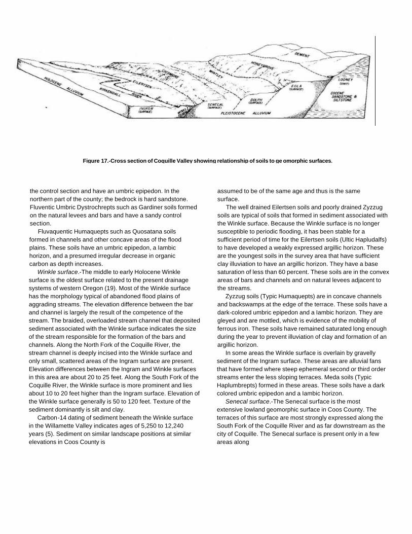
Figure 17.-Cross section of Coquille Valley showing relationship of soils to ge omorphic surfaces.
the control section and have an umbric epipedon. In thenorthern part of the county; the bedrock is hard sandstone.Fluventic Umbric Dystrochrepts such as Gardiner soils formedon the natural levees and bars and have a sandy controlsection.
Fluvaquentic Humaquepts such as Quosatana soilsformed in channels and other concave areas of the floodplains. These soils have an umbric epipedon, a Iambichorizon, and a presumed irregular decrease in organiccarbon as depth increases.
Winkle surface.-The middle to early Holocene Winklesurface is the oldest surface related to the present drainagesystems of western Oregon (19). Most of the Winkle surfacehas the morphology typical of abandoned flood plains ofaggrading streams. The elevation difference between the barand channel is largely the result of the competence of thestream. The braided, overloaded stream channel that depositedsediment associated with the Winkle surface indicates the sizeof the stream responsible for the formation of the bars andchannels. Along the North Fork of the Coquille River, thestream channel is deeply incised into the Winkle surface andonly small, scattered areas of the Ingram surface are present.Elevation differences between the Ingram and Winkle surfacesin this area are about 20 to 25 feet. Along the South Fork of theCoquille River, the Winkle surface is more prominent and liesabout 10 to 20 feet higher than the Ingram surface. Elevation ofthe Winkle surface generally is 50 to 120 feet. Texture of thesediment dominantly is silt and clay.
Carbon-14 dating of sediment beneath the Winkle surfacein the Willamette Valley indicates ages of 5,250 to 12,240years (5). Sediment on similar landscape positions at similarelevations in Coos County is
assumed to be of the same age and thus is the samesurface.
The well drained Eilertsen soils and poorly drained Zyzzugsoils are typical of soils that formed in sediment associated withthe Winkle surface. Because the Winkle surface is no longersusceptible to periodic flooding, it has been stable for asufficient period of time for the Eilertsen soils (Ultic Hapludalfs)to have developed a weakly expressed argillic horizon. Theseare the youngest soils in the survey area that have sufficientclay illuviation to have an argillic horizon. They have a basesaturation of less than 60 percent. These soils are in the convexareas of bars and channels and on natural levees adjacent tothe streams.
Zyzzug soils (Typic Humaquepts) are in concave channelsand backswamps at the edge of the terrace. These soils have adark-colored umbric epipedon and a Iambic horizon. They aregleyed and are mottled, which is evidence of the mobility offerrous iron. These soils have remained saturated long enoughduring the year to prevent illuviation of clay and formation of anargillic horizon.
In some areas the Winkle surface is overlain by gravellysediment of the Ingram surface. These areas are alluvial fansthat have formed where steep ephemeral second or third orderstreams enter the less sloping terraces. Meda soils (TypicHaplumbrepts) formed in these areas. These soils have a darkcolored umbric epipedon and a Iambic horizon.
Senecal surface.-The Senecal surface is the mostextensive lowland geomorphic surface in Coos County. Theterraces of this surface are most strongly expressed along theSouth Fork of the Coquille River and as far downstream as thecity of Coquille. The Senecal surface is present only in a fewareas along

other major streams in the county. Minor eroded remnants ofthis surface occur along streams in the northern part of thecounty. Elevation of the Senecal surface is about 100 to 380feet. This surface lies about 100 to 150 feet above the Winklesurface in the southern part of the county and decreases toabout 50 feet in the vicinity of Coquille. The increasingprominence of the geomorphic surfaces toward the southernpart of the county appears to be the result of greater tectonicuplift in the Klamath Mountains. This theory is consistent withthe conclusions of Palmer in
his study of the tectonic displacement of marine terraces (18).Slopes of the Senecal surface are dominantly 0 to 3 percent,but they are as much as 15 percent in eroded areas. Texture ofthe underlying sediment is dominantly clayey.
Most areas of the Senecal surface are moderately welldrained to poorly drained. Soils that formed in material of thissurface include Chismore soils (Aquic Haplohumults) andPyburn soils (Typic Umbraquults). The Senecal surface hasbeen stable long enough for the formation of a well developedargillic horizon. The
Figure 18.-Microrelief of the Ingram surface. Kirkendall soils are at slightly higher elevations; Quosatana soils are in depressional areas.
Figure 19.-Steep, broken topography of the Looney unit is in background. Coquille and Langlois soils underlie the Ingram surface alongthe Coos River.
Chismore soils have an umbric epipedon, moderate andsubangular blocky structure, an argillic horizon, and low chromamottles in the lower part of the argillic horizon. The Pyburn soilshave an umbric epipedon, moderate and subangular blockystructure, an argillic horizon, and evidence of gleying.
Gauldy Variant soils (Typic Haplumbrepts) formed in the oldstream channels where coarse textured sediment wasdeposited. These soils are loam over a very gravelly 2Chorizon. Permeability of the 2C horizon
commonly is rapid or very rapid, and illuvial clay has beenwashed out of the profile.
Meda soils formed on small alluvial fans where steepephemeral streams enter the Senecal surface. These soils arediscussed under the heading "Winkle surface."
Dolph Surface.-The Dolph surface in Coos County consistsof nearly level to sloping, dissected topography of middlePleistocene age. Evidence of this geomorphic episode occursmainly along the South Fork of the Coquille River and along theCoquille River to the

vicinity of Riverton. Elevation commonly is 150 to 420 feetalong the South Fork of the Coquille River; however, alongthe Coquille River terraces as low as 50 feet have beenincluded in the Dolph surface because of the similarity of thesoils in these areas. The terraces on which the city of Coquilleis built are a prominent example. Further study is needed todetermine whether these terraces included in the Dolphsurface are of the same geomorphic episode.
Wintley and McCurdy soils (Typic Haplohumults) areextensive on the Dolph surface. These soils have an umbricepipedon and an argillic horizon. The Wintley soils haveredder hue and a higher content of clay than the McCurdysoils. The McCurdy soils have low chroma mottles in thelower part of the subsoil.
Eola surface.-The Eola surface consists of erosionalremnants of the oldest stable geomorphic surface in thecounty and has tentatively been correlated to the marineSeven Devils surface (17). Relief of the Eola surface ismoderate; topography of the remnants typically is roundedhills and valleys, with as much as 300 feet of local relief.Slope ranges from 3 to 50 percent, and elevation ranges from200 to 1,000 feet.
The Eola surface is considered to be early Pleistocene.Erosion during Pleistocene and Holocene times has removedmuch of this surface. The surface occurs only in the centralpart of the county. Landforms of the Looney unit generallyadjoin the Eola surface and join it to lower-lying, youngersurfaces.
Honeygrove soils (Typic Haplohumults) formed inmaterial of the Eola surface. These are deep, red soils thathave a prominent argillic horizon that extends to a depth ofmore than 60 inches. These soils exhibit the most advancedstages of weathering and leaching of bases in the surveyarea. Base saturation commonly is less than 10 percent inthe subsoil.
Looney unit.-The Looney geomorphic unit has noparticular age connotation and is not considered to be ageomorphic surface. The terrain of the Looney unit iscompletely dissected, is dominantly steeply sloping, and
has narrow ridges. Slope gradients are more than 100percent in some areas. The Looney unit on the uplands hascomponent landforms primarily of the Horseshoe, Ingram,and Winkle surfaces, although areas of older surfaces arepresent in places. The Looney unit may join other surfacesor it may make up large areas of mountainous terrain sothoroughly dissected that it contains no mappablegeomorphic surfaces (fig. 19). Erosion is active on much ofthe Looney unit; mass movement has occurred in someareas (7).
The variability in age makes the Looney unit useful inmapping areas of mountainous terrain. The unit could bedivided into several geomorphic surfaces if it were mapped ata larger scale. Three significant gradient breaks areapparent-stable, metastable, and active slopes. Narrow valleyfloors and small alluvial cones are inclusions of the Ingramsurface in the Looney unit. Soils of the Looney unit formed inmaterial derived mainly from sandstone, siltstone, basalt, andserpentinite.
Orford soils (Typic Haplohumults) are on the most stablepositions of the Looney unit. They have an umbric epipedon,moderate structure, and an argillic horizon. Typical soils onmetastable slopes include those of the Dement, Etelka,Preacher, Rinearson, and Whobrey series. Dement soilsformed in clayey sediment of the Roseburg Formation; Etelkaand Whobrey soils formed in clay of the Otter PointFormation; Preacher soils formed in loamy sediments of theTyee and Flournoy Formations; and Rinearson soils formedin loamy sediment of the Coaledo Formation (4). These soilsare discussed in the section "Climate and Living Organisms."
Typical soils on active slopes include Dystrochrepts suchas Remote soils, Eutrochrepts such as Digger, Umpcoos,and Serpentano soils, and Haplumbrepts such as Harringtonand Milbury soils. These soils formed dominantly in materialof the Tyee and Flournoy Formations and in minor areas ofmaterial derived from basalt and serpentinite.

References
(1) Alexander, R.R. 1966. Site indexes for lodgepole (9)pine with corrections for stand density. U.S. Dep.Agric. Res. Pap. RM-24, 7 pp.
(2) American Association of State Highway andTransportation Officials. 1982. Standardspecifications for highway materials and methods (10)of sampling and testing. Ed. 10, 2 vol., illus.
(3) American Society for Testing and Materials. 1985.. Standardtest method for classification of soils for engineeringpurposes. ASTM Stand. D 2487-69.
(4) Baldwin, E.M., and J.D. Beaulieu. 1973. Geology andmineral resources of Coos County, Oregon. Oreg. Dep.Geol. and Miner. Ind. Bull. 80, 82 pp., illus.
(5) Balster, C.A., and R.B. Parsons. 1968.Geomorphology and soils, Willamette Valley,Oregon. Oreg. Agric. Exp.Stn. Spec. Rep. 265, (13)31 pp., illus., map.
(6) Barnes, George H. 1962. Yield of even-agedstands of western hemlock. U.S. Dep. Agric. (14)Tech. Bull. 1273, 52 pp.
(7) Beaulieu, J.D., and P.W. Hughes. 1975.Environmental geology of western Coos andDouglas Counties, Oregon. Oreg. Dep. Geol.and (15)Miner. Ind. Bull. 87, 148 pp, illus.
(8) Beckham, S.D., and R. Minor. 1980. Cultural resourceoverview of the Coos Bay Bureau of Land ManagementDistrict. U.S. Dep. Int., Bur. Land Manage. Spec. Rep.,295 pp.
Franklin; Jerry F., and C.T. Dyrness. 1973. Naturalvegetation of Oregon and Washington. Pac. NorthwestForest and Range Exp. Stn., U.S. Dep. Agric., Forest Serv.Gen. Tech. Rep. PNW-8, 417 pp, illus.
Gardner, R.A., and K.E. Bradshaw. 1954. Characteristicsand vegetation relationships of some podzolic soils nearthe coast of northern California. Soil Sci. Soc. Am. Proc.18: 320-325.
(11) Griggs, A.B. 1945. Chromite-bearing sands of the southernpart of the coast of Oregon. U.S. Dep. Int. Geol. Bull.945-E: 113-150.
(12) Jenny, H., R.J. Arkley, and A.M. Schultz. 1969. The pygmyforest-podsol ecosystem and its dune associates of theMendocino coast. Madrono 20: 60-74.
King, James E. 1966. Site index curves for Douglasfir in the Pacific Northwest. Weyerhaeuser Co. For.Pap. No. 8, 49 pp.
McArdle, Richard E., Walter H. Meyer, and Donald Bruce.1961. The yield of Douglas fir in the Pacific Northwest. U.S.Dep. Agric. Tech. Bull. 201 (revised), 74 pp.
Meyer, Walter H. 1937. Yield of even-aged stands of Sitkaspruce and western hemlock. U.S. Dep. Agric. Tech. Bull.544, 86 pp.
(16) Myers, Clifford A. 1966. Yield tables for managed stands oflodgepole pine in Colorado and Wyoming. U.S. Dep. Agric.Res. Pap., 20 pp.
(26)
(17) Nettleton, W.D., R.B. Parsons, A.0. Ness, and (23)F.W. Gelderman. 1982. Spodosols along thesouthwest Oregon coast. Soil Sci. Soc. Am. J. 46:593-598.
(18) Palmer, L.A. 1967. Marine terrace deformation in (24)Pacific coastal United States. J. Geosci. OsakaCity University, Vol. 10, Art 1-9.
(19) Parsons, R.B., C.A. Balster, and A.O. Ness. 1970. Soildevelopment and geomorphic surfaces, Willamette Valley,Oregon. Soil Sci. Soc. Am. Proc. 34: 485-491.
(20) Parsons, R.B., and G.L. Green. 1982. Geomorphic surfacesand soils in Multnomah County. U.S. Dep. Agric.,SoilConserv. Serv., 86 pp., map.
(21) Portland Cement Association. 1962. PCA soil (27)primer. 52 pp., illus.
(22) Society of American Foresters. 1980. Forest cover types ofthe United States and Canada. 148 pp., map.
United States Department of Agriculture. 1951. Soilsurvey manual. U.S. Dep. Agric. Handb. 18, 503 pp., illus.(Supplements replacing pp. 173-188 issued May 1962)
United States Department of Agriculture. 1961. Landcapability classification. U.S. Dep. Agric. Handb. 210,21 pp.
(25) United States Department of Agriculture. 1970. Soilsurvey of Curry area, Oregon. Soil Conserv. Serv., 70 pp.,illus., maps.
United States Department of Agriculture. 1975. Soiltaxonomy: A basic system of soil classification formaking and interpreting soil surveys. Soil Conserv.Serv., U.S. Dep. Agric. Handb. 436, 754 pp., illus.
United States Department of Agriculture. 1967. Soil surveylaboratory methods and procedures for collecting soilsamples. Soil Surv. Invest. Rep. 1, 50 pp., illus.
(28) United States Department of Health, Education, andWelfare. 1957. Manual of septic tank practices. PublicHealth Serv. Publ. 526, 93 pp., illus.
Glossary
Aggregate, soil. Many fine particles held in a single mass orcluster. Natural soil aggregates, such as granules, blocks, orprisms, are called peds. Clods are aggregates produced bytillage or logging.
Alluvial fan. The fanlike deposit of a stream where it issues froma gorge upon a plain or of a tributary stream near or at itsjunction with its main stream.
Alluvium. Material, such as sand, silt, or clay,deposited on land by streams.
Area reclaim (in tables). An area difficult to reclaim after theremoval of soil for construction and other uses.Revegetation and erosion control are extremely difficult.
Arkosic material. Material that has a high percentage ofweatherable minerals derived from granitic rock (e.g.,arkosic sandstone).
Back slope. The geomorphic component that forms the steepestinclined surface and principal element of many hillsides.Back slopes in profile are commonly steep, are linear, andmay or may not include cliff segments.
Backswamp. Extensive, marshy, depressional areas of floodplains between the natural levee borders of channel beltsand the valley sides or terraces.
Basal area. The area of a cross section of a tree, generallyreferring to the section at breast height and measuredoutside the bark. It is a measure of stand density, commonlyexpressed in square feet.
Base saturation. The degree to which material having cationexchange properties is saturated with exchangeablebases (sum of Ca, Mg, Na, K), expressed as a percentageof the total cation exchange capacity.
Bedrock. The solid rock that underlies the soil and otherunconsolidated material or that is exposed at the surface.
Bottom land. The normal flood plain of a stream, subjectto flooding.
Breast height. An average height of 41/2 feet above the groundsurface; the point on a tree where
diameter measurements are ordinarily taken.Cable yarding. A method of moving felled trees to a nearby central
area for transport to a processing facility. Most cable yardingsystems involve use of a drum, a pole, and wire cables in anarrangement similar to that of a rod and reel used for fishing.To reduce friction and soil disturbance, felled trees generallyare reeled in while one end is lifted or the entire log issuspended.
Cation. An ion carrying a positive charge of electricity. Thecommon soil cations are calcium, potassium, magnesium,sodium, and hydrogen.
Cation-exchange capacity. The total amount of exchangeablecations that can be held by the soil, expressed in terms ofmilliequivalents per 100 grams of soil at neutrality (pH 7.0) orat some other stated pH value. The term, as applied to soils,is synonymous with base-exchange capacity, but is moreprecise in meaning.
Clay. As a soil separate, the mineral soil particles less than 0.002millimeter in diameter. As a soil textural class, soil materialthat is 40 percent or more clay, less than 45 percent sand,and less than 40 percent silt.
Clay film. A thin coating of oriented clay on the surface of a soilaggregate or lining pores or root channels. Synonyms: claycoating, clay skin.
Claypan. A slowly permeable soil horizon that contains muchmore clay than the horizons above it. A claypan iscommonly hard when dry and plastic or stiff when wet.
Coarse fragments. Mineral or rock particles 2 to 250millimeters in diameter.
Cobble (or cobblestone). A rounded or partly rounded fragmentof rock 3 to 10 inches (7.6 to 25 centimeters) in diameter.
Colluvium. Soil material, rock fragments, or both, movedby creep, slide, or local wash and deposited at thebase of steep slopes.
Compaction, soil. An alteration of soil structure that
ultimately can affect the biological and chemical properties ofsoil. Soil compaction decreases voids and increases bulkdensity.
Complex slope. Irregular or variable slope. Planning orconstructing terraces, diversions, and other water-controlmeasures on a complex slope is difficult.
Compressible (in tables). Excessive decrease in volumeof soft soil under load.
Concretions. Grains, pellets, or nodules of various sizes, shapes,and colors consisting of concentrated compounds orcemented soil grains. The composition of most concretionsis unlike that of the surrounding soil. Calcium carbonate andiron oxide are common compounds in concretions.
Consistence, soil. The feel of the soil and the ease with which alump can be crushed by the fingers. Terms commonly usedto describe consistence are-Loose.-Noncoherent when dry or moist; does not holdtogether in a mass.Friable.-When moist, crushes easily under gentle pressurebetween thumb and forefinger and can be pressed togetherinto a lump.Firm.-When moist, crushes under moderate pressurebetween thumb and forefinger, but resistance is distinctlynoticeable.Plastic.-When wet, readily deformed by moderate pressurebut can be pressed into a lump; will form a "wire" whenrolled between thumb and forefinger.Sticky.-When wet, adheres to other material and tends tostretch somewhat and pull apart rather than to pull free fromother material.Hard.-When dry, moderately resistant to pressure; can bebroken with difficulty between thumb and forefinger. Softrock.-When dry, breaks into powder or individual grainsunder very slight pressure.Cemented.-Hard; little affected by moistening.
Control section. The part of the soil on which classification isbased. The thickness varies among different kinds of soil, butfor many it is that part of the soil profile between depths of 10inches and 40 or 80 inches.
Corrosive. High risk of corrosion to uncoated steel ordeterioration of concrete.
Culmination of the mean annual increment (CMAI).
The average annual increase per acre in the volume of astand. Computed by dividing the total volume of the standby its age. As the stand increases in age, the mean annualincrement continues to increase until mortality begins to
reduce the rate of increase. The point where the standreaches its maximum annual rate of growth is called theculmination of the mean annual increment.
Cutbanks cave (in tables). The walls of excavations tend tocave in or slough.
Depth to rock (in tables). Bedrock is too near the surfacefor the specified use.
Drainage class (natural): Refers to the frequency and duration ofperiods of saturation or partial saturation during soilformation, as opposed to altered drainage, which iscommonly the result of artificial drainage or irrigation but maybe caused by the sudden deepening of channels or theblocking of drainage outlets. Seven classes of natural soildrainage are recognized:Excessively drained.-Water is removed from the soil veryrapidly. Excessively drained soils are commonly very coarsetextured, rocky, or shallow. Some are steep. All are free ofthe mottling related to wetness.Somewhat excessively drained.-Water is removed from thesoil rapidly. Many somewhat excessively drained soils aresandy and rapidly pervious. Some are shallow. Some are sosteep that much of the water they receive is lost as runoff. Allare free of the mottling related to wetness.Well drained.-Water is removed from the soil readily, but notrapidly. It is available to plants throughout most of thegrowing season, and wetness does not inhibit growth of rootsfor significant periods during most growing seasons. Welldrained soils are commonly medium textured. They aremainly free of mottling.Moderately well drained.-Water is removed from the soilsomewhat slowly during some periods. Moderately welldrained soils are wet for only a short time during the growingseason, but periodically they are wet long enough that mostmesophytic crops are affected. They commonly have aslowly pervious layer within or directly below the solum, orperiodically receive high rainfall, or both.Somewhat poorly drained.-Water is removed slowly enoughthat the soil is wet for significant periods during the growingseason. Wetness markedly restricts the growth ofmesophytic crops unless artificial drainage is provided.Somewhat poorly drained soils commonly have a slowlypervious layer, a high water table, additional water fromseepage, nearly continuous rainfall, or a combination ofthese.
Poorly drained.-Water is removed so slowly that the soilis saturated periodically during the growing season orremains wet for long periods. Free water is commonly ator near the surface for long enough during the growingseason that most mesophytic crops cannot be grownunless the soil is artificially drained. The soil is notcontinuously saturated in layers directly below plowdepth. Poor drainage results from a high water table, aslowly pervious layer within the profile, seepage, nearlycontinuous rainfall, or a combination of these.Very poorly drained.-Water is removed from the soil soslowly that free water remains at or on the surfaceduring most of the growing season. Unless the soil isartificially drained, most mesophytic crops cannot begrown. Very poorly drained soils are commonly level ordepressed and are frequently ponded. Yet, whererainfall is high and nearly continuous, they can havemoderate or high slope gradients.
Duff. A term used to identify a generally firm organic layeron the surface of mineral soils. It consists of fallenplant material that is in the process of decompositionand includes everything from the litter on the surfaceto underlying pure humus.
Eluviation. The movement of material in true solution orcolloidal suspension from one place to another withinthe soil. Soil horizons that have lost material througheluviation are eluvial; those that have received materialare illuvial.
Erosion. The wearing away of the land surface by water,wind, ice, or other geologic agents and by suchprocesses as gravitational creep.Erosion (geologic). Erosion caused by geologicprocesses acting over long geologic periods andresulting in the wearing away of mountains and thebuilding up of such landscape features as floodplains and coastal plains. Synonym: natural erosion.Erosion (accelerated). Erosion much more rapid thangeologic erosion, mainly as a result of the activities ofman or other animals or of a catastrophe in nature;for example, fire that exposes the surface.
Escarpment. A relatively continuous and steep slope or cliffbreaking the general continuity of more gently slopingland surfaces and produced by erosion or faulting.Synonym: scarp.
Excess fines (in tables). Excess silt and clay in the soil. Thesoil does not provide a source of gravel or sand forconstruction purposes.
Fan terrace. A relict alluvial fan, no longer a site of
active deposition, incised by younger and lower alluvialsurfaces.
Fast intake (in tables). The rapid movement of water into thesoil.
Fertility, soil. The quality that enables a soil to provide plantnutrients, in adequate amounts and in proper balance, forthe growth of specified plants when light, moisture,temperature, tilth, and other growth factors are favorable.
Fibric soil material (peat). The least decomposed of all organicsoil material. Peat contains a large amount of well preservedfiber that is readily identifiable according to botanical origin.Peat has the lowest bulk density and the highest watercontent at saturation of all organic soil material.
Fine textured soil. Sandy clay, silty clay, and clay.Flood plain. A nearly level alluvial plain that borders a stream
and is subject to flooding unless protected artificially.Foothill. A steeply sloping upland that has relief of as much as
1,000 feet (or 300 meters) and fringes a mountain range orhigh-plateau escarpment.
Foot slope. The inclined surface at the base of a hill.Forb. Any herbaceous plant not a grass or a sedge.Genesis, soil. The mode of origin of the soil. Refers especially to
the processes or soil-forming factors responsible for theformation of the solum, or true soil, from the unconsolidatedparent material.
Gleyed soil. Soil that formed under poor drainage, resultingin the reduction of iron and other elements in theprofile and in gray colors and mottles.
Gravel. Rounded or angular fragments of rock as much as 3inches (2 millimeters to 7.6 centimeters) in diameter. Anindividual piece is a pebble.
Gravelly soil material. Material that is 15 to 50 percent, byvolume, rounded or angular rock fragments, not prominentlyflattened, as much as 3 inches (7.6 centimeters) in diameter.
Ground water (geology). Water filling all the unblocked pores ofunderlying material below the water table.
Hemic soil material (mucky peat). Organic soil materialintermediate in degree of decomposition between the lessdecomposed fibric material and the more decomposedsapric material.
Hill. A natural elevation of the land surface, rising as much as1,000 feet above surrounding lowlands, commonly oflimited summit area and having a well-defined outline;hillsides generally have slopes of more than 15 percent.The distinction between a hill and a mountain is arbitraryand is dependent on local usage.
Horizon, soil. A layer of soil, approximately parallel to the surface,having distinct characteristics produced by soil-formingprocesses. In the identification of soil horizons, an uppercase letter represents the major horizons. Numbers or lowercase letters that follow represent subdivisions of the majorhorizons. An explanation of the subdivisions is given in theSoil Survey Manual. The major horizons of mineral soil areas follows:O horizon.-An organic layer of fresh and decaying plantresidue at the surface of a mineral soil.A horizon.-The mineral horizon at or near the surface inwhich an accumulation of humified organic matter is mixedwith the mineral material. Also, a plowed surface horizon,most of which was originally part of a B horizon.B horizon.-The mineral horizon below an A horizon. The Bhorizon is in part a layer of transition from the overlying A tothe underlying C horizon. The B horizon also has distinctivecharacteristics such as (1) accumulation of clay,sesquioxides, humus, or a combination of these; (2)prismatic or blocky structure; (3) redder or browner colorsthan those in the A horizon; or (4) a combination of these.The combined A and B horizons generally are called thesolum, or true soil. If a soil does not have a B horizon, the Ahorizon alone is the solum.C horizon.-The mineral horizon or layer, excluding induratedbedrock, that is little affected by soil-forming processes anddoes not have the properties typical of the A or B horizon.The material of a C horizon may be either like or unlike thatin which the solum formed. If the material is known to differfrom that in the solum, the Roman numeral II precedes theletter C.R layer.-Consolidated rock beneath the soil. The rockcommonly underlies a C horizon, but can be directly belowan A or a B horizon.
Humus . The well decomposed, more or less stable part of theorganic matter in mineral soils.
Igneous rock. Rock formed by solidification from a molten orpartially molten state. Major varieties include plutonic andvolcanic rock. Examples are andesite, basalt, and granite.
Illuviation. The movement of soil material from one horizon toanother in the soil profile. Generally, material isremoved from an upper horizon and deposited in alower horizon.
Infiltration rate . The rate at which water penetrates the surface ofthe soil at any given instant, usually
expressed in inches per hour. The rate can be limited bythe infiltration capacity of the soil or the rate at which wateris applied at the surface.
Intake rate . The average rate of water entering the soil underirrigation. Most soils have a fast initial rate; the ratedecreases with application time. Therefore, intake rate fordesign purposes is not a constant but is a variabledepending on the net irrigation application. The rate of waterintake in inches per hour is expressed as follows:
Less than 0.2............0.2 to 0.4...............0.4 to 0.75...............0.75 to 1.25.............1.25 to 1.75...........1.75 to 2.5 ...........…………..
. . . . . . . .. . . . . Very low
............... Low. . . . . . . Moderately low.......... Moderate....... .... Moderately high
……………………HighMore than 2.5………………………………………… Very high
Intermittent stream. A stream, or reach of a stream, that flows forprolonged periods only when it receives ground waterdischarge or long, continued contributions from melting snowor other surface and shallow subsurface sources.
Landslide. The rapid downhill movement of a mass of soil andloose rock, generally when wet or saturated. The speedand distance of movement, as well as the amount of soiland rock material, vary greatly.
Large stones (in tables). Rock fragments 3 inches (7.5centimeters) or more across. Large stones adversely affectthe specified use of the soil.
Leaching. The removal of soluble material from soil or othermaterial by percolating water.
Liquid limit. The moisture content at which the soil passesfrom a plastic to a liquid state.
Loam . Soil material that is 7 to 27 percent clay particles, 28 to50 percent silt particles, and less than 52 percent sandparticles.
Low strength. The soil is not strong enough to support loads.Metamorphic rock. Rock of any origin altered in mineralogical
composition, chemical composition, or structure by heat,pressure, and movement. Nearly all such rocks arecrystalline.
Morphology, soil. The physical makeup of the soil, includingthe texture, structure, porosity, consistence, color, andother physical, mineral, and biological properties of thevarious horizons, and the thickness and arrangement ofthose horizons in the soil profile.
Mottling, soil. Irregular spots of different colors that vary innumber and size. Mottling generally indicates pooraeration and impeded drainage.
Descriptive terms are as follows: abundance-few, common,and many; size-fine, medium, and coarse; andcontrast-faint, distinct, and prominent. The sizemeasurements are of the diameter along the greatestdimension. Fine indicates less than 5 millimeters (about0.2 inch); medium, from 5 to 15 millimeters (about 0.2 to0.6 inch); and coarse, more than 15 millimeters (about 0.6inch).
Mountain. A natural elevation of the land surface, rising morethan 1,000 feet above surrounding lowlands, commonly ofrestricted summit area (relative to a plateau) and generallyhaving steep sides and considerable bare-rock surface. Amountain can occur as a single, isolated mass or in agroup forming a chain or range.
Muck . Dark colored, finely divided, well decomposed organicsoil material. (See Sapric soil material.)
Munsell notation. A designation of color by degrees of thethree simple variables-hue, value, and chroma. Forexample, a notation of 10YR 6/4 is a color of 10YR hue,value of 6, and chroma of 4.
Nutrient, plant. Any element taken in by a plant essential to itsgrowth. Plant nutrients are mainly nitrogen, phosphorus,potassium, calcium, magnesium, sulfur, iron, manganese,copper, boron, and zinc obtained from the soil andcarbon, hydrogen, and oxygen obtained from the air andwater.
Parent material. The unconsolidated organic andmineral material in which soil forms.
Peat. Unconsolidated material, largely undecomposed organicmatter, that has accumulated under excess moisture.(See Fibric soil material.)
Ped. An individual natural soil aggregate, such as agranule, a prism, or a block.
Percolation. The downward movement of water through the soil.Percs slowly (in tables). The slow movement of water through
the soil adversely affecting the specified use.Permeability. The quality of the soil that enables water to move
downward through the profile. Permeability is measuredas the number of inches per hour that water movesdownward through the saturated soil. Terms describingpermeability are:
Very slow . . . . . . . . . . . . . . . . . . Less than 0.06 inch
Slow……………………………….0.06 to 0.2 inchModerately slow . . . ……………0.2 to 0.6 inch
Moderate . . . . . . . . . . . . . . . . . ..0.6 inch to 2.0 inches
Moderately rapid ..... .. ...... ... . 2.0 to 6.0 inchesRapid . . .. .. . . ... . . .. .. .. .. .. .. 6.0 to 20 inchesVery rapid . . . . . . . . . . . . . . . . . More than 20 inches
Phase, soil. A subdivision of a soil series based on features thataffect its use and management. For example, slope,stoniness, and thickness.
Piping (in tables). Formation of subsurface tunnels or pipelikecavities by water moving through the soil.
Plasticity Index. The numerical difference between the liquid limitand the plastic limit; the range of moisture content withinwhich the soil remains plastic.
Plastic limit. The moisture content at which a soil changesfrom semisolid to plastic.
Ponding. Standing water on soils in closed depressions. Thewater can be removed only by percolation orevapotranspiration.
Poor filter (in tables). Because of rapid permeability or animpermeable layer near the surface, the soil may notadequately filter effluent from a waste disposal system.
Poor outlets (in tables). Refers to areas where surface orsubsurface drainage outlets are difficult or expensive toinstall.
Poorly graded. Refers to a coarse grained soil or soil materialconsisting mainly of particles of nearly the same size.Because there is little difference in size of the particles,density can be increased only slightly by compaction.
Profile, soil. A vertical section of the soil extending throughall its horizons and into the parent material.
Puddling, soil. A condition that occurs in certain wet soils as aresult of compression and shearing. Puddling generally isaccompanied by compaction. The mechanical forcerearranges soil particles and destroys soil structure.
Reaction, soil. A measure of acidity or alkalinity of a soil,expressed in pH values. A soil that tests to pH 7.0 isdescribed as precisely neutral in reaction because it isneither acid nor alkaline. The degree of acidity or alkalinity isexpressed as-
Extremely acid ...................Very strongly acid . . . . . . . . . . . . . . . .
Strongly acid. . .Medium acid.. .
Slightly acid . . . .Neutral . . . . . . . .Mildly alkaline .................Moderately alkaline .............Strongly alkaline ...............
. . . Below 4.5
... 4.5 to 5.0
...... ... 5.1 to 5.5
...... ... 5.6 to 6.0
...... ... 6.1 to 6.5
...... ... 6.6 to 7.3
...... ... 7.4 to 7.8
...... ... 7.9 to 8.4
...... ... 8.5 to 9.0
Very strongly alkaline . . . . . . . . . . . . 9.1 and higher
Relief. The elevations or inequalities of a land surface,considered collectively.
Residuum (residual soil material). Unconsolidated,
weathered, or partly weathered mineral material thataccumulated as consolidated rock disintegrated in place.
Rill. A steep sided channel resulting from accelerated erosion. Arill generally is a few inches deep and not wide enough tobe an obstacle to farm machinery.
Road cut. A sloping surface produced by mechanical meansduring road construction. It is commonly on the uphill side ofthe road.
Rock fragments . Rock or mineral fragments having a diameterof 2 millimeters or more; for example, pebbles, cobbles,stones, and boulders.
Runoff. The precipitation discharged into stream channels froman area. The water that flows off the surface of the landwithout sinking into the soil is called surface runoff. Waterthat enters the soil before reaching surface streams iscalled groundwater runoff or seepage flow from groundwater.
Sand. As a soil separate, individual rock or mineral fragments from0.05 millimeter to 2.0 millimeters in diameter. Most sandgrains consist of quartz. As a soil textural class, a soil that is85 percent or more sand and not more than 10 percent clay.
Saprolite (soil science). Unconsolidated residual materialunderlying the soil and grading to hard bedrock below.
Sedimentary rock . Rock made up of particles deposited fromsuspension in water. The chief kinds of sedimentary rockare conglomerate, formed from gravel; sandstone, formedfrom sand; shale, formed from clay; and limestone, formedfrom soft masses of calcium carbonate. There are manyintermediate types. Some wind-deposited sand isconsolidated into sandstone.
Seepage (in tables). The movement of water through the soil.Seepage adversely affects the specified use.
Series, soil. A group of soils that have profiles that are almostalike, except for differences in texture of the surface layer orof the underlying material. All the soils of a series havehorizons that are similar in composition, thickness, andarrangement.
Shale . Sedimentary rock formed by the hardening of a claydeposit.
Sheet erosion. The removal of a fairly uniform layer of soilmaterial from the land surface by the action of rainfall andrunoff water.
Silt. As a soil separate, individual mineral particles that range indiameter from the upper limit of clay (0.002 millimeter) to thelower limit of very fine sand (0.05 millimeter). As a soiltextural class, soil
that is 80 percent or more silt and less than 12 percentclay.
Siltstone . Sedimentary rock made up of dominantly silt-sizedparticles,
Site index. A designation of the quality of a forest site based onthe height of the dominant stand at an arbitrarily chosen age.For example, if the average height attained by dominant andcodominant trees in a fully stocked stand at the age of 50years is 75 feet, the site index is 75 feet.
Skid trail. Trail or furrow made by log skidding over groundsurface.
Slippage (in tables). Soil mass susceptible to movementdownslope when loaded, excavated, or wet.
Slope. The inclination of the land surface from the horizontal.Percentage of slope is the vertical distance divided byhorizontal distance, then multiplied by 100. Thus, a slope of20 percent is a drop of 20 feet in 100 feet of horizontaldistance.
Slope (in tables). Slope is great enough that special practicesare required to ensure satisfactory performance of thesoil for a specific use.
Slow intake (in tables). The slow movement of water into thesoil.
Slow refill (in tables). The slow filling of ponds, resulting fromrestricted permeability in the soil.
Small stones (in tables). Rock fragments less than 3 inches (7.5centimeters) in diameter. Small stones adversely affect thespecified use of the soil.
Soil. A natural, three-dimensional body at the earth's surface. It iscapable of supporting plants and has properties resultingfrom the integrated effect of climate and living matter actingon earthy parent material, as conditioned by relief overperiods of time.
Solum. The upper part of a soil profile, above the C horizon, inwhich the processes of soil formation are active. The solumin soil consists of the A and B horizons. Generally, thecharacteristics of the material in these horizons are unlikethose of the underlying material. The living roots and plantand animal activities are largely confined to the solum.
Stones. Rock fragments 10 to 24 inches (25 to 60centimeters) in diameter if rounded or 6 to 15 inches(15 to 38 centimeters) in length if flat.
Stony. Refers to a soil containing stones in numbers thatinterfere with or prevent tillage.
Structure, soil. The arrangement of primary soil particles intocompound particles or aggregates. The principal forms ofsoil structure are-platy (laminated), prismatic (vertical axisof aggregates
longer than horizontal), columnar (prisms with roundedtops), blocky (angular or subangular), and granular.Structureless soils are either single grained (each grain byitself, as in dune sand) or massive (the particles adheringwithout any regular cleavage, as in many hardpans).
Subsoil. Technically, the B horizon; roughly, the part of thesolum below plow depth.
Substratum. The part of the soil below the solum.Subsurface layer. Technically, the A2 horizon. Generally
refers to a leached horizon lighter in color and lower incontent of organic matter than the overlying surfacelayer.
Surface layer. The soil ordinarily moved in tillage, or itsequivalent in uncultivated soil, ranging in depth from 4 to10 inches (10 to 25 centimeters). Frequently designatedas the "plow layer," or the "Ap horizon."
Talus . Rock fragments of any size or shape, commonly coarseand angular, derived from and lying at the base of a cliffor very steep, rock slope. The accumulated mass of suchloose, broken rock formed chiefly by falling, rolling, orsliding.
Taxadjuncts. Soils that cannot be classified in a seriesrecognized in the classification system. Such soils arenamed for a series they strongly resemble and aredesignated as taxadjuncts to that series because theydiffer in ways too small to be of consequence ininterpreting their use and behavior.
Terrace (geologic). An old alluvial plain, ordinarily flat orundulating, bordering a river, a lake, or the sea.
Texture, soil. The relative proportions of sand, silt, and clayparticles in a mass of soil. The basic textural classes, inorder of increasing proportion of fine particles, are sand,loamy sand, sandy loam, loam, silt loam, silt, sandy clayloam, clay loam, silty clay loam, sandy clay, silty clay,and clay. The sand, loamy sand, and sandy loam classesmay be further divided by specifying "coarse," "fine," or"very fine."
Thin layer (in tables). Otherwise suitable soil
material too thin for the specified use.Tilth, soil. The physical condition of the soil as related to tillage,
seedbed preparation, seedling emergence, and rootpenetration.
Toe slope. The outermost inclined surface at the base of a hill;part of a foot slope.
Topsoil. The upper part of the soil, which is the most favorablematerial for plant growth. It is ordinarily rich in organicmatter and is used to topdress roadbanks, lawns, and landaffected by mining.
Unstable fill (in tables). Risk of caving or sloughing on banks offill material.
Upland (geology). Land at a higher elevation, in general, thanthe alluvial plain or stream terrace; land above thelowlands along streams.
Variant, soil. A soil having properties sufficiently different fromthose of other known soils to justify a new series name, butoccurring in such a limited geographic area that creation of anew series is not justified.
Water bars. Smooth, shallow ditches or depressional areas thatare excavated at an angle across a sloping road. They areused to reduce the downward velocity of water and divert itoff and away from the road surface. Water bars can easilybe driven over if constructed properly.
Weathering. All physical and chemical changes produced in rocksor other deposits at or near the earth's surface byatmospheric agents. These changes result in disintegrationand decomposition of the material.
Wilting point (or permanent wilting point). The moisturecontent of soil, on an ovendry basis, at which a plant(specifically a sunflower) wilts so much that it does notrecover when placed in a humid, dark chamber.
Windthrow. The action of uprooting and tipping over trees bythe wind.
Yarding. A logging term meaning to move a log from the area itwas cut to a landing or loading area.
Yarding, cable. Yarding a log by a suspended cable rather thanbehind a wheeled or trucked vehicle.