former gas works, gas house drove, brandon, suffolk · matthew adams ba aifa . britannia...
TRANSCRIPT

FORMER GAS WORKS, GAS HOUSE DROVE,
BRANDON, SUFFOLK
ARCHAEOLOGICAL DESK BASED ASSESSMENT
Report Number: 1038 October 2013

© Britannia Archaeology Ltd 2013 all rights reserved Report Number: 1038
FORMER GAS WORKS, GAS HOUSE DROVE, BRANDON, SUFFOLK
Archaeological Desk Based Assessment
Prepared for: Mr David Baker
Stratus Environmental Ltd 4245 Park Approach
Thorpe Park Leeds
LS15 8GB
By: Matthew Adams BA AIfA
Britannia Archaeology Ltd
4 The Mill, Clovers Court, Stowmarket, Suffolk,
IP14 1RB T: 01449 763034
[email protected] www.britannia-archaeology.com
Registered in England and Wales: 7874460
October 2013
Site Code
NA
NGR
578868 286570
Planning Ref.
N/A
OASIS
britanni1-160116
Approved By
Timothy Schofield
DATE
October 2013

Former Gas Works, Gas House Drove, Brandon, Suffolk Archaeological Desk Based Assessment
Project Number 1043
3 ©Britannia Archaeology Ltd 2013 all rights reserved Report Number: 1038
DISCLAIMER The material contained within this report was prepared for an individual client and solely for the benefit of that client and the contents should not be relied upon by any third party. The results and interpretation of the report cannot be considered an absolute representation of the archaeological or any other remains. Britannia Archaeology Ltd will not be held liable for any error of fact resulting in loss or damage, direct, indirect or consequential, through misuse of, or actions based on the material contained within by any third party.

Former Gas Works, Gas House Drove, Brandon, Suffolk Archaeological Desk Based Assessment
Project Number 1043
4 ©Britannia Archaeology Ltd 2013 all rights reserved Report Number: 1038
CONTENTS
ABSTRACT Page 5 1.0 INTRODUCTION & METHODOLOGY Page 6 2.0 METHODOLOGY Page 7 3.0 PLANNING BACKGROUND Page 8 4.0 ARCHAEOLOGICAL AND HISTORICAL SEARCH RESULTS Page 10 5.0 DISCUSSION Page 17 6.0 CONCLUSIONS & RECOMMENDATIONS Page 19 7.0 ACKNOWLEDGEMENTS Page 20 8.0 PROJECT ARCHIVE & DEPOSITION Page 20
BIBLIOGRAPHY Page 21 Appendix 1 HER Data Appendix 2 OASIS Summary Sheet Figure 1 Site Location Plan 1:1000 Figure 2 HER Search Data 1:10000 Figure 3 Cartographic Sources Figure 4 Existing & Proposed Impact 1:500 Figure 5 Photographic Record

Former Gas Works, Gas House Drove, Brandon, Suffolk Archaeological Desk Based Assessment
Project Number 1043
5 ©Britannia Archaeology Ltd 2013 all rights reserved Report Number: 1038
Abstract Britannia Archaeology Ltd was commissioned by Stratus Environmental Ltd to undertake an archaeological desk-based assessment of the site of the former Gas Works at land off Gas House Drove, Brandon Suffolk (NGR: 578868 286570) The assessment has identified a moderate potential for sub-surface archaeology dating to the Neolithic period and a high potential for late 19th century and 20th century remains associated with the former gas works. The potential for Anglo-Saxon and medieval finds or features is low to moderate given the significant levels of occupation activity during these periods in the search area. The assessment site is located away from the focus of this activity, but could easily be part of the agricultural or industrial landscape outside of the town. The potential for all other periods is considered to be low and the historic maps show the site probably remained in agricultural use until the mid-19th century. The site has undergone at least four phases of development from initial construction of the town gas works in the 1860s, expansion in the early 20th century, alteration in the 1960’s or 1970s from coal gas to natural gas and finally closure and substantial demolition in the 1980s. The potential for any sub-surface archaeology pre-dating the mid-19th century is likely to be low due to the development of the site from the mid-19th century onwards, the unknown density of old service trenches and depth of site truncation during demolition. The potential for the preservation of remains associated with the gas works is high.

Former Gas Works, Gas House Drove, Brandon, Suffolk Archaeological Desk Based Assessment
Project Number 1043
6 ©Britannia Archaeology Ltd 2013 all rights reserved Report Number: 1038
1.0 INTRODUCTION & METHODOLOGY 1.1 Project Background Britannia Archaeology Ltd was commissioned by Stratus Environmental Ltd to undertake an archaeological desk-based assessment of the site of the former Gas Works at Gas House Drove, Brandon, Suffolk (NGR: 578868 286570) (Fig. 1). The site is located close to the medieval core of the village but lies outside the Conservation Area (Fig. 2) and is not in an Archaeological Priority Area. This assessment will accompany a planning application for remediation works to:
• establish the extent of ground contamination from coal gas production and storage on the site;
• rectify via excavation, processing and refilling any established areas of contamination.
This report will help assess the need for any further archaeological work to mitigate the impact of the remediation works on any surviving heritage assets. It will also consider the setting of the new development in relation to existing listed buildings and known archaeological sites within the immediate area. The proposed remediation works include an initial phase of trial trenching over two areas of the site that formally contained a cess pool, retort buildings, large holder tanks and a tar and liquid tank (Fig. 4). This will be followed by full excavation to a depth of around 2m of any areas found to be contaminated. 1.2 Site Description The site is located 200m south of the River Little Ouse on the east side of the parish of Brandon, in the Forest Heath District of Suffolk, close to the county border with Norfolk. It lies on the south side of Gas House Drove and is bounded to the west by Webbs Row and the south and east by residential properties. It forms a roughly rectangular parcel of land measuring 3500m² and currently contains the remains of concrete foundation pads, mixed grass, trees and scrub vegetation (DP. 1). A recent topography survey shows the site to lie at approximately 7.00m AOD. The underlying geological bedrock comprises chalk described as Holywell Nodular Chalk Formation and New Pit Chalk Formation. This is a sedimentary bedrock formed approximately 89 to 100 million years ago in warm chalk seas. The superficial geology comprises river terrace deposits, of sand and gravel. These were formed up to 3 million years ago by rivers. (British Geological Survey, BGS).
Former Gas Works, Gas House Drove, Brandon, Suffolk Archaeological Desk Based Assessment
Project Number 1043
7 ©Britannia Archaeology Ltd 2013 all rights reserved Report Number: 1038
2.0 METHODOLOGY 2.1 Aims & Scope This report will assess all available information relating to archaeological remains within a 1km radius centred on the site. The assessment will identify the potential for archaeological remains that are likely to be impacted upon during the remediation work. It will also consider the impact of the development on the setting of existing archaeological sites and listed buildings in the immediate vicinity. This report will take into consideration existing truncation from previous developments and the potential impact caused by the implementation of the proposed development plans and construction methods. A mitigation strategy may be necessary after consultation with the Suffolk County Council Archaeology Service Conservation Team (SCCAS/CT) who advise Forest Heath District Council on matters relating to archaeology in the planning process. 2.2 Research and Sources Historic Environment Record Office Both the Suffolk Historic Environment Record Office (SHER) and Norfolk Historic Environment Record Office (NHER) were consulted and provided details of all data held within a 1km radius of the site. The HER databases hold records of archaeological sites, scheduled monuments, listed buildings, finds spots, registered parks and gardens, protected wreck sites and battlefields. Documentary Sources Primary and secondary documentary sources were consulted via the HER’s, the Suffolk Record Office and the Archaeology Data Service (www.archaeologydataservice.ac.uk). All sources consulted are listed in the bibliography. Cartographic Sources A search of primary and secondary cartographic sources was undertaken via the Ordnance Survey and the Suffolk Record Office. Site Visit A site visit was undertaken on the 19th September 2013 and a photographic record compiled. The visit aimed to identify any existing earthworks or visible archaeological remains, establish the condition and character of the existing site and note its setting. Proposed site plans were consulted during the visit to assess the area’s most at risk from the development.

Former Gas Works, Gas House Drove, Brandon, Suffolk Archaeological Desk Based Assessment
Project Number 1043
8 ©Britannia Archaeology Ltd 2013 all rights reserved Report Number: 1038
Presentation of Results The results are presented by historical/archaeological period and are a synthesis of all data relevant to the site. Not all of the data supplied by the GLHER is referred to in the report, however Appendix 1 contains a full table and brief description of the HER search results which are also shown in full in Figure 2. 3.0 PLANNING BACKGROUND The archaeological investigation was carried out in consultation with SCCAS/CT, following guidance laid down by the National Planning and Policy Framework (NPPF, DCLD 2012). The relevant local planning policy is the Forest Heath Local Plan (Policy 8.20, 1995). 3.1 National Planning Policy Framework (NPPF, DCLG March 2012) The NPPF recognises that ‘heritage assets’ are an irreplaceable resource and planning authorities should conserve them in a manner appropriate to their significance when considering development. It requires developers to record and advance understanding of the significance of any heritage assets to be lost (wholly or in part) in a manner proportionate to their importance and the impact, and to make this evidence (and any archive generated) publicly accessible. The key areas for consideration are:
• The significance of the heritage asset and its setting in relation to the proposed development;
• The level of detail should be proportionate to the assets’ importance and no more than is sufficient to understand the potential impact of the proposal on their significance;
• Significance (of the heritage asset) can be harmed or lost through alteration or destruction, or development within its setting. As heritage assets are irreplaceable, any harm or loss should require clear and convincing justification;
• Local planning authorities should not permit loss of the whole or part of a heritage asset without taking all reasonable steps to ensure the new development will proceed after the loss has occurred;
• Non-designated heritage assets of archaeological interest that are demonstrably of equivalent significance to scheduled monuments, should be considered subject to the policies for designated heritage assets.
3.2 Forest Heath Local Plan, (Policy 8.20, 1995) Forest Heath’s local plan development plan was adopted in 1995 and has undergone some revision since. A Core Strategy was released in 2010 and an updated assessment of their Heritage Policy is pending. The Council’s position on heritage assets is summarised as follows:
• The District Council will seek provision to be made for the evaluation of archaeological sites of unknown importance and areas of high potential prior to the determination of development proposals. Where nationally or locally

Former Gas Works, Gas House Drove, Brandon, Suffolk Archaeological Desk Based Assessment
Project Number 1043
9 ©Britannia Archaeology Ltd 2013 all rights reserved Report Number: 1038
important sites, whether scheduled or not, and their settings, are effected by proposed development, there will be a presumption in favour of their preservation. On sites where there is no overriding case for preservation, development will not normally be permitted unless agreement has been reached to provide either for their preservation or for their recording and, where desirable, their excavation prior to development.
4.0 ARCHAEOLOGICAL AND HISTORICAL RESEARCH RESULTS The following results are presented as a synthesis of all the data obtained from the sources detailed above (Section 2.0) and listed in the bibliography (Figures 2-6). Where possible, the HER preferred reference has been used and corresponds with Figure 2. 4.1 Prehistoric (750000BC – 43AD) (Fig.2) Brandon is situated to the south of the River Little Ouse on the edge of The Fens which begin to the west of the town. The combination of alluvial and peat deposits produced abundantly fertile soils well suited to habitation during prehistory. For this reason, prehistoric archaeological sites have been recorded all along the Fen Edge indicating that these areas were well populated and exploited from an early date. The HER search results returned 14 records dating between the Mesolithic and late Iron Age periods. The earliest recorded activity in the search area dates to the Mesolithic period and comprises a scatter of worked flints (BRD018), including `knapping areas' found during excavations by SAU at Staunch Meadow. This large, multi-phase site lies to the west of the town adjacent to the river and the Fen and around 750m from the assessment site. The Neolithic period is well-represented in the search area with five records indicating wide-spread activity. A scatter of worked flint was found at the Staunch Meadow excavation (BRD018) to the west. Another scatter of early Neolithic flints (BRD020) was recorded during monitoring work 700m to the south of the assessment site, and a leaf-shaped arrowhead was recovered along with late Neolithic to early Bronze Age pottery (BRD193) from a site located approximately 550m to the south. Late Neolithic features including a ditch and pit (BRD154) were excavated at Game Farm, 700m east of the assessment area and an assemblage of early to late Neolithic flints (40433) were recorded at Lignacite Quarry, 330m north of the site on the other side of the river. A possible flint mine at Taflin’s Quarry (STN018) was initially dated to the Neolithic period, but may also be a post-medieval gun flint mine. Later Neolithic settlement and agricultural activity in East Anglia tends to persist into the early Bronze Age and many artefacts such as beaker style pottery are noted in both periods. In Brandon the evidence supports this theory and several of the Neolithic sites discussed above, including Staunch Meadow (BRD018), Game Farm (BRD154) and monitoring work at BRD020 and BRD193, also contained material from the Bronze Age.

Former Gas Works, Gas House Drove, Brandon, Suffolk Archaeological Desk Based Assessment
Project Number 1043
10 ©Britannia Archaeology Ltd 2013 all rights reserved Report Number: 1038
Two separate search entries (BRD001 and 5617) record further Bronze Age sites. The former records a findspot containing a bronze narrow side-looped spearhead adjacent to the river 400m north-west of the assessment site. The latter records the site of a possible round barrow north of the river which contained polished flint axe heads when excavated in 1905. Four entries relate to Iron Age and later prehistoric activity (BRD018, BRD090, BRD151 & BRD Misc). The occupation activity recorded during the excavation at Staunch Farm (BRD018) continued into the Iron Age with pits, postholes and cultivation marks dating to this period. A Dubnovellaunus bronze coin dating to the late Iron Age (BRD090) was recovered from a garden 650m to the east and a scraper & trimmed blade (BRD Misc) were found during works located 600m to the south-east of the site. The last entry records a relatively dense scatter of later prehistoric flints (BRD151) found during Forestry Commission fieldwalking 1km south-west of the site. The search results show a high level of prehistoric activity in the wider area around the site with the main focus of possible settlement activity at Staunch Meadow to the west of the site. The records closer to the assessment site tend more to isolated artefact scatters and findspots than settlement activity. 4.2 Romano-British (43AD – c. 410AD) (Fig. 2) The Romano-British period marked a significant change in development for the wider area with Camulodunum (Colchester) becoming the Roman Capital of Britannia and consequently East Anglia underwent more rapid change than perhaps the rest of the country. Iron Age settlements became at least partially Romanised and villa complexes became common throughout the region. The nearest settlement of note was at Thetford, 7km south-east of the assessment site, where a large ditch and palisade Celtic ceremonial/religious enclosure measuring 32000m² was constructed in the AD50’s (Sealy, 1997). A large hoard of Roman metal work including fragments of lorica segmentata, un-used ingots and ironworking tools were found close to Stanton Downham suggesting settlement and industrial activity, around 3km north-west of the site (Smith, RA. 1909). It is likely that that during the Romano-British period, Brandon was part of a rural farming hinterland, however the evidence for settlement in the search area is limited. Only four entries (BRD018, BDR024, BRD037 & BRD Misc) record Romano-British finds or features and these are generally found in Saxon or later contexts. The excavation at Staunch Meadow (BRD018) recorded several Roman finds including box flue tiles, brooches, a coin and Samian pottery, however these were all in Saxon occupation layers and could have been collected from a wide area, possibly from a small settlement nearby at Santon Downham. Several sherds of Roman pottery were found along with late Saxon pottery in a garden next to Church Street and London Road (BRD024) and part of a pudding stone quern was found at Thetford Road (BRD Misc) 400m east of the assessment site, although this might have been imported.

Former Gas Works, Gas House Drove, Brandon, Suffolk Archaeological Desk Based Assessment
Project Number 1043
11 ©Britannia Archaeology Ltd 2013 all rights reserved Report Number: 1038
The only exception to the redeposited Roman material was a hoard of Roman bronze artefacts (BRD037) found during building work around 600m south-east of the assessment site. This mainly consisted of large bronze cauldron with iron handles, containing a wine strainer, inscribed skillet, situla fittings and the remains of wood, all dating to circa AD 50-60. The material was not reported until later and subsequent fieldwaking was not identified any late Iron Age or Roman find suggesting this material might have been from an isolated findspot or inhumation (SHER record for BRD037). 4.3 Anglo-Saxon (Early medieval) (c.410AD – 1066AD) (Fig. 2) Brandon and many of the surrounding villages trace their modern origins to the Anglo-Saxon period which was a time of significant change in East Anglia. After the withdrawal of Roman authority in Britain in the early 5th Century AD, many Roman towns like Colchester waned in significance while new towns such as Ipswich and Hadleigh emerged as centres of administration. Settlement patterns persisting throughout Iron Age and Roman Britain did not necessarily continue into the Anglo-Saxon period. Brandon can certainly trace its origins back to the Anglo-Saxon period; the name is a corruption of the Old English (Anglo-Saxon) Bromdun meaning ‘hill where broom grows’ (Mills, 2003) and is recorded as Brandona or Brantona in the Domesday Survey of AD 1086. Significant occupation activity dating to the Middle Saxon period is recorded at Staunch Meadow (BRD018) to the west of the modern town and 800m from the assessment site. Excavations, fieldwalking and geophysical surveys have recorded the location of a high status settlement with hundreds of finds, aisled buildings, a wooden church, industrial buildings, houses and a cause way believed to link the sandy island that the settlement was built on to the higher ground in the south and east (Carr et al, 1988). This area is designated as a Scheduled Monument (SF 229). Following a regional trend (known as the Middle Saxon Shift or Schwerpunktverlagerung), the Middle Saxon settlement seems to have been abandoned by the end of the 9th century in favour of settlement on higher ground to the south around Church Road and Victoria Avenue. Seven search entries (BRD024, BRD071, BRD089, BRD156, BRD083, BRD208 and BRD045) relate to this later settlement and record various finds (St. Neots ware pottery) in conjunction with features including several phases of ditch construction (BRD208). Two records describe Saxon remains away from the settlement locations. A ruined chapel (BRD094) located north of the river may have its origins in the Late Saxon period, however the record suggests a medieval date for the current ruins which have been substantially disturbed and moved around. The second entry records the site of a possible cemetery (BRD165) associated with executions located approximately 900m east of the assessment site and 1.7km from the main settlement activity. At least two inhumations have been discovered, one having been beheaded.

Former Gas Works, Gas House Drove, Brandon, Suffolk Archaeological Desk Based Assessment
Project Number 1043
12 ©Britannia Archaeology Ltd 2013 all rights reserved Report Number: 1038
The evidence shows substantial Anglo-Saxon settlement activity in the search area, however this is focused on the west of the modern town and some distance from the assessment site. 4.4 Medieval (1066 AD – 1540 AD) (Fig. 2) The medieval period in Brandon is well represented in both primary and secondary sources. The Norman invasion of AD 1066 ended Anglo-Saxon rule in Britain, but in practice it did not affect the area to any great extent. However, by AD 1070 the rebellion against Norman rule led by Morcar and involving Hereward the Wake took place on the nearby Isle of Ely and the surrounding Fen (Freeman, EA. 1876). The later Anglo-Saxon town appears to have continued to thrive into the medieval period and the Domesday Survey of AD 1086 records a total of 24 households. The tax value in AD 1066 was around £6 which rose to £8 by AD 1086 (Phillimore, 1986). The ownership of many manorial demesnes passed to Norman aristocrats after the Conquest, however Brandon remained under the lordship of the abbey of St. Ethelreda in Ely and as such little would have really changed for the town. It is highly likely that a ferry or bridge across the river already existed, although the location is unknown, however the siting of an unfortified Norman Castle at Weeting to the north in 1180, may have been intended to control passing traffic along much the same course as the current road system (Peacock, D. 2013) Literary sources show that Brandon was well established as a town by the 14th and 15th centuries and the manorial (leet) court records give details of 15 cases of assault in 1385 alone. Brandon appears to have been a violent town requiring a large team of watchmen and constables to keep the ‘Kings vigil’ (Bailey, M. 2007). This apparently continued when in 1440 the town constable, Alan Lakenheath, was severely assaulted while arresting four men (Bailey, M. 2007). The HER search returned 19 records dating to the medieval period, however many of the features are likely to have originated in the Late Saxon period and continued in use into the medieval period. The extent of the medieval town is recorded as BRD209 which lies over 300m to the west of the assessment site. The boundary suggests that the focus of the settlement shifted over time from the later Saxon area to the current High Street, probably due to the construction of a wooden bridge across the river in 1328. It is possible that more than one bridge existed as the Ram Ferry and Causeway toll (BRD113) was granted to William Dwyte, Mayor of Thetford in 1511 under the proviso that ‘he was to repair the bridges’. The record entry further suggests that the location of a second bridge (BRD112) might correspond to the location of the Chapel (BRD094) described above. Nine entries (BRD018, BRD165, BRD194, BRD071, BRD189, STN035, BRD160, BRD172 and 42776) record features or know sites. The excavation at Staunch Meadow (BRD018) recorded numerous finds, medieval buildings, a wall, enclosure and ditches, all showing that the site was re-occupied in the medieval period. Excavations and monitoring work at five sites (BRD194, BRD165, BRD071, BRD 189, BRD172 and 42776) recorded more

Former Gas Works, Gas House Drove, Brandon, Suffolk Archaeological Desk Based Assessment
Project Number 1043
13 ©Britannia Archaeology Ltd 2013 all rights reserved Report Number: 1038
medieval pits, a well (BRD172) and ditches including a large ditch on the county boundary between Suffolk and Norfolk (BRD189). During the medieval period, rabbit was considered a high status food and enclosed warrens were created in many areas to farm and manage them. The Breckland soils were notoriously bad for arable farming and consequently many rabbit warrens or ‘lodges’ were located here. The remains of a large warren (STN035) are located 850m east of the assessment area and comprise surviving earth works boundary and trackway. This is the only medieval record located east of the site with all other entries located to the west or north. Another possible warren lodge and windmill (BRD160) are recorded 650m south-west of the assessment site. The site of a 13th century Augustine Priory (5627) is located 850m north of the assessment area, across the river. Broomhill Priory was built around 1220 by Sir Hugh De Plaiz, the Lord of Weeting Manor and was an Augustinian order of Black Canons. The Priory included a windmill and more than 2000 sheep, but was suppressed in 1528 following complaints about the food, the lack of servants, and the disrepair of the buildings. After the suppression the buildings were demolished and the lead sold off. It has also been suggested that this is the site of the deserted village of Kebburn. Seven entries (BRD073, BRD083, BRD089, BRD068 and three BRD Miscs) record findspots and artefact scatters all of which are located inside the medieval boundary (BRD 209). Five (BRD083, BRD089, BRD068 & two BRD Miscs) are located in or around the late Saxon settlement and often include Saxon pottery finds as well as medieval finds. The remaining entries (BRD 073 and BRD Misc) are located at the south end of the high street and contain medieval finds. The records show substantial medieval activity in Brandon and the beginnings of the modern town as it is laid out today. The majority of activity is situated to the west of the assessment site with some limited satellite activity located some distance to the east, south and north. 4.5 Post-medieval and Modern (1540AD – Present) (Figs. 2–6) Brandon, like many towns in Suffolk, continued to grow during the post-medieval period, however unlike the booming textile towns in the south, its success was initially built on travellers. At first these were mostly pilgrims heading to the major shrine at Walsingham; Brandon prospered by being on the main route that skirted the edge of the Fens and offered the first river crossing over the Little Ouse (Bailey, M. 2007). The bridge toll and the many taverns located on the High Street generated significant revenue and employment for the town. After the Dissolution, the pilgrim trade dried up, however the rise of the port at Kings Lynn provided a new source of travellers (Bailey, M. 2007). A new bridge (BRD014) was constructed in the 16th century and replaced the earlier medieval bridge. The earliest maps of the area show very little detail of the village itself, but confirm the rough location in relation to surrounding towns and villages. Saxon’s Map of Suffolk dates to 1575 and shows pictorial representations of the towns and villages and scales
Former Gas Works, Gas House Drove, Brandon, Suffolk Archaeological Desk Based Assessment
Project Number 1043
14 ©Britannia Archaeology Ltd 2013 all rights reserved Report Number: 1038
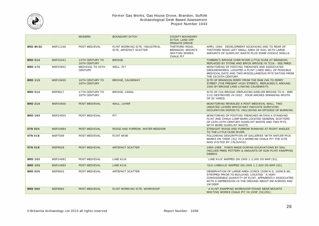
the size to match population and importance. Brandon is shown as a larger town (Fig. 3) along with Thetford, Bury St Edmunds and Mildenhall while the surrounding towns and villages are smaller in representation. The area of Breckland is also represented and shows relatively sparse settlement distribution. Two listed buildings on the High Street (275821 and 275815) date to the late medieval/early post-medieval period. The first (275821) is recorded as a house and the second as a mid-16th century shop. John Kirby’s map from 1736 is a little more detailed showing some roads and the basic layout of the larger settlements including Brandon. The High Street is clearly identified as the main built-up area, but the area of the former Saxon town is also shown to contain buildings and St Peter’s Church. Four listed buildings (275815, 275820, 275816 and 275817) along the High Street date to this period showing a definite increase in building activity. During the 17th, 18th and 19th centuries, Brandon became a centre for gun flint manufacture and the majority of post-medieval records relate to finds and features associated with this. Nine records (BRD018, BRD183, BRD020, BRD065, BRD068, BRD069, BRD183, STN018 and BRD Misc) identify either waste pits containing worked flint debitage or the workshops of gun flint manufacturing. The most relevant to the assessment site are three workshops/manufacturing areas (BRD065, BRD069 and BRD Misc) located 250m to the south. This area seems to have become an industrial zone in the middle of the post-medieval period with the addition of two lime kilns (BRD102 and BRD103) also located close by. Nearly all the listed buildings already noted underwent extensive renovation/redevelopment in the 19th century and three additional buildings (275819, 275812 and 275818) dating to this period have also been listed. Brandon High Street contains many other 19th and early 20th century buildings which are not listed and the general explosion in development shows that the town was fairly affluent toward the end of the post-medieval period. This was probably due to both the unstable but lucrative gun flint trade and the rabbit fur trade that boomed in the middle and late 19th century (Peacock, 2013). The canalisation of the river also helped to boost trade with the wider area. The Enclosure Map of 1801 (Fig. 3) is much more detailed than the earlier maps and the site is clearly identifiable off a ‘private track’, now called Gas House Drove. The assessment site is situated at the northern end of a larger plot owner by Robert Crafton and the whole plot is free of buildings, therefore most likely used for agriculture. The Tithe Map of 1838 (Fig. 3) is more detailed than the Enclosure Map and shows some development had taken place adjacent to the assessment site and along Thetford Road. The plot (671) is situated off ‘Adler Drove’ which is now Gas House Drove. It is shown to have a strip of trees on three sides, but no other features or buildings appear on the site. The apportionment entry gives the following details:

Former Gas Works, Gas House Drove, Brandon, Suffolk Archaeological Desk Based Assessment
Project Number 1043
15 ©Britannia Archaeology Ltd 2013 all rights reserved Report Number: 1038
TITHE NUMBER
LAND OWNER OCCUPIER SITE NAME LAND USE
A R P
671 JOHN BREWSTER HIMSELF ALLOTMENT PASTURE 4 1 6
Table 1: Tithe Apportionment The most significant SHER search entry relates to the old gas works (BRD072) which were located on the assessment site. This was constructed in around 1869 to provide gaslight for the town and is present on the First Edition Ordnance Survey Map of 1885 (Fig. 3). The Kelly’s Directory entry for 1883 reads: ‘Gas works have been erected by a local company and the town has, since the commencement of 1869, been lighted with gas' (Kelly’s Directory, 1883). The subsequent development of the site is well documented by cartographic sources from the Ordnance Survey and the Eastern Gas Board (Fig. 3). The First (1885) and Second (1905) Edition OS maps show two circular tanks in the centre and west of the site and several buildings along the northern boundary including the manager’s house. The 1953 Revised OS map shows that the site had been extended to the south and contained three tanks as well as the buildings in the northern area of the site. A far more detailed plan of the site was produced by the Eastern Gas Board in 1952 (Fig. 3) and each of the buildings and tanks is described. A later plan dated 1976 shows the number of buildings and tanks had been reduced significantly. The following table illustrates the site development between 1952 and 1976 and shows the change in use, demolition and construction of buildings on the site (Fig. 4):
1952 SITE LAYOUT 1976 SITE LAYOUT LOCATION HOLDING TANK 1 HOLDING TANK 1 WEST HOLDING TANK 2 HOLDING TANK 2 SOUTH-EAST
TAR & LIQUID WELL DEMOLISHED CENTRE MANAGERS HOUSE MANAGERS HOUSE NORTH-EAST
ENGINE ROOM BOOSTER HOUSE NORTH COAL STORE, WORKSHOP & OFFICE GOVERNOR HOUSE NORTH-WEST
RETORT HOUSE, BOOSTER HOUSE, METER HOUSE, PURIFIERS AND OXIDE SHED
DEMOLISHED CENTRE
BOILER DEMOLISHED SOUTH NOT CONSTRUCTED GAS HOLDER WATER HEATER WEST NOT CONSTRUCTED GAS HOLDER WATER HEATER SOUTH-EAST NOT CONSTRUCTED GOVERNOR HOUSE SOUTH NOT CONSTRUCTED INSTRUMENT ROOM SOUTH NOT CONSTRUCTED CESS POOL EAST
Table 2: Site Development 1952-1976 (Fig. 4) The significant redevelopment of the site was due to the change from using coal gas to natural gas in Britain in the late 1960’s and 1970’s which requires very different equipment for creation, storage and distribution. The retort and tar well were part of the coal gas production process and were demolished when the works became a storage facility. The OS Map from 1980 still shows the works, however by 1985 the site had been cleared of nearly all the buildings except the manger’s house and the two northern buildings described in 1976 as the governor house and booster house. A substation had been constructed just south of the manager’s house and it is clear that the site is no longer a working gas works.

Former Gas Works, Gas House Drove, Brandon, Suffolk Archaeological Desk Based Assessment
Project Number 1043
16 ©Britannia Archaeology Ltd 2013 all rights reserved Report Number: 1038
The remaining late post-medieval and modern search entries give details of a brick works (BRD092) 860 to the south-west and two World War II spigot mortar emplacements (BRD220 & BRD219) located around 800m to the west. A pill box (BRD222) which is located close to the site (160m west along Gas Works Drove) appears to have been situated to cover the river. A small archaeological evaluation was undertaken at Wishing Well Lane (BRD216) 70m west of the assessment site in 2011, however no significant archaeological finds or features were present (Newman, 2011). 4.6 Site Visit (Fig. 5) A site visit was undertaken by the author on 19th September 2013 to determine the current state of the assessment area, investigate the presence of any surface or potential sub-surface archaeological remains and to ascertain the current level of truncation. The only buildings still present on the site are the manager’s house which is occupied and the former boiler room to the north which is derelict and overgrown with ivy (DP. 10). A concrete pad where the northern governor house once stood is also still extant (DP. 2) and the remains of gravel/building rubble was situated in the centre of the site where the 1952 retort building once stood (DP. 3). The site is generally laid to grass, which was long in most areas, and the periphery of the site contains varying degrees of bramble and thicket bushes. An area of well-established trees comprising birch and pine was located in the south-west quarter of the site. A definite rise in the centre of the site where the 1952 tar and liquid well was located was identified and areas around this contained natural sand and chalk patches where the exposed soil was visible. The areas around the other holder tanks did not show any signs that they had been there. One very small area of possible in-situ brick path was identified in the eastern part of the site however this proved to be an isolated find. No obvious archaeological structures or earthworks were observed. 5. DISCUSSION 5.1 Archaeological Potential Archaeological information in the immediate area of the assessment site is relatively sparse, due mainly to a low level of archaeological investigation in the immediate locality. The only archaeological work to take place within 500m of the site did not find any archaeological remains (BRD126). The wider area is well represented showing significant human activity within 1km dating from the Mesolithic to the modern periods. Evidence suggests a relatively high level of human activity in the prehistoric, Saxon, medieval and post-medieval periods.

Former Gas Works, Gas House Drove, Brandon, Suffolk Archaeological Desk Based Assessment
Project Number 1043
17 ©Britannia Archaeology Ltd 2013 all rights reserved Report Number: 1038
The results show unusually high levels of Neolithic activity in all sections of the search area, although not especially close to the assessment site. Consequently there is a moderate potential for the presence of material dating to this period. Although the other prehistoric periods are also well represented in the search area, they tend to be focussed to the west of Brandon at Staunch Meadow and near the river and consequently there is low potential for finding remains dating to this period on the assessment site. The majority of Roman finds were identified in Saxon contexts at Staunch Meadows and London Road suggesting they had been looted from other sites, and no Roman features have yet been conclusively identified in the search area. The pudding stone quern found nearer to the site may also have been imported and was not found with any other artefact or remains. The potential for find Roman remains on the site is therefore low. The origins of Brandon as a modern parish lie in the Anglo-Saxon period and there is substantial evidence for high status settlement activity in two locations in the search area to the west of the modern town. The wealth of features and finds are highly focused at Staunch Meadow and the area around Church Street and it is unlikely that any settlement activity extended as far as the assessment site. The only notable exception to this localised activity is the possible cemetery and execution area located over 800m to the east. The assessment site lies between these two areas and despite the focus of activity being some distance away, the possibility of encountering outlying field systems and boundary ditches cannot be ruled out. The potential for encountering Anglo-Saxon remains is therefore considered low to moderate. The parish was properly established by the medieval period, and the later medieval maps suggest the town was locally important, probably thanks to the ferry crossing and bridge which were part of a route around the Fens. The transient nature of the passing trade seems to have made the town quite dangerous by the middle of the medieval period. The search results show that the settlement activity was also highly localised along High Street to the bridge and the area of the later Anglo-Saxon settlement at Church Street to the west and did not extend as far as the assessment site, but more agrarian and industrial activity spread out well beyond the town centre and was noted in many parts of the search area. The potential for finding medieval remains is therefore low to moderate with the emphasis on outlying field systems. Brandon developed along the High Street and London Road during the majority of the post-medieval period, with some development on the Thetford Road towards the assessment site which was very much on the outskirts of town. Cartographic sources from the 18th and early 19th century show the site was used for agriculture or as allotments until the mid-19th century when it was developed as the town’s gas works. Later alterations and a change from coal gas to natural gas mean the site has undergone at least four phases of development from initial construction in the 1860’s, expansion in the early 20th century, alteration in the 1960’s or 1970’s and finally closure and substantial demolition in the 1980’s. Therefore the potential for post-medieval and modern features and finds is very high in relation to the gas works, but low for post-medieval remains prior to the mid-19th century.

Former Gas Works, Gas House Drove, Brandon, Suffolk Archaeological Desk Based Assessment
Project Number 1043
18 ©Britannia Archaeology Ltd 2013 all rights reserved Report Number: 1038
5.2 Existing and Proposed Impact (Fig. 4) Existing Impact Construction of the gas works in the 1860’s and the three further phases of alteration and development until the 1980’s will have had a significant impact on any below ground heritage assets, especially under the footprint of the known structures (Fig. 4). The affected areas account for around 30% of the site and there were also numerous service runs between the structures that would further increase this figure. The extent and depth of demolition and site clearance in the 1980’s is unknown, however deposits of the natural drift geology were noted during the site visit suggesting some areas have been significantly truncated below the archaeological horizon. Hydrocarbon contamination due to coal gas production is likely to be high across the entire site and the recovery of any palaeo-environmental samples is inadvisable. Given the above, the preservation potential of archaeological remains dating to before the mid-19th century (if any exist) is likely to be low due to the development of the site from the mid-19th century onwards, the unknown density of old service trenches and depth of site truncation during demolition. The potential for the preservation of remains associated with the gas works is high. Proposed Impact The proposed remediation works include an initial phase of trial trenching over two areas of the site that formally contained a cess pool, retort buildings, large holder tanks and a tar and liquid tank (Fig. 4). This will be followed by full excavation to a depth of around 2m of any areas found to be contaminated and the processing and refill of soil. If archaeological remains are present in the areas of the proposed work then the impact will be high due to the depth of the intended excavation. However, much of the work is on areas where former gas works structures were located. Area A, in the east, is over an old cess pool which was presumably dug well below the archaeological horizon. It is also the suspected location of a tar tank not shown on the detailed maps from 1952 onwards, but may have existed prior to this. Area B will target holder tank one and the site of the tar and liquid well to check for contamination. The impact to mid-19th century remains will therefore be high, but it is likely that earlier deposits will already have been removed during the construction and redevelopment of the gas works.

Former Gas Works, Gas House Drove, Brandon, Suffolk Archaeological Desk Based Assessment
Project Number 1043
19 ©Britannia Archaeology Ltd 2013 all rights reserved Report Number: 1038
Impact on Setting The proposed plans will have no impact on setting as the ground will be reinstated to its current level. No development of the site is currently planned beyond these remediation works. 6. CONCLUSIONS AND RECOMMENDATIONS 6.1 Conclusions Brandon has been a site of occupation activity since the Mesolithic period with significant settlement activity identified in the Neolithic and particularly the Anglo-Saxon periods. The assessment site is situated some distance from the focus of much of this settlement activity, although Neolithic finds and sites have been noted all over the search area. The assessment site itself is recorded in the SHER as the former gas works for the town and as such the potential for encountering remains associated with it are high. The overall potential for encountering remains predating the mid-19th century during the work is low, however there is a high potential for encountering foundations and other structural remains associated with the gas works due to the remediation work targeting areas that contained some of these structures. Although their location can be easily identified from the detailed cartographic sources available, the level and depth of demolition during the 1980’s is unknown and it is possible that little of these structures actually remain. The site visit noted that some areas contained patches of natural sand and chalk which suggests the demolition truncated down through to natural drift geology in places. The high potential for ground contamination should also be noted and it is likely that archaeological field investigation might be seriously hampered due to substances hazardous to health. There will be no impact on setting as the site will be reinstated to its current level and there are no plans for further development 6.2 Recommendations Given the results of the assessment and the proposed plans, it is unlikely that the development will encounter undisturbed archaeological remains predating the late 19th and 20th centuries. Monitoring of the initial trial trenches may be useful in establishing the following:
• The presence or absence of remains associated with the 19th century gas works and the level of truncation from the demolition phase of activity from the 1980s;
• State of preservation if any remains are present;

Former Gas Works, Gas House Drove, Brandon, Suffolk Archaeological Desk Based Assessment
Project Number 1043
20 ©Britannia Archaeology Ltd 2013 all rights reserved Report Number: 1038
• The level of ground contamination in relation to the viability of palaeo-environmental sampling or the viability of further fieldwork if deemed necessary.
Despite the above, it is unlikely that further archaeological work would add to our understanding of this particular site given the corpus of information available concerning location and construction of the gas works. However this recommendation may be subject to change once the final proposals have been submitted and fully reviewed. 7.0 ACKNOWLEDGMENTS Britannia Archaeology Ltd would like to thank Mr David Baker of Stratus Environmental Ltd for his instructions, assistance and for funding the project. 8.0 PROJECT ARCHIVE & DEPOSITION A full archive will be prepared for all work undertaken in accordance with guidance from the Selection, Retention and Dispersion of Archaeological Collections, Archaeological Society for Museum Archaeologists, 1993. Arrangements will be made for the archive to be deposited with the relevant museum or the SHER Office. The archive will be quantified, ordered, indexed, cross-referenced and checked for internal consistency. The material will be catalogued, labelled and packaged for transfer and storage in accordance with the guidelines set out in the United Kingdom Institute for Conservation's Conservation Guidelines No.2 and the Archaeological Archives Forum’s Archaeological Archives, A guide to best practice, compilation, transfer and curation (Brown, 2007).

Former Gas Works, Gas House Drove, Brandon, Suffolk Archaeological Desk Based Assessment
Project Number 1043
21 ©Britannia Archaeology Ltd 2013 all rights reserved Report Number: 1038
Bibliography Bailey, M. 2007. Medieval Suffolk: An Economic and Social History, 1200-1500. Boydell Press Barringer, C. (ed.) 1984. Aspects of East Anglian Prehistory: 20 Years after Rainbird Clarke. Norwich. Brown, A.E. (ed.) 1995. Roman Small Towns in Eastern England and Beyond. Oxbow Monograph 52. Oxford. Carr, R. Tester, A. Murphy, P. 1988. The Middle-Saxon Settlement at Staunch Meadow, Brandon. Antiquity; Vol. 62 Issue 235, p371 Department for Communities and Local Government, 2012. National Planning Policy Framework (NPPF) Forest Health District Council. 1995. Forest Heath Local Plan, (Policy 8.20) Freeman, E. A. (1870–1876), The History of the Norman Conquest of England, vol.II Institute for Archaeologists. 2011. Standard and Guidance for Archaeological Desk Based Assessments. 1883. Kelly's Directory for Cambridgeshire, Norfolk & Suffolk. Kelly’s Directories Ltd Mills, A D. 2003. Oxford Dictionary of British Place Names. OUP Morris, J. (ed). 1986. Domesday Book Suffolk (Part Two). Phillimore & Co. Murrell, P. 1968 Index to Victoria County History of Suffolk. Suffolk Record Office Newman, J. 2011. Land Off Wishing Well Close and to the Rear of The Red House, Gas House Drove, Brandon, Suffolk- Archaeological Evaluation Report. JNAS. Norfolk Historic Environment Record Office Ordnance Survey, 2001. Historical Map and Guide, Roman Britain. Peacock, D. 2013. History of Brandon. Brandon Town Council Reynolds, T. 1794. Iter Britanniarum or that part of the Itinerary of Antoninus Which Relates to Britain. Cambridge Scarfe, N. 2010. Suffolk in the Middle Ages: Studies in Places and Place-Names, the Sutton Hoo Ship-Burial, Saints, Mummies and Crosses, Domesday Book and Chronicles of Bury Abbey. Boydell Press Sealey, P R. 1997. The Boudican Revolt against Rome. Shires.

Former Gas Works, Gas House Drove, Brandon, Suffolk Archaeological Desk Based Assessment
Project Number 1043
22 ©Britannia Archaeology Ltd 2013 all rights reserved Report Number: 1038
Smith, RA. 1909. A Hoard of Metal found at Santon Downham, Norfolk. CAS Suffolk Historic Environment Record Office Cartographic Sources Saxon’s Map of Suffolk, 1575 John Kirby, 1736 Enclosure Map, 1801 Tithe Map, 1839 Ordnance Survey 1st Edition, 1885 Ordnance Survey 2nd Edition, 1905 Ordnance Survey Revised Edition, 1953 Ordnance Survey 1981-1985 Eastern Gas Board Property Plan – 1952 Eastern Gas Board Property Plan – 6th Sept 1976 Websites: The British Geological Survey (Natural Environment Research Council) – Geology of Britain Viewer - www.bgs.ac.uk/opengeoscience/home.html?Accordion2=1#maps English Heritage PastScape www.pastscape.org.uk Archaeological Data Service (ADS) www.ads.ahds.ac.uk English Heritage National List for England www.english-heritage.org.uk/professional/protection/process/national-heritage-list-for-england DEFRA Magic http://magic.defra.gov.uk/website/magic Brandon Town Council http://www.brandon.suffolk.gov.uk/

Former Gas Works, Gas House Drove, Brandon, Suffolk Archaeological Desk Based Assessment
Project Number 1043
23 ©Britannia Archaeology Ltd 2013 all rights reserved Report Number: 1038
APPENDIX 1 – HER DATA MONUMENT DATA PREFERED REF
MONUMENT ID
PERIOD MONUMENT TYPES NAME SUMMARY
BRD 018 MSF9821 MESOLITHIC FLINT WORKING SITE 1980-1988: SCATTER OF MES WORKED FLINT, INCLUDING `KNAPPING AREAS' FOUND DURING EXCAVATIONS BY SAU.
BRD 018 MSF9822 NEOLITHIC ARTEFACT SCATTER 1980-1988: SCATTER OF NEO WORKED FLINT FOUND DURING EXCAVATIONS BY SAU.
BRD 020 MSF9831 NEOLITHIC ARTEFACT SCATTER OBSERVATION OF LARGE AREA (CIRCA 150M N-S, 100M E-W), STRIPPED PRIOR TO BUILDING.
BRD 193 MSF23731 EARLY NEOLITHIC TO LATE BRONZE AGE
PIT MONIOTORING LOCATED A BROAD SCATTER OF PITS DATING TO THE PREHISTORIC PERIOD AND 19TH CENTURY, MATERIAL RECOVERED INCLUDED A LAUREL LEAF AND GUNFLINT.
BRD 154 MSF18646 EARLY NEOLITHIC TO POST MEDIEVAL
PIT, POST HOLE, ENCLOSURE, STRUCTURE, CREMATION, DITCH, TRACKWAY, INHUMATION, ROUND HOUSE (DOMESTIC), HUT CIRCLE?
MARCH 1999: PREH, MAINLY MIDDLE BRONZE AGE (R/C DATED, THOUGH LBA STYLE POTTERY), SITE DISCOVERED DURING EVALUATION & SUBSEQUENT EXCAVATION.
STN 018 MSF7600 EARLY NEOLITHIC TO POST MEDIEVAL
FLINT MINE WORKING CHALK QUARRY WHERE FACE WORKINGS REVEALING GALLERIES "WITH ANTLER PICK MARKS ON THEM" (OR POSSIBLY PMED IRON FLINT MINING PICK MARKS?).
BRD 001 MSF9792 MIDDLE BRONZE AGE FINDSPOT RIVER LITTLE OUSE BRONZE NARROW SIDE-LOOPED SPEARHEAD.
BRD 018 MSF9823 MIDDLE BRONZE AGE TO LATE BRONZE AGE
FINDSPOT 1980-1988: FRAGMENTS OF BA METALWORK, FLINT ARROWHEADS & VARIOUS WORKED FLINTS, FOUND DURING EXCAVATION OF BRD 018.
5617 MNF5617 BRONZE AGE ROUND BARROW, MOUND SITE OF POSSIBLE BRONZE AGE ROUND BARROW
BRD 018 MSF9824 IRON AGE CULTIVATION MARKS, FEATURE, PIT, POST HOLE
SCHEDULED MONUMENT - MIDDLE SAXON OCCUPATION ON CHEQUER MEADOW (S3).
BRD 090 MSF13974 IRON AGE FINDSPOT 18 DOWNHAM WAY 1979: UNINSCRIBED IA BRONZE COIN.
BRD 151 MSF18086 LATER PREHISTORIC ARTEFACT SCATTER JANUARY 1998: FIELDWALKING SURVEY OF FORESTRY COMMISSION PLANTING FURROWS, CIRCA 40M APART TRANSECTS, LOCATED RELATIVELY DENSE SCATTER OF 68 PREH WORKED FLINTS AND 5 BURNT FLINTS - DETAILS IN (S1)(S2).
BRD MISC MSF11196 LATER PREHISTORIC FINDSPOT MARCH 1990: SITE VISIT IN AREA OF DEVELOPMENT & PROPOSED DEVELOPMENT, LOCATED SCRAPER & TRIMMED BLADE IN SPOIL REMOVED FOR CREATION OF `EXISTG COLLECTOR ROAD NO.

Former Gas Works, Gas House Drove, Brandon, Suffolk Archaeological Desk Based Assessment
Project Number 1043
24 ©Britannia Archaeology Ltd 2013 all rights reserved Report Number: 1038
BRD 018 MSF9825 ROMAN ARTEFACT SCATTER SCHEDULED MONUMENT - ROMAN MATERIAL, LARGELY WITHIN MIDDLE SAXON OCCUPATION LEVELS, ON CHEQUER MEADOW.
BRD 024 MSF10004 ROMAN ARTEFACT SCATTER SCATTER OF POTTERY FOUND IN BACK GARDEN.
BRD MISC MSF9906 ROMAN FINDSPOT 193 THETFORD ROAD, BRANDON.
"BOTTOM STONE OF PUDDING STONE QUERN".
BRD 018 MSF9826 SAXON AISLED BUILDING, BUILDING, CHURCH, FEATURE, PIT, POST HOLE, DITCH, CEMETERY, CAUSEWAY, HOUSE, INDUSTRIAL BUILDING, SETTLEMENT, ANIMAL BURIAL
SCHEDULED MONUMENT - MIDDLE SAXON OCCUPATION ON CHEQUER MEADOW.
BRD 024 MSF9853 SAXON ARTEFACT SCATTER SCATTER OF POTTEY FOUND IN BACK GARDEN.
BRD 071 MSF10651 SAXON FEATURE, PIT, DITCH SPORTS CENTRE SITE; PLAYING FIELD
1989: EXCAVATION OF CIRCA 1500 SQ M PRIOR TO CONSTRUCTION OF SPORTS CENTRE FOR FOREST HEATH DISTRICT COUNCIL LOCATED VARIOUS FEATURES, IPSWICH WARE, THETFORD WARE, STAMFORD WARE AND ST NEOTS WARE, ANIMAL BONES ETC (S1).
BRD 089 MSF13847 SAXON FEATURE, PIT, POST HOLE, ARTEFACT SCATTER
11 VICTORIA AVENUE FINDS FROM SPOIL FROM FOUNDATION TRENCH FOR EXTENSION,, INCLUDED: 44 SHERDS THETFORD TYPE WARE (1 DECORATED), 1 SHERD ST NEOTS TYPE WARE AND 2 LUMPS OF FIRED CLAY AND A FEW MED SHERDS.
BRD 094 MSF14540 SAXON CHAPEL BRANDON HOUSE HOTEL
CHAPEL REMAINS TO THE REAR N SIDE OF THE BRANDON HOUSE HOTEL, N SIDE OF THE RIVER OUSE.
BRD 156 MSF19546 MIDDLE SAXON TO LATE SAXON
DITCH TESCO, LONDON ROAD, BRANDON
SEVERAL PHASES OF DITCHES IN 3 EVALUATION TRENCHES AND EXCAVATION PRIOR TO DEVELOPMENT 1999-2000.
BRD 083 MSF13489 LATE SAXON FEATURE, BUILDING 9 VICTORIA AVENUE NARROW BUILDING SLOT, WITH AT LEAST ONE POST HOLE IN BASE LOCATED AND EXCAVATED IN 60 CM WIDE BUNGALOW FOOTING TRENCH.
BRD 208 MSF26861 LATE SAXON TO MEDIEVAL
DITCH, DITCH EVALUATION IDENTIFIED THREE PARALLEL DITCHES OF MEDIEVAL DATE AND A THIRD DITCH AT AN OBLIQUE ALIGNMENT AND IS PROBABLY OF LATE SAXON DATE.
BRD 045 MSF12101 LATE SAXON TO MEDIEVAL
FEATURE, DITCH, SITE, ARTEFACT SCATTER
CIRCA 1983: ASSORTMENT OF ST NEOTS WARE SHERDS FOUND WHILE DISPOSING OF OLD BIBLES BY BURYING THEM IN THE KITCHEN GARDEN.
BRD 165 MSF20364 LATE SAXON TO MEDIEVAL
INHUMATION, CEMETERY, EXECUTION SITE
GAME FARM, 48 WOODCOCK RISE
REMAINS OF AT LEAST TWO INHUMATIONS, ONE WITH SKULL BETWEEN KNEES, FOUND DIGGING GARDEN TERRACES IN SLOPE TO SOUTH OF HOUSE.
BRD Misc MSF13491 MEDIEVAL FINDSPOT LARGE IRON (DOOR?) KEY WITH KIDNEY SHAPED LOOP.
BRD 165 MSF20565 MEDIEVAL PIT, DITCH THE EXCAVATION OF FOUR EVALUATION TRENCHES, REVEALED SUBSTANTIAL TOPSOIL WHICH MAY BE RESULT OF MED, OR PMED PLOUGHING.

Former Gas Works, Gas House Drove, Brandon, Suffolk Archaeological Desk Based Assessment
Project Number 1043
25 ©Britannia Archaeology Ltd 2013 all rights reserved Report Number: 1038
BRD 018 MSF9827 MEDIEVAL BUILDING, DITCH, ENCLOSURE, WALL, FEATURE
SCHEDULED MONUMENT - MED FINDS AND FEATURES WITHIN AREA OF MIDDLE SAXON OCCUPATION ON CHEQUER MEADOW (S1).
BRD 194 MSF23345 MEDIEVAL PIT EVALUATION LOCATED ONE PIT THAT CONTAINED POTTERY SHERDS, DATING BETWEEN 12TH-14TH CENTURY.
BRD 071 MSF10650 MEDIEVAL FEATURE, PIT, DITCH 1989: EXCAVATION OF CIRCA 1500 SQ M PRIOR TO CONSTRUCTION OF SPORTS CENTRE FOR FOREST HEATH DISTRICT COUNCIL LOCATED VARIOUS FEATURES, IPSWICH WARE, THETFORD WARE, STAMFORD WARE AND ST NEOTS WARE, ANIMAL BONES ETC (S1).
BRD 073 MSF11784 MEDIEVAL ARTEFACT SCATTER OLD BURY ROAD/GEORGE STREET
DEPOSIT OF DARK CHARCOALLY SANDY SOIL WITH OCCASIONAL SHERD OF C16 POTTERY AND ANIMAL BONE BETWEEN CIRCA 50CM AND 1.
BRD 083 MSF13490 MEDIEVAL ARTEFACT SCATTER 9 VICTORIA AVENUE JUNE 1992: LSAX AND MED POTTERY FROM BURIED SOIL UP TO CIRCA 1M IN DEPTH LOCATED IN SPOIL FROM FOUNDATION TRENCHES.
BRD 089 MSF13848 MEDIEVAL ARTEFACT SCATTER 11 VICTORIA AVENUE FINDS FROM SPOIL FROM FOUNDATION TRENCH FOR EXTENSION, INCLUDED 4 MED SHERDS:- 1 C12/C13 RIM; 2 BODY SHERDS MED COARSEWARE; 1 BODY SHERD GRIMSTON TYPE WARE (S1).
BRD 068 MSF14873 MEDIEVAL ARTEFACT SCATTER JUNE 1994: WATCHING BRIEF ON FOOTING TRENCHES FOR EXTENSION/GARAGE TO ADJOINING FUNERAL SERVICE PREMISES LOCATED MODERN TOPSOIL, OVERLAYING CIRCA 50CM DE0EP (DOUBLE DUG?) SOIL CONTAINING PMED GUNFLINT WASTE, TILE, BRICK ETC AND C13/C14 POTTERY, IN PART
BRD MISC MSF13491 MEDIEVAL FINDSPOT 11 VICTORIA AVENUE LARGE IRON (DOOR?) KEY WITH KIDNEY SHAPED LOOP.
BRD MISC MSF15686 MEDIEVAL ARTEFACT SCATTER BROMHALL CHEMIST'S, 32 HIGH STREET
AMOUNT OF FRAGMENTARY LIMESTONE (BOTH OOLITIC OF BARNACK TYPE AND NON-OOLITIC OF NORTH NORTHANTS TYPE).
BRD 156 MSF19547 MEDIEVAL DITCH, PIT TESCO, LONDON ROAD, BRANDON
EVALUATION, EXCAVATION AND MONITORING, 1999-2000
BRD 209 MSF24455 MEDIEVAL TO POST MEDIEVAL
TOWN, MARKET INDICATIVE AREA OF MEDIEVAL TOWN OF BRANDON
BRD 189 MSF23346 MEDIEVAL TO POST MEDIEVAL
DITCH EVALUATION AND EXCAVATION LOCATED A LARGE DITCH MARKING THE COUNTY BOUNDARY IN FILLED IN THE LATE MEDIEVAL OR EARLY POST-MEDIEVAL PERIOD AND ALSO AN AREA OF GUNFLINT WASTE.
STN 035 MSF14289 MEDIEVAL TO POST MEDIEVAL
RABBIT WARREN, BANK (EARTHWORK), BOUNDARY, TRACKWAY
DOWNHAM RABBIT WARREN BOUNDARY.
BRD 160 MSF24503 MEDIEVAL TO POST MEDIEVAL
LODGE, WINDMILL THE MOUNT LODGE 1884 (1810 ENCLOSURE)
WARREN LODGE AND BUILDING MENTIONED IN BRANDON INCLOSURE EXCHANGES (S1).
42776 MNF47626 MEDIEVAL TO PIT, DITCH, LITHIC WORKING SITE, POST MEDIEVAL PITS,
Former Gas Works, Gas House Drove, Brandon, Suffolk Archaeological Desk Based Assessment
Project Number 1043
26 ©Britannia Archaeology Ltd 2013 all rights reserved Report Number: 1038
MODERN BOUNDARY DITCH COUNTY BOUNDARY DITCH, LAND OFF FENGATE DROVE
BRD MISC MSF11246 POST MEDIEVAL FLINT WORKING SITE, INDUSTRIAL SITE, ARTEFACT SCATTER
THETFORD ROAD, BRANDON; MOUNTS WHITING WORKS CHALK PIT
APRIL 1990: DEVELOPMENT ADJOINING AND TO REAR OF THETFORD ROAD LEFT SMALL AREA OF SOIL WITH LARGE AMOUNTS OF GUNFLINT WASTE PLUS SOME COCKLE SHELLS.
BRD 014 MSF15441 14TH CENTURY TO 16TH CENTURY
BRIDGE TIMBER(?) BRIDGE OVER RIVER LITTLE OUSE AT BRANDON, REPLACED BY STONE AND BRICK BRIDGE IN ?C16 - SEE PMED.
BRD 172 MSF23652 MEDIEVAL TO 20TH CENTURY
WELL, PIT MONITORING OF FOOTING TRENCHES AND ASSOCIATED GROUNDWORKS, LOCATED A FLINT LINED WELL OF POSSIBLE MEDIEVAL DATE AND TWO MISCELLANEOUS PITS DATING FROM THE 19/20TH CENTURY.
BRD 113 MSF15655 16TH CENTURY TO 18TH CENTURY
BRIDGE, CAUSEWAY SITE OF BRANDON FERRY FROM THE RAM INN TO FERRY STREET (THE PRESENT HIGH STREET), REPLACED(?) AROUND 1500 BY BRIDGE (AND LINKING CAUSEWAY?).
BRD 014 MSF9817 17TH CENTURY TO 18TH CENTURY
BRIDGE, CANAL SITE OF C16 BRIDGE (REPLACING EARLIER BRIDGE TO N - BRD 113) DESTROYED IN 1932: FOUR ARCHES SPANNING WIDTH OF 30 YARDS.
BRD 214 MSF24600 POST MEDIEVAL WALL, LAYER MONITORING REVEALED A POST-MEDIEVAL WALL, TWO UNDATED LAYERS WHICH MAY INDICATE SURVIVING OCCUPATION DEPOSITS, INCLUDING AN EPISODE OF BURNING.
BRD 183 MSF24055 POST MEDIEVAL PIT MONITORING OF FOOTING TRENCHES WITHIN A STANDING FLINT AND CHALK LUMP BARN LOCATED GENERAL SCATTERS OF 19TH-20TH CENTURY GUNFLINT WASTE AND TWO PITS WITH MORE GUNFLINT WASTE.
STN 024 MSF10884 POST MEDIEVAL RIDGE AND FURROW, WATER MEADOW STRAIGHT RIDGE AND FURROW RUNNING AT RIGHT ANGLES TO THE LITTLE OUSE RIVER.
STN 018 MSF7599 POST MEDIEVAL FLINT MINE FOLLOWING DESCRIPTION OF GALLERIES 'WITH ANTLER PICK MARKS ON THEM' (S1) IN A WORKING CHALK PIT THE SITE WAS VISITED BY J PLOUVIEZ.
STN 018 MSF9828 POST MEDIEVAL ARTEFACT SCATTER 1980-1988: FINDS MADE DURING EXCAVATIONS BY SAU, INCLUDE PMED POTTERY & AMOUNTS OF GUN-FLINT KNAPPING DEBRIS.
BRD 102 MSF14982 POST MEDIEVAL LIME KILN `LIME KILN' MAPPED ON 1905 1:2,500 OS MAP (S1).
BRD 103 MSF14983 POST MEDIEVAL LIME KILN 'OLD LIMEKILN' MAPPED ON 1905 1:2,500 OS MAP (S1).
BRD 020 MSF9832 POST MEDIEVAL ARTEFACT SCATTER OBSERVATION OF LARGE AREA (CIRCA 150M N-S, 100M E-W), STRIPPED PRIOR TO BUILDING, LOCATED `A VERY CONSIDERABLE QUANTITY OF FLINT, APPARENTLY ASSOCIATED WITH A DEPRESSION IN THE GROUND ABOUT 6M ACROSS AND 1M DEEP.
BRD 065 MSF9883 POST MEDIEVAL FLINT WORKING SITE, WORKSHOP `A FLINT KNAPPING WORKSHOP FOUND NEAR MOUNTS WHITING WORKS CHALK PIT IN 1938' (S1)(R1).

Former Gas Works, Gas House Drove, Brandon, Suffolk Archaeological Desk Based Assessment
Project Number 1043
27 ©Britannia Archaeology Ltd 2013 all rights reserved Report Number: 1038
BRD 068 MSF9903 POST MEDIEVAL FLINT WORKING SITE, WORKSHOP "ALBION SITE" FLINT KNAPPING WORKSHOP - `THE "ALBION SITE" (ONCE A BEER HOUSE AND NOW THE NEW METHODIST CHURCH)'.
BRD 069 MSF9904 POST MEDIEVAL FLINT WORKING SITE, WORKSHOP "R J SNARE'S FLINTWORKS"; 62 THETFORD ROAD.
`"R J SNARE'S (1835-1898) FLINT WORKS, BRANDON, SUFFOLK, AUGUST 5TH 1878", NOW 62 THETFORD ROAD' (S1)(R1).
BRD MISC MSF2667 POST MEDIEVAL FINDSPOT CONNAUGHT HOUSE NEWSPAPER (UNKNOWN) CUTTING IN BASIL BROWN ARCHIVE GIVES DETAILS OF A SHILLING COIN OF ELIZABETH I DATED 1573 (S1).
BRD 072 MSF11269 19TH CENTURY TO 20TH CENTURY
GAS WORKS BRANDON GAS WORKS.
BRD 092 MSF14874 19TH CENTURY TO MODERN
BRICKWORKS SPARTAN BRICKWORKS.
BRD 191 MSF22824 19TH CENTURY TO UNKNOWN
BUILDING RATTLERS ROAD; STUART CLOSE
'LODGE' MARKED ON ENCLOSURE MAP (CIRCA 1810), NE OF RATTLERS ROAD.
BRD 222 MSF26187 SECOND WORLD WAR
PILLBOX PROBABLE PILLBOX, OF WHICH NO TRACE REMAINS. SITE NOW OCCUPIED BY A PRIVATE HOUSE.
BRD 220 MSF26313 SECOND WORLD WAR
SPIGOT MORTAR EMPLACEMENT HEXAGONAL CONCRETE PILLAR C.1M ACROSS, WITH STAINLESS STEEL SPIGOT, NOW BURIED TO GROUND LEVEL.
BRD 219 MSF26314 SECOND WORLD WAR
SPIGOT MORTAR EMPLACEMENT SPIGOT MORTAR HEXAGONAL CONCRETE PILLAR C.1M ACROSS, WITH CENTRAL STAINLESS STEEL SPIGOT. TOP 0.75M ABOVE GROUND LEVEL.
SF 229 MSF9829 UNKNOWN CEMETERY, FEATURE, DITCH SCHEDULED MONUMENT - UNDATED FEATURES ON MIDDLE SAXON OCCUPATION SITE ON CHEQUER MEADOW (S6).
BRD 037 MSF9870 UNDATED ARTEFACT SCATTER PINEFIELDS; BENNETT'S SITE
HOARD OF BRONZE VESSELS FOUND DURING BUILDING DEVELOPMENT.
BRD MISC MSF19045 UNDATED ARTEFACT SCATTER 6 HIGH STREET; FORMER LLOYDS BANK
RESIDUAL MED & PMED FINDS IN CELLAR OBSERVED DURING MONITORING EXTENSION.
BRD 156 MSF19548 UNKNOWN DITCH TESCO, LONDON ROAD, BRANDON
EVALUATION, EXCAVATION AND MONITORING 1999-2000.
LISTED BUILDINGS PREFERED REF
DESIGNATED ID
NAME GRADE CURATORIAL NOTES
275821 DSF3510 C AND C FABRICS, SAXON FURNISHINGS, ANTIQUES, AND BRANDON MOTOR CYCLES
II TYPE AND DATE: EARLY C16 HOUSE. DATE: FROM 1500 TO 1532 TYPE AND DATE: EARLY C16 TIMBER FRAMED HOUSE. DATE: FROM 1500 TO 1532 TYPE AND DATE: EARLY C18 HOUSE. DATE: FROM 1700 TO 1732 TYPE AND DATE: LATE C19 HOUSE. DATE: FROM 1867 TO 1899 TYPE AND

Former Gas Works, Gas House Drove, Brandon, Suffolk Archaeological Desk Based Assessment
Project Number 1043
28 ©Britannia Archaeology Ltd 2013 all rights reserved Report Number: 1038
275811 DSF3289 BRANDON HOUSE HOTEL II TYPE AND DATE: LATE C18 HOUSE. DATE: FROM 1767 TO 1799 TYPE AND DATE: EARLY C19 HOUSE. DATE: FROM 1800 TO 1832 TYPE AND DATE: LATE C19 HOUSE. DATE: FROM 1867 TO 1899 TYPE AND DATE: HOTEL. MAIN MATERIAL: BRICK COVERING MATERIAL: SLATE
275815 DSF3291 BRANDON BARGAIN CENTRE AND RUTTERS II TYPE AND DATE: MID C16 SHOP. DATE: FROM 1533 TO 1566 TYPE AND DATE: C17 SHOP. DATE: FROM 1600 TO 1699 TYPE AND DATE: C19 SHOP. DATE: FROM 1800 TO 1899 TYPE AND DATE: C20 SHOP. DATE: FROM 1900 TO 1999 TYPE AND DATE: MID C16 TIMBER FRAMED BUILDING.
275819 DSF3292 CRAFTON HOUSE II TYPE AND DATE: MID C19 HOUSE. DATE: FROM 1833 TO 1866 TYPE AND DATE: MID C16 HOUSE. DATE: FROM 1533 TO 1566 MAIN MATERIAL: BRICK COVERING MATERIAL: PANTILE
275820 DSF3293 HELLESDON HOUSE II TYPE AND DATE: LATE C18 HOUSE. DATE: FROM 1767 TO 1799 MAIN MATERIAL: BRICK COVERING MATERIAL: PANTILE
275812 DSF3429 THE RAM HOTEL II TYPE AND DATE: EARLY C19 HOTEL. DATE: FROM 1800 TO 1832 TYPE AND DATE: EARLY C19 TIMBER FRAMED BUILDING. DATE: FROM 1800 TO 1832 TYPE AND DATE: LATE C16 HOTEL. DATE: FROM 1567 TO 1599 TYPE AND DATE: C19 HOTEL. DATE: FROM 1800 TO 1899 MAIN MATERIA
275816 DSF3434 OAK HOUSE II* TYPE AND DATE: C1730 INN. DATE: FROM 1710 TO 1750 TYPE AND DATE: HOUSE. MAIN MATERIAL: BRICK MAIN MATERIAL: LIMESTONE COVERING MATERIAL: PANTILE COVERING MATERIAL: SLATE
275818 DSF3435 CONNAUGHT HOUSE II TYPE AND DATE: EARLY C19 INN. DATE: FROM 1800 TO 1832 TYPE AND DATE: LATE C19 INN. DATE: FROM 1867 TO 1899 TYPE AND DATE: HOUSE. MAIN MATERIAL: BRICK
275817 DSF3589 THE LIMES II TYPE AND DATE: EARLY C18 HOUSE. DATE: FROM 1700 TO 1732 TYPE AND DATE: HOUSE. MAIN MATERIAL: BRICK COVERING MATERIAL: PANTILE

Former Gas Works, Gas House Drove, Brandon, Suffolk Archaeological Desk Based Assessment
Project Number 1043
29 ©Britannia Archaeology Ltd 2013 all rights reserved Report Number: 1038
APPENDIX 2 – OASIS SUMMARY SHEET (Copied from OASIS Page) OASIS ID: britanni1-160116 Project details Project name Former Gas Works, Gas House Drove, Brandon, Suffolk Short description of the project
Britannia Archaeology Ltd was commissioned by Stratus Environmental Ltd to undertake an archaeological desk-based assessment of the site of the former Gas Works at land off Gas House Drove, Brandon Suffolk (NGR: 578868 286570) The assessment has identified a moderate potential for sub-surface archaeology dating to the Neolithic period and a high potential for late 19th century and 20th century remains associated with the former gas works. The potential for Anglo-Saxon and medieval finds or features is low to moderate given the significant levels of occupation activity during these periods in the search area. The assessment site is located away from the focus of this activity, but could easily be part of the agricultural or industrial landscape outside of the town. The potential for all other periods is considered to be low and the historic maps show the site probably remained in agricultural use until the mid-19th century. The site has undergone at least four phases of development from initial construction of the town gas works in the 1860s, expansion in the early 20th century, alteration in the 1960's or 1970s from coal gas to natural gas and finally closure and substantial demolition in the 1980s. The potential for any sub-surface archaeology pre-dating the mid-19th century is likely to be low due to the development of the site from the mid-19th century onwards, the unknown density of old service trenches and depth of site truncation during demolition. The potential for the preservation of remains associated with the gas works is high.
Project dates Start: 23-09-2013 End: 04-10-2013 Previous/future work No / Not known Any associated project reference codes
P1043 - Contracting Unit No.
Type of project Desk based assessment Site status None Current Land use Other 13 - Waste ground Monument type GAS WORKS Post Medieval Monument type NONE None Significant Finds NONE None Significant Finds NONE None Methods & techniques ''''Documentary Search'''', ''''Visual Inspection'''' Development type Land reclamation/de-contamination Prompt National Planning Policy Framework - NPPF Project location Country England Site location SUFFOLK FOREST HEATH BRANDON Former Gas Works, Gas
House Drove Postcode IP27 0ED Study area 3500.00 Square metres Site coordinates TL 78868 86570 52 0 52 26 50 N 000 37 56 E Point Height OD / Depth Min: 6.00m Max: 7.00m Project creators Name of Organisation Britannia Archaeology Ltd Project brief originator Consultant Project design originator Matthew Adams

Former Gas Works, Gas House Drove, Brandon, Suffolk Archaeological Desk Based Assessment
Project Number 1043
30 ©Britannia Archaeology Ltd 2013 all rights reserved Report Number: 1038
Project director / manager Matthew Adams Project supervisor Matthew Adams Type of sponsor/funding body
Developer
Name of sponsor/funding body
Stratus Environmental Ltd
Project archives Physical Archive Exists? No Digital Archive recipient Suffolk HER Digital Contents ''none'' Digital Media available ''GIS'', ''Images raster / digital photography'', ''Text'' Paper Archive Exists? No Paper Archive recipient Suffolk HER Paper Contents ''none'' Paper Media available ''Report'' Project bibliography 1 Publication type Grey literature (unpublished document/manuscript) Title Former Gas Works, Gas House Drove, Brandon, Suffolk -
Archaeological Desk Based Assessment Author(s)/Editor(s) Adams, M.C. Other bibliographic details R1038 Date 2013 Issuer or publisher Britannia Archaeology Ltd Place of issue or publication Stowmarket, Suffolk Description A4 thermal bound report with A3 figures URL http://www.britannia-archaeology.com Entered by Matt Adams ([email protected]) Entered on 26 November 2013

PROJECT:
1038
CLIENT:
FORMER GAS WORKS, GAS HOUSE
DROVE, BRANDON, SUFFOLK
DESCRIPTION:
SCALE:
1:1000
DATE:
PLOT:
AUTHOR:
A3
OCT 2013
MCA
01
APPROVED: VERSION:
TPS
01
GENERAL LOCATION PLAN
N
FIGURE:
NGR:
REPORT NUMBER:
578870 286570
0
50m
Reproduced on plans supplied by the client
from the Ordnance Survey map with the
permission of the controller of Her Majesty’s
Stationery Office. Licence number:
100052663.
© CROWN COPYRIGHT.
115 OSPREY DRIVE, STOWMARKET, SUFFOLK
IP14 5UX
T: 01449 763034
W: www.britannia-archaeology.com
SITE
Site Boundary
578900
286600
SITE
Norfolk
Suffolk
Cambridgeshire
Essex
Lincolnshire
Greater
London
H
e
r
t
f
o
r
d
s
h
i
r
e
B
u
c
k
i
n
g
h
a
m
s
h
i
r
e
Kent
Surrey
Berks
Beds
N
o
r
t
h
a
m
p
t
o
n
s
h
i
r
e
STRATUS
ENVIRONMENTAL
LTD

PROJECT:
1038
CLIENT:
FORMER GAS WORKS, GAS HOUSE
DROVE, BRANDON, SUFFOLK
DESCRIPTION:
SCALE:
1:10000
DATE:
PLOT:
AUTHOR:
A3
OCT 2013
MCA
02
APPROVED: VERSION:
TPS
01
SHER DATA PLAN
N
FIGURE:
NGR:
REPORT NUMBER:
578870 286570
0500m
115 OSPREY DRIVE, STOWMARKET, SUFFOLK
IP14 5UX
T: 01449 763034
W: www.britannia-archaeology.com
Site Boundary
STRATUS
ENVIRONMENTAL
LTD
Based on data supplied by Suffolk & Norfolk
HERs and reproduced on Open Data from
the Ordnance Survey map with the
permission of the controller of Her Majesty’s
Stationery Office. Licence number:
100052663.
© CROWN COPYRIGHT.
Mesolithic (12000-4000BC)
Neolithic (4000-2200BC)
Bronze Age (2200-700BC)
Roman (43-410AD)
Anglo-Saxon (410-1066AD)
Medieval (1066-1540AD)
Post-Medieval 1540-1900AD)
Modern (1901-Present)
Iron Age (700BC-43AD)
Scheduled Ancient Monument
Brandon Conservation Area
Archaeological Event Area
HER Search Area

PROJECT:
1038
CLIENT:
FORMER GAS WORKS, GAS HOUSE
DROVE, BRANDON, SUFFOLK
DESCRIPTION:
SCALE:
VARIOUS
DATE:
PLOT:
AUTHOR:
A3
OCT 2013
MCA
03
APPROVED: VERSION:
TPS
01
CARTOGRAPHIC SOURCES
FIGURE:
NGR:
REPORT NUMBER:
578870 286570
115 OSPREY DRIVE, STOWMARKET, SUFFOLK
IP14 5UX
T: 01449 763034
W: www.britannia-archaeology.com
Site Boundary
STRATUS
ENVIRONMENTAL
LTD

PROJECT:
1038
CLIENT:
FORMER GAS WORKS, GAS HOUSE
DROVE, BRANDON, SUFFOLK
DESCRIPTION:
SCALE:
DATE:
PLOT:
AUTHOR:
A3
OCT 2013
MCA
04
APPROVED: VERSION:
TPS
01
IMPACT ASSESSMENT
FIGURE:
NGR:
REPORT NUMBER:
578870 286570
115 OSPREY DRIVE, STOWMARKET, SUFFOLK
IP14 5UX
T: 01449 763034
W: www.britannia-archaeology.com
Site Boundary
STRATUS
ENVIRONMENTAL
LTD
Building on 1952 Map
Building on 1976 Map
Buildings on Both Maps
Proposed Remediation Trial
Trench
Remediation Area A
0
20m
1:500
Reproduced on plans supplied by the client
from the Ordnance Survey map with the
permission of the controller of Her Majesty’s
Stationery Office. Licence number:
100052663.
© CROWN COPYRIGHT.
578900
286600

PROJECT:
1038
CLIENT:
FORMER GAS WORKS, GAS HOUSE
DROVE, BRANDON, SUFFOLK
DESCRIPTION:
SCALE:
DATE:
PLOT:
AUTHOR:
A3
OCT 2013
MCA
05
APPROVED: VERSION:
TPS
01
PHOTOGRAPHIC RECORD
FIGURE:
NGR:
REPORT NUMBER:
578870 286570
115 OSPREY DRIVE, STOWMARKET, SUFFOLK
IP14 5UX
T: 01449 763034
W: www.britannia-archaeology.com
STRATUS
ENVIRONMENTAL
LTD
NOT TO SCALE
Site Boundary
4
Photo Direction & Number
Areas of Trees and Bushes
Former Buildings