former peters cartridge facility
TRANSCRIPT
Prepared for
DuPont
Corporate Remediation Group Barley Mill Plaza, Building 19 Wilmington, Delaware 19805
Feasibility Study Report
Former Peters Cartridge Facility
Prepared by
8120 Main Street Dexter, Michigan 48130
Project Number CHR8231
23 June 2009

09-CHR8231-5.2-Feasibility Study-Final Report.doc i 23 June 2009
TABLE OF CONTENTS
EXECUTIVE SUMMARY ........................................................................................ ES-1 Introduction ..................................................................................................... ES-1 Site Description ............................................................................................... ES-1 Risk Assessment ............................................................................................. ES-2 Remedial Action Objectives and Preliminary Remediation Goals ................. ES-3 Technology Screening .................................................................................... ES-4 Alternatives Evaluation ................................................................................... ES-6
1. Introduction ........................................................................................................ 1-1 1.1 Objectives of the Feasibility Study ........................................................... 1-1 1.2 Site Description ........................................................................................ 1-1
1.2.1 Site Ownership ............................................................................ 1-2 1.2.2 Site Operational History .............................................................. 1-3 1.2.3 Surrounding Land Use ................................................................. 1-5 1.2.4 Site Investigations ....................................................................... 1-5 1.2.5 Areas of Concern and Exposure Areas ........................................ 1-6
1.3 Contaminants of Interest ........................................................................... 1-7 1.4 Toxicity Characteristic Leaching Procedure (TCLP) - Soil Results ........ 1-8 1.5 Contaminant Fate and Transport .............................................................. 1-8
2. Summary of Baseline Risk Assessments ........................................................... 2-1 2.1 Human Health Risk Assessment ............................................................... 2-1 2.2 Baseline Ecological Risk Assessment ...................................................... 2-3
3. Remedial Action Objectives .............................................................................. 3-1 3.1 Development of Human Health RAOs ..................................................... 3-1
3.1.1 Contaminants and Media of Concern .......................................... 3-1 3.1.2 Land Use and Relevant Receptors ............................................... 3-2 3.1.3 Human Health Preliminary Remediation Goals – Soil ................ 3-4 3.1.4 Groundwater RAOs and PRGs .................................................... 3-6 3.1.5 Management of Ecological Risk.................................................. 3-7 3.1.6 Shoreline Sediment and Deltas .................................................... 3-9
3.2 Definition of Remedial Action Areas ..................................................... 3-10 3.2.1 Former Process Area ................................................................. 3-11 3.2.2 Lowland Area ............................................................................ 3-13
09-CHR8231-5.2-Feasibility Study-Final Report.doc ii 23 June 2009
3.2.3 Hamilton Township Property .................................................... 3-13 3.2.4 Shoreline Sediment and Deltas .................................................. 3-14
4. Technology screening ........................................................................................ 4-1 4.1 Introduction ............................................................................................... 4-1 4.2 Technology Screening .............................................................................. 4-1 4.3 Conclusions ............................................................................................... 4-2
5. Identification and Evaluation of Remedial Alternatives .................................... 5-1 5.1 Introduction ............................................................................................... 5-1 5.2 Evaluation Approach ................................................................................ 5-1 5.3 Individual Analysis of Alternatives .......................................................... 5-3
5.3.1 Alternative 1: No Action ............................................................. 5-3 5.3.2 Alternative 2: Isolation/Soil Capping .......................................... 5-4 5.3.3 Alternative 3: Excavation with On-site Consolidation .............. 5-11 5.3.4 Alternative 4: Excavation with Off-site Disposal ..................... 5-15
5.4 Comparative Evaluation of Remedial Alternatives ................................ 5-19
6. Conclusions and Recommendations for Remediation ....................................... 6-1
7. References .......................................................................................................... 7-1
LIST OF TABLES
Table 1: Summary of Human Health and Ecological Constituents of Concern
Table 2: Remedial Action Objectives
Table 3: Development of Preliminary Remediation Goals, Soil – Human Health
Table 4: Development of Preliminary Remediation Goals, Human Health, Groundwater – Human Health
Table 5a: Development of Preliminary Remediation Goals, Soil – Ecological
Table 5b: Development of Preliminary Remediation Goals, Sediment Outfall Material – Ecological
Table 6: Final Preliminary Remediation Goals Surface Soil/Swale Soil
Table 7: Technology Screening Matrix
Table 8: Alternatives Evaluation Matrix (Graphical)
09-CHR8231-5.2-Feasibility Study-Final Report.doc iii 23 June 2009
Table 9: Alternatives Evaluation Matrix (Text)
Table 10: Summary of Compliance With ARARs for Final Alternatives
Table 11: Summary of Alternatives Cost Estimates
LIST OF FIGURES
Figure 1: Site Location Map
Figure 2: Site Aerial and Topographic Map
Figure 3: Property Parcel Map with Exposure Areas
Figure 4: Current Site Layout and Potential Areas of Concern
Figure 5: Property and Vicinity Zoning Designations
Figure 6: Site-wide Locations Targeted for Soil Remediation
Figure 7: Former Process Area Locations Targeted for Soil Remediation
Figure 8: Lowland Area Locations Targeted for Soil Remediation
Figure 9: Hamilton Township Property Locations Targeted for Soil Remediation
Figure 10: Approximate Shoreline Excavation Areas
Figure 11: Alternative 3 – Excavation with On-site Consolidation
Figure 12: Conceptual Cross-section of the Consolidation Cell
LIST OF ATTACHMENTS
Attachment 1: Refined Ecological Risk Estimates for Copper, Lead and Mercury
Attachment 2: Applicable or Relevant and Appropriate Requirements
Attachment 3: Alternative Cost Estimates
Attachment 4: Alternative Carbon Footprint Estimates
Attachment 5: Requests and Results of Threatened and Endangered Species Database Searches
09-CHR8231-5.2-Feasibility Study-Final Report.doc iv 23 June 2009
ACRONYMS AND ABBREVIATIONS
AOC Area of Concern ARARs Applicable or Relevant and Appropriate Requirements BERA Baseline Ecological Risk Assessment bgs Below Ground Surface COC Contaminant of Concern COI Contaminant of Interest COPC Contaminant of Potential Concern COEC Contaminant of Ecological Concern COPEC Contaminant of Potential Ecological Concern CT Central Tendency DAF Dilution Attenuation Factor DuPont E.I du Pont de Nemours and Company EPC Exposure Point Concentration ERAGS Ecological Risk Assessment Guidance for Superfund ESL Ecological Screening Levels EWH Exceptional Warm Water Habitat FS Feasibility Study FML Flexible membrane liner FSP Field Sampling Plan FTG Foppe, Thelen, Group, Inc. Geosyntec Geosyntec Consultants gpm Gallons Per Minute HEAST Health Effects Assessment Summary Tables HHBLRA Human Health Baseline Risk Assessment HI Hazard Index HMW High Molecular Weight HQ Hazard Quotient HSA Hollow Stem Auger IRIS Integrated Risk Information System KMOP Kings Mills Ordnance Plant LDR Land Disposal Restrictions LLI Lancaster Laboratories, Inc. LMRR Little Miami Railroad LMW Low Molecular Weight MCL Maximum Contaminant Level MDL Method Detection Limit msl Main Sea Level NCP National Contingency Plan (40 CFR 300) NOAEL No-Observed-Adverse-Effects Level

09-CHR8231-5.2-Feasibility Study-Final Report.doc v 23 June 2009
NPDES National Pollution Discharge Elimination System NRWQC National Recommended Water Quality Criteria NTU Nephelometric Turbidity Units NWI National Wetland Inventory OEHHA Office of Environmental Health Hazard Assessment Ohio DNR Ohio Department of Natural Resources Ohio EPA Ohio Environmental Protection Agency OMZA Outside Mixing Zone Average ORP Oxidation Reduction Potential PA Preliminary Assessment PAH Polynuclear Aromatic Hydrocarbons PCB Polychlorinated Biphenyls PEC Probable Effects Concentration PPL Priority Pollutant List PPRTV Provisional Peer Reviewed Toxicity Values PRAP Proposed Remedial Action Plan PRC PRC Environmental Management, Inc. PRG Preliminary Remediation Goal RAO Remedial Action Objectives RfC Reference Concentration RfD Chronic Reference Doses RI Remedial Investigation RIR Remedial Investigation Report RME Reasonable Maximum Exposure RSL Regional Screening Level SCTM Site Characterization Technical Memorandum SF Slope Factor SLERA Screening Level Ecological Risk Assessment SMDP Scientific/Management Decision Point SOW Statement of Work SPLP Synthetic Precipitation Leaching Procedure SRI Supplemental Remedial Investigation SSL Soil Screening Level TCLP Toxicity Characteristic Leaching Procedure TEC Threshold Effects Concentration TOC Total Organic Carbon UCL Upper Confidence Limit URF Unit Risk Factor URS URS Corporation USEPA United States Environmental Protection Agency

09-CHR8231-5.2-Feasibility Study-Final Report.doc vi 23 June 2009
UTL Upper Tolerance Limit XRF X-Ray Fluorescence Spectroscopy
09-CHR8231-5.2-Feasibility Study-Final Report.doc ES-1 23 June 2009
EXECUTIVE SUMMARY
Introduction
On behalf of Sporting Goods Properties, Inc., E.I. du Pont de Nemours and Company (DuPont) entered into an Administrative Order on Consent (referred to herein as the Order), effective July 7, 2004, with the U.S. Environmental Protection Agency (USEPA) for a Remedial Investigation and Feasibility Study (RI/FS) at the Former Peters Cartridge Facility in Warren County, Hamilton Township, Ohio (the Site). This Feasibility Study (FS) Report has been prepared based on the findings of the final Remedial Investigation Report (RIR) submitted in February 2009 and subsequent discussions between USEPA and DuPont. Site Description
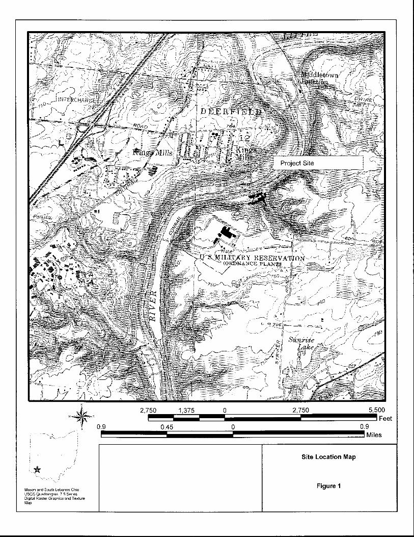
The Former Peters Cartridge Facility is located along the southern bank of the Little Miami River, in Warren County, Ohio. A site location map is included as Figure 1. The Site occupies approximately 71 acres located west of Grandin Road, and approximately one acre located east of Grandin Road. The Peters Cartridge facility operated from 1887 to 1944. During its operational period, the production of paper shot shell ammunition was the primary function of the facility. Metal cartridge ammunition was also produced during brief periods, primarily to support military efforts during World War I and World War II. Site operations included primer mixing and wad production, cupping and drawing of shell heads and casing cartridges, and shell/cartridge packing and assembly. Metals likely used in the manufacturing process included lead for shot and slugs, mercury (also called fulminate of mercury) for the primary ignition powder, and to a lesser extent copper and possibly nickel for plating casings. The Site has been the subject of multiple investigations. Contaminants of Interest (COIs) were identified based on historical Site operations and the results of the previous investigations (presented in the 2009 RIR). Copper, lead, and mercury were identified as COI for the Site; for areas where ash-like fill is known or suspected to be present, USEPA priority pollutant list (PPL) metals and PPL PAHs were also identified as COI. The results of the RI indicated that the highest concentrations of COI metals on-site occur in surface soils, and concentrations typically decline with depth. Site COI were also detected above-site specific background concentrations in ash-like fill. The majority of ash-like fill was encountered in the Former Process Area; however, discrete-ash-like fill was also encountered in the Lowland Area and northern portions of the Hamilton Township Property. COI in surface water and sediment generally reflected those in soil in the immediate vicinity of the stream channels. Limited groundwater impacts were observed.

09-CHR8231-5.2-Feasibility Study-Final Report.doc ES-2 23 June 2009
Risk Assessment
Following the characterization of the nature and extent of contamination, an evaluation was conducted to determine whether site-related contaminants pose a potential unacceptable risk to human health or the environment. A Human Health Baseline Risk Assessment (HHBLRA or HHRA), Screening Level Ecological Risk Assessment (SLERA), and Baseline Ecological Risk Assessment (BERA) were conducted for the Site. For the purposes of conducting the risk assessments and based on discussions with USEPA on July 11, 2007, the upland portion of the Site was divided into three Exposure Areas on the basis of habitat cover types, current land use, land parcel ownership, and anticipated future redevelopment. These areas are the Former Process Area, the Lowland Area, and the Hamilton Township Property. The Former Process Area and Lowland Area combined form a 15-acre parcel of improved land. The Former Process Area encompasses the remaining buildings which are currently leased to tenant organizations. The Lowland Area encompasses the Little Miami Scenic Trail, formerly the Little Miami Railroad (LMRR) which runs along the LMR. Current and past use, as well as ownership for Lowland Area, is distinct from the larger, former manufacturing portion. Predating the existence of the facility, the LMRR, now redeveloped and deeded to the Ohio Department of Natural Resources (Ohio DNR) for recreational use, was separate from operations of the Former Peters Cartridge Facility. The Hamilton Township property is a 56-acre upland area of unimproved wooded land. The parcel, which is currently vacant, was transferred to Hamilton Township in 2007. The Township plans to retain this area as open space. The results of the HHBLRA, SLERA, and BERA were used to provide information for the FS to support decisions concerning the need for further evaluation or action at individual AOCs, based upon current and reasonably anticipated future land use. The main findings of these evaluations are as follows:
• The HHBLRA indicates that there are no unacceptable cancer or non-cancer human health risks under current or future land use scenarios for the Little Miami River Scenic Trail in the Lowland Area. However, average levels of lead in Lowland Area surface soil exceed acceptable levels for relevant receptors (e.g., utility workers and recreators). Potential unacceptable cancer and non-cancer risks were identified for several current and future receptors in surface soil and subsurface soil at the Former Process Area and surface soil/swale soil at the Hamilton Township Property. In addition, average lead concentrations in surface soil also exceed acceptable levels for current/future receptors in the Former Process Area and Hamilton Township Property. Cancer risks at the Site were generally driven by arsenic and benzo(a)pyrene; non-cancer risks were generally driven by arsenic and antimony.

09-CHR8231-5.2-Feasibility Study-Final Report.doc ES-3 23 June 2009
Areas of unacceptable risks were primarily associated with the former process areas and the AOC9 drainage feature.
• Under current conditions, shallow groundwater is not used on Site for potable or industrial uses, including irrigation. In addition, shallow groundwater is at a depth where direct contact during intrusive activities would likely not occur. As a result, the potential for human exposure to this medium is limited. Cumulative non-cancer risk estimates for groundwater for site-related contaminants are below a threshold hazard index of 1. However there are potential carcinogenic risks which are driven by detections of arsenic at levels below the stipulated maximum contaminant level (MCL).
• The SLERA and BERA identified potential ecological risks at the Site based on exposure to soil/swale soil in the upland terrestrial portions of the Site, erosional material and surface water in the concrete-lined culverts, and sediment and surface water at the culvert outfalls along the shoreline of the Little Miami River. The 1999 and 2007 Ohio EPA Little Miami River studies demonstrated that Site related contaminants are not impacting ecological receptors in the River; however, the on-site drainage features have the potential to transport site-related to the sediment and surface water of the Little Miami River.
Remedial Action Objectives and Preliminary Remediation Goals
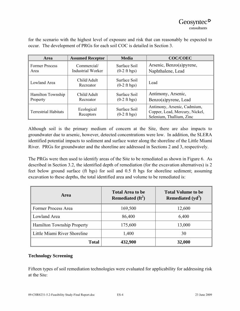
The HHBLRA, SLERA, and BERA provide risk managers with an understanding of the potential risks to human health and the environment posed by the Site and any uncertainties associated with the assessment. The next step, Risk Management, uses this information to determine the significance of the potential risks at the Site and whether or not, and how, the risks should be addressed (USEPA, 1989). It is not practical, feasible, or necessary to remove all contamination from a Site; however, using the results of the risk characterization, risk managers can develop media-specific goals (Remedial Action Objectives or RAOs) protective of human health and the environment. The site RAOs are summarized in Table 2. Preliminary Remediation Goals (PRGs) were then developed for relevant contaminants of concern (COCs) based on the land use scenarios which represent the scenario with the highest level of exposure and risk that can reasonably be expected to occur, under the assumption that residential land use of the properties will be restricted. Thus, PRGs for the Former Process Area are protective of commercial/industrial workers and PRGs for the Lowland Area and Hamilton Township Property will be protective of current/future recreators. Ecologically-based PRGs are based on the most protective among the assessment endpoints evaluated: for copper and lead – the short-tailed shrew, for mercury – the meadow vole. The table below presents the soil COCs
09-CHR8231-5.2-Feasibility Study-Final Report.doc ES-4 23 June 2009
for the scenario with the highest level of exposure and risk that can reasonably be expected to occur. The development of PRGs for each soil COC is detailed in Section 3.
Area Assumed Receptor Media COC/COEC
Former Process Area
Commercial/ Industrial Worker
Surface Soil (0-2 ft bgs)
Arsenic, Benzo(a)pyrene, Naphthalene, Lead
Lowland Area Child/Adult Recreator
Surface Soil (0-2 ft bgs) Lead
Hamilton Township Property
Child/Adult Recreator
Surface Soil (0-2 ft bgs)
Antimony, Arsenic, Benzo(a)pyrene, Lead
Terrestrial Habitats Ecological Receptors
Surface Soil (0-2 ft bgs)
Antimony, Arsenic, Cadmium, Copper, Lead, Mercury, Nickel, Selenium, Thallium, Zinc
Although soil is the primary medium of concern at the Site, there are also impacts to groundwater due to arsenic, however, detected concentrations were low. In addition, the SLERA identified potential impacts to sediment and surface water along the shoreline of the Little Miami River. PRGs for groundwater and the shoreline are addressed in Sections 2 and 3, respectively. The PRGs were then used to identify areas of the Site to be remediated as shown in Figure 6. As described in Section 3.2, the identified depth of remediation (for the excavation alternatives) is 2 feet below ground surface (ft bgs) for soil and 0.5 ft bgs for shoreline sediment; assuming excavation to these depths, the total identified area and volume to be remediated is:
Area Total Area to be Remediated (ft2)
Total Volume to be Remediated (yd3)
Former Process Area 169,500 12,600
Lowland Area 86,400 6,400
Hamilton Township Property 175,600 13,000
Little Miami River Shoreline 1,400 30
Total 432,900 32,000 Technology Screening
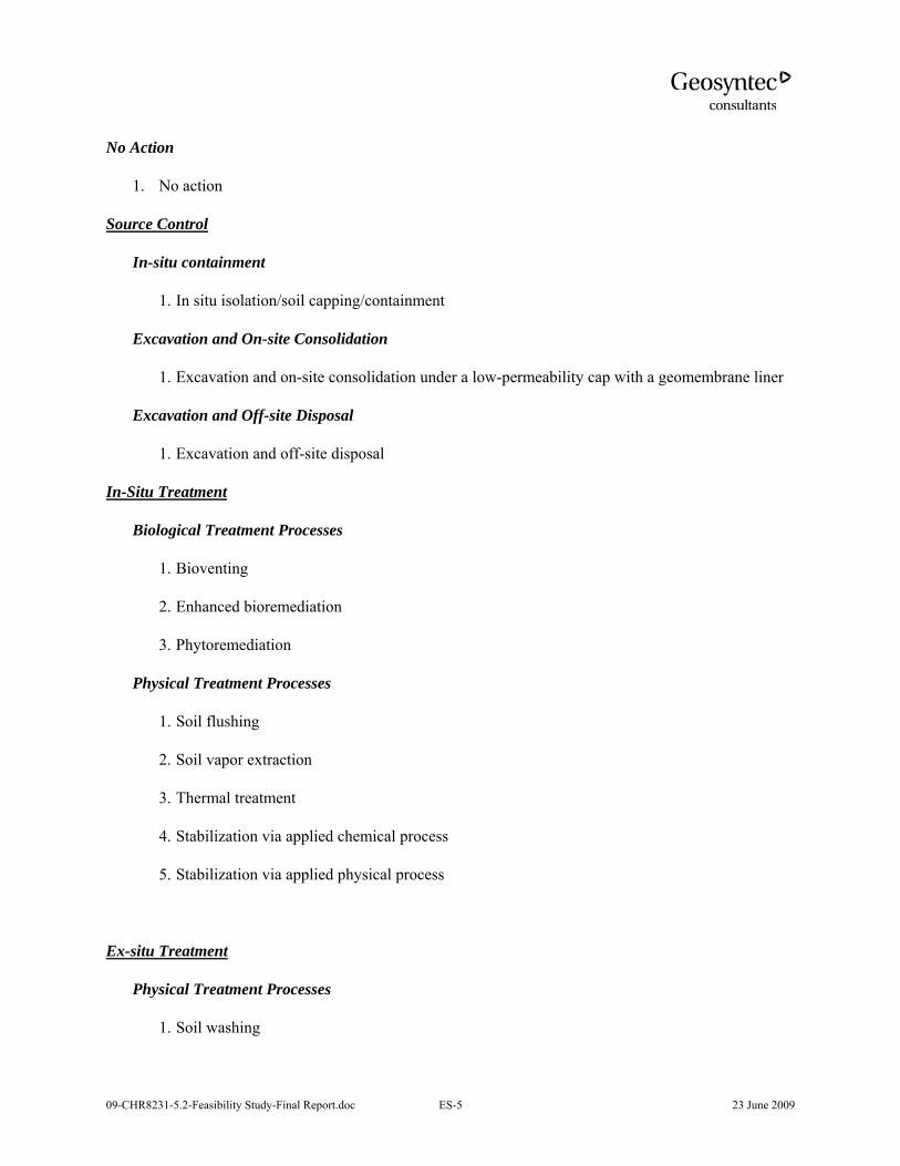
Fifteen types of soil remediation technologies were evaluated for applicability for addressing risk at the Site:
09-CHR8231-5.2-Feasibility Study-Final Report.doc ES-5 23 June 2009
No Action
1. No action
Source Control
In-situ containment
1. In situ isolation/soil capping/containment
Excavation and On-site Consolidation
1. Excavation and on-site consolidation under a low-permeability cap with a geomembrane liner
Excavation and Off-site Disposal
1. Excavation and off-site disposal
In-Situ Treatment
Biological Treatment Processes
1. Bioventing
2. Enhanced bioremediation
3. Phytoremediation
Physical Treatment Processes
1. Soil flushing
2. Soil vapor extraction
3. Thermal treatment
4. Stabilization via applied chemical process
5. Stabilization via applied physical process
Ex-situ Treatment
Physical Treatment Processes
1. Soil washing

09-CHR8231-5.2-Feasibility Study-Final Report.doc ES-6 23 June 2009
2. Electrochemical
In accordance with Guidance for Conducting Remedial Investigations and Feasibility Studies Under the Comprehensive Environmental Response, Compensation, and Liability Act (CERCLA) (USEPA 1988), the technologies were screened using a comparative evaluation against the following three of the nine CERCLA evaluation criteria:
1. Effectiveness
2. Implementability
3. Cost
A technology screening matrix is presented in Table 7. In this evaluation, the relative general effectiveness of the technologies and cost were considered. Specific site characteristics were considered for the implementability criterion.
Based on the evaluation in Table 7, four alternatives were recommended for consideration in the FS:
1. No action
2. Isolation/soil capping
3. Excavation and on-site consolidation under an engineered cap
4. Excavation and off-site disposal Alternatives Evaluation
Each of the four identified alternatives are described and evaluated against the nine CERCLA criteria. A tenth criterion, sustainability of the remedial action, was also used. The evaluation criteria are summarized and the alternatives are compared to each other in Tables 8, 9, and 10. Table 8 presents a graphical comparison of the alternatives while Table 9 presents a text description of the evaluation by criteria. Table 10 provides a summary of compliance of the alternatives with the identified Applicable or Relevant and Appropriate Requirements (ARARs). Based on this analysis, it is concluded that both Alternatives 3 and 4, combined with residential land use restrictions offer similar overall protection to human health and the environment. From a sustainability perspective, Alternative 3 is preferable to Alternative 4 as it results in a lower carbon footprint. However, from an implementability aspect, it is not clear if Alternative 3 would meet the approval of Hamilton Township which is the current owner of the property where the on-site consolidation area would be located. A decision on the disposal of impacted
09-CHR8231-5.2-Feasibility Study-Final Report.doc ES-7 23 June 2009
soil from excavations will be finalized during the RD phase based on discussion with Hamilton Township authorities. Remediation activities will also include culvert/outfall clean-out and excavation of the identified shoreline deltas to a depth of approximately 6-inches to prevent future impacts to the LMR. Remediation work will also include removal of debris in AOC-9, which was at one point considered for implementation as an interim remedial measure (IRM).

09-CHR8231-5.2-Feasibility Study-Final Report.doc 1-1 23 June 2009
1. INTRODUCTION
On behalf of Sporting Goods Properties, Inc., E.I. du Pont de Nemours and Company (DuPont) entered into an Administrative Order on Consent (referred to herein as the Order), effective July 7, 2004, with the U.S. Environmental Protection Agency (USEPA) for a Remedial Investigation and Feasibility Study (RI/FS) at the Former Peters Cartridge Facility in Warren County, Hamilton Township, Ohio (the Site). This Feasibility Study (FS) Report has been prepared based on the findings of the final Remedial Investigation Report (RIR) submitted in February 2009 and subsequent discussions between USEPA and DuPont. This FS Report was prepared to identify and evaluate potential remedial options to address contaminated soils at the Site. The FS report is divided into six sections with the following information:
• Section 1: Background Information
• Section 2: Results of the Baseline Risk Assessment
• Section 3: Remedial Action Objectives
• Section 4: Screening of Remedial Technologies
• Section 5: Identification and Evaluation of Alternatives
• Section 6: Conclusions and Recommendations
1.1 Objectives of the Feasibility Study
The purpose of the FS is to identify preliminary remediation goals (PRGs) and potential remedial alternatives, and to evaluate the ability of the alternatives to achieve the PRGs. The FS and information from the remedial investigation will be used by USEPA as the basis for selecting a remedy to mitigate potential threats to human health and the environment posed by the Site. This will be described as a Proposed Remedial Action Plan (PRAP) by the Agency. 1.2 Site Description
The Former Peters Cartridge Facility is located along the southern bank of the Little Miami River, in Warren County, Ohio. A site location map is included as Figure 1. The Site occupies approximately 71 acres located west of Grandin Road, and approximately one acre located east of Grandin Road. An aerial photograph showing the Site and vicinity features, area topography, and location of Grandin Road is included as Figure 2. A map showing land parcel ownership
09-CHR8231-5.2-Feasibility Study-Final Report.doc 1-2 23 June 2009
and exposure areas is included as Figure 3. A map showing the current site layout and the potential areas of concern evaluated in the RI is included as Figure 4. The Site is defined as the former operational areas of the facility including storage and handling locations for products and materials used in support of ordnance manufacturing. The Site consists of two distinct areas, Area A and Area B (see Figure 2). Area A is a fifteen-acre parcel of improved land, with approximately six buildings. Area A encompasses the production portion of the Site, where most manufacturing associated with the Peters Cartridge process took place. Area A also encompasses a smaller distinct area, the Little Miami Scenic Trail, formerly the Little Miami Railroad (LMRR). Current and past use, as well as ownership for this area is distinct from the larger, former manufacturing portion of Area A. Predating the existence of the facility, the LMRR, now redeveloped and deeded to the Ohio Department of Natural Resources (Ohio DNR) for recreational use, was separate from operations of the Former Peters Cartridge Facility. The LMRR service existed even before the Peters Cartridge facility was constructed and operated. Area B consists of a 56-acre parcel of unimproved wooded land on the southern and southwestern boundaries of Area A. Area B was used primarily for storage of finished product from the facility. 1.2.1 Site Ownership
From 1887 to 1934, the Peters Cartridge facility produced ordnance and shot shell ammunition. In 1934, the Remington Arms Company, Inc. (Remington) purchased the Peters Cartridge Co. and continued the production of shot shell and cartridge ammunition at the facility. In 1941, Remington renovated the Site and provided design assistance for the new Kings Mills Ordnance Plant (KMOP) to the U.S. Government under a program known as the “Unit Plan.” Located on land that formerly constituted a portion of the Peters Cartridge Facility, and what is now the U.S. Army Reserve Center, the new government-owned KMOP facility began production in 1942. Both the Remington and KMOP facilities manufactured .45-caliber carbine ammunition for less than a year. Thereafter, Remington and KMOP manufactured .30-caliber carbine ammunition until 1944, when operations at both sites were discontinued. Since 1944, the Former Peters Cartridge Facility has been divided into multiple land parcels that have been owned and occupied by various entities. From 1987 through 1991, LensCrafters conducted eyeglass frame manufacturing and optical lens coating operations in portions of Buildings R-3 and R-9. Today, Area A includes property parcels owned by Kings Mills Technical Center, Hamilton Township, TEJ Holdings, Inc., Little Miami, Inc., Ohio DNR, and Warren County Commissioners. Hamilton Township owns most of the property in Area B.

09-CHR8231-5.2-Feasibility Study-Final Report.doc 1-3 23 June 2009
Kings Mills Technical Center owns a small portion of Area B. Portions of Area A are currently in use by commercial or industrial businesses, as a public bike trail, or as a parking lot (east of Grandin Road). At the time this report was prepared, Area A business occupants/tenants included warehousing for large printing equipment; an acetylene tank reconditioning business; an instrument maker and a painter located in the west end of Building R-3; and an artist’s studio (painting, sculpting, etc.) located on the first and second floors, respectively, of Building R-9. The Kings Mills Technical Center property manager’s office is located in Building R-2. A metals scrapping/salvage company has operations in the outdoor area adjacent to the western end of Building R-1 and in a portion of the building. Area B, which is currently vacant, was transferred to Hamilton Township in 2007. The Township plans to retain this area as open space. This property, previously called the Lewis Property, is now referred to as the “Hamilton Township Property”. 1.2.2 Site Operational History
The Peters Cartridge Company was established in the late 1880s and began production during 1887 (Schiffer, 2002). The location for the company was chosen due to its proximity to both a material supplier (the Kings Mills Powder Company) and an operation rail line (the LMRR) (Black, 1940). The LMRR, established at this location in 1845 (Black, 1940) included a rail line that crossed through Area A between the main buildings and two rail spurs, one located near the river and one adjacent to Building R-21 at the northern corner of the Site. Concrete supports for the elevated spur still exist, shown in Figure 4. All rail lines have been removed, and a portion of the rail right-of-way has been redeveloped as the Little Miami Scenic Trail. The Peters Cartridge facility operated from 1887 to 1944. During its operational period, the production of paper shot shell ammunition was the primary function of the facility. Metal cartridge ammunition was also produced during brief periods, primarily to support military efforts during World War I and World War II. Site operations included primer mixing and wad production, cupping and drawing of shell heads and casing cartridges, and shell/cartridge packing and assembly. Metals likely used in the manufacturing process included lead for shot and slugs, mercury (also called fulminate of mercury) for the primary ignition powder, and to a lesser extent copper and possibly nickel for plating casings. The Peters Cartridge facility underwent a number of facility renovations and new construction. There have been no major changes in the type of manufacturing or the location of production at the Site. Site buildings and facility structures shown in the Site figures are identified using numbers and descriptions referenced in historical documents. Information on the buildings and facilities pertaining to historical use are provided in the RI Report.
09-CHR8231-5.2-Feasibility Study-Final Report.doc 1-4 23 June 2009
Historical data indicate that the main manufacturing processes were conducted in Area A and included shell assembly and inspection, the packing house and lab, the shot tower, machine shop and metal stores, a blacksmith shop, a lead bullet house, a primer house, shooting ranges, and a test center. Two other shooting galleries/ranges were historically located on-site. One was parallel to and east of Grandin Road near Building R-21, and the other was parallel to the river, on the northwest portion of the Site (see Figure 4). The earliest boilers were originally located in Buildings R-35 and R-58. When the new boiler house, R-19, was constructed in 1917, R-35 and R-58 were subsequently used for the manufacture of clay targets. From 1917 until operations ceased in 1944, R-19 was the main powerhouse, and contained engines and generators. Other facilities were adjoined to Building R-19, including water-softening equipment, steam driven fire pumps, and coal conveyor equipment. A water treatment system and boilers were also located between Buildings R-1 and R-19. R-36, located on the bank of the Little Miami River, housed pumps and chlorination equipment for treating water that the facility provided to the Village of Kings Mills, across the river. Salvage facilities were located on the northwestern corner of the Site. Employee facilities such as offices, medical facilities, and cafeteria were housed in Buildings R-1; Building R-16 housed a locker room. Throughout Area A, elevated walkways connected the majority of the main buildings and were used for conveyance of raw materials, products, and personnel. Support facilities were constructed throughout Area B. They included:
• shooting ranges;
• storage bunkers and magazine houses;
• conveyors;
• a fire water reservoir (currently backfilled);
• a pump house and sluice gate near the former reservoir on the central portion of the Site;
• process control houses; and
• primer mixer houses.
Walkways and supports for water, steam, and electric lines historically ran between Areas A and B and between the former Remington plant and KMOP Government plant sites. Remnants of the structures are still visible.
09-CHR8231-5.2-Feasibility Study-Final Report.doc 1-5 23 June 2009
1.2.3 Surrounding Land Use
The Site is bordered to the north by the Little Miami River (designated as a State and National Scenic River), to the west by a U.S. Army Reserve Center, to the south by the Warren County Water District water treatment plant, and to the east by a natural area owned by Ohio DNR. Residential and agricultural properties are located to the southeast. A zoning map showing property parcels and their associated zoning classification is included as Figure 5. Past manufacturing and industry in the immediate vicinity of the Site included:
• Gunpowder manufacturing from 1878 to 1958 by Kings Powder Co. along the north bank of the Little Miami River across from the Site;
• Munitions manufacturing at the KMOP government plant, located adjacent to the southern end of the Site; and
• Metals fabrication and painting operations by Diversified Products, Inc. at the former KMOP government plant.
Current industrial sites in the vicinity of the Former Peters Cartridge Facility include:
• The Warren County water treatment facility, adjacent to the southeast end of the Site (see Figure 4).
• The Lebanon regional wastewater treatment plant, located along the south side of the Mason-Morrow-Millgrove Road, approximately two miles upstream (northeast) of the Site. The wastewater plant discharges treated water directly into the Little Miami River under a National Pollution Discharge Elimination System (NPDES) permit issued by Ohio EPA.
• The former KMOP government facility, now occupied by both the U.S. Army Reserve Center and Diversified Products, Inc. Diversified Products is listed on the EPA’s CORRACTS database and is designated as a high priority corrective action site.
1.2.4 Site Investigations
A series of environmental investigations have been conducted at the Site, starting in 1987. These investigations have had varying data quality objectives and work scopes, and were primarily focused in the main manufacturing portion of the Site (Area A). A timeline of previous investigations and their scope is as follows:

09-CHR8231-5.2-Feasibility Study-Final Report.doc 1-6 23 June 2009
• 1987 – QSource Environmental Inc. conducted a site assessment to support a property transfer (QSource, 1987).
• 1990-1993 – Foppe Thelen Group, Inc (FTG) conducted additional investigations to evaluate the release of Freon-113 by LensCrafters to an on-site septic system.
• 1992 – Site was listed by Ohio EPA as a discovery site in 1992, and subsequently reported to the USEPA.
• 1993 – The Former Peters Cartridge Facility was the subject of a Preliminary Assessment (PA) conducted by Ohio EPA in 1993. LensCrafters completed clean-up actions under a closure plan approved by the Ohio EPA (Ohio EPA, 1992).
• 1994, 1996, and 1999 – PRC Environmental Management, Inc. (PRC) conducted several site-screening investigations/evaluations for USEPA.
• 2005-2009 – URS and Geosyntec conducted the Remedial Investigation (RI) associated with this FS. The RI was conducted in multiple phases, including field sampling events, and preparation of a Human Health Baseline Risk Assessment (HHBLRA), a Screening Level Ecological Risk Assessment (SLERA), and a Baseline Environmental Risk Assessment (BERA). The risk assessments, described in Section 2, form the basis for identifying the remedial needs and approach for the site. Historical data show that metals (copper, lead and mercury) in soil are the main contaminants of concern (COCs) at the Site. Impacts are generally confined to surface soils in the former manufacturing and storage areas.
1.2.5 Areas of Concern and Exposure Areas
Fourteen AOCs were identified at the Site as the Areas of Concern during the Remedial Investigation study. The RIR includes descriptions of each AOC. Locations of the AOCs are shown in Figure 4. Based on discussions with USEPA on July 11, 2007, the upland portion of the Site was divided into three Exposure Areas on the basis of habitat cover types, current land use, land parcel ownership, and anticipated future redevelopment. These areas are the Former Process Area, the Lowland Area, and the Hamilton Township Property. Former Process Area
The Former Process Area, in Area A in the northern portion of the Site, includes the main facilities historically used by the Peters Cartridge Company. Discontinuous areas of ash-like fill

09-CHR8231-5.2-Feasibility Study-Final Report.doc 1-7 23 June 2009
are present around the existing buildings. The majority of the Former Process Area is relatively flat and covered by concrete/asphalt paving, buildings, and small landscaped grass areas. Portions of the Former Process Area are currently used by commercial or industrial businesses; future land use is expected to remain commercial/industrial. The Lowland Area
The Lowland Area is included in Area A and includes the portions of the Site along the southern bank of the Little Miami River, within the Little Miami River floodplain. Steel fencing, thick vegetation, and steep topography along the southern border of the Scenic Trail effectively differentiate the Lowland Area from the remainder of the Site. The Little Miami River Scenic Trail (historical railroad right-of-way redeveloped as a bike and walking path) is included within the Lowland Area. North of the trail, the Lowland Area includes some historical manufacturing areas which are characterized by the presence of ash-like fill, concrete foundations, masonry structures, and concrete box culverts that drain surface water from the upgradient portions of the Site (“culvert outfalls”). The Lowland Area is characterized by steep banks and dense vegetation including a variety of woody and herbaceous species. In addition, the Lowland Area includes a narrow strip of the Little Miami River shoreline characterized by local bedrock outcropping and a shale limestone bottom substrate. Future land use in the Lowland Area is expected to remain recreational/open space. The Hamilton Township Property
The Hamilton Township Property, formerly the Lewis Property, includes Area B and a southwestern portion of Area A. It consists of steeply sloping bedrock ridges and rolling topography, also with dense vegetation. The Hamilton Township property contains bunkers, concrete supports, foundations, conveyance structures, and other facilities historically used by the Peters Cartridge Company. The salvage area at the northwestern portion of the Hamilton Township Property (i.e., in Area A) is unpaved and surrounded by steel fencing and mature woody and herbaceous vegetation. This area features buildings original to the former salvage yard; discontinuous areas of ash-like fill are present in the salvage area. The Hamilton Township Property is currently vacant; future land use is expected to be recreational. 1.3 Contaminants of Interest
In this section, the Contaminants of Interest (COI) that are discussed are limited to contaminants in soil. The RI concluded that the impact to surface water from site COI is insignificant; therefore, addressing surface water contamination as a remedial action is beyond the scope of this FS. Furthermore, while there are impacts to groundwater due to arsenic, detected concentrations were low. Groundwater will be discussed further in Section 3.

09-CHR8231-5.2-Feasibility Study-Final Report.doc 1-8 23 June 2009
COI at the Site were identified using information contained in previous investigations. Within the native soil, indentified COIs include copper, lead, and mercury. Ash-like fill materials identified as COI include PPL metals and PPL PAHs. For this FS, the following data obtained during the RI study have been used to define the nature and extent of soil contamination at the site:
• Soil samples, defined as either surface/swale soil (≤2 ft bgs) or subsurface soil (>2 ft bgs), were collected. Surface/swale-soil was collected from 29 locations within the Hamilton Township Property. Soil was also collected from 380 boring locations: 112 in the Former Process Area, 69 in the Lowland Area, and 199 in the Hamilton Township Property. Note that swale-soil was not present at the Former Process Area or Lowland Area.
• Erosional material, defined as solid media collected from within the concrete-lined portions of the on-site drainage features (culverts), was collected from six locations within the Former Process Area and one location within the Lowland Area. Due to the contents of these materials, which included eroded soils as well as miscellaneous debris and detritus materials, erosional materials were independently of soil/swale-soil.
• Sediment samples, defined as solid media collected from areas inundated with water, were collected from seven on-site locations located near the discharge points of the on-site drainage features and in close proximity to the Little Miami River. Unlike swale-soil and erosional material sampling locations, conditions at the sediment sampling locations were judged to be capable of supporting benthic macro invertebrates (which may or may not have been present).
1.4 Toxicity Characteristic Leaching Procedure (TCLP) - Soil Results
As part of the RI, samples were tested using the TCLP method and lead was not detected in any of the samples above the TCLP limit. No other metals were detected above their regulatory limits. Based on the analytical results, Site soil would be classified as a characteristic non-hazardous waste. 1.5 Contaminant Fate and Transport
The RI data indicate that soils at the Site are the main source of COI. There is limited impact to sediment, surface water, and groundwater. A discussion on the various factors that control the fate and transport of Site-related COI is given below.

09-CHR8231-5.2-Feasibility Study-Final Report.doc 1-9 23 June 2009
Soil
Manufacturing, storage and handling, and waste disposal practices led to soil contamination at the Site. The current potential for migration of Site-related COI from soils to other media is limited but includes the following:
• Airborne transport of particulates to downwind locations, generated by wind erosion of Site surface soils and physical disturbance of Site surface and subsurface soils;
• Overland transport of soil and sediment (including sediment of the Little Miami River) to downgradient surface water bodies during precipitation events; and
• Leaching of Site-related COI from surface/swale-soil and subsurface soil to shallow groundwater.
Airborne or overland transport of soil are unlikely mechanisms of migration at the Site because the majority of Area A is paved. In Area B, overland transport is confined to the narrow channels of deeply-incised ephemeral streams and is unlikely to move much material annually. Leaching is also an unlikely mechanism of migration at the Site. Soil geochemistry data from the RI indicate that a combination of neutral pH and high cation exchange capacity of soils results in metals at the Site being strongly bound to silt and clay sized particles within the native soils. Similarly, the organic content of the ash-like fill and surficial soils coupled with the low solubility and high sorption coefficients of PAHs has resulted in PAHs being bound strongly within the soil matrix. As a consequence, leaching of these contaminants into groundwater and/or dissolution into surface water is very limited. Leaching to groundwater is further inhibited at the Site by the extent of impermeable surfaces within Area A, along with the low vertical permeabilities of soils in this area. The topmost soils (surface to 10 feet) at the Site have been characterized as being predominately silts and clays. Geotechnical testing of these soils during the RI revealed vertical permeabilities that were typically less than 1 x 10⁻⁶ cm/s. As a consequence, even in the absence of paving, infiltration of water through native soils at this Site is limited. Sediment
As is the case with soils, overland or airborne transport are unlikely mechanisms of migration of sediments. Sediments in the river may be affected by surface water discharge. Overland runoff causes infrequent and miniscule discharge of COI into the river which may cause COI to concentrate in sediment at the discharge location. Surface water flow within the river may further move
09-CHR8231-5.2-Feasibility Study-Final Report.doc 1-10 23 June 2009
sediment downstream. While surface water itself is not recognized as a mass-transfer mechanism for dissolved phase Site-related COI, it is identified as the physical mode of transport for soil and sediment to the Little Miami River. Groundwater discharge to the Little Miami River was evaluated to see whether there was an impact to sediments in the River. Groundwater from the Site discharges to the Little Miami River. During dry periods, the Little Miami River is a gaining stream; during flood periods, it is a losing stream and serves to recharge the surficial aquifer in the immediate vicinity of the flood-stage riverbank. Aquifer testing conducted at the Site groundwater indicates that flux through the Site to the Little Miami River is approximately 3,236 gallons per day, which equates to 0.0097% of the base flow within the Little Miami River. Based on Site geochemistry, limited groundwater flux through the Site, and the low concentrations of soluble metals detected in downgradient monitoring wells located between the Site and the river (see Section 5.5), groundwater discharge to the Little Miami River is not expected to have a measurable effect on the river sediments. Surface Water
Surface water is not considered to be a significant potential migration pathway for Site-related COI. Extremely low concentrations of metals and PAHs have been detected in surface water samples collected at the Site, reflecting the low mobility in the soluble phase for both metals and PAHs. The highest metals concentrations in surface water were detected in the total rather than the dissolved phase. This suggests that the Site-related COI are bound to solids that are suspended in the surface water. Surface water samples collected downstream of the swale discharge points in the Little Miami River exhibited concentrations similar to upstream background samples. Groundwater
Groundwater discharge is not considered to be a significant potential migration pathway for Site-related COI because groundwater flux through the Site is limited and no COI were detected in downgradient monitoring wells located between the Site and the river.

09-CHR8231-5.2-Feasibility Study-Final Report.doc 2-1 23 June 2009
2. SUMMARY OF BASELINE RISK ASSESSMENTS
Following the characterization of the nature and extent of contamination, an evaluation was conducted to determine whether site-related COIs pose a potential unacceptable risk to human health or the environment. A baseline human health risk assessment (HHBLRA or HHRA), screening level ecological risk assessment (SLERA), and baseline ecological risk assessment (BERA) were conducted for the Former Peters Cartridge Facility. These reports were presented in Appendices J, K, and L, respectively of the Final RI Report submitted to USEPA on 26 February 2009. Summaries of these assessments are provided below. 2.1 Human Health Risk Assessment
The HHBLRA evaluated the potential exposure of human receptors to contaminants detected in environmental media at 14 areas of concern (AOCs) identified at the Former Peters Cartridge Facility. The objectives of the HHBLRA were to determine whether releases from AOCs pose unacceptable risks to human health under site-specific exposure conditions; and, to provide information for the FS to support decisions concerning the need for further evaluation or action at individual AOCs, based upon current and reasonably anticipated future land use. For the purposes of the HHBLRA and based on discussions with USEPA and Ohio EPA on 11 July 2007, the upland portion of the Site was divided into three Exposure Areas on the basis of habitat cover type, historical operations, current land use, land parcel ownership, and anticipated future redevelopment. These areas are: the Former Process Area, the Lowland Area, and the Hamilton Township Property1. Potential risks from exposure to soil/swale-soil, erosional material, sediment, and surface water were evaluated as relevant for each exposure area. Studies conducted by Ohio EPA in 1999 and 2007 showed that the Site has not had a significant impact on the adjacent Little Miami River. Therefore, with the exception of the surface water and sediments on the shoreline associated with the culvert outfalls, the sediment and surface water of the Little Miami River were not quantitatively evaluated. Potential risk from exposure to groundwater was evaluated on a site-wide basis. Shallow groundwater is not currently used as drinking water on-site or in the vicinity of the Site. The HHBLRA provided cumulative cancer risk estimates and non-cancer hazard indexes for potential receptors under current and reasonably anticipated future land uses, namely on-site commercial/industrial workers, utility workers, construction workers, trespassers, and recreators. In addition, a hypothetical residential scenario was evaluated in the Former Process Area and Hamilton Township Property to provide an upper-bound estimate of potential risk to assist in
1 The Hamilton Township Property was called the Former Lewis Property earlier in the project cycle. This property has since been conveyed to Hamilton Township; the term “Hamilton Township Property” is thus consistent with its current ownership and use.

09-CHR8231-5.2-Feasibility Study-Final Report.doc 2-2 23 June 2009
future on-site land use decisions. With its steep slopes and position in the Little Miami River flood plain, significant redevelopment of the Lowland Area is not expected to occur; therefore, residential redevelopment was not considered a reasonably foreseeable future land use. The HHBLRA supports the following conclusions:
• Under current conditions, shallow groundwater is not used on Site for potable or industrial uses, including irrigation. Drinking water for the Site and surrounding area is provided by the Warren County Water District. In addition, shallow groundwater is at a depth where direct contact during intrusive activities would likely not occur. As a result, the potential for human exposure to this medium is limited. Cumulative non-cancer risk estimates for groundwater for site-related contaminants are below a threshold hazard index of 1. However, there are potential carcinogenic risks which are driven by detections of arsenic at levels below the MCL.
• No unacceptable cancer or non-cancer health risks were associated with current or future exposure scenarios for the Lowland Area; however, average levels of lead in surface soil exceed acceptable levels for relevant receptors (i.e., utility workers and recreators). Potential cancer and non-cancer risks to shoreline fisherman from exposure to sediment and surface water were within the USEPA acceptable risk limits; average lead concentrations in sediment and maximum lead concentration in surface water are not likely to result in adverse health outcomes.
• For the Former Process Area, numerous exposure scenarios were evaluated. Under current land use exposure scenarios, there are no unacceptable cancer risks or non-cancer hazards to utility workers or trespassers. However, potential carcinogenic risk to commercial/industrial workers due to surface soil exposure slightly exceeded 1x10-
4. Average concentrations of lead in surface soil also exceed acceptable levels for current receptors. Arsenic, benzo(a)pyrene [B(a)P], and naphthalene are the primary cancer risk drivers.
• For future land use exposure scenarios in the Former Process Area, carcinogenic risks to commercial/industrial workers and aggregate residents exceed 1x10⁻⁴; non-carcinogenic hazard quotients exceed one for future construction workers and child residents. Average concentrations of lead in surface soil also exceed acceptable levels for future receptors. Arsenic, B(a)P, and naphthalene are the primary cancer risk drivers; arsenic, antimony, and mercury are the primary non-cancer risk drivers. Exposures which exceeded acceptable levels are related to surface soil except for potential future residential receptors, where exceedances occurred in both surface and subsurface soil.

09-CHR8231-5.2-Feasibility Study-Final Report.doc 2-3 23 June 2009
• A number of exposure scenarios were also evaluated for the Hamilton Township Property. No unacceptable cancer or non-cancer risks were identified for subsurface soil; average lead concentrations in subsurface soil are not likely to result in adverse health outcomes. Potential for unacceptable carcinogenic risks or non-cancer hazards were calculated for all the exposure scenarios developed for the Hamilton Township Property. The cancer risks ranged from a low of 4.4x10⁻⁵ for the construction worker to a high of 3.2x10⁻³ for the aggregate resident. Non-cancer hazards ranged from a low of 2.3 for the utility worker to a high of 76 for a child resident. In addition, average lead concentrations in surface soil exceed acceptable levels for current and future receptors. Cancer risks were driven by arsenic and PAHs; non-cancer hazards were driven by arsenic and antimony. Areas of potential unacceptable risk were primarily associated with the former process areas and the AOC-9 drainage feature.
In summary, the risk assessment shows the potential for unacceptable human health risks at each of the exposure areas evaluated under current and reasonably anticipated future land uses; Table 1 summarizes the receptor/exposure scenarios evaluated for soil and groundwater which resulted in unacceptable risk. There were no unacceptable human health risks from exposure to surface water and sediment at the Site. The HHBLRA was conducted with the assumption of future residential land use; however, this conservative assumption is unwarranted for the Site. Future land use within the Former Process Area is expected to remain commercial/industrial. Future land use in the Lowland Area, which consists of the public bike trail and Little Miami River floodplain, is expected to remain recreational/open space. Hamilton Township has indicated the intent is to leave the Hamilton Township Property as open space to be used as recreational/open space similar to the Lowland Area. 2.2 Baseline Ecological Risk Assessment
The Site was divided into four ecological exposure areas based on current and future land use and habitat areas to facilitate the evaluation (Former Process Area, Lowland Area (including the shoreline deltas along the Little Miami River), Hamilton Township Property, and the unnamed creek). The BERA evaluated potential ecological risks for current/future soil invertebrates, mammalian herbivores, mammalian invertivores, and avian carnivores exposed to soil/swale soil in the terrestrial portions of the Former Peters Cartridge Facility and sediment in the unnamed creek. Ecological exposure to materials in the concrete-lined culverts and at their outfalls (referred to herein as the shoreline deltas) along the Little Miami River was evaluated in the SLERA. The SLERA and BERA support the following conclusions:
09-CHR8231-5.2-Feasibility Study-Final Report.doc 2-4 23 June 2009
• No potential unacceptable ecological risks were identified in the unnamed creek sediments.
• Concentrations of antimony, arsenic, cadmium, nickel, selenium, thallium, and zinc have the potential to result in adverse ecological effects to current/future terrestrial receptors on a limited spatial scale. Concentrations of these metals with the highest probability in resulting in adverse effects to ecological receptors are generally associated with the Former Salvage Area (AOC-1).
• Because the spatial extent of antimony, arsenic, cadmium, nickel, selenium, thallium, and zinc is spatially limited, population-level or food-web ecological effects as a result of exposure to PPL metals in Site soil/swale soil are unlikely. However, hot spots for antimony, arsenic, and zinc were identified and will be addressed as described herein.
• Based on magnitude and spatial extent, copper, lead, and mercury in Site soil/swale soil make the most significant contribution to overall risk to current/future terrestrial receptors at the Site. For copper and lead, short-tailed shrews represent the most sensitive assessment endpoint evaluated at the Site; for mercury, meadow voles represent the most sensitive assessment endpoint evaluated at the Site (see Attachment 1).
• On-site drainage features, including the AOC-9 drainage swale, contain levels of contaminants that exceed ecological screening levels and have the potential to transport site-related contaminants to other areas of the Site and off-site via surface water and stormwater runoff.
Ecological risks as a result of direct exposure to environmental media at the culvert outfalls along the shoreline of the Little Miami River were not quantitatively evaluated in the BERA. However, the SLERA concluded the following:
• There is a potential for adverse ecological effects to benthic and aquatic receptors from metals and PAHs in sediment and water at the culvert outfalls.
• The 1999 and 2007 Ohio EPA Little Miami River studies demonstrated that Site related contaminants are not impacting ecological receptors in the River. However, based on the screening level assessment of environmental media in the drainage features, there is a potential for adverse ecological effects to aquatic receptors in the river from site-related materials.
09-CHR8231-5.2-Feasibility Study-Final Report.doc 2-5 23 June 2009
Table 1 summarizes the contaminants evaluated in the BERA for soil which resulted in unacceptable ecological risk. The SLERA indicated that sediment and surface water along the shoreline of the Little Miami River associated with the culvert outfalls has the potential to result in adverse ecological effects to benthic receptors. Elevated concentrations of site-related contaminants in the culvert outfalls will be addressed by removing on-site sources that contribute to elevated concentrations in surface water discharged from the Site. Preliminary Remediation Goals (PRGs; see Section 3) for sediment at the outfalls will be developed in this FS to establish a basis for the extent of remediation along the shoreline such that the transport of outfall material to downstream ecological habitats in the Little Miami River is mitigated. However, during the pre-design phase, these PRGs may be refined using site-specific ecological endpoints. Potential remedial technologies and alternatives to address risks from this exposure pathway are discussed in Section 5.

09-CHR8231-5.2-Feasibility Study-Final Report.doc 3-1 23 June 2009
3. REMEDIAL ACTION OBJECTIVES
The HHBLRA, SLERA, and BERA provide risk managers with an understanding of the potential risks to human health and the environment posed by the Site and any uncertainties associated with the assessment. The next step, Risk Management, uses this information to determine the significance of the potential risks at the Site and whether or not, and how, the risks should be addressed (USEPA, 1989). It is not practical, feasible, or necessary to remove all contamination from a Site; however, using the results of the risk characterization, risk managers can develop media-specific goals (Remedial Action Objectives or RAOs) protective of human health and the environment. Additionally, to the extent practicable, remedial actions must comply with the requirements of federal, state, and local environmental laws. These requirements are referred to as Applicable or Relevant and Appropriate Requirements (ARARs). ARARs are identified on a site-specific basis by determining whether a regulation is applicable. Those considered applicable would include remedial standards and promulgated requirements or limitations that address a specific problem or situation at the site. If it is not applicable, then it is determined whether it is relevant and appropriate. While not applicable to site conditions, the requirements may be sufficiently similar to warrant their use, hence, relevant and appropriate. ARARs for the Site have been identified and are provided in Attachment 2. In addition to ARARs, state and federal advisories may exist. Since these are not binding as promulgated regulations, they are referred to as “to be considered” (TBCs). TBCs are not required to be complied with, but may be considered in the absence of specific requirements. 3.1 Development of Human Health RAOs
RAOs are intended to provide a framework for risk managers to evaluate and select alternative regulatory and non-regulatory response action to address potential risk at the Site. Each RAO addresses contaminants of concern (COCs), media of concern, and receptors to be protected, and develops preliminary remediation goals (PRGs) for specific chemicals in environmental media that are protective of human health and the environment that are specific to the unique Site conditions including established or reasonably foreseeable land use. 3.1.1 Contaminants and Media of Concern
This HHBLRA provided cumulative cancer risk estimates and non-cancer hazard indices (HIs) for potential receptors under current and reasonably anticipated future land uses, namely on-site commercial/industrial workers, utility workers, construction workers, trespassers, and recreators. In addition, a hypothetical residential scenario was evaluated in the Former Process Area and Hamilton Township Property to provide an upper-bound estimate of potential risk to assist in
09-CHR8231-5.2-Feasibility Study-Final Report.doc 3-2 23 June 2009
future on-site land use decisions. With its steep slopes and position in the Little Miami River flood plain, significant redevelopment of the Lowland Area is not expected to occur; therefore, residential redevelopment was not considered a reasonably foreseeable future land use. Risk results were compared to USEPA’s acceptable risk range of one in ten thousand (1 x 10⁻⁴) to one in one million (1 x 10⁻⁶) cumulative excess cancer risk, and an HI of 1 for groups of toxicants that affect the same target organ as decision points for identifying units of potential concern (USEPA, 1989). It should be noted that, while the HHBLRA presented some receptor/analytes which resulted in a calculated HI equal to 1, these have not been carried forward into the FS, as they are not above the EPA limit of 1. Potential risks associated with lead were evaluated through the prediction of blood lead concentrations. Lead was retained as a COC where average exposure concentrations that have an estimated risk of greater than 5% of exceeding a 10 μg/dl blood lead level (PbB). As presented in Table 1, the HHBLRA identified the following COCs (for at least one receptor):
• Former Process Area: antimony, arsenic, lead, mercury, B(a)P, and naphthalene;
• Lowland Area: lead; and
• Hamilton Township Property: antimony, arsenic, lead, mercury, and B(a)P.
The results of the HHBLRA indicated that surficial soil was the primary medium of concern for the Site; human health risks from groundwater and subsurface soil were limited to hypothetical future residential scenarios. RAOs focus on preventing human exposure to COCs at concentrations that pose unacceptable risk based on current and anticipated future land use. RAOs for the Site are presented in Table 2. Further discussion of risk management used during development of the RAOs and PRGs is presented in the following sections. 3.1.2 Land Use and Relevant Receptors
The Site is zoned M-2 Heavy Industry. Adjacent properties are also zoned M-2, with the exception of one boundary parcel on the southeast side of the Site, which is zoned R-1 Single Family Residential, and one parcel directly to the east, which is zoned M-1 Light Industrial. Current industrial sites in the vicinity of the Site include the Warren County water treatment facility, the Lebanon regional wastewater treatment plant, and the former KMOP government plant paint manufacturing facility site (now the U.S. Army Reserve Center) which is listed in State and Federal environmental databases as a hazardous waste treatment, storage, and disposal facility, and is designated as a high priority corrective action site.
09-CHR8231-5.2-Feasibility Study-Final Report.doc 3-3 23 June 2009
According to the NCP, “sites that are surrounded by operating industrial facilities can be assumed to remain as industrial areas unless there is an indication that this is not appropriate.” Thus, the Site setting and zoning designations preclude residential land use at the Site; other land uses are more appropriate. The assumed land use for each Exposure Area and its basis are as follows:
• Former Process Area – Portions of the Former Process Area are currently occupied and/or in use by commercial or industrial businesses (main building area) or as a parking lot (east of Grandin Road). At the time this report was prepared, business occupants/tenants included an acetylene tank reconditioning business located in the west end of Building R-3 and a cabinet manufacturer and an artist’s studio (painting, sculpting, etc) located on the first and second floors, respectively, of Building R-9. The Kings Mills Technical Center property manager’s office is located in Building R-2. A metals scrapping/salvage company has operations in the outdoor area adjacent to the western end of Building R-1 and in a portion of Building R-1. Given the Site’s industrial setting and the fact that commercial/industrial businesses are currently present, the probability that the Former Process Area will support residential land use in the future is small. Therefore, commercial/industrial land use is considered the scenario with the highest level of exposure and risk that can reasonably be expected to occur.
• Lowland Area – The Lowland Area includes the portions of the Site along the southern bank of the Little Miami River, within the Little Miami River floodplain. The Little Miami River Scenic Trail (historical railroad right-of-way redeveloped as a bike and walking path) is included within the Lowland Area. Given its narrow dimensions, steep slopes, and position within the Little Miami River floodplain, large-scale redevelopment (including residential or commercial/industrial redevelopment) of the Lowland Area is unlikely to occur. In addition, the adjacent commercial/industrial land use also tends to preclude residential land use. Therefore, future land use in the Lowland Area is expected to remain recreational/open space; a recreational exposure scenario is the scenario with the highest level of exposure and risk that can reasonably be expected to occur.
• Hamilton Township Property – The Hamilton Township Property is currently vacant. One boundary parcel located southeast of the Hamilton Township Property is zoned R-1 Single Family Residential; however, similar to the Former Process Area and Lowland Area, the surrounding industrial land use and historical industrial operations tend to preclude residential redevelopment. Hamilton Township has indicated that this property will remain as recreational/open space.

09-CHR8231-5.2-Feasibility Study-Final Report.doc 3-4 23 June 2009
PRGs will be developed for the COCs described in the following section based on the land use scenarios described above which represent the scenario with the highest level of exposure and risk that can reasonably be expected to occur. Thus, PRGs for the Former Process Area are protective of commercial/industrial workers and PRGs for the Lowland Area and Hamilton Township Property are protective of current/future recreators. These PRGs were developed under the assumption that residential land use at the Site will be restricted through the use of institutional controls. 3.1.3 Human Health Preliminary Remediation Goals – Soil
Consistent with the land use scenarios described in the previous section, soil PRGs for the Former Process Area were developed to be protective of current/future commercial/industrial workers and soil PRGs for the Lowland Area and Hamilton Township Property were developed to be protective of current/future recreators. Assuming these land uses/receptors, PRGs were developed for the COCs:
• Former Process Area: arsenic, lead, B(a)P, and naphthalene;
• Lowland Area: lead; and
• Hamilton Township Property: antimony, arsenic, lead, and B(a)P.
With the exception of lead (discussed below), risk-based cleanup goals were calculated for all COCs for the assumed exposure pathway as: PRG = Target Risk x Exposure Point Concentration Calculated Risk EPA manages carcinogens and non-carcinogens differently in that risk from carcinogens may fall within a 1 x 10⁻⁶ to 1 x 10⁻⁴ range, whereas risks from non-carcinogens must generally fall below a threshold HQ of 1. As described in the previous section, a cumulative 1 x 10⁻⁴ risk level and target organ HI of 1 were used as “triggers” for identifying receptor-exposure scenarios of concern. As presented in Table 3, three of the potential PRGs are based on theoretical carcinogenic effects, correlating to different target risk levels of 1 x 10⁻⁶, 1 x 10⁻⁵, and 1 x 10⁻⁴, spanning USEPA’s designated target risk range. A potential PRG based on USEPA’s target HQ of 1 is also presented for non-cancer health effects. These PRGs represent chemical concentrations in soil/swale soil that are considered protective of relevant receptors over a lifetime. Table 3 also presents several additional values for consideration in selecting PRGs including the site-specific background, state-promulgated standards, and analytical limits. Analyte-specific discussions of the PRGs are presented in the following sections.

09-CHR8231-5.2-Feasibility Study-Final Report.doc 3-5 23 June 2009
Soil PRG – Lead
Potential risks associated with lead are evaluated through the prediction of PbB. For non-residential exposures, the Adult Lead Model was developed by the USEPA as a method of relating soil lead intake to PbB concentrations in women of childbearing age (USEPA, 1996b). Using this model, a site-specific acceptable average concentration range of approximately 700-1,700 mg/kg was developed for commercial/industrial workers at the Former Process Area. The USEPA default non-residential soil remediation goal is 800 mg/kg. The USEPA has identified an unrestricted use soil remediation goal of 400 mg/kg met as an average soil concentration across the site. Given that children are likely to be present at the Lowland Area and Hamilton Township Property, this unrestricted use goal was adopted as the risk-based value for these Exposure Areas. Above this level the USEPA has indicated that children may be at risk of having elevated PbB. This value was derived via the USEPA Integrated Exposure Uptake Biokinetic (IEUBK) model for lead in children and standard conservative assumptions regarding exposure of children to soil in a residential setting. Soil PRG - Arsenic
Although arsenic was identified as contributing to risk at many of the AOCs, detected concentrations were often below the site-specific background, established in the RI Report, of 20.57 mg/kg. This suggests that risks associated with exposure to arsenic in soil are largely a result of naturally-occurring arsenic and not due to site-related activities. As a result, the inclusion of arsenic in the risk characterization calculations overestimates cancer risk estimates due to Site releases for the exposure scenarios evaluated. The contribution of naturally-occurring background to total Site risks is accounted for by selecting a background value as the arsenic PRG. Also note, the background value is within the USEPA acceptable risk range of 1 x 10⁻⁶ to 1 x 10⁻⁴ for both commercial/industrial workers and recreators. Soil PRGs – Other Carcinogens (Benzo(a)pyrene & Naphthalene)
For human health, B(a)P is a primary carcinogenic risk driver in the Former Process Area and Hamilton Township Property. No unacceptable carcinogenic risks were identified in the Lowland Area. As shown in Table 3, naphthalene (a Class C carcinogen) was also identified as contributing to overall carcinogenic risks in the Former Process Area; however, this is due to a single location (AOC3-017) with a concentration of 120 mg/kg. AOC3-017 also represents the highest B(a)P concentration; therefore, cancer risks from naphthalene will likely be addressed through the remediation of B(a)P to acceptable levels. A commercial/industrial worker scenario was assumed for the Former Process Area and a recreational exposure scenario was assumed for the Hamilton Township Property. EPA assumes
09-CHR8231-5.2-Feasibility Study-Final Report.doc 3-6 23 June 2009
that there is some increased cancer risk at every dose level; therefore, incremental lifetime cancer risks to recreators were evaluated by summing the risks for child and adult recreators. Conversely, EPA assumes non-carcinogenic risk is an event-driven phenomena and not a result of exposure over a lifetime; therefore, non-cancer hazards to recreators were based on the more sensitive child receptor. PRGs which correspond to target risk levels of 1 x 10⁻⁶, 1 x 10⁻⁵, and 1 x 10⁻⁴ are presented in Table 3. As a point-of-departure for managing carcinogenic risks from B(a)P (and naphthalene) at the Site, sample locations with concentrations resulting in an ILCR greater than 1x10⁻⁵ will be targeted for remedial action. Given the limited number of carcinogenic COCs, managing individual carcinogens at a 1 x 10⁻⁵ risk level will result in a cumulative risk within the USEPA acceptable risk range. As shown in Table 3, the selected PRGs are 2.1 mg/kg and 0.26 mg/kg for the Former Process Area and Hamilton Township Property, respectively. Soil PRGs – Non-Carcinogens
COCs with non-carcinogenic endpoints identified in the HHBLRA include antimony, arsenic, and naphthalene. As described in the previous sections, the selected PRGs for arsenic and naphthalene are based on background and carcinogenic endpoints, respectively; however, these PRGs are also protective of potential non-cancer effects. For non-carcinogens, EPA generally uses a target HI of 1 for groups of toxicants that affect the same target organ as a decision point for further investigation. The primary target organs/systems of the non-carcinogenic COCs are as follows:
• Antimony – blood;
• Arsenic – dermal/cardiovascular system; and
• Naphthalene – respiratory system.
Because the non-carcinogenic COCs do not affect the same target organs/systems, a PRG based on a target HQ of 1 for individual COCs is considered protective of human health. 3.1.4 Groundwater RAOs and PRGs
Under current conditions, shallow groundwater is not used on Site for potable or industrial uses, including irrigation. The RI Report provided hydrogeologic data indicating that groundwater yield for a well installed on-site would be insufficient for a potable, industrial, or irrigation well. In addition, shallow groundwater is at a depth where direct contact during intrusive activities would not occur. As a result, the potential for human exposure to this medium is limited. The
09-CHR8231-5.2-Feasibility Study-Final Report.doc 3-7 23 June 2009
target-organ non-cancer HIs for site-related contaminants of concern in groundwater are below the USEPA threshold HI of 1. However, there are potential carcinogenic risks which are driven by detections of arsenic at levels below the MCL. The RAO for groundwater focuses on preventing human ingestion of groundwater with concentrations of arsenic above the PRG; the PRG for arsenic is the Federal MCL (Table 4). Thus, no active remedial actions are necessary to address groundwater. 3.1.5 Management of Ecological Risk
As described in the previous sections, the development of PRGs for the protection of human health is largely dependent on land use scenarios in that land use determines activities, which determine exposure. For ecological receptors, however, exposure pathways are not dependent on land use unless a Site (or Exposure Area) offers no suitable habitat. As described in the BERA, suitable ecological habitat in the Former Process Area is highly limited due to the commercial/industrial operations; however, the Lowland Area and Hamilton Township Property do provide suitable habitat for terrestrial receptors. Contaminants of ecological concern (COECs) in surface soil were identified as contaminants with a “lowest observable effect level” (LOAEL) hazard quotient (HQ) greater than or equal to one. However, based on the limited spatial distribution and resulting low risk to populations of future ecological receptors, the risk to terrestrial receptors from arsenic, antimony, cadmium, nickel, selenium, thallium, and zinc do not represent unacceptable ecological risk. Therefore, terrestrial COECs evaluated in the FS are limited to copper, lead, and mercury. Similar to human health, surface soil is the primary media of concern for COECs. The RAOs for ecological receptors focus on preventing exposure to copper, lead, and mercury at concentrations that pose unacceptable risks to populations of ecological receptors. Refinement of Ecological Risk Estimates
Just as the BERA refined ecological risk estimates presented in the SLERA, the FS refines the ecological risk estimates presented in the BERA. In order to further refine the ecological risk estimates, the assumptions used to calculate ecological risks were reviewed and modified as follows:
• A soil-to-plant BAF of 0.344 was selected; this value is the geometric mean uptake factor for whole plants reported by Bechtel Jacobs Company (1998).
• A soil-to-small mammal BAF of 0.192 was selected; this value is the 90th percentile literature-derived soil-to-small mammal uptake factor for mercury for general trophic groups (presented in Table 7 of Sample et al., 1998). Sample also provides a mean
09-CHR8231-5.2-Feasibility Study-Final Report.doc 3-8 23 June 2009
uptake factor of 0.1244; however, to retain the conservative nature of the ecological risk assessment through the FS, 0.192 was selected as the soil-to-small mammal BAF.
Attachment 1 presents the inputs and refined ecological risk estimates based on the maximum or 95% UCL site-wide exposure point concentration. Based on these refinements, no unacceptable ecological risks were identified for the American kestrel; the maximum calculated ecological risks (and their basis) for COECs in the upland portions of the Site are as follows:
• Copper: LOAEL HQ = 186 (short-tailed shrew);
• Lead: LOAEL HQ = 82 (short-tailed shrew); and
• Mercury: LOAEL HQ = 10 (meadow vole).
Preliminary Remediation Goals – Contaminants of Ecological Concern
Similar to human health, ecologically-based PRGs were calculated for copper, lead, and mercury as follows, assuming a target LOAEL HQ of 1: PRGECO = Target LOAEL HQ x Exposure Point Concentration Calculated Risk Table 5a presents the refined maximum ecological risks, ecologically-based PRGs, and selected PRGs; these values (and their basis) for surface soils are as follows:
• Copper: 291 mg/kg (short-tailed shrew LOAEL HQ of 1);
• Lead: 2,647 mg/kg (short-tailed shrew LOAEL HQ of 1); and
• Mercury: 85 mg/kg (meadow vole LOAEL HQ of 1).
Threatened and Endangered Species
As noted in the BERA, no threatened, endangered, or rare species have been observed on or near the Site during the RI or previous Site assessments [PRC Environmental Management, Inc. (PRC), 1994; 1996]. However, as indicated in a letter from the U.S. Fish and Wildlife Service dated 25 January 2006 (Attachment 5), the Site lies within the range of the following threatened or endangered species described below. A brief description of the species preferred habitats is also provided.

09-CHR8231-5.2-Feasibility Study-Final Report.doc 3-9 23 June 2009
• Indiana bat (Myotis sodalist), Federally-listed endangered species – Summer habitats of the Indiana bat include dead or live trees with peeling or exfoliating bark, split tree trunks and/or branches, or civilities. Trees with exfoliating bark such as shagbark hickory (Carya ovate) and red oak (Quercus rubra) have been observed at the Hamilton Township Property. However, the primary areas targeted for remediation are located adjacent to the Former Process Area (AOC1 and AOC4) where vegetative cover tends to be dominated by understory vegetation or overstory saplings not suitable for the Indiana bat. Furthermore, remedial actions will primarily focus on soil; significant tree removal is not likely to be necessary. If remedial activities will impact a significant number of mature trees or associated habitats, further consultation with USFWS will be necessary.
• Running buffalo clover (Trifolium stoloniferum), Federally-listed endangered species – This species is found in partially shaded woodlots, mowed areas, and along streams and trails. However, this species requires periodic disturbance and somewhat open habitat to successfully flourish, but it cannot tolerate full-sun, full-shade, or severe disturbance. Given the long history of industrial operations at the Site and resultant disturbance, this species is not expected to be present on-site. However, on-site surveys to identify buffalo clover will be conducted during the pre-design phase.
• Eastern massasauga (Sistrurus catenatus catenatus), Federal candidate species; Ohio endangered species – This rattlesnake species is found in or near wet areas, including wetlands, wet prairie, or nearby woodland or shrub edge habitat. They avoid open water and seem to prefer the cover of broad-leafed plants, emergents, and sedges. The on-site habitats, including the Little Miami River shoreline, are not considered suitable for this species.
• Rayed bean mussel (Villosa fabilis), Federal candidate species – This mussel species has been recorded in the Little Miami River. However, no remedial actions are being conducted within the River. Remedial actions are not expected to adversely impact potential habitats for this species.
While conducting remedial activities at the Site, every effort will be made to avoid disturbance or removal of habitats associated with the listed species described above. 3.1.6 Shoreline Sediment and Deltas
The results of the LMR study conducted by Ohio EPA in 2007 showed that the Site has not had a significant impact on the River. Also, the results of the BERA showed that there is no ecological risk associated with the unnamed creek. However, the SLERA indicated that sediment and

09-CHR8231-5.2-Feasibility Study-Final Report.doc 3-10 23 June 2009
surface water along the shoreline of the Little Miami River associated with the culvert outfalls has the potential to result in adverse ecological effects to benthic receptors. There is a potential for site-related contaminants in upland soil/swale soil and erosional/depositional material to migrate off-site to the Little Miami River via the on-site drainage features. Therefore, transport of these materials to the sediment and surface water of the River will be addressed. Accordingly, the RAO for the shoreline sediments and deltas will be to prevent exposure of aquatic receptors to contaminants of ecological concern in the Little Miami River by limiting migration of site-related contaminants in depositional material in the channelized outfalls and deltas bordering the Little Miami River. Elevated concentrations of site-related contaminants in the culvert outfalls will be addressed by removing on-site sources that contribute to elevated concentrations in surface water discharged from the Site. PRGs for sediment at the outfalls were developed to establish a basis for the extent of remediation along the shoreline such that the transport of outfall material to downstream ecological habitats in the Little Miami River is mitigated. COPECs identified in the outfall material in the SLERA included arsenic, lead, mercury, and PAHs. Ecological risks identified in the SLERA associated with outfall sediment were not further evaluated in the BERA. Consequently, ecological PRGs for these contaminants were established as literature-based sediment quality guidelines. PRGs were identified for arsenic, lead, mercury, and B(a)P (Table 5b). A PRG for B(a)P was selected among the PAHs exceeding screening levels to be representative of sediment PAH concentrations. Note: during the pre-design phase, these PRGs may be refined, if necessary, using site-specific ecological endpoints. The potential remedial approach to address risks from this exposure pathway is discussed in Section 5.3.2. 3.2 Definition of Remedial Action Areas
The selected soil PRGs which will be applied during site remediation considered both the human health and ecological PRGs developed in Tables 3 and 5, respectively. Table 6 provides a summary of the PRGs and their basis. Applying these PRGs, the Site data was reviewed to develop a streamlined approach for remediation at the Site. The data review indicated that lead is the most prevalent risk-driver at the Site (i.e., lead exceeds the selected PRGs at more locations than the other COCs). Because site-related contaminants tend to be co-located, addressing lead will also tend to address the unacceptable risks associated with other COCs/COECs. The general remediation process to be followed is to use lead as a sentinel compound for identifying areas for targeted remediation and then assess what, if any, additional remedial actions will be required to meet the RAOs for human health from other COCs and then to protect populations of ecological receptors. This general process, which is described in further detail for each Exposure Area in the following sections, is as follows:
09-CHR8231-5.2-Feasibility Study-Final Report.doc 3-11 23 June 2009
1. Identify potential locations for remediation based on exceedances of the lead PRGs (i.e., 800 mg/kg in the Former Process Area and 400 mg/kg in the Lowland Area and Hamilton Township Property).
2. Of the remaining locations, identify potential locations for remediation based on receptor-specific human health PRG exceedances.
3. Of the remaining locations, identify potential locations for remediation based on ecologically-based PRG exceedances and the potential for population-level effects as a result of these exceedances.
4. During pre-design activities, collect pre-construction confirmation samples at the margins of the potential remedial locations identified in steps 1 through 3. The confirmation samples will be used to refine the estimated areal extent required for capping or excavation of soils that do not meet the final PRGs presented in Table 6. Recommended areas for additional sampling include the shoreline of the Little Miami River near the drainage outfalls, the streamline channels in the upland areas, and the steep slopes on the Hamilton Township property and the Former Process Area where remedial construction is likely to be the most disruptive to the existing ecosystem.
Based on the results of the risk assessments, the identified depth of remediation (for the excavation alternatives) is 2-ft bgs. No unacceptable human health risks were identified for current or future exposure to soil greater than 2-ft bgs (i.e., subsurface soil) for the assumed receptors (see Table 1). As described in the BERA, ecological exposure to soil primarily occurs at less than 0.5-ft bgs; exposure to soil greater than 2-ft bgs is unlikely to occur. Therefore, soils deeper than 2-ft will not need to be excavated to achieve the stated RAOs. Areas of the site to be remediated based on the PRGs are shown on Figure 6. These areas are shown in more detail by site area in Figure 7 for the Former Process Area, Figure 8 for the Lowland Area, and Figure 9 for the Hamilton Township Property. 3.2.1 Former Process Area
The HHBLRA identified arsenic, lead, B(a)P, and naphthalene as COCs for current/future commercial/industrial workers at the Former Process Area. PRGs developed for these COCs assume that land use at the Former Process Area will remain commercial/industrial. The table below presents the health-protective PRGs (and their basis) calculated for the Former Process Area and the number of locations identified for remediation (steps 1 and 2 above) based on the human health PRGs.

09-CHR8231-5.2-Feasibility Study-Final Report.doc 3-12 23 June 2009
Receptor/ Endpoint COCs PRG
(mg/kg)
Number of Additional Locations Targeted 1
Basis of PRG
Human Health PbB Lead 800 36 Default Value2
Human Health Cancer
Arsenic 20.57 3 Site-Specific BackgroundBenzo(a)pyrene 2.1 2 1x10⁻⁵ Cancer Risk Naphthalene 137 0 1x10⁻⁵ Cancer Risk
Ecological Copper 291 3 Short-Tailed Shrew LOAEL HQ=1
Notes: 1 Number of additional locations assumes that remediation occurs in the same order of priority as the chemicals are presented in the table. 2 Default commercial/industrial value.
As indicated by the table above, using lead as a sentinel compound identifies the majority of sample locations with unacceptable human health risks. Five additional locations have been identified for remediation based on exceedances of either the arsenic or B(a)P PRG. Of the remaining sample locations, none have concentrations that exceed the ecologically-based PRGs for lead or mercury. However, three locations have copper concentrations that exceed the PRG of 291 mg/kg (based on the short-tailed shrew): AOC3-023 (789 mg/kg), AOC13-046 (446 mg/kg), and AREAA-063 (468 mg/kg). Figure 7 presents the areas for remediation based on the human health and ecological PRGs presented above. These areas encompass approximately 169,500 ft2. Assuming remediation to a depth of two feet below ground surface (ft bgs), the total volume of soil for remediation is approximately 12,600 yd3. Sections 5 and 6 discuss potential remedial alternatives for these areas. As described in the RI Report, remedial actions at the Site will also include mitigation of the potential for transport of site-related contaminants to the Little Miami River via the on-site drainage features. Therefore, erosional material in the concrete-lined drainage features (herein referred to as culverts) that run under the buildings of the Former Process Area will be addressed during the remediation process. Remedial actions to address this transport pathway are described in Section 3.2.4.

09-CHR8231-5.2-Feasibility Study-Final Report.doc 3-13 23 June 2009
3.2.2 Lowland Area
The HHBLRA identified lead as a COC for current/future recreators at the Lowland Area. The PRG developed for lead assumes that land use at the Lowland Area will remain open space/recreational. The table below presents the health-protective PRG (and its basis) calculated for the Lowland Area and the number of locations identified for remediation (steps 1 and 2 above) based on the human health PRGs:
Receptor/ Endpoint COCs PRG
(mg/kg)
Number of Locations Targeted
Basis of PRG
Human Health PbB Lead 400 18 Default Value1
Notes: 1 Default residential value.
Of the remaining sample locations, none have concentrations that exceed the ecologically-based PRGs for copper, lead, or mercury. Therefore, additional remedial actions to address ecological risk are not warranted. Figure 8 presents the areas for remediation based on the lead PRG presented above. These areas encompass approximately 86,400 ft2. Assuming remediation to a depth of two ft bgs, the total volume of soil for remediation is approximately 6,400 yd3. Section 4 discusses the remedial alternatives for these areas. As described in the RI Report and previously stated, remedial actions at the Site will also include mitigation of the potential for transport of site-related contaminants to the Little Miami River via the on-site drainage features. Therefore, erosional material at the outfalls of the concrete-lined drainage features (herein referred to as shoreline deltas) will also be addressed during the remediation process. Remedial actions to address this transport pathway are described in Section 3.2.4. 3.2.3 Hamilton Township Property
The HHBLRA identified antimony, arsenic, lead, and B(a)P as a COCs for current/future recreators at the Hamilton Township Property. PRGs developed for these COCs assume that land use at the Hamilton Township Property will be open space/recreational. The table below presents the health-protective PRGs (and their basis) calculated for the Hamilton Township Property and the number of locations identified for remediation (steps 1 and 2) based on the human health PRGs.
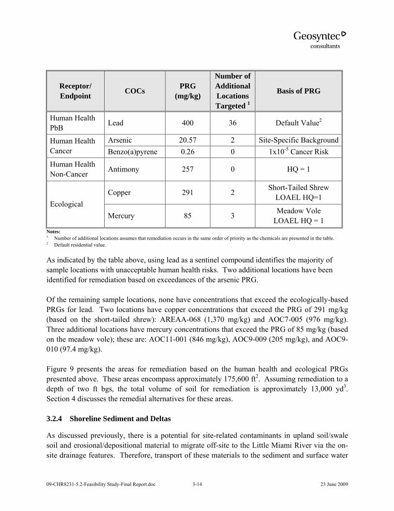
09-CHR8231-5.2-Feasibility Study-Final Report.doc 3-14 23 June 2009
Receptor/ Endpoint COCs PRG
(mg/kg)
Number of Additional Locations Targeted 1
Basis of PRG
Human Health PbB Lead 400 36 Default Value2
Human Health Cancer
Arsenic 20.57 2 Site-Specific BackgroundBenzo(a)pyrene 0.26 0 1x10⁻⁵ Cancer Risk
Human Health Non-Cancer Antimony 257 0 HQ = 1
Ecological Copper 291 2 Short-Tailed Shrew
LOAEL HQ=1
Mercury 85 3 Meadow Vole LOAEL HQ = 1
Notes: 1 Number of additional locations assumes that remediation occurs in the same order of priority as the chemicals are presented in the table. 2 Default residential value.
As indicated by the table above, using lead as a sentinel compound identifies the majority of sample locations with unacceptable human health risks. Two additional locations have been identified for remediation based on exceedances of the arsenic PRG. Of the remaining sample locations, none have concentrations that exceed the ecologically-based PRGs for lead. Two locations have copper concentrations that exceed the PRG of 291 mg/kg (based on the short-tailed shrew): AREAA-068 (1,370 mg/kg) and AOC7-005 (976 mg/kg). Three additional locations have mercury concentrations that exceed the PRG of 85 mg/kg (based on the meadow vole); these are: AOC11-001 (846 mg/kg), AOC9-009 (205 mg/kg), and AOC9-010 (97.4 mg/kg). Figure 9 presents the areas for remediation based on the human health and ecological PRGs presented above. These areas encompass approximately 175,600 ft2. Assuming remediation to a depth of two ft bgs, the total volume of soil for remediation is approximately 13,000 yd3. Section 4 discusses the remedial alternatives for these areas. 3.2.4 Shoreline Sediment and Deltas
As discussed previously, there is a potential for site-related contaminants in upland soil/swale soil and erosional/depositional material to migrate off-site to the Little Miami River via the on-site drainage features. Therefore, transport of these materials to the sediment and surface water

09-CHR8231-5.2-Feasibility Study-Final Report.doc 3-15 23 June 2009
of the River will be addressed. The RAO for the shoreline sediments and deltas will be to prevent exposure of aquatic receptors to contaminants of ecological concern in the Little Miami River by limiting migration of site-related contaminants in depositional material in the channelized outfalls and deltas bordering the Little Miami River. Remedial actions such as culvert cleanout and excavation are described in Section 5 for these depositional areas to prevent future migration of contaminants. COPECs identified in the outfall material in the SLERA included arsenic, lead, mercury, and PAHs. Ecological risks identified in the SLERA associated with outfall sediment were not further evaluated in the BERA. Consequently, ecological PRGs for these contaminants were established as literature-based sediment quality guidelines (Table 5b). Figure 10 presents the areas for remediation based on the initial PRGs (i.e., literature-based sediment quality guidelines). The current estimate of cleanup extent encompasses an area of approximately 1,400 ft2. Assuming remediation to a depth of 0.5 ft bgs, the total volume for soil remediation is approximately 30 yd3. As described in Section 3.1.6, pre-design and remedial action sampling results may be utilized, as necessary, as part of more detailed ecological evaluations to develop site-specific ecological PRGs to refine the extent of cleanup.
09-CHR8231-5.2-Feasibility Study-Final Report.doc 4-1 23 June 2009
4. TECHNOLOGY SCREENING
4.1 Introduction
As described in Sections 2 and 3, the risk assessments concluded that the residual risk at the Site is limited to COCs in soil in the 0 to 2 foot horizon. Surface water does not pose unacceptable ecological or human health risks. COCs in groundwater are below MCLs and therefore no remedial action is required for groundwater. Accordingly, the technology screening presented in this section is limited to soil remediation technologies. These include the nine candidate technologies identified in the 2004 Technical Memorandum for soil remediation (URS, 2004). 4.2 Technology Screening
Soil remediation technologies considered in the screening include the following:
1. No Action – required for consideration under the National Contingency Plan (NCP); would apply to concentrations of COCs in soils below ARARs
2. Removal of impacted media and transport to a permitted waste disposal facility
3. In-situ containment via construction of an isolation soil cap over impacted portions of the site
4. Removal of impacted media and consolidation and containment on-site under an engineered cap with a geomembrane liner.
5. In-situ treatment via applied biological processes
• Bioventing – removal of COCs by stimulating naturally occurring contaminant degradation through addition of oxygen
• Enhanced bioremediation – removal of COCs by stimulating naturally occurring contaminant degradation through addition of substrate
• Phytoremediation - removal of COCs by certain plants
6. In-situ treatment via physical processes
• Soil flushing – desorbing COCs from soil particles by flushing with water, surfactants and/or chemical reagents
• Soil vapor extraction – volatilizing COCs from soil particles and removing them by drawing air through the impacted zone
• In-situ treatment via thermal treatment – desorbing COCs from soil particles by thermally volatilizing and extracting the carrier air

09-CHR8231-5.2-Feasibility Study-Final Report.doc 4-2 23 June 2009
• In-situ stabilization via applied chemical process – Application and mixing of stabilizing agent into impacted soil using earth moving equipment
• In-situ vitrification - heating of soils to their melting point with fume capture to control emission of organics and fugitive dust
7. Ex-situ treatment
• Soil washing - separation of finer particles associated with COCs
• Electrochemical - separation of metals from soil using electricity
In accordance with the CERCLA Guidance (USEPA 1988), the technologies were screened using a comparative evaluation against the following three of the nine CERCLA evaluation criteria:
1. Effectiveness
2. Implementability
3. Cost
A technology screening matrix is presented in Table 7. In this evaluation, the relative general effectiveness of the technologies and cost were considered. Specific site characteristics were considered for the implementability criteria.
4.3 Conclusions
Based on the evaluation in Table 7, four alternatives are recommended for consideration in the FS:
1. No action
2. Isolation/soil capping and containment
3. Excavation and on-site consolidation under an engineered cap with a geomembrane liner
4. Excavation and off-site disposal
These alternatives are evaluated in Section 5 using the nine CERCLA criteria. In addition, although not evaluated as stand-alone remedial alternative, ex situ chemical stabilization will be retained as a potential aspect of the excavation alternatives to control soil moisture and strength properties during transport and/or placement of excavated material.
09-CHR8231-5.2-Feasibility Study-Final Report.doc 5-1 23 June 2009
5. IDENTIFICATION AND EVALUATION OF REMEDIAL ALTERNATIVES
5.1 Introduction
Based on the technology screening described in Section 4, the following remedial alternatives were identified for the Peters Cartridge Site.
1. No action
2. Isolation/soil capping of soil with concentrations of COCs above PRGs
3. Excavation and on-site consolidation of soils with concentrations of COCs above PRGs in a cell with a geomembrane liner and subsequent backfilling of the excavated areas
4. Excavation and off-site disposal of soil with concentrations of COCs above PRGs and subsequent backfilling of the excavated areas
5.2 Evaluation Approach
The NCP [40 CFR 300.430(e)(9)(iii)] identifies nine evaluation criteria to be used in a Feasibility Study. These criteria are segregated into three categories - Threshold Criteria, Primary Balancing Criteria, and Modifying Criteria. Threshold criteria include:
1. Overall protectiveness of human health and the environment, and
2. Compliance with ARARs.
Threshold Criteria must be met for an alternative to be acceptable. The results of BERA, SLERA, HHRA, and applicable ARARs are used in comparison of alternatives against the two threshold criteria. Potential ARARs for this project include a number of federal, state and local regulatory requirements (see Attachment 2). The subsections below identify those ARARs most likely to be applicable to each remedial alternative being evaluated. As the details of a selected remedy are developed, the list of ARARs in Attachment 2 will be reevaluated. The Primary Balancing Criteria are:
1. Long-term protectiveness and permanence,
2. Reduction of toxicity, mobility, or volume,
3. Short-term effectiveness,
09-CHR8231-5.2-Feasibility Study-Final Report.doc 5-2 23 June 2009
4. Implementability, and
5. Cost effectiveness.
The Modifying Criteria are:
1. State Acceptance, and
2. Community Acceptance.
State and community acceptance will be evaluated by USEPA as part of the response to public comments on the PRAP. Section 5.3 evaluates the four identified alternatives individually based on the remaining seven CERCLA criteria along with an eighth criterion, Sustainability. Section 5.4 provides a comparative analysis of the four alternatives based on these criteria. The terrain at the Peters Cartridge Site varies widely. For the purpose of evaluating the implementability of the remedial alternatives listed above, the following three terrain types were considered:
1. Upland soil: The upland soil areas include portions of the site in and around the former plant buildings as well as the steep banks with local bedrock outcropping. The upland soil areas are generally densely vegetated with a variety of woody and herbaceous cover (Geosyntec, 2007).
2. Upland depositional/erosional soil: Portions of the upland area of the site are characterized by intermittent tributary drainages or ravines that drain the steep upland slopes north toward the Little Miami River. There are three main drainage areas that convey flows into three manmade culverts that pass under the Former Process Area and discharge to the Little Miami River at three outfall locations.
3. Shoreline sediment and deltas: The culverts discharge into eroded gullies that convey flow from the culvert outfall to the Little Miami River. The shoreline sediment and delta areas consist of the drainage channels downstream of the three culverts and the adjacent river shoreline.
Each of these terrain types may be addressed using one or a combination of the four alternatives under consideration. The descriptions of implementability considerations in this section call out instances where an alternative may be more applicable to one type of terrain than another. Sustainability considerations are also factored into the evaluation of alternatives.

09-CHR8231-5.2-Feasibility Study-Final Report.doc 5-3 23 June 2009
The goals of analyzing the alternatives, both individually and through comparison, are to identify a remedy that reduces ecological and human health risks to acceptable levels, balances risk reduction between human health and ecological concerns, and will not result in a level of ecological harm that outweighs the risk reduction benefits. 5.3 Individual Analysis of Alternatives
Tables 8 and 9 present an evaluation matrix for the alternatives. Table 8 presents a graphical comparison of the alternatives evaluation while Table 9 presents a text description of the evaluation by criteria. The compliance with ARARs for each alternative is summarized in Table 10. 5.3.1 Alternative 1: No Action
5.3.1.1 Description
The No Action alternative is used as a baseline against which other remedial alternatives may be compared. The No Action alternative would leave the Site in its present condition without further remediation, monitoring, or institutional controls. This alternative is feasible if the risk to human health and the environment is acceptable. 5.3.1.2 Criteria Assessment
Overall protectiveness of human health and the environment: This alternative would not reduce the human health and ecological risks associated with the site COCs. Compliance with ARARs: This alternative, without institutional controls, does not comply with ARARs. Long-term protectiveness and permanence: This alternative would not be protective of human health or the environment. It will not prevent the exposure of human and ecological receptors to soil containing concentrations of COCs above PRGs. Reduction of toxicity, mobility, or volume through treatment: This alternative does not reduce the toxicity, mobility, or volume of COC-impacted soils. Short-term effectiveness: This alternative, without institutional controls, is not effective or reliable in the short-term. Implementability: This alternative is readily implementable. Also, the No Action alternative does not pose any implementation hazards.
09-CHR8231-5.2-Feasibility Study-Final Report.doc 5-4 23 June 2009
Cost: This alternative has no associated capital or operation and maintenance (O&M) costs. Sustainability: This alternative will not cause any ecosystem disturbances and has no carbon footprint. However, it will negatively impact ecological receptors due to their exposure to concentrations of COCs that exceed PRGs. 5.3.2 Alternative 2: Isolation/Soil Capping
Description
Isolation capping impacted areas of the site with a soil layer will limit exposure of current/future construction workers, child trespassers, and animals/birds from coming in contact with impacted soils. Isolation capping will also reduce the potential for migration of impacted soils due to wind and water erosion. A specific soil cover design would be developed during the remedial design (RD) phase to address the remediation areas illustrated in Figures 6, 7, 8, and 9. The isolation capping remedy may include excavation of localized COC “hot spots” with consolidation of the excavated soils under isolation capped impacted areas. All three active alternatives will include implementation of the removal of bottles and debris in AOC-9 previously discussed as a candidate interim remedial measure (IRM) and addressing the shoreline deltas. The proposed approach to address the shoreline deltas is described following the description of the soil capping, below. Alternative 2 would require the property owners to maintain the current uses of the property which restrict residential development. The Lowland Area includes the Little Miami Scenic Trail owned by the Ohio DNR. This area is a dedicated scenic trail; thus the restriction as open recreational land will be maintained. The Hamilton Township Property is restricted open space/recreational land, a designation which will also be maintained. The Former Process Area will be maintained as industrial/commercial property use. The current deed for all three properties will need to be reviewed to ensure that residential use is restricted. A deed restriction precluding future residential development will need to be added as a part of the remedial action if the current deed does not already include such restriction. Preparation of Isolation/Soil Capped Areas
Areas to be soil capped would be cleared and grubbed. The areas would then be excavated to a depth of 6-inches to prepare the area for capping. For the purposes of the cost estimate for this
09-CHR8231-5.2-Feasibility Study-Final Report.doc 5-5 23 June 2009
alternative, the excavated material is assumed to be hauled off-site for disposal. In total, this will generate approximately 8,000 yd3 of soil for disposal. Description of Isolation/Soil Cap
For remedy evaluation purposes, the isolation cap is assumed to consist of a 2-foot thick compacted soil with the upper 6-inches being topsoil to support re-growth of vegetation. The function of the soil cap is to eliminate the direct contact exposure pathway. This must be done in a fashion that has a degree of permanence and can be engineered (graded) to specification given the uncertainty in that process. There is no standard for isolation cap thickness for human recreators. A 2-ft soil cap was selected to isolate potential human recreators and biota from the underlying impacted soils for a number of reasons, including the following:
1. A 2-ft isolation cap is a typically applied technology for isolation;
2. A number of regulatory programs (e.g., RCRA sub-D definition) define surface soil as 0-2 ft bgs or shallower (e.g., 0-1 ft bgs);
3. In assessing risks to human and ecological receptors, surface soils were defined as 0-2 ft bgs and 0-0.5 ft bgs, respectively, as these are the intervals likely to represent the point-of-exposure; and
4. Two feet was selected as a cover thickness that would preclude contact with the underlying soils during typical recreational activities, including semi-intrusive activities such as driving tent stakes.
The area of the isolation cap would be cleared of understory vegetation and trees less than 12 inches in diameter. The majority of the area would be stripped of fibrous material and non-structural upper soil horizon, scarified, and then covered with the clean fill. Areas immediately surrounding trees that are 12-inches in diameter or larger would not be stripped or capped to reduce the potential for damage of such trees (which currently help to control erosion, particularly in steeply sloping areas). The soil cap would be compacted to minimize settling. The material for the cover soil layer would be imported to the site unless a source of clean, homogenous material was identified on-site and a borrow pit was excavated. The vegetative support layer would consist of a clean organic material that may be temporarily stabilized with an erosion control blanket rated for the steep slopes (e.g., 1(H):1(V)) and coir fiber rolls. The soil cap would be seeded and planted to revegetate the area with species similar to the natural vegetation. Portions of the Former Process Area may be capped with asphalt or concrete paving. In these high traffic areas, the existing asphalt would be inspected, evaluated, and maintained.

09-CHR8231-5.2-Feasibility Study-Final Report.doc 5-6 23 June 2009
Capping in the drainage ravines would consist of placing rip-rap or similar channel lining material in a 2 foot thick minimum cover. A soil cap could be installed to span the grade between the rip-rap cap and the existing grade. The rip-rap capping material would be designed to have a permissible velocity greater than that predicted for the drainages. Under Alternative 2, the estimated area to be capped is 10 acres. Institutional controls (e.g., deed restrictions) would be required to ensure periodic inspection and maintenance of capped areas and to prevent intrusive activities that could compromise the soil or asphalt caps. Shoreline Sediments and Deltas
As noted in Section 3, the RAO for the shoreline sediments and deltas will be to prevent exposure of aquatic receptors to constituents of ecological concern in the Little Miami River by limiting migration of site-related contaminants in depositional material in the channelized outfalls and deltas bordering the Little Miami River. The excavation of the three shoreline sediment areas at the culvert outfalls will require excavating approximately the top 6-inches of sediment and other material from the outfall channels (i.e., gullies) and the area immediately adjacent to either side of the channels. The proposed excavation areas are shown in Figure 10. The excavated material will be transported it to either an on-site consolidation area or a loading area for off-site disposal. Clean fill material would be used to backfill the excavation area and rip-rap or native river rock would be installed in the channel. The clean fill would be imported to the site. The rip-rap or river rock lining would be designed such that the size of the stabilization would be adequate to convey the predicted flows and velocities of the culvert outfalls without eroding. The backfilled area would require stabilization with temporary erosion control material and would be seeded with native vegetation. Additionally, concrete and brick rubble observed near the central outfall would be removed along with the debris (e.g., concrete rubble and a refrigerator) in the eastern drainage channel. The clean-up of AOC-9 was previously discussed as a candidate interim remedial measure (IRM). Additionally, depositional material in the concrete culverts will also be removed. Criteria Assessment
Overall protectiveness of human health and the environment: This alternative would reduce the human and ecological risks associated with the Site COCs by eliminating exposures to contaminated soils that exceed the established PRGs.

09-CHR8231-5.2-Feasibility Study-Final Report.doc 5-7 23 June 2009
Compliance with ARARs: This alternative will comply with ARARs provided institutional controls are in place to ensure periodic inspection and maintenance of soil capped areas. The following ARARs are expected to be the most important to the potential implementation of this alternative:
• Uniform Environmental Covenants Act. This Act establishes standards for environmental covenants for sites with institutional controls or use restrictions. A set of environmental covenants specifying institutional controls and possible use restrictions would be drafted as part of remedy implementation to ensure the protection and maintenance of soil capped areas and to restrict residential development.
• OEPA, Surface Water Division. Ohio Revised Code 6111.04. The NPDES Construction General Permit requires the development of a Stormwater Pollution Prevention Plan (SWPPP) for any land disturbance of more than one acre. The general permit requires weekly inspection of erosion controls and inspections following greater than 0.5 inches of precipitation. A SWPPP would be developed to identify the areas of land clearing and the types of construction erosion and sediment controls required to prevent sediment discharges. A Notice of Intent would be filed with OEPA in substantial compliance with permit requirements.
• OEPA, Surface Water Division. Section 401 Water Quality Certification. The 401 Water Quality Certification and Isolated Wetland Permit Section reviews applications regarding projects that would physically impact waters of the state, including streams, lakes and wetlands, and that would result in the filling of floodplains or wetlands. This alternative will result in work within the floodplain to the Little Miami River as well as work in Isolated Wetlands. This ARAR will require the filing of a 401 Water Quality Certification and substantial compliance with the requirements to obtain an Isolated Wetlands Permit from OEPA.
• OEPA, Division of Hazardous Waste, Ohio Revised Code 3734.02 (I). This regulation prohibits emissions of any particulate matter, dust, fumes, gas, mist, smoke, vapor, or odorous substance. This may pertain to a site where there is movement of earth. A dust control and abatement program would be developed to control the impacts of dust during land clearing and capping. Periodic air sampling during construction may be required.
• ODNR, Ohio Revised Code 1517.17, Protection of Wild and Scenic Rivers. This regulation requires approval from the director of ODNR for modifications of the channel of any watercourse within a wild, scenic or recreational river area outside the limits of a municipal corporation. As part of remedy implementation, a letter would

09-CHR8231-5.2-Feasibility Study-Final Report.doc 5-8 23 June 2009
be prepared and submitted to the Director of ONDR requesting approval for modification of the channels and banks in areas where sediment removal is planned.
• ONDR, ODNR Ohio Revised Code 1531.25, Endangered Animal Species. This regulation prohibits removal or destruction of endangered animal species. The ODNR, Division of Natural Areas and Preserves would be contacted relative to the presence of endangered animal species in areas that would be impacted by proposed remedial construction activities.
• OEPA, Division of Air Pollution Control. Ohio Revised Code 3704.05 A-I. and 3745-15-07A and 3745-17-02 A,B,C and 3745-17-08 A1, A2, B, D. These sections of the Ohio Revised Code prohibit emissions of an air contaminant and fugitive dust in violation of SE. 3704 or any rules, permits, order, or variance issued. They also prohibit air pollution nuisances. A dust control and abatement program would be developed as part of remedial design and implementation to control the impacts of dust during land clearing and/or capping. Periodic air sampling during construction may be required.
• Clean Air Act. 42 U.S.C. § 7401 et seq. as amended in 1977 and 1990 and National Emission Standards for Hazardous Air Pollutants (40 CFR 61). The Clean Air Act identifies emission standards for specific hazardous air pollutants. These standards may be applicable to this site if identified hazardous air pollutants are emitted from the site during the remedial actions. A dust control and abatement program would be developed to control emissions and fugitive dust during land clearing and/or capping. Periodic air sampling during construction may be required to demonstrate compliance with emission standards.
• RCRA Land Disposal Restrictions (40 CFR 268). The RCRA LDRs identify hazardous wastes that are restricted from land disposal and defines those limited circumstances under which an otherwise prohibited waste may continue to be land disposed. Based on TLCP data obtained during the RI, site soils meet the definition of characteristic non-hazardous waste. If, however, hazardous wastes are encountered or generated during remedy implementation, a Hazardous Waste Part A Permit Application Form for treatment, storage and disposal facilities [EPA Form 8700-23] would be submitted in substantial compliance with permitting requirements.
• OEPA, Division of Hazardous Waste, Ohio Revised Code 3745-52-12A-C. This regulation requires manifests for the transportation of hazardous waste off-site for treatment, storage or disposal. TCLP analysis of soil samples from the Site has indicated the material will be non-hazardous. Accordingly, this ARAR will only be relevant should the excavation encounter areas of high levels of contaminants. If

09-CHR8231-5.2-Feasibility Study-Final Report.doc 5-9 23 June 2009
needed, the remediation contractor will prepare transportation permit applications in substantial compliance with the OEPA permitting requirements.
• OEPA, Division of Hazardous Waste, Ohio Revised Code 3745-52-41 A, B. This section of the Ohio Revised Code requires generators of hazardous waste that ship off-site to submit annual reports to OEPA. TCLP analyses of soil samples from the Site have indicated the material will be non-hazardous. Accordingly, this ARAR will only be relevant should the excavation encounter areas of high levels of contaminants. If needed, annual reports documenting the waste shipping and trucking to off-site locations would be prepared and submitted to OEPA.
Long-term protectiveness and permanence: This alternative is protective of human health and the environment. It will prevent the direct exposure of human and ecological receptors to contaminated soil. However, contaminants will remain in place at the site and the soil caps will require periodic maintenance. This alternative would allow site reuse with limited restrictions (e.g., prohibition of intrusive activities in capped areas). It may be also necessary to place deed restrictions that will identify the presence of impacted soil above PRGs underneath the soil covers as well as the need for health safety precaution should intrusive activities such as construction of foundations and utility trenches become necessary. Reduction of toxicity, mobility, or volume through treatment: Under this alternative, there will be no treatment performed. However, this alternative will reduce the mobility of contaminants through installation of a compacted soil cap. It will not reduce the toxicity or volume of impacted soil. Short-term effectiveness: This alternative is effective and reliable in the short-term. RAOs would be achieved within approximately 12 to 15 months of initiation of construction. The duration of the work is relatively short and steps can be taken to minimize impacts during implementation. The soil cap will include a vegetation layer; re-growing vegetation will not be a problem. Excavation activities have the potential to cause erosion and runoff issues. The alternative will include provisions for erosion control and stormwater management. These will include inspection and monitoring of the drainage to the LMR to ensure erosion and runoff has been addressed during implementation. The limited excavation of targeted areas and installation of the soil caps will temporarily impact terrestrial habitat. The excavation and backfilling of the shoreline areas will also temporarily impact terrestrial and aquatic habitat. These impacts will be limited as the habitat is expected to be restored soon after the construction is completed. Risks to workers performing excavation and capping can be controlled and mitigated with proper health and safety measures. Short-term impacts to the community due to dust generation and

09-CHR8231-5.2-Feasibility Study-Final Report.doc 5-10 23 June 2009
truck traffic will be mitigated through engineering controls, monitoring, and traffic planning. Environmental impacts due to excavation and capping will be mitigated through restoration. The off-site disposal of excavated soil and importation of fill will require a large number of trucks transporting materials. In total approximately 2,600 truck trips for hauling contaminated soil from the site and backfill or capping soil into the site will be required. Typical daily trips will be 35, however, there will be overlap of hauling waste out and fill in which will result in 44 trucks entering and leaving the site a day. The truck traffic will pose safety hazards and negatively impact traffic on local roadways. This will be mitigated by development and adherence to a traffic management plan. Implementability: Isolation/soil capping is implementable as it requires only readily available machinery and a borrow pit to obtain clean cover soil. In general the areas to be capped are accessible; however, the steep slopes of the upland soil areas range up to 1(H):1(V), and placing and compacting soil cover material in these areas will likely require specialized equipment and safety precautions. Temporary working benches and long reach or specialized equipment are anticipated. In addition, capping on the steep upland slopes may require structural fill to achieve the required grades. Isolation capping in the drainage ravines associated with the upland depositional/erosional presents unique challenge due to poor accessibility for construction equipment. These areas are generally accessible for small equipment and hand work. In recent years a full range of professional small earth work equipment has become available. With proper planning this alternative poses no unmanageable hazards to on-site workers or the public, though care will need to be taken when working on the sloped areas. Cost: This alternative would cost approximately $3.8M to implement. A summary of the cost estimate is provided in Table 11 and the cost estimate calculations are provided in Attachment 3. The estimate includes approximately $0.7M for disposal of the upper 6-inches of soil from the areas to be capped; to be removed as preparation for the soil cover. The estimate also includes approximately $160k in present value cost for long-term (30-years) operation and maintenance (O&M) consisting of semiannual capped area inspections for the first 5-years, annual inspections for years 6 to 30, and an allowance for regarding and seeding. Additionally, five-year reviews will be required however the cost of these efforts will be minimal. Sustainability: Alternative 2 will benefit ecological receptors by eliminating the exposure to the COCs. Capping may induce negative impacts such as reduction in soil fertility, reduction in infiltration, increased storm water runoff, and some ecosystem disturbance. The importation of fill and capping material will require transportation of materials by truck from local borrow areas.
09-CHR8231-5.2-Feasibility Study-Final Report.doc 5-11 23 June 2009
Activities associated with this alternative will result in an estimated 475 metric ton (mt) carbon footprint. Approximately 300 mt results from clearing forested areas and revegetating. Approximately 175 mt results from excavation activities and transport of excavated and borrowed material. Carbon emissions can be reduced or mitigated by: selecting biodiesel fuel or low sulfur fuel for construction and hauling vehicles; mandating reduced idling time for waiting equipment; ensuring that the all equipment is maintained tuned; and finding borrow material closer to the site. 5.3.3 Alternative 3: Excavation with On-site Consolidation
Description
Excavation
Excavation with on-site consolidation will involve clearing, grubbing and excavation of targeted impacted soil to an anticipated depth of 2-ft bgs and backfilling the excavation with clean fill material to the existing grade. Figure 6, 7, 8, and 9 shows the target remediation areas. The actual areas to be excavated and depths will be determined and evaluated during the RD phase in accordance with the risk management strategy described in Section 3. In general, the 2-ft deep excavation in the upland areas would exclude areas immediately surrounding trees with a diameter greater than 12-inches. The fill materials used to backfill the excavations will be imported from off-site borrow sources. A vegetated support layer may be required over the backfill depending on the suitability of the backfill to support vegetation. The top layer would require an erosion control blanket and coir fiber rolls as temporary stabilization. The finish grade would be seeded and planted to revegetate the area with species similar to the natural vegetation. The assumed excavation areas of impacted soils encompass approximately 10 acres. Within the assumed excavations footprint, the total volume of excavated soil is 32,000 yd3. The approximate breakdown of the excavated material by site area is:
• Former Process Area – 12,600 yd3
• Lowland Area – 6,400 yd3
• Hamilton Township Property – 13,000 yd3
(Note: These volumes can only be approximated as the excavation areas cross-over the Site areas.)

09-CHR8231-5.2-Feasibility Study-Final Report.doc 5-12 23 June 2009
Consolidation Cell
Under this soil remedy all excavated material will be placed in an on-site consolidation cell, tentatively located on the flat area in the southwest portion of the Hamilton Township property as shown on Figure 11. The actual consolidation cell location would be indentified during the RD. The location will be selected based on the required physical aspects such as footprint, environmental factors (current use of the area, environmental value, and environmental effects), and the potential for beneficial use of this area. The area of the consolidation cell would be prepared by clearing the portion of the site for the cell and stripping the fibrous material and non-structural upper soil horizon. The total estimated area for the consolidation cell is approximately 3-acres. The consolidation area will be excavated to a depth of approximately 5.5 ft bgs. The total estimated material to be excavated to create the consolidation cell is 29,300 yd3. This material would be stockpiled onsite for possible future use. Impacted soil would be transported to the consolidation cell and placed and compacted prior to being capped. The consolidation cell would be constructed with composite liner and cap systems. A conceptual cross-section of the consolidation cell is provided as Figure 12. After cell excavation and preparation of the clay subgrade, a flexible membrane liner (FML) with a geotextile cushion will be installed as the main component of the cell liner system. The consolidation area will be filled to approximately 1 foot or less above existing grade prior to capping. The cap would be graded to divert storm water runoff from the consolidation cell and reduce the potential for erosion of the cap material. For remedy evaluation purposes, the composite cap system is assumed to consist, from top to bottom, of a 6-inch thick vegetative support layer, a 2-foot thick layer of compacted low-permeability clay, a geocomposite drainage layer, a flexible geomembrane (FML) and a low permeable clay layer beneath the geomembrane. The clay layers would be compacted to achieve low permeability (e.g., ≤1×10⁻⁵cm/sec). The material for the clay layer would be imported to the site. A geocomposite drainage layer was included above the geomembrane to provide drainage of the cover materials and reduce the potential for infiltration. The vegetative support layer will serve as a protective cover over the low-permeability material and would support vegetative stabilization. The consolidation cell would be revegetated with native plant species. The design of the consolidation cell could be configured with grades that mimic natural contour curvature and moderate side slopes suitable for the impacted material excavated from the site. Note that the final cap design would be developed to be compliant with state regulations during the design phase of the project. The consolidation cell area will be fenced as shown on Figure 11 to restrict access. A 6-foot chain link fence with a total length of 1,700 lf was assumed for cost estimating purposes.
09-CHR8231-5.2-Feasibility Study-Final Report.doc 5-13 23 June 2009
Institutional controls in the form of deed restrictions would be required to ensure periodic inspection and maintenance of the on-site containment cell and to prevent intrusive activities that could compromise the cell. The Site as a whole is currently dedicated to non-residential use as described in Section 5.3.2. Restriction on residential development will need to be added as a part of the remedial action alternatives. The on-site consolidation cell alternative may require installation of a monitoring wells downgradient of the cell and implementation of a long-term monitoring program to demonstrate there is no migration of metals from the consolidation area. Although this will be determined during the RD phase, if Alternative 3 is chosen, for evaluation purposes six monitoring wells have been assumed with annual sampling and analysis as part of the operation and maintenance activities. Implementation of Alternative 3 would also include implementation of the removal of bottles and debris in AOC-9 previously discussed as a candidate IRM and addressing the shoreline deltas/concrete culverts. A description of the planned remedial action for the shoreline deltas/concrete culverts is presented in Section 5.3.2. Criteria Assessment
Overall protectiveness of human health and the environment: This alternative would reduce the human and ecological risks associated with the Site COCs by eliminating exposures to soils with COC concentrations above the established PRGs. Compliance with ARARs: This alternative will comply with ARARs provided that the consolidation cell is properly maintained. The specific ARARs discussed above for Alternative 2 are also applicable to Alternative 3 except for transportation related ARARs. Additionally, the alternative would need to comply with Ohio regulations related to industrial waste landfills, specifically:
• OEPA, Division of Solid and Infectious Waste Management, Ohio Revised Code 3745-29-08 Industrial Solid Waste Landfill Facilities. This section of the Ohio Revised Code specifies requirements for the construction of an industrial solid waste landfill facility. The consolidation cell would be designed and built in substantial conformance to these regulations.
Long-term protectiveness and permanence: This alternative is protective of human health and the environment. It will prevent the direct exposure of human and ecological receptors to contaminated soil. However, the contaminants will remain in place at the site and the

09-CHR8231-5.2-Feasibility Study-Final Report.doc 5-14 23 June 2009
consolidation cell will require periodic inspection and maintenance. This alternative will allow site re-use with limited restrictions. These restrictions will include prohibiting intrusive activities within the limits of the consolidation cell. The consolidation cell area will also be fenced to further prevent intrusive activities. Reduction of toxicity, mobility, or volume through treatment: Under this alternative, there will be no treatment performed. However this alternative will reduce the mobility of contaminants by containing impacted soils within an engineered consolidation cell. It will not reduce the toxicity or volume of impacted soil. Short-term effectiveness: This alternative is effective and reliable in the short-term for controlling exposures to impacted soils. Excavation of impacted soils will impact existing vegetation in the remediation areas however re-growth of vegetation will not be a problem. Excavation and consolidation activities have the potential to cause erosion and runoff issues. The alternative will include provisions for erosion control and stormwater management. These will include inspection and monitoring of the drainage to the LMR to ensure erosion and runoff has been addressed during implementation. Risks to workers performing excavation and consolidation can be controlled and mitigated with proper health and safety measures. Environmental impacts due to excavation and consolidation will be mitigated through restoration. RAOs would be achieved within approximately 12 to 15 months of initiation of construction. The importation of backfill and capping material will require a large number of trucks transporting materials. In total approximately 3,000 truck trips for hauling contaminated soil from of the site and backfill or capping material into the site will be required. Typical daily trips will be 50. The truck traffic will pose safety hazards and negatively impact traffic on local roadways. This will be mitigated by development and adherence to a traffic management plan. Additionally, truck traffic will be reduced substantially if the material excavated to create the consolidation cell can be used for backfilling waste excavation areas. The excavation of targeted areas and the consolidation cell and backfilling will temporarily impact terrestrial habitat. The excavation and backfilling of the shoreline areas will also temporarily impact terrestrial and aquatic habitat. These impacts will be limited as the habitat is expected to be restored soon after the construction is completed. Implementability: This alternative is implementable as it requires only readily available machinery and a borrow pit to obtain clean soil for backfill of the excavation areas and capping of the consolidation cell. The areas to be excavated are accessible, although some of the grades in the upland soils are very steep particularly in the drainage ravines associated with the upland
09-CHR8231-5.2-Feasibility Study-Final Report.doc 5-15 23 June 2009
depositional/erosional soil. Temporary working benches and use of long reach or specialized equipment are anticipated. The consolidation cell/borrow pit will be located in a relatively flat area of the upland soils as shown in Figure 11. With proper planning, this alternative poses no unmanageable hazards to on-site workers and the public. Cost: This alternative would cost approximately $5.0 M to implement. A summary of the cost estimate is provided in Table 11 and the cost estimate calculations are provided in Attachment 3. Alternative 3 has the highest present value O&M cost component at approximately $277k. O&M is assumed to include annual groundwater sampling from 6 wells to be installed as part of the RA. It also includes semiannual inspection of the cap for the first 5 years, annual inspection in years 6 to 30, and an allowance for cap regarding and seeding. Additionally, five-year reviews will be required however the cost of these efforts will be minimal. Sustainability: Alternative 3 will benefit ecological receptors by eliminating exposures to the COCs. However, on-site consolidation requires land disturbance to build the consolidation cell. Excavation and on-site consolidation would not require extensive trucking except for the on-site excavation equipment. The importation of fill and capping material will require transportation of materials by truck from local borrow areas. The carbon footprint of this alternative is expected to be approximately 560 mt. This alternative requires a greater area of disturbance than Alternative 2, leading to a 406 mt footprint associated with land clearing. Excavation vehicle use will contribute an additional 100 mt to the total carbon footprint. Excavated material will be consolidated on site, so the carbon footprint associated with contaminated material transport is negligible. Carbon emissions can be reduced or mitigated by: selecting biodiesel fuel or low sulfur fuel for construction and hauling vehicles; mandating reduced idling time for waiting equipment; ensuring the all equipment is maintained tuned; and finding borrow material closer to the site. 5.3.4 Alternative 4: Excavation with Off-site Disposal
Description
Excavation
The currently assumed excavation areas under Alternative 4 encompass approximately 10 acres. Within the assumed excavation footprint, the total volume of excavated soil is 32,000 yd3.
09-CHR8231-5.2-Feasibility Study-Final Report.doc 5-16 23 June 2009
Transportation and Disposal
The off-site disposal facility will be selected by the remediation contractor, subject to approval of the responsible parties, during the Remedial Action. Impacted soil will go to a DuPont approved land disposal facility. Based on TCLP results, the impacted soil will be considered non-hazardous and an industrial landfill will be able to accept the material. For cost estimating purposes, we have assumed that impacted soil will go to the Rumpke Landfill in Hamilton Township. The haul distance to the Rumpke facility is approximately 30-miles. The Allied Waste Facility in Frankfort, Kentucky and the Envirosafe Landfill in Oregon, Ohio will also be considered during the remedial design and remedial action. Both of these facilities are a farther distance from the Site than the Rumpke landfill. The applicable disposal criterion is assumed to be non-municipal but non-hazardous special waste based on Toxicity Characteristic Leaching Procedure analytical results. A facility (landfill) for proper disposal of the excavated soils is selected based on the location, hauling distance, and cost. The material being exported from the site would require temporary stockpiling and subsequent loading into haul trucks. Erosion and sediment control measures would be required for dust control and to control tracking of sediment onto public roads. The Site as a whole is currently dedicated to non-residential use as described in Section 5.3.2. Restriction on residential development will need to be added as a part of the remedial action alternatives. As noted, implementation of Alternative 4 would also include implementation of the removal of bottles and debris in AOC-9 previously discussed as a candidate interim remedial measure (IRM) and addressing the shoreline deltas/concrete culverts. A description of the planned remedial action for the shoreline deltas/concrete culverts is presented in Section 5.3.2. Criteria Assessment
Overall protectiveness of human health and the environment: This alternative would reduce the human health and ecological risks associated with the Site COCs by eliminating the exposure to contaminated soil above the established PRGs. Compliance with ARARs: This alternative will comply with ARARs. In addition to the specific ARARs listed above for Alternative 2, the following would be applicable to this remedial alternative:
• OEPA, Ohio Revised Code 6111.04. The NPDES Construction General Permit requires the development of a Stormwater Pollution Prevention Plan for off-site soil disposal areas associated with construction activities. A SWPPP would be developed
09-CHR8231-5.2-Feasibility Study-Final Report.doc 5-17 23 June 2009
to identify the areas of off-site soil disposal and the types of construction erosion and sediment control required to prevent sediment discharges. A Notice of Intent would be filed with OEPA to obtain coverage under this general permit.
Long-term protectiveness and permanence: This alternative is protective of human health and environmental receptors. Excavation and off-site disposal is reliable and would permanently remove contaminants from the site. When properly established and implemented, institutional controls provide adequate and reliable long-term protectiveness. Reduction of toxicity, mobility, or volume through treatment: Under this alternative, there will be no treatment performed. However, this alternative will reduce the mobility of contaminants by containing impacted soil at an off-site landfill. Short-term effectiveness: This alternative is effective and reliable in the short-term for controlling exposures to impacted soils. Excavation of impacted soils will impact existing vegetation in the remediation areas however re-growth of vegetation will not be a problem. Excavation activities have the potential to cause erosion and runoff issues. The alternative will include provisions for erosion control and stormwater management. These will include inspection and monitoring of the drainage to the LMR to ensure erosion and runoff has been addressed during implementation. Risks to workers performing excavation can be controlled and mitigated with proper health and safety measures. Short-term impacts to the community due to dust generation will be mitigated through engineering controls and monitoring. Environmental impacts due to excavation will be mitigated through restoration. RAOs would be achieved within approximately 12 to 15 months of initiation of construction. The off-site disposal of excavated soil and importation of fill will require a large number of trucks transporting materials. In total approximately 4,200 truck trips for hauling contaminated soil from the site and backfill or capping material into the site will be required. Typical daily trips will be 30, however, there will be overlap of hauling waste out and fill in which will result in 70 trucks entering and leaving the site a day. The truck traffic will pose safety hazards and negatively impact traffic on local roadways. This will be mitigated by development and adherence to a traffic management plan. The excavation of targeted areas and the consolidation cell and backfilling will temporarily impact terrestrial habitat. The excavation and backfilling of the shoreline areas will also temporarily impact terrestrial and aquatic habitat. These impacts will be limited as the habitat is expected to be restored soon after the construction is completed.

09-CHR8231-5.2-Feasibility Study-Final Report.doc 5-18 23 June 2009
Implementability: This alternative is implementable as it requires only readily available machinery and a borrow pit to obtain clean soil for backfill of the excavation areas and capping of the consolidation cell. The areas to be excavated are accessible, although some of the grades in the upland soils are very steep particularly in the drainage ravines associated with the upland depositional/erosional soil. Temporary working benches and use of long reach or specialized equipment are anticipated. With proper planning, this alternative poses no unmanageable hazards to on-site workers and the public. Cost: This alternative would cost approximately $6.3M to implement. A summary of the cost estimate is provided in Table 11 and the cost estimate calculations are provided in Attachment 3. Approximately $2.9M of the total cost is in hauling and disposal of impacted soil and debris. Alternative 4 has the lowest O&M cost with an estimated present worth value of $48,000. Additionally, five-year reviews will be required however the cost of these efforts will be minimal. Sustainability: In the long-term, this alternative will enhance the ecosystem by eliminating exposures to COCs. However, there are negative impacts of off-site disposal such as extensive material handling and hauling and associated fuel consumption. Applicable negative impacts of excavation can be reduced using USEPA’s best management practices for Green Remediation such as:
1. Selecting the closest disposal facility.
2. Identifying opportunities for resource sharing with other waste haulers.
3. Limiting on-site vehicle speed to 10 miles per hour.
Alternative 4 will have an estimated 676 metric ton carbon footprint. The disturbed area for this alternative is similar to Alternative 3; the carbon footprint associated with land clearing is approximately 390 mt. This alternative requires a greater amount of waste material transport than the other alternatives. The disposal site is located 30 miles from the site, causing material transport to contribute approximately 190 mt to the total carbon footprint. An additional 100 mt is expected to result from the use of excavation equipment. Carbon emissions can be reduced or mitigated by: selecting biodiesel fuel or low sulfur fuel for construction and hauling vehicles; mandating reduced idling time for waiting equipment; ensuring the all equipment is maintained tuned; finding borrow material closer to the site; and selecting an off-site disposal facility close to the site.
09-CHR8231-5.2-Feasibility Study-Final Report.doc 5-19 23 June 2009
5.4 Comparative Evaluation of Remedial Alternatives
This subsection compares the four remedial alternatives based on the primary balancing criteria listed in Section 5.2. Long-term effectiveness and permanence: Alternative 1 is not effective as a long-term or permanent solution. It will not prevent the exposure of human and ecological receptors to contaminated soil. Alternative 2 and Alternative 3 will require institutional controls to ensure that soil capped areas or the consolidation cell are periodically inspected and properly maintained. Neither Alternative 2 nor 3 can be considered permanent. Alternative 4 is effective as a permanent solution because the contaminants are removed from the Site. Alternatives 2, 3 and 4 will result in the removal and possible future loss of trees, understory shrubs, forbs, wildflowers and other vegetative features. Alternative 1 will negatively impact the site reuse potential. The areas that are not remediated would require institutional controls such as fencing. Alternative 2 and Alternative 3 will allow site reuse with limited restrictions, including prohibition of non-intrusive activities in the soil cover/capped areas and continued restriction on residential development of the Site. Alternative 4 will allow site reuse limited to non-residential use. Reduction of toxicity, mobility, or volume through treatment: None of the alternatives treat the contaminated materials. However, discussion of the alternatives relative to the reduction of toxicity, mobility, or volume without treatment is as follows: Alternative does not reduce toxicity, mobility, or volume of the COCs. Alternative 2 and Alternative 3 reduce the mobility of contaminants but they do not reduce the toxicity or volume, as contaminants will remain in place at the site. Alternative 4 reduces the mobility of COCs by containing them in an off-site landfill, but it also does not reduce the toxicity or volume of contaminants. Short term effectiveness: Alternative 1 would not be effective in the short term. Alternative 2 and Alternative 3 are effective in the short-term because the duration of the work is relatively short and steps can be taken to minimize RA impacts. Alternative 4 would have the short-term impacts of an off-site disposal remedy, including increased health and safety risks off-site associated with increased truck traffic. The roads servicing the site are not well suited to large construction vehicles. Alternatives 2, 3 and 4 will all have short-term impacts on native vegetation and habitat and potential to exacerbate erosion if high intensity precipitation events occur during the time between site disturbance and full site stabilization and revegetation. Alternative 1 does not result in any loss of habitat, vegetation or impacts to the Little Miami River (LMR). OEPA (2007) has stated that the Site does not impact the LMR. Alternatives 2, 3 and 4 all involve the loss of habitat, impacts on scenic vistas, removal of mature trees and
09-CHR8231-5.2-Feasibility Study-Final Report.doc 5-20 23 June 2009
understory vegetation, and at least temporary construction impacts to the existing bikeway/rail trail. Implementability: Alternative 1 is the most easily implementable alternative. Alternatives 2, 3 and 4 are implementable, but pose construction challenges requiring use of specialized equipment during construction activities on steep slopes. Alternative 4 requires the additional steps of identifying an appropriate disposal site, coordinating removal of the material, and, in light of the increased truck traffic on public roads, obtaining community acceptance of the remediation plan. Alternatives 2, 3, and 4 would require the property owners to maintain the current uses of the property which restrict residential development. The Lowland Area includes the Little Miami Scenic Trail owned by the Ohio DNR. This area is a dedicated scenic trail; thus the restriction as open recreational land will be maintained. The Hamilton Township Property is restricted open space/recreational land, a designation which will also be maintained. The Former Process Area will be maintained as industrial/commercial property use. As part of the remedial action, deeds for all properties will be reviewed and restrictions on residential development will be added. Under Alternative No. 3 DuPont would need to obtain permission from Hamilton Township to construct the consolidation area. It is not clear if this would be acceptable to Hamilton Township. Cost: Cost estimates were developed using approximate area take-offs and unit prices for major activities such as clearing and grubbing, excavation, capping and disposal. A summary of the alternative cost estimates is provided in Table 11 and detailed cost estimate worksheets are included in Attachment 3.
• Alternative 1 - No Action has no associated costs but does not reduce risk.
• Alternative 2 – Isolation/Soil Capping is expected to have a net present value cost of approximately $3.8M.
• Alternative 3 - Excavation with On-site Consolidation is expected to have a net present value cost of approximately $5.0M
• Alternative 4 - Excavation with Off-site Disposal is expected to have a net present value cost of approximately $6.3M
Sustainability: Alternative 1 will negatively impact environmental receptors due to risks associated with exposure to COCs. Alternative 2 will cause short-term ecosystem disturbances by covering the contaminated areas with a compacted soil cap. Alternative 3 (Excavation with
09-CHR8231-5.2-Feasibility Study-Final Report.doc 5-21 23 June 2009
On-site Consolidation) and Alternative 4 will cause ecosystem disturbances in the excavation areas and, in the case of Alternative 3, the consolidation area. The carbon footprint of Alternatives 2, 3 and 4 are estimated at:
• Alternative 2 – Isolation/Soil Capping/Containment 475 mt CO2
• Alternative 3 - Excavation with On-site Consolidation 560 mt CO2
• Alternative 4 - Excavation with Off-site Disposal 676 mt CO2
09-CHR8231-5.2-Feasibility Study-Final Report.doc 6-1 5 June 2009
6. CONCLUSIONS AND RECOMMENDATIONS FOR REMEDIATION
Four remediation alternatives were identified and carried through the evaluation process in Section 5:
1. No action
2. Isolation/soil capping of impacted soil with concentrations of COCs above PRGs
3. Excavation and on-site consolidation of soils with concentrations of COCs above PRGs and subsequent backfilling of the excavated areas
4. Excavation and off-site disposal of soil with concentrations of COCs above PRGs and subsequent backfilling of the excavated areas
The four remediation alternatives were evaluated against the seven of the nine CERCLA remedy evaluation criteria identified in the NCP [40 CFR 300.430(e)(9)(iii). Based on this analysis, it is concluded that both Alternatives 3 and 4 offer similar overall protection to human health and the environment without any significant restriction on future use of the Site (beyond the restriction of use as residential property). From a sustainability perspective, Alternative 3 is better than Alternative 4 as it results in a lower carbon footprint. However, from an implementability aspect, it is not clear if Alternative 3 would meet the approval of Hamilton Township which is the current owner of the property where the on-site consolidation are would be located. A final decision on the disposition of impacted soil from excavations will be finalized during the RD phase based on discussion with Hamilton Township authorities. The recommended remediation will also include excavation of the identified shoreline deltas to a depth of approximately 6-inches to prevent future impacts to the LMR and removal of depositional material in the concrete culverts. The recommended work will also include removal of debris in AOC-9, which was at one point considered for implementation as an IRM.
09-CHR8231-5 2-Feasibility Study-Final Report 6-23-09 7-1 23 June 2009
7. REFERENCES
Bechtel Jacobs Company LLC. 1998. Empirical Models for the Uptake of Inorganic Chemicals from Soil by Plants. Bechtel Jacobs Company LLC, Oak Ridge, TN. BJC/OR-133.
Black, Robert L, 1940. The Little Miami Railroad, as cited on
http://en.wikipedia.org/wiki/Little_Miami_Railroad, Cincinnati, Ohio. Camp Dresser & McKee (CDM), 1993. Well Field Evaluation and Monitoring Plan Hamilton-
Deerfield Well Field South Water System Expansion Hamilton Township, Warren County, Ohio. May 7.
CDM, 2004. Warren County, Ohio. South Wellhead Protection Plan, March 2004. Geosyntec, 2007. Remedial Investigation Report, Former Peters Cartridge Facility. Hamilton
Township, Warren County, Ohio. August 2007. Geosyntec, 2009. Remedial Investigation Report, Former Peters Cartridge facility, February 25,
2009. Howard et al., 1991. Handbook of Environmental Degradation Rates. Lewis Publishers. Ohio EPA, 2005. Ohio Primary Drinking Water Standards (DWS) as found in Chapter 3745-81
of the Ohio Administrative Code (OAC). Ohio EPA, 2007. Biological and Water Quality Study of the Little Miami River – Peters
Cartridge Area. November 1. PRC Environmental Management, Inc., 1994. Screening Site Inspection-Site Evaluation Report -
Peters Cartridge Factory (also known as Kings Mills Technical Center), 1415 Grandin Road, Kings Mills, Ohio 45034. September 30.
PRC Environmental Management, Inc. (PRC), 1996. Screening Site Inspection-Site Evaluation
Report (revised). Peters Cartridge Factory, 1415 Grandin Road, Kings Mills, Warren County, Ohio. December 20.
Schiffer, Tom, 2002. Peters and King the Birth and Evolution of the Peters Cartridge Co. and the
King Powder Co., Krause Publications, Iola, WI.
09-CHR8231-5 2-Feasibility Study-Final Report 6-23-09 7-2 23 June 2009
URS Corporation (URS), 2005. Remedial Investigation and Feasibility Study Work Plan. Former Peters Cartridge Facility, Kings Mills, Ohio.
URS Diamond, 2004. Preliminary Remedial Action Objectives (PRAO) and Identification of
Candidate Technologies (ICT), Technical Memorandum for the Former Peters Cartridge Site, August 10, 2004.
URS, 2006. Remedial Investigation Report. Former Peters Cartridge Facility, Kings Mills, Ohio. United States Department of Agriculture (USDA), 2004. Polycyclic Aromatic Hydrocarbon
Migration from Creosote-Treated Railway Ties Into Ballast and Adjacent Wetlands. June 2004.
United States Environmental Protection Agency (USEPA), 1988. Guidance for Conducting
Remedial Investigations and Feasibility Studies Under CERCLA, Interim Final, October, 1988.
USEPA, 1989. Risk Assessment Guidance for Superfund, Volume I: Human Health Evaluation
Manual. EPA/540/1-89/002. USEPA, May 1993. Superfund’s Standard Default Exposure Factors for the Central Tendency
and Reasonable Maximum Exposure. Preliminary Review. US EPA, 1994. Interim Soil Lead Guidance for CERCLA Sites and RCRA Corrective Action
Facilities. OSWER Directive 9355.4-12. Office of Solid Waste and Emergency Response, Washington, D.C.
USEPA, 1996a. Soil Screening Guidance: Technical Background Document, EPA/540/R-
95/128. USEPA, 1996b. Recommendations of the Technical Review Workgroup for Lead for an Interim
Approach to Assessing Risks Associated with Adult Exposures to Lead in Soil. Technical Workgroup for Lead, December.
USEPA, 1997a. Exposure Factors Handbook. EPA/600/P-95/002Fa. USEPA 1997b. Heath Effects Summary Tables (HEAST). EPA/540/R-97/036. July. USEPA, 2001a. Risk Assessment Guidance for Superfund, Vol. I – Human Health Evaluation
Manual (Part D, Standardized Planning, Reporting and Review of Superfund Risk Assessments).
09-CHR8231-5 2-Feasibility Study-Final Report 6-23-09 7-3 23 June 2009
US EPA. 2001b. User’s Guide for the Integrated Exposure Uptake Biokinetic Model for Lead in Children (IEUBK) Windows Version. Office of Emergency and Remedial Response, EPA 540-K-01-005.
USEPA, 2002a. Supplemental Guidance for Developing Soil Screening Levels for Superfund
Sites. Office of Emergency and Remedial Response. OSWER 9355.4-24. December. USEPA 2002b. Guidance for Comparing Background and Chemical Concentrations in Soil for
CERCLA Sites. US EPA (2002c) Blood Lead Concentrations of U.S. Adult Females: Summary Statistics from
Phases 1 and 2 of the National Health and Nutrition Evaluation Survey (NHANES III). Office of Solid Waste and Emergency Response, OSWER 9285.7-52, March, 2002.
USEPA 2003. Recommendations of the Technical Review Workgroup for Lead for an Interim
Approach to Assessing Risks Associated with Adult Exposures to Lead in Soil. EPA-540-R-03-001. January.
USEPA, 2004a. Risk Assessment Guidance for Superfund Volume I: Human Health Evaluation
Manual (Part E, Supplemental Guidance for Dermal Risk Assessment). EPA/540/R/99/005. July.
USEPA, 2004b. 2004 Edition of the Drinking Water Standards and Health Advisories. Office of Water. EPA 822-R-04-005. Winter.
USEPA, 2004c. National Recommended Water Quality Criteria: Office of Water. EPA, 2004. USEPA, 2005. Supplemental Guidance for Assessing Susceptibility from Early-Life Exposure to
Carcinogens (EPA/630/R-03/003F, March 2005). USEPA, 2006. Memorandum dated 14 June 2006: Implementation of the Cancer Guidelines and
Accompanying Supplemental Guidance – Science Policy Council Cancer Guidelines Implementation Workgroup Communication II: Performing Risk Assessments that Include Carcinogens Described in the Supplemental Guidance as having a Mutagenic Mode of Action.
USEPA. 2007a. ProUCL Version 4.0, Office of Research and Development. April 2004.
Technical Support Center for Monitoring and Site Characterization Software for Calculating Upper Confidence Limits (UCLs) < http://www.epa.gov/esd/tsc/software.htm> Accessed 1 May 2007.

09-CHR8231-5 2-Feasibility Study-Final Report 6-23-09 7-4 23 June 2009
USEPA, 2007b. Integrated Risk Information System (IRIS). (On-Line). Available: http://www.epa.gov/ngispgm3/iris/irisdat/.
USEPA, 2008. Regional Screening Levels Table. November. USEPA Region 3. 1993. Selecting Exposure Routes and Contaminants of Concern by Risk-Based
Screening. USEPA Region 3 Hazardous Waste Management Division Office of Superfund Programs. EPA/903/R-93-001.
USEPA Region 5, 1996. Risk Assessment Exposure Parameters Correspondence to Indiana
Department of Environmental Management. Region 5 EPA Waste Management Branch. September 26, 1996.
USEPA, Region 5, 1999. Ecologically rich areas – critical ecosystem team. June 1999 Draft.
http://www.epa.gov/glnpo/ecopage/R5/era/index.html. United States Geological Survey (USGS), 2003. Little Miami River Surface water Flow Rates and
Catchment Statistics. http:///waterdata.usgs/oh/nwis/uv?03245500.
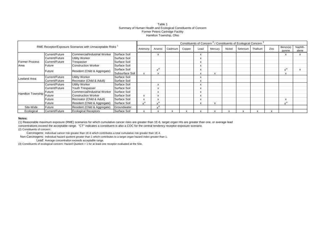
Table 1Summary of Human Health and Ecological Constituents of Concern
Former Peters Cartridge FacilityHamilton Township, Ohio
Antimony Arsenic Cadmium Copper Lead Mercury Nickel Selenium Thallium Zinc Benzo(a) pyrene
Naphth- alene
Current/Future Commercial/Industrial Worker Surface Soil x x x xCurrent/Future Utility Worker Surface Soil xCurrent/Future Trespasser Surface Soil xFuture Construction Worker Surface Soil x
Surface Soil xct x xct xSubsurface Soil x x x x x
Current/Future Utility Worker Surface Soil xCurrent/Future Recreator (Child & Adult) Surface Soil xCurrent/Future Utility Worker Surface Soil x xCurrent/Future Youth Trespasser Surface Soil x xFuture Commercial/Industrial Worker Surface Soil x xFuture Construction Worker Surface Soil x x xFuture Recreator (Child & Adult) Surface Soil x x x xFuture Resident (Child & Aggregate) Surface Soil xct xct x x xct
Site-Wide Future Resident (Child & Aggregate) Groundwater xct
Ecological Current/Future Ecological Receptors Surface Soil x x x x x x x x x x
Notes:
(2) Constituents of concern:Carcinogens: Individual cancer risk greater than 1E-6 which contributes a total cumulative risk greater than 1E-4.
Non-Carcinogens: Individual hazard quotient greater than 1 which contributes to a target organ hazard index greater than 1.Lead: Average concentration exceeds acceptable range
(1) Reasonable maximum exposure (RME) scenarios for which cumulative cancer risks are greater than 1E-6, target organ HIs are greater than one, or average lead concentrations exceed the acceptable range. "CT" indicates a constituent is also a COC for the central tendency receptor-exposure scenario.
Lowland Area
Hamilton Township P
RME Receptor/Exposure Scenarios with Unnaceptable Risks 1Constituents of Concern 2 / Constituents of Ecological Concern 3
Former Process Area
Future Resident (Child & Aggregate)
Lead: Average concentration exceeds acceptable range.(3) Constituents of ecological concern: Hazard Quotient > 1 for at least one receptor evaluated at the Site.

Table 2Remedial Action Objectives
Former Peters Cartridge FacilityHamilton Township, Ohio
Prevent direct human exposure (via incidental ingestion, dermal contact, and inhalation) by a future resident to surface and subsurface soil having COC concentrations which result in cumulative excess cancer risk greater than 1E-04 or a non-cancer hazard index greater than 1.Prevent direct human exposure (via incidental ingestion, dermal contact, and inhalation) by a future resident to surface and subsurface soil having lead concentrations which result in receptor-specific PBL > 5%.Prevent direct human exposure (via incidental ingestion, dermal contact, and inhalation) by a current/future commercial/industrial worker to surface soil having COC concentrations which result in cumulative excess cancer risk greater than 1E-04.Prevent direct human exposure (via incidental ingestion, dermal contact, and inhalation) by a trespasser, construction worker, utility worker and/or commercial/industrial worker to surface soil having lead concentrations which result in receptor-specific PBL > 5%.
Lowland AreaPrevent direct human exposure (via incidental ingestion, dermal contact, and inhalation) by recreators and utility workers to surface soil having lead concentrations which result in receptor-specific PBL > 5%.Prevent direct human exposure (via incidental ingestion, dermal contact, and inhalation) by a resident, recreator, trespasser, construction worker, utility worker and/or commercial/industrial worker to surface/swale soil having COC
t ti hi h lt i l ti i k t th 1E 04
Media Risk Type Exposure Area Remedial Action Objectives
Soil
Human Health
Former Process Area
concentrations which result in cumulative excess cancer risk greater than 1E-04 or non-carcinogenic hazard index greater than 1. Prevent direct human exposure (via incidental ingestion, dermal contact, and inhalation) by a resident, recreator, trespasser, construction worker, utility worker and/or commercial/industrial worker to average concentrations of lead in surface/swale soil which results in receptor-specific PBL > 5%.
Ecological Site Wide Prevent ecological receptor exposures to on-site surface soil/swale soil with copper, lead, and mercury concentrations creating unacceptable levels of risk.
Groundwater Human Health Site Wide Prevent ingestion exposures by a future resident with groundwater used as a domestic water supply having an arsenic concentration that exceeds its MCL.
Erosional/ Depositional
MaterialEcological
Depositional Areas (Shoreline deltas) along Shoreline of Little Miami River
Prevent exposure of aquatic receptors to constituents of ecological concern in the Little Miami River by limiting migration of site-related contaminants in depositional material in the channelized outfalls and deltas bordering the Little Miami River.
Notes:PBL = Probability that fetal PbB > PbBt, assuming lognormal distributionPbB = Lead blood levelPbBt = Target PbB level of concern (e.g., 10 ug/dL)
Hamilton Township Property
Table 3Development of Preliminary Remediation Goals
Soil - Human HealthFormer Peters Cartridge Facility
Hamilton Township, Ohio
Lead (1) 4667 -- -- -- -- -- -- 800 73.06 1800 1 800 Lead RSLArsenic 48.1 3E-05 2E-01 1.6 16 159 255 -- 20.57 80 1 20.57 BackgroundBenzo(a)pyrene 21.44 1E-04 -- 0.21 2.1 21 -- -- - - 6.3 0.0033 2.1 ILCR = 1E-5Naphthalene 36.46 3E-06 8E-02 14 137 1371 478 -- - - 530 0.0033 137 ILCR = 1E-5
Soil - mg/kgLowland Area(Recreator)
Lead (1) 979.8 -- -- -- -- -- -- 400 73.06 400 1 400 Lead RSL
Lead (1) 4333 -- -- -- -- -- -- 400 73.06 400 1 400 Lead RSLArsenic 1224 2E-03 8E+00 0.61 6.1 61 148 -- 20.57 6.8 1 20.57 BackgroundBenzo(a)pyrene 0.293 1E-05 -- 0.026 0.26 2.6 -- -- - - 1.1 0.0033 0.26 ILCR = 1E-5Antimony 451 -- 2E+00 -- -- -- 257 -- -- 31 6 257 HQ = 1
Notes: Definitions:1. Values for lead are the average concentrations for surface soil in the exposure area. COC - Contaminant of Concern2. With the exception of lead, risk-based cleanup goals were calculated as follows: EPC - Exposure Point Concentrations
PRG = Target Risk x EPC ILCR - Incremental Lifetime Cancer Risk Calculated Risk HQ - Hazard Quotient
PRG - Preliminary Remediation GoalRSL - Regional Screening Level
3. Background values calculated as the mean + 3 standard deviations.4. VAP - Ohio Voluntary Action Program - Generic Standards (Effective 10/21/02) [OAC 3745-300-08 (B) and (C)] applied as follows:
Former Process Area: default commercial/industrial valuesLowland Area default residential values
Selected PRG
(mg/kg)PRG Basis (6)ILCR
HQ = 1 LeadRSL
Site- SpecificBackground
(3)
Additional Values (mg/kg)
VAP (4)
For lead, the PRG is the USEPA Regional Screening Level (RSL - September 12, 2008) for soil - Residential Soil = 400 mg/kg; Industrial Soil = 800 mg/kg; these concentrations also correspond to model calculations for a child (IEUBK model) and adult (Adult Lead Model).
Estimated ILCR
Estimated HQ PQL (5)
Soil - mg/kgFormer Process Area(Commercial/Industrial Worker)
Soil - mg/kgHamilton Township Property(Recreator) (7)
COC
Risk-Based PRGs (mg/kg) (2)
EPC(mg/kg) 1.00E-06 1.00E-05 1.00E-04
Media of ConcernExposure Area(Assumed Receptor)
Lowland Area - default residential valuesHamilton Township Property - default residential values
5. PQL (Practical Quantitation Limit) Analytical References:Antimony, Arsenic, Lead - ILM05.4 ICP-AES (mg/kg)Benzo(a)pyrene, Naphthalene - SOM01.2 SVOA SIM (mg/kg)
6. PRG Basis Definitions:Lead RSL - USEPA Regional Screening Level for leadILCR - Incremental Lifetime Cancer RiskHQ - Non-cancer Hazard QuotientBackground - Site-Specific Background
7. ILCR and HQ for recreators is the sum of risks to child and adult recreators.
Table 4Development of Preliminary Remediation Goals
Groundwater - Human HealthFormer Peters Cartridge Facility
Hamilton Township, Ohio
Media of ConcernExposure Area(Receptor) 1.0E-06 1.0E-05 1.0E-04Groundwater - ug/LSite-wide(Residential Scenario)
Arsenic 8.1 2E-04 7E-01 0.045 0.45 4.5 11 - - 10 10 1 10 Federal/Ohio MCL
Notes: Definitions:1. Site-wide maximum detected concentration (total and dissolved). EPC - Exposure Point Concentrations (maximum detected on-site concentration)2. ILCR and HQ calculations only based on ingestion. COC - Contaminant of Concern3. PQL (Practical Quantitation Limit) Analytical References: Arsenic - ILM05.4 ICP-AES MCL - Maximum Contaminant Level
ILCR - Incremental Lifetime Cancer RiskHQ - Hazard QuotientPQL - Practical Quantification Limit
PRG BasisILCR HQ = 1 Site-specific Background
Federal MCL Ohio MCL PQL (3)
Risk-Based PRGs (ug/L) (2) Additional Values (ug/L)COC EPC (1) Estimated
ILCREstimated
HQ
Selected PRG(ug/L)
Table 5aDevelopment of Preliminary Remediation Goals
Soil - Ecological Former Peters Cartridge Facility
Hamilton Township, Ohio
(mg/kg) (mg/kg)Copper 53,900 931 4.6 186 0.047 11,608 291 1,134,952 46 2.5 291 Shrew, LOAEL HQ = 1Lead 217,000 7,267 8.2 82 0.099 26,612 2,647 2,194,500 73.06 1.0 2,647 Shrew, LOAEL HQ = 1Mercury 846 16 10 5.2 0.27 85 163 3,139 0.2822 0.10 85 Vole, LOAEL HQ = 1
Notes: Definitions:COC - Contaminant of ConcernEPC - Exposure Point ConcentrationsILCR - Incremental Lifetime Cancer RiskHQ - Hazard QuotientPRG - Preliminary Remediation GoalUCL - Upper Confidence Limit on the mean
PRG Basis
Additional Values (mg/kg)Maximum EPC (2)
95% UCL EPC (2)
American kestrel
Site-SpecificBackground
(5)PQL (6)
Selected Ecological
PRG(mg/kg)
Baseline LOAEL HQ (3) Risk-Based PRGs(LOAEL HQ =1) (mg/kg) (4)
Short-tailed shrew
American kestrel Meadow vole
Surface Soil/Swale Soil
Media of Concern COC (1)
Meadow vole Short-tailed shrew
6. PQL (Practical Quantitation Limit) Analytical Reference: ILM05.4 ICP-AES (mg/kg)
1. The BERA identified additional metals as constituents of ecological concern (COECs); however, as part of the risk management strategy for the Site, ecological risk-based remediation will focus on copper, lead, and mercury.
3. Lowest Observable Adverse Effect Level (LOAEL) hazard quotient (HQ) as calculated in Appendix B.4. With the exception of lead, risk-based cleanup goals were calculated as follows:
PRG = Target Risk x EPC Calculated Risk
5. Background values calculated as the mean + 3 standard deviations.
2. Exposure point concentrations (EPCs) for meadow vole and short-tailed shrews are site-wide maximums; EPCs for American kestrels are 95% UCLs. Note that the EPCs used in the BERA were calculated for each Exposure Area. Site-wide 95% UCLs generated for this risk estimate refinement are included in Attachment 1.

Table 5bDevelopment of Preliminary Remedial Goals
Sediment Outfall Material - EcologicalFormer Peters Cartridge Facility
Hamilton Township, Ohio
MetalsArsenic 124 13 9.79 9.79 33 7.6 2.5 33 PECLead 2370 66 35.8 35.8 128 15 1 128 PECMercury 0.594 3.4 0.174 0.18 1.06 0.009 0.01 1.06 PECPAHsBenzo(a)pyrene 8.6 57.3 0.15 0.15 1.45 0.1 0.0033 1.45 PEC
Notes: Definitions:SLERA - Screening Level Ecological Risk AssessmentCOPEC - Contaminant of Potential Ecological ConcernHQ - Hazard QuotientESV - Ecological Screening ValueESL - Ecological Screening Level (USEPA, Region 5, 2003)TEC - Threshold Effects Concentration (MacDonald et. al, 2000)PEC - Probable Effects Concentration (MacDonald et. al, 2000)PRG - Preliminary Remediation GoalPQL - Practical Quantitation LimitPAH - Polynuclear Aromatic Hydrocarbon
Additional Values (mg/kg)
OutfallSediment
Selected Ecological PRG
(mg/kg)PRG Basis
ESV (3) TEC (4) PEC (5)Site-SpecificBackground
(6)PQL (7)
Media of Concern COPEC (1)
Maximum Concentratio
n (mg/kg)
Screening-Level HQ (2)
Sediment PRG Values
1. The SLERA identified other metals as constituents of ecological concern; however, as part of the risk management strategy for the Site, remediation of the outfall sediments will focus on arsenic, lead, mercury and PAHs. 2. Screening level hazard quotient (HQ) is the observed maximum concentration divided by the Ecological Screening Value (ESV).3. Ecological screening values (ESVs) are USEPA Region 5 Ecological Screening Levels (ESLs) for sediment.4. TEC - Threshold Effects Concentrations are consensus-based sediment quality guidelines (MacDonald et. al, 2000).5. PEC - Probable Effects Concentrations are consensus-based sediment quality
6. Background values calculated as the mean + 3 standard deviations.7. PQL (Practical Quantitation Limit) Analytical Reference: ILM05.4 ICP-AES (mg/kg).
guidelines (MacDonald et. al, 2000).
Table 6Final Preliminary Remediation Goals
Surface Soil/Swale SoilFormer Peters Cartridge Facility
Hamilton Township, Ohio
Antimony mg/kg -- 225 -- -- -- -- -- 225Arsenic mg/kg 20.57 20.57 -- -- -- 20.57 -- 20.57Copper mg/kg -- -- 11,608 291 1,134,952 291 291 291Lead mg/kg 800 400 26,612 2,647 2,194,500 800 400 400Mercury mg/kg -- -- 85 163 3,139 85 85 85Benzo(a)pyrene mg/kg 2.1 0.26 -- -- -- 2.1 -- 0.26Naphthalene mg/kg 137 -- -- -- -- 137 -- --
Notes:PRG = Preliminary Remediation Goal-- = Not a COC/COEC; PRG not calculated
Final PRGs
Former Process Area Lowland Area
Hamilton Township Property
Constituents Units
Human Health PRGs Ecological PRGsCommercial/
Industrial Worker
Child/Adult Recreator Meadow vole Short-tailed
shrewAmerican
kestrel
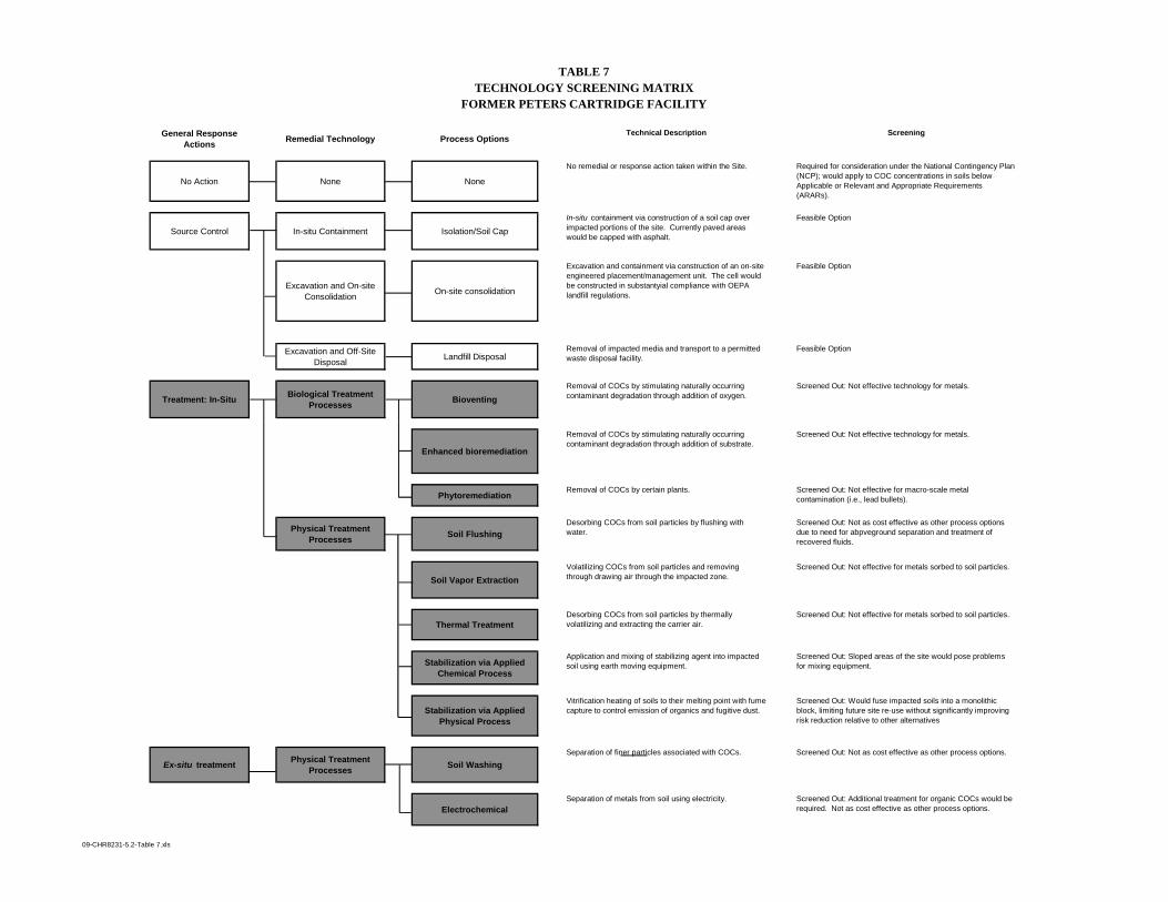
TABLE 7TECHNOLOGY SCREENING MATRIX
FORMER PETERS CARTRIDGE FACILITY
General Response Actions Remedial Technology Process Options
Technical Description Screening
No Action None None
No remedial or response action taken within the Site. Required for consideration under the National Contingency Plan (NCP); would apply to COC concentrations in soils below Applicable or Relevant and Appropriate Requirements (ARARs).
Source Control In-situ Containment Isolation/Soil CapIn-situ containment via construction of a soil cap over impacted portions of the site. Currently paved areas would be capped with asphalt.
Feasible Option
Excavation and On-site Consolidation On-site consolidation
Excavation and containment via construction of an on-site engineered placement/management unit. The cell would be constructed in substantyial compliance with OEPA landfill regulations.
Feasible Option
Excavation and Off-Site Disposal Landfill Disposal
Removal of impacted media and transport to a permitted waste disposal facility.
Feasible Option
Treatment: In-Situ Biological Treatment Processes Bioventing
Removal of COCs by stimulating naturally occurring contaminant degradation through addition of oxygen.
Screened Out: Not effective technology for metals.
Enhanced bioremediation
Removal of COCs by stimulating naturally occurring contaminant degradation through addition of substrate.
Screened Out: Not effective technology for metals.
PhytoremediationRemoval of COCs by certain plants. Screened Out: Not effective for macro-scale metal
contamination (i.e., lead bullets).
Physical Treatment Processes Soil Flushing
Desorbing COCs from soil particles by flushing with water.
Screened Out: Not as cost effective as other process options due to need for abpveground separation and treatment of recovered fluids.
Soil Vapor Extraction Volatilizing COCs from soil particles and removing through drawing air through the impacted zone.
Screened Out: Not effective for metals sorbed to soil particles.
Thermal Treatment Desorbing COCs from soil particles by thermally volatilizing and extracting the carrier air.
Screened Out: Not effective for metals sorbed to soil particles.
Stabilization via Applied Chemical Process
Application and mixing of stabilizing agent into impacted soil using earth moving equipment.
Screened Out: Sloped areas of the site would pose problems for mixing equipment.
Stabilization via Applied Physical Process
Vitrification heating of soils to their melting point with fume capture to control emission of organics and fugitive dust.
Screened Out: Would fuse impacted soils into a monolithic block, limiting future site re-use without significantly improving risk reduction relative to other alternatives
Ex-situ treatment Physical Treatment Processes Soil Washing
Separation of finer particles associated with COCs. Screened Out: Not as cost effective as other process options.
ElectrochemicalSeparation of metals from soil using electricity. Screened Out: Additional treatment for organic COCs would be
required. Not as cost effective as other process options.
09-CHR8231-5.2-Table 7.xls

TABLE 8DETAILED EVALUATION OF REMEDIAL ALTERNATIVES
FORMER PETERS CARTRIDGE FACILITY
Alternative1
Ove
rall
Prot
ectiv
enes
s
Com
plia
nce
with
AR
AR
s
Lon
g-T
erm
Eff
ectiv
enes
s
Red
uctio
n of
Tox
icity
, Mob
ility
, or
Vol
ume
Thr
ough
Tre
atm
ent
Shor
t-T
erm
Eff
ectiv
enes
s
Impl
emen
tabi
lity
Sust
aina
bilit
y
Cos
t
Comments
1. No action N/A $0 No action will not meet the RAOs.
2. Isolation/Soil capping N/A $3.8MInstallation of a soil cap will reduce mobility. Capping sloped areas would be difficult and may not be effective in the long-term. Truck traffic through the community poses health and safety risks .
3. Excavation and on-site consolidation N/A $5.0M On-site consolidation will reduce mobility. Truck traffic through the community poses health and safety risks .
4. Excavation and off-site disposal N/A $6.3MOff-site landfilling will reduce mobility. Truck traffic through the community poses health and safety risks and would have a substantial carbon footprint relative to other alternatives.
Above Average Average Below Average
1. See Section 5 of the Feasibility Study Report for a description of each remedial alternative.
09-CHR8231-5.2-Table 8.xls
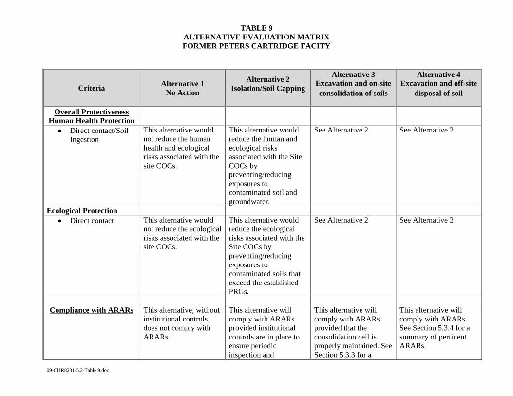
TABLE 9 ALTERNATIVE EVALUATION MATRIX FORMER PETERS CARTRIDGE FACITY
09-CHR8231-5.2-Table 9.doc
Criteria Alternative 1 No Action
Alternative 2 Isolation/Soil Capping
Alternative 3 Excavation and on-site consolidation of soils
Alternative 4 Excavation and off-site
disposal of soil
Overall Protectiveness Human Health Protection
• Direct contact/Soil Ingestion
This alternative would not reduce the human health and ecological risks associated with the site COCs.
This alternative would reduce the human and ecological risks associated with the Site COCs by preventing/reducing exposures to contaminated soil and groundwater.
See Alternative 2 See Alternative 2
Ecological Protection • Direct contact This alternative would
not reduce the ecological risks associated with the site COCs.
This alternative would reduce the ecological risks associated with the Site COCs by preventing/reducing exposures to contaminated soils that exceed the established PRGs.
See Alternative 2 See Alternative 2
Compliance with ARARs This alternative, without
institutional controls, does not comply with ARARs.
This alternative will comply with ARARs provided institutional controls are in place to ensure periodic inspection and
This alternative will comply with ARARs provided that the consolidation cell is properly maintained. See Section 5.3.3 for a
This alternative will comply with ARARs. See Section 5.3.4 for a summary of pertinent ARARs.

TABLE 9 ALTERNATIVE EVALUATION MATRIX FORMER PETERS CARTRIDGE FACITY
09-CHR8231-5.2-Table 9.doc
maintenance of soil capped areas. See Section 5.3.2 for a summary of pertinent ARARs.
summary of pertinent ARARs.
Long-term protectiveness
and permanence
Magnitude of Residual Risk
• Direct contact This alternative would not be protective of human health or the environment. It will not prevent the exposure of human and ecological receptors to soil containing concentrations of COCs above PRGs.
This alternative is protective of human health and the environment. It will prevent the direct exposure of human and ecological receptors to contaminated soil. However, contaminants will remain in place at the site and the caps will require periodic maintenance. This alternative would allow site reuse with limited restrictions (e.g., prohibition of intrusive activities in capped areas and restrictions on use of the site as residential)
This alternative is protective of human health and the environment. It will prevent the direct exposure of human and ecological receptors to contaminated soil. However, the contaminants will remain in place at the site and the consolidation cell will require periodic inspection and maintenance. This alternative will allow site re-use with limited restrictions. These restrictions will include prohibiting intrusive activities within the limits of the
This alternative is protective of human health and environmental receptors. It will prevent the exposure of human and ecological receptors to contaminated soil at the site and will allow site reuse with a restriction on residential development.
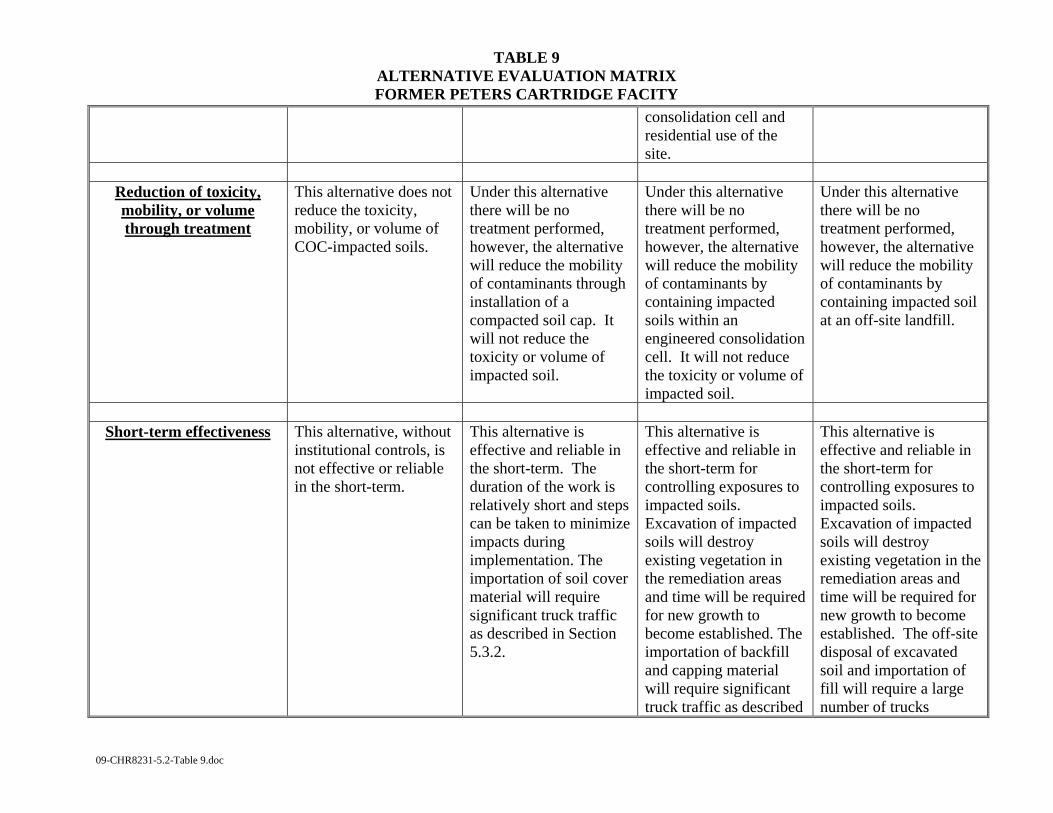
TABLE 9 ALTERNATIVE EVALUATION MATRIX FORMER PETERS CARTRIDGE FACITY
09-CHR8231-5.2-Table 9.doc
consolidation cell and residential use of the site.
Reduction of toxicity, mobility, or volume through treatment
This alternative does not reduce the toxicity, mobility, or volume of COC-impacted soils.
Under this alternative there will be no treatment performed, however, the alternative will reduce the mobility of contaminants through installation of a compacted soil cap. It will not reduce the toxicity or volume of impacted soil.
Under this alternative there will be no treatment performed, however, the alternative will reduce the mobility of contaminants by containing impacted soils within an engineered consolidation cell. It will not reduce the toxicity or volume of impacted soil.
Under this alternative there will be no treatment performed, however, the alternative will reduce the mobility of contaminants by containing impacted soil at an off-site landfill.
Short-term effectiveness This alternative, without
institutional controls, is not effective or reliable in the short-term.
This alternative is effective and reliable in the short-term. The duration of the work is relatively short and steps can be taken to minimize impacts during implementation. The importation of soil cover material will require significant truck traffic as described in Section 5.3.2.
This alternative is effective and reliable in the short-term for controlling exposures to impacted soils. Excavation of impacted soils will destroy existing vegetation in the remediation areas and time will be required for new growth to become established. The importation of backfill and capping material will require significant truck traffic as described
This alternative is effective and reliable in the short-term for controlling exposures to impacted soils. Excavation of impacted soils will destroy existing vegetation in the remediation areas and time will be required for new growth to become established. The off-site disposal of excavated soil and importation of fill will require a large number of trucks
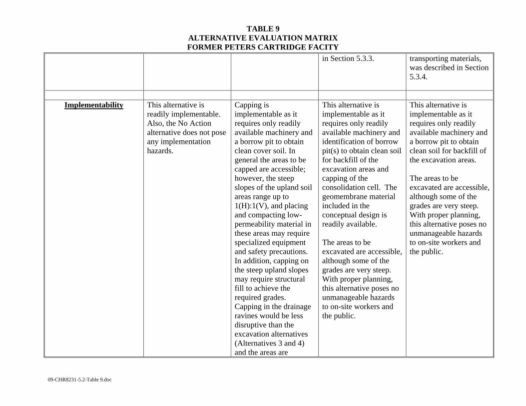
TABLE 9 ALTERNATIVE EVALUATION MATRIX FORMER PETERS CARTRIDGE FACITY
09-CHR8231-5.2-Table 9.doc
in Section 5.3.3.
transporting materials, was described in Section 5.3.4.
Implementability This alternative is
readily implementable. Also, the No Action alternative does not pose any implementation hazards.
Capping is implementable as it requires only readily available machinery and a borrow pit to obtain clean cover soil. In general the areas to be capped are accessible; however, the steep slopes of the upland soil areas range up to 1(H):1(V), and placing and compacting low-permeability material in these areas may require specialized equipment and safety precautions. In addition, capping on the steep upland slopes may require structural fill to achieve the required grades. Capping in the drainage ravines would be less disruptive than the excavation alternatives (Alternatives 3 and 4) and the areas are
This alternative is implementable as it requires only readily available machinery and identification of borrow pit(s) to obtain clean soil for backfill of the excavation areas and capping of the consolidation cell. The geomembrane material included in the conceptual design is readily available. The areas to be excavated are accessible, although some of the grades are very steep. With proper planning, this alternative poses no unmanageable hazards to on-site workers and the public.
This alternative is implementable as it requires only readily available machinery and a borrow pit to obtain clean soil for backfill of the excavation areas. The areas to be excavated are accessible, although some of the grades are very steep. With proper planning, this alternative poses no unmanageable hazards to on-site workers and the public.

TABLE 9 ALTERNATIVE EVALUATION MATRIX FORMER PETERS CARTRIDGE FACITY
09-CHR8231-5.2-Table 9.doc
generally accessible for small equipment and hand work. With proper planning this alternative poses no unmanageable hazards to on-site workers or the public, though care will need to be taken when working on the sloped areas.
Cost This alternative has no
associated capital or operation and maintenance (O&M) costs.
This alternative would cost approximately $3.8M to implement.
This alternative would cost approximately $5.0M to implement.
This alternative would cost approximately $6.3M to implement.
Sustainability This alternative will not
cause any ecosystem disturbances and has no carbon footprint. However, it will negatively impact ecological receptors due to their exposure to concentrations of COCs that exceed PRGs.
This alternative will benefit ecological receptors by eliminating the exposure to the COCs. Capping may induce negative impacts such as reduction in soil fertility, reduction in infiltration, increased storm water runoff, and some ecosystem disturbance. The importation of fill and capping material will require transportation of
This alternative will benefit ecological receptors by eliminating exposures to the COCs. However, on-site consolidation requires land disturbance to build the consolidation cell. Excavation and on-site consolidation would not require extensive trucking except for the on-site excavation equipment. The importation of fill and
In the long-term, this alternative will enhance the ecosystem by eliminating exposures to COCs. However, there are negative impacts of off-site disposal such as extensive material handling and hauling and associated fuel consumption.
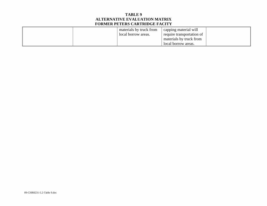
TABLE 9 ALTERNATIVE EVALUATION MATRIX FORMER PETERS CARTRIDGE FACITY
09-CHR8231-5.2-Table 9.doc
materials by truck from local borrow areas.
capping material will require transportation of materials by truck from local borrow areas.

09-CHR8231-5.2-Table 10.doc
TABLE 10 SUMMARY OF COMPLIANCE WITH ARARS FOR FINAL ALTERNATIVES
FORMER PETERS CARTRIDGE FACILITY SITE
Criteria Alternative 1 No Action
Alternative 2 Isolation/Soil Capping
Alternative 3 Excavation with On-
site Consolidation
Alternative 4 Excavation with Off-
site Disposal
Chemical-Specific ARARs
Does not meet reduction in human health risks from soil due to antimony, arsenic, lead, mercury B(a)P and naphthalene potential exposure
Will reduce human health risks from antimony, arsenic, mercury, lead, B(a)P and naphthalene
See Alternative 2
See Alternative 2
Will meet CAA and OEPA air emissions requirements during construction including the development of a dust control and abatement program
See Alternative 2 See Alternative 2
Location-Specific ARARs
Not relevant. Will not comply with Location-specific ARARs
Will require wetlands protection and the filing of a CWA Section 404 permit from the Army Corps of Engineers and Isolated Wetlands Permit with OEPA
See Alternative 2 See Alternative 2

TABLE 10 SUMMARY OF COMPLIANCE WITH ARARS FOR FINAL ALTERNATIVES
FORMER PETERS CARTRIDGE FACILITY SITE
09-CHR8231-5.2-Table 10.doc
Criteria Alternative 1 No Action
Alternative 2 Isolation/Soil Capping
Alternative 3 Excavation with On-
site Consolidation
Alternative 4 Excavation with Off-
site Disposal
Will require permission to operate within a flood control area
See Alternative 2 See Alternative 2
Will require approval from Director of ODNR for work near the Little Miami River Scenic River
See Alternative 2 See Alternative 2
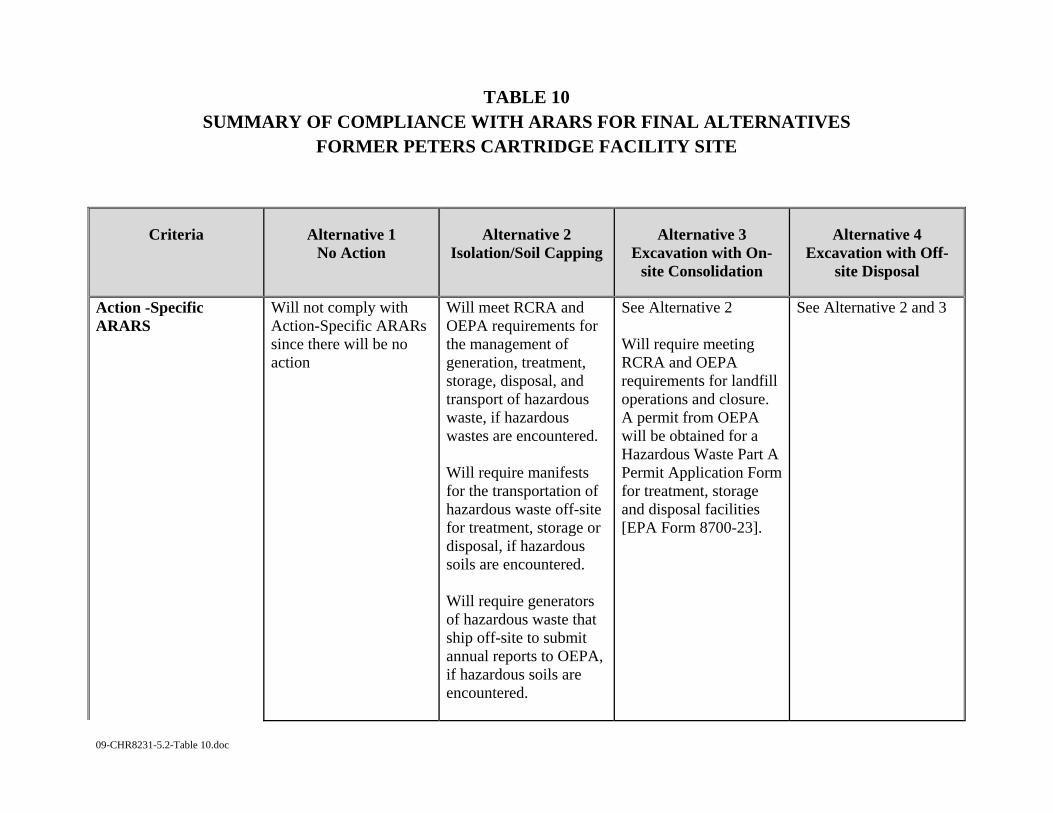
TABLE 10 SUMMARY OF COMPLIANCE WITH ARARS FOR FINAL ALTERNATIVES
FORMER PETERS CARTRIDGE FACILITY SITE
09-CHR8231-5.2-Table 10.doc
Criteria Alternative 1 No Action
Alternative 2 Isolation/Soil Capping
Alternative 3 Excavation with On-
site Consolidation
Alternative 4 Excavation with Off-
site Disposal
Action -Specific ARARS
Will not comply with Action-Specific ARARs since there will be no action
Will meet RCRA and OEPA requirements for the management of generation, treatment, storage, disposal, and transport of hazardous waste, if hazardous wastes are encountered. Will require manifests for the transportation of hazardous waste off-site for treatment, storage or disposal, if hazardous soils are encountered. Will require generators of hazardous waste that ship off-site to submit annual reports to OEPA, if hazardous soils are encountered.
See Alternative 2 Will require meeting RCRA and OEPA requirements for landfill operations and closure. A permit from OEPA will be obtained for a Hazardous Waste Part A Permit Application Form for treatment, storage and disposal facilities [EPA Form 8700-23].
See Alternative 2 and 3
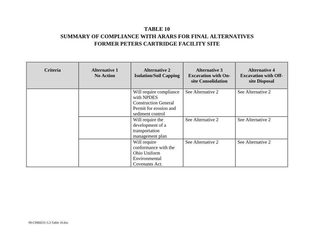
TABLE 10 SUMMARY OF COMPLIANCE WITH ARARS FOR FINAL ALTERNATIVES
FORMER PETERS CARTRIDGE FACILITY SITE
09-CHR8231-5.2-Table 10.doc
Criteria Alternative 1 No Action
Alternative 2 Isolation/Soil Capping
Alternative 3 Excavation with On-
site Consolidation
Alternative 4 Excavation with Off-
site Disposal
Will require compliance with NPDES Construction General Permit for erosion and sediment control
See Alternative 2 See Alternative 2
Will require the development of a transportation management plan
See Alternative 2 See Alternative 2
Will require conformance with the Ohio Uniform Environmental Covenants Act.
See Alternative 2
See Alternative 2
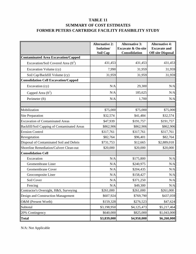
Alternative 2: Isolation/Soil Cap
Alternative 3: Excavate & On-site
Consolidation
Alternative 4: Excavate and
Off-site DisposalContaminated Area Excavation/Capped
Excavation/Soil Covered Area (ft2) 431,453 431,453 431,453
Excavation Volume (cy) 7,990 31,959 31,959
Soil Cap/Backfill Volume (cy) 31,959 31,959 31,959Consolidation Cell Excavation/Capped
Excavation (cy) N/A 29,300 N/A
Capped Area (ft2) N/A 185,625 N/A
Perimeter (ft) N/A 1,700 N/A
Mobilization $75,000 $75,000 $75,000
Site Preparation $32,574 $41,484 $32,574Excavation of Contaminated Areas $47,939 $191,757 $191,757Backfill/Soil Capping of Contaminated Areas $862,906 $862,906 $862,906Erosion Control $317,761 $317,761 $317,761Revegetation $82,764 $96,401 $82,764Disposal of Contaminated Soil and Debris $731,753 $12,665 $2,889,018Shoreline Remediation/Culvert Clean-out $20,000 $20,000 $20,000Consolidation Cell Excavation N/A $175,800 N/A Geomembrane Liner N/A $240,975 N/A Geomembrane Cover N/A $204,435 N/A Geocomposite Liner N/A $158,427 N/A Soil Cover N/A $371,250 N/A Fencing N/A $49,300 N/AContractor's Oversight, H&S, Surveying $261,000 $261,000 $261,000Design and Construction Management $607,924 $769,790 $437,059
O&M (Present Worth) $159,328 $276,523 $47,624Subtotal $3,198,950 $4,125,473 $5,217,46420% Contingency $640,000 $825,000 $1,043,000
Total $3,839,000 $4,950,000 $6,260,000
N/A: Not Applicable
TABLE 11SUMMARY OF COST ESTIMATES
FORMER PETERS CARTRIDGE FACILITY FEASIBILITY STUDY
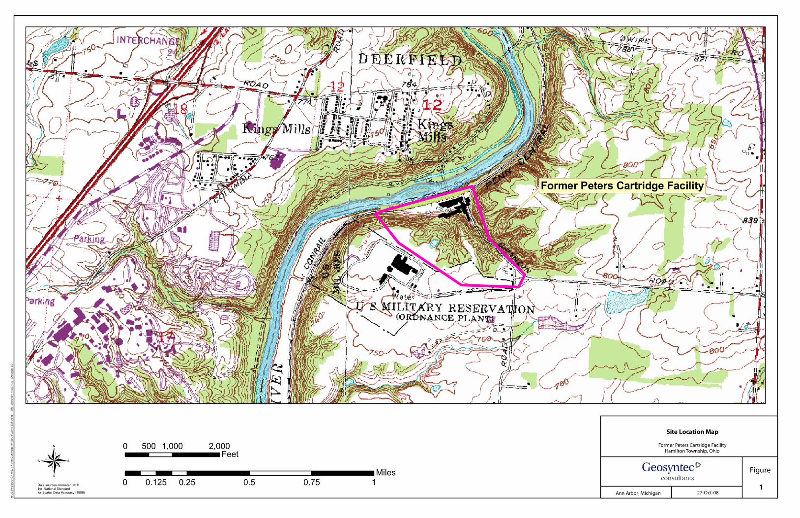
Data sources consistent wtihthe National Standardfor Spatial Data Accuracy (1998)
¬0 1,000 2,000500 Feet
0 0.25 0.5 0.75 10.125Miles
Site Location Map
Former Peters Cartridge FacilityHamilton Township, Ohio
Figure
1Ann Arbor, Michigan 27-Oct-08
H:\GI
SPro
jects\
CHR8
231-P
eters
Cartr
idge\
Projec
ts\Ju
ne_E
dits\
Fig_1
_Site
_Loca
tion_
Map.m
xd; C
hicag
o-JD
@A @A
@A
@A
@A
@A@A
@A
@A
@A
@A
@A
@A
@A
@A
@A
Former Peters Cartridge Facility
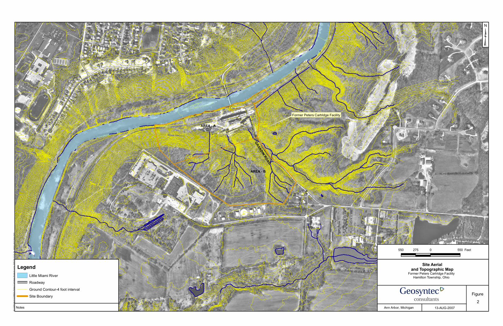
Former Peters Cartridge Facility
AREA - A
AREA - B
GRANDIN ROAD
Site Aerialand Topographic Map
Former Peters Cartridge FacilityHamilton Township, Ohio
Figure
Q:\G
ISPro
jects\
CHR8
231-P
eters
Car
tridge
\Pro
jects\
June
_Edit
s\fig
_I2-J2
_site
_aer
ial_a
nd_to
po.m
xd
Notes Ann Arbor, Michigan 13-AUG-2007
550 0 550275 Feet
³
LegendLittle Miami RiverRoadwayGround Contour-4 foot intervalSite Boundary
2

BACK F
ILLED
RESERV
OIR
R-74R-73R-71
R-72R-75R-76
R-63
GUARD HOUSE
GUARD HOUSE
GUARD HOUSE
GUARD HOUSEMUNICIPAL
WELL
CULVERT
CULVERT
OLD RAIL
ROAD SUP
PORTS
SALVAGE
UPPERPUMPHOUSE
SEWERPUMP STATION
CULVERT
F F
FF BLDG
B
F
F
B
B
FR-77
B
EQUIPMENT HOUSEMIX/PROCESSHOUSE
F
BB
B
F
R-56STRUSSPIPESUPPORTSPUMPSTA.
PIPE/WALKWAY
SUPPORTS FF
B
B
FF
F
CISTERN/VAULT
BB T
B
BBT
F
R-44
TARGETPLATFORM
CHIMNEY
R-1
R-19 R-35
R-9
LAB R-2
R-2R-3
R-3 R-23
R-36
R-53R-37 R-
39
CULVERTCULVERT
CULVERT
F
U.S. ARMYRESERVE CENTER(FORMER KMOP
WARREN CO. MUNICIPALWASTEWATER TREATMENT
PLANT
CULVERT
GOVERNMENT PLANT)
STORAGE /
R-21
Proposed Area A3
Proposed Area A1
Proposed Area A2
GRANDIN ROAD
Exposure Area B4
Exposure Area B1
Exposure Area A1
Exposure Area A3
Exposure Area B2
Exposure Area B3Exposure Area B5
Exposure Area A2
Property Parcel Map with Exposure Areas
Former Peters Cartridge FacilityHamilton Township, Ohio
Figure
H:\G
ISPro
jects\
CHR8
231-P
eter
sCar
tridge
\Pro
jects\
June
_Edit
s\Fig
3_Pr
oper
ty_pa
rcel.
mxd
Notes Ann Arbor, Michigan 1-JUL-2009
250 0 250125 Feet
³
LegendLittle Miami RiverFenceGround Contour-4 foot interval
LAND PARCELS BY OWNEROWNER NAME
KINGS MILLS TECHNICAL CENTERHAMILTON TOWNSHIP PROPERTYLITTLE MIAMI INCSTATE OF OHIO DEPT NATURAL RESOURCES PAVED PORTION OF LMR SCENIC TRAIL (ODNR)TEJ HOLDINGS INC (TEJ)WARREN COUNTY COMMISSIONERS (LOT 1)WARREN COUNTY COMMISSIONERS (LOT 2)
3

R-74R-73
R-71R-72
R-75R-76
R-63
MANHOLE
MANHOLE
GUARD HOUSE
GUARD HOUSE
GUARD HOUSE
GUARD HOUSE
MANHOLE
DRYWELL
CULVERT
CULVERT
OLD RAILROAD SUPPORTS
SALVAGE
UPPERPUMP
HOUSE
SEWERPUMP STATION
AOC 1 AOC 2
AOC 3
AOC 4AOC 5
AOC 6
AOC 12
F F
FF BLDG
B
F
F
B
B
FR-77
EQUIPMENT HOUSEMIX/PROCESSHOUSE
F
BB
B
F
R-56
STRUSSPIPESUPPORTS
PUMPSTA.
PIPE/WALKWAY
SUPPORTSF
B
FF
F
CISTERN/VAULT
BB T
B
B
BT
F
R-44
TARGETPLATFORM
CHIMNEY
R-1
R-19R-35
R-9
LAB
R-2
R-2
R-3
R-23
R-36
R-1 ANNEX
R-16R-53
R-21
R-58
R-34
R-6
R-24 R-37 R-
39
R-5CULVERT
CULVERT
CULVERT
F
CULVERT
KMOPGOVERNMENT
PLANT
F
STORAGE /
AOC 11
AOC 7 AOC 9(CULVERT/SWALE 1) (CULVERT/SWALE 3)
AOC 10
AOC 14
AOC 13
AOC 13
AOC 13
AOC 13
AOC 13AOC 13
FELT & WAD MFG.
WARREN COUNTYWATER TREATMENT
PLANT
AOC 1 AOC 2
AOC 3
AOC 4AOC 5
AOC 6
AOC 12
AOC 11
AOC 7 AOC 9(CULVERT/SWALE 1) (CULVERT/SWALE 3)
AOC 10
AOC 14
AOC 13
AOC 13
AOC 13
AOC 13
AOC 13AOC 13
GRANDIN ROAD
AOC 8(CULVERT/SWALE 2)
Q:\G
ISPr
ojects
\CHR
8231
-Pete
rs Ca
rtridg
e\Proj
ects\
June
_Edit
s\Fig_
3_cu
rrent_
site_
layou
t.mxd
C'
Current Site Layout and Potential Areas of Concern
Former Peters Cartridge FacilityHamilton Township, Ohio
Figure
ANN ARBOR, MICHIGAN 21-APR-2009
0 250 500Feet
LegendRoadwaySwales/Drainage FeatureLittle Miami RiverFenceSite FeaturesFormer Building/StructureOccupied Building/StructureCulverts/Drainage Features
³
4F - Foundation / Structure RemnantsB - Bunker / Ingloo Storage StructureKMOP - Kings Mills Ordinance PlantT - Transformer
AOC 1 - Salvage areaAOC 2 - Fulminate Production/AssemblyAOC 3 - Main Buildings/FacilityAOC 4 - Shooting RangeAOC 5 - Shooting Range/Test Facility/ and Outdoor Target PlatformAOC 6 - Shooting RangeAOC 7 - Culvert/Swale 1AOC 8 - Culvert/Swale 2AOC 9 - Culvert/Swale 3AOC 10 - Storage/Mix HousesAOC 11 - Storage/Mix HousesAOC 12 - Felt & Wad Manufacturing AreaAOC 13 - Area B Bunkers/Foundations/ Misc StructuresAOC 14 - Former Railroad Spur
AOC Descriptions

Q:\G
ISPr
ojects
\CHR
8231
-Pete
rs Ca
rtridg
e\Proj
ects\
June
_Edit
s\Fig_
J5_Z
oning
.mxd
C'
Property and Vicinity Zoning DesignationsFormer Peters Cartridge Facility
Hamilton Township, Ohio
Figure
ANN ARBOR, MICHIGAN 28-Oct-08
0 3,000 6,000Feet
LegendSite BoundarySwales/Drainage FeatureLittle Miami River
Hamilton Twp. Zoning DesignationB-1 Neighborhood BusinessB-2 General BusinessM-1 Light IndustrialM-2 Heavy IndustrialR-1 Residential/AgricultureR-2 Residential-1 to 2 FamilyR-3 Residential-Multi-FamilyR-4 UrbanM-H Mobile Home ParkT-C Trailer Camp
³
5
Former Peters Cartridge Facility
3-mile radius
1-mile radius
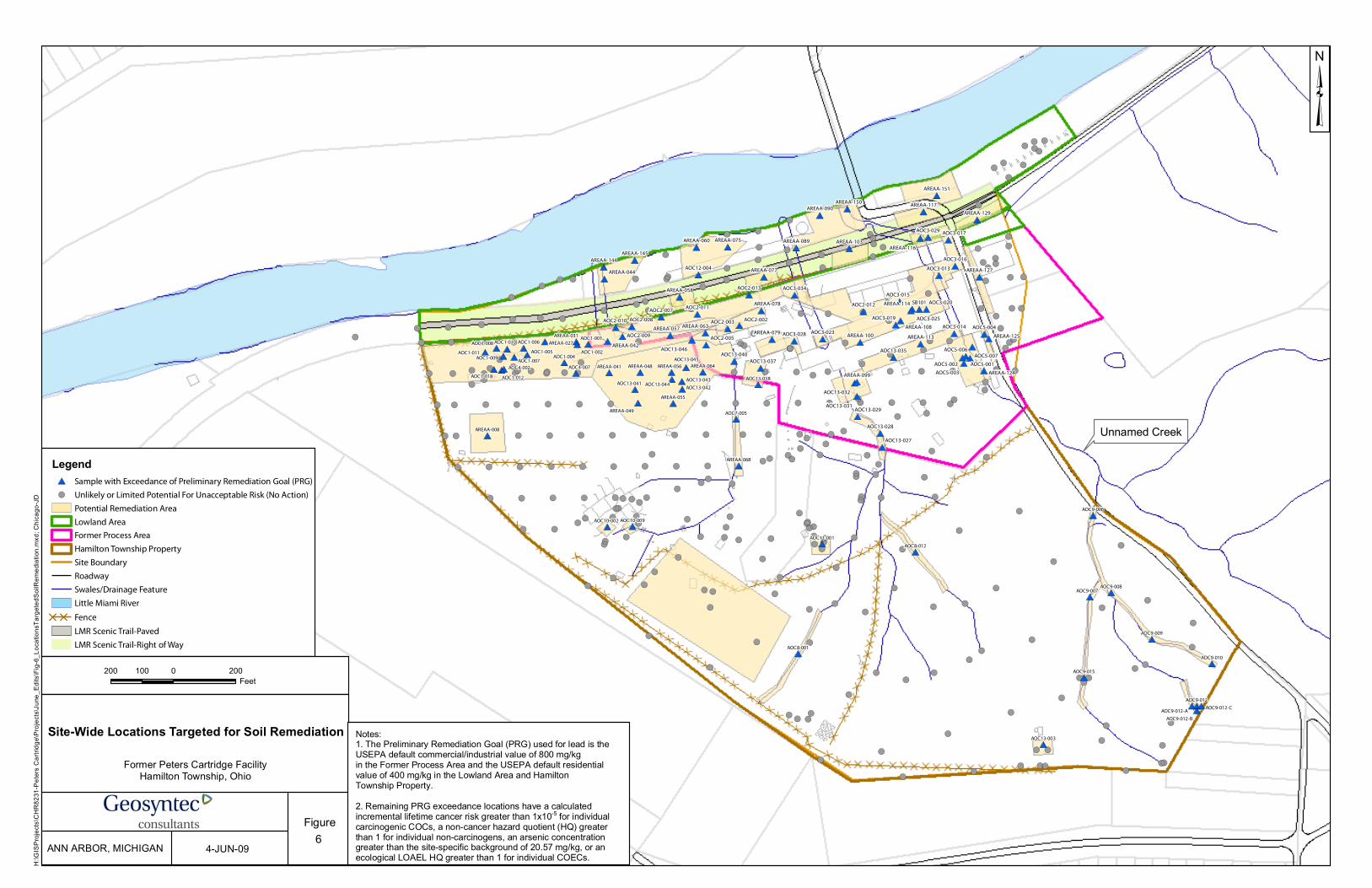
!
!
!!
!
!
!
!
!
!
!!
!
!
!
!
!
!
!!
!
!
!
!
!
!
!
!!
!
!
!
!
!
!
!
!!
!
!
!
!
!
!!!
(
(
((
(
(
(
(
(
(
((
(
(
(
(
(
(
((
(
(
(
(
(
(
(
((
(
(
(
(
(
(
(
((
(
(
(
(
(
(((
#
#
#
#
#
#
#
#
#
#
#
#
#
#
#
#
#
#*
*
*
*
*
*
*
*
*
*
*
*
*
*
*
*
*
*
!!!
!
!! !
! !!
!
!
!
!
!
!
!
!!!
!
!
! !
!
!
!
!
!!
!
!
!
!
!
!
!
!
!
!! !
!
!
!
!
! !
!
!
!
!!
!
!
!! !
!
!
!
! !
(((
(
(( (
( ((
(
(
(
(
(
(
(
(((
(
(
( (
(
(
(
(
((
(
(
(
(
(
(
(
(
(
(( (
(
(
(
(
( (
(
(
(
((
(
(
(( (
(
(
(
( (
*#*#
*#
*#*#
*#*#
*# *#
*#
*#*# *#
*#
*#
*#
*#
*#
*#
*#
*#
*#
*#
*#
*#
*# *#
*#*#
*#
*#*#*#
*#
*#*#
*#
*#*#
*#
*#
*#
*#
*#
*#
*#*#
*#*#!
!
!
!
!!
!
! !
! !
!! ! ! ! !
! ! ! !
! !
! !
!
!
!
!
!!
!!
! !
!!
!
!
!
!
!
!
!
!!
!
!
!
! !
!
!
!
! !
!
!
! !
!
!
! !
! !
!
!
!
!
!
! !
!
!
!
!
!
!
!
!
!
!
!
!
!
!!
!
!
!
!
!
!
!
!
! !
!!
!!
!
!
!!
!
!!!
!
!!
!
!
!
!
!
!
!
!
!
!
!
!
!
!
!
!
!
!
!
!
!
!
!
!
!
!
!!
!
!
!
!
!
!
! !
!
!
!
! !
!!!!
!
!!!!
!
!
!
!!!
!
!
!
!
!
!
!
!
!
!
!
!!
(
(
(
(
((
(
( (
( (
(( ( ( ( (
( ( ( (
( (
( (
(
(
(
(
((
((
( (
((
(
(
(
(
(
(
(
((
(
(
(
( (
(
(
(
( (
(
(
( (
(
(
( (
( (
(
(
(
(
(
( (
(
(
(
(
(
(
(
(
(
(
(
(
(
((
(
(
(
(
(
(
(
(
( (
((
((
(
(
((
(
(((
(
((
(
(
(
(
(
(
(
(
(
(
(
(
(
(
(
(
(
(
(
(
(
(
(
(
(
(
((
(
(
(
(
(
(
( (
(
(
(
( (
((((
(
((((
(
(
(
(((
(
(
(
(
(
(
(
(
(
(
(
((
##
###
###
##
##
# #
# # # #
#
#
# #
## #
##
#
#
#
# #
#
#
#
##
#
# #
#
#
####
#
**
***
***
**
**
* *
* * * *
*
*
* *
** *
**
*
*
*
* *
*
*
*
**
*
* *
*
*
****
*
Unnamed Creek
AOC9-015
AOC9-012
AOC9-010
AOC9-009
AOC9-008AOC9-007
AOC9-006
AOC8-012
AOC8-001
AOC7-005
AOC4-007AOC4-002
AOC1-018 AOC1-012
AOC1-011
AOC1-010
AOC1-009AOC1-007
AOC1-006
AOC1-004AOC1-002
AOC1-001
AOC11-001
AOC13-003
AREAA-068
AREAA-064AREAA-056
AREAA-055
AREAA-008
AOC13-045
AOC13-044AOC13-043
AOC13-042AOC13-041
AOC13-038
AOC10-009AOC10-002
AREAA-049
AREAA-048AREAA-041
AREAA-031
AREAA-027
AOC9-012-C
AOC9-012-B
AOC9-012-A
AOC1-008
AOC1-005
SB101
AOC3-029
AREAA-089
AREAA-129
AREAA-103
AREAA-117
AREAA-058
AREAA-151
AREAA-044
AREAA-145
AREAA-077
AREAA-090
AREAA-144
AREAA-116
AREAA-150
AREAA-060
AOC12-004
AREAA-075
AOC3-014
AOC5-007AOC5-006
AOC5-004
AOC5-003
AOC5-002 AOC5-001
AOC3-034
AOC3-028
AOC3-025
AOC3-023
AOC3-020
AOC3-019
AOC3-017
AOC3-016
AOC3-015
AOC3-013
AOC2-013
AOC2-012AOC2-011
AOC2-010
AOC2-009
AOC2-008
AOC2-007
AOC2-005
AOC2-003 AOC2-002
AOC13-040AOC13-037
AREAA-099
AOC13-032
AOC13-031AOC13-029
AOC13-028
AOC13-027
AOC13-035
AREAA-113 AREAA-125
AREAA-124
AREAA-127
AREAA-114
AREAA-108
AREAA-100AREAA-079
AOC13-046
AREAA-078
AREAA-063AREAA-057
AREAA-042
Legend#* Sample with Exceedance of Preliminary Remediation Goal (PRG)
!( Unlikely or Limited Potential For Unacceptable Risk (No Action)
Potential Remediation Area
Lowland Area
Former Process Area
Hamilton Township Property
Site Boundary
Roadway
Swales/Drainage Feature
Little Miami River
DD DD Fence
LMR Scenic Trail-Paved
LMR Scenic Trail-Right of Way
H:\G
ISPr
ojects
\CHR
8231
-Pete
rs Ca
rtridg
e\Proj
ects\
June
_Edit
s\Fig-
6_Lo
catio
nsTa
rgeted
SoilR
emed
iation
.mxd
; Chic
ago-J
D
C'
Site-Wide Locations Targeted for Soil Remediation
Former Peters Cartridge FacilityHamilton Township, Ohio
FigureANN ARBOR, MICHIGAN 4-JUN-09
200 0 200100Feet
³
6
Notes:1. The Preliminary Remediation Goal (PRG) used for lead is theUSEPA default commercial/industrial value of 800 mg/kgin the Former Process Area and the USEPA default residentialvalue of 400 mg/kg in the Lowland Area and HamiltonTownship Property.2. Remaining PRG exceedance locations have a calculatedincremental lifetime cancer risk greater than 1x10⁻⁵ for individualcarcinogenic COCs, a non-cancer hazard quotient (HQ) greaterthan 1 for individual non-carcinogens, an arsenic concentrationgreater than the site-specific background of 20.57 mg/kg, or anecological LOAEL HQ greater than 1 for individual COECs.
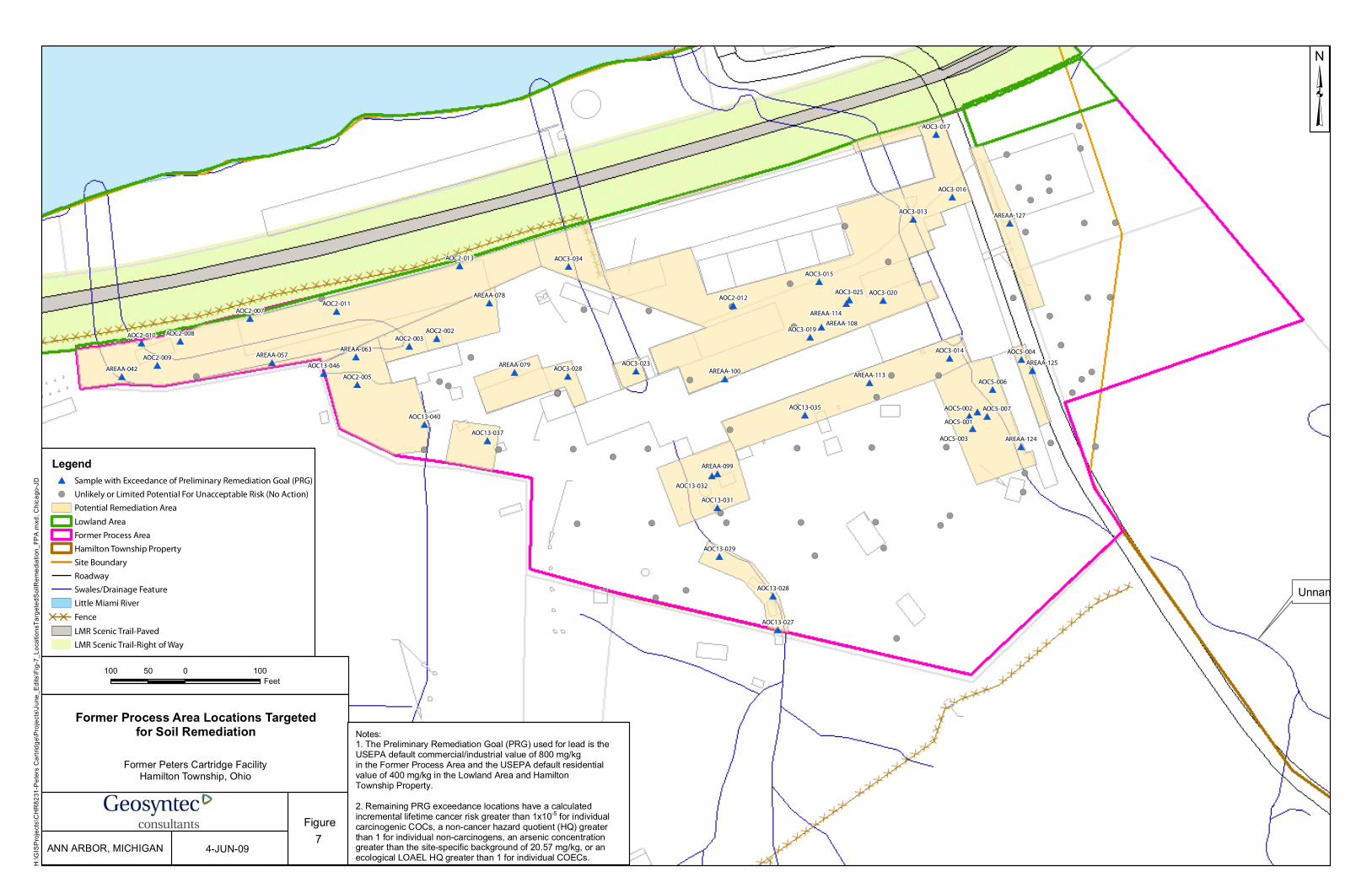
!
!!
!
!
! !
!!
!
!
!
!
!
!
!
!
!
!
!
!
!
!!
!
!
!
!
!
!
!
!
!
!
!
!
!
!
!
!! !
!
!
!
!
! !
!
!
!
!
!
!
!
!
! !
!
!
!
! !
(
((
(
(
( (
((
(
(
(
(
(
(
(
(
(
(
(
(
(
((
(
(
(
(
(
(
(
(
(
(
(
(
(
(
(
(( (
(
(
(
(
( (
(
(
(
(
(
(
(
(
( (
(
(
(
( (
*#*#
*#
*#
*#
*#
*#
*#*#
*#
*#
*#*#
*#
*#
*#
*#
*#
*#
*#
*#
*#
*#
*#
*#
*#*#
*#
*#
*#
*#*#
*#
*#
*#
*#
*#
*#
*#
*#
*#
*#
*#
*#
*#
*#*#
*#
*#
Unnamed Creek
AOC3-014
AOC5-007
AOC5-006
AOC5-004
AOC5-003
AOC5-002
AOC5-001
AOC3-034
AOC3-028
AOC3-025
AOC3-023
AOC3-020
AOC3-019
AOC3-017
AOC3-016
AOC3-015
AOC3-013
AOC2-013
AOC2-012AOC2-011
AOC2-010
AOC2-009
AOC2-008
AOC2-007
AOC2-005
AOC2-003AOC2-002
AOC13-040
AOC13-037
AREAA-099
AOC13-032
AOC13-031
AOC13-029
AOC13-028
AOC13-027
AOC13-035
AREAA-113
AREAA-125
AREAA-124
AREAA-127
AREAA-114
AREAA-108
AREAA-100AREAA-079AOC13-046
AREAA-078
AREAA-063AREAA-057
AREAA-042
Legend#* Sample with Exceedance of Preliminary Remediation Goal (PRG)
!( Unlikely or Limited Potential For Unacceptable Risk (No Action)
Potential Remediation Area
Lowland Area
Former Process Area
Hamilton Township Property
Site Boundary
Roadway
Swales/Drainage Feature
Little Miami River
DD DD Fence
LMR Scenic Trail-Paved
LMR Scenic Trail-Right of Way
H:\G
ISPr
ojects
\CHR
8231
-Pete
rs Ca
rtridg
e\Proj
ects\
June
_Edit
s\Fig-
7_Lo
catio
nsTa
rgeted
SoilR
emed
iation
_FPA
.mxd
; Chic
ago-J
D
C'
Former Process Area Locations Targetedfor Soil Remediation
Former Peters Cartridge FacilityHamilton Township, Ohio
FigureANN ARBOR, MICHIGAN 4-JUN-09
100 0 10050Feet
³
7
Notes:1. The Preliminary Remediation Goal (PRG) used for lead is theUSEPA default commercial/industrial value of 800 mg/kgin the Former Process Area and the USEPA default residentialvalue of 400 mg/kg in the Lowland Area and HamiltonTownship Property.2. Remaining PRG exceedance locations have a calculatedincremental lifetime cancer risk greater than 1x10⁻⁵ for individualcarcinogenic COCs, a non-cancer hazard quotient (HQ) greaterthan 1 for individual non-carcinogens, an arsenic concentrationgreater than the site-specific background of 20.57 mg/kg, or anecological LOAEL HQ greater than 1 for individual COECs.

!
!
!
!
!
!
!
!
!
!
!!
!
!
!
!
!
!
!
!
!
!
!
!
!
!
!
!!
!
!
!
!
!
!
!
!
!
!
!
!
!
!
!
!!
(
(
(
(
(
(
(
(
(
(
((
(
(
(
(
(
(
(
(
(
(
(
(
(
(
(
((
(
(
(
(
(
(
(
(
(
(
(
(
(
(
(
((
#
#
#
#
#
#
#
#
#
#
#
#
#
#
#
#
#*
*
*
*
*
*
*
*
*
*
*
*
*
*
*
*
*
Unnamed Creek
AOC3-029
AREAA-089
AREAA-129
AREAA-103
AREAA-117
AREAA-058
AREAA-151
AREAA-044
AREAA-145
AREAA-077
AREAA-090
AREAA-144
AREAA-116
AREAA-150
AREAA-060
AOC12-004
AREAA-075
Legend#* Sample with Exceedance of Preliminary Remediation Goal (PRG)
!( Unlikely or Limited Potential for Unacceptable Risk
Potential Remediation Area
Lowland Area
Former Process Area
Hamilton Township Property
Site Boundary
Roadway
Swales/Drainage Feature
Little Miami River
DD DD Fence
LMR Scenic Trail-Paved
LMR Scenic Trail-Right of Way
H:\G
ISPr
ojects
\CHR
8231
-Pete
rs Ca
rtridg
e\Proj
ects\
June
_Edit
s\Fig-
8_Lo
catio
nsTa
rgeted
SoilR
emed
iation
_LOW
.mxd
; Chic
ago-J
D
C'
Lowland Area Locations Targetedfor Soil Remediation
Former Peters Cartridge FacilityHamilton Township, Ohio
FigureANN ARBOR, MICHIGAN 6-MAY-09
150 0 15075Feet
³
8
Notes:1. The Preliminary Remediation Goal (PRG) used for lead is theUSEPA default commercial/industrial value of 800 mg/kgin the Former Process Area and the USEPA default residentialvalue of 400 mg/kg in the Lowland Area and HamiltonTownship Property.2. Remaining PRG exceedance locations have a calculatedincremental lifetime cancer risk greater than 1x10⁻⁵
for individual carcinogenic COCs, a non-cancer hazard quotient(HQ) greater than 1 for individual non-carcinogens, or an arsenicconcentration greater than the site-specificbackground of 20.57 mg/kg.

!
!
!
!
!
!
!
! !
! !
!! ! ! ! !
! ! ! !
! !
! !
!
!
!
!
!!
!
!
! !
!
!
!
!
!
!
!
!
!
!!
!
!
!
! !
!
!
!
! !
!
!
! !
!
!
! !
! !
!
!
!
!
!
! !
!
!
!
!
!
!
!
!
!
!
!
!
!
!!
!
!
!
!
!
!
!
!
! !
!!
!!
!
!
!!
!
!!
!
!
!!
!
!
!
!
!
!
!
!
!
!
!
!
!
!
!
!
!
!
!
!
!
!
!
!
!
!
!!
!
!
!
!
!
!
! !
!
!
!
! !
!
!!!
!
!!!!
!
!
!
!!!
!
!
!
!
!
!
!
!
!
!
!
!
!
(
(
(
(
(
(
(
( (
( (
(( ( ( ( (
( ( ( (
( (
( (
(
(
(
(
((
(
(
( (
(
(
(
(
(
(
(
(
(
((
(
(
(
( (
(
(
(
( (
(
(
( (
(
(
( (
( (
(
(
(
(
(
( (
(
(
(
(
(
(
(
(
(
(
(
(
(
((
(
(
(
(
(
(
(
(
( (
((
((
(
(
((
(
((
(
(
((
(
(
(
(
(
(
(
(
(
(
(
(
(
(
(
(
(
(
(
(
(
(
(
(
(
(
((
(
(
(
(
(
(
( (
(
(
(
( (
(
(((
(
((((
(
(
(
(((
(
(
(
(
(
(
(
(
(
(
(
(
(
##
###
#
##
##
# #
# #
## # #
#
#
# #
## #
##
#
#
#
# #
#
#
#
#
#
#
##
#
#
####
#
**
***
*
**
**
* *
* *
** * *
*
*
* *
** *
**
*
*
*
* *
*
*
*
*
*
*
**
*
*
****
*
Unnamed Creek
AOC9-015
AOC9-012
AOC9-010
AOC9-009
AOC9-008AOC9-007
AOC9-006
AOC8-012
AOC8-001
AOC7-005
AOC4-007AOC4-002
AOC1-018 AOC1-012
AOC1-011
AOC1-010
AOC1-009AOC1-007
AOC1-006
AOC1-004AOC1-002
AOC1-001
AOC11-001
AOC13-003
AREAA-068
AREAA-064AREAA-056
AREAA-055
AREAA-008
AOC13-045
AOC13-044AOC13-043
AOC13-042AOC13-041
AOC13-038
AOC10-009AOC10-002
AREAA-049
AREAA-048AREAA-041
AREAA-031
AREAA-027
AOC9-012-C
AOC9-012-B
AOC9-012-A
AOC1-008
AOC1-005
Legend#* Sample with Exceedance of Preliminary Remediation Goal (PRG)
!( Unlikely or Limited Potential For Unacceptable Risk (No Action)
Potential Remediation Area
Lowland Area
Former Process Area
Hamilton Township Property
Site Boundary
Roadway
Swales/Drainage Feature
Little Miami River
DD DD Fence
LMR Scenic Trail-Paved
LMR Scenic Trail-Right of Way
H:\G
ISPr
ojects
\CHR
8231
-Pete
rs Ca
rtridg
e\Proj
ects\
June
_Edit
s\Fig-
9_Lo
catio
nsTa
rgeted
SoilR
emed
iation
_HTP
.mxd
; Chic
ago-J
D
C'
Hamilton Township Property Locations Targetedfor Soil Remediation
Former Peters Cartridge FacilityHamilton Township, Ohio
FigureANN ARBOR, MICHIGAN 4-JUN-09
200 0 200100Feet
³
9
Notes:1. The Preliminary Remediation Goal (PRG) used for lead is theUSEPA default commercial/industrial value of 800 mg/kgin the Former Process Area and the USEPA default residentialvalue of 400 mg/kg in the Lowland Area and HamiltonTownship Property.2. Remaining PRG exceedance locations have a calculatedincremental lifetime cancer risk greater than 1x10⁻⁵ for individualcarcinogenic COCs, a non-cancer hazard quotient (HQ) greaterthan 1 for individual non-carcinogens, an arsenic concentrationgreater than the site-specific background of 20.57 mg/kg, or anecological LOAEL HQ greater than 1 for individual COECs.
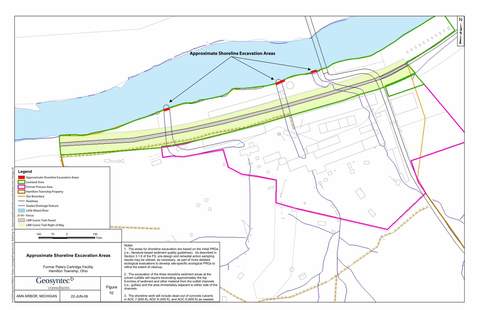
Unnamed Creek
Approximate Shoreline Excavation Areas
LegendApproximate Shoreline Excavation Areas
Lowland Area
Former Process Area
Hamilton Township Property
Site Boundary
Roadway
Swales/Drainage Feature
Little Miami River
DD DD Fence
LMR Scenic Trail-Paved
LMR Scenic Trail-Right of Way
H:\G
ISPr
ojects
\CHR
8231
-Pete
rs Ca
rtridg
e\Proj
ects\
June
_Edit
s\Fig-
10_A
pprox
imate
Shore
lineE
xcav
ation
Area
s.mxd
; Chic
ago-J
D
C'
Approximate Shoreline Excavation Areas
Former Peters Cartridge FacilityHamilton Township, Ohio
FigureANN ARBOR, MICHIGAN 22-JUN-09
150 0 15075Feet
³
10
Notes:1. The areas for shoreline excavation are based on the initial PRGs(i.e., literature-based sediment quality guidelines). As described inSection 3.1.6 of the FS, pre-design and remedial action samplingresults may be utilized, as necessary, as part of more detailedecological evaluations to develop site-specific ecological PRGs torefine the extent of cleanup.2. The excavation of the three shoreline sediment areas at theculvert outfalls will require excavating approximately the top6-inches of sediment and other material from the outfall channels(i.e., gullies) and the area immediately adjacent to either side of thechannels. 3. The shoreline work will include clean-out of concrete culvertsin AOC 7 (650 ft), AOC 8 (450 ft), and AOC 9 (900 ft) as needed.
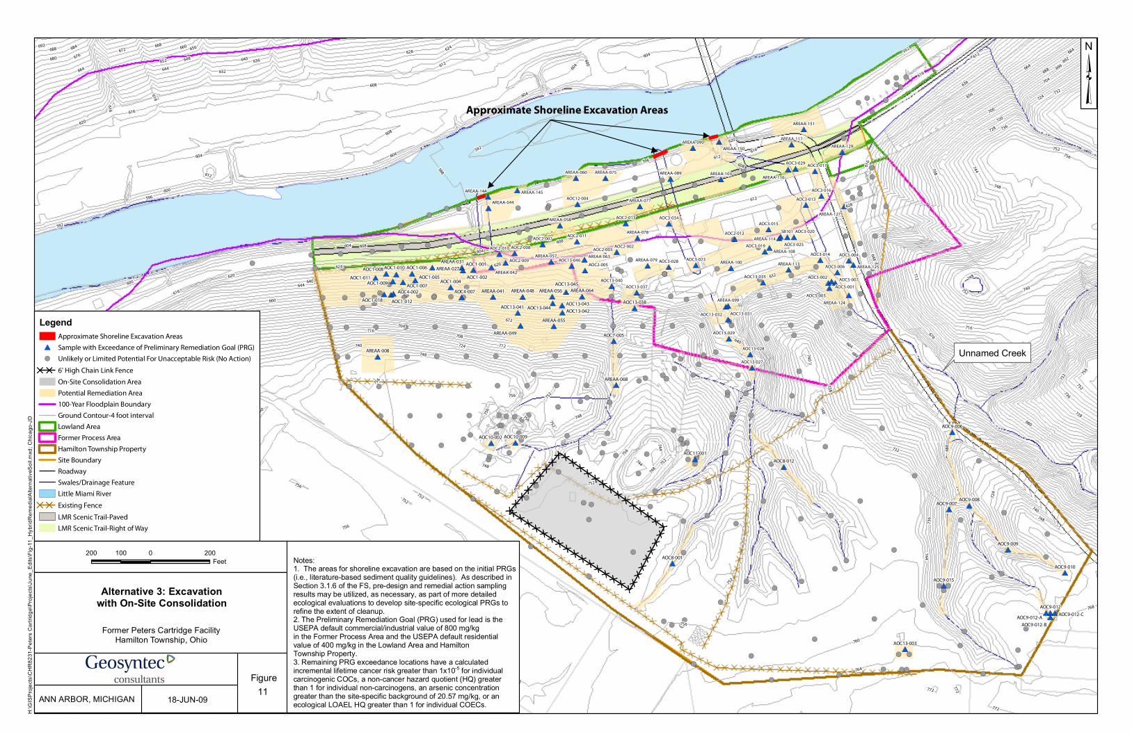
DDDDDDDDDDDDDDDDDDDD
DDDDDDDDDDDDDDDDDDDDDDDDDDDD
DDDDDDDDDDDD
DDDDDDDDDDDDDDDDDDDDDDDDDDDDDDDD
!
!
!!
!
!
!
!
!
!
!!
!
!
!
!
!
!
!
!
!
!
!
!
!
!
!
!!
!
!
!
!
!
!
!
!!
!
!
!
!
!
!!!
(
(
((
(
(
(
(
(
(
((
(
(
(
(
(
(
(
(
(
(
(
(
(
(
(
((
(
(
(
(
(
(
(
((
(
(
(
(
(
(((
#
#
#
#
#
#
#
#
#
#
#
#
#
#
#
#
#
#*
*
*
*
*
*
*
*
*
*
*
*
*
*
*
*
*
*
!
!!
!
!! !
! !
!
!
!
!
!
!
!
!
!!!
!
!
! !
!
!
!
!
!!
!
!
!
!
!
!
!
!
!
!! !
!
!
!
!
! !
!
!
!
!!
!
!
!! !
!
!
!
! !
(
((
(
(( (
( (
(
(
(
(
(
(
(
(
(((
(
(
( (
(
(
(
(
((
(
(
(
(
(
(
(
(
(
(( (
(
(
(
(
( (
(
(
(
((
(
(
(( (
(
(
(
( (
##
#
##
##
# #
#
## #
#
#
#
#
#
#
#
#
#
#
#
#
# #
##
#
###
#
#
#
#
##
#
#
#
#
#
#
##
##
**
*
**
**
* *
*
** *
*
*
*
*
*
*
*
*
*
*
*
*
* *
**
*
***
*
*
*
*
**
*
*
*
*
*
*
**
**!
!
!
!
!!
!
! !
! !
!! ! ! ! !
! ! ! !
! !
! !
!
!
!
!
!!
!
!
! !
!!
!
!
!
!
!
!
!
!!
!
!
!
! !
!
!
!
! !
!
!
! !
!
!
! !
! !
!
!
!
!
!
! !
!
!
!
!
!
!
!
!
!
!
!
!
!
!!
!
!
!
!
!
!
!
!
! !
!!
!!
!
!
!!
!
!!
!
!
!!
!
!
!
!
!
!
!
!
!
!
!
!
!
!
!
!
!
!
!
!
!
!
!
!
!
!
!!
!
!
!
!
!
!
! !
!
!
!
! !
!!!!
!
!!!!
!
!
!
!!!
!
!
!
!
!
!
!
!
!
!
!
!!
(
(
(
(
((
(
( (
( (
(( ( ( ( (
( ( ( (
( (
( (
(
(
(
(
((
(
(
( (
((
(
(
(
(
(
(
(
((
(
(
(
( (
(
(
(
( (
(
(
( (
(
(
( (
( (
(
(
(
(
(
( (
(
(
(
(
(
(
(
(
(
(
(
(
(
((
(
(
(
(
(
(
(
(
( (
((
((
(
(
((
(
((
(
(
((
(
(
(
(
(
(
(
(
(
(
(
(
(
(
(
(
(
(
(
(
(
(
(
(
(
(
((
(
(
(
(
(
(
( (
(
(
(
( (
((((
(
((((
(
(
(
(((
(
(
(
(
(
(
(
(
(
(
(
((
##
###
###
##
##
# #
# # # #
#
#
# #
## #
##
#
#
#
# #
#
#
#
##
#
# #
#
#
####
#
**
***
***
**
**
* *
* * * *
*
*
* *
** *
**
*
*
*
* *
*
*
*
**
*
* *
*
*
****
*
Unnamed Creek
AOC9-015
AOC9-012
AOC9-010
AOC9-009
AOC9-008AOC9-007
AOC9-006
AOC8-012
AOC8-001
AOC7-005
AOC4-007AOC4-002
AOC1-018 AOC1-012
AOC1-011
AOC1-010
AOC1-009AOC1-007
AOC1-006
AOC1-004AOC1-002
AOC1-001
AOC11-001
AOC13-003
AREAA-068
AREAA-064AREAA-056
AREAA-055
AREAA-008
AOC13-045
AOC13-044AOC13-043
AOC13-042AOC13-041
AOC13-038
AOC10-009AOC10-002
AREAA-049
AREAA-048AREAA-041
AREAA-031
AREAA-027
AOC9-012-C
AOC9-012-B
AOC9-012-A
AOC1-008
AOC1-005
Approximate Shoreline Excavation Areas
672
668
664
660
656
652
648
644640
720
636
716
712
708
704
700
676
680
696
684
692
688
632
628
624
620
616
612
608604
600
596
752
748
592
744
740
736
732
728
724
756
760
588
764
768
772
604
736
748
632
604
736
752
608
756
612
728
676
752
648
616 740
600
616
732
628
604
732
600
616
620
636
760
748
616
696
748
712
668
752
684
596
688
732
604
756
748
724
692
752
752
676
748
660
608
752
736
680
644
744
684
756
612
720
744760
748
672
772
688
752
756
612
708
656
752
740
752
680
640
724
752
620
616
752
756
664
752
772
752
592
756
616
748
728
640
620
756
756
628
756
756
624
608
748
680
608
604744
612
604
728
716
700
652
616
752
740
692
752
616
592
704
744
756
SB101
AOC3-029
AREAA-089
AREAA-129
AREAA-103
AREAA-117
AREAA-058
AREAA-151
AREAA-044
AREAA-145
AREAA-077
AREAA-090
AREAA-144
AREAA-116
AREAA-150
AREAA-060
AOC12-004
AREAA-075
AOC3-014
AOC5-007
AOC5-006
AOC5-004
AOC5-003
AOC5-002
AOC5-001
AOC3-034
AOC3-028
AOC3-025
AOC3-023
AOC3-020
AOC3-019
AOC3-017
AOC3-016
AOC3-015
AOC3-013
AOC2-013
AOC2-012AOC2-011
AOC2-010
AOC2-009
AOC2-008
AOC2-007
AOC2-005
AOC2-003AOC2-002
AOC13-040
AOC13-037
AREAA-099
AOC13-032 AOC13-031
AOC13-029
AOC13-028
AOC13-027
AOC13-035
AREAA-113AREAA-125
AREAA-124
AREAA-127
AREAA-114
AREAA-108
AREAA-100AREAA-079AOC13-046
AREAA-078
AREAA-063AREAA-057
AREAA-042
LegendApproximate Shoreline Excavation Areas
#* Sample with Exceedance of Preliminary Remediation Goal (PRG)
!( Unlikely or Limited Potential For Unacceptable Risk (No Action)
DD DD 6' High Chain Link Fence
On-Site Consolidation Area
Potential Remediation Area
100-Year Floodplain Boundary
Ground Contour-4 foot interval
Lowland Area
Former Process Area
Hamilton Township Property
Site Boundary
Roadway
Swales/Drainage Feature
Little Miami River
DD DD Existing Fence
LMR Scenic Trail-Paved
LMR Scenic Trail-Right of Way
H:\G
ISPr
ojects
\CHR
8231
-Pete
rs Ca
rtridg
e\Proj
ects\
June
_Edit
s\Fig-
11_H
ybrid
Reme
dialAl
terna
tiveS
oil.m
xd; C
hicag
o-JD
C'
Alternative 3: Excavationwith On-Site Consolidation
Former Peters Cartridge FacilityHamilton Township, Ohio
FigureANN ARBOR, MICHIGAN 18-JUN-09
200 0 200100Feet
³
11
Notes:1. The areas for shoreline excavation are based on the initial PRGs(i.e., literature-based sediment quality guidelines). As described inSection 3.1.6 of the FS, pre-design and remedial action samplingresults may be utilized, as necessary, as part of more detailedecological evaluations to develop site-specific ecological PRGs torefine the extent of cleanup.2. The Preliminary Remediation Goal (PRG) used for lead is theUSEPA default commercial/industrial value of 800 mg/kgin the Former Process Area and the USEPA default residentialvalue of 400 mg/kg in the Lowland Area and HamiltonTownship Property.3. Remaining PRG exceedance locations have a calculatedincremental lifetime cancer risk greater than 1x10⁻⁵ for individualcarcinogenic COCs, a non-cancer hazard quotient (HQ) greaterthan 1 for individual non-carcinogens, an arsenic concentrationgreater than the site-specific background of 20.57 mg/kg, or anecological LOAEL HQ greater than 1 for individual COECs.

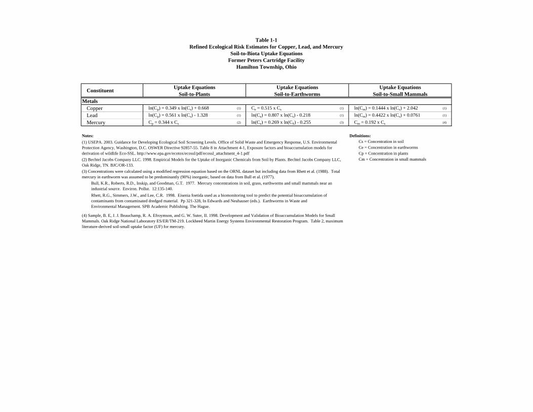
Table 1-1Refined Ecological Risk Estimates for Copper, Lead, and Mercury
Soil-to-Biota Uptake EquationsFormer Peters Cartridge Facility
Hamilton Township, Ohio
MetalsCopper ln(Cp) = 0.349 x ln(Cs) + 0.668 (1) Ce = 0.515 x Cs (1) ln(Cm) = 0.1444 x ln(Cs) + 2.042 (1)
Lead ln(Cp) = 0.561 x ln(Cs) - 1.328 (1) ln(Ce) = 0.807 x ln(Cs) - 0.218 (1) ln(Cm) = 0.4422 x ln(Cs) + 0.0761 (1)
Mercury Cp = 0.344 x Cs (2) ln(Ce) = 0.269 x ln(CS) - 0.255 (3) Cm = 0.192 x Cs (4)
Notes: Definitions:(1) USEPA. 2003. Guidance for Developing Ecological Soil Screening Levels. Office of Solid Waste and Emergency Response, U.S. Environmental Protection Agency, Washington, D.C. OSWER Directive 92857-55. Table 8 in Attachment 4-1, Exposure factors and bioaccumulation models for derivation of wildlife Eco-SSL. http://www.epa.gov/ecotox/ecossl/pdf/ecossl_attachment_4-1.pdf
Constituent Uptake EquationsSoil-to-Plants
Uptake EquationsSoil-to-Earthworms
Uptake EquationsSoil-to-Small Mammals
(2) Bechtel Jacobs Company LLC. 1998. Empirical Models for the Uptake of Inorganic Chemicals from Soil by Plants. Bechtel Jacobs Company LLC, Oak Ridge, TN. BJC/OR-133.
Ce = Concentration in earthwormsCs = Concentration in soil
Cp = Concentration in plantsCm = Concentration in small mammals
(4) Sample, B. E, J. J. Beauchamp, R. A. Efroymson, and G. W. Suter, II. 1998. Development and Validation of Bioaccumulation Models for Small Mammals. Oak Ridge National Laboratory ES/ER/TM-219. Lockheed Martin Energy Systems Environmental Restoration Program. Table 2, maximum literature-derived soil-small uptake factor (UF) for mercury.
(3) Concentrations were calculated using a modified regression equation based on the ORNL dataset but including data from Rhett et al. (1988). Total mercury in earthworm was assumed to be predominantly (90%) inorganic, based on data from Bull et al. (1977).
Bull, K.R., Roberts, R.D., Inskip, and Goodman, G.T. 1977. Mercury concentrations in soil, grass, earthworms and small mammals near an industrial source. Environ. Pollut. 12:135-140.Rhett, R.G., Simmers, J.W., and Lee, C.R. 1998. Eisenia foetida used as a biomonitoring tool to predict the potential bioaccumulation of contaminants from contaminated dredged material. Pp 321-328, In Edwards and Neuhauser (eds.). Earthworms in Waste and Environmental Management. SPB Academic Publishing. The Hague.

Table 1-2Refined Ecological Risk Estimates for Copper, Lead, and Mercury
Exposure Assumptinos - Terrestrial HerbivoreRepresentative Species: Microtus pennsylvanicus (Meadow Vole)
Former Peters Cartridge FacilityHamilton Township, Ohio
Parameter Definition Units Meadow VoleMicrotus pennsylvanicus
BW Body Weight kg 0.0329 (1)IRF Food Ingestion Rate (0.33 kg/kgBW-day) kg/day 0.011 (2)PF Plant Fraction of Diet unitless 0.98 (3)AF Animal Fraction of Diet unitless 0.0 (4)SF Soil Fraction of Diet unitless 0.02 (5)HR Home Range hectacre 0.027 (7)
AUF Area Use Factor unitless 1.0 (8)TUF Temporal Use Factor unitless 1.0 (9)
Notes:(1) Arithmetic mean of means - adult, both sexes, all seasons (USEPA, 1993)(2) USEPA, 1993
(4) Assumed to be negligible
(6) Arithmetic mean of means - adult, both sexes (USEPA, 1993)(7) Arithmetic mean of means - adult, both sexes (USEPA, 1993)(8) Home range is relatively small and therefore assumed to be entirely within the exposure area(9) Assumed to be present year round
Sources:
USEPA, 1993. Wildlife Exposures Factor Handbook Volume I of II. EPA/600/R-93/187a.
(3) Arithmetic mean of all seasons, assumed to be vegetative portions of the plants (USEPA, 1993)
(5) Estimated (Beyer et al )
Beyer W, EE Conner, and S Gould, 1994. Estimates of Soil Ingested by Wildlife. Journal of Wildlife Management, 58(2):375-382.
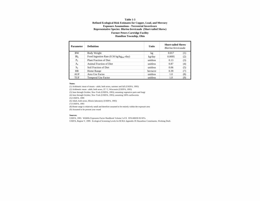
Table 1-3Refined Ecological Risk Estimates for Copper, Lead, and Mercury
Exposure Assumotions - Terrestrial InvertivoreRepresentative Species: Blarina brevicauda (Short-tailed Shrew)
Former Peters Cartridge FacilityHamilton Township, Ohio
Parameter Definition Units Short-tailed ShrewBlarina brevicauda
BW Body Weight kg 0.017 (1)IRF Food Ingestion Rate (0.56 kg/kgBW-day) kg/day 0.0095 (2)PF Plant Fraction of Diet unitless 0.13 (3)AF Animal Fraction of Diet unitless 0.87 (4)SF Soil Fraction of Diet unitless 0.06 (5)HR Home Range hectacre 0.39 (7)
AUF Area Use Factor unitless 1.0 (8)TUF Temporal Use Factor unitless 1.0 (9)
Notes:(1) Arithmetic mean of means - adult, both sexes, summer and fall (USEPA, 1993)(2) Arithmetic mean - adult, both sexes, 25˚ C, Wisconsin (USEPA, 1993)
(4) June through October, New York (USEPA, 1993); assuming 100% earthworms
(6) Adult, both sexes, Illinois laboratory (USEPA, 1993)(7) USEPA, 1993(8) Home range is relatively small and therefore assumed to be entirely within the exposure area(9) Assumed to be present year round
Sources:USEPA, 1993. Wildlife Exposures Factor Handbook Volume I of II. EPA/600/R-93/187a.
(3) June through October, New York (USEPA, 1993); assuming vegetative parts and fungi
(5) USEPA, 1999
USEPA, Region V, 1999. Ecological Screening Levels for RCRA Appendix IX Hazardous Constituents, Working Draft.
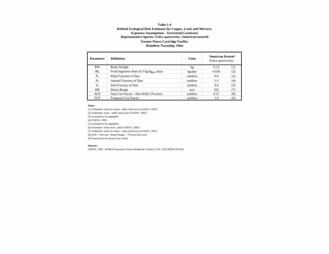
Table 1-4Refined Ecological Risk Estimates for Copper, Lead, and Mercury
Exposure Assumptions - Terrestrial CarnivoreRepresentative Species: Falco spareverius (American kestrel)
Former Peters Cartridge FacilityHamilton Township, Ohio
Parameter Definition Units American KestrelFalco spareverius
BW Body Weight kg 0.12 (1)IRF Food Ingestion Rate (0.3 kg/kgBW-day) kg/day 0.036 (2)PF Plant Fraction of Diet unitless 0.0 (3)AF Animal Fraction of Diet unitless 1.0 (4)SF Soil Fraction of Diet unitless 0.0 (5)HR Home Range acre 262 (7)
AUF Area Use Factor - Site-Wide (70 acres) unitless 0.27 (8)TUF Temporal Use Factor unitless 1.0 (9)
Notes:(1) Arithmetic mean of means - adult, both sexes (USEPA, 1993)(2) Arithmetic mean - adult, both sexes (USEPA, 1993)
(4) USEPA, 1993
(6) Estimated - both sexes, adult (USEPA, 1993)(7) Arithmetic mean of means - adult, both sexes (USEPA, 1993)(8) AUF = Site size / Home Range = 70 acres/262 acres(9) Assumed to be present year round
Sources:USEPA, 1993. Wildlife Exposures Factor Handbook Volume I of II. EPA/600/R-93/187a.
(3) Assumed to be negligible
(5) Assumed to be negligible

Table 1-5Refined Ecological Risk Estimates for Copper, Lead, and Mercury
LOAEL Toxicity Reference Values - Mammalian SpeciesFormer Peters Cartridge Facility
Hamilton Township, Ohio
TRVmg/kg-day
Copper Geometric mean of mammalian LOAELs for reproduction and growth USEPA, 2007 8.27E+01
Lead Geometric mean of mammalian LOAELs for reproduction and growth USEPA, 2007 1.86E+02
Mercury Chronic NOAEL, mercuric chloride, mink, oral in diet 6 months (critical lifestage), reproduction, 0.1 x to adjust for LOAEL
Sample et al., 1996 1.00E+01
Sources:
USEPA. 1986. Subchronic toxicity of thallium sulfate in Sprague- Dawley rats. Office of Solid Waste, Washington, DC.USEPA, 2007. Guidance for Developing Ecological Soil Screening Levels (Eco-SSLs). OSWER Directive 9285.7-55.
Sample, B.E., D.M. Opresko, G.W. Suter,II. 1996. Toxicological Benchmarks for Wildlife: 1996 Revision. Prepared for US Dept. of Energy. ES/ER/TM-86/R3
Terrestrial COPEC Endpoint/ Duration/ Effect Source
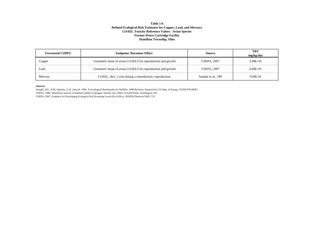
Table 1-6Refined Ecological Risk Estimates for Copper, Lead, and Mercury
LOAEL Toxicity Reference Values - Avian SpeciesFormer Peters Cartridge Facility
Hamilton Township, Ohio
TRVmg/kg-day
Copper Geometric mean of avian LOAELS for reproduction and growth USEPA, 2007 3.49E+01
Lead Geometric mean of avian LOAELS for reproduction and growth USEPA, 2007 4.46E+01
Mercury LOAEL, diet, 1 year during a reproduction, reproduction Sample et al., 199 9.00E-01
Sources:
USEPA. 1986. Subchronic toxicity of thallium sulfate in Sprague- Dawley rats. Office of Solid Waste, Washington, DC.USEPA, 2007. Guidance for Developing Ecological Soil Screening Levels (Eco-SSLs). OSWER Directive 9285.7-55.
Terrestrial COPEC Endpoint/ Duration/ Effect Source
Sample, B.E., D.M. Opresko, G.W. Suter,II. 1996. Toxicological Benchmarks for Wildlife: 1996 Revision. Prepared for US Dept. of Energy. ES/ER/TM-86/R3

Table 1-7Refined Ecological Risk Estimates for Copper, Lead, and Mercury
Maximum Ecological Risks - Site-WideFormer Peters Cartridge Facility
Hamilton Township, Ohio
Copper 53,900 930.6 87 27,759 21 384 15,341 1.7 4.6 186 0.047Lead 217,000 7,267 261 16,287 55 1,517 15,245 4.4 8.2 82 0.099Mercury 846 15.76 291 4.8 3.0 100 52 0.24 10 5.2 0.27
Notes:
(2) Average Daily Dose (ADD) calculated as:ADD = [(CP x IR x FP) + (CE x IR x FE) + (CM x IR x FM) + (CS x IR x FS)] x (1/BW) x (AUF)
CP = Modeled concentration in plants IR = Daily food ingestion rate FP = Plant fraction of dietCE = Modeled concentration in earthworms FE = Invertebrate (i.e., earthworm) fraction of dietCM = Modeled concentration in small mammals FM = Small mammal fraction of dietCS = Measured concentration in soil AUF = Area use factor FS = Soil fraction of dietIR = Ingestion Rate BW = Body weight AUF = Area use factorBW = Body Weight FA = Animal fraction of diet
(5) LOAEL HQ calculated as:LOAEL HQ = ADD/TRV
LOAEL HQ = Lowest Observable Adverse Effect Level Hazard QuotientADD = Average Daily DoseTRV = Toxicity Reference Value
Short-Tailed Shrew
American Kestrel
Average Daily Dose (2) (mg/kg)
Meadow Vole
Short-Tailed Shrew
American Kestrel
(1) Site-wide maximums were used for modeling meadow vole and short-tailed shrew average daily doses; site-wide 95% UCLs were used for modeling American kestrel average daily doses. Note that the EPCs used in the BERA were calculated for each Exposure Area. Site-wide 95% UCLs generated for this risk estimate refinement are included in this attachment.
Constituents of Ecological Concern
Maximum Soil Concentration (1)
(mg/kg)
Modeled Biota Concentration (mg/kg)
Plants Earthworms
95% UCL Soil Concentration (1)
(mg/kg)Small
Mammals
LOAEL HQ (3)
Meadow Vole
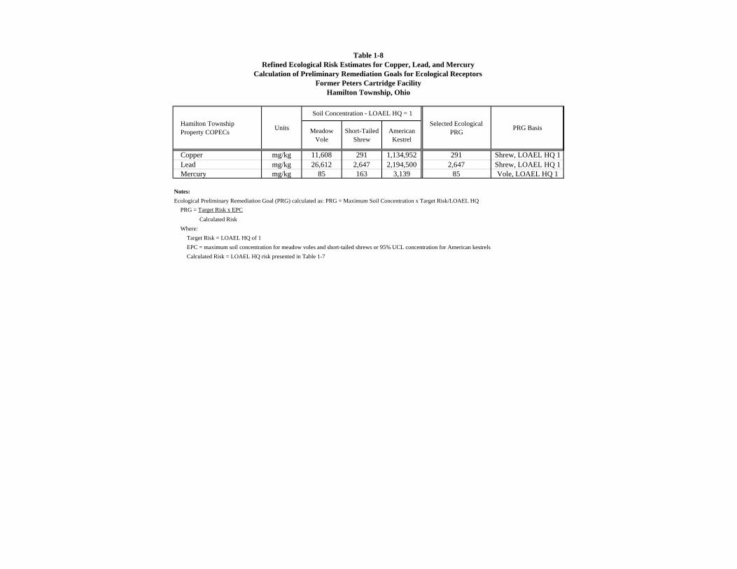
Table 1-8Refined Ecological Risk Estimates for Copper, Lead, and Mercury
Calculation of Preliminary Remediation Goals for Ecological ReceptorsFormer Peters Cartridge Facility
Hamilton Township, Ohio
Copper mg/kg 11,608 291 1,134,952 291 Shrew, LOAEL HQ 1Lead mg/kg 26,612 2,647 2,194,500 2,647 Shrew, LOAEL HQ 1Mercury mg/kg 85 163 3,139 85 Vole, LOAEL HQ 1
Notes:Ecological Preliminary Remediation Goal (PRG) calculated as: PRG = Maximum Soil Concentration x Target Risk/LOAEL HQ
PRG = Target Risk x EPCCalculated Risk
Where:Target Risk = LOAEL HQ of 1EPC = maximum soil concentration for meadow voles and short-tailed shrews or 95% UCL concentration for American kestrelsCalculated Risk = LOAEL HQ risk presented in Table 1-7
Hamilton TownshipProperty COPECs American
Kestrel
Soil Concentration - LOAEL HQ = 1Selected Ecological
PRG PRG BasisUnits Meadow Vole
Short-Tailed Shrew

Attachment 1Documentation for Site-Wide 95% UCL Calculations
ProUCL Inputs
Sample Location Exposure Area
AOC1-001 HTP 148 1 270 1 0.694 1AOC1-002 HTP 271 1 2710 1 0.416 1AOC1-003 HTP 26.5 1 102 1 1.76 1AOC1-004 HTP 559 1 877 1 17.5 1AOC1-005 HTP 6520 1 3960 1 37.2 1AOC1-006 HTP 53900 1 9070 1 20.2 1AOC1-007 HTP 584 1 119000 1 66.8 1AOC1-008 HTP 15400 1 56800 1 25.1 1AOC1-009 HTP 71.7 1 417 1 8.15 1AOC1-010 HTP 985 1 1.13 0 2.87 1AOC1-011 HTP 475 1 2240 1 2.71 1AOC1-012 HTP 128 1 1700 1 2.3 1AOC1-013 HTP 47.4 1 258 1 2.46 1AOC1-014 HTP 32 1 233 1 1.65 1AOC1-015 HTP 20 1 89 1 0.974 1AOC1-016 HTP 61.8 1 378 1 7.9 1AOC1-017 HTP 38.1 1 246 1 3.99 1AOC1-018 HTP 65.4 1 407 1 9.35 1AOC2-001 FPA 21.7 1 41.6 1 0.64 1AOC2-002 FPA 389 1 1050 1 83.1 1AOC2-003 FPA 22.3 1 37.7 1 0.317 1AOC2-004 FPA 35.1 1 62.2 1 6.58 1AOC2-005 FPA 75 1 1750 1 0.489 1AOC2-006 FPA 43.6 1 131 1 0.529 1AOC2-007 FPA 40.9 1 129 1 0.729 1AOC2-008 FPA 134 1 811 1 0.213 1AOC2-009 FPA 301.5 1 2520 1 0.901 1AOC2-010 FPA 37.1 1 606 1 0.943 1AOC2-011 FPA 72.8 1 1210 1 1.07 1AOC2-012 FPA 49.6 1 386 1 0.784 1AOC2-013 FPA 591 1 989 1 3.33 1AOC3-001 FPA 31 1 269 1 0.401 1AOC3-002 FPA 23.5 1 34.8 1 0.302 1AOC3-003 FPA 50.4 1 258 1 0.644 1AOC3-004 FPA 102 1 260 1 0.556 1AOC3-005 FPA 53.4 1 455 1 1.24 1AOC3-006 FPA 53.4 1 625 1 0.852 1AOC3-007 FPA 34.6 1 49.3 1 0.409 1AOC3-008 FPA 48.3 1 166.5 1 1.51 1AOC3-009 FPA 37.5 1 75.5 1 0.395 1AOC3-010 FPA 32.55 1 65.6 1 0.365 1AOC3-011 FPA 140 1 108 1 0.0315 1AOC3-012 FPA 47.7 1 18.1 1 0.0587 1AOC3-013 FPA 61.2 1 909 1 3.18 1AOC3-014 FPA 39.3 1 644 1 4.47 1AOC3-015 FPA 53.9 1 277 1 0.847 1AOC3-016 FPA 8 1 11.8 1 0.0245 1AOC3-017 FPA 12.6 1 67.8 1 0.165 1AOC3-018 FPA 16.7 1 27.6 1 0.0202 1AOC3-019 FPA 1340 1 811 1 4.55 1AOC3-020 FPA 47.4 1 106 1 1.34 1AOC3-021 FPA 38.9 1 86.4 1 0.595 1AOC3-023 FPA 789 1 123 1 4.61 1AOC3-024 FPA 43.8 1 408 1 2.4 1AOC3-025 FPA 42.4 1 251 1 0.279 1AOC3-026 FPA 52.25 1 239 1 1.305 1AOC3-027 FPA 29.6 1 17.7 1 0.492 1AOC3-028 FPA 118 1 268 1 2.51 1AOC3-029 LOW 22.3 1 125 1 0.213 1AOC3-030 FPA 79 1 309 1 2.5 1AOC3-031 FPA 26.4 1 35.3 1 0.87 1AOC3-032 LOW 31.3 1 45.5 1 0.236 1AOC3-033 LOW 30.8 1 52 1 0.3205 1AOC3-034 FPA 335 1 823 1 21.2 1AOC4-001 HTP 27.7 1 117 1 0.586 1AOC4-002 HTP 125 1 2800 1 3.72 1AOC4-003 HTP 32.9 1 199 1 0.396 1AOC4-004 HTP 23.7 1 146 1 1.78 1AOC4-005 HTP 25.5 1 132 1 1.33 1AOC4-006 HTP 30.5 1 272 1 2.87 1AOC4-007 HTP 41.1 1 546 1 6.08 1
Mercury (mg/kg)Lead (mg/kg)Copper (mg/kg)
Notes:Paved and unpaved samples included.FPA = Former Process Area; LOW = Lowland Area; HTP = Hamilton Township Property1 = detected result; 0 = non-detect result (MDL presented)

Attachment 1Documentation for Site-Wide 95% UCL Calculations
ProUCL Inputs
Sample Location Exposure Area Mercury (mg/kg)Lead (mg/kg)Copper (mg/kg)
AOC5-001 FPA 910 1 156000 1 0.698 1AOC5-002 FPA 262 1 92500 1 1.48 1AOC5-003 FPA 62 1 84900 1 0.994 1AOC5-004 FPA 42.1 1 1190 1 1.34 1AOC5-005 FPA 50.1 1 289 1 0.9 1AOC5-006 FPA 29.1 1 1010 1 1.79 1AOC5-007 FPA 47.6 1 90300 1 0.573 1AOC6-001 FPA 21.5 1 71.7 1 0.337 1AOC6-002 FPA 18.8 1 42.1 1 0.216 1AOC6-003 FPA 17.9 1 113 1 0.0946 1AOC7-005 HTP 976 1 95.2 1 9.7 1AOC7-006 HTP 50.1 1 47.7 1 5.43 1AOC7-007 HTP 19.4 1 370 1 0.156 1AOC7-008 HTP 10.8 1 40.7 1 0.181 1AOC7-009 HTP 45.5 1 110.5 1 19 1AOC8-001 HTP 14.9 1 19.6 1 0.03635 1AOC8-002 HTP 11.35 1 18.55 1 0.04375 1AOC8-003 HTP 14.8 1 35.05 1 0.1745 1AOC8-004 HTP 11.15 1 20.8 1 0.5345 1AOC8-005 HTP 12.2 1 20 1 0.782 1AOC8-006 HTP 19.8 1 33.2 1 0.305 1AOC8-007 HTP 15.7 1 45.5 1 0.217 1AOC8-008 HTP 28.7 1 90.9 1 0.33 1AOC8-009 HTP 46.3 1 113 1 0.31 1AOC8-010 HTP 19.25 1 58.3 1 0.278 1AOC8-011 HTP 33.8 1 51.25 1 0.0811 1AOC8-012 HTP 10.68 1 22.2 1 0.0648 1AOC8-013 HTP 17.1 1 63.2 1 0.0568 1AOC8-014 HTP 17.25 1 38.9 1 0.122 1AOC9-006 HTP 59.9 1 1400 1 13.1 1AOC9-007 HTP 72.75 1 1215 1 0.173 1AOC9-008 HTP 15.65 1 60.1 1 45.9 1AOC9-009 HTP 22.2 1 53 1 205 1AOC9-010 HTP 79.5 1 83.1 1 97.4 1AOC9-011 HTP 22.8 1 66.7 1 0.69 1AOC9-012 HTP 456 1 4570 1 4.89 1AOC9-012-A HTP 3680 1AOC9-012-B HTP 217000 1AOC9-012-C HTP 3940 1AOC9-013 HTP 19.9 1 73.7 1 0.657 1AOC9-014 HTP 98.4 1 362 1 0.618 1AOC9-015 HTP 199 1 6350 1 0.723 1AOC9-015-A HTP 21.25 1AOC9-015-B HTP 39.7 1AOC9-015-C HTP 12.7 1AOC10-001 HTP 14.3 1 70.1 1 0.224 1AOC10-002 HTP 24.35 1 57.65 1 10.3 1AOC10-003 HTP 25.6 1 40.7 1 1.82 1AOC10-004 HTP 27.1 1 36.9 1 1.09 1AOC10-005 HTP 28.3 1 18.8 1 0.074 1AOC10-006 HTP 33.9 1 54 1 0.496 1AOC10-007 HTP 18.6 1 36.6 1 0.289 1AOC10-008 HTP 21.6 1 17.8 1 0.277 1AOC10-009 HTP 19.6 1 70.6 1 2.39 1AOC10-010 HTP 18.5 1 58.5 1 0.6 1AOC11-001 HTP 15.85 1 35 1 846 1AOC11-001-A HTP 0.242 1AOC11-002 HTP 21.3 1 61.4 1 9.32 1AOC11-003 HTP 16.6 1 30.9 1 0.681 1AOC11-004 HTP 17.8 1 41.1 1 0.413 1AOC11-005 HTP 14.8 1 69.3 1 1.87 1AOC11-006 HTP 15.15 1 58.55 1 0.288 1AOC11-007 HTP 14.2 1 38.4 1 0.324 1AOC11-008 HTP 7.65 1 117 1 0.15 1AOC11-009 HTP 18.6 1 25.1 1 0.144 1AOC12-001 LOW 21.1 1 70.8 1 0.211 1AOC12-002 LOW 23.5 1 68.6 1 0.235 1AOC12-003 LOW 74.8 1 272 1 0.83 1AOC12-004 LOW 274 1 475 1 0.51 1AOC12-005 LOW 126 1 187.5 1 0.7395 1AOC13-001 HTP 26.3 1 45.3 1 1.61 1
Notes:Paved and unpaved samples included.FPA = Former Process Area; LOW = Lowland Area; HTP = Hamilton Township Property1 = detected result; 0 = non-detect result (MDL presented)

Attachment 1Documentation for Site-Wide 95% UCL Calculations
ProUCL Inputs
Sample Location Exposure Area Mercury (mg/kg)Lead (mg/kg)Copper (mg/kg)
AOC13-002 HTP 23.65 1 93.4 1 0.4085 1AOC13-003 HTP 65.1 1 510 1 0.212 1AOC13-004 HTP 23.3 1 68 1 0.0867 1AOC13-005 HTP 17.2 1 20.7 1 0.064 1AOC13-006 HTP 14.15 1 16.6 1 0.0388 1AOC13-007 HTP 21.1 1 54.9 1 0.317 1AOC13-008 HTP 19 1 16.5 1 0.0498 1AOC13-009 HTP 24.7 1 72.5 1 0.342 1AOC13-010 HTP 30.4 1 33.8 1 2.11 1AOC13-011 HTP 16 1 31.4 1 1.3 1AOC13-012 HTP 13.7 1 22.1 1 0.9 1AOC13-013 HTP 12.6 1 114 1 0.481 1AOC13-014 HTP 21.7 1 36.8 1 4.46 1AOC13-015 HTP 13.35 1 38.9 1 1.45 1AOC13-016 HTP 20.7 1 28.5 1 0.698 1AOC13-017 HTP 17.1 1 74.4 1 1.06 1AOC13-018 HTP 15.3 1 80.4 1 0.653 1AOC13-019 HTP 20.2 1 84.9 1 2.15 1AOC13-020 HTP 21.9 1 38.3 1 0.334 1AOC13-021 HTP 17 1 160 1 0.925 1AOC13-022 HTP 20.4 1 60.5 1 0.501 1AOC13-023 HTP 26 1 51.8 1 3.65 1AOC13-024 HTP 25.95 1 25.95 1 0.308 1AOC13-025 HTP 17.4 1 52.7 1 3.54 1AOC13-026 FPA 14.9 1 27 1 0.588 1AOC13-027 FPA 61.3 1 351 1 72.1 1AOC13-028 FPA 28.6 1 665 1 61.9 1AOC13-029 FPA 249 1 206 1 22 1AOC13-030 FPA 83.1 1 529 1 9.41 1AOC13-031 FPA 92.9 1 1280 1 10.6 1AOC13-032 FPA 13.6 1 39.9 1 0.629 1AOC13-033 FPA 30.2 1 35.7 1 0.142 1AOC13-034 FPA 32.8 1 66.1 1 0.113 1AOC13-035 FPA 32.7 1 1300 1 0.993 1AOC13-036 FPA 23.3 1 94 1 0.543 1AOC13-037 FPA 38 1 148 1 28.2 1AOC13-038 HTP 31.55 1 120.5 1 24.75 1AOC13-039 FPA 42.4 1 380 1 17.6 1AOC13-040 FPA 51.2 1 1160 1 37.9 1AOC13-041 HTP 50.9 1 281 1 0.889 1AOC13-042 HTP 111 1 174000 1 3.58 1AOC13-043 HTP 10700 1 17000 1 20.7 1AOC13-044 HTP 250 1 15400 1 2.76 1AOC13-045 HTP 221 1 14800 1 9.86 1AOC13-046 FPA 205 1 516 1 11.4 1AOC14-001 LOW 32.2 1 62.9 1 0.435 1AOC14-002 LOW 30.8 1 55.4 1 0.0683 1AOC14-003 LOW 29.3 1 75.7 1 0.112 1AOC14-004 LOW 131 1 191 1 0.0917 1AOC14-005 LOW 34.6 1 136 1 0.171 1AOC14-006 LOW 16.3 1 29.3 1 0.0685 1AOC14-007 LOW 27.2 1 62.1 1 0.14 1AOC14-008 LOW 33.3 1 50.1 1 0.13 1AOC14-009 LOW 16.5 1 50.2 1 0.123 1AREAA-001 LOW 13.8 1 14.6 1 0.108 1AREAA-002 HTP 21.8 1 38.6 1 1.49 1AREAA-003 HTP 26.2 1 62.8 1 0.953 1AREAA-004 HTP 15 1 33.2 1 0.397 1AREAA-005 HTP 16.1 1 73 1 0.353 1AREAA-006 HTP 12.1 1 50.8 1 0.106 1AREAA-007 HTP 12.8 1 87.2 1 0.177 1AREAA-008 HTP 11.2 1 676 1 0.281 1AREAA-009 HTP 18.3 1 75 1 0.75 1AREAA-010 HTP 24 1 110 1 0.644 1AREAA-011 HTP 35.9 1 139 1 2.975 1AREAA-012 LOW 20.6 1 29.4 1 0.224 1AREAA-013 LOW 35.1 1 47.5 1 0.0938 1AREAA-014 HTP 62.3 1 368 1 6.4 1AREAA-015 HTP 28.5 1 144 1 1.52 1AREAA-016 HTP 16.4 1 62.7 1 0.6205 1AREAA-017 HTP 11.3 1 87.1 1 0.3885 1
Notes:Paved and unpaved samples included.FPA = Former Process Area; LOW = Lowland Area; HTP = Hamilton Township Property1 = detected result; 0 = non-detect result (MDL presented)
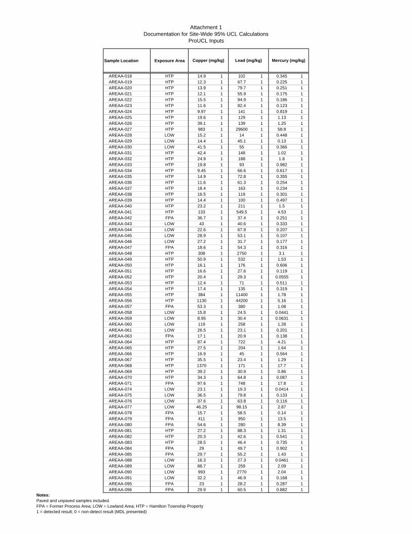
Attachment 1Documentation for Site-Wide 95% UCL Calculations
ProUCL Inputs
Sample Location Exposure Area Mercury (mg/kg)Lead (mg/kg)Copper (mg/kg)
AREAA-018 HTP 14.9 1 102 1 0.345 1AREAA-019 HTP 12.3 1 67.7 1 0.225 1AREAA-020 HTP 13.9 1 79.7 1 0.251 1AREAA-021 HTP 12.1 1 55.9 1 0.175 1AREAA-022 HTP 15.5 1 94.9 1 0.186 1AREAA-023 HTP 11.6 1 82.4 1 0.123 1AREAA-024 HTP 9.97 1 141 1 0.819 1AREAA-025 HTP 19.6 1 129 1 1.13 1AREAA-026 HTP 39.1 1 139 1 1.25 1AREAA-027 HTP 983 1 29600 1 58.8 1AREAA-028 LOW 15.2 1 14 1 0.448 1AREAA-029 LOW 14.4 1 45.1 1 0.13 1AREAA-030 LOW 41.5 1 55 1 0.366 1AREAA-031 HTP 42.4 1 148 1 1.02 1AREAA-032 HTP 24.9 1 188 1 1.8 1AREAA-033 HTP 19.8 1 93 1 0.982 1AREAA-034 HTP 9.45 1 66.6 1 0.617 1AREAA-035 HTP 14.9 1 72.8 1 0.355 1AREAA-036 HTP 11.6 1 61.3 1 0.254 1AREAA-037 HTP 18.4 1 163 1 0.234 1AREAA-038 HTP 16.5 1 119 1 0.301 1AREAA-039 HTP 14.4 1 100 1 0.497 1AREAA-040 HTP 23.2 1 211 1 1.5 1AREAA-041 HTP 133 1 549.5 1 4.53 1AREAA-042 FPA 36.7 1 37.4 1 0.251 1AREAA-043 LOW 43 1 40.6 1 0.333 1AREAA-044 LOW 22.6 1 67.9 1 0.207 1AREAA-045 LOW 28.9 1 53.1 1 0.107 1AREAA-046 LOW 27.2 1 31.7 1 0.177 1AREAA-047 FPA 18.6 1 54.3 1 0.316 1AREAA-048 HTP 308 1 2750 1 3.1 1AREAA-049 HTP 50.9 1 532 1 1.53 1AREAA-050 HTP 16.1 1 176 1 0.606 1AREAA-051 HTP 16.6 1 27.6 1 0.119 1AREAA-052 HTP 20.4 1 29.3 1 0.0555 1AREAA-053 HTP 12.4 1 71 1 0.511 1AREAA-054 HTP 17.4 1 135 1 0.319 1AREAA-055 HTP 384 1 11400 1 1.78 1AREAA-056 HTP 1130 1 44200 1 5.16 1AREAA-057 FPA 53.3 1 380 1 1.08 1AREAA-058 LOW 15.8 1 24.5 1 0.0441 1AREAA-059 LOW 8.95 1 30.4 1 0.0631 1AREAA-060 LOW 119 1 258 1 1.28 1AREAA-061 LOW 26.5 1 23.1 1 0.201 1AREAA-063 FPA 17.1 1 20.9 1 0.138 1AREAA-064 HTP 87.4 1 722 1 4.21 1AREAA-065 HTP 27.5 1 204 1 1.64 1AREAA-066 HTP 16.9 1 45 1 0.564 1AREAA-067 HTP 35.5 1 23.4 1 1.29 1AREAA-068 HTP 1370 1 171 1 17.7 1AREAA-069 HTP 39.2 1 30.9 1 0.86 1AREAA-070 HTP 34.3 1 64.8 1 0.087 1AREAA-071 FPA 97.6 1 748 1 17.8 1AREAA-074 LOW 23.1 1 19.3 1 0.0414 1AREAA-075 LOW 36.5 1 79.8 1 0.133 1AREAA-076 LOW 37.6 1 63.8 1 0.116 1AREAA-077 LOW 46.25 1 98.15 1 2.87 1AREAA-078 FPA 15.7 1 58.5 1 0.14 1AREAA-079 FPA 411 1 950 1 13.5 1AREAA-080 FPA 54.6 1 280 1 8.39 1AREAA-081 HTP 27.2 1 88.3 1 1.31 1AREAA-082 HTP 20.3 1 42.6 1 0.541 1AREAA-083 HTP 28.5 1 46.4 1 0.735 1AREAA-084 FPA 29 1 49.7 1 0.902 1AREAA-085 FPA 29.7 1 55.2 1 1.43 1AREAA-088 LOW 16.3 1 27.3 1 0.0461 1AREAA-089 LOW 88.7 1 259 1 2.09 1AREAA-090 LOW 993 1 2770 1 2.04 1AREAA-091 LOW 32.2 1 46.9 1 0.168 1AREAA-095 FPA 23 1 28.2 1 0.287 1AREAA-096 FPA 29.9 1 60.5 1 0.882 1
Notes:Paved and unpaved samples included.FPA = Former Process Area; LOW = Lowland Area; HTP = Hamilton Township Property1 = detected result; 0 = non-detect result (MDL presented)

Attachment 1Documentation for Site-Wide 95% UCL Calculations
ProUCL Inputs
Sample Location Exposure Area Mercury (mg/kg)Lead (mg/kg)Copper (mg/kg)
AREAA-097 FPA 32.5 1 227 1 1.77 1AREAA-098 FPA 80.1 1 359 1 2.52 1AREAA-099 FPA 41 1 663 1 0.995 1AREAA-100 FPA 136 1 665 1 0.829 1AREAA-103 LOW 20.5 1 26.5 1 0.0598 1AREAA-105 LOW 34.8 1 135 1 0.528 1AREAA-107 FPA 57.6 1 134 1 0.082 1AREAA-108 FPA 33.4 1 277 1 0.219 1AREAA-109 FPA 19.1 1 86.4 1 0.634 1AREAA-110 FPA 18.5 1 44.65 1 0.367 1AREAA-111 FPA 9.71 1 61.9 1 0.19 1AREAA-112 FPA 15.7 1 86.1 1 0.334 1AREAA-113 FPA 29.1 1 408 1 0.509 1AREAA-114 FPA 132 1 989 1 4.47 1AREAA-116 LOW 48.6 1 190 1 0.555 1AREAA-117 LOW 32.2 1 507 1 0.382 1AREAA-118 LOW 29.4 1 82.6 1 0.125 1AREAA-122 FPA 29.4 1 86.6 1 0.146 1AREAA-123 FPA 21.5 1 281 1 0.418 1AREAA-124 FPA 44.3 1 1600 1 0.494 1AREAA-125 FPA 87.7 1 2770 1 2.34 1AREAA-126 FPA 62.6 1 189 1 0.198 1AREAA-127 FPA 41.7 1 803 1 0.0637 1AREAA-128 FPA 26.5 1 153 1 0.566 1AREAA-129 LOW 68.3 1 207 1 1.22 1AREAA-130 FPA 33.4 1 94.8 1 11.4 1AREAA-131 FPA 24.9 1 98.1 1 0.242 1AREAA-132 FPA 26.1 1 74.6 1 0.213 1AREAA-133 FPA 26.6 1 428 1 0.235 1AREAA-134 FPA 78.1 1 482 1 0.78 1AREAA-135 LOW 28.5 1 31.1 1 0.17 1AREAA-136 LOW 18 1 34.3 1 0.132 1AREAA-137 LOW 13.6 1 18.9 1 0.0844 1AREAA-138 HTP 18.2 1 63.5 1 0.123 1AREAA-139 HTP 22.3 1 44.9 1 1.54 1AREAA-140 HTP 19.6 1 48.1 1 0.643 1AREAA-141 HTP 15.2 1 30.6 1 0.448 1AREAA-142 HTP 9.01 1 27.5 1 0.36 1AREAA-143 LOW 20.6 1 23.8 1 0.117 1AREAA-144 LOW 97.8 1 448 1 0.867 1AREAA-145 LOW 25.4 1 86.05 1 0.1895 1AREAA-146 LOW 35.1 1 104 1 0.341 1AREAA-147 LOW 46.5 1 131 1 0.0592 1AREAA-148 LOW 19.1 1 18.6 1 0.141 1AREAA-149 LOW 17.55 1 31.45 1 0.3865 1AREAA-150 LOW 14.2 1 34.7 1 0.05 1AREAA-151 LOW 110 1 286 1 4.53 1AREAA-153 FPA 33.6 1 43.8 1 0.104 1AREAA-154 FPA 138 1 510 1 0.559 1AREAA-155 FPA 19.6 1 70.7 1 0.155 1AREAA-156 FPA 28.4 1 137 1 0.37 1AREAA-157 FPA 24.2 1 527 1 0.552 1AREAA-158 FPA 10.4 1 101.5 1 0.3845 1AREAA-161 HTP 24.15 1 35.95 1 0.6795 1AREAA-162 HTP 90.7 1 47.4 1 1.06 1AREAA-163 HTP 41.9 1 36 1 0.956 1AREAA-164 HTP 10.6 1 53.2 1 0.267 1AREAA-165 HTP 15.7 1 30.9 1 0.135 1AREAA-166 HTP 15.3 1 91.9 1 0.0419 1AREAB-001 HTP 20.3 1 71.4 1 0.301 1AREAB-002 HTP 18.6 1 19.7 1 0.0473 1AREAB-003 HTP 12.9 1 40.7 1 0.344 1AREAB-004 HTP 21.8 1 41.4 1 0.389 1AREAB-005 HTP 13.1 1 42.1 1 0.194 1AREAB-006 HTP 11.9 1 24.3 1 0.517 1AREAB-007 HTP 15.2 1 13.3 1 0.0959 1AREAB-008 HTP 9.78 1 19.8 1 0.33 1AREAB-009 HTP 13.1 1 23.7 1 1.9 1AREAB-010 HTP 10.6 1 32.6 1 0.634 1AREAB-011 HTP 12.9 1 20.8 1 0.114 1AREAB-012 HTP 117 1 246 1 0.231 1
Notes:Paved and unpaved samples included.FPA = Former Process Area; LOW = Lowland Area; HTP = Hamilton Township Property1 = detected result; 0 = non-detect result (MDL presented)

Attachment 1Documentation for Site-Wide 95% UCL Calculations
ProUCL Inputs
Sample Location Exposure Area Mercury (mg/kg)Lead (mg/kg)Copper (mg/kg)
AREAB-013 HTP 23.3 1 28.5 1 0.0586 1AREAB-014 HTP 19.3 1 26.7 1 0.267 1AREAB-015 HTP 9.27 1 37.6 1 0.264 1AREAB-016 HTP 14.7 1 125 1 0.154 1AREAB-017 HTP 18.4 1 36.5 1 2.09 1AREAB-018 HTP 27.6 1 33.8 1 0.109 1AREAB-019 HTP 5.245 1 29.5 1 0.239 1AREAB-020 HTP 12.5 1 35.6 1 0.1295 1AREAB-021 HTP 22.1 1 101 1 0.296 1AREAB-022 HTP 19.9 1 35.5 1 2.56 1AREAB-023 HTP 21.7 1 274 1 1.43 1AREAB-024 HTP 13.1 1 32.5 1 0.0534 1AREAB-025 HTP 21.8 1 147 1 0.366 1AREAB-026 HTP 18.2 1 60.1 1 0.251 1AREAB-027 HTP 10.4 1 31.7 1 0.422 1AREAB-028 HTP 25.25 1 16.85 1 0.1145 1AREAB-029 HTP 17.1 1 38.9 1 1.97 1AREAB-030 HTP 26.5 1 74.6 1 0.314 1AREAB-031 HTP 15.4 1 74.4 1 0.285 1AREAB-032 HTP 16.5 1 62.3 1 0.168 1AREAB-035 HTP 19.5 1 21.1 1 0.0482 1AREAB-036 HTP 28.6 1 156 1 3.78 1AREAB-037 HTP 22.5 1 110 1 0.0765 1AREAB-038 HTP 9.22 1 27.8 1 0.184 1AREAB-039 HTP 17.2 1 14.6 1 0.107 1AREAB-040 FPA 9.77 1 61.4 1 0.284 1AREAB-041 FPA 22.2 1 34.1 1 0.182 1AREAB-042 HTP 34.05 1 315 1 0.541 1AREAB-043 HTP 40.8 1 108 1 1.4 1AREAB-044 HTP 29.5 1 55.1 1 1.51 1AREAB-045 HTP 19.1 1 18.8 1 0.0779 1AREAB-046 HTP 14.7 1 29.6 1 0.0549 1AREAB-047 HTP 20.4 1 17.5 1 0.0373 1AREAB-048 HTP 17.8 1 111 1 0.0344 1AREAB-049 HTP 19.4 1 15.4 1 0.034 1AREAB-050 HTP 17.9 1 31.5 1 0.219 1AREAB-052 HTP 112 1 39.3 1 1.42 1AREAB-053 HTP 17.6 1 111 1 0.265 1AREAB-055 HTP 17.6 1 34.4 1 0.34 1AREAB-056 HTP 24.9 1 97.2 1 0.848 1AREAB-057 HTP 17.1 1 18.3 1 0.0625 1AREAB-058 HTP 16.2 1 21.9 1 0.0714 1AREAB-059 HTP 19.5 1 16.9 1 0.039 1SB112 (0-5 ft bgs) LOW 36.5 1 88.3 1 0.653 1
Notes:Paved and unpaved samples included.FPA = Former Process Area; LOW = Lowland Area; HTP = Hamilton Township Property1 = detected result; 0 = non-detect result (MDL presented)

Attachment 1Documentation for Site-Wide 95% UCL Calculations
ProUCL Outputs
392 299
5.245 1.657
53900 10.89
293 3.557
26.15 1.162
2896
9.884
16.81
0.46 0.165
0.0447 0.0447
534.2 78.47
91.16
666.3 100.9
554.9 120.1
0.32
914.5
251.2
215.5
0.0494 533.6
215.4 534.2
531.6
1.798E+308 1331
0.866 1313
0.354 550.6
0.0496 817.4
930.6
1206
1748
341.5
341.7
1206Use 97.5% Chebyshev (Mean, Sd) UCL
95% Approximate Gamma UCL
95% Adjusted Gamma UCL
Potential UCL to Use
Kolmogorov-Smirnov Test Statistic 95% Percentile Bootstrap UCL
Kolmogorov-Smirnov 5% Critical Value 95% BCA Bootstrap UCL
97.5% Chebyshev(Mean, Sd) UCL
Assuming Gamma Distribution 99% Chebyshev(Mean, Sd) UCL
Adjusted Level of Significance 95% CLT UCL
Data not Gamma Distributed at 5% Significance Level 95% Chebyshev(Mean, Sd) UCL
95% Standard Bootstrap UCL
Anderson-Darling Test Statistic 95% Bootstrap-t UCL
Anderson-Darling 5% Critical Value 95% Hall's Bootstrap UCL
Adjusted Chi Square Value 95% Jackknife UCL
k star (bias corrected) Data do not follow a Discernable Distribution (0.05)
Theta Star
nu star
Approximate Chi Square Value (.05) Nonparametric Statistics
95% Modified-t UCL 99% Chebyshev (MVUE) UCL
Gamma Distribution Test Nonparametric Test
Assuming Normal Distribution Assuming Lognormal Distribution
Lilliefors Critical Value Lilliefors Critical Value
Data not Normal at 5% Significance Level Data not Lognormal at 5% Significance Level
95% Student's-t UCL 95% H-UCL
95% UCLs (Adjusted for Skewness) 95% Chebyshev (MVUE) UCL
95% Adjusted-CLT UCL 97.5% Chebyshev (MVUE) UCL
Coefficient of Variation
Skewness
Normal Distribution Test Lognormal Distribution Test
Lilliefors Test Statistic Lilliefors Test Statistic
Minimum Minimum of Log Data
Relevant UCL Statistics
Mean Mean of log Data
Median SD of log Data
SD
Raw Statistics Log-transformed Statistics
Maximum Maximum of Log Data
Copper
General Statistics
Number of Valid Samples Number of Unique Samples
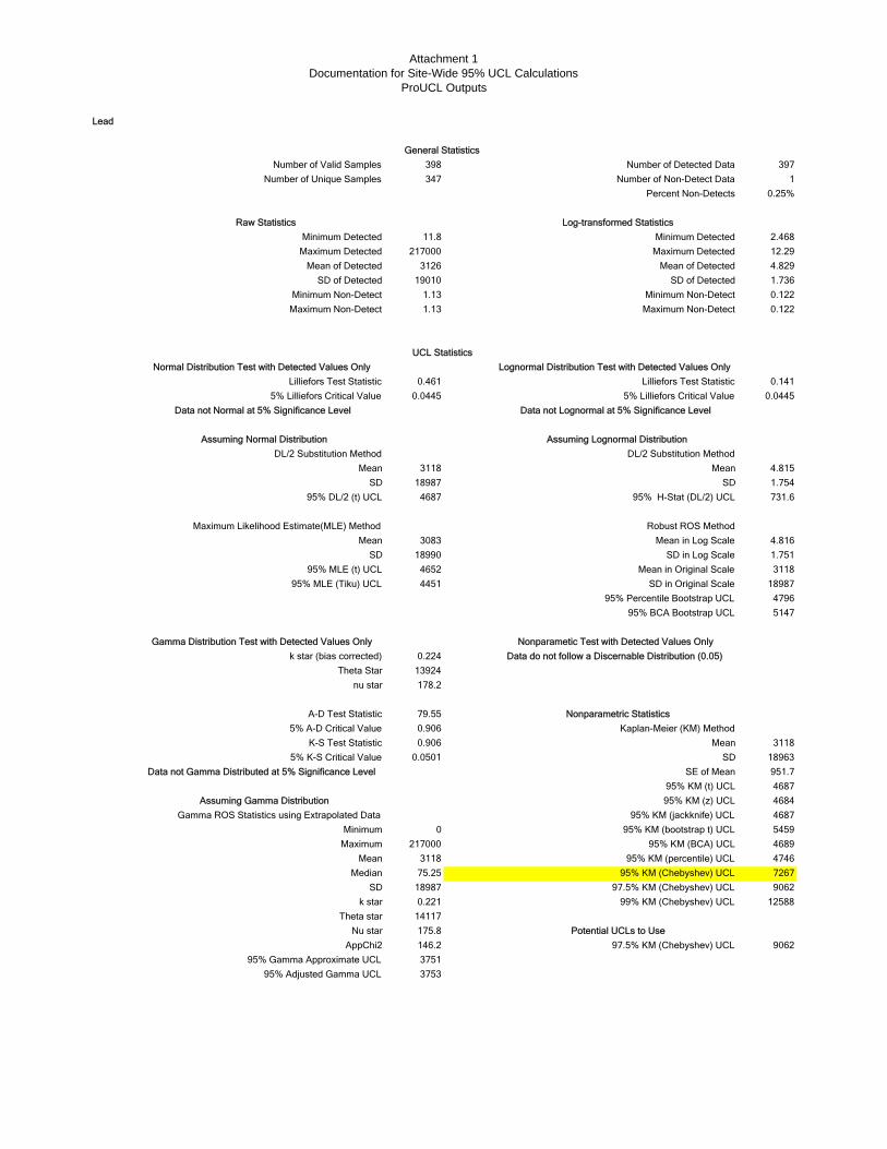
Attachment 1Documentation for Site-Wide 95% UCL Calculations
ProUCL Outputs
398 397
347 1
0.25%
11.8 2.468
217000 12.29
3126 4.829
19010 1.736
1.13 0.122
1.13 0.122
0.461 0.141
0.0445 0.0445
3118 4.815
18987 1.754
4687 731.6
3083 4.816
18990 1.751
4652 3118
4451 18987
4796
5147
0.224
13924
178.2
79.55
0.906
0.906 3118
0.0501 18963
951.7
4687
4684
4687
0 5459
217000 4689
3118 4746
75.25 7267
18987 9062
0.221 12588
14117
175.8
146.2 9062
3751
3753
Theta star
Nu star Potential UCLs to Use
95% Adjusted Gamma UCL
Median 95% KM (Chebyshev) UCL
SD 97.5% KM (Chebyshev) UCL
AppChi2 97.5% KM (Chebyshev) UCL
95% Gamma Approximate UCL
k star 99% KM (Chebyshev) UCL
Gamma ROS Statistics using Extrapolated Data 95% KM (jackknife) UCL
Minimum 95% KM (bootstrap t) UCL
Maximum 95% KM (BCA) UCL
Mean 95% KM (percentile) UCL
K-S Test Statistic Mean
5% K-S Critical Value SD
A-D Test Statistic Nonparametric Statistics
5% A-D Critical Value Kaplan-Meier (KM) Method
Data not Gamma Distributed at 5% Significance Level SE of Mean
95% KM (t) UCL
Assuming Gamma Distribution 95% KM (z) UCL
Gamma Distribution Test with Detected Values Only Nonparametic Test with Detected Values Only
k star (bias corrected) Data do not follow a Discernable Distribution (0.05)
nu star
95% MLE (t) UCL Mean in Original Scale
Theta Star
95% Percentile Bootstrap UCL
95% BCA Bootstrap UCL
95% MLE (Tiku) UCL SD in Original Scale
Maximum Likelihood Estimate(MLE) Method Robust ROS Method
Mean Mean in Log Scale
SD SD in Log Scale
Mean Mean
SD SD
95% DL/2 (t) UCL 95% H-Stat (DL/2) UCL
DL/2 Substitution Method DL/2 Substitution Method
5% Lilliefors Critical Value 5% Lilliefors Critical Value
Data not Normal at 5% Significance Level Data not Lognormal at 5% Significance Level
Assuming Normal Distribution Assuming Lognormal Distribution
Normal Distribution Test with Detected Values Only Lognormal Distribution Test with Detected Values Only
Lilliefors Test Statistic Lilliefors Test Statistic
Maximum Detected Maximum Detected
SD of Detected SD of Detected
Minimum Non-Detect Minimum Non-Detect
Raw Statistics Log-transformed Statistics
UCL Statistics
Percent Non-Detects
Maximum Non-Detect Maximum Non-Detect
Minimum Detected Minimum Detected
Mean of Detected Mean of Detected
Number of Valid Samples Number of Detected Data
Number of Unique Samples Number of Non-Detect Data
Lead
General Statistics
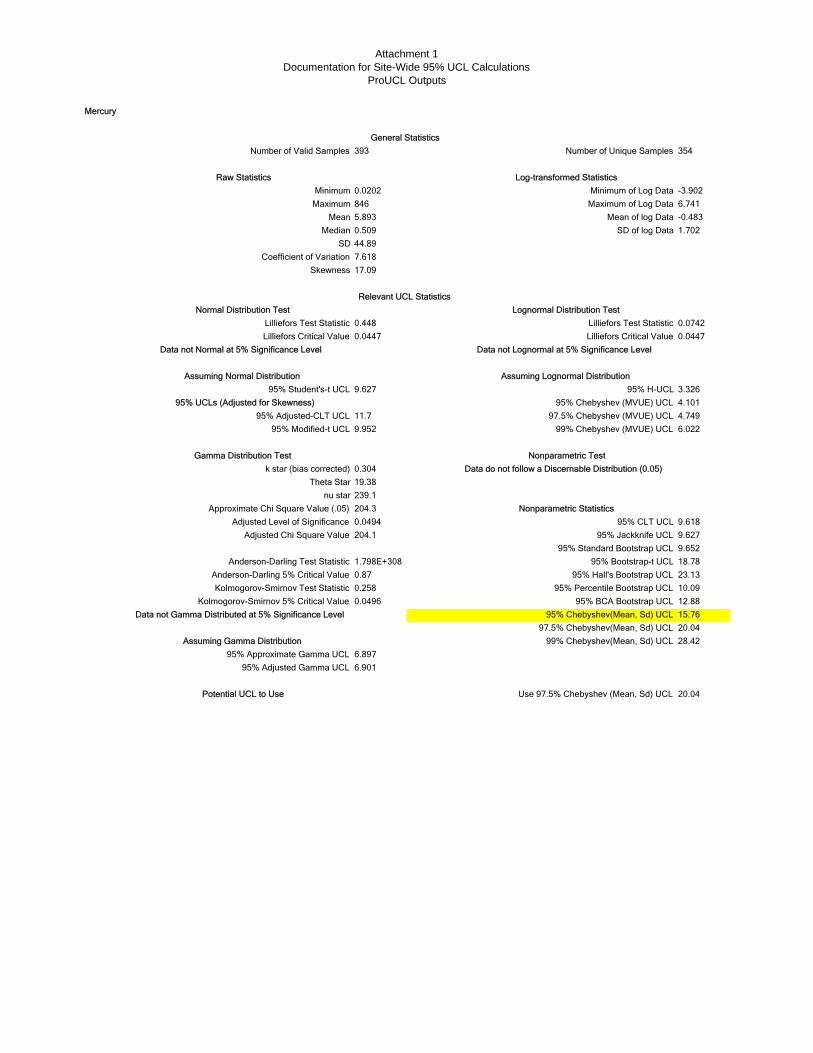
Attachment 1Documentation for Site-Wide 95% UCL Calculations
ProUCL Outputs
393 354
0.0202 -3.902
846 6.741
5.893 -0.483
0.509 1.702
44.89
7.618
17.09
0.448 0.0742
0.0447 0.0447
9.627 3.326
4.101
11.7 4.749
9.952 6.022
0.304
19.38
239.1
204.3
0.0494 9.618
204.1 9.627
9.652
1.798E+308 18.78
0.87 23.13
0.258 10.09
0.0496 12.88
15.76
20.04
28.42
6.897
6.901
20.04
95% Approximate Gamma UCL
95% Adjusted Gamma UCL
Potential UCL to Use Use 97.5% Chebyshev (Mean, Sd) UCL
95% Percentile Bootstrap UCL
Kolmogorov-Smirnov 5% Critical Value 95% BCA Bootstrap UCL
Data not Gamma Distributed at 5% Significance Level 95% Chebyshev(Mean, Sd) UCL
99% Chebyshev(Mean, Sd) UCL
97.5% Chebyshev(Mean, Sd) UCL
Assuming Gamma Distribution
95% Standard Bootstrap UCL
Anderson-Darling Test Statistic 95% Bootstrap-t UCL
Anderson-Darling 5% Critical Value 95% Hall's Bootstrap UCL
Kolmogorov-Smirnov Test Statistic
Theta Star
nu star
Gamma Distribution Test Nonparametric Test
k star (bias corrected) Data do not follow a Discernable Distribution (0.05)
Approximate Chi Square Value (.05) Nonparametric Statistics
Adjusted Level of Significance 95% CLT UCL
Adjusted Chi Square Value 95% Jackknife UCL
95% Student's-t UCL 95% H-UCL
95% UCLs (Adjusted for Skewness) 95% Chebyshev (MVUE) UCL
95% Modified-t UCL 99% Chebyshev (MVUE) UCL
Lilliefors Test Statistic Lilliefors Test Statistic
95% Adjusted-CLT UCL 97.5% Chebyshev (MVUE) UCL
Data not Normal at 5% Significance Level Data not Lognormal at 5% Significance Level
Assuming Normal Distribution Assuming Lognormal Distribution
Lilliefors Critical Value Lilliefors Critical Value
Coefficient of Variation
Skewness
Relevant UCL Statistics
Minimum Minimum of Log Data
Maximum Maximum of Log Data
Normal Distribution Test Lognormal Distribution Test
Mean Mean of log Data
Median SD of log Data
SD
Raw Statistics Log-transformed Statistics
Mercury
General Statistics
Number of Valid Samples Number of Unique Samples
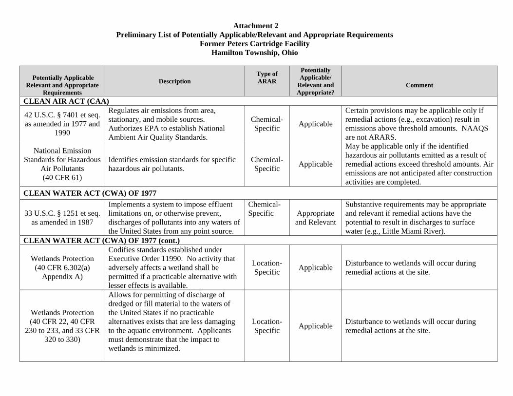
Attachment 2 Preliminary List of Potentially Applicable/Relevant and Appropriate Requirements
Former Peters Cartridge Facility Hamilton Township, Ohio
Potentially Applicable Relevant and Appropriate
Requirements
Description Type of ARAR
Potentially Applicable/
Relevant and Appropriate?
Comment
CLEAN AIR ACT (CAA)
42 U.S.C. § 7401 et seq. as amended in 1977 and
1990
Regulates air emissions from area, stationary, and mobile sources. Authorizes EPA to establish National Ambient Air Quality Standards.
Chemical-Specific Applicable
Certain provisions may be applicable only if remedial actions (e.g., excavation) result in emissions above threshold amounts. NAAQS are not ARARS.
National Emission Standards for Hazardous
Air Pollutants (40 CFR 61)
Identifies emission standards for specific hazardous air pollutants.
Chemical-Specific Applicable
May be applicable only if the identified hazardous air pollutants emitted as a result of remedial actions exceed threshold amounts. Air emissions are not anticipated after construction activities are completed.
CLEAN WATER ACT (CWA) OF 1977
33 U.S.C. § 1251 et seq. as amended in 1987
Implements a system to impose effluent limitations on, or otherwise prevent, discharges of pollutants into any waters of the United States from any point source.
Chemical-Specific Appropriate
and Relevant
Substantive requirements may be appropriate and relevant if remedial actions have the potential to result in discharges to surface water (e.g., Little Miami River).
CLEAN WATER ACT (CWA) OF 1977 (cont.)
Wetlands Protection (40 CFR 6.302(a)
Appendix A)
Codifies standards established under Executive Order 11990. No activity that adversely affects a wetland shall be permitted if a practicable alternative with lesser effects is available.
Location-Specific Applicable Disturbance to wetlands will occur during
remedial actions at the site.
Wetlands Protection (40 CFR 22, 40 CFR
230 to 233, and 33 CFR 320 to 330)
Allows for permitting of discharge of dredged or fill material to the waters of the United States if no practicable alternatives exists that are less damaging to the aquatic environment. Applicants must demonstrate that the impact to wetlands is minimized.
Location-Specific Applicable Disturbance to wetlands will occur during
remedial actions at the site.
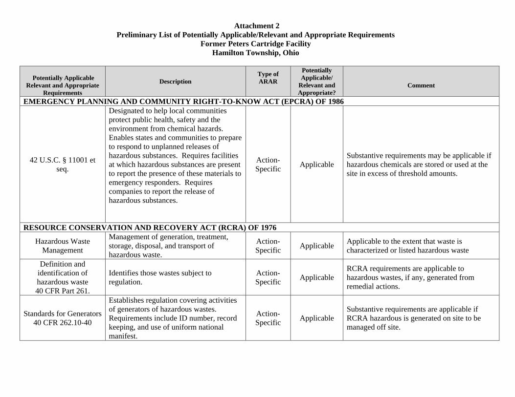
Attachment 2 Preliminary List of Potentially Applicable/Relevant and Appropriate Requirements
Former Peters Cartridge Facility Hamilton Township, Ohio
Potentially Applicable Relevant and Appropriate
Requirements
Description Type of ARAR
Potentially Applicable/
Relevant and Appropriate?
Comment
EMERGENCY PLANNING AND COMMUNITY RIGHT-TO-KNOW ACT (EPCRA) OF 1986
42 U.S.C. § 11001 et seq.
Designated to help local communities protect public health, safety and the environment from chemical hazards. Enables states and communities to prepare to respond to unplanned releases of hazardous substances. Requires facilities at which hazardous substances are present to report the presence of these materials to emergency responders. Requires companies to report the release of hazardous substances.
Action-Specific Applicable
Substantive requirements may be applicable if hazardous chemicals are stored or used at the site in excess of threshold amounts.
RESOURCE CONSERVATION AND RECOVERY ACT (RCRA) OF 1976
Hazardous Waste Management
Management of generation, treatment, storage, disposal, and transport of hazardous waste.
Action-Specific Applicable Applicable to the extent that waste is
characterized or listed hazardous waste
Definition and identification of hazardous waste 40 CFR Part 261.
Identifies those wastes subject to regulation.
Action-Specific Applicable
RCRA requirements are applicable to hazardous wastes, if any, generated from remedial actions.
Standards for Generators 40 CFR 262.10-40
Establishes regulation covering activities of generators of hazardous wastes. Requirements include ID number, record keeping, and use of uniform national manifest.
Action-Specific Applicable
Substantive requirements are applicable if RCRA hazardous is generated on site to be managed off site.
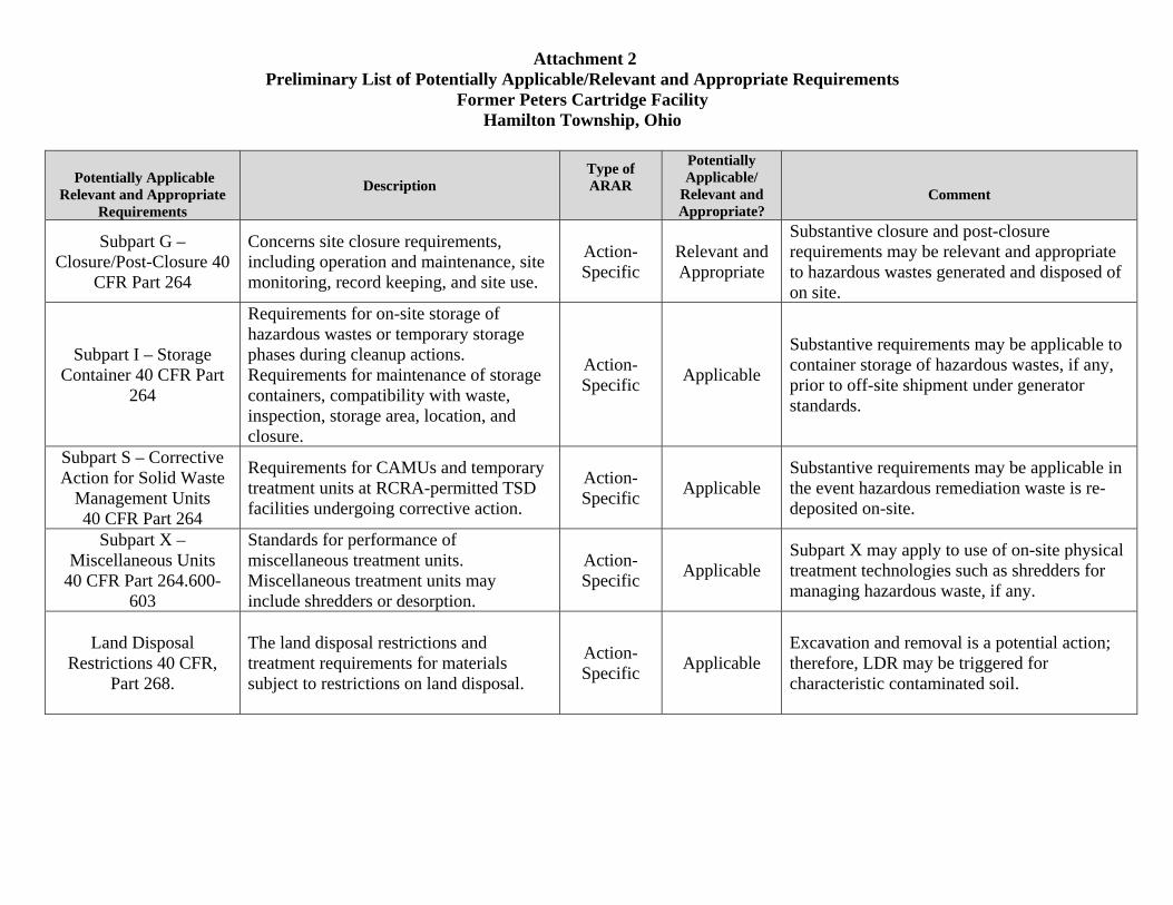
Attachment 2 Preliminary List of Potentially Applicable/Relevant and Appropriate Requirements
Former Peters Cartridge Facility Hamilton Township, Ohio
Potentially Applicable Relevant and Appropriate
Requirements
Description Type of ARAR
Potentially Applicable/
Relevant and Appropriate?
Comment
Subpart G – Closure/Post-Closure 40
CFR Part 264
Concerns site closure requirements, including operation and maintenance, site monitoring, record keeping, and site use.
Action-Specific
Relevant and Appropriate
Substantive closure and post-closure requirements may be relevant and appropriate to hazardous wastes generated and disposed of on site.
Subpart I – Storage Container 40 CFR Part
264
Requirements for on-site storage of hazardous wastes or temporary storage phases during cleanup actions. Requirements for maintenance of storage containers, compatibility with waste, inspection, storage area, location, and closure.
Action-Specific Applicable
Substantive requirements may be applicable to container storage of hazardous wastes, if any, prior to off-site shipment under generator standards.
Subpart S – Corrective Action for Solid Waste
Management Units 40 CFR Part 264
Requirements for CAMUs and temporary treatment units at RCRA-permitted TSD facilities undergoing corrective action.
Action-Specific Applicable
Substantive requirements may be applicable in the event hazardous remediation waste is re-deposited on-site.
Subpart X – Miscellaneous Units
40 CFR Part 264.600-603
Standards for performance of miscellaneous treatment units. Miscellaneous treatment units may include shredders or desorption.
Action-Specific Applicable
Subpart X may apply to use of on-site physical treatment technologies such as shredders for managing hazardous waste, if any.
Land Disposal Restrictions 40 CFR,
Part 268.
The land disposal restrictions and treatment requirements for materials subject to restrictions on land disposal.
Action-Specific Applicable
Excavation and removal is a potential action; therefore, LDR may be triggered for characteristic contaminated soil.
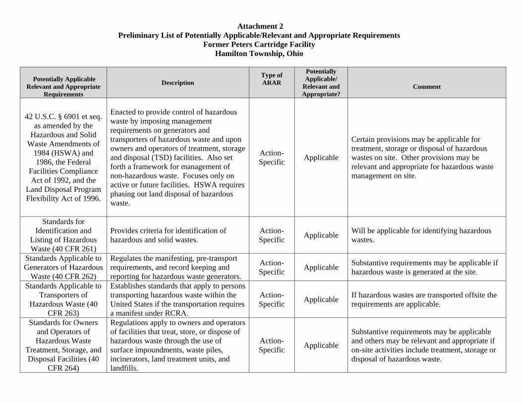
Attachment 2 Preliminary List of Potentially Applicable/Relevant and Appropriate Requirements
Former Peters Cartridge Facility Hamilton Township, Ohio
Potentially Applicable Relevant and Appropriate
Requirements
Description Type of ARAR
Potentially Applicable/
Relevant and Appropriate?
Comment
42 U.S.C. § 6901 et seq. as amended by the
Hazardous and Solid Waste Amendments of
1984 (HSWA) and 1986, the Federal
Facilities Compliance Act of 1992, and the
Land Disposal Program Flexibility Act of 1996.
Enacted to provide control of hazardous waste by imposing management requirements on generators and transporters of hazardous waste and upon owners and operators of treatment, storage and disposal (TSD) facilities. Also set forth a framework for management of non-hazardous waste. Focuses only on active or future facilities. HSWA requires phasing out land disposal of hazardous waste.
Action-Specific Applicable
Certain provisions may be applicable for treatment, storage or disposal of hazardous wastes on site. Other provisions may be relevant and appropriate for hazardous waste management on site.
Standards for Identification and
Listing of Hazardous Waste (40 CFR 261)
Provides criteria for identification of hazardous and solid wastes.
Action-Specific Applicable Will be applicable for identifying hazardous
wastes.
Standards Applicable to Generators of Hazardous
Waste (40 CFR 262)
Regulates the manifesting, pre-transport requirements, and record keeping and reporting for hazardous waste generators.
Action-Specific Applicable Substantive requirements may be applicable if
hazardous waste is generated at the site.
Standards Applicable to Transporters of
Hazardous Waste (40 CFR 263)
Establishes standards that apply to persons transporting hazardous waste within the United States if the transportation requires a manifest under RCRA.
Action-Specific Applicable If hazardous wastes are transported offsite the
requirements are applicable.
Standards for Owners and Operators of Hazardous Waste
Treatment, Storage, and Disposal Facilities (40
CFR 264)
Regulations apply to owners and operators of facilities that treat, store, or dispose of hazardous waste through the use of surface impoundments, waste piles, incinerators, land treatment units, and landfills.
Action-Specific Applicable
Substantive requirements may be applicable and others may be relevant and appropriate if on-site activities include treatment, storage or disposal of hazardous waste.
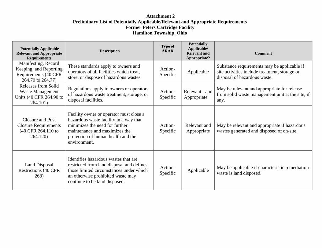
Attachment 2 Preliminary List of Potentially Applicable/Relevant and Appropriate Requirements
Former Peters Cartridge Facility Hamilton Township, Ohio
Potentially Applicable Relevant and Appropriate
Requirements
Description Type of ARAR
Potentially Applicable/
Relevant and Appropriate?
Comment
Manifesting, Record Keeping, and Reporting Requirements (40 CFR
264.70 to 264.77)
These standards apply to owners and operators of all facilities which treat, store, or dispose of hazardous wastes.
Action-Specific Applicable
Substance requirements may be applicable if site activities include treatment, storage or disposal of hazardous waste.
Releases from Solid Waste Management
Units (40 CFR 264.90 to 264.101)
Regulations apply to owners or operators of hazardous waste treatment, storage, or disposal facilities.
Action-Specific
Relevant and Appropriate
May be relevant and appropriate for release from solid waste management unit at the site, if any.
Closure and Post Closure Requirements (40 CFR 264.110 to
264.120)
Facility owner or operator must close a hazardous waste facility in a way that minimizes the need for further maintenance and maximizes the protection of human health and the environment.
Action-Specific
Relevant and Appropriate
May be relevant and appropriate if hazardous wastes generated and disposed of on-site.
Land Disposal Restrictions (40 CFR
268)
Identifies hazardous wastes that are restricted from land disposal and defines those limited circumstances under which an otherwise prohibited waste may continue to be land disposed.
Action-Specific Applicable May be applicable if characteristic remediation
waste is land disposed.
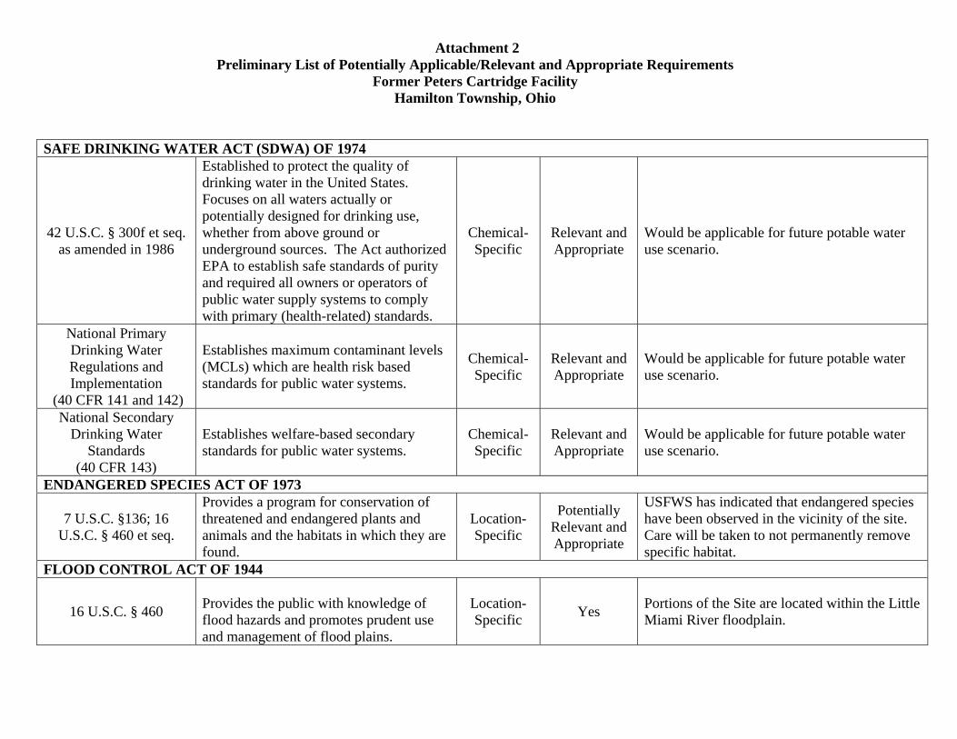
Attachment 2 Preliminary List of Potentially Applicable/Relevant and Appropriate Requirements
Former Peters Cartridge Facility Hamilton Township, Ohio
SAFE DRINKING WATER ACT (SDWA) OF 1974
42 U.S.C. § 300f et seq. as amended in 1986
Established to protect the quality of drinking water in the United States. Focuses on all waters actually or potentially designed for drinking use, whether from above ground or underground sources. The Act authorized EPA to establish safe standards of purity and required all owners or operators of public water supply systems to comply with primary (health-related) standards.
Chemical-Specific
Relevant and Appropriate
Would be applicable for future potable water use scenario.
National Primary Drinking Water Regulations and Implementation
(40 CFR 141 and 142)
Establishes maximum contaminant levels (MCLs) which are health risk based standards for public water systems.
Chemical-Specific
Relevant and Appropriate
Would be applicable for future potable water use scenario.
National Secondary Drinking Water
Standards (40 CFR 143)
Establishes welfare-based secondary standards for public water systems.
Chemical-Specific
Relevant and Appropriate
Would be applicable for future potable water use scenario.
ENDANGERED SPECIES ACT OF 1973
7 U.S.C. §136; 16 U.S.C. § 460 et seq.
Provides a program for conservation of threatened and endangered plants and animals and the habitats in which they are found.
Location-Specific
Potentially Relevant and Appropriate
USFWS has indicated that endangered species have been observed in the vicinity of the site. Care will be taken to not permanently remove specific habitat.
FLOOD CONTROL ACT OF 1944
16 U.S.C. § 460
Provides the public with knowledge of flood hazards and promotes prudent use and management of flood plains.
Location-Specific Yes Portions of the Site are located within the Little
Miami River floodplain.
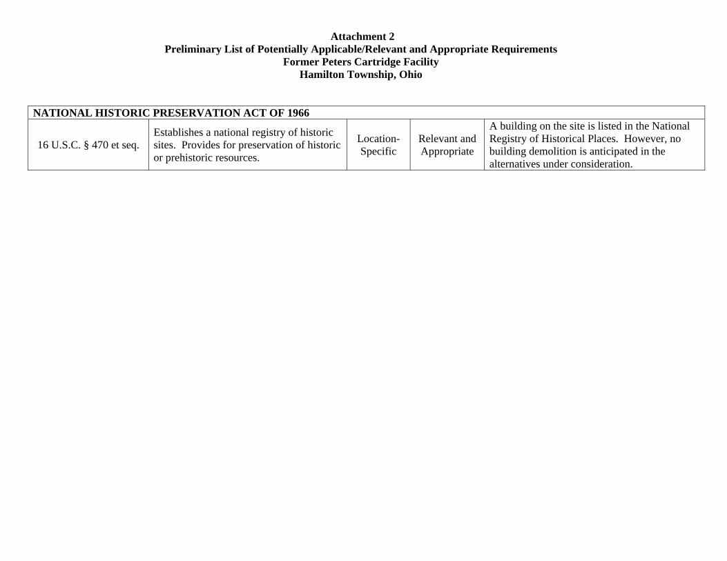
Attachment 2 Preliminary List of Potentially Applicable/Relevant and Appropriate Requirements
Former Peters Cartridge Facility Hamilton Township, Ohio
NATIONAL HISTORIC PRESERVATION ACT OF 1966
16 U.S.C. § 470 et seq. Establishes a national registry of historic sites. Provides for preservation of historic or prehistoric resources.
Location-Specific
Relevant and Appropriate
A building on the site is listed in the National Registry of Historical Places. However, no building demolition is anticipated in the alternatives under consideration.
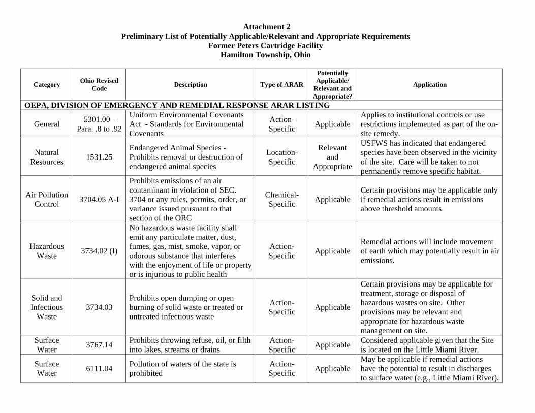
Attachment 2 Preliminary List of Potentially Applicable/Relevant and Appropriate Requirements
Former Peters Cartridge Facility Hamilton Township, Ohio
Category Ohio Revised Code Description Type of ARAR
Potentially Applicable/
Relevant and Appropriate?
Application
OEPA, DIVISION OF EMERGENCY AND REMEDIAL RESPONSE ARAR LISTING
General 5301.00 -Para. .8 to .92
Uniform Environmental Covenants Act - Standards for Environmental Covenants
Action-Specific Applicable
Applies to institutional controls or use restrictions implemented as part of the on-site remedy.
Natural Resources 1531.25
Endangered Animal Species - Prohibits removal or destruction of endangered animal species
Location-Specific
Relevant and
Appropriate
USFWS has indicated that endangered species have been observed in the vicinity of the site. Care will be taken to not permanently remove specific habitat.
Air Pollution Control 3704.05 A-I
Prohibits emissions of an air contaminant in violation of SEC. 3704 or any rules, permits, order, or variance issued pursuant to that section of the ORC
Chemical-Specific Applicable
Certain provisions may be applicable only if remedial actions result in emissions above threshold amounts.
Hazardous Waste 3734.02 (I)
No hazardous waste facility shall emit any particulate matter, dust, fumes, gas, mist, smoke, vapor, or odorous substance that interferes with the enjoyment of life or property or is injurious to public health
Action-Specific Applicable
Remedial actions will include movement of earth which may potentially result in air emissions.
Solid and Infectious
Waste 3734.03
Prohibits open dumping or open burning of solid waste or treated or untreated infectious waste
Action-Specific Applicable
Certain provisions may be applicable for treatment, storage or disposal of hazardous wastes on site. Other provisions may be relevant and appropriate for hazardous waste management on site.
Surface Water 3767.14 Prohibits throwing refuse, oil, or filth
into lakes, streams or drains Action-Specific Applicable Considered applicable given that the Site
is located on the Little Miami River.
Surface Water 6111.04 Pollution of waters of the state is
prohibited Action-Specific Applicable
May be applicable if remedial actions have the potential to result in discharges to surface water (e.g., Little Miami River).

Attachment 2 Preliminary List of Potentially Applicable/Relevant and Appropriate Requirements
Former Peters Cartridge Facility Hamilton Township, Ohio
Category Ohio Revised Code Description Type of ARAR
Potentially Applicable/
Relevant and Appropriate?
Application
Surface Water 6111.04.2
Establishes regulations requiring compliance with national effluent standards
Chemical-Specific
Relevant and
Appropriate
May be relevant and appropriate if remedial actions have the potential to result in discharges to surface water (e.g., Little Miami River).
Surface Water 6111.07 A,C
Prohibits failure to comply with requirements of Sections 6111.01 – 6111.08 or any rules, permits or orders issued under those sections
Action-Specific Applicable
May be applicable if remedial actions have the potential to result in discharges to groundwater or surface water (e.g., Little Miami River).
Natural Resources
1501:31-23-01, A-B
List of Ohio Endangered Animal Species
Location-Specific
Relevant and
Appropriate
No threatened or endangered species, or their habitats, are present at or near the Site, however, USFWS has said endangered species have been seen in the area.
Natural Resources 1517 Protection of Wild and Scenic Rivers Location-
Specific Applicable Applicable for shoreline delta removal work.
Surface Water/
Wetlands 401
The 401 Water Quality Certification and Isolated Wetland Permit Section reviews projects that would impact waters of the State.
Action-Specific Applicable
Although a permit will not be necessary, substantial compliance with the permit application will be required.
Surface Water 3745-1-03
Analytical methods and collection procedures for surface water discharge
Action-Specific Applicable
May be applicable if remedial actions have the potential to result in discharges to groundwater or surface water (e.g., Little Miami River). Surface
Water 3745-1-04 A,B,C,D,E
All surface waters of the state shall be free from: A) objectionable suspended solids, B) floating debris, oil and scum, C) materials that create a nuisance, D) toxic, harmful or lethal substances, and E) nutrients that create nuisance growth
Action-Specific Applicable
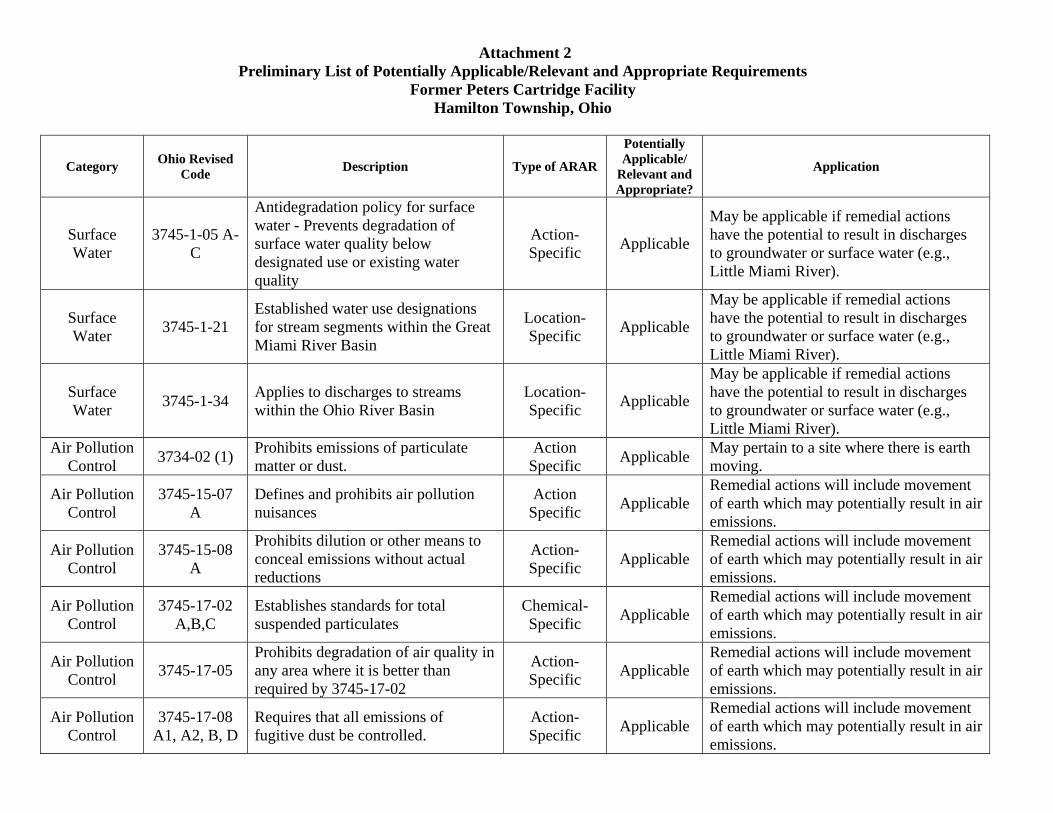
Attachment 2 Preliminary List of Potentially Applicable/Relevant and Appropriate Requirements
Former Peters Cartridge Facility Hamilton Township, Ohio
Category Ohio Revised Code Description Type of ARAR
Potentially Applicable/
Relevant and Appropriate?
Application
Surface Water
3745-1-05 A-C
Antidegradation policy for surface water - Prevents degradation of surface water quality below designated use or existing water quality
Action-Specific Applicable
May be applicable if remedial actions have the potential to result in discharges to groundwater or surface water (e.g., Little Miami River).
Surface Water 3745-1-21
Established water use designations for stream segments within the Great Miami River Basin
Location-Specific Applicable
May be applicable if remedial actions have the potential to result in discharges to groundwater or surface water (e.g., Little Miami River).
Surface Water 3745-1-34 Applies to discharges to streams
within the Ohio River Basin Location-Specific Applicable
May be applicable if remedial actions have the potential to result in discharges to groundwater or surface water (e.g., Little Miami River).
Air Pollution Control 3734-02 (1) Prohibits emissions of particulate
matter or dust. Action
Specific Applicable May pertain to a site where there is earth moving.
Air Pollution Control
3745-15-07 A
Defines and prohibits air pollution nuisances
Action Specific Applicable
Remedial actions will include movement of earth which may potentially result in air emissions.
Air Pollution Control
3745-15-08 A
Prohibits dilution or other means to conceal emissions without actual reductions
Action-Specific Applicable
Remedial actions will include movement of earth which may potentially result in air emissions.
Air Pollution Control
3745-17-02 A,B,C
Establishes standards for total suspended particulates
Chemical-Specific Applicable
Remedial actions will include movement of earth which may potentially result in air emissions.
Air Pollution Control 3745-17-05
Prohibits degradation of air quality in any area where it is better than required by 3745-17-02
Action-Specific Applicable
Remedial actions will include movement of earth which may potentially result in air emissions.
Air Pollution Control
3745-17-08 A1, A2, B, D
Requires that all emissions of fugitive dust be controlled.
Action-Specific Applicable
Remedial actions will include movement of earth which may potentially result in air emissions.
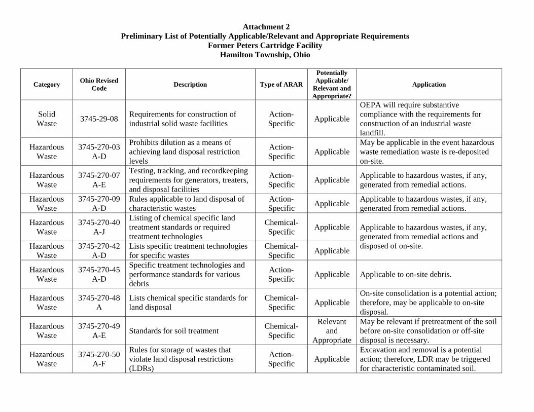
Attachment 2 Preliminary List of Potentially Applicable/Relevant and Appropriate Requirements
Former Peters Cartridge Facility Hamilton Township, Ohio
Category Ohio Revised Code Description Type of ARAR
Potentially Applicable/
Relevant and Appropriate?
Application
Solid Waste 3745-29-08 Requirements for construction of
industrial solid waste facilities Action-Specific Applicable
OEPA will require substantive compliance with the requirements for construction of an industrial waste landfill.
Hazardous Waste
3745-270-03 A-D
Prohibits dilution as a means of achieving land disposal restriction levels
Action-Specific Applicable
May be applicable in the event hazardous waste remediation waste is re-deposited on-site.
Hazardous Waste
3745-270-07 A-E
Testing, tracking, and recordkeeping requirements for generators, treaters, and disposal facilities
Action-Specific Applicable Applicable to hazardous wastes, if any,
generated from remedial actions.
Hazardous Waste
3745-270-09 A-D
Rules applicable to land disposal of characteristic wastes
Action-Specific Applicable Applicable to hazardous wastes, if any,
generated from remedial actions.
Hazardous Waste
3745-270-40 A-J
Listing of chemical specific land treatment standards or required treatment technologies
Chemical-Specific Applicable Applicable to hazardous wastes, if any,
generated from remedial actions and disposed of on-site. Hazardous
Waste 3745-270-42
A-D Lists specific treatment technologies for specific wastes
Chemical-Specific Applicable
Hazardous Waste
3745-270-45 A-D
Specific treatment technologies and performance standards for various debris
Action-Specific Applicable Applicable to on-site debris.
Hazardous Waste
3745-270-48 A
Lists chemical specific standards for land disposal
Chemical-Specific Applicable
On-site consolidation is a potential action; therefore, may be applicable to on-site disposal.
Hazardous Waste
3745-270-49 A-E Standards for soil treatment Chemical-
Specific
Relevant and
Appropriate
May be relevant if pretreatment of the soil before on-site consolidation or off-site disposal is necessary.
Hazardous Waste
3745-270-50 A-F
Rules for storage of wastes that violate land disposal restrictions (LDRs)
Action-Specific Applicable
Excavation and removal is a potential action; therefore, LDR may be triggered for characteristic contaminated soil.
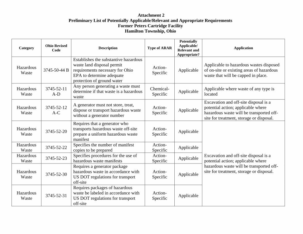
Attachment 2 Preliminary List of Potentially Applicable/Relevant and Appropriate Requirements
Former Peters Cartridge Facility Hamilton Township, Ohio
Category Ohio Revised Code Description Type of ARAR
Potentially Applicable/
Relevant and Appropriate?
Application
Hazardous Waste 3745-50-44 B
Establishes the substantive hazardous waste land disposal permit requirements necessary for Ohio EPA to determine adequate protection of ground water
Action-Specific Applicable
Applicable to hazardous wastes disposed of on-site or existing areas of hazardous waste that will be capped in place.
Hazardous Waste
3745-52-11 A-D
Any person generating a waste must determine if that waste is a hazardous waste
Chemical-Specific Applicable Applicable where waste of any type is
located
Hazardous Waste
3745-52-12 A-C
A generator must not store, treat, dispose or transport hazardous waste without a generator number
Action-Specific Applicable
Excavation and off-site disposal is a potential action; applicable where hazardous waste will be transported off-site for treatment, storage or disposal.
Hazardous Waste 3745-52-20
Requires that a generator who transports hazardous waste off-site prepare a uniform hazardous waste manifest
Action-Specific Applicable
Excavation and off-site disposal is a potential action; applicable where hazardous waste will be transported off-site for treatment, storage or disposal.
Hazardous Waste 3745-52-22 Specifies the number of manifest
copies to be prepared Action-Specific Applicable
Hazardous Waste 3745-52-23 Specifies procedures for the use of
hazardous waste manifests Action-Specific Applicable
Hazardous Waste 3745-52-30
Requires a generator package hazardous waste in accordance with US DOT regulations for transport off-site
Action-Specific Applicable
Hazardous Waste 3745-52-31
Requires packages of hazardous waste be labeled in accordance with US DOT regulations for transport off-site
Action-Specific Applicable
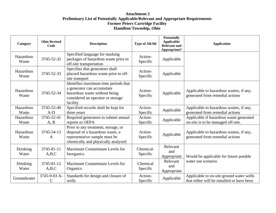
Attachment 2 Preliminary List of Potentially Applicable/Relevant and Appropriate Requirements
Former Peters Cartridge Facility Hamilton Township, Ohio
Category Ohio Revised Code Description Type of ARAR
Potentially Applicable/
Relevant and Appropriate?
Application
Hazardous Waste 3745-52-32
Specified language for marking packages of hazardous waste prior to off-site transportation
Action-Specific Applicable
Hazardous Waste 3745-52-33
Specifies that generators shall placard hazardous waste prior to off-site transport
Action-Specific Applicable
Hazardous Waste 3745-52-34
Identifies maximum time periods that a generator can accumulate hazardous waste without being considered an operator or storage facility
Action-Specific Applicable Applicable to hazardous wastes, if any,
generated from remedial actions
Hazardous Waste
3745-52-40 A-D
Specified records shall be kept for three years
Action-Specific Applicable Applicable to hazardous wastes, if any,
generated from remedial actions Hazardous
Waste 3745-52-41
A, B Required generators to submit annual reports to OEPA
Action-Specific Applicable Applicable if hazardous waste generated
on-site is to be managed off-site.
Hazardous Waste
3745-54-13 A
Prior to any treatment, storage, or disposal of a hazardous waste, a representative sample must be chemically and physically analyzed
Action-Specific Applicable Applicable to hazardous wastes, if any,
generated from remedial actions
Drinking Water
3745-81-11 A,B,C
Maximum Contaminant Levels for Inorganics
Chemical-Specific
Relevant and
Appropriate Would be applicable for future potable water use scenario. Drinking
Water 3745-81-12
A,B,C Maximum Contaminant Levels for Organics
Chemical Specific
Relevant and
Appropriate
Groundwater 3745-9-03 A-C
Standards for design and closure of wells
Action-Specific Applicable Applicable to on-site ground water wells
that either will be installed or have been

Attachment 2 Preliminary List of Potentially Applicable/Relevant and Appropriate Requirements
Former Peters Cartridge Facility Hamilton Township, Ohio
Category Ohio Revised Code Description Type of ARAR
Potentially Applicable/
Relevant and Appropriate?
Application
Groundwater 3745-9-04 A,B
Mandates that wells be located so as to prevent contamination from entering a well and to be accessible for cleaning and maintenance
Action-Specific Applicable
installed since Feb 15, 1975.
Groundwater 3745-9-05 A1, B-H
Specified minimum construction requirements for new ground water wells
Action-Specific Applicable
Groundwater 3745-9-06 A Established specific requirements for well in different types of aquifers
Action-Specific Applicable
Applicable to on-site ground water wells that either will be installed or have been installed since Feb 15, 1975.
Groundwater 3745-9-07 A-C
Established specific grouting procedures for wells
Action-Specific Applicable
Groundwater 3745-9-10 A,B,C
Provides procedures for closing and sealing wells
Action-Specific Applicable

ATTACHMENT 3BASIS FOR PRELIMINARY COST ESTIMATES
SOIL REMEDIATIONFORMER PETERS CARTRIDGE FACILITY
HAMILTON TOWNSHIP, OHIO
Cost Estimating ParametersMobilization
Mobilization & Demobilization $75,000 LSContractor's Oversight, H&S, and Surveying
Construction surveying $2,000 per dayDuration of Surveying 20 daysContractor Health and Safety $3,000 per weekContractor Management and Oversight $10,000 per weekDuration of Construction 17 weeks
Site PreparationTree and Brush Removal - High Density $1,250 per 10,000 ft2
Tree and Brush Removal - Medium Density $900 per 10,000 ft2
Tree and Brush Removal - Low Density $600 per 10,000 ft2
ExcavationSoil Excavation $6 per cy
Backfill/CappingFill Place and Compact - onsite Borrow $15 per cyFill Place and Compact - offsite Borrow $27 per cy
DisposalSoil Load, Haul, & Disposal $90 per cyDebris Rinse, Load, Haul, & Disposal $85 per cy
Erosion ControlBedding Material $22 per cy Assume 100 cyRiprap $38 per cy Assume 100 cyErosion Control Mat- Slopes & low Lands $9 per syErosion Control Mat- Drainage Channels $10 per sy
RevegetationTree Planting $25 per tree plugSeeding $4,000 per acre Assume 1 tree per 250 ft2
Consolidation CellExcavation $6 per cyGeomembrane Liner $2 per ft2 Cost for Geomembrane and GeotextileSoil Cover (2.5 ft) $27 per cy Assume off-site clay and VSL BorrowFencing $29 lf 6-ft high aluminized steel chain linkGeocomposite liner $1 per ft2

ATTACHMENT 3BASIS FOR PRELIMINARY COST ESTIMATES
SOIL REMEDIATIONFORMER PETERS CARTRIDGE FACILITY
HAMILTON TOWNSHIP, OHIO
ALTERNATIVE 2: CAPPED INPLACE WITH OFFSITE FILLCapital Items Quantity Units CostMobilization 1 $75,000Contractor's Oversight, H&S, and Surveying 1 $261,000Site Preparation Tree/Brush Removal- High Density 150,355 ft2 $18,794 Tree/Brush Removal- Medium Density 107,911 ft2 $9,712 Tree/Brush Removal- Low Density 67,794 ft2 $4,068Excavation 7,990 cy $47,939Backfill/Capping 31,959 cy $862,906Disposal Soil Load, Haul, & Disposal 7,990 cy $719,088 Debris Rinse, Load, Haul, & Disposal 149 cy $12,665Erosion Control Bedding Material and Riprap 100 cy $6,000 Erosion Control Mat- Slopes & low Lan 28,424 sy $255,814 Erosion Control Mat- Drainage Channel 5,595 sy $55,947Revegetation Seeding 10 acre $39,619 Tree Planting 1,726 Nos $43,145Shoreline Remediation 1 LS $20,000
Direct Capital $2,431,698Engineering, Procurement & Construction Management: $607,924Total Capital $3,039,622
Present Worth, Longer Term O&M Costs Years(Interest Rate = 5%) 30 $159,328 See Table A for analysisTotal Project Capital and O&M Cost $3,198,950
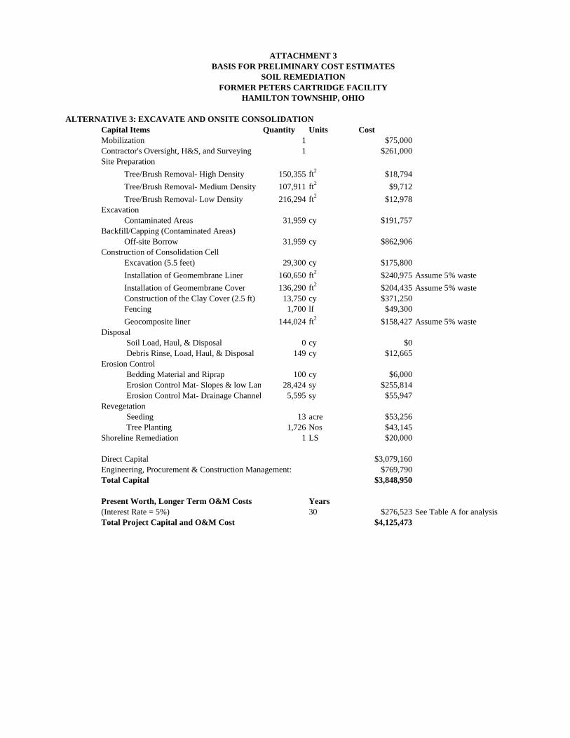
ATTACHMENT 3BASIS FOR PRELIMINARY COST ESTIMATES
SOIL REMEDIATIONFORMER PETERS CARTRIDGE FACILITY
HAMILTON TOWNSHIP, OHIO
ALTERNATIVE 3: EXCAVATE AND ONSITE CONSOLIDATIONCapital Items Quantity Units CostMobilization 1 $75,000Contractor's Oversight, H&S, and Surveying 1 $261,000Site Preparation Tree/Brush Removal- High Density 150,355 ft2 $18,794 Tree/Brush Removal- Medium Density 107,911 ft2 $9,712 Tree/Brush Removal- Low Density 216,294 ft2 $12,978Excavation Contaminated Areas 31,959 cy $191,757Backfill/Capping (Contaminated Areas) Off-site Borrow 31,959 cy $862,906Construction of Consolidation Cell Excavation (5.5 feet) 29,300 cy $175,800 Installation of Geomembrane Liner 160,650 ft2 $240,975 Assume 5% waste Installation of Geomembrane Cover 136,290 ft2 $204,435 Assume 5% waste Construction of the Clay Cover (2.5 ft) 13,750 cy $371,250 Fencing 1,700 lf $49,300 Geocomposite liner 144,024 ft2 $158,427 Assume 5% wasteDisposal Soil Load, Haul, & Disposal 0 cy $0 Debris Rinse, Load, Haul, & Disposal 149 cy $12,665Erosion Control Bedding Material and Riprap 100 cy $6,000 Erosion Control Mat- Slopes & low Lan 28,424 sy $255,814 Erosion Control Mat- Drainage Channel 5,595 sy $55,947Revegetation Seeding 13 acre $53,256 Tree Planting 1,726 Nos $43,145Shoreline Remediation 1 LS $20,000
Direct Capital $3,079,160Engineering, Procurement & Construction Management: $769,790Total Capital $3,848,950
Present Worth, Longer Term O&M Costs Years(Interest Rate = 5%) 30 $276,523 See Table A for analysisTotal Project Capital and O&M Cost $4,125,473

ATTACHMENT 3BASIS FOR PRELIMINARY COST ESTIMATES
SOIL REMEDIATIONFORMER PETERS CARTRIDGE FACILITY
HAMILTON TOWNSHIP, OHIO
ALTERNATIVE 4: EXCAVATE AND OFFSITE DISPOSALCapital Items Quantity Units CostMobilization 1 $75,000Contractor's Oversight, H&S, and Surveying 1 $261,000Site Preparation Tree/Brush Removal- High Density 150,355 ft2 $18,794 Tree/Brush Removal- Medium Density 107,911 ft2 $9,712 Tree/Brush Removal- Low Density 67,794 ft2 $4,068Excavation 31,959 cy $191,757Backfill/Capping 31,959 cy $862,906Disposal Soil Load, Haul, & Disposal 31,959 cy $2,876,353 Debris Rinse, Load, Haul, & Disposal 149 cy $12,665Erosion Control Bedding Material and Riprap 100 cy $6,000 Erosion Control Mat- Slopes & low Lan 28,424 sy $255,814 Erosion Control Mat- Drainage Channel 5,595 sy $55,947Revegetation Seeding 10 acre $39,619 Tree Planting 1,726 Nos $43,145Shoreline Remediation 1 LS $20,000
Direct Capital $4,732,780Engineering, Procurement & Construction Management: $437,059Total Capital $5,169,839
Present Worth, Longer Term O&M Costs Years(Interest Rate = 5%) 5 $47,624 See Table A for analysisTotal Project Capital and O&M Cost $5,217,464

TABLE AOPERATION AND MAINTENECE COST ESTIMATE
Alternative 2 - Isolation Capping
Soil Caps Inspections2 people for 2 days (with travel) at $1,000 per person per day = $4,000ODCs (flights, hotel rooms, car, per diem) $2,000
Total (per year) $6,000First 5 years - semi-annual = $12,000 per yearYears 6 through 30, annual = $6,000 per year
Soil Caps MaintenanceFirst 5 years, assume 1 day of grading and seeding
Dozer and crew with mobilization $5,000 per yearPaved areas, assume $5,000 of paving every 5 years
Alternative 3 - Excavation and On-site Consolidation
Cap Inspections2 people for 2 days (with travel) ay $1,000 per person per day = $4,000ODCs (flights, hotel rooms, car, per diem) $2,000
Total $6,000 per yearFirst 5 years - semi-annual = $12,000 per yearYears 6 through 30, annual = $6,000 per year
Cap MaintenanceFirst 5 years, assume 1 day of grading and seeding
Dozer and crew with mobilization = $5,000 per year
Monitoring Well SamplingInstallation of 6 Groundwater monitoring wells ($2,700 per well) $16,200 per yearAnnual monitoring for 30 years ($1,300 per well) 7,800 per year
Alternative 4 - Excavation and Off-site Disposal
Backfilled Areas Inspections2 people for 2 days (with travel) at $1,000 per person per day = $4,000ODCs (flights, hotel rooms, car, per diem) $2,000
Total $6,000First 5 years - annual = $6,000 per year
Backfilled Areas MaintenanceFirst 5 years, assume 1 day of grading and seeding
Dozer and crew with mobilization = $5,000 per year

ATTACHMENT 4ALTERNATIVES CARBON FOOTPRINT CALCULATIONS
ALTERNATIVE 2
Alternative 2 Conversion Factors LocationArea of excavated
Material (sf)Volume of Excavated
Material (cy)Volume of Cap (cy)
Land Clearing Carbon Footprint (mt)
Disposal Hauling Footprint (mt)
Borrow Hauling Footprint (mt)
Disposal Distance 30 miles Excavation Area E1 13640 253 1263 10 1 1Disposal Amount 20 cy/load Excavation Area E2 88168 1633 8164 62 6 9Borrow Distance 10 miles Excavation Area E3 35310 654 3269 25 2 4Borrow Amount 20 cy/load Excavation Area E4 5460 101 506 4 0 1
Nonroad Diesel Fuel Usage 2.8 gal/hr Excavation Area E5 6330 117 586 4 0 1No. of Nonroad Construction Veh. 4 veh. Excavation Area E6 8120 150 752 6 1 1
Workday Length 10 hrs Excavation Area E7 4750 88 440 3 0 1Project Length 17 weeks Excavation Area E8 14494 268 1342 10 1 2
Heavy Duty Diesel Fuel Economy 9 mpg Excavation Areas E9‐1 & E9‐2 8313 154 770 6 1 1Diesel‐to‐carbon factor 22.9 lbs/gal Excavation Area E10‐1, E10‐2 & E10‐3 5563 103 515 4 0 1Land‐Clearing Footprint 0.0007 mt/sf Excavation Area E11 16658 308 1542 12 1 2
Excavation Depth 0.5 ft Excavation Area E12‐1 thru E12‐5 28700 531 2657 20 2 3Cap Thickness 2.5 ft Excavation Area E13 9732 180 901 7 1 1
Excavation Area E14 17837 330 1652 12 1 2Excavation Area E15 18212 337 1686 13 1 2Excavation Area E16 11878 220 1100 8 1 1Excavation Area E17 61770 1144 5719 43 4 7Excavation Area E18 14331 265 1327 10 1 2Excavation Area C1 62187 1152 5758 44 4 7
Total 431453 7988 39949 302 28 46
TOTAL CARBON FOOTPRINT (mt)Land Clearing 302Hauling/Trucking 74Excavating Equipment 99
475
Alternative 2: All affected areas will be excavated to a depth of 0.5 ft. Excavated material will be disposed of off site. A 2 ft thick cap with a 0.5 ft thick vegetation layer will be placed over affected
areas. Cap material will be imported from off‐site.

ATTACHMENT 4 (continued)
ALTERNATIVE 3
Alternative 3 Conversion Factors LocationArea of excavated
Material (sf)Volume of Excavated
Material (cy)Volume of Fill/Cap (cy)
Land Clearing Carbon Footprint (mt)
Consolidation Hauling Footprint (mt)
Borrow Hauling Footprint (mt)
Consolidation Distance 0.2 miles Excavation Area E1 13640 1010 1010 10 0.02 1Consolidation Amount 20 cy/load Excavation Area E2 88168 6531 6531 62 0.15 8
Borrow Distance 10 miles Excavation Area E3 35310 2616 2616 25 0.06 3Borrow Amount 20 cy/load Excavation Area E4 5460 404 404 4 0.01 0
Nonroad Diesel Fuel Usage 2.8 gal/hr Excavation Area E5 6330 469 469 4 0.01 1No. of Nonroad Construction Veh. 4 veh. Capped Area E6 8120 601 752 6 0.01 1
Workday Length 10 hrs Capped Area E7 4750 352 440 3 0.01 1Project Length 17 weeks Excavation Area E8 14494 1074 1074 10 0.02 1
Heavy Duty Diesel Fuel Economy 9 mpg Excavation Areas E9‐1 & E9‐2 8313 616 616 6 0.01 1Diesel‐to‐carbon factor 22.9 lbs/gal Excavation Area E10‐1, E10‐2 & E10‐3 5563 412 412 4 0.01 0Land‐Clearing Footprint 0.0007 mt/sf Capped Area E11 16658 1234 1542 12 0.03 2
Excavation Depth 2 ft Excavation Area E12‐1 thru E12‐5 28700 2126 2126 20 0.05 2Fill Thickness 2 ft Excavation Area E13 9732 721 721 7 0.02 1Cap Thickness 2.5 ft Excavation Area E14 17837 1321 1321 12 0.03 2
Excavation Area E15 18212 1349 1349 13 0.03 2Excavation Area E16 11878 880 880 8 0.02 1Excavation Area E17 61770 4576 4576 43 0.11 5Excavation Area E18 14331 1062 1062 10 0.02 1Excavation Area C1 62187 4606 4606 44 0.11 5Capped Area BC2 148500 27000 13750 104 0.62 16
Total 579953 58960 46256 406 1 53
TOTAL CARBON FOOTPRINT (mt)Land Clearing 406Hauling/Trucking 55Excavating Equipment 99
560Alternative 3: Affected areas will be excavated to a depth of 2 ft. The excavated material will be placed
in a consolidation area (BC2) to the south of the site. The consolidation area will be capped.
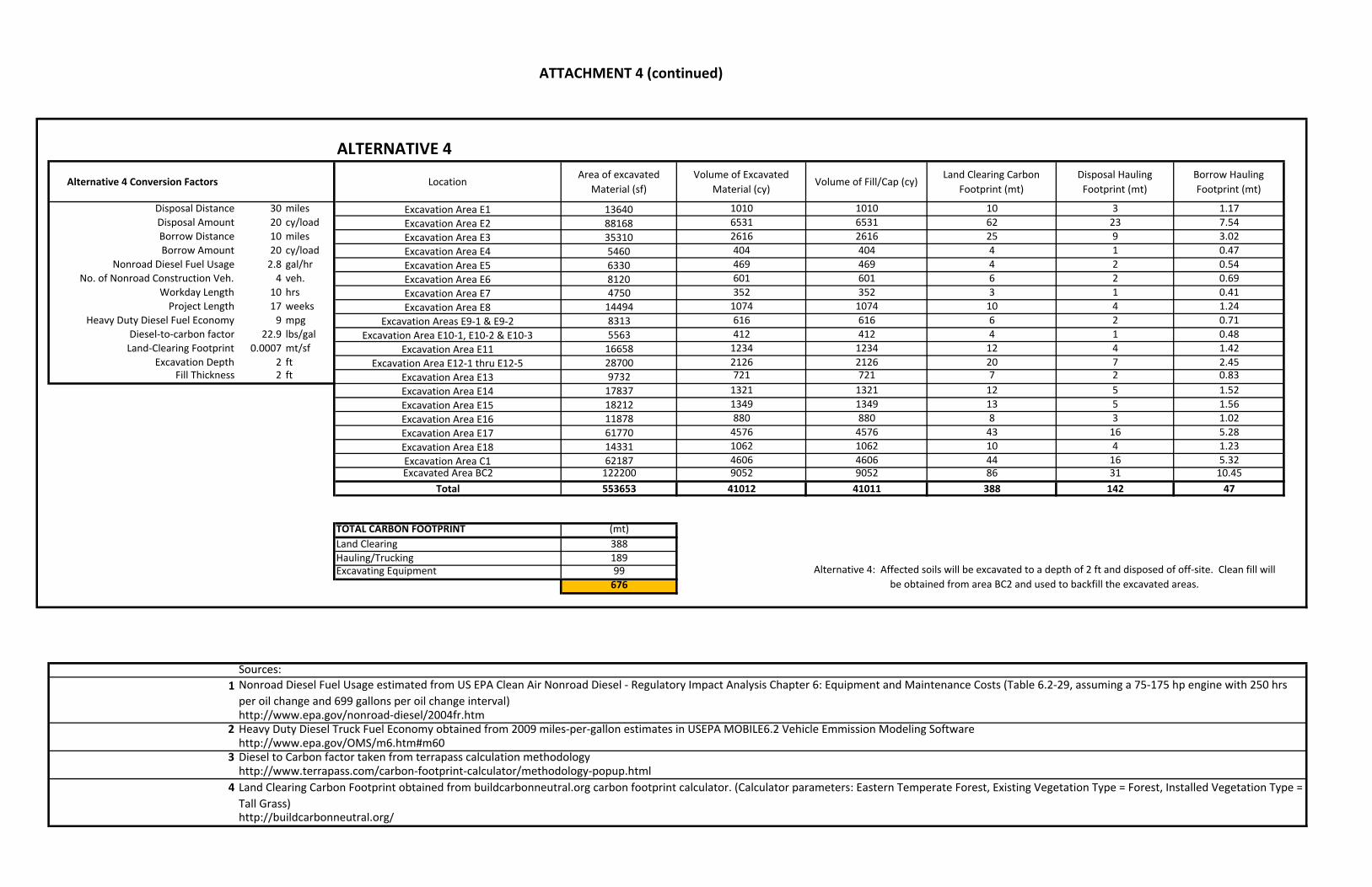
ATTACHMENT 4 (continued)
ALTERNATIVE 4
Alternative 4 Conversion Factors LocationArea of excavated
Material (sf)Volume of Excavated
Material (cy)Volume of Fill/Cap (cy)
Land Clearing Carbon Footprint (mt)
Disposal Hauling Footprint (mt)
Borrow Hauling Footprint (mt)
Disposal Distance 30 miles Excavation Area E1 13640 1010 1010 10 3 1.17Disposal Amount 20 cy/load Excavation Area E2 88168 6531 6531 62 23 7.54Borrow Distance 10 miles Excavation Area E3 35310 2616 2616 25 9 3.02Borrow Amount 20 cy/load Excavation Area E4 5460 404 404 4 1 0.47
Nonroad Diesel Fuel Usage 2.8 gal/hr Excavation Area E5 6330 469 469 4 2 0.54No. of Nonroad Construction Veh. 4 veh. Excavation Area E6 8120 601 601 6 2 0.69
Workday Length 10 hrs Excavation Area E7 4750 352 352 3 1 0.41Project Length 17 weeks Excavation Area E8 14494 1074 1074 10 4 1.24
Heavy Duty Diesel Fuel Economy 9 mpg Excavation Areas E9‐1 & E9‐2 8313 616 616 6 2 0.71Diesel‐to‐carbon factor 22.9 lbs/gal Excavation Area E10‐1, E10‐2 & E10‐3 5563 412 412 4 1 0.48Land‐Clearing Footprint 0.0007 mt/sf Excavation Area E11 16658 1234 1234 12 4 1.42
Excavation Depth 2 ft Excavation Area E12‐1 thru E12‐5 28700 2126 2126 20 7 2.45Fill Thickness 2 ft Excavation Area E13 9732 721 721 7 2 0.83
Excavation Area E14 17837 1321 1321 12 5 1.52Excavation Area E15 18212 1349 1349 13 5 1.56Excavation Area E16 11878 880 880 8 3 1.02Excavation Area E17 61770 4576 4576 43 16 5.28Excavation Area E18 14331 1062 1062 10 4 1.23Excavation Area C1 62187 4606 4606 44 16 5.32Excavated Area BC2 122200 9052 9052 86 31 10.45
Total 553653 41012 41011 388 142 47
TOTAL CARBON FOOTPRINT (mt)Land Clearing 388Hauling/Trucking 189Excavating Equipment 99
676
Sources:1
http://www.epa.gov/nonroad‐diesel/2004fr.htm2http://www.epa.gov/OMS/m6.htm#m60
3http://www.terrapass.com/carbon‐footprint‐calculator/methodology‐popup.html
4
http://buildcarbonneutral.org/
Diesel to Carbon factor taken from terrapass calculation methodology
Land Clearing Carbon Footprint obtained from buildcarbonneutral.org carbon footprint calculator. (Calculator parameters: Eastern Temperate Forest, Existing Vegetation Type = Forest, Installed Vegetation Type = Tall Grass)
Alternative 4: Affected soils will be excavated to a depth of 2 ft and disposed of off‐site. Clean fill will be obtained from area BC2 and used to backfill the excavated areas.
Nonroad Diesel Fuel Usage estimated from US EPA Clean Air Nonroad Diesel ‐ Regulatory Impact Analysis Chapter 6: Equipment and Maintenance Costs (Table 6.2‐29, assuming a 75‐175 hp engine with 250 hrs per oil change and 699 gallons per oil change interval)
Heavy Duty Diesel Truck Fuel Economy obtained from 2009 miles‐per‐gallon estimates in USEPA MOBILE6.2 Vehicle Emmission Modeling Software