forth replacement crossing: managed crossing scheme ... · pdf file6 definition of the managed...
TRANSCRIPT

Forth Replacement Crossing Managed Crossing Scheme Scheme Definition Report
Report on Scheme Development: August to November 2008 Published: March 2009 No part of this report may be copied or reproduced by any means without prior written permission from Jacobs Arup – Jacobs Engineering UK Limited and Ove Arup & Partners International Limited Consortium. If you have received this report in error, please destroy all copies in your possession or control and notify Jacobs Arup. This report has been prepared for the exclusive use of the commissioning party and unless otherwise agreed in writing by Jacobs Arup, no other party may use, make use of or rely on the contents of this report. No liability is accepted by Jacobs Arup for any use of this report, other than for the purposes for which it was originally prepared and provided. Opinions and information provided in the report are on the basis of Jacobs Arup using due skill, care and diligence in the preparation of the same and no warranty is provided as to their accuracy. It should be noted and it is expressly stated that no independent verification of any of the documents or information supplied to Jacobs Arup has been made.


Contents
Glossary i
Abbreviations iv
Bibliography and Workstream Timeline v
1 Executive Summary 1
1.1 Introduction 1
1.2 Route Corridor Options Review (January to May 2008) 1
1.3 DMRB Stage 2 Corridor Assessment (May to August 2008) 2
1.4 Main Crossing (Bridge) Assessment (January to August 2008) 3
1.5 Forth Road Bridge Feasibility of Multi-modal Corridor (August to October 2008) 3
1.6 Main Crossing (Bridge) Assessment (August to October 2008) 4
1.7 The Managed Crossing (August to November 2008) 5
2 Report Background 9
2.1 Introduction 9
2.2 Sustainable Development Objectives 11
3 Forth Replacement Crossing Route Corridor Options Review (January to May 2008) 12
3.1 Approach 12
3.2 Corridor Assessment 13
3.3 Rationale for Route Corridor Option Removal 13
4 DMRB Stage 2 Corridor Assessment (May to August 2008) 15
4.1 Approach 15
4.2 Stage 2 Assessment: Report Conclusions 15
4.3 Stage 2 Recommendation 17
5 Forth Road Bridge and Forth Replacement Crossing (January to October 2008) 18
5.1 Introduction 18
5.2 The Development of the Main Crossing Design (January to August 2008) 19

5.3 Forth Road Bridge Feasibility of Multi-modal Corridor (August to October 2008) 20
5.4 The D2M Forth Replacement Crossing (October to November 2008) 22
6 Definition of the Managed Crossing Scheme (August to November 2008) 24
6.1 The Managed Crossing 24
7 Environmental Considerations 32
7.1 Overview 32
7.2 Sustainability Appraisal 34
8 Cost Information: Full Corridor and Managed Crossing Scheme 36
8.1 Full Corridor Scheme: July 2008 estimate 36
8.2 Full Crossing and Managed Crossing Schemes: November 2008 estimates 38
9 Assessment against Scheme Specific Objectives 42
10 Economic Evaluation 44
10.1 Introduction 44
10.2 Economic Assessment 46
10.3 Wider Economic Input 46
11 Public Transport and other sustainable transport options 48
11.1 Introduction 48
11.2 Analysis of Bus Movements 49
12 Conclusion 51

i
Glossary
Benefit to Cost Ratio (BCR)
An indicator, used in the formal discipline of cost-benefit analysis that attempts to summarize the overall value for money of a project or proposal. A BCR is the ratio of the benefits of a project or proposal, expressed in monetary terms, relative to its costs, also expressed in monetary terms.
D2M Dual two lane special road with hard shoulders. Access restrictions to certain classes of traffic will apply.
Design Manual for Roads and Bridges (DMRB)
A UK-wide comprehensive manual system which accommodates all current standards, advice notes and other published documents relating to the design, assessment and operation of trunk roads.
Do-minimum a) For Environmental Assessment:
The base situation where the Forth Road Bridge continues to operate at its present level of service. In addition, do-minimum scenarios comprising full or partial closures of the Forth Road Bridge over an extended period will be assessed qualitatively. b) For Economic Assessment:
The continued operation of the existing road network with long term restrictions and temporary closures of the Forth Road Bridge for repair and maintenance.
DMRB Stage 2 Corridor Assessment
The detailed assessment of options in accordance with DMRB leading to the recommendation of a preferred option.
Environmental Impact Assessment (EIA)
The process by which information about the environmental effects of a project is evaluated and mitigation measures are identified.
Forth Replacement Crossing
The 3 tower cable stayed bridge to be provided as a replacement to the Forth Road Bridge for general traffic (with pedestrians, cyclists and public transport accommodated on the Forth Road Bridge).
Forth Road Bridge The existing road bridge at Queensferry.
Forth Bridge The existing rail bridge at Queensferry.
Free flow junction/connections
A junction or connecting roads allowing traffic to move unhindered between individual roads without formal traffic control (i.e. traffic signals, stop lines).
Full Corridor Scheme The improvement considered over the full extent of North Corridor Option 1 and South Corridor Option 1 in the Stage 2 Corridor Report.
ii
General traffic General modes of traffic including cars, private light goods vehicles, vans, lorries and buses.
Grade Separated Junction
A junction arrangement that is separated by level from the through carriageway
Ground Investigation Exploratory investigation to determine the structure and characteristics of the ground influenced by a development. The collected information is used to establish or predict ground and groundwater behaviour during, and subsequent to, construction.
Heavy Goods Vehicle (HGV)
Vehicle with 3 axles (articulated) or 4 or more axles (rigid and articulated).
Hard Shoulder Running The use of the emergency lane sited to the nearside of the trafficked carriageway for the running of vehicles.
Intelligent Transport Systems (ITS)
Technology systems or a collection of equipment that assists network operators in providing an efficient, reliable and safe transport network by providing a suite of tools to deploy temporary traffic control measures at a strategic or local level.
Listed Building Building included on the list of buildings of special architectural or historic interest and afforded statutory protection under the ‘Planning (Listed Buildings and Conservation Areas) (Scotland) Act 1997’ and other planning legislation. Classified categories A – C(s).
Local Road An A, B or C classified road (non Trunk Road) typically operated by a local authority or council.
Net Present Value The total present value of a time series of cash flows. It is a standard method for using the time value of money to appraise long-term projects.
Mainline The principal road being considered, namely the A90/M90 or the road proposed as its replacement.
Managed Crossing Scheme
The preferred scheme that combines:
i. The Forth Road Bridge as a public transport corridor.
ii. A narrower D2M replacement crossing for general traffic.
iii. ITS from Halbeath on the M90 to junction 1a on the
M9. iv. The optimised road and junction improvement within
the preferred corridors.
Net Present Value (NPV) The total present value of a time series cash flow. It is a standard method for using the time value of money to appraise long-term projects.

iii
Northern Route Corridor Options
The route corridor options considered north of the Firth of Forth connecting the proposed replacement bridge to existing roads infrastructure.
Northern Study Area The area to the north of the Firth of Forth in which preliminary investigations have been undertaken as part of the Forth Replacement Crossing Project.
North Corridor Option 1
The preferred road improvement corridor in the Northern Study Area.
Ramp metering
A device, usually a basic traffic light together with a signal controller, which regulates the flow of traffic entering the Mainline according to current traffic conditions.
SESTRANS
The South-East Scotland Transport Partnership.
South Corridor Option 1
The preferred road improvement corridor in the Southern Study Area.
Southern Route Corridor Options
The route corridors options considered south of the Firth of Forth connecting the proposed replacement bridge to existing roads infrastructure.
Southern Study Area The area to the south of the Firth of Forth in which preliminary investigations have been undertaken as part of the Forth Replacement Crossing Project.
Scottish Transport Appraisal Guidance (STAG)
The document prepared by the Scottish Executive and commended to Local Authorities and Consultants to provide guidance on the appraisal of transport schemes in accordance with the Government’s principles of providing a sustainable integrated transport system in Scotland.
Strategic Transport Project Review (STPR)
A two year review of the Scottish transport network being undertaken by Transport Scotland in parallel with the Forth Replacement Crossing development work covered in this report. Its aim was to identify and prioritise the road, rail and other interventions of national significance, which will be taken forward to improve the network. The review was published on 10th December 2008.
Transport User Benefit Appraisal (TUBA)
The purpose of TUBA is to carry out transport scheme economic appraisal in accordance with the Department for Transport’s published guidance.
Variable Speed Control Mandatory variable speed limits where the speed limit is varied according to traffic conditions to smooth traffic flows, increase operating efficiency and to reduce accidents or incidents.

iv
Abbreviations
BCR Benefit to Cost Ratio
DMRB Design Manual for Roads and Bridges
EIA Environmental Impact Assessment
FETA Forth Estuary Transport Authority
HGV Heavy Goods Vehicle
ITS Intelligent Transport System
LCC Life Cycle Costs
LRT Light Rapid Transit
NPV Net Present Value
O&M Operation and maintenance costs
STAG Scottish Transport Appraisal Guidance
STPR Strategic Transport Projects Review
TMfS Transport Model for Scotland

v
Bibliography and Workstream Timeline
This is the final report on the project planning work carried out for the Forth Replacement Crossing Study in 2007 and for the Forth Replacement Crossing during 2008. The following reports have been produced in connection with the project and are referenced within this report. These supporting reports can be viewed at www.forthreplacementcrossing.info.
Ref Report Title and Work Period Report Synopsis
1. Forth Replacement Crossing Study Report 5: Final Report
Work pre-June 2007.
Report on work undertaken by Jacobs and Faber Maunsell to June 2007 to assess the options for a replacement crossing which recommended that a cable stayed bridge in ‘Corridor D’ – a crossing point immediately upstream of the Forth Road Bridge - be taken forward as the best overall performing option.
2. Forth Replacement Crossing Route Corridor Options Review:
Work carried out by Jacobs Arup, January to May 2008.
Report to assess nine mainline connecting road corridors: three in the Northern Study Area and six in the Southern Study Area. It recommended that two of the northern and two of the southern corridor options be taken forward for further assessment.
3. Forth Replacement Crossing DMRB Stage 2 Corridor Report:
Work carried out by Jacobs Arup, May to August 2008.
Report on the assessment of the shortlisted corridor options and a supplementary assessment of a variant version of a connecting road corridor in the Southern Study Area. The report recommended that work continue to identify in detail the optimum road improvement within North Corridor Option 1 and South Corridor Option 1.
4. Forth Replacement Crossing, Main Crossing (Bridge) Scheme Assessment Report, Development of Options:
Work carried out by Jacobs Arup, January to August 2008.
Report on the assessment of options for the outline design of the replacement crossing.
5. Forth Road Bridge – Feasibility of Multi-Modal Corridor:
Work carried out by Jacobs Arup, August to October 2008.
Report on the feasibility of utilising the existing Forth Road Bridge for non motorised and public transport/light road traffic, including for a potential future guided bus/tram/ light rail facility. The report concluded that this would be a feasible option.

vi
Ref Report Title and Work Period Report Synopsis
6. Forth Road Bridge - Audit of Feasibility of Future Multi-Modal Use - Summary Report
Work carried out by Faber Maunsell to November 2008
Independent summary of review on the Jacobs-Arup assessment of the feasibility of utilising the existing Forth Road Bridge for non motorised and public transport/light road traffic, including for a potential future guided bus/tram/ light rail facility. The report concluded that the Forth Road Bridge could, in principle, be adapted for future LRT
7. Forth Replacement Crossing, Main Crossing (Bridge) Scheme Assessment Report, Development of D2M Alternatives:
Work carried out by Jacobs Arup, October to November 2008.
Report on the assessment of options for a narrower replacement crossing to carry a dual carriageway road with hard shoulders.

vii

viii
Figure 1.1 Preferred Scheme Layout
1
1 Executive Summary
1.1 Introduction
This report provides summary information on the project development work carried out following the announcement to Parliament in December 2007 (see bibliography: report references 2 to 7), and reports on the further development work carried out to define and assess the Managed Crossing Scheme between August and November 2008. It is the final report on the project planning work carried out during 2008 and provides recommendations on:
� the detail of the road connections to the Forth Replacement Crossing, as shown in Figure 1.1, within the preferred connecting road corridor defined in the DMRB Stage 2 Corridor Report; and
� the incorporation of the Forth Road Bridge as an integral element of the proposals for use by pedestrians, cyclists, public transport and any future multi-modal facility.
Following the completion of the Forth Replacement Crossing Study, as part of the Strategic Transport Project Review (STPR), it was announced to Parliament on 19 December 2007 that the Forth Replacement Crossing is to be a cable-stayed bridge and that the scheme would be designed to:
� safeguard the capability of future multi-modal use;
� provide for pedestrians and cyclists;
� provide for two lanes in each direction for general traffic;
� incorporate hard shoulders to relieve disruption due to breakdowns and maintenance activity;
� provide an enhanced service to West Lothian, and;
� protect and promote economic development areas in Fife. Following the announcement on 19 December 2007, the Jacobs Arup Joint Venture was appointed in January 2008 to work as a development partner with Transport Scotland to take the project forward. 1.2 Route Corridor Options Review (January to May 2008)
Nine mainline route corridor options for the connecting roads to the Forth Replacement Crossing were identified: three in the Northern Study Area and six in the Southern Study Area. An initial assessment reduced the number of options to three in each study area on the basis of environmental impact, cost, geotechnical issues associated with mine workings and economic/ transportation performance. Following this sifting, the remaining route corridors were further assessed in relation to engineering, environmental, transportation and cost considerations in greater detail.

2
Following this further assessment of the route corridor options, North Corridor Options 1 and 2 and South Corridor Options 1 and 2 were selected for DMRB Stage 2 Corridor Assessment (see Figure 1.2)
Figure 1.2: Route Corridors shortlisted for Stage 2 Assessment
1.3 DMRB Stage 2 Corridor Assessment (May to August 2008)
The shortlisted corridor options were developed further and assessed in relation to the scheme objectives and the engineering, environmental, sustainability, traffic and economic advantages/disadvantages associated with each. North Corridor Option 1 and South Corridor Option 1 were preferred. In each case, they had the engineering, cost, environmental and sustainability benefits associated with the maximisation of the use of existing infrastructure. This latter feature of the preferred options contributes to the achievement of the key sustainability objectives of:
� protecting and enhancing the natural heritage including biodiversity;
� improving local accessibility and reducing community severance;
� adopting sustainable resource management in design and construction; and
� minimising embodied carbon. In economic terms, whilst recognising the operational benefits associated with South Corridor Option 2, the comparison of Benefit to Cost ratio (BCR) indicated that the North Corridor Option 1 combined with South Corridor Option 1 provided best value for money.

3
Following completion of the assessment, a sensitivity check was undertaken on a further option, South Corridor Option 4B, a combination option that was defined at the Forth Replacement Crossing Route Corridor Workshop held with Transport Scotland on 25 June 2008. Details of this option are provided in the DMRB Stage 2 Corridor Report (see bibliography reference 3). The option was discounted on the grounds of its greater environmental impact of the infrastructure and its higher cost. 1.4 Main Crossing (Bridge) Assessment (January to August 2008)
A short list of design concepts was developed at a workshop in February 2008 to provide the functionality as listed below and illustrated in Figure 1.3:
� Dual two lane motorway with 3.3m hard shoulders and a footway/cycleway.
� Multi-modal (public transport) corridor.
Figure 1.3: Forth Replacement Crossing Bridge Cross Section
(No utilisation of Forth Road Bridge)
Bridge options were developed to carry the multi-modal public transport corridor in the central area of the bridge (as illustrated in Figure 1.3 above), or in the lower level of a double deck structure. Given the very high cost of this provision for multi-modal public transport, a decision on the preferred bridge option was deferred pending the outcome of further investigations on the suitability of the Forth Road Bridge to take part of the overall crossing traffic. 1.5 Forth Road Bridge Feasibility of Multi-modal Corridor (August to
October 2008)
A more positive prognosis for the Forth Road Bridge emerged during 2008. The second internal cable inspection carried out by FETA in early 2008 indicated that cable deterioration was not as rapid as had been feared. The technical feasibility of replacing the cables was also confirmed by a report published early in the year by FETA, although disruption to users and the consequential adverse impacts to business and the economy was such that it was not considered practical in the absence of a replacement bridge. Accordingly, a technical assessment of the capability of the Forth Road Bridge to work alongside the Forth Replacement Crossing was commissioned. With the new bridge being designed to carry general traffic and all heavy goods vehicles, the technical assessment of the Forth Road Bridge considered a range of options for rail based light rapid transit public transport together with footway loading and reduced highway loadings. All options were assessed to be geometrically feasible in that they could be accommodated within

4
the available width of the bridge. All but one of the options reduced the load on the main cables. Modifications to the movement joints on the bridge would be required but could be provided within the parameters required for a rail based tram. All of the options were assessed as having positive potential. The load reduction would mitigate the loss of cable strength that had already occurred and extend the period before cable replacement or augmentation became necessary. If the current dehumidification scheme being undertaken by FETA is a success, this work could be deferred indefinitely. 1.6 Main Crossing (Bridge) Assessment (August to October 2008)
� The appraisal of the condition of the Forth Road Bridge provided confidence that it can make a contribution to the project. Although not capable of meeting the future needs as the main crossing, it was concluded that it can support future public transport requirements and accommodate non-motorised users (pedestrians and cyclists). The opportunity to use the Forth Road Bridge in this way has allowed the development of a flexible, narrower replacement bridge of high quality and significantly reduced cost. The proposals for the Forth Replacement Crossing and Forth Road Bridge working as part of a managed crossing strategy are illustrated in Figures 1.4 and 1.5.
Figure 1.4: Forth Replacement Crossing Cross Section (Utilising Forth Road Bridge)
Figure 1.5: Forth Road Bridge Cross Section

5
Figure 1.7: Use of Intelligent Transport Systems on the M42 in England (photograph courtesy of Highways Agency)
A 3 mono-tower cable stay bridge with a single box girder deck was recommended as the preferred option for the Forth Replacement Crossing.
Figure 1.6: Artist’s impression of 3 mono-tower cable stay bridge 1.7 The Managed Crossing (August to November 2008)
Options for optimising the scheme definition were considered, having regard to the outcome of the Stage 2 Corridor Report and the assessment of the potential use for the Forth Road Bridge. The key considerations were that:
� The Stage 2 Corridor Report concluded that the Full Corridor Scheme need not be implemented in full and that project planning work should be progressed to give further detailed consideration to the form and function of the junctions required and the extent of the road infrastructure improvements provided within the preferred corridors (see Section 4).
� The Forth Road Bridge could be capable of adaptation for multi-modal use, including future tram/light rail use, and it was determined that this would be taken forward as a planning assumption (see Section 5).
� The scheme, which has been defined to take account of the combined output from these separate exercises, is referred to as the Managed Crossing Scheme. The Managed Crossing Scheme will provide high quality approach roads to the new bridge. The existing junctions at Admiralty and Ferrytoll will be enhanced to protect and promote the developing area of Rosyth and to provide good quality connections for local communities. A new junction will be provided at South Queensferry and Junction 1a on the M9 will be enhanced to facilitate new access to the bridge from West Lothian.
Analysis indicates that, for the majority of the time, the existing bridge and road network operate without congestion. Peak period congestion is largely due to the close junction spacing along the A90/M90 corridor and driver reaction to that. Much of the congestion and queuing which is observed during peak periods at present is due to the interaction of traffic joining busy traffic on the main carriageway at closely spaced junctions. It is proposed that this is addressed by the use of Intelligent Transport Systems with local junction improvements (see Figure 1.7).

6
1.7.1 Environmental and Sustainability Considerations
The potential adverse environmental impacts for the Managed Crossing Scheme are less than those identified for the Full Corridor Scheme. In terms of resource use, preliminary calculations have been undertaken to provide a high level comparison of the embodied carbon of materials associated with the two scheme alternatives. The results show that the Full Corridor Scheme, which would have more roadworks, earthworks and bridge deck compared to the Managed Crossing Scheme would require approximately102,000 tonnes more embodied carbon than the Managed Crossing Scheme. 1.7.2 Capital Cost Estimate: Comparison
Table 1.1 sets out the capital cost estimates for the Full Corridor Scheme (as at July 2008 and as modified in October 2008) and the Managed Crossing Scheme, all at Q4 2006 prices. Outturn prices allowing for the cost of capital and an estimated inflation range are also detailed below.
Element
Full Corridor Scheme
(as defined July 2008)
Costs (£m)
Full Corridor Scheme
(as modified Oct 2008)
Costs (£m)
Managed Crossing Scheme
(Oct 2008)
Costs (£m)
Network Connections North 299 254 124
Network Connections South 142 152 90
ITS and Supervision 41 26 26
Main Crossing 613 613 455
Approach Viaducts 108 108 82
Sub-total excl risk, OB and VAT 1,204 1153 777
Risk allowance 160 156 95
Optimism bias 499 247 178
Sub-total excl VAT 1,863 1,556 1,050
Non Recoverable VAT 223 217 145
Total incl. Risk, OB & VAT 2,086 1,773 1,195
Uplift to outturn costs:
Addition for Cost of Capital (Annual Managed Expenditure) and inflation to 2016 1,114 to 2,114 857 to 1,747 525 to 1,145
Total Outturn Cost Range (2016) 3,200 to 4,200 2,630 to 3,520 1,720 to 2,340
Table 1.1: Comparison of Capital Cost Estimates

7
1.7.3 Whole Life Cost Estimate Comparison
In additional to the capital costs, operations and maintenance (O&M) cost profiles detailing the long term operating costs and lifecycle refurbishment costs have been estimated. The assumption is made in the Full Corridor Scheme that the Forth Road Bridge, a listed structure, would be managed on a care and maintenance basis although not used for traffic. Its usage under the Managed Crossing Scheme as a public transport corridor is assessed to require a higher level of operation and maintenance cost input.
Costs at Q4 2006 prices (£,000s)
Cost Element Full Corridor Scheme (as modified Oct
2008)
Managed Crossing Scheme
Construction Costs excl VAT (from Table 1.1) 1,556,000 1,050,000
O&M Costs
Network Connections 93,000 34,000
New Bridge 413,000 340,000
Existing Bridge 218,000 342,000
O&M sub total 724,000 716,000
Lifecycle Refurbishment Costs
Network Connections 103,000 39,000
New Bridge 430,000 392,000
Existing Bridge 208,000 556,000
Lifecycle cost sub total 741,000 987,000
Total 3,021,000 2,753,000
Table 1.2: Whole life cost comparison 1.7.4 Economic Assessment
The economic assessment considers the monetised benefits of the options for the Forth Replacement Crossing and compares these benefits to the costs associated with its construction and maintenance in accordance with the requirements of the Scottish Transport Appraisal Guidance (STAG). In this exercise, all costs are rebased to 2002 prices and are discounted to 2002 in line with the practice for transport schemes. The maintenance costs associated with retaining the Forth Road Bridge are included in this assessment. Table 1.3 provides a comparison of the Benefit to Cost Ratio of the Full Corridor Scheme and the Managed Crossing Scheme.

8
Table 1.3: Economic Appraisal - Full Corridor and Managed Crossing Schemes The Benefit to Cost Ratios (BCRs) provide a comparison of the transport costs without the tested investment (but in this case including the refurbishment of the existing bridge) and the transport and investment costs with the investment. In addition to the above, the wider economic impact of closure or restricted use of the Forth Road Bridge, without a replacement crossing, on the local economies of Fife and the Lothians and the national economy of Scotland, would be very significant. FETA have assessed that cable replacement would be the preferred method of restoring the strength of the suspension cables and that it would be possible to undertake. However, if carried out without a replacement bridge to carry traffic during the period of the works, the disruption caused would reduce business turnover by £1,320 million and reduce business turnover by £1,085 million in Scotland as a whole with an associated loss of jobs of 3,200, many of which would be permanent.
Full Corridor Scheme (£’000)
Managed Crossing Scheme (£’000)
Present Value of Benefits £660,805 £632,898 Present Value of Costs £881,073 £621,830 Net Present Value -£220,268 £11,068 Benefit to Cost Ratio (BCR) 0.75 1.02

9
2 Report Background
2.1 Introduction
This report provides summary information on the project development work carried out following the announcement to Parliament in December 2007 (see bibliography: report references 2 to 7), and reports on the further development work carried out to define and assess the Managed Crossing Scheme between August and November 2008. Prior to the appointment of Jacobs Arup, Jacobs and Faber Maunsell were commissioned by Transport Scotland to undertake the Strategic Transport Projects Review. The review, which commenced in the summer of 2006, culminated in a report published on 10 December 2008 which detailed a portfolio of land based interventions to be taken forward, further developing Scotland’s transport infrastructure to meet the demands of the 21st century. Given the urgent need to assess options for a replacement of the Forth Road Bridge, a separate Forth Replacement Crossing Study was commissioned under the umbrella of the Strategic Transport Projects Review. The Forth Replacement Crossing Study Reports 1 to 5 were published in 2007 and summarise the study development and findings. The Forth Replacement Crossing Study was primarily concerned with determining the form, function and location for a replacement crossing. It made an assessment of five different crossing corridors and whether bridge and/or tunnels would be feasible solutions. It also confirmed that further development is required to determine the role, if any, that the existing bridge could take. Any decision on that issue required to await further information, including the Forth Estuary Transport Authority (FETA) Feasibility Study into Replacement/Augmentation of Main Cable report (subsequently published in February 2008). Given that, at the time of the Forth Replacement Crossing Study, the long term future of the existing Forth Road Bridge was uncertain, the development of the Forth Replacement Crossing was progressed on the premise that the existing Forth Road Bridge may not be available for future use. The expectations from emerging and current policies and action plans enabled the Scottish Government to develop eight specific transport planning objectives for the Forth Replacement Crossing. These are:
� to maintain cross-Forth transport links for all modes to at least the level of service offered in 2006;
� to connect to the strategic transport network to aid optimisation of the network as a whole;
� to improve the reliability of journey times for all modes;
� to increase travel choices and improve integration across modes to encourage modal shift of people and goods;
� to improve accessibility and social inclusion;
� to minimise the impacts of maintenance on the effective operation of the transport network;

10
� to support sustainable development and economic growth; and
� to minimise the impact on people, and the natural and cultural heritage of the Forth area.
The recommendation of the Forth Replacement Crossing Study was that the replacement crossing be a cable stayed bridge in ‘Corridor D’, immediately upstream of the Forth Road Bridge (see Figure 2.1). This new crossing would incorporate two lanes with hard shoulders plus pedestrian walkways/cycleway in each direction.
Figure 2.1: Bridge Corridor D was the selected location for the replacement crossing. The Forth Replacement Crossing Study assessment work considered the various crossing options in relation to these objectives. The study findings formed the basis upon which the Cabinet Secretary for Finance and Sustainable Growth announced, on the 19 December 2007, that: Having assessed all these factors the Government has come to the view that the Forth Replacement Crossing should be a cable-stayed bridge with multi-modal capacity on a route slightly to the west of the existing Road Bridge. The replacement crossing is about more than just the crossing itself: the connections at either side are equally important. Providing a link to the M9 will allow greater choices and opportunities to West Lothian, whilst the construction of improved junctions in Fife will protect and promote access to the development areas of Fife. Including dedicated public transport will provide opportunities for those who travel into and around Edinburgh and offer improved opportunities for links more widely between Fife, Edinburgh and the Lothians. The Forth crossing is a crucial part of the road network connecting communities on a local, regional and national scale and is overloaded due to single occupant cars during peak periods. This is only predicted to worsen in the future. Our key objectives of a wealthier and fairer and greener Scotland are well supported by this decision to protect cross-Forth travel whilst ensuring the flexibility and capacity to provide for other modes of transport including measures to ensure reliability of the crossing.

11
In January 2008, the Jacobs Arup Joint Venture was appointed by Transport Scotland to manage the delivery of the Forth Replacement Crossing Project. Throughout 2008, Jacobs Arup has been engaged in the development of all aspects of the Forth Replacement Crossing Project, considering the replacement bridge, the Forth Road Bridge, the connecting road network and the road operating regime, and the environmental and sustainability aspects of each. 2.2 Sustainable Development Objectives
One of the main commitments made in the scheme objectives is ‘to support sustainable development and economic growth’ making it clear that the concept of sustainability is at the heart of the Forth Replacement Crossing Project. Transport Scotland has set out a sustainable development policy for the scheme including a vision statement and objectives. The vision is: ‘To deliver an iconic project that respects the environment, contributes to sustainable economic growth at both regional and Scottish levels and facilitates efficient public transport whilst minimising disruption to the community and reducing the use of non-renewable resources during its construction and throughout its life’. Beneath this vision is a set of sustainable development objectives detailed in Transport Scotland’s ‘Forth Replacement Crossing Sustainable Development Policy’. Consideration of sustainable development will form a core thread throughout all the activities of the project team and stages in the project life cycle including:
� Project design and appraisal;
� Preparation of contract documents;
� Tender evaluation;
� Construction;
� Maintenance;
� Operation
12
3 Forth Replacement Crossing Route Corridor Options Review (January to May 2008)
3.1 Approach
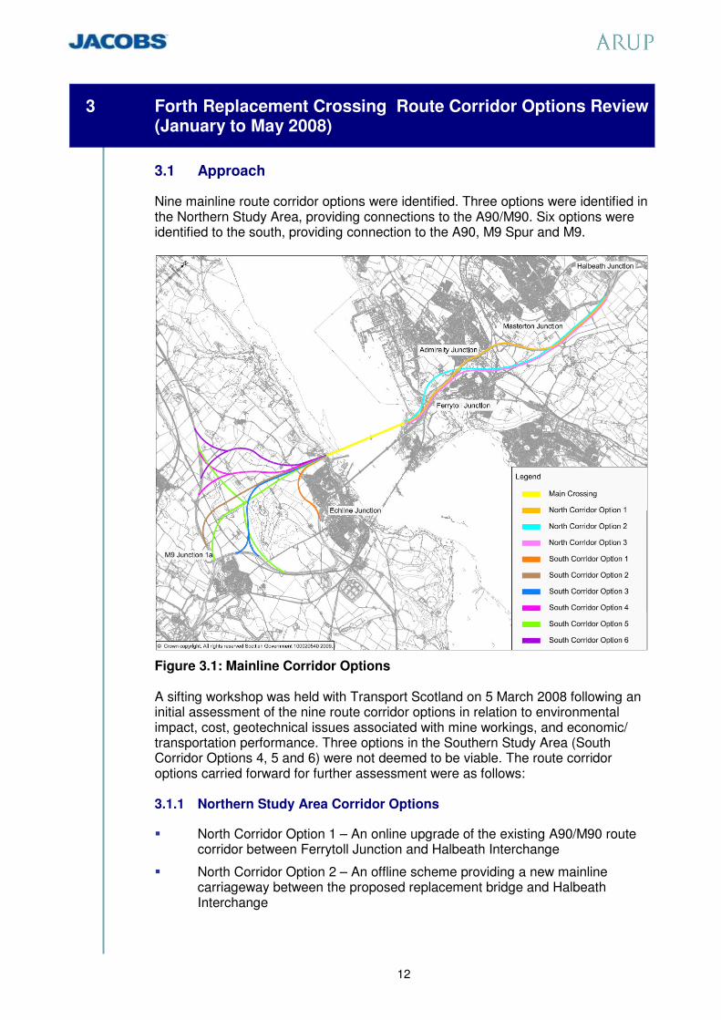
Nine mainline route corridor options were identified. Three options were identified in the Northern Study Area, providing connections to the A90/M90. Six options were identified to the south, providing connection to the A90, M9 Spur and M9.
Figure 3.1: Mainline Corridor Options A sifting workshop was held with Transport Scotland on 5 March 2008 following an initial assessment of the nine route corridor options in relation to environmental impact, cost, geotechnical issues associated with mine workings, and economic/ transportation performance. Three options in the Southern Study Area (South Corridor Options 4, 5 and 6) were not deemed to be viable. The route corridor options carried forward for further assessment were as follows: 3.1.1 Northern Study Area Corridor Options
� North Corridor Option 1 – An online upgrade of the existing A90/M90 route corridor between Ferrytoll Junction and Halbeath Interchange
� North Corridor Option 2 – An offline scheme providing a new mainline carriageway between the proposed replacement bridge and Halbeath Interchange

13
� North Corridor Option 3 – A combined option requiring the online upgrade of the A90 between Ferrytoll Junction and Admiralty Junction with a new section of offline carriageway being provided between Admiralty Junction and Halbeath Interchange.
3.1.2 Southern Route Corridor Options
� South Corridor Option 1 – A short offline section of new carriageway connecting the proposed replacement bridge to the A90 south of Echline Junction.
� South Corridor Option 2 – A new offline carriageway connecting the proposed replacement bridge to the M9 north of Winchburgh.
� South Corridor Option 3 – A new offline carriageway connecting the proposed replacement bridge to the M9 Spur northeast of M9 Junction 1a.
� South Corridor Option 4A – An additional option identified for assessment at the sifting workshop of 5 March 2008; a combination of South Corridor Options 1 and 2 providing direct connections to the A90 and the M9.
3.2 Corridor Assessment
Following further assessment of the above route corridor options, the following options were recommended for DMRB Stage 2 Corridor Assessment:
� North Corridor Option 1
� North Corridor Option 2
� South Corridor Option 1
� South Corridor Option 2
3.3 Rationale for Route Corridor Option Removal
3.3.1 North Corridor Option 3
North Corridor Option 3 was not found to provide any benefits over North Corridor Option 1 or North Corridor Option 2. It was the least effective option in meeting the scheme objectives and, of the options available, it provided the least amount of junction functionality, limiting local access connectivity. In addition, of the northern route corridor options available, this corridor was assessed to generate a deterioration of local air quality at the highest number of properties. 3.3.2 South Corridor Option 3
Whilst the South Corridor Option 3 mainline could be implemented fully in association with the proposed replacement bridge, the junction arrangement required to the M9 and M9 Spur was assessed to be complex, requiring multiple structures to implement. The proximity of existing roads and the Falkirk-Fife Railway Line to the proposed junction location makes the provision of connections to all routes extremely difficult. A substantial number of departures from standard would be required. South Corridor Option 3 would also require the greatest number of residential property demolitions when compared with the other southern route corridor options available.

14
3.3.3 South Corridor Option 4A
Whilst South Corridor Option 4A was found to be capable of providing direct access to the A90 and the M9, the land area required would be far greater than that of South Corridor Option 1 or South Corridor Option 2 in isolation. This corridor is also expected to have the greatest ecological, visual and landscape impacts of the southern route corridor options and would require a high number of water crossings. Further, the cost of this option would be greater than that of either South Corridor Option 1 or South Corridor Option 2 in isolation.
Figure 3.2: Route Corridors shortlisted for Stage 2 Assessment

15
4 DMRB Stage 2 Corridor Assessment (May to August 2008)
4.1 Approach
The DMRB Stage 2 Corridor Report was prepared in accordance with TD37/93, Scheme Assessment Reporting, of the Design Manual for Roads and Bridges (DMRB). The purpose of the report was to document the factors that have been taken into account in the provision of alternative route corridor options, considering the scheme objectives and the engineering, environmental, traffic and economic advantages/disadvantages and constraints associated with each. For the purposes of DMRB Stage 2 Corridor Assessment, North Corridor Options 1 and 2 and South Corridor Options 1 and 2 were considered over the full extent of the corridors. It was noted that the preferred corridor identified need not be implemented over these full lengths. 4.2 Stage 2 Assessment: Report Conclusions
The recommendation made in the DMRB Stage 2 Corridor Report was based upon the requirements of the scheme objectives and the assessment work undertaken from an engineering, environmental, traffic, economic and sustainability perspective. 4.2.1 Engineering Conclusion
North Corridor Option 1 and South Corridor Option 1 were deemed to be the preferable corridor options in terms of engineering assessment. The preference was primarily based upon the maximum use made within these corridors of existing roads infrastructure which provides better value for money. 4.2.2 Environmental Conclusion
Overall, North Corridor Option 1 and South Corridor Option 1 were also preferred in environmental terms, largely due to the majority of the corridors being online. North Corridor Option 1 which is largely online would affect the fewest land interests, cross fewer pedestrian/cyclist routes, have less ecological impact and lower potential for impacts on sites of geological importance. It is likely to have less potential for flood risk and water quality impacts. Noise and air quality impacts would be similar for either northern route corridor option but, on balance, North Corridor Option 1 was considered to be preferable. The predominantly online alignment of North Corridor Option 1 would also result in lower landscape and visual change and was therefore found to be preferable in terms of view from the road and driver stress. South Corridor Option 1 requires less new infrastructure than its alternative and passes through less sensitive areas. It captures very similar comparative benefits to Northern Option 1 as a result. South Corridor Option 2 was assessed to be better in terms of overall noise effects as it would divert traffic away from the A90 south of South Queensferry. South Corridor Option 1 was preferred in terms of landscape and visual impacts as it is much more contained and in contrast to South Corridor Option 2 does not cut

16
through open, rural landscape. South Corridor Option 2 would also increase the isolation of the designed landscape of Dundas Estate. 4.2.3 Traffic and Economic Conclusion
In comparing the economic evaluation of Corridor Option combinations, under South Corridor Option 2 it is noted that a proportion of Edinburgh bound traffic would assign to the A904 as a more direct route from the Forth Replacement Crossing to Scotstoun Junction and Edinburgh via the A90, leaking from the new strategic network linking to the M9 and M9 Spur. The attributed traffic cost benefits, including the benefits attributed to the traffic from Fife using the A904, results in a higher Net Present Value (NPV). However, South Corridor Option 2 also comes with a substantial additional cost and therefore a broadly equivalent Benefit to Cost Ratio (BCR) in comparison to those option combinations containing South Corridor Option 1. Given the additional cost associated with South Corridor Option 2 and its similarity with South Corridor Option 1 in terms of BCR, it was concluded that North Corridor Option 1 paired with South Corridor Option 1 would offer, overall, the preferred solution. 4.2.4 Sustainability Conclusion
The high level evaluation of the northern and southern route corridor options against the key DMRB Stage 2 sustainability objectives showed that North Corridor Option 1 and South Corridor Option 1 are preferred. 4.2.5 Sensitivity Check: Corridor Option 4B
Following completion of the assessment, it was agreed that it was necessary to validate the finding by carrying out a sensitivity check against an additional option, South Corridor Option 4B, an option identified at the Forth Replacement Crossing Route Corridor Workshop held with Transport Scotland on 25 June 2008, with the objectives of providing a direct link from the Forth Replacement Crossing to the M9 and a direct link to the A90. Similar to that of Option 4A, but to a reduced standard of alignment and junction design, this option would relieve some of the traffic pressures which may build up on the existing road network through the implementation of South Corridor Option 2 in isolation. South Option 4B would require the closure of the recently completed M9 Spur and the removal of the Scotstoun Junction and M9 Junction 1a, each of which would become redundant. A new all movements junction would be required on the M9 northeast of Winchburgh providing direct access to the proposed replacement bridge. It was assessed that whilst South Corridor Option 4B is capable of providing direct access to the A90 and the M9, the land take associated with the implementation of such a scheme would be far higher than that of South Corridor Option 1 or South Corridor Option 2 in isolation. This corridor would have higher overall environmental impact. Further to this, the anticipated cost associated with the implementation of this option is greater than that associated with South Corridor Option 1 and of a comparable order with South Corridor Option 2. Considering the environmental impacts, the cost associated with this options implementation and the amount of existing roads

17
infrastructure made redundant through its provision, South Corridor Option 4B was removed from further assessment in advance of the detailed assessment undertaken for the DMRB Stage 2 Corridor Report. 4.3 Stage 2 Recommendation
Based on the above conclusions, the overall recommendation of the DMRB Stage 2 Corridor Report was that North Corridor Option 1 and South Corridor Option 1 be taken forward as the preferred corridors. The improvement over the full extent of North Corridor Option 1 and South Corridor Option 1 in the Stage 2 Corridor Report is referred to in this report as the Full Corridor Scheme. The Stage 2 Corridor Report noted that this improvement need not be implemented in full. Further work would be required to define the road improvement within the corridor that would provide best value for money. The project planning work was therefore progressed to allow further detailed consideration to be given to the form and function of the junctions required and the extent of the road infrastructure improvements that should be provided.

18
5 Forth Road Bridge and Forth Replacement Crossing (January to October 2008)
5.1 Introduction
The design of the Forth Replacement Crossing is inexorably linked with the future use (if any) of the Forth Road Bridge. The Forth Road Bridge is a Grade A listed structure, opened to traffic in 1964. It has a main span of 1006 metres and an overall length of 2500 metres including approach viaducts. On opening, the Forth Road Bridge was the longest suspension bridge outside of the USA and the fourth longest in the world. The bridge is maintained and operated by the Forth Estuary Transport Authority (FETA). Since opening, traffic over the bridge has increased from 4 million to 24 million vehicles per year. The annual number of heavy goods vehicles has risen commensurately. The weight of unrestricted heavy goods vehicles has also increased from 22 tons to 44 tonnes. The volume of traffic and intensity of traffic loading is likely to continue to increase in the future. Major maintenance is an on-going requirement for all large suspension bridges. In the case of the Forth Road Bridge, this requirement has been exacerbated by the increases in traffic volume and the increased weight of heavy goods vehicles. In addition, the Forth Road Bridge is at relatively northern latitude and is subject to high winds blowing in from the west. Combined with the cold waters of the Firth, this leads to foggy weather during the spring and summer months with high relative humidity. The presence of salt water helps to contribute to highly corrosive conditions. The most recent focus of concern in relation to the Forth Road Bridge being able to continue to provide an unrestricted crossing has been the condition of the main suspension cables upon which the stability of the bridge depends. In 2004 and 2005, FETA undertook the first internal inspection of the main suspension cables, following draft guidelines as recommended by the American National Co-operative Highway Research Program Report 534 “Guidelines for Inspection and Strength Evaluation of Suspension Bridge Parallel Wire Cables”. As there are no UK or European guidelines for such inspections the American guidelines are currently accepted as the industry standard. FETA found that a significant number of cable wires had broken or were in an advanced state of corrosion. This led to the estimation that the cables had lost between 8% and 10% of their original strength. In addition, if the rate of cable deterioration was not reduced, it was predicted that restrictions to heavy goods vehicle traffic may be required from 2014 and closure to all vehicles from 2020. In early 2008, FETA carried out a second internal cable inspection which included some areas of cable which had previously been inspected in 2004 and 2005. In July 2008, FETA reported that the cables were estimated to have lost 10% of their strength, which can be compared to the lower bound figure of 8% estimated from the 2004/2005 work. Whilst the previously predicted timescale for possible traffic restrictions remained valid, cable deterioration appeared to be tending towards the optimistic end of the range. Restrictions to HGV traffic now

19
seem more likely to be required at some point between 2017 and 2021. FETA also reported that these were the predicted dates for restrictions if the cables continued to deteriorate without intervention; if dehumidification is successful then the date for traffic restrictions could be extended. In February 2008, FETA reported on a study to investigate the feasibility of replacing or augmenting the cables, should this become necessary. It concluded that such measures would be possible but would not be realistically feasible if a replacement crossing was not available when carrying out such works, as the traffic disruption and economic impact would be severe. FETA is currently installing dehumidification equipment to the cables. This involves pumping dry air through the voids within the cable, having first applied an air-tight neoprene wrapping. It is hoped that this process will remove moisture from the cables and prevent or reduce further deterioration. The success of this method can only be determined once the cables have dried out and it will therefore be necessary to wait until late 2011/early 2012 until further evaluation can take place. In addition to the cable problems, the Forth Road Bridge has a number of identified on-going and significant maintenance issues, some of which are typical for a bridge of this type and age. Much of the work has or will have a significant impact on users and the wider economy. Despite the on-going maintenance and operational issues, the improved prognosis for the cables and the technical feasibility of replacing or augmenting them if necessary has increased the attractiveness of using the Forth Road Bridge in the Forth Replacement Crossing strategy. This possibility was acknowledged by the Cabinet Secretary for Finance and Sustainable Growth. On the 15 January 2008, he reported to the Scottish Parliament Transport, Infrastructure and Climate Change Committee (TICC) that: “If we find that the existing bridge can be refurbished and there is a continuing use for it we will proceed to determine what that future use could be. There are many things that the bridge could be used for, particularly in encouraging significant modal shift, if it can be refurbished”. 5.2 The Development of the Main Crossing Design (January to
August 2008)
The initial design development work for the replacement crossing produced a short list of concepts at a team workshop in February 2008 to provide the functionality as listed below and illustrated in Figure 5.1:
� Dual two lane motorway with 3.3m hard shoulders, footway/cycleway.
� Multi-modal (public transport) corridor.

20
Figure 5.1: Forth Replacement Crossing: Bridge Cross Section
(No utilisation of Forth Road Bridge)
Bridge options were developed to carry the multi-modal public transport corridor in the central area of the bridge (as illustrated in Figure 5.1 above), or in the lower level of a double deck structure. For further details on this work refer to the ‘Forth Replacement Crossing, Main Crossing (Bridge) Scheme Assessment Report, Development of Options’. Given the very high cost of this provision for multi-modal public transport, a decision on the preferred bridge option was deferred pending the outcome of further investigations on the suitability of the Forth Road Bridge to take part of the overall crossing traffic. 5.3 Forth Road Bridge Feasibility of Multi-modal Corridor (August
to October 2008)
The project team monitored the work undertaken by FETA during 2008 which reported a more positive prognosis for the Forth Road Bridge than the previously reported scenario. Encouraged by the improved prognosis, an assessment was begun to assess the viability of the existing structure being retained and utilised as part of the Forth Replacement Crossing Project. In particular, the FETA reports increased the attractiveness of including the use of the existing bridge to realise the following advantages:
� The backlog of maintenance on the Forth Road Bridge, including possible cable replacement, could be completed more efficiently and without traffic disruption and economic impact if a replacement crossing were to be in place and traffic volumes reduced before the work was undertaken;
� If the strategy could remove HGV traffic from the Forth Road Bridge, then many of the maintenance issues would reduce in severity and on-going maintenance costs for the existing bridge would be reduced; and
� Sharing the required functionality between a replacement crossing and the existing bridge would allow a narrower and much less expensive replacement crossing, and would allow the greatest operational flexibility in the event that either bridge required temporary closure.
The feasibility of possible arrangements to accommodate pedestrian and cycle traffic, light road traffic and/or public transport, and any future light rail or tram traffic were reviewed and reported in the Forth Road Bridge – Feasibility of Multi-modal Corridor Report. The study assessed the capability of the existing bridge

21
to carry a range of options for tram/light rail based public transport together with footway loading and reduced highway loadings. All options were assessed to be geometrically feasible, and all but one reduced the load on the main cables. Modifications to the movement joints on the bridge, in particular at the main towers, would be required. In conclusion, all of the options were assessed to have positive potential. The load reduction would mitigate the loss of cable strength that had already occurred and extend the period before cable replacement or augmentation became necessary. If the current dehumidification scheme is a success, this work could be deferred indefinitely. An independent technical audit of Transport Scotland’s work was undertaken by Faber Maunsell - Forth Road Bridge Audit of Future Multi-Modal Use: Summary Report: October 2008. This audit concurred with the above report’s findings. On the basis that it was concluded that the Forth Road Bridge could be capable of adaptation for multi-modal use, including future tram/light rail use, it was determined that this would be taken forward as a planning assumption. Figure 5.2 illustrates the Forth Road Bridge (FRB) as a public transport corridor with provision for pedestrians and cyclists. Figure 5.3 shows a possible LRT layout.
Figure 5.2: FRB: Public transport corridor and foot/cycle paths.
Figure 5.3: FRB: Possible adaptation for LRT.

22
5.4 The D2M Forth Replacement Crossing (October to November 2008)
Following a review of the necessary facilities which are required for the Forth Replacement Crossing, it was concluded that relocation of the multi-modal and the pedestrian and cycle facility onto the Forth Road Bridge would enable a narrower section of the replacement bridge to be adopted comprising:
� Dual two lane carriageway with hard shoulder in each direction;
� Widening of the hard shoulder to enable future hard shoulder running in times of maintenance or by buses during periods of strong winds; and
� Sufficient width of bridge deck to enable the rearrangement of the functions to provide a multi-modal corridor and dual two lane carriageway, or pedestrian and cycleway with dual two lane carriageway and narrow hard shoulder.
Figure 5.4: Forth Replacement Crossing Cross Section (Utilising Forth Road Bridge)
A range of deck and tower options have been considered in relation to aesthetic, construction and cost parameters. Two types of deck have been considered; a single deck combined with either an ‘H’ or ‘A’ or ‘diamond’ tower and a twin corridor deck combined with a central mono-tower.
H-Frame Tower Diamond Tower A-Frame Tower
Figure 5.5: Alternative Tower Forms considered

23
Fig 5.6: Visualisation of proposed Forth Replacement Crossing
Following further analysis and review, the recommended option is a single deck twin corridor combined with mono-towers. This work is reported in ‘Forth Replacement Crossing, Main Crossing (Bridge) Scheme Assessment Report, Development of D2M Alternatives’. An analysis of the various options for the D2M bridge is summarised in Table 5.1.
Table 5.1: Assessment Matrix for D2M Cable Stayed Bridge The following factors contributed to this recommendation:
� It provides a unique and instantly recognisable image;
� It is the simplest to construct overall, and in the shortest period of time;
� It represents a cost substantially the same as the lowest cost option; and
� It is aesthetically the most pleasing design and is considered to be that which best complements the setting of the existing rail and road bridges.
The recommended option and the basis for that recommendation has been the subject of consultation with Architecture + Design Scotland (ADS), who are supportive of the proposed bridge option in preference to other alternatives.

24
6 Definition of the Managed Crossing Scheme (August to November 2008)
6.1 The Managed Crossing
Taking together the outcome of the Stage 2 Corridor Report and the assessment regarding the potential use for the Forth Road Bridge, the options for optimising the scheme definition were considered. The key considerations were that:
� The Stage 2 Corridor Report concluded that the Full Corridor Scheme need not be implemented in full. Further work would be required to define the road improvement within the preferred corridor that would provide best value for money. The project planning work was therefore progressed to allow further detailed consideration to be given to the form and function of the junctions required and the extent of the road infrastructure improvements that should be provided (see Section 4).
� The Forth Road Bridge could be capable of adaptation for multi-modal use, including future tram/light rail use, and it was determined that this would be taken forward as a planning assumption (see Section 5).
� The scheme defined to combine the output from these separate exercises is referred to as the Managed Crossing Scheme.
6.1.1 The Forth Road Bridge within a Managed Crossing
Of the various options for utilising the Forth Road Bridge within a managed crossing, the option that fits most comfortably with the scheme objectives is for the existing bridge to be retained to carry only public transport, pedestrians and cyclists. This approach contributes in particular to the objectives:
� to increase travel choices and improve integration across modes to encourage modal shift of people and goods;
� to improve accessibility and social inclusion;
� to minimise the impacts of maintenance on the effective operation of the transport network;
� to support sustainable development and economic growth; and
� to minimise the impact on people, and the natural and cultural heritage of the Forth area.
Future public transport use could include a light rapid transit system in the form of high quality bus network, guided bus way or a rail based system. The creation of a new public transport corridor will support the further development of the public transport interchange park and ride facility at Ferrytoll and the development of new facilities as planned by Fife Council. There is also the further potential to create a new park and ride facility at South Queensferry for West Lothian and local residents. To complement the existing bridge as part of a managed crossing, the replacement bridge will carry heavy goods vehicles and general traffic, with

25
greater reliability and with a reduction of carbon-generating congestion from incidents and breakdowns through the inclusion of wind shielding and the availability of hard shoulders. Given the age and nature of the existing bridge, an element of unforeseeable risk cannot be ignored. If a future unforeseen circumstance means that the Forth Road Bridge would not be suitable to carry all potential light rapid transit systems, it is proposed that the Forth Replacement Crossing would be designed such that light rapid transit could be accommodated in place of hard shoulders. 6.1.2 The Network Connections within a Managed Crossing
The connecting road strategy looked initially at expanding capacity through additional road width prioritised for high occupancy cars (cars with more than 1 person). Given that this strategy carries the risk of overprovision for residual single occupancy vehicles, particularly during the peak commuting periods, and creates traffic management inefficiencies, a more focussed assessment was made of the connecting road provision. Detailed analysis of traffic conditions indicates that, for the majority of situations, the existing network operates without congestion, and that peak period congestion is largely a factor of the close junction spacing along the A90/M90 corridor and driver reaction to that, rather than the inadequacy of a dual two lane motorway. Much of the congestion and queuing which is observed during peak periods at present is due to the interaction of traffic joining busy traffic on the main carriageway at closely spaced junctions. It is proposed that these operational issues are addressed by the use of Intelligent Transport Systems in combination with local junction improvements. Intelligent Transport Systems, or ITS, as they are more commonly known, are technology systems that assist network operators in providing an efficient, reliable and safe transport network by providing a suite of tools to deploy temporary measures at a strategic or local level. These measures can be used to influence road user behaviour, to deliver policy objectives, or to manage planned or unplanned disruption or congestion on the network. Intelligent Transport Systems have been shown to provide environmental, economic and social benefits through the achievement of smoother and more reliable driving conditions, reducing accidents, managing incidents and delays. Typical benefits are:
� Environmental: reducing vehicle emissions and improving air quality and noise levels by managing traffic flow to reduce congestion, prevent flow break down or relocate queues.
� Economic: ITS potentially provides a more cost effective alternative to road widening, while systems have been shown to reduce congestion, accidents and improve journey time reliability.
� Social: ITS has been used to manage the road space better, reducing accidents and delays, and enabling the emergency services to deal with incidents more efficiently (reducing the amount of time the network is out of operation). Traditionally ITS was provided as a reactive tool for operators to manage the network and invoke plans or procedures during

26
unplanned and planned events, but more recently ITS has been deployed to support pro-active traffic management.
6.1.3 Objectives for ITS in the Managed Crossing Scheme
The ITS Strategy will provide complementary measures to support the operation of the Forth Replacement Crossing during normal and abnormal conditions on the network and in the wider context allow the Forth Replacement Crossing to be a managed corridor within the Traffic Scotland trunk road network. The design of the ITS provision is integral to the project and takes account of the specific strategic transport planning objectives for the Forth Replacement Crossing. (a) Maintaining Cross-Forth transport links
Tactical management on the Forth Replacement Crossing will be developed to deliver optimum capacity within a safe, efficient and reliable environment and provide local information to road and public transport users. The ITS components that will allow network operators to provide tactical management include:
� Lane Control Signals – used for controlling each lane, displaying mandatory speed limits, general road sign aspects and other aspects for managing lane use.
� Tactical Message Signs – used for displaying text messages and/or multicoloured pictograms to drivers to provide tactical messages.
� Ramp metering – used to regulate the flow of traffic entering the mainline from a slip road according to current traffic conditions.
� Traffic Monitoring System – used for gathering traffic data and detection of incidents.
� CCTV – used for visual monitoring of the motorway.
� Bridge Traffic Control and Monitoring Facilities – to manage traffic on the each carriageway of the bridge under normal and abnormal circumstances.
� Emergency Telephone System – to provide a consistent approach across the trunk road network in the provision of roadside assistance through direct connection of roadside telephones.
(b) Strategic Network Optimisation
Strategic optimisation would be concerned with the use of the Forth Replacement Crossing within a Scotland-wide transport network allowing strategic and diversionary routing to minimise the impact on the trunk road network of incidents or major refurbishments. In time of emergency, strategic management optimisation, which would be implemented through interconnection with Traffic Scotland’s system for network management, would be undertaken to maximise the efficiency of the network as a whole. The ITS components that will allow network operators to provide strategic network optimisation include:
� Strategic Message Signs – used in conjunction with existing messages signs for displaying text messages to drivers to provide pre-defined strategic message sets.

27
� Communications network – to collect and disseminate real-time travel information through a variety of media and applications.
� Interface with Traffic Scotland – to allow the Forth Replacement Crossing to be managed as a corridor within a wider network.
(c) Improve Journey Time Reliability
The integration of the Forth Replacement Crossing journey time measurement system with the existing systems of the network will allow network operators to use the ITS applications of tactical and strategic management to provide consistency of journey through interventions and provision of information. (d) Multi-modal Integration and Sustainable development
The new ITS facilities will be integrated with Traffic Scotland’s Intelligent Transport System and utilise the same platform that is designed to support system enhancements. The facilities will use real-time traffic information to determine corrective action or dynamically implement management strategies as traffic conditions change. The ITS will be designed with a development and technology refresh regime so that the operator tools remain effective as traffic demand changes in future years. The ITS components that will assist sustainable development and economic growth include:
� Real-time traffic and travel information, collection, exchange and dissemination between the road network and public transport interchanges and park and ride sites.
� Traffic signal provision and access/exit control to prioritise public transport and vehicles utilising ‘park and ride’.
(e) Minimise Effects of Maintenance
The design will optimise whole life-cycle costs but there will still remain requirements for maintenance activities, repairs to damaged infrastructure and renewal of infrastructure during the life of the Forth Replacement Crossing. The use of ITS to provide lane control, advance message signs and mandatory speed limits, will provide safety benefit to roadside workers and minimise the impact to road users through provision of information and timely management of the available capacity. (f) Minimise Environmental Impact
ITS has been shown to reduce the environmental impact of traffic as a result of reduced vehicle emissions and fuel consumption. This is achieved by reducing the occurrences of flow breakdown and therefore minimising ‘stop and start’ and prolonged queuing of traffic. The following ITS components would be used to deliver these benefits:
� Lane Control Signals
� Variable Speed Control

28
� Tactical and Strategic Message Signs
� Ramp metering.
� Traffic Monitoring System to detect congestion
� CCTV surveillance to reduce the time of response to incidents. 6.1.4 Associated Road Improvements
The Managed Crossing Scheme will provide high quality approach roads to the new bridge. The existing junctions at Admiralty and Ferrytoll will be enhanced to protect and promote the developing area of Rosyth and to provide good quality connections for local communities. A new grade separated junction will be provided at South Queensferry and Junction 1a on the M9 will be enhanced to facilitate new access to the bridge from West Lothian. To the south of the Forth, the alignment of the Managed Crossing Scheme is based on the Full Corridor Scheme, South Corridor Option 1, as described within the Stage 2 Corridor Report.
Figure 6.1 – Option under consideration South of Forth

29
A new road will connect the Forth Replacement Crossing to the existing A90 and M9 motorway spur in the vicinity of the existing Scotstoun Junction via 2.7km of new dual carriageway located to the south and west of South Queensferry. A new grade separated junction will be located between the new crossing and the Scotstoun Junction providing a connection to the A904, giving local access to South Queensferry and bus access to the existing Forth Road Bridge. The developing alignment and junctions in this area of the scheme are illustrated in Figure 6.1. The new road will be dual two lane with hard shoulder provision between the replacement crossing and the new South Queensferry Junction. East of the South Queensferry Junction, the new road will be dual three lane with hard shoulder provision to tie in with the existing road which diverges to provide free flow links to the M9 motorway spur and the A90 local road to Edinburgh. The redundant A90 road space between the existing Echline slip roads has the potential to be converted to provide a cost effective new Park and Ride facility for around 400 cars, utilising the existing road construction and lighting. This new facility would cater for travellers in South Queensferry and West Lothian. Further work will however be required to determine the feasibility of this option in consultation with the City of Edinburgh Council, SESTRANS and bus operators.
Figure 6.2 – Option under consideration North of Forth To the north of the Forth, the alignment of the Managed Crossing Scheme is based on that of the Full Corridor Scheme North Corridor Option 1, as far as the Admiralty Junction. The new crossing will connect to the existing A90 at Ferrytoll via the provision of a new dual two lane carriageway with hard shoulder. The existing grade separated Ferrytoll Junction will be significantly upgraded to

30
provide bus access to the Forth Road Bridge while also improving the existing connections to the local road network and the Ferrytoll Park and Ride Site. The developing alignment and junctions are illustrated in Figure 6.2. To allow for the high percentage of weaving vehicles between Ferrytoll and Admiralty Junctions, the existing northbound A90 will be upgraded, largely utilising the existing alignment, to provide a dual three lane road by the provision of weaving lanes between the junctions. This will also involve improvements to the south facing slip roads of Admiralty Junction. 6.1.5 Carriageway Provision
In addition to the improvements between Ferrytoll and Admiralty Junctions described above, the road between the South Queensferry and Scotstoun Junctions will also be widened to dual three lanes, thereby improving the operational effectiveness of the network. Hard shoulder provision will be wider than the standard 3.3m between the South Queensferry and Ferrytoll Junctions. This additional width will allow for usage by buses, when wind conditions preclude the use of the existing bridge, or by other forms of public transport if this becomes necessary in the future. 6.1.6 Associated Junction Improvements
The junction improvements are summarised below. (a) Ferrytoll Junction
The existing grade separated Ferrytoll Junction will be significantly upgraded to connect the realigned A90 to the local road network serving Rosyth, Inverkeithing and North Queensferry. The junction will also provide a connection for public transport vehicles to the Forth Road Bridge. The integration of the Ferrytoll Park and Ride Facility is a critical aspect of the junction design and the reconfiguration of the access to improve the operational aspects of both the junction and the site will be incorporated within the design. The new Ferrytoll gyratory will be repositioned to the north and, taking cognisance of the expected increase in activity in the Rosyth area from development of the Rosyth waterfront. The junction size will be expanded to improve the capacity of the junction. In order to maximise operational characteristics, signalisation of the junction is likely. (b) South Queensferry Junction
The new South Queensferry Junction will provide local access from the realigned A90 to South Queensferry, the A904 and the Forth Road Bridge. To accommodate the volume of weaving traffic between Scotstoun and South Queensferry, the junction will be grade separated with a lane gain/lane drop configuration for the east facing slip roads reducing the mainline carriageway though the junction from three lanes to two. The west facing slip roads will have standard merge and diverge layouts onto the dual two lane connection to the replacement bridge. A short link road to the north will connect the South Queensferry Junction to the A904. The new junction on the A904 will be located to the west of the existing

31
Echline Junction and will likely take the form of a roundabout. Due to the close interaction between the new South Queensferry and A904 Junctions, signalisation may be required to improve junction efficiency. Bus access to the Forth Road Bridge will be facilitated through the new South Queensferry Junction via the existing Echline Junction. (c) M9 Junction 1a
In the facilitation of improved cross Forth connections, the junction between the M9 Spur and the M9 Junction 1a is to be enhanced to provide free flow connections to the west and the existing connections to the east will be refined. The developing junction layout is illustrated in Figure 6.3. The interaction between the M9 Junction 1a and the Newbridge Junction located to the east has been recognised as a constraint on the operation of the strategic road network in this area. It is therefore proposed that the short section of M9 between the junctions will be upgraded to a dual four lane carriageway to cater better for the weaving movement of traffic over this section. This proposal would also permit the east facing slip roads from the M9 Spur to the M9 carriageway to be widened to two lanes improving the connectivity and operational performance of the junctions. The potential high level of development growth in West Lothian is recognised and, with increased accessibility being a key objective, new west facing slip roads connecting the M9 and M9 Spur will be provided, catering for a movement that does not currently exist.
Figure 6.3 Junction 1a Layout

32
7 Environmental Considerations
7.1 Overview
The Managed Crossing Scheme is in effect a shortened version of the Full Corridor Scheme, with the added feature of utilisation of the Forth Road Bridge for public transport. The Managed Crossing Scheme infrastructure lies within the Full Corridor Scheme corridor but does not extend to its full extent. For this reason it is reasonable to assume that the Managed Crossing Scheme’s environmental impacts would be less than those of the Full Corridor Scheme. The impacts relating to the use of the Forth Road Bridge for public transport were not a feature of the Full Corridor Scheme, but as the number of public transport vehicles on the existing bridge is relatively low, this was not considered a source of significant impacts. A qualitative assessment has been undertaken to provide a commentary on the comparative impacts of the Managed Crossing Scheme and the Full Corridor Scheme. The key issues identified for the Full Corridor Scheme during the Stage 2 assessment were:
� Ecology: international and national designations in and around the Forth;
� Landscape and visual impacts: various gardens and designed landscapes and other designated areas. Iconic bridges over Forth;
� Cultural Heritage: historic buildings and landscapes in the area. A SAM near Masterton junction potentially directly affected;
� Noise: proximity of communities such as South Queensferry;
� Land use: connecting road footprint;
� Disruption due to construction: length of construction period and proximity of communities; and
� Water environment: new or extended water crossings and road drainage outfalls.
These issues are considered in turn in the following paragraphs. 7.1.1 Ecology
The most sensitive ecological areas are in and around the main crossing, and would be equally affected by the Full Corridor Scheme and the Managed Crossing Scheme. The narrower bridge structure of the Managed Crossing Scheme could result in some reduction in disturbance to species during construction. Elsewhere, the smaller footprint of the Managed Crossing Scheme will lessen habitat loss, habitat fragmentation and disturbance to protected species and other wildlife. 7.1.2 Landscape and Visual Impacts
The reduced footprint and fewer new structures of the Managed Crossing Scheme will tend to reduce impacts on landscape and visual amenity.

33
7.1.3 Cultural Heritage
There is a high concentration of sites of archaeological interest. Direct impacts on Middlebank Souterrain Scheduled Ancient Monument (SAM) and impacts on the settings of nearby listed buildings may arise from the Full Corridor Scheme proposals at Masterton Junction on the M90. These would be avoided by the Managed Crossing Scheme. 7.1.4 Noise
Both the Full Corridor Scheme and the Managed Crossing Scheme have the potential to create noise impacts on residential properties. It is not envisaged that either scheme would have significantly different noise impacts. 7.1.5 Land Use
Compared to the Full Corridor Scheme, the land use impacts of the Managed Crossing Scheme would be reduced, in terms of both direct loss and severance. The potential impacts of the Full Corridor Scheme for a number of land interests at Masterton and Scotstoun Junctions would be avoided completely by the Managed Crossing Scheme. 7.1.6 Disruption Due to Construction
The smaller scale of the Managed Crossing Scheme means that construction works will be less extensive than for the Full Corridor Scheme. The Managed Crossing Scheme may also allow for a shortening of the construction period or a lessening of the intensity of the works. These could be expected to result in disruption due to construction being less for the Managed Crossing Scheme than for the Full Corridor Scheme. 7.1.7 Water Environment
The Full Corridor Scheme requires a number of new water crossings and lengthening of some existing culverts. Fewer water courses would be affected by the shorter the Managed Crossing Scheme and this would reduce the potential impacts on geomorphology and other water environment characteristics. In terms of the environmental Scheme Specific Objective, ‘to minimise the impact on people and the natural and cultural heritage of the Forth area’, the Managed Crossing Scheme performs better than the Full Corridor Scheme:
� Impact on People: the Managed Crossing Scheme will use/affect less land and will be less visually intrusive. Construction operations will be less extensive and thus disruption to people will be reduced.
� Impact on Natural Heritage: less habitat loss, fragmentation and disturbance. Fewer water crossings and less impact on the landscape.
� Impact on Cultural Heritage: Fewer known sites affected and less risk of impacts on unknown sites.

34
7.2 Sustainability Appraisal
A full sustainability appraisal will be undertaken for the preferred scheme. For the purposes of the comparative assessment, sustainability impacts have been considered in relation to embodied carbon. In terms of resource use, preliminary calculations have been undertaken to provide a high level comparison of the embodied carbon of materials associated with the two scheme alternatives. A summary of the results of the carbon footprinting exercise is provided in Table 7.1. The results show that the Full Corridor Scheme, which would have more roadworks, earthworks and bridge deck compared to the Managed Crossing Scheme would require approximately 102,000 tonnes more embodied carbon than the Managed Crossing Scheme.
Embodied Carbon (tCO2e) Full Corridor Scheme Managed Crossing
Scheme
Component
tonnes CO2e
Proportion of Scheme Carbon Footprint
tonnes CO2e
Proportion of Scheme Carbon Footprint
Road Network (main materials i.e. asphalt & aggregate to be used in construction of new pavement and overlay/inlay of existing pavement)
8,575 3% 5,029 3%
Earthworks associated with Road Network 62,873 25% 11,750 8%
Main Crossing (Orthotropic Cable Stayed Bridge & Twin Concrete Box Girder Approach Viaducts)
180,947 72% 130,312 87%
Refurbishment of Forth Road Bridge (main materials i.e. steel concrete & asphalt) to be used in refurbishment
0 0% 3,028 2%
TOTAL 252,395 150,119
Table 7.1: Estimated mass of embodied carbon associated with the construction materials required for the Full Corridor and Managed Crossing Schemes Carbon emissions associated with earthworks will be refined at the next stage in project development. In order to obtain an initial comparison of the embodied carbon, the carbon conversion factor for soil as an input material, from the Highways Agency (HA) Carbon Accounting Tool for Major Projects has been used, based on the volume of soils requiring import to or export from the site. The above results are based on estimates of the types and quantities of construction materials to be used in the new road network and main crossing.

35
These quantities incorporate the majority of carbon emissions associated with construction. It is not possible at this stage of the project to obtain accurate estimates of the likely energy required for other aspects of the construction such as the use of plant and equipment or the removal of waste from site. These aspects are not included in the carbon calculation at this stage. The scope of the carbon footprinting exercise does not currently include the emissions associated with the operation of the Forth Road Crossing i.e. vehicle usage and bridge maintenance.

36
8 Cost Information: Full Corridor and Managed Crossing Scheme
8.1 Full Corridor Scheme: July 2008 estimate
A cost estimate for the Full Corridor Scheme was prepared in July 2008 for:
� A 3 corridor cable stayed bridge with orthotropic deck and concrete approach viaducts.
� A short length of motorway standard road to be constructed between the north bridgehead of the replacement bridge and the existing A90 to the south of Ferrytoll junction, upgrading of the existing A90/M90 northwards to Halbeath Junction, and associated junction improvements with free flow connecting roads to the Forth Road Bridge;
� A section of motorway standard road constructed from the bridge to join onto the A90 at Scotstoun Junction, with a new junction for South Queensferry and new free flow connecting roads to the Forth Road Bridge.
� An upgrade to Junction 1a on the M9 to provide east and west facing slip roads.
8.1.1 Cost Data
The primary sources of cost data used were:
� Stonecutters Bridge Hong Kong - a 1596m cable stayed bridge (1018m main span and two 289m back spans), currently under construction.
� River Usk Crossing, Newport, Wales - a 250m main span cable stayed bridge that forms part of the proposed New M4 project.
� Chacao Project, Chile - a three tower suspension bridge.
� Lake Mead, USA - contract awarded early 2008 for the design and construction of a deep water intake valve and associated rock tunnels.
� Cheviot Offshore Platform, Scotland - concrete gravity structure for offshore oil production.
� M1 Widening J6a-10, UK - £250m on-line widening of 17km of existing motorway under an ECI contract awarded in 2007.
� M1 Widening J25 to J28 - £325m ECI contract awarded January 2007 (with rates at a base date of Q3 2007) for the on line widening of 23.5km of motorway from D3M to D4M.
� M1 Widening J21 to J25 and J28 to J30 - cost estimates totalling around £2 billion at a Q2 2006 base, compiled with independent contractor input on buildability, construction sequencing and traffic management, for the widening of 60km of mainly D3M to D4M with major remodelling of specific junctions.
� N11 Ashford Bypass, Ireland - a €105 million traditional re-measurement contract at a 2002 base for 14km of new D2AP involving significant

37
earthworks volumes including excavation and processing of natural rock materials.
� Spons Civil Engineering and Highway Works Price Books 2007 and 2008. Where rates were taken from the above sources, appropriate consideration was given to differences in scope, procurement method, location, currency and base date in deriving the rates to apply to the Forth Replacement Crossing Project. A benchmarking exercise was undertaken to validate the derived rates upon which the cost estimate was based. The rates were benchmarked as appropriate against other current Scottish design and build contracts and against the Transport Scotland Road Asset Valuation System. 8.1.2 Capital Cost Estimate: Risk and Optimism Bias
A risk management programme was established to identify the risks for the various stages of the Forth Replacement Crossing Project, including procurement, design and construction. There are inherent risks and uncertainties in the costs of large civil engineering projects due to various unforeseen circumstances. To take these into account, a risk factor is used to uplift the scheme cost estimates.
It has also been demonstrated that there is a systematic tendency for appraisals to be overly optimistic. Evidence suggests that many parameters within a project can be affected by optimism. Benefits can be overstated, and timescales and costs underestimated, particularly in the early stages of project development. To offset this, the Scottish Transport Appraisal Guidance (STAG) recommends that an Optimism Bias is applied to the scheme costs. The capital cost estimate prepared for the Full Corridor Scheme includes allowances for:
� Risk: allowances of 17.27% and 22.39% respectively were calculated for the north and south connecting roads respectively and 9.4% for the main crossing.
� Optimism Bias: the degree of design development was assessed to require an allowance for optimism bias of 25% for the network connections and 45% for the bridge.
� VAT: only non-recoverable VAT is allowed for in the estimate. Overall, 45% of the value of roadworks and all of the replacement crossing costs were assessed to be subject of non-recoverable VAT.

38
8.1.3 Cost Estimate Summary: Full Corridor Scheme (July 2008 estimate)
The cost estimate at Q4 2006 prices (excluding inflation to outturn prices and the cost of capital) is shown in Table 8.1:
Element
Full Corridor
Scheme
£m
Network Connections North 299
Network Connections South 142
ITS and Supervision 41
Main Crossing (Option 1A) 613
Approach Viaducts (Option 1A) 108
Sub-total excl risk, OB and VAT 1,204
Risk allowance 160
Optimism bias (OB) 499
Sub-total excl VAT 1,863
Non Recoverable VAT 223
Total incl. Risk, OB and VAT 2,086
Table 8.1: Cost Estimate: Full Corridor Scheme (July 2008 estimate)
8.2 Full Crossing and Managed Crossing Schemes: October 2008 estimates
8.2.1 Design Refinements
A considerable amount of information from field surveys became available post-July 2008 including information from the topographical survey and the land based and marine ground investigations. This additional data facilitated design development, a better quantification of identified risk, and a review of the appropriate allowance for optimism bias. 8.2.2 Scheme information
As described elsewhere in this report, the principal differences between the Full Corridor Scheme and the Managed Crossing Scheme are:
� The incorporation into the Managed Crossing Scheme of:
- The Forth Road Bridge.
- A narrower cross section for the Forth Replacement Crossing and its connecting roads.
- ITS from Halbeath to M9.

39
� The deletion of:
- Motorway widening and junction improvements of the M90 north of Admiralty to Halbeath.
- The removal of free flow connecting roads to the Forth Road Bridge. For the Managed Crossing Scheme, a new series of options for the Main Crossing were developed based on a dual two lane motorway standard (D2M) carriageway with widened hard shoulders to provide future operational flexibility. At the Option Selection Workshop held on 27 October 2008, the deck and tower options were assessed against a series of headings including cost, aerodynamic stability, aesthetics, construction duration, operation and maintenance, environmental impact and sustainability. Option 1A, a two corridor orthotropic single box girder deck with mono towers, was used as the basis of the cost estimate. The option has composite twin box girders on the approach viaducts.
When comparing the costs of the D2M crossing to the Full Corridor Scheme, it should be noted that various issues contribute to the main changes in cost in addition to the reduction in functional cross sections. These include:
� Marine ground investigation indicates higher rockhead levels at south tower;
� Reduced excavation required at Beamer Rock by raising foundation level; and
� Reduced ship impact allowances due to more detailed risk assessment
� Refinement of the calculation of preliminaries.
� Reduction of statutory undertakers’ costs on cable stayed bridge.
8.2.3 Capital Cost Estimate: Comparison
Table 8.2 sets out the capital cost estimates for the Full Corridor Scheme (as at July 2008 and as modified in October 2008) and the Managed Crossing Scheme, all at Q4 2006 prices. Outturn prices allowing for the cost of capital and an estimated inflation range are also detailed.

40
Element
Full Corridor Scheme
(as defined July 2008)
Costs (£m)
Full Corridor Scheme
(as modified Oct 2008)
Costs (£m)
Managed Crossing Scheme
(Oct 2008)
Costs (£m)
Network Connections North 299 254 124
Network Connections South 142 152 90
ITS and Supervision 41 26 26
Main Crossing 613 613 455
Approach Viaducts 108 108 82
Sub-total excl risk, OB and VAT 1,204 1153 777
Risk allowance 160 156 95
Optimism bias 499 247 178
Sub-total excl VAT 1,863 1,556 1,050
Non Recoverable VAT 223 217 145
Total incl. Risk, OB & NR VAT 2,086 1,773 1,195
Uplift to outturn costs:
Addition for Cost of Capital (Annual Managed Expenditure) and inflation to 2016 1,114 to 2,114 857 to 1,747 525 to 1,145
Total Outturn Cost Range (2016) 3,200 to 4,200 2,630 to 3,520 1,720 to 2,340
Table 8.2: Comparison of Capital Cost Estimates
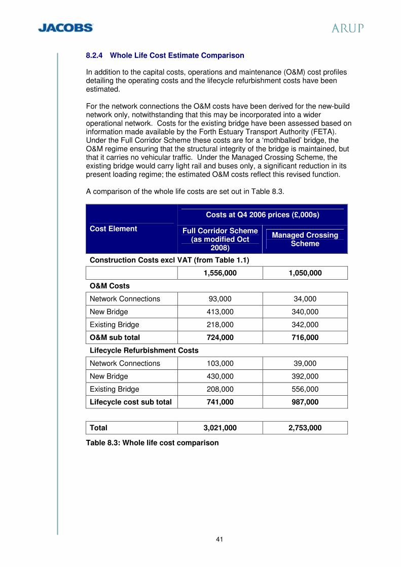
41
8.2.4 Whole Life Cost Estimate Comparison
In addition to the capital costs, operations and maintenance (O&M) cost profiles detailing the operating costs and the lifecycle refurbishment costs have been estimated. For the network connections the O&M costs have been derived for the new-build network only, notwithstanding that this may be incorporated into a wider operational network. Costs for the existing bridge have been assessed based on information made available by the Forth Estuary Transport Authority (FETA). Under the Full Corridor Scheme these costs are for a ‘mothballed’ bridge, the O&M regime ensuring that the structural integrity of the bridge is maintained, but that it carries no vehicular traffic. Under the Managed Crossing Scheme, the existing bridge would carry light rail and buses only, a significant reduction in its present loading regime; the estimated O&M costs reflect this revised function. A comparison of the whole life costs are set out in Table 8.3.
Costs at Q4 2006 prices (£,000s)
Cost Element Full Corridor Scheme (as modified Oct
2008)
Managed Crossing Scheme
Construction Costs excl VAT (from Table 1.1) 1,556,000 1,050,000
O&M Costs
Network Connections 93,000 34,000
New Bridge 413,000 340,000
Existing Bridge 218,000 342,000
O&M sub total 724,000 716,000
Lifecycle Refurbishment Costs
Network Connections 103,000 39,000
New Bridge 430,000 392,000
Existing Bridge 208,000 556,000
Lifecycle cost sub total 741,000 987,000
Total 3,021,000 2,753,000
Table 8.3: Whole life cost comparison

42
9 Assessment against Scheme Specific Objectives
As noted in Section 2.1, eight specific transport planning objectives were defined for the Forth Replacement Crossing. The Managed Crossing Scheme has key features that contribute to the achievement of these objectives as summarised in the table below.
Objective Contributing Features: Maintain cross-Forth transport links for all modes to at least the level of service offered in 2006.
• Improving reliability and journey times for bus travel, by making use of the existing bridge for exclusive use of buses and taxis.
• Improving journey reliability for general traffic, including freight, with the provision of hard shoulder on the replacement bridge to reduce the impact of incidents.
• An ITS technology solution to help manage traffic flows and incidents.
• All weather capability through wind shielding.
Connect to the strategic transport network to aid optimisation of network as a whole.
• Creating a new public transport facility. • Completing the trunk road network between
the M9 and M90 – improving connectivity to existing road network.
• Improving Fife junctions. • Providing connection for West Lothian at
M9 Junction 1a. • Improving response to incidents. • Improving management of traffic on the
strategic network controls through the use of ITS technology.
Improve reliability of journey times for all modes.
• Dedicated public transport corridor on the existing bridge.
• Improved connections to existing road network.
• Including hard shoulders on the replacement bridge.
• ITS technology control system. • Wind shielding on the replacement bridge.
Increase travel choices and improve integration across modes to encourage modal shift of people and goods.
• Facilitating new and improved car/bus interchanges.
• Improving reliability for bus services. • Providing scope for additional services and
routes.
Improve accessibility and social inclusion.
• Improving public transport services through enhanced service quality and interchange opportunities.
Minimise impacts of maintenance on the effective operation of the transport network.
• Introducing new infrastructure designed for reduced maintenance and built in maintenance capability.
• Introducing technology to help minimise maintenance disruption.

43
Objective Contributing Features: Support sustainable development and economic growth.
• Encouraging the use of more sustainable travel modes.
• ITS technology will help traffic move more smoothly and reduce carbon footprint.
Minimise impact on people and the natural and cultural heritage of the Forth area.
• Reducing the extent and impact of new works.
• Making best use of existing infrastructure. • Reducing impacts on the natural and
cultural heritage and on people.

44
10 Economic Evaluation
10.1 Introduction
The economic assessment considers the monetised benefits of the options for the Forth Replacement Crossing and compares these benefits to the costs associated with its construction and maintenance in accordance with the requirements of the Scottish Transport Appraisal Guidance (STAG). In this exercise, all costs are rebased to 2002 prices and are discounted to 2002 in line with the practice for transport schemes. The maintenance costs associated with retaining the Forth Road Bridge are included in this assessment. The cost-benefit analysis looks specifically at transport user efficiency benefits and compares these to the scheme costs. Wider economic benefits have not been monetised at this stage of this project development. The wider economic impact of closure or restricted use of the Forth Road Bridge, without a replacement crossing, on the local economies of Fife and the Lothians and the national economy of Scotland, would be significant, as illustrated in recent studies by FETA (reference “Feasibility Study for the Replacement or Augmentation of the Main Cables”, http://www.feta.gov.uk. 10.1.1 Benefits to Transport Users
Benefits to transport users have been calculated for the proposed scheme. In terms of performance, these benefits are calculated by comparing the travel times and distances travelled by users within the proposed network with those that would have occurred in a Do-minimum scenario. For the purposes of the assessment, a Do-minimum comparator has to be defined. The calculation of all costs and benefits is undertaken as a comparison against this Do-minimum scenario.
10.1.2 Forth Replacement Crossing Study (FRCS)
This economic assessment in the FRCS compared the economic performance of various options for a replacement crossing against a Do-minimum scenario which, given the uncertainty of the future reliability of the Forth Road Bridge, assumed that the Forth Road Bridge would not be capable of accommodating traffic over the Forth Estuary beyond 2019. Under such assumptions, the options assessed within the Part 2 Appraisal all had monetised benefits greater than the costs. The recommended option (Cable stayed bridge in Corridor D) was assessed to have a Benefit to Cost Ratio (BCR) of 4.31. The Forth Replacement Crossing Stage 2 Corridor Assessment work also assumed that the Forth Road Bridge would be closed for the comparator Do-minimum scheme.

45
10.1.3 Revised Do-minimum Comparator
The FETA Feasibility Study into Replacement/Augmentation of Main Cable offered two key updates to inform the development of the current economic assessment. These were that:
� There appears to be a greater degree of confidence that the Forth Road Bridge can be repaired and strengthened.
� The duration of bridge repair works and the likely traffic disruption in the absence of a replacement bridge are significant.
The various combinations of replacement options and traffic management options suggested a minimum range of potential programmes of works and associated traffic disruption of between 5 years and 2 months (with full bridge closures) and 8 years 11 months (off peak carriageway closures). The programmes assume no holiday impacts or slippage due to inclement weather conditions. Other closures would be required as necessary for all other routine and cyclical maintenance activity. As would be expected, the benefits attributable to the project will be lower than the FRCS assessment if it is assumed that the Forth Road Bridge can be repaired and brought back into full use. The impact on the benefit to cost ratio of different base case scenarios, together with an illustrative weighted assessment, is illustrated in Table 10.1.
Table 10.1: Dealing with uncertainty: impact on benefit to cost ratios In addition to the cable problems, the Forth Road Bridge has a number of identified on-going and significant maintenance issues, some of which are typical for a bridge of this type and age. These include without limitation, the repair of
1.7081.0830.1851.8500.1Repaired with 10 year closure
1.1191.0830.4851.2120.4Repaired with 5 year closure
Benefit to cost ratio
Cost£bn (2002
prices discounted to
2002)
Weighted benefit
Benefit £bn (2002
prices discounted to
2002)
Probability.Base scenario with existing
bridge
6.1701.0830.6686.6830.1Abandoned
0.7451.0830.2430.8070.3Repaired with 10 year
restriction
1.521.0831.6481.0Summary
0.6161.0830.0670.6680.1Repaired with 5 year restriction

46
the main movement joints and periodic deck re-surfacing. Much of the work has or will have a significant impact on users and the wider economy. 10.2 Economic Assessment
In light of the results of the recent work by FETA that there is a greater likelihood that the Forth Road Bridge could be strengthened, albeit with a high level of disruption to users in the absence of a replacement crossing, a revised approach to the Do-minimum situation was adopted. The Do-minimum for the purpose of the current economic assessment was taken as the existing crossing and road network, with use of the Forth Road Bridge interrupted for a 10 year period by restrictions to carriageway availability to allow for routine and cyclical repairs and refurbishment, including the replacement of the existing cables. Following completion of the Stage 2 Corridor Assessment, further work was undertaken to refine the cost and operation of the Full Corridor Scheme. Economic evaluation was undertaken on the refined scheme and compared with the Managed Crossing Scheme. The results of the Transport User Benefit Appraisal (TUBA) evaluation are presented in Table 10.2.
Table 10.2: Economic Appraisal of the Full Corridor and Managed Crossing Schemes The Managed Crossing Scheme offers significantly improved value for money over the Full Corridor Scheme, demonstrated by the improved benefit to cost ratio of the Managed Crossing Scheme compared with the Full Corridor Scheme. Although the Managed Crossing Scheme offers marginally lower transport user efficiency benefit than the Full Corridor Scheme, this is more than offset by the additional cost of the Full Corridor Scheme.
10.3 Wider Economic Input
As noted above, the wider economic impact of closure or restricted use of the Forth Road Bridge, without a replacement crossing, on the local economies of Fife and the Lothians and the national economy of Scotland, would be significant. To illustrate the scale of this potential impact, the FETA cable augmentation study included a preliminary economic assessment, addressing the wider impact on the economies of Fife and the Lothians, resulting from traffic disruption, delays and reduced accessibility related to the works.
Full Corridor Scheme (£’000)
Managed Crossing Scheme (£’000)
Present Value of Benefits £660,805 £632,898 Present Value of Costs £881,073 £621,830 Net Present Value -£220,268 £11,068 Benefit to Cost Ratio 0.75 1.02

47
A sample of representative businesses was canvassed for predicted responses to pre-defined level of disruption, which in turn was seen as representative of the likely level of disruption which would be experienced. The impact on the economy resulting from cable replacement/augmentation works depends on the structure and competitiveness of the local market. It could potentially increase costs to the travelling public, add to distribution costs, affect customer markets, and lead to a competitive disadvantage. The inconvenience and added cost of travel could potentially discourage tourism and reduce recreational travel. The net effect would be to reduce business and government revenues resulting in a contraction in economic activity and a loss of jobs.
The response to the questionnaires was analysed and scaled to represent the business community as a whole. The forecast economic impact was depicted in terms of business turnover and business output and presented as ranges. For a range of treatments between cable augmentation measures and cable replacement, the forecast impact is that turnover would reduce by between £539 million and £1,320 million in Scotland as a whole and output would reduce by, between £443 million and £1,085 million in Scotland as a whole. Cable replacement, which was regarded as the preferred option, yielded the higher end figures, and the possibility of job losses of 3,200, many of which would be permanent.

48
11 Public Transport and other sustainable transport options
11.1 Introduction
The project has objectives to increase travel choices and improve integration across modes to encourage modal shift of people and goods and to improve accessibility and social inclusion. In providing facilities for sustainable transport initiatives, such as bus priority, it is important that the proposals should not significantly disadvantage other travellers. Priority measures for buses must not significantly impact on capacity for general purpose vehicles or artificially seek to slow down general traffic. In practice, this means that bus priority measures would be most practical where sufficient infrastructure exists. The potential for high occupation vehicle lanes, that is lanes reserved for light vehicles with more than one occupant, has also been considered. Experience has shown that these are best suited to roads which have the following features:
� High traffic volumes and congestion, where the high occupation vehicle facility offers a journey time advantage.
� Interurban roads, with long spacing between junctions, to allow high occupation vehicle lanes to be safely operated and allow traffic to safely join and leave each high occupation vehicle lane. Each high occupation vehicle lane should have at least 500 metres between the start or finish of the high occupation vehicle lane and the nearest road entry or exit slip.
The network around the Forth Crossing is characterised by the close spacing of junctions. This feature poses restrictions to the feasibility of operating high occupation vehicle lanes effectively. As a consequence, it was determined that the focus was to align the Managed Crossing Scheme with key initiatives emerging from the Strategic Transport Project Review (STPR) which have the objective of making better use of existing road capacity in association with targeted infrastructure improvements; including:
� New strategic Park & Ride / Park & Choose sites to encourage the use of public transport at strategic access points to Edinburgh.
� Intelligent Transport Systems on the motorway and trunk road network to improve journey times and support Park & Ride and Park & Choose strategies.
� Light Rapid Transit between Edinburgh and Fife, which could include provision of a bus based rapid transport capacity between Fife and Edinburgh.
The Managed Crossing Scheme offers significant opportunities for complementary measures by local transport authorities which can address scheme and wider transport objectives. The principal facility close to the crossing is the successful Ferrytoll Park & Ride site. This may be complemented by further Park & Ride or Park & Choose facilities north of the crossing such as at Halbeath and Rosyth.

49
There is also an opportunity for the local transport authority to develop a new Park & Ride facility at South Queensferry, south of Echline junction. The viability of these sites will be enhanced with the availability of the existing bridge for use by public transport and the journey time and journey reliability benefits that this brings. Although there are limitations on the capacity of park and ride sites and the number of trips that can be practicably catered for by public transport, the addition and expansion of facilities can make significant contributions to meeting travel demand during the busiest periods. As an illustration, after proving successful, with the original 500 space car park regularly reaching near capacity, Ferrytoll has been expanded to provide over 1000 car parking spaces. This number of spaces is significant when set in the context of a morning peak hour southbound flow on the M90/A90 and Forth Road Bridge of around 3,500 vehicles. 11.2 Analysis of Bus Movements
Recognising that the Managed Crossing Scheme offers the advantage to buses of the use of the existing bridge without conflict with general traffic, consideration has been given to current and possible future service patterns in the design of the connecting roads. This seeks to maximise bus journey time advantages and journey time reliability without prejudice to other users. The majority of the local services in Fife and the long distance services (Megabus and City Link) have created a small bus hub at Ferrytoll, allowing local and long distance passengers to change onto other services. As a consequence almost all the current services join/leave the A90 at the Ferrytoll junction. Relatively few buses currently travel all the way along the M90/A90 between Halbeath and the Bridge. To the south of the bridge, there are two movements at present: 3 buses an hour to/from the airport and a further service from Queensferry that uses the A90 towards/from Edinburgh. All services that cross the bridge are commercial services (i.e. without subsidy from a local authority), with the exception of the 747 route, which is operated under the Bus Route Development Grant scheme. This means that there has been a sliding subsidy over a three year period with the service expected to operate commercially from year 4 and onwards; it is currently in the third and final year of subsidy. There are at least 3 Park & Ride/Choose sites that are planned to be implemented, with others being discussed by Local Authorities. The 3 planned sites at Halbeath, Rosyth Station and Winchburgh are shown on Figure 11.1. Whilst the final decision on implementation has yet to be taken, consultation with Fife Council has indicated that:
� Services from the proposed Halbeath site are expected to run direct down the M90 and A90 towards Edinburgh at approximately 10 to 15 minute intervals. They may visit Ferrytoll as part of the route.
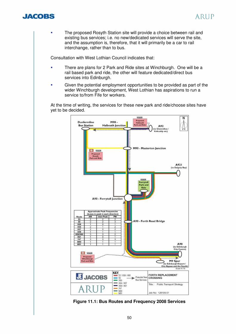
50
� The proposed Rosyth Station site will provide a choice between rail and existing bus services; i.e. no new/dedicated services will serve the site, and the assumption is, therefore, that it will primarily be a car to rail interchange, rather than to bus.
Consultation with West Lothian Council indicates that:
� There are plans for 2 Park and Ride sites at Winchburgh. One will be a rail based park and ride, the other will feature dedicated/direct bus services into Edinburgh.
� Given the potential employment opportunities to be provided as part of the wider Winchburgh development, West Lothian has aspirations to run a service to/from Fife for workers.
At the time of writing, the services for these new park and ride/choose sites have yet to be decided.
Figure 11.1: Bus Routes and Frequency 2008 Services

51
12 Conclusion
This is the final report on the project planning work carried out during 2008. It summarises the work carried out to date and explains the project development through its key stages as summarised below:
� The Government’s decision in December 2007 on the scope of the Forth Replacement Crossing Project to provide an independent replacement bridge was based on prognosis at that time that the functionality of the existing bridge would be extremely limited. The project was estimated to cost between £3.2bn and £4.2bn at outturn completion in 2016.
� An undertaking was provided to the Scottish Parliament Transport, Infrastructure and Climate Change Committee (TICC) in January 2008 that, should the prognosis for the existing bridge improve, further consideration would be given to what any future long term role might be for the existing bridge in supporting the crossing capacity over the River Forth.
� A review of the route options undertaken between January and August 2008 (reference Sections 3 and 4) identified that improvements should be based on the road corridors utilising the A90/M90 north of the Forth (North Corridor Option 1) and the M9 Spur south of the Forth Road Bridge (South Corridor Option 1).
� Continued appraisal of the condition and potential of the Forth Road Bridge (reference Section 5) has provided confidence that the existing crossing can make a contribution to the project. It is not capable of meeting the future needs as the main crossing but can support future public transport requirements and accommodate non-motorised users (pedestrians and cyclists).
� The opportunity to use the Forth Road Bridge in this way has allowed the development of a flexible, narrower replacement bridge of high quality and significantly reduced cost.
� The connecting road strategy looked initially at expanding capacity through additional road width prioritised for high occupancy cars (cars with more than 1 person). Given that this strategy carries the risk of overprovision for residual single occupancy vehicles, particularly during the peak commuting periods, and traffic management inefficiencies, a more focussed assessment was made of the connecting road provision.
� Analysis of traffic conditions indicates that peak period congestion is largely a factor of the close junction spacing along the A90/M90 corridor and driver reaction to that, rather than the inadequacy of a dual two lane motorway. It is proposed that this is addressed by the use of Intelligent Transport Systems with local junction improvements. This strategy contributes a further cost saving against the original project estimate.
� The revised scheme cost estimate is between £1.72bn and £2.34bn (see Section 8), an overall reduction of broadly £1.7bn in cost compared to the previous proposal.
� The economic parameters have changed over the period. The improving prognosis for the Forth Road Bridge has meant that the economic base case assumes its repair rather than closure (see Section 10). The assessment takes into account the restricted use of the crossing over an extended period to allow for repair and refurbishment including the replacement or augmentation of the existing cables. The revised assessment confirms the

52
emerging project as a sound investment, but with benefits at a reduced level reflecting the revised base case.
� The construction of the recommended scheme has a lower environmental and carbon footprint in relation to embedded carbon, reflecting the maximised use of existing infrastructure, and better supports the development of public transport.
� The Managed Crossing Scheme offers opportunities for complementary measures by local transport authorities which can address scheme and wider objectives. These include potential improvements to existing facilities for bus priority and to promote sustainable transport practices. The principal facility close to the crossing is Ferrytoll Park and Ride. This may be complemented by further Park and Ride or Park and Choose facilities at Halbeath and Rosyth. There is also an opportunity for the local transport authority to develop a further new Park and Ride facility at South Queensferry, south of Echline Junction.