foss4g2007 24-27 september 2007 development of geoprocessing service with realtime data using wps...
Post on 22-Dec-2015
218 views
TRANSCRIPT
FOSS4G2007 24-27 September 2007
Development of Geoprocessing Service with Realtime Data Using WPS and SOS
Open Standard
Sarawut Ninsawat, Venkatesh RaghavanGraduate School for Creative CitiesOsaka City University

FOSS4G2007 24-27 September 2007
Introduction Rapid urbanization is global phenomenon and it is estimated that
60% of the worlds population will be urban by the year 2050. Providing a clean, safe and creative urban environment has become
a top priority for many nations. Clean and safe water is one of the precious resource for the urban
population . A comprehensive system that could monitor a water quality and
provide information for to stake-holders needs to be implemented Such a system should;
Provide access to geospatial water quality data over the Web for collaborating all the departments.
Allow spatial analysis and environmental modeling functionality for decision making.
Afford timely reporting of events through real-time in situ measurement (not a archive system).

FOSS4G2007 24-27 September 2007
Dynamic Web-GIS Many standards for a Spatial Data Infrastructure
(SDI), which aims to facilitate and standardize the storage and access of to spatial data
Availability of spatial analysis capability in Web-GIS applications would allow extraction of knowledge from spatial data repositories.
GRASSLinks (Huse, 1995) is one of the early implementation of analytical Web GIS for providing public access to environmental information.
Similarly, pgRouting provides some core tools for Location Based Services.
However, only the visualization and searching is inadequate for monitoring purposes.

FOSS4G2007 24-27 September 2007
Web Processing Service Recently, Open Geospatial Consortium (OGC)
launches a draft specification of Web Processing Service (WPS) , originally named Geoprocessing Service.
The specified Web Processing Service provides client access to pre-programmed calculations and/or computation models that operate on spatially referenced data. The result of request process are available to download for
further analysis at user’s machine.

FOSS4G2007 24-27 September 2007
PyWPS (Python Web Processing Service)
PyWPS is written in Python programming language.
GRASS Go Web PyWPS implement OGC’s Web Processing
Service standard Operable with any other tool or just with Python itself
even without GRASS GIS in the background Current version is 2.0.0 http://pywps.wald.intevation.org/index.psp.

FOSS4G2007 24-27 September 2007
WPS Interface
GetCapabilities – This operation allows a client to describe the abilities of specific server implementation.
DescribeProcess – This operation allows a client to request detailed information about one or more process that can be executed, including the necessary input parameters and formats, and the outputs.
Execute – This operation allows a client to run a specified process implemented by the WPS, using provided input parameter values and returning the output produced.

FOSS4G2007 24-27 September 2007
WPS : GetCapabilities Interface
ppt\getcap01.jpg
http://mizu.info.gscc.osaka-cu.ac.jp/cgi-bin/wps.py?service=wps&version=0.4.0&request=getcapabilities

FOSS4G2007 24-27 September 2007
WPS : DescribeProcess Interface
http://mizu.info.gscc.osaka-cu.ac.jp/cgi-bin/wps.py?service=wps&version=0.4.0&request=describeprocess&Identifier=shortestpath
FOSS4G2007 24-27 September 2007
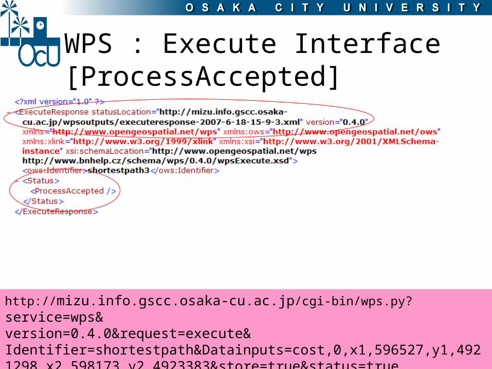
WPS : Execute Interface[ProcessAccepted]
http://mizu.info.gscc.osaka-cu.ac.jp/cgi-bin/wps.py?service=wps&version=0.4.0&request=execute&Identifier=shortestpath&Datainputs=cost,0,x1,596527,y1,4921298,x2,598173,y2,4923383&store=true&status=true

FOSS4G2007 24-27 September 2007
WPS : Execute Interface[ProcessStarted]
http://mizu.info.gscc.osaka-cu.ac.jp/wpsoutputs/executereponse-2007-6-18-15-9-3.xml
FOSS4G2007 24-27 September 2007
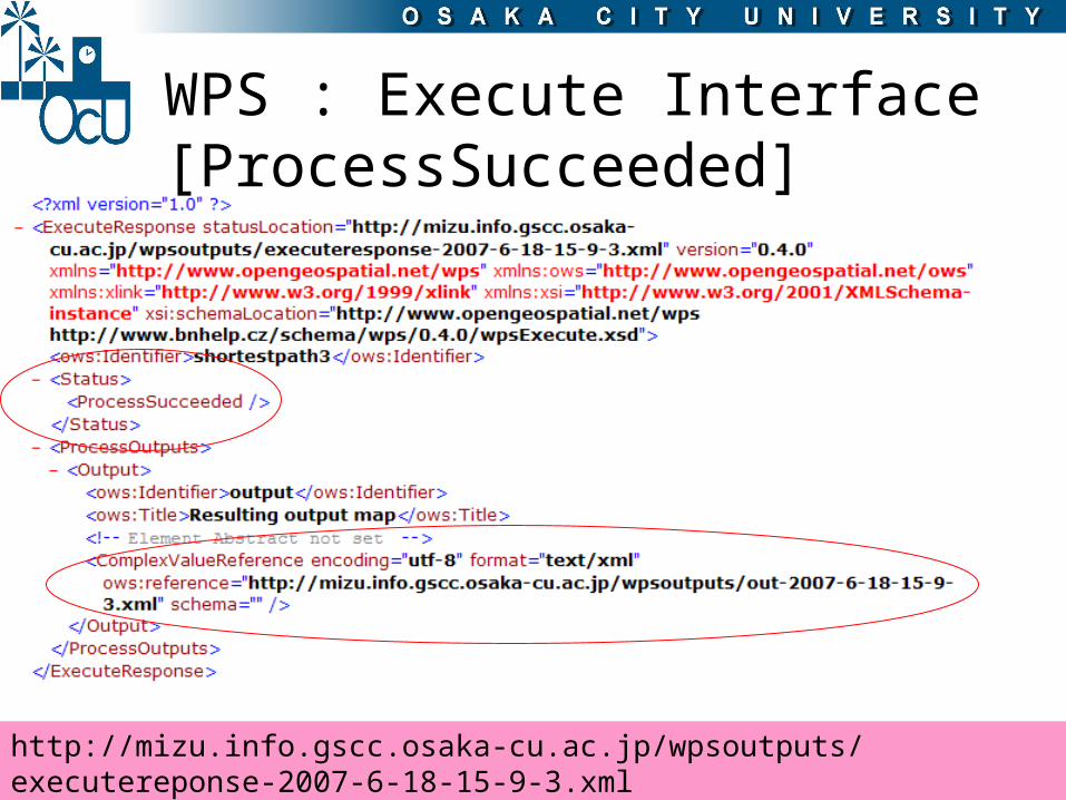
WPS : Execute Interface[ProcessSucceeded]
http://mizu.info.gscc.osaka-cu.ac.jp/wpsoutputs/executereponse-2007-6-18-15-9-3.xml

FOSS4G2007 24-27 September 2007
**Execute Request
http://wps.org/cgibin/wps.py?service=wps&
version=0.4.0&request=execute&
Identifier=shortestpath&Datainputs=cost,0,x1,596527,y1,4921298,x2,598173,y2,4923383&store=true&status=true
Py
WP
S S
ys
tem
Py
WP
S S
ys
tem
WFSWFS WCSWCS GeoTiff, GMLGeoTiff, GML
PostgreSQL/PostGISPostgreSQL/PostGIS
ShpShp
GeoTiffGeoTiff
GMLGML
Web Processing Service Server Web Processing Service Server
UserUser
Execute Request
GML or GeoTiff Result
GRASS GISGRASS GIS
Web-Mapping Web-Mapping ApplicationApplication
FOSS4G2007 24-27 September 2007
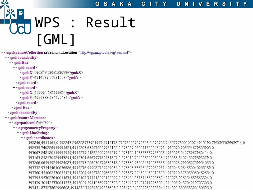
WPS : Result[GML]

FOSS4G2007 24-27 September 2007
Demo site

FOSS4G2007 24-27 September 2007
Py
WP
S S
ys
tem
Py
WP
S S
ys
tem
WFSWFS WCSWCS GeoTiff, GMLGeoTiff, GML
PostgreSQL/PostGISPostgreSQL/PostGIS
ShpShp
GeoTiffGeoTiff
GMLGML
Web Processing Service Server Web Processing Service Server
UserUser
Execute Request
GML or GeoTiff Result
GRASS GISGRASS GIS
Web-Mapping Web-Mapping ApplicationApplication
Real-Time DataReal-Time Data

FOSS4G2007 24-27 September 2007
Sensor Network In the past, to acquire an information
from remote place consume time and money.
Environmental monitoring requires real-time reporting and archiving of events and phenomenon.
Sensors and communications chips can be embedded in data logging devices enabling them to.
communicate with other devices, serviced and upgraded remotely through computer network.
collect huge amount of information at low costs via a network of field sensors.

FOSS4G2007 24-27 September 2007
Wireless Sensor system
The sensor-node “Field Server” equipped with a Web server and Wireless Lan was introduced for a remote field monitoring system Manage and periodically collect monitoring data via the
Internet connection from remote place. More than 40 Field Servers are currently deployed in
various parts of Japan, the United States, Thailand, China, Korean and Taiwan.
However, the lack of integration and communication between these sensor networks, often leaves such valuable information underutilized.

FOSS4G2007 24-27 September 2007
Sensor Web Enablement (SWE)

FOSS4G2007 24-27 September 2007
Sensor Web Enablement (SWE)
O&M [Observations & Measurements Schema] SensorML [Sensor Model Language ] TML [Transducer Markup Language] SOS [Sensor Observation Service]
In this study, 52N Sensor Observation Service (52NSOS) has been used.
Provides the framework of the sensing resources to service users. SPA [Sensor Planning Service] SAS [Sensor Alert Service] WNS [Web Notification Service]

FOSS4G2007 24-27 September 2007
GetObservation
Observations/Measurements
Sensor Observation ServiceSensor Observation Service(SOS)(SOS)

FOSS4G2007 24-27 September 2007
SOS Result

FOSS4G2007 24-27 September 2007
Web-Mapping Web-Mapping ApplicationApplication
Sensor Observation Sensor Observation ServiceService(SOS)(SOS)
Web Processing ServiceWeb Processing Service(WPS)(WPS)
WFSWFS
WCSWCS
GeoTiff, GMLGeoTiff, GML
UserUser
Implementation of Real-time unmanned modeling map
Real-time mapUpdate in situ data to modeling computationWater Quality demonstrate is developing.In this demonstrate, simulated sensor nodes are used to supply a water quality value to SOS.

FOSS4G2007 24-27 September 2007
WPS and SOS integration Due to the capability of WPS that allows to
access distributed geospatial data across the network (such as WCS and WFS). It is possible to utilize the observation from
SOS server.
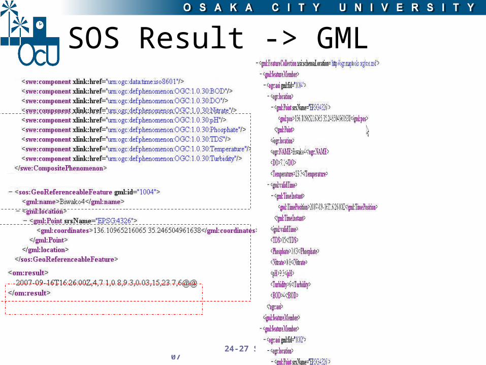
Presently, WPS are not able to directly use this observation data in further processing. The observation is converted to a feature
object as GML document, which is an acceptable data format for WPS.
FOSS4G2007 24-27 September 2007
SOS Result -> GML
FOSS4G2007 24-27 September 2007
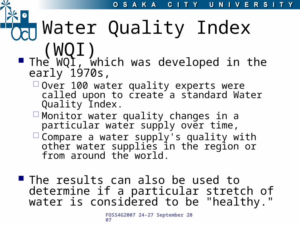
Water Quality Index (WQI) The WQI, which was developed in the early
1970s, Over 100 water quality experts were called upon to
create a standard Water Quality Index. Monitor water quality changes in a particular water
supply over time, Compare a water supply's quality with other water
supplies in the region or from around the world.
The results can also be used to determine if a particular stretch of water is considered to be "healthy."

FOSS4G2007 24-27 September 2007
Seven water quality parameters
Dissolved Oxygen (% Saturation) Nitrate (mg/L) pH Total Phosphate (mg/L) Total Dissolved Solids (mg/L) Temperature Change (C) Turbidity (NTU)

FOSS4G2007 24-27 September 2007
WQI Calculation
n
nnn q
110 ]logW[AntilogWQI
VVVVq idealstandardidealactualn 100
WhereVactual : actual amount of n parameter from analysisVideal : ideal value of water quality parameter Videal for pH = 7, D.O. = 14.6 mg/L and for other parameters is zero.Vstandard: recommended WHO standard value of water quality parameter.
qn that is a quality rating is computed using the following equation.

FOSS4G2007 24-27 September 2007
WQI Calculation
S
K
nn W
)1(
1
1
n
niS
K
Where W (Weight factor) is computed using the following equation.
Where K is proportionality constant that is derived from
Where Sn and Si are the WHO standard values of each water quality parameters.
FOSS4G2007 24-27 September 2007
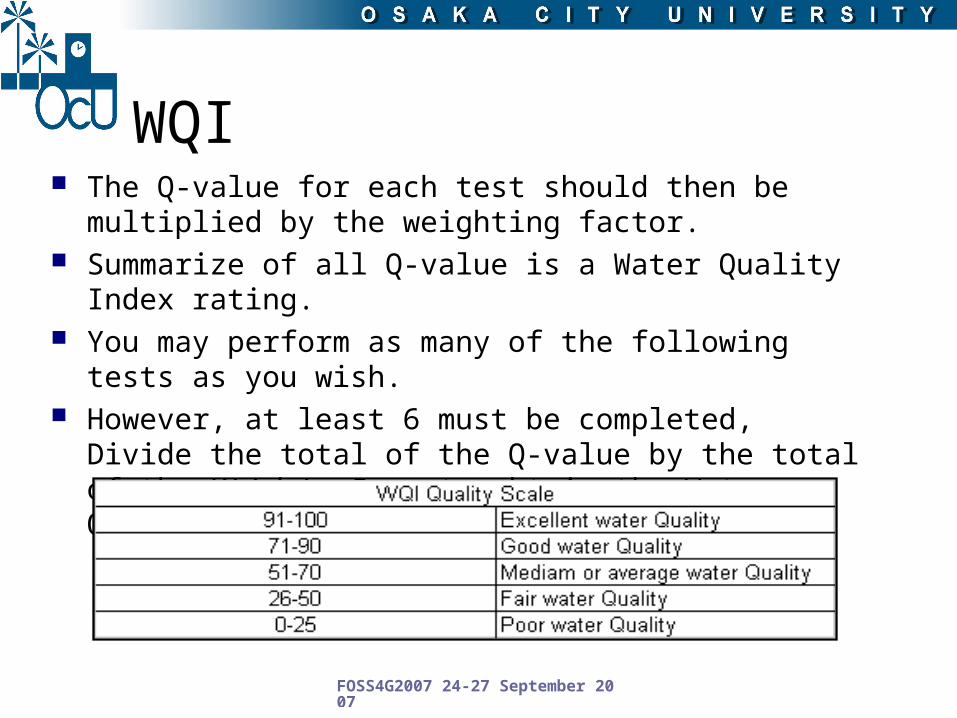
WQI The Q-value for each test should then be multiplied by the
weighting factor. Summarize of all Q-value is a Water Quality Index rating. You may perform as many of the following tests as you
wish. However, at least 6 must be completed, Divide the total of
the Q-value by the total of the Weighting Factor to obtain the Water Quality Index rating.

FOSS4G2007 24-27 September 2007
Demo System : WQI (Biwa Lake Supplies water to Osaka)
http://mizu.info.gscc.osaka-cu.ac.jp/waterwqi/
FOSS4G2007 24-27 September 2007
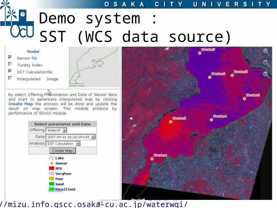
Demo system : SST (WCS data source)
http://mizu.info.gscc.osaka-cu.ac.jp/waterwqi/

FOSS4G2007 24-27 September 2007
Demo site : Turbidity Index (WCS data source)

FOSS4G2007 24-27 September 2007
Conclusion
The integration of two OGC-compliant open standards to create a comprehensive geoprocessing service utilizing real-time data from sensor observation network has been described
SOS can be a valuable data source for WPS via the integrated client developed as a part of this study
Due to standardization, the usage of geodata as well access to real-time data much easier and less expensive allows better decision making.
We are now working on development of field water quality sensor that could be integrated with the present system for monitoring groundwater quality urban areas.

FOSS4G2007 24-27 September 2007
Thank you