fu-lung chang1, patrick minnis ... - ceres.larc.nasa.gov · earth radiation budget workshop 13-16...
TRANSCRIPT

Earth Radiation Budget Workshop 13-16 September 2010, École Normale Supérieure (ENS), Paris, France
Fu-Lung Chang1, Patrick Minnis2, Sunny Sun-Mack1 Seiji Kato2 and Walter Miller1
1) Science Systems & Applications Inc., Hampton, VA 2) NASA Langley Research Center, Hampton, VA

*CERES – Clouds and the Earth’s Radiant Energy System *CALIPSO – Cloud-Aerosol Lidar and Infrared Pathfinder Satellite Observation *CloudSat – A cloud radar satellite instrument
• Introduction of the exploratory CERES MODIS multilayered cloud retrieval algorithm.
• Evaluation of the CERES multilayered cloud property retrievals by comparisons with the CALIPSO and CloudSat data.
• Improvement towards Edition 4.
Objective • To report the current status of CERES multilayered cloud retrieval.

CERES Multilayered Cloud Retrieval Algorithm
The algorithm uses a two-layered cloud model to retrieve both an upper-layer and a lower-layer cloud properties, especially for a pixel containing upper cirrus overlapped with lower stratus clouds.

Application of the Multilayered Cloud Retrieval Algorithm • Require minimum, a CO2-absorption 13.3-µm channel, as well as the
traditional VIS (0.63µm), IR (11µm) and NIR (3.7µm) window channels.
Chang et al. Chang and Li CERES Algorithm (2010a, b) (2005a, b) (in preparation)

Experimental Test of the Multilayered Cloud Algorithm on GEOs
• The new exploratory multilayered cloud retrieval algorithm has been tested to provide pixel-by-pixel multilayered cloud properties on the CERES MODIS as well as on the GOES-12, -13 and Meteosat-8, -9.
GOES-13 Image (2010.09.15 17:45Z) 3-level Multilayered Cloud Mask

MODIS RGB Imag Upper-layer Height (IR) Upper-layer Tau (VIS) Upper-layer Re (NIR)
2007.08.15 0150 Lower-layer Height (IR) Lower-layer Tau (VIS) Lower-layer Re (NIR)

Dataset Used for Evaluation of the CERES Multilayered Cloud Retrieval Algorithm
A-Train Matched MODIS, CALIPSO and CloudSat Data from 2006/07, 2006/10, 2007/01 and 2007/04
(Note: CALIPSO products are Version 2)

Comparisons of High Clouds and Multilayered Clouds (April 2007) CALIPSO high clouds CloudSat high clouds CERES high clouds
CALIPSO Multilayered CloudSat Multilayered CERES Multilayered

Comparisons of Upper- and Lower-layer Cloud Top Heigt (April 2007) CERES vs CALIPSO CERES vs CloudSat

RGB Imag Multilayer mask 1 Multilayer Mask 2 Multilayer Mask 3
MCO2 Cloud Top Height Multilayer Mask 4 Multilayer Mask 5
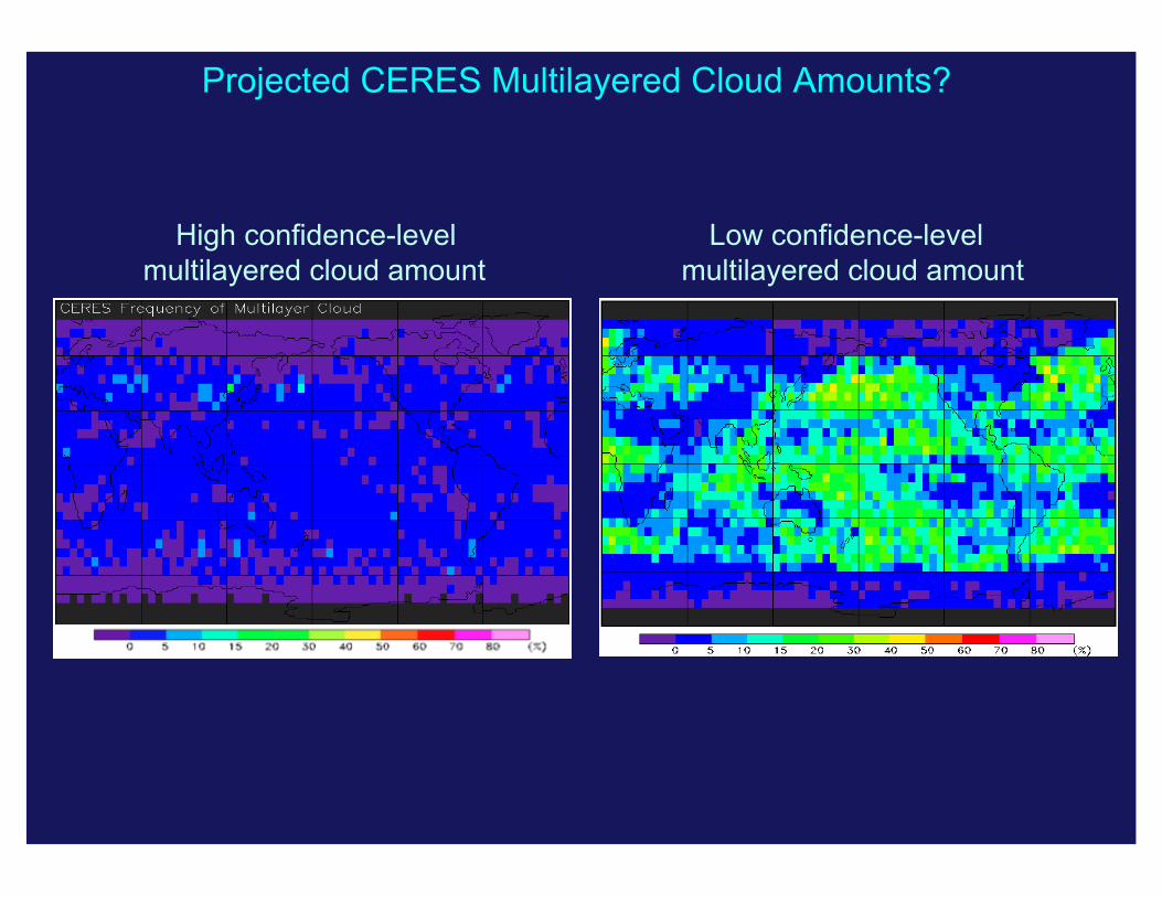
Projected CERES Multilayered Cloud Amounts?
High confidence-level Low confidence-level multilayered cloud amount multilayered cloud amount

Concluding Remarks • Conventional single-layered cloud assumptions lead to erroneous
results in passive satellite retrieved cloud properties for multilayered cloud systems. The CERES project strives to develop an exploratory multilayer cloud data product using the MODIS data.
• It is possible and important to improve the passively retrieved upper- and lower-layer cloud properties that often consist of multilayered ice over water cloud conditions.
• The A-Train active satellite sensing are ideal for observations of multilayered cloud vertical structure. Unfortunately, they are limited by nadir-only pointing observations. Until the challenge of actively sensing clouds on large spatial and temporal scales are overcome, it is necessary to develop and test novel techniques for retrieving multilayered cloud properties using passively sensed radiances.