g o v. u k buttercup meadow cranesbill meadow vetchling meadowsweet musk mallow nettle leaved...
TRANSCRIPT

2/20/2018 Rural Payments service: land use codes 2018 - GOV.UK
https://www.gov.uk/guidance/rural-payments-service-land-use-codes-2018 1/31
GOV.UK 1. Home (https://www.gov.uk/)
Guidance
Rural Payments service: land use codes 2018What land use codes to use in 2018 when declaring land in a rural payments application (like the BasicPayment Scheme (BPS) and Countryside Stewardship)
Published 20 February 2018
From:Rural Payments Agency (https://www.gov.uk/government/organisations/rural-payments-agency)
Contents
What has changed since 2017Agricultural landDual useAgricultural land under a Rural Development Programme agreementNon-agricultural landCodes you must not useCodes for Countryside Stewardship options with multiple crops
When farmers apply for a rural payment scheme using the Rural Payments service(https://www.ruralpayments.service.gov.uk/), they must use the codes on this page to declare what they use theirland for.
To search the lists on this page, click ‘CTRL’ and ‘F’ and type in the term or code you’re looking for.
To print the codes, click ‘CTRL’ and ‘P’.
There are codes for:
agricultural landnon-agricultural landCountryside Stewardship options with multiple crops
There are also some codes you must not use for BPS.
Read more about BPS 2018 (https://www.gov.uk/guidance/bps-2018).
What has changed since 2017
You can now claim Spelt Wheat as a separate crop, to do so you should use code AC96, which will show as aSamphire when applying online.
Agricultural land

2/20/2018 Rural Payments service: land use codes 2018 - GOV.UK
https://www.gov.uk/guidance/rural-payments-service-land-use-codes-2018 2/31
Land use codes for agricultural land are given below for:
permanent grassland and permanent grassland buffer stripspermanent cropsarable land: temporary grassland, fallow land, arable buffer strips, hedges and arable land exempt fromgreeningarable land: arable crops for crop diversificationarable land: leguminous and nitrogen-fixing crops for crop diversification and ecological focus areasarable land: catch and cover crops for ecological focus areas
Permanent grassland and permanent grassland buffer strips
Land use Code Description
Permanentgrassland
PG01
All land you are planning to count as permanent grassland for BPS. Also use thiscode for strips and margins of permanent grassland if you want these to counttowards your total area of grassland to meet a greening exemption or to limit yourarea of arable land subject to crop diversification.
Otherwise you can include strips and margins of permanent grassland under themain land use of the parcel and they don’t need to be separately identified. Readthe BPS 2018 scheme rules (https://www.gov.uk/guidance/bps-2018) for moreinformation on permanent grassland.
Permanent crops
Land use Code Description
Permanent cropsother thannursery crops andshort rotationcoppice
TC01 Permanent crops are crops that occupy the land for 5 years or more (otherthan permanent grassland) and nursery crops and provide repeatedharvests. They include nursery crops short rotation (code NU01) and shortrotation coppice (code SR01).
Multi-annual/perennial crops include:
Almonds Apples Apricots Artichoke Asparagus Avocados Bilberries Blackberries Blueberries Cherries Chestnuts Citrus fruit Cranberries Currants EnglishChamomile Figs

2/20/2018 Rural Payments service: land use codes 2018 - GOV.UK
https://www.gov.uk/guidance/rural-payments-service-land-use-codes-2018 3/31
Land use Code Description
Gooseberries Grapes Guavas Hazelnuts Hops Hyssop Lavender Loganberries Macadamia nuts Mangos Mangosteens Melissa Mint Miscanthus Mulberries Papayas and Locust beans Peaches Pears Pecans Pineapples Pine nuts Pistachios Plantains Plums Raspberries Reed canary grass Rhubarb Rosemary Sloes and Quinces Walnuts Yarrow
Other fruits under the genus ‘Vaccinium’ are also permanent crops
Includes flower crops such as:
Agrinomy Autumn Hawk-bit Betony Bladder Campion Bluebell Bulbous Buttercup Cats Ear Clustered Bellflower Coltsfoot Common Daisy Common Mallow Common Sorrel Cowslip

2/20/2018 Rural Payments service: land use codes 2018 - GOV.UK
https://www.gov.uk/guidance/rural-payments-service-land-use-codes-2018 4/31
Land use Code Description
Creeping Buttercup Dandelion Devils-bit Scabious Drop wort Field Scabious Garlic Mustard Great Burnet Greater Hawk-bit Greater Knapweed Greater Mullein Heartsease Hedge woundwort Hoary Plantain Kidney Vetch Lady’s Bed Straw Lawn Chamomile Lesser Knapweed Meadow Buttercup Meadow Cranesbill Meadow Vetchling Meadowsweet Musk Mallow Nettle leaved bellflower Ox-Eye Daisy Purple Loosestrife Purple Toadflax Ragged Robin Red Campion Ribwort Plantain Salad Burnet Self Heal Small Scabious St. John’s Wort Vipers Bugloss Water Avens White Campion Wild Angelica Wild Garlic Wild Primrose Wood Avens Yellow flag Iris Yellow Toad Flax

2/20/2018 Rural Payments service: land use codes 2018 - GOV.UK
https://www.gov.uk/guidance/rural-payments-service-land-use-codes-2018 5/31
Land use Code Description
Nursery crops NU01
Nursery crops are areas of young woody plants grown in the open air, onsoil in greenhouses, or under polytunnels for later transplantation.
They include:
Vine and root stock nurseries Fruit tree and berry nurseries Ornamental nurseries Mixed nurseries of forest trees (except those for the holding’s ownrequirements grown in woodland) Nurseries of trees and bushes for planting in gardens, parks, at the roadside and on embankments
Nursery crops do not include Christmas trees unless they are grown innurseries for later transplantation.
Short rotationcoppice
SR01
Short rotation coppice includes areas planted with tree species that consistof woody, perennial crops, the rootstock or stools remaining in the groundafter harvesting, with new shoots emerging in the following season. Theinitial tree planting must have been planted after the year 2000 .
The eligible species for short rotation coppice are:
Alder (Alnus) Ash (Fraxinus excelsior) Birch (Betula) Hazel (Corylus avellana) Hornbeam (Carpinus spp) Lime (Tilia cordata) Poplar (Populus spp) Sweet chestnut (Castanea sativa) Sycamore (Acer pseudoplatanus) Willow (Salix spp)
Arable land: temporary grassland, fallow land, arable buffer strips, hedges and arable landexempt from greening
Land use Code Description

2/20/2018 Rural Payments service: land use codes 2018 - GOV.UK
https://www.gov.uk/guidance/rural-payments-service-land-use-codes-2018 6/31
Land use Code Description
Temporarygrassland
TG01
All land you are planning to count as temporary grassland for BPS.
Also use this code for strips and margins of temporary grassland if you wantthese to count towards your total area of grassland to meet a greeningexemption or as a single ‘crop’ for crop diversification. If the grassland meetsthe fallow rules for greening and you want it to count as fallow land for cropdiversification or EFA, use the land use code for ‘Land lying fallow’ (FA01).Otherwise you can include the areas of strips and margins of temporarygrassland under the land use code you are using for the main land use of theparcel and they don’t need to be separately identified.
Land lyingfallow
FA01
All land you are planning to count as fallow land for BPS or as part of yourecological focus area.
Use this code for strips and margins of fallow land if you want these to counttowards your total area of fallow land to meet a greening exemption or as asingle ‘crop’ for crop diversification. Otherwise you can include the areas ofstrips and margins of fallow land under the land use code you are using forthe main land use of the parcel and they don’t need to be separatelyidentified.
Wild bird mixes can be coded under a number of different land use codes, aslong as in your individual example matches the criteria, for example:
a) as a mixed crop if there is an area where a seed mixture is sown, this areamust be counted as a single crop for crop diversification, it doesn’t matterwhat crops are included in the mix.
b) as fallow land (crop diversification) when it is land which has no cropproduction or grazing on it, but is maintained in a state suitable for grazing orcultivation.
c) as fallow land (EFA) when it is land which has no crop production orgrazing on it, but is maintained in a state suitable for grazing or cultivation.Farmers can grow or plant wild-bird seed mixes, pollen sources and nectarsources on their EFA fallow land during the fallow period.
These must be an un-harvestable mix of at least 2 crops that support wildlifeand pollinators (advisers from the ‘Campaign for the Farmed Environment’can help farmers choose). Wild-bird seed mixes should be an area with abalanced combination of small-seed bearing crops, for example Barley,Triticale, Kale, Quinoa, Linseed, Millet, Mustard, Fodder radish, Sunflower.This will benefit over-wintering birds.
Pollen sources and nectar sources should be in an area with a mixture ofnectar-rich plants, for example Red clover, Alsike clover, Bird’s foot trefoil,Sainfoin, Musk mallow or Common knapweed. This will benefit nectar feedinginsects like butterflies and bumble bees.

2/20/2018 Rural Payments service: land use codes 2018 - GOV.UK
https://www.gov.uk/guidance/rural-payments-service-land-use-codes-2018 7/31
Land use Code Description
Cropsunderwater andleguminouscrops
Use theappropriatecode(s)listed in thearable landtables
All land you are planning to count as crops under water or leguminous cropsto meet a greening exemption or for crop diversification purposes.
Hedge
BF11 - HalfHedge,BF12 -adjacenthedge
A hedge that you want to use as part of your ecological focus area. Thisincludes trees in a line as per the revised BPS 2018 guidance.
Use ‘BF11 - Half Hedge’ for the inside half of a hedge in land parcel. Theselengths will be shown in column D5 on your application summary.
Use ‘BF12 - Adjacent Hedge’ as well as BF11 if you to want to add the other‘outside’ half of the hedge but it can’t be claimed in another arable landparcel. For example where:
If you have management control of both sides of the hedge enter the length/sof the hedges using both codes (so that they are entered twice, once as BF11and once as BF12). This means that both sides of the hedge will be countedwhen we work out what your hedges are worth for EFA. These lengths will beshown in column D6 on your application summary.
For paper application you will not need to use this code as you must enter alength in the correct column in Part D.
Buffer strip BF15
A buffer strip of permanent grassland and field margin of temporarygrassland or fallow land that you want to use as part of your ecological focusarea. For a paper application you will not need to use this code as you must enter alength in the correct column in Part D. For an online application, declare thebuffer strip as BF15 in the ‘Land use’ screen against the land parcel it is onand enter the length of the buffer strip in metres.
Arable land: arable crops for crop diversification
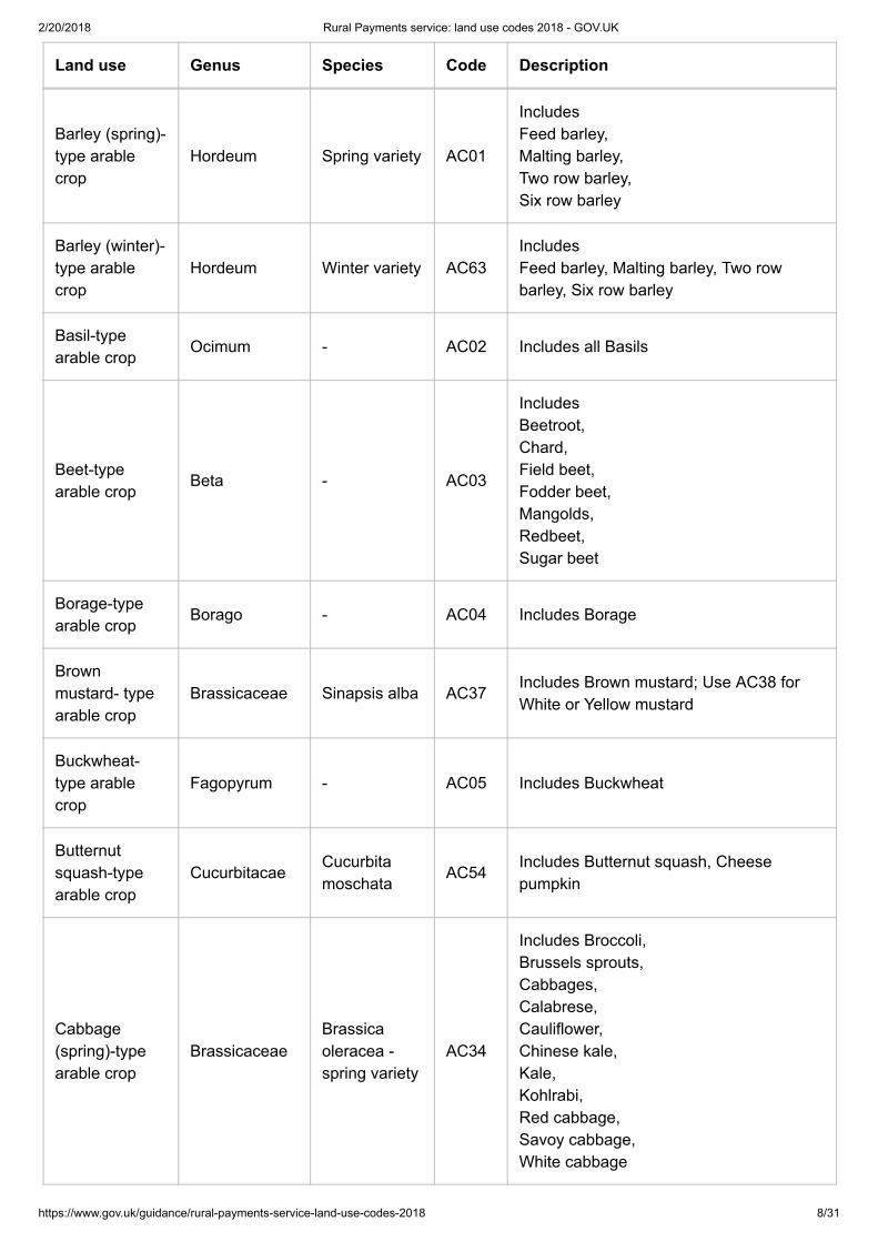
Land use Genus Species Code Description
Aster(Chinese)
Callistephus - AC97 -
Aubergine-typearable crop
SolanaceaeSolanummelongena
AC46 Includes Aubergine and Eggplant
Bananasquash- typearable crop
CucurbitacaeCucurbitamaxim
AC53Includes Banana squash and Buttercupsquash
2/20/2018 Rural Payments service: land use codes 2018 - GOV.UK
https://www.gov.uk/guidance/rural-payments-service-land-use-codes-2018 8/31
Land use Genus Species Code Description
Barley (spring)-type arablecrop
Hordeum Spring variety AC01
Includes Feed barley, Malting barley, Two row barley, Six row barley
Barley (winter)-type arablecrop
Hordeum Winter variety AC63Includes Feed barley, Malting barley, Two rowbarley, Six row barley
Basil-typearable crop
Ocimum - AC02 Includes all Basils
Beet-typearable crop
Beta - AC03
Includes Beetroot, Chard, Field beet, Fodder beet, Mangolds, Redbeet, Sugar beet
Borage-typearable crop
Borago - AC04 Includes Borage
Brownmustard- typearable crop
Brassicaceae Sinapsis alba AC37Includes Brown mustard; Use AC38 forWhite or Yellow mustard
Buckwheat-type arablecrop
Fagopyrum - AC05 Includes Buckwheat
Butternutsquash-typearable crop
CucurbitacaeCucurbitamoschata
AC54Includes Butternut squash, Cheesepumpkin
Cabbage(spring)-typearable crop
BrassicaceaeBrassicaoleracea -spring variety
AC34
Includes Broccoli, Brussels sprouts, Cabbages, Calabrese, Cauliflower, Chinese kale, Kale, Kohlrabi, Red cabbage, Savoy cabbage, White cabbage

2/20/2018 Rural Payments service: land use codes 2018 - GOV.UK
https://www.gov.uk/guidance/rural-payments-service-land-use-codes-2018 9/31
Land use Genus Species Code Description
Cabbage(winter)-typearable crop
BrassicaceaeBrassicaoleracea -winter variety
AC70
Includes Broccoli, Brussels sprouts, Cabbages, Calabrese, Cauliflower, Chinese kale, Kale, Kohlrabi, Red cabbage, Savoy cabbage, White cabbage
Camelina-typearable crop
Camelina - AC73Includes Camelina, gold-of-pleasure, false flax
Canary seed-type arablecrop
Phalaris - AC06 Includes Canary seed
Carrot-typearable crop
Daucus - AC07 Includes Carrot
Celery-typearable crop
Apium - AC08Includes Celeriac, Celery
Chicory-typearable crop
Chichorium - AC09
Includes Chicory, Endive, Italian chicory, Radiccio
Chilli-typearable crop
SolanaceaeCapsicumbaccatum
AC48 Includes chilli peppers
Coriander-typearable crop
Coriandrum - AC71 Includes Coriander
Cornchamomile-type arablecrop
Anthemisarvensis
- AC77 Includes Corn chamomile
Corn cockle-type arablecrop
Agrostemma - AC78 Includes Corn cockle

2/20/2018 Rural Payments service: land use codes 2018 - GOV.UK
https://www.gov.uk/guidance/rural-payments-service-land-use-codes-2018 10/31
Land use Genus Species Code Description
Corn flower-type arablecrop
Centaurea - AC79 Includes Corn flower
Corn gromwell-type arablecrop
Buglossoides(also known asLithospermum)
- AC72 Includes Corn gromwell
Corn marigold-type arablecrop
- - AC80 Includes Corn marigold
Crambe-typearable crop
BrassicaceaeCrambemaritima
AC39Includes Crambe, Seakale
Cress-typearable crop(excludingWatercress)
BrassicaceaeLepidiumsativu
AC89Includes Garden Cress. Use CW01 forWatercress
Cucumber-typearable crop
CucurbitacaeCucumissativus
AC56 Includes Cucumber
Daffodil-typearable crop
Narcissus - AC10 Includes all daffodils
Dill-type arablecrop
Anethum - AC11 Includes Dill
Echium Boraginacae - AC91 -
Eveningprimrose-typearable crop
Oenothera - AC12 Includes Evening primrose
Fennel-typearable crop
Foeniculum - AC13 Includes Fennel
Field forget-me- not-typearable crop
Myosotis - AC82 Includes Forget-me-not
Fox-glove-typearable crop
Digitalis - AC83 Includes Fox-glove
2/20/2018 Rural Payments service: land use codes 2018 - GOV.UK
https://www.gov.uk/guidance/rural-payments-service-land-use-codes-2018 11/31
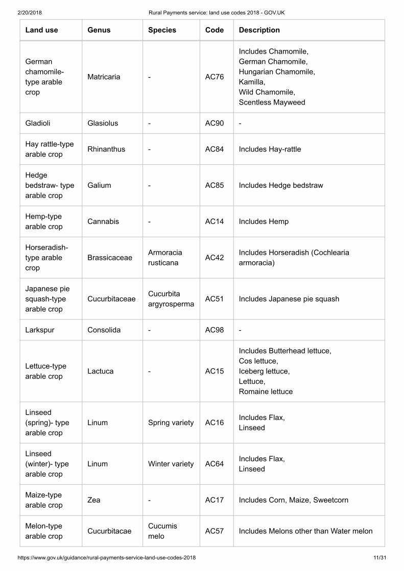
Land use Genus Species Code Description
Germanchamomile-type arablecrop
Matricaria - AC76
Includes Chamomile, German Chamomile, Hungarian Chamomile, Kamilla, Wild Chamomile, Scentless Mayweed
Gladioli Glasiolus - AC90 -
Hay rattle-typearable crop
Rhinanthus - AC84 Includes Hay-rattle
Hedgebedstraw- typearable crop
Galium - AC85 Includes Hedge bedstraw
Hemp-typearable crop
Cannabis - AC14 Includes Hemp
Horseradish-type arablecrop
BrassicaceaeArmoraciarusticana
AC42Includes Horseradish (Cochleariaarmoracia)
Japanese piesquash-typearable crop
CucurbitaceaeCucurbitaargyrosperma
AC51 Includes Japanese pie squash
Larkspur Consolida - AC98 -
Lettuce-typearable crop
Lactuca - AC15
Includes Butterhead lettuce, Cos lettuce, Iceberg lettuce, Lettuce, Romaine lettuce
Linseed(spring)- typearable crop
Linum Spring variety AC16Includes Flax, Linseed
Linseed(winter)- typearable crop
Linum Winter variety AC64Includes Flax, Linseed
Maize-typearable crop
Zea - AC17 Includes Corn, Maize, Sweetcorn
Melon-typearable crop
CucurbitacaeCucumismelo
AC57 Includes Melons other than Water melon

2/20/2018 Rural Payments service: land use codes 2018 - GOV.UK
https://www.gov.uk/guidance/rural-payments-service-land-use-codes-2018 12/31
Land use Genus Species Code Description
Millet-typearable crop
Echinochloa - AC18 Includes Millet
Mixed arablecrop - group 1
Variable Variable AC58
Mixed arable crop - you can mark up to 5different mixed crops on your land asdifferent crops. Each mixed crop will beconsidered as a separate crop for cropdiversification.
Mixed crop -group 2
Variable Variable AC59 description as crop group 1
Mixed crop -group 3
Variable Variable AC60 description as crop group 1
Mixed crop -group 4
Variable Variable AC61 description as crop group 1
Mixed crop -group 5
Variable Variable AC62 description as crop group 1
Mustard-typearable crop
Brassicaceae Sinapsis alba AC38Includes White or Yellow mustard; useAC37 for Brown mustard
Nigella Nigella - AC99 -
Oats (spring)-type arablecrop
Avena Spring variety AC19
Includes Feed oats, Naked oats, Porridge oats, Quaking oats
Oats (winter)-type arablecrop
Avena Winter variety AC65
Includes Feed oats, Naked oats, Porridge oats, Quaking oats
Oca-typearable crop
Oxalis - AC75Includes Oca, New Zealand Yam
Oilseed(spring)- typearable crop
BrassicaceaeBrassicanapus (springvariety)
AC36
Includes Industrial rape, Oilseed rape, Swede

2/20/2018 Rural Payments service: land use codes 2018 - GOV.UK
https://www.gov.uk/guidance/rural-payments-service-land-use-codes-2018 13/31
Land use Genus Species Code Description
Oilseed(winter)- typearable crop
BrassicaceaeBrassicanapus (wintervariety)
AC67
Includes Industrial rape, Oilseed rape, Swede
Onion-typearable crop
Ilium - AC20
Includes Chives, Garlic, Onions, Leeks, Scallions, Shallot, Spring Onions
Oregano-typearable crop
Origanum - AC21Includes Oregano, Marjoram
Parsley-typearable crop
Petroselinum - AC22 Includes All Parsleys
Parsnip-typearable crop
Pastinaca - AC23 Includes Parsnips
Pepper-typearable crop
SolanaceaeCapsicumannuum
AC47Includes Bell pepper, Chilli pepper
Phacelia-typearable crop
Phacelia - AC74 Includes Phacelia
Poppy-typearable crop
Papaver - AC81 Includes Poppy and Corn poppy
Potato-typearable crop
SolanaceaeSolanumtuberosum
AC44
Includes Early potato, Maincrop potato, Seed potato; use AC28 for Sweet potato
Quinoa-typearable crop
Chenopodiumquinoa
- AC87 Includes Quinoa
Radish-typearable crop
BrassicaceaeRaphanussativus
AC41 Includes Radish
Rocket-typearable crop
Brassicaceae Eruca sativa AC40 Includes Rocket

2/20/2018 Rural Payments service: land use codes 2018 - GOV.UK
https://www.gov.uk/guidance/rural-payments-service-land-use-codes-2018 14/31
Land use Genus Species Code Description
Rye (spring)-type arablecrop
Secale Spring variety AC24 Includes Rye (spring)
Rye (winter)-type arablecrop
Secale Winter variety AC68 Includes Rye (winter)
Rygrass(Italian) (Solanumsisymbriifolium)
Lolium - AC100 -
Sage-typearable crop
Salvia - AC25Includes Clary sage, Sages
Siam pumpkin-type arablecrop
CucurbitacaeCucurbitaficifolia
AC52Includes Siam pumpkin, Seven year melon
Sorghum Sorghum - AC92 -
Spelt Wheat Triticum Spelta - AC96If you are applying on line use SamphireAC96.
Spinach-typearable crop
Spinacia - AC26 Includes Spinach
Squash-typearable crop
CucurbitacaeCucurbitapepo
AC50
Includes Pumpkins, Squashes, Marrows, Zucchini, Courgettes
Strawberry-type arablecrop
Fragaria - AC27 Includes Strawberry
StickyNightshade(Solanumsisymbriifolium)
Solanum - AC93 -
Sunflower-typearable crop
Halianthus - AC88 Includes Sunflower

2/20/2018 Rural Payments service: land use codes 2018 - GOV.UK
https://www.gov.uk/guidance/rural-payments-service-land-use-codes-2018 15/31
Land use Genus Species Code Description
Sweet potato-type arablecrop
Ipomoea - AC28Includes Sweet potato; use AC44 forPotato
Sweet William Dianthus - AC94 -
Teasel-typearable crop
Dipsacus - AC86 Includes Teasel
Thyme-typearable crop
Thymus - AC29 Includes all thymes
Tobacco-typearable crop
SolanaceaeNicotianatabacum
AC43 Includes Tobacco
Tomato-typearable crop
SolanaceaeSolanumlycopersicum
AC45 Includes Tomato
Tree chilli-typearable crop
SolanaceaeCapsicumpubescens
AC49 Includes Tree chilli
Triticale(spring)- typearable crop
- Spring variety AC30 Includes Triticale (spring)
Triticale(winter)- typearable crop
- Winter variety AC69 Includes Triticale (winter)
Tulip-typearable crop
Tulipa - AC31 Includes all tulips
Turnip-typearable crop
Brassicaceae Brassica rapa AC35
Includes Bok choi, Chinese cabbage (Pak choi), Turnip, Turnip rape
Wallflower Erysimum - AC95 -
Water melon-type arablecrop
CucurbitacaeCitrulluslanatus
AC55 Includes Water melon
Watercress –arable cropunder water
BrassicaceaeNasturtiumofficinale
CW01 Includes Watercress

2/20/2018 Rural Payments service: land use codes 2018 - GOV.UK
https://www.gov.uk/guidance/rural-payments-service-land-use-codes-2018 16/31
Land use Genus Species Code Description
Wheat (spring)-type arablecrop
Triticum Spring variety AC32
Includes Biscuit wheat, Common or Bread wheat, Durum wheat, Einkorn, Feed wheat, Red wheat, Spelt
Wheat (winter)-type arablecrop
Triticum Winter variety AC66
Includes Biscuit wheat, Common or Bread wheat, Durum wheat, Einkorn, Feed wheat, Red wheat
Yam-typearable crop
Dioscorea - AC33 Includes Yam
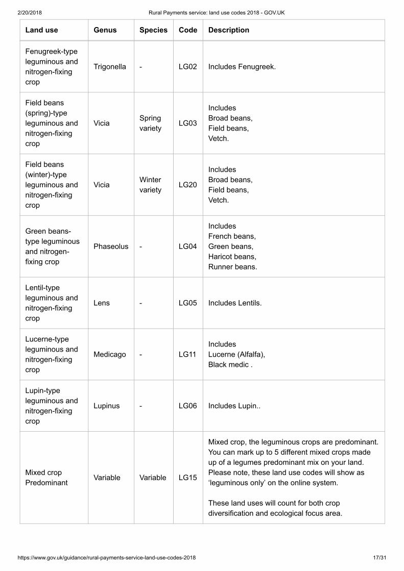
Arable land: leguminous and nitrogen-fixing crops for crop diversification and ecologicalfocus areas
Land use Genus Species Code Description
Bird’s foot trefoil-type leguminousand nitrogen-fixing crop
Lotus - LG10 Includes Bird’s foot trefoil
Chickpea-typeleguminous andnitrogen-fixingcrop
Cicer - LG01 Includes Chickpea.
Clover-typeleguminous andnitrogen-fixingcrop
Trifolium - LG14 Includes clovers and some trefoil.
Cowpea-typeleguminous andnitrogen-fixingcrop
Vigna - LG09Includes Black eye peas, Cowpeas.
2/20/2018 Rural Payments service: land use codes 2018 - GOV.UK
https://www.gov.uk/guidance/rural-payments-service-land-use-codes-2018 17/31
Land use Genus Species Code Description
Fenugreek-typeleguminous andnitrogen-fixingcrop
Trigonella - LG02 Includes Fenugreek.
Field beans(spring)-typeleguminous andnitrogen-fixingcrop
ViciaSpringvariety
LG03
Includes Broad beans, Field beans, Vetch.
Field beans(winter)-typeleguminous andnitrogen-fixingcrop
ViciaWintervariety
LG20
Includes Broad beans, Field beans, Vetch.
Green beans-type leguminousand nitrogen-fixing crop
Phaseolus - LG04
Includes French beans, Green beans, Haricot beans, Runner beans.
Lentil-typeleguminous andnitrogen-fixingcrop
Lens - LG05 Includes Lentils.
Lucerne-typeleguminous andnitrogen-fixingcrop
Medicago - LG11Includes Lucerne (Alfalfa), Black medic .
Lupin-typeleguminous andnitrogen-fixingcrop
Lupinus - LG06 Includes Lupin..
Mixed cropPredominant
Variable Variable LG15
Mixed crop, the leguminous crops are predominant.You can mark up to 5 different mixed crops madeup of a legumes predominant mix on your land.Please note, these land use codes will show as‘leguminous only’ on the online system.
These land uses will count for both cropdiversification and ecological focus area.

2/20/2018 Rural Payments service: land use codes 2018 - GOV.UK
https://www.gov.uk/guidance/rural-payments-service-land-use-codes-2018 18/31
Land use Genus Species Code Description
Mixed cropPredominant
Variable Variable LG16 description as Mixed crop Predominant
Mixed cropPredominant
Variable Variable LG17 description as Mixed crop Predominant
Mixed cropPredominant
Variable Variable LG18 description as Mixed crop Predominant
Mixed cropPredominant
Variable Variable LG19 description as Mixed crop Predominant
Pea (spring)-type leguminousand nitrogen-fixing crop
PisumSpringvariety
LG07
Includes Feed pea, Mange tout, Marrow fat pea, Snap pea, Snow pea, Vining pea.
Pea (winter)-type leguminousand nitrogen-fixing crop
PisumWintervariety
LG21
Includes Feed pea, Mange tout, Marrow fat pea, Snap pea, Snow pea, Vining pea.
Sainfoin-typeleguminous andnitrogen-fixingcrop
- - LG13 Includes sainfoin.
Soya-typeleguminous andnitrogen-fixingcrop
Glycine - LG08Includes Soya bean, Soybean.
Sweet clover-type leguminousand nitrogen-fixing crop
Melilotus - LG12 Includes sweet clover.
Arable land: catch and cover crops for ecological focus areas
Landuse Code Description

2/20/2018 Rural Payments service: land use codes 2018 - GOV.UK
https://www.gov.uk/guidance/rural-payments-service-land-use-codes-2018 19/31
Landuse Code Description
CatchCrop
CA01Any catch crop that is eligible under the ecological focus area rule. Read the BPS 2018scheme rules (https://www.gov.uk/guidance/bps-2018) for more information.
CoverCrop
CA02Any cover crop that is eligible under the ecological focus area rule. Read the BPS 2018scheme rules (https://www.gov.uk/guidance/bps-2018) for more information.
These two codes should only be used in ‘rotation 2’ for online applications. In Part D of the paper form you justneed to claim the area under the correct column.
Dual use
If you are in a ‘dual use’ situation with another BPS applicant – the other applicant has the land at theirdisposal for BPS and you have the same area of land under your management control for a RuralDevelopment Programme agreement, you must agree the land-use code for the land parcel with the otherclaimant - make sure it is compatible with both BPS and CS / ES agreements. Once this is agreed, the land-use code should not be changed unless you both agree with the change.
Then, you need to do one of the following if you are:
Claiming BPS on the land parcel: claim on the land parcel. The person who IS NOT claiming BPS on theland parcel, but applying for BPS on other land, should make sure that they do not activate the landparcel for payment. If they apply online, use the ‘activate less BPS area’ screen to show the ‘eligiblearea’ as 0.0000. If they apply on paper, declare the area in column C8 as 0.00ha.Claiming Countryside Stewardship or Environmental Stewardship and someone else is claiming BPS onthe same area: if you are claiming BPS on other land parcels and applying online, use the ‘activate lessBPS area’ screen so you do not activate the land parcel for payment on your BPS application. Or, if youare applying on paper, declare the area in column C8 as 0.00ha.
Agricultural land under a Rural Development Programme agreement
If you have agricultural land which is under your management control for a Rural Development Programmeagreement and at your disposal for BPS use the appropriate codes to tell us about this land.
If you have agricultural land which is under your management control for a Rural Development Programmeagreement and is not at your disposal for BPS, read the information above about ‘Dual use’.
Non-agricultural land
Non-agricultural areas and features on otherwise eligible land
You can tell us about non-agricultural areas and features on agricultural land in your online application usingland use codes.
You also need to tell us about these features on any non-agricultural land you have that is eligible for BPS –read the ‘Non-agricultural land under a Rural Development Programme agreement or the National ForestChanging Landscape Scheme, Woodland Carbon Fund, HS2 Woodland fund’ below for more information.
Declare BPS permanent non-agricultural areas or features using the land use codes below.
2/20/2018 Rural Payments service: land use codes 2018 - GOV.UK
https://www.gov.uk/guidance/rural-payments-service-land-use-codes-2018 20/31
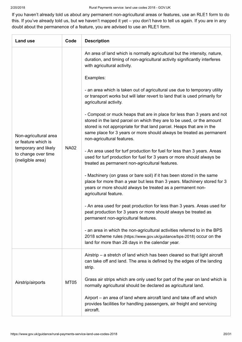
If you haven’t already told us about any permanent non-agricultural areas or features, use an RLE1 form to dothis. If you’ve already told us, but we haven’t mapped it yet – you don’t have to tell us again. If you are in anydoubt about the permanence of a feature, you are advised to use an RLE1 form.
Land use Code Description
Non-agricultural areaor feature which istemporary and likelyto change over time(ineligible area)
NA02
An area of land which is normally agricultural but the intensity, nature,duration, and timing of non-agricultural activity significantly interfereswith agricultural activity.
Examples:
- an area which is taken out of agricultural use due to temporary utilityor transport works but will later revert to land that is used primarily foragricultural activity.
- Compost or muck heaps that are in place for less than 3 years and notstored in the land parcel on which they are to be used, or the amountstored is not appropriate for that land parcel. Heaps that are in thesame place for 3 years or more should always be treated as permanentnon-agricultural features.
- An area used for turf production for fuel for less than 3 years. Areasused for turf production for fuel for 3 years or more should always betreated as permanent non-agricultural features.
- Machinery (on grass or bare soil) if it has been stored in the sameplace for more than a year but less than 3 years. Machinery stored for 3years or more should always be treated as a permanent non-agricultural feature.
- An area used for peat production for less than 3 years. Areas used forpeat production for 3 years or more should always be treated aspermanent non-agricultural features.
- an area in which the non-agricultural activities referred to in the BPS2018 scheme rules (https://www.gov.uk/guidance/bps-2018) occur on theland for more than 28 days in the calendar year.
Airstrip/airports MT05
Airstrip – a stretch of land which has been cleared so that light aircraftcan take off and land. The area is defined by the edges of the landingstrip.
Grass air strips which are only used for part of the year on land which isnormally agricultural should be declared as agricultural land.
Airport – an area of land where aircraft land and take off and whichprovides facilities for handling passengers, air freight and servicingaircraft.

2/20/2018 Rural Payments service: land use codes 2018 - GOV.UK
https://www.gov.uk/guidance/rural-payments-service-land-use-codes-2018 21/31
Land use Code Description
Non-utilised Bank PL01
This code should only be used for banks which are inaccessible or notprotected under cross compliance.
A bank is a raised linear feature that is artificially constructed andpredominantly made up of earth. A bank can have a vegetated, bareearth or stone surface.
Bog IW07An area of land that is normally waterlogged throughout the year andconsists of spongy moss and peat. Bogs most often occur in low lyingflat areas with poor drainage, and in upland areas of high rainfall.
Boulders RO03An area of large, rounded rocks that are weathered or water-worn andhave a diameter that is greater than 0.2 metres.
Bracken, heather andheathland
HE02
Bracken - this code should only be used for an area of bracken which isnot kept in a state suitable for grazing or is in an area where grassesand other herbaceous forage are not predominant.
Grazeable bracken in an area where grasses and other herbaceousforage remain predominant should be coded as permanent grassland.
Bracken is an area covered predominantly by a type of fern (Pteridiumaquilinum) found together with other species in heathland or hill sides.See also ‘Scattered bracken or heather’.
Heather - this code should only be used for an area of heather which isnot kept in a state suitable for grazing.
Grazeable heather should be coded as permanent grassland.
Heather is an area covered predominantly by common heather andvarious species of the Cassiope or Erica genus. See also ‘Scatteredbracken or heather’.
Cliff CF01
A feature representing a steep rock face, most commonly occurringwhere the land meets the sea. Cliffs may be semi-natural, in the case ofdisused mineral workings, or manmade in the case of rock facesresulting from construction activity.
Farm building AB01A building used for livestock husbandry, cultivation or the storage ofcrops, feed and machinery, and associated residences, i.e. farmhouses.
Farmyard AB09The open ground, generally of hard standing or compacted earth,surrounding farm buildings.
Fen, marsh andswamp
IW06 An area of low and flat waterlogged land.
2/20/2018 Rural Payments service: land use codes 2018 - GOV.UK
https://www.gov.uk/guidance/rural-payments-service-land-use-codes-2018 22/31
Land use Code Description
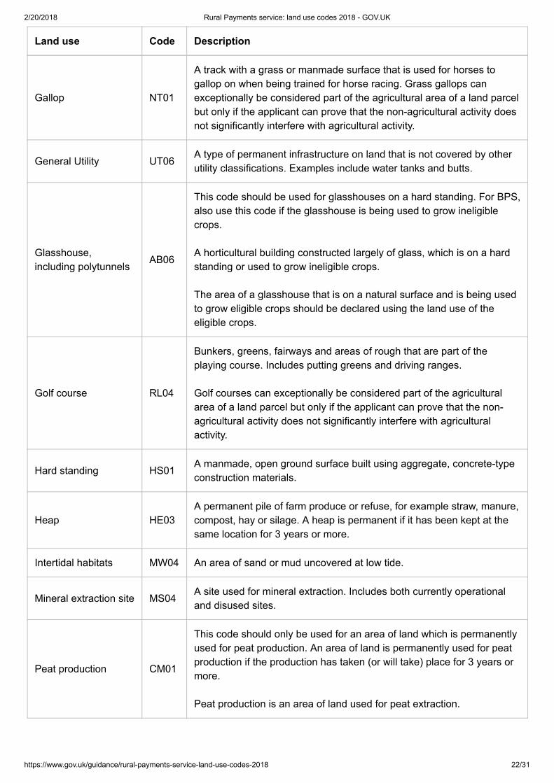
Gallop NT01
A track with a grass or manmade surface that is used for horses togallop on when being trained for horse racing. Grass gallops canexceptionally be considered part of the agricultural area of a land parcelbut only if the applicant can prove that the non-agricultural activity doesnot significantly interfere with agricultural activity.
General Utility UT06A type of permanent infrastructure on land that is not covered by otherutility classifications. Examples include water tanks and butts.
Glasshouse,including polytunnels
AB06
This code should be used for glasshouses on a hard standing. For BPS,also use this code if the glasshouse is being used to grow ineligiblecrops.
A horticultural building constructed largely of glass, which is on a hardstanding or used to grow ineligible crops.
The area of a glasshouse that is on a natural surface and is being usedto grow eligible crops should be declared using the land use of theeligible crops.
Golf course RL04
Bunkers, greens, fairways and areas of rough that are part of theplaying course. Includes putting greens and driving ranges.
Golf courses can exceptionally be considered part of the agriculturalarea of a land parcel but only if the applicant can prove that the non-agricultural activity does not significantly interfere with agriculturalactivity.
Hard standing HS01A manmade, open ground surface built using aggregate, concrete-typeconstruction materials.
Heap HE03A permanent pile of farm produce or refuse, for example straw, manure,compost, hay or silage. A heap is permanent if it has been kept at thesame location for 3 years or more.
Intertidal habitats MW04 An area of sand or mud uncovered at low tide.
Mineral extraction site MS04A site used for mineral extraction. Includes both currently operationaland disused sites.
Peat production CM01
This code should only be used for an area of land which is permanentlyused for peat production. An area of land is permanently used for peatproduction if the production has taken (or will take) place for 3 years ormore.
Peat production is an area of land used for peat extraction.
2/20/2018 Rural Payments service: land use codes 2018 - GOV.UK
https://www.gov.uk/guidance/rural-payments-service-land-use-codes-2018 23/31
Land use Code Description
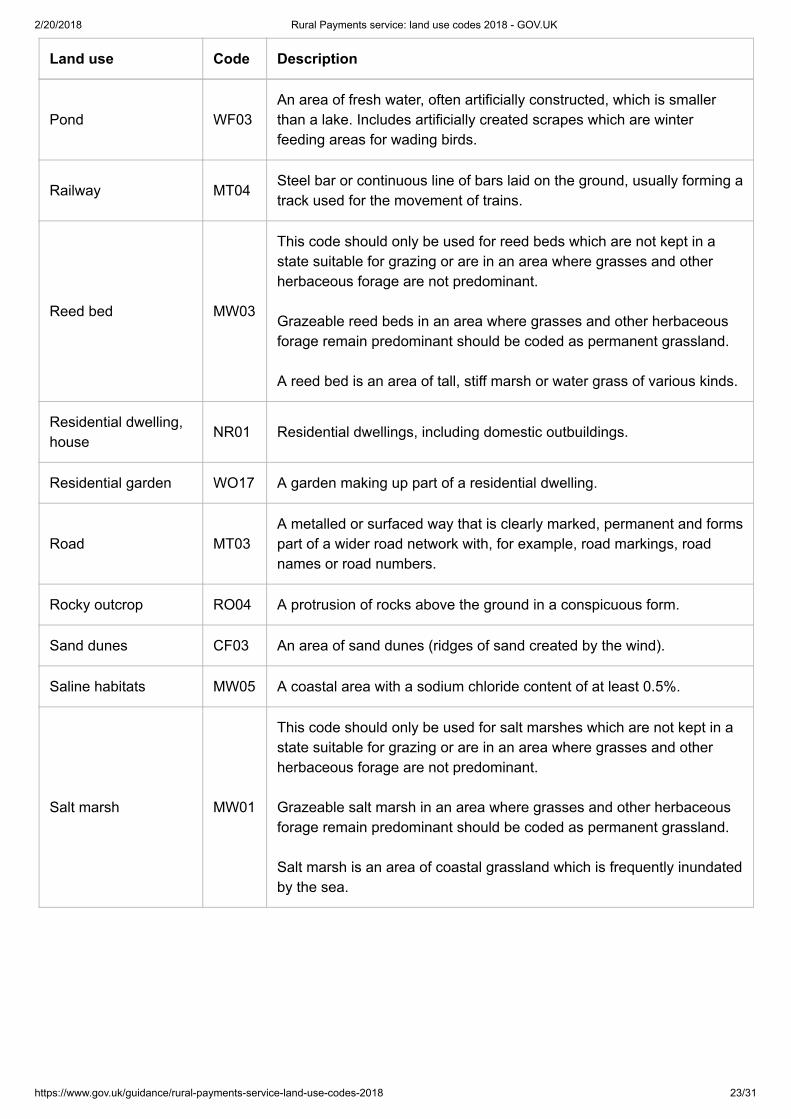
Pond WF03An area of fresh water, often artificially constructed, which is smallerthan a lake. Includes artificially created scrapes which are winterfeeding areas for wading birds.
Railway MT04Steel bar or continuous line of bars laid on the ground, usually forming atrack used for the movement of trains.
Reed bed MW03
This code should only be used for reed beds which are not kept in astate suitable for grazing or are in an area where grasses and otherherbaceous forage are not predominant.
Grazeable reed beds in an area where grasses and other herbaceousforage remain predominant should be coded as permanent grassland.
A reed bed is an area of tall, stiff marsh or water grass of various kinds.
Residential dwelling,house
NR01 Residential dwellings, including domestic outbuildings.
Residential garden WO17 A garden making up part of a residential dwelling.
Road MT03A metalled or surfaced way that is clearly marked, permanent and formspart of a wider road network with, for example, road markings, roadnames or road numbers.
Rocky outcrop RO04 A protrusion of rocks above the ground in a conspicuous form.
Sand dunes CF03 An area of sand dunes (ridges of sand created by the wind).
Saline habitats MW05 A coastal area with a sodium chloride content of at least 0.5%.
Salt marsh MW01
This code should only be used for salt marshes which are not kept in astate suitable for grazing or are in an area where grasses and otherherbaceous forage are not predominant.
Grazeable salt marsh in an area where grasses and other herbaceousforage remain predominant should be coded as permanent grassland.
Salt marsh is an area of coastal grassland which is frequently inundatedby the sea.
2/20/2018 Rural Payments service: land use codes 2018 - GOV.UK
https://www.gov.uk/guidance/rural-payments-service-land-use-codes-2018 24/31
Land use Code Description
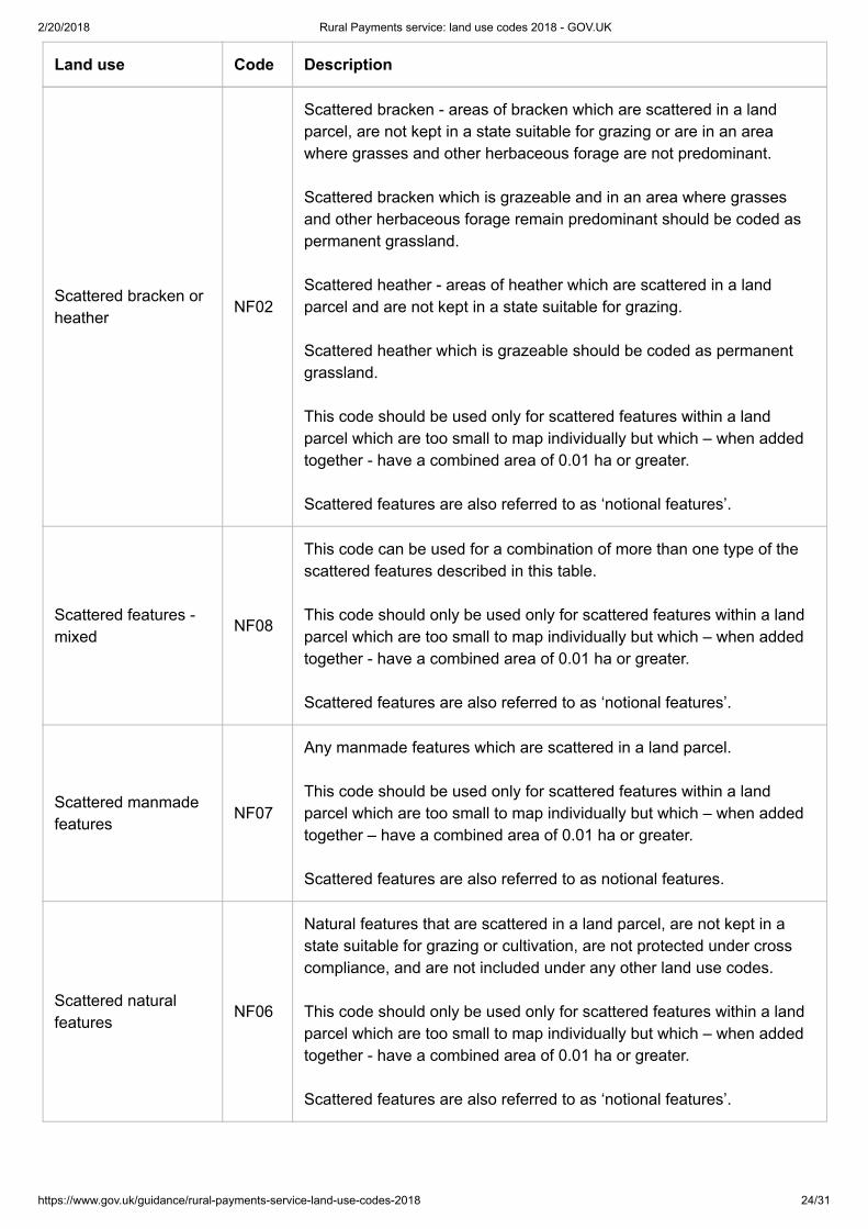
Scattered bracken orheather
NF02
Scattered bracken - areas of bracken which are scattered in a landparcel, are not kept in a state suitable for grazing or are in an areawhere grasses and other herbaceous forage are not predominant.
Scattered bracken which is grazeable and in an area where grassesand other herbaceous forage remain predominant should be coded aspermanent grassland.
Scattered heather - areas of heather which are scattered in a landparcel and are not kept in a state suitable for grazing.
Scattered heather which is grazeable should be coded as permanentgrassland.
This code should be used only for scattered features within a landparcel which are too small to map individually but which – when addedtogether - have a combined area of 0.01 ha or greater.
Scattered features are also referred to as ‘notional features’.
Scattered features -mixed
NF08
This code can be used for a combination of more than one type of thescattered features described in this table.
This code should only be used only for scattered features within a landparcel which are too small to map individually but which – when addedtogether - have a combined area of 0.01 ha or greater.
Scattered features are also referred to as ‘notional features’.
Scattered manmadefeatures
NF07
Any manmade features which are scattered in a land parcel.
This code should be used only for scattered features within a landparcel which are too small to map individually but which – when addedtogether – have a combined area of 0.01 ha or greater.
Scattered features are also referred to as notional features.
Scattered naturalfeatures
NF06
Natural features that are scattered in a land parcel, are not kept in astate suitable for grazing or cultivation, are not protected under crosscompliance, and are not included under any other land use codes.
This code should only be used only for scattered features within a landparcel which are too small to map individually but which – when addedtogether - have a combined area of 0.01 ha or greater.
Scattered features are also referred to as ‘notional features’.
2/20/2018 Rural Payments service: land use codes 2018 - GOV.UK
https://www.gov.uk/guidance/rural-payments-service-land-use-codes-2018 25/31
Land use Code Description
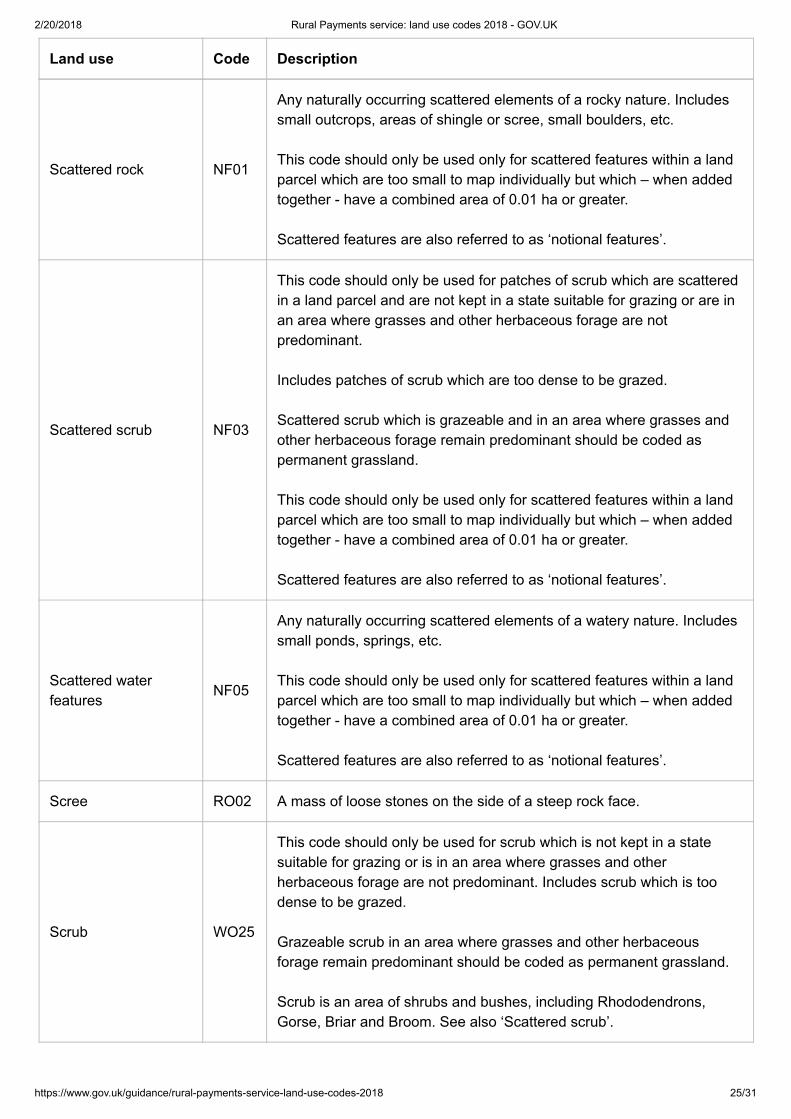
Scattered rock NF01
Any naturally occurring scattered elements of a rocky nature. Includessmall outcrops, areas of shingle or scree, small boulders, etc.
This code should only be used only for scattered features within a landparcel which are too small to map individually but which – when addedtogether - have a combined area of 0.01 ha or greater.
Scattered features are also referred to as ‘notional features’.
Scattered scrub NF03
This code should only be used for patches of scrub which are scatteredin a land parcel and are not kept in a state suitable for grazing or are inan area where grasses and other herbaceous forage are notpredominant.
Includes patches of scrub which are too dense to be grazed.
Scattered scrub which is grazeable and in an area where grasses andother herbaceous forage remain predominant should be coded aspermanent grassland.
This code should only be used only for scattered features within a landparcel which are too small to map individually but which – when addedtogether - have a combined area of 0.01 ha or greater.
Scattered features are also referred to as ‘notional features’.
Scattered waterfeatures
NF05
Any naturally occurring scattered elements of a watery nature. Includessmall ponds, springs, etc.
This code should only be used only for scattered features within a landparcel which are too small to map individually but which – when addedtogether - have a combined area of 0.01 ha or greater.
Scattered features are also referred to as ‘notional features’.
Scree RO02 A mass of loose stones on the side of a steep rock face.
Scrub WO25
This code should only be used for scrub which is not kept in a statesuitable for grazing or is in an area where grasses and otherherbaceous forage are not predominant. Includes scrub which is toodense to be grazed.
Grazeable scrub in an area where grasses and other herbaceousforage remain predominant should be coded as permanent grassland.
Scrub is an area of shrubs and bushes, including Rhododendrons,Gorse, Briar and Broom. See also ‘Scattered scrub’.

2/20/2018 Rural Payments service: land use codes 2018 - GOV.UK
https://www.gov.uk/guidance/rural-payments-service-land-use-codes-2018 26/31
Land use Code Description
Shingle IW05 An area of small, rounded pebbles.
Stone wall BB01
This code should only be used for stone walls which are not protectedunder cross compliance.
Stone walls protected under cross compliance should be coded usingthe land use code for the main land use of the parcel.
A stone wall is a wall structure built with stones, traditionally with loosefield stones and mortar.
Solar panels UT01
An area taken up by solar panels and solar panel arrays.
Land parcels which contain solar panels are ineligible for BPS. If thepanels are concentrated in one end of a field, the rest of the land can beeligible if the 2 areas are registered as individual land parcels andseparated by a permanent boundary.
Sports and recreation RL03 An area of land used for permanent sports and recreational activities.
Storage area SA02An area of bare earth that is used for storage purposes. Includesstorage of farm-related machinery, hay bales, etc.
Structure ST05A manmade structure that is not described under any other land usecode. Examples include animal shelters or polytunnels on a hardstanding.
Tidal areas MW02 Tidal areas other than salt marshes.
Track - naturalsurface
NT03
This code should only be used for a natural, unsurfaced track or pathwhich is not used as part of the agricultural activity carried out on theland parcel or is part of a transport network entering and exiting the landparcel.
Natural paths and tracks which are used as part of the agriculturalactivity carried out on the land parcel and are not part of a transportnetwork entering and exiting the land parcel should be coded using theland use code for the main land use of the parcel.
Manmade track(Metalled)
MT01A metalled or surfaced way that is clearly marked and permanent.Includes any manmade surface, such as areas of asphalt, concrete andgravel.

2/20/2018 Rural Payments service: land use codes 2018 - GOV.UK
https://www.gov.uk/guidance/rural-payments-service-land-use-codes-2018 27/31
Land use Code Description
Turf production CM02
This code should only be used for a site which is permanently used forthe production of turf for fuel. A site is permanently used for theproduction of turf for fuel if the production has taken (or will take) placefor 3 years or more.
Turf for later replanting will be considered part of the agricultural area ofthe land parcel and should be coded as either permanent grassland ortemporary grassland.
Turf production is a site used for the production of turf, a surface layerof earth containing a dense growth of grass and its roots.
Vegetated shingle CF02 An area of water-worn pebbles which supports growth of vegetation.
Watercourse - ditch,drain or dyke
WF01
This code should only be used for a drain, ditch or dyke which is insidethe land parcel and is not part of the parcel boundary.
A drain, ditch or dyke is an artificial channel used to carry excess waterfrom low-lying areas.
Watercourse - river orstream (Rivers andStreams Type 2)
IW02
This code should only be used for a river or stream which:
- is inside the land parcel and is not part of the parcel boundary.
- is less than 4 metres wide over the majority of its length.
A river or stream is a body of water flowing in a definite channel towardsthe sea, a lake or into another river.
Watercourse - river orstream (Rivers andStreams Type 3)
IW03
This code should only be used for a river or stream which:
- is inside the land parcel and is not part of the parcel boundary
- is greater than, or equal to, 4 metres wide over the majority of itslength
A river or stream is a body of water flowing in a definite channel towardsthe sea, a lake or into another river.
Water treatmentworks
UT07 A site where water is treated and supplied.
Woodland WO12An area of woodland preventing agricultural activity. Includes areaswhere the density of the trees prevents the growth of vegetative under-storey needed to support agricultural activity.
Non-agricultural land under a Rural Development Programme agreement or the NationalForest Changing Landscapes Scheme, Woodland Carbon Fund, HS2 Woodland Fund
2/20/2018 Rural Payments service: land use codes 2018 - GOV.UK
https://www.gov.uk/guidance/rural-payments-service-land-use-codes-2018 28/31
Non-agricultural land used with entitlements to claim for SPS in 2008 and currently in certain RuralDevelopment Programme agreements or the National Forest Changing Landscapes Scheme, the WoodlandCarbon Fund or the HS2 Woodland Fund can still be eligible for BPS.
This land may have been coded as ‘SA2’ or ‘SA3’ on your SPS claim. Read page 26 of the BPS 2018 schemerules (https://www.gov.uk/guidance/bps-2018) for more information. You need to include all of the land uses for theland parcel in your ‘Land use’ screen on the Rural Payments service. The non-agricultural land that is eligiblefor BPS will not count towards greening.
Other non-agricultural land under these schemes is not eligible for BPS. However, you still need to enter it inyour application. If you have land of this type, use an appropriate land use code.
This land will not count towards your area available to use entitlements, or towards greening.
Use the following code to tell us about any non-agricultural land you are claiming under a Rural DevelopmentProgramme agreement or the National Forest Changing Landscapes Scheme, the Woodland Carbon Fund orthe HS2 Woodland Fund that is eligible for BPS.
Landuse Code
RD01
Non-agricultural land, for example woodland, which is at your disposal and remains eligible forBPS because it is under a suitable Rural Development Programme agreement or the NationalForest Changing Landscape Scheme, the Woodland Carbon Fund or the HS2 Woodland Fundand was used with entitlements to claim SPS in 2008. Woodland scheme agreement holdersneed to refer to Forestry Commission guidance ON42(https://www.forestry.gov.uk/pdf/ON042_v2.pdf/%24FILE/ON042_v2.pdf) for details about how to amendthe Land cover to enable these areas to be claimed on for BPS.
Codes you must not use
There are some land use codes which appear in the Rural Payments service which you should not use in yourBPS application.
The table below shows which codes not to use, and which to use instead:
Code What code to use instead
ES01 - Real estateservices
This code does not relate to land and is for RPA use only.
NF04 - Scattered trees
If the area with scattered trees in is eligible, you don’t need to declare it as aseparate ‘land use’ with its own land use code. Instead, include its area withinthe main land use of the parcel it is in. If the area with scattered trees in isineligible, use the code ‘WO12 – Ineligible woodland’.
AS01 – Archaeologicalsite
Use the code which best describes the land which the archaeological site is on.

2/20/2018 Rural Payments service: land use codes 2018 - GOV.UK
https://www.gov.uk/guidance/rural-payments-service-land-use-codes-2018 29/31
Code What code to use instead
PL02
If the area is eligible, use one of the following: FA01 – Fallow
PG01 - Permanent Grassland
If the area is ineligible, use the relevant code from the ‘Ineligible areas andfeatures on otherwise eligible land’ list above.
BF01 - Stone wallprotected under crosscompliance
You don’t need to declare it as a separate ‘land use’ with its own land usecode. Instead, include its area within the main land use of the parcel it is in.
BF02 - Hedge protectedunder cross compliance
You don’t need to declare it as a separate ‘land use’ with its own land usecode. Instead, include its area within the main land use of the parcel it is in.
AB03 - Animal shelteron bare soil
You don’t need to declare it as a separate ‘land use’ with its own land usecode. Instead, include its area within the main land use of the parcel it is in.
IW01 - Rivers andstreams less than 4metres in width andforming part of aboundary (type 1)
You don’t need to declare it as a separate ‘land use’ with its own land usecode. Instead, include its area within the main land use of the parcel it is in.
IW11 - Drain/Ditch/Dykeless than 4 metres inwidth and forming partof a boundary
You don’t need to declare it as a separate ‘land use’ with its own land usecode. Instead, include its area within the main land use of the parcel it is in.
BF08 - BankYou don’t need to declare it as a separate ‘land use’ with its own land usecode. Instead, include its area within the main land use of the parcel it is in.
BF16 - FenceYou don’t need to declare it as a separate ‘land use’ with its own land usecode. Instead, include its area within the main land use of the parcel it is in.
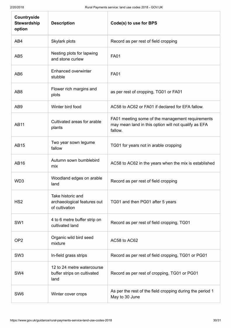
Codes for Countryside Stewardship options with multiple crops
CountrysideStewardshipoption
Description Code(s) to use for BPS
AB1 Nectar flower mix as per rest of cropping, FA01 or TG01
AB3 Beetle banks Record as per rest of field cropping
2/20/2018 Rural Payments service: land use codes 2018 - GOV.UK
https://www.gov.uk/guidance/rural-payments-service-land-use-codes-2018 30/31
CountrysideStewardshipoption
Description Code(s) to use for BPS
AB4 Skylark plots Record as per rest of field cropping
AB5Nesting plots for lapwingand stone curlew
FA01
AB6Enhanced overwinterstubble
FA01
AB8Flower rich margins andplots
as per rest of cropping, TG01 or FA01
AB9 Winter bird food AC58 to AC62 or FA01 if declared for EFA fallow.
AB11Cultivated areas for arableplants
FA01 meeting some of the management requirementsmay mean land in this option will not qualify as EFAfallow.
AB15Two year sown legumefallow
TG01 for years not in arable cropping
AB16Autumn sown bumblebirdmix
AC58 to AC62 in the years when the mix is established
WD3Woodland edges on arableland
Record as per rest of field cropping
HS2Take historic andarchaeological features outof cultivation
TG01 and then PG01 after 5 years
SW14 to 6 metre buffer strip oncultivated land
Record as per rest of field cropping, TG01
OP2Organic wild bird seedmixture
AC58 to AC62
SW3 In-field grass strips Record as per rest of field cropping, TG01 or PG01
SW412 to 24 metre watercoursebuffer strips on cultivatedland
Record as per rest of cropping, TG01 or PG01
SW6 Winter cover cropsAs per the rest of the field cropping during the period 1May to 30 June

2/20/2018 Rural Payments service: land use codes 2018 - GOV.UK
https://www.gov.uk/guidance/rural-payments-service-land-use-codes-2018 31/31
CountrysideStewardshipoption
Description Code(s) to use for BPS
WT2Buffering in-field ponds andditches on arable land
Record as per rest of cropping, TG01 or PG01
Published 20 February 2018
Is this page useful?
Yes this page is useful (https://www.gov.uk/contact/govuk) No this page is not useful(https://www.gov.uk/contact/govuk) Is there anything wrong with this page? (https://www.gov.uk/contact/govuk)Thank you for your feedbackClose
Help us improve GOV.UK
Don’t include personal or financial information like your National Insurance number or credit card details.
What were you doing?
What went wrong? Send
Close
Help us improve GOV.UK
To help us improve GOV.UK, we’d like to know more about your visit today. We’ll send you a link to a feedbackform. It will take only 2 minutes to fill in. Don’t worry we won’t send you spam or share your email address withanyone.
Email address Send me the survey Don’t have an email address?
(https://www.smartsurvey.co.uk/s/gov-uk-banner/?c=/guidance/rural-payments-service-land-use-codes-2018&gcl=1627485790.1515403243)