geneva road area-wide plan · introduction the imagine orem: geneva road area‐wide plan (awp)...
TRANSCRIPT

GGENEVA
A ROADReview
D AREA of Plans Re
A-WIDE eport
PLAN

IMAGIN
TABLE
INTRODUCTIO
BROWNFIELD
BROWNFIELD
PROJECT ARE
COMMUNITY
REVIEW OF E
OREM GE
OREM TR
ECONOM
STATE ST
GENEVA H
ASPEN AN
NE OREM: GENE
OF CON
ON ..................
DS ....................
D AREA‐WIDE PLA
EA ...................
Y PROFILE ..........
EXISTING PLANS ..
ENERAL PLAN 201
RANSPORTATION M
IC DEVELOPMENT
REET CORRIDOR M
HEIGHTS, OREM P
ND TIMPVIEW NE
EVA ROAD AREA
NTENTS .......................
.......................
ANNING PROGRA
.......................
.......................
.......................
11 (LAST AMENDE
MASTER PLAN (2
T STRATEGIC PLAN
MASTER PLAN (2
PARK, SUNCREST
IGHBORHOOD PLA
A‐WIDE PLAN
.......................
.......................
M ....................
.......................
.......................
.......................
ED 2016) ..........
015) ................
N (2014) ..........
017) ................
NEIGHBORHOOD
AN (2017) ........
.......................
.......................
.......................
.......................
.......................
.......................
.......................
.......................
.......................
.......................
D PLAN (2017) ...
.......................
.......................
.......................
.......................
.......................
.......................
.......................
.......................
.......................
.......................
.......................
.......................
.......................
P
........................
........................
........................
........................
........................
........................
........................
........................
........................
........................
........................
........................
Prepared for t
.......................
.......................
.......................
.......................
.......................
.......................
.......................
.......................
.......................
.......................
.......................
.......................
the City of Ore
........ 1
........ 1
........ 2
........ 4
........ 4
........ 6
........ 6
........ 7
...... 12
...... 13
...... 14
...... 15
em by

INTRODUCTION The Imagine Orem: Geneva Road Area‐Wide Plan (AWP) area is a predominately industrial corridor on
the western border of the City. This area has served as an important employment center for the City and
County since the 1940s, as it grew around the Geneva Steel plant (formerly located across Geneva Road
in the city of Vineyard). Geneva Steel was constructed by the United States government in 1912 and was
purchased by United States Steel Division (US Steel) in 1946. The Geneva Heights, Suncrest, and Orem
Park neighborhoods in the eastern part of the GRA was the original housing constructed for Geneva
Steel workers during the 1940s and 1950s. Since 2001, the majority of the former Geneva Steel
structures have been demolished and in recent years redevelopment has occurred.
Despite the challenges posed by the closure of Geneva Steel and the resulting loss of jobs, Geneva Road
retains significant assets and redevelopment potential. The area has excellent transportation
infrastructure, including access to Interstate 15, the Orem Intermodal Center (currently served by UTA
FrontRunner commuter rail and planned for MAX bus rapid transit line) and two freight rail lines (the
Union Pacific and Denver Rio Grande). The area also benefits from its proximity to a highly educated
workforce and educational opportunities. Finally, the area has benefitted from multiple long‐range
planning studies over the past ten years, ranging from the City‐wide Orem General Plan and Economic
Development Strategic Plan, to neighborhood‐level plans and redevelopment reports. This report
examines some of these in detail and relates their significance to the current Area‐Wide Planning effort.
BROWNFIELDS The EPA defines brownfields as “real property, the expansion, redevelopment or reuse of which may be
complicated by the presence or potential presence of a hazardous substance, pollutant or contaminant”.
The cleanup of Brownfields sites improves and protects the environment and may result in many
benefits for the local community, including:
• community involvement in the project, • job creation, and • an increase in nearby property values once a brownfield site is assessed or cleaned up.
According to a 2005 report by Envision Utah, investing in the re‐use of brownfield sites is an important
component of a municipal economic development strategy. Employers may be reluctant to locate their
business on a brownfield site because of potential liability, cost of clean‐up and the additional time
required to conduct clean‐up activities. However, because brownfields are often located in desirable,
close‐in areas, require limited new infrastructure, and provide easy access to transportation and
housing, they are a valuable resource to be developed. 1
1 Flynn, Erin. “Thinking and Acting Regionally in the Greater Wasatch Area: Implications for Local Economic Development Practice.” Envision Utah. 2005.
IMAGIN
BROW
The EPA B
and non‐p
where co
residents,
According
communit
than a site
infrastruc
short‐ and
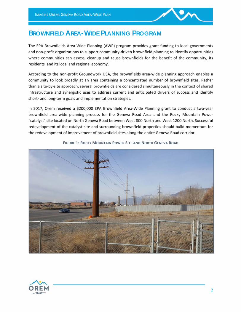
In 2017, O
brownfiel
“catalyst”
redevelop
the redev
NE OREM: GENE
WNFIELD ABrownfields A
profit organiz
ommunities c
, and its local
g to the non‐
ty to look br
e‐by‐site app
cture and syn
d long‐term g
Orem receive
d area‐wide
” site located
pment of the
velopment of
FIG
EVA ROAD AREA
AREA-WArea‐Wide Pl
zations to sup
an assess, cl
and regional
‐profit Groun
roadly at an
roach, severa
nergistic uses
goals and imp
ed a $200,00
planning pr
on North Gen
catalyst site
improvemen
GURE 1: ROCKY
A‐WIDE PLAN
WIDE PLAN
anning (AWP
pport commu
eanup and re
economy.
dwork USA, t
area contain
al brownfield
s to address
lementation
00 EPA Brown
ocess for th
neva Road be
and surroun
t of brownfie
Y MOUNTAIN P
NNING PP) program p
nity‐driven b
euse brownf
the brownfie
ing a concen
s are conside
current and
strategies.
nfield Area‐W
e Geneva Ro
etween West
nding brownfi
eld sites along
POWER SITE A
PROGRAM
rovides grant
rownfield pla
ields for the
elds area‐wid
ntrated numb
ered simultan
anticipated d
Wide Planning
oad Area an
800 North an
ield propertie
g the entire G
AND NORTH GE
M t funding to
anning to ide
benefit of t
e planning ap
ber of brown
neously in the
drivers of su
g grant to co
d the Rocky
nd West 1200
es should bu
Geneva Road
ENEVA ROAD
local governm
ntify opportu
he communit
pproach enab
nfield sites. R
e context of s
ccess and id
onduct a two
Mountain P
0 North. Succ
ild momentu
corridor.
2
ments
unities
ty, its
bles a
Rather
hared
entify
o‐year
Power
essful
m for
IMAGINNE OREM: GENEEVA ROAD AREA
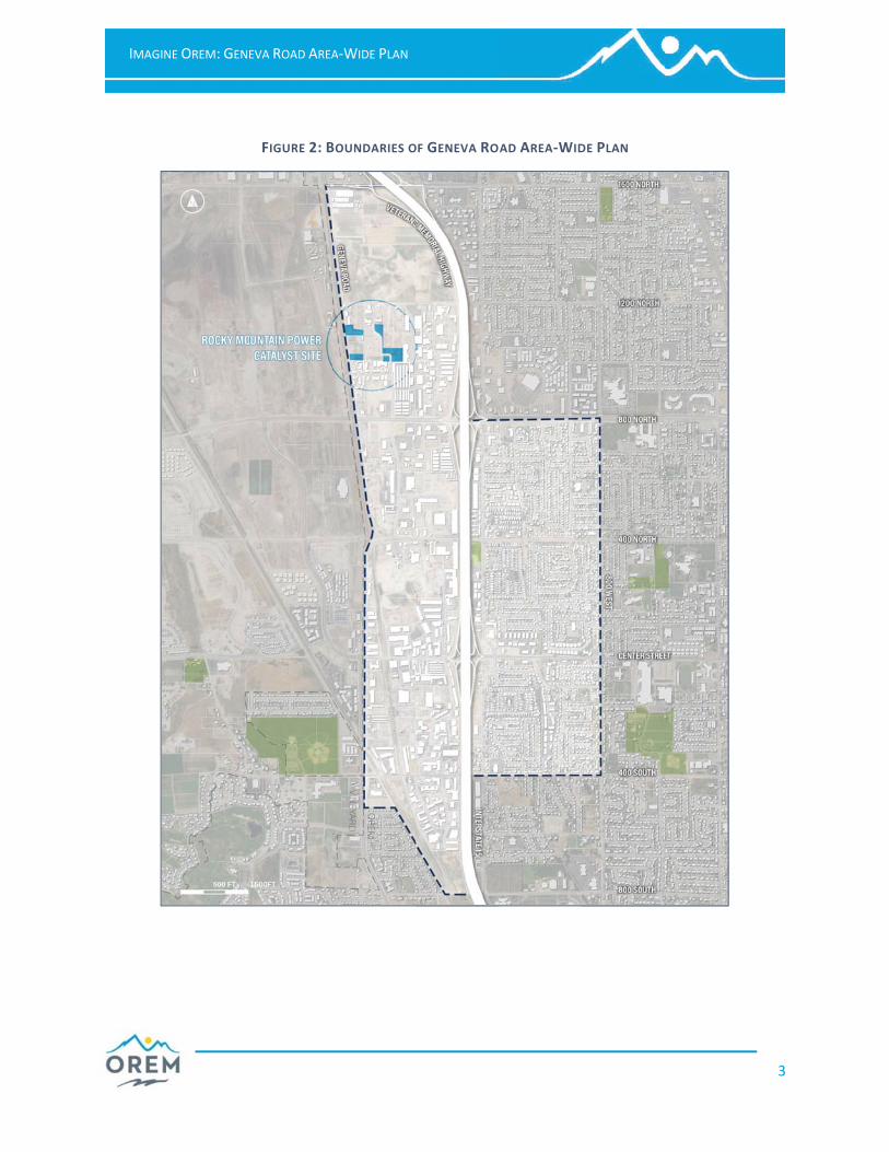
FIGURE 2: B
A‐WIDE PLAN
BOUNDARIES O
OF GENEVA ROAD AREA‐WIDDE PLAN
3

IMAGIN
PROJE
The Ge
approxim
northwes
generally
major t
Interstate
numbered
east to we
The plan a
at the No
the east,
Geneva R
of I‐15 is
commerc
is predom
neighborh
as Timpvi
Suncrest.
The plan a
Resort, w
at the beg
COMM
The Gene
and three
this indus
Geneva S
Vineyard,
Today, th
industrial
employm
neighborh
percent o
Orem, Uta
NE OREM: GENE
ECT AREA
neva Road
ately 1400
t corner of O
organized no
thoroughfares
e 15, 1200 We
d streets co
est.
area is bound
orth, Intersta
South 800 W
Road at the W
predominate
ial uses, whil
minately ind
hoods are id
ew, Geneva
area takes its
which operate
ginning of the
MUNITY Peva Road Are
e residential n
strial area on
Steel Plant w
Utah.
ese neighbor
corridor can
ent associate
hoods in Orem
of households
ah County, an
EVA ROAD AREA
A Area en
acres of la
Orem, Utah.
orth to south
s – Gene
est and 800 W
nnected the
ded by North
ate 15 and 8
West at the
West. The pla
ely residential
le the area w
ustrial. The
entified nort
Heights, Orem
s name from t
ed on nearby
e 20th century
PROFILE ea (GRA) inclu
neighborhood
n the other
workers in the
rhoods are im
n produce, co
ed with the
m, with key e
s receiving fo
nd the State o
A‐WIDE PLAN
ncompasses
and in the
The area is
h along four
eva Road,
West – with
plan area
1600 West
800 East on
South and
n area east
l with some
west of I‐15
residential
th to south
m Park and
the Geneva
y Utah Lake
y.
udes the com
ds, Geneva H
side of I‐15.
e 1940s and
mpacted by al
ompounded
closure of t
economic ind
ood stamps)
of Utah. Acco
mmercial/ ind
Heights, Sunc
These neigh
1950s, whic
ll the negativ
by uses past
he Geneva S
icators (unem
showing eco
ording to the
FIGURE 3:
dustrial area
rest, and Ore
hborhoods w
ch was locat
ve effects of a
t and present
Steel plant. T
mployment le
onomic challe
USDA, these
GENEVA ROAD
known locall
em Park, that
were originall
ed on the si
a major inter
t and the de
These are am
evels, median
enges compa
neighborhoo
D AREA IN CON
ly as “the We
t lie to the e
ly created fo
ite of presen
state highwa
ecline of indu
mong the po
home values
ared to the re
ods are curren
NTEXT
4
edge”
ast of
or the
nt‐day
ay and
ustrial
oorest
s, and
est of
ntly in
IMAGIN
low incom
The Alpin
within on
achievem
environm
mothers,
to environ
rates (His
State of U
fourth mo
and 2 belo
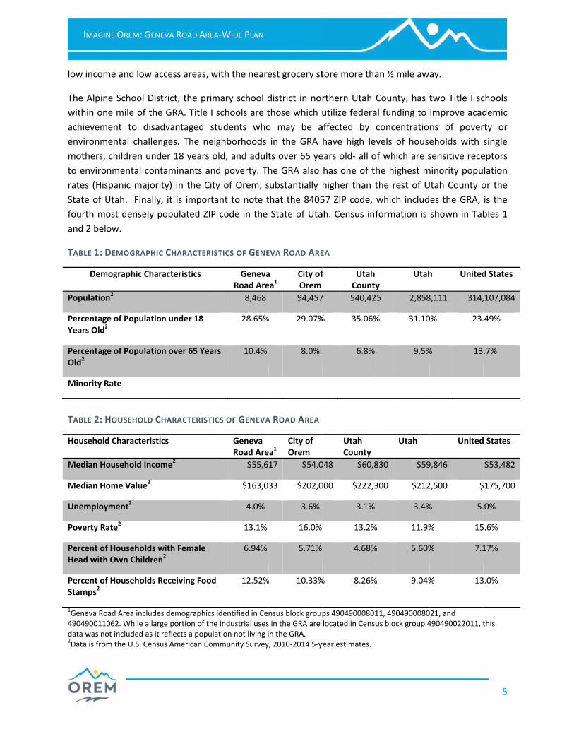
TABLE 1: D
Dem
Population
PercentageYears Old2
PercentageOld2
Minority R
TABLE 2: H
Household
Median Ho
Median Ho
Unemploy
Poverty Ra
Percent ofHead with
Percent ofStamps2
1Geneva Ro4904900110data was no2Data is from
NE OREM: GENE
me and low ac
e School Dist
e mile of the
ent to disad
ental challen
children und
nmental cont
spanic majori
Utah. Finally
ost densely p
ow.
DEMOGRAPHIC
mographic Char
n2
e of Populatio2
e of Populatio
Rate
HOUSEHOLD C
d Characteristi
ousehold Incom
ome Value2
yment2
ate2
f Households w Own Children
f Households R
ad Area include062. While a largot included as it m the U.S. Censu
EVA ROAD AREA
ccess areas, w
trict, the prim
e GRA. Title I
dvantaged st
nges. The nei
er 18 years o
taminants an
ty) in the Cit
, it is importa
populated ZIP
C CHARACTERIS
racteristics
n under 18
n over 65 Year
HARACTERISTI
cs
me2
with Female n2
Receiving Food
s demographics ge portion of thereflects a populaus American Com
A‐WIDE PLAN
with the neare
mary school d
schools are t
tudents who
ighborhoods
old, and adult
nd poverty. Th
ty of Orem, s
ant to note t
P code in the
STICS OF GENE
GenevaRoad Are
8,468
28.65%
rs 10.4%
CS OF GENEVA
Geneva Road Are
$55,6
$163,0
4.0%
13.1%
6.94%
d 12.52%
identified in Cee industrial usesation not living immunity Survey
est grocery st
district in nor
those which u
o may be a
in the GRA
ts over 65 ye
he GRA also
substantially
that the 8405
State of Uta
EVA ROAD ARE
a ea1
City ofOrem
94,457
% 29.07%
8.0%
A ROAD AREA
ea1 City of Orem
17 $54,0
33 $202,0
3.6%
16.0%
5.71%
% 10.33%
nsus block groups in the GRA are in the GRA. y, 2010‐2014 5‐y
tore more tha
rthern Utah
utilize federa
affected by
have high le
ears old‐ all o
has one of th
higher than t
57 ZIP code,
ah. Census inf
EA
f Utah County
7 540,42
% 35.06%
6.8%
Utah County
048 $60,8
000 $222,3
3.1%
13.2%
4.68%
% 8.26%
ps 49049000801located in Censu
year estimates.
an ½ mile aw
County, has t
al funding to
concentratio
vels of house
of which are s
he highest m
the rest of U
which includ
formation is
y Utah
25 2,858
% 31.10
9.5%
Utah
830 $59
300 $212
3.4%
% 11.9%
% 5.60%
% 9.04%
11, 4904900080us block group 4
ay.
two Title I sc
improve acad
ns of pover
eholds with
sensitive rece
minority popu
Utah County o
es the GRA,
shown in Tab
h United
8,111 314,
0% 23.
% 13
United
9,846
2,500 $
% 5.
% 15
% 7.1
% 13
021, and 490490022011, t
5
chools
demic
rty or
single
eptors
lation
or the
is the
bles 1
d States
,107,084
.49%
.7%i
d States
$53,482
$175,700
.0%
5.6%
17%
3.0%
this

IMAGIN
REVIEW
OREM
This com
including
and publi
locations
industrial
Cfa
n
p
o
O
o
co
am
Uan
o
st
d
an
Ew
fr
20
ac
o
Trse
b
an
o
Th
NE OREM: GENE
W OF EX
GENERA
prehensive p
land use, tra
ic services an
for uses tha
and public us
Communityamily‐friendly
eighborhood
laces that c
utcomes incl
Orem. The G
rganizations,
ommunity cu
menities can
Urban Plannd methods t
bjectives of t
treetscapes w
esign goals
nticipating th
conomic workforce, are
rom surround
012 and deve
ction include
ngoing land d
ransportateveral in‐dep
oth the City a
nd walking im
riented devel
he Plan conc
services
EVA ROAD AREA
ISTING P
L PLAN 20plan is the of
ansportation,
nd facilities. T
t manage gr
ses.
y Characty city and
s, to provide
an meet the
ude improve
eneral Plan
educational
ulture. Its de
develop and
nning and to create a de
the City are to
with inviting
include crea
he eligibility o
Developmea universitie
ding commun
eloped the 2
expanding t
development
tion: Orem
th plans and
and region, th
mprovements
lopments (TO
cludes with a
s provided by
A‐WIDE PLAN
PLANS
011 (LAS
fficial statem
housing, urb
The guides f
owth as wel
ter: Orem p
this is tran
affordable h
e growing d
d public serv
lists the nu
resources,
esire is to f
flourish.
Design: Oesirable phys
o develop an
amenities a
ating gatewa
f historic stru
ment: The es, low cost of
ities has grow
014 Economi
he tax base,
meets econo
has a highl
studies to g
he General Pl
, the expansi
ODs) and the a
a brief overv
y City governm
T AMEND
ent of polici
ban design g
or land use a
l as provide
laces a high
nslated into
housing in ne
emand for
vices and sch
merous park
and the city
foster an en
rem also pla
ical environm
d implement
and buffers t
ays, signage
uctures for pr
economic vita
f living and its
wn, the City a
ic Developme
increasing as
omic developm
y developed
uide its futur
an outlines th
on of transit
addition of a
view of publ
ment.
ED 2016)es for the fu
guidelines, ec
are intended
sufficient lan
priority on
its goals
ewer mixed u
student and
hools that wil
ks and recre
y library whi
nvironment w
ces significan
ment for its co
t an urban for
that encoura
improveme
reservation an
ality of Orem
s recreationa
added an Eco
ent Strategic
ssessed prop
ment goals (m
d multi‐moda
re. In order t
he need to su
services (bus
Transportatio
ic safety, pu
) uture develo
conomics, par
d to provide
nd for reside
protecting it
to protect
use developm
senior hou
ll improve th
eation faciliti
ch make up
where such
nce on urban
ommunity. T
restry plan an
age pedestri
ents, reducin
nd the inclusi
m has depen
l opportuniti
nomic Develo
Plan (EDSP).
perty values a
more on the E
al transporta
to address pr
upport strate
s and rail), enc
on Center.
ublic works a
pment of the
rks and recre
classification
ential, comme
ts reputation
older resid
ment and to c
sing. The de
e quality of
es, festivals,
p its “tapestr
organizations
n design prin
The major pla
nd to human
an activity.
ng light poll
ion of public a
ded on its s
es. As compe
opment Divis
The goals fo
and to ensure
EDSP is below
ation system
rojected grow
egies such as b
couraging tra
and administr
6
e City
eation
s and
ercial,
n as a
ential
create
esired
life in
, civic
ry” of
s and
ciples
anning
ize its
Other
ution,
art.
strong
etition
sion in
or this
e that
w).
with
wth in
biking
ansit–
ration

IMAGIN
OREM
Between
considere
projected
somewhe
potential
maintaine
separated
as well as
Geneva R
service (C
West, an
neighborh
around th
Orem, Sta
without a
of 1600 N
west acce
According
Routes al
vision pla
slated for
Geneva R
service is
transport
Bicycle an
on Genev
neighborh
Geneva R
designate
travel lim
keep in m
outlines i
crosswalk
TMP diag
NE OREM: GENE
TRANSPO
today and 20
ed moderate
to result in
ere in Orem. W
congestion a
ed by UDOT,
d into 10 year
updated pol
Road is chara
C or better) th
adjacent su
hoods in the
he intersectio
ate Street an
ction. Anothe
North betwee
essibility to Ge
g to the TMP
ong Geneva
n in the MAG
r Phase 1 and
Road and 120
s flexible and
ation alterna
nd Pedestrian
va Road, sev
hoods along 8
Road is design
ed as an alter
ited to these
mind the role
important de
ks, safety and
rams illustrat
EVA ROAD AREA
ORTATION
040, the popu
growth, the
74% of all
With this in m
and to coordi
, UTA, Utah
r and 25 year
icies and guid
cterized as a
hrough the AW
urface road
study area o
on of Center
d I‐15. The s
er major imp
n 400 West a
eneva Road b
, the preferre
Road with co
G RTP and No
d 2 in those
00 West with
d able to ex
tive the city w
Plan shows a
eral east‐wes
800 West.
nated as a m
rnative truck
e routes and a
e these road
esign conside
connectivity
ting the tran
A‐WIDE PLAN
MASTER
ulation in Ore
larger region
vehicles from
mind the Tran
nate the goa
County and
r windows for
delines for tra
a 5‐lane princ
WP study area
categorized
on the west.
Street. Cent
egment is ra
rovement at
and I‐15 to 5 l
but will impac
ed alternative
onnection to
orth County T
plans. Curren
h connection
xpand and a
wishes to pro
an extension
st connection
major truck ro
route. These
away from sm
dways serve w
erations for
.
sportation sc
PLAN (20em is projecte
al growth in
m outside th
nsportation M
ls of Orem w
neighboring
r roadway, tr
affic managem
cipal arterial
a. Running pa
as a 2‐3 lan
1200 West is
ter Street is
ted a D level
the northern
anes. All of th
ct the neighbo
e to address
downtown, t
Transit Study,
ntly the area
n to State Str
adjust routes
omote is bicy
of the bike la
ns spanning
oute along th
designations
maller and re
within the e
roadway de
cenarios desc
015) ed to grow b
tandem with
e city using
Master Plan (T
with the regio
municipalitie
ransit, bicycle
ment and des
route that p
arallel to the
ne minor ar
s also rated a
a major con
l of service b
n end of the A
hese projects
orhoods thes
increased tra
the Universit
, but are seco
a is served by
reet via 800
s and stops
ycle and pede
ane on 1200 W
I‐15 and pla
he west edge
s are intende
esidential stre
ntire transpo
sign, access
cribed in this
by 20,800 or 2
h the attractio
the roadway
TMP) was dev
onal infrastru
es. The plan
e and pedestr
sign standard
provides an a
east are Inter
rterial route
acceptable e
nnector betw
but is expecte
AWP study ar
s will significa
se roadways b
ansportation
ty and Vinela
ondary to the
y routes that
North. Oper
as demand
estrian option
West, the add
anned bike ro
e of the city
ed to keep th
eets. As such,
ortation syste
managemen
s section are
23% overall.
on to visit Or
y network to
veloped to co
cture planne
includes pro
rian improvem
s.
acceptable lev
rstate 15 and
that border
xcept for the
een the cent
ed to drop to
rea is the wid
antly improve
bisect.
needs is ligh
nd are part o
e preferred r
run the leng
rated by UTA
changes. An
ns. The 2010
dition of bike
outes throug
and 1200 W
e impacts of
, it is importa
em. The plan
nt, traffic cal
provided bel
7
While
rem is
o stop
ombat
d and
ojects
ments
vel of
d 1200
rs the
e area
ter of
o an E
dening
e east‐
ht rail.
of the
routes
gth of
A, this
nother
Orem
lanes
gh the
West is
truck
ant to
n also
ming,
ow.

0 0.75 1.50.375Miles
LegendPrincipal Arterial - UDOT (2-7 Lanes)Principal Arterial- Orem (6-7 Lanes)Major Arterial - Orem (4-5 Lanes)Minor Arterial - Orem (2-3 Lanes)Urban Collector- Orem (2-3 Lanes)
>?@ Freeway Interchange
))!!!!!! Traffic Signal
Roundabout
Traffic Circle
89:D Intersection Improvement
""""""!
! ! HAWK (PED) Signal
Orem City BoundaryAnnexation Area
Transportation Master Plan
400 SOUTH
CENTER STREET
400 NORTH
1200 NORTH
1600 NORTH
2000 NORTH
800 SOUTH
1200 SOUTH
UNIVERSITY PKWY
1600 SOUTH
2000 SOUTH
400 SOUTH
CENTER STREET
400 NORTH
1200 NORTH
1600 NORTH
2000 NORTH
800 SOUTH
1200 SOUTH
UNIVERSITY PKWY
1600 SOUTH
2000 SOUTH
GENE
VA R
D
1200
WES
T
800 W
EST
400 W
EST
MAIN
STRE
ET
400 E
AST
800 E
AST
1300
EAST
GENEVA RD
1200
WES
T
800 W
EST
400 W
EST
MAIN
STRE
ET
400 E
AST
800 E
AST
STATE ST
STATE ST
STATE ST
OREM BLVD
Figure 26: 2040 ProposedRoadway Network
CANYON PKWY(800 NORTH)
CANYON PKWY(800 NORTH)

811
842
850
750
822
807
805
806
830
831
862
840
841
0 0.75 1.50.375Miles
LegendUTA Bus RoutesOrem City BoundaryAnnexation Area
Transportation Master Plan
400 SOUTH
CENTER STREET
400 NORTH
1200 NORTH
1600 NORTH
2000 NORTH
800 SOUTH
1200 SOUTH
UNIVERSITY PKWY
1600 SOUTH
2000 SOUTH
400 SOUTH
CENTER STREET
400 NORTH
1200 NORTH
1600 NORTH
2000 NORTH
800 SOUTH
1200 SOUTH
UNIVERSITY PKWY
1600 SOUTH
2000 SOUTH
GENE
VA R
D
1200
WES
T
800 W
EST
400 W
EST
MAIN
STRE
ET
400 E
AST
800 E
AST
1300
EAST
GENEVA RD
1200
WES
T
800 W
EST
400 W
EST
MAIN
STRE
ET
400 E
AST
800 E
AST
STATE ST
STATE ST
STATE ST
OREM BLVD
Figure 33: Existing UTATransit Routes
CANYON PKWY(800 NORTH)
CANYON PKWY(800 NORTH)

0 0.75 1.50.375Miles
LegendPedestrian and Bike Paths
Existing Bike LanePlanned Bike LaneExisting Multi-Use PathPlanned Multi-Use PathExisting Bike RoutePlanned Bike RouteProposed Bike BoulevardState Street Corridor - Bike RoutePotential MAG FundingOrem City BoundaryAnnexation Area
Transportation Master Plan
400 SOUTH
CENTER STREET
400 NORTH
1200 NORTH
1600 NORTH
2000 NORTH
800 SOUTH
1200 SOUTH
UNIVERSITY PKWY
1600 SOUTH
2000 SOUTH
400 SOUTH
CENTER STREET
400 NORTH
1200 NORTH
1600 NORTH
2000 NORTH
800 SOUTH
1200 SOUTH
UNIVERSITY PKWY
1600 SOUTH
2000 SOUTH
GENE
VA R
D
1200
WES
T
800 W
EST
400 W
EST
MAIN
STRE
ET
400 E
AST
800 E
AST
1300
EAST
GENEVA RD
1200
WES
T
800 W
EST
400 W
EST
MAIN
STRE
ET
400 E
AST
800 E
AST
STATE ST
STATE ST
STATE ST
OREM BLVD
Figure 35: Pedestrian and Bike Paths
CANYON PKWY(800 NORTH)
CANYON PKWY(800 NORTH)
0 0.75 1.50.375Miles
LegendTruck Routes
Truck RouteAlternate Truck RouteOrem City BoundaryAnnexation Area
Transportation Master Plan
400 SOUTH
CENTER STREET
400 NORTH
CANYON PKWY(800 NORTH)
1200 NORTH
1600 NORTH
2000 NORTH
800 SOUTH
1200 SOUTH
UNIVERSITY PKWY
1600 SOUTH
2000 SOUTH
400 SOUTH
CENTER STREET
400 NORTH
CANYON PKWY(800 NORTH)
1200 NORTH
1600 NORTH
2000 NORTH
800 SOUTH
1200 SOUTH
UNIVERSITY PKWY
1600 SOUTH
2000 SOUTH
GENE
VA R
D
1200
WES
T
800 W
EST
400 W
EST
MAIN
STRE
ET
400 E
AST
800 E
AST
1300
EAST
GENEVA RD
1200
WES
T
800 W
EST
400 W
EST
MAIN
STRE
ET
400 E
AST
800 E
AST
STATE ST
STATE ST
STATE ST
OREM BLVD
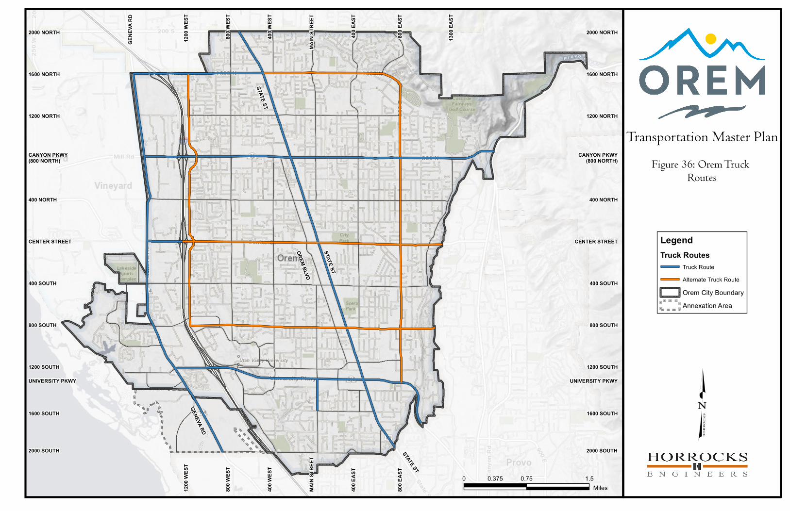
Figure 36: Orem Truck Routes

IMAGIN
ECONO
The City’s
current e
vitality ha
relatively
fuel the fu
However,
growing m
depends o
outlines r
the goals
the amou
profession
Nodes 17
to the Eco
for conve
addition
interchan
occur nex
for two gr
TABLE 3: P
Geneva R
1 Mile
3 Miles
5 Miles
The GRA
Class A of
business p
vacant lan
The EDSP
developed
Fo
lo
NE OREM: GENE
OMIC DE
s 2014 Econo
economic env
as been the r
low cost of l
uture of Orem
competitive
more rapidly
on more expe
recommendat
the City has
unt and avail
nal services s
and 18 along
onomic Devel
ersion from u
to retail an
ges and area
xt door in Vin
rocery stores
POPULATION G
Road
1
8
18
is not identif
ffice space b
park in the n
nd in that por
P also include
d four leading
or the City of
ow cost of doi
start‐up
EVA ROAD AREA
VELOPME
omic Develop
vironment in
result of its lo
living and hig
m’s economy.
pressures fr
and have op
ensive infill an
tions that be
to grow a sta
lability of Cla
tartups and g
g I‐15 and Ge
lopment Strat
underdevelop
nd advanced
as along Gen
eyard. Specif
and Orem w
GROWTH PROJ
2015
0,377
9,869
5,312 1
fied as a targ
ut the plan a
orth portion
rtion of the C
es the results
g brand attrib
f Orem’s eco
ing business a
p companies,
A‐WIDE PLAN
ENT STRAT
pment Strateg
Orem and t
ocation at the
ghly educated
.
rom outside t
en land avail
nd strategic a
est uses the a
able tax base
ass A office s
growing comp
eneva Road a
tegic Plan, th
ped industria
d manufactu
neva Road to
fically, the Vin
ishes to captu
ECTION (OREM
2020
10,800
94,253
194,189
geted area fo
acknowledges
of GRA are a
ity (see Figure
s of commun
butes that lea
onomic develo
and a quality
established b
TEGIC PLA
gic Plans tak
the challenge
e center of re
d workforce.
the city are g
able for new
approaches. T
assets of each
. Emphasis in
space neede
panies from le
re located in
ese areas, co
al uses to hi
uring.” Retai
o capitalize o
neyard popula
ure that mark
M CITY ECONO
2030
11,648
104,929
210,490
r future hous
s further pla
already under
e 1 below).
nity engagem
ad to a simplif
opment audie
y workforce. O
businesses an
AN (2014kes a holistic
es it faces in
etail activity
These assets
growing. The
w developmen
The plan crea
h district and
n the plan is p
d to keep de
eaving Orem.
the heart of
ollectively kno
gh‐quality, fr
l developme
on the increa
ation growth
ket position b
OMIC DEVELOP
2040
12,472
113,834
223,283
sing redevelo
nning for thi
r developmen
ent in the b
fied brand po
ence, Orem p
Orem is the ep
nd developers
4) approach to
the future.
for the regio
s are anticipat
e surrounding
nt. Orem’s fu
ates 19 develo
d how it can
placed on the
esirable tech
.
the GRA stud
own as “the W
reeway‐visibl
ent is targe
ased develop
is expected t
before it goes
MENT STRATE
opment or a
s area is req
nt, utilizing so
randing of O
ositioning stat
provides grea
picenter of U
s prosper.
o documentin
Orem’s econ
on coupled w
ted to contin
g communitie
uture develop
opment node
best contribu
e need to foc
h, information
dy area. Acco
Wedge” are “
le office spa
ted for the
ment expect
to create the
s to Vineyard.
GIC PLAN)
prime locatio
uired. Plans
ome of the li
Orem. Partici
tement:
at value throu
Utah County, w
12
ng the
nomic
ith its
nue to
es are
pment
es and
ute to
cus on
n and
ording
prime
ce, in
e I‐15
ted to
e need
.
on for
for a
mited
ipants
ugh a
where

IMAGIN
FIGURE 4:
STATE SThe State
Street, wh
into an a
developm
identifies
center, ar
The plan
of Orem.
4300 offic
that deve
to create
establishe
reinforce
The State
design gu
planning e
NE OREM: GENE
BUSINESS PAR
STREET CO
e Street Corr
hich served a
ttractive, urb
ment initiative
five (5) maj
rts and entert
projects the i
These includ
ce jobs, 48%
elopment awa
a vibrant dow
ed by this pla
the commun
e Street Mast
uidelines in t
efforts will be
EVA ROAD AREA
RK DEVELOPM
ORRIDOR
idor Master
as the central
ban lifestyle
es, transporta
or nodes of
tainment, sho
impacts the p
de absorbing
increase in t
ay from the S
wntown core
an are carrie
ity image and
ter Plan will s
he Geneva R
e explored as
A‐WIDE PLAN
ENT IN GRA (O
MASTER
Plan provide
l commercial
alternative fo
ation solution
developmen
opping and di
proposed stra
over 75% of
taxable sales
State Street C
. It will be eq
ed through to
d identity of t
serve as a te
Road Area. M
the planning
OREM CITY EC
PLAN (20es a framewo
corridor of O
or residents,
s and enhanc
nt each with
ning, mixed u
ategies for St
f the projecte
and 140% in
Corridor be co
ually importa
o other rede
the City.
mplate for re
More informa
g process prog
CONOMIC DEV
017) ork to guide
Orem. The go
businesses a
ced communi
a different f
use center an
ate Street co
ed population
ncrease in tax
ompatible an
ant that the d
velopment a
ecommended
ation on the
gresses.
ELOPMENT ST
the future g
oal is to trans
and visitors t
ity image and
focus – emp
nd residential/
ould have on
n growth, th
x revenue. It
nd not compe
design standa
areas, such a
d zoning chan
synergies be
RATEGIC PLAN
rowth along
sform State S
through econ
d identity. The
ployment and
/retail.
shaping the f
e addition of
will be impo
ete with the d
ards and aest
s Geneva Ro
nges and pot
etween these
13
N)
State
Street,
nomic
e plan
d civic
future
f over
ortant
desire
hetics
oad to
tential
e two
IMAGIN
GENEV
(2017The Gene
and Orem
serve as
developm
as the ne
industrial
Together,
according
children u
units, whi
of supply,
(4) mobile
According
Orem’s o
expected
Geneva
interest
propertie
Orem. Ho
propertie
and will
being red
A key goa
Road B
“Economi
business d
jobs and
revenue.”
area are a
for the e
section, t
vast maj
assessed
potential
through s
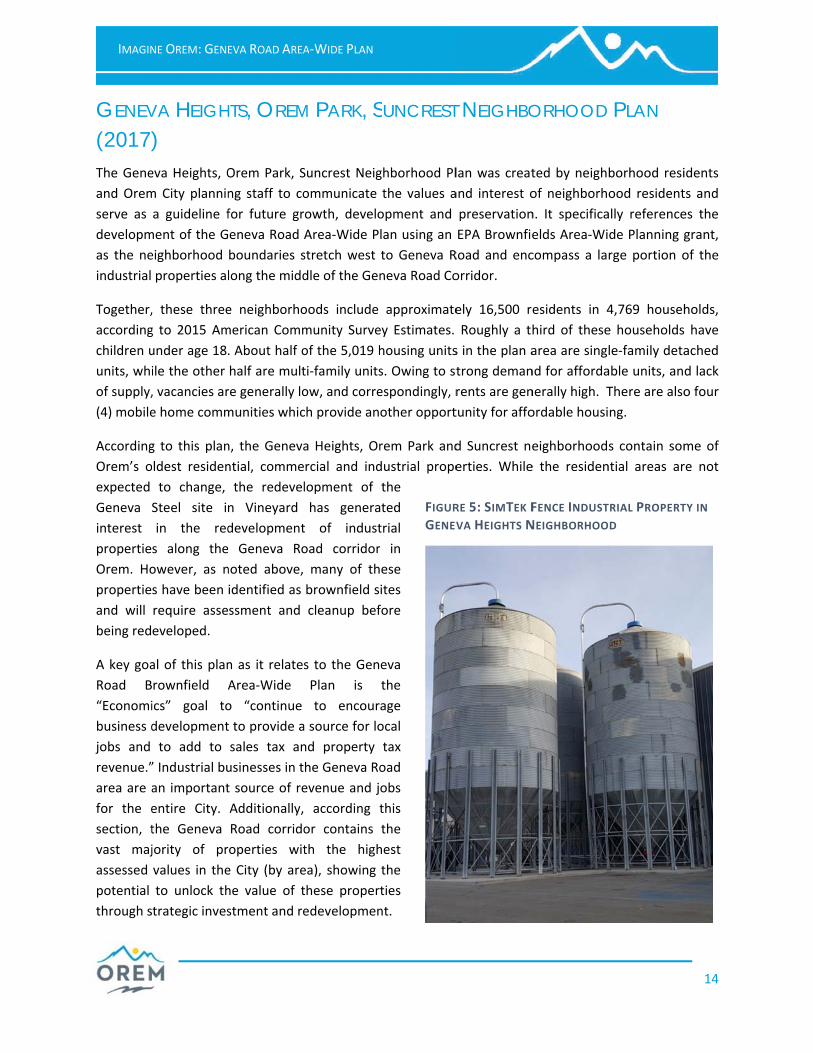
NE OREM: GENE
VA HEIGH
) eva Heights, O
m City plannin
a guideline f
ment of the G
eighborhood
properties al
, these three
g to 2015 Am
under age 18.
ile the other
, vacancies ar
e home comm
g to this plan
ldest residen
to change,
Steel site in
in the red
s along the
owever, as n
s have been
require asse
eveloped.
al of this plan
rownfield A
ics” goal to
development
to add to
” Industrial bu
an important
entire City.
the Geneva
jority of pr
values in the
to unlock th
trategic inves
EVA ROAD AREA
HTS, OREM
Orem Park, S
ng staff to co
for future gr
eneva Road A
boundaries s
long the midd
e neighborho
merican Comm
. About half o
half are mult
re generally lo
munities whic
n, the Geneva
ntial, comme
the redevel
n Vineyard
development
Geneva Ro
noted above,
identified as
ssment and
n as it relates
Area‐Wide
o “continue
t to provide a
sales tax an
usinesses in t
t source of re
Additionally,
Road corrido
roperties wit
e City (by are
he value of t
stment and re
A‐WIDE PLAN
M PARK, S
Suncrest Neig
ommunicate
owth, develo
Area‐Wide P
stretch west
dle of the Gen
oods include
munity Surve
of the 5,019 h
ti‐family units
ow, and corre
ch provide an
a Heights, Or
rcial and ind
lopment of
has genera
t of indust
oad corridor
many of th
brownfield s
cleanup bef
s to the Gen
Plan is
to encour
a source for lo
nd property
he Geneva Ro
evenue and j
according t
or contains
th the high
ea), showing
these propert
edevelopmen
SUNCREST
ghborhood Pl
the values a
opment and
lan using an
to Geneva R
neva Road Co
approximate
ey Estimates.
housing units
s. Owing to st
espondingly, r
other opport
rem Park and
dustrial prope
the
ted
trial
in
ese
ites
fore
eva
the
age
ocal
tax
oad
obs
this
the
hest
the
ties
nt.
FIGURGENEV
T NEIGHBO
lan was creat
and interest o
preservation
EPA Brownfie
Road and enc
orridor.
ely 16,500 r
Roughly a th
s in the plan a
trong deman
rents are gen
tunity for affo
d Suncrest ne
erties. While
RE 5: SIMTEK FVA HEIGHTS N
ORHOOD
ted by neigh
of neighborh
n. It specifica
elds Area‐Wi
compass a la
esidents in 4
hird of these
area are sing
nd for afforda
nerally high. T
ordable housi
eighborhood
e the residen
FENCE INDUSTNEIGHBORHOO
PLAN
borhood resi
ood resident
ally reference
de Planning g
rge portion o
4,769 househ
e households
le‐family deta
able units, an
There are also
ng.
s contain som
ntial areas ar
TRIAL PROPERTD
14
idents
ts and
es the
grant,
of the
holds,
have
ached
d lack
o four
me of
re not
TY IN

IMAGIN
ASPEN
Like the G
Suncrest
Aspen an
Plan was
residents
to comm
interest o
serve as a
developm
Aspen an
comprise
City, wit
Geneva R
the devel
Area‐Wid
Brownfiel
as the ne
the Genev
The Aspe
limited co
1970s. Th
concentra
the City is
1600 N, I‐
These ne
2015 Am
children u
Timpview
of supply.
Key goals
Transport
increa increa bette utilize deal w
NE OREM: GENE
AND TIM
Geneva Heigh
Neighborho
nd Timpview
s created b
and Orem C
municate th
of neighborho
a guideline fo
ment and pr
nd Timpview
the northwe
h a wester
Road. It speci
lopment of t
e Plan u
ds Area‐Wid
eighborhood b
va Road Corri
n and Timpv
ommercial an
hese neighbo
ated along Ge
s the former W
‐15, 1200 N a
eighborhoods
merican Comm
under age 18
w have a very
.
s of this plan
tation and Eco
ase roadway
ase the netwo
r access man
e major thoro
with traffic an
EVA ROAD AREA
MPVIEW NE
hts, Orem Par
ood Plan,
w Neighborh
by neighborh
ity planning
he values
ood residents
or future grow
reservation.
w neighborho
est corner of
rn boundary
fically refere
the Geneva R
using an
e Planning gr
boundaries s
idor, includin
view neighbo
nd industrial
orhoods rema
eneva Road, 1
Williams Farm
nd Geneva Ro
contain appr
munity Surve
. As with the
low vacancy
n that pertain
onomics sect
capacity thro
ork and impro
agement for
oughfares for
nd safety issu
A‐WIDE PLAN
EIGHBORH
rk and
the
hood
hood
staff
and
and
wth,
The
oods
f the
y of
nces
Road
EPA
rant,
tretch west t
g the catalyst
rhoods, like
development
ain predomin
1200 W, 800
m property lo
oad.
roximately 9,
ey estimates
Geneva Heig
rate of 3%, o
n to the Gen
ions. The Tra
ough improve
ove the qualit
new develop
traffic from n
es at congest
FIGUTIMP
HOOD PL
to Geneva Ro
t site of Rocky
much of Ore
t until the de
nately reside
N and State
ocated at the
532 residents
. Forty‐five
ghts Orem Pa
owing to a str
neva Road Br
nsportation s
ments along
ty of bike and
ments;
new developm
ted intersecti
RE 6: ROCKY MPVIEW NEIGHB
LAN (201
oad and enco
y Mountain P
em, were hist
esignation of
ntial, with c
Street. The la
northwest co
s residing in 2
percent (45%
ark and Suncr
rong demand
rownfield Are
section has go
major corrido
d walking pat
ment; and
ons, particula
MOUNTAIN POBORHOOD
7)
ompasses the
Power.
torically agric
f residential s
ommercial a
ast large und
orner of the p
2,790 househ
%) of these
rest neighbor
for affordab
ea‐Wide Plan
oals that inclu
ors, prioritizin
hs;
arly 1600 N a
OWER CATALYS
e northern se
cultural lands
subdivisions i
nd industrial
eveloped par
plan area bet
holds, accord
households
rhoods, Aspe
le units, and
n are found i
ude the follow
ng 1600 N;
nd 1200 W.
ST SITE IN THE
15
ection
s with
in the
l uses
rcel in
tween
ing to
have
n and
a lack
in the
wing: